DARTFORD’S NATURAL ENVIRONMENT BIODIVERSITY AND LANDSCAPE ... · NATURAL ENVIRONMENT BIODIVERSITY...
31
BOROUGH COUNCIL DARTFORD’S NATURAL ENVIRONMENT BIODIVERSITY AND LANDSCAPE TECHNICAL PAPER PART OF DARTFORD’S LOCAL DEVELOPMENT FRAMEWORK July 2010
Transcript of DARTFORD’S NATURAL ENVIRONMENT BIODIVERSITY AND LANDSCAPE ... · NATURAL ENVIRONMENT BIODIVERSITY...
BOROUGH COUNCIL
DARTFORD’S NATURAL ENVIRONMENT
BIODIVERSITY AND LANDSCAPE TECHNICAL PAPER
PART OF DARTFORD’S LOCAL DEVELOPMENT FRAMEWORK
July 2010
CONTENTS
1 Introduction 2 Purpose and Content 2
Overview of the Borough’s Natural Environment 2
2 The Policy Framework 2 Higher Level Policy Guidance 2 The Development Plan and Emerging Policy 3 Summary 4
3 Protecting Dartford’s Natural Environment 4 National Level Designations 4 Regional Level Designations 5 County Level Designations 5
Features of Local Value 7 Summary 8
4 Enhancing Dartford’s Natural Environment 8 Biodiversity Opportunity Areas 8
Marshes 10
Water Bodies 11
Lowland Grasses and Heath 11
Woodlands 12 Outside BOAs 13Protected Species 13
Biodiversity in Development Sites 14
Recreational Access 16 Management and Partnership Working 17 Summary 18
5 Policy Implications 18
6 Appendices 19Appendix 1: Biodiversity Opportunity Areas 19 Appendix 2: Landscape Character Areas 20 Appendix 3: Protecting Dartford’s Natural Assets 21 Appendix 4: Enhancing Dartford’s Natural Assets 31
1
Dartford’s Natural Environment: A Biodiversity and Landscape Technical Paper
1 Introduction
Purpose and Content 1.1 This technical paper has been prepared to inform, and support the preparation of, Dartford’s Local
Development Framework (LDF). It contributes towards the development of biodiversity and landscape policies in the Core Strategy and determines whether there is a need for more detailed policies in the future. It focuses on the borough’s landscapes and areas of biodiversity and: provides a summary of the relevant policy context – section 2; identifies the borough’s natural resource to be protected – section 3; identifies ways in which Dartford’s natural environment can be enhanced – section 4; identifies implications for Core Strategy policy and other Development Plan Documents – section 5.
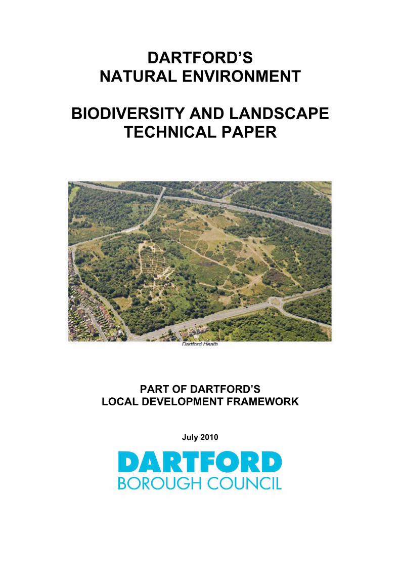
Overview of the Borough’s Natural Environment 1.2 Much of the northern part of the borough has been developed, forming the urban settlements of Dartford,
Stone, Greenhithe and Swanscombe. Within the built form, there are significant pockets of undeveloped land including Dartford Heath and Ebbsfleet Valley. Dartford Marshes and Swanscombe Peninsula provide large swathes of marshland alongside the River Thames. The southern part of the borough remains as substantially open countryside and lies within the Green Belt, although there are a number of villages scattered across the rural landscape. It is typical of the downland landscapes of southern England. The varied geology and topography has produced a wide range of habitats, in addition to agricultural land. Apart from their intrinsic landscape and ecological value, natural assets provide a number of benefits. They provide a backdrop for urban development, help to create a sense of place, improve people’s quality of life, provide sustainable transport and recreational resources for communities to utilise, accommodate water in times of flood, provide a carbon sink, help habitats and species to adapt to climate change and attract tourism.
2 The Policy Framework
2.1 When planning for biodiversity and landscape, account should be taken of the policy framework that already exists. The section below provides an overview of the main policies and higher level guidance.
Higher Level Policy Guidance 2.2 At the national level, there are a number of relevant PPS/PPGs:
PPS1: Delivering Sustainable Development1; PPS1: Supplement: Planning and Climate Change2; PPS Consultation: Planning for a Low Carbon Future in a Changing Climate3; PPG2: Green Belts4; PPS7: Sustainable Development in Rural Areas5; PPS9: Biodiversity and Geological Conservation6; PPG17: Planning for Open Space, Sport and Recreation7 .
2.3 A number of principles are set out in these PPS/PPGs that relate to biodiversity and landscape conservation, including:
1 CLG (January 2005) PPS1: Delivering Sustainable Development 2 CLG (December 2007) PPS1 Supplement: Planning and Climate Change 3 CLG (March 2010) Consultation on a PPS: Planning for a Low Carbon Future in a Changing Climate. This document will combine and update PPS1 Supplement and PPS22
4 CLG (March 2001) PPG2: Green Belts 5 CLG (August 2004) PPS7: Sustainable Development in Rural Areas 6 CLG (August 2005) PPS9: Biodiversity and Geological Conservation 7 CLG (July 2002) PPG17: Planning for Open Space, Sport and Recreation
2
identifying the location and hierarchy of designated sites and new habitat creation in LDFs (PPS9); acknowledging biodiversity sites identified via international conventions and directives (PPS9); giving the highest degree of protection to SSSIs (PPS9); conserving and enhancing habitat types and species identified in Acts (PPS9); restraining development in statutorily designated areas and establishing criteria based policies forsites of regional and local interest (PPS1, PPS7, PPS9); ensuring development in the countryside is in scale with it’s location and is sensitive to thedistinctiveness and character of the countryside and the openness of the Green Belt (PPG2, PPS7); protecting the countryside from significant impacts for the sake of it’s intrinsic character (PPS7); permitting development that will result in harm to designated sites only where development cannotreasonably be located on any alternative sites and the benefits of development clearly outweigh theharm, or where adequate mitigation or compensation measures can be secured (PPS9); recognising direct, indirect, cumulative, long-term or short-term impacts and understandingenvironmental limits to accept further development (PPS1); restricting development that would result in the deterioration of ancient woodland (PPS9); allowing access for recreation and encouraging community forests (PPG2); promoting farming which achieves high environmental standards (PPS7); avoiding fragmentation of habitats and integrating habitats within developments (PPS9); retaining biodiversity or geological interest on previously developed land (PPS9); identifying natural greenspaces to be protected from development (PPG17); recognising that habitats and species will be affected by climate change and adapting to climatechange by providing migration routes for species and creating ecological networks (PPS1).
2.4 A current Consultation Paper PPS: Planning for a Natural and Healthy Environment8 seeks to simplify guidance and replaces parts of PPS9, PPS7 and PPG17. It advocates conservation, restoration, enhancement and enjoyment of the natural environment by: giving statutory protection to international and national sites; ensuring development does not harm wildlife sites and landscapes of regional and local value; minimising impacts where development cannot be reasonably located on alternative sites that willresult in less harm, using conditions to ensure adequate mitigation or compensation; encouraging opportunities to maximise biodiversity/geodiversity within developments and retainingnature conservation interest on previously developed sites; building on poorer quality agricultural land in preference to the best/most versatile agricultural land.
The Development Plan and Emerging Policy 2.5 The 1995 Adopted Local Plan9, contains relevant saved policies10 that seek to enhance the
environment by: protecting the countryside, Green Belt, agricultural land, allotments and the rural landscape (S4,GB1, GB2, C1, C2, C7, CF12); protecting and managing designated sites (ALLIs, SSSI, NNR, SNCIs) and features of natureconservation value that are not formally protected (S5, C1, C5, C13, C14, C16, C17); protecting important woodlands and supporting native species tree planting (C11, C12, V2, B3); re-using derelict/despoiled land whilst taking account of nature conservation interests (S3 and DL1); safeguarding the North Downs Special Landscape Area, Dartford Heath, Central Park, BrooklandsLakes, Darent Valley and Darent Valley Footpath (C8, RT14 and C10); establishing local nature reserves at Dartford Marshes and Ebbsfleet Valley (C15); promoting accessibility along the River Darent, River Thames and on Dartford Marshes (RT5, B15); ensuring a number of development sites have regard to site characteristics - topography,landscaping, buffer zones, riverside, woodland areas, Green Belt and nature conservation (CF5).
8 CLG (March 2010) The Consultation Paper PPS: Planning for a Natural and Healthy Environment 9 Dartford Borough Council (Adopted April 1995) The Borough of Dartford Local Plan 10 Policies have been saved under paragraph 1(3) of Schedule 8 to the Planning and Compulsory Purchase Act 2004
3
2.6 Although the Dartford Town Centre Area Action Plan (AAP)11 has been withdrawn, the policies abd proposals within it relating to greenspace gained support, including: nature conservation within Central Park and linking it with Brooklands Lakes (Policy 13); improving access to and along the River Darent and increasing it’s biodiversity (Policy 14); safeguarding existing tree cover and encouraging tree planting (Policies 20 and 21); providing green spaces within new developments that link with the Green Grid (Policy 21); ensuring greenspace enhancements within development sites including the Northern Gateway,Overy Street, Lowfield Street and Acacia Hall (Policies 30, 31, 34 and 36).
Summary
The policy framework provides clear guidance on the need to protect and enhance designated sites and features of local value. It seeks to restrict development that will cause material harm to the interests of nature conservation, unless there are no alternatives and their impacts can be mitigated or compensated for. It also encourages enhancement of the natural environment, with biodiversity and geological features incorporated into new developments and the creation of ecological networks.
3 Protecting Dartford’s Natural Environment
3.1 Protecting Dartford’s existing habitats, species and sites of nature conservation interest is necessary to ensure that biodiversity is not degraded during a time of large scale development and growth. The Sustainability Appraisal12 carried out by Enfusion found that the Core Strategy will have many positive effects on biodiversity and landscape but that there may be some adverse cumulative impacts from large scale growth such as physical changes to biodiversity, the landscape and the character of the borough. It will therefore be important to protect the natural assets from the adverse effects of development.
3.2 The section below takes a look at the different sites and features that make up Dartford’s natural assets. It identifies all levels of designations as well as features that are not formally designated but nevertheless have local value. The assessment does not identify designations that are not relevant to the borough and therefore omits reference to World Heritage Sites, Ramsar sites, Special Areas of Conservation (SACs) and Special Protection Areas (SPAs), National Parks, Areas of Outstanding Natural Beauty (AONB) and Local Nature Reserves (LNR).
National Level Designations 3.3 In the UK, statutory legislation began with the 1949 National Parks and Access to the Countryside Act,
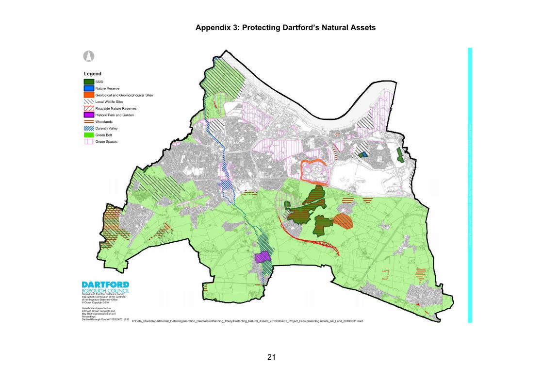
which introduced Sites of Special Scientific Interest (SSSIs). They are designated either by Natural England as biological interest SSSIs and/or published in the Geological Conservation Review as geological SSSIs. The 1949 Act also introduced National Nature Reserves (NNRs). They are some of the higher quality SSSIs that have also been designated by Natural England. There are five designated SSSI and NNR sites in the borough: 1: Swanscombe Skull Heritage Park; 2: Bakers Hole; 3: Wansunt Pit; 4: Darenth Wood/Lords Wood/Ladies Wood; 5: Farningham Woods.
3.4 The SSSI/NNRs are shown on the map and listed in the schedule of sites worthy of protection in Appendix 3.
3.5 Protection is also provided at the national level. The 1981 Wildlife and Countryside Act, (amended by the 2000 Countryside and Rights of Way Act) gives Natural England a statutory function to identify,
11 Dartford Borough Council (2008) Dartford Town Centre Area Action Plan – Submission Document 12 Enfusion (January 2008) Sustainability Appraisal/Strategic Environmental Assessment: Core Strategy Sustainability Appraisal Report and Enfusion (August 2007) Sustainability Appraisal/Strategic Environmental Assessment: Dartford Town Centre Sustainability Appraisal Report
4

designate and advise upon areas of biological and geological significance. Most recently, Section 41 of the 2006 The Natural Environment and Rural Communities Act requires that the Secretary of State and Natural England publish a list of habitats/species that are of principle importance to the preservation of biodiversity.
3.6 The 1994 UK Biodiversity Action Plan (BAP)13 was prepared in response to Article 6 of the Convention of Biological Diversity. It provides a detailed plan of the UK’s biological resource and provides the national framework for conserving and enhancing biological diversity within the UK. By 2007, the UK BAP contained 1150 species and 65 habitats. UK Habitat Action Plans (HAPs) and UK Species Action Plans (SAPs) have also been prepared.
3.7 Arising from the UK BAP, Natural England’s predecessors identified different natural areas based on distinct ecological divisions. Their report, The Character of England14, identified 76 different terrestrial Natural Areas for England, three of which are relevant to Dartford: Greater Thames Estuary15 - the Natural Area covers the Dartford Marsh, Swanscombe Peninsula,the coast and low-lying hinterland. The intertidal zone in Dartford is dominated by salt marshes.These are separated along most of its length by man-made sea defences. Urban development isalso present. The area is characterised by open, predominantly flat landscapes and panoramicseascape views; North Kent Plain16 - the Natural Area covers south of the A2 and consists of open, low and gentlyundulating land. It is one of the most fertile and productive agricultural areas in Kent with intensivelycropped irregular fields in addition to woodland; North Downs17 - the Natural Area is present in the south eastern tip of the borough. The NorthDowns form one of the most striking landscape features in the South East of England and haveoutstanding nature conservation interest.
Regional Level Designations 3.8 Regionally Important Geological/Geomorohological Sites (RIGS) are designated at the regional level
for their geodiversity value. These are sites that do not have national recognition as SSSI but are important in the local area. In the borough there are two RIGS: 6: Bluewater Quarry; 7: Beacon Wood Country Park.
Both of these are displayed on the map and included within the schedule of sites worthy of protection in Appendix 3.
3.9 The Wildlife Trusts across the south east of England have grouped together to create the Living Landscape project, which seeks to provide an ecological network approach to rebuilding biodiversity. It focuses on restoring, recreating and reconnecting the natural environment and connecting people with nature. It’s key principles are to protect designated sites, ensuring multi-functional land management, focussing on BAP habitats and species, connecting large habitat areas, sympathetic management of wildlife in agricultural land through Environmental Stewardship and supporting local communities.
County Level Designations 3.10 The Kent Biodiversity Partnership (KBP) has taken forward BAP work at the county level, starting with
the first Kent Biodiversity Action Plan18 which sought effective conservation of protected habitat and species. In 2000 they prepared the Kent Red Data Book19, which provides details of over 1300 species of flora and fauna which are rare or threatened in Kent. In 2003, they carried out the Kent Wildlife
13 DoE (1994) Biodiversity: The UK Action Plan 14 English Nature/Countryside Commission (1996) The Character of England: landscape, wildlife and natural features 15 English Nature (1997) Greater Thames Estuary Coastal Natural Area Profile 16 English Nature (1997) North Kent Plain Natural Area Profile 17 English Nature (1997) North Downs Natural Area Profile 18 Kent Biodiversity Partnership (1997) Kent Biodiversity Action Plan 19 Kent Biodiversity Partnership (2000) The Kent Red Data Book
5
Habitat Survey20. It found that semi-natural habitats and amenity grasslands make up 29% of the borough, and that 43% of semi-natural habitats are designated sites. It also identified that out of the 137 Habitat Survey categories, 60 occur in Dartford, reflecting the fact that despite the small size of the borough, it encompasses a wide range of habitats. Since then they have prepared a new species list containing 345 species, including water vole, dormouse, nightingale, great-crested newt and white-clawed crayfish and these are present in Dartford. The KPB have also prepared 28 Kent Habitat Action Plans (HAP)21 and many of these priority habitats are of relevance to Dartford, including: marshes - coastal saltmarshes, coastal grazing marshes, floodplain grazing marshes;water bodies - aquifer fed naturally fluctuating water bodies, eutrophic standing waters, ponds, riversand streams; lowlands - fens, calcareous grasslands, dry acid grassland, meadows and heathlands;woodlands - mixed deciduous woodland, wet woodland.
3.11 Many of Dartford’s sites contain BAP Priority Habitats, and these have been used as the basis for identifying improvements to BAP Habitats – see section 4.
3.12 Specific wildlife sites have been protected since the 1980s when Sites of Nature Conservation Interest (SNCIs) were identified. Additionally, Kent Wildlife Trust designates Local Wildlife Sites (LWS) within Kent and Medway. Although not always of national importance, these sites are of sufficient interest as to merit recognition. Kent Wildlife Trust are also responsible for designating Roadside Nature Reserves (RNRs). These are verge sites that provide (or have the potential to provide) grassland habitats that are biologically rich. LSW and RNR provide protection to sites not covered by other designations and ensure the countryside as a whole is rich in wildlife.
3.13 Dartford has 13 LWS, as listed below and shown on the map and in the schedule of sites worthy of protection in Appendix 3: 7: DA10 Beacon Wood Country Park; 8: DA01 Green Street Green Common LWS; 9: DA02 Sutton-at-Hone Churchyard LWS; 10: DA03 Sutton-at-Hone Lakes LWS; 11 and 12: DA04 Dartford Marshes LWS; 13: DA05 Ebbsfleet Marshes; 14: DA06 Joyden’s Wood and Chalk Wood LWS; 15: DA07 Dartford Heath LWS; 16: DA08 Railway Cutting (CTRL) LWS; 17: DA09 Woods at Wilmington LWS; 18: DA11 Chalk Bank LWS; 19: DA12 Mabledon LWS; 20: DA13 Alkerden Lane Pit LWS/Swanscombe Skull Heritage Park/Craylands Gorge.
3.14 Dartford has 5 RNRs, as listed below and shown on the map and in the schedule of sites worthy of protection in Appendix 3: 21: D1Longfield Road/New Barn Road RNR; 22: D3 Joyce Green Lane RNR; 23: D4 B260 Main Road RNR; 24: D8 Station Road RNR; 25: D10 Mounts Road RNR.
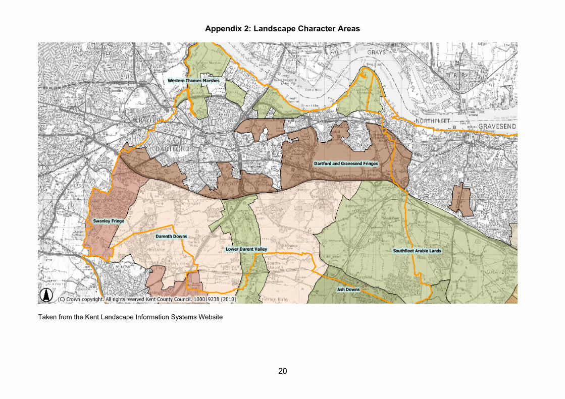
3.15 The Landscape Assessment of Kent22 categorises Dartford’s natural resource into a number of Landscape Character Areas – as shown on the map in Appendix 2 and listed below: Darenth Downs – this covers the gentle undulating dip slope of the North Downs with open arablelandscape, ancient semi-natural woodland at Darenth Woods, Lords Wood and Ladies Wood. It has
20 Kent County Council et al (1994 and 2003) The Kent Wildlife Habitat Survey 21 Kent Wildlife Trust website 22 Kent County Council/Jacobs Babtie (October 2004) The Landscape Assessment of Kent
6
attractive views southwards. Views northwards are dominated by the urban edge and major transport routes; Lower Darent Valley – this covers the River Darent Valley with a distinctive landscape. The chalk streammeanders through the flat flood plain. Gravel extraction has created a series of recreational fishing lakesthat have returned to nature at Sutton-at-Hone Lakes and Brooklands Lakes. The landscape is dissectedby major transport routes; Southfleet Arable Lands – this covers the eastern part of the borough, with open undulating arablelandscape, interspersed with unkempt hedgerows, copses. The landscape is impacted by the HighSpeed 1 railway line and electricity powerlines; Western Thames Marshes – this covers low-lying flat, open marshland at Dartford Marshes andSwanscombe Peninsula in the northern part of the borough that is fragmented by built development; Dartford and Gravesend Fringes – this covers a number of open areas such as Dartford Heath, DarenthCountry Park and part of Darenth Woods that are rural in character, which perform an important amenityfunction within or close to the urban area. It also covers former chalk quarries at Eastern Quarry andEbbsfleet, both of which have planning permission for development; Ash Downs – this covers a small area south of New Barn and provides a pleasant area of well-woodeddry valleys, narrow country lanes and attractive southwards views; Swanley Fringe – this covers the south western corner of the borough, formed mostly of woodlands atJoydens Wood.
3.16 Kent County Council have also surveyed the historic parks and gardens in Kent23. Within the borough there is one historic garden at 26: St John’s Jerusalem that has an impact on Dartford’s rural landscape. It is shown on the map and in the schedule of sites worthy of protection in Appendix 3.
Features of Local Value 3.17 Other local features have been recognised for their biodiversity and landscape importance. Woodlands
are a major land use and covers significant areas of the countryside. They contain remnants of ancient woodlands (in existence from medieval times without being cleared for uses other than wood and timber production). There are 13 woodlands in the borough that add to the appearance of the landscape, provide a habitat for wildlife, give shelter to animals and provide timber: 4: Darenth Woods; 5: Farningham Woods; 7: Beacon Wood Country Park; 14: Joydens Wood/Chalk Wood; 17: Rowhill Woods; 27: The Thrift; 28: Stone Wood; 29: Court Wood; 30: Beaton Close Woodland; 31: Bean Road Woodland; 32: Trolling Down Hill Wood; 33: Watling Street/Bean Triangle; 34: Darenth Country Park.
These woodlands are plotted on the map and listed in the schedule of sites worthy of protection in Appendix 3.
3.18 Darent Valley is a feature which has particular significance locally, for its landscape qualities, its ease of access and its interpretative and educational potential. Starting in the North Downs the river makes it’s way northwards through sites such as 10: Sutton-at-Hone Lakes, 36: Brooklands Lakes, 37: Central Park, Dartford Town Centre, Northern Gateway, 12: Dartford Fresh Marshes and 11: Dartford Marshes until it flows into the River Thames.
3.19 The southern half of the borough is Green Belt. Some parts of the borough north of the A2 still remain in the Green Belt, including Dartford Heath and Dartford Marshes. Overall, there are 19 formally
23 Kent County Council (1992) The Historic Parks and Gardens of Kent
7

4
designated sites and 11 sites that are not designated but have local value located within the Green Belt. The majority of the countryside south of the A2 is agricultural land and a significant proportion of it is within grades 1, 2 and 3a (the best and most versatile agricultural land). Parts of the borough have a market gardening agricultural economy. Hedgerows make a significant contribution to agricultural land. They provide effective boundary providing screening, security as well as providing wildlife habitats and a safe haven for flora and fauna.
3.20 Dartford’s Open Spaces Technical Paper24 has analysed the existing supply of open spaces, including natural greenspaces. The sites with a primary or secondary function categorised as 1a Formal Garden, 1b Country Park, 2a Nature Conservation Sites, 2b Other Semi-Natural Greenspace, 2c Neglected and Damaged Land and 3 Green Corridor have been included here as they have the potential to harbour wildlife. The natural greenspace sites are identified on the map and in the schedule in Appendix 3. They include: 28 natural greenspace sites also designated as SSSI, RIGS, LWS, historic garden and locally valuedwoodland; 26 additional natural greenspace sites that have no specific nature conservation designation butnevertheless perform an important function of introducing natural greenspace into the urbanenvironment, forming a backdrop to the urban landscape. If connected, they have the potential toenable wildlife to migrate through the urban area.
3.21 In total there are 62 natural asset sites shown on the map and listed on the schedule in Appendix 3 that are worthy of protection and conservation. It is easy to see from Appendix 3 that many of the sites have multiple designations and local features of nature conservation importance, hence there is some repetition in the lists of sites in the paragraphs above. The policy framework outlined in section 2 provides guidance regarding the sensitive control of development. Those with formal designations require the most protection from development. The local nature conservation and landscape value associated with the other listed sites should be included as material considerations when determining applications that are located on, or impact on, local feature sites. The need for further local level policy to protect the borough’s natural assets, either designated at the local level or undesignated sites of local value, will be considered in the Development Management DPD.
Summary
Section 3 identifies that a multitude of designated sites and features of local importance are present in Dartford. In many cases each site has been designated several times. Appendix 3 contains a map showing the spatial distribution of the existing designated sites. There is a relatively good spread across the borough with sites interspersed in the urban area, sites located close to the edges of the urban area and sites located within the countryside. Given the large number of sites shown in Appendix 3, the borough has a varied and widespread biological resource.
Enhancing Dartford’s Natural Environment
4.1 In addition to conserving designated sites, there is a need to enhance nature conservation in a proactive way and to increase biodiversity across the borough.
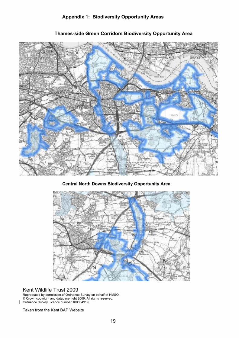
Biodiversity Opportunity Areas 4.2 At the regional level, the South East Biodiversity Strategy25 identified areas of greatest biodiversity
opportunity, where the delivery of BAP targets will be focussed. At the county level, the Kent Wildlife Habitat Survey and Kent Landscape Information System data has been used to model ecological network for the county that in turn has informed the location of 16 Biodiversity Opportunity Areas (BOAs) across Kent. Appendix 1 shows the two BOAs relevant to Dartford. Virtually all of the undeveloped land north of the A2 and substantial amounts of land south of the A2 fall within the BOAs, suggesting that the borough has significant potential for enhancing biodiversity in the future.
24 Dartford Borough Council (June 2010) Dartford’s Open Spaces: Open Space Technical Paper 25 South East Biodiversity Forum (SEEBF) (2009) South East Biodiversity Strategy
8
4.3 The Thames-side Green Corridors BOA26 presents very varied wildlife sites, including ancient semi-natural woodland, several Local Wildlife Sites and a number of brownfield sites of known importance for invertebrates. It covers the majority of the borough’s natural sites in the south of the borough, greenspaces and degraded land in the urban northern part of the borough, some potential development sites and parts of Gravesham. It has grazing marsh, river valley, woodland, heathland and former chalk quarries fragmented by urban development and transport corridors. The floodplain of the Darent Valley runs northwards from the North Downs, forming a wet landscape and water-filled gravel pits. Specific ecological interest include intertidal habitats and coastal grazing marsh, one of the most extensive heathland and acid grassland sites in Kent, nationally important ancient woodland, some chalk grassland, important brownfield sites and key species including brown hare, water vole, reed bunting, adder, shrill carder bumblebee, the brown-banded carder bee, the picture-winged fly and the weevil-hunting wasp.
4.4 The Central North Downs BOA27 encompasses the rolling downlands in the borough of Sevenoaks and Farningham Woods SSSI, just within Dartford’s southern boundary. The landscape consists of chalk downland with steep wooded scarps and it includes the mid stretch of the Darent Valley, some intensive arable cultivation, chalk grassland sites and irregular pastures in the valleys. Specific ecological interest includes nationally important woodland, as well as many small ancient woodlands, the River Darent and its floodplain, and Sutton-at-Hone Lakes form an important landscape element. Key species include otter, crayfish, adder, dark green fritillary, chalk hill blue, early gentian, Deptford pink and juniper.
4.5 The BOAs provide a spatial reflection of the UK BAP and Kent BAP targets by 2015 and indicate the areas where enhancements should take place in order to secure maximum biodiversity benefits. However, the BOA Statement Documents recognise the need for flexibility in policy application relating to BOAs: BOAs are areas of opportunity, not constraint. Nature conservation should not necessarily becomethe primary land-use within the BOA and development in these areas should not be precluded solong as the nature conservation targets can be achieved. On the other hand, development within aBOA should not significantly increase the fragmentation of wildlife habitats or neutralize significantopportunities for habitat restoration; BOAs are not definitive. They focus on priority habitats for which the areas is known to be mostimportant but other habitats may also exist. BOAs are not intended to cover all BAP habitats nor allareas where new habitat creation is possible; BOA boundaries are not absolute. A project immediately outside the boundary should not bedismissed if it would help to deliver BAP targets. Not all land within a BOA offers the sameopportunities for habitat restoration or recreation; areas outside the BOAs still have substantial biodiversity interest, and it will still be necessary tomaintain and enhance areas of wildlife habitat outside the BOAs in order to maintain the wildlifeinterest and richness of the wider countryside. Some biodiversity interest such as wildlife associatedwith arable farmland, and widely dispersed species will need improvement across the whole of thecountryside, not just within the BOAs.
4.6 With these limitations in mind, Dartford’s BOAs as shown on the map in Appendix 4 are the prime focus for nature conservation action within the borough. The following section identifies the sites that can contribute to enhancing the four main BAP habitat types within the BOAs. Specific ongoing or planned enhancement schemes are also acknowledged. Lastly, some general principles on improving each of the BAP habitat types are summarised. To avoid lengthy referencing within the text below, the main source documents are noted here. The description of the four habitat types has been primarily based on information contained in Dartford’s s41 Report28 and the Kent Wildlife Habitat Survey and Bluewater Ecological Survey29. Suggested enhancements and conservation priorities noted at the end of each habitat section have been taken from a range of studies, plans and strategies including: Thames Strategy East30; Landscape Assessment of Kent;
26 BOA Statement from website 27 BOA Statement from website 28 Kent Wildlife Trust (2009) Biodiversity Action Plan (s41) Habitats, Species and Protected Species. 29 Kent Wildlife Trust (2008) Bluewater, Dartford, Kent: Ecology Survey 30 Thames Estuary partnership (2008) Thames Strategy East
9
North Kent Plain Natural Area Profile; Greater Thames Estuary Natural Area Profile; North Downs Natural Area Profile; Kent Wildlife Habitat Survey; Darent Valley Cluster Study31; Thameside Green Corridors BOA Statement; Central North Downs BOA Statement; Dartford’s s41 Report.
Marshes 4.7 There are four main BOA sites that contain BAP priority marshland habitat, as can be seen on the map
in Appendix 4, including: 11: Dartford Marshes; 12: Dartford Fresh Marshes; 13: Ebbsfleet Marshes; 56: Black Duck Marsh.
4.8 Work is already underway to conserve, restore and enhance marshland at 11: Dartford Marshes, which contain both saline and fresh water flora species which are tolerant of saline conditions. An important feature of the marshes is the waterways and dykes that support both rich flora and water voles and feed the grazing marshes. The "Managing the Marshes" project is run by Groundwork and the University of Greenwich and supported by GlaxoSmithKline and Dartford Borough Council. The Environment Agency is supporting the development of a water level management plan, which is important in securing the future of the site. The “Managing the Marshes” initiative may offer the opportunity to move towards formal designation as a nature reserve. The Vision and Strategy32 recognises the potential for the marshes to develop as a multi-functional open space that provides resources for people visiting the area whilst also conserving and enhancing habitats and the landscape. It sets out a 10 year plan that a) protects and enhances habitats, b) enhances visual connections, c) enhances access, d) responds to flood risk and climate change, e) enhances education and community links and f) introduces framework plans of how the strategy may be delivered, subject to landowner agreement, funding, management arrangements and planning processes. The south eastern part of the site contains a large area of unimproved neutral grassland, and there are opportunities to link the grassland with the marshes in the northern part of the site, thereby creating green corridors.
4.9 A number of conservation and enhancement objectives have already been identified for marshland habitats in general. These include: protecting, restoring, enhancing and creating new grazing marsh, salt marsh, wetlands, reed beds, and marshy grassland. This includes restoring 50ha of grazing marsh at 11: Dartford Marshes; encouraging management practices that maintain undisturbed feeding and roosting areas for wildfowl and waders, maintain an interconnected network of estuarine habitats, maintain sea walls without detriment to habitats and species, enhances water supply, water quality, flood storage and water levels in grazing marshes and maintains a diverse range of ditch habitats through appropriate grazing and mowing regimes; protecting the open estuarine character of marshlands, ensuring that adjacent development respects the inherent landscape conditions and uses buffer zones; creating multi-functional green infrastructure that improves biodiversity value and connectivity; protecting marshlands from the effects of coastal squeeze, where rises in sea level result in increases in salinity and inter-tidal habitats becoming compressed, with consequent impact on fishes, wading birds, sensitive aquatic and marginal vegetation and aquatic invertebrates.
31 Darent Valley Cluster Study Leaflet 32 Bexley Council et all (2006) Managing the Marshes Vision and Strategy
10
Water Bodies 4.10 The majority of the borough’s water bodies are included as BOA sites. There are a number of sites
across the borough where enhancements to water bodies could be made, as shown on the map in Appendix 4. These include: 6: Bluewater Quarry; 7: Beacon Wood Country Park; 10: Sutton-at-Hone Lakes; 13: Ebbsfleet Marshes; 37: Central Park; 56: The Bridge.
4.11 The River Darent creates an important blue corridor running from the south to the north of the borough. Dartford’s Green Heart is a project funded by the ODPM as part of the Thames Gateway Parklands project. It focuses on access improvements and associated ecological works along the River Darent, especially in the town centre, in the Northern Gateway, at the tidal creek in 11: Dartford Marshes and further upstream. One of the key elements of the Dartford Green Heart project is to restore and improve the habitat within 37: Central Park by enhancing the River Darent and establishing a new ecology island between the two branches of the River Darent.
4.12 In addition, there are a few sites outside BOAs that provide opportunities to enhance aquatic environments. These flooded gravel pits create recreational fishing lakes and are also shown on the map in Appendix 4. They include: 36: Brooklands Lakes; 48: Crossways Lakes.
4.13 A number of conservation and enhancement objectives have already been identified for water bodies and their surrounding land. These include: restoring the Lower Darent Valley by safeguarding water quality, encouraging open bank-side habitats to the river and improving their quality, maintaining water flows and increasing the depth of river flow at strategic sites, restoring a vegetative framework to the fields on lower slopes; promoting green corridors, as identified in the Darent Valley Cluster Study which seeks to safeguard the valley and path, with priority given to initiatives that enhance nature conservation and recreation; enhancing the Darent Valley landscape by retaining the rural character, by replanting hedgerows, river's edge trees and tree clumps, seeking ways of reducing motorway noise without increasing visual intrusion, enhancing or restoring the natural floodplain habitats and emphasising views of current landmarks.
Lowland Grasses and Heath 4.14 There are a number of BAP priority grasslands (neutral, calcareous, acid grassland/heathland) which are
present within BOA sites. Enhancements could be made to these grasslands, as shown in Appendix 4: 4: Darenth Woods; 6: Bluewater Quarry; 7: Beacon Wood Country Park; 8: Green Street Green Common; 10: Sutton-at-Hone Lakes; 14: Joyden’s Wood and Chalk Wood; 15: Dartford Heath; 19: Mabledon; 20: Swanscombe Skull Heritage Site; 34: Darenth Country Park; 47: Dartford Marshes; 51: Stone Pits 9 and 9a; 55: The Bridge; 59: Stone Lodge and surrounding pits including 49: Stone Discovery Park.
11
4.15 Ongoing management is already taking place on some of the borough’s grasslands. For instance, parts of 15: Dartford Heath have become colonised by trees and scrub or suffer from bracken encroachment. Groundwork Kent Thameside helped prepare a management and restoration plan for the heath33. The management on this site is now ensuring that the habitat is recovering. The grassland and water body habitats at 6: Bluewater has been managed for over 10 years and will continue in the future. The margins of the quarry have now been found to support good species diversity. The Kent Wildlife Trust has aspirations to turn the landfill pits adjacent to 59: Stone Lodge into 49: Stone Discovery Park34 with the creation of a wildlife rich accessible greenspace for the local community to utilise. Proposals include the creation of wild flower grassland, wild flower meadow, ponds, trim trail, hedgerows, trees, woodland and scrub, increased populations of reptiles, insects and birds, with enhanced access through the site and enhanced community planning, involvement and management of the site.
4.16 A number of conservation and enhancement objectives have already been identified for lowlands. These include: restoring, enhancing and recreating heathland, unimproved calcareous grassland both in and around built-up areas, including restoring at least 12 hectares of heathland at 15: Dartford Heath, 40 hectares of acid grassland and heath adjacent to 4: Darenth Woods, 100 hectares of species-rich neutral grassland in blocks of 2 hectares or more adjacent to existing species-rich grassland or other semi-natural habitat and 10 hectares of chalk grassland in the Darent Valley area - all by 2015; protecting against pollution and nutrient enrichment, especially nitrogen enrichment from farm fertilisers, sewage run-off and car emissions. Unimproved grassland and heathland flora species only survive if the soil is nutrient-poor with flora growing in a thin layer of poor soil on top of chalk, peat clay or gravel. Increases in nutrients encourage the growth of invasive grasses which swamp tender grasses flowering plants and shrubs on which the specialised fauna feed; protecting against habitat fragmentation. The growth in industry and urban development, pollution and climate change have also led to unimproved grassland and lowland heathland becoming increasingly rare. What remains often comprises of small fragments, unconnected to other habitat.
Woodlands 4.17 The BOA sites also include BAP priority woodlands. This includes both ancient semi-natural woodlands,
broad-leaved woodlands and wet woodland habitats, all of which are indigenous to the local area. Appendix 4 shows that enhancements to woodlands should be focussed on the following sites: 4: Darenth Woods; 5: Farningham Woods; 7: Beacon Wood Country Park; 10: Sutton-at-Hone Lakes; 14: Joyden’s Wood/Chalk Wood; 15: Dartford Heath; 17: Rowhill Woods (not part of the BOA sites); 20: Swanscombe Skull Heritage Park.
4.18 Many of these woodlands are now being managed in line with nature conservation objectives. Traditional coppicing techniques have been re-introduced, including at 4: Darenth Woods, which are an extensive ancient semi-natural woodland containing some of the most valuable woodland in North West Kent.
4.19 A number of conservation and enhancement objectives have already been identified for woodlands. These include: protecting the valuable woodland resource, especially ancient semi-natural woodlands, native broad-leaved woodland and promoting conversion of existing woods back to native species (especially on ancient woodland sites), in character with the local landscape;
33 Groundwrok Kent Thameside/DBC (2006) Dartford Heath Management and Restoration Plan 34 Kent Wildlife Trust (2008) Stone Discovery Park: Master Plan
12

promoting tree planting, especially a woodland corridor between 4: Darenth Woods and Shorne/Ashenbank Woods SSSI, a new ecologically rich vegetative cover woodland adjacent to the motorway corridor and reconnecting fragmented woodlands where this would not conflict with grassland conservation. New woodland planting that leads to the establishment of large, commercial coniferous plantations should be avoided as they are alien to the local landscape. Buffer planting can help to reduce the visual impact of new development and the intrusiveness of the A2 and M25; protecting woodlands from habitat fragmentation. The loss of ancient woodland has led to only small pockets of ancient woodland remaining where once there was extensive woodland cover. Species which rely on this habitat need continuous woodland cover for migration to occur. Due to fragmentation, many woodland species are unable to spread and have become isolated, leaving them vulnerable to localised extinction. Increasing woodland cover and creating new linkages between them will help to create new migration routes; re-introducing good management practices such as coppicing can also help to increase the quality of existing woodland areas.
Outside BOAs 4.20 There are some types of habitat and landscape that have not been included within the BOA but
nevertheless warrant protection and enhancement. Much of the land to the south of A2 is in agricultural use, especially the area in the east of the borough, identified as Southfleet Arable Lands. In this area the agricultural landscape needs enhancing by encouraging a pattern of arable fields interspersed with woodland blocks, so that ecologically rich corridors can be encouraged. Agricultural land also creates an edge to the urban area and views across open farmland should be preserved. Greater diversity and abundance of wildlife within intensively farmed land should be promoted by creating new habitat and allowing tree planting on arable land that is surplus to agricultural needs.
4.21 Hedgerows are an important feature of the agricultural landscape and are valuable wildlife habitats that act as places of refuge as well as green linear corridors that help species to migrate across the countryside. There is over 100 km of hedgerows throughout the borough although much of this is species poor, no longer stock proof or contains trees and only 27km are species rich. Despite protection under the 1997 Hedgerow Regulations, hedgerows have been lost since the mid 70s. The retention, restoration and protection of hedgerows is therefore important and opportunities to enhance the hedgerow network should be supported, whilst replacement of hedgerows by walls or fences should be discouraged.
4.22 There are a number of churchyards throughout the borough, but only one, 9: Sutton-at-Hone Churchyard, is included within the BOA. It contains meadow saxifrage, a scarce species in Kent, as well as a diverse community of lichens. Other churchyards and cemeteries also provide a place of refuge for wildlife within the urban area and can act as stepping stones for migrating species. Likewise, private gardens and allotments form an additional resource for species to utilise. As such, these additional open spaces should be protected from development and wildlife should be encouraged to flourish where possible. The Temple Hill Trust has been working on the 45: Enchanted Woodland site at the north of Temple Hill, helping it revert back from a former cemetery into a natural woodland. Their aim is to make this 3.5 acre woodland oasis a fully accessible leisure space for all residents, allowing people to enjoy a quiet and natural place amongst the urban environment..
Protected Species 4.23 A number of protected, rare and scarce species also flourish in the borough. The East Thames corridor
is especially important for invertebrates including nationally important solitary bees, rare spiders, rare beetles and flies within the borough. Amphibians are also important to the borough, with great crested newt, common frog, grass snake, common lizard and slow worms. There are also waterfowl and wading birds, many of which are protected under European law as well as a range of common birds, woodland and farmland birds including owls. Protected mammals in the borough consist of water voles bats badgers and hazel dormice. Most of the BOA sites contain protected species, as shown on the map in Appendix 4 and in the list below. Appendix 3 provides details of the specific types of species that are protected in each site: 1 and 20: Swanscombe Skull Heritage Park;
13
4: Darenth Wood; 6: Bluewater; 7: Beacon Wood Country Park; 10: Sutton-at-Hone Lakes; 11: Dartford Marshes; 14: Joydens Wood/Chalk Wood; 15: Dartford Heath; 17: Rowhill Woods; 19: Mabledon Hospital; 55: The Bridge; 56: Black Duck Marsh/Swanscombe Peninsula; 57: St James Lane Pit; 58: St Clement’s Valley; 65: Eastern Quarry.
Biodiversity in Development Sites 4.24 As acknowledged in paragraph 3.2, Dartford will experience significant growth which could affect the
wildlife, landscape and character of the area. Dartford’s s41 Report recognises development and human disturbance as threats to habitats and species. For instance, reclamation of coastal habitats for shorefront development can contribute to the loss of inter-tidal and grazing marshes. Industrialisation can create pollution and waste discharge which increases nutrients, to the detriment of grassland and marshland habitats. Modern agricultural practices can lead to the deterioration of ancient woodland. Low flying aircraft, bait digging and shooting also disturbs wildlife. Dartford’s s41 report also identifies alien, or non indigenous species, as one of the threats to habitats. With no predators to limit growth and an ability to produce huge amounts of seeds, some alien plants quickly spread and can swamp indigenous ground and shrub flora, in some cases creating a monoculture of one species.
4.25 The Open Spaces Technical Report has assessed the ability of development sites, as identified in the SHLAA35 and SELAA36, to accommodate natural greenspaces alongside development. The report identified a number of sites where natural greenspace could be included as part of a re-development scheme: 19: Mabledon *; 55: The Bridge *; 56: Swanscombe Peninsula *; 57: St James Lane Pit *; 58: St Clement’s Valley; 59: Stone Lodge *; 61: Fantaseas *; 62: Ingress Park; 63: Thames Europort; 64: Everards; 65: Eastern Quarry *; 66: Ebbsfleet Valley *; 67: Crayland’s Lane*; 68: The Northern Gateway; 69: Stone House Hospital.
4.26 It is evident from the list above that many of the allocated development sites (marked as *) are either former quarries, landfill sites or other previously developed land that has lain vacant for considerable amounts of time, and special consideration needs to be given to this neglected and damaged land. The East Thames Corridor is acknowledged for it’s national importance in terms of brownfield land biodiversity. Since 2007, it has been designated as a UK BAP priority habitat – open mosaic habitat
35 DBC (2010) Strategic Housing Land Availability Assessment (SHLAA) 36 DBC (2010) Strategic Employment Land Availability Assessment (SELAA)
14

on previously developed land (OMHPDL). Furthermore, the National Brownfield Strategy37 emphasised the potential importance of previously developed land for nature conservation interests and the need to protect these interests where appropriate.
4.27 Many of the sites listed as * above may qualify as OMHPDL priority habitat. The majority of the sites are remnants of chalk quarries, gravel quarries and landfill waste sites and because they have been left vacant, without public access, for significant amounts of time, they are reverting back to nature. Many of the sites now serve as wildlife refuges and have already accumulated significant ecological value. Re-development of these sites could lead to a reduction in biodiversity and sites will need to be carefully designed to ensure the long-term survival of existing wildlife. This ecological resource should be retained and enhanced by integrating rich, biodiverse urban greenspaces and ecological networks into re-development and restoration schemes. Utilising existing habitats can help to alleviate the need for costly landscaping works, can help to achieve BAP targets and can help to create stepping stones that allows species migration and wildlife adaptation to climate change. Further benefits can be accrued from tree planting on previously developed land which will act as carbon sinks within the urban environment.
4.28 There are a number of greenfield and previously developed sites that provide the opportunity to significantly enhance biodiversity, as part of their re-development. 60: Ebbsfleet Valley and 63: Eastern Quarry are vast sites that can provide large amounts of development as well as accommodating a number of BAP priority habitats. For example, redevelopment can help to bring about qualitative improvements to wetland and water body habitats at 13: Ebbsfleet Marshes and woodlands at 20: Craylands Gorge. The Eastern Quarry BAP Report and Implementation Plan38 is committed to meeting BAP targets by seeking to enhance populations of great crested newts, bats, reptiles, birds, invertebrates, plants, lichens and fungi. It identifies 12 different areas which will have their own specific actions to enhance biodiversity across individual parts of the site, including cliffs, cliff tops and 20: Craylands Gorge. It has identified zones where wetland habitats will be created, ecological and natural reserve areas along the quarry sides and on the top of the quarry and through 20: Craylands Gorge, an ecological connectivity corridor along the northern edge of the site and green zones incorporating elements of habitat creation running north-south through the site.
4.29 56: Swanscombe Peninsula is another large site that can accommodate both development and nature side by side. It has a unique character with remnant marshland at 56: Black Duck Marsh. Redevelopment will provide the opportunity to not only enhance the nature conservation of 56: Black Duck Marsh but can also enhance flood risk management, provide new green corridors and protect the panoramic views over the peninsula.
4.30 In re-developing 68: Northern Gateway, there is an opportunity to enhance biodiversity of 12: Dartford Fresh Marshes as well as the aquatic environment along the River Darent and at the Mill Pond. The potential introduction of a tidal lock may change the river levels along the Dartford Creek (part of the River Darent) which in turn could impact negatively on inter-tidal mud flat habitats but on the other hand could introduce a greater variety of aquatic species.
4.31 There are currently proposals under consideration to redevelop part of the abandoned 19: Mabledon site as a crematorium. The remainder of the site is planned to be handed over to the Land Restoration Trust in order that they turn this important grassland site into a nature reserve, with improvements made to the management of the grassland habitat.
4.32 Stone Lodge Ecological Survey39 identified that 59: Stone Lodge has an interesting matrix of habitats, with an intrinsic wildlife interest. Re-development of the western plateau part of the site for leisure and recreational uses may reduce the overall amount of natural greenspace but could enable enhancement of the ecologically rich parts of the site, especially the southern valley.
37 English Partnerships (2007) Brownfield Strategy Recommendations to Government 38 Middlemarch Environmental Ltd/Land Securities (2008) Eastern Quarry 2 Biodiversity Action Plan and BAP Implementation Plan 39 Ecology Consultancy (2002) Stone Lodge, Dartford: Draft report of Ecological Survey
15
4.33 Development schemes in general should seek to go beyond the protection of existing wildlife by considering the general advice outlined below by ensuring development: mitigates against the negative effects of urban development and ensures no loss of priority habitats and species; helps to create a new, improved urban edge, with better links and views to the countryside beyond, the creation of a more cohesive landscape character and enhanced links between existing natural habitats into developed areas; contributes to BOA targets and in particular enhances marshland, water bodies, grassland and woodland habitats; uses buffer zones, trees, hedges and copses to limit the impact of development on nearby wildlife sites and to create positive landscape features that can effectively screen development, and create a more attractive edge to the urban area; does not encourage the spread of invasive, non-native species by avoiding the planting of the most virulent species such as rhododendron in acidic conditions, buddleia on chalk, Himalayan balsam, Japanese knotweed and giant hogweed on wetland habitats; follows the advice contained in Kent Design Guide’s Technical Appendix on Biodiversity40 which stresses the importance of evaluating sites for their ecological potential, maintaining existing habitats, creating habitat corridors and stepping stones, incorporating a landscape design approach, enhancing a number of key habitats, promoting Sustainable Drainage Systems and living roofs and accommodating bird nest sites and protected species; provides extensively for flower rich green and brown roofs, which can act as an important mitigation tool to help with climate change adaption; is designed to a high standard to reflect the features of the surrounding natural environment, thereby creating a sense of place; provides interpretation panels to inform people of the ecological value of the site.
Recreational Access 4.34 When combined together, the enhanced and new natural greenspaces arising from development sites
will provide significant improvements to the Green Grid. In particular, 56: Swanscombe Peninsula, 57: St James Lane Pit, 58: St Clements Valley, 59: Stone Lodge, 68: Northern Gateway, 55: The Bridge, 62: Ingress Park, 63: Thames Europort, 64: Everards, 65: Eastern Quarry and 66: Ebbsfleet are development sites that provide the opportunity to create new Green Grid sites and links, as shown in the Core Strategy’s Greenspaces Key Diagram. They perform a vital role in enabling habitats and species to migrate through the borough and help to reduce the severance effect created by barriers such as roads, railways and rivers.
4.35 Another important function of the Green Grid is to enhance recreational access to and through natural greenspace sites, so that people can get close to nature, learn about nature, relax in it, carry out recreational activities in it and generally help to increase people’s health, well being and quality of life. However, recreational access needs to be carried out in a manner that does not jeopardise biodiversity. Dartford’s s41 Report recognises that human disturbance can threaten habitats and species. In particular, trespassing and even walkers with dogs disturb wildlife, which in turn stops birds feeding. Trampling can damage the sensitive flora species within grassland and heathlands, depriving the specialised fauna of essential food species. Noise pollution, light pollution, fly tipping all impact negatively on the natural environment. The significant transport routes such as the A2 and M25 dissect the Borough making it difficult for both people to access the countryside and species to migrate.
4.36 Providing sites for recreation and improving access to the countryside will help to meet the increasing demands for recreation arising from the growing population, without the need to travel significant distances to find natural sites. Encouraging recreational use of the borough’s natural sites also helps to reduce visits to other sites outside of the borough, thereby helping to protect the integrity of the European sites (SACs, SPAs, Ramsar Sites) located in neighbouring boroughs – this is one of the
40 Kent County Council/Kent Wildlife Trust (2006) The Kent Design Guide: Biodiversity Technical Appendix
16
specific recommendations from Enfusion in their Appropriate Assessment (AA)41. The AA also stressed that recreational pressures arising from new development can be reduced by ensuring significant levels of greenspace within development sites.
4.37 The Open Space Technical Report identifies that all of the borough is encapsulated within the catchment rings of natural greenspaces - this means that residents living in the borough have good access to nearby natural sites, many of which are accessible greenspace (ANGST) sites or have the opportunity to become ANGST sites in the future with accessibility enhancements. Furthermore, local communities have access to a variety of types of BAP Habitats within easy reach of their homes – marshland at 11: Dartford Marshes, heathland at 15: Dartford Heath and woodland south of the A2. Improvement of rural-urban fringe sites will be particularly important.
4.38 Various access enhancement schemes are already planned. The Thames Gateway Delivery Plan42
seeks to establish the Thames Gateway Parklands, a network of landscapes, which amongst other things strengthens the identity and character of the Thames Gateway. The Thames Gateway Parklands Vision43 provides a spatial framework for the area focussing on reinvigorating the blue landscape as a major environmental, recreational, transport and economic asset, improving access for existing and new communities to significant landscapes, ensuring urban environments are part of the landscape and are integrated with rural areas, providing a connected parklands landscape and appreciating the agricultural landscapes.
4.39 As part of the Green Heart project, 37: Central Park will become a key gateway destination where local people will be encouraged to access open space and the countryside beyond. Improvements have already made, with the opening of a new entrance at the eastern end of Acacia Hall, two new bridges across the River Darent and the new tunnel under Princes Road provides easy access to 36: Brooklands Lakes and beyond. The Darent Valley Cluster Study acknowledges the River Darent as an important recreational route north-south through the borough and other improvements to the alignment of the Darent Valley Footpath will be secured, especially at Northern Gateway and 11: Dartford Marshes. New footbridges at 68: Northern Gateway and at 12: Dartford Marshes will improve east-west connectivity. The Cluster Study also emphasises the Sutton-at-Hone Lakes as a gateway to the countryside.
4.40 The Council has been working in partnership with Kent Wildlife Trust to improve access and signage through Darenth Woods. A circular route has been devised and is being constructed; an accessible route is also available.44 There are also longer term aspirations to link 34: Darenth County Park, 19: Mabledon, 4: Darenth Woods/Ladies Wood/Lords Wood, 7: Beacon Woods Country Park, 27: The Thrift and 28: Stone Wood with 10: Sutton-at-Hone Lakes to the west and eastwards to the countryside sites across the Gravesham border.
4.41 The Community Strategies and Kent’s Natural Environment45 acknowledges the need to celebrate local distinctiveness and enhance quality of life by making habitat enhancement and creation central to the Thames Gateway’s regeneration objectives. Furthermore, Dartford’s s41 Report identifies a BOA target to use biodiversity projects to improve the engagement of local people with the natural environment and to encourage their physical and intellectual access to the landscape and wildlife of the area.
4.42 Making it easy for people to move around the borough away from traffic also helps species in that they can use natural greenspaces as stepping stones and green corridors as key wildlife migration routes. The key to the Green Grid’s success will be in ensuring the introduction and enhancement of multifunctional green infrastructure that caters for people whilst also reducing disturbance to wildlife habitats.
41 Dartford Borough Council and Gravesham Borough Council (January 2008) Habitat Regulations Assessment: Appropriate Assessment Interim Report 42 CLG (2007) Thames Gateway the Delivery Plan 43 CLG (2008) Thames Gateway Parklands Vision 44 Kent Wildlife Trust: Darenth Wood promotional leaflet 45 English Nature et al (2003) Community Strategies and Kent’s Natural Environment
17
Management and Partnership Working 4.43 Dartford’s s41 report recognises lack of management as a threat to habitats and species. For instance,
under-grazing of marshes, inadequate mowing and cutting regimes and poor ditch management leads to declines in biodiversity, a reduction in waterfowl and silting up with direct impacts on species such as great crested newts and water vole. Neglect and poor management in ancient woodlands reduces their conservation worth. Traditionally, woods were coppiced but this has become less common and now much ancient woodland is unmanaged and overgrown, with a decrease in diversity of woodland ground flora and a loss of woodland butterflies. Grassland were originally man-made and they are vulnerable to changes in management. Abandonment of grazing or more labour intensive mowing regimes lead to changes in the flora, including increases in competitive plants such as tor grass in calcareous habitats, purple moor grass in acidic areas and cocksfoot and yorkshire fog on neutral grassland.
4.44 Management and partnership working are therefore essential in ensuring that habitat enhancement schemes are successful. Working with bodies that have a special interest in the natural environment will be needed, including Natural England, the Royal Society for the Protection of Birds, Kent Wildlife Trust, Forestry Commission, Environment Agency, South East England Biodiversity Forum, Groundwork Kent Thameside, farmers and landowners.
4.45 There are a number of examples where management and partnership is already working. These include 11: Dartford Marshes where the Council is working with a wide range of bodies including Bexley Council, Groundwork and the Environment Agency. A number of Countryside Stewardship Schemes exist throughout the borough at Dartford Heath, east of Beacon Wood Country Park, on the agricultural land surrounding Court Wood at Longfield and on agricultural land surrounding the junction of A2/M25. Kent Wildlife Trust has designated Roadside Nature Reserves where biodiversity is being enhanced by introducing a range of measures such as annual and biannual grass cutting, reducing competitive grasses in the sward, regular cutting of rank grasses to encourage interesting species to extend their populations, cut back shrubs and woody vegetation to restore more species rich grassland, no planting of trees or ground plants on road verges and reducing shade by cutting back vegetation, reducing overshadowing and colonisation by cutting back scrub, ivy and clematis and hedges.
4.46 There is a need to ensure cross boundary working. This is particularly so for Sevenoaks District Council where partnership is needed to secure environmental and access improvements to the Darent Valley and 5: Farningham Woods. Working with Bexley Council at 11: Dartford Marshes and 14: Joydens Wood. Working with Gravesham Borough Council will be important when implementing enhancement schemes at 13: Ebbsfleet Marshes, 56: Swanscombe Peninsula and cross boundary corridor improvements linking 4: Darenth Woods with Cobham/Ashenbanks.
Summary
Section 4 identifies opportunities to enhance BOA habitats and protected species, as shown on the map in Appendix 4. In particular, there are a number of development sites that can contribute to enhancing biodiversity across the borough, and meeting BAP habitat and species targets, as integral parts of their re-development. In addition to biodiversity enhancements, there are also opportunities to enhance the Green Grid network and provide recreational access. These improvements will combine to provide a multi-functional green infrastructure network across the borough.
Policy Implications
5.1 This Technical Report identifies the need for policies in the Core Strategy that will seek: to protect the existing natural environment for nature conservation and landscape purposes; proactive conservation of the natural environment including enhancements to existing natural greenspaces and habitats, especially those in development sites.
5.2 Issues to consider further in the Development Management DPD include whether there is a need for further local level policy, beyond national guidance PPS/PPGs, to protect BAP priority habitats and species, designated sites, features of local importance and the countryside in general, as well as generic policies for the enhancement of habitats, species and landscape.
18
5
Appendix 1: Biodiversity Opportunity Areas
Thames-side Green Corridors Biodiversity Opportunity Area
Central North Downs Biodiversity Opportunity Area
Kent Wildlife Trust 2009 Reproduced by permission of Ordnance Survey on behalf of HMSO. © Crown copyright and database right 2009. All rights reserved. Ordnance Survey Licence number 100004919.
Taken from the Kent BAP Website
19
Appendix 2: Landscape Character Areas
Taken from the Kent Landscape Information Systems Website
20
0
---~~ fZ.21 -~ -[II]
DARTFORD BOROUGH COUNCIL
Appendix 3: Protecting Dartford’s Natural Assets
Reproduced from the Ordnance Survey map with the permission of the Controller of Her Majestys Stationery Office © Crown Copyright 2010
Unauthorised reproduction Infringes Crown Copyright and May lead to prosecution or civil Proceedings Dartford Borough Council 100025870 2010
© Dartford Borough
Counc 1000
25870 2010, M
ap Produ
ced By Th
e Managem
en A
nalys s & Inte g
ence Tea
m,
Legend SSSI
Nature Reserve
Geological and Geomorphogical Sites
Local Widlife Sites
Roadside Nature Reserves
Historic Park and Garden
Woodlands
Darenth Valley
Green Belt
Green Spaces
X:\Data_Store\Departmental_Data\Regeneration_Directorate\Planning_Policy\Protecting_Natural_Assets_20100804\01_Project_Files\protecting nature_A4_Land_20100831.mxd
21
Appendix 3: Protecting Dartford’s Natural Assets
Sites of Biodiversity and Landscape Value and Sites with Biodiversity Potential
Site No
Site Name
Site Location and Description
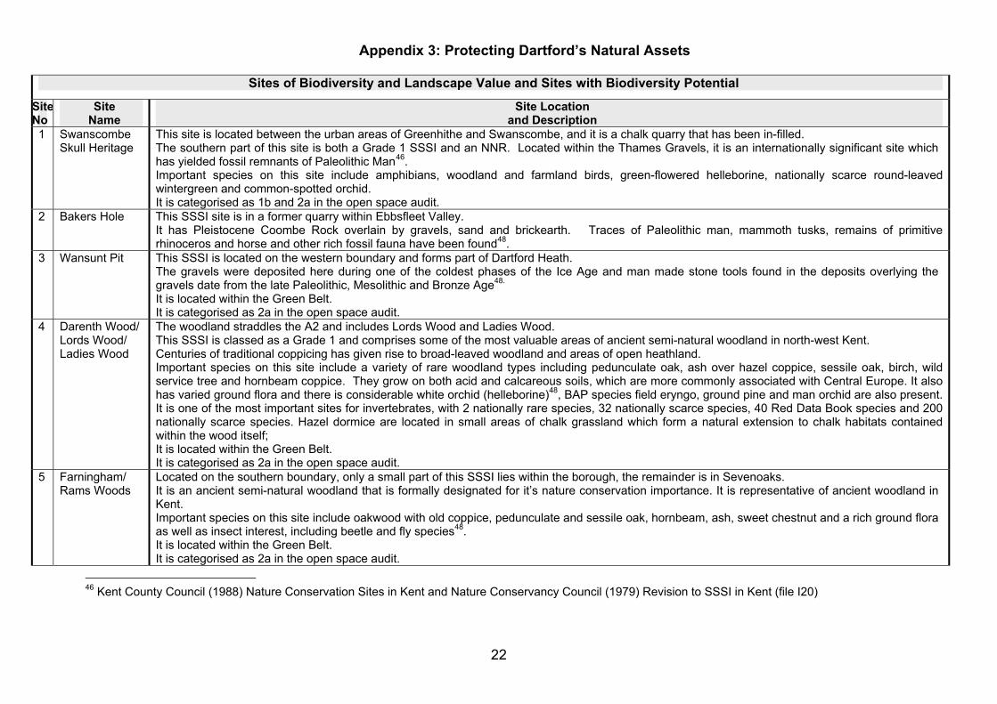
1 Swanscombe Skull Heritage
This site is located between the urban areas of Greenhithe and Swanscombe, and it is a chalk quarry that has been in-filled. The southern part of this site is both a Grade 1 SSSI and an NNR. Located within the Thames Gravels, it is an internationally significant site which has yielded fossil remnants of Paleolithic Man46 . Important species on this site include amphibians, woodland and farmland birds, green-flowered helleborine, nationally scarce round-leaved wintergreen and common-spotted orchid. It is categorised as 1b and 2a in the open space audit.
2 Bakers Hole This SSSI site is in a former quarry within Ebbsfleet Valley. It has Pleistocene Coombe Rock overlain by gravels, sand and brickearth. Traces of Paleolithic man, mammoth tusks, remains of primitive rhinoceros and horse and other rich fossil fauna have been found48 .
3 Wansunt Pit This SSSI is located on the western boundary and forms part of Dartford Heath. The gravels were deposited here during one of the coldest phases of the Ice Age and man made stone tools found in the deposits overlying the gravels date from the late Paleolithic, Mesolithic and Bronze Age48. It is located within the Green Belt. It is categorised as 2a in the open space audit.
4 Darenth Wood/ Lords Wood/ Ladies Wood
The woodland straddles the A2 and includes Lords Wood and Ladies Wood. This SSSI is classed as a Grade 1 and comprises some of the most valuable areas of ancient semi-natural woodland in north-west Kent. Centuries of traditional coppicing has given rise to broad-leaved woodland and areas of open heathland. Important species on this site include a variety of rare woodland types including pedunculate oak, ash over hazel coppice, sessile oak, birch, wild service tree and hornbeam coppice. They grow on both acid and calcareous soils, which are more commonly associated with Central Europe. It also has varied ground flora and there is considerable white orchid (helleborine)48, BAP species field eryngo, ground pine and man orchid are also present. It is one of the most important sites for invertebrates, with 2 nationally rare species, 32 nationally scarce species, 40 Red Data Book species and 200 nationally scarce species. Hazel dormice are located in small areas of chalk grassland which form a natural extension to chalk habitats contained within the wood itself; It is located within the Green Belt. It is categorised as 2a in the open space audit.
5 Farningham/ Rams Woods
Located on the southern boundary, only a small part of this SSSI lies within the borough, the remainder is in Sevenoaks. It is an ancient semi-natural woodland that is formally designated for it’s nature conservation importance. It is representative of ancient woodland in Kent. Important species on this site include oakwood with old coppice, pedunculate and sessile oak, hornbeam, ash, sweet chestnut and a rich ground flora as well as insect interest, including beetle and fly species48 . It is located within the Green Belt. It is categorised as 2a in the open space audit.
46 Kent County Council (1988) Nature Conservation Sites in Kent and Nature Conservancy Council (1979) Revision to SSSI in Kent (file I20)
22
Appendix 3: Protecting Dartford’s Natural Assets
Sites of Biodiversity and Landscape Value and Sites with Biodiversity Potential
Site No
Site Name
Site Location and Description
6 Bluewater Quarry (surrounding the retail centre)
This former quarry is located close to the urban area of Stone. It was worked until the 1980s. It is a RIGS site because it has classic white Upper Chalk with lines of flint overlain uncomfortably by Pleistocene deposits and has yielded important fossils. Kent Wildlife Trust has carried out Bluewater’s Ecological Survey47 on behalf of Lend Lease. The results of the survey show that there is wildlife interest in the areas of semi-natural habitat around the margins of the retail park, including three priority habitats and s41 protected species. Seven lakes have been created to accommodate the natural drainage from the surrounding chalk. Some of the lakes have densely reed-fringed margins and a reed bed has been created to filter the water. There are also steep escarpments, vegetated plateau slopes and some areas of calcareous grassland at the top of the quarry, which have good species diversity, many of which are of county value. Important species on this site include invertebrates, butterflies, dragonflies and damselflies, kidney vetch (with the potential to attract the BAP species small blue butterfly who feeds on it). The BAP species man orchid, bee orchid and broad-leaved helleborine, water vole, common toad, hazel dormouse, grass snake, hedgehog, yellow hammer, house sparrow, starling, song thrush, brown banded carder bee, 5-banded tailed digger wasp. Although some species were not recorded the habitat suggests that there is potential to support bats, great crested newts, viviparous lizards and slow-worms. This site is categorised as 2b in the open space audit.
7 Beacon Woods Country Park
This RIGS and LWS site is located to the south of the A2. It has an excavated fault that runs north-south as a cliff between the upper and lower parts of the former London Clay pit, where various fossils have been recorded. It has woodlands at it’s margins and contains pockets of ancient semi-natural woodland that is formally designated for it’s nature conservation importance. Some wet woodland species exist around the lakes. A large expanse of open water within the clay pit supports common aquatic and marginal plants. Important species on this site include large stands of early purple orchid, fungi species associated with willow birch and aspen, butterflies, dragonflies and damselflies, amphibians, woodland and farmland birds, badgers, hazel dormice, sea club rush, (unusual so far inland), acid loving aquatic moss species and nationally scarce round-leaved wintergreen and over 370 mushroom species. It is located within the Green Belt. It is categorised as 1b and 2a in the open space audit.
8 Green Street Green Common
This LWS is located in the south of the borough, along the main artery road B260. It is common land that contains grassland habitat and pollarded trees and has high quality acidic grassland. Currently the most ecologically valuable areas are those grazed by horses and there is the potential to restore the ranker grassland around the periphery to acidic grassland Important species on this site include small legumes with 10 clover species. It is located within the Green Belt. It is categorised as 2a and 3 in the open space audit.
47 Kent Wildlife Trust (December 2008) Bluewater, Dartford, Kent: Ecological Survey
23
Appendix 3: Protecting Dartford’s Natural Assets
Sites of Biodiversity and Landscape Value and Sites with Biodiversity Potential
Site No
Site Name
Site Location and Description
9 Sutton-at-Hone Churchyard
This LWS is located in the south of the borough. It is located within the Green Belt. It is categorised as 2a in the open space audit.
10 Sutton-at-Hone Lakes
This LWS is located in the south of the borough. It contains a series of gravel pits that are managed as recreational fishing lakes, but also have ecological value. The lakes are surrounded by a small area of alder carr woodland and floodplain meadows within the Darent Valley. They provide valuable BAP habitats that support a rich species mix. It’s three northern lakes are the most ecologically interesting with wet woodland and a diverse reed cover around the lakes. Important species on this site include butterflies, dragonflies and damselflies, bats It is located within the Green Belt. It is categorised as 2a in the open space audit.
11 Dartford Marshes
This LWS covers part Dartford Marshes and part Dartford Fresh Marshes, to the north of Dartford Town centre, stretching up to the River Thames. It contains BAP priority marshland habitat within the Darent Valley. Important species on this site include county scarce greater bladderwort, lesser pondweed and the BAP species corn parsley, invertebrates, butterflies, dragonflies and damselflies, amphibians, waterfowl and wading birds, bats and has the largest population of water voles in Kent. It is located within the Green Belt. It is categorised as 2a and 2b in the open space audit.
12 Dartford Fresh Marshes
This LWS covers part Dartford Marshes and part Dartford Fresh Marshes, to the north of Dartford Town centre, stretching up to the River Thames and is located within the Darent Valley. Contains similar important species as Dartford Marshes – see above. This site is categorised as 2a and 2b in the open space audit.
13 Ebbsfleet Marshes
This LWS is located on the borough’s eastern boundary. It has scrubby marshland and reed beds occur alongside the Ebbsfleet stream. Important species on this site include rare invertebrates, amphibians, waterfowl and wading birds and water voles.
14 Joydens Wood/Chalk Woods
This LWS is located in the south west of the borough. It is ancient semi-natural woodland managed by the Woodlands Trust. It contains relict heathland within the glades of Joyden’s Wood. Wet areas within the woodland support cross leaved heath. Important species on this site include amphibians, waterfowl and wading birds, woodland and farmland birds, badgers, the uncommon wild service tree, small leaved lime and BAP species white helleborine within the ground flora, ferns and bryophytes including 33 mosses and liverworts. Some wet woodland species are also present. It is located within the Green Belt. It is categorised as 2a in the open space audit.
15 Dartford Heath This LWS is located in the north of the A2 surrounding the urban area. It contains one of the most important sites for this habitat in Kent with extensive acid grassland, with extensive areas of heathland habitat. Important species on this site include butterflies, dragonflies and damselflies, amphibians, 14 acid grassland indicators including the uncommon petty
24
Appendix 3: Protecting Dartford’s Natural Assets
Sites of Biodiversity and Landscape Value and Sites with Biodiversity Potential
Site No
Site Name
Site Location and Description
whin, clovers, more common grassland species as well as a number of bryophytes, heather ling, the less common bell heather, dwarf gorse. Dodder, an uncommon parasitic plant grows amongst the gorse. It is located within the Green Belt. it is categorised as 2a in the open space audit.
16 Railway Cutting at Longfield
This grassland LWS is located near Longfeld in the south east of the borough. It is located within the Green Belt.
17 Rowhill Woods This LWS is located in the in the south west of the borough. It contains ancient semi-natural woodland that is formally designated for it’s nature conservation importance. Important species on this site include woodland and farmland birds. It is located within the Green Belt. It is categorised as 2a and 2b in the open space audit.
18 Chalk Bank at Longfield
This LWS is located in Longfeld, in the south east of the borough. This grassland is a Kent Wildlife Trust Reserve. It is a small urban fringe site of two hectares. Parts of the reserve appear to have been much disturbed in the past but have now been colonised with scrub and woodland. It is managed as part of the Longfield Community Park maintaining the existing areas of chalk grassland and creating small paths and clearings through the scrub. Specific management is occasionally aimed at small-scale disturbance around the grey mouse-ear in order to encourage seed dispersal and germination It is located within the Green Belt. It is categorised as 2a in the open space audit.
19 Mabledon This LWS is located just south of the A2, between Darenth Country Park and Darenth Woods. It has a developing chalk (calcareous) grassland community Important species on this site include the BAP species man orchid, bee orchid and a good population of pyramidal orchid are present within the footprint of the old hospital, rare invertebrates and amphibians - probably the most important site for adders in the county. Being a former hospital site, it is classed as a major developed site in the Green Belt. It is categorised as 2a and 2b in the open space audit.
20 Crayland’s Gorge/ Alkerden Lane
This LWS is located between Greenhithe and Swanscombe, adjacent to Swanscombe Skull NNR. It is a former chalk pit that has been in-filled. Interesting flora occurs on the grassy margins. The railway cutting along the western border is an undisturbed secondary woodland Important species on this site include nationally and county scarce helleborine, orchids, bryophytes, a variety of birds, common lizard, slow worm, great crested newt, nationally rare and scarce invertebrates, butterflies and moths48, clover dominated grassland and a good diversity of the more common chalk grassland flora. This site is categorised as 2a in the open space audit.
21 Longfield This RNR is located in the south east of the borough.
48 Kent Wildlife Trust (various) Kent Local Wildlife Site: Area of nature Conservation Interest Sheets
25
Appendix 3: Protecting Dartford’s Natural Assets
Sites of Biodiversity and Landscape Value and Sites with Biodiversity Potential
Site No
Site Name
Site Location and Description
Road/New Barn Road
It consists of grassland on chalky soils, with a good range of common chalk plants and hedgerow trees and shrubs. It is located within the Green Belt.
22 Joyce Green Lane
This RNR is situated within the grassland part of Dartford Marshes in the northern part of the borough. It contains grassland plants that are rare and uncommon in Kent. It is located within the Green Belt.
23 B260 Main Road
This RNR in the south east of the borough is a 2 metre high steep south-west facing bank about 50 metres long in the south east of the borough. It has chalk soils and the site is being colonised by scrub. It is located within the Green Belt.
24 Station Road This RNR in the south of the borough, within Sutton-at-Hone is about 80 metres long and is located in the south of the borough, at Sutton-at-Hone. It has a steep bank facing south and is being colonised by woody species. It is located within the Green Belt.
25 Mounts Road Located north of the A2 within the urban area, this RNR has a chalk bank on both sides of the road and is the last known site in Britain to accommodate Italian catchfly.
26 St John’s Jerusalem
Located at Sutton-at-Hone close to the River Darent in the southern part of the borough, this garden is a small green historic oasis in the urban fringe, within the Darent Valley. It’s main features include the historic house and moated garden, with trees, walled flower and vegetable garden and climbing shrubs. It is located within the Green Belt. It is categorised as 1a in the open space audit.
27 The Thrift This ancient semi-natural woodland located immediately to the south of the A2 that is not designated but is locally important. Located east of Darenth Woods, this sizable ancient woodland fragment is likely to have been part of the Darenth Woods complex. It is located within the Green Belt. It is categorised as 2a in the open space audit.
28 Stone Wood This ancient semi-natural woodland adjoining The Thift is not formally designated but is locally important. Located east of Darenth Woods, this sizable ancient woodland fragment is likely to have been part of the Darenth Woods complex. It is located within the Green Belt. This site is categorised as 2a in the open space audit.
29 Court Wood This ancient semi-natural woodland located in the south east of the site, just north of New Barn is not formally designated but is locally important. It is located within the Green Belt. It is categorised as 2a in the open space audit.
30 Beaton Close Woodland
This woodland located within the village of Greenhithe is not formally designated but is locally important. This site is categorised as 2a and 2b in the open space audit.
31 Bean Road Woodland
This woodland located along the western border of Knockhall is not formally designated but is locally important. This site is categorised as 2b in the open space audit.
32 Trolling Down This woodland located to the north of the A2 and south of the Orbital One Estate is not formally designated but is locally important.
26
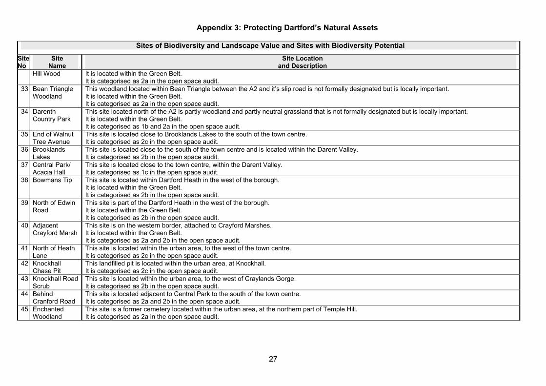
Appendix 3: Protecting Dartford’s Natural Assets
Sites of Biodiversity and Landscape Value and Sites with Biodiversity Potential
Site No
Site Name
Site Location and Description
Hill Wood It is located within the Green Belt. It is categorised as 2a in the open space audit.
33 Bean Triangle Woodland
This woodland located within Bean Triangle between the A2 and it’s slip road is not formally designated but is locally important. It is located within the Green Belt. It is categorised as 2a in the open space audit.
34 Darenth Country Park
This site located north of the A2 is partly woodland and partly neutral grassland that is not formally designated but is locally important. It is located within the Green Belt. It is categorised as 1b and 2a in the open space audit.
35 End of Walnut Tree Avenue
This site is located close to Brooklands Lakes to the south of the town centre. It is categorised as 2c in the open space audit.
36 Brooklands Lakes
This site is located close to the south of the town centre and is located within the Darent Valley. It is categorised as 2b in the open space audit.
37 Central Park/ Acacia Hall
This site is located close to the town centre, within the Darent Valley. It is categorised as 1c in the open space audit.
38 Bowmans Tip This site is located within Dartford Heath in the west of the borough. It is located within the Green Belt. It is categorised as 2b in the open space audit.
39 North of Edwin Road
This site is part of the Dartford Heath in the west of the borough. It is located within the Green Belt. It is categorised as 2b in the open space audit.
40 Adjacent Crayford Marsh
This site is on the western border, attached to Crayford Marshes. It is located within the Green Belt. It is categorised as 2a and 2b in the open space audit.
41 North of Heath Lane
This site is located within the urban area, to the west of the town centre. It is categorised as 2c in the open space audit.
42 Knockhall Chase Pit
This landfilled pit is located within the urban area, at Knockhall. It is categorised as 2c in the open space audit.
43 Knockhall Road Scrub
This site is located within the urban area, to the west of Craylands Gorge. It is categorised as 2b in the open space audit.
44 Behind Cranford Road
This site is located adjacent to Central Park to the south of the town centre. It is categorised as 2a and 2b in the open space audit.
45 Enchanted Woodland
This site is a former cemetery located within the urban area, at the northern part of Temple Hill. It is categorised as 2a in the open space audit.
27
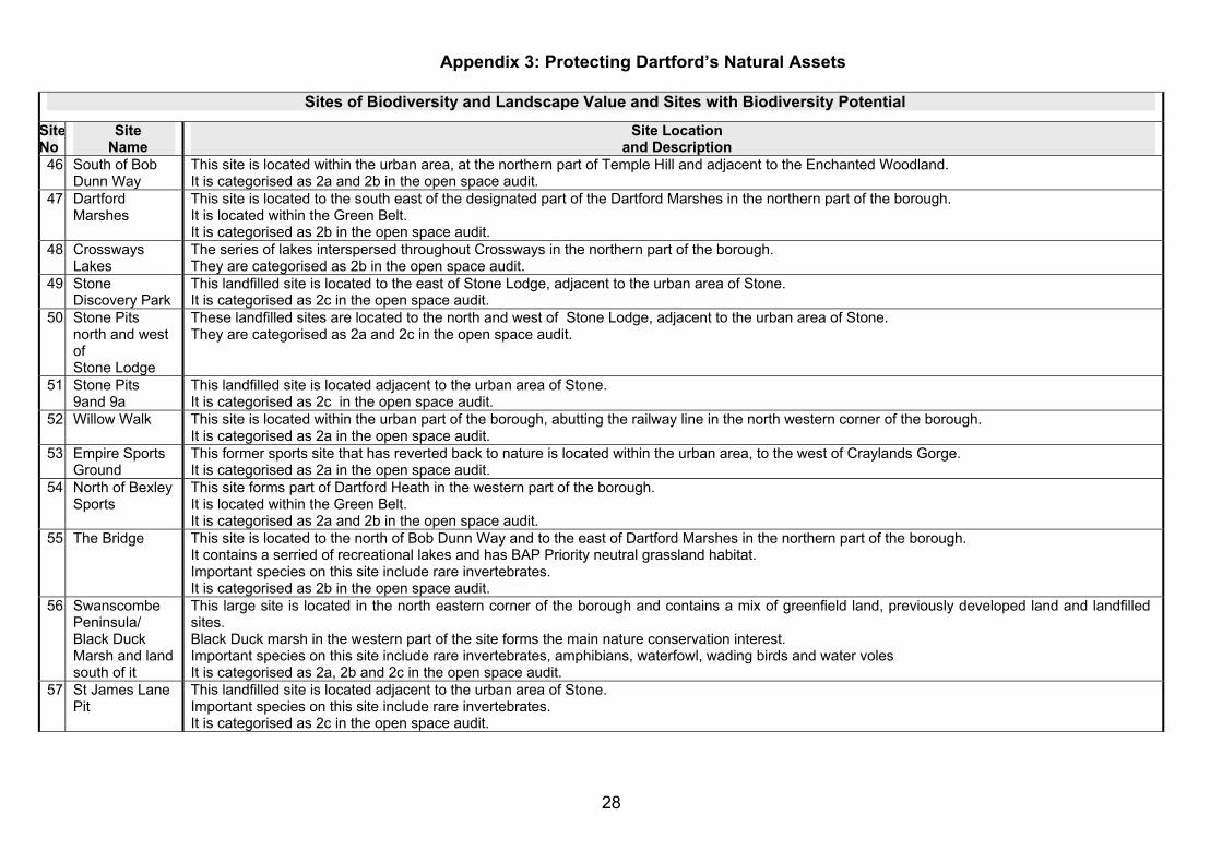
Appendix 3: Protecting Dartford’s Natural Assets
Sites of Biodiversity and Landscape Value and Sites with Biodiversity Potential
Site No
Site Name
Site Location and Description
46 South of Bob Dunn Way
This site is located within the urban area, at the northern part of Temple Hill and adjacent to the Enchanted Woodland. It is categorised as 2a and 2b in the open space audit.
47 Dartford Marshes
This site is located to the south east of the designated part of the Dartford Marshes in the northern part of the borough. It is located within the Green Belt. It is categorised as 2b in the open space audit.
48 Crossways Lakes
The series of lakes interspersed throughout Crossways in the northern part of the borough. They are categorised as 2b in the open space audit.
49 Stone Discovery Park
This landfilled site is located to the east of Stone Lodge, adjacent to the urban area of Stone. It is categorised as 2c in the open space audit.
50 Stone Pits north and west of Stone Lodge
These landfilled sites are located to the north and west of Stone Lodge, adjacent to the urban area of Stone. They are categorised as 2a and 2c in the open space audit.
51 Stone Pits 9and 9a
This landfilled site is located adjacent to the urban area of Stone. It is categorised as 2c in the open space audit.
52 Willow Walk This site is located within the urban part of the borough, abutting the railway line in the north western corner of the borough. It is categorised as 2a in the open space audit.
53 Empire Sports Ground
This former sports site that has reverted back to nature is located within the urban area, to the west of Craylands Gorge. It is categorised as 2a in the open space audit.
54 North of Bexley Sports
This site forms part of Dartford Heath in the western part of the borough. It is located within the Green Belt. It is categorised as 2a and 2b in the open space audit.
55 The Bridge This site is located to the north of Bob Dunn Way and to the east of Dartford Marshes in the northern part of the borough. It contains a serried of recreational lakes and has BAP Priority neutral grassland habitat. Important species on this site include rare invertebrates. It is categorised as 2b in the open space audit.
56 Swanscombe Peninsula/ Black Duck Marsh and land south of it
This large site is located in the north eastern corner of the borough and contains a mix of greenfield land, previously developed land and landfilled sites. Black Duck marsh in the western part of the site forms the main nature conservation interest. Important species on this site include rare invertebrates, amphibians, waterfowl, wading birds and water voles It is categorised as 2a, 2b and 2c in the open space audit.
57 St James Lane Pit
This landfilled site is located adjacent to the urban area of Stone. Important species on this site include rare invertebrates. It is categorised as 2c in the open space audit.
28
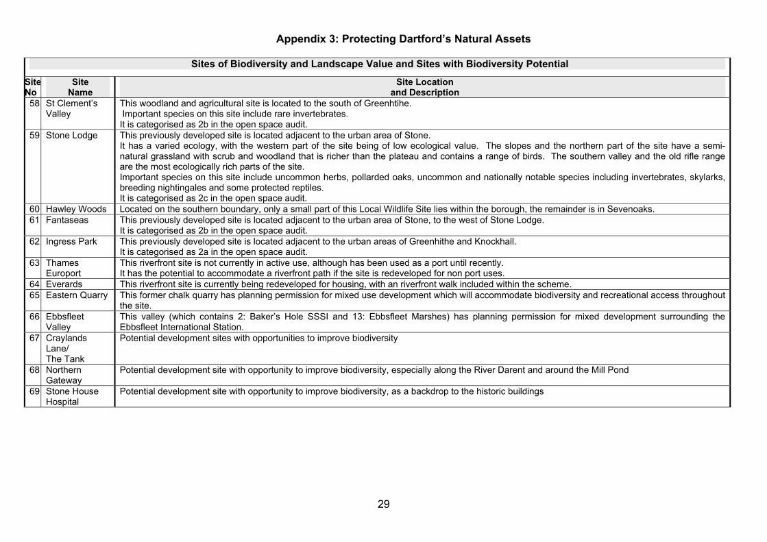
Appendix 3: Protecting Dartford’s Natural Assets
Sites of Biodiversity and Landscape Value and Sites with Biodiversity Potential
Site No
Site Name
Site Location and Description
58 St Clement’s Valley
This woodland and agricultural site is located to the south of Greenhtihe. Important species on this site include rare invertebrates. It is categorised as 2b in the open space audit.
59 Stone Lodge This previously developed site is located adjacent to the urban area of Stone. It has a varied ecology, with the western part of the site being of low ecological value. The slopes and the northern part of the site have a semi-natural grassland with scrub and woodland that is richer than the plateau and contains a range of birds. The southern valley and the old rifle range are the most ecologically rich parts of the site. Important species on this site include uncommon herbs, pollarded oaks, uncommon and nationally notable species including invertebrates, skylarks, breeding nightingales and some protected reptiles. It is categorised as 2c in the open space audit.
60 Hawley Woods Located on the southern boundary, only a small part of this Local Wildlife Site lies within the borough, the remainder is in Sevenoaks. 61 Fantaseas This previously developed site is located adjacent to the urban area of Stone, to the west of Stone Lodge.
It is categorised as 2b in the open space audit. 62 Ingress Park This previously developed site is located adjacent to the urban areas of Greenhithe and Knockhall.
It is categorised as 2a in the open space audit. 63 Thames
Europort This riverfront site is not currently in active use, although has been used as a port until recently. It has the potential to accommodate a riverfront path if the site is redeveloped for non port uses.
64 Everards This riverfront site is currently being redeveloped for housing, with an riverfront walk included within the scheme. 65 Eastern Quarry This former chalk quarry has planning permission for mixed use development which will accommodate biodiversity and recreational access throughout
the site. 66 Ebbsfleet
Valley This valley (which contains 2: Baker’s Hole SSSI and 13: Ebbsfleet Marshes) has planning permission for mixed development surrounding the Ebbsfleet International Station.
67 Craylands Lane/ The Tank
Potential development sites with opportunities to improve biodiversity
68 Northern Gateway
Potential development site with opportunity to improve biodiversity, especially along the River Darent and around the Mill Pond
69 Stone House Hospital
Potential development site with opportunity to improve biodiversity, as a backdrop to the historic buildings
29

0
DA ~D --~-- ·;g-- -C]o, 11, sawlitM-......_.,.1e~Han1Gtl'EftSpace, ·---~
Appendix 4: Enhancing Dartford’s Natural Assets
30