IOC/GLOSS-GOOS Training Workshop on Sea-level...
28
INTERGOVERNMENTAL OCEANOGRAPHIC COMMISSION Training Course Reports 54 _____________________________________________ IOC/GLOSS-GOOS Training Workshop on Sea-level Measurements, Tidal Analysis, GPS and Gravity Measurements, Satellite Altimetry and Numerical Modelling ________________________________________ Instituto Oceanográfico da Universidade de São Paulo São Paulo, Brazil 30 August - 25 September 1999 UNESCO
-
Upload
truongquynh -
Category
Documents
-
view
221 -
download
0
Transcript of IOC/GLOSS-GOOS Training Workshop on Sea-level...

INTERGOVERNMENTAL OCEANOGRAPHIC COMMISSION Training Course Reports
54
_____________________________________________ IOC/GLOSS-GOOS Training Workshop on Sea-level Measurements, Tidal Analysis, GPS and Gravity Measurements, Satellite Altimetry and Numerical Modelling ________________________________________ Instituto Oceanográfico da Universidade de São Paulo São Paulo, Brazil 30 August - 25 September 1999 UNESCO

INTERGOVERNMENTAL OCEANOGRAPHIC COMMISSION Training Course Reports
54
_____________________________________________ IOC/GLOSS-GOOS Training Workshop on Sea-level Measurements, Tidal Analysis, GPS and Gravity Measurements, Satellite Altimetry and Numerical Modelling ____________________________________________ Instituto Oceanográfico da Universidade de São Paulo São Paulo, Brazil 30 August - 25 September 1999 UNESCO 2000 SC-2000/WS/51

IOC Training Course Report No. 54
Paris, 23 February 2000 English only
Abstract This report provides a summary of an IOC-GLOSS/GOOS Training Workshop on Sea-Level Data Analysis. The course programme is described. Sea-level activities in the countries of the course participants (primarily Spanish and Portuguese speaking countries in South America and Africa) are briefly described. A set of recommendations for future sea-level activities in the regions are listed.

IOC Training Course Report No.54
TABLE OF CONTENTS SUMMARY REPORT Page l. INTRODUCTION .....................................................................................................1 2. COURSE PROGRAMME ........................................................................................2 3. PRESENTATIONS BY PARTICIPANTS ..............................................................2 4. RECOMMENDATIONS ..........................................................................................4 5. WORKSHOP CERTIFICATE ................................................................................4 6. ACKNOWLEDGEMENTS ......................................................................................4 ANNEXES I. COURSE PROGRAMME II. USP FOLDER III. LIST OF PARTICIPANTS IV. COURSE MATERIAL V. COURSE CERTIFICATE VI. LIST OF ACRONYMS

IOC Training Course Report No.54
1. INTRODUCTION
Since 1983, the Intergovernmental Oceanographic Commission (IOC) has co-sponsored a series of training workshops on sea-level measurements, data analysis and interpretation. The courses have been held at the rate of approximately one per year, and have been organized primarily by the national organizations, which have hosted the workshops. From 1983-90, workshops were held each summer at the Proudman Oceanographic Laboratory (POL), UK, and concentrated on technical aspects of operating the then-standard type of float and stilling-well tide gauge. The main objective was to build up tide gauge expertise around the world in order to facilitate the development of the Global Sea Level Observing System (GLOSS).
Workshops have since been held in a number of other countries around the world and
in different languages. Each course has contained different proportions of the technical, scientific and socio-economic aspects of sea level studies. Courses have been held in China (IOC Training Course Report No. 6), France, Brazil (Training Course Report No. 20), in India (Training Course Report No. 39), Argentina (Training Course Report No. 43), UK (IOC Workshop Report No. 133) and most recently in South Africa in 1998 (Training Course Report No. 51).
In the recent years the priorities for training in sea level research have evolved and the
GLOSS Training Courses have been broadened. The present GLOSS course is a prime example of this and spans from the traditional subjects such as sea-level measurements and analysis to Global Positioning System (GPS) to gravity measurements to satellite altimetry and to numerical modelling.
The GLOSS course was opened by the Director of the Instituto Oceanográfico da Universidade de São Paulo (IOUSP), Professor Titular Rolf Roland Weber. Present were the Heads of the Department of Physical Oceanography, Associated Prof. Valdenir Veronese Furtado, of the Department of Biological Oceanography, Professor Titular Phan Van Nang and the Co-ordinator of the course at IOUSP, Professor Titular Afranio Rubens de Mesquita.
Professor Weber welcomed the participants expressing his great honor for hosting the IOC GLOSS course and the representatives of several Portuguese and Spanish speaking nations of the Americas and Africa. He stressed the overall importance of global sea level monitoring. He summarized the steps taken within the University; in order to have the Auditorium ready in time for the course, as it was undergoing long overdue repairs. He acknowledged the Institutional support for the Training Course from (IOUSP), where it was organized, and Escola Politécnica, (Polytechnic School) (EPUSP), Instituto de Astronomia e Geofísica, (Institute of Astronomy and Geophysics) (IAGUSP), Comissão de Cooperação International (Commission for International Co-operation) (CCInt) and Pró-Reitoria de Pesquisas (Pro-Rectory of Research), the Centre for Coastal and Marine Sciences, POL of the United Kingdom, and the Centro de Ciências Marinhas de Pontal, Universidade Federal do Paraná. Finally Professor Weber wished all participants a pleasant stay in the city of São Paulo and the best success in the course activities. Professor Mesquita outlined the organization of the course, by mentioning information that appeared in the Afro-America GLOSS News 3(1) of October 1998 and on the leaflet of the University (Annex II) that extended to all the interested local community the benefits of the course.

IOC Training Course Report No.54 page 2
After the opening all participants were invited for lunch in the Faculty Club. 2. COURSE PROGRAMME
The course programme (Annex I) was prepared in collaboration with the Chairman of GLOSS (Dr. Philip Woodworth), and in accordance with the recommendations of the Buenos Aires GLOSS Training Course (Training Course Report No. 43).
The objective of the course was to provide the participants with the basics of the sea-level data gathering and analysis, GPS, gravity, satellite altimetry, and numerical solutions of the tidal equations of Laplace, that largely depend on GLOSS data for description of coastal and global oceanic processes.
The course lasted four weeks with each week devoted to a specific theme: (week 1) Data systems and tidal analysis; (week 2) Gravity measurements, leveling and satellite positioning measurements by GPS; (week 3) Sea-level measurements by artificial satellite; (week 4) Elaboration and calibration of numerical models. The morning sessions were dedicated to the theoretical aspects of data collection, reduction, analysis and prediction while the afternoon sessions were devoted to hands-on training sessions (HOTS) such as application of the TASK-software, tidal prediction, leveling etc.
At the end of each lecturing day the participants were given the opportunity to give
seminars on the GLOSS activities of their home countries/institutions. The seminars were planned as an open forum for discussion and exchange of experiences on tide-gauge equipment, infrastructure developments, problems and achievements. Two of these seminar periods, in the first two weeks, were used to lecture on the topics (Annex I) planned for the third and fourth weeks of the course so participants who were not attending the last two weeks of the course could get a flavor of the topics.
The full list of course participants are provided in Annex III. In total 15 trainees from five South American and two African countries participated in the course. 3. PRESENTATIONS BY PARTICIPANTS Nelson Paredes - Ecuador
A general account of the GLOSS activities in Equador was provided. Particular attention was given to the Station of La Libertad. Results for M2, S2 and other tidal components, based on application of the tidal predictions programmes from the University of Hawaii, were presented. The participants discussed the results and the data were re-analyzed during the HOTS-sessions of the course. Silvia Dmiani - Argentina
A description of the Argentinean Naval Hydrographic Service was provided. Of twelve tidal stations five of them belong to the GLOSS network, one being located in the Antarctic. Some of the GLOSS stations operate with the next generation tide gauges. Data are annually sent to the Permanent Service for Mean Sea Level (PSMSL). The Division for Prediction of Floods also makes the tide predictions and surge predictions. The "Sudestada" is an important characteristic of sea-level variation and the diurnal wave is the only significant.

IOC Training Course Report No.54 page 3
Claudia Alejandra Valenzuela Cuevas - Chile
A report was provided on the eight Chilean GLOSS stations. Most have two gauges (Handar) for data quality control. There are recordings of GPS, atmospheric pressure, air temperature and sea surface temperature. Data is transmitted through the GOES satellite. Data is shown at www.shoa.cl and are updated every five days. The use of recent technology started in 1999. Eduardo Lazo King - Peru
A report was given on the eight GLOSS tidal stations including the Talara and Calau (1942) stations. Motivations for sea-level measurements are strongly related to the El Niño. International funding from the Global Environment Facility (GEF) has recently been approved for the implementation of tidal stations. Next generation tide gauges will be installed. Arnulfo Sanchez - Panamá
The Panamá GLOSS Stations Balboa and Coco Solo were described. Data of sea level and meteorological variables are produced. The data is sent to the archive of the University of Hawaii. Three types of tide gauges are used: One electrical, one Handar and other Stevens. Tide tables are produced. It was reported that at the end of this year the administration of the Panamá Canal is going to be changed to the Panamanian authorities. There is the need for a thorough and qualified transfer of the sea-level measuring facilities. Roberto Teixeira Luz - Brazil
Sea-level geometrical leveling. Geocentric positioning. Gravimetry. Brazilian network for geodetic positioning. National network for Gravimetry. Brazilian network of GPS monitoring. Cananeia station has been leveled in recent years. National Datum of Imbituba. Permanent network for tide gauges. Macaé station of sea-level measurements. Hidrologia, Hidrometric and Digilevel sea-level measurements. Sistema de Referência Geocêntrico para a América do Sul (SIRGAS). Ana Claudia de Paula - Brazil
The status of the ten Brazilian GLOSS Stations was reported. ANDERAA Pressure gauges were installed in the Trindade, Termisa, Fenando de Noronha, Arquipélago de São Pedro e São Paulo and Itaparica. Links for data transmission are established via the ARGOS system. The process of data collection, reduction, processing, analysis, prediction and data/information dissemination was described. Jafar Rubi - Mozambique
A report was given on six sea-level stations in Mozambique. The Inhambani and Pemba are GLOSS Stations. Continuous records are regularly obtained. Analyses of sea-level extremes, sea level and harmonic analyses. Benchmark leveling is regularly taken. The problems of data with long intervals of missing data were discussed.

IOC Training Course Report No.54 page 4
Agenor da Silva - DHN-Brazil
A general overview of the Global Ocean Observing System (GOOS) and its four design panels: Coastal; Living Marine Resources (LMR); Health of the Ocean (HOTO); and Climate (Ocean Observations Panel for Climate: OOPC) was provided. 4. RECOMMENDATIONS
The discussions of the participants during the seminars and the lecturing days of the course stressed the need for continued and increasing actions of IOC, regarding its GLOSS programme. The requirements for specialized personnel in the matters of sea-level data gathering and analysis, measurements of crustal motions and hydrodynamical modelling of harbor and open oceans; the overwhelming speeds of technology of satellite communications of present days and the requirements of near real-time data for global operational purposes; the threats of “Global Warming” and sea-level rise; the poor reporting of Atlantic and India Ocean data, puts all national sea-level observing systems under pressure, particularly those of African and American countries, for training of staff dedicated to sea-level measurements, their use and applications. Bearing in mind these points it is emphatically recommended that: • = The IOC should support the continuation of GLOSS training courses for the Portuguese
and Spanish speaking countries of the Americas and Africa. • = The IOC should make every effort to stimulate and facilitate the participation of other
Spanish and Portuguese speaking countries that have not yet participated in the GLOSS training courses.
• = The next course should be chosen to be given in Chile or Mozambique if the African continent is now the IOC´s first choice.
• = The Afro-America GLOSS News is an important vehicle that disseminates the GLOSS activities in different Institutions of countries of the Americas and Africa.
• = That the Afro-America GLOSS News shall be published also in English language for an enlarged coverage of the African continent. For that purpose, according to decision of the 6th Meeting of the GLOSS Group of Experts (Toulouse, France May 1999), shall have also the editorial participation of Dr Brundrit of the University of Cape Town.
5. WORKSHOP CERTIFICATE
Each trainee was presented with a workshop certificate on behalf of IOC and Instituto Oceanográfico da Universidade de São Paulo signed by Professor Afranio Rubens de Mesquita. 6. ACKNOWLEDGEMENTS
Thanks are due to Professor Afranio Rubens de Mesquita, Carlos Franca and the staff of Instituto Oceanográfico da Universidade de São Paulo. Thanks are also due to the Institutions for allowing the participation of the lecturers of the course nominated as follows: Dr. Ian Vassie and Dr. Trevor Baker from POL, UK; Almt Dr. Alberto dos Santos Franco, Associated Prof. Joseph Harari, M.Sc. Carlos Augusto de Sampaio França and M.Sc. Jose

IOC Training Course Report No.54 page 5
Edison Pereira from the Department of Physical Oceanography of IOUSP; Prof. Titular Marta Mantovani from the Geophysics Department of IAGUSP; Prof. Titular Denizar Blitzkow from the Department of Civil Engineer of EPUSP and Dr. Ricardo Camargo from the Department of Atmospheric Sciences of IAGUSP. He also thanked the Directory of Hydrography and Navigation of the Brazilian Navy, the Commission for International Co-operation and the Pro Rectory of Research of the University São Paulo for their support to the GLOSS course

IOC Training Course Report No.54 Annex I
ANNEX I
COURSE PROGRAMME
1st WEEK - DATA SYSTEM AND TIDAL ANALYSIS
(Morning 9 to 12 h) (afternoon 1400 to 17:30 h)
Monday 30 August 1999
Opening -Introduction to the course -Visit to the IOUSP
Introduction to the computer facilities at IOUSP. Introduction to the TASK software to be used during the course.
Tuesday 31 August 1999
Analysis of Tides. – Dr Ian Vassie. Tides in the Oceans. Gravitational Attraction. Tidal Bulges. Radiational Tides. Diurnal and Semidiurnal Tides. Tidal Periods. Tidal Potential. Spectrum of Tides. The harmonic Method of Analysis of tides. The Admiralty Semi-Graphic Method. The Doodson and Suthons Method. The Foreman Method the Franco Method.
Summary of Oceanic Tides. – Prof. Tit Afranio Rubens de Mesquita. The phenomenon of tides. Motions of Earth Moon and Sun. Orbital planes. The motion around the Centre of Mass. Formation of Bulges. The Tide Generating Force. The Centrifugal Force Around the Centre of Mass. Mean Longitudes of Moon and Sun; Lunar Perigee, Lunar Nodules, Solar Perigee. Astronomical Tidal Periods and Frequencies.
A Short Resume of Tides. – Almt. Dr Alberto dos Santos Franco. The Tidal Staff. Recording of Tidal Heights. Bulges. Declinational Effects. Diurnal Inequalities. Ebb and Flood. Levels of Reference. Datum.
Introduction to computer via TASK computer software for analysis and prediction of tides. Introduction to harmonic analysis by IOUSP methods.
Wednesday 1 September 1999
The Harmonic Method of Analysis of Tides. - Dr Ian Vassie. Fitting a Finite Number of Harmonic Constituents to the Data. Short Term Analyses of Less than a Month. The Age of Tide. Number of Constituents and the Length of the Records. Matrix Inversion of Gauss. Raleigh Criterion. Analysis of Data of Currents. Ellipses of Currents.
Summary of Oceanic Tides. – Prof. Titular. Afranio Rubens de Mesquita Tides as they are Observed. Tides of Brest (France).
Use of software for analysis and prediction of tides.
Use of tables of the tide generating potential.

IOC Training Course Report No.54 Annex I - page 2
Tides of Saigon (China) Do Son (China). Declinational Effects. Syzygies. Quadrature. Phases of the Moon. Diurnals. Semi-diurnals. Mixed Tides. Tides of Ensenada (Mexico). Tides of Punta Arena, Puerto Montt, Valparaiso and Antofagassta (Chile). Phases of the Moon. Tides of Ingeniero White, El Rincon, (Argentina). Tides of Imbituba, Cananeia, Santos (Brasil). Tide Generating Potential. Legendre Polynomials. Solid Angle. Doodson Numbers. Tables of the Tidal Potential.
A Short Resumé of Tides. – Almt Dr. Alberto dos Santos Franco. Tide Generating Force. Motion of Earth and Moon The Harmonic Treatment. Principles of Harmonic Analysis of Tides. Shallow Water Constituents.
Thursday 2 September 1999
The Response Method of Tidal Analysis. - Dr Ian Vassie. The Response Method: Basic Concepts. Tidal Frequencies from Astronomy. Tidal Species. The Tidal Potential. Admittance Function. Covariance Analysis. Response Analyses of Short Duration time Series. Procedure for Covariance Analyses. Standard Errors. Summary of Oceanic Tides. – Prof. Titular Afranio Rubens de Mesquita. The Fundamental Equation of Tidal Analysis. The Fourier Integral Equation. The Fourier Transform. The Inverse Fourier Transform. Continuous and Discrete. Truncated Spectrum. Sampling interval. The Fundamental Frequency and Record Length. Harmonic Frequencies. A Short Resumé of Tides. Almt Dr Alberto dos Santos Franco. Harmonic Prediction. Tide Tables. Tidal Currents. Mathematical Representation of Currents. Ellipses of Currents. Reference Levels. Mean Sea Level. Sounding Datum. Extremes.
Practical calculation. Corrections. Predictions.
Friday 3 September 1999
Estimation of Extreme Sea levels. - Dr Ian Vassie. Introduction. The Annual Maxima Method. The Joint Probability Method. The Revised Joint Probabilities Method (RJPM). Mathematical Formulation and the Inversion Case. The Exceedance Probability Method. Spatial Estimation of Extremes. Examples. Summary of Oceanic Tides. – Prof. Titular Afranio Rubens de Mesquita. Extracting the Tidal Components from Tidal Records. Truncation of Spectra. Dirac Function. The Minimum Square Method in the Time Domain and in the Frequency Domain. Nodal Corrections. Non
Practical computations - Filtering
Altimetry by Orbiting Satellites. - Dr Ian Vassie.

IOC Training Course Report No.54 Annex I - page 3
Linear Tidal Components. Prediction of Tides.
COMMENT - From 17:30 to 18:30 of all lecturing days there will be presentations by the participants on GLOSS matters at their Institutions
2nd WEEK: - LEVELLING AND SATELLITES MEASUREMENTS BY GPS
(GLOBAL POSITIONING SYSTEM)
Monday 6 September 1999
Geodetic Positioning by Satellite – GPS. - Prof. Titular Denizar Blitzkow. Historical Evolution of Positioning. Surfaces of Reference. Geodesic Co-ordinates (Ellipsoidal). International Earth Reference System. Datum. Characteristics of the GPS System. Satellites and Signals. Contents of a Message and Format. GPS Time System. Fundaments of Gravimetry. - Prof. Dr Wladimir Shukowsky. Gravitational Law of Attraction. Gravitational Potential. Potential of a Sphere. The Sphere Under Rotation. The Ellipsoid. The Reference Ellipsoid. The Geoid. Geodesy : The Science of the Shape of the Earth. - Dr. Trevor Baker. First order : The Ellipsoid of Revolution. Second Order: Earth Alterations. The Geoid. The Third Order: Ocean Surface Differs from Geoid. Ocean Topography. Horizontal and Vertical Datums. Geocentric Reference Ellipsoid. Geoid. Geoid (Vertical datum). Reference Ellipsoid (Horizontal Datum). Very Long Baseline Interferometry. Satellite Laser Ranging.
Geodetic Positioning by Satellites. - Prof. Titular Denizar Blitzkow. Methods and Mathematical Models. Observing Codes: Distances. Phase Measurements. Differences of Phase with Time. Simple Differences of Phase. Double Phase Differences. Triple Differences of Phases. Fundaments of Gravimetry - Prof. Dr Wladmir Shukowsky. Measuring the Acceleration of Gravity. Pendulum. Free Fall Gravimeters LaCoste – Romberg Gravimeter. Super Conducting Gravimeters. Workshop Reports. - Dr. Trevor Baker. Tide Gauge BenchMark Fixing Committee. Methods for Monitoring Sea level. Geodetic Fixing of Tide Gauge BenchMarks. Vertical Crustal Movements. Local Subsidence. Tectonics. Post Glacial Rebound. Climate Change. Changes in Ocean Circulation Satellite Altimetry. Techniques required for Geodetic Fixing of Tide Gauge BenchMarks. Vertical Land Movements from G PS. Pseudo Range Measurements. Glacial Rebound Studies.
Tuesday 7 September 1999
The GPS Signal - Prof. Titular Denizar Blitzkow. Navigation System with Time and Ranging. Equation of the Signals. GPS Timing. Systematic Errors. GPS Beating. Propagation Time. Phase as distance Linear Combinations of the Observations. DGPS. Gravity Measurements. - Dr. Wladmir Shukowsky. Correction of Gravity Measurements. Observed Gravity. Theoretical Gravity. Earth Tides. Eotvos Correction. Free Air Correction. Bouguer Correction. Complete Bouguer Anomaly. Simple Bouguer Anomaly.
The GPS Signal. - Prof. Titular Denizar Blitzkow. Solution of the Ambiguities Rapid Positioning with GPS. Rapid Static. Cinematic. Stop and Go. GPS and Altimetry. GPS and Engineering. Topographic Aids. The South America Geoid. EUC (European) Projects. - Dr Trevor Baker Eurogauge Network. Final Coordinates Differences. GPS Network. Network of Permanent Stations. GPS Single Site UMEA. Self-Tide Gauges and GPS Sites. Porto Corsini. Medicina. EUVN .

IOC Training Course Report No.54 Annex I - page 4
UK Projects. - Dr. Trevor Baker. Crustal movements of Great Britain. Present Rate of Sea level Change. Mean Sea level with Respect to Newlyn Datum Sea Surface Elevation around The British Islands. Tide Gauges and GPS Sites. Newlyn Tide Gauge - GPS Station.
Wednesday 8 September 1999
Visit to Cananéia'’s Research Station João de Paiva Carvalho. The tide gauge station. The GPS Tower. The Gravimeter site hut. Bench marks. Meteorological automatic stations and pressure gauge.
Visit to Cananéia’s Research Station João de Paiva Carvalho (continued)
Thursday 9 September 1999 Dr Wladmir Shukowsky Lecture Uses of the La Coste / Romberg Gravimeter. Practical measurements with the gravimeter. Prof. Titular Denizar Blitzkow Lecture - GPS uses of the GPS Trimble. Practical measurements with Trimble on the GPS Tower of Cananéia Station. Practical - Leveling - BenchMarks. Leveling with modern techniques
Friday 10 September 1999
The Manual on Sea-level Measurements and Interpretation - Mr. Jose Edson Rodrigues Pereira. Science of sea-level changes and their applications. Extreme levels for design of coastal defenses. Tide gauges. The sites. Installation leveling and datum control. Data reduction. Exchange formats. Data transmission. Sea level Centres. Measurements Errors and GOOS - Prof. Dr Eduardo Marone. Main errors of continuous recording systems of sea level. Clock errors. Data gaps in recording. Estimate of errors amplitudes. What is GOOS. Coastal GOOS. GLOSS and GOOS. Monitoring and climatic prediction. Assessment of the Resources of the sea. Ocean health. Coastal management. Oceanographic and meteorological operational systems.
Leveling of the Cananéia's tide gauge. Tide gauge bench marks fixing. Datum control. Van de Castelle test. Numerical Modeling -Mr. Jose Edson Rodrigues Pereira. 17:30h to 18:30 h Overview of numerical modelling. Basic ideas of classical discretisation numerical schemes. Topics of grid generation, numerical calculus limitations and related errors. Examples of application in the Amazonian continental shelf.
Saturday 11 September 1999
Return trip to University Campus of São Paulo.
COMMENT - From the 17:30 to the 18:30 of all lecturing days there will be presentations of the participants on GLOSS, matters at their Institutions

IOC Training Course Report No.54 Annex I - page 5
Note: One of these hours shall be used to give information on numerical Modelling of tides
3rd WEEK - SEA-LEVEL OBSERVATIONS FROM SATELLITE
Monday 13 September 1999
Altimetry by Satellite: Prof. Assoc. Joseph Harari.
Oceanography by Remote Sensing. Measurements of the Earth Topography. The characteristics of the measurement. The composition of the altimetric measurement of altitude and the geoid. Correction of the altimeter measurement. Correction of the instrumental errors. The state of the sea and the altimetric measurement. Tropospheric and ionospheric correction in the altitude measurement.
Application of the AVISO information system of data. Altimetry data. Extraction of the altimetric information.
Tuesday 14 September 1999
The Altimetry Data: Prof. Assoc. Joseph Harari.
The sea contribution to the altimeter measurement. Precision of the altimetric measurements of the significant wave height. Calibration of the altimetric measurement of altitude. The sensors of the TOPEX/POSEIDON in its orbit. Altimetric measurements of the T/P. Timing and geophysical corrections. Archives of T/P altimetry data.
Selection of geographical areas of interest. Extraction of the data from the AVISO.MGDR.
Wednesday 15 September 1999
TOPEX/POSEIDON Data: Prof. Associado Joseph Harari. Utilization of TOPEX/POSEIDON data. Geophysical Corrections. The altimetric range and calibration errors. Tropospheric influences; Dry and Humid. Ionospheric influences. Ocean waves influences. Inverted Barometer. Geoid and mean sea surface. The Geiod JGM-3/OSU91A.The sea surface (OSUMSS95). Tidal models. Elastic Tides. Solid Earth. tide. The Pole Tide. The algorithm of the wind velocity. Criteria for calibration.
Correction of the propagation of the altimetric signal.
Application of geophysical corrections.
Thursday 16 September 1999
Tides and TOPEX/POSEIDON data. - Mr. Carlos Augusto de Sampaio França. General Introduction. Tides and orbits. Sampling theorem. Tidal measurements of T/P.Tidal models in T/P days. Filtering. Internal Tides.
Formation of TOPEX/POSEIDON sea-level anomaly time series and tidal analysis.

IOC Training Course Report No.54 Annex I - page 6
Friday 17 September 1999
Overview of TOPEX/POSEIDON results. -Mr. Carlos Augusto de Sampaio França Mapping altimetric data. Sea surface variability. Filtering. Kelvin and Rossby waves. El Niño. Seasonal variability. Interannual variability.
Hands on training with other AVISO products: CORSSH, SLA, MSLA
COMMENT - From the 17:30 to the 18:30 of all lecturing days there will be presentations of the participants on GLOSS, matters at their Institutions
4th WEEK – ELABORATION AND CALIBRATION OF NUMERICAL MODELS
Monday 20 September 1999
Basic Hydrodynamical Equations – Prof. Dr Ricardo de Camargo Equation of Motion. Continuity and Diffusion. Mean flow. Fluctuation to the mean flow. Cartesian system of coordinates. Boussinesq and hydrostatic approximations. Two dimensional Equation. Vertically integrated equations. Viscosity and turbulence. Vertical exchanges. Large horizontal exchanges.
One-dimensional models.
Tuesday 21 September 1999
Two dimensional Numerical Models - Prof. Associado Jopseph Harari. The basic problems. Practical approximation to open conditions. The time and space discretization and the equations. Numerical solutions of the simplified system. Stability. Step by step for the construction and analysis of simplified models. The discretization of the radiational boundary conditions.
Programming of the hydrodynamic equations. Grid Generation. Study of the grids, Initial stability, Initial and boundary conditions.
Wednesday 22 September 1999
Two-dimensional models. Prof. Associado Joseph Harari. Implementation of two-dimensional models. Condition of Stability. Errors in numerical calculation. Development of simplified software routine.
Application of two dimensional models.
Thursday 23 September 1999
Development of a two dimensional model - Mr. Jose Edson Rodrigues Pereira Diffusion and dispersion. Boundary conditions. Contouring conditions. Land boundaries. Earth boundaries. General classification of boundary conditions. Clamped. Gradient. Gravity waves Implicit/Explicit. Sponge. Radiational.
Boundary conditions

IOC Training Course Report No.54 Annex I - page 7
Friday 24 September 1999
Three dimensional models - Prof. Dr Ricardo de Camargo. Classification of oceanic numerical models. Free surface and rigid lid. Fixed levels. Isopycnal. Sigma Coordinate models. Barotropic models. Baroclinic models. Reduced gravity. Mixed layer models. Tidal models.
Pre-processed numerical experiments.
COMMENT - From the 17:30 to the 18:30 of all lecturing days there will be presentations of the participants on GLOSS, matters at their Institutions

IOC Training Course Report No.54 Annex II
ANNEX II
University of Sao Paulo Folder UNIVERSIDADE DE SÃO PAULO
INSTITUTO
OCEANOGRÁFICO
Curso de EXTENSÃO UNIVERSITÁRIA Treinamento do GLOSS
(Global Observing Sea Level System) UNESCO/COI
(Comissão Oceanográfica Intergovernamental) Módulo I 30/08 a 03/09/99 Sistema de dados e análise de marés Módulo II (Cananéia) 06/09 a 10/09/99 Nivelamento e medições por satélite (GPS) (Global Positionig System), Gravimetria. Módulo III - 13 a 17/09/99 Observações de nível do mar por satélite artificial (TOPEX/POSEIDON). Módulo IV 20 e 24/09/99 Elaboração e Calibração de modelos numéricos
HORÁRIOS
09:30 às 12:00 h e das
14:00 às 17:30 h OBJETIVOS DO CURSO Fornecer elementos básicos para a obtenção e análise de dados de nível do mar (GPS, altimetria por satellite, gravimetria, modelagem numérica).

IOC Training Course Report No.54 Annex II - page 2
PÚBLICO - ALVO Graduandos e graduados em Oceanografia, Física, Geociências, Geofísica, Matemática e Estatística. CARGA HORÁRIA 40 horas por módulo NÚMERO DE VAGAS
10 vagas por módulo. LOCAL Módulos I, III e IV São Paulo Anfiteatro do Instituto Oceanográfico/USP Módulo IV - Cananéia Base João de Paiva Carvalho do IOUSP COORDENADOR
Prof. Dr. Afranio Rubens de Mesquita
Professores do Curso Dr. Ian Vassie (Proudman Oceanographic Laboratory POL) Dr. Trevor Backer (POL) Dr. Alberto dos Santos Franco IOUSP Dr. Joseph Harari IOUSP Dr. Denisar Blitskow POLI-USP Dra Marta Mantovani IAG-USP Dr. Ricardo Camargo IAG-USP M.Sc. Carlos Augusto S. França IOUSP M.Sc. José Edson R. Pereira - IOUSP

IOC Training Course Report No.54 Annex II - page 3
INSCRIÇÕES Período:
Módulo I 23 a 27/08/99 Módulo II 30/08 a 03/09/99 Módulo III 08 a 10/09/99 Módulo IV 13 a 17/09/99 Horário: das 09:00 às 11:00 e das 14:00 às 17:00 h
Local: Secretaria de Atividades Acadêmicas, Instituto Oceanográfico/USP. Informações: Fone: 818-6530 ou http://www.mares.io.usp.br TAXA DE INSCRIÇÃO R$ 45,00 (quarenta e cinco reais) por módulo. No caso dos participantes do Módulo II além da taxa haverá despesas de transporte, alojamento e alimentação que correrão por conta do aluno. CERTIFICADOS Será conferido certificado aos participantes que observarem a freqüência mínima de 80% (por módulo) nas atividades. UNIVERSIDADE DE SÃO PAULO Reitor Prof. Dr. Jacques Marcovitch Vice-Reitor Prof. Dr. Adolpho José Melfi INSTITUTO OCEANOGRÁFICO Diretor Prof. Dr. Rolf Roland Weber Vice-Diretor Prof. Dr. Yasunobu Matsuura
Endereço Praça do Oceanográfico, 191 Cidade Universitária, Butantã
São Paulo, SP

IOC Training Course Report No.54 Annex III
ANNEX III
LIST OF PARTICIPANTS
A. TRAINEES Claudia Alejandra Valenzuela Cuevas Servicio Hidrografico y Oceanografico de la Armada SHOA Errazuriz 232 Playa Ancha Valparaiso CHILE Tel: (+56-32) 266542 Email: [email protected] Silvia Noemi Damiani Servicio de Hidrografia Naval Buenos Aires ARGENTINA Tel: 4301-3091 Fax: 4301-2918 Email: [email protected] Eduardo Carlos Lazo King Direccion de Hidrografia y Navegacion de la Marina Calle Gamarra, 500Chucuito Callo, Lima PERU Tel: (+51-1) 4298925 E-mail: [email protected] Arnulfo Sanches Morales Direc. Apdo. 0819-12196, El Doradu PANAMÁ Tel: (+507) 232-7510 / 232-6117 Fax: (+507) 232-5527 E-mail: [email protected] Cândida Inês Sete Nhapulo Intituto Nacional de Hidrografia e Navegação INAHINA Av. Karl Marx 153 CP 2089, Maputo MOZAMBIQUE Tel: (+258-1) 430184 ext. 8 Fax: (+258-1) 430185 E-mail: [email protected]
Ana Claudia de Paula Diretoria de Hidrografia e Navegação, setor de Marés Rua Barão de Jaceguai s/n Ponta da Areia Niteroi RJ CEP: 24048-900 BRAZIL Tel: (+55 21) 613-8238 Fax: (+55 21) 620-0073 Emails: [email protected] Nelson Gerardo Paredes Téran Istituto Oceanográfico de la Armada Casilla 5940 Base Naval Sur, Guayaquil ECUADOR E-mail: [email protected] B. LECTURERS Dr. Trevor Baker Center for Costal and Marine Science Proudman Laboratory, Bidston Observatory Birkenhead, Merseyside L43 7RA UK E-mail: [email protected] Prof. Tit. Denizar Blizkow Escola Politécnica da USP Departamento de Transportes 05508-900 Cidade Universitária, SP BRAZIL Tel: (+55 11) 818-5501 Prof. Dr. Ricardo Camargo Instituto Astronómico e Geofísico da USP Departamento de Ciências Atmosféricas 05508-900 Cidade Universitária, SP BRAZIL Tel: (+55 11) 818-4683 Almt. Dr. Alberto Dos Santos Franco Instituto Oceanográfico da USP Depto. de Oceanografia Física

IOC Training Course Report No.54 Annex III - page 2
Praça do Oceanográfico, 191 05508-900, Cidade Universitária, SP BRAZIL Tel: (+55 11) 818-6564 Fax: (+55 11) 818-6564 E-mail: [email protected] Prof. Associado Joseph Harari Instituto Oceanográfico da USP Depto. de Oceanografia Física Praça do Oceanográfico, 191 05508-900, Cidade Universitária, SP BRAZIL Tel: (+55 11) 818-6564 Fax: (+55 11) 818-6564 E-mail: [email protected] Prof. Tit. Marta Mantovani Instituto Astronómico e Geofísico da USP Departamento de Geofísica BRAZIL 05508-900 Cidade Universitária, SP Tel: (+55 11) 818-4739 Prof. Tit. Afranio R. de Mesquita Instituto Oceanográfico da USP Depto. de Oceanografia Física Praça do Oceanográfico, 191 05508-900, Cidade Universitária, SP BRAZIL Tel: (+55 11) 818-6564 Fax: (+55 11) 818-6564 E-mail: [email protected] Msc. José Edson Rodrigues Pereira Instituto Oceanográfico da USP Depto. de Oceanografia Física Praça do Oceanográfico, 191 05508-900, Cidade Universitária, SP BRAZIL Tel: (+55 11) 818-6564 Fax: (+55 11) 818-6564 E-mail: [email protected] Prof. Dr. Vladmir Sukowsky Instituto Astronómico e Geofísico da USP Departamento de Geofísica 05508-900 Cidade Universitária, SP BRASIL
Tel: (+55 11) 818-4739 Jorge Luiz Alves Trabanco Escola Politécnica da USP Departamento de Transportes 05508-900 Cidade Universitária, SP BRAZIL Tel: (+55 11) 818-5501 Dr. Ian Vassie Center for Costal and Marine Science Proudman Laboratory, Bidston Observatory Birkenhead, Merseyside L43 7RA UK E-mail: [email protected] C. OTHER PARTICIPANTS Claudia Lellis Callado Anciães Instituto Brasileiro de Geografia e Estatística Av. Brasil 15671 Parada de Lucas CEP: 21241-051 Rio de Janeiro BRAZIL Tel: (+21) 381-3674 / 351-9355 / 482-8217 Fax: (+21) 481-2797 e-mail: [email protected] Marilene de Lima Climerh/Epagre Rod. Admar Gonzaga, 1347 Itacombí, Florianópolis, SC CEP 88034-901 BRAZIL Tel: (+48) 239-8055 Email: [email protected] Roberto Teixeira Luz Instituto Brasileiro de Geografia e Estatística Av. Brasil 15671 Parada de Lucas CEP: 21241-051 Rio de Janeiro BRAZIL Tel: (+21) 381-3674 / 351-9355 / 482-8217 Fax: (+21) 481-2797 e-mail: [email protected] Katia Duarte Pereira Instituto Brasileiro de Geografia e Estatística Av. Brasil 15671 Parada de Lucas CEP: 21241-051 Rio de Janeiro

IOC Training Course Report No.54 Annex III - page 3
BRAZIL Tel: (+21) 381-3674 / 351-9355 / 482-8217 Fax: (+21) 481-2797 e-mail: [email protected] Maria Fernanda de Lucena Rezende Diretoria de Hidrografia e Navegação, setor de Marés Rua Barão de Jaceguai s/n Ponta da Areia Niteroi RJ CEP: 24048-900 BRAZIL Tel: (+55 21) 613-8238 Fax: (+55 21) 620-0073 e-mail: [email protected] Jafar Ruby Intituto Nacional de Hidrografia e Navegação INAHINA Av. Karl Marx 153 CP 2089, Maputo MOÇAMBIQUE Tel: (+258-1) 430184 ext. 8
Fax: (+258-1) 430185 E-mail: [email protected] Nilo Cesar Coelho da Silva Instituto Brasileiro de Geografia e Estatística Av. Brasil 15671 Parada de Lucas CEP: 21241-051 Rio de Janeiro BRAZIL Tel: (+21) 381-3674 / 351-9355 / 482-8217 Fax: (+21) 481-2797 e-mail: [email protected] Agenor da Silva Diretoria de Hidrografia e Navegação, setor de Marés Rua Barão de Jaceguai s/n Ponta da Areia Niteroi RJ CEP: 24048-900 BRAZIL Tel: (+55 21) 613-8238 Fax: (+55 21) 620-0073

IOC Training Course Report No.54 Annex IV
ANNEX IV
COURSE MATERIAL
Prof. Dr. Ricardo de Camargo Lecture Notes: Equações Hidrodinamicas Básicas Modelos Oceanicos Tridimensionais Prof. Associado Joseph Harari Lecture Notes: Modelos Numéricos Bi-dimensionais Implementação de Modelos Bi-dimensionais Introdução a Autimetria Por Satélite Prof. Dr. Marta S. N. Mantovani Lecture Notes: Fundamentos de Gravimetria Dr. Ian Vassie Lecture Notes: Estimation of the Extreme Sea Level The Response Method of Tidal Analysis TASK- Tidal Analysis Software Kit (POL-PSMSL) Almt. Dr. Alberto dos Santos Franco Lecture Notes: Estudo Resumido Das Marés - O Fenómeno da Maré Dr. Trevor Baker Information Documents: Some Background Geodesy Workshop Reports UK Projects European Projects Prof. Titular Afranio Rubens de Mesquita Lecture Notes: Sumário de Marés Oceânicas INFORMATION MATERIAL: Global Sea Level Observing System (GLOSS) Implementation Plan - 1997 International Sea Level Workshop - 10-11 June 1997 Honolulu Hawaii Manual on Sea-level Measurement and Interpretation. IOC Manuals and Guides 14 V.(1) - Basic Procedures. Manual on Sea-level Measurement and Interpretation. IOC Manuals and Guides 14 V.(2) - Emerging Technologies. GLOSS Station Handbook. IOC Global Sea Level Observing System (CDROM) WOCE Sea-level Global Data, version 1 (BODC, UHSLC) (CDROM) Prof. Titular Denizar Blitzkow Lecture Notes: Posicionamento Geodetico Por Satélite GPS

IOC Training Course Report No.54 Annex V
ANNEX V
COURSE CERTIFICATE

IOC Training Course Report No.54 Annex VI
ANNEX VI
LIST OF ACRONYMS
DHN Diretoria de Hidrografia e Navegação GEF Global Enviroment Facility GLOSS Global Sea Level Observing System GOOS Global Ocean Observing System (IOC-WMO-UNEP-IOSU) GPS Global Positioning System IOC Intergovernmental Oceanographic Commission (of UNESCO) IOUSP Instituto Oceanográfico da Universidade de São Paulo NGWLMS Next Generation Water Level Measurement System POL Proudman Oceanographic Laboratory (UK) PSMSL Permanent Service for Mean Sea Level SIRGAS Sistema de Referência Geocêntrico para a América do Sul TASK Tidal Analysis Software Kit T/P Topex/Poseidon UK United Kingdom USP Universidade de São Paulo
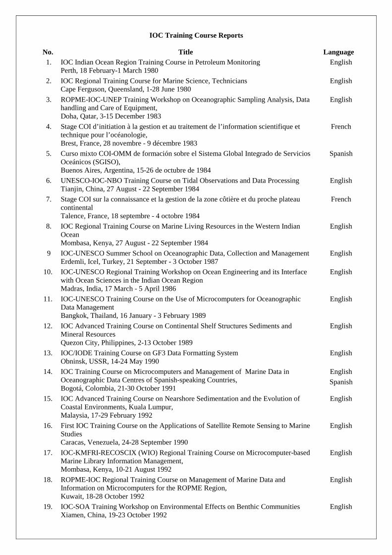
IOC Training Course Reports
No. Title Language 1. IOC Indian Ocean Region Training Course in Petroleum Monitoring
Perth, 18 February-1 March 1980 English
2. IOC Regional Training Course for Marine Science, Technicians Cape Ferguson, Queensland, 1-28 June 1980
English
3. ROPME-IOC-UNEP Training Workshop on Oceanographic Sampling Analysis, Data handling and Care of Equipment, Doha, Qatar, 3-15 December 1983
English
4. Stage COI d’initiation à la gestion et au traitement de l’information scientifique et technique pour l’océanologie, Brest, France, 28 novembre - 9 décembre 1983
French
5. Curso mixto COI-OMM de formación sobre el Sistema Global Integrado de Servicios Oceánicos (SGISO), Buenos Aires, Argentina, 15-26 de octubre de 1984
Spanish
6. UNESCO-IOC-NBO Training Course on Tidal Observations and Data Processing Tianjin, China, 27 August - 22 September 1984
English
7. Stage COI sur la connaissance et la gestion de la zone côtière et du proche plateau continental Talence, France, 18 septembre - 4 octobre 1984
French
8. IOC Regional Training Course on Marine Living Resources in the Western Indian Ocean Mombasa, Kenya, 27 August - 22 September 1984
English
9 IOC-UNESCO Summer School on Oceanographic Data, Collection and Management Erdemli, Icel, Turkey, 21 September - 3 October 1987
English
10. IOC-UNESCO Regional Training Workshop on Ocean Engineering and its Interface with Ocean Sciences in the Indian Ocean Region Madras, India, 17 March - 5 April 1986
English
11. IOC-UNESCO Training Course on the Use of Microcomputers for Oceanographic Data Management Bangkok, Thailand, 16 January - 3 February 1989
English
12. IOC Advanced Training Course on Continental Shelf Structures Sediments and Mineral Resources Quezon City, Philippines, 2-13 October 1989
English
13. IOC/IODE Training Course on GF3 Data Formatting System Obninsk, USSR, 14-24 May 1990
English
14. IOC Training Course on Microcomputers and Management of Marine Data in Oceanographic Data Centres of Spanish-speaking Countries, Bogotá, Colombia, 21-30 October 1991
English Spanish
15. IOC Advanced Training Course on Nearshore Sedimentation and the Evolution of Coastal Environments, Kuala Lumpur, Malaysia, 17-29 February 1992
English
16. First IOC Training Course on the Applications of Satellite Remote Sensing to Marine Studies Caracas, Venezuela, 24-28 September 1990
English
17. IOC-KMFRI-RECOSCIX (WIO) Regional Training Course on Microcomputer-based Marine Library Information Management, Mombasa, Kenya, 10-21 August 1992
English
18. ROPME-IOC Regional Training Course on Management of Marine Data and Information on Microcomputers for the ROPME Region, Kuwait, 18-28 October 1992
English
19. IOC-SOA Training Workshop on Environmental Effects on Benthic Communities Xiamen, China, 19-23 October 1992
English

No. Title Language 20. IOC Training Course for the Global Sea Level Observing System (GLOSS) directed
to the African and South American Portuguese and Spanish-Speaking Countries São Paulo, Brazil, 1-19 February 1993
English
21. IOC-SSTC-SOA Training Course on Marine Information Management and ASFA Tianjin, China, 19-30 October 1992
English
22. First IOC/IOCARIBE-UNEP Training Course on Monitoring and Control of Shoreline Changes in the Caribbean Region, Port-of-Spain, Trinidad and Tobago, 21-30 July 1993
English Spanish
23. IOC/WESTPAC Training Course on Numerical Modelling of the Coastal Ocean Circulation Matsuyama, Japan, 27 September - 1 October 1993
English
24. IOC-JODC Training Course on Oceanographic Data Management Tokyo, Japan, 28 September - 9 October 1992
English
25. IOC-JODC Training Course on Oceanographic Data Management Tokyo, Japan, 27 September - 8 October 1993
English
26. IOC Training Course on Ocean Flux Monitoring in the Indian Ocean. Organized with the support of the Government of Germany Mombasa, Kenya, 15-27 November 1993
English
27. IOC-UNEP-SPREP Training Course on Coral Reef Monitoring and Assessment Rarotonga, Cook Islands, 23 February - 13 March 1994
English
28. IOC-JODC Training Course on Oceanographic Data Management Tokyo, Japan, 26 September - 7 October 1994
English
29. IOC-UNEP-WHO-FAO Training Course on Qualitative and Quantitative Determination of Algal Toxins Jena, Germany, 18-28 October 1994
English
30. IOC Training Course on Oceanographic Data Management for Black Sea Countries Obninsk, Russian Federation, 1-12 August 1994
English
31. COI-CEADO Curso Regional de Capacitación en Gestión de Datos e Información Oceanográficos Buenos Aires, Argentina, 17-28 de octubre de 1994
Spanish
32. IOC-UNEP-FAO Training Course on Nutrient Analysis and Water Quality Monitoring Zanzibar, Tanzania, 21-26 November 1994
English
33. IOC-IOMAC Advanced Training Course on Marine Geology and Geophysics off Pakistan. Pakistan, 12-26 November 1994
English
34. Training Course on Management of Marine Data and Information for the Mediterranean Region Valletta, Malta, 10-21 April 1995
English
35. IOC-UNEP-WHO-FAO Training Course on Toxin Chemistry and Toxicology related to Harmful Algal Blooms Trieste, Italy, 3-12 September 1995
English
36. MAST-IOC Advanced Phytoplankton Course on Taxonomy and Systematics Naples, Italy, 24 September - 14 October 1995
English
37. IOC-JODC Training Course on Oceanographic Data Management Tokyo, Japan, 16-27 October 1995
English
38. IOC/IODE Training Course on Marine Geological and Geophysical Data Management Gelendzhik, Russian Federation, 13-29 September 1995
English
39. IOC/GLOSS-GOOS Training Workshop on Sea-Level Data Analysis, Geodetic & Research Branch Survey of India, Dehra Dun, India, 21 November- 1 December 1995
English

No. Title Language 40. IOC-DANIDA Training Course on the Taxonomy and Biology of Harmful Marine
Microalgæ; University of Copenhagen, Denmark, 31 July-11 August 1995; IOC-SAREC-DANIDA Training Course on the Taxonomy and Biology of Harmful Marine Microalgæ; University of Mauritius, Republic of Mauritius, 5-14 February 1996; and Annual Report 1995, IOC Science and Communication Centre on Harmful Algæ, DANIDA, University of Copenhagen, Danish Fisheries Research Institute, Danish National Environmental Research Institute
English
41. IOC-Germany Advanced Training Course on Bathymetric Charting in the Western Indian Ocean METEOR, 15-29 December 1995
English
42. COI-SHOA-CICESE Curso Sobre Modelación Numérica de Tsunamis Valparaiso, Chile, 11 de Marzo - 11 de Mayo de 1996
Spanish
43. Seminario/Taller de la COI/GLOSS-SHN sobre Observación y Análisis del Nivel del Mar para países de habla hispano-portuguesa de Latinoamérica Servicio de Hidrografía Naval (SHN), Buenos Aires, Argentina, 19-27 de noviembre de 1996
Spanish
44. IOC-INCO-ROPME Training Course on Oceanographic Data and Information Management, Tehran, Iran, 19-30 October 1997
English
44. IOC-ICSU-IAEA-EU Training Course on Marine Geological and Geophysical Data Management for the Countries of the Black and Caspian Seas Regions, Gelendzhik, Russian Federation, 8-19 September 1997
English
45. IOC-ICSU-IAEA-EU Training Course on Marine Geological and Geophysical Data Management for the Countries of the Black and Caspian Seas Regions Gelendzhik, Russian Federation, 8-19 September 1997
English
46. Training Course on Management of Marine Data and Information for the IOCINCWIO Region Mombasa, Kenya, 1-11 December 1997
English
47. IOC/WESTPAC-SIDA-SAREC-SEAPOL Training Workshop on Operational Data and Information System for the Gulf of Thailand Bangkok, Thailand, 18-21 November 1997
English
48. SZN-IOC Advanced Phytoplankton Course on Taxonomy and Systematics Vico Equense, Naples, Italy, 10-30 May 1998
English
49. First IOC/WESTPAC Training Course on Monitoring of PSP Plankton and Shellfish Toxicity, Japan, July 1995 Second IOC/WESTPAC Training Course on Species Identification of Harmful Microalgæ, Japan, February 1997 Third IOC/WESTPAC Training Course on Species Identification of Harmful Microalgæ, Japan, August 1997
English
50. IOC/IODE-NIO Training Course on Oceanographic Data and Information Management Goa, India, 17–27 October 1998
English
51. IOC/GLOSS-GOOS Training Workshop on Sea-Level Data Analysis South Africa, 16–27 November 1998
English
52. Under preparation 53. Under preparation 54. IOC/GLOSS-GOOS Training Workshop on Sea-Level Measurements, Tidal
Analysis, GPS and Gravity Measurements, Satellite Altimetry and Numerical Modelling Sao Paulo, Brazil, 30 August-25 September 1999
English