
INVESTIGATION AND MANAGEMENT OF GEOHAZARD …eetg.weebly.com/uploads/8/4/0/2/8402133/lee.pdf ·...
56
INVESTIGATION AND MANAGEMENT OF GEOHAZARD RISKS ON THE TAP PIPELINE Dr Mark Lee May 2017 May-2017 1
Transcript of INVESTIGATION AND MANAGEMENT OF GEOHAZARD …eetg.weebly.com/uploads/8/4/0/2/8402133/lee.pdf ·...

INVESTIGATION AND MANAGEMENT OF
GEOHAZARD RISKS ON THE TAP PIPELINE
Dr Mark Lee
May 2017
May-2017 1

May-2017 2
TAP is part of a pipeline system to carry natural gas from the Caspian basin in Azerbaijan to Western Europe.
TAP's initial capacity of 10 billion cubic metres (bcm) of gas per year is equivalent to the energy consumption of approximately seven million households in Europe. In future: plans to double throughput to more than 20 bcm.
BTC
Project cost c. 4.5B Euros

May-2017 3
TAP: Basics TAP will be approximately 878 kilometres in total (Greece 550 km; Albania 215 km; Adriatic Sea 105 km; Italy 8 km). Onshore pipeline diameter 48 inches (1.2 metres). The thickness of the steel pipe wall will be 17.5 to 31 mm (there are four different classes of pipe). Pipe laid in a 2.5m deep trench.

May-2017 4
TAP Basics Timeline 2003 – Pre-feasibility 2012 – TAP selected by Shah Deniz 2013/15 – Front End Engineering Design (FEED) 2015 – start of pre-construction work (Albania) 2016 – start of pipeline construction 2019 – construction and commissioning completed 2020 – First Gas
TAP’s shareholding is comprised of BP (20%), SOCAR (20%), Snam (20%), Fluxys (19%), Enagás (16%) and Axpo (5%).

5
Geohazards and Risks Naturally occurring or man-made adverse geological conditions, features or processes with the potential to pose a risk to pipelines, facilities, life or the environment.
Hazard; a circumstance, condition or practice that has the potential to cause harm to people, the environment, or TAP’s reputation, assets or business.
Risk; the potential for an undesired impact. Usually measured as the product of the likelihood of a hazard and the severity of the consequences that may arise.
Pipeline exposure Pipeline rupture Loss of containment
May-2017
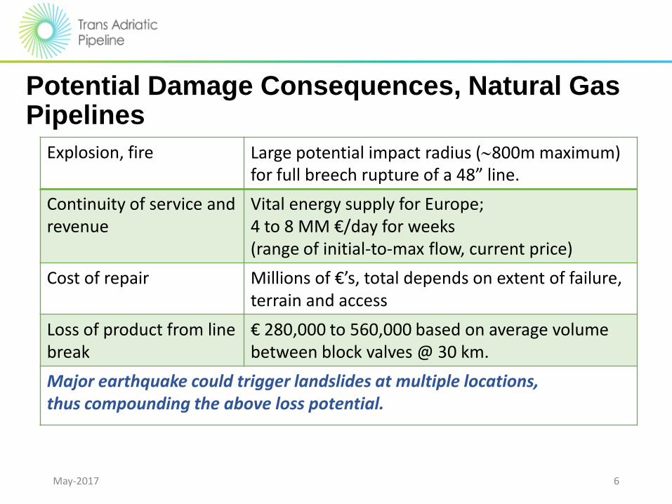
Potential Damage Consequences, Natural Gas Pipelines
May-2017 6
Explosion, fire Large potential impact radius (800m maximum) for full breech rupture of a 48” line.
Continuity of service and revenue
Vital energy supply for Europe; 4 to 8 MM €/day for weeks (range of initial-to-max flow, current price)
Cost of repair Millions of €’s, total depends on extent of failure, terrain and access
Loss of product from line break
€ 280,000 to 560,000 based on average volume between block valves @ 30 km.
Major earthquake could trigger landslides at multiple locations, thus compounding the above loss potential.

Pipeline Industry Guidance
May-2017 7
ASME 1999 has 188 pages, of which a third of one page mentions terrain and geohazards. Many of the main industry codes have 1% or less content on this topic. Despite the overwhelming impact of geohazards in active terrains, those working on pipelines terrain issues have little formal guidance, and often have to work from first principles.

May 2017 8
Geohazard Challenges
Experience elsewhere on the regional pipeline system is that geohazards can present significant risks to long-term pipeline integrity: • geohazards should be taken into account at all
stages in the project cycle; • routing to avoid or minimise geohazard risks is
the key stage; • design basis for mitigation measures needs to
be risk-based; • geohazard risks need to be monitored and
managed through the operational phase.
These principles have been adopted on TAP
Sweeney, M. (ed.) 2005. Terrain and geohazard challenges facing onshore oil and gas pipelines. Thomas Telford.

Geohazard Management • Experience from BTC onward has highlighted the need for pro-active
geohazard management in order to minimise risks on major projects.
• Focus on identification, assessment and mitigation of geohazards of relevance to the project.
• Integration of geohazard management activities into: • Pipeline routing (e.g. avoidance of landslides) • Engineering (e.g. fault crossing design) • ESIA activities and environmental restoration activities • Operations, including development of a monitoring and management plan
Landslide avoidance: Turkey Fault crossing construction: Georgia Landslide monitoring: Georgia
May-2017 9

Pipeline construction
May 2017 10

May 2017 11
Progress in Greece (March 2017) TAP’s contractors have: • received 66% of the total 32,000 line
pipes to be used for the construction of the pipeline’s Greek section;
• cleared and graded 260 km of the project’s route (RoW);
• strung 217 km of pipeline; • welded 184 km of the mainline. At the same time 154 km of trench have been opened; 119 km of pipeline have been lowered into the trench; 97 km of pipeline has been backfilled; and 18 km of land is being reinstated.

May-2017 12
Geohazard Assessment (FEED)
• Probabilistic seismic hazard assessment
• Fault studies • Liquefaction assessment • Landslide identification
and characterisation

Geohazard Assurance Team (Construction) • Formed at the time of EPC contract awards (March 2016).
• Consists of 4-person team of highly experienced specialists.
• Serves as the technical authority tasked with the review and approval of contractor’s pipeline design through geohazard areas.
• Provides technical oversight for the investigation and characterization of geohazards potentially affecting TAP. Collaborates as needed with EPC contractors.
• Provides assurance to TAP that the proposed solutions are necessary and practicable (“fit for purpose” design).
May-2017 13

14
Geohazards Key geohazards encountered on the gas pipeline system from the Caspian Sea to the Adriatic:
• Landslides
• River erosion and scour
• Active faults
• Earthquakes and liquefaction
• Ground collapse in karst terrain
• Gullying and surface soil erosion
River erosion: Azerbaijan Landslide: Georgia Karst terrain: Turkey
Fault rupture: Turkey
May-2017

Landslides
May-2017 15

16
0
0,5
1
1,5
2
2,5
Europe (General) Europe (Mountains, mainly Alps)
US (Mountains, mainly Rockies)
Andes (Mountains, traditional practice)
Andes (Mountains, geotechnics)
AGT Region (Modern practice)
Lan
dsl
ide
Failu
res/
10
00
km/y
ear
Landslides are often the key risk driver for mountain pipelines.
Post 2000 it has been possible to significantly reduce landslide risks through pro-active landslide identification and avoidance (modern practice).
From: Mike Sweeney (2016). The Fifteenth Glossop Lecture: Terrain and geohazard challenges for remote region onshore pipelines: Risk Management, Geoteams and Ground Models. Quarterly Journal of Engineering geology and Hydrogeology, in press.
May-2017

17
Sistema de Transporte de Gas Natural y Líquidos – Camisea, Peru

18
The Camisea pipeline system comprises 2 buried pipelines within the same right-of-way; a natural gas line (32-18”; 714km) and a natural gas liquids (NGL) line (8-14”; 540km).
GAS PLANT
MALVINAS
BLOCK 88
Urubamba
River
LOBERIA
TERMINAL
CITY GATE
TERMINAL,
LURIN
LIMA
Apurimac
River
PISCO
Kp 200 Toccate
Kp 126
Kepashiato
Kp 8 Tupac
Amaru
Pisco River
0 100Km
PERU
• The pipelines originate at the Camisea gas field near Malvinas in the Amazon jungle (Selva) and continue across the Andes (Sierra) to the Pacific coast (Coasta).
• Since the Camisea pipeline system became operational in September 2004, 6
ruptures have occurred along the NGL pipeline. 4 of these ruptures were caused by landslide events.
The Selva

19
Kp 126; A full-bore rupture of the 14” NGL pipeline with 0.2m separation was caused by 1.5-2m lateral displacement of a pre-existing landslide. The pipelines passed diagonally across a series of shallow (<5m deep) earthflow lobes that extended downslope from an area of deeper-seated landsliding to the south.

Lateral displacement The critical displacement that would lead to pipeline rupture varies with transition zone width and pipeline diameter/wall thickness: • Large diameter pipes; in excess of 5m
displacement for those cases where the transition zone is very gradual, around 25-30m wide;
• around 1m displacement when the transition zone width is abrupt, around 1m wide.
Buried pipeline
Pipe bending atlandslide margin (transition zone)
Pipe stretches in tension at landslide margin (transition zone)
Landslide
Pipeline buried in stable soil/rock
A. Lateral Dispacement (Pipeline transverse to landslide): Plan View
Pipeline buried in stable soil/rock
Pipe stretches in tension at landslide head (transition zone)
Pipe bends/buckles in compression atlandslide toe
Landslide
B. Lateral Dispacement Scenario (Pipeline longitudinal to landslide): Section View
Buried pipeline
Pipe drops down and stretches in tension acrossfree span at landslide head
Pipe bending atlandslide margin (transition zone)
Buried pipeline
Exposed and free spanning pipeline
C. Spanning Scenario: Section View
Landslide removes material from beneath the pipeline
Landslide backscar
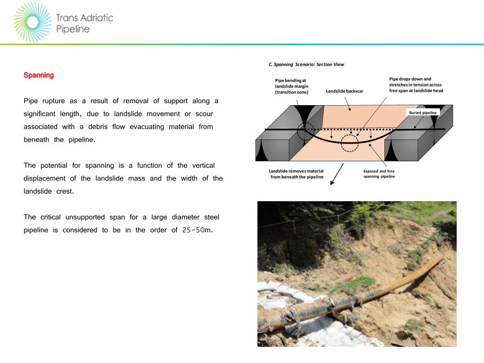
Spanning Pipe rupture as a result of removal of support along a significant length, due to landslide movement or scour associated with a debris flow evacuating material from beneath the pipeline. The potential for spanning is a function of the vertical displacement of the landslide mass and the width of the landslide crest. The critical unsupported span for a large diameter steel pipeline is considered to be in the order of 25-50m.

22
Modern practice: routing principles in landslide prone terrain:
• Avoid pre-existing landslides;
• Routing on ridge crests and spurs
• Avoid landslide prone settings (e.g. steep sidelong ground).
Eastern Turkey
Eastern Turkey
Andes, Colombia
May-2017

23
TANAP Route Rev. C
TANAP Route Rev. J
Landslide avoidance: TANAP
May-2017

TAP Landslide Management Plan
24
A landslide management plan has been developed and put into practice.
The key elements are avoidance, mitigation, spoil management and monitoring (consistent with best international practice).
Stabilisation generally not an option, except for small, relatively shallow landslides.

Key Challenges: Albania
25
An 80km section of mountains in Albania (KP50-KP133).
Probably the most challenging onshore section of the SCPX-TANAP-TAP pipeline system because of the combination of narrow ridge crests, high seismicity, widespread active landslides and unstable side slopes, and very limited access.
Mountain section is predominantly in flysch sediments (a mixture of siltstones, clay-rich schist beds and sandstones).
26
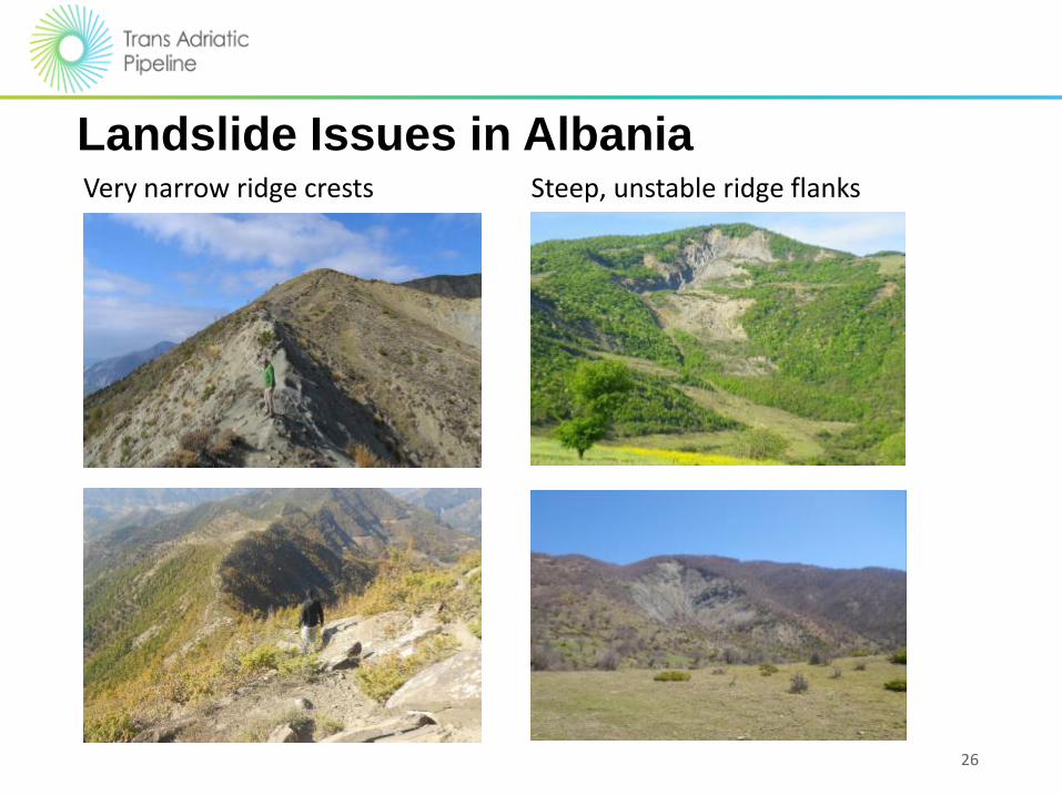
Landslide Issues in Albania Very narrow ridge crests Steep, unstable ridge flanks

May-2017 27
Landslide Issues in Albania Pre-existing landslides Glacial and peri-glacial deposits

28
Timeline for Landslide Investigations
2009; ILF Geological Terrain Assessment Report – Albania (TAP-A594-AL-ROU-REP-0057). Landslides identified from satellite imagery and InSAR analysis.
2013; OGS Structural and Geohazard Maps (Faults and Landslides). Landslides identified from Google Earth.
2014 – 2015; AUT Seismic Design Study Assessment of Earthquake Loading & Seismic Response: Field survey and landslide assessment in Albania.
Landslides identified from Google Earth.
Field visits: KP74 to KP130.
Boreholes and inclinometers installed, laboratory testing.
Re-routes proposed and implemented.
High level landslide risk assessment.
2016; CTR FEED Verification and Landslide Investigations.
Landslides identified from detailed LIDAR.
Field mapping verification.
Boreholes and inclinometers installed.
Re-routes proposed.

29
The 2013 OGS seismic study identified 21 landslides between KP78 and KP135.
Landslides identified on Google Earth by E.ON/OGS.
Alerted TAP to the nature and extent of the landslide issue
30
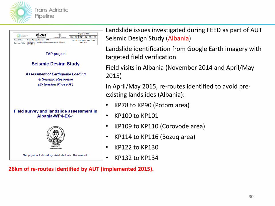
Landslide issues investigated during FEED as part of AUT Seismic Design Study (Albania)
Landslide identification from Google Earth imagery with targeted field verification
Field visits in Albania (November 2014 and April/May 2015)
In April/May 2015, re-routes identified to avoid pre-existing landslides (Albania):
• KP78 to KP90 (Potom area)
• KP100 to KP101
• KP109 to KP110 (Corovode area)
• KP114 to KP116 (Bozuq area)
• KP122 to KP130
• KP132 to KP134
26km of re-routes identified by AUT (implemented 2015).

31
The AUT study identified landslides between KP64 and KP135 (based on Google Earth imagery and field reconnaissance) Confirmed significance of landslide issues and started process of avoidance by re-routing
32
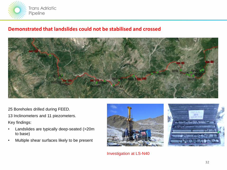
25 Boreholes drilled during FEED.
13 Inclinometers and 11 piezometers.
Key findings:
• Landslides are typically deep-seated (>20m to base)
• Multiple shear surfaces likely to be present
Investigation at LS-N40
Demonstrated that landslides could not be stabilised and crossed

FEED VERIFICATION BY CONTRACTOR (2016)
33
Re-routes and route optimisation are product of continuing process of landslide risk reduction after FEED:
• Reliance on Google Earth during FEED (17 landslide areas in Sections 5A, 5B&C and 4B only identified from LIDAR; boundaries were revised at 1 additional site in Section 5B&C)
• The need for ridge crest optimisation in Section 5B&C recognised during FEED (3 sections)
• Constructability concerns (cutting through landslide debris; 2 sites in Sections 5B&C)
Detailed ground investigations and slope monitoring, leading to a precautionary approach to defining the final route.

34
Albania (West)
RR-012 KP161+250; avoids earthflow and rotational slides (1600m)
Rotational slides on abandoned river cliff

35
KP 72 to 79; a very ridge crest section. Active tension cracks and old slope deformation features present on the ridge crest. Numerous active landslides extend to the ridgeline.
Mitigation options include geotechnical drainage, gabion walls, soil and/or rock anchors and piles.
The objective would be to ensure that the ridge crest RoW is isolated from any landslide activity on the ridge flanks (climate and earthquake-triggered events).
KP74 to KP78: Panarit Ridge

36
The Albanian mountain section is the most challenging terrain across the entire SCP-TANAP-TAP system.
Even if all pre-existing landslides are avoided, there will still be “residual risks” associated with new landslides:
• Retreat of landslide heads into RoW;
• Ridge crest “breaching” landslides;
• Failure of cut slopes;
• Landslides associated with ineffective pipe trench drainage.
Ongoing commitment to monitoring and slope repairs will be necessary to maintain integrity over the operational life.
37
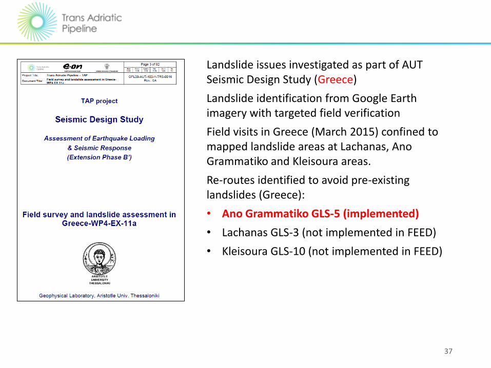
Landslide issues investigated as part of AUT Seismic Design Study (Greece)
Landslide identification from Google Earth imagery with targeted field verification
Field visits in Greece (March 2015) confined to mapped landslide areas at Lachanas, Ano Grammatiko and Kleisoura areas.
Re-routes identified to avoid pre-existing landslides (Greece):
• Ano Grammatiko GLS-5 (implemented)
• Lachanas GLS-3 (not implemented in FEED)
• Kleisoura GLS-10 (not implemented in FEED)

38
FEED Landslide Assessment (Greece)
Kleisoura
Ano Grammatico
Lachanas
Landslide mantled slopes at Kleisoura
Landsliding and severe gullying at Lachanas
Landslide complex at Ano Grammatico
Thessaloniki

39
Section 3 (Greece): Kleisoura
Landslides identified during FEED (route frozen).
Deeper burial on existing alignment not considered feasible.
Re-route proposed outside ESIA corridor (purple route).
Landslide area

40
Section 3 (Greece): Kleisoura
Landslides identified during FEED (route frozen).
Deeper burial on existing alignment not considered feasible.
Re-route proposed outside ESIA corridor.
Kleisoura re-route
FEED alignment

Rivers
May-2017 41

River erosion and scour problems: a major operational risk
42 May-2017

This Caucasus river channel migrated by 126m between 2001 and 2006, impacting the pipeline crossing
May-2017 43
2001 2006

44
In 1996 the river was straight with no island – construction by conventional means of a crude oil line may have affected characteristics of river.
May-2017

30-Nov-16 45
River Geomorphology
• abundant supply of both fine and coarse materials (cobbles, gravels and sands) to the river systems. This has led to the deposition of extensive alluvial floodplains and significant within-channel stores of gravels and cobbles.
• streams and rivers with sufficient power to transport coarse materials during high flows. This has created multi-thread (braided) gravel-bed rivers prone to rapid channel changes and bank erosion where the river passes through alluvial floodplain areas.

River Crossings: Avoid the Active Zone
46
Pipelines should be installed outside of, and below, a defined Active Zone for each major river.
Active Zone assessed using a team of specialists consisting of river engineers, river geomorphologists, and geotechnical engineers.
For each river assess maximum vertical scour, lateral scour and avulsion risk.
Karasu River, TANAP Turkey
May-2017

Basis of Design
• Design Life
• 50 years
• Design Philosophy
• Pipeline to remain fully buried outside predicted active zone for design life.
• Design Event
• 1:200 year return period flood (scour depth calculations).
• Future regime changes
• Vertical Design Safety Factors
• Lateral Design Safety Factors
47

Scour Calculations
30-Nov-16 48
General scour in the design flood event is a function of discharge and bed materials

Scour Calculations
May-2017 49
Local scour developed downstream of a bed sill and bank protection
Local scour is a localised reduction in the elevation of the channel bed. It may occur where the flow accelerates due to an abrupt reduction in boundary roughness, for example at the downstream edge of a bed sill or bank protection, or it may occur due to a sharp change in the flow direction, for example at an obstruction such as a bridge pier.
The scour produced by the presence of the revetment may be an additional 10-20% of the flow depth predicted based on Blench’s general scour equation.
CIRIA (2002). Manual on scour at bridges and other hydraulic structures. Published by CIRIA.

Bank Retreat
May-2017 50
Bank retreat is the progressive movement of the stream bank into the floodplain. It may be expected (e.g. due to evolution of the channel in dynamic equilibrium) or unexpected (e.g. bankline shifting in response to disturbance of the fluvial system).
1.E-06
1.E-05
1.E-04
1.E-03
1.E-02
1.E-01
1.E+00
0 0.2 0.4 0.6 0.8 1 1.2
Proportion of channel w idth
Pro
bab
ilit
y
Probability curves for bank retreat due to channel evolution in dynamic equilibrium. Based on observed rates of bankline shifting in rivers that are free to migrate across their floodplains

Active depth is a function of:-
1. Max scour depth
2. General degradation during life of asset
3. Allowance for existing civil protection works
4. Aggregate winning
5. Climate Change
51

Rivers Detailed Design – activities • Classification of all watercourse crossings
• Site Specific designs and crossing drawings for all RV1, RV2, RV3 and, RV4 uplands streams of high erosion potential
• Hydrological evaluations of sites requiring site specific designs
• Environmental assessment
• Design reports and method statements for all key crossings
52

HDD feasibility • Constructability; the site must be suitable for the layout of the HDD drilling equipment and the product pipe which will be pulled through on completion of the HDD
• Geology; the site must have suitable geological conditions (stratigraphy and lithology)
• Alignment; the curvature of the HDD profile/alignment must be feasible.
53
There are many factors to consider when evaluating the technical feasibility of an HDD design. An overall evaluation of each site is required considering geological factors, topographical and hydrological details and geotechnical aspects.
HDDs can be a major schedule/cost risk

Open Cut Construction • Diversion Channel
• Dry Cut
• Wet Cut
• Isolation Method using Dam and Pump
• Isolation Method using restricted flow via Flume
54
The type of crossing at each specific watercourse will be determined based on site conditions, timing of construction and by evaluating risk for adverse effects to each watercourse. Almost all Osumi crossings (Albania) will be constructed by diverting the braided channel and constructing in the ‘Dry’. They are unsuitable for HDD construction (presence of >30% coarse gravels and cobbles/boulders)

Major Rivers in Greece
• The geological conditions at major crossings are more favourable in Greece and as a consequence, a total of 4 HDD’s (Spiecapag LOT 1) and, 9 HDD’s (Bonatti LOTs 2 & 3) are currently planned.
• All other crossings will be by Open Cut
55
Major Rivers (RVX 1-3) Comment
Albania 22 Osumi; gravel/cobble bed river, not suited to HDD. Micro-tunnel scheduled in Corovode area 2 HDDs on Seman River
Greece (Lot 1) 21 4 HDDs proposed, remainder Open Cut
Grecce (Lots 2 and 3) 41 9 HDDs proposed, remainder Open Cut

Final Words
• Geohazards are important risk drivers for major gas pipeline systems;
• The potential consequences of pipeline rupture are extremely serious; health and safety, financial, environmental, business reputation;
• TAP has addressed geohazard risks at different stages of the project – a series of progressively more detailed investigations leading to continuous risk reduction;
• TAP recognises that risk cannot be eliminated, geohazard monitoring and management through the design life.
May-2017 56


![Tacloban geohazard assessment report [11.28.13]](https://static.fdocuments.in/doc/165x107/5551c3d8b4c905ca7f8b5449/tacloban-geohazard-assessment-report-112813.jpg)
