
Inverness South-West Development Connectivity Study · Inverness South-West Development...
71
Inverness South-West Development Connectivity Study TRANSPORT APPRAISAL Consultation Draft - November 2011
Transcript of Inverness South-West Development Connectivity Study · Inverness South-West Development...

Inverness South-West Development Connectivity Study
TRANSPORT APPRAISAL
Consultation Draft - November 2011

1
Table of Contents 1 INTRODUCTION 1.1 Report Format 3 1.2 Purpose of Study 3 2 CONSULTATION 2.1 Introduction 6 2.2 STAG Workshops 6 3 ANALYSIS OF PROBLEMS & OPPORTUNITIES 3.1 Previous STAG Study Findings 8 3.2 Further Reports and Studies Since 2006 9 3.3 Other Further Work 9 3.4 The Planning Context for a River and Canal Crossing 10 3.5 Inverness, Nairn and A96 Corridor Transport Study 13 3.6 Highland Council Local Transport Strategy 2011-2014 14 3.7 Key Issues and Opportunities 15 3.8 Problems 17 3.9 Issues 20 3.10 Constraints 21 3.11 Opportunities 24 3.12 Summary 26 4 OBJECTIVES 27 5 OPTION GENERATION 5.1 Initial Optioneering 29 6 OPTION SIFTING & DEVELOPMENT 6.1 Initial Option Appraisal 30 6.2 Options Taken Forward for Further Assessment 33
6.3 Further Option Assessment for River Ness Crossing and Canal Crossing 33
6.4 River and Canal Options for Further Development 35 7 PART 1 APPRAISAL 7.1 Introduction 39 7.2 Public Consultation Number 1 39 7.3 Responses from the Public Consultation 39 7.4 Summary of Comments 40 7.5 Outcome of Public Consultation 42 8 PART 2 APPRAISAL 8.1 Criteria Used in the Options Appraisal 45 8.2 Outcome from the Options Appraisal 48 8.3 Summary of Outcomes 48 8.4 Public Consultation Number 2 67 9 SUMMARY & CONCLUSIONS 9.1 Summary 69 9.1 Conclusions 70

2
Table of Contents APPENDIX A 2006 Summary Table of Recommendations APPENDIX B 2006 STAG Part 1 Recommendations Drawing APPENDIX C Minutes of Pre-Appraisal Workshop - 24th June 2010 APPENDIX D Minutes of second Pre-Appraisal Workshop - 29th September 2010APPENDIX E 2010 Matrix Assessment Base APPENDIX F 2010 Matrix Assessment APPENDIX G 2010 Matrix Assessment Final APPENDIX H 2010 Matrix Assessment Final Options – Plan Views APPENDIX I Public Consultation No. 1 - Handout APPENDIX J Engineering Drawings of 8 Options APPENDIX K Transport Modelling Report APPENDIX L Options Appraisal Summary Table APPENDIX M Magnitude of Impacts Table APPENDIX N Public Consultation No. 2 – Handout APPENDIX O Scheme Cost Estimates Summary APPENDIX P Strategic Environmental Assessment APPENDIX Q Highland Council Meeting Minutes APPENDIX R Stakeholder Meeting Minutes

3
1 INTRODUCTION
1.1 Report Format This report is structured as follows: • Chapter 1 – Introduction • Chapter 2 – Consultation • Chapter 3 – Analysis Of Problems & Opportunities • Chapter 4 – Objectives • Chapter 5 – Option Generation • Chapter 6 – Option Sifting & Development • Chapter 7 – Part 1Appraisal • Chapter 8 – Part 2 Appraisal • Chapter 9 – Summary and Conclusions All Appendices referred to in this report are contained in a separate document entitled Transport Appraisal – Appendices A to R. The report has been compiled jointly by the Highland Council and URS Scott Wilson.
1.2 Purpose of Study In 2006 URS Scott Wilson was commissioned by The Highland Council to carry out a STAG study in relation to the transport connectivity issues south and west of the City of Inverness. The Council was seeking to promote options for improved transport and infrastructure facilities to address a range of objectives and facilitate growth and expansion aspirations in a sustainable manner. The study area extended between the A96 trunk road to the east of Inverness and the A82 trunk road to the west and is shown on Figure 1.

4
Figure 1: 2006 Study Area
At this time it was recognised that the study area had undergone significant transformation in recent years with major development investment underway or completed, and further developments either committed or planned for the next 10 years. It was considered these developments would dramatically change the local area and place greater pressure on the transport network and services. The Highland Council was therefore pursuing additional transport infrastructure to serve the development proposals and also address existing weaknesses in the local facilities. Since completion of the earlier STAG study, two main developments have changed the context in which the previous study was undertaken. 1) Firstly, since 2006, The Highland Council has prepared and published the 2010 Highland Wide Local Development Plan. The Plan updates and replaces parts of the previous Highland Structure Plan as well as parts of existing Local Plans which cover strategic policy issues. It sets out:
• the spatial strategy and vision for the area; • clear policy guidance for development of all types; • the development principles of key action areas.

5
2) Secondly, following the STAG study undertaken in 2006, multi-modal proposals were submitted to the Scottish Government’s 2008 Scottish Transport Projects Review (STPR) as listed in Appendix A and as illustrated in Appendix B. The Council’s input to the STPR process was partially successful in that the East Link (Proposal 1) co-joining the A96 with the A9 was included in the Review output but not the West Link (Proposal 2) over the River Ness and Canal. The other multi-modal proposals elsewhere in Inverness were also not included in the Review output. As a consequence of the limited success of the Council’s submission to the STPR, the Council has had to re-consider the potential for other targeted interventions to support current and planned developments in the South and West of Inverness. A Stakeholder Group comprising representatives from the Highland Council, Transport Scotland, British Waterways, SEPA, SNH and Historic Scotland was formed to help guide the Council in the development of any such interventions. In order to develop and consider potential interventions, the Stakeholder Group agreed that any study should follow the normal STAG process of looking at issues and problems followed by considering objectives and thereafter producing an exhaustive list of possible solutions which could then be sifted down to firm options to be taken forward for further consideration. Therefore, as a result of these developments, it was agreed that a new STAG assessment of potential transport interventions in the south west of Inverness should be undertaken taking into account the outcome of the STPR and the completion of the 2010 Highland Wide Local Development Plan. The purpose of this Inverness South-West Development Connectivity STAG study is therefore to identity multi-modal transport interventions which will support the development opportunities to the South and West of Inverness. Whilst previous work may have focussed on multi-modal solutions incorporating a road crossing of the river and canal, there is a need for this study to be objective led rather than solution led and consider an exhaustive list of potential multi-modal transport interventions. This report sets out the findings of the Inverness South-West Development Connectivity STAG study and outlines recommendations for further development and assessment. This study has been undertaken generally in accordance with the Scottish Transport Appraisal Guidance (STAG). Its purpose is to generate and appraise transport options which could potentially address the evidence-based transport problems and opportunities within the study area.

6
2 CONSULTATION 2.1 Introduction
A major aspect of the new appraisal was to involve key stakeholders in the “Pre-Appraisal” element of the STAG appraisal. This included carrying out a STAG Workshop with key local stakeholders. As part of the STAG ongoing appraisal, a wider consultation with statutory bodies relating to environmental implications will be carried out. This chapter provides an overview of the consultation carried to date. Supporting information is contained in various appendices.
2.2 STAG Workshops
A STAG Workshop was held on Wednesday 24 June 2010 at Tulloch Castle Hotel, Dingwall. The workshop was held with a number of stakeholders to review the key issues in the study area, discuss planning objectives and identify options which could be taken forward for onward development through the STAG Part 1 and Part 2 Appraisals. The workshop was facilitated by URS Scott Wilson and representatives from the following organisations attended:
• Highland Council – TECS Transport and Infrastructure; • Highland Council – TECS Project Design Unit; • Highland Council – TECS Structures; • Highland Council – TECS Area Maintenance; • Highland Council – Planning and Development Services; • Transport Scotland including representatives from Network
Management and Transport Economics, Analysis and Research Strategy & Investment Directorate;
• HITRANS; • Highlands and Islands Enterprise (Inverness/East Highlands); • British Waterways; and • Scottish Environment Protection Agency.
Historic Scotland and Scottish Natural Heritage were not able to attend. Minutes of the STAG Workshop are contained in Appendix C of this report. The discussion and feedback from the workshop are reviewed in the following sections of the report. A second STAG Workshop was held on 29th September 2010 at Tulloch Castle Hotel, Dingwall. The workshop was facilitated by URS Scott Wilson and representatives from the following organisations attended:
• URS Scott Wilson; • Highland Council – TECS Transport and Infrastructure; • Highland Council – TECS Project Design Unit; • Highland Council – TECS Structures;

7
• Highland Council – TECS Area Maintenance; • Highland Council – Planning and Development Services; • Transport Scotland, including a representative from the Structures
Section; • Highlands and Islands Enterprise (Inverness/East Highlands); • British Waterways; • Scottish Environment Protection Agency; and • Historic Scotland.
Scottish Natural Heritage and HITRANS were not able to attend. The second Workshop had two purposes. Firstly to review the further work undertaken on the options development and sifting and secondly to carry out a risk assessment of emerging options. Minutes of the second STAG Workshop are contained in Appendix D of this report. Regular meetings of the Stakeholders Group (as described in Section 1) have also been held throughout this process and the findings of the STAG workshops have been presented, discussed and, where possible, agreed by the Group. Minutes of the Stakeholder Meetings are contained in Appendix R of this report.
8
3 ANALYSIS OF PROBLEMS & OPPORTUNITIES
3.1 Previous STAG Study Findings The analysis of the 2006 STAG study area resulted in the main conclusions reproduced below. Upon review, it is considered these provide a useful starting point for the current study:
• cars dominate transport in the area. Over 55% of all journeys to work (JTW) are
made by car and car ownership is set to increase. To this must be added the effects of the significant projected increase in population/employment due to major development plans. In addition to JTW, car dominates journeys for shopping and leisure and is therefore vital to the quality of life and mobility of residents;
• car traffic growth is significantly higher than the Scottish average. There are a
number of junctions and/or intersections in the area experiencing congestion due to high traffic flows in the AM Peak Hour. The Road Traffic Reduction Act (RTRA) Report within the Highland Council LTS monitors vehicles entering/leaving the City of Inverness. This highlights significant increases since monitoring began and predicts a 50% increase in AM Peak Hour flows between 1994 to 2013;
• above observations do not allow for future planned land-use developments which clearly would increase traffic. A 50% increase in AM peak flows would have serious effects on accidents, safety and the environment;
• car mode share in the study area is marginally higher than the average levels in
the Scottish national average. By 2015, car mode share is expected to increase in the study area. There is a slightly lower than national average mode share for “other” trips in the base year, which include trips made by walking and cycling. This suggests there is an untapped demand for walking and cycling in the study area;
• rail has grown steadily over recent years which is reflected in the observed
growth rates for rail trips in the key stations influencing the study area. Aggregate information on bus passenger growths suggests bus journeys have fallen over the last 10 years, which is typical of other parts of the country; and
• major investment planned over the next 30 years will promote continued
expansion of the City. Even without new developments, travel demand is expected to grow by approximately 25% during the AM peak period (2001 to 2011) however when new developments are added travel demand is anticipated to increase by up to 40% during the same period. An increase of up to 40% would raise serious implications for safety and the local environment in the study area.

9
Certain parts of the network have been identified as either approaching or already at congestion stress levels. Consequently, further network stresses would raise serious issues to travel times and network reliability (likely to impact on most modes of travel) which in turn would raise further issues for the local economy.
3.2 Further Reports and Studies Since 2006 Since 2006, further reports and studies have been undertaken which are relevant to the current study and which supplement the findings of the 2006 study. Firstly, The Highland Council has published the 2010 Highland Wide Local Development Plan. Amongst other things this Plan sets out a vision for the future development of Inverness and objectives to support the delivery of the Plan. The Plan was also supplemented by a number of specific studies which are relevant to the current study. Most relevant of these is the Inverness, Nairn and A96 Corridor Transport Study, in particular the A96 2009 VISUM Model Update report, and this is discussed in more detail later in this section. Secondly, The Highland Council's Local Transport Strategy 2011-2014 was published in 2010. This reinforces some of the earlier findings of the 2006 STAG and provides further data and objectives related to the transport issues facing Inverness.
3.3 Other Further Work In addition to the earlier STAG work, further work has also been undertaken on identifying problems, issues, constraints and opportunities more specific to the reduced study area shown in Figure 2. This has used the studies and reports prepared for and by the Highland Council described in section 3.2. In addition STAG workshops have been held to obtain stakeholder input on the problems and opportunities in the new study area. The findings from this further work are discussed below.
Figure 2: 2010 Study Area

10
3.4 The Planning Context for a River and Canal Crossing History The principle of the Southern Distributor Road (SDR) was first established in the early 1970’s to facilitate the expansion and then consolidation of the City and to provide a strategic an around city distributor road to carry an element of bypass traffic. Phases 1-4 of the Southern Distributor Road from Inshes to Dores were completed in 2002 with completion of the Slackbuie Avenue to Old Edinburgh Road section. Phase 5 of the road was committed to by the Council in 2003. This final phase would allow for key development sites to be released to consolidate the City’s development. Inverness Local Plan The Inverness Local Plan was adopted in 2006. During the consultation on the Inverness Local Plan a consultation was carried out and then a decision made by The Council on the indicative corridor alignment of Phase 5 of the SDR. The indicative alignment of Phase 5 is shown on the proposals map for the City of Inverness and supported by Policy 29 which safeguards land at Ness-side, Canal Parks and Torvean. It was recognised at the time that key expansion/consolidation sites in the Inverness Local Plan could not be brought forward in their entirety without the river and canal crossing including:
• Ness-side – land is allocated at Ness Castle/Ness-side for a mixture of uses. The Inverness Local Plan clearly states that development of this site will be dependant on the: programmed/committed funding necessary to link the A82 including development; construction of part of this route concurrent with development and addressing of other constraints.
• Charleston – land is allocated at Charleston for a mix of uses (predominantly housing), however this was limited to 140 houses prior to the completion of Phase 5 of the Trunk Link Road.
Highland wide Local Development Plan (Proposed Plan) The Highland wide Local Development Plan is currently at the examination stage. The Proposed Plan is of a form and content that the Council would be willing to adopt subject to commended changes to the Reporter’s at the Directorate of Planning and Environmental Appeals (DPEA). Any changes to the Plan which the Reporters recommend are largely binding on the Council. The Highland Wide Local Development Plan sets out 5 strategic land use planning objectives for the Highlands as a whole. Of particular relevance to this Study are the following extracts:

11
We will have supported a Competitive, Sustainable and Adaptable Highland Economy by: • providing opportunities which encourage economic development and create new
employment across the area focusing on the key sectors of life sciences, energy, tourism, food and drink, higher education, inward investment, financial and business services, creative industries and aquaculture, whilst at the same time improving the strategic infrastructure necessary to allow the economy to grow over the long term;
• helping to deliver, in partnership with Transport Scotland and other transport bodies, transport infrastructure improvements across the area in line with the Council’s Local Transport Strategy and the Scottish Government’s Strategic Transport Projects Review;
• promoting a positive and innovative approach to masterplanning new developments that contribute towards reducing the need to travel and encourage people to walk, cycle or use public transport;
The Plan also sets out in more detail in relation to the Inner Moray Firth area, the following aspirations:
• have a growing City – building on the growth and opportunities of its role as the
major service and administrative centre, Inverness will have developed in a way that promotes the key aspirations of the updated City vision, focuses development where infrastructure exists or can be provided in the most efficient way and maintains a thriving City centre as the focus for services and retail provision
• have more efficient forms of travel – the area will have seen substantial improvements to the existing transport network through improvements to the road network, seeing an increase in the numbers of people walking, cycling as a result of the green network, and taking the urban rail/bus networks and delivery of better connections for local road freight to and from longer haul Caledonian canal, rail, sea and air routes.
• have resolved its infrastructure constraints - an effective partnership of all funding bodies will have removed the barriers to growth. As well as improvements to the A9 trunk road, the West Link, A96 upgrade, the Nairn By-pass and a new station at Dalcross will have been delivered. Broadband, electricity grid networks and drainage infrastructure will no longer restrict the economic potential of the area.
The HwLDP sets out the Spatial Strategy for Inverness. The focus of this is consolidation of the existing city by regeneration of key sites, completion of existing expansion sites and development of future expansion sites prior to expansion of the City East into the A96 Corridor. This strategy is shown on map (Figure 3):

12
Figure 3
The HwLDP recognises that Ness-side and Charleston continue to be constrained by the lack of a river and canal crossing and that it is a Council priority to unlock these areas through acceptable solutions to the river and canal crossing. Policy 8 of the HwLDP supports the masterplanning of Ness-side and Charleston in tandem with the work being carried out to identify options for the river and canal crossing with any development on these sites to contribute towards the delivery of an environmentally sensitive river and canal crossing. Inverness City Vision Work has been carried out to update the Inverness City Vision first approved by the Council in 2003. The themes emerging from the updated Inverness City Vision are:
• the economy at the heart of everything; • strengthen the city centre; • a better connected Inverness; • a city for all ages; • greenness; • build on our assets; • think tourism; • culture, pride and identity; and • health and well-being.
The river and canal crossing can contribute to many of the above themes including a the economy at the heart of everything and better connected Inverness. Projects and priority areas have been put forward, this includes the “Spider: Restoring the City Shape”. The Spider seeks:
• Priority streets; • Public realm and public art investment; • Strategic infill/edge developments; and

13
• Transport links. The River and Canal project will facilitate the delivery of this project by improving cross-city transport links and strategic infill developments. The updated Inverness City Vision will be subject to consultation in early 2012.
3.5 Inverness, Nairn and A96 Corridor Transport Study The previous work undertaken as part of the 2006 STAG Study utilised the Inverness City 2005 Base VISUM Transport Model owned and operated by The Highland Council. Since the original report was prepared, the Council, in preparation for the updated Highland Wide Local Development Plan, commissioned an update and expansion of the Transport Model. The outcome of this work is described in the Inverness, Nairn and A96 Corridor Transport Study, available on The Highland Council website. This update included an expansion of the model to cover a wider geographical area including more detailed modelling of the A96 corridor between Inverness and Nairn. The new A96 VISUM Transport Model was also supplemented by new traffic survey information including extensive junction and link traffic counts, queue length surveys, roadside interviews and journey time surveys. The model used a Base year of 2009 and using predicted development data and phasing provided by The Highland Council Planning Department provided traffic predictions relating to future years of 2016 and 2021. Finally, the update also included for the high level testing of potential Transport Interventions in and around Inverness at different Design years. The work undertaken used the following indicators to analyse model performance for both base and future models:
• Traffic Flow Percentage Change on Links compared to the “Do Nothing” scenarios;
• Level Of Service (LOS); • Queues at the end of this period; • Journey times; and • Volume / Capacity for Links.
The traffic modelling work undertaken in this study used these indicators to identify the type of transport interventions that will be required throughout Inverness (and the A96 Corridor and Nairn) over the period to 2021 in order to accommodate the significant levels of development envisaged over these years. Of particular relevance to the current study is the finding outlined in page 9 of Part 1 of the Inverness, Nairn and A96 Corridor Transport Study report which states that: It has been considered that the provision of the following interventions by Highland Council (or by developers in partnership with the Council) is essential

14
by 2021 to accommodate future development both in the city and in the A96 Corridor, as illustrated on the following plans:
2. West Link from Dores Road across to the A82.
3.6 Highland Council Local Transport Strategy 2011-2014 The Highland Council Local Transport Strategy 2011-2014 was published in 2010. It sets out the strategy for transport in the Highlands at a local level and provides guidance on policy and investment on transport for the Highland area. It sets out the Councils’ LTS Vision:
Through its Local Transport Strategy, the Highland Council seeks to enable and facilitate sustainable development and economic growth; support, include and empower communities through transparent decision-making, and establish an integrated transport network which supports safe and sustainable environments in which people can live, work and travel.
It also sets out nine LTS objectives:
Economy: Provide a transport network to enable sustainable economic growth, noting the very different conditions between urban and rural locations and addressing the remoteness factor facing Highland trips to the rest of the UK; Social Inclusion: Facilitate travel to enable economic/social involvement and improve access/travel choices to essential services for those without access to a private car; Environment: Manage/reduce the impacts of transport on the natural and built environment; Health: Increase levels of cycling and walking to promote health improvement and modal shift; Road Safety: Continue to improve road safety, addressing locations where road accidents are above average levels; Personal Safety: Address issues of perceived safety and personal security particularly where they are a barrier to walking, cycling and public transport; Policy Integration: Identify policy overlap across Council services, and with other public bodies (e.g. NHS), maximise benefits and minimise contradiction; Investment integration: Identify benefits and opportunities of combined transport procurement for all Council services; and Traffic reduction: Where appropriate consider targets for reducing traffic, although noting the variation in conditions and requirements between rural and urban areas.

15
Also of particular interest and relevance to the current study are the background sections on the Moray Firth Journey to Work Area, traffic flow characteristics, transport modes and parking / park and ride.
3.7 Key Issues and Opportunities The attendees at the STAG Workshop on 24th June 2010 were specifically tasked with identifying key issues relevant to the new study area. The key issues identified by the attendees are presented below and these have been used as the starting point for an analysis of the problems and opportunities within the study area. These and other key issues are then discussed in more detail in the following sections. At the STAG Workshop on 24th June 2010 the following key issues and opportunities in the study area were identified. These are repeated verbatim from the workshop minutes but have been grouped under appropriate headings to help identify common themes as follows: Traffic
• Ness Bridge / Friar’s Bridge – problems regarding traffic management when undertaking maintenance;
• Canal swing bridge. Queues – opening times / congestion / time of day; • Street capacity in city centre; • Streets not wide enough. cyclist, pedestrians – not friendly; • Poor road links into city centre; • Dores road – On road parking problem; • A82 – traffic volumes / capacity; • Radial movements forced through city; • Capacity of Dores Road; and • Trunk road through city.
Public Transport
• Frequency of public transport; • Lack of active public travel options; and • Lack of workplace parking.
Environment
• Noise / fumes for residents; • Environmental impact – SSSI, heritage, sport & recreation, wildlife impact,
landscape; and • Flooding.
Planning
• Economy > low development contributions; • Barriers to water transport increase; • Pressures from developers; and

16
• City centre employment concentration in centre. General
• Lack of amenities in area; • Too few river/canal crossings (part of the ‘wheel’ is missing); • Constraints river / canal crossings; • Existing river/canal crossings capacity; • Difference in level river / canal; and • Contingencies for accidents within the city / local area
In addition, the workshop attendees also identified potential opportunities that may arise from the outcome of the study. These were:
• Separate local/strategic traffic; • Commercial/ / residential share amenities? • Development close to city; • Developer contributions; • Cross river connectivity; • Bring communities together; • Opportunity for integrated development with transport; • Relieve congestion in city; • Landscape integration of transport corridor;
The key issues identified at the workshop can be further broken down into problems, issues and constraints. Therefore, building on the workshop, more work was undertaken to group together, develop and better understand the key issues listed above. In particular, the updated transport model described in section 3.5, the 2010 Local Development Plan and the LTS have been used to support a more detailed assessment of some of the perceived issues identified at the STAG Workshop. Also further research has been carried out to gather evidence to provide a better understanding of these and other issues. The outcomes from this are discussed in more detail in Section 3.9 to 3.7. In addition, other issues have emerged and these are also included below. The key issues have been sub-divided into the following groups; where possible, to merge together common issues; and to define each in more detail: Problems – what the study is seeking to address. Issues – uncertainties in the study area that the study may not be in a position to resolve, but must work within the context of. Constraints – bounds within which the study is being undertaken.

17
3.8 Problems From the key issues identified at the workshop and further study, the following are considered to capture the main problems in the study area that any interventions must seek to address. Traffic
• Ness Bridge / Friar’s Bridge – problems regarding traffic management when undertaking maintenance - Ness Bridge and Friars Bridge provide the two main vehicular crossings of the River Ness within Inverness and the flow of traffic to both sides of the city is dependent on their full availability. Both are now several years old and are subject to increasing maintenance requirements. Any requirement to carry out maintenance activities results in extensive traffic management within the city centre, adding to existing congestion levels.
• Canal swing bridge. Queues – opening times / congestion / time of day - The
A82 to and from Inverness currently crosses the Caledonian Canal via the Tomnahurich opening swing bridge on Glenurquhart Road. The current protocol between Transport Scotland and British Waterways is that, with the exception of peak hours, vessels on the canal have precedence over vehicles on the A82 trunk road. The requirement to open the swing bridge to allow canal vessels to pass results in the A82 being closed for a minimum of between 3 and 9 minutes at a time resulting in delays to trunk road traffic and consequent traffic queues and congestion. In addition, the aged swing bridge is increasingly subject to operational problems and there have been several incidents where the bridge has been stuck open for extended periods of time resulting in extensive congestion in and around the area.
• Street capacity in city centre – The main routes in, around and through
Inverness city centre utilise existing roads and streets which have little changed over a long period e.g. Kenneth Street, Tomnahurich Street Academy Street, Castle Road, Castle Street. Consequently the ability of city centre roads to accommodate increasing traffic levels is heavily constrained by existing widths and junctions dictated by adjacent properties and buildings.
• A82 – traffic volumes / capacity – the existing A82 through Inverness is
subject to the same issues outlined above in terms of the constraints imposed by its current route via Kenneth Street and Tomnahurich Street. The traffic on these routes is subjected to excessive queuing, displays and congestion throughout the year.

18
• Radial movements forced through city – there is currently no route which
allows inter-urban traffic between the west of Inverness (A82) and east of Inverness (A9) to bypass the city without passing through the city centre. There is a high level of traffic in the City Centre that has no destination there.
• City Centre congestion – The centre of Inverness is increasingly subject to
congestion during peak times. This is illustrated graphically in the Level of Service diagrams for the AM and PM peak periods for the base year of 2009 in the A96 2009 VISUM Model Update Report which illustrates existing junctions which are currently at or above capacity. In particular, it identifies a number of key pressure areas including the following city centre junctions:
o A82 Friars Bridge South Roundabout (Shore Street Roundabout) o Ness Bridge Junction (Dores Road / Young Street) o A82 Friars Bridge North Roundabout (Telford Street Roundabout) o Crown Y Junction o Old Edinburgh Road / Southside Road Junction
Public Transport
• Frequency of public transport – Use of public transport is constrained by current frequency of services; The average frequency of bus services in Inverness is 20 minutes.

19
• Lack of active public travel options – The Highland Council’s Vision includes the objective of achieving a healthier Highlands by, amongst other things, promoting opportunities for active travel. In addition, the lTS aspires to increase levels of cycling and walking to promote health improvement. This is hindered by a lack of integrated cycling and walking facilities. In addition, the level of traffic congestion on existing streets is perceived as discouraging the wider adoption of non-vehicular modes and the use of buses.
• Lack of workplace parking. Many businesses in the City Centre do not have workplace parking forcing employees and customers to use Town Centre parking or the City bus service.
General
• Too few river/canal crossings (part of the ‘wheel’ is missing) – The Ness Bridge and Friars Bridge provide the two main vehicular crossings of the River Ness within Inverness, with a more local crossing at Grant Street to the north of Friars Bridge. Similarly there are only two crossings of the Caledonian Canal: at Tomnahurich to the south west of the city and at Telford Street / Clachnaharry to the north west of the city.
• Existing river/canal crossings capacity – With the exception of Friar’s Bridge, the existing river and canal crossings are single carriageway with limited width.
20
• Development at Ness-side and Charleston – The two expansion sites at Ness-side and Charleston identified in the Inverness Local Plan are currently constrained by the need for a new river and canal crossing (reference The City of Inverness 38 (iv) and 38 (v)).
3.9 Issues
Other key issues are not considered to be problems as such but are uncertainties in the study area that the study must take into account as follows.
Traffic
• Dores / Island Bank road – On road parking problem – The nature of Dores Road and Island Bank Road and the adjacent land uses is such that it is subject to high levels of on road parking. This is exacerbated by the fact that there are currently no parking restrictions on these roads. The prevalence of on road parking together with narrow road widths inhibits the flow of traffic on this busy radial route.
Environment
• Noise / fumes for residents – Although currently air quality is not an issue in Inverness, with no Air Quality Management Areas and no issues with achieving Government air quality objectives, it is likely that residents will expect that any transport interventions will have a negative impact on air quality. A similar scenario exists for noise.
Planning
• Economy > low development contributions – The current economic climate has resulted in a suppression of demand for housing and commercial property resulting in a slow down in development. As a result, the timing and level of developer contributions to any infrastructure improvements is potentially an issue with respect to capital costs and implementation programme.
• Barriers to water transport increase – British Waterways are keen that any
potential intervention be considered in relation to its potential to increase the use of the Caledonian Canal by water borne transport modes and any associated development land uses.
• Pressures from developers – As economic conditions improve, pressure from
developers to release land will increase. As noted earlier, the release of an allocation of approximately 1,160 houses at Charleston and Ness-side are currently dependent on provision of a new river and canal crossing.

21
• City centre employment concentration in centre – There is currently a concentration of employment in the city centre which contributes to the problems with city centre congestion discussed earlier. The ability to distribute future employment opportunities more widely around the area will have transport and traffic implications.
3.10 Constraints In addition to the problems and key issues described earlier, there also a number of constraints within which the study must be undertaken (i.e. the things which impact on the study / study area and which the study cannot change). The key constraints are therefore: Traffic
• Streets not wide enough - not cyclist / pedestrian friendly; • Poor road links into city centre; • Capacity of Dores Road; and • Trunk road through city.
The above constraints are interlinked with the problems discussed in section 3.9. Any proposal to address these problems must take into account the physical constraints inherent in the existing road infrastructure in the City. Typical carriageway and footway widths on key routes in the study area are:
Road Carriageway width Footway width Island Bank Road 6.7m 1.3m and lengths with no
footway Dores Road 7.2m 1.8m and lengths with no
footway Kenneth Street 8.25m 2m Tomnahurich Street 10.4m 1.7m Glenurquhart Road 7.3m 1.7m Southern Distributor Road 7.3m 3.0m x 2No
In addition, the back of footway generally coincides with adjacent property boundaries. General
• Constraints river / canal crossings; and • Difference in level between river and canal.
Options which may require a joint crossing of the River Ness and the Caledonian Canal will be constrained by the difference in level between the two. In the vicinity of

22
Whin Park the water level of the river is approximately 26m AOD. At the same location, the canal water level is approximately 33.5m AOD, 7.5m higher than the river water level.
Environment
• Flooding
The SEPA Indicative River and Coastal Flood Map (Scotland) shows some flooding along the channel of the River Ness in the vicinity of the Mill / Timber Yard on the southern bank, at Canal Park on the northern bank and also at Ness-side House on the eastern bank. It is likely that SEPA will require that any proposals in the vicinity of the River Ness should not result in any increase to flood risk or flooding extent.
• Figure 4 Predicted pre-development extent of flooding
The Highland Council’s Vision includes the objective of safeguarding the environment by ensuring that the special quality of the natural, built and cultural environment in the Highlands is protected and enhanced (Ref HWLDP para. 4.2.2) and therefore any potential intervention must take this into account. Where possible, it should also seek to support the Council’s aim to take a lead in reducing the amount of greenhouse gases released into the air.

23
The environmental constraints will be an important consideration in any proposed interventions. These are described in more detail below.
SSSI The Torvean Landforms Site of Special Scientific Interest (SSSI) falls within the study area and any proposal will need to take into account any potential impact on the site. This SSSI is designated because of its excellent assemblage of fluvioglacial landforms which include suites of ‘kame terraces’ and one of the highest ‘esker ridges’ in Britain.
Cultural Heritage Key sites in the proximity of the study area include: Mott Holm House, the River Ness, Torvean Motte and the Caledonian Canal. Both the Torvean Motte and Caledonian Canal are designated as Scheduled Monuments.

24
Community Effects - Sport and Recreation The study area encompasses a number of important community sports and recreation facilities. These include
• Torvean Golf Course; • Highland Rugby Club at Canal Park; • Inverness Rowing Club Boat House and the Rowing Club measured
competitive length; • Whin Park; • Inverness Leisure facilities at Bught Park which include –
Inverness Aquadome; Sports Centre; Queen’s Park athletics stadium; Inverness Blitz American football grass training pitch; and Inverness Ice Centre.
Wildlife Impact - Ecology & Nature Conservation Ecological issues that are likely to be of importance are the possible presence of protected species such as water vole, Atlantic salmon, fresh water lamprey, otter, red squirrel, bats and badger. These are likely to be present within the western part of the River Ness. Extensive Tree Preservation Orders are in existence on the south side of the river around Dores Road in particular and these should be avoided where possible.

25
Landscape & Visual Effects There are potential impacts on the landscape, particularly in relation to the river crossings of the Ness and Caledonian Canal. Although less likely, there are also potential impacts on the Historic Garden and Designed Landscape designations at Tomnahurich Cemetery. Water Quality The water quality of the River Ness and Caledonian Canal will be an important issue. Funding As explained earlier in this report the previous study, which was undertaken as part of the Inverness Trunk Link Road project, eventually had to be terminated when funding for the overall project from the Scottish Government was only part committed. The Highland Council, working under tight Capital spending constraints, has been able to identify a limited amount of funding to progress any potential interventions identified as part of this study. Accordingly, it has to be recognised that any proposals taken forward from the STAG study have to be capable of being developed into a project that is affordable relative to the allocation identified in the Council’s Capital Programme.
3.11 Opportunities The STAG Workshop identified Opportunities that may result from the project. Separate local/strategic traffic This had been a key element of the previous STAG study and the development of proposals for the East Link in particular. A similar split for Options from this Study may be more difficult to deliver. Commercial / residential share amenities Community and commercial facilities that are currently not directly accessible from either side of the river would become more accessible. Development close to city The Ness-side Development Plan for the area within the Study limits on the south side of the River Ness advises on the potential for:- Opening up access along River Ness - Pedestrian / Cyclist, New Community School, Better/Accessible Business Land, Development tied into genuine District Centre, Consolidating sustainable pattern of development for Inverness.

26
Developer contributions The Highland Council Local Plan identifies areas zoned for housing that are currently blocked until a link across from Dores Road to the A82 is constructed. The Council expect that contributions from developers will be realised if a new link is delivered. This opportunity is expressly acknowledged in the Council’s Vision which states that the Council shall ensure the effective delivery of its plan strategy through efficient and transparent use of developer contributions (Ref HWLDP para. 4.2.1). The potential opportunity to release areas for housing through a targeted transport intervention ought to provide an opportunity to realise such contributions. Cross river connectivity; bring communities together These were two separate items however it is considered that they embrace a similar Opportunity which can be delivered by fulfilling the long held plan to connect the roads system to the west of the city by crossing the River Ness and the Caledonian Canal. Opportunity for integrated development with transport The Ness-side Development Plan for the area within the Study limits on the south side of the River Ness advises on the potential for: - Self-contained neighbourhood - ACTIVE travel and Potential for Park & Ride and for enhanced public transport into the City Centre. Landscape integration of transport corridor An opportunity under this heading has potential however, whether it can be delivered is down to availability of adequate funding and as advised earlier the project funding is limited.
3.12 Summary
The problems, issues and constraints in the study area, as discussed above, have been used to derive the STAG Objectives for the study. These are described in the following section.

27
4 OBJECTIVES
The earlier Objectives set in the 2006 STAG study are listed below:
OLD OBJECTIVES
• Objective 1 (Sustainable Development): assist with economic opportunities (as measured by potential numbers of jobs) by accommodating future development growth;
• Objective 2 (Reliability): assist in improving the efficiency of the transport network (as measured by travel congestion, costs and times);
• Objective 3 (Modal Shift): improve the modal shares of more sustainable means of transport;
• Objective 4 (Connectivity): improve strategic connectivity between the east and west sides of Inverness; and
• Objective 5 (Accessibility): alleviate river and canal crossing constraints.
These Objectives were reviewed and considered inappropriate for the new study. At the initial STAG Workshop, following consideration of the problems and issues in the area, appropriate themes were agreed for the specific study STAG Objectives. These were:
• Connectivity; • Modal shift; • Journey time reliability; and • Integration with existing land use development plans.
Based on a more detailed assessment of the problems and opportunities discussed in section 3, the themes were then further developed to study specific SMART objectives. Connectivity - Transport in and around Inverness is currently impacted by the presence of the River Ness and Caledonian Canal through the centre of the city. In particular, the existing river crossing points act as pressure points for traffic. In addition, any disruption to the free use of the crossings results in major disruption in the area. Modal shift - The Council has a strategic objective to encourage people to walk, cycle or use public transport and any transport intervention must seek opportunities to support this objective. Journey time reliability - Inverness already suffers from traffic congestion through lack of capacity and this is likely to get worse as new development continues and traffic

28
levels increase. As a key travel indicator for users, any intervention must seek to address this issue. Integration with existing land use development plans – Future plans for the south west of Inverness are clearly set out in Highland Council statutory documents. Any interventions must take cognisance of published plans and development levels. Lastly, whilst not specifically agreed at the Workshop, it was apparent that there is a desire that any future interventions should be developed with the aim to minimise the impact on the local environment. Again, this is supported by published Council objectives and it is considered that the study must recognise this. Consequently, the new and revised study objectives are:
NEW OBJECTIVES
• Objective 1 (Land Use): integrate any interventions with the existing Highland Council land use development plans for the South West of Inverness (Ness Castle, Milton of Ness-side, Ness-side, Torvean and Charleston);
• Objective 2 (Journey Time and Reliability): maintain level of service at existing junctions in City centre at 2009 levels (ref A96 2009 VISUM Model Update Report);
• Objective 3 (Modal Shift): increase travel choices and improve integration across modes to encourage modal shift of people;
• Objective 4 (Connectivity): reduce operational dependence on existing river and canal crossing points; and
• Objective 5 (Environment): minimise the impact on people and properties, and the natural and cultural heritage of the study area.
Whilst it is acknowledged that some of the above objectives may fall under the standard STAG criteria, it is considered that it worthwhile to highlight these as overarching study objectives. As the study progresses, all potential interventions will also be assessed against the STAG criteria of Environment, Safety, Economy, Integration and Accessibility.

29
5 OPTION GENERATION
5.1 Initial Optioneering The final part of the Pre-Appraisal workshop was the identification and initial sifting of potential options for consideration. Firstly, through break-out groups, a long list of potential interventions was derived. These were then assessed by the whole group to identify initial options which were duplicated and to sift out any that clearly did not meet the study objectives. The full process is documented in the workshop minutes presented in Appendix D. At the end of the Workshop, a list of potential interventions was agreed for further consideration and more detailed sifting against the study objectives. The potential interventions are presented below unfiltered:
1. Provide a Cycle route along Dores road / river corridor 2. Improve B861 (Culduthel Road) - Active travel opportunities / bus priority
routes 3. Improve B862 (Dores Road) - Traffic management / active travel opportunities
/ parking / bus priority routes 4. Improve A82: Traffic management / active travel opportunities / parking / bus
priority routes 5. Improve city centre junctions (physical improvements) 6. Improve SCOOT system in city centre (management improvement) 7. Provide Park & Ride on radial routes including cycle facilities 8. Provide Park & Stride on radial routes 9. Additional pedestrian & cycle crossings of canal / river 10. Improve existing canal crossings (reliability / operation of open / swing bridge) 11. Provide new river crossings for all modes 12. Provide new canal crossings for all modes 13. Encourage green travel plans for major employers 14. Proven traffic model 15. Three lanes to facilitate maintenance for any new bridge 16. Provide cycle network in new developments 17. Restrict long stay (city centre) parking opportunities 18. Provide enhanced bus services 19. Provide tourist attractive public transport services 20. Provide adequate path network / separated width 21. Establish a City Centre Car park on west side of river 22. Car free households 23. Freight strategy 24. Stagger school hours 25. Stagger work place hours 26. Encourage car sharing

30
6 OPTION SIFTING & DEVELOPMENT 6.1 Initial Option Appraisal
Further to the Workshop, the options described in section 5 have been further considered in relation to the objectives listed in section 4. This resulted in the following conclusions. Options 2, 3 and 4 Options 2, 3 and 4 propose the promotion of bus priority routes, active travel opportunities (e.g. cycle and foot) and traffic management on the A82, B861 and B862. In addition, option 4 includes improving parking on the A82. These 3 options are heavily restricted by the existing road corridor and the proximity of roadside development / properties. Whilst these options may assist in encouraging modal shift (Objective 3) they will not address the other objectives by themselves. Indeed given the current congestion levels in the city centre and the restrictions imposed by existing infrastructure, the introduction of bus priority measures would increase pressure on existing roads and junctions, contradictory to the aims of Objective 2. Similarly these options would not reduce dependence on existing river and canal crossings (Objective 4) or assist with the integration of the transport needs of the area with the existing development plans for the South West of Inverness (Objective 1). Options 18 and 19 Options 18 and 19 are the provision of enhanced bus services and tourist attractive public transport services. Rather than options in their own right, it is considered that these should be treated as opportunities that may arise from any potential interventions. Options 7 and 8 Options 7 and 8 are the provision of park and ride facilities on radial routes to and from Inverness. Whilst these options may assist in encouraging modal shift (Objective 3) they will not wholly address the other objectives by themselves. Whilst the use of park and ride may help ease the current congestion levels in the city centre, it is considered that it would not make a major contribution to journey time reliability (Objective 2) at peak hours due to the challenges faced by buses as described above. Similarly these options would not reduce dependence on existing river and canal crossings (Objective 4) or assist with the integration of the transport needs of the area with the existing development plans for the South West of Inverness (Objective 1). Options 17 and 21

31
Options 17 and 21 relate to the restriction of long-term parking in the city centre and the establishment of a new car park on the west side of the River Ness. Whilst these ideas may reduce the amount of cars entering the city centre, the effect is likely to be modest only and would not contribute to the achievement of the main study objectives, in particular Objectives 1 and 4. Options 5 and 6 These options propose improvements to the operation of city centre junctions, physically and through the improvement of the existing SCOOT system. With respect to the latter option, it is the view of the Highland Council that there is scope to expand the SCOOT system to include the junction at Telford Street and other parts of the network such as Inshes and Old Perth Road. This proposal is being taken forward separately by the Highland Council. The opportunity to physically improve existing city centre junctions may assist the throughput of traffic in the city centre but does not address the other issues in the study area such as severance and developer pressures. It is also heavily compromised by the very fact that they are in the city centre and hence constrained by lack of working space and the proximity of roadside development / properties. Hence it is concluded that these options are not worth pursuing. Option 10 This option proposes the improvement of the reliability and operation of existing canal crossings. Although reliability of canal crossings is a big local issue in reality this is a periodic and short duration problem only. The bigger issue is the impact of the regular openings of the swing bridge at Tomnahurich and the impact on journey time reliability; the improvement of the reliability and operation of the existing bridges would not however remove the requirement for the bridge to open to allow canal traffic to pass. Options 11 and 12 These options propose new river and canal crossings suitable for all travel modes. It is considered that these options would increase travel options to and from the city centre and would meet all the study objectives as follows: Objective 1 - supports land use development and planning constraints. Objective 2 - has the potential to free up capacity and to improve journey time due to the potential removal of longer distance/strategic traffic. Objective 3 - removes traffic to more suitable roads and hence allow opportunities for sustainable travel initiatives. Objective 4 - reduces reliability on existing river and canal crossing points.

32
As the time available at the workshop was limited, there was no opportunity to develop potential options for river and canal crossings however previous work has been done on this which can inform further development of options. It was noted that locations for potential crossings will be dictated by and restricted by the desire to avoid any property demolition and significant environmental impacts. Option 15 The option to provide three lanes to facilitate maintenance for any new bridge is a sub-set of options 11 and 12 and should be considered in any future development of these options. Options 1, 9, 16 and 20 These options all relate to improved pedestrian and cycling facilities. In their own right these options will only make a modest improvement / contribution to the objectives and it is clear that cycling or walking on its own is unlikely to meet the study aims and objectives for the area. It is therefore concluded that these options would not in themselves meet the study objectives but potential opportunities for enhanced walking/cycling facilities should be considered as complementary to other potential interventions. Options 13, 22, 23, 24, 25 and 26 Option 13 proposes that major employers are encouraged to adopt green travel plans. This option is already covered by the requirements of Policy Numbers 1 and 12 in the Council’s Local Transport Strategy (LTS). Similarly, Option 23 proposing preparation of a freight strategy is covered by Policy 13 of the LTS. Options 22, 24, 25 and 26 may have a contribution to make to addressing transport issues within Inverness; however it is considered that they are too high level to be relevant to the current study and would more appropriately be covered by a City-wide approach perhaps by adoption within the LTS. Option 14 This option proposes that the availability of a proven traffic model would assist in the achievement of the study objectives. The Inverness City Base 2009 VISUM Transport Model described in section 3.5 has been replaced by a new Moray Firth Transport Model, commissioned by the Highland Council in August 2009. This new model provides a proven traffic model suitable for the assessment of traffic issues in and around Inverness.

33
6.2 Options Taken Forward for Further Assessment Based on the initial option appraisal presented in section 6.1, it is apparent that the only options that have the potential to fully meet all the study objectives are Options 11 and 12. Therefore the two main options proposed for further more detailed assessment are:
11 Provide new river crossings for all modes 12 Provide new canal crossings for all modes
At the same time, it is considered that, whilst not meeting all objectives, other options could make a contribution to meeting the study objectives, particularly with respect to Objectives 2 and 3. Therefore it is proposed that the development of Options 11 and 12 must include the following elements: A. Integrated walking/cycling facilities B. Pedestrian/cycle facilities on any new crossing of the River Ness and Caledonian
Canal. C. Allow for a cycle path beside the river into the City centre.
It is also recommended that if options 11 and 12 can be delivered then consideration should be given to promoting a new integrated bus service serving south-west Inverness and connecting with the City centre. Similarly, it is recommended that the Council also seeks to promote new Park & Ride sites on the west approaches to Inverness.
6.3 Further Option Assessment for River Ness Crossing and Canal Crossing Based on the above findings, further development work was undertaken on potential options for new crossings of the River Ness and the Caledonian Canal. In order to inform this development work, further detailed meetings were held with British Waterways, SEPA, SNH and Historic Scotland. Particular issues raised at these meetings included the potential impact of a new river crossing on the River Ness flood plain, the potential operational effect of a new canal crossing on canal users and the need to respect the Scheduled Monument status of the canal. British Waterways also made the point that the river and canal crossings should be considered as part of one over-arching scheme albeit that they may be delivered in two phases. Initially, a range of possible crossing points was determined for both the river and canal crossings. It was considered that any new river crossing should be as short as possible for economic reasons and, in view of possible funding constraints, that it should be
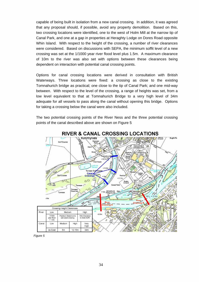
34
capable of being built in isolation from a new canal crossing. In addition, it was agreed that any proposal should, if possible, avoid any property demolition. Based on this, two crossing locations were identified, one to the west of Holm Mill at the narrow tip of Canal Park, and one at a gap in properties at Heraghty Lodge on Dores Road opposite Whin Island. With respect to the height of the crossing, a number of river clearances were considered. Based on discussions with SEPA, the minimum soffit level of a new crossing was set at the 1/1000 year river flood level plus 1.5m. A maximum clearance of 10m to the river was also set with options between these clearances being dependent on interaction with potential canal crossing points. Options for canal crossing locations were derived in consultation with British Waterways. Three locations were fixed: a crossing as close to the existing Tomnahurich bridge as practical; one close to the tip of Canal Park; and one mid-way between. With respect to the level of the crossing, a range of heights was set, from a low level equivalent to that at Tomnahurich Bridge to a very high level of 34m adequate for all vessels to pass along the canal without opening this bridge. Options for taking a crossing below the canal were also included. The two potential crossing points of the River Ness and the three potential crossing points of the canal described above are shown on Figure 5
Figure 5

35
When the river and canal crossings are considered in combination, 90 No. possible alternative schemes are apparent. Consequently, a matrix of potential schemes was established to assist in carrying out an initial review of the various alternatives. The resulting matrix is presented in Appendix E. This matrix was then used to carry out an initial sift of options as summarised in Appendix F. It was apparent that the vast majority of these options were not achievable due to prevailing level constraints. Other options were ruled out as offering no benefits over other less expensive options. Lastly, it was considered that some options would not meet the desired objective of being deliverable on a phased basis. As a result, the original 90 No. options were sifted down to 5 No. which it is considered are worthy of further development and assessment, as presented in Appendix G and summarised in section 6.3. The results of this sifting exercise were presented at the second STAG Workshop held on 29 September 2010. The morning session of this Workshop reviewed the matrix based assessment and the workshop participants agreed with the findings presented in Appendix G. Plan views of the five remaining options are shown in Appendix H.
6.4 River and Canal Options for Further Development
The five options that have been selected for further development and assessment are as follows: Option One: Canal Crossing 1 (Low Level) – River Crossing A (Low Level) Option Two: Canal Crossing 2 (Low Level) – River Crossing A (Low Level) Option Three: Canal Crossing 1 (Low Level) – River Crossing B (Low Level) Option Four: Canal Crossing 2 (Low Level) – River Crossing B (Low Level) Option Five: Canal Crossing 3 (Low Level) – River Crossing B (Low Level) The five Options are shown on the following Figures 6 to 10.

36
Figure 6 Short direct link from Dores Road to Precast Yard / Weir crossing of the River Ness. Link road to follow the tow path of the Caledonian Canal embankment to a tandem Canal Bridge arrangement at Tomnahurich.
Figure 7 Short direct link from Dores Road to Precast Yard / Weir crossing of the River Ness. Follow the north side of Whin Park to a roundabout at the corner of Bught Road. Follow a raising embankment across the middle of the Canal Park Rugby Ground to a new opening bridge over the Canal. Thereafter follow a falling embankment through the Golf Club to join the A82 Trunk Road to the east of the General Booth Road junction.

37
Figure 8 Short direct crossing of the River Ness at Heraghty Lodge Flats. Follow Bught Road to a tandem Canal Bridge arrangement at Tomnahurich.
Figure 9 Short direct crossing of the River Ness at Heraghty Lodge Flats. From a roundabout at the corner of Bught Road follow a rising embankment across the Canal Parks Rugby Ground to a new opening bridge over the Canal. Thereafter follow a falling embankment through the Golf Club to join the A82 Trunk Road to the east of General Booth Road junction.
38
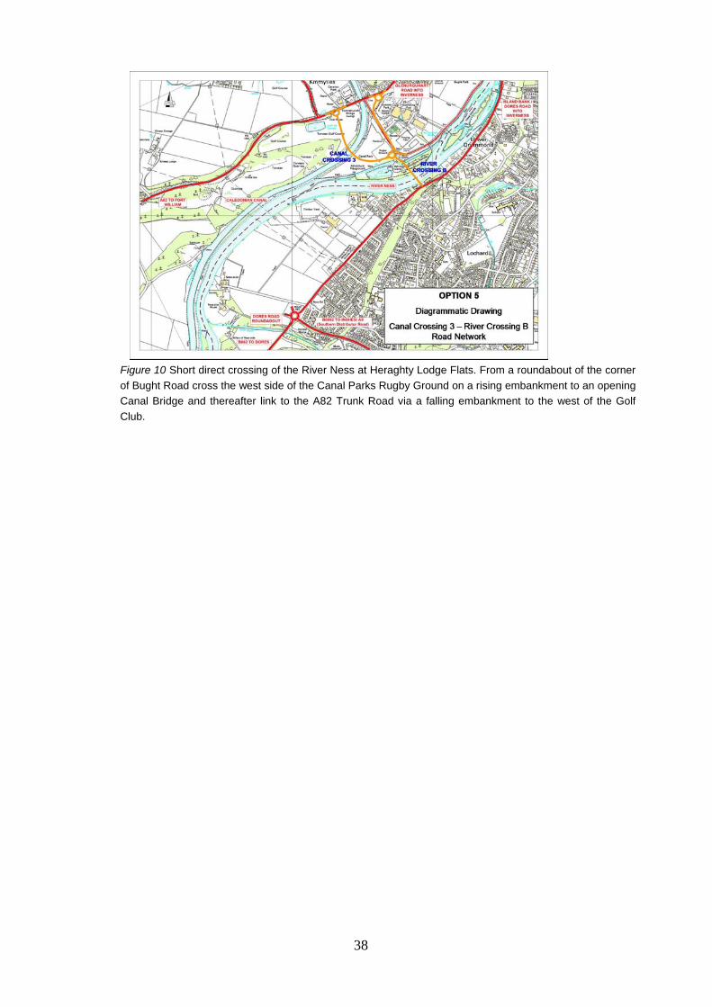
Figure 10 Short direct crossing of the River Ness at Heraghty Lodge Flats. From a roundabout of the corner of Bught Road cross the west side of the Canal Parks Rugby Ground on a rising embankment to an opening Canal Bridge and thereafter link to the A82 Trunk Road via a falling embankment to the west of the Golf Club.

39
7 PART 1 APPRAISAL
7.1 Introduction
At a meeting of the Stakeholders Group on 5th November 2010 a report on the development of the five Options, that were brought forward from the STAG process, was presented. A meeting with the Council’s Administration Group on 17 November 2010 confirmed that the five Options were to be taken forward to the public for consultation and that a STAG Part 2 Options Appraisal should be carried out on the five Options. The Highland Council issued a Press Notice on 2 December 2010 advising of the process to be followed.
7.2 Public Consultation Number 1 The Council arranged a series of public meetings and displays, to give the public the opportunity to consider the Options in more detail, and the venues used are listed below:- 14 December – Evening Presentation in Charleston Academy – 7.30pm 15 December – Daytime Exhibition in Kinmylies Church – 11am until 7pm 15 December – Evening Presentation in Inverness Royal Academy – 7.30pm 16 December – Daytime Exhibition in Culduthel Hall – 11am until 7pm Representatives from the Council attended the exhibitions to explain the proposals in greater detail and the public were given the opportunity to submit their comments. Details of the five Options were presented at the exhibition on display boards and computerised traffic modelling of the Tomnahurich canal swing bridge was presented in video format to allow for a comparison to be made if a second canal swing bridge were to be introduced at that location. A visual graphics ‘fly through video was also presented to illustrate two of the Options. The content of the display boards was included in a handout, available to the public, as shown in Appendix I.
7.3 Responses from the Public Consultation
The West Link consultation commenced on 13 December 2010 and ended on 11 February 2011 with a 2 week extension to give the public more time to submit their comments.

40
A total of 779 No. comments were received from the public and interested parties. The location of those submitting a comment are shown on the following map.
Figure 11 Public Comments Map
7.4 Summary of Comments
Of those that commented on the five options presented for consultation, the majority favoured Route 1 or a variation of route 1. There were no preferences for Options 4 & 5. Of those that did not express a preference for one of the five options the majority favoured a route through the Torvean Quarry area, which was not one of the five options presented for consultation. This majority included a West Link Protest Group which organised the submission of a standard letter of which 428 No. were received. A submission by e-mail enclosed a Petition (We, the undersigned, call on the Highland Council to save the Whin Park and to find an alternative route for its distributor road completion) with 540 signatures recorded at the close of the consultation period against the loss of Whin Park.

41
The Inverness Chamber of Commerce, the Inverness Business Improvement District (BID) and the University of the Highlands & Islands were supportive of Option 1. A Summary table of the Public Comments and how they were recorded is shown on the following table. TABLE OF COMMENTS RECEIVED Councillor Landowner /
Tenant Community
Council / Business
Group
Public
For Option 1 0 7 3 36 For Option 1A 0 0 2 25 For Option 2 0 0 0 1 For Option 2A 0 0 1 1 For Option 3 0 0 0 8 For Tunnel 3 0 0 11 For Dores R/about to A82 through Torvean SSSI
0 1 2 145
Action Group Standard Letter For Dores R/about to A82 through Torvean SSSI
0 0 0 411
For Option further West 0 0 0 7 No Preference / Other Proposal
4 1 1 34
Against Options 3, 4 & 5
1 1 0 19
Against all the 5 Options
0 0 0 53
The principal issues raised at Public Consultation Number 1 were as follows:
• Impact on Whin Park;
• Impact on green space and environmental areas;
• Conflict with the leisure, recreational and sporting facilities to the north of the River Ness;
• Proposed distributor road does not link up with existing one;

42
• Loss of sporting/recreational areas;
• Increase in traffic along Dores Road / Islandbank Road (Dores Road unsuitable as a distributor road);
• Concerns regarding how long it has taken to deliver this project.
7.5 Outcome of Public Consultation
Following a review of the responses received from the Public Consultation it was agreed at a Council Leaders Business Meeting on 25 May 2011 that the next stage of the project (Stage II) would involve a detailed appraisal of the Options, carried out in accordance with standard design methodology. The options to be assessed included the original five Options and three additional options which emerged during the public consultation. The Highland Council issued a Press Notice on 26 May 2011 advising on the background to the decision to progress with eight Options and the appraisal process to be followed. Two of these additional options were known to present major difficulties in terms of the serious environmental concerns from statutory bodies and the engineering complexity of the options. However, as these had been raised during the consultation they were examined alongside the five options which went out for consultation. These additional options were the construction of an Aqueduct/Tunnel for crossing the Caledonian Canal and a direct route from the Dores Road Roundabout to the A82 south of Inverness, which crosses the River Ness and the canal via a high level viaduct. In addition, the Council considered a variation on Option 1, which provides a tandem canal bridge solution at Torvean. Option 1 followed the edge of the canal embankment and crosses the river in open ground in the vicinity of the woollen mills with a direct link onto Dores Road. The variation incorporates a River Bank route to the Dores Road Roundabout instead of the more direct link from the south side of River Ness to Dores Road. The three additional Options Nos. 6, 7 and 8 are shown as Figures 12 to 14

43
Figure 12 Follow a sweeping alignment along the river bank from Dores Road roundabout to cross the River Ness at the Precast Yard / Weir. Thereafter link road to follow the tow of the Caledonian Canal embankment to a tandem Canal Bridge arrangement at Tomnahurich.
Figure 13 Follow a rising embankment from the Dores Road roundabout to a high level bridge across the River Ness and Caledonian Canal. Thereafter pass through the Torvean Quarry to join the A82 Trunk Road near the old quarry access.

44
Figure 14 Short direct link from Dores Road to Precast Yard / Weir crossing of the River Ness. Follow the north side of Whin Park to a roundabout at the corner of Bught Road. Thereafter follow an alignment in cutting through the Canal Parks Rugby Ground underneath the Canal via an aqueduct. Then follow a rising gradient in cutting through the Golf Club to link with the A82 Trunk Road and the General Booth Road junction.

45
Also included in the project proposals are two Park & Ride Sites, Public Transport improvements and Pedestrian / Cycle routes and links to the various Options.
Figure 15
These proposals have been included as additional costs at Year 6 of the project delivery programme and are additional to the scheme costs assessed against each option.
8 Part 2 Appraisal
8.1 Criteria Used in the Options Appraisal
For those options which came forward from the Part 1 Appraisal and the Public Consultation No 1, the Part 2 Appraisal undertook a detailed appraisal against:
• Planning Objectives; • Risk and Uncertainty; • STAG Criteria (Accessibility, Environment, Economy, Safety and Integration)
For each Option preliminary road alignment design work was undertaken and preliminary bridge proposals for the River Ness crossings prepared. The eight Options with preliminary alignments are shown in Appendix J.

46
To support the Part 2 Appraisal the Moray Firth Transport Model of the corridor was used to provide quantitative data for the appraisal of options against the Economy Criterion, part of the Environment Criterion and the Safety Criterion. The traffic modelling report is provided in Appendix K. Cost estimates were prepared for each option with a quantitative assessment undertaken that provided the information shown in Appendix O. This information was used in a Transport User Benefits Appraisal (TUBA) assessment with the cost benefit results included in the STAG Option Appraisal Tables that are included at the end of this section. All 8 options were assessed through the options appraisal methodology. The options appraisal included an assessment of each option under the following main headings / principal criteria:
• Environmental Impact • Accessibility • Integration • Safety • Economy • Risk and Uncertainty
Each of the main headings / principal criteria were subdivided into sub criteria Environment
• Policies and Plans • Land use • Cultural Heritage • Landscape and Visual Effects • Vehicle Travellers • Geology and Soils • Ecology and Nature Conservation • Noise and Vibration & Air • Water Environment • Flood Risk • Disruption due to construction
All of the above were undertaken as desk top assessments augmented by with walkover survey where required.
Accessibility
• Maintain access to local facilities • Maintain or improve access for non motorised users
Integration
• Land Use Integration

47
• Integration with Public Transport Safety
• Improve Safety for Motorised Users • Improve Safety for Non Motorised Users (cyclists & pedestrians)
Economy
• Maintain / Improve Journey Time & Journey Time Reliability • Maintain / Improve Journey Time & Journey Time Reliability in the area of
south west Inverness • Efficiency of the Network (Canal) • Efficiency of the Network (Trunk Road ) • Efficiency of the Network (Local Roads) • Maintenance Efficiency • Scheme Costs as assessed at 2011 • Present Value of Costs (PVC) • Present Value of Benefits (PVB) • Net Present Value (NPV) • Benefit to Cost Ratio (BCR)
Risk and Uncertainty
• Public Response to December 2010 Public Meetings and Displays • Construction Risk • Statutory Consent Risk • Land Acquisition Risk • Opportunities for External / Developer Contributions • Deliverability against the Council’s Capital Programme with Developer
Contributions • Ease of Phasing (Canal / River separately)
The following organisations were involved in the Options Appraisal process:- Highland Council - development of outline vertical and horizontal geometry designs, roadwork cost estimate preparation and planning issues. URS Scott Wilson – Environment, Flood Risk Assessment, Structures outline design concepts, Structures cost estimates; AECOM Ltd - Traffic Modelling using the Moray Firth Transport Model, TUBA Economic Assessment; District Valuer’s Office – Guidance and provision of estimated land purchase and disturbance costs

48
All eight Options were assessed against the STAG Objectives listed in section 4.
8.2 Outcome from the Options Appraisal The reporting on the Options Appraisal is presented in Appendix L Options Appraisal Summary Table. The appraisal at the Part 2 stage was based on the nine point scale assessment set out in the DMRB environmental section scheme assessment as follows: Major benefit: Moderate benefit: Minor benefit: Negligible benefit: No benefit or impact: 0 Negligible negative impact: X Small negative impact: XX Moderate negative impact: XXX Major negative impact: XXXX The details of the above table of Magnitude of Impacts is presented in Appendix M.
8.3 Summary of Outcomes Environmental Impact Land Use: - It is anticipated that Options 1, 3 and 6 would allow a reconfigured layout for the Rugby Club to be accommodated at the existing location. For Options 2, 4, 5 & 8 the Club would have to be relocated. Option 7 would not affect the Club other than for access. Torvean Golf Club is affected by all Options with 1, 3, 6 & 7 having the least impact. Inverness Blitz training area has to be relocated for all Options. Options 3, 4 & 5 impact on the car parking area at Heraghty and Rossie Lodges. Cultural Heritage: - Option 8 has greatest impact on the Caledonian Canal Scheduled Monument. Landscape and Visual Effects: - Options 1, 2, 6 and & 7 have been assessed as having the greatest adverse impact with Option 7 giving Scottish Natural Heritage significant concerns even with mitigation proposals introduced. Noise and Vibration and Air: - Options 3, 4 & 5 would have the greatest adverse impact given that they pass between Heraghty and Rossie Lodges. Water Environment: - Option 8 has the greatest impact on the water environment with concerns on the likely impact on groundwater for both the construction and operational periods.

49
In both the Disruption due to Construction and Flood Risk assessment sub criterias Option 8 has been assessed as having the worst adverse impact. The risk of flooding for Option 8 has been commented on by SEPA with the footprint of this Option within the modelled flood map extent. Accessibility Cyclist and pedestrian routes have been considered for each Option and Options 1, 2 and 6 have been assessed as giving the greatest benefit. Integration Information under this heading is reported on in the STAG Transport Planning Objectives Section that follows. Safety There are no major differences between the Options for this criteria. Economy It should be noted that in terms of delivery of the Project as a Construction Contract Option 7 would have to be issued as one Contract whereas all the other Options could be split into two Phases. It should be noted the significantly higher costs against Options 7 & 8 with Option 1 having been assessed as having the lowest cost. Option 6 is comparable with the additional road length around Ness-Side accounting for the difference with Option 1. Risk and Uncertainty Risk to the Highland Council has been assessed in this section and Options 7 and 8 carry a major risk category. Land acquisition for all except Option 7 are listed as major risk however it is anticipated that the project will be moved forward under a Compulsory Purchase Order. Performance against the STAG Transport Planning Objectives Objective 1 (Land Use): integrate any interventions with the existing Highland Council land use development plans for the South West of Inverness (Ness Castle, Milton of Ness-side, Ness-side, Torvean and Charleston); Options 3, 4 and 5 are the least favourable of the Options under this Objective. Options 2, 7 and 8 are considered as of medium fit with Options 1 and 6 of best fit to the Objective. Objective 2 (Journey Time and Reliability): maintain level of service at existing junctions in City centre at 2009 levels (ref A96 2009 VISUM Model Update Report);

50
All Options are considered as giving major benefits against this Objective. Objective 3 (Modal Shift): increase travel choices and improve integration across modes to encourage modal shift of people; All Options are considered as giving major benefits against this Objective with the exception of Option 7 which would be less attractive to bus services and has been assessed as giving moderate benefits. Objective 4 (Connectivity): reduce operational dependence on existing river and canal crossing points; By providing an additional bridge over the River Ness this will enhance capacity of the network with diversionary routes, during major bridge maintenance with significant cost savings. This applies to all Options. Objective 5 (Environment): minimise the impact on people and properties, and the natural and cultural heritage of the study area. The appraisal under Environment has Options 7 and 8 with the worst adverse assessment, Options 3, 4 and 5 minor adverse and Options 1, 2 and 6 negligible adverse. The Options Appraisal Summary table that was prepared to bring the main comments for each sub-criteria together into one table is represented in Appendix L and from this information the following STAG Appraisal Tables were prepared for each Option.
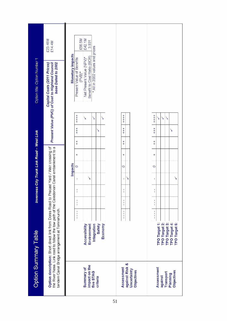
51

52

53

54

55
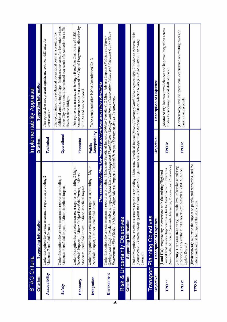
56
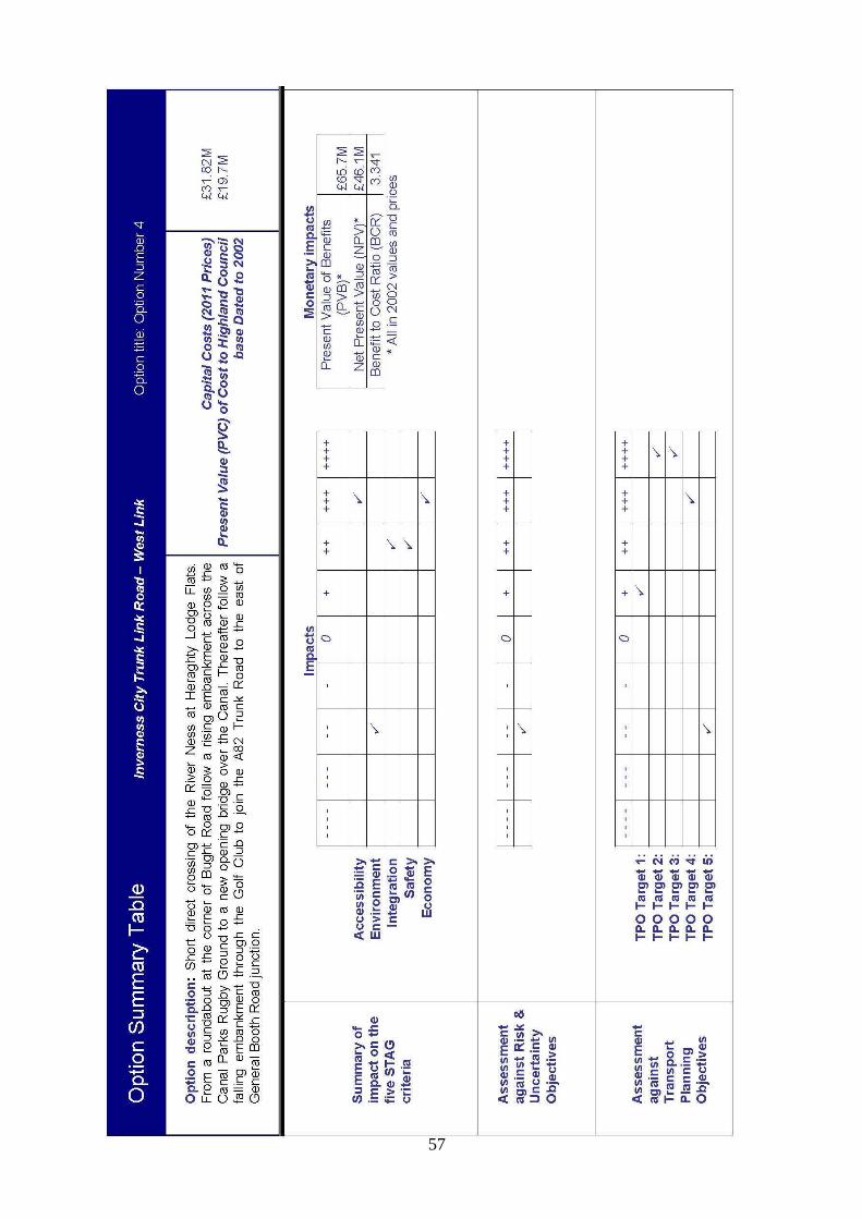
57

58

59

60

61

62

63

64
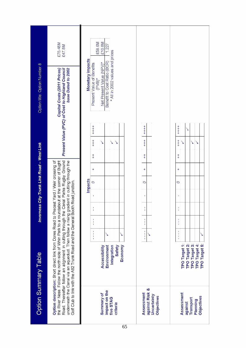
65

66

67
8.4 Public Consultation Number 2 At a meeting of the Highland Council on 27th October 2011 an item was debated which recommended:-
a. Approve the formation of a Member Working Group to consider the outcome of the Options Appraisal and make recommendations on the preferred route(s) prior to further public consultation;
b. Approve the following process:- Stage 1 A Member Working Group is formed to consider the
outcome of the Options Appraisal, and to make recommendations in relation to the preferred route(s) prior to further public consultation.
Stage 2 The outcome of the Options Appraisal, including the recommendations of the Working Group, is presented to the public as part of a further consultation exercise.
Stage 3 The Working Group will consider the feedback from the public consultation and make recommendations to the Council on the preferred route(s).
Stage 4 The Council will be invited to select the preferred route which will be submitted for Planning Consent.
c. Note the timetable as follows:- Action
Proposed Date
Member Working Group considers the outcome of the Options Appraisal and makes recommendations on the preferred route(s) prior to public consultation.
Week beginning 7 November 2011
Public Consultation
23 November 2011 to 16 January 2012
Member Working Group considers outcome of public consultation and makes recommendation to the Council on the preferred route(s)
Week beginning 23 January 2012
Report to full Council
To be confirmed
The Highland Council approved the above item.

68
The Member Working Group was formed with following Councillors:- Mr I Brown Mr A Henderson Mr P Cairns Mr D Henderson Mr J Crawford Mr J Laing Mrs M C Davidson Mr A S Park Mr N Donald Mr R Pederson Dr M E M Foxley Mr T Prag Mr L Fraser Mr H Wood Mr J Gray At a meeting of the Working Group on 10th November 2011 the outcome of the Options Appraisal was presented and the Working Group directed that all eight Options be taken forward for Public consultation. The Highland Council issued a Press Notice on 11 November 2011 advising of the process to be followed. The Council have arranged a series of public meetings and displays, to give the public the opportunity to consider the outcome of the Options Appraisal, and the venues used are listed below:- 29 November – Daytime Exhibition in Kinmylies Church – 11am until 7pm 29 November – Evening Presentation in Inverness Sports Centre – 7.30pm 1 December – Daytime Exhibition in Culduthel Christian Centre – 11am until 7pm 1 December – Evening Presentation in Inverness Royal Academy – 7.30pm Representatives from the Council, AECOM and URS Scott Wilson will attend the exhibitions to explain the proposals in greater detail and the public will be given the opportunity to submit their comments. Details of the 8 Options will be presented at the exhibition on display boards and the reports prepared as part of the Options Appraisal will be available for the public to review. The content of the display boards will be included in a handout, available to the public, as shown in Appendix N. The consultation period will extend from 29th November 2011 to 16th January 2012. During this period the public will have the opportunity to comment on the Options and indicated their preference for a particular Option.

69
9 SUMMARY AND CONCLUSIONS 9.1 Summary
Strategic Environmental Assessment The Highland Council have prepared a Strategic Environmental Assessment (SEA) for the West Link Project. The SEA has been prepared in consultation with Scottish Natural Heritage, Scottish Environment Protection Agency, and Historic Scotland. The SEA was published on 23rd November 2011 for comment and the public were invited to submit their comments as advised in the Non-Technical Summary. All comments on the SEA have to be submitted not later than 16th January 2012. The SEA is included in Appendix P. Single Outcome Agreement 2. All the Options will help deliver outcomes from the Single Outcome Agreement 2. The Single Outcome Agreement 2 delivers a partnership approach to tackling issues which affects the Highlands. As part of this there are a number of National and Local Outcomes, the ones relevant to this project are listed below. By delivering the Inverness West Link it is considered that the project is compatible with the Single Outcome Agreement. National Outcomes
• We live in a Scotland that is the most attractive place to do business in Europe (NO1);
• We live in well-designed, sustainable places where we are able to access the amenities and services we need (NO10).
Local Outcomes
• To support the economy access is improved to housing, transport and high speed broadband (LO1.I).
Council Programme The Council Programme states that ‘’We will work with the Scottish Government, Transport Scotland, British Waterways and other key stakeholders to examine and agree solutions for completing the link road between the A9/A96 and the A82 trunk roads, including crossing the River Ness and the Caledonian Canal.’’ Through delivering this project we hope to meet the aspirations of the programme. Public Consultation No 2 and the Way Forward The responses from the public to Consultation No. 2 will be reviewed and a report will be prepared for the Working Group to consider at their meeting scheduled for 23rd January 2012.

70
The Highland Council will consider the outcome of the Options Appraisal and the feedback from the public consultation when it comes to select the preferred route which will be taken forward for planning consent.
9.2 Conclusions
This section of the report will be prepared after Public Consultation No. 2 has been undertaken and reported.