INVENTORY, MONITORING ASSESSMENT PROGRAM IMAP · natural resource Inventory, Monitoring and...
46
CALIFORNIA DEPARTMENT OF PARKS AND RECREATION INVENTORY, MONITORING & ASSESSMENT PROGRAM IMAP A Program to Systematically Monitor and Assess the Status of Natural Resources in the California State Park System Program Basis and Implementation Plan October 2001
Transcript of INVENTORY, MONITORING ASSESSMENT PROGRAM IMAP · natural resource Inventory, Monitoring and...

CALIFORNIA DEPARTMENT OF PARKS AND RECREATION
INVENTORY, MONITORING
& ASSESSMENT PROGRAM
IMAP
A Program to Systematically Monitor and Assess the Status of Natural Resources in the California State Park System
Program Basis and
Implementation Plan
October 2001

California Department of Parks and Recreation - Inventory, Monitoring & Assessment Program (IMAP)
Page 2
EXECUTIVE SUMMARY This Program Basis and Implementation Plan has been prepared for the California Department of Park and Recreation's natural resource Inventory, Monitoring and Assessment Program (IMAP). IMAP endeavors to systematically monitor natural resources, including vegetation, wildlife, soil, air, and water quality, throughout the California State Park System. Inventory and monitoring of natural resources is not a new act for the Department. Many individual inventory and monitoring efforts have been undertaken over the long history of the California State Park System to assess the status of natural resources in specific units. The newly developed IMAP provides the foundation for a coherent, long-term, systemwide approach. By implementing this program, the Department formalizes a systematic approach to the critical task of gathering quantitative information on the status of important natural resources for which it is chief steward. Information obtained is used to assess the status of natural resources, changes brought about by park use and management activities, and long-term changes resulting from regional and global influences. Knowing the condition of natural resources under our care is fundamental to meeting our long-term stewardship responsibility. The IMAP consists of State Park ecologists, consultants, or collaborators from universities, local, state or federal agencies, and/or non-governmental organizations systematically and regularly
monitoring a select set of natural resource indicators in each State Park System park1. A baseline set of ecological parameters is monitored in each park. Also, a planning process conducted for each individual unit, the Environmental Condition Assessment process, identifies additional specific elements to monitor in individual parks. To implement the IMAP program a Program Manager and support positions are located in Natural Resources Division (NRD) and additional ecological staff at the Southern Service Center. The NRD IMAP function will ensure statewide consistency for the program. IMAP project funding for specific projects resides in Districts, and may flow upward from the Districts to Service Centers or NRD to utilize additional or specialist staff. Working groups, composed of Department experts, have been formed to deal with technical issues of sampling data collection, data analysis, and data management. Pilot projects to test sampling protocols and data management are underway at Wilder Ranch State Park (Santa Cruz District) and Chino Hills State Park (Inland Empire District).
1 ‘Park’ as used throughout this document refers to the different types of units in the California State Park System including State Parks, State Vehicular Recreation Areas, State Recreation Areas, State Historic Parks, State Beaches, and others.

California Department of Parks and Recreation - Inventory, Monitoring & Assessment Program (IMAP)
Page 3
Table of Contents
1. INTRODUCTION................................................................................................................................................................5
1.1 BACKGROUND OF DPR NATURAL RESOURCE INVENTORY AND MONITORING...................................................5 1.2 PURPOSE OF IMAP..........................................................................................................................................................6 1.3 PROGRAM GOALS.............................................................................................................................................................6
2. PROGRAM SCOPE...........................................................................................................................................................8
2.1 IMAP STEERING COMMITTEE .....................................................................................................................................8 2.2 TECHNICAL WORKING GROUPS....................................................................................................................................8 2.3 HEADQUARTERS & SERVICE CENTER IMAP TEAMS ...............................................................................................8
2.3.1 Natural Resources Division..............................................................................................................................8 2.3.2 IMAP Statewide Manager.................................................................................................................................8
2.4 SERVICE CENTERS...........................................................................................................................................................8 2.4.1 Systemwide IMAP team......................................................................................................................................9
2.5 DISTRICTS.........................................................................................................................................................................9 2.6 INTERDISCIPLINARY TEAMS.........................................................................................................................................9 2.7 COLLABORATION WITH INVENTORY AND MONITORING PROGRAMS OUTSIDE OF DPR..................................9 2.8 INTERFACE WITH OTHER CALIFORNIA DEPARTMENT OF PARKS AND RECREATION PROGRAMS................10 2.9 DPR STRATEGIC OBJECTIVES AND INITIATIVES...................................................................................................10 2.10 PERFORMANCE CONTRACTS..................................................................................................................................10 2.11 GENERAL PLANNING...............................................................................................................................................10 2.12 UNIT DATA FILES & DEPARTMENT DATABASES .............................................................................................11 2.13 STATEWIDE PRESCRIBED FIRE PROGRAM ..........................................................................................................11 2.14 ON-GOING PROJECT MONITORING .......................................................................................................................11 2.15 ON-GOING THIRD-PARTY RESEARCH PROJECTS.................................................................................................11 2.16 PARTNERSHIPS.........................................................................................................................................................11 2.17 PARK OPERATIONS..................................................................................................................................................11 2.18 PARK ACQUISITIONS & PLANNING.......................................................................................................................12 2.19 CULTURAL RESOURCES..........................................................................................................................................12 2.20 EMERGENCY RESPONSE MONITORING.................................................................................................................12 2.21 IMAP FUNDING........................................................................................................................................................12
2.21.1 Category 1 Resource Maintenance Program..............................................................................................12 2.21.2 Deferred maintenance and stewardship projects........................................................................................12
3. IMPLEMENTATION STRATEGY.................................................................................................................................14
3.1 ENVIRONMENTAL CONDITION ASSESSMENT PROCESS ..........................................................................................14 3.2 IMAP APPROACH TO INVENTORY & MONITORING..............................................................................................14
3.2.1 Five levels of inventory & monitoring..........................................................................................................14 3.2.2 Inventory.............................................................................................................................................................16 3.2.3 Monitoring.........................................................................................................................................................16
3.3 INITIAL THREE YEAR IMAP EFFORT ........................................................................................................................16 3.3.1 pilot projects ......................................................................................................................................................17 3.3.2 help to districts..................................................................................................................................................17
3.4 INVENTORY & MONITORING PROTOCOLS ...............................................................................................................17 3.5 COSTS, LEVEL OF EFFORT , AND EXPERTISE .............................................................................................................17
4. DATA MANAGEMENT....................................................................................................................................................18
4.1 WORKING GROUP APPROACH ....................................................................................................................................18 4.2 WORKING GROUP STANDARDS...................................................................................................................................18 4.3 PLAN & SCHEDULE .......................................................................................................................................................18
5. ASSESSMENT ..................................................................................................................................................................19

California Department of Parks and Recreation - Inventory, Monitoring & Assessment Program (IMAP)
Page 4
5.1 OUTCOMES & PRODUCTS............................................................................................................................................19 5.2 MANAGEMENT IMPLICATIONS..................................................................................................................................19
6. HELP & TRAINING.........................................................................................................................................................20
6.1 HELP DESK .....................................................................................................................................................................20 6.2 ON-SITE TRAINING........................................................................................................................................................20 6.3 OFF-SITE TRAINING ......................................................................................................................................................20
7. LITERATURE REFERENCED DURING PREPARATION OF THIS DOCUMENT...............................................21
APPENDIX A: INVENTORY AND MONITORING MINIMUM DATA FRAMEWORK
APPENDIX B: ENVIRONMENTAL CONDITION ASSESSMENT PROCESS
1. INTRODUCTION - ENVIRONMENTAL CONDITION ASSESSMENT ................................................................30
2. PROGRAM IMPLEMENTATION..................................................................................................................................31
2.1 DESIGN AND IMPLEMENTATION OF UNIT NATURAL RESOURCE INVENTORY, MONITORING AND
ASSESSMENT (IMAP) PLANS.................................................................................................................................................31 2.2 INFORMATION PHASE – THE FIRST 5 STEPS.............................................................................................................31
2.2.1 Step 1 – Identify Broad Goals and Objectives for the unit ........................................................................31 2.3 2.2.2 STEP 2 - IDENTIFY ECOLOGICAL UNITS AND MANAGEMENT ZONES AND CREATE MODELS..............31
2.3.1 Step 3 Identify Existing Resource Information and Knowledge Gaps...................................................32 2.3.2 Step 4 – Establish Unit Inventory and Monitoring Program Goals and Objectives including framework for databases .................................................................................................................................................32 2.3.3 Step 5 - Describe Existing Conditions..........................................................................................................32
2.4 ASSESSMENT PHASE – STEPS 7 TO 12........................................................................................................................34 2.4.1 Step 6 - Describe Desired Conditions...........................................................................................................34 2.4.2 Step 7 - Identify Stressors ................................................................................................................................34 2.4.3 Step 8 - Identify Environmental Indicators..................................................................................................34 2.4.4 Step 9 - Identify Target Ranges ......................................................................................................................34 2.4.5 Step 10 - Assess Effects of Not Attaining Desired Conditions..................................................................34 2.4.6 Step 11 - Rank Environmental Indicators....................................................................................................35 2.4.7 Step 12 - Identify Monitoring Projects..........................................................................................................35
2.5 IMPLEMENTATION AND EVALUATION PHASE – STEPS 13-15..............................................................................36 2.5.1 Step 13 - Initiate Inventorying & Monitoring Projects .............................................................................36 2.5.2 Step 14- Evaluate results.................................................................................................................................36 2.5.3 Step 15 - assessment .........................................................................................................................................37
2.6 CONCLUSION..................................................................................................................................................................37

California Department of Parks and Recreation - Inventory, Monitoring & Assessment Program (IMAP)
Page 5
1. INTRODUCTION
1.1 BACKGROUND OF DPR NATURAL RESOURCE INVENTORY AND MONITORING
The Mission of the Department of Parks and Recreation is to provide for the health, inspiration, and education of the people of California by helping to preserve the state’s extraordinary biological diversity, protecting its most valued natural and cultural resources, and creating opportunities for high-quality outdoor recreation.
The Department strives to understand, maintain, restore, and protect the inherent integrity of the natural resources, processes, systems, and values of the parks. Natural resources include both physical and biotic resources. Physical resources are water, air, soil, topographic features, geologic features, paleontological artifacts, natural soundscapes, clear skies, and physical processes such as weather, erosion, cave formation and fire. Biological resources include native plants, vegetation communities, animals and their habitats, and biological processes such as photosynthesis, succession, and evolution; ecosystems and biodiversity; and highly valued associated characteristics such as scenic views. The need for active natural resources inventorying and monitoring programs is implicit in the Department's mission statement and in many of the policies, regulations and directives that guide the Department's actions. Natural resources are affected by visitor use, Department activities, and activities outside park boundaries. External influences are becoming more threatening - air and water pollution, exotic plant and animal invasion, urbanization and development, and large scale wildland fires are some examples. Scientifically based monitoring is necessary to detect and predict changes in natural resources, to understand the forces driving the changes, and to direct management interventions as necessary. Inventorying and monitoring of natural resources is a logical and fundamental element of the stewardship responsibility of the Department.
The Department's park unit classification and general planning process has traditionally provided the primary impetus for preparation of inventories of natural features. For over twenty years, resource inventories have been required prior to classification or reclassification of State Park System units under Section 5002.1 of the Public Resources Code. Resource inventory information has also been required in the resource element of unit general plans for as many years. Inventory efforts, particularly those associated with unit general plans produced since 1985, provide valuable point-in-time information on the status of important natural resources. However, the present condition of many resources evaluated during initial inventory and general plan efforts is largely unknown because follow-up monitoring has not been conducted and documented. Additionally, many units have no general plan or comprehensive inventory. The Department has funded and supported monitoring projects for over thirty years. These projects have generally been performed by Department ecologists or contracted to universities or consultants. The majority of this monitoring was targeted at projects for prescribed burning, non-native species control (vegetation and wildlife), threatened and endangered species, and habitat restoration. The goal of project monitoring was generally very focused on the results of the individual project and was not meant to assess the overall condition of the park. A comprehensive program for assessing overall condition of wildlife habitat, the Habitat Monitoring System, has been implemented for State Vehicular Recreation Areas; however, this program only applies to eight out of over two-hundred and sixty park units.
Processes that provide for inventorying and monitoring through other than traditional general planning efforts are needed to support the short and long term needs for stewardship of park resources. Toward that end, natural resource specialist staff in the Department began conceptual development of a natural resources inventory and monitoring program in 1995 to direct Department actions into the 21st century. One important facet has been the development of a programmatic approach to inventorying and monitoring natural resources in each park.

California Department of Parks and Recreation - Inventory, Monitoring & Assessment Program (IMAP)
Page 6
1.2 PURPOSE OF IMAP
In 2000, funding was provided for natural resource staff to be dedicated to developing and implementing an Inventory, Monitoring, and Assessment Program (IMAP or Program) for the Department. As the program title indicates, the purpose of the program is to inventory, monitor, and assess the condition of natural resources in the State Park System. The purpose of natural resources inventories is to provide a foundation of knowledge about the physical and biotic resources of the unit upon which resource management goals, objectives, policies and programs are based. Inventory information also provides the background for unit interpretive and education programs, and properly designed inventories will serve as baselines for subsequent natural resource monitoring. A consistent set of basic data of natural resources is essential in order to understand the processes that maintain and preserve the parks. For example, an inventory should lead to an understanding of species diversity, abundance, and distribution. In effect, developing an inventory is the first step in a monitoring program; subsequent collection of data of park resources, possibly using the same data collection methods as the inventory, constitutes the monitoring program. It is possible to inventory without monitoring, but to monitor requires at least a partial inventory. The purpose of ecological monitoring is to develop scientifically sound information on the current status and long term trends in the composition, structure, and function of the park natural resources and ecosystem. Management actions that are based on sound scientific information will instill a higher level of confidence for park managers and stakeholders and will better ensure that natural resources and ecosystem functions are perpetuated for future generations. A successful IMAP would provide answers to these questions:
• What natural resources are in parks? • What is the condition of the park
resources? • How is the condition of the resources
changing over time? • What is the condition of resources
outside of park boundaries (air, water,
nonnative and migratory species), and, what impact do these resources have on park resources?
• What are the implications of these findings to parks and to the larger systems in which they reside?
The Program serves as the perfect vehicle for the Department’s participation in regional planning efforts for areas where the Department has major holdings including the Tahoe Basin, Santa Cruz Mountains, Santa Monica Mountains, Big Sur Coast, and Coast Redwood forest, among others. The IMAP will benefit multi-agency planning teams and ensure that the Department’s interests are appropriately considered. Planning, environmental evaluation and public involvement regarding management actions that may affect the natural resources of parks are essential for carrying out the Department’s responsibilities. The Program can help the Department ensure that the environmental costs and benefits of proposed operations, development, and resource management are fully and openly evaluated before taking actions that may impact the natural resources of parks. This evaluation must include appropriate participation by the public; the application of scholarly, scientific, and technical information in the planning, evaluation, and decision-making processes; the use of Department knowledge and expertise through interdisciplinary teams and processes; and the aggressive incorporation of mitigation measures, pollution prevention techniques, and other principles of sustainable park management. A successful Program will reduce conflicts in the Department, assist the Department in cooperating with regulatory agencies and the public, and be affordable, durable, and implementable.
1.3 PROGRAM GOALS
The IMAP has the following mission statement regarding natural resources:
Mission: Enable the Department of Parks and Recreation to account for natural resources in the State Park System, track changes to natural resources, and identify factors affecting natural resources for which the

California Department of Parks and Recreation - Inventory, Monitoring & Assessment Program (IMAP)
Page 7
Department can adaptably manage. The Program focuses on attaining the following major long-term goals:
• To inventory the natural resources and ecosystems on lands managed by the Department to determine their nature, location, and status.
• To monitor park ecosystems to better understand their condition, and to measure and evaluate the status and trends of environmental conditions.
• To establish natural resource inventory and monitoring as standard practice in the management of lands and waters under the Department's stewardship responsibility. This includes the integration of monitoring into planning and management.
• To maintain systemwide-monitoring and data management standards and systems that ensure, over time, the full usefulness of information obtained. This will allow for comparative analyses of ecosystems within and between parks.
• To cooperate with other agencies and conservation organizations in sharing natural resource information to advance the understanding of natural resource systems and resource management needs.
The manner in which the program is structured and interacts with other governmental and non-governmental entities, and other Department programs is described in the next section.

California Department of Parks and Recreation - Inventory, Monitoring & Assessment Program (IMAP)
Page 8
2. PROGRAM SCOPE The Program is composed of full-time staff, plus seasonal support, and ad hoc committees and working groups made up of Department specialists. District teams may be formed to prepare and implement District led IMAP programs.
2.1 IMAP STEERING COMMITTEE
The IMAP Steering Committee is composed of natural resource leads from Natural Resource Division, Off-Highway Motor Vehicle Recreation Division, Service Centers, and selected District Superintendents and District ecologists. The Steering Committee provides leadership for the development and coordination for the Department IMAP by setting Department goals and objectives, maintaining standards and protocols for the Program, and establishing and directing Technical Working Groups on sampling design and data management. The Steering Committee provides direction and guidance to the IMAP Manager and ensures integration between the Program and other Department functions. The Steering Committee also recommends allocation of Department funding for the Program, ensures bioregional coordination with other agencies, and provides program evaluations and revisions.
2.2 TECHNICAL WORKING GROUPS
Two technical working groups, a Sampling Design and Analysis Working Group and a Data Management Working Group, serve under the auspices of the Steering Committee. The working groups are composed of experts from throughout the Department. The working groups address major IMAP technical issues including data collection protocols; data analysis and statistical design; report and data presentation structure; naming, handling, and storage of data files; and data quality control and transfer of data within the Department.
2.3 HEADQUARTERS & SERVICE CENTER IMAP TEAMS
2.3.1 NATURAL RESOURCES DIVISION
The headquarters IMAP team is stationed at the Natural Resources Division (NRD). This team, comprised of the statewide IMAP Manager, Data Management lead, and technical staff provides
the lead for coordinating the implementation of the systemwide Program. This team has primary responsibility for coordinating the development and maintenance of systemwide IMAP natural resource databases, including geographic information systems (GIS), to ensure systemwide and statewide compatibility. In addition, the NRD can provide technical support in special subject areas, such as geology, soils, wildlife, and plant ecology for unit monitoring programs developed by Districts and Service Centers.
2.3.2 IMAP STATEWIDE MANAGER
Under guidance of the IMAP Steering Committee, the Statewide Manager:
• Manages the budget for the Statewide Program including expenditures for the systemwide IMAP team.
• Assists Districts to implement IMAP Unit Plans and projects by negotiating contracts between Districts and the Statewide IMAP Support Teams, assists District personnel with sampling design, and assists District personnel with project data management.
• Provides direction to the Statewide IMAP technical support staff.
• Serves as an interface between the Department's IMAP function and the other functions of the Department including: • District Superintendents; • Park Services/Park Stewardship; • General Plan Policy Committee; • Unit Data File Team; • Interpretive Services; • Strategic Planning and Analysis
Section. • Serves as an interface between the
Department's IMAP function and inventory and monitoring functions in other departments, agencies, and non-governmental organizations.
2.4 SERVICE CENTERS
Service Centers provide a wide variety of assistance to local Districts. Conducting resource inventories for unit classification and general planning actions are major workloads for the Service Centers. These inventories can provide the base for establishing long-term, quantitative monitoring programs. Service

California Department of Parks and Recreation - Inventory, Monitoring & Assessment Program (IMAP)
Page 9
Centers also coordinate regional databases in connection with cooperative multi-agency bioregional efforts and provide staff through specific District requests for various aspects of monitoring design, data collection, and data analysis for State Park System units. Service Centers also provide staff for stewardship and resource management projects with significant monitoring components, and funded projects selected from unit IMAP plans.
2.4.1 SYSTEMWIDE IMAP TEAM
Resource specialists available to the Program were placed in NRD and the Southern Servi ce Center beginning in 2000 to assist Districts in planning and conducting inventory and monitoring projects. These individuals provide special technical skills and supply more "hands to the task" for District IMAP projects. They also serve to coordinate projects across Districts and/or bioregions, and provide help-desk assistance to Districts personnel.
2.5 DISTRICTS
Districts initiate comprehensive unit IMAP plans and have the responsibility of ensuring the plans are implemented. In order to accomplish this, staff from many classifications are redirected and/or augmented (there is a discussion of funding opportunities in Sec. 2.21). Whenever special technical specialists are needed for a District IMAP project specialists can be made available from the NRD or Service Center IMAP teams.
2.6 INTERDISCIPLINARY TEAMS
Parkland management is often characterized as a balancing act between two primary goals - protection of important natural and cultural resources and provision for public recreation. This challenge is met through cooperative efforts of staff with a variety of expertise and responsibilities in park management. Resource management, like other park functions, is a shared responsibility and reliable information on the presence and condition of natural resources is necessary for all aspects of park management. To ensure that it provides a high level of support to all aspects of park management, it is important that the unit inventorying and monitoring and environmental condition assessment programs be developed and updated through cooperative efforts
using an interdisciplinary approach. The recommended composition of the interdisciplinary team varies from District to District based on such factors as the type of unit for which the program is being developed, management commitment, functional responsibilities, and longevity, experience, and expertise of key personnel. The District interdisciplinary team can include the District Superintendent, District Maintenance Chief, Maintenance Supervisor, District Chief Ranger, Chief Interpreter, Land Agent, Engineering Geologist, any other staff specialists, and the District Resource Chief/Ecologist. Department staff from outside the District should be utilized to provide additional technical expertise and possibly a different perspective. Non-department staff may also be helpful as outside technical experts to the team, particularly during the information and gap assessment steps during unit specific program development. Special technical support in disciplines not readily available in a particular District is sometimes needed to design and implement some unit or project monitoring programs. This expertise may not be available at NRD or a Service Center but may be within another District. Districts may cooperate by providing District staff specialists to support projects at other Districts. The formation of regional guilds or issue-related working groups also provides for technical support and review for developing unit-monitoring programs.
2.7 COLLABORATION WITH INVENTORY AND MONITORING PROGRAMS OUTSIDE OF DPR
State and federal agencies including National Park Service, California Environmental Protection Agency, U.S. Forest Service, U.S. Geological Survey, Bureau of Land Management, U.S. Environmental Protection Agency, CalFed Program, California Department of Water Resources, California Department of Fish and Game, and California Department of Forestry and Fire Protection conduct large-scale natural resource inventory and monitoring programs. The Program coordinates with these agencies by participating in meetings and workshops to learn how other programs are organized and how inventory and monitoring methods or projects may be shared.

California Department of Parks and Recreation - Inventory, Monitoring & Assessment Program (IMAP)
Page 10
Program personnel publicize the Department’s Program by speaking at conferences and scientific gatherings. This participation alerts others to the existence of IMAP and allows the Program to take advantage of the special technologies and opportunities other programs have to offer. The Program acknowledges the expertise available in colleges/universities throughout California that could benefit the Department inventory and monitoring program. The program has established links with university professors and departments for advice on technical issues, such as sampling design and surveys for specialty taxa such as invertebrates, and assistance with data collection in the field. The Program plans for individual parks will identify inventory and monitoring tasks that could be completed by students solicited from nearby colleges, either as senior or graduate projects. As IMAP becomes more firmly established the Program may become an important resource for other land managers, including city, county, or regional parks and private land trusts seeking for methods to assess and manage their lands. How the Department will manage this outreach program is beyond the scope of the IMAP plan at this time, though IMAP procedures will be available in the future via the IMAP website.
2.8 INTERFACE WITH OTHER CALIFORNIA DEPARTMENT OF PARKS AND RECREATION PROGRAMS
IMAP is an integral part of the California Department of Parks and Recreation (DPR) and is being integrated with all other Department programs. The following discussion addresses the ways in which IMAP interfaces with existing DPR programs.
2.9 DPR STRATEGIC OBJECTIVES AND INITIATIVES
The Department has established strategic objectives (DPR memo from Director Rusty Areias to all employees, Nov. 14, 2000) that state DPR will: • Be Leaders in Parks and Recreation; • Utilize Technology; • Develop a New Image; • Create an Urban Connection;
• Expand Recreation Opportunities; and • Be Leaders in Natural Resource
Management. A key initiative to carryout these objectives is to inventory, monitor, and assess the natural resources in our park units. The IMAP is a key instrument the Department will use to meet these objectives.
2.10 PERFORMANCE CONTRACTS
IMAP plans for individual parks identify inventory and monitoring tasks and describe how these tasks dovetail with other Department activities. The planning process involves 15 steps, including gathering information about park resources, identifying gaps in knowledge, setting desired conditions for resources, and prioritizing what resources will be inventoried and monitored; the process is described in Appendix B. Once an IMAP plan is completed for a park, park personnel can include IMAP tasks in annual Performance Contracts. Examples of Performance Contract tasks include setting-up taxa specific monitoring plots, beginning a water quality sampling program, data collection at monitoring plots established in the past, or preparing or updating the unit IMAP plan. The Performance Contracts are a means of tracking IMAP progress for District and Department managers.
2.11 GENERAL PLANNING
The General Plan Policy Committee (GPPC) maintains the schedule for general plan development for park units several years in advance. The general planning process requires a significant amount of natural resource data collection during the inventory phase of the plan that can meet IMAP goals for each park. Tracking success of the natural resource elements of the general plan in protecting and managing resources is an added benefit of conducting IMAP projects in parks. IMAP assists the general planning process by providing focus and protocols for inventory and monitoring projects. Parks with significant natural resources for which general plans are due to be developed could be given priority for IMAP related projects so that a useful baseline data set is available once the general planning process

California Department of Parks and Recreation - Inventory, Monitoring & Assessment Program (IMAP)
Page 11
begins. The IMAP manager at NRD interfaces with the GPPC to assist with planning inventory and monitoring portions of general plans.
2.12 UNIT DATA FILES & DEPARTMENT DATABASES
The Department has made a concerted effort to collect and digitize historical wildlife and plant data for each park unit. The CalParks Flora & CalParks Fauna Biological Inventory System database, including the Observe function, contains important inventory information about where and when species of plants and wildlife have been observed in each park. IMAP supports continuation of the CalParks Flora & CalParks Fauna Biological Inventory System as a tool for tracking presence/absence types of data. Through the Program the possibility of expanding the use of this database for other types of inventory and monitoring data is pursued.
2.13 STATEWIDE PRESCRIBED FIRE PROGRAM
The Department’s Statewide Prescribed Fire Program conducts extensive inventory and monitoring of particular natural resources, such as vegetation cover and air quality, pursuant to their mission of conducting prescribed burns as a resource management tool. Immediately preceding a prescribed burning project data is required to determine fuel amounts, fuel condition, and climatic conditions. During the course of a prescribed burn data on the fires’ behavior and smoke may be continuously collected. In general, IMAP is not involved with data collection relating to whether or not to conduct prescribed fires, or with monitoring fire condition at the time of the burn, or with pre- and post-burn fuel assessments. IMAP may establish pre-burn plots that can be monitored after prescribed fire to assess affects of the fire on wildlife, vegetation, soil, and water. The IMAP manager works closely with managers of the Statewide Prescribed Fire Program to develop procedures for integrating the programs.
2.14 ON-GOING PROJECT MONITORING
At any one time potentially hundreds of projects are underway in the State Park System that may have a natural resource inventory or monitoring component. Examples of projects include
removal of invasive plants, development of drinking water sources for visitor use, or restoration of degraded sites. Coordination of these projects with park IMAP goals is best accomplished at the District and unit level. IMAP makes available protocols and procedures, and advice on sampling design and data collection methods; however, in general IMAP will focus on the overall condition of natural resources in the park rather than the results of individual projects.
2.15 ON-GOING THIRD-PARTY RESEARCH PROJECTS
Research projects may be conducted in parks by college professors/students, other state or federal resource departments, or other researchers. Often these projects are not supported financially by the Department and are not targeted at a particular inventory or monitoring goal the unit has identified. However, the data collected for these studies may have utility for supporting IMAP objectives. The Program encourages the use of the parks for research sites and cooperates with researchers wherever possible. The Program makes available to researchers the protocols and procedures used for IMAP projects, particularly the standards for data management. Individual parks can consult with IMAP staff whenever third-party researchers are identified so the efforts may be coordinated.
2.16 PARTNERSHIPS
The Program tasks in parks contain many opportunities for utilizing the time and talent of Department partners, including volunteers, Cooperative Associations, and non-governmental organizations such as the California Native Plant Society and Audubon Society. The key to success when working with volunteers is well-prepared IMAP plans, detailed sampling plans, and on-site training and direction by Department specialists. A component of every IMAP plan identifies occasions for volunteer support, particularly in technical topics, such as amphibians or reptiles or birds. Participating in IMAP projects is a great motivator for Department supporters and truly makes them a participant in stewardship of the State Park System.
2.17 PARK OPERATIONS
The Program is designed as a tool to help

California Department of Parks and Recreation - Inventory, Monitoring & Assessment Program (IMAP)
Page 12
manage the Department’s natural resources. Other Department programs have responsibility for management of park visitors, maintenance of park facilities, law enforcement, interpretation, and recreation. In general, IMAP does not collect data about visitor use, such as numbers of visitors entering a park. However, visitor use data, such as mountain bicycle use in certain areas, may be used to assess impacts to natural resources. The Program coordinates with visitor services staff for collection of visitor or park maintenance data that could be used for natural resource assessments. Mapping and use of GIS are essential IMAP tasks, and several types of maps may be produced for IMAP use. IMAP products are made available for Park Operations’ staff and cooperative mapping projects are undertaken wherever possible.
2.18 PARK ACQUISITIONS & PLANNING
Acquisition of parkland intrinsically has an IMAP component. As ecosystems are affected by protection or creation of wildlife migration corridors, watersheds units are brought under common management, and incompatible uses outside of parks come to an end it is important to inventory and establish a monitoring program to track the trends brought about by acquisition. IMAP protocols and procedures provide a means to assess acquisitions. Assessment of IMAP natural resource data results in models that can help detect the need for additional parklands that will maintain viable natural resources. The DPR Park Design and Construction Division has broad responsibility for development and mapping of park facilities, including park boundaries. The extensive IMAP mapping program coordinates with Department land surveyors and development teams to ensure products that can be commonly used to avoid duplication of efforts.
2.19 CULTURAL RESOURCES
In general, the Program does not collect or manage data concerning park cultural resources, such as locations of archaeological sites. Paleontogical sites are considered natural resources and are inventoried and monitored by IMAP. IMAP seeks to coordinate data collection,
particularly mapping efforts, with park cultural staff wherever possible.
2.20 EMERGENCY RESPONSE MONITORING
Major accidental chemical spills, wildfires, or other emergencies originating inside or outside of a park may encroach on park natural resources. Conducting containment and cleanup operations requires timely assessment of the impacts. Also, evaluating the affects of these events is important to determine responsibility for mitigation and long-term management for recovery of lost and damaged resources. A component of IMAP includes preparations for monitoring emergency situations. An important element is procedures for data assessment taking into consideration sometimes drastically altered ecosystems. This includes how to work with agencies, such as EPA or CDFG, and ensure that the Department’s interests are protected.
2.21 IMAP FUNDING
2.21.1 CATEGORY 1 RESOURCE MAINTENANCE PROGRAM
The Category 1 Resource Maintenance program is designed to provide reliable funding for recurring resource projects, including regular monitoring. Reliable funding for dedicated IMAP staff and projects in the form of a share of Category 1 Resource Maintenance Program funds is pending State approval. These funds may be used to support IMAP in the following manner: • Full-time IMAP staff are located at NRD to
administer the Program. The NRD team coordinates statewide IMAP efforts, provides training and help to Districts, and administers District IMAP funding;
• Each of the three Service Centers continue to perform IMAP projects in assistance to the Districts with funding provided from the Districts;
• An allocation is divided among all Districts for conducting IMAP projects.
2.21.2 DEFERRED MAINTENANCE AND STEWARDSHIP PROJECTS
Additional funding opportunities from the Deferred Maintenance and Stewardship programs exist for IMAP projects, chiefly for preparing IMAP plans and completing baseline inventories. There are IMAP tasks, such as vegetation classification,

California Department of Parks and Recreation - Inventory, Monitoring & Assessment Program (IMAP)
Page 13
pre- and post-prescribed fire monitoring, stream and watershed classification, and invasive exotic plant classification and monitoring that are best performed by teams of ecologists dedicated to the task. The NRD IMAP team and Service Center IMAP staff provide technical support to the Districts for these specialty areas. NRD & Service Center IMAP team tasks also include: • Help and training to Districts (particularly for
sampling design and data analysis); • Facilitation of IMAP plans for additional
parks; • Keeping IMAP protocols and procedures
current (for example, selecting and publicizing sampling methods for new subjects such as invertebrates, non-vascular plants, and physical features);
• Managing data and the systemwide IMAP GIS;
• Assisting with collection of resource data in the field.

California Department of Parks and Recreation - Inventory, Monitoring & Assessment Program (IMAP)
Page 14
3. IMPLEMENTATION STRATEGY
The overall Program essentially consists of: • Preparing unit specific IMAP plans using the
15-step Environmental Condition Assessment process. This process identifies the significant resources that will be inventoried/monitored and explains why these resources were selected;
• Experts in the appropriate discipline design the studies to carryout inventory and monitoring projects. Study design includes selection of methods, data management procedures, and development of detailed schedules for the projects;
• Data is analyzed by District staff for assessment of local results, and made available to the NRD IMAP for additional analysis and bioregional or statewide assessments;
• Data assessment includes applications for modifying the monitoring program, adaptively management of the park, and proactive planning for parks.
The entire process starts with solid IMAP plans that are developed using the Environmental Condition Assessment Process.
3.1 ENVIRONMENTAL CONDITION ASSESSMENT PROCESS
Systemwide guidelines for the preparation of unit-specific natural resource IMAP plans are described in the Department's Environmental Condition Assessment (ECA) process. ECA is a planning process for developing unit specific IMAP elements or ‘vital signs’, used to assess the overall condition of park natural resources. The natural resources that may be included are wildlife, vegetation, or physical assets. This process recognizes that the Department needs more data to help determine if natural resources at the unit level are in dynamic equilibrium, improving, or declining. The ECA process identifies the need for effective resource management to be scientifically based (data-driven) and provides a framework for identifying appropriate indicators of environmental conditions. The ECA process is intended to provide a measure of selected ‘vital signs’ (environmental factors including key wildlife, vegetation, and
physical resources) that, when extrapolated and used in conjunction with baseline inventory and monitoring, provide an appraisal of the integrity and “health” of the park’s natural resources. Further, the ECA process is intended to provide an understanding of the broader conditions of park natural resources allowing park staff to understand how the resource condition of the park affects the visitor experience and the health of ecosystems outside of the park. The ECA process used in IMAP is described in Appendix B.
3.2 IMAP APPROACH TO INVENTORY & MONITORING
3.2.1 FIVE LEVELS OF INVENTORY & MONITORING
IMAP experience has demonstrated there are five levels of inventory and monitoring to obtain biological resource data (see Table 1, a table similar to this is under development for physical resources). One time use of any of these levels constitutes an inventory, whereas monitoring requires multiple measures over time. In general, there is an increase in time and cost as inventory and monitoring escalate from reconnaissance level studies to intensive level studies. Park specific IMAP plans identify unique issues wherein inventory and monitoring can assist park management decisions. There is also a basic set of resource subjects that need to be addressed in all parks during inventory and monitoring sampling that are more general than the specific priority issues identified during the ECA process.

California Department of Parks and Recreation - Inventory, Monitoring & Assessment Program (IMAP)
Page 15
Table 1. Inventory & Monitoring Protocols - Biological
# Level Objective Methods
1 Preliminary (office oriented)
• Determine lists of what habitats are potentially present; • Determine lists of what taxa are potentially present;
• Access databases (NDDB, WHR); • Collect data from unit files, general plans, research
reports; • Interview knowledgeable persons; •
2 Reconnaissance (field oriented)
• Get a sense of resources present; • Spot obvious problems; • Determine the scale of work needed; •
• Walk-through; • Drive-by; • Fly-over; • Look at photos; • Annual inspection & questionnaire; • Rapid assessment; •
3 Baseline (field oriented)
• Determine presence; • Determine distribution; • Determine habitat type; • Develop base maps; • Determine if reproduction is occurring; •
• Field assessments; • Photographic plots; • Selection of classification systems; •
4 Comprehensive (field oriented)
• Determine abundance (frequency, density, richness, cover); • Determine population boundaries; • Detect year-to-year changes in #; • Confirm reproduction & estimate #; • Determine habitat condition; •
• Field assessments with high statistical reliability; • Photographic plots; •
5 Intensive (field & laboratory oriented)
• Reproductive/demographic studies (pollination, predator-prey); • Physiology/health studies; • Genetic studies; • Migration/home range/movement tracking studies; • Trophic structure/productivity-biomass studies; • Energetics/nutrient cycling; •
• Research level field assessments; •
California Department of Parks and Recreation - Inventory, Monitoring & Assessment Program (IMAP)
Page 16
3.2.2 INVENTORY
Each park unit should have an inventory of biotic and abiotic natural resources obtained in such a manner that this information can act as a baseline for subsequent monitoring. Minimum information for each unit should include: • Base cartographic map and data (boundaries,
facilities, roads, trails, etc.). • Aerial photography (less than 5 years old). • Air quality information. • Precipitation and meteorological information. • Water resources map and information. • Geology map and information. • Soils map and information. • Plant community and habitat map and
information. • Species lists of vertebrates and vascular
plants, including identification of rare, endangered, sensitive species and species of special management interest (endemics, exotics, etc.).
• Distribution and status of rare, endangered and special interest species and communities. Mapped locations of individuals and populations. Data on population size and extent.
• Monitoring data on management activities, such as prescribed fire, ecosystem restoration, and mitigation activities.
• Historic database: a compilation of historic land use and scientific material (rare event records, maps, photographs, specimen collections, etc.).
• Natural resources bibliography. A detailed Framework for minimum data needs appears as Appendix A.
3.2.3 MONITORING
All monitoring in State Park System lands should have the following characteristics: • Monitoring should be objective-based, i.e. it
should reflect resource management goals, priorities, and issues.
• The number and type of elements monitored should be appropriate for the monitoring objectives, and based on the indicators or ‘vital signs’ identified in the ECA process.
• Sampling techniques should be cost-effective with careful selection of intensity of measurement, frequency of sampling,
duration of sampling, ease of data collection and intensity of analysis.
• Pilot projects should be used to test usefulness and economy of sampling protocols.
• Methodologies should be repeatable, statistically sound and based on historic approaches and data where possible. All monitoring efforts should be thoroughly documented.
• Sampling protocols, data management and reporting formats should be compiled in a handbook.
• Sampling techniques should take into account the potential effects of changes in personnel (i.e., variability in samplers).
• Data should be geographically referenced, e.g., should use USGS standard maps, global positioning and geographic information systems, and stored in secure databases. Data should meet accuracy standards and database systems should be compatible with other systems used in the Department.
• Results should be made available to others such as other Department staff and outside researchers, specialists, and managers.
• Monitoring data should be used to refine monitoring techniques, management assumptions and management actions or to reassess management objectives.
3.3 INITIAL THREE YEAR IMAP EFFORT
Beginning in fiscal year 1999-2000 funds were allocated from deferred maintenance funds for the Department IMAP program. These funds are available until July 1, 2002. Limited-term positions were created for an IMAP Manager, Research Program Specialist (GIS), and an Associate State Park Resource Ecologists at NRD, and for two Associate State Park Resource Ecologists and a half-time Research Analyst (GIS) at the Southern Service Center (SSC). Also, funds are available for temporary help (Environmental Services Intern or Scientific Aide) to support the program in each office. Other District, NRD, and SC staff also assist on selected IMAP projects. In addition, some Districts have funding to support specific deferred maintenance funded projects that have an IMAP element, mainly preparing IMAP plans for parks. The NRD and SSC staffs have responsibility for designing and carrying-out the IMAP. These

California Department of Parks and Recreation - Inventory, Monitoring & Assessment Program (IMAP)
Page 17
staff, working with ad hoc assistance from other Department ecologists, will develop and test the protocols and procedures that will constitute the DPR IMAP. Major efforts of these teams are pilot IMAP projects in two park units and help to Districts conducting IMAP projects.
3.3.1 PILOT PROJECTS
Two parks, Chino Hills State Park in Inland Empire District and Wilder Ranch State Park in Santa Cruz District were selected for pilot projects to test IMAP protocols and procedures. IMAP plans have been prepared and refined for these parks, and the IMAP team with assistance from the District will implement on-the-ground inventory and monitoring projects according to those plans. The overall aim of the pilot projects is to produce a workable IMAP for each of these parks that can be continued by each District with minimal outside assistance, and apply the techniques and lessons learned to other IMAP projects systemwide. The plan is to complete the initial primary inventory and monitoring tasks pilot projects by June 30, 2002. Additional parks will be selected during fall 2001 to receive IMAP team assistance for implementing their IMAP plan projects beginning in spring 2002.
3.3.2 HELP TO DISTRICTS
An important responsibility of the NRD and SSC IMAP teams is assistance to Districts conducting IMAP projects typically funded by the deferred maintenance program. During fiscal year 2000-2001 the majority of this assistance will be in the form of facilitating preparation of park-specific IMAP plans. The IMAP team will also provide training to Department ecologists by making IMAP documents, such as ecological sampling protocols, available and by attending and participating in the statewide Natural Resources Specialist training. Also, the teams will meet in the Districts with local ecologists to discuss their IMAP needs and strategies, and the team will be available for immediate support via email and telephone to assist with IMAP questions.
3.4 INVENTORY & MONITORING PROTOCOLS
Developing a standard set of inventory and monitoring protocols that can be used by District ecologists in a timely and cost-effective manner is
a principal objective of the Program. An IMAP working group has been performing the technical task of developing standard inventory and monitoring protocols. Initial topics selected for protocol development were vegetation, mammals, birds, fish, and reptiles/amphibians. Future protocols will include terrestrial and aquatic invertebrates, marine ecosystems, nonvascular plants, and physical resources such as geologic processes, soil erosion, soundscapes, viewscapes, air and water. The working group is not developing new sampling methods, but has searched the scientific literature and consulted knowledgeable individuals, especially university researchers and other agency ecologists, to extract the best available inventory and monitoring techniques. General guidance regarding which protocol to use in different circumstances, sample design, data collection and data management, data analysis, assessment, and reporting will be assembled by the working group and made available to Department ecologists for the existing protocols as they become available in the form of a manual. This manual and the monitoring methods/procedures contained therein will be updated as necessary by issuance of new printed material or via the IMAP webpage.
3.5 COSTS, LEVEL OF EFFORT, AND EXPERTISE
Establishing the costs, level of effort required for adequate inventory and monitoring, and the types of expertise that the Department will require to carryout IMAP is a major objective of the program. Some of this information will be derived from the pilot projects and deferred maintenance funded projects; however, it will take several years for the program to evaluate individual IMAP projects and ascertain which are the most effective. The processes of preparing IMAP plans will become more efficient as personnel learn what techniques best facilitate their development. Also, the economy of scale of inventory and monitoring projects will improve as bioregional projects are accomplished in several parks at the same time. The core principle is that IMAP is a living program that will be regularly revised as necessary to remain effective, practical and economical.
California Department of Parks and Recreation - Inventory, Monitoring & Assessment Program (IMAP)
Page 18
4. DATA MANAGEMENT Data management is designed to support field-level users with a common set of basic data and data standards, in a common computing environment. Data can include casual observations made on a day-to-day basis by park users and Department personnel or extensive maps, photographs, counts, and measures made during systematic data collection programs designed and carried out for specific park resources. Data management denotes establishing standards and procedures for handling the subjective and quantitative measures made for natural resources in parks. In effect, data management means Department IMAP data can be easily transferred between Department sections; data can be stored and retrieved simply; after data is retrieved it is easily identified as to what it is and when and where it came from; and, data is easily useable by commonly available computer programs. Management of data is at the core of the Program.
4.1 WORKING GROUP APPROACH
A Data Management Working Group has served as an ad hoc group under the IMAP Steering Committee beginning in 2000. This working group is composed of department experts in ecology, computers, and GIS. The working group has identified the following as the primary data management tasks for the IMAP:
a) Develop a "Project Numbering System"; b) Develop an "Occurrence Numbering
System"; c) Develop a "Catalog System" for existing
inventory and monitoring data; d) Identify "Framework Data"; e) Develop "Naming and Directory Structure
Conventions"; f) Develop "Database Structure Standards"; g) Develop "Metadata Standards"; h) Develop an "Index System"; i) Identify "Database/Data Responsibilities"
of access, security, etc. by levels; j) Database construction of "User's Tools"; k) Research potential Contractors –
Database System Developers; l) Develop contract specification for a
Database System Development; m) Conduct a Pilot Program – Test System; n) Implement "Users IMAP Database
System".
The technical working group is developing the Department IMAP data management system. Their products will firstly be made available to the IMAP pilot projects and the Sampling Design and Analysis Working Group, and finally implemented Department wide.
4.2 WORKING GROUP STANDARDS
The working group has proposed the following data standards. It is the working group’s intention that these standards are formally carried forward and adopted as Department standards for the IMAP data system.
1. IMAP will be map based. 2. ArcView-ArcInfo will be the standard
GIS software. 3. ArcInfo and ArcView capabilities will be
provided at Headquarters/Service Center level. ArcView capabilities will be provided at all District Office levels and some Park Unit levels.
4. ArcView and ArcInfo will be purchased through a department-wide (enterprise) site license.
5. MS Visual Studio will be the standard development environment.
6. IMAP will serve core context data to ArcView at the District Level (WAN).
7. District upgrade to ArcInfo may be provided if need is justified.
8. System will have to support bi-directional FTP.
9. IMAP will only accept electronic data (including photographs).
10. Districts will own their data (working file) that is kept on the system.
11. When District verifies that their data (working file) is complete or after a specified “stale date” period, the file will be closed and converted to ‘a coverage’ and become unchangeable. Any new data will become a new file.
12. Any project that occurs in DPR will get a unique tracking number. The tracking number system will be defined later.
4.3 PLAN & SCHEDULE
A Department Digital Data Strategic Plan Committee has been convened to develop a GIS

California Department of Parks and Recreation - Inventory, Monitoring & Assessment Program (IMAP)
Page 19
strategy for the entire Department. IMAP is represented on this committee. IMAP will present the basic information concerning what metadata should accompany data sets, what constitutes an acceptable data set for IMAP, and guidance for data software to Department ecologists in 2002. The overall data management program of IMAP is essentially in a trial for the first three years of the Program, just as the pilot projects will test the field data collection methods, so that by 2002 the structure of the IMAP data management program may be in place. However, it is recognized that with evolving computer technology the Department system must always remain dynamic to remain modern.
5. ASSESSMENT Timely and reliable assessment of inventory and monitoring data is the key to a successful Program. Department-wide IMAP projects will produce thousands of data sets over many decades and analysis and assessment of this data is as enormous task.
5.1 OUTCOMES & PRODUCTS
The responsibility of data evaluation, including statistical analysis, will reside with individual Districts conducting IMAP projects. The NRD and Service Center IMAP teams provide help and training to Districts for sample design and data analysis techniques, but in general there is no central data analysis facility for all Department data. IMAP data is compiled at the NRD or Service Center level for regional or statewide analysis, but assessment of individual IMAP projects should also be completed and reports prepared in the District where the project was conducted. IMAP data and reports are assembled and stored at NRD and at least one other central location for the purpose of backing-up the information. The basic product of IMAP projects is a report of annual monitoring results produced at the District level. The report includes a description of the work performed and the results, including raw data. After initial monitoring projects are established annual (or over whatever period the monitoring is conducted) reporting consists of simply providing the details that only apply to the current year’s monitoring effort (date, personnel involved), copies of the raw data, and addition of a
point(s) to a trend chart. NRD produces topical reports using IMAP data, such as regional assessment of vegetation or wildlife trends. Also, IMAP data is made available to other agencies and/or universities for analyses and reporting for pertinent projects.
5.2 MANAGEMENT IMPLICATIONS
What gets measured gets managed, according to an old adage. IMAP is focused on descriptive rather than prescriptive data collection. In other words, the goal is to identify trends and slopes of curves without necessarily identifying the causes of those trends. So, what use is the data? In many cases, the cause of effects, i.e., trends in environmental indicators, detected by IMAP projects are self-evident, and therefore management actions are applied without further detailed study. Examples include dense invasions of exotic plants displacing native species or vandalism to sensitive geologic features. Identifying the causes of changes to the majority of environmental indicators requires a combination of more detailed, typically research-oriented studies and modeling exercises. IMAP projects help the Department determine what needs further study. An important relationship exists between IMAP indicators and appraisals of park use. Correlating trends of visitor use with environmental trends can lead to mathematical models of carrying capacity/allowable use. At this time no such analysis have been performed using IMAP data, but IMAP will maintain a goal of eventually generating these types of results. The IMAP program produces an annual report assessing the status of natural resources in the State Park System. This report is largely developed from an annual questionnaire completed by District ecologists based on their inspections and knowledge of each park. Findings indicate major trends in the State Park System. Every third year, starting in 2004, a more comprehensive Condition of the Parks report will be produced by IMAP providing more in-depth results of detailed monitoring projects. These reports will aid the IMAP program to better decide how to allocate staff and funding, and inform park managers and the public about the status of park

California Department of Parks and Recreation - Inventory, Monitoring & Assessment Program (IMAP)
Page 20
resources.
6. HELP & TRAINING IMAP has responsibility for providing help and training to Department personnel. IMAP staff develops training procedures and tools and takes the lead in implementing an IMAP training program for the Department. An important task of NRD IMAP is notifying District ecologists of up-coming training opportunities, within and outside of the Department. The IMAP training program will develop over time and consist of a help desk and on-site and off-site training.
6.1 HELP DESK
The most basic form of help and training comes from NRD and Service Center IMAP teams supplying current versions of IMAP documents, via mailing and an IMAP website, and IMAP team members being available to answer questions and discuss IMAP projects with District ecologists via telephone or email. The IMAP teams make themselves available for this type of assistance on an as-needed basis.
6.2 ON-SITE TRAINING
When requested IMAP team members go to Districts to discuss and help with IMAP issues. In general, the IMAP team is not available to conduct extensive field studies, but can give on-site training in various monitoring methodologies. IMAP team members participate in individual District IMAP projects by providing expertise for special inventory and monitoring tasks, such as for bats, and use this opportunity to train District ecologists to assume future monitoring duties. Training workshops are conducted for monitoring topics that have wide applicability, such as monitoring common wildlife or vegetation. Ecologists from many Districts attend these workshops so that consistent practices are learned and practiced and common questions addressed.
6.3 OFF-SITE TRAINING
NRD and Service Center IMAP teams also present Department-wide training at Department resource training classes, and at annual Natural Resource Specialist training for Department resource ecologists.
On occasion Department ecologists are shared between Districts to participate in IMAP projects outside of their area. NRD IMAP looks to facilitate these opportunities and provide expertise and materials to ensure this cross training is successful.

California Department of Parks and Recreation - Inventory, Monitoring & Assessment Program (IMAP)
Page 21
7. LITERATURE REFERENCED DURING PREPARATION OF THIS DOCUMENT
CALFED 1998. Recommendations for the implementation and continued refinement of a comprehensive monitoring, assessment, and research program. http://calfed.ca.gov/programs/cmarp4728.html. Davis, G. E. in press. Vital signs monitoring program design, implementation, and applications: A case study from Channel Islands National Park, California. In: Measuring and Monitoring Biodiversity for Conservation Science and Adaptive Management, J.K. Reaser and F. Dallmeier editors, Smithsonian Institution, Washington, DC. Elzinga, C. L., D. W. Salzer, and J. W. Willoughby. 1998. Measuring and monitoring plant populations. BLM Technical Reference 1730-1, BLM/RS/ST-98/005+1730. 492 p. Karr, James R. and Ellen W. Chu. 1999. Restoring Life in Running Waters – Better Biological Monitoring. Island Press, Washington D.C., ISBN 1-55963-674-2. 206 p. National Park Service, 1999. Natural Resource Challenge: The National Park Service’s Action Plan for Preserving Natural Resources. U.S. Department of Interior, National Park Service, Washington D.C., 21 p. National Park Service, 2000. Management Policies 2001. http://www.nps.gov/refdesk/mp/index.html. U.S. Department of Interior, National Park Service, Washington D.C., 132 p. Off-Highway Motor Vehicle Recreation Division 1997. Habitat Monitoring System, California Department of Parks and
Recreation, Off-Highway Motor Vehicle Recreation Division, 254 p.

California Department of Parks and Recreation - Inventory, Monitoring & Assessment Program (IMAP)
Page 22
Appendix A Inventory & Monitoring Minimum Data Framework

California Department of Parks and Recreation - Inventory, Monitoring & Assessment Program (IMAP)
Page 23
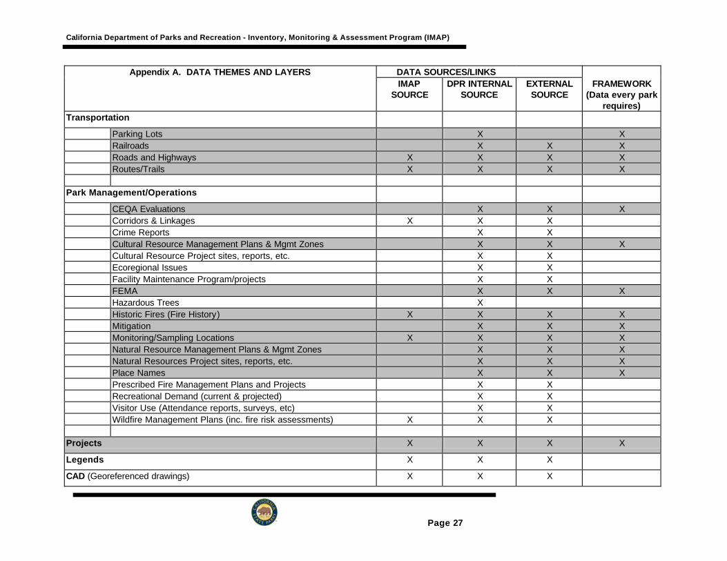
Appendix A. DATA THEMES AND LAYERS DATA SOURCES/LINKS IMAP
SOURCE DPR INTERNAL
SOURCE EXTERNAL SOURCE
FRAMEWORK (Data every park
requires) Imagery
Aerial Photographs X X X Digital Orthophotos X X X Digital Raster Graphic X X X Photographs X Satellite Imagery X X
Boundary
Inholdings X X X Land Ownership/Use X X Legal Boundaries X X X Mapping Boundaries X X X Parcel Boundaries X Political Boundaries X Preserve Boundaries X X X X Resource Sensitive Areas X X X USGS Quad Sheet Boundaries X X Wilderness Boundaries X X X Working Boundary X X
Topography
Aspect X X Contour Lines X X X Digital Elevation Model X X Slope X X X Spot Elevations/Control Points/Bench Marks/Monuments X X X
Meteorology
Air Quality (Pollutant Load) X Climate (Current and Paleo) X X

California Department of Parks and Recreation - Inventory, Monitoring & Assessment Program (IMAP)
Page 24
Appendix A. DATA THEMES AND LAYERS DATA SOURCES/LINKS IMAP
SOURCE DPR INTERNAL
SOURCE EXTERNAL SOURCE
FRAMEWORK (Data every park
requires) Isohyetal X Microclimate X X X Relative Humidity X X X Visibility X X X Weather Recording Stations (Precip., Wind, Temp., Metadata) X X X X
Hydrology
Avalanche X X Floodplains X X Ground Water/Aquifers/Soil Moisture X X X Lakes/Ponds/Reservoirs (location, quantity) X X X X Springs/Seeps X X X X Stream Recording Stations (some minimum, Metadata) X X X Streams/Rivers/Canals (location, quantity) X X X X Turbidity Water Flow X X X Water Quality X X X Water Rights X X X Watersheds X X X X Wells X X X
Geology (includes soils, paleontology and geomorphology)
Erosion X X X X Faults X Geologic Hazards Zones X X X Geologic Structure X X Geomorphology X X Lithology X X Local Geology X X Mineralogy X X Mines/Pits/Quarries X X X

California Department of Parks and Recreation - Inventory, Monitoring & Assessment Program (IMAP)
Page 25
Appendix A. DATA THEMES AND LAYERS DATA SOURCES/LINKS IMAP
SOURCE DPR INTERNAL
SOURCE EXTERNAL SOURCE
FRAMEWORK (Data every park
requires) Paleontology Sites X X X X Paleontology Survey Areas X X X X Regional Geology X X Soils X X X X
Botany
Exotic Plants X X X X Flora Species List X X X X Plant Communities X X X X Rare and Endangered Plants X X X X Revegetated Areas X X Special Interest Plants X X X Surveyed Areas X X X X
Wildlife
Exotic and Feral Species X X X X Fauna - Species List X X X X Sensitive Species X X X X Special Interest Species X X X Threatened and Endangered Wildlife Species X X X X Wildlife Habitats (WHR) X X X X
Aquatic Life
Aquatic Habitats X X X X Aquatic Life Species List X X X X Sensitive Species X X X X Special Interest Species X X X Threatened and Endangered Aquatic Species X X X X
Archaeology

California Department of Parks and Recreation - Inventory, Monitoring & Assessment Program (IMAP)
Page 26
Appendix A. DATA THEMES AND LAYERS DATA SOURCES/LINKS IMAP
SOURCE DPR INTERNAL
SOURCE EXTERNAL SOURCE
FRAMEWORK (Data every park
requires) Artifacts X X Ethnographic Sites, Place Names X X Features X X Prehistoric Sites X X X Surveyed Areas X X X
Paleontology
Artifacts X X Features X X Paleontology Sites X X X X Paleontology Survey Areas X X X X
Historical
Historic Routes X X Historic Sites X X X Historic Structures X X
Esthetic
Designated Scenic Areas X X X X Scenically Importance X X X Viewsheds X X X
Infrastructure
Artificial Water Structures X X X Bridges and Culverts X X X Buildings/Structures X X Camping/Day Use Areas X X Fences/walls X X X Utilities (Power, Water, Gas, Sewer, Telephone, etc) X X X X
California Department of Parks and Recreation - Inventory, Monitoring & Assessment Program (IMAP)
Page 27
Appendix A. DATA THEMES AND LAYERS DATA SOURCES/LINKS IMAP
SOURCE DPR INTERNAL
SOURCE EXTERNAL SOURCE
FRAMEWORK (Data every park
requires) Transportation
Parking Lots X X Railroads X X X Roads and Highways X X X X Routes/Trails X X X X
Park Management/Operations
CEQA Evaluations X X X Corridors & Linkages X X X Crime Reports X X Cultural Resource Management Plans & Mgmt Zones X X X Cultural Resource Project sites, reports, etc. X X Ecoregional Issues X X Facility Maintenance Program/projects X X FEMA X X X Hazardous Trees X Historic Fires (Fire History) X X X X Mitigation X X X Monitoring/Sampling Locations X X X X Natural Resource Management Plans & Mgmt Zones X X X Natural Resources Project sites, reports, etc. X X X Place Names X X X Prescribed Fire Management Plans and Projects X X Recreational Demand (current & projected) X X Visitor Use (Attendance reports, surveys, etc) X X Wildfire Management Plans (inc. fire risk assessments) X X X
Projects X X X X
Legends X X X
CAD (Georeferenced drawings) X X X
California Department of Parks and Recreation - Inventory, Monitoring & Assessment Program (IMAP)
Page 28

California Department of Parks and Recreation - Inventory, Monitoring & Assessment Program (IMAP)
Page 29
Appendix B Environmental Condition Assessment Process

California Department of Parks and Recreation - Inventory, Monitoring & Assessment Program (IMAP)
Page 30
1. INTRODUCTION - ENVIRONMENTAL CONDITION ASSESSMENT Environmental Condition Assessment (ECA) is a process for establishing long-term monitoring that uses “environmental indicators" as a primary tool to assess current resource conditions and to detect change in these conditions over time. This process is equivalent to the National Park Service’s ‘vital signs’ process (Davis, in press) and the 15 steps of the process are described below. Environmental indicators will be the parameters that, when measured over time, will provide information about trends in ecosystem condition. Monitoring integrated sets of indicators will provide valuable information, in an efficient manner, on the response of environmental complexes to visitor use, park management, and external influences. Properly selected environmental indicators can be used in parklands to: • help managers understand how natural systems are responding to internal and external influences and
threats; • evaluate the ability of ecological systems to sustain biological diversity while providing visitor recreation
and educational opportunities; • anticipate or forecast emerging natural resource problems before they reach crisis proportions; and • monitor progress in maintaining and restoring ecosystems and ecosystem processes, both in natural
areas of the park as well as heavily used and modified sites, such as day use areas and campgrounds. An assessment of the condition or health2 of environmental complexes is complicated by two major factors: 1) the lack of adequate knowledge of the basic ecological elements (structure, components, and processes) occurring in the park units; and 2) the difficulty in deciding what the desired environmental condition actually should be. Any process used to assess conditions, whether it is for the health of a person or for ecological complexes, relies on certain knowledge and assumptions. To evaluate health, it is necessary to know the qualities of good health and poor health. Much is known about the factors or elements of human health. The range in human characteristics, such as body size, heart rate and blood pressure, is well documented. In contrast, little is known about the range of variation in a healthy ecosystem. Ecosystem health cannot be assessed without the knowledge of normal ranges of variation. Since little is known about most environmental complexes, the use of indicators as a method to assess environmental condition has important limitations at this time. In many cases, a change in condition of an indicator, such as an increase in the number of a particular native wildlife species, will not necessarily provide a clear indication of whether or not environmental conditions are improving or declining. To again use the human condition as an example, a high heart rate in and of itself doesn’t necessarily mean a person is in poor health - she may have just run three blocks to get to her medical appointment. As in the medical profession, environmental assessments must not rely heavily on short-term data or narrowly focused information. Assessment of environmental condition must be based on trends of various indicators that provide information on different elements of the ecosystem, including components, structures and processes. An Environmental Condition Assessment program designed for a specific park should: • identify the status or condition of sensitive species; • identify the status of selected indicator species; • identify the status or condition of key processes (fire, nutrient flow, hydrologic cycles) in environmental
complexes; • identify threats; • document and display data in a manner which allows managers to assess local conditions and events
(such as a wildfire) within the context of surrounding regional conditions and events; and • represent present knowledge, yet be capable of being modified as new knowledge and techniques are
developed.
2 We realize that in some ways ‘health’ is an inappropriate metaphor for ecological condition and there has been much debate over use of the term. However, we agree with Karr and Chu (1999) that, “Health as a word and concept in ecology is useful precisely because it is something people are familiar with.”

California Department of Parks and Recreation - Inventory, Monitoring & Assessment Program (IMAP)
Page 31
2. PROGRAM IMPLEMENTATION
2.1 DESIGN AND IMPLEMENTATION OF UNIT NATURAL RESOURCE INVENTORY, MONITORING AND ASSESSMENT (IMAP) PLANS
Unit monitoring programs must be well thought out to help ensure that the efforts capture the most important information in an effective and efficient manner for both short and long-term management needs. This section describes the 15 steps followed in the ECA process to develop and prepare the unit IMAP plan (Figure 1). Through this planning process many essential issues are addressed, including identification of general unit management goals and objectives, identification of a conceptual model of the park unit and ecosystems, identification of monitoring priorities, development of monitoring protocols, and provisions for database management and reporting of all essential aspects of the program. The ECA process can be carried out in several ways, and we highly recommend an interdisciplinary approach that includes park ecological, maintenance, interpretation, and ranger personnel. Several successful IMAP plans have been developed during workshops, generally lasting 1-3 days, whereat key park personnel go through the steps in the following process. An alternative approach is for one person to be given responsibility for the ECA process, and through meetings with key individuals and iteratively circulating intermediate products for review among park staff a plan is derived.
2.2 INFORMATION PHASE – THE FIRST 5 STEPS
2.2.1 STEP 1 – IDENTIFY BROAD GOALS AND OBJECTIVES FOR THE UNIT
Based on the unit's General Plan, Declaration of Purpose, or reason for acquisition, and intrinsic values, in concert with District and Department-wide goals, articulate the primary goals and objectives of the unit. A review of the general legal mandates and directives, such as those contained in the classification statutes and Department Resource Management Directives, and policies and management objectives contained in the General Plan for the unit is helpful at this time. This step can be accomplished through a workshop of the Interdisciplinary Team. The product expected for this step is a statement of unit goals and objectives.
2.3 2.2.2 STEP 2 - IDENTIFY ECOLOGICAL UNITS AND MANAGEMENT ZONES AND CREATE MODELS
Parks are a mosaic of different environmental complexes and land uses. Assessing the condition of natural resources in a park requires delineation of its different ecological units, or environmental complexes. Ecological units are equivalent to ecosystems for this purpose and are based on the analysis of vegetation, landforms, and hydrologic processes. It is then necessary to identify management zones. This is necessary to provide a foundation from which desired environmental conditions and appropriate environmental indicators can be identified. Management zoning involves dividing the park into specific management areas, each with specific management objectives. Each zone also specifies a particular combination of physical, biological, social and management conditions. To achieve and maintain these conditions, different types and levels of use and facilities are permitted and different management actions are taken. Larger and/or less homogenous, parks may require more zones than smaller and/or more uniform, parks, where fewer (or even a single) zones may suffice. Zones should be established through synthesis of existing information on natural and cultural

California Department of Parks and Recreation - Inventory, Monitoring & Assessment Program (IMAP)
Page 32
resources, recreational values, and long-term management objectives. The boundaries of zones can be established using a combination of natural boundaries, such as watersheds, and boundaries of areas with different land use, such as campgrounds and day use areas. A large area containing lands with similar broad management objectives can be identified as one zone and further subdivided into subzones, as necessary, to identify more specific objectives. Preparation for the workshops also includes the development of conceptual models that provide an outline of management zones in the unit. The models are designed as a graphic tool to help organize the information and the discussions. They are based on the various management zones within the units and habitat types or natural communities known to occur within them. Major watersheds may provide a scheme for partitioning or subdividing the units because they represent easily recognized subunits within the parks. In small units, watersheds may not be an effective tool for division. Instead, ecological units may be delineated as natural communities and management zones may be defined based on land use. Diagrams identifying the broad categories of biotic (living), abiotic (non-living, i.e. air and water quality and geologic features) and socio-cultural resources (human-influenced). The models can further break down the categories to the level of components (such as fishes, birds, soils, and land pollution). Reference forms were created to allow convenient recordation of the specific biotic, abiotic, and socio-cultural components addressed in each referenced report, see attached example (Table 1) from Plumas-Eureka State Park. The conceptual models and diagrams are important tools for assessment of existing information and gap analysis. The expected product from step 2 is the delineation of all zones and subzones on a park map with a U.S.G.S. standard base.
2.3.1 STEP 3 IDENTIFY EXISTING RESOURCE INFORMATION AND KNOWLEDGE GAPS
Review and assess what is known about the biotic and abiotic resources of the unit and identify important information gaps. This task is accomplished through literature review and through a workshop where the interdisciplinary team discusses what information was available and what information is needed. Approximately two weeks prior to the first team workshop the District Ecologist needs to begin a review and compilation of reference sources that address the natural resources in the unit. The information gathered can be entered into a database now or at a later time. The products expected from Step 3 are lists of references and management issues for the various management zones identified in Step 2.
2.3.2 STEP 4 – ESTABLISH UNIT INVENTORY AND MONITORING PROGRAM GOALS AND OBJECTIVES INCLUDING FRAMEWORK FOR DATABASES
As discussed by Elzinga et al.(1998) monitoring objectives, to be effective, should be realistic, specific, unambiguous, and measurable. The goals and objectives of the unit IMAP should support the resource goals outlined in Step 1 and the management zones identified in Step 2. The team identifies which of the resource goals and management zone objectives require an ongoing evaluation of resource conditions or of resource and/or visitor management effectiveness. These form the basis for the unit IMAP plan objectives. The product expected from Step 4 is a preliminary statement of goals and objectives for the unit IMAP plan. These may need to be modified if further steps point to refinements or omissions.
2.3.3 STEP 5 - DESCRIBE EXISTING CONDITIONS
This is the last step in the Information Phase and the first task of entering information into the

California Department of Parks and Recreation - Inventory, Monitoring & Assessment Program (IMAP)
Page 33
Environmental Indicator Matrix under the ECA process. An example of the ranking method (discussed in Step 11) and the Matrix format is attached as Table 1. The matrix is a tool for showing the relationships between the existing resources of the unit, desired resource conditions, stressors to the resources, environmental indicators of resource condition, and target measures. Providing information in the first two columns of the matrix involves describing the resources of the unit using a hierarchical approach. The approach draws information from some of the diagrams and models prepared in Step 2. Management zones are identified in the first column. Important environmental complexes (such as coastal foredune) within each selected zone and/or subzone are shown in the second column. Statements on the existing condition of selected resource components (such as water quality or specific animal species) are also provided in the second column under appropriate major categories (such as hydrology and terrestrial animal). The following is a guide for selecting categories and components under management zones and subzones. When deciding which categories and components to use, selection should be based on which ones afford the broadest and truest "picture" of the condition of the unit, while maintaining a realistic approach to what information-gathering can be accomplished with sufficient regularity and accuracy to be reliable and useful. This step involves selecting components for which environmental indicators can be identified that provide relevant and measurable data over time. When filling in the Matrix Existing Condition column include basic statements pertaining to the integrity/quality of the environmental complex and the component parts. In many cases, adequate information will not exist initially. In these situations, the lack of data can be stated and additional information can be collected over time. The type and extent of information to be gathered will vary among park units. The following identifies some important parameters or topics under each of the six major resource categories and serves as a guide until a comprehensive guideline or standard is prepared. Atmospheric • Temperature and precipitation (such as daily high/low temperatures and rainfall). • Pollutant concentrations (such as particulates and nitrogen oxides). Geologic • Major landslide areas. • Erosion and sedimentation (such as the rate of coastal bluff retreat). Hydrologic • Water quantity and quality; • Fluvial processes. Plant Life • Native plant species (such as lists and mapped locations). • Special interest plants, including endangered, threatened, sensitive and alien species. • Plant communities (communities/type map). Animal Life (for invertebrates, reptiles and amphibians, fishes, mammals, birds)

California Department of Parks and Recreation - Inventory, Monitoring & Assessment Program (IMAP)
Page 34
• Native species (such as lists and mapped locations). • Special interest animals, including endangered, threatened, sensitive and alien species. Esthetics • Noise and visual conditions or intrusions.
2.4 ASSESSMENT PHASE – STEPS 7 TO 12
Following the information phase the assessment phase utilizes the judgement and experience of park staff to continue completing the environmental indicator matrix (Table 1).
2.4.1 STEP 6 - DESCRIBE DESIRED CONDITIONS
Desired conditions are statements describing the conditions of the environmental complexes, components, and processes that are expected to exist if management goals and objectives are achieved. These statements can address visitor uses, degrees and/or types of development desired, as well as natural resource conditions to be maintained or restored. It is important to make calls, even if based solely on professional judgement, about the desired condition of park resources.
2.4.2 STEP 7 - IDENTIFY STRESSORS
An environmental stressor is a specific cause of ecosystem change. It may be an active threat or a result of past land uses. Stressors may be threats that the Department has direct control over and thus has the ability to change (e.g. slides occurring along roads or trails), or may be the result of off-site influences (e.g. air quality effects on vegetation/visual resources). Both types of stressors are important to consider and include under this column in the matrix. A stressor’s exposure is the frequency, duration and/or the intensity and rate of accumulation of the stressor on the environmental complex or its component parts.
2.4.3 STEP 8 - IDENTIFY ENVIRONMENTAL INDICATORS
An environmental indicator is a specific component of the environmental complex affected by exposure to a stressor. Indicators are used to measure the response of biological features of ecosystems to their exposure to stresses, whether natural or anthropogenic. Indicators are selected that will measure the integrity of the whole system, including species, features and processes integral to healthy continuance of the environmental complex. This step must not attempt to underestimate or oversimplify the complexity of ecosystems. It is critical to attempt to look at the ‘big picture’ and to identify components (known and unknown) and potential factors of change (stressors/exposure). There is a point later in the process where prioritization of needed data collection and/or active management efforts will occur.
2.4.4 STEP 9 - IDENTIFY TARGET RANGES
Target ranges set the goal for maintenance of a particular desired resource condition. Targets must be identified in some measurable quantity. For example, a target for a coastal grassland might be “Not less than 80 percent native species” and/or “Less than 5 percent cover by any alien species rated as highly invasive”. For animals, an appropriate target for an environmental indicator at the individual hierarchical level might be between 20 and 60 successfully fledged snowy plovers (a ground nesting endangered bird).
2.4.5 STEP 10 - ASSESS EFFECTS OF NOT ATTAINING DESIRED CONDITIONS

California Department of Parks and Recreation - Inventory, Monitoring & Assessment Program (IMAP)
Page 35
In this step, an assessment is made of the effects associated with not attaining the desired resource condition. It indicates the environmental result that is likely to occur if the indicator is not in the desired state. The potential impact of this effect upon natural conditions within and beyond the environmental complex should be addressed. The effect of the stressor on the environment should also be defined in terms of potentially direct effects on park visitors as well as the other citizens of the state.
2.4.6 STEP 11 - RANK ENVIRONMENTAL INDICATORS
Due to limited funding and staff, only the most useful, relevant and economically feasible of the many possible environmental indicators should be used in the evaluation of environmental conditions. The most useful and relevant indicators are those that will provide information about specific resources within the complex that are most indicative of ecosystem condition (health). The relative importance of all of the unit’s many resources that might be monitored will be judged and numerically ranked using the three broad criteria (knowledge of resource and threat, importance of resource, and intensity of threat). A description of each criterion and explanation for how to apply them is provided in Tables 1 and 2. Note that evaluations and comparisons will be made at the park level. Interpark comparisons are not expected. This is because resource “X“ may be critical in one park but not in another. Note also that all evaluations and comparisons are to be made without regard to probable cost of data gathering or of subsequent remedial actions. If Resource “X” is the most important, it is the most important without regard to the cost of protecting it.
2.4.7 STEP 12 - IDENTIFY MONITORING PROJECTS
Natural resource monitoring includes the spectrum of activities running from repeated casual observations to the more formal collection of quantitative measurements at specific intervals of time. The appropriate intensity for monitoring is dependent on both the characteristics of the element being monitored and the level of information needed for management. The word "monitoring" can mean different things depending on the discipline involved. Some of the common terms associated with monitoring are discussed below. In the State Park System, all of these monitoring types may be used; however, "trend" monitoring and "project" monitoring are the primary monitoring activities used in natural resource management.
Long Term Monitoring: Baseline or Inventory vs. Trends: Baseline data and inventory data are terms that are sometimes interchangeable in usage, although baseline implies a commitment to a continued assessment over time. Both terms signify the initial assessment made of an area. Trend monitoring involves monitoring the changes in the elements of interest over the long-term and may simply be the continuation, over time, of the sampling conducted during the initial inventory. Ecological health assessments are a type of trend monitoring.
Project or Management Activity Monitoring: This type of monitoring assesses the impacts of specific management actions such as habitat restoration, species reintroduction, and prescribed fire. Monitoring of specific project effects may be of shorter duration and require more intensive sampling than trend monitoring. Some management actions, such as prescribed fire, may be recurring and have long-term effects. Therefore, there may be considerable overlap between project monitoring and trend monitoring. Visitor Use Impacts: Impacts from recreation and other public use often require a different approach than project monitoring. Either using a "carrying capacity" approach or defining minimum

California Department of Parks and Recreation - Inventory, Monitoring & Assessment Program (IMAP)
Page 36
acceptable conditions, monitoring data on recreation use and its effects can provide a rational basis for mitigating impacts by such means as restricting use, changing the period of use, or closing areas.
Compliance Monitoring: Laws governing water quality, air quality, and other environmental elements may specify required levels for particular parameters. For instance, state of local agencies may require monitoring to determine if the water quality downstream from a park sewage treatment plant meets predetermined standards. Monitoring mitigation actions for Department facility development projects required by other agencies can be included in this type. The California Environmental Quality Act requires monitoring for project mitigation activities. In addition, federal, state, county and regional regulations may require monitoring for certain management activities the Department undertakes.
In a few instances, data to measure and assess high priority indicators may already have been gathered through monitoring efforts of park staff, researchers, or other government agencies. However, new monitoring projects will need to be planned to acquire needed data/information for most of the highest priority indicators.
2.5 IMPLEMENTATION AND EVALUATION PHASE – STEPS 13-15
Once the planning steps have ended it is time to set-up and carryout actually inventory and monitoring projects. The next three steps describe the process of implementing the IMAP plan.
2.5.1 STEP 13 - INITIATE INVENTORYING & MONITORING PROJECTS
High priority projects are implemented to gather data on the environmental indicators to determine if measurements are within the target range. Experts should be identified who will design and conduct the field studies and who will prepare specific inventory and monitoring study plans including details about appropriate sample methods and timing of sampling. To ensure quality control the IMAP project manager at HQ should review the study plan before any fieldwork is initiated. DPR, contract, or volunteer staff may perform project fieldwork. An important element of this step is ensuring data is processed according to IMAP data management standards that will be issued to all Districts and made available on the IMAP website.
2.5.2 STEP 14- EVALUATE RESULTS
Evaluating the data and answering the question “Is the desired condition existing or met?” presents many challenges depending on the environmental indicators selected. In many cases, the target range will not be initially known and will need to be determined at a later time through the evaluation of many cycles or years of monitoring. This step involves statistical analysis of data and comparisons with previous years inventory and monitoring findings. This evaluation also includes an assessment of the monitoring protocol to determine if selected indicators appear useful or if new indicators should be selected. In some instances, standards or target ranges have been developed such as for some water quality parameters. For many others, they have not. Methods to evaluate data and express individual trends in a particular resource and to evaluate trends for an entire park will be developed over time. Guidance on how to address these questions will be developed during the initial pilot study. The unit IMAP plan should contain a schedule for planning purposes showing the seasons of data collection, period of data analysis, and when final reports of inventory and monitoring studies will be produced.

California Department of Parks and Recreation - Inventory, Monitoring & Assessment Program (IMAP)
Page 37
2.5.3 STEP 15 - ASSESSMENT
Once information on the condition of important resource values is evaluated, projects can be designed and initiated to correct or ameliorate an environmental complex or specific environmental indicator that is out-of-balance or otherwise not in the “desired condition”. Adaptive management efforts may focus on those indicators that have the highest numerical ranking - those judged to be most significant in the Environmental Indicator Matrix. The ranking and importance of individual monitoring projects will be reevaluated based on the findings and available target ranges to make sure the field effort is meaningful. Work on projects that have consistently met target criterion may be scaled-back so that other issues may be emphasized.
2.6 CONCLUSION
The ECA process is an important place to start before implementing a monitoring program. The 15-steps in the process have proven to develop an effective inventory, monitoring, and assessment plan for each park. It is probably also possible to develop plans for several parks simultaneously on a bioregional basis using this process. IMAP HQ and Service Center staff will assist Districts in the planning process.

California Department of Parks and Recreation - Inventory, Monitoring & Assessment Program (IMAP)
Page 38
GLOSSARY Desired Condition - The condition of natural resources expected to result if resource management goals and objectives are achieved. This can (and should) include evaluations of the social component of park management by identifying the desired natural resource condition that can be maintained while allowing for an accepted level of visitor use (or non-use). Ecosystem - A system formed by the interaction of living organisms (including people) with their environment. Spatially, ecosystems are described for areas in which it is meaningful to talk about these relationships. Ecosystem Function - The flow of species, materials, and energy within an ecosystem, across landscapes and through time. Includes a variety of processes, such as succession, biotic food chains, fire, hydrologic systems, and nutrient cycling. Elements (of an ecosystem) - The basic building blocks of ecosystems. Three fundamental types of elements: components are the kinds and numbers of organisms and physical attributes that make up the ecosystem -- the “pieces”; structures refer to spatial distribution or pattern of these “pieces”; and processes refer to the flow or cycling of energy, materials, and nutrients through space and time. Environmental Complex - As assemblage (entirety of/aggregate) of natural features (biological, physical, chemical) occurring within a specific geographic area, features deemed to reflect collectively a unique grouping of ecosystems. Environmental Condition - The general status of an environmental complex. Environmental Indicators - Measurable features of ecosystems that provide useful evidence of the state or condition of the environment. Indicators can be biological, physical, or chemical. Environmental Stressor - A specific cause of ecosystem change. Environmental (Stressor) Exposure - The frequency and/or duration of exposure and/or the intensity and rate of accumulation of the stressor on the environmental complex or component parts. Existing Condition - Basic statements pertaining to integrity/quality of the environmental complex and the component parts. In some parks, existing conditions may not be known. Data collection will be needed to determine “condition”. In other cases, enough data may be available to describe the current condition. Function - The specific role or activity of an ecosystem component. For example, fire functions as a rapid decomposer of woody material. Healthy Ecosystems - Normally, an ecosystem is considered “healthy” if its structure and functions allow the maintenance of biological diversity, biotic integrity, and ecological processes over time. The term “healthy”, however, is laden with values that have not been consistently defined. Indicator - An organism or an ecological community that is so closely associated with particular environmental conditions, that its presence (or absence) is a fairly certain sign or symptom of the existence of these conditions (see “Environmental Indicator”). Limiting Factor - Any environmental factor whose presence, absence, or abundance is the main factor restricting the distribution, numbers, or condition of an organism. Monitoring - The collection of information to determine the effects of resource management and to identify

California Department of Parks and Recreation - Inventory, Monitoring & Assessment Program (IMAP)
Page 39
changing resource conditions or needs. Natural Resource Inventorying is the process of acquiring information on park resources, including the presence, distribution, and condition of plants, animals, soils, water, air, geologic features, biotic communities, natural processes, and human-induced changes in park resources. Natural Resource Inventories are accounts of park resources, including the presence, class, distribution, and normal variation of plants, animals, and abiotic components such as water, soils, landform and climate. They include an assessment of the biological or ecological diversity. Inventories are designed to contribute to a statement of the condition of park resources, which is best described in relation to a standard condition such as the natural or unimpaired state. Inventories may involve both the compilation of existing information and the acquisition of new information. Natural resource monitoring is long-term systematic repetition of a specific resource survey and the analysis of those data to predict or detect natural and human-induced changes in resource condition, and to determine if natural resource condition objectives are being achieved. Reference Variability - The spectrum of conditions possible in ecosystem composition, structure, and function, considering both temporal and spatial factors. Specifically, it is the distribution of data values for an Environmental Indicator over a selected period of time (for biological indicators, an evolutionary time period). Also referred to as Natural Range of variability or Historic Range of Variability. Response Indicator - A specific component of the environmental complex affected by exposure to a stressor. Species Richness - The number of species, either in total or by some grouping scheme. Succession - The predictable, orderly, long-term developmental changes of an ecosystem, involving changes in species composition, structure, and community processes

California Department of Parks and Recreation - Inventory, Monitoring & Assessment Program (IMAP)
Page 40
Figure 1. Environmental Condition Assessment (ECA) Process Flowchart and relationship to District, Service Center, and NRD Inventory, Monitoring and Assessment Program (IMAP).
IMAP Program ECA Steps
Commitment by key staff and Superintendent to develop a program
Start-up meeting to determine process, time line, interdisciplinary team members and key roles
1. Identify broad goals and objectives for the unit
2. Identify Ecological Units & Management Zones and Create Models
3. Identify existing resource information and knowledge gaps
4. Establish unit inventory and monitoring program goals & objectives including framework for
Conduct literature review and data entry for reference database
5. Describe existing conditions
6. Describe desired conditions
7. Identify stressors
9. Identify target ranges
10. Assess effects of not attaining desired conditions
11. Rank environmental indicators
12. Identify monitoring projects
Identify IMAP activities to fill data gaps
Rank IMAP project priorities
13. Initiate inventorying and monitoring projects
14. Evaluate results
15. Assessment
Implement projects
Evaluate data and reassess projects
Info
rmat
ion
Ph
ase
A
sses
smen
t Ph
ase
Imp
lem
enta
tio
n
Ph
ase
8. Identify environmental indicators

California Department of Parks and Recreation - Inventory, Monitoring & Assessment Program (IMAP)
Page 41
Table 1. Ranking environmental indicators and Environmental Indicator Matrix (used in ECA process Steps 5-12, example from Plumas-Eureka State Park).
Importance of the Resource (40 points): The intrinsic or inherent importance of a resource in and of itself, without respect to other factors, may be measured in terms of its quality or quantity. This importance has been identified by such means as state and federal legal requirements or listings, local recognition, the unit’s general plan, the unit’s resource inventory or management plan(s), departmental policies and/or the judgment of well-informed professional resource managers.
Quality: Either a superb (the best) example or an excellent characteristic sample -- the resource size (a critical mass or scale, its current or prospective condition), and its location (good distribution, minimum fragmentation and its relationship to other ecologically relevant resources) are important considerations.
Quantity: The total acreage, the number of existing examples within and outside the park; is it rare, endangered, or listed at state or federal level.
Legal Aspect: The resource in question is protected by law or policy at some level; protectors include everything from CEQA/NEPA to endangered species laws to the regulatory requirements of the Coastal Commission and local governments. The level of required legal protection is an important factor in measuring “intrinsic importance.”
Intensity of the Threat to the Resource (40 points): The probable reduction in the quality and/or quantity and/or viability of the resource that will occur if remedial action is not taken. The estimated potential negative changes may be measured in terms of their magnitude, speed, and irreversibility.
Magnitude: How much of the resource will be lost, particularly in terms of the size needed for a viable population.
Speed: The rate at which the loss is taking place, considering whether the rate of change is constant or increasing/decreasing over time.
Irreversibility: The potential loss of resource viability, or the genetic diversity needed for a healthy population.
Knowledge of the Resource and the Threat(s) to It (20 points): The quantity and quality of the information already at hand, the time needed to gather more, the possibility that the new information that is to be gathered will be useful in other areas or for other purposes, and the capability of the department’s own actions to have a positive impact on the situation.
Quantity: How much Is known about the threat, its nature, how it works, its changes over time and the impact of possible remedial actions.
Quality: Is the known information the result of scientific studies, observations, informed opinions or anecdotal information.
Spillover: Will information gathered here be useful on other matters of importance to the department.
DPR Capability: The degree to which the department, as a land manager or in its influence of others, can have a significant effect reducing the threat.

California Department of Parks and Recreation - Inventory, Monitoring & Assessment Program (IMAP)
Page 42
Management
Zone Subzone
Environmental Complex Existing Condition
Desired Condition Stressor/ Exposure Environmental Indicator
Target Range (Measure) of
Indicator
Is Desired Condition Existing?
Effect on Resource
Effect on Public
Environmental Indicator
Ranking
Management Activities, as necessary
Is Desired Condition
Met?
Parkwide Parkwide. The integrity and long-term perpetuation of important natural resources in the park depends on the perpetuation of habitat on, or adjacent to, nearby lands (especially for the scrub communities northeast of the park).
Perpetuation of adequate ecological linkages to important o f f -site habitat areas.
Existing zoning and land use northeast of the unit has impacted and continues to impact off-site habitat values. Linkages to park habitats have also been impacted.
Connectivity to important o f f -site habitat areas.
Unknown Unknown
Linkages or corridors to these lands is equally important.
Coastal Foredune I. Coastal Zone .... A. Spit Area
Soils and Flora. Sites are recovering from extensive past disturbance. Prescribe fire treatments, visitor control, exotic plant control and native plant revegetation efforts begun in the
Biotic communities to be in similar condition as occurred prior to significant European influence (prior to 1800).
Visitor use (hikers and equestrians) creates conditions favorable to the introduction and spread of invasive plants pests.
Percentage of bare ground.
20-40% bare ground.
Yes. 30% is bare ground.
1980's have made some significant improvements. Native plant cover.
60-80% native plant cover.
No. Only 50% cover is native.
Exotic plant cover.
Less than 10% cover by most invasive exotic taxa.
No. 20% cover is exotics
Coastal Dune Scrub Soils, Flora, and Fauna. Sites
are recovering from extensive past disturbance. Visitor control, exotic plant control and native plant revegetation efforts begun in the 1980's have made some significant improvements.
Biotic communities to be in similar condition as occurred prior to significant European influence (prior to 1800). Native plant communities with a variety of seral stages.
Visitor use (hikers and equestrians) creates conditions favorable to the introduction and spread of invasive plants pests; fire suppression affects processes that helped maintain mosaic pattern of different seral vegetation stages.
Presence of invasive exotic plants, such as ice plant.
Total coverage by the most invasive exotics (identified for region) to be less than 5%.
No. 20% of cover is in the class of highly invasive species.
Potential habitat for Morro Bay Kangaroo rat.
Not less than 100 acres of prime habitat.
Yes. 120 acres of prime habitat.

California Department of Parks and Recreation - Inventory, Monitoring & Assessment Program (IMAP)
Page 43
Management Zone
Subzone
Environmental Complex Existing Condition
Desired Condition Stressor/ Exposure Environmental Indicator
Target Range (Measure) of
Indicator
Is Desired Condition Existing?
Effect on Resource
Effect on Public
Environmental Indicator
Ranking
Management Activities, as necessary
Is Desired Condition
Met?
Not less than three different seral stages of dune scrub.
Yes. 40% young, 30% middle aged, 30% old.
Dune Chaparral Flora. Areas are recovering
from historic disturbance. Some diversity of different seral community stages exists.
Biotic communities to be in similar condition as prior to European influence (prior to 1800). Native plant communities to include different seral stages; subareas with different levels of senescence in shrubs.
Soil disturbance by visitors favors the introduction and spread of invasive plants pests; continued fire suppression and other factors are tending to maintain an even age (single seral stage) community, compromising long-term stability .
Status of Morro Manzanita (T&E species).
Not less than 60 acres of good habitat.
No. Only 40 acres of good habitat.
30-40% of area in each of three age classes.
No. Only two classes (40% middle age & 60% old (senescent).
Not less than 40 total plants.
Yes. 45 plants
Intertidal I. Coastal Zone ....B. Intertidal .........and terraces
Flora and Fauna. Existing conditions are largely unknown. Native intertidal species abundance and diversity is thought to be within the desired range in areas with limited visitor access and potentially degraded in other areas.
Biotic communities to be in similar condition as occurred prior to significant European influence (prior to 1800).
Various exploitation during period 1800 to 1950's; sport and commercial harvest since.
Presence and distributions of sea palm.
To be determined through initial monitoring of pristine vs. impacted areas.
Unknown
Species diversity and abundance of selected taxon
To be determined through initial monitoring of pristine vs. impacted areas.
Unknown
Grassland Flora. Most grasslands are
moderately to highly modified due to past land use (including agriculture), fire suppression and invasion of exotic plants.
Biotic communities to be in similar condition as occurred prior to significant European influence (prior to 1800).
Suppression of natural processes (including fire) and soil disturbance due to facilities and visitor use continues to create conditions suitable for the introduction and spread of exotic
Percent native plant cover.
50 -75 % native species.
No. Cover only 40% native species.

California Department of Parks and Recreation - Inventory, Monitoring & Assessment Program (IMAP)
Page 44
Management Zone
Subzone
Environmental Complex Existing Condition
Desired Condition Stressor/ Exposure Environmental Indicator
Target Range (Measure) of
Indicator
Is Desired Condition Existing?
Effect on Resource
Effect on Public
Environmental Indicator
Ranking
Management Activities, as necessary
Is Desired Condition
Met?
pest plants.
Status of high priority invasive exotic plants, such as Kikuyu grass.
Total coverage by top priority exotics (as listed) to be less than 20 %.
No. 40% of cover is in the class of highly invasive species.
Wetlands - Creek estuaries
Riparian Forest II. Upland Zone .... A. Natural ........ Areas
Flora. Control efforts underway since the mid 1980's have had some success in reducing the number of eucalyptus in riparian areas. Other exotic plants also threaten the native communities.
Biotic communities to be in similar condition as occurred prior to significant European influence (prior to 1800).
Eucalyptus continue to restock the area through resprouts and seeds.
Presence of eucalyptus.
Mid-term (5-20 years) - less than 5 plants/ac.; long-term (20-50 years - less that 1 plant/ac.
No. 10 plants per acre.
Visitor use and off-site upper watershed land uses increases the potential for introduction and spread of invasive plants pests.
Status of most invasive exotic plants, such as German ivy.
Total coverage by most invasive exotics (other than eucalyptus) to be less than 5 %.
No. Cover is 10% highly invasive species.
Fauna. The riparian forests provide overwintering sites for monarch butterflies.
The unit should continue to provide suitable habitat (shelter and foraging) for monarch populations.
Reduction in certain eucalyptus groves used by monarchs may decrease overwintering populations if alternate sites in native stands are not suitable and accepted. Disturbance by major storm events and visitors may also be factors.
Number of overwintering locations within unit and population numbers.
Not less than 3 locations in park and not less than a total of 10,000 butterflies.
Yes. 3 groups with a total of 12,000 butterflies.
Pine Forest
Flora. The pine forest appears to be stable and in good health, however, no studies have been conducted to confirm.
Biotic communities to be in similar condition as occurred prior to significant European influence (prior to 1800).
Presence and status of pitch canker
Unknown. Unknown.
Creek corridor

California Department of Parks and Recreation - Inventory, Monitoring & Assessment Program (IMAP)
Page 45
Management Zone
Subzone
Environmental Complex Existing Condition
Desired Condition Stressor/ Exposure Environmental Indicator
Target Range (Measure) of
Indicator
Is Desired Condition Existing?
Effect on Resource
Effect on Public
Environmental Indicator
Ranking
Management Activities, as necessary
Is Desired Condition
Met?
Hydrology. Streambank erosion is moderate/high, especially in Islay Creek, due to maintenance of road to adjacent landowner and related minor/moderate landslides. Significant impacts extend downstream, possibly to estuary.
Erosion and sedimentation to be minimal with no significant adverse impacts to downstream bank stabilization and aquatic communities.
Sedimentation and turbidity.
Unknown. Unknown.
Oak Riparian Forest - Islay Creek
II. Upland Zone .... B. Recreation .........Facilities (Campground and Day -use Areas)
Hydrology and Flora. Streambank erosion is moderate/high in this reach due upstream erosion problems and bank modifications associated with campground development and maintenance. Campground road and sites require frequent maintenance as a result.
Bank erosion and sedimentation to be within norm for non-impacted streams with no significant adverse impacts to downstream aquatic life.
Accelerated bank erosion due to upstream disturbances and visitor facilities and use along this reach.
Bank stability (rates of erosion).
Unknown. Unknown.
Vegetative cover.
80% plant cover. No. 70% cover.
Hydrology. Water quality is unknown.
Islay Creek should be managed for optimum water quality to support native aquatic life and allow for safe human contact. Campground facilities and use should not degrade water quality. Coon Creek may serve as benchmark.
Turbidity from upstream erosion and possible contamination from campground and sanitation use and maintenance.
Sedimentation and turbidity.
Unknown. Unknown.
Dissolved oxygen levels
Unknown. Unknown.
Coliform levels.
Unknown. Unknown.
Diversity and abundance of selected aquatic invertebrates and fishes.
Unknown. Unknown.

California Department of Parks and Recreation - Inventory, Monitoring & Assessment Program (IMAP)
Page 46
TABLE 2. CRITERIA USED TO PRIORITIZE INVENTORYING AND MONITORING PROJECTS
IMPORTANCE OF THE RESOURCE AND/OR DEALING WITH THE ISSUE 5 - Very important 3 - Important 1 - Slightly/not important
PRESENT KNOWLEDGE OF THE RESOURCE 1 - Substantial information exists 3 - Very little information (moderate) 5 - No information
RATE OF CHANGE IN THE RESOURCE AND/OR ISSUE 5 - Probably very rapid 3 - Probably fairly rapid to moderate change or widely variable 1 - Probably slow
CONSEQUENCE OF THAT CHANGE 5 - Probably very serious 3 - Probably moderate 1 - Probably slight
CHANGE IS A RESULT OF LAND MANAGEMENT ACTIONS: INCLUDING RESOURCE MANAGEMENT PROJECTS, OUTSIDE AGENCY ACTIVITIES, ADJACENT LAND DEVELOPMENT, ETC. 5 - Probably a direct result 3 - Probably an indirect result 1 - No
RESOURCE IS RELATED TO A SIGNIFICANT PUBLIC HEALTH OR SAFETY ISSUE 5 - Probably a key element 3 - Possibly a key element 1 - Probably not a key element
PROJECT WILL CONTRIBUTE SIGNIFICANTLY IN FILLING GAPS IN KNOWLEDGE OF THE RESOURCE AND/OR ISSUE 5 - Probably very well 3 - Probably moderately well 1 - Probably only slightly
USEFULNESS OF INFORMATION AND/OR TECHNIQUES TO OTHER AREAS OR DPR PARK UNITS 5 - Probably of wide use 3 - Probably of some use 1 - Probably of little use
LEGAL REQUIREMENTS: INCLUDING DPR MANDATES TO UNDERSTAND THE EFFECTS OF OUR MANAGEMENT UPON LISTED OR CANDIDATE TAXA; OTHER PRC MANDATES; INTERAGENCY AGREEMENTS; PERMIT requirements (for ongoing projects) 5 - Yes 3 - Some 1 - No