Introduction to the Pajaro Valley Hydrologic Model - …€¦ · Introduction to the Pajaro Valley...
32
Introduction to the Pajaro Valley Hydrologic Model Ad Hoc BMP Committee February 10 th 2011 Presented by: Brian Lockwood, P.G., Hydrologist Pajaro Valley Water Management Agency
Transcript of Introduction to the Pajaro Valley Hydrologic Model - …€¦ · Introduction to the Pajaro Valley...

Pajaro Valley Water Management Agency
Introduction to the Pajaro Valley
Hydrologic ModelAd Hoc BMP Committee
February 10th 2011Presented by:
Brian Lockwood, P.G., HydrologistPajaro Valley Water Management Agency

Pajaro Valley Water Management Agency
AcknowledgementsDevelopment of the model was a long and complex process. The following
people were instrumental in the development of the PVHM:
– Randall T. Hanson, Research Hydrologist, Principal Scientist• U.S. Geological Survey, San Diego, CA
– Claudia Faunt, Ph.D., P.E., Hydrologist• U.S. Geological Survey, San Diego, CA
– Wolfgang Schmid, Ph.D., • Research Hydrologist, University of Arizona, Tucson, AZ
– Model Technical Advisory Committee (TAC)• Andy Fisher, Ph. D., UCSC • Derrik Williams, P.G., C.Hg., SqCWD• Howard Franklin, P.G., MCWRA • John Eiskamp, Ph. D., PVWMA• Mike Cloud, P.G., (County of SC) • Warren Koenig, Ch. E.
– Martin Feeney, P.G., C. Hg. – TAC Moderator• Consulting Hydrogeologist
– Jonathan Lear, P.G., C. Hg., Senior Hydrogeologist• Monterey Peninsula Water Management District

Pajaro Valley Water Management Agency
Presentation Overview• Background
– What is a Groundwater Model– History of Modeling in the
Pajaro Basin– Need for a New Model
• Model Development Process– Overview– Quality Control/Review– Model Results– Model Acceptance– Model Limitations
• Use of the Model– Current Status– Next Steps
Pajaro Valley Water Management Agency
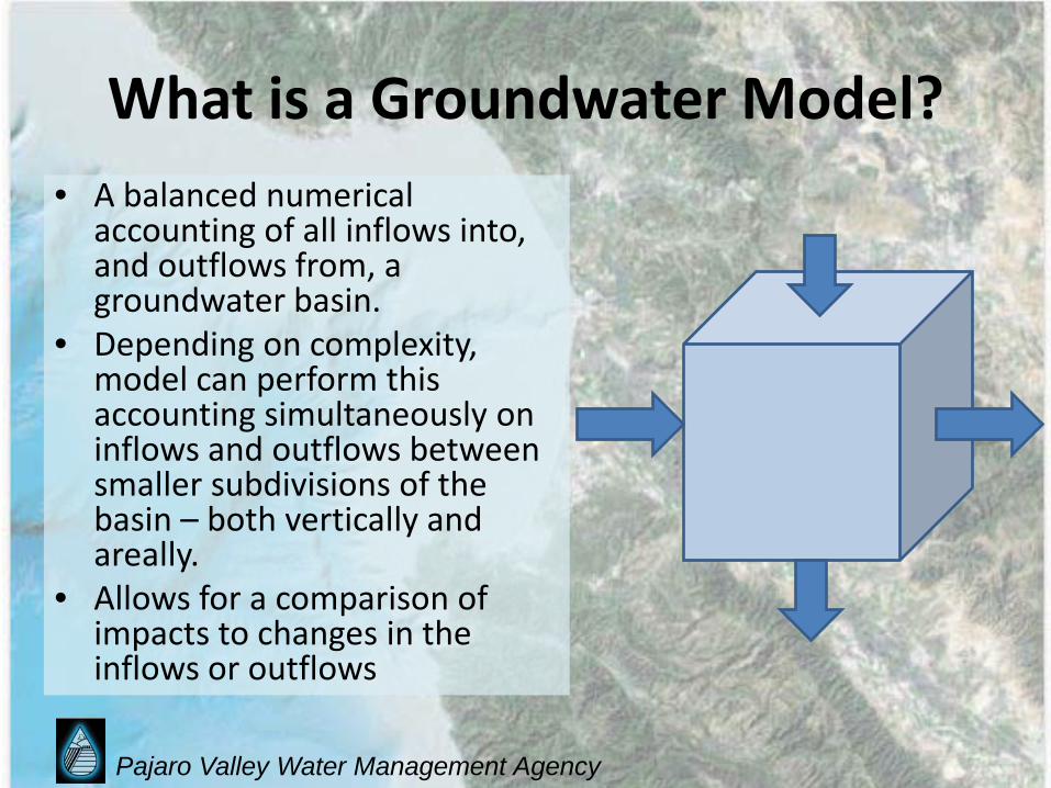
What is a Groundwater Model?• A balanced numerical
accounting of all inflows into, and outflows from, a groundwater basin.
• Depending on complexity, model can perform this accounting simultaneously on inflows and outflows between smaller subdivisions of the basin – both vertically and areally.
• Allows for a comparison of impacts to changes in the inflows or outflows

Pajaro Valley Water Management Agency
What is a Groundwater Model?

Pajaro Valley Water Management Agency
Conceptual Model

Pajaro Valley Water Management Agency
History of Modeling in the Pajaro Valley
• USGS, 1988, MODFLOW CODE– 11 year simulation period: 1970 1981– Recommended better pumpage estimates
• MW, RMC, 1990-2000, IGSM CODE– 32 year simulation period: 1965 1997– Documented increasing storage depletion and SWI– Estimated of pumpage remained somewhat
unconstrained– Used to simulate management scenarios contained in
the Basin Management Plan

Pajaro Valley Water Management Agency
The Need for a New Model• The IGSM proprietary model code has been
subject of some criticism from modeling community
• Develop robust, defensible model utilizing public domain code
• Incorporate new data (pumpage, land use, precipitation, etc.) now available as a result of Agency's monitoring programs
• Develop tool to evaluate and compare various water management scenarios to balance basin

Pajaro Valley Water Management Agency
Pajaro Valley Hydrologic Model (PVHM): Model Development Process
• Selection of USGS to perform work• Establishment of a Model Technical Advisory
Committee (MTAC)– By invitation. Included Board Members, Academics,
Technical Representatives of adjoining hydrogeologic areas
– Supervised Model Development– Met nine times with the USGS modeling team
throughout model development to discuss and concur with selected approaches to modeling issues and assumptions

Pajaro Valley Water Management Agency
Model Technical Advisory Committee
• Andy Fisher, PhD (UCSC)• Derrik Williams, PG CHg (SqCWD)• Howard Franklin, PG (MCWRA)• Mike Cloud, PG (SC Co.)• John Eiskamp, PhD (PVWMA)• Warren Koenig, ChE (Public)

Pajaro Valley Water Management Agency
Pajaro Valley Hydrologic Model (PVHM): Model Development Process
• Converted previous IGSM code based model to MODFLOW code.
• Completed a “mimic” model of old model with new code.
• Updated and refined “mimic” model to incorporate improved hydrogeologic understanding, and better pumpage and land use data.
• Calibrated new model.

Pajaro Valley Water Management Agency
Acceptance of PVHM• Results of model calibration presented to
Model TAC on paper and at two meetings.• Consensus that model is impressive,
defensible and best effort possible given current understanding of basin.
• Limitations of the model are now predominately reflections of the limited understanding and required simplification of the complex hydrogeologic setting.

Pajaro Valley Water Management Agency
Improvement Over Previous Models
• Internally-calculated agricultural pumpage and recharge
• Metered municipal pumpage• Improved conceptualization of
hydrostratigraphy• More robust surface and groundwater linkage• Open, peer-reviewed development
Pajaro Valley Water Management Agency
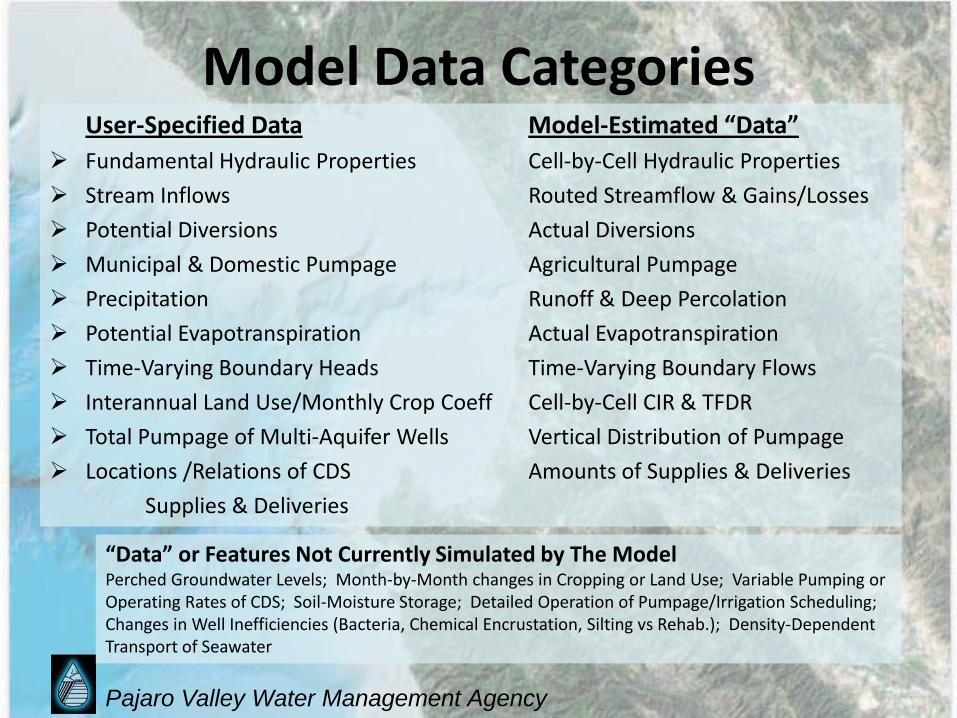
Model Data CategoriesUser-Specified Data Model-Estimated “Data”
Fundamental Hydraulic Properties Cell-by-Cell Hydraulic Properties Stream Inflows Routed Streamflow & Gains/Losses Potential Diversions Actual Diversions Municipal & Domestic Pumpage Agricultural Pumpage Precipitation Runoff & Deep Percolation Potential Evapotranspiration Actual Evapotranspiration Time-Varying Boundary Heads Time-Varying Boundary Flows Interannual Land Use/Monthly Crop Coeff Cell-by-Cell CIR & TFDR Total Pumpage of Multi-Aquifer Wells Vertical Distribution of Pumpage Locations /Relations of CDS Amounts of Supplies & Deliveries
Supplies & Deliveries
“Data” or Features Not Currently Simulated by The ModelPerched Groundwater Levels; Month-by-Month changes in Cropping or Land Use; Variable Pumping or Operating Rates of CDS; Soil-Moisture Storage; Detailed Operation of Pumpage/Irrigation Scheduling; Changes in Well Inefficiencies (Bacteria, Chemical Encrustation, Silting vs Rehab.); Density-Dependent Transport of Seawater

Pajaro Valley Water Management Agency
Potential Limitations of PVHM• Suitable for regional
predictions• Not suitable for small
scale types of analysis, i.e. water level response on an individual parcel or well scale
• Less reliable for monthly analysis
• Density-dependent flow of seawater intrusion

Pajaro Valley Water Management Agency

Pajaro Valley Water Management Agency
Basin Geology:Map View
Four geologic units exposed:
• Alluvium• Upper Aromas• Purisima• Basement

Pajaro Valley Water Management Agency
Basin Geology:Profile View
6 Model Layers:•Alluvium•Alluvial Confining Unit•Upper Aromas•Aromas Confining Unit•Lower Aromas•Purisima
Pajaro Valley Water Management Agency
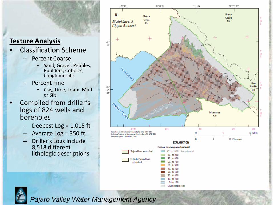
Texture Analysis• Classification Scheme
– Percent Coarse• Sand, Gravel, Pebbles,
Boulders, Cobbles, Conglomerate
– Percent Fine• Clay, Lime, Loam, Mud
or Silt
• Compiled from driller’s logs of 824 wells and boreholes– Deepest Log = 1,015 ft– Average Log = 350 ft– Driller’s Logs include
8,518 different lithologic descriptions
Pajaro Valley Water Management Agency
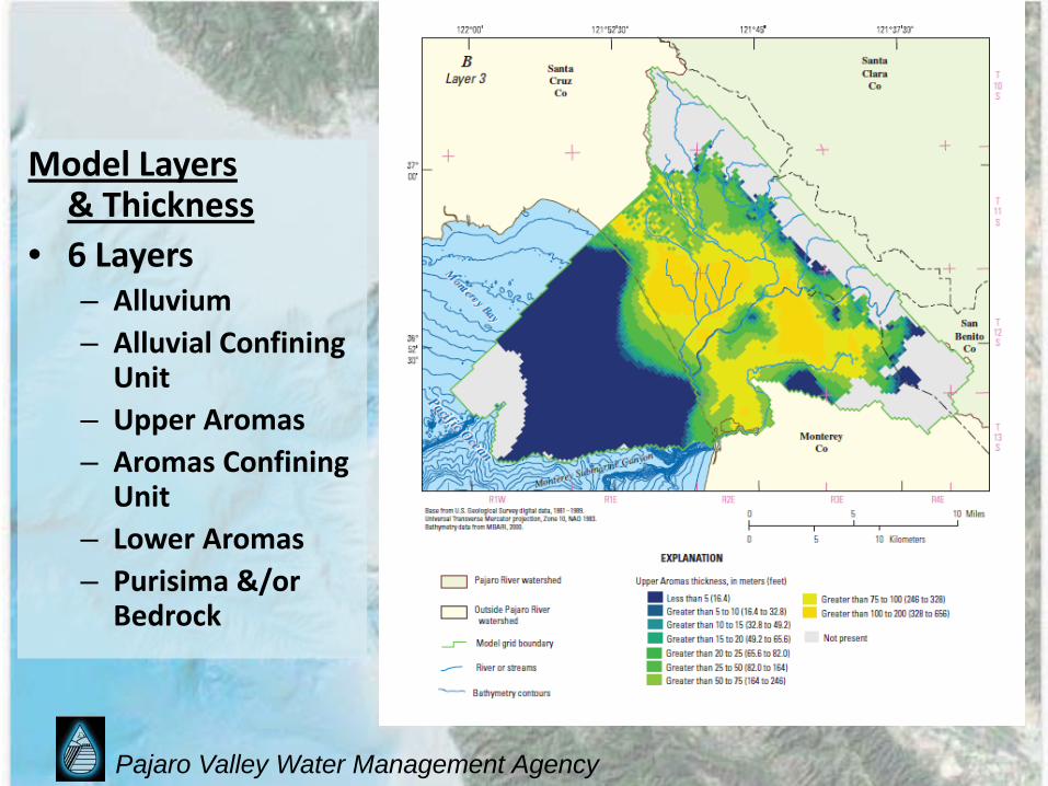
Model Layers & Thickness
• 6 Layers– Alluvium– Alluvial Confining
Unit– Upper Aromas– Aromas Confining
Unit– Lower Aromas– Purisima &/or
Bedrock
Pajaro Valley Water Management Agency
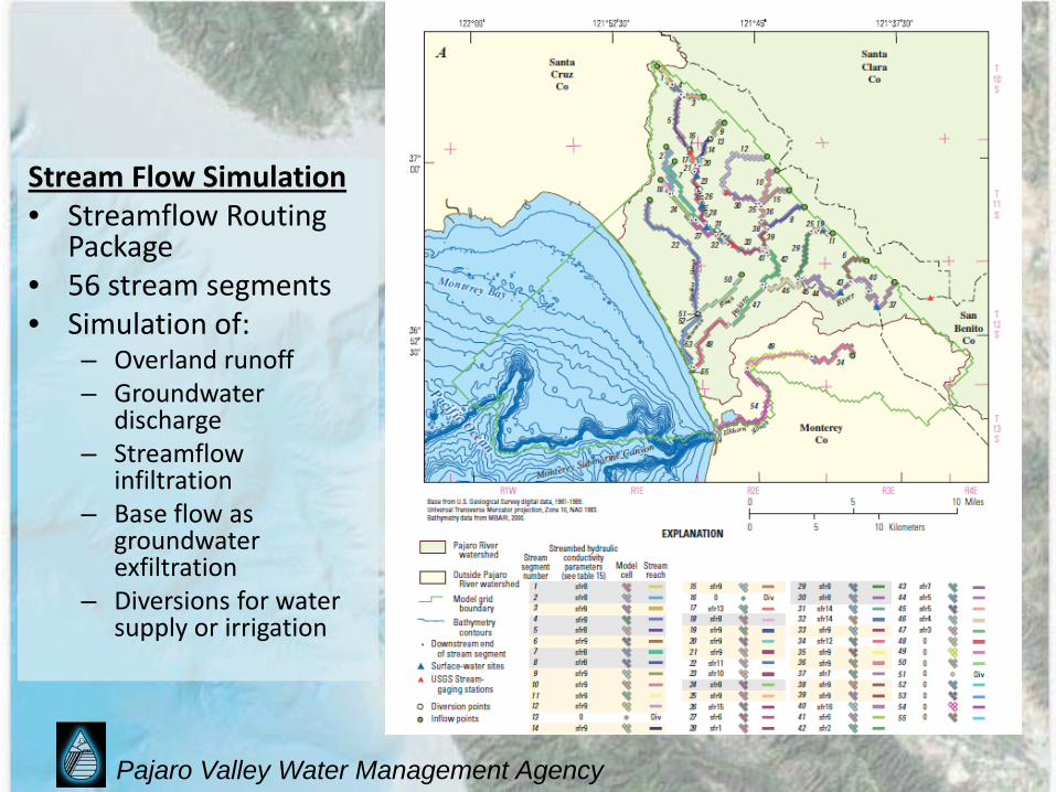
Stream Flow Simulation• Streamflow Routing
Package• 56 stream segments• Simulation of:
– Overland runoff– Groundwater
discharge– Streamflow
infiltration– Base flow as
groundwater exfiltration
– Diversions for water supply or irrigation

Pajaro Valley Water Management Agency
Precipitation:• Gridded regional
estimates of 2 km resolution compared against four local stations.
• Portions of the precipitation are simulated as:– Evaporation– Transpiration– Runoff– Deep Percolation

Pajaro Valley Water Management Agency
Evapotranspiration:• Estimates of total
monthly ETo were derived using the H-S Equation (Hargreaves & Samani, 1982/1985)
• Derived values were checked against Pajaro Valley CIMIS stations
Pajaro Valley Water Management Agency
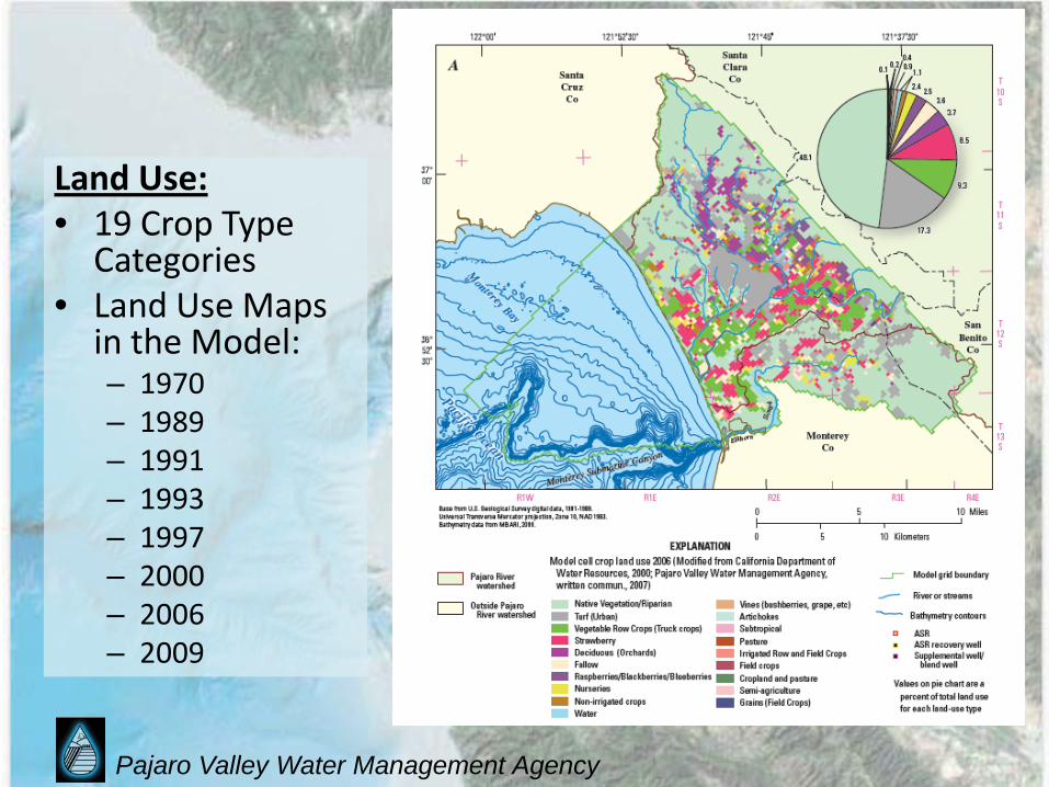
Land Use:• 19 Crop Type
Categories• Land Use Maps
in the Model:– 1970– 1989– 1991– 1993– 1997– 2000– 2006– 2009

Pajaro Valley Water Management Agency
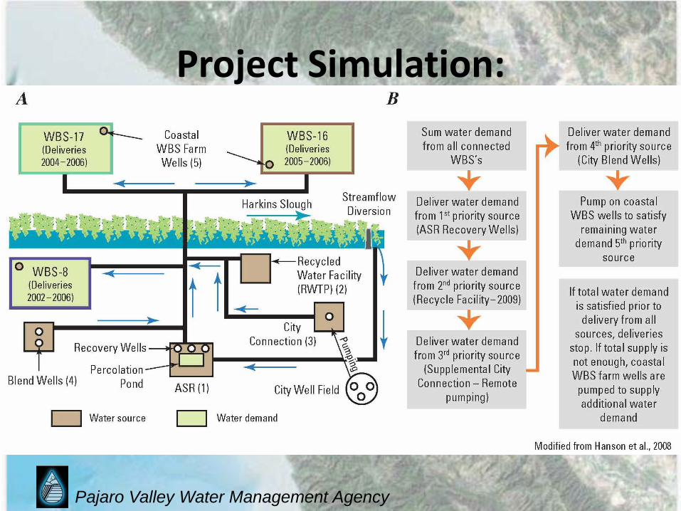
Project Simulation:• Demand Driven• Supply Constrained• Prioritized by
Source• Controlled by Crop
Water Demand
Pajaro Valley Water Management Agency
Project Simulation:

Pajaro Valley Water Management Agency
Use of the Model: Current Status
Simulation Tool vs. Scenario Modeling
• The Model is a Simulation Tool useful to evaluate management approaches.
• A Scenario is a set of management actions that can be simulated to evaluate impacts and benefits.

Pajaro Valley Water Management Agency
Use of the Model: Next Steps• Development of management scenarios to
simulate.• Scenarios to simulate should be developed
through public process.• Simulated Scenarios could include:
– Status Quo (Baseline) – In preparation…– Sustainable Yield– Reduced pumping in selected areas– Water delivery in-lieu of pumping– Adjudication
Pajaro Valley Water Management Agency
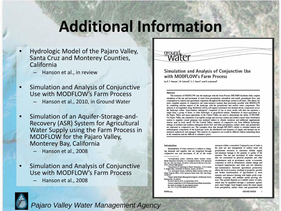
Additional Information• Hydrologic Model of the Pajaro Valley,
Santa Cruz and Monterey Counties, California
– Hanson et al., in review
• Simulation and Analysis of Conjunctive Use with MODFLOW’s Farm Process
– Hanson et al., 2010, in Ground Water
• Simulation of an Aquifer-Storage-and-Recovery (ASR) System for Agricultural Water Supply using the Farm Process in MODFLOW for the Pajaro Valley, Monterey Bay, California
– Hanson et al., 2008
• Simulation and Analysis of Conjunctive Use with MODFLOW’s Farm Process
– Hanson et al., 2008

Pajaro Valley Water Management Agency
Additional Information, cont.• MODFLOW-2005, The US-
Geological Survey Modular Ground-Water Model– The Groundwater Flow Process
– Harbaugh, A. W. 2005
• The Farm Process, Version 2– Schmid, Wolfgang, and Hanson,
R.T., 2009
• Links to references may be found on the Agency’s website:
– www.pvwma.dst.ca.us/hydrology/references.shtml

Pajaro Valley Water Management Agency
Summary• New model has been peer-reviewed and has
been accepted as calibrated and is considered as good as possible at present.
• The model is a good tool for simulating basin management alternatives (Scenarios).
• Basecase scenario in progress, other scenarios have not yet been simulated, as they have not yet been developed.
• Initial steps of the BMP process will include development of Scenarios that can be simulated to evaluate their effectiveness.
Pajaro Valley Water Management Agency
Thank You..--
Questions?