Introduction Public Consultation Bank Hey, Blackburn · Bank Hey, Blackburn Introduction Public...
7
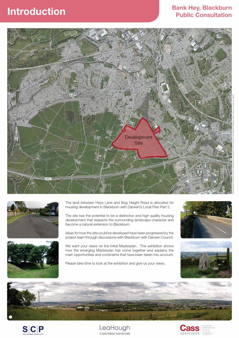
Bank Hey, Blackburn Public Consultation Introduction The land between Heys Lane and Bog Height Road is allocated for housing development in Blackburn with Darwen’s Local Plan Part 2. The site has the potential to be a distinctive and high quality housing development that respects the surrounding landscape character and become a natural extension to Blackburn. Ideas for how the site could be developed have been progressed by the project team through discussions with Blackburn with Darwen Council. We want your views on the initial Masterplan. This exhibition shows how the emerging Masterplan has come together and explains the main opportunities and constraints that have been taken into account. Please take time to look at the exhibition and give us your views. Development Site
Transcript of Introduction Public Consultation Bank Hey, Blackburn · Bank Hey, Blackburn Introduction Public...
Bank Hey, BlackburnPublic ConsultationIntroduction
The land between Heys Lane and Bog Height Road is allocated for housing development in Blackburn with Darwen’s Local Plan Part 2.
The site has the potential to be a distinctive and high quality housing development that respects the surrounding landscape character and become a natural extension to Blackburn.
Ideas for how the site could be developed have been progressed by the project team through discussions with Blackburn with Darwen Council.
We want your views on the initial Masterplan. This exhibition shows how the emerging Masterplan has come together and explains the main opportunities and constraints that have been taken into account.
Please take time to look at the exhibition and give us your views.
DevelopmentSite
���
����
��
����
��
���
��
����
��
����
����
�����
���
����
����
���
��
����
����
���
���
���
����
���
�����
����
��
��
����
���
���
��
��
!"#$
"%
�
!
�#&

Bank Hey, BlackburnPublic Consultation
Industrial Estate
River D
arwen
CRWard Bdy
Tank
VValalveHoHouses
Fishmoor Reservoir
Sloping masonry
Fishmoor Reservoir
Newfield Brook
HigherFa
SSlloopipinngg mmaasosonnryry
Tank
O
Guide Reservoir
FishmoorReservoir
Slopingm
asony
SSllopiing masonry
Slipway
HLA
NE
Refuse Tip
BROKEN STONE ROAD
157157.3m
Fowler Fold
Potter's Plantation
BROKE
Issues
Spring
Path (um)
Refuse Tip
168.9m16
163.7m
Flare
ETL
STOCKCLOUGH LANE
BM 193.55m
Issues
Issues
Well
Spring
Path (um)
Issues
Coppic
Coppice Cott
Path (um)
FW
ETL
Path
(um
)
Well
FW
195.7mBM 184.64m
HillsGreen
Wood
200.9m
GIB LA
GN
E
BROKEN STONE ROAD
Und
210.3m
Ward WBdy
d Bdy
184.4m184
WaddingtonFarm
PillarBM 218.74m
Iss
146.5m
Issues
Lower Moss FoldFarm
Moss Fold
ETL
196.3m
s
Track
Track
Path
E
Knowle Fold
Track
Eccles HillUndUndUnd
PaPatthh
187.1m
Ward Bdy
193.5m
Track
BM 194.93m
Pathh ((um))
ETETLL
TTrackk
Badger BrookB
Path
(um
)
Fourwinds
CR
Issues
Path (um)h (um))
441
190.8m188.5m
ETL
El Sub Sta
Tank
Works
Witton Park
Willow Ground Wood
Golf Driving Range
Site Context
Spatial Vision
'������(�����������������������������������������������)area are very important:
* +���������������������������������������������������,
* +��������� ���-������������/�����������0 �������)���-��)�������),
* +����������������������������������������������,
* �����������������������������������������������)�����,
These considerations have helped to shape our thinking on the way the development can integrate into its setting. In addition:
* '����������������� /���� ������ 1��/����)�3 �� ������ /�important that it is designed in a way that creates a transition into the countryside beyond.
* �������� �����)� �������������� ���� ������������� ����important issue.
���
����
��
����
��
���
��
����
��
����
����
�����
���
����
����
���
��
����
����
���
���
���
����
���
�����
����
��
��
����
���
���
��
��
!"#$
"%
Site Boundary
Public Park or Playing Field
Hospital
Sports
����'����������
Religious Ground and Cemeteries
Allotments and growing Zones
Schools
Train Stations
Railway Line
Canal
Public Rights of Way
Witton Weavers Way
DevelopmentSite
�#&
4###
4###
4#5#$
Ewood Park
Witton Park
Cherry Tree
MillHill
Royal BlackburnTeaching Hospital
Weavers Wheel Way
Gib Lane housing development
�

Bank Hey, BlackburnPublic Consultation
1
2
3
Site Analysis
Site Analysis
* The site has challenging gradients and natural slopes* Overhead power lines divide the site into two.* Existing Public Footpaths run across the south from Heys Lane to
Bog Height Road* The site offers a number of potential access points.* 8(�����)�������������/������������������������������
across the site are an important countryside characteristic.* The site contains two existing ponds and a water course * Bands of existing native trees. * The site offers panoramic views over Blackburn town centre to the
north east and Darwen to the south east.* Access will need to be retained for Bank Hey Farm and Bank Hey
Cottages
Guiding Principles
* The development will need to gain access from the surrounding �������9�-+��-��+��0;�)���)��������������������������������<�����������������
* Pedestrian and cycling links should connect the development to surrounding areas.
* Development must create attractive green space incorporating existing trees and woodlands.
* An attractive housing development appropriate to its setting on the edge of Blackburn
* The development will need to incorporate a Sustainable Drainage solution
�
1
Site Boundary
Existing Power Lines
Stone Walls
Existing Trees and Woodland
Public Rights of Way
Watercourses
Pond
Culverts
Slope and Gradient
Public Access
Former Quarry
Panoramic Location
���
����
��
����
��
���
��
����
��
����
����
�����
���
����
����
���
��
����
����
���
���
���
����
���
�����
����
��
��
����
���
���
��
��
!"#$
"%
2

Bank Hey, BlackburnPublic ConsultationVision & Character
The sloping land and the overhead power line point to the division of the land into a series of individual development plots.
Each development plot will be served from new points of access onto ;�)���)������0��������09�-+��-��+�����4������4�����=
The development will include a network of green spaces providing space for informal recreation.
�������>����������������������/�����������������)����������-����������������0��)��������������������������������������
Landmark Buildings will create a focal point and/or terminate a key approach or vista. They typically front onto more important areas of the public realm.
The development will include on site water retention areas to manage ���<��������������(�����)��������������������=
Key Character Types will be developed:
Character Type 1 - Suburban Transition Will have a suburban character to complement the existing housing around Jack Walker Way. Red brick faced dwellings with grey tiled roofs and a diverse mix of house types and sizes.
Character Type 2 - Urban EdgeThe Urban Edge Character Area provides the interface between the town and countryside. It will draw on the characteristics of adjacent properties along Bog Height Road and Heys Lane and could feature ����� ���� �������)�0 ����� ���� ����� ��� /��������� �� ��������walls on key frontages.
The Green Edge '��������������������������)��������-��))��������0���������a high quality outlook and surveillance of the space.
Key Site Frontages To provide direct outlook and connections to Bog Height Road and Heys Lane and links to Jack Walker Way.
11
1
2
2
1@�������'���!
2Character Type 2
Proposed Green Space
Existing Trees and Woodland
Proposed Road Junction
Proposed Road
Proposed Footpath
Proposed Footpath ����
Overhead Power Lines
Green Edge overlooking Public Open Space
Key Site Frontages
Proposed Landmark Building
RetainedWoodland
2
2
�
���
����
��
����
��
���
��
����
��
����
����
�����
���
����
����
���
��
����
����
���
���
���
����
���
�����
����
��
��
����
���
���
��
��
!"#$
"%
3

Bank Hey, BlackburnPublic ConsultationDraft Masterplan Framework
Development PlotsThere will need to be regrading of the land to create gently sloping development plots
���
����
��
����
��
���
��
����
��
����
����
�����
���
����
����
���
��
����
����
���
���
���
����
���
�����
����
��
��
����
���
���
��
��
!"#$
"%
Plot A
Plot H
Plot B
Plot E
Plot G
Plot F
Plot D
Plot C
GreenspaceN��������<���/������������������������������������������more steep.
AccessThere are individual points of access to development plots with the effect ��������/����)�������������/���������='��������������/�������a new route between Bog Height Road and Ashwood Avenue. This will allow the closure of the eastern section of Bog Height Road to through �����=
LinksA network of footpaths through the development and the green spaces will connect the site to surrounding areas.
Surface WaterWater retention ponds will be built into the development to control the ���������������������<�������������� �����������������sewers.
�
Plot AccessPoint
Access to: Indicative Number of Houses
A Bog Height Road V5B / Jack Walker Way/Ashwood Avenue $X5C / Jack Walker Way/Ashwood Avenue !5D 4 Bog Height Road &5E 4 Bog Height Road #&F / Ashwood Avenue / Jack Walker Way !5%G / Ashwood Avenue / Jack Walker Way V5H ! Heys Lane !55
1
2
3
4
5
Avenue
5
2 3
2 3
4
4
2 3
2 3
1
Bank Hey, BlackburnPublic Consultation
KEYPhase 1Plot A
Phase 2Plot A & B
Phase 3Plot D & E
Phase 4Plot F & G
Phase 5Plot H
BOG HEIGHT ROAD
M 6 5
BOG HEIGHT ROAD
HEYS
LA
NE
HEYS
LANE THE HEIGHTS
FREE SCHOOL
THE REDEEMERCE PRIMARY
SCHOOL
BANK HEYFARM
BOLTO
N ROAD
JACK WALKER W
AYBANK HEYCOTTAGES
Fowler Height
eight
Cottage
Barn-sideCottage
Fowler HeightFarm
Fowler HeightHouse
Higher Fowler HeightFarm
Lower Fowler Height
Trough
WellPpLower
HEYS
LANE
New Row
Methodist Church
CR
Path
Path
PumpHouse
25
11
Well
FARMER'S ROW
2014
39
47
81
72
69
HEYS CLOSE
CLOSE
34
44
52
66
68
76
84
67
57
43
55
Well
Boro
Con
st &
War
d Bd
y
CF
Ward Bdy
CW
CF
Path
w
Morris Bank
Path (um)
Holden Fold
RH
Well
Trough
m
207.9m
BM 2
08.4
8m
FW
Def
Turners Farm
BOG HEIGHT ROADPEAK BROW
BS
Well
FW
Und
217.6m
89
88
2a2
1
The Hollies
Well
HEYS LA
GreenRow
LowerFowlerHeight
Boro
Const
and W
ard Bd
y
Pond
FARMER'S ROWBM
174
.25m
171.0m24
0
242
33
23
11
9
158
68
10
2
CR
162.5m
HEYS
CLO
SE
39
35
32
40
48
50
22
10
8
2
30
24
156.1m
HEYS
LAN
E
15
164
33
Boro
Con
st &
War
d Bd
y
Ward Bdy
CF
MOORLAND
ROAD
137
1
3
1
3
1115
8
HEYWORTH AVENUE
3l
20
2
4
17
25
2
3
Craven's
Farm
Def
Fernhurst Wood
CS
FERGUSON STREET
Und
BM 111.53m
14
2
542
544
5
1
Boro Const & Ward Bdy
Garage10
26
23
21
17
19
27
18
8
MEADO
WFIELDS
ARBOUR DRIVE
38
44
43
47
50
25
11
WATER MEADOWS
15
5
2
8
24
OLD FARMSIDE
2
1
MEADOWFIELDS
DALGLISH DRIVE
8
2
DOUGLAS CLOSE
1
11
2
1
2
4
8
THO
RNYLEA
7
12
18
1
7
9
21
30
12
10
2
14
39
21
10
12
2
El Sub Sta
1
FLOW
ERS CLOSE
GARN
ER
AVENUE
29
36
1
2
1
3
9
6
10
23
9
5
9
1
GREENFIELDS
1
7
6
2
7
11
20
1
18
FORRESTSIDE
14
20
3
THE GREENWOOD
2
1
11
15
3
17
32
293526
2
14
9
WHE
LAN
CLO
SE
1
1
7
Well
MEADOW HEAD LANE
198.7m
49
BM
Well
BOG
HEIG
HT RO
AD
87
PEAK BROW
223.7m
219.8m
Bog Height House
172.0m BOG HEIGHT ROAD 162.7m
43
41a
72
150.5m
50
BEECH GROVE
146.7m
17
12
2
29
Issues 31
32
22
Pond
ETL
Sinks
THE DELL
OAKMERE CLOSE
PARKDALE GARDENS
HEATHERLEIGH GARDENS
THE
SHIR
ES
ARBOUR D
RIVE2
12
67
13
5
11
15
1
3
1
5
7
11
9
22
2420
10
8
2
4
5
9
1
3
5
9
2
4
10
16
18
M 65
11
15
25
33
13
15
12
2
4
RYE GARDENS 24
2
1
5
8
49
ORCHARD CLOSE
4
20
28 1
5
12
32
11
27
1517
ASHWOOD AVE
3
6
39
20
1
2
10
23
11
8
GREENWOODTHE
1
9
15
25
CRAVEN'S AVENUE
632
636
638
640
1
9
4 2
BM 126.57m
127.7m St BartholoVicarag
598
608
604
BOLTO
N ROAD
Craven's Brow
122.2m
118.0m
568
588
578
113.4m
Und
CR
558
235
2
556
164
223
211
Boro Const & Ward Bdy
Garage
610
612
MEADOWFIELDS
16
6
9
11
46
40
22 GoldenCup Inn
143.3m
BEECH GROVE
BOG HEIGHT ROAD
9
1
27
BM 140
BOL
CRAVEN'S BRO
W
Craven's Cottage
132.6m
24
1012
30
28
20
MEADO
W VALE
13
5
1115
21
25
31
35
LEA DRIVE
CRAV
ENS
HO
LLO
W
THE GLEN
3
5
3
1
7
1
126
16
14
12
24
35
2123
4
5
1
M 65
51
11
10
21
2
THE G
LADE
15
31
LB
26
36
46 50
37
Spout House Farm
Spout House Barn
M 65
Issues
M 65
M 65 SM
Gar
M 65
Path
(um
)
Well
halleyrrace
Boro
Bog Bank Farm
Higher Bog Height
Farm
199.62m
41
190.8m
Path (um)
Path (um)
188.5m 178.5m
60
39
39
27
Darwen Vale High School
18
Posts
(PH)
144.8m 13
30
1
14
34
El Sub Sta
purpose
NORTH
0 4020 100m8060
ProposedRoad
Phasing and Earthworks
Phase Housing Units! V52 $V53 !!&4 !V%& !55
Total 642
Phase 2Plot B>����&
Plot H
>����!Plot A
Phase 2Plot C
Phase 3Plot D
Phase 3Plot E
Phase 4Plot G
Phase 4Plot F
Phase 3Plot E
Open Space
Phase 4Plot G
Phase 4Plot F
ProposedRoad Proposed
Road
ProposedRoad
ProposedRoad
Bog HeightRoad
Higher Bog Height Farm
OrchardClose
A A1
A
A1
���
����
��
����
��
���
��
����
��
����
����
�����
���
����
����
���
��
����
����
���
���
���
����
���
�����
����
��
��
����
���
���
��
��
!"#$
"%
Existing Trees
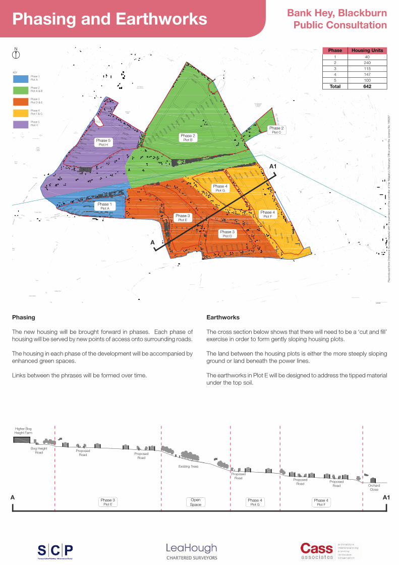
Phasing
The new housing will be brought forward in phases. Each phase of housing will be served by new points of access onto surrounding roads.
The housing in each phase of the development will be accompanied by enhanced green spaces.
Links between the phrases will be formed over time.
Earthworks
'������������/����������������������������/��[���������exercise in order to form gently sloping housing plots.
The land between the housing plots is either the more steeply sloping ground or land beneath the power lines.
The earthworks in Plot E will be designed to address the tipped material under the top soil.
�

Bank Hey, BlackburnPublic ConsultationAccess and Drainage
Proposed Green Space
Existing Trees and Woodland
Proposed Road Junction
Proposed Road
Proposed Footpath
Proposed Footpath ����
Overhead Power Lines
Proposed Site Entrance P
P
PP
P
P
PP
P
P
Proposed Water Retention PondsP
�
���
����
��
����
��
���
��
����
��
����
����
�����
���
����
����
���
��
����
����
���
���
���
����
���
�����
����
��
��
����
���
���
��
��
!"#$
"%
Plot A
Plot H
Plot B
Plot E
Plot G
Plot F
Plot D
Plot C
OPTION 1 - ASHWOOD AVENUE TO BOG HEIGHT ROAD LINKThis option involves the closure of Bog Height Road at the Junction �������4###\;��-/�������]=
OPTION 2 - ASHWOOD AVENUE TO BOG HEIGHT ROAD LINKThis option involves the closure of Bog Height Road to the West of ��=VX0������)�����������������4###\;��-/�������]���������limited number of properties.
AccessThe new points of access will serve discrete pockets of housing. The �������� �����)��������/� ���������������� ��� ����������)���������/��������������������������������)�(�����=
Drainage4���������������������0�����������������������/�/����='��������/�������������^���������������������/����������������in periods of high rainfall and then released slowly into water courses and sewers. Water retention ponds will also provide new habitat and �����������������='�����������/�����)��������������/��������������������������������������/��-�������=
DevelopmentSite
DevelopmentSite
������-����between Bog
Height Road and Ashwood Avenue
������-����between Bog
Height Road and Ashwood Avenue
Bog Height Road stopped to the ��������=VX
Bog Height Road stopped at the Golden Cup


![Hey, hey, hey! Welcome, welcome, everyone! · Hey, hey, hey! Welcome, welcome, everyone! • It’s me, your friend, [Host’s name], with you, and I am so glad you guys are here](https://static.fdocuments.in/doc/165x107/5fbe51e50602d61619707374/hey-hey-hey-welcome-welcome-everyone-hey-hey-hey-welcome-welcome-everyone.jpg)