Introduction - NetHope Solutions...
8
Introduction It is rather the rule than the exception that search and rescue (SAR) missions are initiated under harsh weather conditions. Weather also plays an important part in disaster relief operations. In any case, such missions are very dependent on weather forecasts, as the safety of the field personnel must be secured in the best possible manner. Disaster Managers, SAR operators and field personnel often work in extreme conditions, where better and timelier information is of paramount importance. IMR/Belgingur has developed a unique weather forecasting system, named SARWeather (http://www.sarweather.com ). SARWeather, short for Search And Rescue Weather, is tailored to serve the demanding needs of SAR teams, humanitarian organizations and emergency operations centers worldwide. SARWeather is an on demand cloud based software suite that brings the power of modern weather forecasting models to the hands of ordinary people. To ensure its usability, SARWeather has been developed in close collaboration with the Civil Protection Department of the Icelandic police (CPD), the Icelandic Search and Rescue Association (ICE-SAR), and UNITAR’s Operational Satellite Applications Programme (UNOSAT). SARWeather SARWeather provides a simple, web based, user interface to the WRF modeling system [1]. In few easy steps the user places a new forecast order, defines the region of interest, verifies/modifies the choice, submits the forecast order and finally views the resulting high- resolution weather forecast. The SARWeather system uses data from the Global Forecasting System (GFS) run by the National Oceanic and Atmospheric Administration (NOAA) as initial and boundary data. The GFS data are scaled down to 1km horizontal resolution using the WRF models nesting technique. This detailed resolution ensures that the effects that complex terrain can have on the atmospheric flow are taken into account in the weather forecast.
Transcript of Introduction - NetHope Solutions...
IntroductionIt is rather the rule than the exception that search and rescue (SAR) missions are initiated under harsh weather conditions. Weather also plays an important part in disaster relief operations. In any case, such missions are very dependent on weather forecasts, as the safety of the field personnel must be secured in the best possible manner. Disaster Managers, SAR operators and field personnel often work in extreme conditions, where better and timelier information is of paramount importance.
IMR/Belgingur has developed a unique weather forecasting system, named SARWeather (http://www.sarweather.com). SARWeather, short for Search And Rescue Weather, is tailored to serve the demanding needs of SAR teams, humanitarian organizations and emergency operations centers worldwide. SARWeather is an on demand cloud based software suite that brings the power of modern weather forecasting models to the hands of ordinary people.
To ensure its usability, SARWeather has been developed in close collaboration with the Civil Protection Department of the Icelandic police (CPD), the Icelandic Search and Rescue Association (ICE-SAR), and UNITAR’s Operational Satellite Applications Programme (UNOSAT).
SARWeatherSARWeather provides a simple, web based, user interface to the WRF modeling system [1]. In few easy steps the user places a new forecast order, defines the region of interest, verifies/modifies the choice, submits the forecast order and finally views the resulting high-resolution weather forecast. The SARWeather system uses data from the Global Forecasting System (GFS) run by the National Oceanic and Atmospheric Administration (NOAA) as initial and boundary data. The GFS data are scaled down to 1km horizontal resolution using the WRF models nesting technique. This detailed resolution ensures that the effects that complex terrain can have on the atmospheric flow are taken into account in the weather forecast.
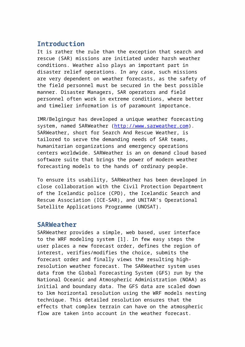
SARWeather was first used in operational mode during the aftermath of the Haiti earthquake in January 2010 (cf. Fig. 1). On-site SAR personnel used the forecasts to plan day-to-day operations. Since than it has been used to create forecasts for Pakistan during the flooding events in the fall of 2010; to provide detailed forecasts for parts of Libya where humanitarian aid was being provided; and to run high resolution forecasts for the region around Fukushima nuclear plants after the 2011 earthquake.
In addition to being run operationally by ICE-SAR, SARWeather is being integrated into the search and rescue web based service provided by Decisions for Heroes (www.decisionsforheroes.com), making SARWeather available to hundreds of SAR teams worldwide. SARWeather is also a certified service provider to the Global Disaster Alert and Coordination System (GDACS –
www.gdacs.org). GDACS is a joint initiative of the United Nations and the European Commission with the aim to consolidate and strengthen the network of providers and users of disaster information worldwide in order to provide reliable and accurate alerts and impact estimations after sudden-onset disasters and to improve the cooperation of international responders in the immediate aftermath of major natural, technological and environmental disasters.
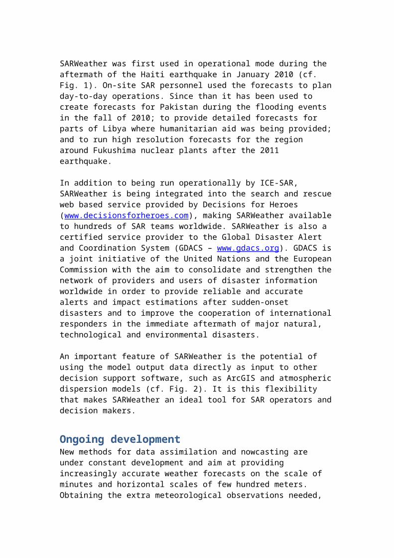
An important feature of SARWeather is the potential of using the model output data directly as input to other decision support software, such as ArcGIS and atmospheric dispersion models (cf. Fig. 2). It is this flexibility that makes SARWeather an ideal tool for SAR operators and decision makers.
Ongoing developmentNew methods for data assimilation and nowcasting are under constant development and aim at providing increasingly accurate weather forecasts on the scale of minutes and horizontal scales of few hundred meters. Obtaining the extra meteorological observations needed, as input to these methods can however be tricky in remote areas or regions severely affected by natural catastrophes. An example of such a region is Haiti after the large earthquake in January 2010. The range of UAV (Unmanned Aerial Vehicle) flying meteorological observatories is an important addition to the meteorological toolbox. Increasingly robust aircraft models can be deployed at a well-defined extra cost, with current weather conditions, in particular wind speed, being the determining factor. Meteorological observatories may even be retrofitted on SAR reconnaissance drones.
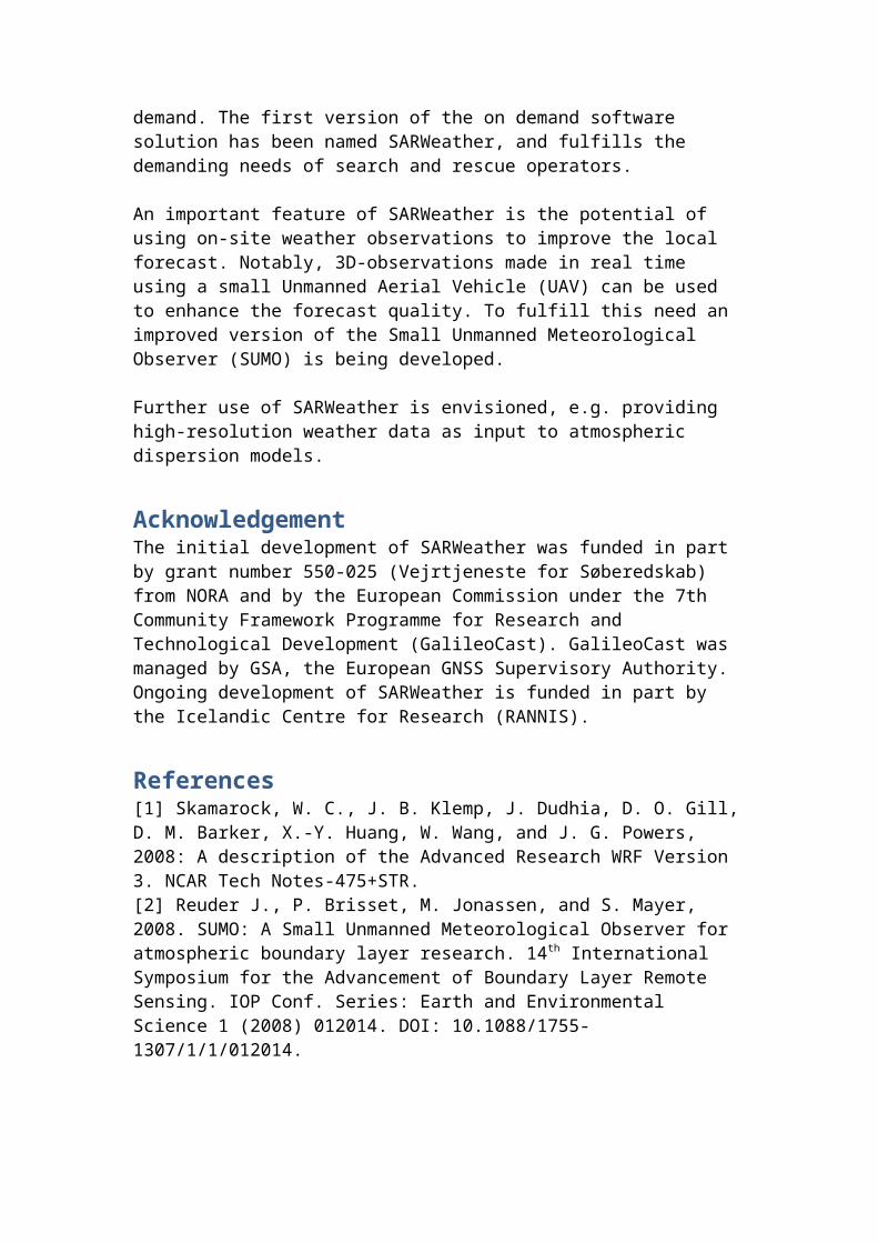
An example of a cost effective UAV system is the Small Unmanned Meteorological Observer (SUMO, cf. Fig. 3) [2].
To demonstrate the effects that three-dimensional observations, made by the SUMO-system, can have on high-resolution weather forecasts, data from test flights done on July 15 2009 have been used as input to the SARWeather system (cf. Fig. 4). For this particular day and location, high resolution atmospheric simulations failed to produce north-easterly accelerated flow on the lee-side of Mt. Esja (900 m.a.g., SW-Iceland near the capital Reykjavík), as was indeed observed in the SUMO test flight as well as at the ground. Instead, the atmospheric models produced a fictitious westerly sea breeze in the early afternoon. Figure 4 shows results from two different simulations done with the SARWeather system at 1 km horizontal resolution. Top row shows the standard simulation where the model in only forced with initial and boundary data from a global forecasting model. When applying the SUMO observations, there is a considerable improvement in the quality of the simulated atmospheric flow and the character of the flow in the lee of Mt. Esja is correctly captured.
ConclusionsA unique software solution has been developed that makes it simple for regular people to create highly accurate weather forecasts for any location worldwide

and on demand. The first version of the on demand software solution has been named SARWeather, and fulfills the demanding needs of search and rescue operators.
An important feature of SARWeather is the potential of using on-site weather observations to improve the local forecast. Notably, 3D-observations made in real time using a small Unmanned Aerial Vehicle (UAV) can be used to enhance the forecast quality. To fulfill this need an improved version of the Small Unmanned Meteorological Observer (SUMO) is being developed.
Further use of SARWeather is envisioned, e.g. providing high-resolution weather data as input to atmospheric dispersion models.
AcknowledgementThe initial development of SARWeather was funded in part by grant number 550-025 (Vejrtjeneste for Søberedskab) from NORA and by the European Commission under the 7th Community Framework Programme for Research and Technological Development (GalileoCast). GalileoCast was managed by GSA, the European GNSS Supervisory Authority. Ongoing development of SARWeather is funded in part by the Icelandic Centre for Research (RANNIS).
References[1] Skamarock, W. C., J. B. Klemp, J. Dudhia, D. O. Gill, D. M. Barker, X.-Y. Huang, W. Wang, and J. G. Powers, 2008: A description of the Advanced Research WRF Version 3. NCAR Tech Notes-475+STR.[2] Reuder J., P. Brisset, M. Jonassen, and S. Mayer, 2008. SUMO: A Small Unmanned Meteorological Observer for atmospheric boundary layer research. 14th International Symposium for the Advancement of Boundary Layer Remote Sensing. IOP Conf. Series: Earth and Environmental Science 1 (2008) 012014. DOI: 10.1088/1755-1307/1/1/012014.
Figure captionFigure 1: ICE-SAR was the first international rescue team to arrive in Haiti after the large earthquake in January 2010. Having received a request for high-resolution forecasts for Haiti from ICE-SAR, it took IMR scientists less than two hours to set up an operational weather forecasting system for Haiti. A system that to this day is still operational. With the current version of SARWeather, this process now only takes a few minutes. Photo courtesy by ICE-SAR.
Figure 2: Complex orography in the vicinity of erupting volcanoes can, e.g. through the formation of mountain waves, effect the vertical displacement of volcanic ash. This is particularly true if the ash plume does not penetrate deeply into the atmosphere, as was the case during most of the Mt. Eyjafjallajökull eruption in spring 2010. Current ash dispersion models do not take this potential orographic influence into account. The formation of mountain waves can be correctly simulated using high-resolution weather models; the results can in turn be used as
input data to advanced ash dispersion models. Image is from NASA's Terra satellite 12:15 UTC, 11 May, 2010. Mt. Eyjafjallajökull is represented by a red rectangle. Credit: NASA Goddard / MODIS Rapid Response Team.
Figure 3: The SUMO system has been used with great success in Iceland, Norway, and in Svalbard. Photo by Erik Kolstad.
Figure 4: Simulated and observed surface wind speed [m/s] and direction in the vicinity of Mt. Esja, SW-Iceland. Top figure shows results from a standard simulation. The bottom figure shows results from a simulation where observations from five consecutive SUMO flights, from the MOSO field project, were used to nudge the simulation. Observed surface wind speed and direction is shown with red wind barbs. Both simulations are done with 1km horizontal resolution and are valid, as are the observations, at 15:00 UTC, 15 July, 2009.