Introduction - mau.nic.inmau.nic.in/Departments/mines/mines.pdf · The district Mau is...
23
Transcript of Introduction - mau.nic.inmau.nic.in/Departments/mines/mines.pdf · The district Mau is...

1

⦁ Introduction
With reference to the gazette notification dated 15th January 2016 of Ministry of
Environment, Forest and Climate Change, the entire District divisional commissioner
shall constitute- District Environment Impact Assessment Authority (DEIAA) and
District Environment Assessment Committee (DEAC) for prior environmental clearance
for quarry of minor minerals. The DEIAA and DEAC will scrutinize and recommend the
prior environmental clearance to ministry for minor minerals on the basis of district
survey report. The main purpose of preparation of District Survey Report is to identify the
mineral resources and mining activities along with other relevant data of district. This
report shall contain the details of Lease, Sand mining and Revenue which comes from
minerals in the district. This report is prepared on the basis of data collected from
different concern departments. A survey is carried out by the members of DEIAA with
the assistance of Geology Department or Irrigation Department or Forest Department or
Public Works Department or Ground Water Boards or Remote Sensing Department or
Mining Department etc. in the district
Mau district was carved out of Azamgarh and lies between 25048'35" and 26017'45"
north latitude and 83010'50" and 83049'55" east longitude in surrey of India Toposheet
No. 63 O & 63 N. Total geographical area of the district 1714 Sq.km. District head
quarter is at Mau of having (4/four) number of Tehsil and 9 (Nine) number of block. As
per the 2011 census the district has population 1493928 of which 747576 males and
746052 females. The decadal growth is 24.28%. Scheduled caste population is 421680
and scheduled tribe population is 430.
The district is surrounded by Ghazipur district on the south, Ballia district in the east and
Azamgarh district in the west and north side surrounded by Gorkhpur. Varanasi touches
some area in south side. The river Ghagra forms its northern boundary and south
2

boundary touches Tamsa River.
3

4
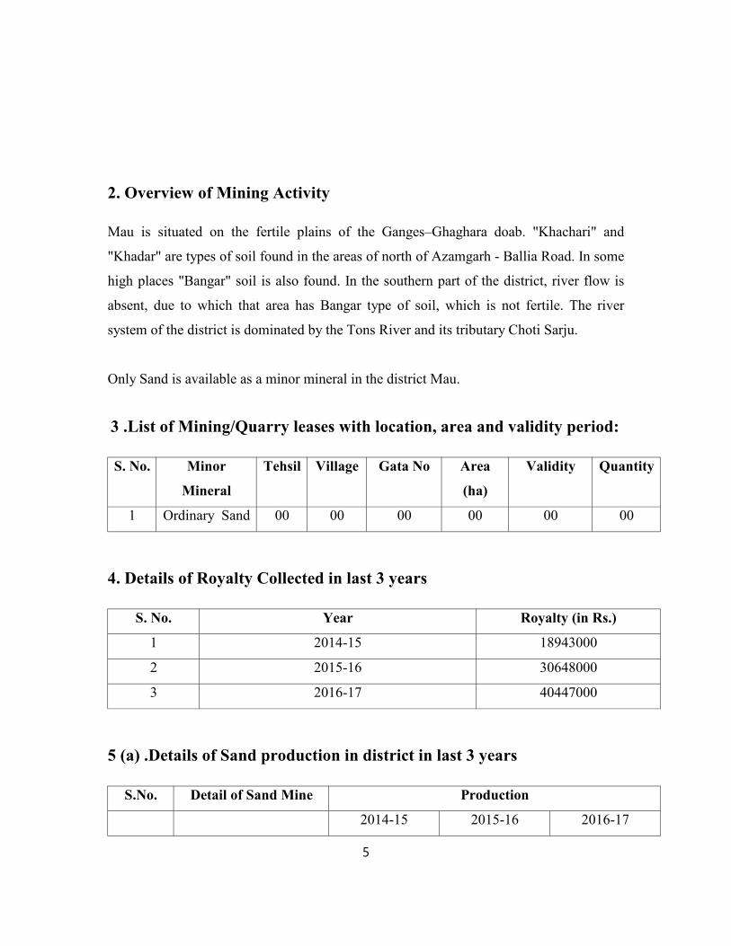
2. Overview of Mining Activity
Mau is situated on the fertile plains of the Ganges–Ghaghara doab. "Khachari" and
"Khadar" are types of soil found in the areas of north of Azamgarh - Ballia Road. In some
high places "Bangar" soil is also found. In the southern part of the district, river flow is
absent, due to which that area has Bangar type of soil, which is not fertile. The river
system of the district is dominated by the Tons River and its tributary Choti Sarju.
Only Sand is available as a minor mineral in the district Mau.
3 .List of Mining/Quarry leases with location, area and validity period:
S. No. Minor
Mineral
Tehsil Village Gata No Area
(ha)
Validity Quantity
1 Ordinary Sand 00 00 00 00 00 00
4. Details of Royalty Collected in last 3 years
S. No. Year Royalty (in Rs.)
1 2014-15 18943000
2 2015-16 30648000
3 2016-17 40447000
5 (a) .Details of Sand production in district in last 3 years
S.No. Detail of Sand Mine Production
2014-15 2015-16 2016-17
5

1 NIL NIL NIL NIL
5(b). Area proposed for e-auction through e-tendering
Name of
Minor
Mineral
Tehsil Village Gata No. Area
(in
Ha)
Validity Reserve Remarks
Ordinary
Sand
Sadar Sanegpur 01 Mi, 91 Mi, 248
Mi, 249, 250, 251,
252, 253
3.42 00 34260 Mining
Area not
Cleared
Ordinary
Sand
Madhuban Druhi-
Dilia
277 k/18 1.11 00 33450 Mining
Area not
Cleared
6. Process of Deposition
Weathering cycle of River (Fluvial) comprises of three stages viz. erosion,
transportation and deposition.
A river/stream in its course to mouth erodes the country rocks through
which it flows. Erosion comprises of mechanical as well as chemical
process nowadays man-made erosion also contributes. These eroded
sediments then transported by river in suspension or solution until the river
runs outs of its capacity to transport. When river enters its flood plain or
reaches its mouth its velocity gets checked due to widening of its channel
6

and deposition of sediments takes place. Natural leeves, oxbow lakes are
depositional features formed by river in its course. Deltas/Alluvial
fans/plains are generally formed when a river ends in a ocean/sea. River
sediments are generally well sorted and well rounded.
Figure showing process of sedimentation
Following factors impacts river cycle of weathering:
i. Annual Rainfall
ii. Geographical Relief
iii. Geology of the river course
iv. Discharge of river and its tributaries
7

v. Activities at nearby rivers (Man-made activities; forestation/deforestation,
mining,
ghats)
vi. Engineering structures (Dams, diversions)
vii. Climatic conditions.
8

7. General Profile of District
S.No Particular Year Unit
1 Geographical features
(A) Geographical Data
i) Latitude 24°4
ii) Longitude 83°1
iii) Geographical Area Hectares 1,73
(B) Administrative Units
i) Sub divisions 0
ii) Tehsils 4
iii) Sub-Tehsil 9
iv) Patwar Circle 0
v) Panchayat Simitis 92
vi)Nagar nigam 0
vii) Nagar Palika 1
viii) Gram Panchayats 597
xi) Revenue villages 162
x) Assembly Area 4
2. Population
9

(A) Sex-wise
i) Male 2011 11,1
ii) Female 2011 10,9
(B) Rural Population 2011 14,9
3. Agriculture
A. Land utilization
i) Total Area 2010-11 Hectare 1,71,624
ii) Forest cover 2010-11 “ 3,301
iii) Non Agriculture Land 2010-11 “ 2,302
v) Cultivable Barren land 2010-11 “ 13,342
4. Forest
(i) Forest 2010-11 Ha.
5. Livestock & Poultry
A. Cattle
i) Cows 2007 Nos.
ii) Buffaloes 2007 Nos.
B. Other livestock
i) Goats 2007 Nos.
ii) Pigs 2007 Nos.
iii) Dogs & Bitches 2007 Nos.
iv) Railways
10

iv) Railways
i) Length of rail line 2010-11 Kms
V) Roads
(a) National Highway 2010-11 Kms
(b) State Highway 2010-11 Kms
(c) Main District Highway 2010-11 Kms
(d) Other district & Rural Roads 2010-11 Kms
(e) Rural road/ Agriculture Marketing Board Roads 2010-11 Kms
8. Land utilization pattern
Total Area : 1, 73, 459 Hectares
Forest : 560 Hectares
Agriculture : 1, 71,624 Hectares
Mining : 150 Hectares
Others : 1125 Hectares
9. Physiography of the district
The district Mau is characterized by various geomorphic units Viz;
(i) Newer Alluvial Plain
(ii) Older Alluvial Plain
(iii) Flood Plain
11

The master slope of the area is mainly towards north to north-eastern side.
Geographically, the area comprises of quaternary alluvium sediments heterogeneous in
nature are deposited over the Vindhayan sandstone and shale in varying thickness. The
main and major drainage of district is the river Tons and Chhoti Sarju. The Ghaghara
river flowing at the northern flank of district. Its tributaries are small and of an
insignificant character.
There are number of Tals / tanks in the district. Agriculture is the main source of
economy of the district. Both surface and ground water are used for irrigation. The net
irrigated area is 116833 Ha. and the net area sown is 125033 Ha. Length of canal in the
district is 397 km. and the number of government tube well is 298.
Mau district is drained by Ganga river system of which Ghaghara, Tons, Chhoti Sarju are
tributaries, Ghaghara enters the district through Dohri Ghat block where as the Tons
touches the district in extreme west at Mohamadabad block and flows over a length of 60
km. in district.
Flood Plain – The Ghaghara and tones river channel and its adjacent area forming terrace
which are subjected to periodic flooding consisting of sand silt clay mainly on old and
new flood plain of river. Younger Alluvial plain the area occupied by younger alluvium
can be delineated all along Ghaghara river and other tributaries streams draining the
district. Newer Alluvium known as ‘Khadar’.
Older Alluival Plain - Older Alluvial remnants largely consisting clay, sand with kankar
at depth locally known as 'Bangar'.
Other geomorphic unit is the old mender which occur very gently sloping landform
formed by the drying up of abandoned channel, meander loops, these cur-linear channels
of the old river preserved as a meander scrolls have good prospect of ground water
occurrences.
SOIL:
12

In Mau district there are three notified type of Soil e.g.
(i) Inccpti Soils
(ii) Arid Soils and
(iii) Enti Soils
(i) Inccpti Soils:
Gray reddish brown soil is the most predominant in the district, there soils are poor in
nitrogen, phosphate, potassium and organic matter. This type of soil known as 'Matiyar'.
(ii) Arid Soils:
These soil include black soil and rich in Ca, Mg and also consist of half decomposed
organic matter. This type of soil locally known as 'Karail'.
(iii) Enti Soils :
These consist of Alluvial soil occupying the flood plains of major rivers and streams in
the district. The older Alluvial soil occurs in the southern parts of river Ghaghara.
Forest
Total area of the Mau district is 1715 sq. Km. Out of which only 1 Sq. Km is dense
forest, 15 Sq. Km. moderately dense and 17 sq. km is open forest. Thus, only 1.92% of
total geographical area is covered by forest in Mau Districts. The species available in
these forests are Mango, Sisam, Mahua, Babool, Neem, Eucalyptus, Palas etc.
10. Rainfall data (Month-wise)
The average annual rain fall in district is 1070 mm, nearly 90% of rain fall received
during the month of June to September. The maximum rain fall recorded during month of
July and August from south west monsoon. The temperature begins to rise in March and
it reaches the peak in the month of May & June when the Mercury touches nearly 45.40C.
January is the coldest month when the minimum temperature comes down to
13

approximately 50C. The relative humidity is highest during south west monsoon ranging
between 83% to 87% with lowest around 32% during peak summer of April.
Monthly rainfall data for the year 2016-17
S.No. Month Precipitation
(in mm)
1 June 147
2 July 322
3 August 363
4 September 227
5 October 48
6 November 06
7 December 03
8 January 21
9 February 07
10 March 13
11 April 05
12 May 14
Total 1176
11. Geology and Mineral Wealth
(a) Geology of the Ganga Plain
The Indian Subcontinent is subdivided into three major phsiographic subdivisions,
the Himalaya, Indo-Gangetic Plain and Peninsular India. The Indo-Gangetic Plain is the
extensive alluvial Plain of the Ganga, Indus and Brahmaputra rivers and their tributaries,
and sepperates the Himalayan ranges from Peninsular India. The Ganga Plain occupies a
central position in the Indo-Gangetic Plain and shows a variety of land forms and
drainage system.
14

Figure showing the Ganga Plain (A) within the Indo-Gangetic Plain (after Singh,
I.B., 1996)
From north to south, the Ganga Plain can be identified into four distinctive regions
(Pathaak, 1982).
⦁ Bhabhar Belt- This is a 10-30 km wide belt of gravelliferous sediments adjacent
to Himalayas with steep slopes and ephemeral streams.
⦁ Terai Belt- This is a 10-50 km wide low lying area adjacent to the Bhabhar Belt
with extensive development of swamps, ponds, small sandy rivers.
15

⦁ Central Alluvial Plain- This represents the major part of the Ganga Plain, located
between the Bhabhar-Terai Belt and the axial river. The drainage is mostly
aligned in the SE direction.
⦁ Marginal Alluvial Plain- This is the north-sloping surface, located south of the
axial river, and characterized by NE-flowing gravelly to coarse sandy rivers
showing entrenched meandering. This area is made up of sediments from
peninsular craton.
However, it is more practical to identify three broad areas in the Ganga Plain:
⦁ Piedmont Zone (it includes both Bhabhar and Terai Zones)
⦁ Central Alluvial Plain
⦁ Marginal Alluvial Plain
These three areas show distinctive landforms, characteristic deposits, and specific
tectonic setting. The areas of Bhabhar and Terai are closely linked. It appears that
in the areas where there is intense fan-building Bhabhar is well developed; while
in areas of subdued fan building Terai is well developed. With changing fan
building activity, Bhabhar can change to Terai and vice-versa. Thus, both are
grouped together as piedmont Zone (Singh, I.B., 1996).
16

17

Figure showing four –fold subdivision of Ganga Plain in Uttar Pradesh
(After Singh, I.B., 1996)
The Ganga Plain is an active area of sedimentation receiving a huge amount of sediments
from the Himalaya, and some from the peninsular craton. Based on borehole data and
after identification of gravel, coarse sand,medium sand, fine sand, mud and mud-kankar;
The Ganga Plain has been subdivided into the following areas: Doon valley, Bhabhar
Zone, Terai Zone, terai Zone, Terai-ghaghara River, Ghaghara-Gomati interfluve,
Gomati-Ganga Interfluve, Ganga-amuna Interfluve and Marginal Alluvial Plain.
The succession in Doon Valley shows about 18% gravel, 16% sand, 66% clay, with
gravel horizons increasing in the lower parts. The Bhabhar zone shows 50% gravel, 34%
sand, and 16% mud with thicker horizons of gravel in lower part. The Terai zone shows
24% gravel, 36% sand, and 38% mud. The northern part of the Central Alluvial Plain
(Terai-Ghaghara zone) shows about 5% gravel, 45% sand and 505 mud. The southern
part of the Central Alluvial Plain (Ghaghara-Gomati Interfluve) shows 50 5 mud-kankar,
20% mud, 20% sand and 10% gravell. The gomati-ganga Interfluve shows 62 % mud,
26% gravel, 8% sand, and 4% kankar. The Ganga-Yamuna Interfluve shows 45% gravel-
coarse sand, 35 % medium to fine sand, 20 5 mud-kankar. The succession of the lower
part is of the craton derived sediments. The Marginal Alluvial Plain shows gravel-coarse
sand 65%, fine sand 10%, and mud-kankar 25%. The sediments are essentially derived
from Peninsular craton.
(b) Geology of District Mau
The geological setup of the district Mau comprises of quaternary sediments classified into
older and newer Alluvial.
The quaternary group of sediments are represented by unconsolidated older and younger
alluvial. The older alluvium occupies the central part of district on higher ground (upland)
and is known as Bhangar.
18

The older Alluvial comprises of coarse gravel with calcareous nodular. (Kankar), Reh on
the ground. Recent alluvium occupies the lower ground consist of thick sequence of clay,
silt & sand.
Group Member Lithology
Quaternary Upper Pleistocene Newer Alluvium Clay silt & sand
Upper middle
Pleistocene
Older Alluvium Brown clay, loamy
sand with Kankar
19

20

Figure showing generalized geological map of Uttar Pradesh
showing location of Mau
21

11 (c). Salient features of Important Rivers and Streams
S.No. Name of River or
Stream
Total length in the
District (in km)
Place of origin Altitude at
Origin (m)
1 Ghaghara 50 Mapchachungo
Glacier, Tibet
3962
2 Tons 56 Bandarpunch,
Uttarakhand
6316
11 (d) Mineral Potential in the area
Boulder (MT) Bajari (MT) Sand (MT)Total Mineable
Mineral Potential
NIL NIL 3.25 3.25
22