Intracoastal Waterway Bahia Honda Key to Sugarloaf … · Intracoastal Waterway Bahia Honda Key to...
16
BookletChart ™ Intracoastal Waterway – Bahia Honda Key to Sugarloaf Key NOAA Chart 11445 A reduced-scale NOAA nautical chart for small boaters When possible, use the full-size NOAA chart for navigation.
Transcript of Intracoastal Waterway Bahia Honda Key to Sugarloaf … · Intracoastal Waterway Bahia Honda Key to...
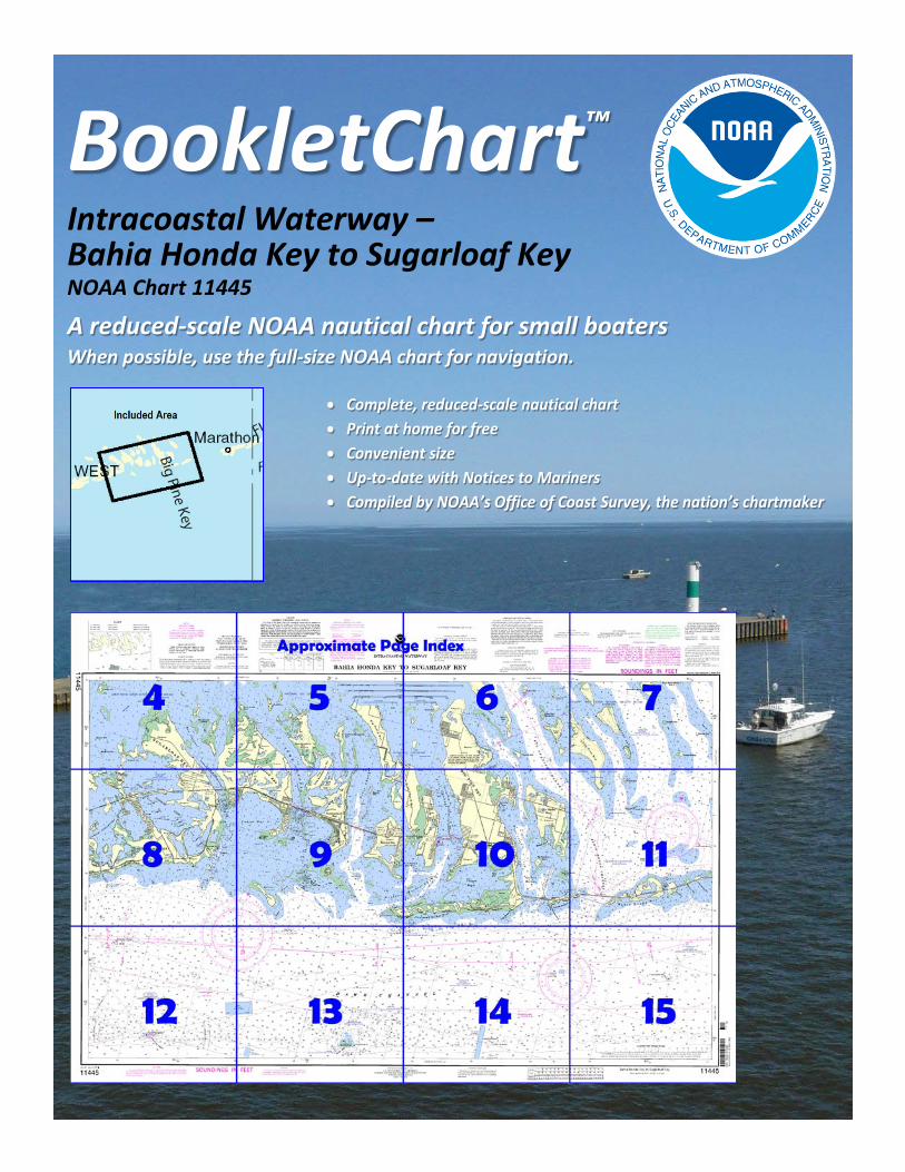
BookletChart™ Intracoastal Waterway – Bahia Honda Key to Sugarloaf Key NOAA Chart 11445
A reduced-scale NOAA nautical chart for small boaters When possible, use the full-size NOAA chart for navigation.
2
Published by the National Oceanic and Atmospheric Administration
National Ocean Service Office of Coast Survey
www.NauticalCharts.NOAA.gov 888-990-NOAA
What are Nautical Charts?
Nautical charts are a fundamental tool of marine navigation. They show water depths, obstructions, buoys, other aids to navigation, and much more. The information is shown in a way that promotes safe and efficient navigation. Chart carriage is mandatory on the commercial ships that carry America’s commerce. They are also used on every Navy and Coast Guard ship, fishing and passenger vessels, and are widely carried by recreational boaters.
What is a BookletChart?
This BookletChart is made to help recreational boaters locate themselves on the water. It has been reduced in scale for convenience, but otherwise contains all the information of the full-scale nautical chart. The bar scales have also been reduced, and are accurate when used to measure distances in this BookletChart. See the Note at the bottom of page 5 for the reduction in scale applied to this chart.
Whenever possible, use the official, full scale NOAA nautical chart for navigation. Nautical chart sales agents are listed on the Internet at http://www.NauticalCharts.NOAA.gov.
This BookletChart does NOT fulfill chart carriage requirements for regulated commercial vessels under Titles 33 and 44 of the Code of Federal Regulations.
Notice to Mariners Correction Status
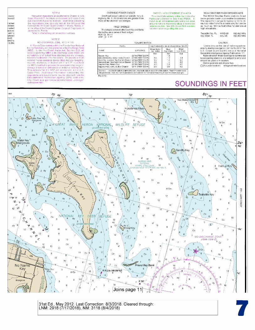
This BookletChart has been updated for chart corrections published in the U.S. Coast Guard Local Notice to Mariners, the National Geospatial Intelligence Agency Weekly Notice to Mariners, and, where applicable, the Canadian Coast Guard Notice to Mariners. Additional chart corrections have been made by NOAA in advance of their publication in a Notice to Mariners. The last Notices to Mariners applied to this chart are listed in the Note at the bottom of page 7. Coast Pilot excerpts are not being corrected.
For latest Coast Pilot excerpt visit the Office of Coast Survey website at http://www.nauticalcharts.noaa.gov/nsd/searchbychart.php?chart=11445.
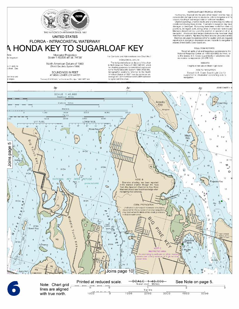
(Selected Excerpts from Coast Pilot) Sombrero Key Light (24°37'40"N., 81°06'39"W.), 142 feet above the water, is shown from a brown, octagonal, pyramidal skeleton tower on pile foundation, enclosing a square dwelling and stair cylinder; a racon is at the light. Moser Channel is northwestward of Sombrero Key Light and 95 miles south-westward of Miami. It affords a passage for vessels of 7 to 8 feet in draft between the Florida Keys from the Straits of Florida to
Florida Bay. The swing span of Seven Mile Bridge across Moser Channel has been removed; however, the bridge piers remain. The fixed highway bridge close south of the former swing span has a clearance of 65 feet.
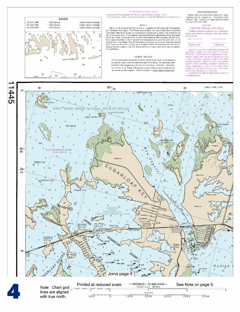
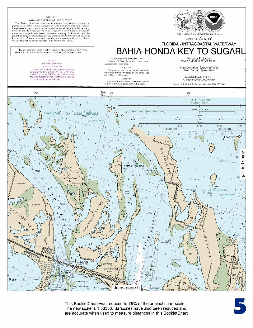
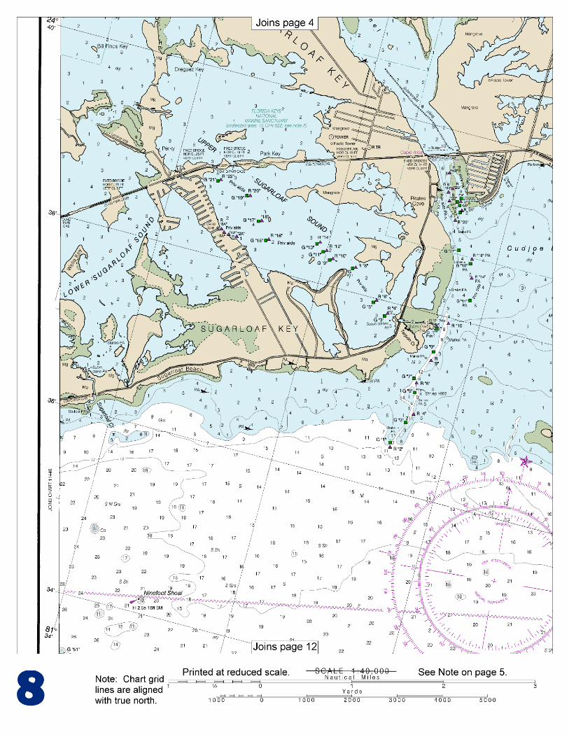
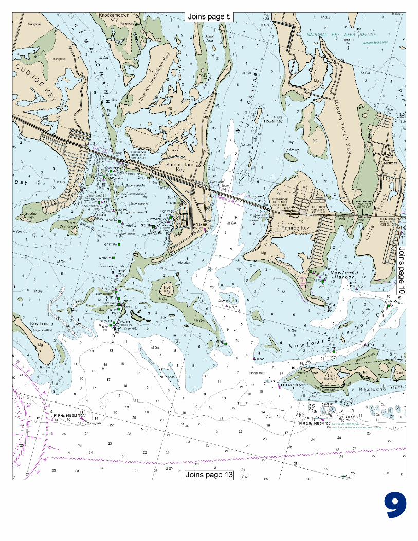
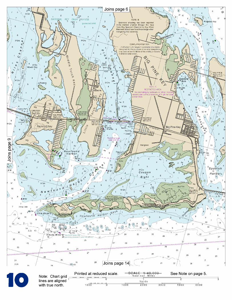
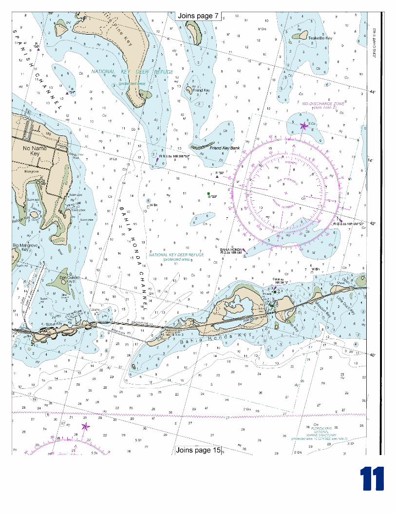
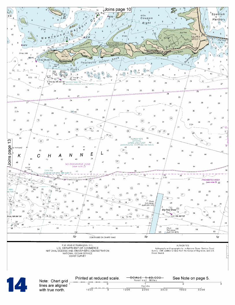
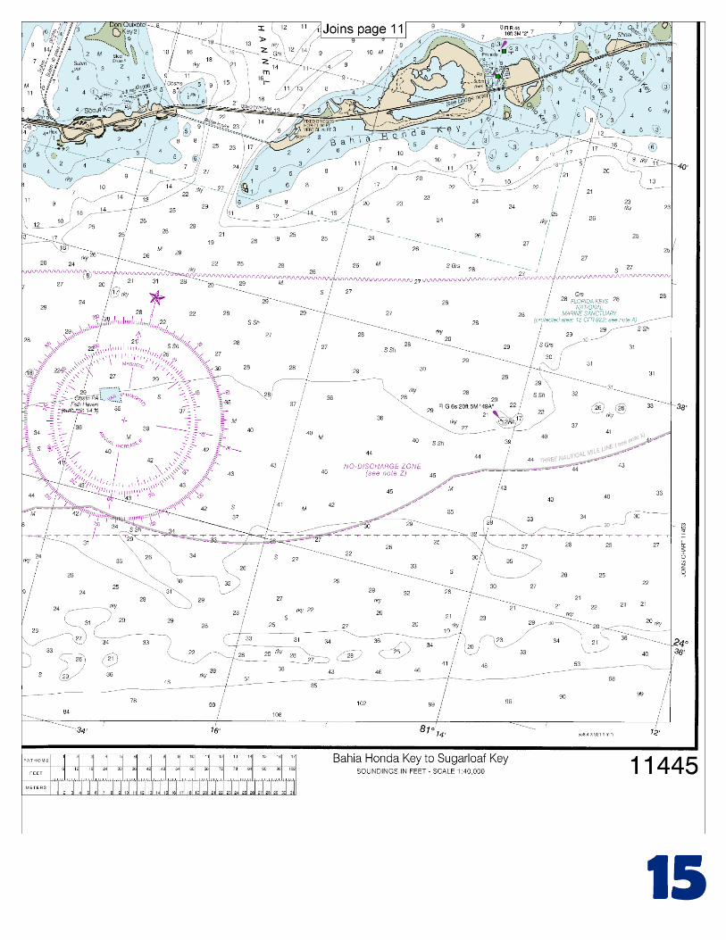
The tidal current at the bridge has a velocity of about 1.4 to 1.8 knots. Wind effects modify the current velocity considerably at times; easterly winds tend to increase the northward flow and westerly winds the southward flow. Overfalls that may swamp a small boat are said to occur near the bridge at times of large tides. (For predictions, see the Tidal Current Tables.) Route.–A route with a reported controlling depth of 8 feet, in July 1975, from the Straits of Florida via the Moser Channel to the Gulf of Mexico is as follows: From a point 0.5 mile 336° from the center of the bridge, pass 200 yards west of the light on Red Bay Bank, thence 0.4 mile east of the light on Bullard Bank, thence to a position 3 miles west of Northwest Cape of Cape Sable (chart 11431), thence to destination. Bahia Honda Channel (Bahia Honda), 10 miles northwestward of Sombrero Key and between Bahia Honda Key on the east and Scout Key on the west, is the deepest channel between the Straits of Florida and Florida Bay. In 1983, the reported controlling depth was 8 feet from Hawk Channel to Little Pine Key. The passage is crossed by three fixed highway bridges. The southernmost has a clearance of 20 feet over the channel and unlimited vertical clearances at an opening at each end. Mariners are advised to navigate with extreme caution as falling and hanging debris exits in the area. The twin bridges to northward have a clearance of 23 feet over the channel. The direction of the current should be carefully watched when turning northwestward after passing under the bridges in order to avoid being grounded on the banks on either side of the channel. These banks are usually visible. Currents through the passage average 2 knots or more at strength. (For predictions at the southernmost bridge, see the Tidal Current Tables.) From Bahia Honda Channel, vessels may proceed via Big Spanish Channel to the Gulf of Mexico as described in chapter 12. A marina with two boat basins is at the Bahia Honda State Park, on the bayside and near the western end of Bahia Honda Key. In 1981, depths of 4 feet were reported in the unmarked entrance channel, with 7 to 15 feet in the basins. Berths with electricity, water, ice, and a launching ramp are available. A marina on the northwest side of Ohio Key, northeast of Bahia Honda Key, provides berths, gasoline, diesel fuel, water, electricity, ice, limited marine supplies, and a launching ramp; a forklift can handle craft to 23 feet. In 1981, the reported controlling depth was 6 feet in the privately marked entrance channel with 5 to 6 feet reported alongside the berths. Newfound Harbor Keys Anchorage, 16 miles westward of Sombrero Key Light, is in depths of 19 to 22 feet in the channel northeastward of the light at the west end of the keys. Newfound Harbor Channel to the northward is clearly defined by the appearance of the water, and is marked by a light and daybeacons. A strong current sets fair with the channel. In 1983, the reported controlling depth was 4 feet to the western of two bridges at the head, 3.4 miles above the entrance. Clearances at the bridges are 15 feet under the westerly span and 9 feet under the easterly span. A marina is on the west side of Big Pine Key about 0.25 mile south of the easterly span. Gasoline, diesel fuel, water, ice, marine supplies, a 2½-ton forklift, and minor hull and engine repairs are available. In 1981, a depth of 3 feet was reported available to the marina. A marina on the east side of Little Torch Key, just south of the westerly span, provides berths with electricity, gasoline, diesel fuel, water, ice, and a launching ramp are available. In 1991, depths of 4 feet were reported in the approach with 10 feet alongside the berths.
U.S. Coast Guard Rescue Coordination Center 24 hour Regional Contact for Emergencies
RCC New Orleans Commander
8th CG District (504) 589-6225 New Orleans, LA

G
NOAA’s navigation managers serve as ambassadors to the maritime community. They help identify navigational challenges facing professional and recreational mariners, and provide NOAA resources and information for safe navigation. For additional information, please visit nauticalcharts.noaa.gov/service/navmanagers
To make suggestions or ask questions online, go to nauticalcharts.noaa.gov/inquiry. To report a chart discrepancy, please use ocsdata.ncd.noaa.gov/idrs/discrepancy.aspx.
Lateral System As Seen Entering From Seaward on navigable waters except Western Rivers
PORT SIDE
ODD NUMBERED AIDS
GREEN LIGHT ONLY
FLASHING (2)
PREFERRED CHANNEL
NO NUMBERS – MAY BE LETTERED
PREFERRED CHANNEL TO
STARBOARD
TOPMOST BAND GREEN
PREFERRED CHANNEL
NO NUMBERS – MAY BE LETTERED
PREFERRED CHANNEL
TO PORT
TOPMOST BAND RED
STARBOARD SIDE
EVEN NUMBERED AIDS
RED LIGHT ONLY
FLASHING (2)
FLASHING FLASHING
OCCULTING GREEN LIGHT ONLY RED LIGHT ONLY OCCULTING QUICK FLASHING QUICK FLASHING
ISO COMPOSITE GROUP FLASHING (2+1) COMPOSITE GROUP FLASHING (2+1) ISO
"1"
Fl G 6s
G "9"
Fl G 4s
GR "A"
Fl (2+1) G 6s
RG "B"
Fl (2+1) R 6s
"2"
Fl R 6s
8
R "8"
Fl R 4s
LIGHT
G
C "1"
LIGHTED BUOY
G
"5"
GR
"U"
GR
C "S"
RG
N "C"
RG
"G"
LIGHT
6
R
N "6"
LIGHTED BUOY
R
"2
"
CAN DAYBEACON
CAN NUN NUN
DAYBEACON
For more information on aids to navigation, including those on Western Rivers, please consult the latest USCG Light List for your area.
These volumes are available online at http://www.navcen.uscg.gov
Navigation Managers Area of Responsibility
Northeast
Lt. Meghan McGovern
Northwest and
Pacific Islands
Crescent Moegling
Great Lakes Region
Tom Loeper
Chesapeake and
Delaware Bay
Steve Soherr
California
Jeff Ferguson
[email protected] Mid-Atlantic
Lt. Ryan Wartick
Alaska
Lt. Timothy M. Smith
Western Gulf Coast
Alan Bunn
Central Gulf Coast
Tim Osborn
[email protected] South Florida
Puerto Rico
U.S. Virgin Islands
Michael Henderson
Southeast
Kyle Ward
2
2 C U 5
1


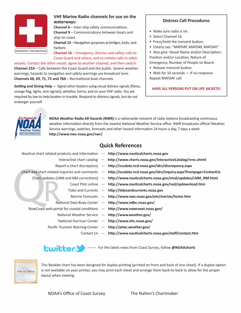
VHF Marine Radio channels for use on the waterways:Channel 6 – Inter-ship safety communications.Channel 9 – Communications between boats and ship-to-coast.Channel 13 – Navigation purposes at bridges, locks, and harbors.Channel 16 – Emergency, distress and safety calls to Coast Guard and others, and to initiate calls to other
vessels. Contact the other vessel, agree to another channel, and then switch.Channel 22A – Calls between the Coast Guard and the public. Severe weather warnings, hazards to navigation and safety warnings are broadcast here.Channels 68, 69, 71, 72 and 78A – Recreational boat channels.
Getting and Giving Help — Signal other boaters using visual distress signals (flares, orange flag, lights, arm signals); whistles; horns; and on your VHF radio. You are required by law to help boaters in trouble. Respond to distress signals, but do not endanger yourself.
EMERGENCY INFORMATION
Distress Call Procedures
• Make sure radio is on.• Select Channel 16.• Press/Hold the transmit button.• Clearly say: “MAYDAY, MAYDAY, MAYDAY.”• Also give: Vessel Name and/or Description;Position and/or Location; Nature of Emergency; Number of People on Board.• Release transmit button.• Wait for 10 seconds — If no responseRepeat MAYDAY call.
HAVE ALL PERSONS PUT ON LIFE JACKETS!
This Booklet chart has been designed for duplex printing (printed on front and back of one sheet). If a duplex option is not available on your printer, you may print each sheet and arrange them back-to-back to allow for the proper layout when viewing.
QR
Quick ReferencesNautical chart related products and information - http://www.nauticalcharts.noaa.gov
Interactive chart catalog - http://www.charts.noaa.gov/InteractiveCatalog/nrnc.shtmlReport a chart discrepancy - http://ocsdata.ncd.noaa.gov/idrs/discrepancy.aspx
Chart and chart related inquiries and comments - http://ocsdata.ncd.noaa.gov/idrs/inquiry.aspx?frompage=ContactUs
Chart updates (LNM and NM corrections) - http://www.nauticalcharts.noaa.gov/mcd/updates/LNM_NM.html
Coast Pilot online - http://www.nauticalcharts.noaa.gov/nsd/cpdownload.htm
Tides and Currents - http://tidesandcurrents.noaa.gov
Marine Forecasts - http://www.nws.noaa.gov/om/marine/home.htm
National Data Buoy Center - http://www.ndbc.noaa.gov/
NowCoast web portal for coastal conditions - http://www.nowcoast.noaa.gov/
National Weather Service - http://www.weather.gov/
National Hurrican Center - http://www.nhc.noaa.gov/
Pacific Tsunami Warning Center - http://ptwc.weather.gov/
Contact Us - http://www.nauticalcharts.noaa.gov/staff/contact.htm
NOAA’s Office of Coast Survey The Nation’s Chartmaker
For the latest news from Coast Survey, follow @NOAAcharts
NOAA Weather Radio All Hazards (NWR) is a nationwide network of radio stations broadcasting continuous weather information directly from the nearest National Weather Service office. NWR broadcasts official Weather Service warnings, watches, forecasts and other hazard information 24 hours a day, 7 days a week. http://www.nws.noaa.gov/nwr/