Intertidal Habitat, Tilbury2 Port Terminal , Tilbury · Phase 1 Habitat Survey Intertidal Habitat,...
30
www.thomsonecology.com Phase 1 Habitat Survey Intertidal Habitat, Tilbury2 Port Terminal, Tilbury For Port of Tilbury London Limited Project No.: AUNI123/002/001/003 October 2017
Transcript of Intertidal Habitat, Tilbury2 Port Terminal , Tilbury · Phase 1 Habitat Survey Intertidal Habitat,...
www.thomsonecology.com
Phase 1 Habitat Survey
Intertidal Habitat, Tilbury2 Port
Terminal, Tilbury
For
Port of Tilbury London Limited
Project No.: AUNI123/002/001/003
October 2017
Phase 1 Habitat Survey
Intertidal Habitats, Tilbury2 Port Terminal, Tilbury
2 Port of Tilbury London Limited, Report Ref.: AUNI123/002/001/003
London & South East
Compass House
Surrey Research Park
Guildford
GU2 7AG . UK
t: +44 (0)1483 466 000
North & Borders
Calls Wharf
2 The Calls
Leeds
LS2 7JU . UK
t: +44 (0)113 247 3780
Wales & South West
Williams House
11-15 Columbus Walk
Cardiff
CF10 4BY . UK
t: +44 (0)2920 020 674
Scotland
20-23 Woodside Place
Glasgow
G3 7QF . UK
t: +44 (0)141 582 1333
Enquiries
w: www.thomsonecology.com
Phase 1 Habitat Survey
Intertidal Habitats, Tilbury2 Port Terminal, Tilbury
Port of Tilbury London Limited, Report Ref.: AUNI123/002/001/003 3
Project Number Report No.
AUNI123/002 001
Revision
No.
Date of
Issue Author Reviewer Approver
001 03/07/2017 Arnaud Duranel Lynnette Pearce Paul Franklin
002 18/10/2017 Arnaud Duranel Lynnette Pearce Paul Franklin
003 24/10/2017 Arnaud Duranel Lynnette Pearce Paul Franklin
Disclaimer:
Copyright Thomson Ecology Limited. All rights reserved.
No part of this report may be copied or reproduced by any means without prior written permission from Thomson Ecology Limited.
If you have received this report in error, please destroy all copies in your possession or control and notify Thomson Ecology Limited.
This report has been prepared for the exclusive use of the commissioning party and unless otherwise agreed in writing by Thomson
Ecology Limited, no other party may use, make use of or rely on the contents of the report. No liability is accepted by Thomson
Ecology Limited for any use of this report, other than for the purposes for which it was originally prepared and provided.
Opinions and information provided in the report are on the basis of Thomson Ecology Limited using due skill, care and diligence in
the preparation of the same and no explicit warranty is provided as to their accuracy. It should be noted and it is expressly stated
that no independent verification of any of the documents or information supplied to Thomson Ecology Limited has been made.
Phase 1 Habitat Survey
Intertidal Habitats, Tilbury2 Port Terminal, Tilbury
4 Port of Tilbury London Limited, Report Ref.: AUNI123/002/001/003
Contents
1. Summary ................................................................................................................................ 5
2. Introduction ............................................................................................................................. 6
2.1 Development Background ............................................................................................. 6
2.2 The Brief ........................................................................................................................ 6
2.3 Surveyors....................................................................................................................... 7
3. Methodology ........................................................................................................................... 8
4. Results .................................................................................................................................... 9
4.1 Background ................................................................................................................... 9
4.2 Field Survey ................................................................................................................... 9
5. Legislation and Planning Policy Considerations................................................................... 16
5.1 Background ................................................................................................................. 16
5.2 Priority Habitats ........................................................................................................... 16
5.3 Protected Species ....................................................................................................... 16
5.4 Other Species of Conservation Concern ..................................................................... 17
6. Conclusion ............................................................................................................................ 18
7. References ........................................................................................................................... 19
Figure 1. Site Location.
Figure 2. Extended Phase 1 Habitat Survey Results.
Figure 3. Photographs of the Site.
Phase 1 Habitat Survey
Intertidal Habitats, Tilbury2 Port Terminal, Tilbury
Port of Tilbury London Limited, Report Ref.: AUNI123/002/001/003 5
1. Summary
1.1.1 The Port of Tilbury London Limited (PoTLL) is proposing to build a new port terminal at Tilbury,
on land previously occupied by the Tilbury Power Station. The project is known at Tilbury2, and
includes the redevelopment of the existing marine terminal. This will require improvement of and
extensions to the existing power station jetty, removal of the Anglian Water jetty, and dredging
works around the jetty and along the approach channel. The proposals are hereafter referred to
as ‘the development’. The area directly affected by the development is hereafter referred to as
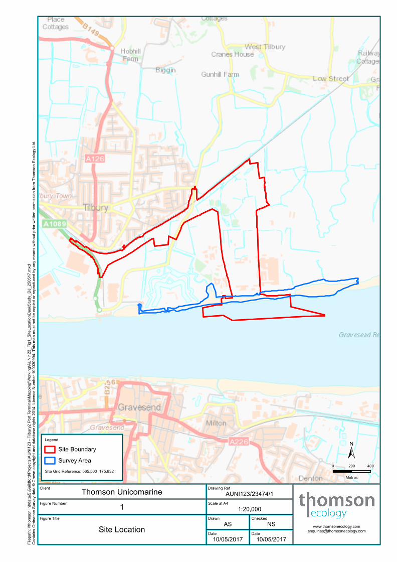
‘the site’. The site location is shown on Figure 1.
1.1.2 Thomson Ecology Ltd was commissioned to undertake a Phase 1 Habitat Survey of intertidal
habitats within the site and in a buffer area around the proposed development extending 700m
upstream and 1.5km downstream of the site along the left bank of the River Thames. The area
within which the survey was undertaken is hereafter referred to as ‘the survey area’, and is shown
on Figure 1.
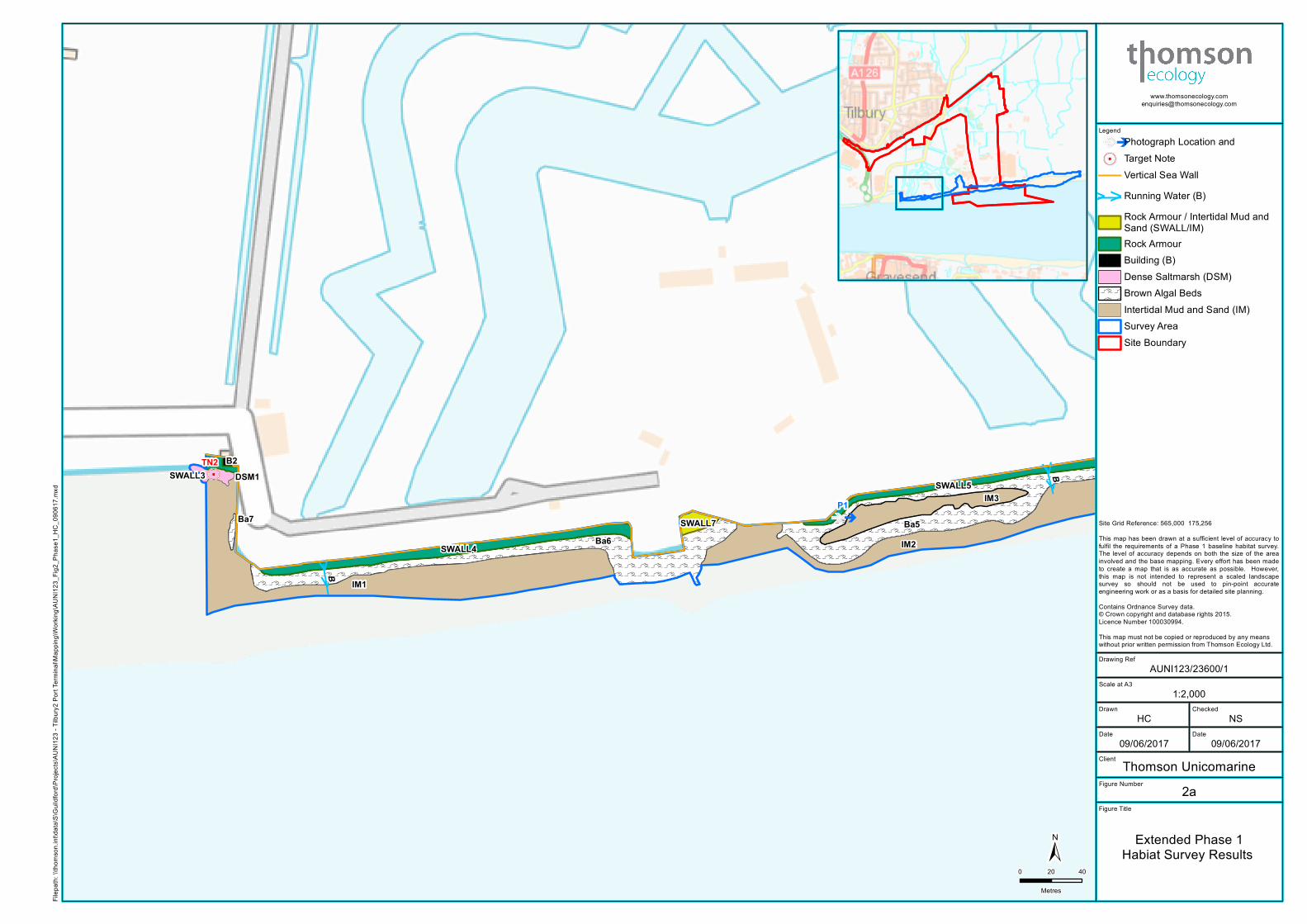
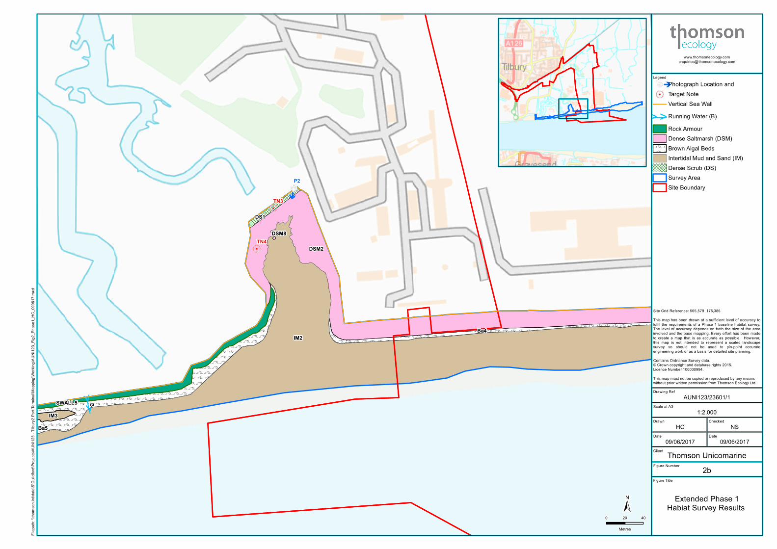
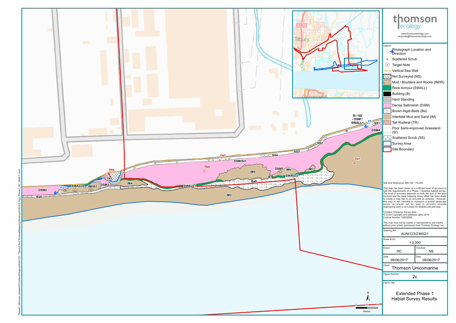
1.1.3 A map of the habitats identified during the extended Phase 1 survey is provided on Figures 2a to
2d, and photographs of the survey area are shown on Figure 3. The main findings of the survey
are that:
• The survey area supports the following Phase 1 habitats: dense scrub; scattered scrub; tall
ruderal; brackish running water; intertidal mud/sand; intertidal shingle/cobbles; intertidal
boulders/rocks; intertidal boulders/rocks with brown algal beds; dense/continuous saltmarsh;
boulders/rocks above high tide mark; soft maritime cliff/slope; sea wall; buildings; bare ground;
hard standing; mosaic of intertidal mud/sand and sea wall; mosaic of intertidal mud/sand and
intertidal boulders/rocks; mosaic of dense/continuous saltmarsh and poor semi-improved
mosaic of poor semi-improved grassland and tall ruderal; and mosaic of bare ground and
ephemeral/short perennial;
• Two of these habitats (dense saltmarsh and intertidal mud/sand) are Habitats of Principal
Importance under Section 41 of the Natural Environment and Rural Communities Act 2006;
• Three plant species of conservation concern (golden-samphire, annual beard-grass and
dittander) were recorded during the survey.
1.1.4 The survey area supports habitats that may potentially be used by a number of protected species
and species of conservation concern, comprising marine mammals, bats, birds, reptiles, and
invertebrates.
1.1.5 The development has the potential to have a negative impact on two types of priority habitat and
three plant species of conservation concern that were recorded within the survey area. In addition
the development has the potential to have a negative impact on a number of protected species
and species of conservation concern that may occur within the survey area. Further survey would
be required to determine the presence or likely absence of these species.
Scale at A4
Drawn Checked
Date Date
Client Thomson UnicomarineFigure Number
Figure Title
10/05/2017 10/05/2017
NSAS
1:20,000
AUNI123/23474/11
Site Location
Drawing Ref
±0 200 400
MetresSite Grid Reference: 565,500 175,832
Legend
Site BoundarySurvey Area
Filep
ath: \\
thoms
on.in
t\data
\S\Gu
ildfor
d\Proj
ects\
AUNI
123 -
Tilbu
ry2 Po
rt Term
inal\M
appin
g\Work
ing\AU
NI12
3_Fig
1_Sit
eLoc
ation
Desk
Study
_DJ_
2505
17.m
xdCo
ntains
Ordn
ance
Surve
y data
© C
rown c
opyri
ght a
nd da
tabas
e righ
ts 20
14. L
icenc
e Num
ber 1
0003
0994
. This
map
mus
t not
be co
pied o
r repro
duce
d by a
ny m
eans
with
out p
rior w
ritten
perm
ission
from
Thom
son E
colog
y Ltd.
Scale at A3
Drawn Checked
Date Date
Drawing Ref
Client
Figure Number
Figure Title
Legend Photograph Location and5 Target Note
Vertical Sea Wall
> >Running Water (B)Rock Armour / Intertidal Mud andSand (SWALL/IM)Rock ArmourBuilding (B)Dense Saltmarsh (DSM)
OOOOOOOOOOOO
Brown Algal BedsIntertidal Mud and Sand (IM)Survey AreaSite Boundary
OOOOOOOOOOOOOOOOOOOOOOOOOOOOOOOOOOOOOOOOOOOOOOOOOOOOOOOOOOOOOOOOOOOOOOOOOOOOOOOOOOOOOOOOOOOOOOOOOOOOOOOOOOOOOOOOOOOOOOOOOOOOOOOOOOOOOOOOOOOOOOOOOOOOOOOOOOOOOOOOOOOOOOOOOOOOOOOOOOOOOOOOOOOOOOOOOOOOOOOOOOOOOOOOOOOOOOOOOOOOOOOOOOOOOOOOOOOOOOOOOOOOOOOOOOOOOOOOOOOOOOOOOOOOOOOOOOOOOOOOOOOOOOOOOOOOOOOOOOOOOOOOOOOOOOOOOOOOOOOOOOOOOOOOOOOOOOOOOO
OOOOOOOOOOOOOOOOOOOOOOOOOOOOOOOOOOOOOOOOOOOOOOOOOOOOOOOOOOOOOOOOOOOOOOOOOOOOOOOOOOOOOOOOOOOOOOOOOOOOOOOOOOOOOOOOOOOOOOOOOOOOOOOOOOOOOOOOOOOOOOOOOOOOOOOOOOOOOOOOOOOOOOOOOOOOOOOOOOOOOOOOOOOOOOOOOOOOOOOOOOOOOOOOOOOOOOOOOOOOOOOOOOOOOOOOOOOOOOOOOOOOOOOOOOOOOOOOOOOOOOOOOOOOOOOOOOOOOOOOOOOOOOOOOOOOOOOOOOOOOOOOOOOOOOOOOOOOOOOOOOOOOOOOOOOOOOOOOOOOOOOOOOOOOOOOOOOOOOOOOOOOOOOOOOOOOOOOOOOO
OOOOOOOOOOOOOO
> >
> >5
DSM1
Ba7
SWALL3B2
IM3
Ba5Ba6 IM2
SWALL7
SWALL4
SWALL5
IM1
B
B
TN2
P1
Thomson Unicomarine2a
Extended Phase 1Habiat Survey Results
NSHC
AUNI123/23600/1
09/06/2017 09/06/2017
±0 20 40
Metres
Filep
ath: \\
thoms
on.in
t\data
\S\G
uildfo
rd\Pr
ojects
\AUNI
123 -
Tilbu
ry2 Po
rt Term
inal\M
appin
g\Work
ing\A
UNI12
3_Fig
2_Ph
ase1
_HC_
0906
17.m
xd
1:2,000
Site Grid Reference: 565,000 175,256
This map has been drawn at a sufficient level of accuracy tofulfil the requirements of a Phase 1 baseline habitat survey.The level of accuracy depends on both the size of the areainvolved and the base mapping. Every effort has been madeto create a map that is as accurate as possible. However,this map is not intended to represent a scaled landscapesurvey so should not be used to pin-point accurateengineering work or as a basis for detailed site planning.
Contains Ordnance Survey data.© Crown copyright and database rights 2015.Licence Number 100030994.
This map must not be copied or reproduced by any meanswithout prior written permission from Thomson Ecology Ltd.
Scale at A3
Drawn Checked
Date Date
Drawing Ref
Client
Figure Number
Figure Title
Legend Photograph Location and5 Target Note
Vertical Sea Wall
> >Running Water (B)Rock ArmourDense Saltmarsh (DSM)
OOOOOOOOOOOO
Brown Algal BedsIntertidal Mud and Sand (IM)Dense Scrub (DS)Survey AreaSite Boundary
OOOOOOOOOOOOOOOOOOOOOOOOOOOOOOOOOOOOOOOOOOOOOOOOOOOOOOOOOOOOOOOOOOOOOOOOOOOOOOOOOOOOOOOOOOOOOOOOOOOOOOOOOOOOOOOOOOOOOOOOOOOOOOOOOOOOOOOOOOOOOOOOOOOOOOOOOOOOOOOOOOOOOOOOOOOOOOOOOOOOOOOOOOOOOOOOOOOOOOOOOOOOOOOOOOOOOOOOOOOOOOOOOOOOOOOOOOOOOOOOOOOOOOOOOOOOOOOOOOOOOOOOOOOOOOOOOOOOOOOOOOOOOOOOOOOOOOOOOOOOO
OOOOOOOOOOOOOOOOOOOOOOOOOOOOOOOOOOOOOOOOOOOOOOOOOOOOOOOOOOOOOOOOOOOOOOOOOOOOOOOOOOOOOOOOOOOOOOOOOOOOOOOOOOOOOOOOOOOOOOOOOOOOOOOOOOOOOOOOOOOOOOOOOOOOOOOOOOOOOOOOOOOOOOOOOOOOOOOOOOOOOOOOOOOOOOOOOOOOOOOOOOOOOOOOOOOOOOOOOOOOOOOOOOOOOOOOOOOOOOOOOOOOOOOOOOOOOOOOOOOOOOOOOOOOOOOOOOOOOOOOOOOOOOOOOOOOOOOOOOOOOOOOOOOOOOOOOOOOOOOOOOOOOOOOOOOOOOOOOOOOOOOOOOOOOOOOOOOOOOOOOOOOOOOOOOOOOOOOOOOOOOOOOOOOOOOOOOOOOOOOOOOOOOOOOOOOOOOOOOOOOOOOOOOOOOOOOOOOOOOOOOOOOOOOOOOOOOOOOOOOOOOOOOOOOOOOOOOOOOOOOOOOOOOOOOOOOOOOOOOOOOOOOOOOOOOOOOOOOOOOOOOOOOOOOOOOOOOOOOOOOOOOOOOOOOOOOOOOOOOOOOOOOOOOOOOOOOOOOOOOOOOOOOOOOOOOOOOOOOOOOOOOOOOOOOOOOOOOOOOOOOOOOOOOOOOOOOOOOOOOOOOOOOOOOOOOOOOOOOOOOOOOOOOOOOOOOOOOOOOOOOOOOOOOOOOOOOOOOOOOOOOOOOOOOOOOOOOOOOOOOOOOOOOOOOOOOOOOOOOOOOOOOOOOOOOOOOOOOOOOOOOOOOOOOOOOOOOOOOOOOOOOOOOOOOOOOOOOOOOOOOOOOOOOOOOOOOOOOOOOOOOOOOOOOOOOOOOOOOOOOOOOOOOOOOOOOOOOOOOOOOOOOOOOOOOOOOOOOOOOOOOOOOOOOOOOOOOOOOOOOOOOOOOOOOOOOOOOOOOOOOOOOOOOOOOOOOOOOOOOOOOOOOOOOOOOOOOOOOOOOOOOOOOOOOOOOOOOOOOOOOOOOOOOOOOO
>>
5
5
DSM8
DS1
Ba4
DSM2
IM3Ba5
IM2
SWALL5 B
TN3
TN4
P2
Thomson Unicomarine2b
Extended Phase 1Habiat Survey Results
NSHC
AUNI123/23601/1
09/06/2017 09/06/2017
±0 20 40
Metres
Filep
ath: \\
thoms
on.in
t\data
\S\G
uildfo
rd\Pr
ojects
\AUNI
123 -
Tilbu
ry2 Po
rt Term
inal\M
appin
g\Work
ing\A
UNI12
3_Fig
2_Ph
ase1
_HC_
0906
17.m
xd
1:2,000
Site Grid Reference: 565,579 175,386
This map has been drawn at a sufficient level of accuracy tofulfil the requirements of a Phase 1 baseline habitat survey.The level of accuracy depends on both the size of the areainvolved and the base mapping. Every effort has been madeto create a map that is as accurate as possible. However,this map is not intended to represent a scaled landscapesurvey so should not be used to pin-point accurateengineering work or as a basis for detailed site planning.
Contains Ordnance Survey data.© Crown copyright and database rights 2015.Licence Number 100030994.
This map must not be copied or reproduced by any meanswithout prior written permission from Thomson Ecology Ltd.
Scale at A3
Drawn Checked
Date Date
Drawing Ref
Client
Figure Number
Figure Title
Legend
Photograph Location andDirection
E Scattered Scrub5 Target Note
Vertical Sea WallNot Surveyed (NS)BB
BBBBMud / Boulders and Rocks (IM/IR)Rock Armour (SWALL)Building (B)Hard StandingDense Saltmarsh (DSM)
OOOOOOOOO
Brown Algal Beds (Ba)Intertidal Mud and Sand (IM)Tall Ruderal (TR)Poor Semi-improved Grassland(SI)
D D D D
D D D D
D D D
D D D
D D D Scattered Scrub (SS)Survey AreaSite Boundary
D D D D
D D D D
D D D
D D D
D D D D D D
D D D D D D
D D D D D D
D D D D D D
D D D D D
D D D D D
D D D D D
D D D D D
D D D D D
D D D
D D D
D D D
D D D
D D D D D
D D D D D
D D D D D
D D D D D
D D D D D
OOOOOOOOOOOOOOOOOOOOOOOOOOOOOOOOOOOOOOOOOOOOOOOOOOOOOOOOOOOOOOOOOOOOOOOOOOOOOOOOOOOOOOOOOOOOOOOOOOOOOOOOOOOOOOOOOOOOOOOOOOOOOOOOOOOOOOOOOOOOOOOO
OOOOOOOOOOOOOOOOOOOOOOOOOOOOOOOOOOOOOOOOOOOOOOOOOOOOOOOOOOOOOOOOOOOOOOOOOOOOOOOOOOOOOOOOOOOOOOOOOOOOOOOOOOOOOOOOOOOOOOOOOOOOOOOOOOOOOOOOOOOOOOOOOOOOOOOOOOOOOOOOOOOOOOOOOOOOOOOOOOOOOOOOOOOOOOOOOOOOOOOOOOOOOOOOOOOOOOOOOOOOOOOOOOOOOOOOOOOOOOOOOOOOOOOOOOOOOOOOOOOOOOOOOOOOOOOOOOOOOOOOOOOOOOOOOOOOOOOOOOOOOOOOOOOOOOOOOOOOOOOOOOOOOOOOOOOOOOOOOOOOOOOOOOOOOOOOOOOOOOOOOOOOOOOOOOOOOOOOOOOOOOOOOOOOOOOOOOOOOOOOOOOOOOOOOOOOOOOOOOOOOOOOOOOOOOOOOOOOOOOOOOOOOOOOOOOOOOOOOOOOOOOOOOOOOOOOOOOOOOOOOOOOOOOOOOOOOOOOOOOOOOOOOOOOOOOOOOOOOOOOOOOOOOOOOOOOOOOOOOOOOOOOOOOOOOOOOOOOOOOOOOOOOOOOOOOOOOOOOOOOOOOOOOOOOOOOOOOOOOOOOOOOOOOOOOOOOOOOOOOOOOOO
B
B BB
BB
BB
B
B B
B
BB BB
B
B
B
BB
BBB
B
B
B
B
BB
B B
BB
B
B B
BB BB
B
B
B
B
B
B
BBB
B
BB
5
5
5
5
E
E
E EE E E E
SI
SI / SS/ DSM /
SWALL1
DSM5
SS1
B1IM5 IM7
SS2
SS3SS4
IM4
DSM4
Ba4
DSM3TR1
DSM2IM2
DSM/SI1
Ba8SWALL1
SWALL2
IM/IR1SWALL6
IM6TN6
TN7
TN5
TN1
P3
P6
Thomson Unicomarine2c
Extended Phase 1Habiat Survey Results
NSHC
AUNI123/23602/1
09/06/2017 09/06/2017
±0 20 40
Metres
Filep
ath: \\
thoms
on.in
t\data
\S\G
uildfo
rd\Pr
ojects
\AUNI
123 -
Tilbu
ry2 Po
rt Term
inal\M
appin
g\Work
ing\A
UNI12
3_Fig
2_Ph
ase1
_HC_
0906
17.m
xd
1:2,000
Site Grid Reference: 566,186 175,395
This map has been drawn at a sufficient level of accuracy tofulfil the requirements of a Phase 1 baseline habitat survey.The level of accuracy depends on both the size of the areainvolved and the base mapping. Every effort has been madeto create a map that is as accurate as possible. However,this map is not intended to represent a scaled landscapesurvey so should not be used to pin-point accurateengineering work or as a basis for detailed site planning.
Contains Ordnance Survey data.© Crown copyright and database rights 2015.Licence Number 100030994.
This map must not be copied or reproduced by any meanswithout prior written permission from Thomson Ecology Ltd.
Scale at A3
Drawn Checked
Date Date
Drawing Ref
Client
Figure Number
Figure Title
Legend Photograph Location andE Scattered Scrub5 Target Note
VVVV Soft CliffSheet PilingVertical Sea WallRock Armour
! ! !
! ! !
! ! ! !
! ! ! !Bare Ground (BG)Hard Standing
B B BB B BBoulders/ Rock Above High Tide
Mark (BR)B
B
B
BB
BIntertidal Shingle / Cobbles (ISC)Dense Saltmarsh (DSM)
OOOOOOOOOOOO
Brown Algal BedsIntertidal Mud and Sand (IM)Poor Semi-improved Grassland(SI)
D D D D
D D D D
D D D D
D D D
D D D
D D D Scattered Scrub (SS)Survey AreaSite Boundary
B
BB
B
B
B
BB
B
B
B
BB
B
B B
B
B
B
B B
BB
B
B
B B
B
B
B
BB
B
B
BB
B B
B
BB
B
B
B
B
BB
B
OOOOOOOOOOOOOOOOOOOOOOOOOOOOOOOOOOOOOOOOOOOOOOOOOOOOOOOOOOOOOOOOOOOOOOOOOOOOOOOOOOOOOOOOOOOOOOOO
B
B
B
B
B
B
B
B
B
B
BB
B
B
B
B
BB
B
B
BBB
BB
B
BB
BB
BB
B
BB
BB
B
B
B
B
B
B
B
B
B
BB
B
BB
B
BB
B
B
B
BB
B
B
B
B
B
B BB
B
B
B
B
B
B
B
B
B
B
B
B
B
B
B
B
B
B
BB
B
B
B
B
B
B
B
B
BB
B
B
B
B
BB
B
B
B
B
BB
B
B
BB
BB
B
B
B
B
B
B
BB
B
BB
B
B
B
B
B
BB
B
D D D D
D D D D
D D D
D D D BB B
BB BBB
BBB
BB
B
B
B
B
BB
B
B
B
BB
OOOOOOOOOOOOOOOOOOOOOOOOOOOOOOOOOOOOOOOOOOOOOOOOOOOOOOOOOOOOOOOOOOOOOO
B
B
BB
B
BB
B
B
B BB B
B
B
BB
BB
B
B
B B
B
B
B
B
B
B B
BB
B
B
B
B BB
B
BB
B
B
B BB
B
B BB
BB
BB
BB
BB
B B B BB B B BB B B B
OOOOOOOOOOOOOOOOOOOOOOOOOOOOOOOOOOOOOOOOOOOOOOOOOOOOOOOOOOOOOOOOOOOOOOOOOOOOOOOOOOOOOOOOOOOOOOOOOOOOOOOOOOOOOOOOOOOOOOOOOOOOOOOOOOOOOOOOOOOOOOOOOOOOOOOOOOOOOOOOOOOOOOOO
B B
B
B
B
BB
B
B
B
BB
B
B
B
B
BB
BBB
B
B
B
B
B
B
B
B
B
B
B
BB
BB
B
B
B
B
B
BB
B
B
B
B
B
B
BB
B
B
B
B B
B
B
BBB
BB
B
BB
B
B
B
B
B
B
B
BB B
B
B
BB
B BBB
B
B
B B
B
B
BB
B
B
B
BB
B
B
B
BBB
B
B
B
B
B
B
B
BB
B
BB
B
BB
BB
! ! ! ! ! ! ! ! ! ! ! ! ! ! ! ! ! ! ! ! ! ! ! ! ! ! ! ! ! ! ! ! ! ! ! ! ! ! ! ! ! ! ! ! !
! ! ! ! ! ! ! ! ! ! ! ! ! ! ! ! ! ! ! ! ! ! ! ! ! ! ! ! ! ! ! ! ! ! ! ! ! ! ! ! ! ! ! ! !
! ! ! ! ! ! ! ! ! ! ! ! ! ! ! ! ! ! ! ! ! ! ! ! ! ! ! ! ! ! ! ! ! ! ! ! ! ! ! ! ! ! ! ! !
! ! ! ! ! ! ! ! ! ! ! ! ! ! ! ! ! ! ! ! ! ! ! ! ! ! ! ! ! ! ! ! ! ! ! ! ! ! ! ! ! ! ! ! !
! ! ! ! ! ! ! ! ! ! ! ! ! ! ! ! ! ! ! ! ! ! ! ! ! ! ! ! ! ! ! ! ! ! ! ! ! ! ! ! ! ! ! ! ! !
! ! ! ! ! ! ! ! ! ! ! ! ! ! ! ! ! ! ! ! ! ! ! ! ! ! ! ! ! ! ! ! ! ! ! ! ! ! ! ! ! ! ! ! ! !
! ! ! ! ! ! ! ! ! ! ! ! ! ! ! ! ! ! ! ! ! ! ! ! ! ! ! ! ! ! ! ! ! ! ! ! ! ! ! ! ! ! ! ! ! !
! ! ! ! ! ! ! ! ! ! ! ! ! ! ! ! ! ! ! ! ! ! ! ! ! ! ! ! ! ! ! ! ! ! ! ! ! ! ! ! ! ! ! ! ! !
! ! ! ! ! ! ! ! ! ! ! ! ! ! ! ! ! ! ! ! ! ! ! ! ! ! ! ! ! ! ! ! ! ! ! ! ! ! ! ! ! ! ! ! ! !
! ! ! ! ! ! !
! ! ! ! ! ! !
! ! ! ! ! ! !
! ! ! ! ! ! !! ! ! ! ! ! ! ! ! ! ! !
! ! ! ! ! ! ! ! ! ! ! !
! ! ! ! ! ! ! ! ! ! ! ! !
! ! ! ! ! ! ! ! ! ! ! ! !
! ! ! ! ! ! ! ! ! !
! ! ! ! ! ! ! ! ! !
! ! ! ! ! ! ! ! ! !
! ! ! ! ! ! ! ! ! !
! ! ! ! ! ! ! ! ! !
! ! ! ! ! ! ! ! ! !
! ! ! ! ! ! ! ! ! !
! ! ! ! ! ! ! ! ! ! !
! ! ! ! ! ! ! ! ! ! !
! ! ! ! ! ! ! ! ! ! !
! ! ! ! ! ! ! ! ! ! !
! ! ! ! ! ! ! ! ! ! !
! ! ! ! ! ! ! ! ! ! !
! ! ! ! ! ! ! ! ! ! !
VVVVVVV VVVVVVVVVVVVVVVVVVVVVVVVVVV
5
5
55
5E
E
E
E
SI
SI SI
ISC1DSM7
Ba1ISC2SS1
ISC3Ba2
ISC4
BR1 Ba3
DSM4
IM2
SI/TR1
DSM6ISC/DSM1
SWALL2
SI/TR2BG1BG/ESP1 BG/ESP2
BG4
SI / SS/ DSM /
SWALL1
TN1
TN8
TN9TN10
TN11
P4
P5
P6
Thomson Unicomarine2d
Extended Phase 1Habiat Survey Results
NSHC
AUNI123/23603/1
09/06/2017 09/06/2017
±0 20 40
Metres
Filep
ath: \\
thoms
on.in
t\data
\S\G
uildfo
rd\Pr
ojects
\AUNI
123 -
Tilbu
ry2 Po
rt Term
inal\M
appin
g\Work
ing\A
UNI12
3_Fig
2_Ph
ase1
_HC_
0906
17.m
xd
1:2,000
Site Grid Reference: 566,798 175,475
This map has been drawn at a sufficient level of accuracy tofulfil the requirements of a Phase 1 baseline habitat survey.The level of accuracy depends on both the size of the areainvolved and the base mapping. Every effort has been madeto create a map that is as accurate as possible. However,this map is not intended to represent a scaled landscapesurvey so should not be used to pin-point accurateengineering work or as a basis for detailed site planning.
Contains Ordnance Survey data.© Crown copyright and database rights 2015.Licence Number 100030994.
This map must not be copied or reproduced by any meanswithout prior written permission from Thomson Ecology Ltd.
Scale at A3
Drawn Checked
Date Date
Client Thomson UnicomarineFigure Number
Figure Title
12/06/2017 12/06/2017
NSHC
AUNI123/23599/13
Photographs of theSite
Drawing Ref
Filep
ath: S
:\Guil
dford\
Proje
cts\A
UNI12
3 - Ti
lbury2
Port T
ermina
l\Map
ping\W
orking
\AUN
I123_
Fig3_
Photo
graph
softh
eSite
_HC_
1206
17.m
xdTh
is fig
ure m
ust n
ot be
copie
d or r
eprod
uced
by an
y mea
ns w
ithou
t prio
r writt
en pe
rmiss
ion fro
m Th
omso
n Eco
logy L
td.
Not applicable
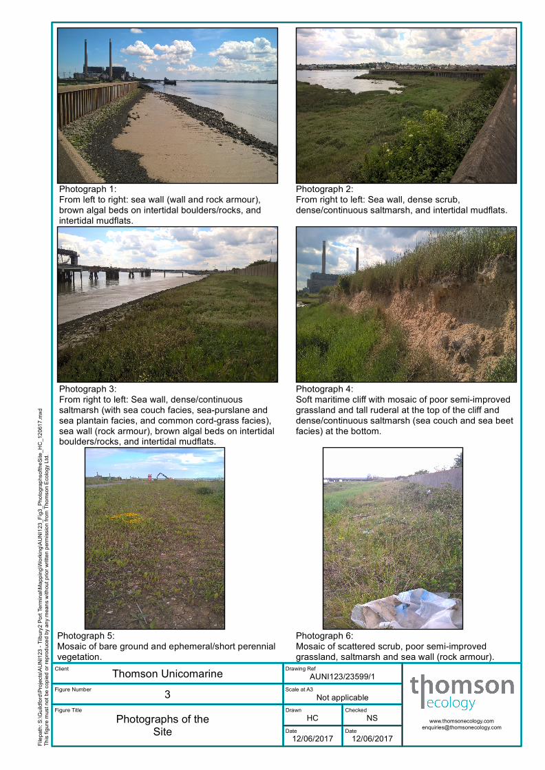
Photograph 1:From left to right: sea wall (wall and rock armour),brown algal beds on intertidal boulders/rocks, andintertidal mudflats.
Photograph 2:From right to left: Sea wall, dense scrub,dense/continuous saltmarsh, and intertidal mudflats.
Photograph 3:From right to left: Sea wall, dense/continuoussaltmarsh (with sea couch facies, sea-purslane andsea plantain facies, and common cord-grass facies),sea wall (rock armour), brown algal beds on intertidalboulders/rocks, and intertidal mudflats.
Photograph 4:Soft maritime cliff with mosaic of poor semi-improvedgrassland and tall ruderal at the top of the cliff anddense/continuous saltmarsh (sea couch and sea beetfacies) at the bottom.
Photograph 5:Mosaic of bare ground and ephemeral/short perennialvegetation.
Photograph 6:Mosaic of scattered scrub, poor semi-improvedgrassland, saltmarsh and sea wall (rock armour).
Phase 1 Habitat Survey
Intertidal Habitats, Tilbury2 Port Terminal, Tilbury
6 Port of Tilbury London Limited, Report Ref.: AUNI123/002/001/003
2. Introduction
2.1 Development Background
2.1.1 The Port of Tilbury London Limited (PoTLL) is proposing a new port terminal on the north bank of
the River Thames at Tilbury, a short distance to the east of its existing Port. The proposed port
terminal will be mainly constructed on previously developed land that formed the western part of
the now redundant Tilbury Power Station. The project is known as “Tilbury2.” The proposed main
uses on the site will be a Roll-on/Roll-off (Ro-Ro) terminal and a Construction Materials and
Aggregates Terminal (the “CMAT”), and associated infrastructure.
2.1.2 The proposed volumes of import/export of Ro-Ro units for the terminal exceed the threshold of
250,000 units stated in the Planning Act 2008 for throughput per annum. The Tilbury2 project
therefore constitutes a Nationally Significant Infrastructure Project (NSIP) and will require a
Development Consent Order (DCO). The DCO application for Tilbury2 will be supported by an
Environmental Statement and Water Framework Directive compliance assessment.
2.1.3 As part of these proposals, a range of works will be required on the coastal and marine side of the
proposed port terminal, on the seaward side of the existing flood wall. These will include:
• Improvement of and extensions to the existing jetty including creation of a new Ro-Ro berth;
• Dredging of berth pockets around the existing and extended jetty;
• Dredging of the approach channel, and
• Removal of the Anglian Water jetty.
2.1.4 The proposals for the coastal and marine side of the Tilbury2 project described above are
hereafter referred to collectively as ‘the development’. The area directly affected by the
development is hereafter referred to as ‘the site’. The site location is shown on Figure 1,
2.1.5 It has been recognised that, due to the extension of the jetty, removal of the Anglian Water jetty
and dredging, the development may cause changes in coastal sediment erosion and accretion
patterns and therefore have an impact on intertidal habitats beyond the site boundary.
Hydrodynamic modelling of the spatial extent of potential impacts from the development is being
undertaken but it is not yet complete. The spatial extent of impacts from the project on intertidal
habitats is thus currently unknown. Consequently, a precautionary approach has been taken and
a buffer extending 700m upstream and 1.5km downstream of the site along the left bank of the
River Thames has been included when defining the area of intertidal habitat that could potentially
be impacted by the development.
2.2 The Brief
2.2.1 Thomson Ecology Ltd was commissioned on 9th May to undertake the following:
• An extended Phase 1 habitat survey of the intertidal area around the existing jetty and
proposed jetty extension on the north bank of the River Thames at the former Tilbury Power
Station site. Habitats and species observed in the survey area were to be recorded and
mapped and the potential for habitats to support protected species was to be assessed.

Phase 1 Habitat Survey
Intertidal Habitats, Tilbury2 Port Terminal, Tilbury
Port of Tilbury London Limited, Report Ref.: AUNI123/002/001/003 7
• A technical report for the extended Phase 1 habitat survey to include an introduction,
methodology, results and a brief discussion of relevant legal and planning policy issues; and
• Appropriate digitised mapping.
2.3 Surveyors
2.3.1 The extended Phase 1 habitat survey was carried out by Arnaud Duranel MSc PhD MCIEEM and
Angela Polak BSc MSc Grad CIEEM .
Phase 1 Habitat Survey
Intertidal Habitats, Tilbury2 Port Terminal, Tilbury
8 Port of Tilbury London Limited, Report Ref.: AUNI123/002/001/003
3. Methodology
3.1.1 A survey area was defined that encompassed all intertidal habitats from the Mean Low Water
Springs isobath to the flood defence wall within the area potentially impacted by the development,
including a buffer zone extending 700m upstream and 1.5km downstream of the site boundaries
along the left bank of the River Thames. The survey area is shown on Figures 1 and 2a to 2d.
3.1.2 A Phase 1 habitat survey (JNCC, 2010) was conducted throughout the survey area. Phase 1
habitat survey is a standard technique for rapidly obtaining baseline ecological information over a
large area of land. It is primarily a mapping technique and uses a standard set of habitat definitions
for classifying areas of land on the basis of the vegetation present. For this survey, the technique
was modified (or extended) to provide more detail over a smaller area and give further
consideration to fauna (Institute of Environmental Assessment, 1995). The standard habitat
definitions were used with an additional category of coarse grassland for unmanaged, secondary
grasslands that are species poor.
3.1.3 The dominant and readily identified species of higher plant species from each habitat type within
the survey area were recorded and their abundance was assessed on the DAFOR scale:
• D Dominant
• A Abundant
• F Frequent
• O Occasional
• R Rare
3.1.4 These scores represent the abundance within the defined area only and do not reflect national or
regional abundances. Plant species nomenclature follows Stace (2010).
3.1.5 Target notes were made for any features which were too small to map or are of particular
ecological interest; or to show particular areas within habitat parcels where vegetation was
surveyed more exhaustively, hereafter referred to as ‘vegetation survey plots’.
3.1.6 Incidental records of fauna were also made during the survey and the habitats identified were
evaluated for their potential to support protected species and other species of conservation
concern, including Priority Species. However, no specific faunal surveys were undertaken.
3.1.7 The survey was conducted on the 1st of June 2017.
Phase 1 Habitat Survey
Intertidal Habitats, Tilbury2 Port Terminal, Tilbury
Port of Tilbury London Limited, Report Ref.: AUNI123/002/001/003 9
4. Results
4.1 Background
4.1.1 The contents of the results section are the factual results of the desk study and extended Phase
1 habitat survey. Excluded from this section is the assessment of the site to support species of
conservation concern not recorded during the survey.
4.2 Field Survey
4.2.1 The following Phase 1 habitat types were identified:
• Dense scrub;
• Scattered scrub;
• Tall ruderal;
• Brackish running water;
• Intertidal mud/sand;
• Intertidal shingle/cobbles;
• Intertidal boulders/rocks;
• Intertidal boulders/rocks with brown algal beds;
• Dense/continuous saltmarsh;
• Boulders/rocks above high tide mark;
• Soft maritime cliff/slope;
• Sea wall;
• Buildings;
• Bare ground;
• Hard standing;
• Mosaic of intertidal mud/sand and sea wall;
• Mosaic of intertidal mud/sand and intertidal boulders/rocks;
• Mosaic of dense/continuous saltmarsh and poor semi-improved grassland;
• Mosaic of poor semi-improved grassland, scattered scrub, dense/continuous saltmarsh and
sea wall;
• Mosaic of intertidal shingle/cobbles and dense/continuous saltmarsh;
• Mosaic of poor semi-improved grassland and tall ruderal; and
• Mosaic of bare ground and ephemeral/short perennial.
4.2.2 These habitats are described below and their distribution is given on Figures 2a to 2d. Their
distribution is shaped by the presence along most of the survey area of a coastal defence system
Phase 1 Habitat Survey
Intertidal Habitats, Tilbury2 Port Terminal, Tilbury
10 Port of Tilbury London Limited, Report Ref.: AUNI123/002/001/003
built on the north bank of the river Thames. This system comprises a continuous vertical concrete
wall inland and a discontinuous rock armour of varying width and slope at the toe of the vertical
wall.
4.2.3 Photographs of the main habitats identified within the survey area are shown on Figure 3.
4.2.4 A full list of species recorded in each habitat is given in Appendix 1.
Dense scrub (DS)
4.2.5 A small area of dense scrub (DS1 on , Photograph 2 on Figure 3) occurs at the bottom of the sea
wall immediately west of the sewage works. It covers 388m2. Bramble (Rubus fruticosus agg.)
dominates the shrub layer, with frequent hawthorn (Crataegus monogyna), blackthorn (Prunus
spinosa) and dog-rose (Rosa canina agg.) and rare elder (Sambucus nigra).
Scattered scrub (SS)
4.2.6 Scattered scrub occurs within the poor semi-improved coarse grassland along the footpath east
of the power station pontoon. It covers a combined area of approximately 369m2 and comprises
scattered hawthorn and blackthorn, one isolated pear tree (Pyrus communis) and patches of dog-
rose and bramble (SS1 to SS4 on Figure 2).
Tall ruderal (TR)
4.2.7 A small patch of tall ruderal vegetation (TR1 on Figure 2) is found on the bank supporting the main
pontoon south of the power station. It covers 147m2. False oat-grass (Arrhenatherum elatius),
creeping thistle (Cirsium arvense), common nettle (Urtica dioica) and bramble are abundant to
frequent, with occasional hedge bindweed (Calystegia sepium) and cleavers (Galium aparine)
and rare hedge bedstraw (Galium album).
Brackish running water
4.2.8 This comprises the outlet of the two culverts allowing sea water to flow in and out of the moats
around Tilbury Fort, at least one of them is assumed to be filled with brackish water. The outlet is
entirely concreted. No vegetation was recorded.
Intertidal mud/sand (IM)
4.2.9 Intertidal mud forms a continuous habitat all along the survey area in the lower part of the intertidal
range (IM1 and IM2 on Figure 2, Photograph 3 on Figure 3). No vegetation was present. In the
absence of detailed bathymetric data that could be used to delineate the Mean Low Water Springs
isobath, the seaward boundary of intertidal mudflats was estimated using aerial photography.
Smaller secondary mudflats have formed at a slightly higher level in flat areas within the rock
armour at the toe of the sea wall (IM3 to IM7 on Figure 2, Photograph 1 on Figure 3). The total
area covered by intertidal mudflats within the survey area was estimated to be around 10.8ha.
Phase 1 Habitat Survey
Intertidal Habitats, Tilbury2 Port Terminal, Tilbury
Port of Tilbury London Limited, Report Ref.: AUNI123/002/001/003 11
Intertidal shingle/cobbles (ISC)
4.2.10 In the eastern part of the survey area, there are small patches of intertidal shingle (ISC1 to ISC4
on Figure 2) covering a combined area of 0.2ha. These are of artificial origin, resulting from the
dumping of crushed construction material including bricks and concrete that were reworked by
the sea. No vegetation is present.
4.2.11 ISC/DSM1 is a mosaic of intertidal shingle and eroding dense saltmarsh further east, covering
0.1ha. The vegetation occurring on the saltmarsh patches is similar to that on dense/continuous
saltmarsh described below.
Intertidal boulders/rocks with brown algal beds (Ba)
4.2.12 This habitat (Ba1 to Ba8 on Figure 2, Photographs 1 and 3 on Figure 3), which covers a combined
area of 1.9ha, corresponds to the lowest lying part of the rock armour that was built at the toe of
the sea wall or in front of saltmarshes. The width of this rock armour that is within the intertidal
range has been colonised by brown algae, mainly bladder wrack (Fucus vesiculosus). This width
is very variable along the survey area, ranging from 0 to 45m.
Dense/continuous saltmarsh (DSM)
4.2.13 Dense saltmarsh habitats cover 2.9ha and are found almost continuously from the creek west of
the sewage works to the end of RWE land south of the ash field. Characteristic species include
abundant to dominant sea-purslane (Atriplex portulacoides), with abundant sea couch (Elytrigia
atherica), sea plantain (Plantago maritima), sea arrowgrass (Triglochin maritima), frequent sea
aster (Aster tripolium) and cord-grass (Spartina sp.), occasional greater sea-spurrey (Spergularia
media), and a number of additional species described in each habitat parcel account below. Even
though the Phase 1 survey methodology recognises one dense saltmarsh habitat only, the
vegetation was clearly distributed along a topographic gradient (see Photograph 3 on ), with a sea
couch facies occupying the upper saltmarsh and a sea-purslane and sea plantain occupying the
mid saltmarsh. Where no rock armour was present, for instance within the creek west of the
sewage works, patches of cord-grass occupied the lower saltmarsh, ensuring a transition with
mudflats. Elsewhere, the rock armour forms a sharp transition between mudflats and saltmarsh
habitats, which have lost their natural dendritic pattern.
4.2.14 DSM1 is a small (187m2) patch of dense saltmarsh at the west end of the survey area. Sea aster
and cord-grass are abundant, sea-purslane occasional, and English scurvygrass and sea plantain
frequent.
4.2.15 Further east, DSM2 and DSM3 covers 1.2ha between the creek west of the sewage works and
the main pontoon of the power station (Photographs 2 and 3 on ). Sea-purslane is dominant, sea
couch abundant, sea aster, sea plantain and sea arrowgrass frequent, saltmarsh rush (Juncus
gerardii), common saltmarsh-grass (Puccinellia maritima), cord-grass and greater sea-spurrey
occasional, and English scurvygrass, sea-milkwort (Glaux maritima), dittander (Lepidium
latifolium) and common sea-lavender (Limonium vulgare) are rare. DSM8 is a small patch of cord-
grass that has started to colonise the mudflat.
4.2.16 DSM4 and DSM5 covers 1.6ha between the pontoon and the area south of the ash field. Sea-
purslane, sea plantain and sea arrowgrass are dominant, with frequent sea aster, sea couch, red
Phase 1 Habitat Survey
Intertidal Habitats, Tilbury2 Port Terminal, Tilbury
12 Port of Tilbury London Limited, Report Ref.: AUNI123/002/001/003
fescue (Festuca rubra) and cord-grass. Sea milkwort, common sea-lavender and greater sea-
spurrey are occasional, and common reed (Phragmites australis), common saltmarsh-grass and
golden-samphire (Inula crithmoides) are rare.
4.2.17 At the foot of the soft cliff in the eastern part of the site, there is a narrow strip of species-poor
vegetation (DSM6 on Figure 2, Photograph 4 on Figure 3) related to saltmarsh communities, and
dominated by sea beet (Beta vulgaris subsp. maritima) and sea couch.
4.2.18 Finally, DSM7 is a small patch of relic saltmarsh vegetation within disturbed ground in the eastern
end of the site.
Boulders/rocks above high tide mark (BR)
4.2.19 In the eastern part of the survey area, there is a small (138m2) area of concrete blocks and large
rocks, part of which is located above Mean High Water Springs.
Soft maritime cliff/slope
4.2.20 The eastern part of the survey area is being actively eroded by the sea, and a small vertical soft
cliff, about 1.0 to 1.5 metre high, has formed in clayey and chalky deposits over a length of
approximately 145m (Photograph 4 on ). It forms a boundary between intertidal shingles (IS2) and
eroding saltmarsh with intertidal shingles (IS/DSM1) and the vegetation growing on the upper
terrace out of reach of sea water. Material falling from the cliff has been colonised by a strip of
saltmarsh vegetation (DSM6, see above).
Sea wall (SWALL)
4.2.21 A flood defence structure is present continuously along most of the northern boundary of the
survey area, over a distance of 2.3km from the World’s End Pub to the east of the ash field. It is
made of several components (Photographs 1 and 3 on ):
• A vertical wall, 2-3m in height;
• A rock armour with a shallow slope at the toe of the vertical wall, in which gaps between
boulders have been filled with asphalt or concrete;
• A rock armour with free boulders or rocks further into the sea, directly in front of the other sea
defences south of Tilbury Fort or defending saltmarshes south of the power station and the ash
field.
4.2.22 The upper part of the rock armour, where devoid of vegetation, was mapped as such (SWALL1 to
SWALL5). It covers 0.5ha in total.
4.2.23 The lower part of the rock armour, located within the normal intertidal range, has been colonised
by brown algal beds, and was mapped as such (Ba1 to Ba8), see above.
4.2.24 At the eastern end of the survey area, there is a barge loading area that is defended by a small
length (about 60m) of iron sheet piling.
Phase 1 Habitat Survey
Intertidal Habitats, Tilbury2 Port Terminal, Tilbury
Port of Tilbury London Limited, Report Ref.: AUNI123/002/001/003 13
Buildings (B)
4.2.25 There are two small buildings within the survey area. The first one (B1) is a blockhaus located
east of the power station main jetty. Its footprint is approximately 44m2. The second one is the
Environment Agency’s pumping station at the western end of the survey area, with a footprint of
42m2.
4.2.26 The three jetties and pontoons south of the power station have not been mapped as they are built
on piles with a minimal footprint and habitats underneath them have been maintained. These
habitats have been mapped instead.
Bare ground (BG)
4.2.27 Bare ground is present in the eastern part of the survey area, on the recently relocated footpath
(BG1) and on the barge loading area (BG4). It covers a combined area of approximately 0.3ha.
Hard standing
4.2.28 Within the survey area, hard standing is found only on the tarmacked footpath along the power
station.
Mosaic of intertidal mud/sand and sea wall (SWALL/IM)
4.2.29 To the south of Tilbury Fort there is a small area covering 235m2 where intertidal mud has
deposited over the rock armour at the toe of the sea wall. It has been labelled SWALL7 on .
Mosaic of intertidal mud/sand and intertidal boulders/rocks (IM/IR);
4.2.30 Similarly, south of the power station, there is an area (labelled IM/IR1) where mud has deposited
above the rock armour, behind the brown algal bed. A number of boulders and rocks that are part
of the rock armour or have been dislodged from it and displaced by the waves still emerge from
the mud, forming a mosaic of intertidal mud and intertidal boulders/rocks. This area covers
approximately 892m2.
Mosaic of intertidal shingle and dense/continuous saltmarsh (ISC/DSM)
4.2.31 In the eastern part of the survey area, just beneath the soft cliff described above, there is an area
of saltmarsh that is currently being eroded and replaced with artificial shingle reworked by the sea
(ISC/DSM1). It covers 0.1ha.
Mosaic of poor semi-improved grassland and dense/continuous saltmarsh (DSM/SI)
4.2.32 East of the power station main jetty, between the footpath and the saltmarsh, there is a long and
narrow strip of habitat transitional between a poor semi-improved grassland and upper saltmarsh
habitats. Tall fescue (Schedonorus arundinaceus) and sea couch are abundant, tufted vetch
(Vicia cracca), rough hawkbit (Leontodon hispidus), cow parsley (Anthriscus sylvestris) and sea-
purslane are occasional. Less abundant species include yarrow (Achillea millefolium), carrot
Phase 1 Habitat Survey
Intertidal Habitats, Tilbury2 Port Terminal, Tilbury
14 Port of Tilbury London Limited, Report Ref.: AUNI123/002/001/003
(Daucus carota), bristly oxtongue (Helminthotheca echioides), black medick (Medicago lupulina),
dandelion (Taraxacum sp.), cock's-foot (Dactylis glomerata) and goat's-beard (Tragopogon
pratensis).
Mosaic of poor semi-improved grassland, scattered scrub, dense/continuous saltmarsh and sea
wall (SI/SS/DSM/SWALL);
4.2.33 Further east, the mosaic described above seems to have developed over the top of the rock
armour, which, in this area, is made of boulders or concrete tiles sealed with asphalt or concrete.
Patches of bare rocks or concrete tiles are still visible in places, with the vegetation growing
preferentially along the joints in the rock armour. In addition, scattered dog-roses and brambles
have developed within this habitat (Photograph 6 on ).
Mosaic of poor semi-improved grassland and tall ruderal (SI/TR)
4.2.34 East of the ash fields, recent earthworks have disturbed the ground on the terrace located out of
reach of the sea, above the small soft cliff. The vegetation in this area (labelled SI/TR1) is a mosaic
of grassland species and tall ruderal species, with a small number of species usually growing on
upper saltmarshes including rare sea beet and abundant sea couch. Cleavers is abundant, and
false oat-grass, hemlock (Conium maculatum), bastard cabbage (Rapistrum rugosum subsp.
linnaeanum) and common nettle are frequent. Other species include occasional barren brome
(Anisantha sterilis), wormwood (Artemisia absinthium), creeping thistle, cock's-foot, hoary cress
(Lepidium draba subsp. draba), common mallow (Malva sylvestris) and tall fescue; and rare hedge
bindweed, wild teasel (Dipsacus fullonum), cotton thistle (Onopordum acanthium), blackthorn,
dog-rose and white campion (Silene latifolia). SI/TR2 is an area of similar vegetation east of the
barge loading area. The combined area of SI/TR1 and SI/TR2 is 0.7ha.
Mosaic of bare ground and ephemeral/short perennial (BG/ESP).
4.2.35 In the eastern part of the survey area, ephemeral/short perennial vegetation has started to
colonise two areas of bare ground along the recently relocated footpath. These are labelled
BG/ESP1 and BG/ESP2, and cover a total area of approximately 630m2. Plants currently cover
approximately 30% to 40% of the ground (Photograph 5 on ). Rough hawkbit is frequent, and is
accompanied by a large number of rare to occasional species including barren brome, false oat-
grass, soft-brome (Bromus hordeaceus), cock's-foot, bristly oxtongue, spotted medick (Medicago
arabica), black medick, greater plantain (Plantago major), rat's-tail fescue (Vulpia myuros),
dove's-foot crane's-bill (Geranium molle), Yorkshire-fog (Holcus lanatus), wall barley (Hordeum
murinum), common bird's-foot-trefoil (Lotus corniculatus), ribwort plantain (Plantago lanceolata),
annual beard-grass (Polypogon monspeliensis) and white clover (Trifolium repens).
Fauna
4.2.36 One shelduck (Tadorna tadorna) and six mallards (Anas platyrhynchos) were incidentally
recorded feeding on mudflats east of the power station (TN1 below).
4.2.37 Numerous insect burrows, including of burrowing bees, were observed on the soft cliff in the east
of the survey area (TN10 below).
Phase 1 Habitat Survey
Intertidal Habitats, Tilbury2 Port Terminal, Tilbury
Port of Tilbury London Limited, Report Ref.: AUNI123/002/001/003 15
Target Notes
4.2.38 Target notes were recorded during the field survey to highlight specific features of ecological
interest, or to show particular areas within habitat parcels where vegetation was surveyed more
exhaustively, hereafter referred to as ‘vegetation survey plots’. Target notes are listed below, and
the full species list for each vegetation survey plot is given in Appendix 2:
• TN1 – One shelduck and six mallards foraging on mudflat;
• TN2 – Vegetation survey plot for DSM1;
• TN3 – Vegetation survey plot for DS1;
• TN4 – Vegetation survey plot for DSM2;
• TN5 – Vegetation survey plot for TR1;
• TN6 – Vegetation survey plot for DSM4;
• TN7 – Vegetation survey plot for DSM/SI1;
• TN8 – Vegetation survey plot for SI/TR1;
• TN9 – Vegetation survey plot for DSM6;
• TN10 – Presence of numerous insect burrows in the soft cliff;
• TN11 – Vegetation survey plot for BG/ESP1.
Phase 1 Habitat Survey
Intertidal Habitats, Tilbury2 Port Terminal, Tilbury
16 Port of Tilbury London Limited, Report Ref.: AUNI123/002/001/003
5. Legislation and Planning Policy Considerations
5.1 Background
5.1.1 The content of the legislation and planning policy section is the legislation and planning policy
considerations that we know are relevant based on this extended Phase 1 habitat survey. The
legislation and policy considerations that might arise following further surveys are excluded.
Potential further ecological considerations, i.e. protected species and species of conservation
concern that may be present within the site due to the presence of suitable habitats but that were
not recorded as this would require additional surveys with a different methodology, are not
discussed in this chapter.
5.2 Priority Habitats
5.2.1 Section 40 of the Natural Environment and Rural Communities Act (NERC Act) 2006 places a
duty on all public authorities (including LPAs) to have regard to the purpose of conserving
biodiversity in all of their functions. This duty extends to restoring or enhancing habitats or
populations. Section 41 of the NERC Act requires the Secretary of State to establish and maintain
a list of habitats (HPI) and species (SPI) of principal importance (also referred to as priority species
and priority habitats) in relation to this duty. The Secretary of State must also take measures to
further the conservation of these habitats and species and promote the taking of such measures
by others.
5.2.2 The NPPF states that:
“planning permission should be refused for development resulting in the loss or deterioration of
irreplaceable habitats, including ancient woodland and the loss of aged or veteran trees found
outside ancient woodland, unless the need for, and benefits of, the development in that location
clearly outweigh the loss”.
5.2.3 There are two HPIs within the site: coastal saltmarsh, and intertidal mudflats. The development
has the potential to have a negative effect on coastal saltmarsh and intertidal mudflats within the
survey area, either through direct damage during the construction phase or indirect damage
during the operational phase following changes in erosion and accretion caused by the extension
of the jetty, removal of the Anglian Water jetty and dredging.
5.3 Protected Species
5.3.1 One shelduck (Tadorna tadorna) and six mallards (Anas platyrhynchos) were incidentally
recorded feeding on mudflats. All wild birds, their eggs and their nests are protected under the
Wildlife and Countryside Act 1981, as amended. This makes it an offence, with certain exceptions
to intentionally:
• Kill, injure or take any species of wild bird;
• Take, damage or destroy their nest while that nest is in use or being built; or
• Take or destroy their eggs.
5.3.2 The development has the potential to result in bird nests or eggs being damaged or destroyed.
Phase 1 Habitat Survey
Intertidal Habitats, Tilbury2 Port Terminal, Tilbury
Port of Tilbury London Limited, Report Ref.: AUNI123/002/001/003 17
5.3.3 No other protected species were recorded within the survey area during the Phase 1 survey;
however, there is habitat within the site that could potentially be used by protected species
comprising: marine mammals, bats, birds, reptiles, and invertebrates.
5.4 Other Species of Conservation Concern
5.4.1 Three plant species of conservation concern, listed as Nationally Scarce, were recorded during
the survey. These are golden-samphire, annual beard-grass and dittander.
5.4.2 Golden-samphire was recorded in several places in the saltmarsh habitats located east of the
main jetty (DSM4). Dittander was recorded in saltmarsh habitats along the creek west of the
sewage works (DSM2). Annual beard-grass was recorded in the area of bare ground and
ephemeral/short perennial vegetation (BG/ESP1) in the eastern end of the survey area.
5.4.3 The development is unlikely to have an impact on the annual beard-grass population within the
site because the latter is located several hundred metres away from the proposed works, on a
terrace unlikely to be impacted in the short or medium term by changes in erosion patterns
potentially resulting from the development.
5.4.4 The development has the potential to have a negative effect on golden-samphire and dittander,
through direct damage during the construction phase if machinery is allowed to move on
saltmarsh habitats, or through indirect damage during the operational phase following changes in
erosion and accretion caused by the extension of the jetty, removal of the Anglian Water jetty and
dredging.
5.4.5 Both shelduck and mallard are amber-listed species in the Birds of Conservation Concern 4
(Eaton et al. 2015). The development has the potential to have a negative effect on these two
species by reducing the area of mudflats in the immediate vicinity of the site through direct
destruction during the construction phase or through indirect damage during the operational
phase following changes in erosion and accretion caused by the extension of the jetty, removal of
the Anglian Water jetty and dredging. In addition the creation of additional structures and the
increase in human presence may lead to a lower suitability of these mudflats for foraging wildfowl.
5.4.6 As species of conservation concern, golden-samphire, dittander, annual beard-grass, shelduck
and mallard should be taken into account by the local planning authority when performing its
duties; however they receive no specific legal or policy protection, except for the general
protection of all birds by the Wildlife and Countryside Act 1981, as amended (WCA), which applies
to shelduck and mallard.
Phase 1 Habitat Survey
Intertidal Habitats, Tilbury2 Port Terminal, Tilbury
18 Port of Tilbury London Limited, Report Ref.: AUNI123/002/001/003
6. Conclusion
6.1.1 An extended Phase 1 habitat survey of intertidal habitats was completed in the vicinity of the
proposed Tilbury2 marine terminal in Tilbury.
6.1.2 The extended Phase 1 habitat survey found that two priority habitats (coastal saltmarsh and
mudflats) and three plant species of conservation concern are present within the site. There are
also habitats that could potentially support other protected species and species of conservation
concern, the observation of which would require further surveys with different methodologies.
6.1.3 The development has the potential to have negative effects on both priority habitats and on two
species of conservation concern that were recorded within the survey area. It also has the
potential to have negative effects on protected species and species of conservation concern that
may be present within the survey area but have not been observed during the extended Phase 1
survey.
Phase 1 Habitat Survey
Intertidal Habitats, Tilbury2 Port Terminal, Tilbury
Port of Tilbury London Limited, Report Ref.: AUNI123/002/001/003 19
7. References
7.1.1 Eaton, M., Aebischer, N., Brown, A., Hearn, R., Lock, L., Musgrove, A., Noble, D., Stroud, D. &
Gregory, R. (2015) Birds of Conservation Concern 4: the population status of birds in the UK,
Channel Islands and Isle of Man. British Birds, 108, 708–746.
7.1.2 Institute of Environmental Assessment (1995) Guidelines for Baseline Ecological Assessment. E
& FN Spon, London, England.
7.1.3 JNCC (2010) Handbook for Phase 1 habitat survey: A technique for environmental audit. Joint
Nature Conservancy Committee, Peterborough, England.
7.1.4 Stace, C. (2010) New Flora of the British Isles (third edition). Cambridge University Press,
Cambridge, England.
Phase 1 Habitat Survey
Intertidal Habitats, Tilbury2 Port Terminal, Tilbury
20 Port of Tilbury London Limited, Report Ref.: AUNI123/002/001/003
Appendix 1 - Vascular Plant Species Recorded during the Extended Phase 1 Habitat Survey
DS1 (Target Note TN3)
Species name Common name Abundance
Crataegus monogyna hawthorn F
Rubus fruticosus agg. bramble F
Prunus spinosa blackthorn O
Pyrus communis pear R
Rosa canina dog-rose R
SS1, SS2, SS3 and SS4.
Species name Common name Abundance
Rubus fruticosus agg. bramble D
Prunus spinosa blackthorn F
Rosa sp. a rose F
Foeniculum vulgare fennel O
Malva sylvestris common mallow R
Rumex obtusifolius broad-leaved dock R
Sambucus nigra elder R
TR1 (Target Note TN5)
Species name Common name Abundance
Arrhenatherum elatius false oat-grass A
Cirsium arvense creeping thistle A
Urtica dioica common nettle A
Rubus fruticosus agg. bramble F
Calystegia sepium hedge bindweed O
Galium aparine cleavers O
Galium album hedge bedstraw R
Phase 1 Habitat Survey
Intertidal Habitats, Tilbury2 Port Terminal, Tilbury
Port of Tilbury London Limited, Report Ref.: AUNI123/002/001/003 21
SI/TR1 (Target Note TN8)
Species name Common name Abundance
Elytrigia atherica sea couch A
Galium aparine cleavers A
Arrhenatherum elatius false oat-grass F
Conium maculatum hemlock F
Rapistrum rugosum subsp.
linnaeanum bastard cabbage F
Urtica dioica common nettle F
Anisantha sterilis barren brome O
Artemisia absinthium wormwood O
Cirsium arvense creeping thistle O
Dactylis glomerata cock's-foot O
Lepidium draba subsp. draba hoary cress O
Malva sylvestris common mallow O
Schedonorus arundinaceus tall fescue O
Beta vulgaris subsp. maritima sea beet R
Calystegia sepium hedge bindweed R
Dipsacus fullonum wild teasel R
Onopordum acanthium cotton thistle R
Prunus spinosa blackthorn R
Rosa sp. a rose R
Silene latifolia white campion R
Phase 1 Habitat Survey
Intertidal Habitats, Tilbury2 Port Terminal, Tilbury
22 Port of Tilbury London Limited, Report Ref.: AUNI123/002/001/003
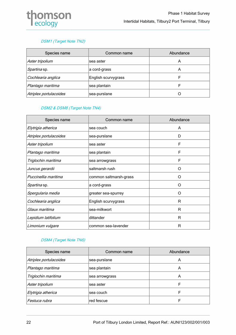
DSM1 (Target Note TN2)
Species name Common name Abundance
Aster tripolium sea aster A
Spartina sp. a cord-grass A
Cochlearia anglica English scurvygrass F
Plantago maritima sea plantain F
Atriplex portulacoides sea-purslane O
DSM2 & DSM8 (Target Note TN4)
Species name Common name Abundance
Elytrigia atherica sea couch A
Atriplex portulacoides sea-purslane D
Aster tripolium sea aster F
Plantago maritima sea plantain F
Triglochin maritima sea arrowgrass F
Juncus gerardii saltmarsh rush O
Puccinellia maritima common saltmarsh-grass O
Spartina sp. a cord-grass O
Spergularia media greater sea-spurrey O
Cochlearia anglica English scurvygrass R
Glaux maritima sea-milkwort R
Lepidium latifolium dittander R
Limonium vulgare common sea-lavender R
DSM4 (Target Note TN6)
Species name Common name Abundance
Atriplex portulacoides sea-purslane A
Plantago maritima sea plantain A
Triglochin maritima sea arrowgrass A
Aster tripolium sea aster F
Elytrigia atherica sea couch F
Festuca rubra red fescue F
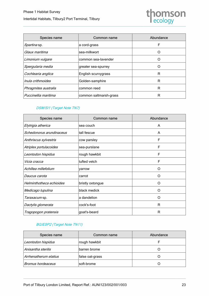
Phase 1 Habitat Survey
Intertidal Habitats, Tilbury2 Port Terminal, Tilbury
Port of Tilbury London Limited, Report Ref.: AUNI123/002/001/003 23
Species name Common name Abundance
Spartina sp. a cord-grass F
Glaux maritima sea-milkwort O
Limonium vulgare common sea-lavender O
Spergularia media greater sea-spurrey O
Cochlearia anglica English scurvygrass R
Inula crithmoides Golden-samphire R
Phragmites australis common reed R
Puccinellia maritima common saltmarsh-grass R
DSM/SI1 (Target Note TN7)
Species name Common name Abundance
Elytrigia atherica sea couch A
Schedonorus arundinaceus tall fescue A
Anthriscus sylvestris cow parsley F
Atriplex portulacoides sea-purslane F
Leontodon hispidus rough hawkbit F
Vicia cracca tufted vetch F
Achillea millefolium yarrow O
Daucus carota carrot O
Helminthotheca echioides bristly oxtongue O
Medicago lupulina black medick O
Taraxacum sp. a dandelion O
Dactylis glomerata cock's-foot R
Tragopogon pratensis goat's-beard R
BG/ESP2 (Target Note TN11)
Species name Common name Abundance
Leontodon hispidus rough hawkbit F
Anisantha sterilis barren brome O
Arrhenatherum elatius false oat-grass O
Bromus hordeaceus soft-brome O
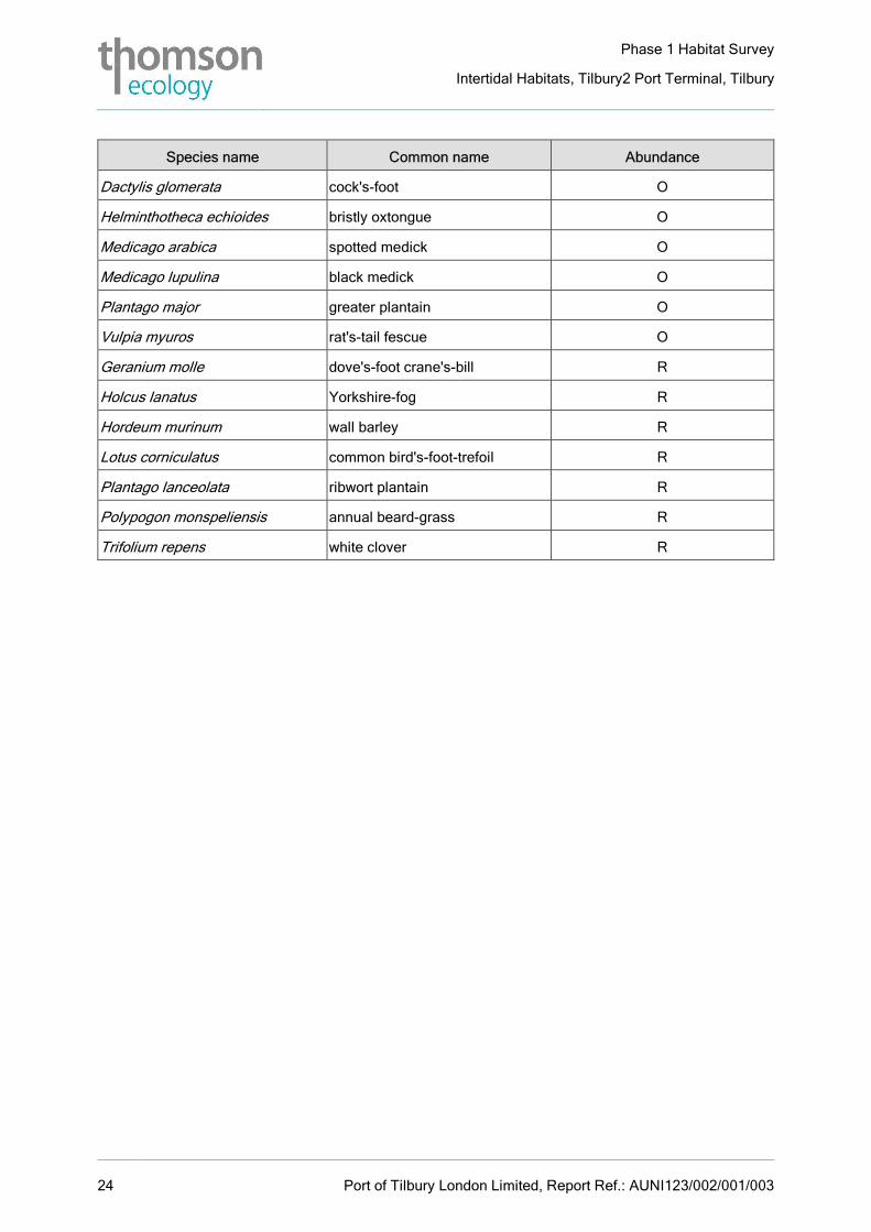
Phase 1 Habitat Survey
Intertidal Habitats, Tilbury2 Port Terminal, Tilbury
24 Port of Tilbury London Limited, Report Ref.: AUNI123/002/001/003
Species name Common name Abundance
Dactylis glomerata cock's-foot O
Helminthotheca echioides bristly oxtongue O
Medicago arabica spotted medick O
Medicago lupulina black medick O
Plantago major greater plantain O
Vulpia myuros rat's-tail fescue O
Geranium molle dove's-foot crane's-bill R
Holcus lanatus Yorkshire-fog R
Hordeum murinum wall barley R
Lotus corniculatus common bird's-foot-trefoil R
Plantago lanceolata ribwort plantain R
Polypogon monspeliensis annual beard-grass R
Trifolium repens white clover R