intergovernmental cooperation - Greendale, Wisconsin · intergovernmental . 9 cooperation. Village...
13
Village of Greendale Comprehensive Plan: 2010 - 2035 Greendale, Wisconsin . Revisiting a Greenbelt Community 9 intergovernmental cooperation
Transcript of intergovernmental cooperation - Greendale, Wisconsin · intergovernmental . 9 cooperation. Village...

Village of Greendale Comprehensive Plan: 2010 - 2035
Greendale, Wisconsin . Revisiting a Greenbelt Community
9intergovernmental cooperation

Village of Greendale Comprehensive Plan: 2010 - 2035
Greendale, Wisconsin . Revisiting a Greenbelt Community

9-1Intergovernmental Cooperation
Intergovernmental Cooperation
As one of only three “greenbelt” communities in the United States, the Village of Greendale plays a unique and important role in the metropolitan Milwaukee region. However, the Village also recognizes that decisions made at the state, regional, or local level have the potential to impact adjacent communities, for better or worse. Therefore, coordination between each of these government units and overlapping jurisdictions (i.e. MMSD, Greendale School District) is crucial to both preserve and enhance Greendale as a significant regional asset into the future. The need for intergovernmental cooperation is further underscored as communities strive to provide services more efficiently in the future.
According the State of Wisconsin’s Comprehensive Planning law, the purpose of the Intergovernmental Cooperation chapter is to “analyze the relationship of the local governmental unit to school districts and adjacent local governmental units, and to the region, the state and other governmental units.”
Furthermore, the element shall “incorporate any plans or agreements to which the local governmental unit is a party under §66.0301, §66.0307, §66.0309. The element shall identify existing or potential conflicts between the local governmental unit and other governmental
units that are specified in this paragraph and describe processes to resolve such conflicts.”
Experience has shown that intergovernmental cooperation is essential to the successful implementation of land use, transportation, environmental, and utility and community service initiatives, including joint opportunities for shared services with other jurisdictions.
The Intergovernmental Cooperation element of the Comprehensive Plan is required by the Wisconsin Comprehensive Planning Grant Program to provide the following:
A compilation of objectives, policies, goals, • maps, and programs for joint decision making with other jurisdictions including school districts and adjacent and other local governments for siting and building public facilities and sharing public services.
Analyze the relationship of the local • governmental unit to school districts, adjacent local governments, the region, the state, and other governments.
The Issues and Opportunities element of this Plan outlines four goals and objectives that shall guide the Intergovernmental Cooperation section:
Encourage ongoing discussion with • neighboring communities regarding land uses, transportation, and services;
Continue coordination with the • City of Greenfield regarding site planning and circulation in and around Southridge Mall and the 76th Street corridor;
Continue coordination with • Milwaukee County with regards to the Root River Parkway and other County parkland within and adjacent to the Village;
Continue to support the Greendale • School District as a valuable community resource.

9-2Village of Greendale Comprehensive Plan: 2010 - 2035
Greendale, Wisconsin . Revisiting a Greenbelt Community
Incorporate plans and agreements under • sections 66.0301, 66.0307, and 66.0309 of the Wisconsin Statutues.
Identify existing/potential conflicts • between the governmental unit and other governmental units.
INTERGOVERNMENTAL COOPERATION BETWEEN MUNICIPALITIESWisconsin Statues govern several types of interaction among neighboring municipalities. Some of these interactions, such as Extraterritorial Plat Authority, Extraterritorial Zoning Authority, and Boundary Agreements are intended to structure the relationship between cities or villages and their unincorporated surroundings. As the Village of Greendale does not lie adjacent to any unincorporated lands, these elements do not apply. Figure 9-1 shows incorporated municipalities in the region by class.
INTERGOVERNMENTAL COOPERATION WITHIN THE REGIONThere are a number of governmental and quasi-governmental agencies at the county, regional, and state level with whom the Village of Greendale interacts. The following section outlines the general relationship between Greendale and these agencies.
Southeastern Wisconsin Regional Planning Commission (SEWRPC)The Commission serves the seven counties of Kenosha, Milwaukee, Ozaukee, Racine, Walworth, Washington, and Waukesha, and was created to provide the basic information and planning services necessary to solve problems which transcend the corporate boundaries and fiscal capabilities of the local units of government comprising the Southeastern Wisconsin Region. The Commission prepares studies relating to highways/transit, sewerage, water supply, park and open space facilities, and land use. It is recommended that the Village of Greendale continue utilize the assistance of SEWRPC in matters of mutual interest.
Milwaukee CountyGreendale resides within the most populous county in the State of Wisconsin, estimated to have 953,328 residents in 2008 (www.census.gov). Several of the parks and open spaces in
the Village are either owned and maintained by or leased from Milwaukee County. Further, there are two highways maintained by the County - S. 76th Street and W. College Avenue. Milwaukee County does not currently have a comprehensive plan, although the region is represented in the 2035 Regional Land Use Plan prepared by SEWRPC.
There are no known conflicts between the Village’s comprehensive plan and the County; it is recommended that the Village of Greendale continue to work with the County on matters of mutual interest.
Wisconsin Department of Transportation (WisDOT)Currently, the Village of Greendale includes one arterial that is regulated by WisDOT:
State Trunk Highway 36: Loomis Road•
The Transportation element of this Plan provides additional information about this

9-3Intergovernmental Cooperation
Figure 9-1. Classes of Incorporated Municipalities in Southeastern Wisconsin (SEWRPC) arterial. In the future, the Village should collaborate with WisDOT as modifications to this highway are proposed.
Wisconsin Department of Natural Resources (WDNR)The DNR is dedicated to the preservation, protection, effective management, and maintenance of Wisconsin’s natural resources. It is responsible for implementing the laws of the state and, where applicable, the laws of the federal government that protect and enhance the natural resources of our state. It is the one agency charged with full responsibility for coordinating the many disciplines and programs necessary to provide a clean natural environment and a full range of outdoor recreational opportunities for Wisconsin citizens and visitors.
In Greendale, the Wisconsin Department of Natural Resources is responsible for overseeing state and federal regulations pertaining to floodplain management, stormwater management, and natural resource protection.
The DNR requires that a governing body adopt a park plan by resolution in order to be eligible to apply for recreational grant funds administered by the DNR. Adoption by the Plan Commission is required only if a community wishes to adopt the park plan as an element of its local master plan. While Greendale does not currently have a park and open space plan, the Village should consider creating one in the future in order to be eligible for a range of recreational grant opportunities. Further,

9-4Village of Greendale Comprehensive Plan: 2010 - 2035
Greendale, Wisconsin . Revisiting a Greenbelt Community
it is recommended that Greendale continue to work with the Wisconsin Department of Natural Resources in order to preserve and enhance natural resources within the Village.
Greendale School DistrictIn many cases, school districts function as a regional entity, as their borders overlap several municipal boundaries. It is possible for different parts of the same municipality to fall within different school districts. However, in the case of Greendale, the municipal and school district boundaries align. While this simplifies the relationship to an extent, the Greendale School District is still considered to be a regional asset and draws approximately 20% of its student population from outside district boundaries. Therefore, it is vital that the Village and the School District have a strong working relationship. More information on Greendale schools can be found in the ‘Utilities and Community Facilities’ chapter of this plan.
PLANS IN THE REGIONSEWRPC has authored a number of plans which impact the Village of Greendale. An overview of these plans is included below.
SEWRPC Planning Report No. 48, A Regional Land Use Plan for Southeastern Wisconsin: 2035This plan, adopted in June of 2006, is the fifth generation of regional land use plans prepared by SEWRPC. SEWRPC is charged by law with the “function and duty of making and adopting a master plan for the physical development of the
region.” The plan emphasizes the “preparation of spatial designs for the use of land and for supporting transportation and utility facilities.” Figure 9-2 shows the recommended future land uses identified by SEWRPC during their planning process. Further detail regarding the 2035 Regional Land Use Plan can be found throughout this Comprehensive Plan, including the Land Use chapter (Chapter 5).
SEWRPC Planning Report No. 49, A Regional Transportation Plan for Southeastern Wisconsin: 2035This plan was developed concurrently with the Regional Land Use Plan, and it represents the fifth generation of SEWRPC’s regional transportation plans. The plan is intended to provide vision and guidance to the development of the region’s transportation system. Plan
Figure 9-2. 2035 Recommended Regional Land Use Plan, Village of Greendale (SEWRPC)

9-5Intergovernmental Cooperation
elements include public transportation (Figure 9-3) systems and demand management, bicycle and pedestrian facilities, and arterial
streets and highways. Transportation needs were based on projected growth as developed through the Regional Land Use Plan.
SEWRPC Planning Report No. 50, A Regional Water Quality Management Plan Update for the Greater Milwaukee WatershedIn 2007, SEWRPC adopted an updated water quality management plan as a guide to achieving clean and wholesome surface waters within the five watersheds which lie entirely or partially in the greater Milwaukee area, the Lake Michigan direct drainage area, the Milwaukee Harbor estuary, and a portion of nearshore Lake Michigan, as shown in Figure 9-4. The watersheds involved are those of the Kinnickinnic River, Oak Creek, Menomonee River, Milwaukee River, and Root River.
SEWRPC, working in cooperation with MMSD, completed this effort following the U.S. Environmental Protection Agency’s recommended watershed approach. As recommended, the approach uses nature’s boundaries instead of jurisdictional limits, recommends decisions based on science and engineering, and requires strong partnerships and public involvement with people, interest groups, and agencies. The plan recommends the control of both point and non-point pollution sources, and provides the basis for decisions on community, industrial, and private waste disposal systems, with a focus on smart growth and enhancing the region’s quality of life.
Figure 9-3. Comparison Of The Proposed Public Transit Element Of The Year 2035 Regional Transportation System Plan To Forecast Year 2035 Job Density In Milwaukee County, Village of Greendale (SEWRPC)
Figure 9-4. Surface Water and Surface Drainage in Milwaukee County, Village of Greendale (SEWRPC)
9-6Village of Greendale Comprehensive Plan: 2010 - 2035
Greendale, Wisconsin . Revisiting a Greenbelt Community
§̈¦894
FRANKLIN
GREENFIELD
HALESCORNERS
Village of Greendale
Parcels
Scale: 1"=2500'
City of Greenfield
Village of Hales Corners
City of Franklin
City of Milwaukee
Greendale withinthe Region
Village of GreendaleComprehensive Plan: 2010-2035
October 1, 2009
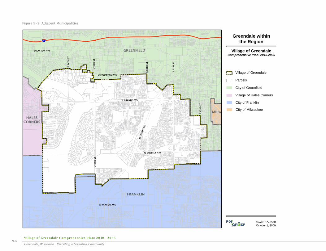
Figure 9-5. Adjacent Municipalities

9-7Intergovernmental Cooperation
SEWRPC Technical Report No. 37, Groundwater Resources of Southeastern WisconsinSEWRPC worked cooperatively with the Wisconsin Geological and Natural History Survey (WGNHS) and the DNR on a regional groundwater plan to develop hydrologic data that can be used to support the preparation of a regional groundwater modeling program. The document also provides information useful for land use and related planning efforts.
SEWRPC Planning Report No. 52, A Regional Water Supply Plan for Southeastern WisconsinSEWRPC is conducting a regional water supply study, with the resulting plan expected to be complete in 2009. The regional water supply plan, together with the above mentioned groundwater inventories and a ground water simulation model, will form the SEWRPC regional water supply management program. The preparation of these three elements includes interagency partnerships with the U.S. Geological Survey, the Wisconsin Geological and Natural History Survey, the University of Wisconsin-Milwaukee, the Wisconsin Department of Natural Resources, and many of the area’s water supply utilities.
The regional water supply plan will include the following major components:
Water supply service areas and forecasted • demand for water use.
Recommendations for water conservation • efforts to reduce water demand.
Evaluation of alternative sources of supply, • recommended sources of supply for each service area, and recommendations for development of the basic infrastructure required to deliver that supply.
Identification of groundwater recharge • areas to be protected from incompatible development.
Specification of new industrial • structures necessary to carry out plan recommendations.
Identification of constraints to development • levels in subareas of the region that emanate from water supply sustainability concerns.
Milwaukee Metropolitan Sewerage District (MMSD)The MMSD has prepared a 2020 Facilities Plan which sets forth ongoing investments and facilities improvements to be made in order to provide a target level of protection for sanitary sewer overflows and adequate treatment under the projected 2020 population and land use conditions. In addition, the plan calls for measures to be undertaken by municipalities served by the MMSD to prevent increases in infiltration and inflow through the plan design year. Additional information about this plan is presented in the Utilities and Community Facilities chapter.
It is recommended that the Village of Greendale continue working with the Milwaukee Metropolitan Sewerage District to attempt to
ensure that the MMSD’s plan is consistent with the Village of Greendale’s Comprehensive Plan, particularly with regard to such issues as the expansion of sanitary sewer service within the Village.
PLANS IN ADJACENT MUNICIPALITIESAs the Village of Greendale begins to implement recommendations from the Comprehensive Plan, as well as other municipal efforts, it will be important to be aware of and coordinate with the policies of adjacent municipalities. Figure 9-5 maps the three communities that are immediately adjacent to Greendale, as well as the City of Milwaukee which is in close proximity. The following section provides a brief overview of the adjacent municipalities and their planning efforts.
City of GreenfieldThe City of Greenfield, population 35,476 (2000 Census), is located north of the Village of Greendale in Milwaukee County. In the City of Greenfield, planning duties are performed by the ‘Planning and Economic Development Division’ within the Department of Neighborhood Services. Duties include plan and development review, community development, and economic development.
The City of Greenfield began the process of updating its 1992 comprehensive plan in 2005. The resulting document, entitled ‘City of Greenfield: Comprehensive Plan 2008’ was adopted in November, 2008.

9-8Village of Greendale Comprehensive Plan: 2010 - 2035
Greendale, Wisconsin . Revisiting a Greenbelt Community
‘City of Greenfield: Comprehensive Plan 2008’ includes a Future Land Use Map. According to this map, recommended land uses along the Greendale-Greenfield border (northern and eastern boundaries) include single-family residential with some duplexes or townhomes near College Avenue. Along S 76th Street, Greenfield proposed “Planned Business” as the corridor approaches Southridge Mall; “Planned Mixed Use” was recommended for Loomis Road as it intersects Greendale.
The 2008 Comprehensive Plan refers to a number of Special Interest Areas (SIA) that were originally addressed in the 1992 Comprehensive Plan and were reexamined in the 2008 Plan. Three of these SIAs are adjacent to the Village of Greendale:
•SIA #19 – located northwest of Forest Home Ave., east of 92nd St., and south of Layton Ave. The 1992 plan recommended development of multi-family residential along Forest Home Ave. with single-family residential to infill the remaining area. The 2008 plan notes that a 46-unit condominium project called ‘the Orchard’ was recently approved.
•SIA #21 – comprised of 30 acres at the intersection of Edgerton Ave. and Loomis Ave. The 1992 plan designated commercial development along Loomis. The 2008 plan recommends office development along this portion of Loomis instead of retial, due to surrounding land uses.
•SIA #28 – located west of 43rd St. and north of Grange Ave. The 1992 plan designated the center of this area to be 2-family residential, with the remaining area designated for single-family residential development. The 2008 plan notes that the 1992 recommendations have been implemented.
Other Plans and Studies
76th Street – Southridge Corridor Study • (September 2002)
Greenfield Crossing Redevelopment • Proposal (in process)
City of FranklinThe City of Franklin, population 29,494 (2000 Census), is located south of the Village of Greendale. The ‘Planning and Zoning Division’ within the ‘Department of City Development’ carries out the city’s planning duties.
Comprehensive Plan - The City of Franklin is currently in the process of updating its comprehensive plan, with final approval expected in October of 2009. Until adoption of the new plan occurs the City of Franklin’s 1992 Comprehensive Master Plan is the current plan.
Other Plans and Studies -
City of Franklin Research Findings (Franklin • Needs Study) - (1998)
Franklin Unified Development Ordinance - • (1998, rev. 2007)
Franklin First Development Plan: Site • Planning, Preliminary Engineering, Feasibility Analysis, and Financial Analysis for the City of Franklin - (2001)
Franklin First: Strategies to Bring Balance to • Franklin’s Tax Base - (2000)
Long Term Vision for the City of Franklin - • (2004)
Crossroad Trade Area: Regulating Plan - • (2004)
S. 27th Street Corridor Plan - (2004)•
Wisconsin 241 (S. 27th Street) Access • Management Plan - (2005)
Village of Hales CornersThe Village of Hales Corners, population 7,765 (2000 Census) is located west of the Village of Greendale. Planning duties are carried out by the ‘Department of Planning and Zoning Administration.’
Comprehensive Plan - The Village of Hales Corners is scheduled to begin its comprehensive planning process in 2009.
9-9Intergovernmental Cooperation
Mutual Aid AgreementsThe Village of Greendale has established mutual aid agreements with several of the surrounding communities in the region, particularly with respect to maintaining basic services during emergency situations. A brief summary of current mutual aid agreements follows:
Police/Fire/Response Teams
With regard to police and fire, the Village has mutual aid agreements for small immediate response with Greenfield, Franklin, and Hales Corners. Greendale is also part of the Suburban Mutual Assistance Response Teams (SMART) agreement, which includes: every suburban community in Milwaukee County, the Milwaukee County Sheriff, all Waukesha communities - including Waukesha Police, and the Wisconsin State Patrol. The SMART agreement is utilized during significant disasters or major crimes.
Greendale Health Department
Greendale Health Department is a member of the Milwaukee/Waukesha Consortium for Emergency Preparedness. As part of the consortium, Greendale has signed a mutual
aid agreement to provide public health nursing staff, registered sanitarian or health officer in the event they are needed at an emergency. The Village also has an informal agreement with other local health departments to share registered sanitarian services while people are on vacation or to assist with temporary events on weekends.
Municipal Sanitary Sewer Agreements
The Village of Greendale has an intergovernmental agreement with several communities regarding municipal sanitary sewer service. Through the agreement, the communities share resources (e.g., vactor, closed-circuit television (CCTV) equipment). Municipalities participating in the agreement include: City of Brookfield, Village of Brown Deer, City of Cudahy, Village of Fox Point, City of Franklin, City of Glendale, Village of Greendale, Milwaukee County, City of Oak Creek, City of St. Francis, Village of Shorewood, City of Wauwatosa, City of West Allis, Village of Whitefish Bay, Village of Elm Grove, City of Greenfield, Village of Bayside, Village of Hales Corners, City of New Berlin, and the City of Milwaukee.
Greendale Department of Public Works
The Greendale Department of Public Works is a member in good standing of the Milwaukee County Public Works Emergency Response Mutual Aid Agreement. The membership was approved by the Village Board in 2005 with resolution number 2005-10.
INTERGOVERNMENTAL COOPERATION CONfLICTS“The element shall identify existing or potential conflicts between the local governmental unit and other governmental units that are specified in this paragraph and describe processes to resolve such conflicts.” excerpt from Wisconsin State Statute 66.1001(2)(g).
An important issue when developing land use plans for cities is the potential for conflicts with the plans of surrounding incorporated areas, as well as unincorporated townships. This is complicated by the following policies:
Cities and villages are allowed to develop • plans for the areas outside their corporate boundaries.
State Statutes require land use decisions to • be consistent with the comprehensive plans after January 1, 2010.
The County could be in a position of • reviewing a land use decision by the Village of Greendale that was consistent with the Village’s comprehensive plan, but inconsistent with plans adopted by surrounding municipalities.

9-10Village of Greendale Comprehensive Plan: 2010 - 2035
Greendale, Wisconsin . Revisiting a Greenbelt Community
Consistency of local plans with county-• wide multi-jurisdictional plans and the comprehensive plans of surrounding municipalities may also be considered as a basis for reviewing zoning and plat decisions.
It is important to note however, that the Village of Greendale is surrounded by incorporated municipalities and, therefore, does not anticipate the development of any plans outside its corporate limits. At this point it time, there are no anticipated conflicts with the adjacent communities in regard to that issue.
Consistency within the Context of the Plan
After 2010, it will be increasingly important to consider consistency of the Comprehensive Plan relative to zoning, subdivision regulations, official mapping, and boundary agreements. Within the context of the Village of Greendale Comprehensive Plan, the concept of consistency means that as decisions are made, they should generally be within the intent and guidelines established by the Plan. This includes all provisions that allow for reasonable exceptions due to unique circumstances (not unlike conditional use zoning).
It is assumed that a proposed land use action is consistent with the local comprehensive plan when the regulation, amendment, or action:
Furthers, or at least is not inconsistent with, • the goals, objectives, and policies contained in the local comprehensive plan.
Is generally compatible with the proposed • future land uses and densities and/or intensities contained in the local comprehensive plan.
Carries out, as applicable, any specific • proposals for community facilities, including transportation facilities, or other specific actions contained in the local comprehensive plan.
Land Use Conflicts and Multi-Jurisdictional Plans
Current discussions of planning conflicts tend to focus on the relationship between incorporated areas and towns. However, there are many other types of planning and land use conflicts. For example, transportation plans often conflict among federal, state, county, and local governments. Many of these conflicts are resolved through regulations and operational policies. The point, however, is that there are numerous conflicts in planning and land use that occur throughout government operations. This is also true in planning for environmental preservation, wetlands, water use, historic preservation, and many other fields. The presence of such conflicts is routine and plans do not necessarily resolve all of these conflicts. Often, the solution is simply identifying the conflicts, defining the key issues, and suggesting procedures for minimizing or resolving conflicts.
Potential land use conflicts in Greendale are most likely to occur between non-related
land uses, such as industrial uses adjacent to residential units. Transitions, appropriate buffers, and a case-by-case review are necessary to minimize the impact of these conflicts.
Land Use Conflicts are Legitimate and Appropriate Components of Plans
Land use and planning conflicts are not, by definition, inappropriate. Perhaps the simplest example is the concept of “mixed use.” Most planning literature today defines mixed use as a legitimate and desirable type of land use. However, a few decades ago mixed uses were considered rare and potentially threatening to property values. Mixed use by definition embodies the potential for multiple futures and alternatives. The same is true for different land use alternatives. It is reasonable to assert, from a planning perspective, that some areas or districts might be most appropriately planned with multiple futures. In fact, it could be argued that plans which define categorically only one appropriate future for an area may be misleading. In addition, most plans have provisions for amendments that are exercised with some frequency. This implies that land use alternatives are dynamic and that plans are being changed constantly. It is reasonable to accept the idea that land use plans with conflicting contents may both have some legitimacy.

9-11Intergovernmental Cooperation
GOALS, OBJECTIVES, & POLICIES
The following goals, objectives, and policies have been created based on input from the community and the Village’s established policies. They are intended to guide future decisions pertaining to intergovernmental cooperation in the Village.
Objectives & PoliciesContinue cooperative planning efforts • with surrounding communities, Milwaukee County, MMSD, and the Greendale School District.
Consider the development of a park ◦and open space plan, in coordination with Milwaukee County Parks.
Coordinate land use planning along • municipal borders
Encourage compatible uses and/ ◦or appropriate transitions between adjacent uses, where possible.
Where there are conflicts, work with ◦adjacent municipalities to identify an appropriate resolution.
Continue efforts to establish and maintain • existing mutual aid agreements and identify new opportunities for joint services or facilities with adjacent communities, the school district, and/or civic organizations.
Coordinate with surrounding communities • to support and, where necessary, expand regional transit in the region.
Continue to work with the School District • to ensure high quality neighborhood school facilities to serve existing and future residents.
Continue to support and coordinate ◦with the Greendale School District in planning for upgrades and/or expansions.
Work with the School District to ◦maintain the value of Greendale’s schools as a major attraction for new, younger families.
Work with the City of Greenfield to develop • a joint master plan that will guide the redevelopment of Southridge Mall and the 76th Street corridor.
GoalsContinue to establish and maintain 1. positive working relationships with adjacent municipalities; county, regional, and state agencies; and the Greendale School District.
Encourage opportunities for 2. cooperation through the formulation of compatible local policies and programs.
Work with adjacent communities and 3. government agencies to resolve land use and/or development conflicts.