Integrated water and biodiversity management in the...
6
EKOLOGIJA. 2007. No. 53. No. 2. P. 64–69 © Lietuvos mokslų akademija, 2007 © Lietuvos mokslų akademijos leidykla, 2007 Integrated water and biodiversity management in the Dovinė river basin In 2003, the PIN-Matra project “Management and Restoration of Natura 2000 sites through an Integrated River Basin Management Plan of the Dovinė River” (Lithuania), financed by the Netherlands Ministry of Agriculture, Nature and Food Quality, was started. e overall purpose of the project was to produce the management and restoration plan for the Dovinė river basin (total area 588.7 km 2 ) as an input to the Integrated River Basin Management Plan of the Nemunas River Basin District. e main outcomes of the Management and Restoration Plan for the Dovinė River Basin are presented in the article. Key words: the Dovinė river, Lake Žuvintas, Natura 2000, river basin management plan Zenonas Gulbinas 1 , Henk Zingstra 2 , Karina Kitnaes 3 , Erik Querner 4 , Arvydas Povilaitis 5 , Valerijus Rašomavičius 6 , Marijus Pileckas 7 1 Nature Heritage Fund / Vilnius Pedagogical University, A. Juozapaviciaus 9, LT-09311 Vilnius, Lithuania E-mail: [email protected] 2 Wageningen International PO Box 88, 6700 AB Wageningen, the Netherlands E-mail: [email protected] 3 Orbicon ( formerly Bioconsult), Jens Juuls Vej 18, DK-8260 Viby J, Denmark E-mail: [email protected] 4 Alterra, P.O. Box 47, 6700 AA Wageningen, the Netherlands E-mail: [email protected] 5 Lithuanian University of Agriculture, Universiteto 10, LT-53361 Kaunas, Lithuania E-mail: [email protected] 6 Institute of Botany Žaliųjų Ežerų 49, LT-08406 Vilnius, Lithuania E-mail: fl[email protected] 7 Institute of Geology and Geography / Vilnius Pedagogical University, T. Ševčenkos 13, LT-03223 Vilnius, Lithuania E-mail: [email protected]
Transcript of Integrated water and biodiversity management in the...

EKOLOGIJA. 2007. No. 53. No. 2. P. 64–69© Lietuvos mokslų akademija, 2007© Lietuvos mokslų akademijos leidykla, 2007
Integrated water and biodiversity management in the Dovinė river basin
In 2003, the PIN-Matra project “Management and Restoration of Natura 2000 sites through an Integrated River Basin Management Plan of the Dovinė River” (Lithuania), financed by theNetherlands Ministry of Agriculture, Nature and Food Quality, was started. The overall purpose ofthe project was to produce the management and restoration plan for the Dovinė river basin (total area 588.7 km2) as an input to the Integrated River Basin Management Plan of the Nemunas River Basin District. The main outcomes of the Management and Restoration Plan for the Dovinė RiverBasin are presented in the article.
Key words: the Dovinė river, Lake Žuvintas, Natura 2000, river basin management plan
Zenonas Gulbinas1,
Henk Zingstra2,
Karina Kitnaes3,
Erik Querner4,
Arvydas Povilaitis5,
Valerijus Rašomavičius6,
Marijus Pileckas7
1 Nature Heritage Fund / Vilnius Pedagogical University, A. Juozapaviciaus 9, LT-09311 Vilnius, Lithuania E-mail: [email protected]
2 Wageningen International PO Box 88, 6700 AB Wageningen, the Netherlands E-mail: [email protected]
3 Orbicon ( formerly Bioconsult), Jens Juuls Vej 18, DK-8260 Viby J, Denmark E-mail: [email protected]
4 Alterra, P.O. Box 47, 6700 AA Wageningen, the Netherlands E-mail: [email protected]
5 Lithuanian University of Agriculture, Universiteto 10, LT-53361 Kaunas, Lithuania E-mail: [email protected]
6Institute of Botany Žaliųjų Ežerų 49, LT-08406 Vilnius, Lithuania E-mail: [email protected]
7 Institute of Geology and Geography / Vilnius Pedagogical University, T. Ševčenkos 13, LT-03223 Vilnius, Lithuania E-mail: [email protected]

65Integrated water and biodiversity management in the Dovinė river basin
INTRODUCTION
The implementation of the Birds and Habitats Directivesand the Water Framework Directive has a far reaching impact on the practical, political and organisational as-pects of nature and water management in the EU mem-ber states. Although all three Directives aim at improv-ing the ecological conditions, the implementation of the Birds and Habitats Directives on the one hand and the Water Framework Directive on the other is often poorlycoordinated. This can result in conflicting objectives andmanagement measures, for water bodies in particular. The management objectives for the EU WFD are basedon ecological reference situations for similar water bodies across the country, while the management objectives for the EU Birds and Habitats Directive are based on main-taining or achieving the so-called “favourable conserva-tion status”.
Sound co-ordination of the implementation of the Directives is of particular importance for water bodies that are designated as Natura 2000 site under the Birds and Habitats Directives. There are over 3 thousand lakesin Lithuania, of them only 14 with an area of 10 sq. km and more, which take up 1.5 per cent of Lithuania’s ter-ritory. Many of these lakes are nutrient-poor fens with specific natural characteristics and designated as Natura2000 sites.
In 2003, the PIN / Matra project “Management and Restoration of Natura 2000 sites through an Integrated River Basin Management Plan of the Dovinė River” (Lithuania), financed by the Netherlands Ministry ofAgriculture, Nature and Food Quality, started. The overallpurpose of the project was to produce the management and restoration plan for the Dovinė river basin (total area 588.7 km2) as an input to the Integrated River Basin Management Plan of the Nemunas River Basin District. This plan will ensure an appropriate tuning of achievinga Good Ecological Status (according to the WFD) and a Favourable Conservation Status (according to the Birds and Habitats Directives) in the Dovinė river basin.
Initially, the project was intended to stop the degrada-tion of Lake Žuvintas and to restore the ecological quality of the Amalvas wetlands located north of Lake Žuvintas and also of part of the Žuvintas Biosphere Reserve. During the process of project development, it was agreed to apply the requirements stemming from the EU Birds and Habitats Directive and the EU Water Framework Directive as a framework for the rehabilitation and res-toration plans. The project provided the basis for a long-term protection of Lake Žuvintas, the re-naturalisation of the Dovinė river and the restoration of drained wet-lands. The Integrated River Basin Management Plan ofthe Dovinė river was finalized in the first part of 2006(Zingstra et al., 2006).
PROJECT SITE AND METHODS
The Dovinė river is the right tributary of the Šešupė riv-er. Its length is 47.0 km and its basin covers a total area of 588.7 km² (Fig. 1). According to the classification ac-
cepted in Lithuania, the Dovinė River belongs to the cat-egory of small rivers being a typical flat plain river. Thefive largest lakes of the Dovinė basin constitute 93.5% ofthe total lake area: Dusia 2334.2 ha; Žuvintas 934.3 ha; Simnas 243.8 ha, Giluitis 235.1 ha and Amalvas 193.0 ha. Lake Dusia is the source of the Dovinė river. The Dovinėflows through the lakes of Simnas and Žuvintas, whilethe other lakes are in the basins of the tributaries of the Dovinė river. Most of the surrounding areas are produc-tive agricultural lands (productivity is higher than the av-erage of the country). The forest cover is scarce (approxi-mately 16% of the area).
Fig. 1. Location of Dovinė River basin
To implement the tasks of the project, four working groups (WG) were established: WG on Hydrology, WG on Ecology, WG on Information and Awareness and a GIS WG. The members of all working groups worked inclose co-operation under the supervision of the Project Management Team.
The group of the hydrology working task was to give recommendations for adjusting the water management of the Dovinė river in order to improve the quality of the water flowing into Lake Žuvintas and to naturalize theflow pattern of the Dovinė river as much as possible, as acontribution to achieving a good ecological status as re-quired by the EU WFD.
The Hydrology group carried out various activitiesincluding gathering and analysis of water quality and quantity data (discharge and groundwater). Experts of the group were trained in the application of the SIMGRO model (Povilaitis, Querner, 2006). To evaluate the meas-ures for water quality improvement in Lake Žuvintas, the PCLake model (Janse, van Liere, 1995) was applied. On evaluating the collected material, basic decisions and pro-posals were presented (Povilaitis, 2006).
The main task of the Ecology working group was to evaluate the status of the wetland biodiversity (species and habitats of European importance) in the Dovinė river basin according to the criteria of EU Directives. The ecol-ogy working group had to make a list of protected areas of national and European importance in the Dovinė river basin, to estimate the scope of data on Habitats Directive

Zenonas Gulbinas, Henk Zingstra, Karina Kitnaes, Erik Querner, Arvydas Povilaitis, Valerijus Rašomavičius, Marijus Pileckas 66
and Birds Directive objects; to work out the fieldworkprogramme, and based on these data to describe the sta-tus of the habitats and species in the selected NATURA 2000 sites; to classify the Dovinė river basin water bod-ies according to the Water Framework Directive and to estimate their ecological status; to elaborate guidelines for the nature management of the Žuvintas wetland areas plan; to prepare the Amalvas wetland area nature man-agement plan.
The Ecology working group carried out analysis ofdata selected during the field work (specification of habi-tat and species diversity in NATURA 2000 sites), map-ping of wetlands and forest habitats and estimation of their conservation status, mapping of the distribution of plant and animal populations and estimation of their status. Expert judgment was one of the main methods analyzing all the available material. The ecological statusof lakes was assessed mostly according to phytoplankton parameters and of rivers according fish fauna parameters(Rašomavičius, 2006).
DESCRIPTION OF THE PROBLEM
In the second half of the twentieth century, the water re-gime of the Dovinė river and its basin underwent signifi-cant changes. Many rivulets were channelled, a number of dams were built, and extensive bog and fen areas were drained and meliorated.
With the growth of industry in the second half of the 20th century, a shortage of clean and fresh water in the Šesupė river near the town of Marijampolė appeared in the 1960s. In Marijampolė, located downstream of Lake Žuvintas, the Dovinė river discharges into the Šesupė. To compensate for the lack of water in summer, sluices-regu-lators were built on the Dovinė river at the outlets of the Dusia, Simnas and Žuvintas lakes to retain and store part of spring-flood water (Fig. 2). This was made in 1968 forLake Žuvintas and in 1972 for lakes Dusia and Simnas. In the lowest reaches of the Dovinė river an electric power station was built. The dams for lakes Dusia, Simnas andŽuvintas were meant as the first stage of the water man-agement plan for the entire area. Fortunately, other stages (redirection of water from other basins) remained unre-alised. In 1992, after introduction of a sewage treatmentplant, the system of retaining water in the lakes lost its value for the town of Marijampolė.
In the 80s of the last century, the hydrology of the area again was altered by large-scale amelioration works: the northern and southern parts of the Amalvas wetland complex were drained, large sections of the Dovinė and the Kiaulyčia rivers canalised, and fish ponds were estab-lished near the Simnas settlement. In addition, the impact of agricultural activities in the river valley on water qual-ity became more and more evident. Pollution from the Simnas town and the other villages, as well as dispersed pollution sources further deteriorated the quality of wa-ter and accelerated the eutrophication of and wetland complexes, especially the lakes Žuvintas and Amalvas.
These human-induced changes in the hydrology anddynamics of the Dovinė river and the large-scale meliora-
tion of wetlands are the main impediments for the long-term conservation of biodiversity and sustainable use of the Dovinė river basin and the Žuvintas Biosphere Reserve.
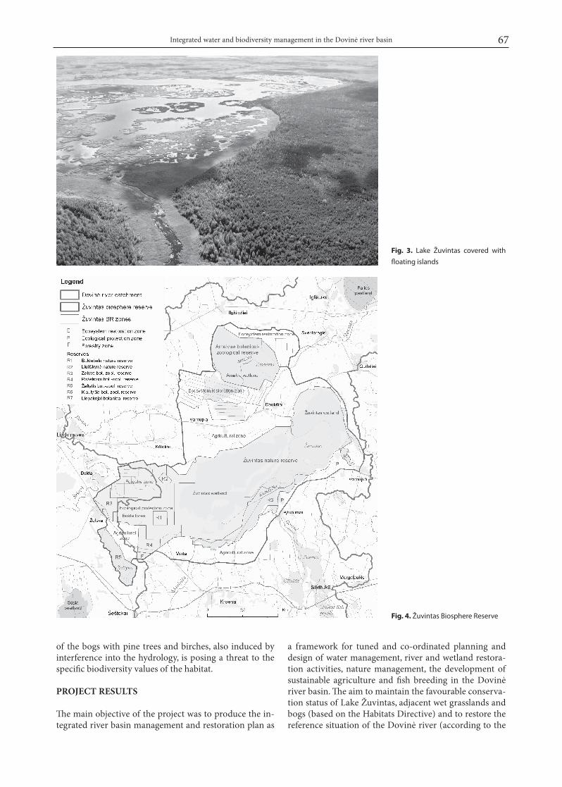
With the construction of water sluices-regulators, wa-ter level fluctuation in Lake Žuvintas decreased from 1.2m to only 70 cm. The average water level after the dam-ming decreased by about 30 cm. Now the lake is rapidly shrinking in size due to the lower average water level and the massive overgrowth of both the shores and bottom. More than half of the lake surface area is covered with aquatic plants. The high nutrient concentration in thesediments is the main reason for the massive growth of vegetation (Fig. 3).
The large-scale melioration works in the Amalvaswetlands downstream of Lake Žuvintas added to the dis-turbance of the hydrology and had a negative impact on the hydrology of the Žuvintas Biosphere Reserve and the Amalvas wetlands (Fig. 4).
Another process reducing the biodiversity values of the Žuvintas Biosphere Reserve was the overgrowth of the wet meadows and fens with shrubs. Overgrowth
Fig. 2. Hydrotechnical objects in Dovinė river basin
67Integrated water and biodiversity management in the Dovinė river basin
Fig. 3. Lake Žuvintas covered with
floating islands
Fig. 4. Žuvintas Biosphere Reserve
of the bogs with pine trees and birches, also induced by interference into the hydrology, is posing a threat to the specific biodiversity values of the habitat.
PROJECT RESULTS
The main objective of the project was to produce the in-tegrated river basin management and restoration plan as
a framework for tuned and co-ordinated planning and design of water management, river and wetland restora-tion activities, nature management, the development of sustainable agriculture and fish breeding in the Dovinėriver basin. The aim to maintain the favourable conserva-tion status of Lake Žuvintas, adjacent wet grasslands and bogs (based on the Habitats Directive) and to restore the reference situation of the Dovinė river (according to the

Zenonas Gulbinas, Henk Zingstra, Karina Kitnaes, Erik Querner, Arvydas Povilaitis, Valerijus Rašomavičius, Marijus Pileckas 68
WFD) make the area an excellent pilot for integrating the protection and restoration of nature values of European significance into the European river basin management.
The Management and Restoration Plan for the DovinėRiver Basin includes:
● proposal to stop the eutrofication and to improvethe hydrological and ecological conditions of Lake Žuvintas as a contribution to achieving a “favourable conservation status” of the key Natura 2000 habitats and species through achieving a “good ecological sta-tus” of the Dovinė river;● proposal for achieving a “favourable conservation status” of the Žuvintas wetland areas (mire and fen ar-eas) adjacent to the lake and other wetlands and water bodies designated as Natura 2000 sites in the catch-ment of the Dovinė river;● proposal of the restoration of the drained Amalvas wetland;● the Geographical Information System of the Dovinė River Basin.The Management and Restoration Plan for the Dovinė
River Basin holds elements of the Programme of Measures as required in the WFD. All proposed measures have a cartographical expression and are part of the Integrated Geographical Information System of the Dovinė River Basin. All the GIS layers were compiled using the back-ground scale 1 : 10 000, only for some of layers the back-ground information was taken from the maps drawn to scale 1 : 50 000 (Pileckas, 2006).
OUTPUTS AND RECOMMENDATIONS
I. The hydrology working group produced the follow-ing outputs:
● Proposal for adjusting water management prac-tices (including the management of the sluices) of the Dovinė river to stop the eutrofication of Lake Žuvintasas a contribution to achieving a good ecological sta-tus and a favourable conservation status of the lake and adjacent Natura 2000 sites. While reconstructing the sluice-gates, the order of priority is the following: 1) Lake Žuvintas sluice-gates; 2) Lake Simnas sluice-gates; 3) Lake Dusia sluice-gates, and 4) Lake Amalvas sluice-gates.● Proposal for an improved management of the Simnas fishponds to reduce the outflow of nutrientsand to improve the natural flow dynamics of theDovinė river, combined with the proposal to designate one of the ponds as a purification pond to reduce thenutrient loads of the fishponds.● Proposals for adjusting the water management of the Amalvas area in order to improve the ecological status of Lake Amalvas and the adjacent wetland and to optimize the restoration possibilities for the drained peatlands.
II. The ecology working group produced the following outputs:
● A list of national protected areas and NATURA 2000 sites occurring in the Dovinė river basin has
been made. Most of the Meteliai Regional Park and the Žuvintas Strict Biosphere Reserve territory be-long to the Dovinė river basin. Preliminary data on NATURA 2000 sites were taken from the database of the DANCEE project “Implementation of NATURA 2000 in Lithuania at local and national level”. The listincludes 10 NATURA 2000 sites (2 according to Bird Directive and 8 to Habitat Directive) occurring in the Dovinė river basin.● Data on all the Dovinė river basin SPA and SAC were presented. At the initial stage of the project imple-mentation, the available official documents indicatedthat the Žuvintas SPA was established due to the pres-ence of 12 species of birds and migrating water birds, and the Žuvintas SAC was intended for the protection of 8 habitat types and 2 species. During more detailed consultations and discussions with employees of the Žuvintas Strict Biosphere Reserve, uncertainty as re-gards the formulated objectives of the Žuvintas SAC emerged: i) habitat diversity is not reflected in the aimsof establishment, ii) it is not clear what Habitat Directive Annex II animal species are prevalent in the territory, iii) Habitat Directive Annex II plant species which occur in the Žuvintas Strict Biosphere Reserve according to lit-erature and herbarium data are not mentioned at all.● Fieldwork was carried out in June–August 2005 by 12 experts in natural habitat types, animals and plants of different systematic groups. The GIS database(maps of habitat and species distribution) was worked out (presented separately). Four coenopopulations of Annex II plant species of Habitats Directive (Liparis loeselii, Saxifraga hirculus) were estimated. Data on Annex II animal species of Habitats Directive (Lutra lutra and Hypodryas maturna mentioned in the initial objectives of establishment, and Bombina bombina and Dytiscus latissimus unlisted in establishment docu-ments) were specified. Data on habitat diversity anddistribution areas, quantity of species populations, localization and status were used for documentation of the Žuvintas SAC. Data on Birds Directive spe-cies were presented, the status and hazards of 12 spe-cies populations was characterized, the distribution range identified, and protection measures suggested.Detailed reports on Habitats Directive Annex I habitat types and Annex II species status in the Žuvintas SPA and SAC were presented.● Recommendations for the Žuvintas SAC nature management plan were worked out. The diversity anddistribution range of habitats and species of European importance was assessed and their conservation sta-tus estimated to provide a base for planning the man-agement measures. Because of the missing standards of the estimation of a favourable conservation status for habitat types on national level, the habitat manage-ment recommendations reflect the local conditions,including measures to address threats to the favourable conservation status of habitats. Analysis of species and habitat mapping data enabled to identify management areas by indicating top priority means and methods of preservation.
69Integrated water and biodiversity management in the Dovinė river basin
● A nature management plan for the Amalvas wet-land areas (part of the Žuvintas SAC) was prepared according to the standards for the description of the management plan content and presented as a self-sus-taining part of the work. Proposals for the manage-ment plan followed detailed investigations of the habi-tat and species diversity and status as well as estimation of the complex of hydrological conditions. Suggestions on the restoration and maintenance of the favourable habitat status are prioritized, and restoration possibili-ties of the hydrological regime are discussed.● Based on the Lithuanian River Cadastre, a list of the Dovinė river basin water bodies has been com-piled. The obtained level of investigations on these wa-ter bodies has been determined. With reference to the reports of the DANCEE project “Implementation of EU General Water Framework Directive in Lithuania”, the categories, typology, estimation and the main crite-ria for the ecological status of water bodies have been studied. Data on the diversity of water bodies in the Dovinė river basin are presented. The categories andtypology of water bodies most closely related to the sites under maintenance were specified and the esti-mation of their ecological status was carried out, based on the quality element parameters designated by the DANCEE project.
ACKNOWLEDGEMENTS
Support from the Dutch Government through the PIN-Matra programme (project No. 2003/040) is greatly ac-knowledged.
Received Accepted
References
1. Janse J. H., Liere van L. 1995. PCLake: a modelling tool for the evaluation of lake restoration scenarios. Wat. Sci. Tech. Vol. 31. No. 8. P. 371–374.
2. Pileckas M. 2006. Preparation of GIS database for Dovinė river basin. In: H. Zingstra (final edit), Z. Gulbinas,K. Kitnaes, E. Querner, A. Povilaitis, V. Rašomavičius. Management and Restoration of Natura 2000 sites in the Dovinė river basin. Wageningen International, the Netherlands. Annex 16.
3. Povilaitis A. 2006. Elaboration of final recommenda-tions for the IRBM plan in the Dovinė River basin. In: H. Zingstra (final edit), Z. Gulbinas, K. Kitnaes, E. Querner, A.Povilaitis, V. Rašomavičius. Management and restoration of Natura 2000 sites in the Dovinė river basin. Wageningen International, the Netherlands. Annex 10.
4. Povilaitis A., Querner E. P., 2006. Analysis of water man-agement measures in the Dovinė River Basin, Lithuania; Possibilities to restore a natural water regime. Wageningen, Alterra, Alterra-Report 1370.
5. Rašomavičius V. (final edit). 2006. Evaluation of the status and ecological conditions of wetlands biodi-versity in the Dovinė river basin. In: H. Zingstra (finaledit), Z. Gulbinas, K. Kitnaes, E. Querner, A. Povilaitis, V. Rašomavičius. Management and restoration of Natura 2000 sites in the Dovinė river basin. Wageningen International, the Netherlands. Annex 11.
6. Zingstra H. (final edit), Gulbinas Z., Kitnaes K., QuernerE., Povilaitis A., Rašomavičius V. 2006. Management and restoration of Natura 2000 sites in the Dovinė river basin. Wageningen International, the Netherlands.
Zenonas Gulbinas, Henk Zingstra, Karina Kitnaes, Erik Querner, Arvydas Povilaitis, Valerijus Rašomavičius, Marijus Pileckas
KOMPLEKSINIS VANDENS IR BIOLOGINĖS ĮVAIROVĖS VALDYMAS DOVINĖS UPĖS BASEINE
Santrauka2003–2006 m. įvykdžius Nyderlandų Vyriausybės PIN-Matra programos finansuotą projektą „Natura 2000 teritorijų tvarky-mas ir atstatymas parengiant integruotą Dovinės baseino val-dymo planą“ konstatuota, kad neįmanoma atkurti Dovinės van-dens dinamikos bei tėkmės buvusioje upės vagoje. Dovinės upė yra labai pakeista, daugelis fizinių pokyčių yra negrįžtami, todėl į juos reikia atsižvelgti vertinant upės ekologinę būklę. Norint išvengti nepageidautino gruntinio vandens lygio pažemėjimo Natura 2000 vietovėse bei apsaugoti jose esančius ežerus nuo išdžiūvimo, rekomenduojama panaudoti specialias vandent-varkos priemones: šliuzus-reguliatorius ir slenksčius-nuopylas. XX a. smarkiai sumažėjo durpingų dirvožemių plotai, pradėjus juose taikyti žemių sausinimą bei rekultivavimą. Dėl to, kad to-kios nusausintos teritorijos ribojasi su Natura 2000 vietovėmis, neprižiūrimi šliuzai-reguliatoriai ir slenksčiai-nuopylos gali su-kelti nepageidautiną gruntinio vandens lygio pažemėjimą šiose vietovėse.
Artimiausiu laikotarpiu nėra galimybių atkurti natūralios upės senvagės dėl žemės nuosavybės. Šiame straipsnyje patei-kiamos realiai įgyvendinamos priemonės hidrologinei ir eko-loginei situacijai vietoje pagerinti. Siūlomomis priemonėmis siekiama suderinti vandentvarkos įrenginių bendrą funkciona-vimą, šitaip pagerinant vandens telkinių bei Natura 2000 buvei-nių ir rūšių ekologinę būklę.
Raktažodžiai: Dovinės upė, Žuvinto ežeras, Natura 2000, upės baseino valdymo planas