Integrated Transport and Land Use Strategy › files › sharedassets › ... · and renew and...
56
INTEGRATED TRANSPORT AND LAND USE STRATEGY The Hills Shire Council | October 2019
Transcript of Integrated Transport and Land Use Strategy › files › sharedassets › ... · and renew and...

INTEGRATED TRANSPORT AND
LAND USE STRATEGYThe Hills Shire Council | October 2019

LOCAL STRATEGIC PLANNING
STATEMENT
PRODUCTIVITYAND CENTRES
STRATEGY
HOUSINGSTRATEGY
ENVIRONMENTSTRATEGY
RURALSTRATEGY
RECREATIONSTRATEGY
INTEGRATEDTRANSPORT
AND LAND USESTRATEGY
The Integrated Transport and Land Use Strategy 2019 was adopted by Council on 22 October 2019, Minute No.565.
This Strategy represents the collaboration of information from a number of sources, including NSW Government plans and policies, and plans and policies of The Hills Shire Council.
COPYRIGHT NOTICE
This document may be reproduced for personal, in-house or non-commercial use. Reproduction of this document for any other purpose shall only be permitted with the written permission of The Hills Shire Council.
DISCLAIMER
Every reasonable effort has been made to ensure that this document is correct at the time of printing. The Hills Shire Council disclaims all liability in respect of the consequences of anything done or omitted to be done in reliance upon any part of this document. The maps provided in this document are general in nature and should not be relied upon. This document is subject to change without notice.

The Hills Shire is a local government area (LGA) in the north west of Greater Sydney, around 30 kilometres from Sydney CBD. Spanning 38,500 hectares, it forms part of the Central City District, along with the Blacktown, Cumberland and City of Parramatta LGAs. The Shire includes land between Baulkham Hills and West Pennant Hills in the south, to Wisemans Ferry in the north.
The Hills Shire was home to approximately 162,500 people in 2016. We are planning for an 80 per cent increase in population by 2036, with the population of 290,900 people needing a mix of housing, access to services, shopping and public transport, and opportunities to connect with each other, with nature and with the rest of Greater Sydney.
While connected to the Central River City, centred around Parramatta, The Hills has strong links to the Eastern Harbour City and will grow connections to the future Western Parkland City and the Aerotropolis around the planned Western Sydney International Airport.
Penrith
Blacktown
SingletonCessnock
Central Coast
Lithgow
Oberon
Parramatta
Liverpool
Campbelltown
WesternSydneyAirport
Harbour City
Key
Greater Sydney
Central City District
Urban area
The Hills Shire
THE HILLS SHIRE COUNCIL | iii

iv | INTEGRATED TRANSPORT AND LAND USE STRATEGY

EXECUTIVE SUMMARY 3
1. INTRODUCTION 5
2. STRATEGIC CONTEXT 9
3. TRANSPORT IN THE HILLS 13
4. PLANNING PRIORITIES 27
5. IMPLEMENTATION, MONITORING AND REVIEW 49
Contents
THE HILLS SHIRE COUNCIL | 1

Image courtesy of Transport NSW
2 | INTEGRATED TRANSPORT AND LAND USE STRATEGY

As the population and economy of The Hills Shire grows, the way people and goods move around, into and out of the Shire is shifting. The completion of Sydney Metro Northwest has created new, modern public transport connections, while also acting as a catalyst for population growth centred around station precincts and supported by walking and cycling links.
While this is a gamechanger for people living within easy access of the new Sydney Metro services, there remains a number of existing and growing areas that are not serviced by public transport. Traffic congestion is an issue on several key routes, parking demand is increasing in key centres, and the Shire’s high car ownership rates mean that nearly 80 per cent of trips are made by private vehicle.
The integration of transport, infrastructure and land use planning is critical to achieving the vision of the 30 minute city, where people live within 30 minutes of their nearest metropolitan or strategic centre by public transport. It also influences how people feel about their local places – how they move to and through a place influences their interactions, perceptions, choices and general enjoyment.
This Integrated Transport and Land Use Strategy 2019 aims to address issues in the current network, and plan for a sustainable future. Gains in liveability and productivity will require new housing to be well connected to where people need to go and jobs and freight networks need to be easily accessible to allow efficient movement of people and goods to their respective markets.
It highlights several strategic local and regional transport infrastructure projects to best support expected growth to 2036 and beyond:
• a mass transit link between Norwest and Parramatta to support jobs growth in the Norwest Business Park and provide a meaningful connection to Parramatta CBD
• the North South Rail link to provide Hills residents and workers with a connection to the developing Western Sydney International Airport, the broader Western Sydney area and an alternative public transport option to Parramatta
• a public transport corridor between Box Hill and Rouse Hill
• the Outer Sydney Orbital which will be critical in the long term success of the Box Hill Business Park and Annangrove Road Industrial Area
• an upgrade of Annangrove Road to an arterial road, providing a bypass at Round Corner, Dural to address its role as a carrier of regional traffic
• grade separation at the intersection of Windsor Road, Old Northern Road and Seven Hills Road at Baulkham Hills
• bus priority measures on local roads to assist in facilitating an effective and efficient bus network.
We have developed this Integrated Transport and Land Use Strategy 2019 around five planning priorities that themselves reflect the planning priorities of our Local Strategic Planning Statement Hills Future 2036. These priorities are:
• build strategic centres to realise their potential and renew and create great places by coordinating the planning for transport, infrastructure and land use to shape and support population growth in The Hills, allowing residents to benefit from the 30 minute city and a network of great places
• influence travel behaviour to promote sustainable choices through measures such as managing demand for car parking and supporting car sharing
• plan for convenient, connected and accessible public transport to shape and support growth, as detailed in the local and regional transport infrastructure projects noted above
• expand and improve the active transport network, with a focus on walking and cycling and integrated planning with our Recreation Strategy 2019
• plan for a safe and efficient regional road network by working collaboratively to implement key priorities relating to the movement of people and goods around and through the Shire.
As the overall strategic approach to the Shire’s transport network planning, the Integrated Transport and Land Use Strategy 2019 also supports the commitments in our Community Strategic Plan, as expressed in the Hills Shire Plan, as well as the objectives of the higher-level Central City District Plan and Greater Sydney Region Plan.
Executive summary
THE HILLS SHIRE COUNCIL | 3

4 | INTEGRATED TRANSPORT AND LAND USE STRATEGY

This Integrated Transport and Land Use Strategy 2019 recognises that integrating land use planning with a new and improved transport, traffic and movement network will help to shape a sustainable future for The Hills Shire
Our planning occurs in the context of a future population of 290,900 people by 2036 and the requirement for an additional 38,000 dwellings between 2016 and 2036.
This Strategy refreshes the Integrated Transport Direction, prepared in 2010, within the context of the Greater Sydney Region Plan and Central City District Plan and substantial transport investment, including Sydney Metro Northwest.
INTRODUCTION
Image courtesy of Transport for NSW
THE HILLS SHIRE COUNCIL | 5
1

1. INTRODUCTION
6 | INTEGRATED TRANSPORT AND LAND USE STRATEGY

Purpose The Integrated Transport and Land Use Strategy 2019 establishes the basis for strategic planning of the Shire’s traffic, transport and movement network to 2036. It informs the planning priorities and five-year actions in Hills Future 2036, our Local Strategic Planning Statement, and provides the finer detail about how we will achieve our vision for a cohesive transport network that meets the needs of the existing and future population.
To shape exceptional living, working and leisure
places where expected growth brings vibrancy,
diversity, liveability and prosperity for The Hills.
Vision – Hills Future 2036
Achieving the vision, as well as the aspiration of a 30-minute city, as defined in the Greater Sydney Region Plan, requires us to integrate the way we plan for transport, infrastructure and land uses. We will need to collaborate with, and seek commitment from, all stakeholders including the community, the NSW Government, business and development industry.
The way we move within, through and around spaces influences our experiences and travel choices. Coordinated consideration of transport, infrastructure and land use priorities enables the creation of great places and spaces and facilitates effective movements that support residential and economic growth.
Developing the StrategyThe Integrated Transport and Land Use Strategy 2019 complements The Hills Shire Plan, including the Community Strategic Plan, and will contribute to the themes of building a vibrant community and prosperous economy, proactive leadership, shaping growth and delivering and maintaining infrastructure.
It was informed by an understanding of the characteristics of the Shire’s transport network and how residents and workers move around the Shire. These characteristics are assessed alongside a broader strategic context, prevailing trends, likely demands on the transport network and its capacity to respond to growth and change.
In developing the Strategy we:
• reviewed NSW Government policies including the Greater Sydney Region Plan, Central City District Plan and Future Transport 2056
• investigated global and regional trends that impact the demand for and use of various transportation modes
• analysed demographic indicators and projections to provide insights into the current and future demands on the transport network.
Additional documents supporting this Strategy and Hills Future 2036 can be viewed at www.thehills.nsw.gov.au
THE HILLS SHIRE COUNCIL | 7

8 | INTEGRATED TRANSPORT AND LAND USE STRATEGY

Understanding the strategic context ensures effective implementation of priorities and actions.
We have a legislative obligation to implement the objectives and vision of NSW Government strategic directions and other policies, as well as an obligation to The Hills community to create a place where people want to live, work and play.
STRATEGIC CONTEXT
THE HILLS SHIRE COUNCIL | 9
2

2. STRATEGIC CONTEXT
Figure 1: Links to the region and district plans
COMMUNITY ENGAGEMENT
Greater Sydney Economic, social and environmental context
40-year vision
20-year
plan
District Economic, social and environmental context
20-year
plan
Hills Shire Economic, social and environmental context
10+
year plan
Central City District Plan
Planning priorities and actions
• Infrastructure and collaboration
• Liveability
• Productivity
• Sustainability
• Implementation
Hills Future 2036 Local Strategic Planning
Statement
Informed by region and district plans and council
planning strategies
• Housing
• Productivity and centres
• Rural
• Recreation
• Environment
• Integrated transport and land use
Local Environmental Plan
Greater Sydney Region Plan
Infrastructure and collaboration
Liveability
Productivity
Sustainability
Implementation
Community Strategic Plan
Deliver and Maintain Infrastructure
Shaping Growth
Vibrant Community Prosperous Economy
Valuing our Surroundings
Proactive Leadership
10 | INTEGRATED TRANSPORT AND LAND USE STRATEGY
Hills Future 2036 communicates how we will address the priorities and actions of the Region Plan and District Plan at a local level. It is supported by background strategies, including this one, undertaken in key areas to provide the vision for the future of The Hills Shire.
We have reviewed the State and local strategic planning framework and recognise that The Hills Shire will be integral in Greater Sydney and will feature places for people, accessible and walkable neighbourhoods and a diverse supply of new housing with effective transport connections to employment opportunities and services. The key documents in this framework are:
State level• Greater Sydney Region Plan
• Central City District Plan
• State planning instruments
• North West Rail Link Corridor Strategy.
Local level• Hills Future 2036
• Hills Shire Plan, including the Community Strategic Plan
• The previous Hills Local Strategy
• The Hills Corridor Strategy
• Local planning instruments.
Figure 2: Hills Future 2036 and supporting strategies
LOCAL STRATEGIC PLANNING
STATEMENT
PRODUCTIVITYAND CENTRES
STRATEGY
HOUSING STRATEGY
ENVIRONMENTSTRATEGY
RURALSTRATEGY
RECREATIONSTRATEGY
INTEGRATED TRANSPORTAND LAND USE STRATEGY
THE HILLS SHIRE COUNCIL | 11
12 | INTEGRATED TRANSPORT AND LAND USE STRATEGY

TRANSPORT IN THE HILLSIntegrated transport and land use planning requires us to consider the characteristics of The Hills Shire’s transport network; how it is used, how often, for how long and by whom; and expected growth and change in the Shire’s urban and rural areas.
The way we move in and around urban environments is influenced by global and regional trends that influence where and how we chose to live, work and play. We keep these trends in mind when we analyse forecasts of the Shire’s growth and change, and how the community and business currently use the transport network.
These trends include:
• Greater Sydney’s shifting structure to a ‘metropolis of three cities’, which creates opportunities to improve connections to realise the ambition of a 30-minute city, where people live within 30 minutes by public transport of their nearest metropolitan or strategic centre
• innovation and technology in the private vehicle market, which will influence fuel choices in the short term and change the way people move in the longer term
• disrupters and the sharing economy, which challenge traditional transport models and influence demand for private vehicle ownership
• the increase in online and digital interactions, which highlights the need for better transport connections and flexibility for local distribution facilities to support freight logistics activities.
Image courtesy of Transport for NSW
THE HILLS SHIRE COUNCIL | 13
3

3. TRANSPORT IN THE HILLS
Growth in The Hills 2016 to 2036
POPULATION
Between 2016 and 2036, The Hills population will grow by around 80 per cent, from around 128,000 people, to approximately 290,000 people by 2036, equivalent to a 2.1 per cent annual growth rate. Almost all of this growth will be contained within the Shire’s urban areas, maximising efficiency of existing and planned infrastructure as well as minimising the impact on environmentally sensitive lands within the rural and northern parts of the Shire.
The expected population growth in The Hills represents 23 per cent of all growth expected across the Central City District, and seven per cent of the expected growth across Greater Sydney.
Development will continue in the North West Growth Area and the Balmoral Road and Box Hill North greenfield areas, and around the Sydney Metro station precincts.
64%Family
households
2016162,500
36%Other
households
61%Family
households
2036290,900 39%
Other households
Source: NSW Department of Planning, Industry and Environment population forecast
14 | INTEGRATED TRANSPORT AND LAND USE STRATEGY
3. TRANSPORT IN THE HILLS
Growth in The Hills 2016 to 2036
POPULATION
Figure 3: Existing and expected Hills Shire population
Between 2016 and 2036, The Hills population will grow by around 80 per cent, from around 128,000 people, to approximately 290,000 people by 2036, equivalent to a 2.1 per cent annual growth rate. Almost all of this growth will be contained within the Shire’s urban areas, maximising efficiency of existing and planned infrastructure as well as minimising the impact on environmentally sensitive lands within the rural and northern parts of the Shire.
The expected population growth in The Hills represents 23 per cent of all growth expected across the Central City District, and seven per cent of the expected growth across Greater Sydney.
Development will continue in the North West Growth Area and the Balmoral Road and Box Hill North greenfield areas, and around the Sydney Metro station precincts.
64% Family
households
2016 162,500
36% Other
households
61% Family
households
2036 290,900 39%
Other households
Source: NSW Department of Planning, Industry and Environment population forecast
14 | INTEGRATED TRANSPORT AND LAND USE STRATEGY

3. TRANSPORT IN THE HILLS
Growth in The Hills 2016 to 2036
POPULATION
Between 2016 and 2036, The Hills population will grow by around 80 per cent, from around 128,000 people, to approximately 290,000 people by 2036, equivalent to a 2.1 per cent annual growth rate. Almost all of this growth will be contained within the Shire’s urban areas, maximising efficiency of existing and planned infrastructure as well as minimising the impact on environmentally sensitive lands within the rural and northern parts of the Shire.
The expected population growth in The Hills represents 23 per cent of all growth expected across the Central City District, and seven per cent of the expected growth across Greater Sydney.
Development will continue in the North West Growth Area and the Balmoral Road and Box Hill North greenfield areas, and around the Sydney Metro station precincts.
64%Family
households
2016162,500
36%Other
households
61%Family
households
2036290,900 39%
Other households
Source: NSW Department of Planning, Industry and Environment population forecast
14 | INTEGRATED TRANSPORT AND LAND USE STRATEGY
Almost all of this growth will be
contained within the Shire’s urban areas,
maximising efficiency of existing and
planned infrastructure.
Figure 4: Population growth and forecast 1949–2036
0
50,000
100,000
150,000
200,000
250,000
300,000
350,000
203620312026202120162011200620011996199119861981197619711966196119551949
Po
pul
atio
n
Year
Source: ABS data and Department of Planning, Industry and Environment Population Projections Note: Population adjustment in 2016 and beyond relate to LGA boundary changes around Carlingford.
THE HILLS SHIRE COUNCIL | 15

3. TRANSPORT IN THE HILLS
Figure 5: Total development capacity of station precincts and greenfield areas
Existingrural area
Box HillNorth
Box Hill
NorthKellyville
BalmoralRoad
Rouse Hill
Showground
Cherrybrook
Castle Hill
BaulkhamHills
Kellyville/Bella Vista
Norwest
Urban Grow
th Boundary
Urban Grow
th Boundary1,700
9,10010,800
4,600
1,900
9,5005,500
5,000
15,700
7,200
5,100
Key
Greenfield areas
Station precincts
Urban Growth Boundary
Where people will liveWe are planning for an additional 38,000 dwellings between 2016 and 2036. Many of the new homes built over the next 20 years will be high density dwellings
located close to public transport hubs. The greenfield areas will continue to provide low and medium density housing.
16 | INTEGRATED TRANSPORT AND LAND USE STRATEGY

How people travelIn 2019, there are approximately 100,000 registered motor vehicles across the Shire, an average of 2.1 per household. The number of households with three or more cars increased by nearly two per cent between 2011 and 2016, possibly reflecting demographic trends including increasing household incomes, increasing household size and changing household structures, such as adult children living at home for longer.
High levels of car ownership also reflect the Shire’s family-dominant demographic. While families are generally smaller, with an average of 1.8 children per household in The Hills, increasingly, more families consist of two or more working parents who own at least two cars. The commute to work often incorporates other trips, such as the journey to school, which traditionally would have been undertaken on foot or by bike (active transport) or public transport. Car travel is generally perceived to be more convenient as well as perhaps safer, particularly for younger school children (Active Healthy Kids Australia 2015).
Figure 6: Number of vehicles per household
0%
10%
20%
30%
40%
50%
201620112006200119961991
Per
cent
age
Year
3 or more210
Source: ABS Census 1991–2016
THE HILLS SHIRE COUNCIL | 17

3. TRANSPORT IN THE HILLS
Nearly 80 per cent of all trips that originate in The Hills are made by private vehicle either as a passenger or driver. Increases in bus numbers and changes to routes and timetables have seen an increase in patronage on bus services, over time especially around Castle Hill, where higher density developments close to the bus interchange gives more people more convenient access to public transport.
We expect Sydney Metro Northwest to influence the travel behaviour of residents and encourage a further shift to train travel as people living within an 800-metre walk of their nearest station take advantage of the convenient service to the Sydney CBD. More people are likely to shift to public transport once bus services and active transport networks are improved and integrated into the Sydney Metro corridor.
Source: Transport for NSW – Household Travel Survey 2016
Figure 7: Mode share – The Hills Shire
Vehicle driver 53%
Vehicle passenger 25%
Train 1%
Bus 11%
Walk only 9%
Other 1%
We expect Sydney Metro Northwest to
influence the travel behaviour of residents
and encourage a further shift to train travel.
18 | INTEGRATED TRANSPORT AND LAND USE STRATEGY

Increasing public and active transport useThe choices people make about transport depend on many factors.
Figure 8: Factors influencing mode choice
Encouraging people to change the way they travel requires us to collaborate with other councils, the NSW Government and transport providers. Our control and influence over transport projects lessens as the size of the transport project increases – often in these instances greater control rests with the NSW or Australian governments. In these situations, our role is that of an advocate for our community and businesses. Table 1
indicates where we can control or influence people’s travel choices.
Investment in public transport infrastructure significantly shifts the way people travel. After the introduction of the T-way in 2007 there was a rapid shift towards buses and a decrease in private vehicle use in the north west urban areas of The Hills, as indicated in Figure 9.
Table 1: Areas of control and influence
Areas of control Areas of influence
We may enforce parking costs in public car parks to manage parking demand.
We lobby the NSW Government for improvements to public transport and State road infrastructure, and seek grants and partnerships for local projects.
We control the availability of car parking by setting car parking rates in development control plans (DCPs) for new development.
We build relationships with transport providers to advocate for improvements to routes and service provision.
We can influence people’s travel choices for trips under five kilometres by increasing accessibility to safe footpaths and cycleways and integrating them within the wider travel network.
We educate residents on alternative transport modes and benefits.
EconomicFare costs
Vehicle operating costs
Parking costs
Road use costs
PhysicalDistance to and availability
of public transport
Routes and travel times
Accessibility
Comfort personal vehicle
Reliability of service
Availability of parking at origin an destination
SocialSocial status linked to
car ownership
Life stage based difficulties (eg travelling with
small children)
Psychological‘Freedom’ of car use
Personal safety concerns
THE HILLS SHIRE COUNCIL | 19

3. TRANSPORT IN THE HILLS
Figure 9: Mode share – McGraths Hill SA3
0%
10%
20%
30%
40%
50%
60%
70%
80%
2016
–17
2015
–16
2014
–15
2013
–14
2012
–13
2011
–12
2010
–11
2009
–10
2008
–9
2007
–8
2006
–7
2005
–6
Per
cent
age
% o
f to
tal t
rip
s
Vehicle driver
Bus
Vehicle passenger
Walk only
Train
T-w
ay o
pens
Maraylya
Pitt Town
Windsor
Vineyard Box Hill
Rouse HillNorth Kellyville
Figure 10: Mode share – Baulkham Hills SA3
0%
10%
20%
30%
40%
50%
60%
70%
80%
2016
–17
2015
–16
2014
–15
2013
–14
2012
–13
2011
–12
2010
–11
2009
–10
2008
–9
2007
–8
2006
–7
2005
–6
Per
cent
age
% o
f to
tal t
rip
s
Vehicle driver
Bus
Vehicle passenger
Walk only
Train
100
new
bus
es
CherrybrookCastleHill
Baulkham Hills
Kellyville
Source: Transport for NSW – Household Travel Survey 2016
Source: Transport for NSW – Household Travel Survey 2016
However, as the number of households increased in North Kellyville, Rouse Hill and Box Hill, which were not yet fully serviced by the bus network, we have seen a gradual increase in vehicle use. Despite this, bus patronage continues to increase with small fluctuations.
Additional buses and improved servicing in Castle Hill and Baulkham Hills from 2014 saw a significant shift from private vehicles towards buses, assisted by increased higher density dwellings close to both town centres (see Figure 10).
20 | INTEGRATED TRANSPORT AND LAND USE STRATEGY

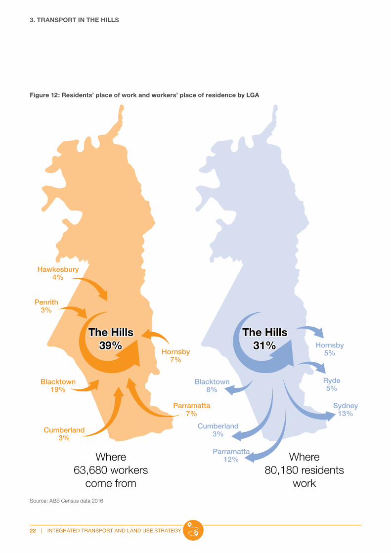
CommutingThirty-nine per cent of The Hills local workforce lives within the Shire, yet nearly 70 per cent of working residents work outside The Hills. Understanding where residents choose to work and where workers live helps to understand travel choices and infrastructure requirements.
Residents travelling outside the Shire for work mainly work in Sydney CBD and Parramatta, where the types of highly skilled and technical jobs align with the levels of education seen in the resident population. The local workforce, which has a higher proportion of lower skilled jobs than the resident workforce, draws primarily from The Hills and Blacktown, with contributions from Parramatta and Hornsby local government areas.
Source: ABS Census data 2016
Figure 11: Journey to work mode share
0%
10%
20%
30%
40%
50%
60%
70%
20162011200620011996
Per
cent
age
Year
Walking and cyclingCar – as passengerCar – as driverBus
Over the last 20 years, while the number of people travelling to work in their own vehicle has increased, the increase in bus patronage has seen the overall proportion of trips by private vehicle decline. Improvements in active transport use are yet to be realised; here, the potential lies in the renewal of Sydney Metro station precincts that will provide access to jobs and services within a walkable distance from people’s homes.
To support this, we will actively target industries that complement residents’ skills, particularly in knowledge-based industries including health, education, finance and professional and scientific services. The Productivity and Centres Strategy 2019 articulates our vision for employment and centres to 2036 and provides detail on employment supply and future demand for jobs and skills.
39% proportion of the The Hills local workforce that lives in the Shire
THE HILLS SHIRE COUNCIL | 21
3. TRANSPORT IN THE HILLS
Figure 12: Residents’ place of work and workers’ place of residence by LGA
The Hills39%
Where63,680 workers
come from
Where80,180 residents
work
Hawkesbury4%
Penrith3%
Blacktown19%
Cumberland3%
Parramatta7%
Hornsby7%
The Hills31%
Blacktown8%
Cumberland3%
Parramatta12%
Sydney13%
Hornsby5%
Ryde5%
Source: ABS Census data 2016
22 | INTEGRATED TRANSPORT AND LAND USE STRATEGY

Figure 13: Job types of resident workers and local workers (top eight locations)
24,870
The Hills
Sydney
Parramatta
Blacktown
Ryde
Hornsby
Cumberland
Hawkesbury
Penrith1,080
1,180
2,200
3,670
3,980
6,030
8,670
9,430 440
4,310
11,040
810
3,650
1,760
2,190
1,890
Key
Where residents work
Where workers come from
Hills residents who work in The Hills
= 100 jobs
Knowledge intensive
Health and education
Population serving
Industrial
Job types
Source: ABS Census data 2016
THE HILLS SHIRE COUNCIL | 23

3. TRANSPORT IN THE HILLS
Road network The Shire’s road network is supported by State roads on the eastern, western and southern boundaries including Old Northern Road, Windsor Road, Old Windsor Road, and the M7 and M2 motorways. Part of Windsor Road transects the Shire’s urban area north to south, supporting local and regional traffic and providing a connection to Parramatta.
Other arterial roads, including Memorial Avenue, Old Northern Road, Showground Road and Norwest Boulevarde provide east-west connections and feed traffic to major roads with greater capacity.
The regional road network experiences serious congestion, and this is likely to continue as the population and economy grows. Without significant investment in regional road infrastructure, traffic congestion will remain a barrier to housing and economic development.
Figure 14: The Hills Shire road network
Glenhaven RoadGlenhaven Road
Annangrove RoadAnnangrove Road
Annangrove Road
Annangrove Road
Pitt Town Road
Pitt Town Road
Pitt Town RoadPitt Town Road
Anna
ngro
ve R
oad
Anna
ngro
ve R
oad
Hynds RoadHynds Road
Nelson Road
Nelson Road
Nel
son
Ro
adN
elso
n R
oad
Lilian Road
Lilian Road
Lang Road
Lang RoadShoplands Road
Shoplands Road
Hes
sio
n R
oad
Hes
sio
n R
oad
Mason RoadMason Road
Old Town Pitt Road
Old Town Pitt Road
Red Gables Road
Red Gables Road
Blind RoadBlind Road
Joylyn RoadJoylyn Road
Hill Climb
DriveHill Climb
Drive
Blue Gum
RoadBlue Gum
Road
Campbell RoadCampbell Road
George StreetGeorge Street
Cataract Road
Cataract Road
Sedger Road
Sedger RoadWhitehall RoadWhitehall Road
Colbran AvenueColbran Avenue
Foxall Road
Foxall Road
Hezlett R
oad
Hezlett R
oad
Brid
gew
oo
d
Drive
Brid
gew
oo
d
Drive
Withers Road
Withers Road
Withers Road
Withers Road
Curtis Road
Curtis Road
Barry Road
Barry Road
Hillview Road
Hillview Road
Stringer Road
Stringer Road
Commercial Road
Commercial Road
Schofields Road
Schofields Road
Mile
End
Roa
d
Mile
End
Roa
d
Ade
lphi
Str
eet
Ade
lphi
Str
eet
Jones RoadJones Road
Kenthurst Road
Kenthurst Road
Pellitt Lane
Pellitt Lane
Gilb
ert R
oad
Gilb
ert R
oad
Ridgecrop D
rive
Ridgecrop D
rive
Yaringa Road
Yaringa Road
Castle Hill Road
Castle Hill Road
Evans RoadEvans Road
Acres Road
Acres Road GrangeRoad
GrangeRoad
Castle Hill Road
Castle Hill Road
Hig
hs R
oad
Hig
hs R
oad
Balmoral Road
Balmoral Road
Old W
indsor Road
Old W
indsor Road
Old N
orthern Road
Old N
orthern Road
Terr
y R
oad
Terr
y R
oad
Bou
ndar
y R
oad
Bou
ndar
y R
oad
Janp
iter R
oad
Janp
iter R
oad
Windsor R
oad
Windsor R
oad
Roseberry
RoadRoseberry
Road
President Road
President Road
Po
ole
Ro
adP
oo
le R
oad
Tuckwell Road
Tuckwell Road
Brit
anni
a R
oad
Brit
anni
a R
oad
Kings R
oad
Kings R
oad
Green R
oad
Green R
oadC
raigmore D
rive
Craigm
ore Drive
Greenw
ood
Road
Greenw
ood
Road
York Road
York Road
Crane Road
Crane Road
Middleton Road
Middleton Road
Barina Downs
RoadBarina Downs
Road
Barclay RoadBarclay Road
Murray Farm Road
Murray Farm Road
Hill
s R
oad
Hill
s R
oad
Taylor S
treetTaylo
r Street
Aiken RoadAiken Road
Oakes R
oadO
akes Road
Eaton RoadEaton Road
Penna
nt H
ills
Penna
nt H
ills
Oratara AvenueOratara Avenue
Excelsior Avenue
Excelsior AvenueCha
pel L
ane
Cha
pel L
ane
Mackillop Drive
Mackillop Drive
Norwes
t Boul
evar
d
Norwes
t Boul
evar
dBrighto
n Driv
e
Brighto
n Driv
e
Edgewater Drive
Edgewater Drive
Hoyle
AvenueHoyle
AvenueGladstone
RoadGladstone
Road
Victoria Avenue
Victoria Avenue
Che
lsea
Ave
nue
Che
lsea
Ave
nue
Norbrik Driv
e
Norbrik Driv
e
Bella Vista
DriveBella Vista
Drive
James Mileham Avenue
James Mileham Avenue
Samantha Riley Drive
Samantha Riley Drive
Marella
AvenueMarella
Avenue
Red
den
Driv
e
Red
den
Driv
e
Arnold AvenueArnold Avenue
Memorial Avenue
Memorial Avenue
Gainsford D
rive
Gainsford D
rive
Lexington Drive
Lexington Drive
Cecil Avenue
Cecil Avenue
Cross Street
Cross Street
Edward Street
Edward Street
Rai
lway
Str
eet
Rai
lway
Str
eet
Oak
land
Aven
ue
Oak
land
Aven
ue
Cro
pley D
riveC
rop
ley Drive
Bingara
Crescent
Bingara
Crescent
Coo
k St
reet
Coo
k St
reet
Castle Street
Castle Street
Harrington A
venue
Harrington A
venue
Glenrow
an
Avenue
Glenrow
an
Avenue
Cecil Avenue
Cecil Avenue
Church Street
Church StreetMar
ie S
tree
t
Mar
ie S
tree
tPars
onag
eAv
enue
Pars
onag
eAv
enue
Hud
son
Ave
nue
Hud
son
Ave
nue
Penn
ant S
tree
t
Penn
ant S
tree
t
Coonara A
venu
e
Coonara A
venu
e
Renown Road
Renown Road
Fr ancis Street
Fr ancis Street
Ban
nerm
an Road
Ban
nerm
an Road
North Rocks RoadNorth Rocks Road
Old Northe
rn R
oad
Old Northe
rn R
oad
Sanctuary Drive
Sanctuary Drive
Brampton Drive
Brampton Drive
The Park
way Drive
The Park
way Drive
Fairw
ay Drive
Fairw
ay Drive
Sole
nt Cct
Sole
nt Cct
Carind a D
rive
Carind a D
rive
Milford D
rive
Milford D
rive
Sagars Road
Sagars Road
Gre enbank Drive
Gre enbank Drive
Showground Road
Showground Road
Jasper RoadJasper RoadMerin
dah Road
Merindah Road
M2 MotorwayM2 Motorway
M2 Motorway
M2 Motorway
M7 M
otorway
M7 M
otorway
Peel Road
Peel Road
Windsor Road
Windsor Road
Windsor Road
Windsor Road
Caddies Boulevard
Caddies Boulevard
Windsor Road
Windsor Road
Rox
boro
ugh
Park
Roa
d
Rox
boro
ugh
Park
Roa
d
Carrington
RoadCarrington
Road
Baulkham Hills
RoadBaulkham Hills
Road
Go
od
enR
oad
Go
od
enR
oad
Wat
kins
Road
Wat
kins
Road
Arthur S
treetA
rthur Street
Pala
ceR
oad
Pala
ceR
oad
Seven Hills Ro
a
d
Seven Hills Ro
a
d
Wyoming RoadWyoming Road
Derriwong Road
Derriwong Road
Dav
ey R
oad
Dav
ey R
oad
Marieba RoadMarieba Road
Haz
eld
ean
Pl
Haz
eld
ean
Pl
Everett PlEverett Pl
Empe
ror P
l
Empe
ror P
l
Jeff
erso
n G
rJe
ffer
son
Gr
Kandara Cl
Kandara Cl
Nyari Road
Nyari Road
Clarke WayClarke Way
Porters Road
Porters Road
Cransto
ns Ro
adC
ranstons R
oad
Cadw
ells Road
Cadw
ells Road
Lawrence Road
Lawrence Road Hafey Road
Hafey Road
Garemyn RoadGaremyn Road
Mcleod R
oad
Mcleod R
oad
Bangor RoadBangor Road
RoughleyRoad
RoughleyRoad
Wandarri RoadWandarri Road
Fuggles RoadFuggles Road
Park R
oadP
ark Road
Old
No
rthe
rn R
oad
Old
No
rthe
rn R
oad
Windsor RoadWindsor Road
Key
Primary arterial
Arterial
Sub arterial
Major collector
Minor collector
Local roads
Private roads
THSC – LGA
0 700 1,400 2,800 4,200m
24 | INTEGRATED TRANSPORT AND LAND USE STRATEGY

Public transportSydney Metro Northwest provides high-speed mass transit between Tallawong Station and Chatswood, taking in the suburbs of Rouse Hill, Kellyville, Bella Vista, Norwest, Castle Hill and Cherrybrook.
The bus network remains essential to move people to and from the Shire to areas such as Blacktown and Parramatta centres, while also providing services from areas without direct access to Sydney Metro Northwest. Services and routes have been amended to support the Metro, including on-demand bus services around Bella Vista, Norwest and Hills Showground stations.
Active transport (walking or cycling)Walking and cycling currently account for approximately 10 per cent of trips made in The Hills. Despite a drop in walking in 2011, both walking and cycling are increasing in popularity as an option for commuting to work. This corresponds with improvements to the Shire’s active transport network and a greater diversity of employment options close to residential areas.
We provide an extensive network of footpaths and on and off-road cycleways, although there are some barriers to use, including topography, wayfinding and gaps in connections to places like schools and shops. Our Recreation Strategy 2019 identifies improvements to the regional and local active transport network.
Figure 15: Walking and cycling to work
0
200
400
600
800
1,000
20162011200620011996
No
. of
peo
ple
Year
Walk Cycle
Source: ABS Census data 2016
THE HILLS SHIRE COUNCIL | 25

26 | INTEGRATED TRANSPORT AND LAND USE STRATEGY

PLANNING PRIORITIES
This section outlines our priorities for the transport network and how we will achieve these priorities. The planning priorities will guide how we plan for the integration of the Shire’s transport network with different centres and land uses, as well as how we can influence a change to more sustainable travel in the next five years and beyond. The priorities are:
• build strategic centres to realise their potential and renew and create great places
• influence travel behaviour to promote sustainable choices
• plan for convenient, connected and accessible public transport
• expand and improve the active transport network
• plan for a safe and efficient regional road network.
Image courtesy of Transport for NSW
THE HILLS SHIRE COUNCIL | 27
4

4. PLANNING PRIORITIES
Figure 16: Movement and Place Framework
Fast movementLess place
Slow movementMore place
Motorways Vibrant Streets Local StreetsPlaces for
PeopleMovementCorridors
Source: Future Transport 2056
Great places are characterised by a mix of land uses and activities that provide opportunities
for social connection in walkable, human scale, fine grain neighbourhoods.”
Greater Sydney Region Plan 2018
Build strategic centres to realise their potential and renew and create great places
This relates to Planning Priorities 2 and 9 in Hills Future 2036.
RationaleBalancing the need to move people and goods with the need for vibrant, liveable communities can be difficult in a car-dominant area like The Hills. There is a general expectation that travel by private vehicle is available for most trips and is convenient and expedient.
Future Transport 2056 adopts a Movement and Place Framework to guide decision-making around how transport planning aligns with the planning for different places.
The Framework relates to how we classify the road network. The roads hierarchy is based on the levels of service each road provides, accounting for requirements such as traffic volumes, speed and load limits, ride quality and pavement durability.
This hierarchy aims to reflect the preferred movement of vehicles and guides road managers, users and land developers as to our intended road network objectives. The design of physical attributes such as width, pavement strength, surfacing and other design elements are determined by its road classification. The road hierarchy complements the Movement and Place Framework and will inform public domain plans for areas experiencing change and renewal.
The Productivity and Centres Strategy 2019 articulates the need for a Public Domain Strategy to enhance the amenity of strategic centres, ensuring they are great places to work and spend time connecting with others.
28 | INTEGRATED TRANSPORT AND LAND USE STRATEGY

• Long distance with limited access
• Supports through traffic and regional connections
• primary freight routes
• generally supports more than 15,000 vehicles per day
• Speed limits up to 90km/h
• Example: Winsdor Road
• Connects the sub-arterial roads to the local road system in developed areas
• Typically carries between 5,000 to 10,000 vehicles per day
• Speed limit of 50–60km/h
• Example: Gilbert Road
• Moderate to long distance with limited access
• Supports through traffic and regional connections
• Generally supports more than 15,000 vehicles per day
• Speed limits of 60–70km/h
• Example: Old Northern Road
• Links local roads to major collector roads
• Route discourages through traffic
• Generally carries fewer than 4,000 vehicles per day
• Speed limit of up to 50km/h
• Example: Tuckwell Road
• Moderate to long distance. Connects arterial roads to areas of development or carries traffic directly from one part of a region to another
• Generally carries between 6,000 to 20,000 vehicles per day including heavy vehicles
• Speed limit of 60km/h
• Example: Samantha Riley Drive
• Provide access to individual properties
• Generally carry fewer than 1,500 to 2,000 vehicles per day
• Speed limit of 50km/h or less
Figure 17: The roads hierarchy
Primary arterial
Major collector
Arterial
Minor collector
Sub-arterial
Local
THE HILLS SHIRE COUNCIL | 29

4. PLANNING PRIORITIES
Transit-oriented developmentTransit-oriented development represents compact, walkable, mixed use developments centred around mass transport. Higher density residential, commercial and retail development are focused on the transport hub. Development then transitions to lower densities on the edge of an 800 metre radius. Roads, cycleways and walking trails are safe, easy to navigate and provide healthier connections. (Daniels and Mulley, 2013).
Transit-oriented developments are central to urban renewal. The Hills Corridor Strategy (2015) employs transit oriented development principles to renew established areas around station precincts. It responds to the vision articulated in the NSW Government’s North West Rail Link Corridor Strategy (2013) and provides the local framework for housing and jobs growth to create liveable urban areas.
Figure 18: Transit-oriented development
Precinct planning for station precincts will focus on connectivity, locating higher density housing in areas that have the greatest potential for change, in easy walking distance to retail centres and stations.
Urban renewalA 30-minute city requires movement corridors to transport people and goods between centres. We need to plan for vibrant centres and local streets that become destinations for shopping, dining, meeting friends, working and connecting to transport. Freight and servicing activities should not detract from the amenity, safety and attractiveness of a centre, while ensuring deliveries and waste collection are timely and efficient.
Transport choices should be a key consideration of place-making and the intended function of the centre, community or place should influence transport planning. Public and active transport should be prioritised in centres and residential areas.
Precinct planning should consider the existing status of the transport network, its shortcomings and pinch-points and apply appropriate modelling to measure potential impacts, as well as forecast demand for transport, and how transport infrastructure and urban design may manage or reduce demand to balance movement and place functions. Consideration should also be given to the integration of smart technology that can improve management of parking demand and traffic flow.
While initial work has been undertaken for the station precincts, further detailed traffic studies are required to refine the information available and ensure precinct planning is based on accurate evidence.
Our Public Domain Strategy will provide an overall vision for the Shire’s public areas and guide the preparation of individual public domain plans for master planned areas.
The Public Domain Strategy will provide guidance on place principles and public domain elements that should be uniform across the Shire and decisions regarding appropriate transport provision.
Key
Train station
Rail
Road link
Local roads, pedestrian and cycle paths
Land use intensity/density
400m
800m
30 | INTEGRATED TRANSPORT AND LAND USE STRATEGY

Council will:• Use the zoning framework to identify the intention
for housing growth close to centres, services and transport.
• Prioritise place-making in new and emerging neighbourhoods.
• Prepare land use planning documents and respond to development applications and planning proposals in strategic centres in line with the structure plans and phasing strategies contained in Hills Future 2036.
Actions• Prepare and implement precinct plans and
development controls for Norwest, Castle Hill and Rouse Hill strategic centres.
• Prepare and implement a Public Domain Strategy to enhance the image and amenity of strategic centres.
• Prepare and endorse a policy to guide the implementation and use of evolving technologies in the urban environment.
We need to plan for vibrant centres and
local streets that become destinations
for shopping, dining, meeting friends,
working and connecting to transport.
THE HILLS SHIRE COUNCIL | 31
Public Domain StrategyOur Public Domain Strategy will direct works and improvements throughout the Shire. It will include:
• design principles applicable across the whole Shire
• key street design elements
• specific design principles for local, village and town centres, and business and industrial areas
• provision for precinct-specific public domain plans for:
– Baulkham Hills town centre
– Castle Hill strategic centre
– Norwest strategic centre
– Rouse Hill strategic centre.
The Public Domain Strategy will drive better place-making. Precinct-specific and Shire-wide plans will inform our Capital Works Program and provide direction and certainty to developers and planners preparing and assessing applications that have an impact on the public domain.

4. PLANNING PRIORITIES
Influence travel behaviour to promote sustainable choices
This relates to Planning Priority 12 in Hills Future 2036.
RationaleAs population increases, so too will the numbers of cars that use the existing road network and demand for car parking.
Based on existing levels of car ownership, an additional 72,000 vehicles could be located in The Hills by 2030. Future Transport 2056 does not identify any major new road connections to or through The Hills within the next 20 years, meaning additional vehicles will be added to the existing road network.
This increases the need to address congestion and encourage a shift to more sustainable transport modes.
The availability and location of car parking influences travel choices, from where and when people shop, or socialise, to how they travel to and from work. Most of the local workforce comes from outside the Shire and most by car. While car ownership and reliance remain high, parking will be required at the places people travel to and from.
We can influence travel behaviour through parking cost and availability that encourages alternative travel choices that are convenient and attractive while ensuring private vehicle travel is accommodated appropriately.
As noted in Figure 19, in places with easier access to mass, rapid public transport, the average number of cars per household is lower. Within The Hills, car ownership levels vary with location, with the lowest levels in Castle Hill where transport infrastructure integrates with high density development.
Reconsidering existing car parking rates for residential and commercial developments close to public transport, where car ownership levels are typically lower, and reducing parking opportunities at both origin and destination, will encourage greater use of public and active transport options.
Reducing required car parking rates may also reduce construction costs – for example, the average construction cost of a basement car parking space can be up to $50,000. This in turn may increase development viability and put downward pressure on housing prices.
Further to this, in order to support residents and workers in their travel mode decisions, it is important for Council to take an active role in working with transport providers to achieve improvements to bus routes and service frequency as needed.
32 | INTEGRATED TRANSPORT AND LAND USE STRATEGY

Figure 19: Vehicle ownership per household
No
. of
cars
Suburb
0.0
0.5
1.0
1.5
2.0
2.5
HurstvilleHornsbyMeadowbank –West Ryde
ChatswoodSt LeonardsSydney MetroCastle HillRouse HillThe Hills
Average car ownership per household
Source ABS Census 2016
Commuter car parkingAvailability of commuter car parking is increasingly a concern in the community. Concerns range from insufficient car spaces, use of local streets, impacts on streetscape, loss of amenity and convenience.
Commuter car parking facilities include:
• Memorial Avenue T-Way car park (150 spaces and 20 spaces on access road)
• Torrs Street, Baulkham Hills (224 spaces and 100 on-street spaces)
• Cherrybrook – 400 spaces
• Showground – 600 spaces
• Bella Vista – 800 spaces
• Kellyville – 1,360 spaces
• Tallawong (in Blacktown LGA) – 1,000 spaces.
We endorsed the Sydney Metro parking management strategy, which manages demand through parking restrictions in areas within a 400-metre radius of Sydney Metro stations. Recommended restrictions vary from two to four-hour limits to no parking and no stopping zones. The strategy was developed and adapted in consultation with Council and affected landowners. Recommended restriction zones were adopted by Council.
Research suggests that train patrons are likely to walk up to and beyond 800 metres to access train services. Subject to monitoring of parking conditions around Sydney Metro Northwest stations, potential strategies to manage car parking demand up to and beyond the 800-metre radius include:
• marginal expansion of off-street commuter car parking capacity at strategic sites
• integration of digital technology to provide real-time parking information
• pop-up commuter car parks utilising infrastructure in locations outside the 800-metre catchment, with the support of a dedicated shuttle bus service
• expansion of a pilot program for on-demand local minibuses to provide an alternative to commuter car parking in areas not well served by bus services.
THE HILLS SHIRE COUNCIL | 33

Paid parkingDemand for on-street parking close to rail stations and centres is likely to increase. The availability of convenient, accessible, safe and well-located short-stay parking for visitors and customers is essential to individual businesses and local economies.
Short-stay parking and space for loading purposes should be prioritised in centres. One example is Carmen Drive shops in the nearby City of Parramatta LGA which is near a prominent bus stop on the M2. Timed parking restrictions allow consumers to support local businesses.
The availability and cost of long-stay parking influences decisions on how people will get to work. Improving active and public transport, and limiting long-stay parking and including paid short-stay parking in appropriate locations, will encourage a change in travel behaviour, enhance the effectiveness of public transport and support economic vitality.
Initial areas for investigation for short-stay parking include:
• Baulkham Hills
• Castle Hill
• Norwest Service sub-precinct
• Box Hill.
Car sharingCar sharing is a convenient, affordable and sustainable transport option that enables more sustainable travel habits and helps keep businesses and residents connected. It allows a single vehicle to be used by a large number of people, reducing congestion and competition for parking spaces.
Encouraging car sharing in high density residential and commercial areas close to transport hubs may be supported through targeted development controls. These could include:
• reduced car parking rates for developments incorporating shared parking facilities in station precincts
• requirements for dedicated car sharing spaces for new developments
• dedicated on-street parking for shared vehicles.
Council will:• Seek to influence travel behaviour through careful
and technologically efficient management of parking demand.
• Consider the integration of smart technology in the management of parking systems and demand.
Actions• Review car parking rates for centres.
• Investigate and implement car parking controls for car sharing spaces in large scale commercial and residential development.
• Investigate metred short-term parking in key locations to manage parking demand and support businesses.
4. PLANNING PRIORITIES
34 | INTEGRATED TRANSPORT AND LAND USE STRATEGY

Plan for convenient, connected and accessible public transport
This relates to Planning Priority 11 in Hills Future 2036.
RationaleWhile Sydney Metro Northwest will be accessed by many new and future residents, bus networks are critical to providing equitable access to public transport, while supporting Sydney Metro operations.
The Shire is traversed by seven strategic bus corridors that carry people to and from key employment areas. They must be supported by local routes throughout the Shire to decrease the need for commuter car parking.
Investment in additional services, bus priority measures and supporting infrastructure has seen a steady rise in bus patronage and a small but significant mode shift away from private vehicle use. Continued investment will increase bus patronage and support Sydney Metro Northwest.
We have identified public transport priorities that include city-serving and city-shaping infrastructure identified in Future Transport 2056 as well as local and regional bus priority measures.
Norwest to Parramatta mass transit linkFuture Transport 2056 nominates a city-shaping link between Norwest and Parramatta as a 20-year visionary project with no firm commitment to planning at this stage.
By 2036, approximately 13,000 to 15,000 people will live in Norwest. Norwest is a strategic centre and has the highest jobs targets of any strategic centre in the Central City District outside of Greater Parramatta. Its success as an employment centre of district significance will rely on efficient connections.
A mass transit link between Norwest and Parramatta will secure the long-term viability of Norwest and support the growth of the Greater Parramatta and Olympic Peninsula (GPOP) economic corridor, cementing Parramatta’s role as the Central River City CBD.
All major connections between The Hills and Parramatta are by road, and these are frequently congested at peak times. While the Sydney Metro Northwest may relieve some of this congestion in the short term, given that nearly 12 per cent of Hills residents work in Parramatta, and 10 per cent of the workforce comes from Parramatta and Cumberland LGAs, pressure on the existing road network will remain and increase as the population increases.
A mass transit link between Norwest
and Parramatta will secure the long-term
viability of Norwest.
THE HILLS SHIRE COUNCIL | 35

4. PLANNING PRIORITIES
Figure 20: City Shaping Corridor – Parramatta to Norwest
Stra
thfield
WolliCreek
To Wollongong
Cronulla
Glenfield
Revesby
Cabramatta
Picton
The Bays Precinct
Bonnyrigg
Prairiewood
Carlingford
Kingsgrove
Malabar
Appin
Narell
an
Oran Park
BaulkhamHills
NorthAustral
Bondi Beach
Coogee
Schofields
Syden-ham
SydneyAirport
Dulwich
Hill
Blackt
ownMac
quarie
Park
Chatsw
ood
Rhodes
Green
Square
- Mas
cot
St Le
onard
s
OlympicPark
Hornsby
Mt Dru
itt
St M
arys
MirandaSutherland
Hurstville
Leppington
Frenchs Forest
Richmond
- Wind
sor
Fairfield
Mona Vale
Norwes
t
Kogarah
Epping
Randwick
Manly
Bondi Junction
Brookvale
- Dee Why
Eastg
arden
s
-Mar
oubra
Junc
tion
Rouse H
ill
Castle
Hill
MarsdenPark
Katoomba
BankstownBur
wood
CampsieLiverpool
Campbelltown-Macarthur
Greater Parramatta
Western SydneyAirport - BadgerysCreek Aerotropolis
GreaterPenrith
HarbourCBD
Strategic centre
Centre
City-shaping corridor
Regional connections
Metropolitan centre
Metropolitan cluster
Provides high capacity turn-up-and-go services across Greater Sydney and between the three cities.
City-shaping Network 2056
Source: Transport for NSW – Future Transport 2056
The current timeframe does not reflect the importance of this corridor to the Central City District and employment growth in Norwest and Parramatta. It is essential to attracting a diversity of jobs to Norwest and will ease pressure on the road network, particularly high traffic levels between Parramatta and The Hills and Blacktown LGAs.
Baulkham Hills is the only local centre identified in Future Transport 2056 for a mass transit link. Assuming the link is likely to be a Metro system, identification of a station box location in Baulkham Hills would reaffirm a commitment to the link. It also provides an opportunity to develop a bus interchange to support the route while planning and delivery of a mass transit link is underway. Possible locations for a future Sydney Metro station box include Crown land around the Baulkham Hills library or alternatively behind the Bull and Bush site. The library site is considered to be the optimal location with good access to Windsor Road and Old Northern Road and the ability to integrate with any future grade separation at Windsor Road and Seven Hills Road.
This should be supported by improvements to bus priority measures including extension of a bus lane north of Rembrandt Drive in Baulkham Hills to Norwest.
North South Rail LinkThe extension of the North South Rail Link from Tallawong Station to St Marys will provide access for Hills residents to the Western Sydney International Airport and serve workers who travel to The Hills from Western Sydney. It would provide faster commutes to Parramatta via the T1 Western Rail Line and act as an interim solution while the mass transit link between Parramatta and Norwest via Baulkham Hills is planned and constructed.
Local and regional bus priority measuresThe Hills sees some of the highest levels of bus patronage in the Central City District comparative to its population. The proportion of bus patronage in The Hills is greater than the proportion of rail patronage as a percentage of total trips in adjoining LGAs.
36 | INTEGRATED TRANSPORT AND LAND USE STRATEGY

Figure 21: Mode split 2018
0%
10%
20%
30%
40%
50%
60%
OtherWalk onlyBusTrainVehicle passengerVehicle driver
% o
f m
od
es
Type of transport
The Hills Blacktown Parramatta Cumberland Hornsby
Source: Transport for NSW Household Travel Survey
While the introduction of Sydney Metro Northwest is expected to shift the mode share in The Hills, bus services should continue to be supported with improved infrastructure to support commuters travelling to destinations not serviced by rail, including Parramatta and Western Sydney.
We have identified the following bus priority measures for arterial and local roads:
Arterial roads:
• Showground Road – from Old Northern Road to Carrington Road
• Norwest Boulevarde – full length
• Green Road – from St Pauls Avenue to Showground Road
• Memorial Avenue – full length
• Old Northern Road – Castle Hill to Baulkham Hills
• Windsor Road – Norwest Boulevard to Rembrandt Drive.
Local roads:
• West Pennant Hills – Highs Road, Taylor Street and Aiken Road (from Taylor Street to Oakes Road) with the bus lane extended to Castle Hill via a bus only bridge link over Excelsior Creek in the longer term
• North Kellyville – bridge from Ross Street to Edwards Road
• Station precincts.
Box Hill to Rouse Hill public transport corridorGrowth in greenfield areas, particularly Box Hill and Box Hill North, will not be directly serviced by rail services. The greenfield areas are expected to accommodate close to 56,000 people and are already 35 per cent complete. To better connect people to both rail and T-way services, a link is required between Box Hill and Rouse Hill. We have preserved a public transport corridor in Rouse Hill along Withers Road, Mile End Road and Green Hills Drive. Investigations are required to identify the best continuation of the corridor and appropriate transport mode, whether that be light rail or bus, to maximise opportunities for residents in the North West Growth Area to access fast, reliable public transport.
THE HILLS SHIRE COUNCIL | 37

4. PLANNING PRIORITIES
Figure 22: Box Hill to Rouse Hill corridor identification
Rouse Hill
Box Hill
KEY
Urban Growth Boundary
LGA Boundary
Metro station
Corridor investigation area
Council will:• Collaborate with Transport for NSW to identify and
preserve a public transport corridor between Rouse Hill and Box Hill and determine the most appropriate transport mode.
• Monitor the effectiveness of the NSW Government’s Sydney Metro parking management strategy and identify improvements or appropriate extensions to its area of operation.
Actions• Identify preliminary corridor and station box options
and advocate for the earlier planning for a mass transit link between Norwest and Parramatta.
• Seek NSW Government commitment to the early planning and delivery of the North South Rail Link between Tallawong Station and St Marys.
• Plan for and advocate to Transport for NSW when appropriate for local bus priority measures as identified.
• Commence a pilot program of pop-up commuter car parking.
38 | INTEGRATED TRANSPORT AND LAND USE STRATEGY

Figure 23: Accidents involving cyclists
0
5
10
15
20
25
30
ParramattaBlacktownCumberlandThe Hills
Num
ber
of
acci
den
ts in
volv
ing
cyc
lists
LGA
2013 2014 2015 2016 2017
Source: Transport for NSW crash and casualty statistics
Expand and improve the active transport network
This relates to Planning Priority 13 in Hills Future 2036.
RationaleIncreasing the use of the active transport, especially for short trips, will benefit residents and reduce traffic congestion. Our Recreation Strategy 2019 identifies improvements to the regional and local active transport network.
Walking is an important travel mode and is often associated with trips that also involve bus, rail or car. Walking and cycling influences the design of attractive, liveable areas with street activity, improved safety and a quality public environment.
Traffic congestion generated by short trips under five kilometres could be reduced by shifting from car trips to walking or cycling. The Shire’s network includes 523 kilometres of footpaths and 82 kilometres of cycleways. Our adopted Footpath Strategy identifies the proposed level of service for the provision of footpaths in the Shire.
Increasing cycling numbers has coincided with an increase in accidents involving cyclists in The Hills. Further improvements to the off-road cycling network may reverse this trend.
Our Bike Plan was last reviewed in 2009 and requires review in light of recent and expected growth. It shows regional, subregional and local links and identifies missing links that could increase patronage and safety. The Bike Plan seeks to identify more direct routes that work with the local topography.
The Sydney Metro Northwest pedestrian and cycle strategy identifies options for improvements to on and off-road cycle and pedestrian networks. Some will be provided by Sydney Metro Northwest with others provided by different bodies, including Council. The review of the Bike Plan will consider the options and how they can be delivered. Public domain plans for station precincts will consider any new on and off-road cycle and pedestrian links and these will be incorporated into our Bike Plan review.
THE HILLS SHIRE COUNCIL | 39

4. PLANNING PRIORITIES
Figure 24: Excerpt from the Sydney Metro Pedestrian and Cycle Strategy
42
1
B
F
E
3IJ
CInglewood PlaceInglewood Place
Ridgehaven Place
Ridgehaven Place
Jacqui Circuit
Jacqui Circuit
Centu
ry C
ircuit
Centu
ry C
ircuit
Barina Downs Road
Barina Downs Road
Fairmont Avenue
Fairmont Avenue
Lakeview Close
Lakeview Close
Bethany Court
Bethany Court
Reston G
range
Reston G
range
Evesham
Court
Evesham
Court
Fairwoo
d Drive
Fairwoo
d Drive
Norwest BoulevardNorwest Boulevard
Norwest Boulevard
Norwest Boulevard
Brookhollow Avenue
Brookhollow Avenue
NorwestMarket
Town ShoppingCentre
KeyStudy area
Station precinct
Station box (approximate)
Station entrance (approximate)
Existing infrastructureFootpath
Off-road cycleway*
Delivered by Sydney Metro Northwest†
Footpath
Off-road cycleway*
Zebra crossing
Delivered by othersOn-road bike lane^
Zebra Crossing
Further recommendations†
Off-road cycleway*
Zebra Crossing
Cyclist prioritisedintersection
* Includes separated cycleways, shared pathways, green links.^ Subject to confirmation of separation requirements based on vehicle volumes and speeds. † Alignments and facility type subject to change based on design/specification development.
0 400m200m100m
Work has commenced on identifying trip generators outside station precincts, overlaid with existing and proposed cycleway improvements. This work will continue as part of the Bike Plan review to identify gaps and opportunities to improve connectivity.
Insufficient wayfinding may influence mode choice. To maximise patronage, active transport networks need to be direct and legible and it should be easier to identify access points to active transport networks. The Bike Plan review will address wayfinding.
Council will:• Progressively identify and fill the gaps in the network
of off-road cycleways and footpaths.
• Support the health and wellbeing of residents by prioritising active transport links in centres and residential areas.
Actions• Review and update the Bike Plan.
• Improve wayfinding on existing and proposed cycleways.
Source: Sydney Metro Pedestrian and Cycle Strategy
40 | INTEGRATED TRANSPORT AND LAND USE STRATEGY

Figure 25: Southbound traffic counts – Windsor Road, Old Northern Road and Renown Road, 2018
Mer
inda
h Road
Old
No
rthe
rn R
oad
Cross Street
Park
Str
eet
Seven Hills Road
M2 Motorway
Cook
Stre
et
Renow
n Road
Wind
sor R
oad
Rox
boro
ugh
Park
Road
Baulkham Hills
21,000
15,500
26,000
9,500Key
Southbound traffic on Old Northern Road
Southbound traffic on Windsor Road
Southbound traffic on Windsor Road/Renown Road
Plan for a safe and efficient regional road network
This relates to Planning Priority 14 in Hills Future 2036.
RationaleTraffic congestion is a source of frustration for Hills residents and contributes to a negative view of growth and change. While improvements to public transport will alleviate some congestion in the short term and localised
improvements will support efficiencies in the regional network, the level of service on arterial and regional roads is critical to a growing population and an effective freight network.
Source: RMS
THE HILLS SHIRE COUNCIL | 41

4. PLANNING PRIORITIES
Traffic congestionReducing traffic congestion requires holistic consideration of the entire transport network, not just road capacity. Infrastructure and policy associated with adjustments to parking supply, public transport, walking and cycling and land use can all contribute to, and can potentially make better use of, available road capacity.
Traffic counts within The Hills and adjoining LGAs speak to the large volumes of traffic movements to and through the area each day. Southbound and eastbound movements are important for residents of the Shire and adjoining LGAs who work in Parramatta, Hornsby, Ryde and Sydney CBD.
Southbound traffic travelling through Baulkham Hills to Parramatta is a concern. More than 30,000 vehicles travel through the intersection of Windsor Road, Old Northern Road and Seven Hills Road each day, with a portion then entering the M2 southbound; however, most are likely to continue on to Parramatta. Despite variable lane directions (tidal flow) on Windsor Road and improved bus services, this route remains subject to significant congestion.
East-west movements represent trips in and out of Blacktown and Hornsby LGAs and serve as an alternative route for people travelling northbound towards the M1 and southbound along Pennant Hills Road to the North Shore and Sydney CBD. Annangrove Road facilitates east-west movements, capturing residents from The Hills and Blacktown LGAs, particularly from the developing North West Growth Area precincts. We commissioned a traffic and transport assessment of the length of Annangrove Road in 2018 to identify and evaluate different strategic options taking into account extra traffic from the growth of the adjacent areas.
While most sections of Annangrove Road operate at a satisfactory level of service (levels A-C), some including between Bannerman Road, Sedger Road and Angus Road are nearing capacity (level D) with up to 970 vehicles passing through during the morning and afternoon peak hour, equivalent to volumes expected on regional, rather than local roads.
With Box Hill and Box Hill North currently only a third developed, initial analysis suggests the current configuration of Annangrove Road is unlikely to be able to support projected traffic demand to 2036, with the easternmost sections estimated to reach an F level of service where delays are extreme and unsatisfactory. Suggested improvements to accommodate growth include:
• widening to form a dual lane divided carriageway separated by a central median
• traffic signals at intersections with Withers Road and The Water Lane
• roundabouts at strategic locations including intersections with Edwards Road and Bannerman Road.
30,000+Number of vehicles that travel through
the intersection of Windsor, Old Northern and Seven Hills roads each day
42 | INTEGRATED TRANSPORT AND LAND USE STRATEGY

Figure 26: Eastbound traffic movements – Annangrove Road
Kenthurst
Northern R
oad
Hynds Road
Mile EndRoad
Dural
North Kellyville
Annangrove
Rouse Hill
Nelson
Box Hill
Source: TSA 2018
Level of service
Satisfactory Unsatisfactory/extreme
A B C D E F
Existing eastbound level of service 2018
Kenthurst
Northern R
oad
Hynds Road
Mile EndRoad
Dural
North Kellyville
Annangrove
Rouse Hill
Nelson
Box Hill
Estimated eastbound level of service in 2036, assuming no changes to existing road configuration
THE HILLS SHIRE COUNCIL | 43

4. PLANNING PRIORITIES
FreightEfficient freight links facilitate smooth and effective movement of goods, allowing supply chains to function smoothly and influence new markets. Currently, businesses in The Hills are somewhat limited in the freight routes they can access; in the absence of heavy rail, freight must move on the road network.
Freight movements originating in the Shire’s urban area (shown in red in Figure 27) travel north to the Central Coast, east to Sydney CBD and south and west towards Port Botany and heavy rail at Blacktown. Freight movements originating in the north of the Shire around extractive industry sites at Maroota (shown in light orange) predominantly travel to markets to the south. Most of these materials are sold locally within Sydney.
Planning for freight and servicing of residential and commercial development is crucial to how the Shire works and connects to adjoining areas, Greater Sydney and beyond. Planning for freight is a shared responsibility between the NSW Government and councils. Transport for NSW identifies and protects key freight corridors and builds transport infrastructure.
Figure 28 shows the existing freight corridors and networks that traverse the Shire: the M2/M7 Motorway, Old Northern Road, Windsor Road, Pennant Hills Road and Norwest Boulevarde.
Figure 27: Freight movements
B59 M1
A3
A8A38
A34
M5
A9
M4M7
A1
B69
M1
M31
B65
B88
M1
Sydney
Richmond
Wollongong
Port Kembla
Campbelltown
Penrith
Gosford
Central Coast
Key
Primary freight movements
Primary freight movementsfor extractive industry
Source: Transport for NSW – Strategic Freight Model
44 | INTEGRATED TRANSPORT AND LAND USE STRATEGY

Figure 28: Freight and logistics precincts and key freight corridors through the Shire
Parramatta
Castle HillNorwest
Blacktown
Kellyville
Bella Vista
Rouse Hill
Cherrybrook
BaulkhamHills
WinstonHills
Dural
RoundCorner
Kenthurst
Glenorie
Box HillNorth
Box Hill
North Kellyville
Annangrove
Glenhaven
Kellyville
KEY
LGA BoundaryUrban Growth BoundaryMetropolitan Rural AreaNorth West Growth AreaStation precinctsIndustrial landsBusiness parksRetail and specialised retail landExisting freight routesExisting shopping centres/supermarketsPlanned shopping centres/supermarketsMetro station
Metropolitan centres
Strategic centres
Town centres
Rural villages
Transit centres
THE HILLS SHIRE COUNCIL | 45

4. PLANNING PRIORITIES
Figure 29: Changes in freight demand in The Hills Shire to 2036
Dural/Wisemans Ferry
Rouse Hill
Baulkham Hills
42%
25%
41%
36%
43%
46%
34%
41%
57%
88%
125%
91%
Key
Total freight (inbound and outbound)
Consumer goods (inbound)
Construction products (inbound)
Waste (outbound)
Source: Transport Performance and Analytics TfNSW
There will continue to be strong demand for construction materials for new infrastructure, and residential and commercial development. Increasing consumer deliveries through e-commerce means there is a need for key transport connections to be preserved and improved. Waste volumes will increase significantly as the Shire’s population grows. As existing landfill capacity is depleted, waste will increasingly need to be transported further afield.
We have identified key strategic improvements to the regional road network that would improve how people and goods are moved.
Outer Sydney OrbitalConsultation on the proposed corridor preservation for the Outer Sydney Orbital in 2018 resulted in the extent of the identified corridor being reduced to end at Richmond Road. Future Transport 2056 identifies the extension of the road as a 20-year visionary project.
Identifying this corridor early will underpin planning for growth in The Hills and surrounding LGAs. The developing business park and industrial estate at Box Hill will rely on the orbital to connect to the Western Sydney International Airport and the Central Coast, the Shire’s primary freight destination. Identifying a corridor and committing to construction of the orbital will ensure the success of the fledgling business park and industrial areas, while protecting the long-term viability of freight routes servicing existing industries and extractive industries in the north of the Shire, as well as the wider area.
Annangrove Road arterial and Round Corner bypassThe Annangrove Road bypass has previously been identified as a priority but is not identified in the Greater Sydney Region Plan or Central City District Plan. Annangrove Road currently connects Windsor Road and Pennant Hills Road via New Line and Boundary roads at Dural. As noted earlier, the development the North West Growth Area will see unacceptable levels of service on Annangrove Road.
Amending the status of Annangrove Road to arterial will help to secure funding for upgrades. In conjunction with this, a bypass of Kenthurst Road to connect directly
Freight demand in Greater Sydney is being transformed by population and economic growth, and changing consumption patterns. Figure 29 shows the expected changes in freight demand for the Hills Shire to 2036.
46 | INTEGRATED TRANSPORT AND LAND USE STRATEGY

with Old Northern Road then New Line Road could ease congestion around Dural and Round Corner.
Grade separation at Windsor Road and Seven Hills RoadResidents who live in and around Baulkham Hills face traffic congestion and delays each day. We have prepared concept plans for either a partial or full grade separation of Windsor and Seven Hills roads and have long advocated for grade separation to improve the intersection capacity and the through traffic speed.
This approach has not been supported by the NSW Government to date. As these are regional roads and most of the traffic is through traffic, we will continue to advocate to NSW Government for grade separation. With the mass transit link between Greater Parramatta and Norwest via Baulkham Hills many years away, in the short term, grade separation at this intersection must be considered in the context of how it could potentially work with the mass transit link.
Freight logisticsThe local road network must have capacity to accommodate delivery vehicles, removalists and waste collection vehicles in addition to increased local traffic. This task presents challenges where existing streets are narrow and on-street parking inhibits manoeuvring room for larger vehicles. For Showground Station Precinct, the development control plan provides for widening of some local streets to facilitate parking on one side and improve the function of the road network.
One of Council’s largest freight tasks is in the transfer of waste for disposal at distant facilities. Waste management needs to be approached from both a reduction and logistics standpoint. The Environment Strategy 2019 details our approach to reducing the waste burden through improved separation and potential for on-site organics processing in high density areas, and potential planning controls to facilitate more efficient waste collection.
The changing nature of retail trade and increased reliance on online shopping and delivery is changing the nature of urban freight logistics. The introduction of local distribution premises as a land use term in the local
environmental plan seeks to permit smaller distribution centres, close to populated areas, using vehicles more appropriate within an urban environment. Presently, local distribution centres are permissible with consent in the following zones:
• B5 Business Development
• B6 Enterprise Corridor
• B7 Business Park
• IN1 General Industrial
• IN2 Light Industrial.
Based on the above zones, it is technically possible to locate local distribution premises within five kilometres of most populated urban areas of the Shire. We will monitor uptake to better understand demand and any barriers. If existing zoned land is insufficient or unviable, we may investigate alternative locations suitable for local distribution premises and determine whether the use should be extended to other zones.
Council will:• Advocate for regional road projects that will benefit
the Shire as well as Greater Sydney.
• Monitor traffic levels on key regional roads to pinpoint timing for necessary upgrades.
• Monitor uptake of local distribution centres and consider if the use is appropriate in additional zones to improve the efficiency of the freight network.
• Consider opportunities to improve local road networks to better accommodate delivery vehicles, removalists and waste collection as part of precinct planning.
• Review development controls for commercial and higher density residential development to ensure efficiencies of deliveries and servicing.
Actions• Work with the NSW Government to revise the status
of Annangrove Road to an arterial road.
• Plan for and seek NSW Government support for grade separation at the intersection of Old Northern Road/Seven Hills Road and Windsor Road, Baulkham Hills.
THE HILLS SHIRE COUNCIL | 47

48 | INTEGRATED TRANSPORT AND LAND USE STRATEGY

IMPLEMENTATION, MONITORING AND REVIEWImplementation and deliveryThe actions in this Strategy will be implemented in accordance with the Implementation Plan supporting Hills Future 2036.
StakeholdersStakeholders who will help us to deliver the actions include:
• residents
• surrounding councils
• State agencies including the Greater Sydney Commission, Department of Planning, Industry and Environment
• the development industry.
Planning instrumentThe Integrated Transport and Land Use Strategy 2019 suggests potential changes to planning controls following further investigations and precinct planning work. We expect to complete these precinct plans and subsequent planning proposals by the next five-year review.
Proposed amendments that do not warrant detailed planning or further investigations will be included in the review of The Hills Local Environmental Plan.
Monitoring and reviewThe Integrated Transport and Land Use Strategy 2019 will be monitored annually and reported to Council to inform future review programs. We expect to review, exhibit and re-adopt the Strategy every five years to ensure transport networks and services meet the needs and lifestyles of The Hills community.
Image courtesy of Transport for NSW
THE HILLS SHIRE COUNCIL | 49
5

Rhonda Daniels and Corinne Mulley, 2013. ‘Explaining walking distance to public transport: The dominance of public transport supply’ in The Journal of Transport and Land Use, vol 6, no.2, pp5–20
Active Healthy Kids Australia 2015. The Road Less Travelled: The 2015 Active Healthy Kids Australia Progress Report Card on Active Transport for Children and Young People. Adelaide, South Australia: Active Healthy Kids Australia
TSA (commissioned by The Hills Shire Council) 2018 Traffic and Parking Impact Statement – Strategic Analysis of Annangrove Road between Windsor Road and Kenthurst Road
References
50 | INTEGRATED TRANSPORT AND LAND USE STRATEGY

THE HILLS SHIRE COUNCIL | 51

The Hills Shire Council
+61 2 9843 0555 During business hours (8am – 4.30pm Mon – Fri)
The Hills Shire Council3 Columbia Court, Norwest 2153
The Hills Shire CouncilPO Box 7064, Norwest 2153
thehills.nsw.gov.au
If you do not speak English and need an interpreter, please contact the Translating and Interpreting Service on 131 450 and ask them to call Council on 9843 0555.