Research Institute from University of Belgrade Affiliated center of ICGEB, Trieste, Italy

Pobrano z http://repo.pw.edu.pl / Downloaded from Repository of Warsaw University of Technology 2022-02-23

InstItute of ArchAeology, BelgrAdeMonographs Vol. 58
AerIAl ArchAeology reseArch groupoccasional publication no. 6
Pobrano z http://repo.pw.edu.pl / Downloaded from Repository of Warsaw University of Technology 2022-02-23

Published byInstitute of Archaeology, Belgrade[series editor-in-chief Miomir Korać]
Aerial Archaeology research group
Book design and prepressdanijela paracki & d_sIgn, Belgrade
Printed bytronIK dIzAjn, Belgrade
Circulation300 copies
IsBn 978-86-80093-99-4
Acknowledgements
this volume has been supported by a number of institutions whose assistance is gratefully acknowledged.
financial support for the production of this book has been provided by the Ministry of education, science and technological development of the republic of serbia, the Aerial Archaeology research group (AArg) and the Ace foundation (Association for cultural exchange).
Archaeolandscapes europe provided support throughout, with additional assistance from the Institute of Archaeology, Belgrade, the Adam Mickiewicz university in poznań, the department of Archaeology at the university of szczecin, the royal commission on the Ancient and historical Monuments of scotland (now historic environment scotland), the research centre of the slovenian Academy of sciences and Arts, ljubljana, and the remote sensing and photogrammetry society (rspsoc).
Pobrano z http://repo.pw.edu.pl / Downloaded from Repository of Warsaw University of Technology 2022-02-23

Recovering lost landscapes
Edited by
Vujadin IvaniševićTatjana VeljanovskiDavid CowleyGrzegorz Kiarszys& Ivan Bugarski
Belgrade 2015
Pobrano z http://repo.pw.edu.pl / Downloaded from Repository of Warsaw University of Technology 2022-02-23

List of ContEnts
page 7
Vujadin Ivanišević, tatjana Veljanovski, david cowley, grzegorz Kiarszys & Ivan Bugarski Recovering Lost Landscapes – introduction to an aerial perspective
page 11
rog palmer Why are historical aerial photographs categorised as something special?
page 21
grzegorz Kiarszys Why are maps often misleading about archaeological sites? Ideology, maps, ALS and historical aerial photographs of district Góra, Lower Silesia Region, western Poland
page 35
dawid soszyński, cyprian jaruga, Barbara sowińska-Świerkosz A river in a rural public space in the early 1940s: a case study of the Bug river valley (East Poland)
page 45
Agnieszka latocha Recovering the lost landscapes of abandoned villages in the Sudetes Mountains, southwest Poland
page 57
Vujadin Ivanišević, Ivan Bugarski Landscape reconstruction in the Middle Danube Roman Limes: case studies from Lederata and Smorna
page 67
Brais X. currás, María ruiz del Árbol, f. javier sánchez-palencia, Almudena orejas, damián romero Ancient landscapes of north-western Iberia: historical aerial photographs and the interpretation of Iron Age and Roman territories
Pobrano z http://repo.pw.edu.pl / Downloaded from Repository of Warsaw University of Technology 2022-02-23
page 79
chris Musson, toby driver Recovering lost landscapes in Wales
page 89
Miloš B. petričević Aerial photography and remote sensing on the Karst: a case study of Boka Kotorska Bay, Montenegro
page 97
helen Winton Recovering lost or hidden landscapes – Aerial photographs and the English National Heritage Protection Plan
page 107
rafał zapłata, sebastian różycki Historic aerial photographs in the analysis of cultural landscape – case studies from Poland
page 117
gianluca cantoro Aerial photogrammetry: when archaeology meets SIFT
page 129
cristina charro lobato Historical aerial photographs to recover a lost landscape using digital photogrammetry: a case study of the Iron Age site of Cerro de la Mesa (Alcolea de Tajo, Toledo, central Spain)
page 141
tatjana Veljanovski, Žiga Kokalj 3D model generation and landscape change: contributions to image-based digital retrospection of the village of Breginj
page 155
sławomir Królewicz, lidia Żuk To trust or not to trust: maps vs. aerial photographs within political discourse
Pobrano z http://repo.pw.edu.pl / Downloaded from Repository of Warsaw University of Technology 2022-02-23

107 — Recovering Lost Landscapes
introductionaerial photographs are widely recognised as a highly valuable source of information for cultural heritage and environment studies (for example: Herbrich 2012; Bedkowski, Górski 2007; Mularz, drzewiecki 2008; cowley, Ferguson 2010; cowley et al. 2010). For the authors, aerial photographs are the subject of integrated studies within a multi-disciplinary scientific project analysing the use of remote sensing in the protection, analysis and research of cultural heritage, primarily archaeology and architecture (Zapłata, in print). the project has already seen the growth of the database of sources, the development of new digital databases of cultural heritage and the development of non-invasive methods for the protection and research of archaeo-logical and architectural heritage.
the central aim of this article is to present examples of the use of historic aerial photographs for cultural heritage, in the context of resources from polish and foreign collections, mainly from World War II, and with a special focus on vertical photographs. Following an overview of the availability of imagery and of archives holding material for poland, some case studies are presented in which aerial photographs provided one of the few, or even the only, available sources for the study of anthropogenic objects that have been altered or de-stroyed. the case study deals with the vicinity of Iłża, Mazowieckie province, using aerial photographs from 1944, amongst other sources (Różycki 2014, 4).
WorLdWide archives of historic aeriaL photographs for poLandaerial photographs of poland are scattered across various archives in europe and north america. often, the lack of information about these collections is a major obstacle to their use, and so this section presents the polish and international archives holding collections of aerial photographs dating from 1938 to 1960.
national archives and record administration (nara)the national archives and Records administration (naRa) is an agency of the usa Government respon-sible for the protection and preservation of governmental and historic records as well as for providing access to the collections. these include aerial and satellite imagery, and of particular importance for this paper, aerial photographs captured during World War II. the main parts of this collection are summarised below.
Rafał Zapłata1, sebastian Różycki2 1 Cardinal Stefan Wyszyński University in Warsaw [email protected] 2 Warsaw University of Technology, Laboratory of Remote Sensing, Photogrammetry and GIS [email protected]
Historic aerial photographs in the analysis of cultural landscape – case studies from poland
abstract: This paper discusses issues related to (1) the acquisition of archival resources, (2) the quality of historical aerial photographs, including their spatial resolution, and (3) their potential for the study of cultural heritage.The scope and applicability of archive material to the study of cultural landscape is also discussed focussing on (1) archival aerial photographs as a source to identify heritage objects and make inventories, and for (2) monitoring change and damage to historic objects in the past.
Pobrano z http://repo.pw.edu.pl / Downloaded from Repository of Warsaw University of Technology 2022-02-23
record group 373Record Group 373 includes aerial and satellite pho-tographs and cartography, within which sub-group 373.3 is the allied and German-flown aerial photo-graphs covering the period 1935–1960, including 2.863.800 allied photographs and 1.209.520 Ger-man images (cowley et al. 2010, 2). photographs in record group 373.3 are difficult to access because the catalogues have not been updated since the 1960s. the first attempts to catalogue this collection have already been undertaken (crawshaw 2001, 46; Rączkowski 2004, 9; Going 2006, 30).
Luftwaffe-flown records held in this archive in-clude original paper prints kept in cardboard boxes, approximately 32 x 32 cm in size. some photo-graphs are stuck together and some show mechanical damage while a significant number have scratches caused by repeated scanning (Figure 1). the major-ity of Luft waffe photographs of poland date from 1944–45, and relate to the intensity of German aerial reconnaissance on the eastern Front. a smaller collection covers the period 1939–43, and may have been used to produce 1:25000 photomaps (Ger. Bildplan/Bildskizze). there are also German photo-graphs antedating World War II, made most prob-ably by special aerial reconnaissance units. the smallest set of photographs (in comparison to other parts of the country) covers the coast of the Baltic sea. no German photographs focus on this area. easily available are photographs of large cities, and middle- and small-sized towns. photographs made in various years and to various scales are accessible.
the largest accessible collection in naRa is the allied aerial photographs, which are kept as original negative films in metal cans held in off-site cold storage that require one or two days to retrieve.
Individual users are not permitted to scan photographs, though the viewing room is equipped with light tables (for example Richards). the archive allows chosen private firms to scan photographs; such services are subject to a fee. to this fee, additional charges by the archives are added that cover loan charges of “cans”.
allied and German aerial photos from this collection are not often used by researchers in poland, although recent aerial photos from naRa are used by private persons in poland to prove property boundaries.
record group 242Record group 242 consists of the so called alexandrian microfilms, which are copies of German records cap-tured towards the end of World War II by the american army. the collection consists of approximately 75.000 rolls. polish archives hold approximately 24.000 rolls, of which 7500 are kept in the central archives of Modern Records in Warsaw. this extensive naRa collection includes microfilmed aerial photographs as well as instructions and guidebooks for the interpretation of aerial imagery. the quality of the microfilm is not very high and its conversion to a digital format makes the interpretation of the aerial photographs more difficult. often, aerial photographs are attached to microfilmed German documents and are not annotated. one way to find aerial photographs in this collection is to search the available catalogues (Guides to German Records Microfilmed at alexandria, Va, naRa/t-733) using names of polish towns and cities and the key word ‘aerial photo’. For example, the Guides for division (naRa/t-314) records that Roll 367 contains photographs of important tactical and strategic targets from the polish campaign during september 6–11 1939.
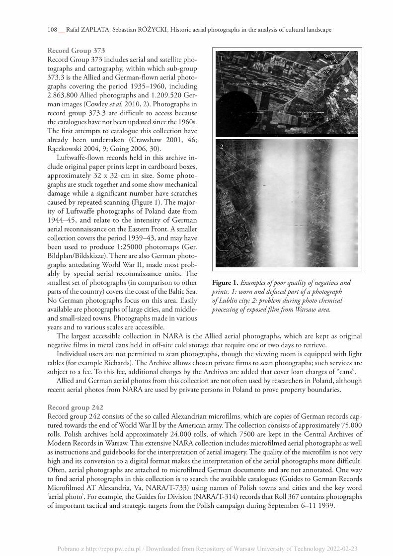
108 — Rafał Zapłata, sebastian RóżYcKI, Historic aerial photographs in the analysis of cultural landscape
figure 1. Examples of poor quality of negatives and prints. 1: worn and defaced part of a photograph of Lublin city; 2: problem during photo chemical processing of exposed film from Warsaw area.
1
2
Pobrano z http://repo.pw.edu.pl / Downloaded from Repository of Warsaw University of Technology 2022-02-23

109 — Recovering Lost Landscapes
national collection of aerial photography the national collection of aerial photographs (ncap), formerly known as the aerial Reconnaissance archives (taRa), is based in edinburgh and holds an extensive collection of aerial photographs from WWII described by cowley et al. (2013).
access to records is through the search room in edinburgh or through the website of the institution (aerial.rcahms.gov.uk). It is possible to order a paid image search. Where images have been digitised low-resolution ‘thumbnail’ photos can be viewed free of charge, while for a modest subscription enhanced quality images and extra features, such as photomosaics data, are available (cowley 2013, 23). currently (december 2014), 2952 allied aerial reconnaissance aerial photographs of poland area accessible online. those photos are well catalogued and annotated, and can be exported to a kml file and viewed with the help of GIs soft-ware or in Google earth.
public records office (pro)the national archives of the united Kingdom holds a small collection of photographs and interpretative records for poland. Records for this area can be found in two groups:
_ allied interpretative records based on aerial reconnaissance, describing strategically important areas, such as industrial sites, airports, oil refineries (those records belong to group aIR 34/40),
_ bulletins and magazines published during World War II, presenting spectacular successes of allied forces in sea and land operations, based, among other, on information gathered through aerial recon-naissance. an example of such a magazine is IMpact. those records belong to group aIR 23.
Interpretive reports for poland concern, for example, the military training ground in Blizna (aIR 40/2517, aIR 34/718), an aircraft replacement parts factory (aIR 34/694), an oil refinery in trzebinia (aIR 34/696, aIR 34/697), and the port area and submarine building-yards in Gdańsk (aIR 34/642, aIR 34/643). the majority of these photos and documents have not as yet been published.
herder institute, marburg, germanythe Herder Institute holds a well annotated and catalogued collection of approximately 6300 vertical aerial photographs of east-central europe taken by the Luftwaffe during 1942–1945 (Kreft, 2000; http://www.herder-institut.de/bildkatalog/). of these, 5395 cover areas within the modern borders of poland (Western pomerania, pomerania and Warmia-Masuria provinces). the online catalogue can be searched by key words, such as historic or modern place-names, and provides previews of photographs spatially referenced through a Google Maps pin.
central military archive, czech republica small collection of historic aerial photographs is available in the central Military archive of the czech Republic (praha). photographs from this archive, featuring for example the Modlin stronghold and Gdańsk, have been published by dubánek (2014).
state archive of the russian federation, russiathe least recognized archive in terms of the accessibility of aerial photographs is the state archive of the Russian Federation (GaRF) in Moscow (Russia). despite numerous accounts of a mass use of aerial photographs by the Russians during World War II, the number of photographs is relatively low, but probably include images of poland (crawshaw 2001, 47).
poLish archives of historic aeriaL photographsthe central Military archive holds, among other sources, a cartographic collection that includes maps, plans and sketches. these holdings are complemented by a collection of aerial photographs taken by the polish army every two years since 1945. the photos are at different scales and do not cover the whole territory of the country, and there is no catalogue.
at the time of writing (early 2015), the archive is closed for modernization and the collection is not acces-sible, and the plans for providing access to this collection after the archive reopens are not known. However, as this is a military facility providing open access to its collection is not one of its priorities.
Pobrano z http://repo.pw.edu.pl / Downloaded from Repository of Warsaw University of Technology 2022-02-23
a small set of photographs taken by Russian military aerial reconnaissance is held, for example, by the Museum of the polish army in Warsaw. the most interesting collection is photographs of Warsaw taken in summer 1945, which includes 650 photographs taken with four aFa-3cn cameras with a focal length of 500 mm and a focal plane shutter, in a 18 x 24 cm format. these photographs were used to create an ortophotomap which can be seen today on the official website of Warsaw city council (http://www.mapa.um.warszawa.pl/).
there are other, small collections of aerial photographs from World War II and from the post-war period, for example in the state archives in Warsaw (small collection of German aerial photos of Warsaw from 1939) or at higher education institutions, such as the Institute of prehistory at the adam Mickiewicz university (Rączkowski 2004, 9).
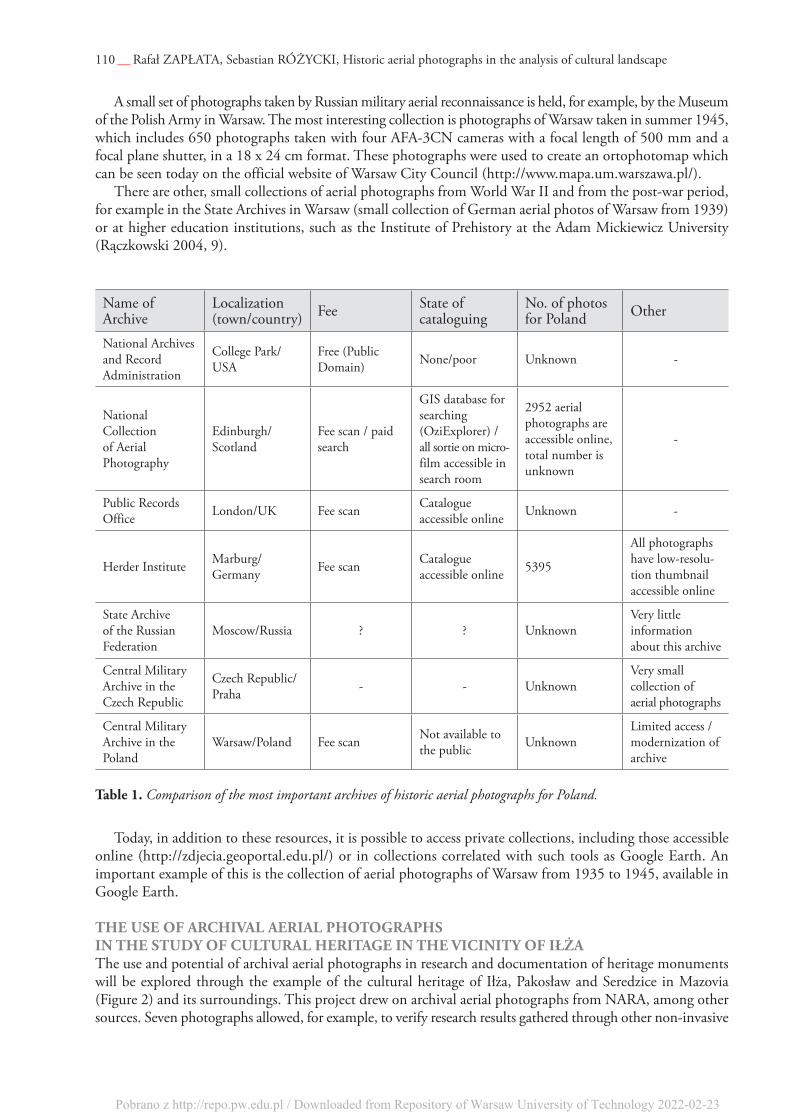
name of archive
Localization (town/country) Fee state of
cataloguingno. of photos for poland other
national archives and Record administration
college park/usa
Free (public domain) none/poor unknown -
national collection of aerial photography
edinburgh/scotland
Fee scan / paid search
GIs database for searching (oziexplorer) / all sortie on micro - film accessible in search room
2952 aerial photographs are accessible online, total number is unknown
-
public Records office London/uK Fee scan catalogue
accessible online unknown -
Herder Institute Marburg/Germany Fee scan catalogue
accessible online 5395
all photographs have low-resolu-tion thumbnail accessible online
state archive of the Russian Federation
Moscow/Russia ? ? unknownVery little information about this archive
central Military archive in the czech Republic
czech Republic/praha - - unknown
Very small collection of aerial photographs
central Military archive in the poland
Warsaw/poland Fee scan not available to the public unknown
Limited access / modernization of archive
table 1. Comparison of the most important archives of historic aerial photographs for Poland.
today, in addition to these resources, it is possible to access private collections, including those accessible online (http://zdjecia.geoportal.edu.pl/) or in collections correlated with such tools as Google earth. an important example of this is the collection of aerial photographs of Warsaw from 1935 to 1945, available in Google earth.
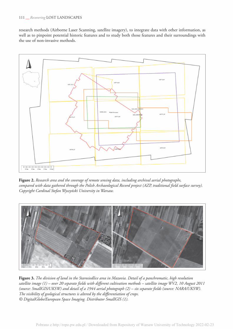
the use of archivaL aeriaL photographs in the study of cuLturaL heritage in the vicinity of iłżathe use and potential of archival aerial photographs in research and documentation of heritage monuments will be explored through the example of the cultural heritage of Iłża, pakosław and seredzice in Mazovia (Figure 2) and its surroundings. this project drew on archival aerial photographs from naRa, among other sources. seven photographs allowed, for example, to verify research results gathered through other non-invasive
110 — Rafał Zapłata, sebastian RóżYcKI, Historic aerial photographs in the analysis of cultural landscape
Pobrano z http://repo.pw.edu.pl / Downloaded from Repository of Warsaw University of Technology 2022-02-23
111 — Recovering Lost Landscapes
research methods (airborne Laser scanning, satellite imagery), to integrate data with other information, as well as to pinpoint potential historic features and to study both those features and their surroundings with the use of non-invasive methods.
figure 2. Research area and the coverage of remote sensing data, including archival aerial photographs, compared with data gathered through the Polish Archaeological Record project (AZP, traditional field surface survey). Copyright Cardinal Stefan Wyszyński University in Warsaw.
figure 3. The division of land in the Starosiedlice area in Mazovia. Detail of a panchromatic, high resolution satellite image (1) – over 20 separate fields with different cultivation methods – satellite image WV2, 10 August 2011 (source: SmallGIS/UKSW) and detail of a 1944 aerial photograph (2) – six separate fields (source: NARA/UKSW). The visibility of geological structures is altered by the differentiation of crops. © DigitalGlobe/European Space Imaging. Distributor SmallGIS (1).
1 2
Pobrano z http://repo.pw.edu.pl / Downloaded from Repository of Warsaw University of Technology 2022-02-23
112 — Rafał Zapłata, sebastian RóżYcKI, Historic aerial photographs in the analysis of cultural landscape
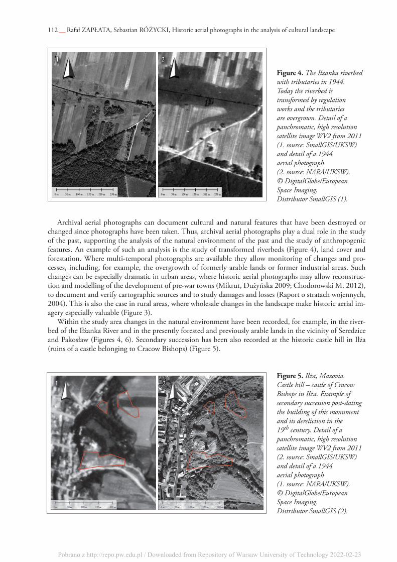
archival aerial photographs can document cultural and natural features that have been destroyed or changed since photographs have been taken. thus, archival aerial photographs play a dual role in the study of the past, supporting the analysis of the natural environment of the past and the study of anthropogenic features. an example of such an analysis is the study of transformed riverbeds (Figure 4), land cover and forestation. Where multi-temporal photographs are available they allow monitoring of changes and pro-cesses, including, for example, the overgrowth of formerly arable lands or former industrial areas. such changes can be especially dramatic in urban areas, where historic aerial photographs may allow reconstruc-tion and modelling of the development of pre-war towns (Mikrut, dużyńska 2009; chodorowski M. 2012), to document and verify cartographic sources and to study damages and losses (Raport o stratach wojennych, 2004). this is also the case in rural areas, where wholesale changes in the landscape make historic aerial im-agery especially valuable (Figure 3).
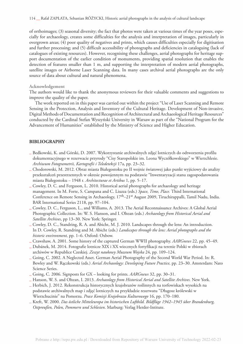
Within the study area changes in the natural environment have been recorded, for example, in the river-bed of the Iłżanka River and in the presently forested and previously arable lands in the vicinity of seredzice and pakosław (Figures 4, 6). secondary succession has been also recorded at the historic castle hill in Iłża (ruins of a castle belonging to cracow Bishops) (Figure 5).
figure 5. Iłża, Mazovia. Castle hill – castle of Cracow Bishops in Iłża. Example of secondary succession post-dating the building of this monument and its dereliction in the 19th century. Detail of a panchromatic, high resolution satellite image WV2 from 2011 (2. source: SmallGIS/UKSW) and detail of a 1944 aerial photograph (1. source: NARA/UKSW). © DigitalGlobe/European Space Imaging. Distributor SmallGIS (2).
figure 4. The Iłżanka riverbed with tributaries in 1944. Today the riverbed is transformed by regulation works and the tributaries are overgrown. Detail of a panchromatic, high resolution satellite image WV2 from 2011 (1. source: SmallGIS/UKSW) and detail of a 1944 aerial photograph (2. source: NARA/UKSW). © DigitalGlobe/European Space Imaging. Distributor SmallGIS (1).
1 2
1 2
Pobrano z http://repo.pw.edu.pl / Downloaded from Repository of Warsaw University of Technology 2022-02-23

113 — Recovering Lost Landscapes
the historic imagery also supports analysis of transformations and analyses of satellite imagery (osińska-skotak 2014) of destroyed buildings and communication routes in the area of pakosław, Iłża and seredzice. In pakosław, it was also possible to analyse the state of a historic green area, a park, during World War II (Figure 6).
the aerial photographs also lead to detection of a cluster of industrial features, comprising the remains of charcoal kilns around seredzice, which are presently covered by forest, built-up land and an open-area (Figure 7).
summaryWhile archival aerial photographs have applications across many disciplines there are some disadvantages and characteristics which limit usage. these include: (1) poor spatial resolution of photographs; (2) lack of coor-dinates of fiducial marks, distortion parameters of lenses generate problems for geo-referencing and production
figure 6. Pakosław, Mazovia. The present and former condition of: (1) park, (2) remains of buildings and (3) overgrowth of features (in the centre of the photograph). Detail of a panchromatic, high resolution 2011 satellite image WV2 (1. source: SmallGIS/UKSW) and detail of a 1944 aerial photograph (2. source: NARA/UKSW).© DigitalGlobe/European Space Imaging. Distributor SmallGIS (1).
figure 7. Seredzice, Mazovia (Forest Inspectorate Marcule). Possible remains of charcoal kilns. The area is presently built-up and partly forested (2). In 1944 it was arable land; dark spots are recognisable (1). Detail of a panchromatic, high resolution 2011 satellite image WV2 (2. source SmallGIS/UKSW) and detail of a 1944 aerial photograph (1. source: NARA/UKSW).© DigitalGlobe/European Space Imaging. Distributor SmallGIS (2).
1 2
1 2
Pobrano z http://repo.pw.edu.pl / Downloaded from Repository of Warsaw University of Technology 2022-02-23
of orthoimages; (3) seasonal diversity; the fact that photos were taken at various times of the year poses, espe-cially for archaeology, creates some difficulties for the analysis and interpretation of images, particularly in overgrown areas; (4) poor quality of negatives and prints, which causes difficulties especially for digitisation and further processing; and (5) difficult accessibility of photographs and deficiencies in cataloguing (lack of catalogues of existing resources). However, recognising these challenges, aerial photographs for heritage sup-port documentation of the earlier condition of monuments, providing spatial resolution that enables the detection of features smaller than 1 m, and supporting the interpretation of modern aerial photographs, satellite images or airborne Laser scanning data. In many cases archival aerial photographs are the only source of data about cultural and natural phenomena.
acknowledgementthe authors would like to thank the anonymous reviewers for their valuable comments and suggestions to improve the quality of the paper.
the work reported on in this paper was carried out within the project “use of Laser scanning and Remote sensing in the protection, analysis and Inventory of the cultural Heritage. development of non-invasive, digital Methods of documentation and Recognition of architectural and archaeological Heritage Resources” conducted by the cardinal stefan Wyszyński university in Warsaw as part of the “national program for the advancement of Humanities” established by the Ministry of science and Higher education.
bibLiography
_ Bedkowski, K. and Górski, d. 2007. Wykorzystanie archiwalnych zdjęć lotniczych do odtworzenia profilu dokumentacyjnego w rezerwacie przyrody “cisy staropolskie im. Leona Wyczółkowskiego” w Wierzchlesie. Archiwum Fotogrametrii, Kartografii i Teledetekcji 17a, pp. 23–32.
_ chodorowski, M. 2012. obraz miasta Białegostoku po II wojnie światowej jako punkt wyjściowy do analizy przekształceń przestrzennych w okresie powojennym na podstawie “Inwentaryzacji stanu zagospodarowania miasta Białegostoku – 1948 r. Architecturae et Artibus 1, pp. 5–17.
_ cowley, d. c. and Ferguson, L. 2010. Historical aerial photographs for archaeology and heritage management. In M. Forte, s. campana and c. Liuzza (eds.) Space, Time, Place. third International conference on Remote sensing in archaeology, 17th–21st august 2009, tiruchirappalli, tamil nadu, India. BaR International series 2118, pp. 97–104.
_ cowley, d. c., Ferguson, L., and Williams, a. 2013. the aerial Reconnaissance archives: a Global aerial photographic collection. In: W. s. Hanson, and I. oltean (eds.) Archaeology from Historical Aerial and Satellite Archives, pp 13–30. new York: springer.
_ cowley, d. c., standring, R. a. and abicht, M. J. 2010. Landscapes through the lens: an introduction. In d. cowley, R. standring and M. abicht (eds.) Landscapes through the lens: Aerial photographs and the historic environment, pp. 1–6. oxford: oxbow.
_ crawshaw, a. 2001. some history of the captured German WWII photography. AARGnews 22, pp. 45–49._ dubánek, M. 2014. Fotografie lotnicze XIX i XX wiecznych fortyfikacji na terenie polski w zbiorach
archiwów w Republice czeskiej. Zeszyt naukowy Muzeum Wojska 24, pp. 109–124._ Going, c. 2002. a neglected asset. German aerial photography of the second World War period. In: R.
Bewley and W. Rączkowski (eds.) Aerial Archaeology: Developing Future Practice, pp. 23–30. amsterdam: nato science series.
_ Going, c. 2006. signposts for GX – looking for prints. AARGnews 32, pp. 30–31._ Hanson, W. s. and oltean, I. 2013. Archaeology from Historical Aerial and Satellite Archives. new York._ Herbich, J. 2012. Rekonstrukcja historycznych krajobrazów roślinnych na torfowiskach wysokich na
podstawie archiwalnych map i zdjęć lotniczych na przykładzie rezerwatu “długosz królewski w Wierzchucinie” na pomorzu. Prace Komisji Krajobrazu Kulturowego 16, pp. 170–180.
_ Kreft, W. 2000. Das östliche Mitteleuropa im historischen Luftbild. Bildflüge 1942–1945 über Brandenburg, Ostpreußen, Polen, Pommern und Schlesien. Marburg: Verlag Herder-Intitute.
114 — Rafał Zapłata, sebastian RóżYcKI, Historic aerial photographs in the analysis of cultural landscape
Pobrano z http://repo.pw.edu.pl / Downloaded from Repository of Warsaw University of Technology 2022-02-23

115 — Recovering Lost Landscapes
_ Mikrut, s. and dużyńska, u. 2009. próba rekonstrukcji nieistniejących obiektów architektonicznych na wybranym przykładzie. Archiwum Fotogrametrii, Kartografii i Teledetekcji 20, pp. 285–294.
_ Mularz, s. and drzewiecki W. 2008. Interpretacja głównych elementów krajobrazu na teledetekcyjnych obrazach lotniczych i satelitarnych. Czasopismo Techniczne 24, series Architektura V.1-a, pp. 101–107.
_ osińska-skotak, K. and Zapłata, R. 2014. Zobrazowania satelitarne w detekcji i inwentaryzacji dziedzictwa kulturowego, Najnowsze techniki dokumentacyjne w archeologii – szansa czy pułapka?, academic conference, 12–13 June 2014 r., Warszawa.
_ Raport o stratach wojennych, 2004. Zespół d.s. ustalenia wartości strat, jakie Warszawa poniosła w wyniku II Wojny Światowej, Warszawa - http://www.rodaknet.com/Raport_o_stratach_wojennych_Warszawy.pdf, [accessed 11.11.2014].
_ Rączkowski, W. 2004. dusty treasure: thoughts on a visit to the aerial Reconnaissance archives at Keele university (uK). AARGnews 29, pp. 9–11.
_ Różycki, s. 2014. Raport z przeprowadzenia kwerendy w archiwum narodowym w stanach Zjednoczonych w celu wyszukania i zeskanowania zdjęć lotniczych z lat 1939–1945. Typescript in the archives of the Cardinal Stefan Wyszyński Unversity. Warszawa.
_ Zapłata, R. [in print]. Zastosowanie fotogrametrii oraz teledetekcji w ochronie, badaniu i inwentaryzacji dziedzictwa archeologiczno-architektonicznego – zarys projektu na przykładzie ruin zamku w Iłży. In a. seidel-Grzesińska and K. stanica-Brzezicka (eds.) Cyfrowe spotkania z zabytkami. Wrocław.
Pobrano z http://repo.pw.edu.pl / Downloaded from Repository of Warsaw University of Technology 2022-02-23

![InstItute of ArchAeology, BelgrAde - univie.ac.at Introdu… · Institute of Archaeology, Belgrade [series editor-in-chief Miomir Korać] Aerial Archaeology research group ... for](https://static.fdocuments.in/doc/165x107/5eca68c4b14d8f718259a6eb/institute-of-archaeology-belgrade-introdu-institute-of-archaeology-belgrade.jpg)