INO: Sustainable Energy Access in Eastern - adb.org · coal fired PLTU power plantTimor 1 in the...
148
Sustainable Energy Access in Eastern Indonesia—Power Generation Sector Project (RRP INO 49203) Environmental Impact Assessment Project Number: 49203-002 March 2018 INO: Sustainable Energy Access in Eastern Indonesia─Power Generation Sector Project Kupang Peaker 2 Core Subproject Prepared by Fichtner for the Asian Development Bank. This environmental impact assessment is a document of the borrower. The views expressed herein do not necessarily represent those of ADB's Board of Directors, Management, or staff, and may be preliminary in nature. In preparing any country program or strategy, financing any project, or by making any designation of or reference to a particular territory or geographic area in this document, the Asian Development Bank does not intend to make any judgments as to the legal or other status of any territory or area.
-
Upload
vuongxuyen -
Category
Documents
-
view
216 -
download
1
Transcript of INO: Sustainable Energy Access in Eastern - adb.org · coal fired PLTU power plantTimor 1 in the...

Sustainable Energy Access in Eastern Indonesia—Power Generation Sector Project (RRP INO 49203)
Environmental Impact Assessment
Project Number: 49203-002 March 2018
INO: Sustainable Energy Access in Eastern
Indonesia─Power Generation Sector Project
Kupang Peaker 2 Core Subproject
Prepared by Fichtner for the Asian Development Bank.
This environmental impact assessment is a document of the borrower. The views expressed herein do not necessarily represent those of ADB's Board of Directors, Management, or staff, and may be preliminary in nature. In preparing any country program or strategy, financing any project, or by making any
designation of or reference to a particular territory or geographic area in this document,
the Asian Development Bank does not intend to make any judgments as to the legal or
other status of any territory or area.

Final Version
March 2018
CONSULTING SERVICES FOR
"TA-9082 INO: Preparing the Eastern Indonesia Sustainable Energy Access Sector Project“
KUPANG-2 PEAKER Environmental Impact Assessment
(Final)

7203F96/FICHT-19631672-v2
Sarweystrasse 3 ● 70191 Stuttgart P.O. 10 14 54 ● 70013 Stuttgart Germany Phone: +49 711 8995-0 Fax: +49 711 8995-459 www.fichtner.de Please contact: Dr. Werner Miller Extension: 418 E-mail: [email protected]

7203F96/FICHT-19631672-v2
Rev No.
Rev-date Contents /amendments Prepared/revised Checked/released
0 21.05.2017 EIA Report - Draft Zajac/Ningtyas Miller
1 12.07.2017 EIA Report - Draft, revision 1 Zajac/Ningtyas Miller
2 07.09.2017 EIA Report - Final Draft Zajac Sousa
3 03.10.2017 EIA Report - Final Zajac/Ningtyas Miller
4 12.10.2017 EIA Report - Final revised SO2 and NOx Emission per stack data
Zajac Sousa
5 17.01.2018 EIA Report - Final
6 01.03.2018 Final EIA after revisions by VJ Johnson

7203F96/FICHT-19631672-v2
Disclaimer The content of this document is intended for the exclusive use of Fichtner’s client and
other contractually agreed recipients. It may only be made available in whole or in part
to third parties with the client’s consent and on a non-reliance basis. Fichtner is not
liable to third parties for the completeness and accuracy of the information provided
therein.

7203F96/FICHT-19631672-v2 I
Table of Contents
I. Executive Summary V-1
A. The Project V-1
B. Legal requirements V-4
C. Project categorization V-4
D. Environmental and social baseline conditions V-4
E. Impact assessment V-7
F. Outline of an Environmental Management and Monitoring Plan V-9
G. Public participation V-10
H. Overall findings and Recommendations V-10
II. Introduction V-1
A. Project Background and Objective V-1
B. Project need V-1
C. Scope of the Study V-1
D. Data sources V-2
E. Project categorization V-4
III. Institutional and Legislative Framework V-1
A. Relevant framework V-1
1. ADB Safeguards V-3
B. National Legal and Institutional Framework V-4
1. National Legal Framework V-4
2. Indonesian Law V-6
3. Indonesian Government Regulations V-6
4. Indonesian Minister Decrees V-7
5. Head of Environmental Impact Management Agency (BAPEDAL) Decrees V-9
6. Other Relevant Requirements V-10
7. National Institutional Framework V-10
C. International Guidelines and Standards V-11
1. International Agreements V-11
2. ADB Safeguards V-13
3. Other relevant international guidelines considered for this EIA: V-13
D. Gaps between national requirements and international standards V-13
IV. Description of the Project V-1
A. Project setting V-1
1. Project location V-1
2. Access to the project site V-2
3. The project site V-4
B. Technical Description V-5
1. Planned Technical Infrastructure of the PLTU Timor 1 and Kupang Peaker 1 site: V-5
2. Planned Technical Infrastructure for Kupang 2 V-6

7203F96/FICHT-19631672-v2 II
3. Project Layout V-8
C. Project associated facilities V-8
D. Project variants V-10
E. No-Project option scenario and Analysis of Alternatives V-10
V. Description of the Environment V-1
A. Physical environment V-1
1. Topography V-1
2. Geology and Soil V-1
3. Seismicity V-3
4. Surface water V-4
5. Ground water V-5
6. Climate V-6
7. Precipitation V-6
8. Wind V-7
9. Air quality V-8
10. Noise V-9
B. Natural environment V-10
1. Flora V-10
2. Fauna V-15
3. Protected areas and species V-16
C. Human environment V-21
1. Population V-21
2. Ethnic Groups/Minorities V-22
3. Human health V-24
4. Land Acquisition and Social Safeguards Issues V-24
5. Gender Aspects V-25
VI. Environmental Impact Assessment and Mitigation Measures VI-27
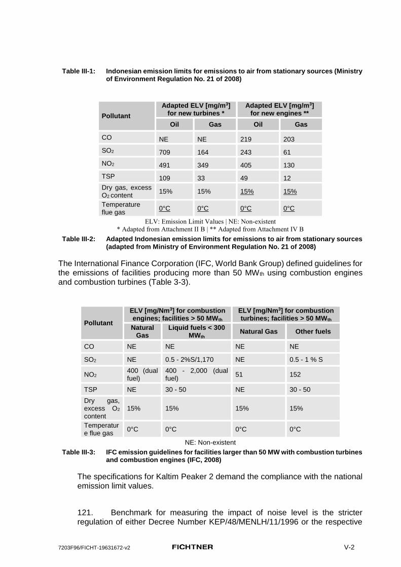
A. Design Phase and Pre-Construction Impacts VI-30
B. Construction Phase Impacts VI-31
C. Operation Phase Impacts VI-40
D. Cumulative impacts VI-55
VII. Environmental Management and Monitoring Plan VII-58
A. Institutional Framework and Procedural Arrangements for Environmental Compliance VII-59
B. Self-monitoring and external auditing VII-59
VIII. Costs of EMP Implementation VIII-1
IX. Public participation IX-2
X. Grievance Redress Mechanism X-3
XI. Conclusions and Recommendations X-5
A. Mitigation X-6

7203F96/FICHT-19631672-v2 III
XII. References XII-1
XIII. Annexes XIII-1
A. Maps of the project site and the investigation area XIII-2
1. Wider project area XIII-2
2. Project area of influence XIII-2
3. Project site XIII-2
4. Project layout plan XIII-2
B. Public Participation and Meetings XIII-3
C. Marine Study XIII-4
D. Air Dispersion Study XIII-5
E. Noise Emission Study XIII-6
F. Noise control for power plants, Short overview of basic principles and examples XIII-7

7203F96/FICHT-19631672-v2 IV
List of Tables Table IV-1: Multiplying factors for point sources to convert 1 hour
concentrations to other averaging periods (*OME, 2008, and
**EPA, 1992) V-8 Table IV-2: Air Quality measured and calculated results in the project area
(adapted from PT.PLN, 2006) V-9 Table IV-3: Data of forest function based on Kupang Regency (Source: Kupang
Regency in Figures, 2017; based on Crops and Forestry Service of
Kupang Regency, 2015) V-11 Table IV-4: Diversity of Mangrove Types in Nusa Tenggara Timur V-12
Table IV-5: Forest Area in Kupang Barat Sub district (Source: Kupang Barat
Sub district in Figures, 2013) V-13 Table V-1: Maximum simulated 24 hours SO2 concentrations and comparison
with the air quality standards VI-44
Table V-2: Maximum simulated 1 hour NO2 concentrations and comparison
with the air quality standards VI-45 Table V-3: Calculated A-weighted downwind sound pressure level LA(DW) at
the POIs for operation of the existing power plants Timor 1 and
Kupang 1 and level increase L caused by the additional
contribution from Kupang 2. VI-51 Table VI-1: Suggestion of an External Auditing Plan for the Kupang Peaker 2 VII-60
Table VI-2: Outline of an Environmental Management and Monitoring Plan for
Kupang Peaker 2 - Pre-Construction and Construction phase VII-62
Table VI-3: Outline of an Environmental Management and Monitoring Plan for
Kupang Peaker 2 - Operation phase VII-73
7203F96/FICHT-19631672-v2 V
List of Figures Figure 1: Location of the future Power Plants Complex, including Kupang 2
(source of the topographic maps: URL 1 and URL 2) Error! Bookmark not
defined. Figure 2: Location of the planned project site Kupang Peaker 2 (marked in
red), bordering the planned project sites of Kupang Peaker 1 and the
coal fired PLTU power plantTimor 1 in the North. Error! Bookmark not
defined. Figure 3: Location of the planned project site Kupang 2 (marked in orange),
bordering the Kupang 1 Peaker site and the PLTU Timor 1 in the
North. Error! Bookmark not defined.
Figure 4: Basic design layout of the Kupang 1 PP and Kupang 2 PP (orange) Error!
Bookmark not defined. Figure 5: Basic design layout of the Power Plan Complex comprising Timor 1
CFPP, Kupang Peaker 1 and Kupang 2 PP. Error! Bookmark not defined. Figure 6: Layout plan of the planned project site Kupang 2 (marked in
yellow), bordering the planned Kupang 1 Peaker site in the North. Error!
Bookmark not defined. Figure 7: Geology Map of Kupang District V-2
Figure 8: Project site with very shallow soil and outcropping volcanic base
rock in numerous places V-3
Figure 9: Earthquake risk, based on recordings from 1900 - 2010 V-3 Figure 10: Earthquake events 1900 - 2010 V-4 Figure 11: Hydrological Map of Kupang District V-5
Figure 12: Windrose for the year 2016 as simulated with the model WRF (wind
blowing from) (source of the satellite image: Google Earth TM) V-7 Figure 13: Palm trees within the proposed project site for Kupang Peaker 2,
surrounded by poor and shallow extensive agricultural land and
outcropping base rock. V-14
Figure 14: Condition of mangrove habitat in Tanjung Lampu, P. acidula (left)
and A. Marina (right) V-15 Figure 15: Zonation system of national marine reserve of Sawu and its
surroundings (Source: Ministry of Marine Affairs and Fisheries of
Republic Indonesia) V-18
Figure 16: Available habitats nearby the proposed power plant V-19 Figure 17: Map - V-22 Figure 18: Bapak Barnabas being interviewed and expressing his views during
the consultation. V-23 Figure 19: Posyandu - the Health facility in the hamlet Panaf (Dusun Panaf) V-25
Figure 21: A-weighted sound pressure levels at 1.5 m above ground around the
plant in 5 dB increments for scenario 3 (Kupang 2 in operation,
Timor 1 and Kupang 1 off), view showing the plant and the area
around POIs 1 and 2. VI-49 Figure 22: A-weighted sound pressure levels at 1.5 m above ground around the
plant in 5 dB increments for scenario 3 (Kupang 2 in operation,
Timor 1 and Kupang 1 off), view showing the area around POI 3. VI-50 Figure 23: A-weighted sound pressure levels at 1.5 m above ground around the
plant in 5 dB increments for scenario 4 (Timor 1, Kupang 1 and

7203F96/FICHT-19631672-v2 VI
Kupang 2 in operation), view showing the plant and the area around
POIs 1 and 2. VI-50

7203F96/FICHT-19631672-v2 vii
Acronyms and Abbreviations ADB Asian Development Bank
AH Affected Household
AMDAL Indonesian broad equivalent to an Environmental Impact Assessment
BLH Badan Lingkungan Hidup (Environmental Agency)
EA Executing Agency (PLN)
EIA Environmental Impact Assessment (for Category A projects)
EMP Environmental Management Plan
ESIA Environmental and Social Impact Assessment
GHG Green House Gas
GWh Giga Watt hours
GFPP Gas Fired Power Plant
HSD High speed diesel
IEE Initial Environmental Examination (for Category B projects)
IPP Indigenous Peoples Plan
IPPF Indigenous Peoples Planning Framework
ISO International Organization for Standardization
LNG Liquefied natural gas
MW Mega Watt
NG Natural Gas
O&M Operation and maintenance
PLN Perusahaan Listrik Negara (Indonesian State Electricity Company)
POI Point of Interest (receptor in the noise emsission study)
PPTA Project Preparatory Technical Assistance (the “PPTA Consultant” has been appointed by ADB to carry out the PPTA assignment)
RKL - RPL Environmental Management Plan - Environmental Monitoring Plan in Indonesia
RF Resettlement framework
PAI Potential Acid Input
PV Photovoltaic
REA Rapid Environmental Assessment
ROW Right Of Way
RP Resettlement Plan
SPS Safeguard Policy Statement
SS Substation
OHL Overhead transmission line
TOR Terms of References
UIP Unit Pembangunan Induk (PLN development unit)
7203F96/FICHT-19631672-v1 viii
Definitions
EIA = Environmental Impact Assessment: Assessment of the substantial impacts of a business and / or activities on the environment. EIA documents in Indonesia consist of: Terms of Reference (KA), AMDAL and RKL – RPL
KA-ANDAL = Terms of Reference for the AMDAL
AMDAL = Environmental Impact Assessment Document in Indonesia for significant impacts of a business and / or activity on the environment.
UKL – UPL = Environmental Management and Environmental Monitoring Effort: is a document that contains the management and monitoring measures to be applied by the Proponent. This document applies for activities where licensing does not require a mandatory EIA.
RKL - RPL = Environmental Management Plan - Environmental Monitoring Plan: is a document containing a series of management and monitoring measures to be applied by the Proponent. This document applies for activities whose licensing requires a mandatory EIA

7203F96/FICHT-19631672-v2 V-1
I. Executive Summary
A. The Project
Project Background and General Objective
1. Electric energy is a central factor to support the regional development especially to support and develop economic activities. Along with the growth of regional development and construction sectors, the demand for energy, particularly electric energy will continue to rise. In future, the growth of economic activity will increase the demand for particularly electric energy continuously.
2. The planned Kupang 2 Peaker Gas Fired Power Plant is part of ADBs Eastern Indonesia Sustainable Energy Access Sector Project TA-9082 INO.
3. The Kupang 2 Peaker will be a gas engine facility capable of running on natural gas (NG) as primary fuel or high speed Diesel (HSD) as a secondary/backup fuel with a power output capacity of approximately 50 MW and shall serve peak load demands.
4. The project objectives are:
(i) Increasing electricity supply in the region of Nusa Tenggara Timur Province, especially in the Kupang regency;
(ii) Implement Accelerated Development of Power Generation with the use of Gas;
(iii) Increasing the availability and reliability of electricity supply from gas-fired power plant in Nusa Tenggara Timur province;
(iv) Providing sufficient energy to fulfill the load demand especially during peak hours;
5. The Kupang Peaker 2 will improve the reliability and capacity of the existing electrical system in West Timor as well as meet the increasing demand for electric energy during peak hours (06:00 p.m. to 10:00 p.m.).
Objectives and Scope of the ESIA
6. Fichtner has been contracted by ADB to provide technical assistance (PPTA) for the preparation of all documents for the sector project framework to be considered by ADB’s Board. Kupang Peaker 2 has been defined as one of the core projects within the sector project framework.
7. This EIA Study covers environmental impact assessment and environmental management plan (EMP), environmental monitoring plan and cost estimates for the implementation of the EMP for Kupang Peaker 2.
8. The main objective of the EIA study is to identify significant environmental impacts and risks resulting from the planned project and to propose measures in order to avoid or at least to reduce environmental impacts and risks to acceptable levels.

7203F96/FICHT-19631672-v2 V-2
Project location and access to the site
9. The project site for the planned Kupang Peaker 2 will be located south-west of the hamlet Panaf (Dusun Panaf), which is part of the village Lifuleo (Desa Lifuleo), District of West Kupang, Kupang Regency, Nusa Tenggara Timur Province, at the most western tip of Timor island.
10. At the time when this report was begun the land for the project site was still private land and the land acquisition process was still ongoing. Towards the end of 2017, PLN announced that the land adquisition had been finalized and a DDR of the process had to be carried out.
11. The 20 ha wide project site is presently used for extensive, rainfed agriculture (roughly 60 % of the site, mainly corn and peanuts). The rest of the project site (around 40 %) is secondary bushland with some trees intersparsed. The bushland is used for cattle and goat breeding and harvesting of fruits (coconut, cashew).
12. The gas supply will take place through a new jetty, which will be built together with the neighbouring Kupang Peaker 1. The Jetty is planned to be in operation when the construction works for Kupang Peaker 2 commence. Diesel will be supplied via road transport.
13. Access to the new site Kupang Peaker 2 will be possible on the then existing access road to the power plants Timor 1 and Kupang Peaker 1, which will be constructed under these specific projects, not financed by ADB.
14. Power evacuation will be done via the then existing power lines, which will be constructed/upgraded for the power plants Timor 1 and Kupang Peaker 1.
15. There are no associated facilities outside the project plant site which have to be considered within this impact assessment.
16. However, cumulative effects from the parallel operation of the already existing power plant complex Timor 1 and Kupang Peaker 1 together with Kupang Peaker 2 have to be assessed. The impacts from the construction of Timor 1 and Kupang Peaker 1 will not be considered in this ESIA, as these will take place before the construction activities for Kupang Peaker 2 commence.
Technical Project description
Planned Power Plant Complex
17. The planned project is directly bordering a planned power plant complex in the north, which is planned to be in operation when the construction activities for Kupang Peaker 2 will commence. These existing facilities have therefore to be considered in the EIA due to the cumulative effects in combination with the planned project.
7203F96/FICHT-19631672-v2 V-3
18. Kupang Peaker 2, as the name suggests is planned as a part of Power Plants Complex, which will be built before the construction works for Kupang Peaker 2 begin and comprise:
(i) Timor 1 power plant planned as a steam turbine plant with a power output of 100 MW, with two coal-fired boilers and
(ii) Kupang Peaker 1 an engine power plant with 5 dual fuel (NG and HSD) gas engines and an output of 40 MW.
Kupang Peaker 2 will be the third power plant in the complex.
At the time this report was written, no project or site specific technical documentation associated with the Kupang Peaker 2 was available. However, planning documents and a layout plan for the neighbouring power plant Kupang Peaker 1 (not financed under the ADB sector loan) were available and the respective Feasibility Study Report was provided to Fichtner. Kupang Peaker 2 will be located directly adjacent to Kupang Peaker 1, within the same power plant complex boundary, and will be technically very similar. The main difference is the power output, which will be 40 MW for Kupang Peaker 1 with 5 dual fired engies (NG and HSD) and 50 MW for Kupang Peaker 2 with 4-8 dual fired engies (NG and HSD)1.
19. The Plant will be operated in peaking mode supplying electric power to the local grid, primarily during times of high demand. This generally occurs typically daily over a 5 hours period between 17:00 and 22:00. In this EIA and in the expert studies for air and noise emission calculations it was therefore assumed that the Kupang Peaker 2 Plant will adopt the same configuration and technology as the planned Kupang Peaker 1 Plant.
20. As a worst case scenario for the air emission calculations the usage of HSD was assumed.
Difficulties encountered
21. The preparation of this this EIA faced a major difficulty of limited design information of Kupang Peaker 2 Power Plant itself. The feasibility study for the neighbouring project Kupang Peaker 1 was though available and it was expected that the Kupang Peaker 2 will adopt a similar design albeit of slightly higher capacity of 50MW instead of 40MW for Kupang Peaker 1.
22. Such limitation of design information are not uncommon if “design-built“ is adopted as the tendering process. Also, with reference to Kupang Peaker 1 and Kupang Peaker 2, the designs of gas engine power plants are not so diverse that the existing information does not represent a good approximation of what will eventually be built. The available information was functional design of the two plants, Timor 1 and Kupang Peaker 1 and is generally sufficient to undertake an EIA for understanding and management of environmental impact of projects.
1 The exact number of engines and their capacity totaling to 50 MW is not known at this stage, This EIA considered 4X12.5 MW configuration for Kupang Peaker 2 Power Plant. This is sffucient to prect the impacts of project on all relevant environmental components.

7203F96/FICHT-19631672-v2 V-4
23. The project being a green field project and located in a remote corner away from any major human habitation, the want of a rigorous baseline was not a constraint. In the absence of any apparent source of pollution, the baseline was close to the ambient environmental quality that exists in near pristine environment.
B. Legal requirements
24. The planned project must comply with the Indonesian environmental and social laws and regulations.
25. In order to fulfil the requirements of the international financing agency ADB its Safeguard Policy Statement (2009), project relevant IFC Environmental, Health, and Safety Guidelines as well as WHO standards were considered in this EIA. Recommendations based on these considerations are obligatory to achieve compliance with ADB safeguards policy.
C. Project categorization
26. Environmentally the planned project falls into Category A, mainly because of the fact that the project is surrounded by a Marine National Reserve (Suwa Sea, a critical habitat) and the potential presence of rare, endangered and protected species in the wider project area, especially marine species. East of the project site there is a mangrove area, also a potentially critical habitat due to ecosystem services it provides to a small indigenous population (residing in a nearby hamlet Panaf2) which is also expected to be impacted by the project.
27. Significant environmental impacts from the planned project on protected species and on the local residents could therefore not be excluded a priori.
D. Environmental and social baseline conditions
28. To determine the environmental and social effects of constructing and operating the planned power plant, a baseline description of the project’s affected area was made for the further assessment of environmental and social impacts caused by the construction and the operation of the planned PP. This description includes the physical, biological and human environment that might be influenced by the construction and operation of the planned project.
2 Panaf hamlet is inhabited by a customary community belonging to the Suku Minfini,
traceable to the 2 branches of the Orang Helong/Gelong and the Suku Dewan/Atoni.

7203F96/FICHT-19631672-v2 V-5
Physical environment
29. The project site is located at the utmost western Tip of Timor island near the coast at a south exposed hillside with an inclination of up to 2 %. Wide parts of the 20 ha large project site are flat.
30. The whole project site only has a very shallow layer of laterite soil cover. There are outcrops of volcanic base rock all over the project site without any soil cover. Most of the coastal area is pure volcanic base rock and only locally sandy areas can be found.
31. Timor island is located at the northern edge of the Australian Plate, near the border to the Sunda plate in a medium earthquake risk zone with a peak ground acceleration of up to 1.6 m/s2.
32. There are no permanent surface water bodies within the physically impacted power plant complex area west of Panaf hamlet.
33. The geological conditions at the project site lead to the assumptions that ground water is expected to be found at best in rock cleavages, and that there is no coherent ground water body.
34. The general climate of the project area is dry and tropical with two distinct seasons. The rainy season lasts for up to 4 months, the dry season up to 9 months. One project site specific peculiarity is the fact that the wind, which comes from a predominantly south-easterly direction, will mostly blow eventual emissions away from the planned power plant complex mainly to north-west, towards the sea and away from Timor island.
35. No measurement data regarding the present air quality and noise situation were available for the project site of Kupang Peaker 2. During the site visit the present environmental conditions regarding air pollutants and noise were assumed to be well below all national and international standards for air quality and noise, as the wider project area site is sparsely populated and completely without any industrial activity, motorized traffic or natural noise sources. This assumption was confirmed by the findings of the AMDAL Report (equivalent to EIA) for Timor 1.
Natural environment
36. A large part (around 60%) of the proposed project area for Kupang Peaker 2 is covered by rainfed crops (corn and peanuts) and secondary bushland (roughly 40 %) with shrubs and a few trees (coconut, cashew) interspersed.
37. Beside several common bird species, monkeys and deer can be observed in the secondary forest and bushland, according to statements from local residents. The quite poor onshore situation regarding environmental species and habitats stands in strong contrast to the rich marine environment surrounding the power plant complex in the south and west.
38. As the planned project is located near the coast an expert study about the marine environment was conducted to compile baseline data, but also to include the opinion of a marine expert on the assessment of potential impacts for the planned project. The marine expert study is attached as Annex C to this EIA report.
39. The planned power plant complex is surrounded by a marine utilization zone, which is part of the Sawu Sea Marine National Park. This National Park,

7203F96/FICHT-19631672-v2 V-6
which covers 3.36 million hectares with a core zone of 80,000 ha is based on the Minister Decree of Marine Affairs and Fisheries of the Republic of Indonesia 38/2009 dated May 8, 2009.
40. According to this decree this approximately 1 km wide utilization zone is mainly designated for ecotourism, research and education, and as a shipping route. The Utilization Zone is surrounded by an area specifically designated for the protection of cetaceans (whales and dolphins).
41. The environmental quality of the coastal waters and habitats bordering the project complex is still fair and corals reefs and sea grass areas can be found. Beside several species of cetaceans, the coastal water also provides habitat for other rare, endangered, and protected species like 6 species of sea turtles and dungongs.
42. East of the planned project site there is a mangrove forest, which is considered as a potentially critical habitat, as mangrove forests are closely interlinked with coral reefs, which are part of the Sawu Sea Marine National Park and they also provide habitat for a variety of protected and endangered species and also provide ecosystem services to local indigenous population.
Human environment
43. The project site for the planned Kupang Peaker 2 will be located at the most western tip of Timor island, around 500 m south-west of Panaf hamlet (Dusun Panaf), which is part of Lifuleo village (Desa Lifuleo), in the District of West Kupang, Kupang Regency, Nusa Tenggara Timur Province.
44. No residential houses are located within the project site for Kupang Peaker 2 and the land of the project site is used by local residents for rainfed agriculture (corn and peanuts) and the bushland is used for cattle breeding and harvesting of coconuts and cashew nuts.
45. The hamlet (Dusun) Panaf, one of the hamlets of Lifuleo Village, has 37 households that consist of 34 male-headed households and 3 female-headed households (Damaris Saketu, Juliana Saketu, and Mama Naema). The customary community in Dusun Panaf is known as the Suku Minfini.
46. Community work is the general working method in the farming village. While farming remains the main livelihood activity in the community, fishing activities are also conducted on a seasonal basis. Other minor livelihood activities in the community are, seaweed farming, and livestock raising (cattle, goat, pig).
47. The fishing period lasts from December to April. In October, at the beginning of the rainy season, agricultural lands are usually prepared for farming. Planting and/or seeding on the farmlands starts in early December and the harvest season begins in May.
48. Suku Minfini leadership is patriarchal whereby the eldest son/male heir is appointed as Head of Suku/customary leader. All decisions regarding land use are discussed with the customary leader. There are 4 main important places/resource for the Minfini: burial area of ancestors, settlements, church, and agriculture land. The Minfini lives by strict adherence to local customs and wisdom in order to maintain social order and mutual cooperation.

7203F96/FICHT-19631672-v2 V-7
E. Impact assessment
49. The impact assessment of the impacts of the planned power plant was made for the physical, the biological and the human environment. It considers the construction and the operational phases (including maintenance).
Physical environment
50. Due to the difficult underground conditions, mainly consisting of volcanic base rock, it is assumed that frequent blasting will be necessary for the leveling and excavation works for the Kupang Peaker 2.
51. The major environmental issues in connection with a gas and Diesel fired power plant during the operation phase are usually air and noise emissions.
52. As a sound basis for an assessment of noise and air emissions, expert studies with noise and air emission calulations were conducted, which are considering the overlapping effects of the relevant noise and air emission sources from the planned neighbouring Power Plant facilities Timor 1 and Kupang Peaker 1 as well as the forecast emissions from the planned Kupang Peaker 2. Wherever more than one project option exists „worst case scenarios“ were used for the emission calculations and the impact assessment in a first iteration. The expert reports are attached as Annex D (Air Dispersion calculation) and Annex E (Noise Emission Calculation) to this EIA Report.
53. The results of these emission calculations showed, that air emission from the stand alone Kupang 2 Peaker project meets all applicable national and international air quality standards for TSP, PM10, SO2, NO2 and CO in the project AoI, at all receptor points.
54. Air emissions from all three power plants together meets the regulatory criteria for the investigated air pollution parameters CO, NOx, SO2, and PM10 / TSP. Only SO2 and NO2 showed exceedances of some of the strict WHO emission standards. Regarding exceedance of SO2 and NO2 the emission calculations showed no difference between the operation of the neighbouring power plants Timor 1 with a small contribution from Kupang Peaker 1 alone and the simultaneous operation of all three power plants together. Simulation for Kupang Peaker 2 also indicate that its contribution to air pollution is well within 25% of national ambient air quality standards.
The noise level generated by a stand-alone Kupang 2 Peaker project will require certain mitigation measures to keep its impacts within the levels prescribed by national and international standards for residential areas, in standalone mode or in cumulation with Timor 1 and Kupang Peaker 1.
Biological environment
55. The Kupang Peaker 2 impacts on natural environment will likely not be significant if proper mitigation has been applied. In particular the terrestrial ecosystems in the project area are modified habitats used by local population for their needs. The marine habitats may be impacted by water intake and waste water discharge, but both operations will be performed at the Kupang 1 project site. Operation of Kupang 2 may contribute to the existing impacts, but volumes of water intake and waste water are small and the waste water will be treated to the national quality standards prior to discharge.

7203F96/FICHT-19631672-v2 V-8
56. Construction and operation of the planned Kupang Peaker 2 may contribute to the degradation of the marine biodiversity, even if the predicted impact from stand-alone project is small compared to the potential impacts resulting from the construction and operation of the coal fired steam Timor 1 Power Plant and Kupang Peaker 1. Anticipated impacts from construction and operation activities are noise from blasting and other construction activities, land clearing which could cause terrestrial runoff which would create sediments.
57. Impaired water quality may lead to a change and depletion of plankton species, which in turn affects the whole food chain via fish up to the marine mammals, as any disruption of fish resources will impact their feeding habitats and finally migratory routes.
58. Depletion of a local marine habitat does not only have local effects, but may also affect the neighbouring habitats within the Sawu Sea Marine National Reserve. Water currents connect the various marine habitats and if one habitat is depleted the neighbouring habitats may also be affected and weakened. E.g. if a source of larva (plankton, corals, fish) may be lost; the juvenile fish may not any more supply neighbouring habitats. This chain reaction may hamper the resilience of a wide and connected habitat system like the Sawu Sea.
59. Operation of LNG supply tankers for Kupang 2 Peaker could contribute to potential impact on marine mammals in the Sawu Sea. A set of mitigation measures for tankers operation will be implemented to avoid collisions with the mammals and lower the level of disturbance.
Kupang Peaker 1 and Kupang Peaker 2 do not have any cumulative impacts with Timor 1 due to cooling water discharge as these dual fuel engine based power plants use radiator technology where cooling is achieved through fflow of forced air on radiator frame. The domestic wastewater from the three plants are too small to give rise to any significant cumulative impacts if treated to national discharge standards. The process water from Kupang Peaker 2 will also be treated to international standards (IFC EHS Guidelines for Therma Power Plants (Dec. 2008).
Human environment
60. No houses or buildings are located within the planned project site for Kupang Peaker 2. Affected property will be compensated by PLN.
61. Presently the project site is used by the local people for extensive, rain fed agriculture (mainly corn and peanuts), livestock breeding (cattle, pigs, goats) and harvesting of fruits (coconuts and cashews).
62. The settlement next to the project site is the hamlet Panaf, around 500m north of the planned project site.
63. PLN acquired 52 hectares of land for the power plant complex and Kupang Peaker 2 will be built within the complex after the other 2 facilities have been constructed. Of the 52 ha, the ADB-funded Kupang Peaker 2 will require around 5 ha. A total of 9 households (41 persons) of the Minfini ethnic group will be affected by the project. Six AHs are deemed vulnerable and all 9 AHs will be severely affected. The land acquisition process was completed at the time this EIA Report was finalized.
7203F96/FICHT-19631672-v2 V-9
64. The planned project will provide job opportunities for the local people, numerous temporary jobs during the construction phase and some permanent jobs in the operation phase.
65. Air and noise emission calculations were made to assess the impacts of the emissions from the existing as well as from the planned power plant on residential houses and sensitive areas in the vicinity of the project site.
F. Outline of an Environmental Management and Monitoring Plan
66. All measures are compiled in this EIA Report in form of an outline of an Environmental and Social Management Plan (EMP). This plan further details the procedures necessary for managing the significant environmental issues (what?how?when?where?who?).
67. The EMP addresses significant impacts separately for the construction and the operation phases and essentially comprises:
(iii) The environmental attribute (e.g. air quality) that is likely to be impacted;
(iv) A summary of the potential impact and/or likely issue; (v) The identified mitigation actions that aim to eliminate and/or reduce
the potential impact to acceptable levels; (vi) Monitoring actions to ensure that the identified mitigation measures
are implemented. Monitoring actions include: inspections, review of reports/plans, reporting, and the undertaking of certain monitoring measures;
(vii) The frequency for implementing the monitoring actions, which include: once, continuously throughout the construction/operation period (depending on the mitigation measure identified this could include daily, weekly, or monthly), or upon occurrence of a certain issue; and
(viii) The responsible entity for implementing the mitigation measures and monitoring actions identified.
(ix) Monitoring must commence from the loan effectiveness date, as it includes monitoring of pre-construction measures. Semi-annual monitoring reports must be provided, even if to confirm that no works commenced.
68. This outline of an EMP forms the basis for further, more detailed protection, safety and security measures planning, which must be set up by the contractor, based on the detailed technical planning. As a “living document” the EMP shall be updated once per year throughout the entire construction period.
69. Additionally, specific Health & Safety as well as Environmental & Social plans must be set up by the EPC contractor (construction phase) and the operator (operation phase).
70. The EPC contractor must ensure that the necessary measures to prevent accidents and health injuries in the construction phase are properly planned and applied through an EHS Plan.
71. A construction safety manager shall be nominated to perform inspections on site, monitor the application of the plan and report accidents, incidents and emergencies.

7203F96/FICHT-19631672-v2 V-10
72. The prevention and avoidance of negative effects for the workers during operation must be subject of an EHS Plan to be developed and applied by the Operator.
73. An environmental and social expert, employed by the contractor, shall survey the construction works and companies and shall take care that the EMP and the specific H&S plans are de facto applied at the construction site.
74. Monitoring must commence as soon as loan effectiveness date, as it includes monitoring of pre-construction measures. Semi-annual monitoring reports must be provided, even if to confirm that no works commenced etc.
75. In the operation phase, if self-monitoring is applied, an external environmental expert will be contracted by the operator to verify the monitoring undertaken by PLN. The monitoring report of the external environmental expert will be delivered to PLN and ADB at the same time.
G. Public participation
76. During the EIA process several meetings were held with various stakeholders (project developer, local residents, authorities, community leaders). A compilation of all meetings conducted by the environmental and the social team is attached as Annex B to this report.
77. The main purpose of these meetings was to inform local stakeholders about the planned project, to collect base line data, and to find out the attitude of the local stakeholders towards the planned project.
78. The general attitude of the local communities towards the planned project was positive, mostly because job opportunities will be created and more money is flowing into this remote region through the spending power of local and foreign workers.
H. Overall findings and Recommendations
79. The impacts caused by the planned stand-alone project Kupang Peaker 2 are assessed as not significant after implementation of the proposed mitigation measures.
80. As a sound basis for an assessment of noise and air emissions expert studies with noise and air emission calculations were conducted, which are considering the overlapping effects of the relevant noise and air emission sources from the planned Power Plant facilities Timor 1 and Kupang Peaker 1 as well as the forecasted emissions from the planned Kupang Peaker 2. Wherever more than one project option exists „worst case scenarios“ were used for the emission calculations and the impact assessment as a first iteration.
81. The results of these emissions showed that of the investigated air pollution parameters CO, NOx, SO2, and PM10 / TSP only SO2 showed exceedance of some of the stricter WHO emission standards for 24 hours at one resident location. The predicted ground level concentrations for all pollutants meet the national ambient air quality standards. The project complies with ADB policy on air quality.

7203F96/FICHT-19631672-v2 V-11
82. Both Timor 1 and Kupang Peaker 1 will meet ambient noise levels through design specification. Kupang Peaker 2 may need some additional noise mitigation measures due to its proximity to Mangrove beach as sensitive receptor. EIA makes necessary recommendations with respect to desired noise mitigation measures.
83. The vegetation within the approximately 5 ha wide project site comprises rainfed, extensive agricultural land (around 60 %) and secondary bushland with a few trees interspersed. No rare, endangered or protected plant species have been observed within the project site and none are expected.
84. The mangrove forest east of the power plant complex and especially the marine areas in the Sawu Marine National Reserve presently provide critical habitats for rare, endangered and protected species. The impact of the Kupang Peaker 2 alone on these critical habitats is assessed as not significant.
85. Beside the small-scale physical impairments of the remaining flora, fauna, and habitats within the directly affected construction sites, the major environmental issues with the gas and diesel engine fired power plant are air emissions, noise and vibration emissions, and to a minor extend emissions of wastewater into the aquatic environment. In this specific planning case vibrations are only expected in the construction phase, especially due to blasting.
86. The land acquisition process for the power plant complex is completed and a Due Dilegence Report has been prepared.
87. Regarding noise impacts, the project area of influence for Kupang Peaker 2 is defined as the 55 dB(A) zone shown in Figure 20 Chapter V. A radius of 10 km around the center of emission has been considered as the calculation area for air emissions, as some sensitive receptors were identified in the area, including beaches and villages.
88. The predictable impacts resulting from the planned power plant complex could affect marine habitats, which resources are essential for sea turtles, dolphins, whales, and dugong as this part of the Suwa Sea National Marine Park is especially set aside for the protection of these species. However, the contribution of Kupang Peaker 2 to the overall impacts from the power plant complex is very small compared to the impacts caused by the coal fired power plant Timor 1 which in themselves are not very significant due to low installed capacity and high dispersion capacity of local environment, especially for air quality.
89. The following project specific measures are recommended:
(i) Minimization of blasting during construction works especially to avoid impairments of marine mammals in the Sawu Sea Marine National Park and disturbance of local residents in Panaf hamlet.
(ii) Normal operation of the Kupang Peaker 2 with gas and only in emergency cases and short-term with HSD
(iii) Integrate noise abatement measures for Timor 1, Kupang Peaker 1 power plants to comply with the national noise regulations and install recommended noise mitigation measures for Kupang Peaker 2.
(iv) Undertake a due diligence study to identify any gaps in construction and operations of Timor 1 and Kupang 2 power plants with respect to good international practice with the objective to fill the gaps by preparing and implementing a corrective action plan.

7203F96/FICHT-19631672-v2 V-12
(v) Align the operation of a power plant complex with plans and strategies of the Sawu Sea National Marine Park aiming at the unit for national conservation area (BKKPN) or the Marine National Park Authority

7203F96/FICHT-19631672-v2 V-1
II. Introduction
A. Project Background and Objective
90. Electric energy is a central factor to support the regional development especially to support and develop economic activities. Along with the growth of regional development and construction sectors, the demand for energy, particularly electric energy will continue to rise. In future, the growth of economic activity will increase the demand for particularly electric energy continuously.
91. The Electricity system in East Nusa Tenggara (NTT) Province consists of 59 power plants with a peak energy output of altogether of 158,7 MW (September 2014). All energy is produced by Diesel fueled and Coal Fired Power Plants, but there are also Hydro and Mini-hydro Powerplants, So far the Bolok Coal Fired Power Plant (2x16.5 MW, located ca. 13 km North of the planned Kupang 2 Peaker) has supplied energy for Kupang City and Kupang Regency via a 20 kV transmission line.
92. Most of the power plants in NTT are diesel fueled and cause high costs. Highest electricity demand in Kupang occurs in the evening. PLN will construct new power plants to fulfil peak power needs, especially to provide energy during peak hours. The new power plants to be built include Kupang Peaker 1 (gas-fired, 40 MW), Timor 1 Coal Fired Powerplant (2x50 MW), and Kupang Peaker 2 (Gas Power Plant 50 MW). These three power plants are planned next to each other at the utmost western tip of Timor Island.
93. The main objective of the planned development project Kupang Peaker 2 is to provide sufficient energy to fulfill the load demand especially during peak hours.
B. Project need
94. The new power plant will improve the reliability and capacity of the existing electrical system in East Nusa Tenggara (NTT) Province on the Timur island, as well as meet the increasing demand for electric energy especially during peak hours in 2017 to 2018 and beyond.
95. For these reasons PLN has decided to build the new power plants Kupang Peaker 1 (40 MW), Timor 1 Coal Fired Power Plant (2x50 MW), and Kupang Peaker 2 (Gas Power Plant 50 MW). The power output capacity of Kupang Peaker 2 will be 50 MW +- 10%.
C. Scope of the Study
96. According to the TOR the following Environmental safeguard documents have to be provided in line with ADBs SPS 2009 documents:

7203F96/FICHT-19631672-v2 V-2
(vi) environmental assessment and review framework for the overall sector project;
(vii) environmental impact assessment or initial environmental examination of each core subproject;
(viii) environmental management plan (EMP), environmental monitoring plan and cost estimates for the implementation of the EMP for each core subproject.
97. This EIA Study covers the positions (ii) and (iii) for the core project Kupang Peaker 2.
98. The main objective of the EIA study is to identify significant environmental impacts and risks resulting from the planned project and to propose measures to avoid or at least to reduce environmental impacts and risks to an acceptable level.
99. Within the scope of this EIA is the physical, marine, biological and human environment in the project area. Regarding noise impacts, the project area of influence for Kupang Peaker 2 is defined as the 55 dB(A) zone shown in Figure 20 below. A radius of 10 km around the center of emission has been considered as the calculation area for air emissions, as some sensitive receptors were identified in the area, including beaches and villages.
100. The area of influence encompasses the seaweed beach in the north, the mangrove forest in the east, and the coastal areas (including the reef flat and the slope) nearby the proposed site.
101. Outside the power plant site itself there are no project associated facilities which have to be assessed within the EIA for Kupang Peaker 2, as the necessary infrastructure will already have been built as part of the projects Timor 1 and Kupang Peaker 1. These structures will be built anyway, independently of Kupang Peaker 2.
102. For more information regarding the associated facilities, please refer to chapter IV.
103. The Timor 1 and Kupang Peaker 1 projects are still not realized but according to the information provided by PLN they will be built and operating by the time the construction activities for Kupang Peaker 2 begin. For the assessment of the environmental impacts within this report, it is therefore assumed that both plants will be operating during construction and operation of the Kupang Peaker 2.
104. The projects Timor 1 and Kupang Peaker 1 have already been approved by the environmental authorities, and as these are not financed by ADB, they generally do not have to be assessed in this EIA Report.
D. Data sources
105. Beside a generic layout, no specific documentation associated with the Kupang Peaker 2 was available at the time this report was written. The project is listed in the current RUPTL, but PLN has still to elaborate a Feasibility Study for it.

7203F96/FICHT-19631672-v2 V-3
As completion of this project is intended for 2022, the project so far was not on PLN’s completion priority schedule.
106. The planning of Kupang Peaker 1 (not financed under this ADB sector loan) was more advanced than that of Kupang 2, and the respective Feasibility Study was made available to Fichtner. According to information from PLN, Kupang Peaker 2 will be located adjacent to and south of Kupang Peaker 1. The capacity will be 40 MW for Kupang Peaker 1 and 50 MW for Kupang Peaker 2.
107. As no technical description and no specific layout was available at the time when this EIA was conducted, it was assumed that Kupang Peaker 2 will be technically similar to Kupang Peaker 1. Therefore, the general layout and the technical description of Kupang Peaker 2 was derived from and adapted from the documents available for Kupang Peaker 1. Since both plants are modular gas engine power plants, this approach seems adequate to provide sufficiently reliable conclusions of the environmental assessment. This information was used as a basis for the environmental assessment of Kupang Peaker 2.
108. The main technical information sources for this EIA report were the PLN Feasibility Studies for Timor 1 and Kupang Peaker 1, and the Kupang Peaker Technical Report (Fichtner, January 2017).
109. Other documents used as a baseline for this study comprise:
(ix) Final Report Feasibility Study KUPANG GEPP (PEAKER) 40 MW (Kupang Peaker 1), August 2015
(x) Draft UKL-UPL PLTMG Kupang Peaker 1, April 2016 (xi) Draft AMDAL for Timor 1 coal power plant (xii) Kupang Peaker 2 - Site visit Report, Fichtner, October 2016 (xiii) Kupang Peaker 2 - Rapid Environmental Assessment Report, Fichtner,
December 2016
110. Three expert studies were conducted as a basis for the assessment of environmental impacts from the Kupang 2 PP. These expert studies comprise:
(xiv) Marine Study (Annex C to this Report) (xv) Air Dispersion Study (Annex D to this report) (xvi) Noise Emission Study (Annex E to this report)
111. In addition to the available data, additional information was collected during field surveys conducted by the national and international environmental and socio-economic experts in 2016, 2017 and 2018. Socio-economic baseline surveys were carried out for sample populations settled within the possible project area of influence.
112. Additional information was collected from literature, internet sources, and discussion with local residents, experts, administration and authorities.
113. Recent, high-resolution (50 cm) satellite maps were bought for the assumed project area of influence in order to precisely locate impact areas and to

7203F96/FICHT-19631672-v2 V-4
enable a quantitative assessment (wherever possible) of ecological and social impacts.
E. Project categorization
114. Environmentally the planned project falls into Category A, mainly because of the fact that the project is surrounded by a Marine National Reserve (Suwa Sea, a critical habitat) and the potential presence of rare, endangered and protected species in the wider project area, especially marine species. East of the project site there is a mangrove area, also a potentially critical habitat due to ecosystem services it provides to a small indigenous population (residing in a nearby hamlet Panaf3) which is also expected to be impacted by the project. Significant environmental impacts from the planned project on rare, endangered, or protected species, especially in the marine environment, could not be excluded a priori.
115. The project also may have cumulative impacts together with planned project together with the impacts from the neighbouring power plants Timor 1 and Kupang Peaker 1. The capacity of all three plants though is low. Proximity of a critical habitat is the key reason for assigning highest category safeguards for environment by ADB.
116. Regarding Involuntary Resettlement and Indigenous Peoples, the planned project falls into Category B. A Resettlement and Customary Communities Development Plan (RCCDP) has been developed for the project to address the impacts on the affected households.
3 Panaf hamlet is inhabited by a customary community belonging to the Suku Minfini, traceable to the
2 branches of the Orang Helong/Gelong and the Suku Dewan/Atoni.

7203F96/FICHT-19631672-v2 V-1
III. Institutional and Legislative Framework
A. Relevant framework
117. Generally, the major environmental issues with a gas and diesel fired power plant are air emissions, noise emissions, and emissions of wastewater into the aquatic environment.
118. The planned project Kaltim Peaker 2 is regarded as the extension of an already existing facility, for which an AMDAL had already been conducted and for which an environmental permit had been given, which is still valid. For an extension no full AMDAL is therefore required. This decision of the environmental authority was communicated to PLN, based on the environmental assessment directive No. 660.1/143/B-1/BLHD dated July 13, 2016. For the planned project an addendum to the existing AMDAL including an RKL-RPL has to be prepared. At the time when this EIA had been prepared only a draft of the addendum to the existing AMDAL was available and handed over to the consultant by PLN.
119. The national emission limits for stationary sources, including thermal power plants, were issued on 1 December 2008 and replaced the earlier 1995 standards. The regulations include limits for the emissions of sulphur dioxide, carbon monoxide, nitrogen oxides (as nitrogen dioxide) and particulate matter for existing, in development and new power plants. Fuel types covered by the decree include coal, oil and natural gas. Power plants must meet these emission standards 95% of the time over 3 months (URL 3).
120. Table 3-1 shows the national emission limit values applicable for turbines and for engines. Because these values consider “standard” conditions (temperature of the flue gas of 25 °C), Table 3-2 shows the values adapted to meet the “normal” conditions (0°C). A correction for the percentage of O2 is also undertaken.
Pollutant
ELV [mg/m3] for new turbines *
ELV [mg/m3] for new engines **
Oil Gas Oil Gas
CO NE NE 540 500
SO2 650 150 600 150
NO2 450 320 1,000 320
TSP 100 30 120 30
Dry gas, excess O2 content
15% 15% 5% 5%
Temperature flue gas
25°C 25°C 25°C 25°C
ELV: Emission Limit Values | NE: Non-existent
* Attachment II B | ** Attachment IV B
7203F96/FICHT-19631672-v2 V-2
Table III-1: Indonesian emission limits for emissions to air from stationary sources (Ministry of Environment Regulation No. 21 of 2008)
Pollutant
Adapted ELV [mg/m3] for new turbines *
Adapted ELV [mg/m3] for new engines **
Oil Gas Oil Gas
CO NE NE 219 203
SO2 709 164 243 61
NO2 491 349 405 130
TSP 109 33 49 12
Dry gas, excess O2 content
15% 15% 15% 15%
Temperature flue gas
0°C 0°C 0°C 0°C
ELV: Emission Limit Values | NE: Non-existent
* Adapted from Attachment II B | ** Adapted from Attachment IV B
Table III-2: Adapted Indonesian emission limits for emissions to air from stationary sources (adapted from Ministry of Environment Regulation No. 21 of 2008)
The International Finance Corporation (IFC, World Bank Group) defined guidelines for the emissions of facilities producing more than 50 MWth using combustion engines and combustion turbines (Table 3-3).
Pollutant
ELV [mg/Nm3] for combustion engines; facilities > 50 MWth
ELV [mg/Nm3] for combustion turbines; facilities > 50 MWth
Natural Gas
Liquid fuels < 300 MWth
Natural Gas Other fuels
CO NE NE NE NE
SO2 NE 0.5 - 2%S/1,170 NE 0.5 - 1 % S
NO2 400 (dual fuel)
400 - 2,000 (dual fuel)
51 152
TSP NE 30 - 50 NE 30 - 50
Dry gas, excess O2
content 15% 15% 15% 15%
Temperature flue gas
0°C 0°C 0°C 0°C
NE: Non-existent
Table III-3: IFC emission guidelines for facilities larger than 50 MW with combustion turbines and combustion engines (IFC, 2008)
The specifications for Kaltim Peaker 2 demand the compliance with the national emission limit values.
121. Benchmark for measuring the impact of noise level is the stricter regulation of either Decree Number KEP/48/MENLH/11/1996 or the respective

7203F96/FICHT-19631672-v2 V-3
IFC EHS guidelines. A comparison of the national standards and IFC guidelines for acoustic environment is provided in the table below. IFC Guidelines for noise limits in residential areas at night time (22:00 to 7:00) are stricter compared to the national standards. Notwithstanding the standards, IFC guidelines do not allow increase of more than 3dB(A) to background noise levels.
Table 6: National Standards and IFC Guidelines for Noise
Parameter Indonesian Standard*
IFC Standard**
Noise (dBA), workplace 85 85
Noise (dBA), industry, trading, services 70 70
Noise (dBA), government and public facilities, cultural reserves
60
Noise (dBA), residential, day (7:00 – 22:00) 55 55
Noise (dBA), residential, night (22:00 – 7:00) - 45
Source: *) MoE Decree No. 481996 concerning on Noise Level Standard **) IFC EHS General Guidelines – Table 1.7 Noise Level Guidelines and Table 2.3.1 Noise Limits for Various Working Environment.
The scope of the Project does not include facilities discharging significant volumes of industrial waste water. Discharges of treated waste water will primarily be associated with water from the construction worker camp, sanitary facilities and workshops for operation of the power plants. As per the ADB policy the parameters of treated process water from the plant should not exceed the discharge standards provided in the IFC EHS guidelines for Therma Power Plants.
1. ADB Safeguards
122. Environmental sustainability is one core issue of ADB’s environmental policy. The ADB requires environmental assessment of all project loans, program loans, sector loans, sector development program loans, financial intermediation loans, and private sector investment operations. Environmental assessment is a process rather than a one-time report, and includes necessary environmental analyses and environmental management planning that take place throughout the project cycle.
123. This EIA was carried out in accordance with the following ADB documents:
(xvii) Safeguard Policy Statement (SPS), June 2009, effective since January 2010;
(xviii) Operations Manual (OM) with relevant Bank Policies (BP), March 2010.

7203F96/FICHT-19631672-v2 V-4
Other relevant international guidelines
(xix) General IFC Health and Safety Guidelines (2007); (xx) IFC Environmental, Health, and Safety Guidelines for Thermal Power
Plants, December 2008; (xxi) IFC Performance Standards and Guidance Notes (2012).
B. National Legal and Institutional Framework
1. National Legal Framework
124. The following list comprises project relevant Indonesian laws regarding environmental protection and management including:
(xxii) Law 2/2013: Acquisition of Land for Development in the Public Interest
(xxiii) Law 32/2009: Environmental Protection and Management (xxiv) Law 22/2009: Traffic and Road – relevant reference for vehicle
and road traffic management (xxv) Law 18/2008: Waste Management – general legislation and
regulation regarding waste management (xxvi) Law 26/2007: Spatial Planning Law (xxvii) Law 13/2003: Workforce – relevant for workforce issues (xxviii) Law 7/2004: Water Resources – hydrological impact assessment
within the assessment area (xxix) Law 5/1990: Conservation of Living Natural Resources and their
Ecosystems. (xxx) Law 19/ 2009: Ratification of Stockholm Conservation on
Persistent Organic Pollutants.
125. These laws are accompanied by various minister and provincial decrees and regulations, including:
(xxxi) Ministry of Land and Spatial Planning 6/2015: Technical Guidelines for Land Acquisition – Standard operating procedure to conduct land acquisition for public interest development;
(xxxii) Ministry of Health 492/MENKES/PER/VIV/2010: Qualification of Drinking Water Quality – drinking water parameters and measures to manage environmental impact to drinking water sources;
(xxxiii) Ministry of Health Regulation 416/1990: Water Quality; (xxxiv) Ministry of Public Works 14/PRT/M/2013: Standards and
Guidelines for procurement Construction Work and Consulting Services;
(xxxv) Ministry of Public Works 03/2013: Regarding Implementation of Infrastructure and Waste Facility in Household Waste Management and Household-like Waste Management;
(xxxvi) Ministry of Public Works 45/1990: Water Quality Control in Water Resources – relevant for water quality control and monitoring review.

7203F96/FICHT-19631672-v2 V-5
126. Environmental protection and management ministerial decrees include:
(xxxvii) State Minister for the Environment Decree Number 13, year 1995, on Standard Quality of Emission of Stationary Source;
(xxxviii) State Minister for Environment Decree Number 48, year 1996, on Noise Level Standard;
(xxxix) State Minister for the Environment Decree Number 49, year 1996, on standard of Vibration Level;
(xl) State Minister for the Environment Decree Number 45, year 1990, on standard Index of Air Pollutant;
(xli) Ministry of Environment 15/2013: Measurement, Reporting and Verification of Climate Change Mitigation;
(xlii) Ministry of Environment 7/2010: Competence Certification of AMDAL Preparation and Training Requirements for AMDAL Preparation;
(xliii) Ministry of Environment 5/2008: AMDAL evaluator Working Guidelines – relevant reference for reviewing AMDAL document compliance;
(xliv) Ministry of Environment 21/2008, Emission Standard for Stationary and/or Thermal Power Generation Activities;
(xlv) Ministry of Environment Regulation 8/2009: Wastewater Quality;
127. Environmental protection and management government regulations include:
(xlvi) Government Regulation 101/2013: Hazardous Waste Management; (xlvii) Government Regulation 81/2012: Household Waste
Management and Household-like Waste Management; (xlviii) Government Regulation 43/2008: Groundwater – groundwater
management and pollution control review; (xlix) Government Regulation 26/2008: National Spatial Plan; (l) Government Regulation 16/2004: Land Use – relevant for land use
and land acquisition review; (li) Government Regulation 41/1999: Air Pollution Control – air quality; (lii) Government Regulation 82/2001: Water Quality Management and
Water Pollution Control – surface water quality; (liii) Government Regulation 7/1999: Flora Fauna Conservation –
biodiversity; (liv) Government regulation 18/ 1999, in conjunction to government
Regulation 85/1995: Management of Dangerous and Poisonous Materials.
128. Presidential Decrees include:
(lv) Presidential Decree 71/2012: Implementation of Land Acquisition for Development of the Public Interest Facility. Amended through 40/2014, 99/2014 and 30/2015;
(lvi) Presidential Decree 15/2015: Establishment of Ministry of Public Works and Housing for 2014-19;
(lvii) Presidential Decree 185/2014: Acceleration of Water and Sanitation provision;
(lviii) Presidential Decree 71/2012: National Greenhouse Gases Inventory;
7203F96/FICHT-19631672-v2 V-6
(lix) Presidential Decree 61/2011: Greenhouse Gas Emission Reduction National Action Plan.
2. Indonesian Law
129. Law No 32 /2009 Regarding Environmental Protection and Management
130. The purpose of this Law is to allow an environmentally sustainable development through means of an environmental planning policy and the rational exploitation, development, maintenance, restoration, supervision and control of the environment.
131. Requirements and procedures for obtaining an environmental license are set out in the Law. Particular attention shall be paid to the importance given by the Law to the community involvement in the environmental protection and management.
132. In Article 22 (1) it is stated that every business or activity having a substantial impact in the environment shall be mandatorily subject to an Environmental Impact Assessment (EIA) and Article 23 describes these activities. Article 34 explains that the activities which are not subject to a mandatory EIA shall prepare environmental management and monitoring efforts (UKL-UPL). Article 36 (1) states that EIA or UKL/UPL is a pre-requisite for an environmental license for all types of activities.
133. For any business or activity where an AMDAL is required a RKL-RPL (Environmental Management Plan - Environmental Monitoring Plan) must also be provided.
3. Indonesian Government Regulations
134. Indonesian Government Regulation No. 27/2012 regarding the Environmental License
135. An environmental license is defined as a license issued to a party engaged in any business activity which requires an AMDAL or UKL-UPL for protection and management of the environment. This is a prerequisite for a business license. In principle, the AMDAL is a study of the potential substantial impact of the proposed business activity on the environment, while the UKL-UPL covers monitoring and management efforts undertaken for business activities which are not likely to have a significant impact on the environment.
136. The required AMDAL and UKL–UPL assessments must be completed before an environmental license can be issued. In other words, any business activities which require an AMDAL or UKL-UPL also require an environmental license. Certain stated business activities are exempt from the AMDAL requirement.
137. The UKL-UPL is prepared at the planning stage of a business activity by completing the prescribed forms and submitting them to the relevant authority.

7203F96/FICHT-19631672-v2 V-7
Only one UKL – UPL is required for several different business activities if they are located in the same ecosystem.
138. The application for an environmental license must be submitted along with its supporting documents, such as the AMDAL or UKL–UPL, to the Minister of Environmental Affairs, Governor, or Mayor/Regent in line with their respective authorities.
139. Having obtained an environmental license, the holder must:
(lx) comply with the terms and conditions of the environmental license; (lxi) submit a report on the compliance with the terms and conditions of
the environmental license to the Minister, Governor, or Mayor/Regent every six months; and
(lxii) provide guarantee funds for environmental recovery. (lxiii) Sanctions for failure to comply with the Government Regulation no
27/2012 may include written warnings, government action, the suspension and eventually revocation of the environmental license.
140. Article 42 (1) states that the environmental permit application shall be submitted in written form by the person in charge of the business and/or activity as the Proponent. Article 43 (1) states that the application must be accompanied by: (i) the AMDAL document or the UKL/UPL; (ii) Article association, and (iii) Company Profile and/or activities. Article 45 refers to community involvement.
141. Indonesian Government Regulation No. 60/2012 Regarding Procedures for Modification of Land Use and Functions of Forest Areas.
142. PP 60/2012 is specifically for plantation companies operating in production forest areas, and is applied to other forest activities including logging and mining companies. This regulation is concerned with the provision of land replacement by a borrow-to-use permit.
4. Indonesian Minister Decrees
143. State Minister for the Environment Regulation No.05 of 2012 Minister Decree No.05/2012 regarding Activities for which an AMDAL is mandatory
144. This minister regulation provides guidance/direction of the preparation of the procedures for the environmental documentation. Article 4 explains that the business and/or activities undertaken: (i) within a protected area, and or (ii) directly adjacent to a protected area, have to prepare an AMDAL.
145. Attachment 1 from this regulation contains a list of the activities for which an AMDAL is mandatory. The CFPP at Kupang
146. The Environmental Documents comprise the following 3 documents, which have to be prepared depending on the impacts to be expected from the respective project:
(lxiv) AMDAL (Indonesial version of an Environmental Impact Assessment), which is an assessment report of the significant impacts expected by the company’s business and/or activities on the

7203F96/FICHT-19631672-v2 V-8
environment, and which is necessary for the process of decision making regarding the running of the business and/or activities.
(lxv) Environmental Management Efforts and Environmental Monitoring Efforts Form (UKL-UPL Form), which pertains to the management and monitoring efforts by the company of its business and activities that have no significant impacts on the environment, and which is necessary for the process of decision making regarding the running of the business and/or business activities.
(lxvi) Statement of Environmental Management and Monitoring undertaking (Surat Pernyataan Kesanggupan Pengelolaan dan Pemantauan Lingkungan Hidup/SPPL), which is a statement regarding the company’s activities to monitor and manage the environmental impact of its business and/or activities which are exempted from the AMDAL or UKL-UPL requirement.
147. Depoending on the project type, one of the first two documents is required for the submission of the application for the Environmental License. The SPPL is only for businesses and/or activities which are exempted from the AMDAL and UKL-UPL requirement.
148. Setting up the Terms of Reference is the initial stage of the assessment of the impacts of the business and/or activities on the environment, which is then further elaborated in the AMDAL.
149. The RKL-RPL sets forth the plans for the management of the environment and prevention of the negative impacts on the environment.
150. The Regulation No.16 of 2012 intensifies the environment assessment requirement, but simplifies the composition of the AMDAL documents.
151. Section 4 explains that the EIA/AMDAL document shall consist of: (i) Terms of Reference (ii) Environmental Impact Analysis and (iii) RKL – RPL (management and monitoring plan). For UKL-UPL, Article 8 states that it must contain: a) the identity of the initiator; b) business plans and/or activities; c) environmental impacts that would occur, and environmental management and monitoring program; d) the number and type of license protection and environmental management which is needed; e) statement of the initiator committing to implement the provisions of the UKL-UPL form; f) bibliography; and g) attachments.
152. The planned project Kupang Peaker 2 is regarded as the extension of the then already existing facilities Timor 1 (CFPP), for which a full AMDAL must be conducted and for which an environmental permit must be given, which is assumed to be still valid, when PLN will apply for the license for Kupang Peaker 2 per. For an extension of an existing facility no full AMDAL is required. For the planned project an addendum to the existing AMDAL including an RKL-RPL has to be prepared.
153. At the time when this EIA had been prepared no environmental document had been prepared for the planned project Kupnag Peaker 2.
154. With the enactment of the Regulation, the following older regulations are revoked:
7203F96/FICHT-19631672-v2 V-9
(lxvii) State Minister for the Environment Regulation No. 08 of 2006 on Guidelines for the Composition of AMDAL documents;
(lxviii) State Minister for the Environment Regulation No. 13 of 2010 on UKL-UPL and SPPL.
155. State Minister for the Environment Regulation No.17 of 2012 regarding Guidelines for Community Involvement in The Process of Environmental Impact Assessment and Environmental License
156. The Ministry of Environment has issued guidelines for the involvement of the public in the environmental impact assessment (AMDAL) process and in the issuance process of environmental licenses.
157. The Regulation explains why the public is included in the processes:
(lxix) the public gets information on business plans or activities that may have a significant impact on the environment;
(lxx) the public can give suggestions, opinions or comments on the business plans or activities;
(lxxi) the public can be involved in the process of decision making in relation to the worthiness or unworthiness of business plans or activities;
(lxxii) the public can give suggestions, opinions and comments on the issuance process of environmental licenses.
158. The communities that are included in the AMDAL process are (i) the community which is suffering from the impact; (ii) the concerned community; and (iii) the community which is affected by any form of decision in the AMDAL process.
159. The affected community must be included in the assessment process of the AMDAL and of the other environmental documents (Environmental Management Plan – Environmental Monitoring Plan or RKL-RPL) through its appointed representative who will be a member of the AMDAL Appraisal Committee.
160. The rules and procedures for the public’s participation in the AMDAL process and for the involvement of the public in the issuance of environmental licenses are specified in Chapter II and Chapter III of the Regulation.
5. Head of Environmental Impact Management Agency (BAPEDAL) Decrees
(lxxiii) Head of BAPEDAL Decree 9/2000: AMDAL Preparation Guidelines for the Components of Public Health
(lxxiv) Head of BAPEDAL Decree 8/2000: Community Involvement and Information Disclosure in the Process of Environmental Impact Assessment
(lxxv) Head of BAPEDAL Decree 124/12/1997: Guidelines for Reviewing Public Health Aspects on Environmental Impact Assessment
7203F96/FICHT-19631672-v2 V-10
(lxxvi) Head of BAPEDAL Decree 105/1997: Monitoring of Implementation of Environmental Management and Monitoring (RKL & RPL) – relevant as reference for reviewing the progress of environmental management and monitoring plan
(lxxvii) Head of BAPEDAL Decree 56/1994: Guidelines to determine significance and scale of environmental impact – as the most relevant reference for reviewing important and significance impacts.
6. Other Relevant Requirements
(lxxviii) Relevant requirements with respect to workers’ health and safety include Law No.1 year 1970 on Workers’ Safety and Ministry of Workforce Decree No. Kep-51/MEN/1999 on Reference Standard on Activities in Working Area.
7. National Institutional Framework
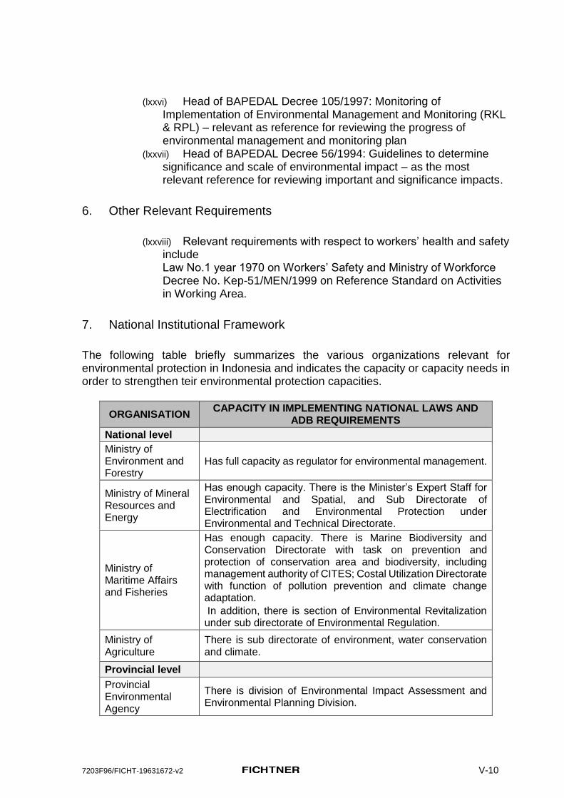
The following table briefly summarizes the various organizations relevant for environmental protection in Indonesia and indicates the capacity or capacity needs in order to strengthen teir environmental protection capacities.
ORGANISATION CAPACITY IN IMPLEMENTING NATIONAL LAWS AND
ADB REQUIREMENTS
National level
Ministry of Environment and Forestry
Has full capacity as regulator for environmental management.
Ministry of Mineral Resources and Energy
Has enough capacity. There is the Minister’s Expert Staff for Environmental and Spatial, and Sub Directorate of Electrification and Environmental Protection under Environmental and Technical Directorate.
Ministry of Maritime Affairs and Fisheries
Has enough capacity. There is Marine Biodiversity and Conservation Directorate with task on prevention and protection of conservation area and biodiversity, including management authority of CITES; Costal Utilization Directorate with function of pollution prevention and climate change adaptation.
In addition, there is section of Environmental Revitalization under sub directorate of Environmental Regulation.
Ministry of Agriculture
There is sub directorate of environment, water conservation and climate.
Provincial level
Provincial Environmental Agency
There is division of Environmental Impact Assessment and Environmental Planning Division.

7203F96/FICHT-19631672-v2 V-11
ORGANISATION CAPACITY IN IMPLEMENTING NATIONAL LAWS AND
ADB REQUIREMENTS
Provincial Mineral Resource and Energy Service
Has no capacity: in East Nusa Tenggara Province, there is Environmental Protection Section which only under Mining Sector; there is no environmental management section under Energy Utilization and Electrical Sector. In East Kalimantan Province, there is Geology Environment and Ground Water Section under Mineral Resources and Geology.
Provincial Maritime Affairs and Fisheries Service
There is no section or division that relate to environmental management and monitoring.
Provincial Agriculture Service
There is no section or division that relate to environmental management and monitoring.
Provincial Development Planning Agency
As coordinating agency among related organizations/institutions in provincial level.
District level
District Environmental Agency (DEA)
There is division of AMDAL & UKL/UPL
District Mineral Resource and Energy Service
Mostly there no section or division that relate to environmental management and monitoring.
District Maritime Affairs and Fisheries Service
Mostly there no section or division that relate to environmental management and monitoring.
District Agriculture Service
Mostly there no section or division that relate to environmental management and monitoring.
District Development Planning Agency
As coordinating agency among related organizations/institutions in district level.
C. International Guidelines and Standards
1. International Agreements
161. Indonesia has ratified several international conventions, including:
(lxxix) Convention on Fishing and Conservation of Living Resources of the High Seas (Marine Life Conservation). Objectives: Solve the problem of preservation of biological resources in the high seas through international collaboration with the consideration that the use of modern technology for the exploitation of resources in excess will cause harm to these resources.
(lxxx) Convention on Biological Diversity, for parties to require the environmental assessment of their proposed projects that are likely to have significant adverse impacts on biological diversity with a view of avoiding or minimizing such impacts;
7203F96/FICHT-19631672-v2 V-12
(lxxxi) Convention on Wetlands of International Importance Especially as Waterfowl Habitat (1972). Indonesia has International agreement to make controlling the continuous encroachment of wetland in the present and future, to recognize the basic ecological functions of wetlands follows the economic, cultural, scientific, and recreation.
(lxxxii) Convention on the Prevention of Marine Pollution by Dumping Wastes and Other Matter (1972). Indonesia has international agreement to control of marine pollution due to accumulation of waste and other materials and to encourage regional agreements to complement the Convention; London Convention come into effect in 1996.
(lxxxiii) Vienna Convention for the Protection of the Ozone Layer, in 1998, and subsequent protocol and amendments, for parties to take appropriate measures to protect human health and the environment against adverse impacts likely to arise from human activities that will/likely modify the ozone layer.
(lxxxiv) Protocol of 1978 Relating to the International Convention for the Prevention of Pollution from Ships, 1973 (MARPOL). Indonesia ratified international agreement to conserve the marine environment / marine pollution by banning oil and other hazardous substances and disposal of hazardous substances to suppress levels that do inadvertently (e.g. due to accidents).
(lxxxv) Basel Convention on the Control of Transboundary Movements of Hazardous Wastes and Their Disposal (1989). Indonesia has ratified international agreement to reduce cross-country movement of waste in accordance with the minimum limit of the Convention in order to create an environmentally friendly waste management and efficient; reducing toxicity of waste generated and to ensure that environmental management is the basis for resource development.
(lxxxvi) United Nations Framework Convention on Climate Change (1992). Indonesia has ratified international agreement to achieve stabilization of greenhouse gas concentrations in the atmosphere as low as possible in order to prevent dangerous anthropogenic interference with the climate.
(lxxxvii) Kyoto Protocol to the United Nations Framework Convention on Climate Change. Indonesia has ratified international agreement to reduce greenhouse gas emissions by promoting national programs in developed countries aimed at reducing greenhouse gas emissions and determine the percentage of reduction targets for developed countries.
(lxxxviii) Indonesia ratified the Paris Agreement within the United Nations Framework Convention on Climate Change (UNFCCC) dealing with greenhouse gases emissions mitigation, adaptation and finance in October 2016.

7203F96/FICHT-19631672-v2 V-13
2. ADB Safeguards
162. Environmental sustainability is one core issues of ADB’s environmental policy.
163. The ADB requires environmental assessment of all project loans, program loans, sector loans, sector development program loans, financial intermediation loans, and private sector investment operations. Environmental assessment is a process rather than a one-time report, and includes necessary environmental analyses and environmental management planning that take place throughout the project cycle.
164. This EIA was carried out in accordance with the following relevant Guidelines:
(lxxxix) ADB Safeguard Policy Statement (SPS), June 2009, effective since January 2010;
(xc) Operations Manual (OM) with relevant Bank Policies (BP), March 2010.
3. Other relevant international guidelines considered for this EIA:
(xci) General IFC Health and Safety Guidelines (2007); (xcii) IFC Environmental, Health, and Safety Guidelines for Thermal
Power Plants, December 2008; (xciii) IFC Performance Standards and Guidance Notes (2012).
D. Gaps between national requirements and international standards
165. The legal framework of the Republic of Indonesia does essentially correspond with the international regulations and safeguards. Gaps however do exist in enforcement of the regulations. There is still a considerable lack of institutional capacities for implementation, monitoring and evaluation.
166. In general, the ADB’s SPS requirements regarding environmental assessment and Indonesian national legal requirements address the same topics. However, ADB’s SPS requirements regarding environmental assessment are more detailed than Indonesian national legal requirements, for example in the following areas:
Identifying gender impacts and impacts on vulnerable groups within Identification of socioeconomic impacts
Considering of the no-project alternative
The legal framework for EMP does not appear to require detailed information on proposed mitigation measures beyond references to “form” and “location”
The legal framework requires monitoring plans but does not appear to specify reporting requirements

7203F96/FICHT-19631672-v2 V-14
The legal framework references the “environmental management institution” as a component of EMP but does not appear to require a description of institutional or organizational arrangements.
The legal framework does not appear require the EMP to specify proposed capacity development and training measures.
The legal framework does not appear to require the EMP to specify its cost estimates.
The legal framework does not appear require the EMP to address significant harm to third parties nor does it require application of the polluter pays principle
The legal framework explicitly requires that NGOs be included in the consultation process
There are no requirements regarding corrective actions or disclosure of monitoring reports in the legal framework.
167. The Indonesian legal framework does not directly define the areas of “critical habitat” apart from various categories of protected areas. However, the prohibitions applicable to protected areas reference “environmental function” unless otherwise defined, can be presumed to include habitat protection. The biodiversity guidelines for effective implementation of legislation are vague with much left to discretion. This appears to be a gap in legislation and capacity, and the Project EIA/IEE will have to follow ADB SPS 2009 and IFC Policies and Guidelines to address this gap.
168. The Indonesian legal framework does not generally prohibit significant conversion or degradation of natural habitat outside of formally designated protected areas, but makes this subject to alternatives assessment, cost-benefit analysis or mitigation requirements.
169. The use of a precautionary approach to develop and manage natural resources is not explicitly mentioned in the Indonesian legal framework.
ADB POLICY PRINCIPLE
GOI LEGAL EQUIVALENCE
DOES NOT COVER
Screening Process Fully covered --
Environmental Assessment
Fully covered --
Alternatives Fully covered --
Offset Adverse Impacts Partially covered Capacity development and training, cost estimates
Consultation Partially covered Ensuring women’s participation and grievance redress mechanism
Disclose EMP Partially covered Public disclosure of draft AMDAL and EMP
Implement EMP & Monitor
Partially covered Public disclosure of EMP monitoring results
Critical Habitats Partially covered EMP for impact monitoring and Committee releasing recommendations to mitigate impacts
Pollution Prevention Partially covered IFC standards are more strict than national standards

7203F96/FICHT-19631672-v2 V-15
ADB POLICY PRINCIPLE
GOI LEGAL EQUIVALENCE
DOES NOT COVER
Health & Safety Fully covered --
Cultural Resources Partially covered Provisions for ‘chance finds’
170. Summing up these considerations it appears that legal provisions of Indonesia’s safeguards country system are general in compliance with the requirements of ADB SPS 2009. The national requirements are fully or partially equivalent to the policy principles and key elements of ADB SPS 2009. However, the existing practice of implementation and enforcement of these provisions needs a substantial support.

7203F96/FICHT-19631672-v2 V-1
IV. Description of the Project
A. Project setting
1. Project location
171. The project site for the planned Kupang Peaker 2 will be located south-west of Panaf hamlet (Dusun Panaf), which is part of Lifuleo village (Desa Lifuleo), in the District of West Kupang, Kupang Regency, Nusa Tenggara Timur Province, at the most western tip of Timor island.
Figure 1: Location of the future Power Plants Complex, including Kupang Peaker 2 (source of the topographic maps: URL 1 and URL 2)
172. The project area is presently a greenfield, however, a Power Plant Complex is planned there which will comprise:

7203F96/FICHT-19631672-v2 V-2
(xciv) Timor 1 Coal Fired Steam Power Plant - 100 MW (xcv) Kupang Peaker 1 Gas Fired Power Plant - 40 MW (xcvi) Kupang Peaker 2 Gas Fired Power Plant - 50 MW (the Project)
173. The Coal Fired Steam Power Plant Timor 1 and the Kupang Peaker 1 will be built before the construction activities of Kupang Peaker 2 commence.
2. Access to the project site
174. The nearest Airport from the project site is El Tari Airport. There are numerous flights from Soekarno-Hatta International Airport in Jakarta to El Tari Airport in Kupang with a flight time of around three hours and thirty minutes.
175. From El Tari Airport the project site can be reached by car in about 60 minutes and the distance is about 40 km. A two-lane public asphalt road in good condition leads from the airport to the beginning of the acess road to the project site.
176. This acess road to the project site is ca. 3 km long, unpaved, and most sections are in poor condition. It is expected that this road will be ubgraded at the beginning of the construction activities for the coal fired power plant and Kupang Peaker 2, so that no road upgrading activities are necessary for Kupang Peaker 2.
177. The project site for Kupang 2 Peaker is part of a planned Power Plant Complex and will directly border the planned Kupang Peaker 1 site and the 100 MW Coal Fired (PLTU) Steam Power Plant Timor 1 in the North.

7203F96/FICHT-19631672-v2 V-3
Figure 2: Location of the planned project site Kupang Peaker 2 (marked in
red), bordering the planned project sites of Kupang Peaker 1 and the coal fired PLTU power plantTimor 1 in the North.
178. Kupang Peaker 2 will be located south-east of the planned new 40 MW Kupang Peaker 1 (commercial operation planned for 2018) and broadly adjacent to the planned new PLTU-Timor 1 coal fired Power Plant (commercial operation planned for 2019). Kupang Peaker 2 is planned to become operational in 2022. According to PLN’s planning schedules, both projects neighbouring Kupang Peaker 2 will be completed before the construction activities for Kupang Peaker 2 begin and will be constructed in any case, i.e. not related to the decision if the Kupang Peaker 2 facility will be constructed or not.
179. As Kupang Peaker 2 will be built in the vicinity of the planned Peaker 1 and the coal fired Power Plant, the emissions of these plants must be considered for the assessment of cumulative impacts of the power plant complex in the area as shown in Appendix 1 to this report.
180. The following layout shows the whole planned power plant complex comprising the planned coal fired Power Plant Timor 1, Kupang Peaker 1, and Kupang Peaker 2.
Access Road to the Kupang Power plant
complex
Panaf hamlet
Kupang
Peaker 1
PLTU Timor 1
Kupang Peaker 2
2 2 2
Kupang
Peaker 1
Sea Weed Beach
Mangrove Beach
Mangrove Forest

7203F96/FICHT-19631672-v2 V-4
Figure 3: Location of the planned project site Kupang 2 (marked in orange), bordering the Kupang 1 Peaker site and the PLTU Timor 1 in the North.
3. The project site
181. The total area for the whole power plant complex acquired by PLN (PLTU Timor, Kupang Peaker 1, and Kupang Peaker 2) is located west of Panaf village and comprises 52 ha.
182. Within these 52 ha the site for Kupang Peaker 2 occupies a 5 hectares wide area, roughly. 400 m south-west of Panaf village. Within the power plant complex only Kupang Peaker 2 will be financed by ADB and this EIA therefore focuses on this site and the selected significant impacts outside the project site during construction and operation of the power plant.
183. The familiarization of customary communities with respect to the project plan was conducted by PLN on 28th – 29th September 2016. The land acquisition planning document was prepared by PLN and submitted to the Regent of Kupang.
184. The land acquisition process was completed and the DDR finalized including consultations this EIA was completed. The delimitation of the project site Kupang 2 and the layout plan was available.

7203F96/FICHT-19631672-v2 V-5
Figure 4: Basic design layout of the Kupang 1 PP and Kupang 2 PP (orange)
185. The layout of Kupang Peaker 1 was used as a template for this EIA as no specific layout plan was available at the time when this EIA Report was compiled. The technology for both plants is the same. Kupang Peaker 2 (50 MW) will have 2 more or equal higher generation capacity gas engines than Kupang Peaker 1 with 40 MW total capacity.
B. Technical Description
1. Planned Technical Infrastructure of the PLTU Timor 1 and Kupang Peaker 1 site:
186. All technical information for these plants was taken from the Feasibility Studies (May 2016) provided by PLN. The Timor 1 study contains some technical information (general layout and technical characteristics of the plant plan, e.g. coal specifications, amount of coal consumed, etc.). However, other data needed for the air dispersion and the noise emission calculations had to be reasonably assumed and estimated. The planning of Kupang Peaker 1 and the respective Feasibility Study was also made available to Fichtner.
187. A short description of the projects and their layout is given below.
Timor 1 Coal Fired Steam Power Plant - 100 MW
188. The Timor 1 coal fired PP will be located in the same complex as the Kupang 1 and Kupang 2 plants.
189. The environmentally most relevant elements of this power plant are the coal loading (jetty), coal transport (belt conveyors), coal storage (coalyard), the power plant itself, the ashyard, the marine water intake and the waste water disposal infrastructure.
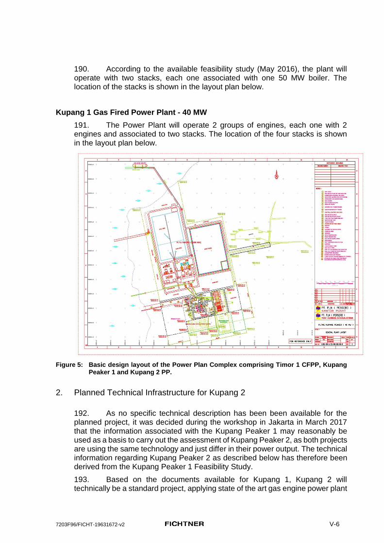
7203F96/FICHT-19631672-v2 V-6
190. According to the available feasibility study (May 2016), the plant will operate with two stacks, each one associated with one 50 MW boiler. The location of the stacks is shown in the layout plan below.
Kupang 1 Gas Fired Power Plant - 40 MW
191. The Power Plant will operate 2 groups of engines, each one with 2 engines and associated to two stacks. The location of the four stacks is shown in the layout plan below.
Figure 5: Basic design layout of the Power Plan Complex comprising Timor 1 CFPP, Kupang Peaker 1 and Kupang 2 PP.
2. Planned Technical Infrastructure for Kupang 2
192. As no specific technical description has been been available for the planned project, it was decided during the workshop in Jakarta in March 2017 that the information associated with the Kupang Peaker 1 may reasonably be used as a basis to carry out the assessment of Kupang Peaker 2, as both projects are using the same technology and just differ in their power output. The technical information regarding Kupang Peaker 2 as described below has therefore been derived from the Kupang Peaker 1 Feasibility Study.
193. Based on the documents available for Kupang 1, Kupang 2 will technically be a standard project, applying state of the art gas engine power plant

7203F96/FICHT-19631672-v2 V-7
technology and state of the art balance of plant systems. Major technical challenges are not expected.
194. The Kupang Peaker 2 will have dual fuel firing capability with the primary fuel being gas (delivered as LNG). The LNG supplier will operate a LNG re-gasification and storage facility at the site and supply the terminal via medium capacity size LNG tankers. The back-up fuel will be HSD and will be provided via road tanker and stored at the site.
195. The Kupang Peaker 2 will be operated in peaking mode supplying electric power to the local grid, primarily during times of high demand. This generally occurs typically daily over a 5-hour period between 17:00 and 22:00.
196. Based on the Kupang Peaker 1 Feasibility Study, the Kupang Peaker 2 plant will consist of 2 groups of gas engines, with each group consisting of 2 to 6 units. The plant will use one engine type only. A single gas engine may thus have a capacity of minimum 4.1 MW and maximum 12.5 MW. The following configuration is assumed:
I. 2 groups of gas engines; (xcvii) Each group will have 2 gas engines (total of 4 engines); (xcviii) Each group will have a capacity of 25 MW; (xcix) Each engine will have a capacity of 12.5 MW.
II. 4 stacks4 (one per engine);
197. According to the Feasibility Study for Kupang 1, the Kupang 2 PP will include a Wastewater Treatment Plant. Wastewater discharged from power plant activities will be treated in the Wastewater Treatment Plant (WWTP) before discharging to the drainage or sea. Wastewater treatment plant will treat wastewater produced on site as a result of the power generation process, building, and surface drainage and domestic and sewage wastewater from the whole site and will ensure that the final discharge point meets the requirements of as set in Indonesian Environmental Regulation for wastewater standard (regulation of the Minister of Environment No. 08 Year 2009 on Wastewater Quality Standard for Thermal Power Plant Businesses and/or Activities). For process water gowever IFC EHS guidelines will apply. Process water contains the chemicals required for operation and maintenance of the WWTP system that typically include hydrochloric acid (HCl) as neutralization agent, sodium hydroxide (NaOH) as neutralization agent, sodium hypochlorite (NaOCl), coagulant such as aluminum sulfate and flocculants.
198. Based on the Kupang 1 Feasibility Study, the general design of the fire protection facilities at the Kupang 2 PP take into account that the basic operating policy for the power plant will have the minimum of personnel supervision for the gas engine. All fire protection installations comply with the requirements of the codes of practice of the National Fire Protection Association (NFPA) especially NFPA 850, “Recommended Practice for Fire Protection for Electric Generating Plants and High Voltage Direct Current Converter Stations”. Fire protection
4 The exact number of stacks is not known at this stage. The air quality Dispersion study assumes 1 stack with 4 pipes wah connecting to a gas engine. From the point of view of modelling Kupang Peaker 2 is assumed to act as one-point sourse.

7203F96/FICHT-19631672-v2 V-8
system will include Fire Pumps, CO2 System, Hydrant System, Portable Equipment, Water spray system, Automatic sprinklers, Foam System, Automatic FM-200 Deluge system, Fire Detection System and Fire Fighting Control System.
3. Project Layout
199. The proposed civil works are based on the overall plant layout. The new plant will be built at the southernmost corner of the planned power plant complex.
200. The new project and all its new project components will be located within the fenced area shown in Error! Reference source not found.Figure 6 below.
Figure 6: Layout plan of the planned project site Kupang 2 (marked in yellow), bordering the
planned Kupang 1 Peaker site in the North.
C. Project associated facilities
201. For the Kupang Peaker 2, the following project-related infrastructure is required:
(c) Access road (ci) Jetty (LNG supply) (cii) LNG re-gasification and storage (ciii) Power evacuation line (interconnection to the Timor transmission
system)
202. The existing country road needs upgrade to provide suitable access to the project sites (PLTU-Timor and Kupang Peaker 1). Plans for upgrade and exact routing are not yet available. However, this upgraded access road will

7203F96/FICHT-19631672-v2 V-9
already exist by the time construction works commence for the Kupang Peaker 2. The then already existing access road to the power plant site (Kupang Peaker 1 and PLTU-Timor 1) will then be used for the access to the Kupang Peaker 2 site. Therefore, in the context of the ADB SPS 2009, the access road is not considered as an associated facility of the project Kupang Peaker 2.
203. The LNG jetty is being constructed to serve both the Kupang Peaker 1 and Kupang Peaker 2 facilities. The construction and operation will be done under a Built / Operate / Transfer (BOT) scheme. The planning of Kupang Peaker 1 is well ahead of Kupang Peaker 2 and will be constructed whether or not Kupang Peaker 2 will be constructed. No upgrading of the jetty is anticipated to accommodate Kupang Peaker 2. Therefore, the LNG jetty is not considered as an associated facility of the project Kupang Peaker 2.
204. The LNG re-gasification and storage facility is being constructed to serve both the Kupang Peaker 1 and Kupang Peaker 2 facilities and will also be part of the BOT scheme. No upgrading of the LNG re-gasification and storage facility is anticipated to accommodate Kupang Peaker 2. Therefore, the LNG re-gasification and storage is not considered as an associated facility of the project Kupang Peaker 2.
205. Similar to the LNG jetty, the electrical interconnection to the transmission system will be constructed ahead of Kupang Peaker 2 to permit evacuation of the power from the power plant sites Kupang Peaker 1 and PLTU-Timor. It will already exist at the time when the construction activities for Kupang Peaker 2 begin and will be constructed irrespective of the construction of Kupang Peaker 2. Therefore, the electrical transmission system is not considered as an associated facility of the project Kupang Peaker 2.
Summary of project associated facilities
206. The following table summarizes the environmentally relevant project associated facilities and their present status.
Project component
Kupang Peaker 2
Access road
existing* and upgraded (shared with other PPs)
Jetty (LNG and Diesel supply)
existing* (shared with Kupang Peaker 1)
LNG re-gasification and storange
existing* (shared with Kupang Peaker 1)
Power evacuation line
existing* (shared with other PPs)
existing* - this infrastructure is presently not yet existing however it will be existing at the time when the construction activities for Kupang Peaker 2 commence.

7203F96/FICHT-19631672-v2 V-10
D. Project variants
207. The location of the project site Kupang Peaker 2 was determined by PLN and the delimitation of the project site was derived from the project layout plan provided by PLN. No other project locations were considered.
208. The EIA process usually goes along in parallel and in coordination with the technical planning from the very beginning of the planning process up to the final design stage.
209. At the time when the EIA process for this project was conducted, only a layout plan of the project was available. No site or project specific documents were made available due to the fact that this project so far has only been listed in the RUPTL (the operation shall not begin before 2022).
210. As the planned Kupang Peaker 2 will be technically very similar to Kupang Peaker 1, the Feasibility Study as well as the Draft UKL-UPL were used as main data sources for the planned project.
211. In the cases when no data was available, assumptions were made based on experiences with similar projects or the experts’ opinion.
212. In case there was more than one technical possibility, worst case scenarios were assumed for impact forecast and assessment as a first iteration, following the standards of international financing agencies.
213. Regarding gaseous emissions, a worst case scenario was assumed as a first iteration, where Kupang Peaker 2 will run on a continuous basis with HSD. The same was assumed for the neighboring plant Kupang Peaker 1. Timor 1 was assumed to run continuously with coal, and this was also incorporated into the Air Dispersion Calculation (ADC) model. This is though contrary to the intentions and the economic incentives of PLN. It is therefore highly likely that the peaker plants will berun on gas being provided through the LNG infrastructure being developed. Plant operations using LNG therefore is more realistic mode of o[eration form the plant. From air quity oimpact assessment though the diesel operaions have been considered.
E. No-Project option scenario and Analysis of Alternatives
214. The planned Kupang Peaker 2 project is just one piece in PLNs energy plan in order to achieve a sufficient and reliable energy supply on Timor Island. Without this project, interruptions of the energy supply will continue
215. Since Kupang Peaker 2 is the third plant of a power complex, is a msall plant and wil e operated on gas, besides noise it does not have any significant impact that will add to the impacts of earlier planned power plants – Timor 1 and Kupang Peaker 1. On this background the additional impacts resulting from the planned Kupang Peaker 2, besides eventual temporary effects from blasting for leveling the site, are almost negligible compared to the then existing and ongoing impacts from the operation of the then existing power plant complex.

7203F96/FICHT-19631672-v2 V-11
216. It has to be stated at this point that setting up a power plant complex at the western tip of Timor island competes with the protection of the still rich natural resources in this area, as specified in many official national and international documents and strategies (protection of rare and endangered species, protection of natural resources, enhancement of eco tourism, etc.).
217. The Sawu Sea and surroundings, including Kupang Regency, have been officially designated as a national marine reserve. The National Marine Reserve of Sawu Sea is classified as category II of IUCN protected areas categories system, thus can be considered a critical habitat according to ADB SPS 2009. Category II areas comprise large natural or near natural areas set aside to protect large-scale ecological processes, along with the complement of species and ecosystems characteristic of the area, which also provide a foundation for environmentally and culturally compatible spiritual, scientific, educational, recreational and visitor opportunities.
218. With respect to analysis of alternatives for such a small peaker plant gas firing mode is most environmental friendly and cost effective. The site does not have potential for commercial exploitation of wind energy. Solar energy with out large battery storage can not play the role of peaking stations besides it needs large land area. Since use of planned transmission system was one of key economic reason to select the present site, solar energy was not a feasible option due to land constraint at the site.

7203F96/FICHT-19631672-v2 V-1
V. Description of the Environment
A. Physical environment
219. The environmental components of the physical environment considered in this EIA are topography, geology and soils, seismicity, water, climate, air, and noise.
1. Topography
Project site
220. The planned Kupang 2 Peaker site has a general south-west inclination of around 2% and is located at a height between 5 to 10 meters above sea level. Large parts of the project site have a quite plain topography with fairly flat terrain. Those parts are mostly used for extensive, rain-fed agriculture. Steeper parts are covered with secondary bushland.
2. Geology and Soil
District
221. Generally, the geological conditions in Kupang District are mixed conditions dominated by Noele Formation, Bobonaro complex and Batuputih Formation with little formation of Ofu and Alluvium in coastal areas in the southern part of Kupang District. Whereas in the middle to the north is dominated by Bobonaro complex with little Batuputih Formation, while in the east and west coastal areas are dominated by Mutis complex, Limestone Formation and little bit of Alluvium.

7203F96/FICHT-19631672-v2 V-2
Figure 7: Geology Map of Kupang District
222. The type of soil in Kupang District consists of lithosol, alluvial, sandy clay, and soil mixture of rocks. The soil mixture of rocks contains of several types of minerals i.e. (1) limestone; (2) Poral sand; (3) marble; (4) clay; (5) sandstone; (6) terracotta; (7) ornamental stones; (8) gold elements; (9) silver elements; (10) the elements copper; and (11) the manganese elements. Litosol is suitable for planting of crops that are resistant to heat, whereas alluvial soils are planted with perennial plants and seasonal crops. Sandy clay is usually found in coastal areas and estuaries, while large areas on hills and hillsides are only covered by shallow soils on base rocks.
Project site
223. Most of the project area area is covered with only up to a few cm of laterite soil. In some places within the project site and especially along the coastline volcanic base rock is directly outcropping from the surface without any soil cover, as shown in Figure 8 below.
224. The stones in the area are very heavy, hard and of volcanic origin. These geological conditions may cause difficulties during construction (leveling, excavations) and may require heavy and frequent blasting.
225. Only directly along the coastline limestones were found during the site visit originating obviously from coral reefs offshore the costline.

7203F96/FICHT-19631672-v2 V-3
Figure 8: Project site with very shallow soil and outcropping volcanic base rock in numerous places
3. Seismicity
226. According to the earthquake events shown in Figure 9 below, Timor island is located at the northern edge of the Australian Plate, near the boder to the Sunda plate in a medium earthquake risk zone with a peak ground acceleration of up to 1.6 m/s2.
Figure 9: Earthquake risk, based on recordings from 1900 - 2010 Source: Seismicity of the Earth 1900-2010, New Guinea and Vicinity, Seismic Hazard Map
of Indonesia, Benz, Harley M. et al., 2011
227. According to the earthqauke events shown in Figure 10 below, the seismicity recordings show that there were numerous earthquake events in western Timor. These events were quite shallow with a depth of up to 69 km and a magnitude of up to 6.4 on the Richter Scale.

7203F96/FICHT-19631672-v2 V-4
Figure 10: Earthquake events 1900 - 2010 Source: Seismicity of the Earth 1900-2010, New Guinea and Vicinity, Seismic Hazard Map
of Indonesia, Benz, Harley M. et al., 2011
4. Surface water
District
228. Annual rainfall average in Kupang District ranges between 100 and 800 mm/year. The region with rainfall < 300 mm/year is located in the western part of the Sulamu, Fatuleu, and South Amfoang sub districts, as well as the western and northern parts of the North Amfoang; including the eastern part of the East Kupang, Semau and South Semau sub districts. The heaviest rainfall of the entire territory occurred in the Amarasi sub district, partly of East Kupang and the western part of the Sulamu and Takari sub districts, in the central part of the Fatuleu sub district and the eastern part of South Amfoang sub district.
229. Most of the surface water flows in the Kupang District are ephemeral and depend on rain events.
230. However, there are some permanent rivers that carry water throughout the year i.e. Oesao River in East Kupang sub district, Manikin River in Central Kupang sub district, river of Termanu, Kapali and Metan in South Amfoang sub district, river of Noelfael, Nalinen and Toko in North Amfoang sub district, Bokong River in Takari sub district; and Barate River in West Fatuleu sub district. These rivers are not only used for irrigation water sources, but also for the daily needs of the local community.
231. In the wider project area, ca. 5 km east of the project site, out of the area of influence from the planned project, the Tuadale lake can be found, which consists of 5 different lakes located near the hamlet 23 Lifuleo village, West Kupang Subdistrict, Kupang District. The total surface area of the lakes reaches ± 10 ha. The lakes are inhabited by various kinds of fish among them tilapia, snapper, and cork. The Tuadale lake is one of the assets of the district government of Kupang. Since 1998 the lake has been managed by the Village Head Lifuleo for commercial fish breeding.

7203F96/FICHT-19631672-v2 V-5
Figure 11: Hydrological Map of Kupang District
Project area
232. There are no permanent surface water bodies within the physical footprint (directly impacted power plant complex area) west of Panaf hamlet.
233. The next open waterbodies are located in a distance of around 1.3 km east of the planned project site within the mangrove forest.
5. Ground water
District
234. Generally, most of Kupang District has the potential of shallow ground water which is spread evenly on each sub district, even on a relatively small area that is on the west side (partly of West Kupang sub district, some part of Sulamu and Fatuleu sub district), and also partly of East Kupang and Takari sub district, as well as the eastern part of South Amfoang sub district.
7203F96/FICHT-19631672-v2 V-6
Project area
235. Most of the project area is covered with only up to a few cm of soil and in some places base rock is outcropping from the surface. These geological conditions lead to the assumptions that ground water is expected to be found at best in rock cleavages, that there is no coherent ground water body, and that the groundwater yields are very small and directly depend on rain events.
236. Fresh water for Panaf hamlet is supplied from deep wells located in a distance of about 2 km away from the project site.
6. Climate
District
237. Kupang District is generally tropical and dry; the rainy season lasts for about 3 or 4 months, the dry season up to 9 months. The rainy season mostly occurs from December to March, in Semau. These climatic conditions certainly influence the cropping and farming patterns of communities in Kupang District.
238. According to the Köppen climate classification, the Kupang District is tropical wet and dry climate (Aw). Unlike many areas outside Indonesia with tropical climate, the temperature Kupang District varies a little between summer season (hotter months) from October to March and winter season (cooler months) from April to September. The hottest month is October with an average temperature of 28.8 °C, while the coolest month is July with the average temperature 26.1 °C.
239. The yearly average air temperature is 27o with an average humidity of 75%.
Project area
240. The general climate of the project area is determined by the climate as described above for the district.
241. Site specific peculiarities are the south-west inclination of the project site and the fact that the wind, which comes from a predominantly south-eastern direction, will blow eventual emissions from future power plants mainly to north-west, towards the sea and away from Timor island.
7. Precipitation
242. Kupang District is likely to be affected by the wind and is categorized as a semi-arid region due to the relatively low rainfall, with an average of 1,441 mm of rainfall per year, or 120.1 mm per month. The district has two distinct seasons, a wet season and a dry season. The wettest month is January with an average precipitation of 389 mm and the driest month is September with an average precipitation of 2 mm.

7203F96/FICHT-19631672-v2 V-7
8. Wind
243. Figure 12 presents the simulated wind rose for the year 2016. It shows that the prevailing winds blow from southeast (SE), while most of the receptors are located to the northeast (NE) of the plant. The wind rose also indicates that the more frequent wind speed is around 5 m/sec, which is equivalent, in the Beaufort scale, to the level “gentle breeze”.
Figure 12: Windrose for the year 2016 as simulated with the model WRF (wind
blowing from) (source of the satellite image: Google Earth TM)

7203F96/FICHT-19631672-v2 V-8
9. Air quality
244. Air quality measurements have been undertaken in the area for the Initial Environmental Examination (in Bahara UKL-UPL) for Kupang 1 PP (PT.PLN, 2016). Measurements have been undertaken at 6 locations (please see a location map in Annex D):
(i) two locations in Lifuleo (belonging to Oisina);
(ii) four locations within the proposed project site (office, engine area,
access road and jetty).
245. The summarized results are shown in Table V-2. The data for gases has been collected as one-hour averages only. However, the air quality standards are defined for different averaging periods, namely 10 minutes, 1 hour, 8 hours, 24 hours and 1 year. Therefore, it is necessary to convert the 1-hour measurement results into the other averaging periods. This is done by applying the multiplying factors shown in Table V-1 to the measured values. For more details see Air Dispersion Calculation report for Kupang 2 Peaker (Annex D).
Averaging period Multiplying Factors - to convert 1 hr to other averaging periods
10 mins 1.65 *
8 hours 0.7 **
24 hours 0.4 **
Annual 0.08 **
Table V-1: Multiplying factors for point sources to convert 1 hour concentrations to other averaging periods (*OME, 2008, and **EPA, 1992)
246. The background pollutant concentrations are below the national standards for air quality, as well as the WHO guidelines and interim targets. Such results were expected given the characteristics of the site (sparsely populated and without industrial developments in the vicinity).

7203F96/FICHT-19631672-v2 V-9
Pollutant Averaging
period
Air Quality Measured and
Calculated Results [μg/Nm3 ]
Air Quality Standards [μg/m³]
NAAQS WHO
CO 1 hour * 2827.7 30,000 -
24 hours 7.1 10,000 -
SO2
10 minutes 29.2 - 500 (GL)
1 hour * 17.7 900 -
24 hours 7.1 365 125 (IT1) 50 (IT2) 20 (GL)
1 year 1.4 60 -
NO2
1 hour * 16.7 400 200 (GL)
24 hours 6.7 150 -
1 year 1.3 100 40 (GL)
PM10
24 hours N.A. 150
150 (IT1) 100 (IT2) 75 (IT3) 50 (GL)
1 year N.A. -
70 (IT1) 50 (IT2) 30 (IT3) 20 (GL)
TSP
1 hour* 28.7
24 hours 11.5 230 -
1 year 2.3 90 -
* Measured values; all other values are calculated using the factors shown in Table V-1
Table V-2: Air Quality measured and calculated results in the project area (adapted from PT.PLN, 2006)
247. The Consultant had no access to a description of the quality assurance and control procedures undertaken during the collection of the air quality data shown. There is therefore no guarantee that the data collection has been made according to reference techniques and methods. Given this, the data is used in this report only for illustrative purposes.
10. Noise
248. At present there are no relevant noise sources within the wider area of the planned power plant complex. The present noise is originated by natural sources like marine waves, wind in the trees, and animals (birds, cows, sheep, goats), together with the sounds from the rural and poor hamlet Panaf, without motorized workshops or motor vehicles. There are no cars in the village, and only a few times per day the sound of a small motor bike is audible.
Standard Standard is not exceeded Standard Standard is exceeded

7203F96/FICHT-19631672-v2 V-10
249. Measurements of noise levels (UKL-UPL for Kupang Peaker 1, PLN 2016) were conducted in the project area using sound level meter according to the Regulation of the Minister of Environment No. 48/MENLH/11/1996 about noise level standards. These measurements showed sound levels between 39 and 42 dB(A).
B. Natural environment
250. The natural environment chapter comprises flora and fauna species and their habitats, but also the protection status of these species and habitats.
1. Flora
District
251. Biodiversity documentation in the Nusa Tenggara Timur Province is quite limited, however typical plants of Kupang District are savanna-type grass species (adapted to endure hot and dry periods), palmyra palm (Borassus flabelifer), pine trees, sandalwood (gewang, Santalum spec.), and mangroves (Rhizophora sp.).
252. In the forest areas there are acacia, eucalyptus, papyrus, eaglewood, etc. Among the numerous tree species in Kupang district, the most famous is sandalwood, which has a better quality than the timber from most other regions in Indonesia. Eucalyptus trees and palmyra palms are the dominating tree species in this area.
253. Around 3.46% or 18,787 hectares of the Kupang District area are dry paddy land, while around 96.54%, or about 523,610 hectares are dry rock land or moor.
254. In the vicinity of the project area in direction east is a mangrove forest area. The mangrove forest area in Kupang Regency, East Nusa Tenggara Province consists of some area in Bipolo, Nanas Beach, Pariti Village, and Nunkurus Village of Sulamu Sub-district; Oebelo Village, Kupang Tengah Sub-district; Enoraen Village, Amarasi East, Sub-district; Lifuleo Village, Sub-district Kupang Barat; and Akle Village, South Semau Sub-district. Of the 40,695 hectares of mangrove forest in East Nusa Tenggara, a great volume has been subject of mangrove logging by communities for the need of building materials and firewood. Discrepancies exist in data regarding mangrove area size from varius sources. According to Kupang Regency in Figures, 2017, based on Crops and Forestry Service of Kupang Regency, 2015, the area covered with mangrove forest in Kupang Regency is 3,266.10 ha (Table V-3). The types of mangrove in Nusa Tenggara Timur are presented in Table V-4.

7203F96/FICHT-19631672-v2 V-11
No. Forest Function Total Forest Area (Ha)
1. Protection Forest 109,463.41
2. Production Forest 107,904.42
3. Limited Production Forest 0
4. Convertible Production Forest 0
5. Wildlife Reserve 3,041.60
6. Hunting Park 0
7. Natural Recreation Park 831.92
8. Mangrove 3,266.10
9 Marine Natural Recreation Park 63,889.55
Total 288,397.00
Table V-3: Data of forest function based on Kupang Regency (Source: Kupang Regency in Figures, 2017; based on Crops and Forestry Service of Kupang Regency, 2015)
No. Familiy Types Source Remarks
1. Rhizophoraceae Ceriops tagal (Perr) 1, 2 and 5 True mangrove
2. Rhizophoraceae Ceriops decandra (Griff). DH 1 and 3 True mangrove
3. Rhizophoraceae Rhizophora apiculata (Bi) 1,2, 4, and 5 True mangrove
4. Rhizophoraceae Rhizophora mucronata Lmk 1,2, 4, and 5 True mangrove
5. Rhizophoraceae Rhizophora stylosa Griff 1 True mangrove
6. Rhizophoraceae Rhizophora lamarckii 1 True mangrove
7. Rhizophoraceae Bruguiera parviflora Roxb 2 and 5 True mangrove
8. Rhizophoraceae Bruguiera cylindrical (L) BI 1 and 2 True mangrove
9. Rhizophoraceae Bruguiera gymnorrhiza (L) Lamk 1,2, 3, and 5 True mangrove
10. Rhizophoraceae Bruguiera sexangula Lour 5 True mangrove
11. Pteridaceae Acrosthicum aureum aureum Linn 5 True mangrove
12. Acanthaceae Acanthus ilicifolius L 2 and 3 True mangrove
13. Acanthaceae Acanthus ebracteatus Vahl 2 True mangrove
14. Myrsinaceae Aegiceras floridum R. & S. 1 and 2 True mangrove
15. Myrsinaceae Aegiceras coniculatum (L) Blanco 1, 2 and 3 True mangrove
16. Myrtaceae Osbornia octodonta F.v.M. 1 True mangrove
17. Lythraceae Phempis acidula 1, 2, and 5 True mangrove
18. Meliaceae Xylocarpus granatum, Koen 1, 2, and 5 True mangrove
19. Meliaceae Xylocarpus moluccensis (Lamk) 1 True mangrove
20. Meliaceae Xylocarpus rumphii (Kostel) Mabb 1 True mangrove
21. Euphorbiaceae Excoecaria agallocha L 1, 2 and 4 True mangrove
22. Plumbaginaceae Aegialitis annulata R. Br 4 True mangrove

7203F96/FICHT-19631672-v2 V-12
No. Familiy Types Source Remarks
23. Rubiaceae Scyphiphora hydrophyllacea
Gaertn 1 and 2 True mangrove
24. Avicenniaceae Avicennia alba Bl. 2 and 3 True mangrove
25. Avicenniaceae Avicennia marina (Forks.) Vierh 1, 3 and 4 True mangrove
26. Avicenniaceae Avicennia officinalis L 1 True mangrove
27. Sonneratiaceae Sonneratia alba J.R Smith 1, 2, 3, and
4 True mangrove
28. Sonneratiaceae Sonneratia caseolaris (L) Engl. 3 True mangrove
29. Arecaceae Nypa fruticans Wurmb. 3 True mangrove
30. Sterculiaceae Heritiera littolaris Dryland, ex W. Ait 1 True mangrove
31. Combretaceae Lumnitzera rasemosa Wild. Var 1, 3 and 4 True mangrove
32. Combretaceae Terminalia catappa L 2 Associates
mangrove
33. Malvaceae Hibiscus tiliaceus L 1 and 2 Associates
mangrove
34. Malvaceae Thespesia populnea (L) Soland 1 Associates
mangrove
35. Molluginaceae Sesuvium postucalartum (L) L 2 Associates
mangrove
36. Goodeniaceae Scaevola taccada (Gaertn.) Roxb 2 Associates
mangrove
37. Leguminosae Derris trifoliata Lour 5 Associates
mangrove
38. Pandanaceae Pandanus odoratissima 2 Associates
mangrove
39. Apocynaceae Carbera manghas L 2 Associates
mangrove
Table V-4: Diversity of Mangrove Types in Nusa Tenggara Timur
Sources: 1) Seno, A (2012); 2) Hidayatullah, M.dkk (2012); 3) Talib, M.F (2008); 4) Jafar, dkk (2007); and 5)
Hidayatullah, M.dkk (2013).
*) True mangrove is a group of mangrove plants that forms pure stands (major) or dominant in the mangrove
community, has both breath and viviparous roots. Examples: Avicennia, Rhizophora, Bruguiera, Ceriops,
Sonneratia, Kandelia, Lumnitzera, and Nypa.
**) Associates mangrove is a group of plant species that associate (follow-up) with the type of mangrove (major
and minor). Examples: Derris, Hibiscus, and Calamus, etc. (Chapman, 1984).
Village State Forest/Protection (Ha) Community Forest (Ha)
Tablolong 0 225.25
Lifuleo 68.00 170.00
Tesabela 214.80 537.00

7203F96/FICHT-19631672-v2 V-13
Village State Forest/Protection (Ha) Community Forest (Ha)
Sumlili 72.00 28.80
Oematnunu 0 14.45
Kuanheun 214.60 214.60
Bolok 0 9.01
Nitneo 0 11.72
Batakte 0 0
Manulai I 0 44.80
Oenesu 5.13 102.60
Oenaek 0 71.60
TOTAL 574.53 1,429.83
Table V-5: Forest Area in Kupang Barat Sub district (Source: Kupang Barat Sub district in Figures, 2013)
255. In Lifuleo Village, community forest is estimated to be 170ha according to Kupang Regency in Figures, 2017 (Table V-5).
256. The beach near to the project area i.e. Salupu Beach is known as a family tourism area. The beach’s length is about 2 kilometers, with width of sand beaches ranging from 5 to 10 meters. In this area there is a mangrove forest.
Project Area
257. A large part (ca. 60%) of the proposed project area for Kupang Peaker 2 is covered by rainfed crops and secondary bushland (ca. 40 %) with shrubs and a few trees interspersed. Dominant species are kosambi (Schleichera oleosa, MERR) and tamarind (Tamarindus indica). The crops mainly comprise corn (Zea mays) and peanuts (Arachis hypogaea). Some trees such as lontar (Borassus flabellifer), coconut (Cocos nucifera), teakwood (Tectona grandis), cashew (Anacardium occidentale) and other species were observed during the site visits.

7203F96/FICHT-19631672-v2 V-14
Figure 13: Palm trees within the proposed project site for Kupang Peaker 2,
surrounded by poor and shallow extensive agricultural land and outcropping base rock.
258. As observed during the marine environmental study commissioned by ADB in spring of 2017, mangrove forest is mainly located southeast of the proposed Kupang 2 power plant. It spans approximately 4 km from Tanjung Lampu to the estuary area in Lifuleo village. It appears that, based on the density, mangrove habitat nearby the proposed site is categorized “poor’’ and then the density becomes higher in Lifuleo village (categorized fair) as it becomes close to the estuary area (see the Table and Photos below). Although it is categorized poor, the mangrove habitat is effective to protect the shoreline from flood and abrasion and plays important role in preserving biodiversity.
Station
Substrate Species Average basal area
Density (trees/hect
are)
Category (Dharmawan & Pramudji,
2014)
St. 8 rock and
sand
Pemphis acidula 60.9 cm 530 poor
Hisbiscus tiliaceus 54. 6 cm
St. 9 Sand Avicennia marina 196.3 cm 130 poor
St. 10 Sand Rhizophora
stylosa
25.9 cm
2750 fair
Ceriops tagal 7.1 cm
Table V 6: Condition of mangrove habitat

7203F96/FICHT-19631672-v2 V-15
Figure 14: Condition of mangrove habitat in Tanjung Lampu, P. acidula (left) and A. Marina (right)
2. Fauna
District
259. In the western part of the Kupang district wildlife mainly comprises forest area species such as deer, wild boar, wild buffalo, and wild horses.
260. Domesticated animals in the district comprise horses, cows, buffalo, goats, and various types of birds.
261. In the Tuadale Lake, West Kupang, there are wildlife species such as Hawksbill (eretmochelis imbricata), white stork (Egreta sp), white-crested cockatoo (Cacatua sulphurea) and others. In addition, fauna in the community area consist of big cattle i.e. cattle, buffalo and horse. There are also small farm animals i.e. pigs, goats, sheep; and poultry i.e. chicken and duck. Cacatua sulphurea is globally Critically Endangered, owing mainly to collecting for the pet bird trade. It naturally occurs in dry forest and scrub habitats, among others, ranging widely across seasons. Without further surveys, its presence in a sanctuary that extends close to the project area means that the project should precautionarily treat the species as potentially present in its area and put in place appropriate mitigation (to avoid collecting of birds by staff and contractors), as well as monitoring to allow for adaptive management should the species be seen during construction or operation.
Project site
262. Based on the UKL/UPL Report for Kupang 1 and discussions with local people, the avifauna found in and around the planned project area includes: aves turtledove (Geopelia striata), finches (Pycnonotus aurigaster), and helmeted friarbird (Philemon buceroides), cerulean kingfisher (Alcedo coerulescens), and some species of whistler birds.
263. According to statements of the local people, monkeys and deer can be observed in the secondary forest and bushland.

7203F96/FICHT-19631672-v2 V-16
3. Protected areas and species
District
264. The nature reserve, nature conservation, and cultural preservation areas within Kupang Regency comprise some Wildlife Reserves, Mangrove Forest Areas, a Forest Park (TAHURA), Nature Parks and Marine Natural Parks.
265. The total area of Wildlife Reserve in Kupang Regency is 2,949.5 ha consisting of some a Wildlife Reserve i.e. Lake Doudde, Perhalu, Menipo and Amalato.
266. According to the status determined by the province of NTT, the Mangrove forest area in Kupang Regency is 4,197.09 hectares that spread in Bipolo village, Pariti village, and Nunkurus village within Sulamu subdistrict; Oebelo village, Kupang Tengah subdistrict; Enoraen village, Amarasi Timur subdistrict; Lifuleo village, subdistrict of West Kupang; and Akle village, Subdistrict of South Semau. The mangrove forest area, which is bordering with its utmost western tip the project area in the east is ca. 300 ha near Lifuleo village.
267. The area of Nature Parks and Marine Nature Parks according to the status set in NTT province is 63,233.60 ha comprising Camplong Nature Parks (696 ha), Baumata Nature Parks (800 ha), and Marine Nature Parks of Teluk Kupang (50,000 hectares).
268. According to a decree from the Ministry of Marine Affairs and Fisheries of the Republic of Indonesia (decree number KEP.38/MEN/2009 and 5/KEPMEN-KP/2014), the Sawu Sea and surroundings, including Kupang Regency, have been officially designated as a national marine reserve. The National Marine Reserve of Sawu Sea is also classified as category II IUCN protected area.
269. Project site
270. Protected area located within the area of influence of the planned project Kupang Peaker 2 is the Sawu Sea (part Sabu-Rote-Timor-Batek island and surroundings) because of its official designation as a national marine reserve. Although the protection status of mangrove forest east of the planned project site has not yet been confirmed, it should be considered as part of the Sawu Sea marine protected area because of the important role the forest plays in biodiversity conservation of the Sawu Sea marine reserve and its value for the local community. In this EIA the National Marine Reserve of Sawu Sea and the mangrove forest near the project site are considered critical habitat5.
5 According the ADB SPS 2009, Critical Habitat is a subset of both natural and modified habitat that deserves particular attention. Critical habitat includes areas with high biodiversity value, including habitat required for the survival of critically endangered or endangered species; areas having special significance for endemic or restricted-range species; sites that are critical for the survival of migratory species; areas supporting globally significant concentrations or numbers of individuals of congregatory species; areas with unique assemblages of species or that are associated with key evolutionary processes or provide key ecosystem services; and areas having biodiversity of significant social, economic, or cultural importance to local communities.

7203F96/FICHT-19631672-v2 V-17
271. A separate marine expert study, which is attached as Annex C to this ESIA report, was conducted for the project Kupang Peaker 2. The following text just summarizes the main findings of this expert study, relevant for the following environmental assessment.
272. Sawu Sea was declared by the government as an Aquatic National Park under the name of Sawu Sea Aquatic National Park through the Minister Decree of Marine Affairs and Fisheries of the Republic of Indonesia 38/2009 dated May 8, 2009. Laut Sawu ANP has an aquatic area of about 3.3,36 million hectares (core zone 80,000 ha). Laut Sawu Aquatic National Park consists of 2 parts, namely Sumba aquatic area and surrounding area, covering 567,165.64 hectares and aquatic area of Sabu-Rote-Timor-Batek island and surrounding, covering an area of 2,953,964.37 hectares.
273. To enhance the management strategy of this marine National Park, the Ministry has issued a decree (6/KEPMEN-KP/2014) which regulates the management plan and zonation system. According to this zonation system the proposed site for Kupang Peaker 2 is bordering the ca 1 km wide utilization zone, i.e. a zone mainly designated for ecotourism, research and education, and as a shipping route. This Utilization Zone is surrounded by an area specifically designated for the protection of cetaceans.
274. The main purpose of the cetaceans’ protection zone is to protect marine habitats, fish population and cetaceans, as well as their migration pathways. There are some sorts of activities that are permissible and prohibited in these zones (for details see Annex C Marine Environmental Assessment Report and also Chapter VI below).
275. The following figure shows the various marine protection zones around the project site comprising:
(i) zones for sustainable fishery (purple, orange and light blue);
(ii) sub-zone for traditional fishery (orange);
(iii) sub-zone for general sustainable fishery (purple), and
(iv) zone for protection of cetaceans (light blue/purple)

7203F96/FICHT-19631672-v2 V-18
Figure 15: Zonation system of national marine reserve of Sawu and its surroundings (Source: Ministry of Marine Affairs and Fisheries of Republic Indonesia)
276. The direction of the marine current nearby the proposed project site changes between the monsoon seasons, flowing eastward during the west monsoon and to the north during the east monsoon. During the time of the field observation for the Marine Study, the marine current direction was heading to the southeast, following the coastline around the proposed project site.
277. Modified habitats were found in Air Cina and Tablolong, approximately 1.5 and 3 km northward respectively from the planned site and out of the PiI of Kupang Peaker 2. The locals seasonally cultivate seaweed, E. cottonii, using a mono line method in Air Cina. In Tablolong, there is a coral transplantation garden in the reef slope held by PT Panorama Alam Tropika which is currently not operating.
278. In the coastal area around the proposed project site some types of natural habitats were found, including coral reef (in the slope), sea grass meadows, shallow rock bottoms, and sandy beaches (see Figure 15 below).
279. Onshore, east of the planned project site there is a natural mangrove habitat area, which has been slightly modified by the locals who created an access to go to the beach.
280.
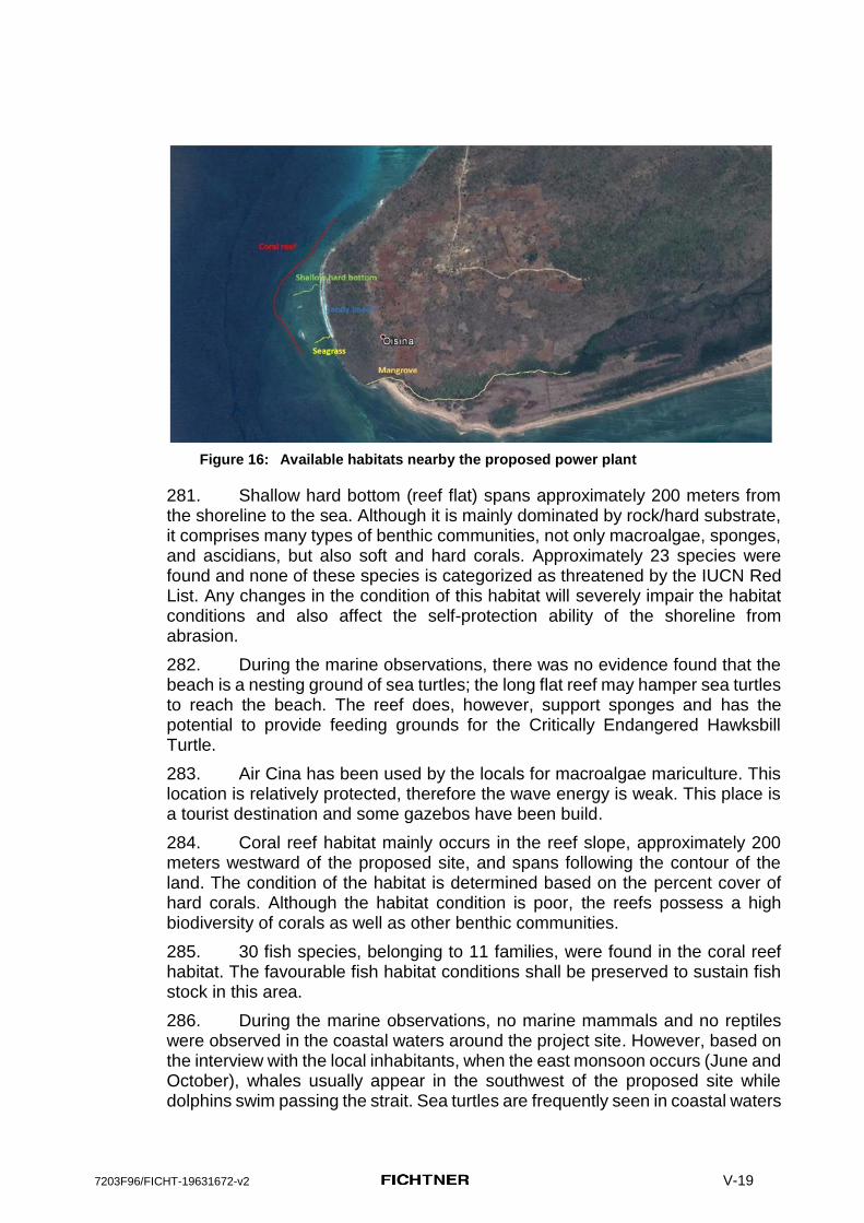
7203F96/FICHT-19631672-v2 V-19
Figure 16: Available habitats nearby the proposed power plant
281. Shallow hard bottom (reef flat) spans approximately 200 meters from the shoreline to the sea. Although it is mainly dominated by rock/hard substrate, it comprises many types of benthic communities, not only macroalgae, sponges, and ascidians, but also soft and hard corals. Approximately 23 species were found and none of these species is categorized as threatened by the IUCN Red List. Any changes in the condition of this habitat will severely impair the habitat conditions and also affect the self-protection ability of the shoreline from abrasion.
282. During the marine observations, there was no evidence found that the beach is a nesting ground of sea turtles; the long flat reef may hamper sea turtles to reach the beach. The reef does, however, support sponges and has the potential to provide feeding grounds for the Critically Endangered Hawksbill Turtle.
283. Air Cina has been used by the locals for macroalgae mariculture. This location is relatively protected, therefore the wave energy is weak. This place is a tourist destination and some gazebos have been build.
284. Coral reef habitat mainly occurs in the reef slope, approximately 200 meters westward of the proposed site, and spans following the contour of the land. The condition of the habitat is determined based on the percent cover of hard corals. Although the habitat condition is poor, the reefs possess a high biodiversity of corals as well as other benthic communities.
285. 30 fish species, belonging to 11 families, were found in the coral reef habitat. The favourable fish habitat conditions shall be preserved to sustain fish stock in this area.
286. During the marine observations, no marine mammals and no reptiles were observed in the coastal waters around the project site. However, based on the interview with the local inhabitants, when the east monsoon occurs (June and October), whales usually appear in the southwest of the proposed site while dolphins swim passing the strait. Sea turtles are frequently seen in coastal waters

7203F96/FICHT-19631672-v2 V-20
but do not nest at the proposed site. Previous studies found 21 marine mammals in the Sawu Sea Marine National Reserve.
287. There is still lack of information regarding the whales’ specific migration routes. It is assumed that the whales use the Rote Strait to migrate from north to south and vice versa. Dolphins and dugongs use the Rote Strait to migrate and forage.
288. Based on the Sawu Sea National Reserve information, six species of sea turtles (of 7 species all over the world) inhabit the marine park. Rocky shore areas with small sandy beaches near the proposed project site are not their favored nesting grounds. No turtle traces, holes, or eggs have been found during the site visits. However, data collected for the marine study confirm the presence of marine turtles in Kupang regency. This is confirmed by the information provided from the local inhabitants who have seen them swimming in the coastal waters around the proposed project site.
289. Species and conservation concern
290. Based on the field observation results and literature study, most of the marine species in the project area are categorized as least concerned species or data are deficient; some species are categorized as „near threatened“ and „vulnerable“ by IUCN.
291. One marine mammal (Balaenoptera musculus ), one sea turtle (Chelonia mydas) and one holothurian (Thelenota ananas) are categorized as “endangered“ by IUCN, and one sea turtle (Eretmochelys imbricata) is classified as a „critically endangered“.It is possible that a number of other threatened species occur in the project area of influence, such as the Endangered Whale Shark (Rhincodon typus) - for which the nearby Perairan Teluk Kupang Key Biodiversity Area was designated.
292. According to the Government Decree of the Republic Indonesia number 7 of 1999, all cetaceans (Family Cetacea) as well as all sea turtles living in Indonesian waters are protected species, meaning that any kinds of activity, especially trading and hunting, are strictly prohibited.
293. Some activities are strictly prohibited within the two zones of the Sawu marine National Park, including destructive fishing methods, mangrove harvesting, hunting of protected animals, coral reef extraction (especially hard corals, both dead and living), mining activities (oil, gas, and sand) and sewage and garbage disposal. In addition, the decree also mentions that the main infrastructures allowed in the utilization zone are local residential houses, shipping routes, patrol office, guard house and jetty, resorts and hotels. More detailed information about activities in the protection zones can be derived from Table 11 in the Marine Environmental Assessment Report (Annex C to this EIA).

7203F96/FICHT-19631672-v2 V-21
C. Human environment
1. Population
District
294. Kupang District consists of 24 subdistricts and 177 vilages, with a total population of 348,010 persons, living in 77,484 households (Kupang District Figures, 2016).
295. West Kupang Subdistrict comprises 12 villages, with a population of 17,541 persons living in 3,984 households.
296. Project area and site
297. Lifuleo Village is located around 13 km from the West Kupang sub-district city, and 61 km from Kupang District city. It has an area of about 6.80 km2 or about 4.54% from the total area of villages in West Kupang sub-district. Lifuleo Village has 4 hamlets (Dusun 1 Nefo, Dusun 2 Tuadale, Dusun 3 Tuadale, and Dusun Panaf), 3 community groups (RW/Rukun Warga), and 12 neighborhood groups (RT/Rukun Tetangga).
298. The village topography is generally sloping, about 5 m above sea level. The village is classified as ‘Desa Swakarya’ (self-help village)6: able to fulfill its own needs, where surplus production (i.e. agriculture, fisheries) is sold to other regions. According to Government of Indonesia, Desa Swakarya can be characterized as: under influence from the outside or external influence leading to social change - a change in mindset; community/people adopt to changes regardless of customs/traditions; productivity increase; and facilities and infrastructure increase.
299. The total number of Lifuleo village households7 in 2014 was 275 households consisting of 257 of male-headed households and 18 female-headed households. This increased to 282 households in 2015: 263 male-headed households and 20 female-headed households. The average number of household members is 4. Most (99.74%) are Christians (Protestant) and 0.26% Catholic. Around 68.2% of the village population is engaged in swidden agriculture, followed by fishermen (24.9%), and business (4.8%). Other types of income generation are as civil servants, pensioner/retiree, and members of the local police force.
300. Education facilities are accessible within Lufuleo village from early childhood to primary school. Health facilities include: 1 unit Village Health Post (Puskesmas Pembantu/Pustu) and 4 units Neighborhood Health Center (Posyandu). There are also traditional birth attendants.
301. Accessible educational facilities are: one PAUD (early childhood education) in the Church, as well as a primary school located far from Panaf hamlet. A secondary school (SMP), is only available in the sub district city. Public transportation is not available in the hamlet, so children have to walk to school.
6 East Nusa Tenggara Statistical Bureau document (West Kupang in Figure 2015). 7 West Kupang in Figure 2015, East Nusa Tenggara Statistical Bureau.

7203F96/FICHT-19631672-v2 V-22
The daily school routine is from 6 am to 2 pm including travel time. The community members, particularly the women, hope that there will be a school in their hamlet, at least a primary school.
302. Since 2015, electricity, especially for lighting, for 224 households is provided by PLN, while 55 households still use fuel lamps and torch (and/or “pelita/petromak/sentir obor”). Water sources are mainly from dug wells (227 households), pump wells (25), and spring water (30 households). For toilet facilities, about 211 households use their own latrines and 27 with communal latrines. Around 235 households in Lifuleo Village have houses made of permanent materials, while 3 households have semi-permanent houses. Around 60 households have television sets and parabola, and 250 households have mobile phones.
303. Village roads in this area comprise: asphalt 2.6 km; pavement 20.9 km, and dirt roads 4 km. Length of the roads regarding road management authorities cover: provincial level 4 km, district level 11 km, and village level 12.5 km.
Language
304. A language map of Timor presented below indicates that at the south-western tip of Timor, where the planned project is located, there is a language or dialect called “Helong”, which is only spoken by members of the local community Suku Minfini in this small part of the island of Timor.
Figure 17: Map -
Languages of Timor (Source:
https://upload.wikimedia.org/wikipedia/commons/thumb/6/6d/Timor_Sprache_en.png/220px-
Timor_Sprache_en.png)
2. Ethnic Groups/Minorities
305. Dusun Panaf, one of the hamlets of Lifuleo Village, has 37 households that consist of 34 male-headed households and 3 female-headed households

7203F96/FICHT-19631672-v2 V-23
(Damaris Saketu, Juliana Saketu, and Mama Naema). The customary community in Dusun Panaf is known as the Suku Minfini with three customary/suku leaders: Bapak Barnabas Minfini who lives in Dusun Panaf, Bapak Yonas Minfini also in Dusun Panaf, and Bapak Usias Saketu in Bolok.
Figure 18: Bapak Barnabas being interviewed and expressing his views during the
consultation.
306. According to Bapak Barnabas, a local resident and head of Panaf hamlet, the Suku Minfini originally came from Timor Tengah Selatan/TTS (Suku Helong) and migrated to Pulau Semau. Their ancestor married with a woman from Panaf, hence their presence in the area. There are 3 marga (sub-suku, a clan/family) under Suku Minfini, i.e. Saketu, Tosi, and Minfini, all of them known as Suku Minfini.8 All of the land in the hamlet belongs to Suku Minfini, known as ‘Tanah Suku Minfini’ (customary land). All decisions regarding land use are discussed with the customary leader.
307. Community livelihood revolves around farming, fishing (seasonal), animal husbandry (cattle, goat, and pig), and seaweed farming. All 37 households are engaged in farming, while around 20 of them are seasonal fishermen, and 5 households conduct seaweed farming (data year 2016).
308. Crops (palawija) are corn and peanuts (ground nuts) harvested once a year on an average farming area of 1-2 hectares. In general, farming season is from October - March. Land preparation is around 2-3 months (October-November), planting in December, and harvesting from February-March. Seasonal fishing activity usually takes place from January - May. It is done by diving into the sea and catching fish using arrows called ‘nyilam’ (origin of the word “menyelam” - dive).
309. On the average, each household earns IDR 30 million from farming (corn and ground nuts) per cropping period. Aside from farming on own land,
8 To date, Suku Minfini is still not listed as a customary community/IP in the AMAN website. Further clarification with AMAN
is still in the process.
7203F96/FICHT-19631672-v2 V-24
farmers also engage in ‘land borrow system’ (sharecroppers). Tenant farmers (sharecroppers) give part of their harvest as a form of rent.
310. During discussions, the community members uttered four priority issues: access to (i) clean water, (ii) electricity, (iii) roads (asphalt), and (iv) economic opportunities. Regarding electricity, Lampu Pelita/Petromaks and/or genset/generators are in use. The present price of Genset/ generator rental excluding fuel is DR 500,000/night.
3. Human health
311. The only health facility in Dusun Panaf is the Posyandu which is housed in the residence of the Head of the RT and health services are available only on the 17th day of each month. The Puskesmas (Community Health Center) is located in the sub district city - in a distance of around 15 km from Dusun Panaf.
312. The community largely uses potable water from an artesian well located 1 km from the settlement. The artesian well was built by the local government in 2007 and each household pays IDR 35,000 per month for operation and maintenance. About 70% of households have their own latrines, while the remaining 30% share with their nearest neighbor or the nearest forest (open defecation).
313. The community largely uses potable water from an artesian well located 1 km from the settlement. The artesian well was built by the local government in 2007 and each household pays IDR 35,000 per month for operation and maintenance. About 70% of households have their own latrines, while the remaining 30% share with their nearest neighbor or the nearest forest (open defecation).
4. Land Acquisition and Social Safeguards Issues
314. PLN conducted land surveys which resulted in a request to acquire about 60 hectares and additional 10 hectares for the whole power plant complex. The local people rejected the plan, because this plan would have impact on the church, graves and residential areas. The Minfini counter proposed that the project area be moved near/along the beach area. Specifically, the additional 10 hectares is located near the community settlement, thus the Minfini refused the request for the additional 10 hectares. An agreement with PLN for 40 hectares was reached.
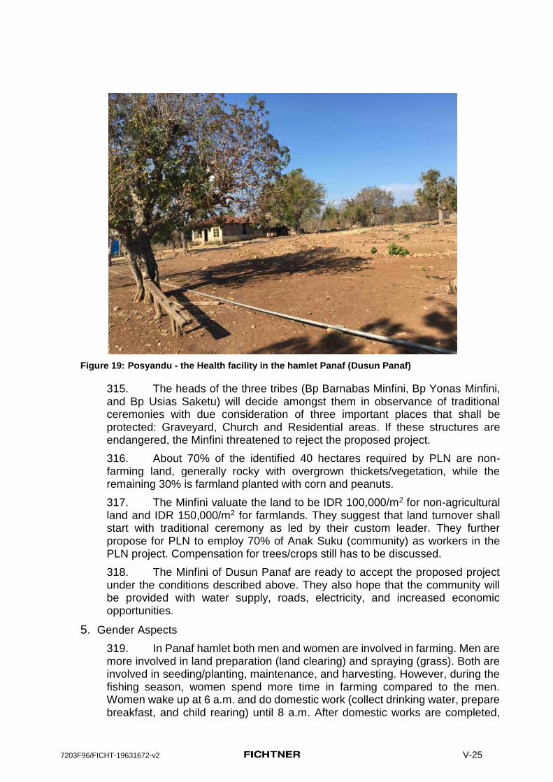
7203F96/FICHT-19631672-v2 V-25
Figure 19: Posyandu - the Health facility in the hamlet Panaf (Dusun Panaf)
315. The heads of the three tribes (Bp Barnabas Minfini, Bp Yonas Minfini, and Bp Usias Saketu) will decide amongst them in observance of traditional ceremonies with due consideration of three important places that shall be protected: Graveyard, Church and Residential areas. If these structures are endangered, the Minfini threatened to reject the proposed project.
316. About 70% of the identified 40 hectares required by PLN are non-farming land, generally rocky with overgrown thickets/vegetation, while the remaining 30% is farmland planted with corn and peanuts.
317. The Minfini valuate the land to be IDR 100,000/m2 for non-agricultural land and IDR 150,000/m2 for farmlands. They suggest that land turnover shall start with traditional ceremony as led by their custom leader. They further propose for PLN to employ 70% of Anak Suku (community) as workers in the PLN project. Compensation for trees/crops still has to be discussed.
318. The Minfini of Dusun Panaf are ready to accept the proposed project under the conditions described above. They also hope that the community will be provided with water supply, roads, electricity, and increased economic opportunities.
5. Gender Aspects
319. In Panaf hamlet both men and women are involved in farming. Men are more involved in land preparation (land clearing) and spraying (grass). Both are involved in seeding/planting, maintenance, and harvesting. However, during the fishing season, women spend more time in farming compared to the men. Women wake up at 6 a.m. and do domestic work (collect drinking water, prepare breakfast, and child rearing) until 8 a.m. After domestic works are completed,

7203F96/FICHT-19631672-v2 V-26
they proceed to the fields for about 4 hours (8 a.m. to 12 a.m.). They take a break to rest and have lunch, and go back again to the field (3 or 4 p.m. – 6 p.m.). Men usually farm in the morning (8 a.m. to 12 a.m.) and take a rest until afternoon as they prepare for night fishing. In the tradition of the community, all domestic work is still the responsibility of women except under certain conditions, i.e. wife (women) is sick, pregnant, or giving birth; then the men will engage themselves in domestic work.

7203F96/FICHT-19631672-v2 VI-27
VI. Environmental Impact Assessment and Mitigation Measures
Methodology
320. The planned Kupang 2 Peaker site borders the Kupang 1 Peaker and will share the following infrastructure that will be built as part of Kupang 1 project:
(i) Access road (ii) Jetty (LNG supply) (iii) LNG re-gasification and storage (iv) Power evacuation line (interconnection to the Timor transmission
system) (v) Water intake and waste water treatment and discharge facilities (vi) Solid waste management area
321. The impact of construction and operation of this infrastructure will be assessed in the relevant documents for Kupang Peaker 1 Power Plant and is considered in this Kupang Peaker 2 EIA only if it affects the environment in a cumulative fashion with impacts of Kupang Peaker 2. In particular, since the construction of the jetty for LNG delivery will be completed before the start of Kupang Peaker 2 project, there will be no dredging activities directly impacting the coral reef and other coastal zone ecosystems in the project area for Kupang Peaker 2.
322. During the preparation of the EIA various environmental and social impacts on physical, natural, and human environment have been identified and evaluated, including cumulative impacts.
323. The assessment of environmental impacts is carried out through determination, description and assessment of the impact that the planned project has or could have during pre-construction, construction, and operation of the work regarding:
(i) the physical environment (geology, soil, surface and ground water, air quality, acoustic environment),
(ii) the natural environment (flora, fauna, habitats, protected areas and species), and
(iii) the human environment (health, livelihood, income, infrastructure, cultural heritage)
324. The following chapters describe the expected impacts caused by the planned Kupang Peaker 2 for pre-construction, construction, and operation, based on presently available information.
325. These chapters also describe the mitigation measures applicable to the parties involved in the project development. Together with the outline of an Environmental Management and Monitoring Plan, it is part of the documentation prepared to meet the requirements of the international financing agency ADB and the laws and regulations of Indonesia.
326. The outline of the EMP identifies the type of measures, where and when these measures are required, and which party is responsible for implementation

7203F96/FICHT-19631672-v2 VI-28
and supervision. The outline of the EMP cannot describe implementing details of the proposed measures, because this must be done by the implementing contractor, based on his detailed technical description and the specific local and actual demands.
327. For a 50 MW thermal power plant like Kupang Peaker 2, the most significant environmental impacts are usually air pollution and noise. For these two factors a clear quantification of environmental impacts, based on expert studies, is required. Therefore, seperate expert studies have been conducted for air and noise emissions in the operation phase. These Expert studies are attached as Annex D (Air Dispersion Calculation Study) and Annex E (Noise Emission Report) to this EIA. The impacts on other environmental and social components were assessed qualitatively.
Assessment criteria
328. The predicted impacts of activities for the new Kupang Peaker 2 shall meet the requirements of the national laws and regulations, as well as the policies and guidelines of the IFC and ADB.
329. The expected impacts caused by the planned project Kupang Peaker 2 must be assessed for the construction phase and the operation phase, based on the baseline information and information from the technical planners.
330. The criteria for the analysis of the characteristics of potential impacts will be described with regard to:
(iv) Extent of the impact (location and size of the affected area); (v) Magnitude and complexity of the impact; (vi) Likelihood/Probability of the impact; (vii) Duration, frequency and reversibility of the impact.
331. Impacts can range from insignificant to highly significant, and from short term to long term. Once the assessment of potential impacts has been completed, mitigating measures will be described to prevent or at least to reduce the potential significant impacts to acceptable levels. In practice, most of the impacts can be mitigated through the implementation of effective mitigation measures and by the application of best available technology.
332. The best possible measures available to achieve mitigation will be identified on the basis of the principles of the hierarchy of mitigation. In order of preference this is:
(viii) Avoidance (ix) Reduction (x) Compensation (xi) Remediation (xii) Enhancement.

7203F96/FICHT-19631672-v2 VI-29
333. For the pre-construction, construction and operation phases, an Environmental Management Plan (EMP) was prepared to define the necessary measures as well as activities, timing, and responsibilities. Environmental monitoring has to be carried out during the construction and operation phases in order to ensure that these mitigation measures will be practically implemented on site.
Cumulative impacts
334. Cumulative impacts are impacts that result from overlapping effects caused by planned project together with other past, present or reasonably foreseeable projects or activities within the area of influence of the planned project. Typically, the assessment of cumulative impacts of the project is only conducted when :
(i) the project will result in a measurable, demonstrable or reasonably-expected residual environmental impact on a component of the biophysical or human environment; and
(ii) the project-specific residual environmental impact on that component does, or is likely to, act in a cumulative fashion with the environmental impacts of other past or future projects and activities that are likely to occur”.
335. As stated in the ADB EIA Guidelines (2003) “In most cases, it will be beyond the scope of an environmental assessment to include a full-fledged cumulative impact assessment. However, it is important that environmental assessment, where appropriate, includes a preliminary assessment of the potential for cumulative effects and specific recommendations on the need for, and the conduct of, a cumulative impact assessment”.
336. There is no major construction or operation activities in the vicinity of the Kupang 2 project other than potential development of Timor 1 and Kupang Peaker 1 power plants therefore only these three facilities were selected for cumulative impact assessment.
337. The impacts from the construction of Timor 1 and Kupang Peaker 1 will not be considered in this EIA, as these will take place before the construction activities for Kupang Peaker 2 commence.
338. Some environmental impacts from the construction and operation of Kupang Peaker 2 may act in a cumulative fashion with the impacts from the operation of Timor 1 and Kupang Peaker 1 which will start running prior to the Kupang 2 project. A due diligence study of the then existing Timor 1 and Kupang Peaker 1 plants would have to be commissioned by PLN prior to making the decision to proceed with the Kupang 2 Peaker project. The Kupang 2 EIA would have to be updated to reflect changes in baseline conditions caused by Timor 1 and Kupang Peaker 1 activities.
339. The following impacts on environmental components were selected as having the potential to act in a cumulative manner:
(i) Impact on air quality (ii) Impact on acoustic environment

7203F96/FICHT-19631672-v2 VI-30
(iii) Impact on marine environment (protected area Sawu sea) from the surface runoff, waste water discharge and operation of the LNG tankers
340. Some cumulative impacts may have low prediction confidence, cannot be entirely evaluated until construction or operation of the Kupang Peaker 2 and have to be monitored to confirm the results of assessment and effectiveness of mitigation.
341. The proposed mitigation of impacts only relates to the Kupang Peaker 2 project, since both Kupang Peaker 1 and Timor 1 coal fired Power Plant are not ADB financed facilities. Both plans are deemed compliant with the national environmental requirements and their design and mitigation assumed to follow the best industry practices.
A. Design Phase and Pre-Construction Impacts
342. In most projects the greatest opportunity to avoid or minimize environmental impacts is given during the technical planning phase. An environmentally sound technical planning, which demands a close cooperation between technical and environmental planners, can help to avoid big problems in the construction and operation phases. This approach following the principle „avoiding the emergence of problems from the beginning is better than repairing problems“ also proved to be beneficial in many projects regarding public acceptance of a project and also regarding saving costs for trying to repair impacts.
343. This approach however must be based on a sound data basis, especially sufficiently precise technical planning. In the present case, options to reduce impacts already in the planning phase were very limited. Most technical descriptions are not project or project site specific and had to be derived from studies of project documents for the neighbouring plant sites Timor 1 and Kupang Peaker 1.
344. In those cases where specific technical information essential for an evironmental assessment was missing, worst case scenarios were assumed and assessed (e.g. for noise and air emissions).
345. Labor mobilization shall be conducted by prioritizing local workers. This approach will increase the acceptability of the planned project by providing job opportunities and income. This approach also helps to minimize changes of social values and norms as a consequence of interaction between the local community members and outside workers. This must be anticipated properly in order to ensure public security and to avoid disturbances of the community life in the wider project area.
346. The specific instructions for the construction activities within the construction sites (clearing activities, cutting of trees, leveling, access road extension, temporary jetty, power plant, deposit sites, etc.) will be detailed in an Environment, Health and Safety Plan, which will be set up by the implementing contractor. The EHS measures must follow the General IFC Health and Safety Guidelines and the IFC Environmental, Health, and Safety Guidelines for

7203F96/FICHT-19631672-v2 VI-31
Thermal Power Plants. The EHS Plan will also include the operation phase. The EHS Plan will be verified and accepted by PLN before commencement of the construction works.
347. In the pre-constructiuion phase a robust Critical Habitat Analysis for the species supported by the protected marine habitat area must be set up by a species expert in close consultation with the protected area management authorities and with local communities (especially fishermen). From the point of view of seismicity, the project is located in mediumseismic risk zone. The contractor is required to incorporate the seismic risks in while designing the structural features of the plant and ensure that national regulation in relation to seismic risks are complied with. The plant being located about from the coast and at low elevation ranging from 7-10 m does have a risk of damage if a tsunami wave strikes the coast. The contractor while designing the plant will assess the structural risk due to tsunami and incorporate sufficient safety margins in the plant design. The contractor will also install advance warning signal for tsunami alert to warn the workers to take timely safety measures. If required a tsunami shelter will be construction at a near by location.
B. Construction Phase Impacts
Physical Environment
348. The Kupang 2 Peaker construction activities will involve civil works, including:
(i) earth moving, (ii) concrete works, (iii) construction of the buildings, connecting roads, powerlines, and
pipelines, (iv) equipment delivery, assembling and tests.
349. The potential impacts caused by these construction phase activities are temporary and any significant impact must be mitigated. The construction phase impacts though are required to adopt good engineering practice as per the international standards.
Geology and soils
Impacts:
350. General geology is not affected by the planned project. Due to hard rock beneath, the project will require blasting during the consruction. It is necessary that the negative impacts are minimized using good construction practices.
351. The shallow and often complete missing soil layer above massive base rock lead to the assumption that heavy blasting will be required for the construction of Kupang Peaker 2, especially for ground leveling activities.
352. Soil can be affected in three primary ways: loss of topsoil and natural soil functions due to ground clearing and sealing for construction sites and roads,
7203F96/FICHT-19631672-v2 VI-32
soil densification and disturbance by heavy machinery and contamination from accidental spills.
353. Erosion must be expected at open, especially sloping areas, wherever the natural vegetation cover has been destroyed. Given the small footprint of the project and relatively flat terrain of construction site, soil erosion risk during the construction phase is considered low. Following mitigation measures have been included in the EMP in line of good engineering practice that further lower the impacts.
354. Beginning erosion processes shall be stopped at an early stage by immediate regreening of open areas with grass and stabilization of hillsides through slope stabilization measures e.g. plantation of deep rooting trees and bushes.
355. Direct runoff from the construction site into the sea in case of heavy rain events may damage or kill the reefs and seagrass areas in the coastal area, as the fine sediments will cover these structures.
Mitigation measures
356. Generally, blasting shall be reduced to the absolute minimum required. Numerous small blasts are preferable to a few heavy blasts. Blasting shall take place during daytime only (10:00 a.m. to 04:00 p.m.). To the extent possible, within this time window, blasting will be repeated on all days at the same time so that the community living nearby is aware of blasting timing during the day and can avoid approaching areas near the site. Blasting will not take place on weekends, during school exam periods or on public holidays. The local community will be kept regularly informed of construction progress and will be warned with an acousic signal (sirene, signal horn) 10 minutes in advance before any blasting event.
357. Monitoring of noise and vibration needs to be done regularly during the whole construction phase at site boundary, at individual receptor within 500m of the site boundary, and at the nearest village to site boundary. Additional monitoring will be conducted in case of complaints of local residents.
358. The contractor has to install a vibration monitor at a sensitive receptor in Panaf hamlet. Direct runoff from the vegetation free construction sites into the sea must be avoided, and the contractor is required to take care that runoff from the construction site is passing sedimentation basins before reaching the sea.
359. Soil densification and disturbance due to heavy machinery must be avoided outside of construction sites and access roads, in case of needs by warning signs and warning tapes.
360. Minimizing the area of the construtction activities, especially near sensitive areas or habitats, like the coastal area or near the mangrove forest.
361. Topsoil will be recovered from temporary or permanent project sites before the ground is disturbed and then stored until it is needed for rehabilitation measures at the end of the construction activities. A topsoil storage and management program shall be developed by the contractor.
7203F96/FICHT-19631672-v2 VI-33
362. Incidents with unintended release of hazardous materials (e.g. fires, spillage of fuel, hydraulic oil, paints, etc.) may always occur. Spill kits shall be available in all transport vehicles and at the construction site. A response plan must be set up by the contractor describing timely applied protection measures against spills. Training must be provided for all drivers and equipment operators.
363. Beginning erosion processes shall be stopped at an early stage e.g by immediate regreening of open areas with grass and stabilization of hillsides through slope stabilization measures e.g. plantation of deep rooting trees and bushes.
364. Sound construction and maintenance of construction roads, including drainage facilities.
Surface and Ground Water Impacts:
365. Within the project site impacts on surface and ground water quality may be caused by construction works, vegetation clearing activities, and land leveling. This impact however is not considered to be relevant, as the project site is located near the coast and ground water is expected to be in the mixing zone between sweet and and salt water. And there are no permanent surface water bodies in the project area of influence.
366. Waste and wastewater from the construction workers camp may constitute a source of marine water pollution.
367. The impacts caused by these activities are temporary in nature (only during construction phase) and can be mitigated and recovered with proper masures applied.
368. Benchmark for measuring this impact is the standard of water quality based on Government Ordinance of the Republic of Indonesia No. 82 Year 2001 regarding water quality management and water pollution control.
Mitigation and monitoring
369. Domestic watewater from the workers camp shall be collected in a septic chamber or a percolation system.
370. Runoff from the construction site shall be collected in sedimentation basins before the cleared water is released into a receiving water.
371. Minimizing the area of the construtcion activities, especially at hillsides, near the coastal areas and the mangrove forest.
372. Incidents with unintended release of hazardous materials (e.g. fires, spillage of fuel, hydraulic oil, paints, etc.) may always occur. Spill kits shall be available in all transport vehicles and at the construction site. A response plan must be set up by the contractor describing timely applied protection measures against spills. Training must be provided for all drivers and equipment operators.

7203F96/FICHT-19631672-v2 VI-34
373. The contractor has to take care that the requirements of the national regulations regarding water quality (discharge of domestic waste wtare and runoff water from the construction sites) are met.
374. Water quality monitorting (well water in Panaf hamlet, sea water quality at the coast south of the PP) will be conducted semi-annually during construction and operation oft he power plant. The monitoring parameters for water quality must include all the parameters as set out in Table 5 of the IFC Environmental, Health, and Safety Guidelines for Thermal Power Plants, including temperature and sanitary wastewater, as set out in the IFC General Environmental, Health, and Safety Guidelines on water, including faecal coliform
Air Quality and Noise
375. Impacts:
376. Impairments of air quality will be caused by levelling activities as well as equipment and material transport during the construction phase of the project. Dispersion of dust generated by project vehicles and movement of materials such as cement, sand, gravel, etc. cause decrease in quality of air in the vicinity of project location. Generally there will be an increase of pollutants from vehicles in the form of CO (Carbon Monoxide), NO2 (Nitrogen Dioxide), SO2 (Sulfur Dioxide), HC (Hydrocarbons), and Dust (Particulate Matter). Benchmark for measuring this impact is the quality standard of air quality based on Government Regulation No. 41 of 1999 and the respective IFC guidelines.
377. Noise and vibrations will be caused by blasting but also heavy equipment handling, transportation of construction materials, land levelling activities and physical construction. Benchmark for measuring noise impacts is the quality standard of noise level based on Decree Number KEP/48/MENLH/11/1996. The respective IFC guidelines ought also to be considered.
378. Especially marine mammals are known to be very sensitive against noise as these animals use acoustic signals for orientation and especially the sensitive sense of hearing may be significantly disturbed or even permanently damaged e.g. by lasting events.
379. All these impacts during the construction phase as mentioned above are local and temporary in nature, which partly reduces their significance.
Mitigation and monitoring
380. In dry periods of the construction phase, when dust is visible, dust control measures are required, including wetting of dirt roads and construction sites. The contractor has to provide adequate equipment and to take care that dust control measures are applied.
381. Vehicles and equipment that burn fuel will have exhaust emissions, however using up-to date equipment and keeping engines in good conditions will reduce emissions to the possible minimum.

7203F96/FICHT-19631672-v2 VI-35
382. Proposed mitigation measures are: engine maintenance, speed limit traffic control (10 km per hour within the construction site, 30 km per hour on the access road to the construction site), especially on the unpaved access road between the project site and the tarred road in Lifuleo village. Traffic management plan is required to be set up by the contractor.
383. The contractor has to take care that the requirements of the national regulations regarding air quality and noise are met.
384. Construction activities shall be limited to daytime (6:00 a.m. to 10:00 p.m).
385. Sudden noise events, especially blasting and hammering shall be avoided or at least minimized to reduce the impacts especially on marine mammals within the Sawu Marine National Park to an absolute minimum.

7203F96/FICHT-19631672-v2 VI-36
Natural Environment
Impacts:
386. The impacts during the construction phase are mainly connected to loss of modified habitats currently located at the project site, alteration of habitats (e.g. increase of turbidity in surface waters, dust and acid deposition, fragmentation), noise and air emissions, and direct mortality of small animals and plants.
387. Within the project site, the main environmental impact expected from the planned project will be the permanent loss of soil functions caused by the sealing (covering with concrete and tar) of so far open areas.
388. Due to the type of the soil conditions at the planned power plant site, heavy blasting activities may be expected during the construction phase. Especially short-term and repeated strong noise emissions (blasting, hammering) may cause significant impacts for the natural and human environment. Sudden noise events, especially blasting and hammering may cause damage to marine mammals within the Sawu Sea Marine National Reserve.
389. Construction activities will cause disturbances that may scare off birds during breeding seasons. Vegetation clearing could remove some of their habitat.
390. Valuable natural habitats in the vicinity of the planned project site Kupang Peaker 2 comprise coastal zone biotopes, including coral reefs (in the slope), sea grass meadows, shallow rock bottom, sandy beach, and mangrove forest. These habitats are sensitive and could be impacted during construction.
391. Disturbances and runoff from the construction site may damage the marine environment within the area of influence of the planned project, especially the corals and fish species. Land clearing for the foundation may result in terrestrial run off which could have adverse effects on the marine environment, especially suspended sediments. Suspended sediment may generate a high turbidity environment which hampers the photosynthesis process of symbiotic algae on corals’ tissue, thus the corals no longer rely on the symbiont to obtain food and became heterotrophic. Some corals may be resistant, especially massive corals, but others, encrusting and branching corals, may not survive. High turbid environment may also affect the photosynthesis process of sea grass and will result in low growth rate. If this condition persists for months, some species may not survive. This also will occur in phytoplankton communities which may decline both in diversity and abundance due to poor light intensity.
392. Short term impact of the construction, if not properly mitigated, may lead to biodiversity loss in marine benthic communities, including the priority species as they settle permanently on substrates, and phytoplankton community (the most dynamic marine community). Long term impact may be habitat degradation as the priority species will eventually decline in abundance or even in presence. As a consequence, zooplankton communities may decline in abundance and biodiversity as their food could become rare.

7203F96/FICHT-19631672-v2 VI-37
393. In addition, the proposed construction of the power plant must take into account the potential impact on dolphins and dugongs, as they use the strait to migrate and forage.
394. Based on the Sawu Sea National Marine Reserve information, six species of sea turtles (of 7 species all over the world) inhabit the marine park. Rocky shore areas with small sandy beaches near the proposed project site are not their favored nesting grounds. No turtle traces, holes, or eggs have been found during the site visits. However, the local inhabitants claim to have found turtles swimming around the proposed site.
395. As the whole Power Plant complex is bordering the Sawu Sea National Marine Reserve, PLN will continue discussing environmental protection issues and consulting with the responsible authorities, especially the unit for national conservation area (BKKPN) or the Marine National Park administration, regarding the various planning activities and the possible impacts on marine environment.
Mitigation and Monitoring
396. Construction activities will be limited to daytime (6:00 a.m. to 10:00 p.m). Actions will have to be taken to reduce noise, if levels are excessive, especially if there are complaints from public.
397. Sudden noise events, especially blasting and hammering will be avoided or at least minimized to reduce the impacts especially on marine mammals within the Sawu Marine National Park to an absolute minimum. In case blasting is unavoidable multiple minor blasts shall be conducted instead of a few heavy single blasting events. Any blasting or other construction that would produce marine noise above international good-practice thresholds for behavioural disturbance (e.g., Southall et al. 2007) will be avoided, particularly during the season when threatened cetaceans are regularly present.
398. The area of the construction activities will be limited to the absolutely necessary. Fencing or other marking of valuable areas and objects (Tuadale Sanctuary boundary, trees, mangrove and coastal area) will be provided in order to avoid unnecessary impacts). Losses of trees have to be compensated by planting of new native trees in a ratio 1 : 2 (for one lost tree 2 young trees have to be planted).
399. The contractor has to take care that the requirements of the national regulations regarding protection of the natural environment (water quality, noise and air emissions) are met. In addition, silt screens and/or silt curtains will be used to prevent significant flow of sediment from land to sea during construction, in particular to prevent impacts to corals.
400. The contractor hast to take care that workers are not illegally poaching, collecting birds or other wildlife for sale, or fishing (e.g. with explosives or poison) or damaging the coral reefs (e.g. selling of corals to tourists) or the seagrass areas. Real penalties should be in place and well communicated to ensure workers abide by such rules. Presently there are almost no tourists visiting the

7203F96/FICHT-19631672-v2 VI-38
project site, but based on experiences in other projects in Indonesia the construction sites will most probably attract Indonesian tourists.
401. Littering and deposition of solid waste must be prevented, especially in the coastal area by setting up solid waste bins, which are regularly emptied and with the solid waste orderly disposed.
402. Daily monitoring of the construction activities, including the practical application of the EMP, will be the responsibility of the contractor, who has to include a local environmental and social expert in his site supervision team. In addition, random construction site controls by PLN and/or a contracted environmental monitoring expert shall be undertaken at least quarterly.
Human Environment
Impacts:
403. PLN will acquire 52 hectares of land for the power plant complex and Kupang Peaker 2 will be built within the complex after the other 2 facilities have been constructed. Of the 52 ha, the ADB-funded Kupang Peaker 2 will require ca. 5 ha. A total of 9 households (41 persons) of the Minfini ethnic group (will be affected by the project by loss of farmland (43,100 m2), 6 secondary structures (69 m2) belonging to 6 AHs, 143 timber trees owned by 6 AHs, 33 fruit trees owned by 5 AHs, and 55,450 m2 of croplands (multiple crops planted on a rotational basis by the 9 AHs). Six AHs are deemed vulnerable and all 9 AHs will be severely affected.
404. The project will create numerous temporary job opportunities for local residents during the construction phase, which is the strongest positive impact for the local inhabitants.
405. The worker camp, which will be located within the project site. must be in accordance with the pollution, health and safety measures set out in the General IFC Health and Safety Guidelines (2007). The detailed design of the contractor needs to elaborate on the sanitation, welfare and medical facilities to be provided, including the ratio of toilets to workers.
406. The establishment of worker camps and the presence of workers from abroad can potentially disrupt existing social networks and traditions. There will be a temporary increase in population as workers will live in the area during construction phase. It is envisaged to hire local workers when they have the right skills, which can benefit the local economy.
407. Construction and transport activities will cause air and noise emissions and may impair the living conditions of local residents.
408. The risk of accidents, especially on the acess road to and through Panaf hamlet, will increase due to the construction traffic. Workers may disturb the way of life of the local population, due to the influx of money, communicable diseases, behavior, cultural or religious differences, etc.
409. The graveyard and the church, as well as the residential houses shall be protected and fenced during the construction works in order to avoid physical damage.

7203F96/FICHT-19631672-v2 VI-39
410. The sea weed cultivation in Air Cina (approximately 1.5 km from the planned site), as well as the coral transplantation garden in Tablolong (approximately 3 km from the planned site) are unlikely to be significantly impacted by the planned power plant Kupang Peaker 2 during construction because of the long distance and the main water current direction, which is not going towards these facilities. However, if the water current direction changes to northward due to the changing season, cumulative impacts from the construction of the power plant complex may also reach these areas.
Mitigation and Monitoring
411. Construction activities will be limited to daytime (6:00 a.m. to 10:00 p.m). Blasting and piling (hammering) will be limited to the absolute minimum. More minor blasts are preferable to heavy single blasting events.
412. The contractor has to take care that the requirements of the national regulations regarding protection of the human environment (H&S, water quality, noise and air emissions) are met. An Environment, Health and Safety Plan must to be developed by the Contractor and approved by PLN before the construction activities begin.
413. There are numerous risks for human health at any construction site. The contractor has to regularly inform and train his staff regarding health and safety issues (PPE), emergency response (e.g. accidents, spills), communicable diseases (e.g. HIV), etc.
414. Considering the risks to which the workers may be exposed, the Contractor shall assure that the necessary measures to prevent accidents and health injuries are properly planned and described in an Environment, Health and Safety Plan. The plan must include, as a minimum, measures to guarantee lodging and food supply to the workers, adequate water supply, a sanitation system, management of waste and waste water, and camp cleaning. The contractor is responsible that this Environment, Health and Safety Plan is practically applied duing the construction phase.
415. The organization of environmental management and health & safety training for the workers is of importance to assure the minimization of incidents at the construction site.
416. It is recommended to perform medical checks of the construction workers before and regularly during the construction phase in order to avoid the spreading of communicable diseases like HIV.
417. To minimize the personal risks for the workers PPE equipment (ear muffs, safety boots, warn vests) must be provided by the contractor and the proper use of this equipment must be regularly supervised.
418. Workers will live in a special worker camp, and health checks have to be made for all newly arriving workers as well as regular health checks for all workers in the worker camp. Skilled health personnel and appropriate first aid equipment must be continuously available in the worker camp.

7203F96/FICHT-19631672-v2 VI-40
419. The worker camp shall be fenced also in order to avoid uncontrolled entering of local people.
420. To reduce the risk of accidents due to construction related traffic, specific measures (speed limits and warning signs, especially on the access road to the site) shall be defined in the Environment, Health and Safety Plan.
421. The contractor has to set up a grievance redress mechanism, and the local people must be informed how to address complaints. This grievance redress mechanism must be explained to the local residents during a public presentation at the beginning of the construction activities.
422. In case archaeological relicts are found during excavation works, the construction activities must be stopped and the responsible authority has to be informed. The contractor has to include the respective contact data and the procedure in his Environment, Health and Safety Plan and during worker training.
Significance of construction impacts
423. The environmental and social impacts of construction activities for the Kupang Peaker 2, if properly mitigated, will be local, temporary, reversible and not significant, considering the scope of civil works at the 5 ha construction site.
424. The soils erosion and surface water runoff from the construction site may act in a cumulative manner with similar impacts from the Timor 1 and Kupang Peaker 1. The pollution of marine environment caused by the runoff from these facilities may adversely affect the Sawu Sea Marine National Reserve.
C. Operation Phase Impacts
425. Environmental issues in thermal power plant operation primarily include the following:
(i) Noise (ii) Air emissions and acid deposition (iii) Greenhouse gas emissions (iv) Water consumption and aquatic habitat alteration (v) Effluents (vi) Solid wastes, hazardous materials and oil.
7203F96/FICHT-19631672-v2 VI-41
Physical Environment
Geology and soils
Impacts:
426. Geology is not affected in any way in the operation phase of the planned project. Soil is not affected by the normal operation of the Kupang Peaker 2. Incidents with unintended release of hazardous materials (e.g. fires, spillage of fuel, hydraulic oil, solvents, paints, etc.) may occur.
427. Direct and uncontrolled runoff from the project site should be avoided as storm water may cause erosion and waste water may impair the soil and marine environment.
Mitigation measures
428. Spill kits shall be available at the plant site. A response plan must be set up by the operator describing timely applied protection measures against spills. Training must be provided for all drivers and equipment operators.
429. Sound maintenance of construction roads, including drainage facilities.
430. Proper treatment of wastewater (sedimentation basin, oil traps, treatment of domestic waste water), orderly storage of hazardous substances on site, and orderly deposition of solid waste.
Surface and Ground Water Impacts:
431. Considering that the Kupang Peaker 2 will be an engine power plant, there will be no sunstantial water intake to and discharges from the power plant site during the operation phase. Not withstanding, waste and wastewater from the Kupang Peaker 2 site may constitute a source of water pollution if not properly controlled.
432. Within the project site, impacts on surface and ground water quality may be caused by unintended release of hazardous materials (e.g. fires, spillage of fuel, hydraulic oil, solvents, paints, etc.).
433. Benchmark for measuring this impact is the quality standard of water quality based on Government Ordinance of the Republic of Indonesia No. 82 Year 2001 regarding water quality management and water pollution control.
Mitigation measures
434. Domestic wastewater from the plant site will be collected in a septic chamber system on site and the solid components will be regularly removed and orderly disposed onshore. Due to the geological conditions on site, a percolation system is not recommended because the waste water most probably will reach the sea unfiltered through base rock fissures.
7203F96/FICHT-19631672-v2 VI-42
435. Runoff and wastewater from the plant site will be collected and at least pass a sedimentation basin and an oil trap before the cleared water is released into the sea.
436. If surface runoff from the site is observed to reaching the mangrove area, silt curtain by way of placing geo-textile rolls in the way of runoffs should be provided. Contractor by direct monitoring of silt content in water should ensure that the there in no incremental incease in silt load reaching the mangroves due to the project. In view of the sesnsitiveity of marine habitat, this measure is in addition to the control of silt and suspended solids levels are per the IFC EHS guidelines for Thermal Power Plants.
437. A response plan for unintended release of hazardous materials will be set up by the operator describing timely applied protection measures against spills. Training must be provided for all drivers and equipment operators.
438. The plant operator has to take care that the requirements of the national regulations regarding releases of domestic waste water as well as international standards for the discharge of cooling water and/or process waste water (IFC Environmental, Health, and Safety Guidelines for Thermal Power Plants, December 2008) are met.
439. Zero discharge into the marine environment is the preferred option to be considered by the contractor in his detailed plannning. A septic tank system is required during both construction and operation, to avoid environmental impacts on the sensitive marine environment. In case water releases cannot be avoided Kaltim Peaker 2 will have an own water treatment and release system on/at site, to avoid mixing of the waste water streams with polluted waste water from the neighbouring site Kupang Peaker 1.
440. Continuous effluent sampler will be installed on the discharge pipe, prior to the cooling water being mixed with EPP, and at the final point of discharge,
Air Quality
Impacts
441. Impairment of the air quality will be caused by air emissions (CO, NO2, SO2, and PM10) produced by the plant operation. If ambient air quality standards are routinely exceeded, degradation of soil and water quality as well as impact on health of local residents, specially children and elderly due to lung function impairment could be expected. The emission calculation however showed that the emissions from Kupang Peaker 2 are lower than those from Timor 1 and even for cumulative impacts of all three plants the GLCs for SO2, NO2 and particulate matter are withinin national ambient air quality standards.
442. An ADC was conducted in order to model the impact of the air emissions from the relevant sources at the Kupang power plant complex for the relevant parameters CO, NO2, SO2, and PM10. The expert report is attached as Annex D Air Dispersion Study to this EIA Report.
7203F96/FICHT-19631672-v2 VI-43
443. As no project specific planning data exist for Kupang Peaker 2, the ADC has been undertaken based on information from the planned neighbouring power plant reports, on assumptions, on available technology and on reasonable engineering estimations. Worst case scenarios with usage of HSD for Kupang Peakers 1 and 2 were used in the emission dispersion calculations. Specific information is given in Annex D (Air Dispersion Study) to this EIA report.
444. The results of the air dispersion calculation show that, if Kupang Peaker 2 is designed under regard for the national emission limit values (which are more stringent than the IFC limits), the national Air Quality Standards (AQS) for TSP, PM10, SO2, NO2 and CO are expected to be respected considering the sole operation of this plant.
445. When considering the cumulative effects of the three power plants, the national AQS will equally be respected if Timor 1 and Kupang 1 are built under consideration of the national ELVs.
446. With the power plants’ configuration and emissions assumed in the ADC, a full compliance with the WHO air quality guidelines and interim targets cannot be achieved in the cumulative scenario, due to the emissions from the neighbouring power plants.
447. Regarding cumulative impacts (Scenario C), the stringent SO2 WHO 24hr GL of 20 μg/m³ is expected to be exceeded at the receptor points R1 (hamlet Panaf, village of Oisina), R2 (mangrove beach), and R3 (sea weed beach). The ADC considered the sulfur content of 1.2% in HSD, where as Indonesian standards require sulfur content in HSD to be 0,25%. However, the exceedance of WHO GL is due to emissions from Timor 1 power plant and reduction of lowering of SO2 emissions from Kupang Peaker 1 and 2 in proportion to sulfur content in diesel, will lower the GLC but will not eliminate the exceedance. It may though be noted that all GLCs for SO2 are within the interim guideline 1 of WHO that is more appropriate standards to achieve for developing countries. It may be also noted that the comparison with WHO standards is good practice in EIA and not a mandatory requirement for ADB.
448. Also regarding cumulative impacts (Scenario C), the NO2 1 hr WHO GL of 200 μg/m³ is expected to be exceeded. The maximum concentration plots show that the maximum cumulative GLC is expected to be found within the power plants complex area.
449. The ADC shows that the decisive influence for the cumulative effects (Scenarios C) of the future emissions is from the planned power plant Timor 1. Kupang Peaker 2 only contributes to an insignificant part to the overall emissions from the neighbouring power plant complex.

7203F96/FICHT-19631672-v2 VI-44
Table VI-1: Maximum simulated 24 hours SO2 concentrations and comparison with the air quality standards
Standard is not exceeded Standard is exceeded
7203F96/FICHT-19631672-v2 VI-45
Table VI-2: Maximum simulated 1 hour NO2 concentrations and comparison with the air quality standards
Standard is not exceeded Standard is exceeded

7203F96/FICHT-19631672-v2 VI-46
Mitigation and Monitoring
450. Fire the power plants at the site with gas instead of Diesel. Diesel shall be used only in rare emergency cases and not for the continuous operation of the power plants as it is done at present. In case Diesel has to be used the sulphur content of the HSD must be below 0.25 % S as per the Indonesian standards which are within the IFC Environmental, Health, and Safety Guidelines for Thermal Power Plants (December 2008).
451. The emissions shall be reduced by the application of appropriate emission reduction equipment for, dust and NO2 at the air emission source at the Kupang 2 and at the neighbouring project sites. These projects however are not financed by ADB and therefore not included in the measures of this EIA.
452. Regular maintenance of the plant components contributes to good functioning of the plant, and consequently to reducing of hazardous emissions.
453. The operator has to take care that the requirements of the national regulations and international standards regarding air quality are met.
Greenhouse Gases Emissions
GHG emission estimate
454. The direct (scope 1) GHG emissions for operation of the power plant9 were calculated using the methodology described in the Guidelines for Estimating Greenhouse Gas Emissions of Asian Development Bank Projects: Additional guidance for clean energy projects. Mandaluyong City, Philippines: Asian Development Bank (2017).
455. Carbon dioxide (CO2) is the primary GHG associated with the combustion of fuel and is emitted in direct proportion to fuel consumption, with different emissions levels associated with different fuel types. Other GHGs include methane (CH4), nitrous oxide (NO2), and hydrofluorocarbons (HFCs), which together account for small percent of power generation GHG emissions. NO2 and CH4 are not directly related to fuel consumption, but instead are dependent on operating conditions and emissions control technologies. In addition, HFCs are emitted from air conditioners and refrigeration used in some freight shipments; these emissions depend on factors such as the age of the equipment and how often air conditioners are used.
456. CO2 emissions from power generation can be calculated based on the amount of fuel – natural gas or diesel, and other fuels - used by power generation turbines or engines. The equations and parameters used to calculate the Project GHG emissions are provided below.
457. GHG Emissions = Eelec × EG
458. Eelec = (Efuel /Ƞ) × 3.6
9 The ADB SPS 2009 requires the borrower/client to quantify direct emissions from the facilities within the physical project boundary and indirect emissions associated with the off-site production of power used by the project.
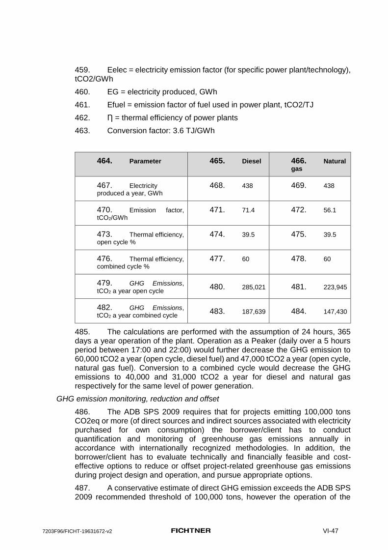
7203F96/FICHT-19631672-v2 VI-47
459. Eelec = electricity emission factor (for specific power plant/technology), tCO2/GWh
460. EG = electricity produced, GWh
461. Efuel = emission factor of fuel used in power plant, tCO2/TJ
462. Ƞ = thermal efficiency of power plants
463. Conversion factor: 3.6 TJ/GWh
464. Parameter 465. Diesel 466. Natural gas
467. Electricity produced a year, GWh
468. 438 469. 438
470. Emission factor, tCO2/GWh
471. 71.4 472. 56.1
473. Thermal efficiency, open cycle %
474. 39.5 475. 39.5
476. Thermal efficiency, combined cycle %
477. 60 478. 60
479. GHG Emissions, tCO2 a year open cycle
480. 285,021 481. 223,945
482. GHG Emissions, tCO2 a year combined cycle
483. 187,639 484. 147,430
485. The calculations are performed with the assumption of 24 hours, 365 days a year operation of the plant. Operation as a Peaker (daily over a 5 hours period between 17:00 and 22:00) would further decrease the GHG emission to 60,000 tCO2 a year (open cycle, diesel fuel) and 47,000 tCO2 a year (open cycle, natural gas fuel). Conversion to a combined cycle would decrease the GHG emissions to 40,000 and 31,000 tCO2 a year for diesel and natural gas respectively for the same level of power generation.
GHG emission monitoring, reduction and offset
486. The ADB SPS 2009 requires that for projects emitting 100,000 tons CO2eq or more (of direct sources and indirect sources associated with electricity purchased for own consumption) the borrower/client has to conduct quantification and monitoring of greenhouse gas emissions annually in accordance with internationally recognized methodologies. In addition, the borrower/client has to evaluate technically and financially feasible and cost-effective options to reduce or offset project-related greenhouse gas emissions during project design and operation, and pursue appropriate options.
487. A conservative estimate of direct GHG emission exceeds the ADB SPS 2009 recommended threshold of 100,000 tons, however the operation of the

7203F96/FICHT-19631672-v2 VI-48
plant as a Peaker would bring the emission down to 60,000 tons a year. Use of natural gas as a primary fuel will further decrease the emission.
488. PLN will implement the environmental management plan to minimize leaks of natural gas and efficiently manage air conditioning equipment to minimize losses of HFC’s to the atmosphere..
489. The Project also requires clearing a number of trees at the powerplant site. As per the EMP these will be replanted, therefore there will be no net negative impact.
Noise
490. Impacts
491. For the calculation and evaluation of the noise emissions from the planned plants and the Kupang 2 Peaker, a Noise Emission Expert Study was conducted. For more details see Annex E Noise Emission Study to this EIA Report.
492. Operation of the various plant components such as gas turbines, generators, oil pumps, fuel gas station, transformers, etc., will produce noise. The noise production will be present continuously during plant operation. The possible impacts can affect the health of local residents, as well as cause impairment of local animal species. For the preparation of the noise study no information on the noise control equipment installed in Kupang 1 or foreseen for Kupang 2 has been available. However, Timor 1 and Kupang Peaker 1 plants to be constructed before Kupang Peaker 2 are expected to meet the national ambient noise standards. In the calculations, it has been, therefore, assumed that the gas engines are equipped with a silencer installed in the exhaust system immediately downstream of the engine. To be conservative, a standard silencer with basic performance in terms of acoustic insertion loss has been assumed. No additional stack silencer has been considered10.
493. The sound pressure level of the noise received from the power plants complex in a various operating scenario has been calculated at the following specific points-of-interest (POIs) which qualify as Noise Sensitive Receptors
(i) • - POI 1: "Settlement" (hamlet Panaf, village of Oisina (ca. 500 m north-east of the project site boundary)
(ii) • - POI 2: "Mangrove beach" (ca. 100 m south of the of the project site boundary)
(iii) • - POI 3: "Sea weed beach" (ca. 800 m north-west of the project site boundary)
1. 10 It may be noted that individual plants have to comply with national ambient noise regulations. If additional measures are required these need to be incorporated in the plant design. ADB will establish this when Environetnal Due Diligence Report is submitted after Tomir1 and Kupang Peaker 1 starts operation. For this EIA , while concluding the noise impacts it has been assumed that such compliance will be achieved.

7203F96/FICHT-19631672-v2 VI-49
Benchmark for measuring this impact of noise level is the stricter regulation of either Decree Number KEP/48/MENLH/11/1996 or the respective IFC EHS guidelines. IFC Guidelines for noise limits in residential areas at night time (22:00 to 7:00) are stricter compared to the national standards. The noise emission calculations for the planned power plants and Kupang 2 are shown Figures 20, 21 and 22
Figure 20: A-weighted sound pressure levels at 1.5 m above ground around the plant in 5 dB increments for scenario 3 (Kupang 2 in operation, Timor 1 and Kupang 1 off), view showing the plant and the area around POIs 1 and 2.
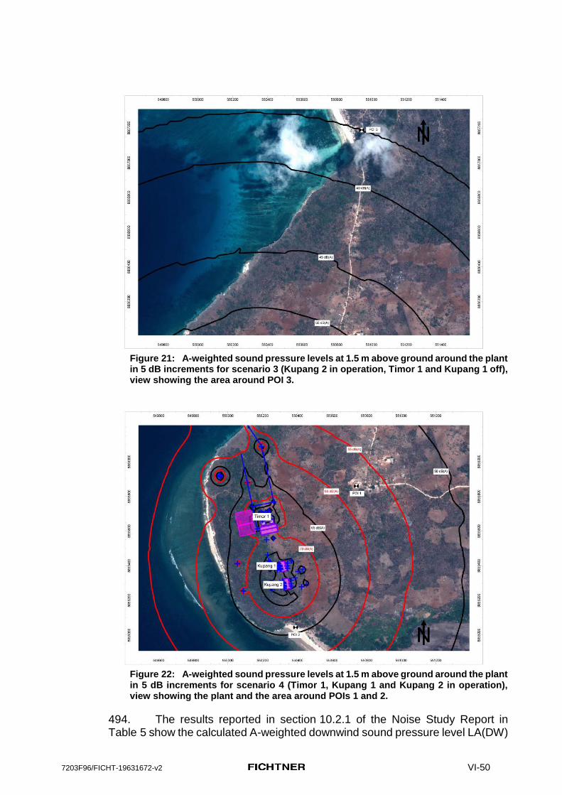
7203F96/FICHT-19631672-v2 VI-50
Figure 21: A-weighted sound pressure levels at 1.5 m above ground around the plant
in 5 dB increments for scenario 3 (Kupang 2 in operation, Timor 1 and Kupang 1 off), view showing the area around POI 3.
Figure 22: A-weighted sound pressure levels at 1.5 m above ground around the plant
in 5 dB increments for scenario 4 (Timor 1, Kupang 1 and Kupang 2 in operation), view showing the plant and the area around POIs 1 and 2.
494. The results reported in section 10.2.1 of the Noise Study Report in Table 5 show the calculated A-weighted downwind sound pressure level LA(DW)

7203F96/FICHT-19631672-v2 VI-51
at the receptors - points of interest (POI) for operational scenario (4), i.e. with the existing power stations Timor 1 and Kupang 1 and the planned plant Kupang 2 in operation simultaneously. From the data in Tables 2 and 3 of the Noise Study Report, the sound pressure level LA(DW) can also be calculated for simultaneous operation of the two existing power plants only and the increase in
sound pressure level L caused by additionally taking Kupang 2 into operation
can be determined. The corresponding data is shown in the Table VI-3 below. L then corresponds to the level difference at the POIs for the planned situation with the new plant Kupang 2 compared to the present situation with only power plants Timor 1 and Kupang 1.
LA(DW)
[dB(A)]
Total L
POI 1 – Settlement 55,4 2,1
POI 2 – Mangrove beach 59,1 7,3
POI 3 – Sea weed beach 41,3 0,8
Table VI-3: Calculated A-weighted downwind sound pressure level LA(DW) at the POIs for operation of
the existing power plants Timor 1 and Kupang 1 and level increase L caused by the additional contribution from Kupang 2.
495. It can be seen in Table VI-3 that L ranges between 0,8 dB and 7,3 dB so that the additional operation of power plant Kupang 2 clearly leads to an increase in sound level at the POIs compared to the present situation.
Mitigation and Monitoring
496. Adapt the design of the Kupang Peaker 2 in such a way that the already existing noise impacts are not aggravated by the planned project. In the pre-construction phase, If the the EPC Contractor deviations from the measures recommended in para 521 below, he also has to submit an updated noise emission assessment, including operation noise modelling, to demonstrate the performance standards can be met, before clearance will be given for the construction activities.
497.
498. To reduce L for the POIs noise control measures can be applied to selected sound sources and sound transmission paths of Kupang 2 power station. Which sources need to be treated and how exactly depends on numerous factors (e.g. level reduction targeted for, technical data of the sources, noise control principle to be applied, operational and process contraints etc.) and can only be determined in a detailed noise control concept when this information is available.
499. An overview of the most important noise control principles applied in industrial acoustics in general along with examples for typical designs and applications is provided in the Annex F.
500. By application of a suitable combination of adequately designed noise
control principles presented in Annex F, the increase in sound pressure level L caused by Kupang 2 power plant can be reduced or even eliminated, if necessary. The calculations undertaken for this EIA, although preliminary in
7203F96/FICHT-19631672-v2 VI-52
nature without the benefit of plant design and correct noise soectrum indicate that additional, noise attenuation measures for fuel gas receiving station and combustion air intake may be required in addition to the flue gas silencer. This is expected to bring down the increamental noise due to Kaltim Peaker 2 at the mangrove beach within 3 dB(A) of abient noise generated due to the Timor 1 and Kaltim Peaker 1 plants.
Natural Environment
Impacts:
501. Most parts of the project site will be cleared of any vegetation and parts of the site will be covered with concrete or asphalt, which results in a long term loss of modified habitat area functions at the project site.
502. The loss of naturally structured soils can facilitate the colonization of invasive animal species or neophytes which can impair the habitats of native species.
503. In the onshore project area of influence local wildlife might be impaired by noise and air emissions, as well as optical disturbances from the operating power plant. Some sensitive animal species in the project area of influence may suffer from air and noise emissions or even vanish. The main environmental impacts will result from the planned power plants Timor 1 and, to a far less extent, from Kupang Peaker 1 as shown in the air and noise emission calculations.
504. The planned project site is bordering the western tail of a ca. 300 ha wide mangrove forest. The present condition of this westen tip of the mangrove forest is already impaired by human activities and the impact resulting from Kupang Peaker 2 on this biotope is lower when compared to the impacts resulting from the coal fired power plant Timor 1 (especially regarding noise, SO2 emissions, fuel transportation, associated infrastructures, etc.).
505. Strong noise affects the acoustic sonar system of the dolphins and impairs orientation and hunting. Noise from operating power plants, may cause whales and dolphins to dive significantly longer when the noise sources are within 300m distance. Compared to noise emissions from Timor 1, the noise emissions from Kupang Peaker 2 are negligible in the operation phase. No significant effects are expected from noise emissions from Kupang Peaker 2 on marine mammals.
506. No significant impacts on the marine environment are caused by Kupang Peaker 2 if the environmental mitigation measures (wastewater treatment fulfilling Indonesian regulations regarding the relase of wastewater (temperature and quality) into the marine environment) are implemented.
507. The power plant will not discharge any warm water from a cooling system (not fresh water). If there was any discharge of warm water, this may affect the surrounding sea temperature. Furthermore, the discharge pipeline will also release heat to the water. This thermal anomaly may cause, causing stress on benthic communities. - Increasing temperature by 1-2°C for more than 5 weeks may lead to local coral bleaching. This also threats plankton communities in which only heat tolerant species will survive and will cause domination. Marine

7203F96/FICHT-19631672-v2 VI-53
biodiversity loss may be the short term impact of such condition and could be a mass die-off of benthic communities and habitat degradation as long term impact.
508. Mangrove forest may potentially be impacted by changes in the marine water quality caused by the uncontrolled release of liquid effluents and cooling water.
509. Biodiversity loss will reduce the complexity of the ecosystem - in this case there may be a breakdown of the food chain. Thus, the ecosystem service may fall and not be able to continue if the habitat is totally degraded. As an end effect, fish resource may decline as the habitat is degraded (bottom up effect).
510. The impact of power plant activities may affect fishery resources which are essential for sea turtles, dolphins and dugong as the area is designed for them. If severe habitat degradation occurs in the proposed site, it will affect habitat connectivity which is important for resilience processes in those particular areas. Impacts to marine biota and ecosystems is discussed in more detail in Annex C.
Mitigation and Monitoring
511. Noise will have to be regularly (at least semi-annually) monitored at key locations (residential houses and areas), and actions will have to be taken to reduce noise, if levels are excessive in residential areas.
512. The plant operator has to take care that the requirements of the national regulations and international standards regarding protection of the natural environment (water quality, noise and air emissions) are met.
513. The operator has to take care that workers from the Kupang Peaker 2 plant are not illegally poaching or fishing (e.g. with explosives or poison). This also includes the protection of the coral reefs, as corals are often sold to tourists.
514. The operator has to take care that workers from the Kupang Peaker 2 plant are not illegally poaching, collecting birds or other wildlife, or fishing (e.g. with explosives or poison). This also includes the protection of the coral reefs, as corals are often sold to tourists.
515. The operator has to take care that environmental pollution (dumping of waste and untreated waste water) is avoided, especially in the coastal and the mangrove area.
516. Appropriate measures against the colonization of invasive nephytes species (replanting with autochthonous vegetation at the earliest possible time, cutting/removing of invasive species etc.) shall be taken within and in the vicinity of the project site.
Human Environment
Impacts:

7203F96/FICHT-19631672-v2 VI-54
517. Employment opportunities for operating the power plant and other related services will be created for limited surrounding workforce during the operational phase, which is an important positive impact. The employment opportunities will generate various benefits on local people’s income, particularly on the households whose family members are long-term employed during operation of Kupang Peaker 2.
518. Plant staff may disturb the way of life of the local population, due to the influx of money, communicable diseases, behavior, cultural or religious differences.
519. Operation of the planned power plant as well as transport and maintennance activities will cause air and noise emissions and may impair the living conditions of local residents.
Mitigation and Monitoring
520. The operator has to take care that the requirements of the national regulations and international standards regarding protection of the human environment (H&S, water quality, noise and air emissions) are met.
521. The air quality must be monitored regularly at defined receptor points, as it might impair community health (details of the monitoring routine are described in the EMP). The monitoring frequency is determined by the environmental authority. For similar projects in Indonesia this monitoring is conducted semi-anually. Since the power plant will be operated as a peaker, the impact will be intermittent. The ambient air quality standard will refer to Government Regulation Number 41 of 1999 for ambient air quality and to the WHO air quality guidelines.
522. In Indonesia the usual procedure for monitoring of thermal power plants is to conduct semi-annual measurements as specified in the UKL-UPL and to summarize these findings in form of Monitoring Reports, which are handed over to the responsible environmental authorities.
523. The operator has to set up a grievance redress mechanism, based on the social studies conducted for this project, and the local people must be informed how to address complaints. This grievance redress mechanism must be explained to the local residents during a public presentation at the beginning of the operation activities.
524. The operator has to regularly inform and train his staff regarding health and safety issues (PPE), emergency response (e.g. accidents, spills), and transferable diseases (e.g. HIV).
525. Hazardous substances shall be stored in safe locations and emergency programs shall be set up by the operator to address spillage of hazardous substances.
4. Significance of operation impacts

7203F96/FICHT-19631672-v2 VI-55
526. The environmental and social impacts of operation activities for the standalone Kupang 2 Peaker project, if properly mitigated, will be local, longterm, reversible and not significant. The confidence of the assessment is high for air and noise emission, waste and waste water management, terrestrial ecosystems and human environment. It is low for impacts on marine ecosystems and mangrove, in particular on Sawu Sea Marine National Reserve (critical habitat).
527. The results of the air dispersion calculation show that air emission from Kupang 2 Peaker meets all applicable national and international air quality standards for TSP, PM10, SO2, NO2 and CO in the project AoI, including all receptors.
528. GHG emission of Kupang 2 Peaker if fueled by HSD is assessed as 285,000 tCO2 for 24 hours operation and 60,000 tCO2 for 5 hours operation as a peaker. Use of natural gas as a primary fuel would further reduce GHG emission to 47,000 tCO2 for 5 hours operation.
529. The emission of SO2 and NOX (precursors of acid deposition) expressed as SO2 equivalents as acidifying effect is less than 10 tons/day. In this case the facility typically would not require any offset and its acid deposition impact would be deemed insignificant.
530. The noise level generated by Kupang 2 Peaker would not exceed national and international standards for residential areas.
531. Kupang 2 impacts on natural environment will likely be not significant if proper mitigation has been applied. In particular the terrestrial ecosystems in the project area are modified habitats used by local population for their needs. The marine habitats may be impacted by water intake and waste water discharge, but both operations will be performed at the Kupang 1 project site and operation of Kupang 2 may contribute to the existing impacts. Volumes of water intake and waste water are small and the waste water will be treated to the national quality standards prior to discharge.
D. Cumulative impacts
532. The following impacts may act in a cumulative fashion with other power plants in the AoI.
(i) Air emission (ii) Acid deposition (iii) Noise (iv) Operation of water intake and waste water discharge (v) Operation of the LNG tankers.
533. A due diligence study of the existing Timor 1 and Kupang Peaker 1 plants would have to be commissioned by PLN prior to making the decision to proceed with the Kupang 2 Peaker project. The Kupang 2 EIA would have to be updated to reflect changes in baseline conditions caused by Timor 1 and Kupang Peaker 1 activities.

7203F96/FICHT-19631672-v2 VI-56
Noise and air
534. As a sound basis for an assessment of the impacts of noise and air emissions it was necessary to conduct expert studies which consider the overlapping effects of the relevant noise and air emission sources from the planned neighbouring Power Plant facilities together with the forecasted emissions from the planned Kupang Peaker 2. Wherever more than one project option exists, „”worst case scenarios“ have been used for the emission calculations and the impact assessment. The results of these calculations have been addressed in the discussion of the operation impacts above.
535.
In particular:
(i) The cumulative impact of the air emissions from Timor 1, Kupang 1 and Kupang 2 Peakers allow meeting all applicable national and international air quality standards for TSP, PM10, NO2 and CO in the project AoI, including all receptors. The model predicts an exceedance of WHO standard for maximum 1 hr NO2 concentration at the location within the project fence line. No additional mitigation other than those required to meet the national standards would be required. It may be noted that the national standards for emissions are more stringent than the international standards for emissions for gas engines.
(ii) Cumulative emissions of SO2 for 24 hours averaging, as predicted by the model, may lead to an exceedance of the WHO standard for three receptors located in the project AoI and one location within the project fence line. The model also predicts an exceedance of the WHO standard for maximum 10 minutes SO2 concentration at the location within the project fence line. . It may be noted that the ADV consideres sulfur content of 1.2% in HSD. The indonesian standards though require use of 0.25% S, HSD. Use of low sulfur KSD will lower the SO2 GLCs, It will though not eleminate the exceedance of stric WHO standard because of higher emissions from Timor power plant (though well within the national standards).
(iii) By design Timor 1, Kupang 1 will be required to meet national noise standards. Additional mitigation for Kupang Peaker 2 have been recommended in this EIA.
Marine environment
536. Impaired water quality may lead to a change and depletion of plankton species, which in turn affects the whole food chain via fish up to the marine mammals, as any disruption of fish resources will impact their feeding habitats and finally migratory routes.
537. Depletion of a local marine habitat does not only have local effects but will also affect the neighbouring habitats within the Sawu Sea Marine National Reserve. Water currents connect the various marine habitats and if one habitat is depleted the neighbouring habitats may also be affected and weakened. E.g. if a source of larva (plankton, corals, fish) may be lost; the juvenile fish may not

7203F96/FICHT-19631672-v2 VI-57
any more supply neighbouring habitats. This chain reaction may hamper the resilience of a wide and connected habitat system like the Sawu Sea.
538. Operation of LNG supply tankers for Kupang 2 Peaker would contribute to potential impact on marine mammals in the Sawu Sea. A set of mitigation for tankers operation can be implemented to avoid collisions with the mammals and lower the level of disturbance.
539. Current level of design details does not allow to assess the cumulative impact of three power plants on the sea water quality and marine habitat with high level of confidence. Considering high sensitivity of critical habitat of the Sawu Sea Marine National Reserve and high intensity of potential impacts form the coal fired Timor 1 power plant the cumulative impact on sea water quality is assessed as significant with low confidence.
540. The operation of a power plant complex in the so far quite untouched and environmentally valuable eastern tip of Timor island should be aligned with other human plans and strategies like the Sawu Sea Marine National Reserve, the protection of natural resources, enhancement of eco-tourism, sea weed farming, and sustainable fishery. PLN will continue discussing environmental protection issues during operation of Kupang Peaker 2 with the responsible authorities, especially the unit for national conservation area (BKKPN) or the Marine National Park authority, regarding the various planning activities and the possible impacts on marine environment.
7203F96/FICHT-19631672-v2 VII-58
VII. Environmental Management and Monitoring Plan
541. The EIA defines measures to mitigate, prevent or minimize negative enviromental and social impacts from the planned project.
542. Based on the results of the impact assessment, especially regarding mitigation measures and monitoring requirements, an EMP has been prepared in form of tables, separately for the construction and the operation phase.
543. The EMP covers the following aspects:
(i) The environmental factor that is likely to be impacted; (ii) A brief summary of the potential impact and/or likely issue; (iii) The identified mitigation actions that aim to eliminate and/or reduce the
potential impact to acceptable levels; (iv) Monitoring actions to ensure that the identified mitigation measures are
implemented. Monitoring actions include: inspections, review of reports/plans, reporting, and the undertaking of certain monitoring measures;
(v) The frequency for implementing the monitoring actions, which include: once, continuously throughout the construction/operation period (depending on the mitigation measure identified this could include daily, weekly, or monthly), or upon occurrence of a certain issue; and
(vi) The responsible entity for implementing the mitigation measures and monitoring actions identified.
544. The EMP is a key document that lists the environmental requirements and details the procedures necessary for managing the significant environmental issues connected to proposed project activities. The EMP is developed specifically to provide flexibility in the nature and exact location of operations, while ensuring all potential impacts are identified and properly mitigated and monitored throughout the later stages of the Project.
545. This EMP can be used as a stand-alone document during the different phases of the Project by the EPC Contractor, the Project Operator, the governmental authorities, and other responsible parties.
546. The EMP does not set out all the implementing details of the proposed measures, because several of the measures identified must be developed in detail by the implementing contractor.
547. The EMP is a “living document“ that shall be updated by the contractor based on the then available detailed engineering before the beginning of the construction phase. In addition, the EMP shall be updated once per year, if necessary, in order to include new issues that were not or not sufficiently considered in the EMP so far.
7203F96/FICHT-19631672-v2 VII-59
A. Institutional Framework and Procedural Arrangements for Environmental Compliance
548. Generally, two main pillars govern the successful implementation of any EMP:
(i) Proper identification of roles and responsibilities for the entities involved; and
(ii) Effective control of the process
549. Generally, the EMP identifies where and when measures are required and which organization is responsible for taking care that the measures are implemented and supervised.
550. All management practices are interlinked, and this section describes how these two pillar criteria could be fulfilled, which in turn helps ensure that the overall objectives of the EMP are met.
551. Control processes mainly include training and awareness for entities involved, control of non-conformances that might occur throughout the process, and the permitting (clearance) requirements throughout the Project implementation phase. The objective is to ensure that the EMP recommendations are implemented in practice during construction and operation, and assess how environmental resources are affected.
552. Generally, a self compliance approach is advocated, whereby the body responsible for the causative action shall ensure that the objectives and requirements stipulated within the EMP are met. The Regulator will be responsible for undertaking compliance monitoring to ensure that the responsible Entity is adhering to the EMP requirements.
553. The EMP in this EIA must be updated by the contractor in the pre-construction phase, based on his specific technical design. The contractor has to adduce evidence, based on his specific project design, that emissions from the planned power plant do not exceed national or international standards. This evidence comprises at least modeling of noise emissions, air emissions, and waste water releases into the marine environment.
B. Self-monitoring and external auditing
554. Generally self-monitoring is a basic requirement to show the compliance of the facility with the standards as outlined in the EMP and represents a suitable basis for the successful realization of the required auditing procedures.
555. In addition, self controlling is an appropriate method of conservation of evidence in case of an accident or emergency situation. All data from the monitoring program during construction and operation as requested by the EMP shall be reported. Summarized data shall be submitted by the contractor monthly and quarterly to PLN as the project developer. PLN shall then forward the quaterly information to the responsible BLHD for assessment and follow up.
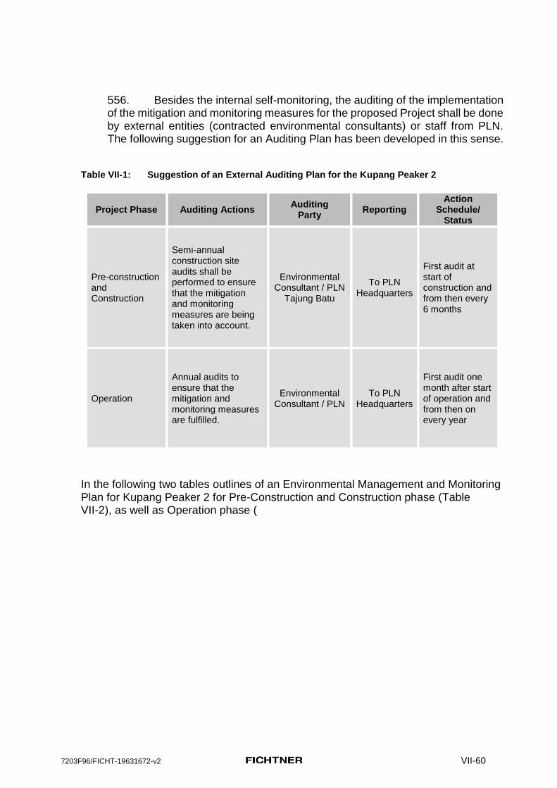
7203F96/FICHT-19631672-v2 VII-60
556. Besides the internal self-monitoring, the auditing of the implementation of the mitigation and monitoring measures for the proposed Project shall be done by external entities (contracted environmental consultants) or staff from PLN. The following suggestion for an Auditing Plan has been developed in this sense.
Table VII-1: Suggestion of an External Auditing Plan for the Kupang Peaker 2
Project Phase Auditing Actions Auditing
Party Reporting
Action Schedule/
Status
Pre-construction and Construction
Semi-annual construction site audits shall be performed to ensure that the mitigation and monitoring measures are being taken into account.
Environmental Consultant / PLN
Tajung Batu
To PLN Headquarters
First audit at start of construction and from then every 6 months
Operation
Annual audits to ensure that the mitigation and monitoring measures are fulfilled.
Environmental Consultant / PLN
To PLN Headquarters
First audit one month after start of operation and from then on every year
In the following two tables outlines of an Environmental Management and Monitoring Plan for Kupang Peaker 2 for Pre-Construction and Construction phase (Table VII-2), as well as Operation phase (

7203F96/FICHT-19631672-v2 VII-61
Table VII-3) are presented.
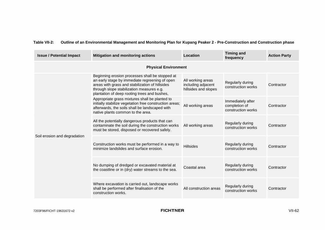
7203F96/FICHT-19631672-v2 VII-62
Table VII-2: Outline of an Environmental Management and Monitoring Plan for Kupang Peaker 2 - Pre-Construction and Construction phase
Issue / Potential Impact Mitigation and monitoring actions Location Timing and frequency
Action Party
Physical Environment
Soil erosion and degradation
Beginning erosion processes shall be stopped at an early stage by immediate regreening of open areas with grass and stabilization of hillsides through slope stabilization measures e.g. plantation of deep rooting trees and bushes,
All working areas including adjacent hillsides and slopes
Regularly during construction works
Contractor
Appropriate grass mixtures shall be planted to initially stabilize vegetation free construction areas; afterwards, the soils shall be landscaped with native plants common to the area.
All working areas Immediately after completion of construction works
Contractor
All the potentially dangerous products that can contaminate the soil during the construction works must be stored, disposed or recovered safely.
All working areas Regularly during construction works
Contractor
Construction works must be performed in a way to minimize landslides and surface erosion.
Hillsides Regularly during construction works
Contractor
No dumping of dredged or excavated material at the coastline or in (dry) water streams to the sea.
Coastal area Regularly during construction works
Contractor
Where excavation is carried out, landscape works shall be performed after finalisation of the construction works.
All construction areas Regularly during construction works
Contractor

7203F96/FICHT-19631672-v2 VII-63
Issue / Potential Impact Mitigation and monitoring actions Location Timing and frequency
Action Party
Slope stabilization and landscape works must be performed in endangered construction or transport areas.
Hillsides Coastal area Previous and regularly during construction works
Contractor
Visual inspections to verify the rehabilitation of the soils in the construction areas
All working areas Regularly during construction works
Contractor
Monitor the application of the waste management procedures (handling, storage, disposal)
All working areas Regularly during construction works
Contractor
Disposal operations must be conducted so as to prevent any unnecessary destruction, scarring or defacing of the soils
Disposal areas Regularly during construction works
Contractor
Soil pollution by waste deposition
Develop a Waste Management Plan (within the HSE Management Plan) containg measures such as: - Coordinate with the Municipality or hire a
competent private contractor for the collection of solid waste from the site to the municipal approved landfill.
- Distribute appropriate number of properly contained litter bins and containers properly marked for the different types of waste, such as: recycable, hazardous, for landfill, etc.
- Maintain records and manifests that indicate volume of waste generated onsite, collected by contractor, and disposed of. The numbers within the records are to be consistent to ensure no illegal dumping at the site or other areas
All construction and surrounding areas
Before the ground leveling works Regularly during construction works
Contractor, PLN
Pollution of the surface waters by sediments, solid and liquid waste, oil leaks
Risk of groundwater pollution with oil, fuels or waste
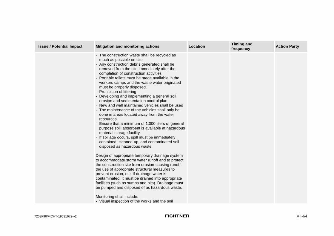
7203F96/FICHT-19631672-v2 VII-64
Issue / Potential Impact Mitigation and monitoring actions Location Timing and frequency
Action Party
- The construction waste shall be recycled as much as possible on site
- Any construction debris generated shall be removed from the site immediately after the completion of construction activities
- Portable toilets must be made available in the workers camps and the waste water originated must be properly disposed.
- Prohibition of littering - Developing and implementing a general soil
erosion and sedimentation control plan - New and well maintained vehicles shall be used - The maintenance of the vehicles shall only be
done in areas located away from the water resources.
- Ensure that a minimum of 1,000 liters of general purpose spill absorbent is available at hazardous material storage facility.
- If spillage occurs, spill must be immediately contained, cleaned-up, and contaminated soil disposed as hazardous waste.
Design of appropriate temporary drainage system to accommodate storm water runoff and to protect the construction site from erosion-causing runoff, the use of appropriate structural measures to prevent erosion, etc. If drainage water is contaminated, it must be drained into appropriate facilities (such as sumps and pits). Drainage must be pumped and disposed of as hazardous waste. Monitoring shall include: - Visual inspection of the works and the soil

7203F96/FICHT-19631672-v2 VII-65
Issue / Potential Impact Mitigation and monitoring actions Location Timing and frequency
Action Party
- Verify the suitability of the storage areas for materials and waste
- Verification on-site of the procedures for waste management
- Review of manifests to ensure consistency - Review the contract with the company in charge
of the waste transportation
Pollution of marine water due to the discharge of wastewater from the construction camp; processing of aggregates.
Collection and treatment of waste water leaving the worker camp.
Worker camp Regularly during construction works
Contractor
Filtering, collection or diversion of silty water leaving the construction site; construction of
drainage channels. Use of silt screens and/or silt curtains to prevent significant flow of sediment from land to sea during construction.
All working areas, Coastal areas
Regularly during construction works Contractor
Effluent of pollutants, muddy water, and nutrients from the project site
Perform regular water sampling to identify relevant water pollution sources and to develop measures to avoid or reduce pollution.
Downhill the project site, coastal area
Prior to and during construction phase
Contractor
Monitoring of the water quality parameters Coastal water Quarterly Contractor
Air pollution due to emissions of particulates and gases from construction operations and circulation and usage of equipments and vehicles
Cover the internal pathways and the working area with non pulverulent material (gravel, grit, concrete, bitumen)
Construction areas All transport routes
Before and regularly during construction works
Contractor
Water the non paved pathways and working areas, especially on windy and dry days.
All working areas All transport routes
Regularly during construction works
Contractor
Cover the load of every truck transporting pulverulent materials with adequate screens.
All working areas All transport routes
Regularly during construction works
Contractor
Store the pulverulent materials in closed compartments; whenever this is not feasible, water these materials.
Construction areas Regularly during construction works
Contractor
Use of new vehicles with good conservation status. All working areas All transport routes
During construction works
Contractor

7203F96/FICHT-19631672-v2 VII-66
Issue / Potential Impact Mitigation and monitoring actions Location Timing and frequency
Action Party
Do not place pulverulent materials in non- protected areas situated upstream of the wind direction from residential areas.
All working areas During construction works
Contractor
Set fences with enough height to separate the construction site from the outside areas.
All working areas Previous to construction works
Contractor
Inform the local residents about the duration of the construction works and whenever an activity that generates high levels of particulates is to be performed.
Residential areas Prior to and regularly during construction works
Contractor
Regardless of the size or type of vehicle, fleet owners / operators shall implement the manufacturer recommended engine maintenance programs.
All working areas All transport routes
Regularly during construction works
Contractor
Drivers shall be instructed on the benefits of driving practices that reduce both the risk of accidents and fuel consumption, within safe speed limits.
All working areas All transport routes
Prior to and regularly during construction works
Contractor
Vehicles shall have emissions control devices, such as catalytic converters.
All working areas All transport routes
Prior to and during construction works
Contractor
Selection of equipment with lower sound power levels.
All working areas Prior to and during construction works
Contractor
Noise and vibrations from blasting and hammering
Avoid blasting whenever possible, All working areas Continuously during construction works
Contractor
Numerous small explosions are better than a few severe explosions
All working areas Continuously during construction works
Contractor
Hammering shall be avoided for piling and foundation works
All working areas Continuously during construction works
Contractor
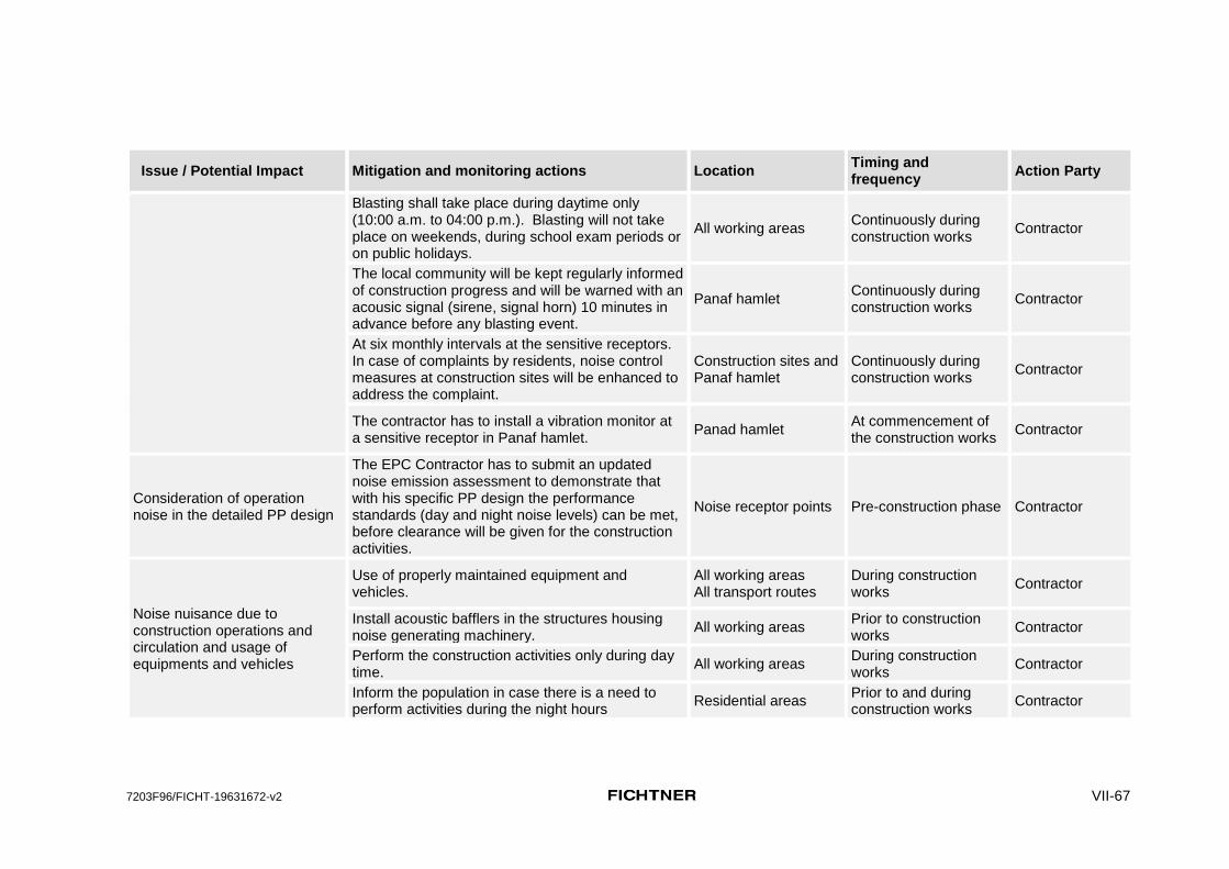
7203F96/FICHT-19631672-v2 VII-67
Issue / Potential Impact Mitigation and monitoring actions Location Timing and frequency
Action Party
Blasting shall take place during daytime only (10:00 a.m. to 04:00 p.m.). Blasting will not take place on weekends, during school exam periods or on public holidays.
All working areas Continuously during construction works
Contractor
The local community will be kept regularly informed of construction progress and will be warned with an acousic signal (sirene, signal horn) 10 minutes in advance before any blasting event.
Panaf hamlet Continuously during construction works
Contractor
At six monthly intervals at the sensitive receptors. In case of complaints by residents, noise control measures at construction sites will be enhanced to address the complaint.
Construction sites and Panaf hamlet
Continuously during construction works
Contractor
The contractor has to install a vibration monitor at a sensitive receptor in Panaf hamlet.
Panad hamlet At commencement of the construction works
Contractor
Consideration of operation noise in the detailed PP design
The EPC Contractor has to submit an updated noise emission assessment to demonstrate that with his specific PP design the performance standards (day and night noise levels) can be met, before clearance will be given for the construction activities.
Noise receptor points Pre-construction phase Contractor
Noise nuisance due to construction operations and circulation and usage of equipments and vehicles
Use of properly maintained equipment and vehicles.
All working areas All transport routes
During construction works
Contractor
Install acoustic bafflers in the structures housing noise generating machinery.
All working areas Prior to construction works
Contractor
Perform the construction activities only during day time.
All working areas During construction works
Contractor
Inform the population in case there is a need to perform activities during the night hours
Residential areas Prior to and during construction works
Contractor

7203F96/FICHT-19631672-v2 VII-68
Issue / Potential Impact Mitigation and monitoring actions Location Timing and frequency
Action Party
If generators are used, locate them far from the residential areas; in case this is not possible, sound barriers (walls or fences) shall be installed.
All working areas Previous and during construction works
Contractor
Changes in landscape as a result of excavation works, withdrawal and disposal of materials
Remove all the waste and leftover materials All working areas Immediately after completion of construction works
Contractor
Re-cultivate and re-vegetate the access roads and temporary construction sites that will no longer be needed, with local plant types and soil cover
All working areas All transport routes
Immediately after completion of construction works
Contractor
Including landscape architecture competences into the detailed project design to optimize harmonious integration of the infrastructure into the landscape
All project area, especially from the sea side
Prior to construction works
Project designers
Using natural materials e.g. for the enforcements of hillsides for erosion protection instead of concrete in order to maintain the character of the landscape
Along the coastline During construction works
Contractor
Delimitation of valuable biotopes and habitats before construction activities begin with signal bands - if necessary (e.g. mangrove forest)
All construction areas During construction works
Contractor
Natural Environment
Disturbance of biotopes and habitats
Avoid blasting whenever possible, use drilling
instead of hammering during piling works. In particular, avoid any blasting or other construction that would produce marine noise above international good-practice thresholds for behavioural disturbance (e.g., Southall et al. 2007) during the season when threatened cetaceans are regularly present.
All construction areas, especially the marine environment
During construction works
Contractor

7203F96/FICHT-19631672-v2 VII-69
Issue / Potential Impact Mitigation and monitoring actions Location Timing and frequency
Action Party
Restriction of all construction activities to absolutely necessary areas.
All working areas and their vicinities
Previous and during construction works
Contractor
Signage of areas, worker instructions and site supervision
All working areas and their vicinities
Previous and during construction works
Contractor
Survey of the marine life around the construction site area
Coastal water in front of the construction site
During construction works
Contractor
r
Losses of trees have to be compensated by planting of new native trees in a ratio 1 : 2
All construction areas
At the end of the construction phase, before commencement of operation
Contractor
Fencing of valuable areas and objects (Tuadale Sanctuary, trees, mangrove and coastal area) will be provided in order to avoid unnecessary impacts).
Wider construction area
At commencement of construction
Contractor
Changes in flora and fauna Survey of the natural and the agricultural vegetation and cultural trees in the vicinity of the construction site
Productive areas, Coastal area, Mangrove forest
During construction works
Contractor
Human Environment
Exposure of workers and local people to hazards at the construction site (pollution, accidents, diseases)
Guarantee of lodging and food supply to the workers, adequate water supply, sanitation system, management of rubbish and camp cleaning.
Worker camp During construction works
Contractor
Providing personal health protection equipment for the workers
All working areas Prior to and during construction works
Contractor
Use of appropriate vehicles for the transport of hazardous materials.
All transport routes During construction works
Contractor
Implementation of road safety measures All transport routes Prior to and during construction works
Contractor

7203F96/FICHT-19631672-v2 VII-70
Issue / Potential Impact Mitigation and monitoring actions Location Timing and frequency
Action Party
Use of appropriately designed storage facilities All working areas Prior to and during construction works
Contractor
Implementation of safe handling procedures. All working areas During construction works
Contractor
Clean-up plans for spill of hazardous substances All working areas Prior to to construction works
Contractor
Organization of environmental management, safety and health training and awareness
All working areas Prior to and regularly during construction works
Contractor
Installation of suitable signage around the project areas and access routes
All working areas All transport routes
Prior to to construction works
Contractor
Mount general safety advice and warnings All working areas Prior to to construction works
Contractor
Drainage of stagnant water All working areas Regularly during construction works
Contractor
Performance of medical checks of the construction workers
All working areas Prior to and regularly during construction works
Contractor
Construction of the camp to accommodate the workers outside the village limits.
All working areas Prior to to construction works
Contractor
Health problems and stress in the population due to the project implementation (transferable diseases and psychological stress)
Acoustic warning signal before blasting events, information of local residents about blasting times
Residential areas nearby, all blasting areas
Prior to to blasting Contractor
Preparation and application of an awareness health program
Project area Prior to to construction works
Health authorities PLN
Provide access to skilled medical personal to the population affected by the project
Project area During construction works
Health authorities PLN

7203F96/FICHT-19631672-v2 VII-71
Issue / Potential Impact Mitigation and monitoring actions Location Timing and frequency
Action Party
Definition of a representative of the project responsible organizations or authorities; he shall be permanently on site in order to gather complaints of the people affected by the project.
Project area Prior to and during construction works
PLN
Enhancing the employment of the maximum possible number of local community members.
All working areas Prior to and during construction works
Contractor
Social stress between the local residents and the foreign workers
Preferably employment of local residents, wherever possible
All working areas Prior to / at beginning of construction works
Contractor
Accommodating the foreign workers in a worker camp outside the limits of existing villages
All working areas Prior to / at beginning of construction works
Contractor
Definition of a representative of the project responsible organizations or authorities; he shall be permanently on site in order to gather complaints of the people to be affected by the project.
Construction site of the project
Continuously during construction works
PLN
Limit the construction activities strictly to absolutely required areas - usage of agricultural land, even if temporary, has to be avoided.
All working areas During construction works
PLN, Contractor
Loss of access to infrastructures
Have a share in the benefits of the project, e.g. by providing relocation of the school, free energy to the schools, the hospital, or public buildings.
Affected communities Prior to and during construction works
PLN
Provide the new communities with material, social and administrative infrastructure and services in such a way that the population is able to compensate losses or hardships
Affected communities Prior to and during construction works
PLN
Preparation and implementation of an emergency and rescue plan in case of a natural disaster
All working areas, areas downstream the project site
Prior to to construction works
PLN/Competent local and state authorities
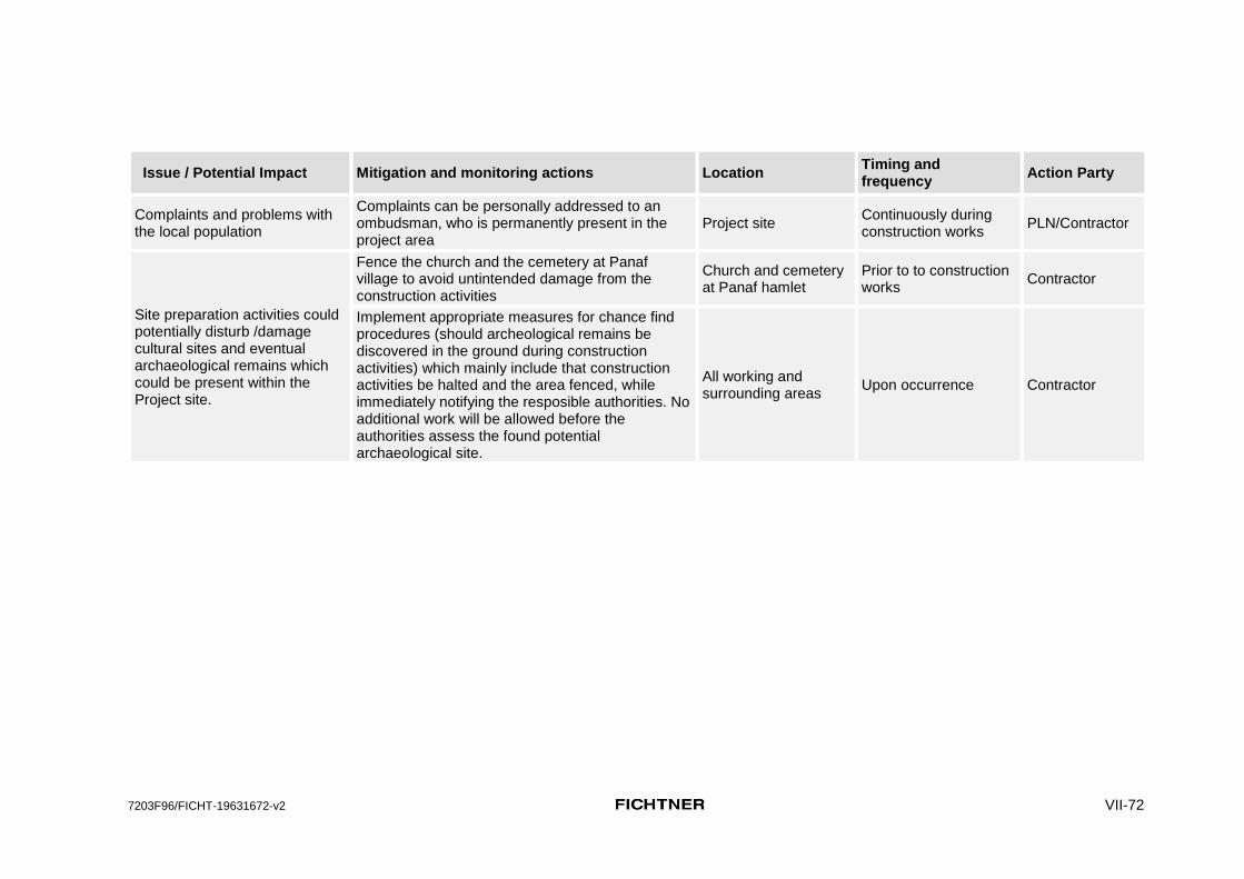
7203F96/FICHT-19631672-v2 VII-72
Issue / Potential Impact Mitigation and monitoring actions Location Timing and frequency
Action Party
Complaints and problems with the local population
Complaints can be personally addressed to an ombudsman, who is permanently present in the project area
Project site Continuously during construction works
PLN/Contractor
Site preparation activities could potentially disturb /damage cultural sites and eventual archaeological remains which could be present within the Project site.
Fence the church and the cemetery at Panaf village to avoid untintended damage from the construction activities
Church and cemetery at Panaf hamlet
Prior to to construction works
Contractor
Implement appropriate measures for chance find procedures (should archeological remains be discovered in the ground during construction activities) which mainly include that construction activities be halted and the area fenced, while immediately notifying the resposible authorities. No additional work will be allowed before the authorities assess the found potential archaeological site.
All working and surrounding areas
Upon occurrence Contractor

7203F96/FICHT-19631672-v2 VII-73
Table VII-3: Outline of an Environmental Management and Monitoring Plan for Kupang Peaker 2 - Operation phase
Issue / Potential Impact Monitoring and mitigation actions Location Timing and frequency Action Party
Physical Environment
Soil pollution by waste deposition
Develop and apply a Waste Management Plan (within the HSE Management Plan) containng measures such as: - Coordinate with the Municipality or hire a
competent private contractor for the collection of solid waste from the site to the municipal approved landfill.
- Distribute appropriate number of properly contained litter bins and containers properly marked for the diffrents types of waste, such as: recyclable, hazardous, for landfill, etc.
- Maintain records and manifests that indicate volume of waste generated onsite, collected by contractor, and disposed of. The numbers within the records are to be consistent to ensure no illegal dumping at the site or other areas.
Monitoring shall include: - Visual inspection of the soil - Verify the suitability of the storage areas for
materials and waste - Verification on-site of the procedures for
waste management - Review of manifests to ensure consistency - Review the contract with the company in
charge of the waste transportation
Power plant Regularly during operation Plant Operator

7203F96/FICHT-19631672-v2 VII-74
Issue / Potential Impact Monitoring and mitigation actions Location Timing and frequency Action Party
The operation of the plant contributes to the degradation of the air quality and emissions of GHG in the project area
Diesel shall be used only in rare emergency cases and not for the continuous operation of the power plants as it is done at present. In case Diesel has to be used the sulphur content of the HSD must be below 0.5 % S
Power plant Any time HSD is purchased Plant Operator
Monitor the air emissions of the plant and verify compliance with national and international standards as follows:
Continuous monitoring of: NOx, CO, PM10, PM2.5, Total PM, and SO2
Annual monitoring of: NOx, CO, PM10, PM2.5, Total PM, SO2, and heavy metals
Monitor and quantify the direct and indirect emissions of GHG following ADB’s SPS (2009)
Stack exit
For air emissions: Regularly during operation following the requirements of the UKL - UPL For GHG: Annually
Plant Operator
Monitor the air quality in the area as follows: Seasonal air quality sampling (1 week per season) at all identified sensitive receptors.
Receptor point at Panaf hamlet (see Air Dispersion Calculation Report in Annex C)
1 week per season Plant Operator
Evaluate the impact of the project in the air quality at the receptors. If the contribution of the project for the air quality in the area is >25% of the applicable national and international standards, then:
two continuous ambient air quality monitors need to be installed, one at the location of maximum GLC and one
At the location of maximum GLC and at the sensitive receptor where the GLC are higher.
Continuously Plant Operator

7203F96/FICHT-19631672-v2 VII-75
Issue / Potential Impact Monitoring and mitigation actions Location Timing and frequency Action Party
at the sensitive receptor where the GLC are higher.
Surface water, groundwater and soil pollution by wastewater deposition
Wastewater discharged from power plant activities will be treated in Wastewater Treatment Plant (WWTP) before discharging to the drainage or sea. Wastewater quality parameters following Government Ordinance of the Republic of Indonesia No. 82 Year 2001 regarding water quality management and water pollution control shall be monitored continuously at the discharge point.
Power Plant Plant design Contractor, Plant Operator
Biological Environment
The air and noise emissions, the water discharges and the solid waste deposition as well as the power supply lines might be stressor factors for local animals, plants and habitats
Develop and apply a Waste Management Plan (within the HSE Management Plan) Adapt the planning of the plant in such a way that the eventually impacted areas are kept below the national and international standards for noise Treat the wastewater to a level corresponding to its final destination (irrigation or discharge
into the marine water). Ensure any wastewater discharge is emitted sufficiently beyond
Power Plant Outlet of the plant
Before the final design of the plant Regularly during operation Continuously during operation
Contractor, Plant operator
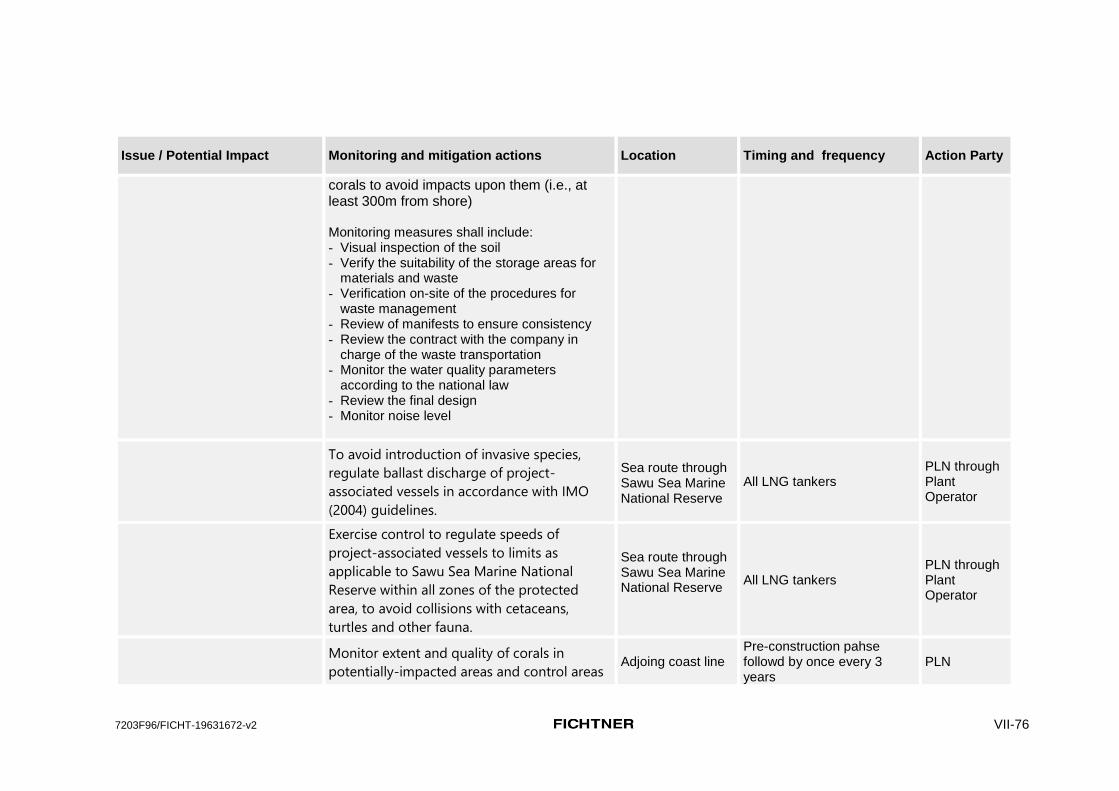
7203F96/FICHT-19631672-v2 VII-76
Issue / Potential Impact Monitoring and mitigation actions Location Timing and frequency Action Party
corals to avoid impacts upon them (i.e., at least 300m from shore) Monitoring measures shall include: - Visual inspection of the soil - Verify the suitability of the storage areas for
materials and waste - Verification on-site of the procedures for
waste management - Review of manifests to ensure consistency - Review the contract with the company in
charge of the waste transportation - Monitor the water quality parameters
according to the national law - Review the final design - Monitor noise level
To avoid introduction of invasive species,
regulate ballast discharge of project-
associated vessels in accordance with IMO
(2004) guidelines.
Sea route through Sawu Sea Marine National Reserve
All LNG tankers PLN through Plant Operator
Exercise control to regulate speeds of
project-associated vessels to limits as
applicable to Sawu Sea Marine National
Reserve within all zones of the protected
area, to avoid collisions with cetaceans,
turtles and other fauna.
Sea route through Sawu Sea Marine National Reserve
All LNG tankers PLN through Plant Operator
Monitor extent and quality of corals in
potentially-impacted areas and control areas Adjoing coast line
Pre-construction pahse followd by once every 3 years
PLN

7203F96/FICHT-19631672-v2 VII-77
Issue / Potential Impact Monitoring and mitigation actions Location Timing and frequency Action Party
post-construction, to assess the need for
further mitigation/ compensation action.
Impacts on habitats and local wildlife, especially on rare and endangered species
Monitoring for at least the first five years of
the operational period for presence of
Yellow-crested Cockatoo, to allow for
adaptive management should the species be
found.
Wider project area Period of construction Plant Operator
Survey of the flora and fauna developing in and around the power plant; e.g. through scientific research e.g. by local universities
Wider project area
Survey of the flora and fauna developing in and around the power plant; e.g. through scientific research e.g. by local universities
Plant Operator
Leisure time activities of the local workers shall not include poaching, collecting of birds or other wildlife, illegal fishing or impair valuable habitats
Wider project area
Leisure time activities of the local workers shall not include poaching, collecting of birds or other wildlife, illegal fishing or impair valuable habitats
Plant Operator
Human Environment
Noise nuisance due to the operation of the power plant
Maintenance of noise producing installations Power Plant During design, construction and operation phase
Plant Operator
Provide noise protection measures to comply with requirements regarding noise levels in green open space areas (50dB), settlements and housing areas (55dB) and industrial areas (70dB) during daytime. Night time operation of Kupang Peaker 2 is not planned.
Noise generating Power Plant Components
Detailed design and during construction
Contractor
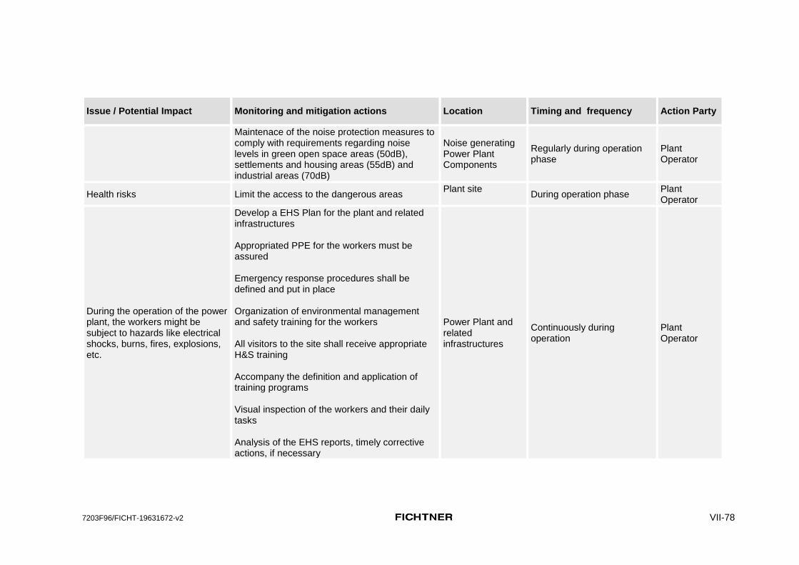
7203F96/FICHT-19631672-v2 VII-78
Issue / Potential Impact Monitoring and mitigation actions Location Timing and frequency Action Party
Maintenace of the noise protection measures to comply with requirements regarding noise levels in green open space areas (50dB), settlements and housing areas (55dB) and industrial areas (70dB)
Noise generating Power Plant Components
Regularly during operation phase
Plant Operator
Health risks Limit the access to the dangerous areas Plant site
During operation phase Plant Operator
During the operation of the power plant, the workers might be subject to hazards like electrical shocks, burns, fires, explosions, etc.
Develop a EHS Plan for the plant and related infrastructures Appropriated PPE for the workers must be assured Emergency response procedures shall be defined and put in place Organization of environmental management and safety training for the workers All visitors to the site shall receive appropriate H&S training Accompany the definition and application of training programs Visual inspection of the workers and their daily tasks Analysis of the EHS reports, timely corrective actions, if necessary
Power Plant and related infrastructures
Continuously during operation
Plant Operator

7203F96/FICHT-19631672-v2 VIII-1
VIII. Costs of EMP Implementation
557. In this specific planning case the EMP does not include all environmental components of construction or rehabilitation costs, as these measures still have to be defined based on the final layout of the power plant site and detailed planning by the contractor. This detailed planning was not available at the time when this EIA Report was compiled.
558. The contractor has to take care that the EMP and the SMP for the construction period are practically applied at the construction site during the whole construction period.
559. For this reason, a local environmental and social expert shall be employed by the contractor and shall be present at the construction site to conduct continuous environmental and social site supervision, and to write down relevant findings in his daily, weekly, and monthly site supervision reports.
560. The findings of the monthly reports from the contractor shall be summarized in form of quarterly or semi-annual construction site reports which will be prepared by PLN or environmental experts contracted by PLN.
561. During the operation phase it is the duty of the project operator to take care that the national environmental laws and regulations are met and that the EMP is practically applied.
562. PLN or contracted environmental experts have to conduct regular montoring according to the UKL-UPL for the planned project. These monitoring activities in Indonesia are usually taking place twice per year.
563. Based on statements from the PLN staff the approximative costs are as follows:
(i) Annual costs of an Indonesian environmental expert employed by PLN/Contractor during the construction period: IDR 30,000,000 - 40,000,000 per month, i.e. max. IDR 480,000,000 per year
(ii) Costs for the semi-annual monitoring of the operating plant, overall costs
for the Monitoring Report: IDR 40,000,000 per half-year, i.e. IDR 80,000,000 per year.

7203F96/FICHT-19631672-v2 IX-2
IX. Public participation
564. During the EIA process numerous meetings were held with various stakeholders (project developer, local residents, authorities, community leaders). A compilation of all meetings conducted by the environmental and the social team is attached as Annex 2 to this report.
565. The main purpose of these meetings was to inform local stakeholders about the planned project, to collect baseline data, and to find out the attitude of the local stakeholders towards the planned project.
566. The general attitude of the local communities towards the planned project was positive, mostly because new job opportunities will be created and more money is flowing into this remote region through the spending power of local and foreign workers.
567. Complaints were made by local resients regarding loss or damage of the church, the graveyard/single graves and the resettlement of houses. These issues are also one reason why the land acquisition process has been delayed and not been completed so far.
568. A summary of the public participation events is attached as Annex B to this Report.
The following wishes were expressed by local stakeholders:
(i) Employment of preferably local residents during construction and operation of the planned power plant
(ii) Rehabilitation of the dirt acess road, that leads from Lifuleo village (Desa Lifuleo) to the hamlet Panaf
(iii) Improvement of the health care situation, as these services are presently provided in Panaf hamlet only once per month
(iv) Provision of a basic school in the hamlet as the children have to walk long distances to attend the school in the neighbouring village.
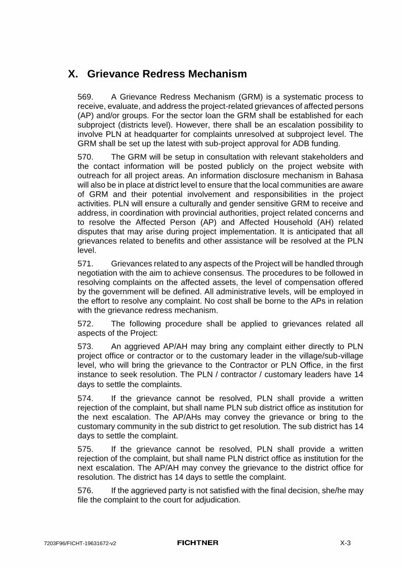
7203F96/FICHT-19631672-v2 X-3
X. Grievance Redress Mechanism
569. A Grievance Redress Mechanism (GRM) is a systematic process to receive, evaluate, and address the project-related grievances of affected persons (AP) and/or groups. For the sector loan the GRM shall be established for each subproject (districts level). However, there shall be an escalation possibility to involve PLN at headquarter for complaints unresolved at subproject level. The GRM shall be set up the latest with sub-project approval for ADB funding.
570. The GRM will be setup in consultation with relevant stakeholders and the contact information will be posted publicly on the project website with outreach for all project areas. An information disclosure mechanism in Bahasa will also be in place at district level to ensure that the local communities are aware of GRM and their potential involvement and responsibilities in the project activities. PLN will ensure a culturally and gender sensitive GRM to receive and address, in coordination with provincial authorities, project related concerns and to resolve the Affected Person (AP) and Affected Household (AH) related disputes that may arise during project implementation. It is anticipated that all grievances related to benefits and other assistance will be resolved at the PLN level.
571. Grievances related to any aspects of the Project will be handled through negotiation with the aim to achieve consensus. The procedures to be followed in resolving complaints on the affected assets, the level of compensation offered by the government will be defined. All administrative levels, will be employed in the effort to resolve any complaint. No cost shall be borne to the APs in relation with the grievance redress mechanism.
572. The following procedure shall be applied to grievances related all aspects of the Project:
573. An aggrieved AP/AH may bring any complaint either directly to PLN project office or contractor or to the customary leader in the village/sub-village level, who will bring the grievance to the Contractor or PLN Office, in the first instance to seek resolution. The PLN / contractor / customary leaders have 14
days to settle the complaints.
574. If the grievance cannot be resolved, PLN shall provide a written rejection of the complaint, but shall name PLN sub district office as institution for the next escalation. The AP/AHs may convey the grievance or bring to the customary community in the sub district to get resolution. The sub district has 14 days to settle the complaint.
575. If the grievance cannot be resolved, PLN shall provide a written rejection of the complaint, but shall name PLN district office as institution for the next escalation. The AP/AH may convey the grievance to the district office for resolution. The district has 14 days to settle the complaint.
576. If the aggrieved party is not satisfied with the final decision, she/he may file the complaint to the court for adjudication.

7203F96/FICHT-19631672-v2 X-4
577. Grievance mechanism amongst customary communities shall follow their internal mechanism (if any) or any mechanism provided by local government based on community request. The APs may bring their complaints to the village leaders and/or customary leaders. The complaint may bring it to the officers in project’s field office or sub-project site office.
578. Several procedures for allowing the register of grievances for the projects are suggested as follows:
(i) Nomination of a Community Liaison Officer (CLO); (ii) Suggestion boxes; (iii) Contacts list; (iv) The PLN’s webpage.
579. All grievances shall be answered, even those which may be considered non-reasonable or not project related. The answer shall always be given using the same medium as the complainant used to place the grievance, but at least one written medium (fax, letter or e-mail) is mandatory.
580. A record shall be made of all complaints, as well as of the answer given to those. The record should contain:
(v) the name of the individual or organization (if the grievance has not been made anonymously);
(vi) the date and nature of the complaint; (vii) any follow-up actions taken; (viii) the final result; and (ix) how and when this decision was communicated to the complainant.
581. The grievance management system will include in addition a reporting procedure to the local authority to document that the complaint was identified, noted, managed and solved. The responsible authorities at the community level shall be identified prior to the start of the construction activities or prior to the mobilization to the site. The reporting procedure shall be discussed and agreed together with the administrative authority.

7203F96/FICHT-19631672-v2 X-5
XI. Conclusions and Recommendations
582. The impacts caused by the planned stand alone project Kupang Peaker 2 are assessed as non significant after application of the proposed mitigation measures.
583. As a sound basis for an assessment of the impacts caused by noise and air emissions, respective expert studies with noise and air dispersion calculations were conducted, which are considering the overlapping effects of the relevant noise and air emission sources from the planned Power Plant facilities Timor 1 and Kupang Peaker 1, as well as the forecasted emissions from the planned Kupang Peaker 2. Wherever more than one project option exists, “worst case scenarios“ were used for the emission calculations and the impact assessment.
584. The results of these Air Dispersion Calculation showed, that from the investigated air pollution parameters CO, NOx, SO2, and PM10 / TSP, only SO2 showed exceedance of some of the strict WHO emission standards for 24 hours at one resident location. But that too is due to Timor 1 coal fired power plant that has significant higher SO2 emissions than Kupang Peaker 2.
585. Kupang Peaker 2 will be designed not to exceed the national noise standards. This will also ensure that applicable international noise emission standards are complied with.
586. The vegetation within the ca. 5 ha wide project site comprises rainfed, extensive agricultural land (around 60 %) and secondary bushland with a few trees interspersed. No rare, endangered or protected plant species have been observed within the project site and none are expected.
587. The Mangrove forest east of the power plant complex and especially the marine areas in the Sawu Sea Marine National Reserve presently provide critical habitats for rare, endangered and protected species. Impact of the standalone Kupang Peaker 2 on critical habitat, with mitigation measures recommended in EIA, are assessed as insignificant.
588. The environmental quality of the project site may be impacted negatively if construction and operations of neighbouring plants at the time when the construction activities for Kupang Peaker 2 will commence. .
589. Beside the small-scale and inevitable physical impairments of the remaining flora, fauna, and habitats within the directly affected construction sites, the major environmental issues in connection with the gas and diesel engine fired power plant are air emissions, noise and vibration emissions, and to a minor extend emissions of wastewater into the aquatic environment. In this specific planning case vibrations are only expected in the construction phase, especially due to blasting.
590. Construction and operation of the planned Kupang Peaker 2 will contribute to the degradation of the marine biodiversity, even if the impact is very small compared to the impacts resulting from the construction and operation of the coal fired Steam Power Plant Timor 1, which causes a multitude of severe

7203F96/FICHT-19631672-v2 X-6
impacts resulting from the jetty and the coal landing, the coalyard, the ashyard and the noise and air emissions from the power plant..
A. Mitigation
The following mitigation measures are recommended for Kupang Peaker 2:
(x) Minimization of blasting during construction works especially to avoid impairments of marine mammals in the Sawu Sea National Marine reserve and disturbance of local residents in Panaf hamlet.
(xi) Normal operation of the Kupang Peaker 2 with gas and only in emergency cases and short-term with HSD
(xii) Integrate noise abatement measures for Timor 1, Kupang Peaker 1 power plants to comply with the national noise regulations and install recommended noise mitigation measures for Kupang Peaker 2.
(xiii) Undertake a due diligence study to identify any gaps in construction and operations of Timor 1 and Kupang 1 power plants with respect to good international practice with the objective to fill the gaps by preparing and implementing a corrective action plan.
(xiv) Align the operation of a power plant complex with plans and strategies of the Sawu Sea National Marine Park aiming at the unit for national conservation area (BKKPN) or the Marine National Park Authority
591.
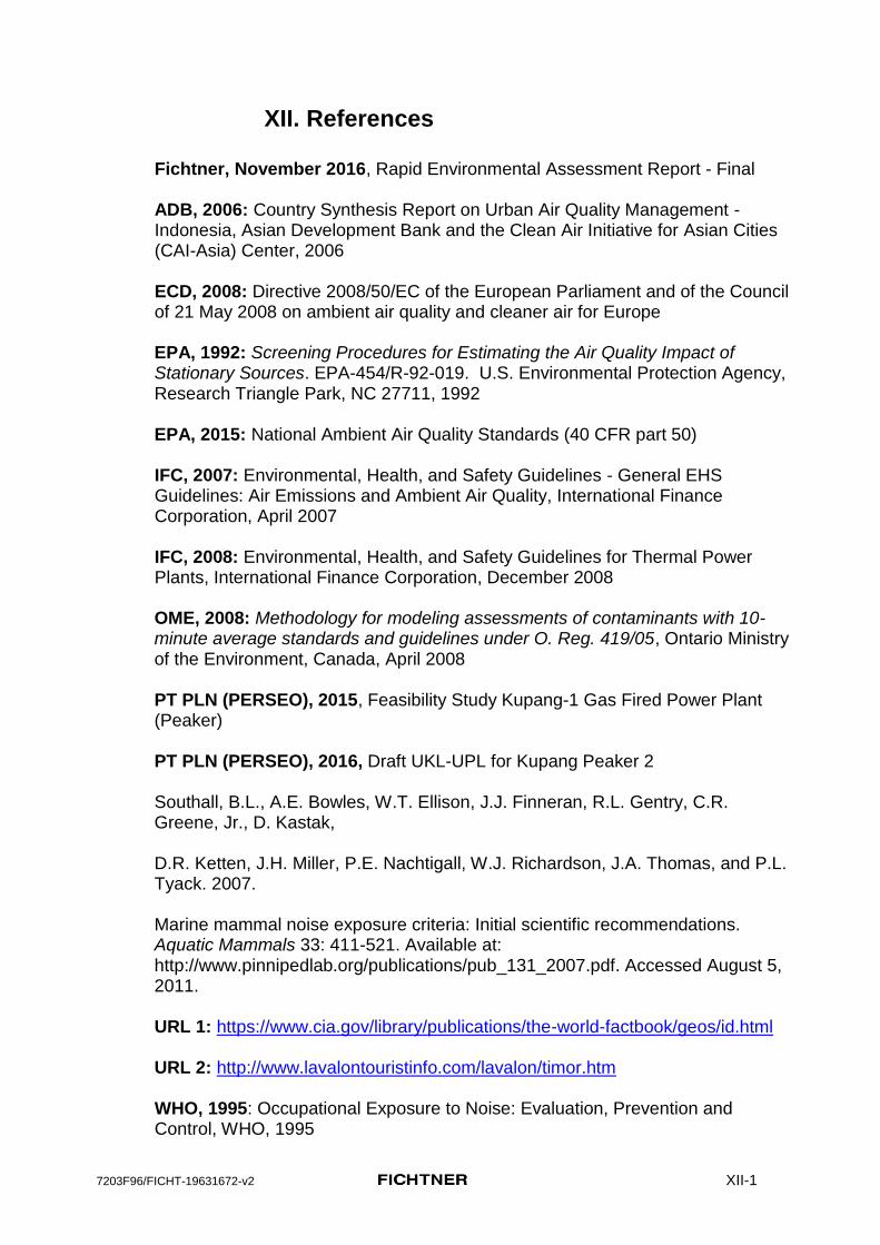
7203F96/FICHT-19631672-v2 XII-1
XII. References
Fichtner, November 2016, Rapid Environmental Assessment Report - Final ADB, 2006: Country Synthesis Report on Urban Air Quality Management - Indonesia, Asian Development Bank and the Clean Air Initiative for Asian Cities (CAI-Asia) Center, 2006 ECD, 2008: Directive 2008/50/EC of the European Parliament and of the Council of 21 May 2008 on ambient air quality and cleaner air for Europe EPA, 1992: Screening Procedures for Estimating the Air Quality Impact of Stationary Sources. EPA-454/R-92-019. U.S. Environmental Protection Agency, Research Triangle Park, NC 27711, 1992 EPA, 2015: National Ambient Air Quality Standards (40 CFR part 50) IFC, 2007: Environmental, Health, and Safety Guidelines - General EHS Guidelines: Air Emissions and Ambient Air Quality, International Finance Corporation, April 2007 IFC, 2008: Environmental, Health, and Safety Guidelines for Thermal Power Plants, International Finance Corporation, December 2008 OME, 2008: Methodology for modeling assessments of contaminants with 10-minute average standards and guidelines under O. Reg. 419/05, Ontario Ministry of the Environment, Canada, April 2008 PT PLN (PERSEO), 2015, Feasibility Study Kupang-1 Gas Fired Power Plant (Peaker) PT PLN (PERSEO), 2016, Draft UKL-UPL for Kupang Peaker 2 Southall, B.L., A.E. Bowles, W.T. Ellison, J.J. Finneran, R.L. Gentry, C.R. Greene, Jr., D. Kastak, D.R. Ketten, J.H. Miller, P.E. Nachtigall, W.J. Richardson, J.A. Thomas, and P.L. Tyack. 2007. Marine mammal noise exposure criteria: Initial scientific recommendations. Aquatic Mammals 33: 411-521. Available at: http://www.pinnipedlab.org/publications/pub_131_2007.pdf. Accessed August 5, 2011. URL 1: https://www.cia.gov/library/publications/the-world-factbook/geos/id.html URL 2: http://www.lavalontouristinfo.com/lavalon/timor.htm WHO, 1995: Occupational Exposure to Noise: Evaluation, Prevention and Control, WHO, 1995

7203F96/FICHT-19631672-v2 XII-2
WHO, 1999: Hazard prevention and control in the work environment: Airborne Dust, WHO, Geneva, August 1999 WHO, 2005: Air quality guidelines - global update 2005, World Health Organization, Genève, Switzerland, 2005

7203F96/FICHT-19631672-v2 XIII-1
XIII. Annexes
A. Maps of the project site and the investigation area
1. Wider project area
2. Project area of influence
3. Project site
4. Project layout plan
B. Public Participation and Meetings
C. Marine Study
D. Air Dispersion Study
E. Noise Emission Study
F. Noise control for power plants, Short overview of basic principles and examples

7203F96/FICHT-19631672-v2 XIII-2
A. Maps of the project site and the investigation area
1. Wider project area
2. Project area of influence
3. Project site
4. Project layout plan

7203F96/FICHT-19631672-v2 XIII-3
B. Public Participation and Meetings

7203F96/FICHT-19631672-v2 XIII-4
C. Marine Study

7203F96/FICHT-19631672-v2 XIII-5
D. Air Dispersion Study

7203F96/FICHT-19631672-v2 XIII-6
E. Noise Emission Study

7203F96/FICHT-19631672-v2 XIII-7
F. Noise control for power plants, Short overview of basic principles and examples