INITIAL STUDY - Department of City Planningplanning.lacity.org/eir/nops/TheFig/is.pdf · ·...
86
City of Los Angeles Department of City Planning Environmental Analysis Section City Hall 200 N. Spring Street, Room 750 Los Angeles, CA 90012 July 2016 INITIAL STUDY SOUTHEAST LOS ANGELES COMMUNITY PLAN AREA The Fig Project Case Number: ENV-2016-1892-EIR Project Location: 3900–3972 S. Figueroa Street, 3901–3969 S. Flower Street, 450 W. 39th Street, Los Angeles, CA 90037 Council District: 9 Project Description: The Project would demolish eight existing multi-family residential buildings and surface parking areas in order to construct a mixed-use development on an approximately 4.4-acre site located adjacent to Exposition Park and near the University of Southern California’s (USC) University Park Campus in the City of Los Angeles. The Project is comprised of three components: a Hotel Component, a Student Housing Component, and a Mixed-Income Housing Component. The Hotel Component would include a high-rise building with 21 above-ground stories, 298 rooms, approximately 15,335 square feet of retail and restaurant uses, approximately 13,553 square feet of shared guest and public amenities, and approximately 7,203 square feet of public meeting spaces. The Student Housing Component would include a seven-story building with 222 student housing units and approximately 32,991 square feet of community-serving retail and restaurant uses. The Mixed-Income Housing Component would include a seven-story building with 186 dwelling units (82 of which would be restricted to households earning no more than 80 percent of the Area Median Income), approximately 20,364 square feet of creative office space, and approximately 7,000 square feet of retail and restaurant uses. The Project would also construct a nine-story above-ground parking structure to provide parking for all three components. Upon completion, the Project would result in approximately 624,167 square feet of new floor area and a total maximum floor area ratio (FAR) of 3.25:1, with a commercial FAR of 0.50:1. APPLICANT: Spectrum Group Real Estate PREPARED BY: Eyestone Environmental, LLC ON BEHALF OF: The City of Los Angeles Department of City Planning Major Projects and Environmental Analysis Section
Transcript of INITIAL STUDY - Department of City Planningplanning.lacity.org/eir/nops/TheFig/is.pdf · ·...

City of Los Angeles Department of City Planning Environmental Analysis Section
City Hall 200 N. Spring Street, Room 750 Los Angeles, CA 90012
July 2016
INITIAL STUDY
SOUTHEAST LOS ANGELES COMMUNITY PLAN AREA
The Fig Project
Case Number: ENV-2016-1892-EIR
Project Location: 3900–3972 S. Figueroa Street, 3901–3969 S. Flower Street, 450 W. 39th Street, Los Angeles, CA 90037 Council District: 9 Project Description: The Project would demolish eight existing multi-family residential buildings and surface parking areas in order to construct a mixed-use development on an approximately 4.4-acre site located adjacent to Exposition Park and near the University of Southern California’s (USC) University Park Campus in the City of Los Angeles. The Project is comprised of three components: a Hotel Component, a Student Housing Component, and a Mixed-Income Housing Component. The Hotel Component would include a high-rise building with 21 above-ground stories, 298 rooms, approximately 15,335 square feet of retail and restaurant uses, approximately 13,553 square feet of shared guest and public amenities, and approximately 7,203 square feet of public meeting spaces. The Student Housing Component would include a seven-story building with 222 student housing units and approximately 32,991 square feet of community-serving retail and restaurant uses. The Mixed-Income Housing Component would include a seven-story building with 186 dwelling units (82 of which would be restricted to households earning no more than 80 percent of the Area Median Income), approximately 20,364 square feet of creative office space, and approximately 7,000 square feet of retail and restaurant uses. The Project would also construct a nine-story above-ground parking structure to provide parking for all three components. Upon completion, the Project would result in approximately 624,167 square feet of new floor area and a total maximum floor area ratio (FAR) of 3.25:1, with a commercial FAR of 0.50:1.
APPLICANT: Spectrum Group Real Estate
PREPARED BY: Eyestone Environmental, LLC
ON BEHALF OF: The City of Los Angeles
Department of City Planning Major Projects and
Environmental Analysis Section
City of Los Angeles The Fig July 2016
Page i
Table of Contents
Page
INITIAL STUDY AND CHECKLIST
ATTACHMENT A: PROJECT DESCRIPTION ................................................................ A-1
ATTACHMENT B: EXPLANATION OF CHECKLIST DETERMINATIONS .................... B-1
APPENDICES
Appendix IS-1 Protected Tree Report
Appendix IS-2 Water Resources Technical Report

City of Los Angeles The Fig July 2016
Page ii
List of Figures Figure Page
A-1 Project Location Map ........................................................................................ A-2
A-2 Aerial Photograph of the Project Vicinity ........................................................... A-4
A-3 Existing Site Plan .............................................................................................. A-5
A-4 Conceptual Site Plan ........................................................................................ A-8
A-5 Open Space and Amenities ............................................................................ A-17

City of Los Angeles The Fig July 2016
Page iii
List of Tables Table Page
A-1 Summary of Proposed Floor Area .................................................................... A-9
A-2 Summary of Student Housing Unit Mix ........................................................... A-11
A-3 Summary of Mixed-Income Housing Unit Mix ................................................. A-12
A-4 Required Vehicle Parking ............................................................................... A-14
A-5 Required Bicycle Parking ................................................................................ A-15
A-6 Project Open Space Requirements ................................................................ A-16
B-1 Existing and Proposed Flow Rates During 25-Year Storm and 50-Year Storm .............................................................................................................. B-25

CITY OF LOS ANGELES OFFICE OF THE CITY CLERK
ROOM 615, CITY HALL LOS ANGELES, CALIFORNIA 90012
CALIFORNIA ENVIRONMENTAL QUALITY ACT
INITIAL STUDY AND CHECKLIST (Article IV B City CEQA Guidelines)
LEAD CITY AGENCY City of Los Angeles Department of City Planning
COUNCIL DISTRICT 9
DATE July 18, 2016
RESPONSIBLE AGENCIES PROJECT TITLE/NO. The Fig
CASE NO. ENV-2016-1892-EIR
PREVIOUS ACTIONS CASE NO.
DOES have significant changes from previous actions.
DOES NOT have significant changes from previous actions.
PROJECT DESCRIPTION: The Project would demolish eight existing multi-family residential buildings and surface parking areas in order to construct a mixed-use development on an approximately 4.4-acre site located adjacent to Exposition Park and near the University of Southern California’s (USC) University Park Campus in the City of Los Angeles. The Project is comprised of three components: a Hotel Component, a Student Housing Component, and a Mixed-Income Housing Component. The Hotel Component would include a high-rise building with 21 above-ground stories, 298 rooms, approximately 15,335 square feet of retail and restaurant uses, approximately 13,553 square feet of shared guest and public amenities, and approximately 7,203 square feet of public meeting spaces. The Student Housing Component would include a seven-story building with 222 student housing units and approximately 32,991 square feet of community-serving retail and restaurant uses. The Mixed-Income Housing Component would include a seven-story building with 186 dwelling units (82 of which would be restricted to households earning no more than 80 percent of the Area Median Income), approximately 20,364 square feet of creative office space, and approximately 7,000 square feet of retail and restaurant uses. The Project would also construct a nine-story above-ground parking structure to provide parking for all three components. Upon completion, the Project would result in approximately 624,167 square feet of new floor area and a total maximum floor area ratio (FAR) of 3.25:1, with a commercial FAR of 0.50:1. ENVIRONMENTAL SETTING: The Project Site is comprised of surface parking areas and residential uses. Specifically, there are currently eight multi-family residential buildings containing a total of 32 dwelling units within approximately 33,720 square feet of residential floor area located on the northeastern portion of the Project Site fronting Flower Drive. These residential buildings are subject to the City’s Rent Stabilization Ordinance (RSO). The remainder of the Project Site is developed with surface parking lots that include approximately 385 parking spaces. Landscaping within the Project Site includes ornamental landscaping, residential lawns, and hardscape features. Street trees and other trees within the Project Site consist of various non-native species that are not subject to the City of Los Angeles Protected Tree Ordinance (Ordinance 177,404). Access to the Project Site is currently provided via several driveways along 39th Street on the north, Flower Drive on the east, and Figueroa Street on the west. The Project Site is located in a highly urbanized area. Surrounding uses include commercial retail and residential uses to the north; Flower Drive and the I-110 freeway immediately to the east; the Expo Park Plaza strip mall directly to the south; and Exposition Park to the west across Figueroa Street. Exposition Park, owned by the State of California and leased by various entities, houses the Los Angeles Memorial Coliseum, the Los Angeles Memorial Sports Arena, the California Science Center, the Dr. Theodore T. Alexander Jr. Science Center School, the California African American Museum, the Los Angeles County Natural History Museum, the Exposition Park Rose Garden, the Wallis Annenberg Building, and the Expo Center, which includes a swim

EVALUATION OF ENVIRONMENTAL IMPACTS: 1) A brief explanation is required for all answers except "No Impact" answers that are adequately
supported by the information sources a lead agency cites in the parentheses following each question. A "No Impact" answer is adequately supported if the referenced information sources show that the impact simply does not apply to projects like the one involved (e.g., the project falls outside a fault rupture zone). A "No Impact" answer should be explained where it is based on project-specific factors as well as general standards (e.g., the project will not expose sensitive receptors to pollutants based on a project-specific screening analysis).
2) All answers must take account of the whole action involved, including off-site as well as on-
site, cumulative as well as project-level, indirect as well as direct, and construction as well as operational impacts.
3) Once the lead agency has determined that a particular physical impact may occur, then the
checklist answers must indicate whether the impact is potentially significant, less that significant with mitigation, or less than significant. "Potentially Significant Impact" is appropriate if there is substantial evidence that an effect may be significant. If there are one or more "Potentially Significant Impact" entries when the determination is made, an EIR is required.
4) "Negative Declaration: Less Than Significant With Mitigation Incorporated" applies where the
incorporation of a mitigation measure has reduced an effect from "Potentially Significant Impact" to "Less Than Significant Impact." The lead agency must describe the mitigation measures, and briefly explain how they reduce the effect to a less than significant level (mitigation measures from Section XVII, "Earlier Analysis," cross referenced).
5) Earlier analysis must be used where, pursuant to the tiering, program EIR, or other CEQA
process, an effect has been adequately analyzed in an earlier EIR, or negative declaration. Section 15063 (c)(3)(D). In this case, a brief discussion should identify the following:
1) Earlier Analysis Used. Identify and state where they are available for review. 2) Impacts Adequately Addressed. Identify which effects from the above checklist
were within the scope of and adequately analyzed in an earlier document pursuant to applicable legal standards, and state whether such effects were addressed by mitigation measures based on the earlier analysis.
3) Mitigation Measures. For effects that are "Less Than Significant With Mitigation Measures Incorporated," describe the mitigation measures which were incorporated or refined from the earlier document and the extent to which they address site-specific conditions for the project.
6) Lead agencies are encouraged to incorporate into the checklist references to information
sources for potential impacts (e.g., general plans, zoning ordinances). Reference to a previously prepared or outside document should, where appropriate, include a reference to the page or pages where the statement is substantiated
7) Supporting Information Sources: A sources list should be attached, and other sources used or
individuals contacted should be cited in the discussion. 8) This is only a suggested form, and lead agencies are free to use different formats; however,
lead agencies should normally address the questions from this checklist that are relevant to a project’s environmental effects in whichever format is selected.

9) The explanation of each issue should identify:
1) The significance criteria or threshold, if any, used to evaluate each question; and 2) The mitigation measure identified, if any, to reduce the impact to less than
significance. ENVIRONMENTAL FACTORS POTENTIALLY AFFECTED:
The environmental factors checked below would be potentially affected by this project, involving at least one impact that is a "Potentially Significant Impact" as indicated by the checklist on the following pages.
Aesthetics
Greenhouse Gas Emissions Population/Housing
Agricultural and Forestry Resources
Hazards & Hazardous Materials Public Services
Air Quality
Hydrology/Water Quality Recreation
Biological Resources
Land Use/Planning Transportation/Traffic
Cultural Resources
Mineral Resources Utilities/Service Systems
Geology/Soils
Noise Mandatory Findings of Significance
INITIAL STUDY CHECKLIST (To be completed by the Lead City Agency)
� BACKGROUND PROPONENT NAME Spectrum Group Real Estate
PHONE NUMBER (949) 346-3318
PROPONENT ADDRESS 2030 Main Street, Suite 400, Irvine, CA 92614 AGENCY REQUIRING CHECKLIST City of Los Angeles, Department of City Planning
DATE SUBMITTED July 18, 2016
PROPOSAL NAME (If Applicable) The Fig

� ENVIRONMENTAL IMPACTS (Explanations of all potentially and less than significant impacts are required to be attached on separate sheets)
Potentially Significant
Impact
Less Than Significant
with Mitigation
Incorporated
Less Than Significant
Impact No Impact
I. AESTHETICS. Would the project:
a. Have a substantial adverse effect on a scenic vista?
b. Substantially damage scenic resources, including, but not limited to, trees, rock outcroppings, and historic buildings, or other locally recognized desirable aesthetic natural feature within a city-designated scenic highway?
c. Substantially degrade the existing visual character or quality of the site and its surroundings?
d. Create a new source of substantial light or glare which would adversely affect day or nighttime views in the area?
II. AGRICULTURAL AND FOREST RESOURCES. In determining whether impacts to agricultural resources are significant environmental effects, lead agencies may refer to the California Agricultural Land Evaluation and Site Assessment Model (1997) prepared by the California Department of Conservation as an optional model to use in assessing impacts on agriculture and farmland. In determining whether impacts to forest resources, including timberland, are significant environmental effects, lead agencies may refer to information compiled by the California Department of Forestry and Fire Protection regarding the state’s inventory of forest land, including the Forest and Range Assessment Project and the Forest Legacy Assessment project; and forest carbon measurement methodology provided in Forest Protocols adopted by the California Air Resources Board. Would the project:
a. Convert Prime Farmland, Unique Farmland, or Farmland of Statewide Importance, as shown on the maps prepared pursuant to the Farmland Mapping and Monitoring Program of the California Resources Agency, to non-agricultural use?
b. Conflict with existing zoning for agricultural use, or a Williamson Act Contract?
c. Conflict with existing zoning for, or cause rezoning of, forest land (as defined in Public Resources Code section 12220(g)), timberland (as defined by Public Resources Code section 4526), or timberland zoned Timberland Production (as defined by Government Code section 51104(g))?
d. Result in the loss of forest land or conversion of forest land to non-forest use?

Potentially Significant
Impact
Less Than Significant
with Mitigation
Incorporated
Less Than Significant
Impact No Impact
e. Involve other changes in the existing environment which, due to their location or nature, could result in conversion of Farmland, to non-agricultural use?
III. AIR QUALITY. Where available, the significance criteria established by the South Coast Air Quality Management District (SCAQMD) may be relied upon to make the following determinations. Would the project:
a. Conflict with or obstruct implementation of the South Coast Air Quality Management District (SCAQMD) Plan or Congestion Management Plan?
b. Violate any air quality standard or contribute substantially to an existing or projected air quality violation?
c. Result in a cumulatively considerable net increase of any criteria pollutant for which the air basin is non-attainment under an applicable federal or state ambient air quality standard?
d. Expose sensitive receptors to substantial pollutant concentrations?
e. Create objectionable odors affecting a substantial number of people?
IV. BIOLOGICAL RESOURCES. Would the project:
a. Have a substantial adverse effect, either directly or through habitat modification, on any species identified as a candidate, sensitive, or special status species in local or regional plans, policies, or regulations by the California Department of Fish and Wildlife or U.S. Fish and Wildlife Service?
b. Have a substantial adverse effect on any riparian habitat or other sensitive natural community identified in the City or regional plans, policies, regulations by the California Department of Fish and Wildlife or U.S. Fish and Wildlife Service?
c. Have a substantial adverse effect on federally protected wetlands as defined by Section 404 of the Clean Water Act (including, but not limited to, marsh vernal pool, coastal, etc.) Through direct removal, filling, hydrological interruption, or other means?
d. Interfere substantially with the movement of any native resident or migratory fish or wildlife species or with established native resident or migratory wildlife corridors, or impede the use of native wildlife nursery sites?
e. Conflict with any local policies or ordinances protecting biological resources, such as tree preservation policy or ordinance (e.g., oak trees or California walnut woodlands)?

Potentially Significant
Impact
Less Than Significant
with Mitigation
Incorporated
Less Than Significant
Impact No Impact
f. Conflict with the provisions of an adopted Habitat Conservation Plan, Natural Community Conservation Plan, or other approved local, regional, or state habitat conservation plan?
V. CULTURAL RESOURCES: Would the project:
a. Cause a substantial adverse change in significance of a historical resource as defined in State CEQA §15064.5?
b. Cause a substantial adverse change in significance of an archaeological resource pursuant to State CEQA §15064.5?
c. Directly or indirectly destroy a unique paleontological resource or site or unique geologic feature?
d. Disturb any human remains, including those interred outside of formal cemeteries?
e. Cause a substantial adverse change in the significance of a site, feature, place, cultural landscape, sacred place, or object with cultural value to a California Native American Tribe that is listed or determined eligible for listing on the California register of historical resources, listed on a local historical register, or otherwise determined by the lead agency to be a tribal cultural resource?1
VI. GEOLOGY AND SOILS. Would the project:
a. Expose people or structures to potential substantial adverse effects, including the risk of loss, injury or death involving :
i. Rupture of a known earthquake fault, as delineated on the most recent Alquist-Priolo Earthquake Fault Zoning Map issued by the State Geologist for the area or based on other substantial evidence of a known fault? Refer to Division of Mines and Geology Special Publication 42.
ii. Strong seismic ground shaking?
iii. Seismic-related ground failure, including liquefaction?
iv. Landslides?
b. Result in substantial soil erosion or the loss of topsoil?
c. Be located on a geologic unit or soil that is unstable, or that would become unstable as a result of the project, and potential result in on- or off-site landslide, lateral
1 This checklist question language, based on Office of Planning and Research (OPR) guidance, is being used
to address Tribal Cultural Resources as required by Assembly Bill 52. However, the language is still under draft form.

Potentially Significant
Impact
Less Than Significant
with Mitigation
Incorporated
Less Than Significant
Impact No Impact
spreading, subsidence, liquefaction, or collapse?
d. Be located on expansive soil, as defined in Table 18-1-B of the Uniform Building Code (1994), creating substantial risks to life or property?
e. Have soils incapable of adequately supporting the use of septic tanks or alternative waste water disposal systems where sewers are not available for the disposal of waste water?
VII. GREENHOUSE GAS EMISSIONS. Would the project:
a. Generate greenhouse gas emissions, either directly or indirectly, that may have a significant impact on the environment?
b. Conflict with an applicable plan, policy or regulation adopted for the purpose of reducing the emissions of greenhouse gases?
VIII. HAZARDS AND HAZARDOUS MATERIALS. Would the project:
a. Create a significant hazard to the public or the environment through the routine transport, use, or disposal of hazardous materials
b. Create a significant hazard to the public or the environment through reasonably foreseeable upset and accident conditions involving the release of hazardous materials into the environment?
c. Emit hazardous emissions or handle hazardous or acutely hazardous materials, substances, or waste within one-quarter mile of an existing or proposed school?
d. Be located on a site which is included on a list of hazardous materials sites compiled pursuant to Government Code Section 65962.5 and, as a result, would it create a significant hazard to the public or the environment?
e. For a project located within an airport land use plan or, where such a plan has not been adopted, within two miles of a public airport or public use airport, would the project result in a safety hazard for people residing or working in the project area?
f. For a project within the vicinity of a private airstrip, would the project result in a safety hazard for the people residing or working in the area?
g. Impair implementation of or physically interfere with an adopted emergency response plan or emergency evacuation plan?

Potentially Significant
Impact
Less Than Significant
with Mitigation
Incorporated
Less Than Significant
Impact No Impact
h. Expose people or structures to a significant risk of loss, injury or death involving wildland fires, including where wildlands are adjacent to urbanized areas or where residences are intermixed with wildlands?
IX. HYDROLOGY AND WATER QUALITY. Would the project result in:
a. Violate any water quality standards or waste discharge requirements?
b. Substantially deplete groundwater supplies or interfere with groundwater recharge such that there would be a net deficit in aquifer volume or a lowering of the local groundwater table level (e.g., the production rate of pre-existing nearby wells would drop to a level which would not support existing land uses or planned land uses for which permits have been granted)?
c. Substantially alter the existing drainage pattern of the site or area, including through the alteration of the course of a stream or river, in a manner which would result in substantial erosion or siltation on- or off-site?
d. Substantially alter the existing drainage pattern of the site or area, including through the alteration of the course of a stream or river, or substantially increase the rate or amount of surface runoff in an manner which would result in flooding on- or off site?
e. Create or contribute runoff water which would exceed the capacity of existing or planned stormwater drainage systems or provide substantial additional sources of polluted runoff?
f. Otherwise substantially degrade water quality?
g. Place housing within a 100-year flood plain as mapped on federal Flood Hazard Boundary or Flood Insurance Rate Map or other flood hazard delineation map?
h. Place within a 100-year flood plain structures which would impede or redirect flood flows?
i. Expose people or structures to a significant risk of loss, injury or death involving flooding, including flooding as a result of the failure of a levee or dam?
j. Inundation by seiche, tsunami, or mudflow?
X. LAND USE AND PLANNING. Would the project:
a. Physically divide an established community?
b. Conflict with applicable land use plan, policy or regulation of an agency with jurisdiction over the project (including but not limited to the general plan, specific plan, coastal program, or zoning ordinance) adopted for the purpose of avoiding or mitigating an

Potentially Significant
Impact
Less Than Significant
with Mitigation
Incorporated
Less Than Significant
Impact No Impact
environmental effect?
c. Conflict with any applicable habitat conservation plan or natural community conservation plan?
XI. MINERAL RESOURCES. Would the project:
a. Result in the loss of availability of a known mineral resource that would be of value to the region and the residents of the state?
b. Result in the loss of availability of a locally-important mineral resource recovery site delineated on a local general plan, specific plan, or other land use plan?
XII. NOISE. Would the project result in:
a. Exposure of persons to or generation of noise in level in excess of standards established in the local general plan or noise ordinance, or applicable standards of other agencies?
b. Exposure of people to or generation of excessive groundborne vibration or groundborne noise levels?
c. A substantial permanent increase in ambient noise levels in the project vicinity above levels existing without the project?
d. A substantial temporary or periodic increase in ambient noise levels in the project vicinity above levels existing without the project?
e. For a project located within an airport land use plan or, where such a plan has not been adopted, within two miles of a public airport or public use airport, would the project expose people residing or working in the project area to excessive noise levels?
f. For a project within the vicinity of a private airstrip, would the project expose people residing or working in the project area to excessive noise levels?
XIII. POPULATION AND HOUSING. Would the project:
a. Induce substantial population growth in an area either directly (for example, by proposing new homes and businesses) or indirectly (for example, through extension of roads or other infrastructure)?
b. Displace substantial numbers of existing housing necessitating the construction of replacement housing elsewhere?
c. Displace substantial numbers of people necessitating the construction of replacement housing elsewhere?

Potentially Significant
Impact
Less Than Significant
with Mitigation
Incorporated
Less Than Significant
Impact No Impact
XIV. PUBLIC SERVICES. Would the project result in substantial adverse physical impacts associated with the provision of new or physically altered governmental facilities, construction of which could cause significant environmental impacts, in order to maintain acceptable service ratios, response times or other performance objectives for any of the public services:
a. Fire protection?
b. Police protection?
c. Schools?
d. Parks?
e. Other governmental services (including roads)?
XV. RECREATION.
a. Would the project increase the use of existing neighborhood and regional parks or other recreational facilities such that substantial physical deterioration of the facility would occur or be accelerated?
b. Does the project include recreational facilities or require the construction or expansion of recreational facilities which might have an adverse physical effect on the environment?
XVI. TRANSPORTATION/TRAFFIC. Would the project:
a. Conflict with an applicable plan, ordinance or policy establishing measures of effectiveness for the performance of the circulation system, taking into account all modes of transportation including mass transit and non-motorized travel and relevant components of the circulation system, including but not limited to intersections, streets, highways and freeways, pedestrian and bicycle paths, and mass transit?
b. Conflict with an applicable congestion management program including, but not limited to, level of service standards and travel demand measures, or other standards established by the county congestion management agency for designated roads or highways?
c. Result in a change in air traffic patterns, including either an increase in traffic levels or a change in location that results in substantial safety risks?
d. Substantially increase hazards to a design feature (e.g., sharp curves or dangerous intersections) or incompatible uses (e.g., farm equipment)?
e. Result in inadequate emergency access?
f. Conflict with adopted policies, plans, or programs
Potentially Significant
Impact
Less Than Significant
with Mitigation
Incorporated
Less Than Significant
Impact No Impact
regarding public transit, bicycle, or pedestrian facilities, or otherwise decrease the performance or safety of such facilities?
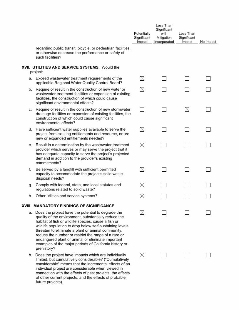
XVII. UTILITIES AND SERVICE SYSTEMS. Would the project:
a. Exceed wastewater treatment requirements of the applicable Regional Water Quality Control Board?
b. Require or result in the construction of new water or wastewater treatment facilities or expansion of existing facilities, the construction of which could cause significant environmental effects?
c. Require or result in the construction of new stormwater drainage facilities or expansion of existing facilities, the construction of which could cause significant environmental effects?
d. Have sufficient water supplies available to serve the project from existing entitlements and resource, or are new or expanded entitlements needed?
e. Result in a determination by the wastewater treatment provider which serves or may serve the project that it has adequate capacity to serve the project’s projected demand in addition to the provider’s existing commitments?
f. Be served by a landfill with sufficient permitted capacity to accommodate the project’s solid waste disposal needs?
g. Comply with federal, state, and local statutes and regulations related to solid waste?
h. Other utilities and service systems?
XVIII. MANDATORY FINDINGS OF SIGNIFICANCE.
a. Does the project have the potential to degrade the quality of the environment, substantially reduce the habitat of fish or wildlife species, cause a fish or wildlife population to drop below self-sustaining levels, threaten to eliminate a plant or animal community, reduce the number or restrict the range of a rare or endangered plant or animal or eliminate important examples of the major periods of California history or prehistory?
b. Does the project have impacts which are individually limited, but cumulatively considerable? ("Cumulatively considerable" means that the incremental effects of an individual project are considerable when viewed in connection with the effects of past projects, the effects of other current projects, and the effects of probable future projects).

Potentially Significant
Impact
Less Than Significant
with Mitigation
Incorporated
Less Than Significant
Impact No Impact
c. Does the project have environmental effects which cause substantial adverse effects on human beings, either directly or indirectly?
� DISCUSSION OF THE ENVIRONMENTAL EVALUATION (Attach additional sheets if necessary)
PREPARED BY
Stephanie Eyestone-Jones
Eyestone Environmental
6701 Center Drive, Suite 900
Los Angeles, CA 90045
TITLE
President
TELEPHONE #
(424) 207-5333
DATE
July 18, 2016

A. Project Description

City of Los Angeles The Fig July 2016
Page A-1
Attachment A: Project Description
A. Introduction
Spectrum Group Real Estate, the Project Applicant, proposes to demolish eight existing multi-family residential buildings and surface parking areas in order to develop a mixed-use Project on an approximately 4.4-acre site (Project Site) located adjacent to Exposition Park and near the University of Southern California’s (USC) University Park Campus in the City of Los Angeles. The Project is comprised of three components: a Hotel Component, a Student Housing Component, and a Mixed-Income Housing Component. The Hotel Component would include a high-rise building with 21 above-ground stories, 298 rooms, approximately 15,335 square feet of retail and restaurant uses, approximately 13,553 square feet of shared guest and public amenities, and approximately 7,203 square feet of public meeting spaces. The Student Housing Component would include a seven-story building with 222 student housing units and approximately 32,991 square feet of community-serving retail and restaurant uses. The Mixed-Income Housing Component would include a seven-story building with 186 dwelling units (82 of which would be restricted to households earning no more than 80 percent of the Area Median Income), approximately 20,364 square feet of creative office space, and approximately 7,000 square feet of retail and restaurant uses. The Project would also construct a nine-story above-ground parking structure to provide parking for all three components. Upon completion, the Project would result in approximately 624,167 square feet of new floor area and a total maximum floor area ratio (FAR) of 3.25:1, with a commercial FAR of 0.50:1.
B. Project Location and Surrounding Uses
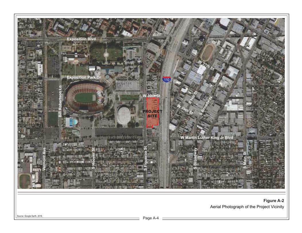
As shown in Figure A-1 on page A-2, the Project Site is located in the Southeast Los Angeles Community Plan area of the City of Los Angeles, approximately two miles southwest of downtown Los Angeles and approximately 11 miles east of the Pacific Ocean. The Project Site is specifically located at the 3900 block of Figueroa Street bounded by 39th Street to north, Flower Drive to the east, commercial retail uses to the south, and Figueroa Street to the west. Primary regional access to the Project Site is provided via Interstate 110 (I-110), which runs north-south and is located immediately east of Flower Drive, and Interstate 10 (I-10), which runs east-west and is located approximately 1.5 miles north of the Project Site. Major arterials providing regional and sub-regional access to the

Hill
Mai
n
Vernon
Washington
Verm
ont
Verm
ont
Wes
tern
Adams
Nor
man
die
Nor
man
die
Figu
eroa
Flow
er
Arlin
gton
Broa
dway
Exposition
Hoo
ver
Aval
on
Jefferson
Gra
nd
41st
Flow
er
Rodeo
23rd
Un
16th
39th
Venice
San
Pedr
o
Martin Luther King Jr
Leim
ert
Hoo
ver
Wes
tern
Gra
nd
San
Pedr
o
Flow
er
Adams
Jefferson
23rd
Venice
Exposition
Arlin
gton
23rd
Gra
nd
23rd
Figu
eroa
enice
Universityof SouthernCalifornia
PROJECTSITE
110
10
Source: Los Angeles County GIS, 2015; Eyestone Environmental, 2015.
0 0.5 10.25Miles
N
Figure A-1Project Location Map
NOT TO SCALE
�
405
101
91
1182
710
1
1
405
10
105
405
210
110
605
5
5
San Pedro
Encino Sherman Oaks
Van Nuys
Chatsworth
Carson
Santa Monica Mtns.
San Gabr ie l Mtns.
Glendale
Hollywood
Santa Monica
Manhattan Beach
Redondo Beach
Torrance
Long Beach
Malibu
Woodland Hills
Simi Valley
Agoura Hills
Los Angeles
Pasadena
Project Site
Page A-2

Attachment A: Project Description
City of Los Angeles The Fig July 2016
Page A-3
Project Site include Figueroa Street, Exposition Boulevard, and Martin Luther King Jr. Boulevard. The Project Site has convenient access to public transportation and is served by the Los Angeles County Metropolitan Transportation Authority (Metro) Blue Line and Expo Line, as well as several bus lines. The closest Metro rail station is the Expo Line’s Expo Park/USC Station, located less than a half-mile northwest of the Project Site.
The Project Site is located in a highly urbanized area, as illustrated in the aerial photograph provided in Figure A-2 on page A-4. Surrounding uses include commercial retail and residential uses to the north; Flower Drive and the I-110 freeway immediately to the east; the Expo Park Plaza strip mall directly to the south; and Exposition Park to the west across Figueroa Street. Exposition Park, owned by the State of California and leased by various entities, houses the Los Angeles Memorial Coliseum, the Los Angeles Memorial Sports Arena, the California Science Center, the Dr. Theodore T. Alexander Jr. Science Center School, the California African American Museum, the Los Angeles County Natural History Museum, the Exposition Park Rose Garden, the Wallis Annenberg Building, and the Expo Center, which includes a swim stadium, recreation center, senior citizen center, amphitheater, and pre-school. In addition, USC’s University Park Campus is located less than 0.3 miles north of the Project Site.
C. Existing Project Site Conditions
As shown in the existing site plan provided in Figure A-3 on page A-5, the Project Site is comprised of surface parking areas and residential uses. Specifically, there are currently eight multi-family residential buildings containing a total of 32 dwelling units within approximately 33,720 square feet of residential floor area located on the northeastern portion of the Project Site fronting Flower Drive. These residential buildings are subject to the City’s Rent Stabilization Ordinance (RSO). The remainder of the Project Site is developed with surface parking lots that include approximately 385 parking spaces. Landscaping within the Project Site includes ornamental landscaping, residential lawns, and hardscape features. Street trees and other trees within the Project Site consist of various non-native species that are not subject to the City of Los Angeles Protected Tree Ordinance (Ordinance 177,404). Access to the Project Site is currently provided via several driveways along 39th Street on the north, Flower Drive on the east, and Figueroa Street on the west.
1. Land Use and Zoning
(a) Southeast Los Angeles Community Plan
The Project Site is located within the planning boundary of the Southeast Los Angeles Community Plan (Community Plan), adopted in March 2000, and designated for
PROJECTSITE
Exposition Blvd
Exposition Park Dr
W 39th St
W 39th St
W 37th St
W Martin Luther King Jr Blvd
Verm
ont A
ve
Bill
Rob
erts
on L
n
S Fi
guer
oa S
t
S B
road
way
S M
ain
St
S H
oove
r St
110
S Hi
ll St
S Br
oadw
aySource: Google Earth, 2016.
Figure A-2Aerial Photograph of the Project Vicinity
Page A-4

FIGUEROA ST
W 3
9TH
ST
110 FREEWAY
Source: Google Earth, 2015.
Figure A-3Existing Site Plan
Page A-5
Attachment A: Project Description
City of Los Angeles The Fig July 2016
Page A-6
Community Commercial land uses under the Community Plan. Corresponding zoning designations for this land use designation include the CR (Limited Commercial), C2 (Commercial), C4 (Commercial), and RAS3 (Residential/Accessory Services) zones of the Los Angeles Municipal Code (LAMC). The Project Site is subject to Footnote 14 of the Community Plan’s land use map, which facilitates increases in FAR for mixed-use, affordable housing, and student housing projects.
(b) City of Los Angeles Municipal Code
The Project Site is zoned C2-1L (Commercial, Height District No. 1L) by the LAMC. The C2 zone permits a wide array of land uses including commercial, office, residential, retail, and hotel uses. Height District 1L restricts building heights to 75 feet, six stories, and establishes a maximum FAR of 1.5:1.
(c) Other Applicable Designations
The eight multi-family residential buildings within the northeastern portion of the Project Site are located within the Flower Drive Historic District (District). The District includes a grouping of 19 multi-family buildings (two of which are non-contributing) that were constructed between 1920 and 1927. Of the eight residential buildings within the Project Site, seven are contributors to the District. The District is generally bounded by West 38th Street to the north, Flower Drive to the east, the southern parcel line of 3941 Flower Drive to the south, and the west parcel lines of the properties between West 38th Street and 3941 Flower Drive on the west. The California State Historical Resources Commission formally determined the Flower Drive Historic District eligible for the California Register of Historical Resources under Criterion 1 for associations with events that have made a significant contribution of the broad patterns of Los Angeles’ history and under Criterion 3 for embodying the distinctive characteristics of a type and period of construction; namely, the Mediterranean Revival Style.
The Project Site is also located within the boundaries of the former Los Angeles State Enterprise Zone, the Greater Downtown Housing Incentive Area, the Exposition/University Park Redevelopment Project area, and the North University Park–Exposition Park–West Adams Neighborhood Stabilization Overlay District.1
1 Although located within the boundaries of the Neighborhood Stabilization Overlay District, the Project
Site, due to its frontage along Figueroa Street, is exempted from this district’s additional zoning provisions. (Ordinance No. 180,218, Section 1.)

Attachment A: Project Description
City of Los Angeles The Fig July 2016
Page A-7
D. Project Characteristics
1. Project Overview
The Project proposes to remove the existing residential uses and surface parking areas in order to redevelop the approximately 4.4-acre Project Site. The Project would construct a mixed-use development comprised of three components: a Hotel Component, a Student Housing Component, and a Mixed-Income Housing Component. Each component would be contained in a separate building designed specifically to serve a distinctive function. The Project would also construct a parking structure that would be located on the Project Site to provide parking for all three components. Figure A-4 on page A-8 provides a Conceptual Site Plan for the Project. As summarized in Table A-1 on page A-9 and described in detail below, upon completion, the Project would result in approximately 624,167 square feet of new floor area and an average FAR of up to 3.25:1 across the Project Site, with a commercial FAR of 0.50:1 in conformance with Community Plan Footnote No. 14.
As shown in Figure A-4, the Hotel Component would be constructed on the northern portion of the Project Site and would occupy the corner of 39th Street and Figueroa Street. The Mixed-Income Housing Component would be constructed on the southern L-shaped portion of the Project Site and would have street frontage along both Figueroa Street and Flower Street. The Student Housing Component would occupy the western portion of the Project Site, between the Hotel Component and the Mixed-Housing Component, fronting Figueroa Street. A nine-story parking structure with a maximum height of 116 feet would be centrally located on the eastern portion of the Project Site, directly behind the Student Housing Component and between the Hotel Component and the Mixed-Income Housing Component. The strategic location of the parking structure would create a buffer between the freeway and the majority of the Project’s housing units.
The Hotel Component would have a maximum height of 226 feet and would be comprised of 21 above-ground levels and a basement level. The basement level would be dedicated to back-of-house uses, service corridors, and mechanical equipment. Level 1 would include the hotel lobby; administrative and back-of-house-uses; and approximately 8,876 square feet of ground-level retail and restaurant uses, of which 5,061 square feet would be retail and 3,815 square feet would be restaurant. Level 2 would contain a 2,207-square-foot restaurant area, food preparation and service areas, and other back-of-house uses. Level 2 would also include approximately 6,458 square feet of public meeting space, consisting of several small meeting rooms and a larger banquet/conference room, as well as associated pre-function areas. The hotel’s proposed 298 guest rooms would be located on Levels 3 through 19 of the building. Of the 298 rooms proposed, 160 would be select-service guest rooms ranging in size from 340 square feet to 756 square feet for

Source: WATG, 2016.
Figure A-4Conceptual Site Plan
Page A-8

Attachment A: Project Description
City of Los Angeles The Fig July 2016
Page A-9
Table A-1 Summary of Proposed Floor Areaa
Hotel
Component Student Housing
Component
Mixed-Income Housing
Component
Dwelling Units/Guestrooms 167,430 SF (298 rooms)
174,688 SF (222 DU)
151,012 SF (186 DU)
Retail Uses 5,061 SF 23,671 SF 3,900 SF
Restaurant Uses 10,274 SF 9,320 SF 3,100 SF
Office Uses N/A N/A 20,364 SF
Private Amenities & Other Uses 23,396 SFb N/A 1,960 SFc
Shared Guest/Public Amenities 13,553 SFd N/A N/A
Public Meeting Rooms 7,203 SFe N/A N/A
Parking Structure Rooftop Amenities N/A 1,950 SFf 1,300 SFg
Parking Structure Lobby and Trash Areas N/A 5,985 SF N/A
Total 226,917 SF 215,614 SF 181,636 SF
Total Project Floor Area 624,167 SF
Total Lot Area 192,605 SFh
Floor Area Ratio 3.25:1 max
Total Commercial Floor Area 96,446 SF
Commercial Floor Area Ratio 0.50:1
SF = square feet
DU = dwelling unit
N/A = Not Applicable a Except where otherwise noted, square footage is calculated pursuant to the LAMC definition of floor
area for the purpose of calculating FAR. In accordance with LAMC Section 12.03, floor area is defined as: “[t]he area in square feet confined within the exterior walls of a building, but not including the area of the following: exterior walls, stairways, shafts, rooms housing building-operating equipment or machinery, parking areas with associated driveways and ramps, space for the landing and storage of helicopters, and basement storage areas.” In addition, in accordance with LAMC Section 12.21.1 A.5, bicycle parking, light courts, and outdoor eating areas of ground floor restaurants are excluded from floor area measurements.
b Includes back-of-house uses, guest-only uses and amenities (including lobby, Level 4 pool bar, Level 4 fitness center, food preparation areas, service room, and storage room).
c Includes Level 2 and Level 7 lounges. d Includes ground-floor coffee bar, lounge, and restrooms, and Level 2 public circulation, restrooms and pre-function areas. e Includes Level 2 meeting rooms and rooftop banquet room.
f Includes fitness center and student lounge. g Includes fitness center. h Lot area after required dedications and proposed partial vacation of Flower Drive.
Source: SVA Architects, 2016; WATG Architects, 2016; Eyestone Environmental, 2016.

Attachment A: Project Description
City of Los Angeles The Fig July 2016
Page A-10
suites.2 The remaining 138 rooms would be extended-stay guestrooms ranging in size from approximately 455 square feet to 1,030 square feet for a two-bedroom suite.3 Level 4 would contain additional hotel guest amenities, including a 724-square-foot fitness room, a pool terrace, and a 215-square-foot bar. The rooftop level would provide additional hotel amenities and publicly accessible uses including a 4,252-square-foot rooftop terrace and dining area with bar, as well as a 745-square-foot banquet space. In total, the hotel would offer approximately 13,553 square feet of shared guest and public amenities. Access to the parking structure for hotel guests would be provided at the ground level through an elevator lobby located immediately south of the hotel on the northwest corner of the parking structure.
The Student Housing Component would be housed in a seven-story building with a maximum height of 81 feet. The ground level of the building would be comprised of approximately 23,671 square feet of retail space, two restaurant spaces totaling approximately 9,320 square feet, approximately 1,600 square feet of outdoor dining area, and leasing and other administrative uses. Proposed hours of operation for the retail and restaurant uses would be from 5:00 A.M. to 2:00 A.M. Levels 2 through 7 of the building would contain 222 student housing units consisting of a mix of studio units, one bedroom/one bathroom units, two bedroom/two bathroom units, and four bedroom/two bathroom units. Units would range in size from 400 square feet to 1,300 square feet depending on the unit type. Table A-2 on page A-11 provides the unit mix and square footages for the student housing units.
Within the Student Housing Component, two private 3,400-square-foot courtyards would be provided on Level 2, and two 1,440-square-foot terraces would be provided on Level 7. The Student Housing Component would also offer additional student amenities on the rooftop of the adjacent parking garage, including a 1,950-square-foot fitness center/student lounge, pool, basketball court, sun terrace, and restroom facilities. Access to the parking structure for the Student Housing residents would be provided through entrances located along the eastern elevation at each level of the Student Housing building. Trash areas and bicycle storage areas for the Student Housing Component would also be provided in the parking structure.
The Mixed-Income Housing Component would consist of a seven-story L-shaped building with a maximum height of 81 feet. The ground level of the building would include
2 “Select-service” guest rooms are generally defined as hotel rooms that have a limited degree of food and
beverage alternatives compared to traditional full-service hotels. 3 “Extended-stay” guest rooms generally provide home-like amenities, such as kitchens, a sink, a
refrigerator, and kitchen appliances. An “extended stay” typically begins at 5 to 7 days, but does not extend past 30 days.

Attachment A: Project Description
City of Los Angeles The Fig July 2016
Page A-11
Table A-2 Summary of Student Housing Unit Mix
Unit Type Size Student Housing
Units
Studio 400 SF 36
1BR/1BA 518 SF 104
2BR/2BA 800 SF 72
4BR/2BA 1,300 SF 10
Total Units 222
BR = bedroom
BA = bathroom
SF = square feet
Source: SVA Architects, 2016; WATG Architects, 2016; Eyestone Environmental, 2016.
a 2,350-square-foot outdoor plaza; a lobby, leasing, and other administrative uses; 20,364 square feet of creative office space, 3,900 square feet of retail uses, and 3,100 square feet of restaurant uses. Proposed hours of operation for the retail and restaurant uses would be from 5:00 A.M. to 2:00 A.M. Levels 2 through 7 of the building would contain 186 dwelling units consisting of a mix of studio units, one bedroom/one bathroom units, and two bedroom/two bathroom units, which would range in size from 425 square feet to 900 square feet. Eighty-two of the units in the Mixed-Income Housing Component building (representing 20 percent of the Project’s 408 total dwelling units) would be restricted to households earning no more than 80 percent of the Area Median Income, as determined by the City’s Housing and Community Investment Department (HCID).4 Table A-3 on page A-12 provides the unit mix and square footages for the mixed-income housing units.
Within the Mixed-Income Housing Component building, Level 2 would include two private courtyards totaling 3,415 square feet, a 650-square-foot lounge area, and a laundry room. An additional 1,310 square feet of lounge spaces and a 975-square-foot balcony would be located on Level 7. Additional amenities for the residents of the Mixed-Income Housing Component, including a pool and spa and a 1,300-square-foot fitness center 4 In connection with the provision of these 82 restricted income units, which exceeds the maximum of
32 replacement units otherwise required under the City’s Ellis Act replacement unit provisions pursuant to the proposed demolition of the existing rent-stabilized dwelling units at the Project Site, the Applicant would request from HCID an exemption from the City’s Rent Stabilization Ordinance provisions for the Project’s newly constructed market-rate units, pursuant to LAMC Section 151.28 B.

Attachment A: Project Description
City of Los Angeles The Fig July 2016
Page A-12
would be provided on the rooftop of the adjacent parking structure. Access to the parking structure for residents of the Mixed-Income Housing Component would be available at the ground level and via pedestrian bridges on Levels 3, 5, and 7 of the building.
2. Access, Circulation, and Parking
As shown in Figure A-4 on page A-8, primary vehicular access to the Project Site would be provided via a driveway entrance off of Figueroa Street between the Student Housing Component and the Mixed-Income Housing Component, which would provide access to the parking structure, as well as through the Project Site to Flower Drive. A second driveway located on Figueroa Street is located between the Hotel Component and the Student Housing Component; however, this driveway would be designated as an exit-only driveway for hotel and valet use. Vehicular access to the hotel would be provided at a drop-off area along 39th Street, which would offer valet services to hotel guests. In addition, a loading area for service vehicles would be located at the southeast corner of the hotel building off of Flower Drive. Vehicular access to the student housing and mixed-income housing would be available from the full-access driveway off of Figueroa Street which leads to the parking structure. Additional vehicular access to the parking structure would be provided off of Flower Drive.
Pedestrian access within and around the Project Site would be enhanced via sidewalks, pedestrian plazas, and new landscaping within and along the perimeters of the Project Site. Public access to the retail and restaurant spaces in all three buildings would be provided via entrances along Figueroa Street. Public access to the hotel lobby would be provided on 39th Street.
Table A-3 Summary of Mixed-Income Housing Unit Mix
Unit Type Size Mixed-Income Housing Units
Studio 425 SF or 500 SF 46
1BR/1BA 550 SF or 650 SF 93
2BR/2BA 800 SF or 900 SF 47
Total Units 186
BR = bedroom
BA = bathroom
SF = square feet
Source: SVA Architects, 2016; WATG Architects, 2016; Eyestone Environmental, 2016.

Attachment A: Project Description
City of Los Angeles The Fig July 2016
Page A-13
As shown in Table A-4 on page A-14, the Project would be required to provide a total of 1,017 vehicular parking spaces per LAMC requirements, with permitted reductions for providing bicycle parking pursuant to the City’s Bicycle Parking Ordinance. The Project would provide a minimum of 541 residential parking spaces, 359 commercial parking spaces, and 117 parking spaces for hotel guests within the nine-level above-ground parking structure in accordance with LAMC requirements for vehicular parking spaces. In addition, the parking garage would include infrastructure for electric vehicle charging stations to facilitate the use of electric vehicles.
The Project would also provide short- and long-term bicycle parking in accordance with LAMC requirements, as summarized in Table A-5 on page A-15. A total of approximately 586 bicycle parking spaces would be provided, including 114 short-term spaces and 472 long-term spaces. Pursuant to the LAMC, the provision of these required bicycle parking spaces permits a reduction in the number of required vehicular parking spaces, as depicted in Table A-4.
3. Landscaping and Open Space
The landscape design for the Project would be a balance between the collaborative interests of the City of Los Angeles master streetscape plan for Figueroa, the new urban developments in and around USC, and the interests of the community of the Ninth District. As shown in Figure A-4 on page A-8, landscaping would be installed around the perimeter of the proposed buildings and along internal drive aisles. The perimeter streetscape character would accommodate pedestrian interests through the use of generous walkways, shade canopy trees, street furniture, and continuity into outdoor dining spaces. Internal vehicular access ways would be amenitized with unique paving materials and diverse landscape materials. Landscaping would also be provided within the outdoor dining areas for the Student Housing and Mixed-Income Housing buildings and in the lobby courtyard of the Mixed-Income Housing building. In addition, landscaping would be installed in all interior courtyards and on the rooftop level of the parking structure.
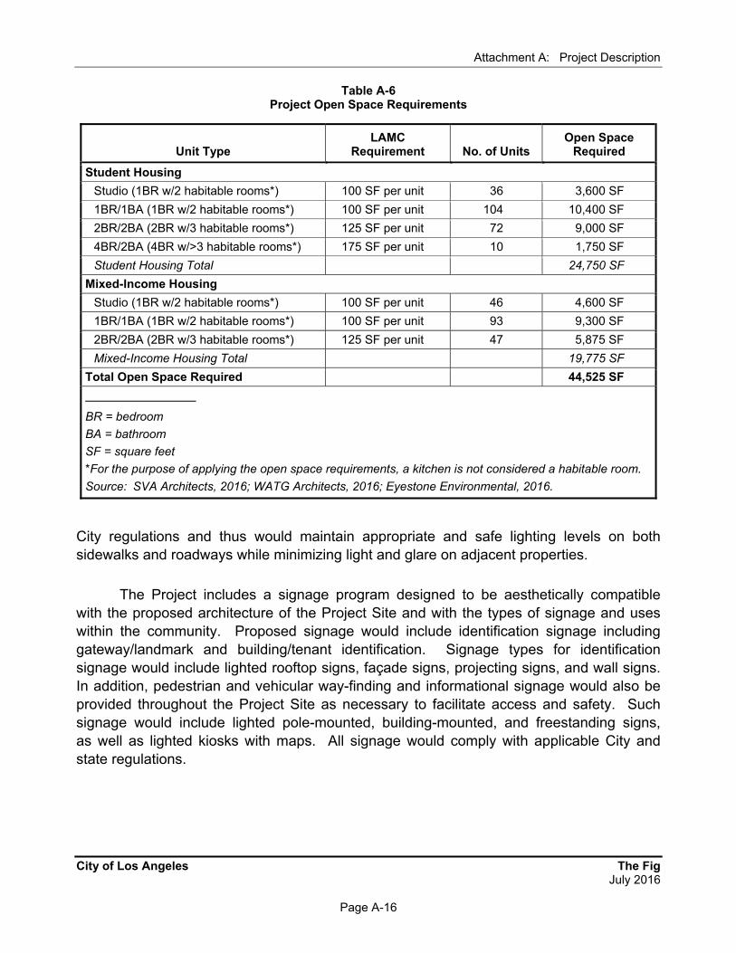
The Project would provide a variety of open space and recreational amenities. Per LAMC requirements, and as detailed in Table A-6 on page A-16, the Project would be required to provide 44,525 square feet of open space in connection with its proposed dwelling units. As shown in Figure A-5 on page A-17, the Project would provide a total of approximately 44,930 square feet of outdoor open space and recreational amenities, as well as indoor fitness centers and lounges, for use by the residents of the Student Housing and Mixed-Income Housing Components. Active recreational amenities would be located on the rooftop terrace above the parking structure. These amenities include a pool, spa, fitness centers, and basketball court. Other open space and passive recreational areas would include courtyards, indoor lounges, an activity lawn, and outdoor terraces.

Attachment A: Project Description
City of Los Angeles The Fig July 2016
Page A-14
Table A-4 Required Vehicle Parking
Use Type No. of Units/SF/Rooms LAMC Requirement
No. of Spaces Required
Residential
Studio 82 units 1 space/unit 82
1BR/1BA 197 units 1.5 space/unit 296
2BR/2BA 119 units 2 spaces/unit 238
4BR/2BA 10 units 2 spaces/unit 20
Subtotal 636
15% Bicycle Parking Reductiona 95
Residential Subtotal with Reduction 541
Commercialb
Retail/Restaurant Uses 55,326 SF 2 spaces/1,000 SF 111
Office Uses 20,364 SF 2 spaces/1,000 SF 41
Shared Guest/Public Amenities 13,553 SF 2 spaces/1,000 SF 27
Hotel Meeting Space 7,203 SF 28.6 spaces/1,000 SF 206
Subtotal 385
Bicycle Parking Reduction 26
Commercial Subtotal with Reduction 359
Hotel
1-30 Rooms 30 rooms 1 space/room 30
31-60 Rooms 30 rooms 0.5 space/room 15
Over 60 Rooms 238 rooms 0.33 space/room 79
Subtotal 124
Bicycle Parking Reduction 7
Hotel Subtotal with Reduction 117
Total Vehicle Parking Required without Bicycle Parking Reduction
1,145
Total Vehicle Parking Required with Bicycle Parking Reduction
1,017
BR = bedroom
BA = bathroom
SF = square feet a 15 percent reduction permitted due to the Project Site’s adjacency to transit, pursuant to LAMC Section
12.21 A.4
b Parking requirements for retail, restaurant/bar, and office uses are pursuant to the Los Angeles Enterprise Zone and LAMC Section 12.21 A.4(x)(3)(6).
Source: SVA Architects, 2016; WATG Architects, 2016; Eyestone Environmental, 2016.

Attachment A: Project Description
City of Los Angeles The Fig July 2016
Page A-15
Table A-5 Required Bicycle Parking
Use Type Units/SF/Rooms LAMC Requirement Required
Short-Term Required
Long-Term
Residential 408 units 1 space/10 units (short-term) 1 space/unit (long-term)
41 408
Hotel 298 rooms 1 space/20 rooms (short-term) 1 space/20 rooms (long-term)
15 15
Retail/Restaurant Uses
55,326 SF 1 space/2,000 SF (short-term) 1 space/2,000 SF (long-term)
28 28
Office Uses 20,364 SF 1 space/10,000 SF (short-term)1 space/5,000 SF (long -term)
2 4
Shared Guest/Public Amenitiesa
13,553 SF 1 space/2,000 SF (short-term) 1 space/2,000 SF (long-term)
7 7
Hotel Meeting Space 7,203 SF 1 space/350 SF (short-term) 1 space/700 SF (long-term)
21 10
Subtotal 114 472
Total Bicycle Parking Required 586 spaces
SF = square feet a Shared guest/public amenities are classified as commercial use; therefore, LAMC’s bicycle parking
requirement for retail/restaurant was applied.
Source: SVA Architects, 2016; WATG Architects, 2016; Eyestone Environmental, 2016.
Specifically, approximately 25,130 square feet of open space would be provided for the Student Housing Component, and approximately 19,800 square feet of open space would be provided for the Mixed-Income Housing Component. The open space provided for both buildings would exceed LAMC open space requirements.
4. Lighting and Signage
Project lighting would include architectural lighting for the buildings, and exterior lights adjacent to buildings and along pathways for aesthetic, security and wayfinding purposes. All Project lighting would comply with current energy standards. For example, exterior lighting would be automatically controlled via occupancy and photo sensors and/or timers to illuminate only when required. In addition, interior lighting would be equipped with occupancy sensors and/or timers that would be controlled based on room occupancy, thus reducing lighting load and glare. Further, all exterior and interior lighting would meet high energy efficiency requirements utilizing light emitting diode (LED) or efficient fluorescent lighting technology. All light sources would be shielded and/or directed toward areas to be illuminated thereby minimizing spill-over onto nearby sensitive areas. In addition, new street and pedestrian lighting within the public right-of-way would comply with applicable
Attachment A: Project Description
City of Los Angeles The Fig July 2016
Page A-16
Table A-6 Project Open Space Requirements
Unit Type LAMC
Requirement
No. of Units Open Space
Required
Student Housing
Studio (1BR w/2 habitable rooms*) 100 SF per unit 36 3,600 SF
1BR/1BA (1BR w/2 habitable rooms*) 100 SF per unit 104 10,400 SF
2BR/2BA (2BR w/3 habitable rooms*) 125 SF per unit 72 9,000 SF
4BR/2BA (4BR w/>3 habitable rooms*) 175 SF per unit 10 1,750 SF
Student Housing Total 24,750 SF
Mixed-Income Housing
Studio (1BR w/2 habitable rooms*) 100 SF per unit 46 4,600 SF
1BR/1BA (1BR w/2 habitable rooms*) 100 SF per unit 93 9,300 SF
2BR/2BA (2BR w/3 habitable rooms*) 125 SF per unit 47 5,875 SF
Mixed-Income Housing Total 19,775 SF
Total Open Space Required 44,525 SF
BR = bedroom
BA = bathroom
SF = square feet
*For the purpose of applying the open space requirements, a kitchen is not considered a habitable room.
Source: SVA Architects, 2016; WATG Architects, 2016; Eyestone Environmental, 2016.
City regulations and thus would maintain appropriate and safe lighting levels on both sidewalks and roadways while minimizing light and glare on adjacent properties.
The Project includes a signage program designed to be aesthetically compatible with the proposed architecture of the Project Site and with the types of signage and uses within the community. Proposed signage would include identification signage including gateway/landmark and building/tenant identification. Signage types for identification signage would include lighted rooftop signs, façade signs, projecting signs, and wall signs. In addition, pedestrian and vehicular way-finding and informational signage would also be provided throughout the Project Site as necessary to facilitate access and safety. Such signage would include lighted pole-mounted, building-mounted, and freestanding signs, as well as lighted kiosks with maps. All signage would comply with applicable City and state regulations.

Source: WATG, 2016.
Figure A-5Open Space and Amenities
Page A-17
Attachment A: Project Description
City of Los Angeles The Fig July 2016
Page A-18
5. Sustainability Features
The Project incorporates the principles of smart growth and environmental sustainability, as evidenced by its mixed-use nature, proximity to transit and walkable streets, and the presence of existing infrastructure needed to service the proposed uses. The Project Site is specifically located less than a half-mile southeast of the Los Angeles Metro Rail Expo Park/USC Station and within walking distance to numerous bus lines, including those with service that runs every 15 minutes or less during daytime hours. The Project Site exhibits a relatively high WalkScore® of 86 percent or “Very Walkable” resulting from its proximity to shopping, transit, dining, employment, and entertainment. The Project is a prime candidate to meet the U.S. Green Building Council’s (USGBC) Leadership in Energy Efficiency and Design (LEED) standards for certification of environmentally sustainable buildings. The Project would incorporate LEED® features capable of achieving Silver certification under the 2009 USGBC’s LEED-NC® Rating System. Specific sustainability features would include the following:
(a) Energy Conservation & Efficiency
Accommodate natural ventilation for the garage and include Carbon Monoxide monitors connected to variable frequency fans, which ramp up to remove excess pollution. Having fans turn on when needed may save up to 80% on fan energy.
Utilize high efficiency Variable Refrigerant Flow (VRF) system or high efficiency water source heat pumps for the hotel.
Provide standard lighting control to ensure system efficiencies are maintained and minimal energy is wasted unnecessarily through local dimming, daylight harvesting, and occupancy sensing controls. Building Management Systems (BMS) are not included for the Project. Astronomical time clocks, photocells that dim lights, occupancy and vacancy sensors will be installed.
Utilize the newest LED technology to provide the appropriate light levels, allow for full dimming where applicable on all fixtures, and keep the energy consumption well below the thresholds established by California’s Title 24. As additional strategies to reduce lighting loads may also include step switched lighting and/or low foot candle lighting to provide for flexibility in design and fixture options.
Utilize light color, highly reflective roofs and R-19 insulation at exterior walls where applicable. Where applicable, utilize light colored building materials and shading elements to reduce heat gain into the building.

Attachment A: Project Description
City of Los Angeles The Fig July 2016
Page A-19
Meet Title 24, Part 6, California Energy Code baseline standard requirements for energy efficiency, based on the 2013 Energy Efficiency Standards requirements, which is about 25% to 30% above the 2008 Title 24 Energy Code.
Include energy efficient design methods and technologies such as high performance window glazing, passive design and façade shading devices such as brise-soleil, high-efficiency domestic water heaters, and enhanced insulation to minimize solar heat gain.
Apply energy-saving technologies and components to reduce the Project’s electrical use profile. Examples of these components include energy-efficient heating, ventilation, and cooling equipment.
Utilize full-cutoff or fully shielded on-street lighting oriented to pedestrian areas/sidewalks so as to follow dark sky standards and to minimize light trespass and glare.
Consider use of on-site power and thermal energy generation technologies, including solar photovoltaic systems, solar thermal systems.
Consider domestic hot water solar pre-heat. Consider domestic hot water solar preheat for the hotel. Using the sun to heat water greatly reduces the need to spend more energy to heat municipal domestic water. Boilers work less and insulated storage tanks retain heat before use by tenants. The system can be used to also heat pool water.
Incorporate use of energy-saving variable frequency drive technology on domestic water pumps or ventilation fans, if applicable and necessary. Utilize multi-speed or variable speed pool pumps.
Complete post-construction commissioning of building energy systems. Building system retrocommissioning shall be performed on an ongoing basis at intervals of roughly five years to ensure all systems are running at optimal efficiency.
Incorporate ENERGY STAR–rated products and appliances where appropriate throughout the hotel, including the laundry and guest services equipment.
Use VRF in lieu of traditional heat pumps for mechanical systems within the housing and retail spaces. VRF is energy efficient and will reduce the amount of power used for the Project by 20 percent for the life of the Project.
Consider a central water heater rather than individual water heaters to reduce electric power consumption by 25 percent.
Plan for future access and space for electrical solar systems. Provide solar ready locations on the site, such as on rooftops and top level of parking garage.

Attachment A: Project Description
City of Los Angeles The Fig July 2016
Page A-20
Utilize lighting fixtures that meet the aesthetic goals of the Project and also provide superior performance capabilities that allow for uniform illumination of the target areas without the unnecessary side effects of backlight, uplight, or glare impacting users and nearby sensitive sites.
(b) Water Conservation
Install high-efficiency toilets (maximum 1.28 gallons per flush), including dual-flush water closets, and no-flush or waterless urinals in all non-residential restrooms where appropriate.
Include non-residential restroom faucets with a maximum flow rate of 0.5 gallon per minute and non-residential kitchen faucets (except restaurant kitchens) with a maximum flow rate of 1.5 gallons per minute. Restaurant kitchen faucets would have pre-rinse self-closing spray heads with a maximum flow rate of 1.6 gallons per minute.
Incorporate non-residential restroom faucets of a self-closing design (automatically turn off when not in use).
Incorporate residential bathroom and kitchen faucets with a maximum flow rate of 1.5 gallons per minute. No more than one showerhead per shower stall, with a flow rate no greater than 2 gallons per minute.
Install high-efficiency clothes washers either within individual units (with water factor of 6.0 or less) and/or in common laundry rooms (commercial washers with water factor of 7.5 or less).
Include a leak detection system for any domestic water systems, swimming pool, Jacuzzi, or other comparable spa equipment installed on-site.
Prohibit the use of single-pass cooling equipment.
Install cooling tower conductivity controllers or cooling tower pH conductivity controllers.
Hotel may utilize cooling towers at a minimum of 5.5 cycles of concentration in accordance with City ordinance requirements.
Consider cooling tower automatic water treatment to minimize cooling tower blowdown and water waste for hotel cooling towers should they be installed.
Consider use of a demand (instantaneous) water heater system sufficient to serve the anticipated needs of the dwellings.

Attachment A: Project Description
City of Los Angeles The Fig July 2016
Page A-21
Install high-efficiency ENERGY STAR–rated dishwashers and washing machines where appropriate.
Encourage the use of greywater and/or blackwater systems within individual buildings/developments.
Incorporate weather-based irrigation controllers with rain shutoff, matched precipitation (flow) rates for sprinkler heads, and rotating sprinkler nozzles or comparable technology such as drip/microspray/subsurface irrigation where appropriate.
Include minimum irrigation system distribution uniformity of 75 percent.
Install a separate water meter (or submeter), flow sensor, and master valve shutoff for irrigated landscape areas totaling 5,000 square feet and greater.
Incorporate proper hydro-zoning, turf minimization, xeriscaping, and use of native/drought-tolerant plant materials, as feasible or appropriate. Specifically, 100 percent of all landscaping would consist of drought-tolerant plants and at least 50 percent would consist of native species.
Use landscape contouring/bioswales, rain gardens, cisterns, and tree pits to minimize precipitation runoff.
Consider use of green or blue roof elements to filter and store roof runoff during storm events.
Use a weather-based irrigation system and high efficiency irrigation system to meet LEED requirements for Water Efficiency (WE) item no. 2.
(c) Water Quality Considerations
Consider use of an on-site storm water capture, filtration, and percolation system.
Implement Best Management Practices (BMPs) to control stormwater runoff, minimize pollutant loading and erosion effects during and after construction.
(d) Construction and Design Elements
Encourage the use of Partnership for Advancing Technology in Housing (PATH) construction methods, materials, and mechanical equipment where applicable.

Attachment A: Project Description
City of Los Angeles The Fig July 2016
Page A-22
(e) Solid Waste
Divert at least 75 percent of construction and demolition debris from Project construction from landfills.
Provide on-site recycling containers to promote the recycling of paper, metal, glass, and other recyclable materials and adequate storage areas for such containers during construction and after the building is occupied.
Use building materials with 10 percent recycled content for the construction of the Project.5
(f) Transportation
Prepare and implement a Transportation Demand Management (TDM) Plan that would promote the use of alternative transportation, such as mass transit, ride-sharing, bicycling, and walking to reduce automobile trips and and/or overall vehicle miles traveled generated by the Project.
Provide on-site bicycle storage for residents, visitors, and employees.
Promote or allow installation of bike share facilities at the Project Site should a bike share program become available in the Project vicinity.
Allocate preferred parking for alternative-fuel vehicles, low-emitting, and fuel-efficient and ride-sharing vehicles.
Provide electric vehicle charging stations in accordance with LAMC requirements (i.e., provide electric vehicle supply wiring equal to 5 percent of the total number of parking spaces).
(g) Air Quality
Employ practices that prohibit the use of chlorofluorocarbons (CFCs) in HVAC systems.
Meet applicable California and/or City air emissions requirements for all heating or cogeneration equipment utilized at the Project Site.
5 This LEED 4.1 credit requires the use of building materials with recycled content such that the sum of
post-consumer recycled content plus one-half of the pre-consumer recycled content constitutes at least 10 percent of the total value of the total building materials in the Project.
Attachment A: Project Description
City of Los Angeles The Fig July 2016
Page A-23
Use adhesives, sealants, paints, finishes, carpet, and other materials that emit low quantities of volatile organic compounds (VOCs) and/or other air quality pollutants.
E. Project Construction and Scheduling
Project construction is anticipated to occur over an approximate period of 18 months and is estimated to be completed in 2020. Construction of the Project would commence with removal of the existing residential structures, surface parking areas and associated utilities, followed by grading and remedial earthwork excavation. Upon completion of earthwork and in accordance with local and State building codes the foundations will be constructed, followed by vertical building construction, paving/concrete, and landscape installation. The Student Housing Component and Mixed-Income Housing Component would require a combined total of approximately 88,840 cubic yards of cut and 19,110 cubic yards of fill, resulting in 69,730 cubic yards of export material (e.g., concrete, asphalt and spoils). The Hotel Component would require approximately 26,360 cubic yards of cut, 8,290 cubic yards of fill and approximately 18,070 cubic yards of export material. In total, the Project would require approximately 115,200 cubic yards of cut, 27,400 cubic yards of fill, and approximately 87,800 cubic yards of export material and soil removal from the Project Site.
As part of the Project, a Construction Traffic Management Plan and Truck Haul Route Program would be implemented during construction to minimize potential conflicts between construction activity and through traffic. The Construction Traffic Management Plan and Truck Haul Route program would be subject to review and approval by the Los Angeles Department of Building and Safety (LADBS) and the Los Angeles Department of Transportation (LADOT). The haul route from the Project Site is anticipated to be via Martin Luther King Jr. Boulevard to the I-110 Freeway, connecting to the I-10 Freeway, to N. Vincent Avenue and arriving at the Irwindale Manning Pit Spreading Basin in the City of Irwindale.
F. Necessary Approvals
The City of Los Angeles has the principal responsibility for approving the Project. Approvals required for development of the Project may include, but are not limited to, the following:
Vesting Zone and Height District Change from C2-1L to (T)(Q)C2-2D pursuant to LAMC Section 12.32 Q to facilitate:
Attachment A: Project Description
City of Los Angeles The Fig July 2016
Page A-24
– An increase in FAR from 1.5:1 to 3.25:1 FAR across the Project Site, in conformance with Community Plan Footnote No. 14;
– An increase in height from six stories/75 feet to: (1) seven stories/81 feet for the Student Housing Component and Mixed-Income Housing Component; (2) 21 stories/226 feet for the Hotel Component; and (3) nine stories/116 feet for the parking structure;
Vesting Tentative Tract Map pursuant to LAMC Section 17.15 to create one ground lot comprising the entire site and multiple above and/or below grade airspace lots, and to vacate a portion of the existing right of way along Flower Drive;
Site Plan Review pursuant to LAMC Section 16.05;
Zoning Administrator’s Determination pursuant to LAMC Section 12.24 X.22 to waive transitional height requirements imposed by LAMC Section 12.21.1 A.10 by virtue of the OS zone being located within 100-199 feet of the Project Site in order to permit the Project’s buildings to exceed 61 feet in height;
Conditional Use Permit pursuant to LAMC Section 12.24 W.24 to allow a hotel within 500 feet of a residential zone;
Master Conditional Use Permit pursuant to LAMC Section 12.24 W.1 for the sale and/or dispensing of alcoholic beverages for a maximum of six (6) on-site full line permits, within the hotel and restaurant spaces, including outdoor and rooftop dining areas of the Project;
Approvals as may be required under the Exposition/University Park Redevelopment Plan;
Approval of the demolition, alteration, or removal of a historic building by the Los Angeles Department of Building and Safety pursuant to LAMC Section 91.106.4.5;
Haul route approval, as may be required; and
Other discretionary and ministerial permits and approvals, that may be deemed necessary, including but not limited to temporary street closure permits, grading permits, excavation permits, foundation permits, and building permits.

B. Explanation of Checklist Determinations

City of Los Angeles The Fig July 2016
Page B-1
Attachment B: Explanation of Checklist Determinations
The following discussion provides responses to each of the questions set forth in the City of Los Angeles Initial Study Checklist. The responses below indicate those issues that are expected to be addressed in an Environmental Impact Report (EIR) and demonstrate why other issues would not result in potentially significant environmental impacts and thus do not need to be addressed further in an EIR. The questions with responses that indicate a “Potentially Significant Impact” do not presume that a significant environmental impact would result from the Project. Rather, such responses indicate those issues that will be addressed in an EIR with conclusions of impact reached as part of the analysis within that future document.
I. Aesthetics
Would the project:
a. Have a substantial adverse effect on a scenic vista?
Potentially Significant Impact. A scenic vista is a view of a valued visual resource. Scenic vistas generally include views that provide visual access to large panoramic views of natural features, unusual terrain, or unique urban or historic features, for which the field of view can be wide and extend into the distance, and focal views that focus on a particular object, scene, or feature of interest. Visual resources in the Project vicinity include views of the downtown Los Angeles skyline as well as historic buildings within the area such as the Los Angeles Memorial Coliseum. The Project would replace the existing two-story, multi-family residential buildings and surface parking areas on the Project Site with a mixed-use development consisting of a 21-story hotel, a seven-story student housing building, a seven-story mixed-income housing building, a nine-story parking structure, and associated landscaping. The new buildings could potentially be visible within scenic vistas of valued visual resources that are available from locations in the vicinity of the Project Site. Therefore, the EIR will provide further analysis of the Project’s potential impacts to scenic vistas.
Attachment B: Explanation of Checklist Determinations
City of Los Angeles The Fig July 2016
Page B-2
b. Substantially damage scenic resources, including, but not limited to, trees, rock outcroppings, and historic buildings, or other locally recognized desirable aesthetic natural feature within a city-designated scenic highway?
Potentially Significant Impact. The Project Site is not located along a City-designated scenic highway.1 The closest scenic highway identified by the City of Los Angeles General Plan, Traffic Element is Adams Boulevard, which is located approximately one mile north of the Project Site. While the Project Site includes some ornamental trees and landscaping, the majority of the Project Site consists of paved and developed surfaces. Furthermore, there are no unique geologic or topographic features located on the Project Site, such as hilltops, ridges, hillslopes, canyons, ravines, rock outcrops, water bodies, streambeds, or wetlands. However, the Project Site includes a portion of the Flower Drive Historic District and has the potential to alter historic buildings within the District. Therefore, the EIR will provide further analysis of potential impacts to scenic resources.
c. Substantially degrade the existing visual character or quality of the site and its surroundings?
Potentially Significant Impact. The Project is located in a highly urbanized community. Surrounding uses include commercial retail and residential uses to the north; Flower Drive and the I-110 freeway immediately to the east; the Expo Park Plaza strip mall directly to the south; and Exposition Park to the west across Figueroa Street. The Project would replace the existing two-story, multi-family residential buildings and surface parking areas on the Project Site with a mixed-used development consisting of a 21-story hotel, a seven-story student housing building, a seven-story mixed-income housing building, a nine-story parking structure, and associated landscaping. The Project would change the visual character and quality of the Project Site and its surroundings. Therefore, the EIR will provide further analysis of the Project’s potential impacts on visual character and quality.
d. Create a new source of substantial light or glare which would adversely affect day or nighttime views in the area?
Potentially Significant Impact. The Project Site is currently developed with eight two-story, multi-family residential buildings and surface parking areas that generate low to moderate levels of artificial light and glare typical of urbanized areas. Light sources include low-level security lighting, vehicle headlights, interior lighting emanating from the multi-family residential buildings, and pole lighting within the surface parking areas. Glare sources include glass and metal building surfaces, and sunlight reflecting off of parked
1 City of Los Angeles General Plan, Transportation Element, Map E: Scenic Highways in the City of Los
Angeles, dated June 1998, accessed March 29, 2016.
Attachment B: Explanation of Checklist Determinations
City of Los Angeles The Fig July 2016
Page B-3
vehicles within the Project Site. The Project would introduce new sources of light and glare that are typically associated with residential, commercial, and hotel uses including: architectural lighting, signage lighting, interior lighting, security and wayfinding lighting, vehicle headlights, and parking structure lighting. In addition, the Project would include new buildings that would have the potential to shade adjacent land uses that may be sensitive to shading. Therefore, the EIR will provide further analysis of the Project’s potential impacts regarding light, glare, and shading.
II. Agricultural and Forest Resources
a. Convert Prime Farmland, Unique Farmland, or Farmland of Statewide Importance, as shown on the maps prepared pursuant to the Farmland Mapping and Monitoring Program of the California Resources Agency, to non-agricultural use?
No Impact. The Project Site is located in an urbanized area of the City of Los Angeles and is currently developed with multi-family residential buildings and surface parking areas. No agricultural uses or operations occur on-site or in the vicinity of the Project Site. In addition, the Project Site and surrounding area are not mapped as Prime Farmland, Unique Farmland, or Farmland of Statewide Importance pursuant to the Farmland Mapping and Monitoring Program of the California Resources Agency Department of Conservation.2 As such, the Project would not convert farmland to a non-agricultural use. No impacts would occur and no mitigation measures would be required. No further evaluation of this topic in an EIR is required.
b. Conflict with the existing zoning for agricultural use, or a Williamson Act Contract?
No Impact. The Project Site is not zoned for agricultural use under the City of Los Angeles Municipal Code (LAMC). Furthermore, no agricultural zoning is present in the surrounding area. The Project Site and surrounding area are also not enrolled under a Williamson Act Contract.3 Therefore, the Project would not conflict with any zoning for agricultural uses or a Williamson Act Contract. No impacts would occur and no mitigation measures would be required. No further evaluation of this topic in an EIR is required.
2 California Department of Conservation, California Important Farmland Finder, http://maps.conservation.
ca.gov/ciff/ciff.html, accessed March 24, 2016. 3 City of Los Angeles Department of City Planning, Zone Information and Map Access System (ZIMAS),
Parcel Profile Report, http://zimas.lacity.org/, accessed March 24, 2016.

Attachment B: Explanation of Checklist Determinations
City of Los Angeles The Fig July 2016
Page B-4
c. Conflict with existing zoning for, or cause rezoning of, forest land (as defined in Public Resources Code section 12220(g)), timberland (as defined by Public Resources Code section 4526), or timberland zoned Timberland Production (as defined by Government Code section 51104(g))?
No Impact. The Project Site is located in an urbanized area and does not include any forest or timberland. In addition, the Project Site is currently zoned for commercial land uses and is not zoned for timberland or forest land. Therefore, the Project would not conflict with existing zoning for, or cause the rezoning of, forest land or timberland as defined by the Public Resources Code. No impacts would occur and no mitigation measures would be required. No further evaluation of this topic in an EIR is required.
d. Result in the loss of forest land or conversion of forest land to non-forest use?
No Impact. As discussed above, the Project Site is located in an urbanized area, and does not include any forest or timberland. Therefore, the Project would not result in the loss or conversion of forest land. No impacts would occur and no mitigation measures would be required. No further evaluation of this topic in an EIR is required.
e. Involve other changes in the existing environment which, due to their location or nature, could result in conversion of Farmland, to non-agricultural use?
No Impact. The Project Site is located in an urbanized area of the City of Los Angeles and is currently developed with multi-family residential buildings and surface parking areas. The Project Site and surrounding area are not mapped as farmland, are not zoned for farmland or agricultural use, and do not contain any agricultural uses. Therefore, the Project would not result in the conversion of farmland to non-agricultural use. No impacts would occur and no mitigation measures would be required. No further evaluation of this topic in an EIR is required.
III. Air Quality
a. Conflict with or obstruct implementation of the South Coast Air Quality Management District (SCAQMD) Plan or Congestion Management Plan?
Potentially Significant Impact. The Project Site is located within the 6,700-square-mile South Coast Air Basin (the Basin). Within the Basin, the South Coast Air Quality Management District (SCAQMD) is required, pursuant to the federal Clean Air Act, to
Attachment B: Explanation of Checklist Determinations
City of Los Angeles The Fig July 2016
Page B-5
reduce emissions of criteria pollutants for which the Basin is in non-attainment (i.e., ozone, particulate matter less than 2.5 microns in size [PM2.5], and lead4). The SCAQMD’s 2012 Air Quality Management Plan (AQMP) contains a comprehensive list of pollution control strategies directed at reducing emissions and achieving ambient air quality standards. These strategies are developed, in part, based on regional population, housing, and employment projections prepared by the Southern California Association of Governments (SCAG). SCAG is the regional planning agency for Los Angeles, Orange, Ventura, Riverside, San Bernardino and Imperial Counties, and addresses regional issues relating to transportation, the economy, community development and the environment.5 With regard to future growth, SCAG has prepared the 2016 Regional Transportation Plan/Sustainable Communities Strategy (2016 RTP/SCS), which provides population, housing, and employment projections for cities under its jurisdiction. The growth projections in the 2016 RTP/SCS are based on growth projections in local general plans for jurisdictions in SCAG’s planning area.
Construction and operation of the Project may result in an increase in stationary and mobile source air emissions. As a result, development of the Project could have a potential adverse effect on the SCAQMD’s implementation of the AQMP. Therefore, the EIR will provide further analysis of the Project’s consistency with the SCAQMD’s AQMP.
With regard to the Project’s consistency with the Congestion Management Program (CMP) administered by the Los Angeles County Metropolitan Transportation Authority (Metro), see Response to Checklist Question XVI.b, Transportation/Circulation, below.
b. Violate any air quality standard or contribute substantially to an existing or projected air quality violation?
Potentially Significant Impact. The Project would result in increased air pollutant emissions from the Project Site during construction (short-term) and operation (long-term). Construction-related pollutants would be associated with sources such as construction worker vehicle trips, the operation of construction equipment, site grading and preparation activities, and the application of architectural coatings. During project operation, air pollutants would be emitted on a daily basis from motor vehicle travel, natural gas consumption, and other on-site activities. Therefore, the EIR will provide further analysis of the Project’s construction and operational air pollutant emissions.
4 Partial non-attainment designation for the Los Angeles County portion of the Basin only. 5 SCAG serves as the federally designated metropolitan planning organization (MPO) for the Southern
California region.

Attachment B: Explanation of Checklist Determinations
City of Los Angeles The Fig July 2016
Page B-6
c. Result in a cumulatively considerable net increase of any criteria pollutant for which the air basin is non-attainment under an applicable federal or state ambient air quality standard?
Potentially Significant Impact. As discussed above, construction and operation of the Project would result in the emission of air pollutants in the Basin, which is currently in non-attainment of federal air quality standards for ozone, PM2.5 and lead, and state air quality standards for ozone, PM10, and PM2.5. Therefore, implementation of the Project could potentially contribute to air quality impacts, which could cause a cumulative impact in the Basin. Therefore, the EIR will provide further analysis of cumulative air pollutant emissions associated with the Project..
d. Expose sensitive receptors to substantial pollutant concentrations?
Potentially Significant Impact. As discussed above, the Project would result in increased air pollutant emissions from the Project Site during construction (short-term) and during operation (long-term). Sensitive receptors located in the vicinity of the Project Site include residential uses to the north of the Project. Therefore, the EIR will provide further analysis of the Project’s potential to result in substantial adverse impacts to sensitive receptors.
e. Create objectionable odors affecting a substantial number of people?
Less Than Significant Impact. No objectionable odors are anticipated as a result of either construction or operation of the Project. Specifically, construction of the Project would involve the use of conventional building materials typical of construction projects of similar type and size. Any odors that may be generated during construction would be localized and temporary in nature and would not be sufficient to affect a substantial number of people or result in a nuisance as defined by SCAQMD Rule 402.
With respect to project operation, according to the SCAQMD CEQA Air Quality Handbook (April 1993), land uses associated with odor complaints typically include agricultural uses, wastewater treatment plants, food processing plants, chemical plants, composting, refineries, landfills, dairies, and fiberglass molding. The Project would not involve these types of uses. In addition, on-site trash receptacles would be contained, located, and maintained in a manner that promotes odor control, and would not result in substantially adverse odor impacts.
Based on the above, the potential odor impact during construction and operation of the Project would be less than significant, and no mitigation measures are required. No further analysis of this topic in an EIR is required.

Attachment B: Explanation of Checklist Determinations
City of Los Angeles The Fig July 2016
Page B-7
IV. Biological Resources
Would the project:
a. Have a substantial adverse effect, either directly or through habitat modification, on any species identified as a candidate, sensitive, or special status species in local or regional plans, policies, or regulations by the California Department of Fish and Wildlife or U.S. Fish and Wildlife Service?
Less Than Significant Impact. The Project Site is located in an urbanized area and is currently developed with multi-family residential buildings and surface parking areas. Ornamental trees and landscaping exist on limited portions of the Project Site. Due to the improved nature of the Project Site and the surrounding areas, and lack of large expanses of open space areas, species likely to occur on-site are limited to small terrestrial and avian species typically found in developed settings. Therefore, the Project would not have a substantial adverse effect, either directly or through habitat modification, on any species identified as a candidate, sensitive, or special status species in local or regional plans, policies, or regulations by the California Department of Fish and Wildlife (CDFW) or U.S. Fish and Wildlife Service (USFW). Impacts would be less than significant, and no mitigation measures are required. No further evaluation of this topic in an EIR is required.
b. Have a substantial adverse effect on any riparian habitat or other sensitive natural community identified in the City or regional plans, policies, regulations by the California Department of Fish and Wildlife or U.S. Fish and Wildlife Service?
No Impact. The Project Site is located in an urbanized area and is developed with multi-family residential buildings and surface parking areas. No riparian or other sensitive natural community exists on the Project Site or in the surrounding area. Therefore, the Project would not have a substantial adverse effect on any riparian habitat or other sensitive natural community. No impact would occur, and no mitigation measures are required. No further evaluation of this topic in an EIR is required.
c. Have a substantial adverse effect on federally protected wetlands as defined by Section 404 of the Clean Water Act (including, but not limited to, marsh vernal pool, coastal, etc.) through direct removal, filling, hydrological interruption, or other means?
No Impact. The Project Site is located within an urbanized area, is adjacent to the I-110 freeway, and is developed with multi-family residential buildings and surface parking areas. No water bodies or federally protected wetlands as defined by Section 404 of the Clean Water Act exist on the Project Site or in the immediate vicinity of the Project Site. As

Attachment B: Explanation of Checklist Determinations
City of Los Angeles The Fig July 2016
Page B-8
such, the Project would not have an adverse effect on federally protected wetlands. No impact would occur, and no mitigation measures are required. No further evaluation of this topic in an EIR is required.
d. Interfere substantially with the movement of any native resident or migratory fish or wildlife species or with established native resident or migratory wildlife corridors, or impede the use of native wildlife nursery sites?
Less Than Significant Impact. The Project Site is located in an urbanized area and is developed with multi-family residential buildings and surface parking areas. In addition, the areas surrounding the Project Site are fully developed and there are no large expanses of open space areas within or surrounding the Project Site that provide linkages to natural open space areas and which may serve as wildlife corridors. Accordingly, development of the Project would not interfere substantially with any established native resident or migratory wildlife corridors or impede the use of native wildlife nursery sites. Furthermore, no water bodies that could serve as habitat for fish exist on the Project Site or in the vicinity of the Project Site. Notwithstanding the foregoing, although unlikely, the existing on-site trees that would be removed during construction of the Project could potentially provide nesting sites for migratory birds. However, the Project would comply with the Migratory Bird Treaty Act, which regulates vegetation removal during the nesting season to ensure that significant impacts to migratory birds would not occur. In accordance with the Migratory Bird Treaty Act, tree removal activities would take place outside of the nesting season (February 15–September 15), to the extent feasible. To the extent that vegetation removal activities must occur during the nesting season, a biological monitor would be present during the removal activities to ensure that no active nests would be impacted. If active nests are found, a 300-foot buffer (500 feet for raptors) would be established until the fledglings have left the nest. With compliance with the Migratory Bird Treaty Act, the impact would be less than significant and no mitigation measures are required. No further evaluation of this topic in an EIR is required.
e. Conflict with any local policies or ordinances protecting biological resources, such as tree preservation policy or ordinance (e.g., oak trees or California walnut woodlands)?
Less Than Significant Impact. The City of Los Angeles Protected Tree Ordinance (Ordinance 177,404) regulates the relocation or removal of Southern California native oak trees (excluding scrub oak), California black walnut trees, Western sycamore trees, and California Bay trees of at least 4 inches in diameter at breast height. These tree species are defined as “protected” by the City of Los Angeles. Trees that have been planted as part of a tree planting program are exempt from this Ordinance and are not considered protected.

Attachment B: Explanation of Checklist Determinations
City of Los Angeles The Fig July 2016
Page B-9
As set forth in the Protected Tree Report (Tree Report) prepared for the Project by The Tree Resource, and included in Appendix IS-1, the Project Site includes approximately ten non-native trees that are 8 inches or greater in diameter at breast height on-site. All of the on-site trees would be removed to provide for the Project. However, none of the trees is of a species that are protected under the City’s Protected Tree Ordinance. Nonetheless, as part of the Project, these trees would be replaced in accordance with an integrated landscape plan for the Project Site, in conformance with the City’s landscaping requirements.
As set forth in the Tree Report, seven City of Los Angeles street trees exist along the perimeter of the Project Site. These seven Fan Palm trees are not protected by the City’s Protected Tree Ordinance. However, should removal of these street trees be determined to be necessary, the Project would replace the street trees in accordance with the requirements of the City of Los Angeles Urban Forestry Division. Specifically, the Applicant would be required to mitigate the street trees at a minimum two-to-one (2:1) ratio. In addition, the new tree species would be drought-tolerant and/or climate-adapted nature and would primarily require moist to dry soil conditions.
Based on the above, the Project would not conflict with any local policies or ordinances protecting biological resources, such as a tree preservation policy or ordinance. Therefore, impacts would be less than significant and no mitigation measures would be required. No further evaluation of this topic in an EIR is required.
f. Conflict with the provisions of an adopted Habitat Conservation Plan, Natural Community Conservation Plan, or other approved local, regional, or state habitat conservation plan?
No Impact. The Project Site is located in an urbanized area, is adjacent to the I-110 freeway, and is developed with multi-family buildings and surface parking areas with limited ornamental landscaping. As such, the Project Site does not support any habitat or natural community. Furthermore, the USFW database of conservation plans and agreements does not show any Habitat Conservation Plan (HCP), Natural Community Conservation Plan (NCCP), or other approved habitat conservation plans as defined by the City of Los Angeles, applicable to the Project Site.6 Thus, the Project would not conflict with the provisions of an adopted HCP, NCCP, or other related plans. No impacts would occur and no mitigation measures would be required. No further evaluation of this topic in an EIR is required.
6 U.S. Fish and Wildlife Service, Conservation Plan and Agreements Database, Region 8, http://ecos.fws.
gov/conserv_plans/public.jsp, accessed March 24, 2016.

Attachment B: Explanation of Checklist Determinations
City of Los Angeles The Fig July 2016
Page B-10
V. Cultural Resources
Would the project:
a. Cause a substantial adverse change in significance of a historical resource as defined in State CEQA §15064.5?
Potentially Significant Impact. Section 15064.5 of the CEQA Guidelines generally defines a historic resource as a resource that is: (1) listed in, or determined to be eligible for listing in the California Register of Historical Resources (California Register); (2) included in a local register of historical resources (pursuant to Section 5020.1(k) of the Public Resources Code); or (3) identified as significant in an historical resources survey (meeting the criteria in Section 5024.1(g) of the Public Resources Code). In addition, any object, building, structure, site, area, place, record, or manuscript which a lead agency determines to be historically significant or significant in the architectural, engineering, scientific, economic, agricultural, educational, social, political, military, or cultural annals of California may be considered to be an historical resource, provided the lead agency’s determination is supported by substantial evidence in light of the whole record. Generally, a resource shall be considered by the lead agency to be “historically significant” if the resource meets the criteria for listing on the California Register. The California Register automatically includes all properties listed in the National Register of Historic Places (National Register) and those formally determined to be eligible for listing in the National Register.
The eight multi-family residential buildings within the northeastern portion of the Project Site are located within the Flower Drive Historic District (District). The District includes a grouping of 19 multi-family buildings (two of which are non-contributing) that were constructed between 1920 and 1927. Of the eight residential buildings within the Project Site, seven are contributors to the District. The District is generally bounded by West 38th Street to the north, Flower Drive to the east, the southern parcel line of 3941 Flower Drive to the south, and the west parcel lines of the properties between West 38th Street and 3941 Flower Drive on the west. The California State Historical Resources Commission formally determined the Flower Drive Historic District eligible for the California Register of Historical Resources under Criterion 1 for associations with events that have made a significant contribution of the broad patterns of Los Angeles’ history and under Criterion 3 for embodying the distinctive characteristics of a type and period of construction; namely, the Mediterranean Revival Style. The Project would remove several of the contributing buildings within the District. Thus, the EIR will include an analysis of potential impacts to historic resources.

Attachment B: Explanation of Checklist Determinations
City of Los Angeles The Fig July 2016
Page B-11
b. Cause a substantial adverse change in significance of an archaeological resource pursuant to State CEQA §15064.5?
Potentially Significant Impact. Section 15064.5(a)(3)(D) of the CEQA Guidelines generally defines archaeological resources as any resource that “has yielded, or may be likely to yield, information important in prehistory or history.” Archaeological resources are features, such as tools, utensils, carvings, fabric, building foundations, etc., that document evidence of past human endeavors and that may be historically or culturally important to a significant earlier community. The Project Site is located within a highly urbanized area and has been subject to grading and development in the past. Thus, surficial archaeological resources that may have existed at one time have likely been previously disturbed. Nonetheless, the Project would require grading, excavation, and other construction activities that could have the potential to disturb existing but undiscovered archaeological resources. Therefore, the EIR will provide further analysis of the Project’s potential impacts to archaeological resources.
c. Directly or indirectly destroy a unique paleontological resource or site or unique geologic feature?
Potentially Significant Impact. Paleontological resources are the fossilized remains of organisms that have lived in a region in the geologic past and whose remains are found in the accompanying geologic strata. This type of fossil record represents the primary source of information on ancient life forms, since the majority of species that have existed on earth from this era are extinct. Although the Project Site has been previously graded and developed, the Project would require grading and excavation to greater depths, which would have the potential to disturb undiscovered paleontological resources that may exist within the Project Site. Therefore, the EIR will provide further analysis of the Project’s potential impacts to paleontological resources.
d. Disturb any human remains, including those interred outside of formal cemeteries?
Less Than Significant Impact. Although no human remains are known to have been found based on previous development on the Project Site, there is the possibility that unknown resources could be encountered during construction of the Project, particularly during ground-disturbing activities such as excavation and grading. While the uncovering of human remains is not anticipated, if human remains are discovered during construction, such resources would be treated in accordance with state law, including Section 15064.5(e) of the CEQA Guidelines, Section 5097.98 of the California Public Resources Code and Section 7050.5 of the California Health and Safety Code. Specifically, if human remains are encountered, work on the portion of the Project Site where remains have been uncovered would be suspended and the City of Los Angeles Public Works Department and
Attachment B: Explanation of Checklist Determinations
City of Los Angeles The Fig July 2016
Page B-12
the County Coroner would be immediately notified. If the remains are determined by the County Coroner to be Native American, the Native American Heritage Commission would be notified within 24 hours, and the guidelines of the Native American Heritage Commission would be adhered to in the treatment and disposition of the remains. Compliance with the regulatory standards described above would ensure appropriate treatment of any potential human remains unexpectedly encountered during grading and excavation activities. Therefore, the Project's impact on human remains would be less than significant and no mitigation measures would be required. No further evaluation of this topic in an EIR is required.
e. Cause a substantial adverse change in the significance of a site, feature, place, cultural landscape, sacred place, or object with cultural value to a California Native American Tribe that is listed or determined eligible for listing on the California register of historical resources, listed on a local historical register, or otherwise determined by the lead agency to be a tribal cultural resource?7
Potentially Significant Impact. Approved by Governor Brown on September 25, 2014, Assembly Bill 52 (AB 52) establishes a formal consultation process for California Native American Tribes to identify potential significant impacts to Tribal Cultural Resources, as defined in Public Resources Code Section 21074, as part of CEQA. Effective July 1, 2015, AB 52 applies to projects that file a Notice of Preparation or Notice of Negative Declaration/Mitigated Negative Declaration on or after July 1, 2015. As specified in AB 52, lead agencies must provide notice to tribes that are traditionally and culturally affiliated with the geographic area of a proposed project if the tribe has submitted a written request to be notified. The tribe must respond to the lead agency within 30 days of receipt of the notification if it wishes to engage in consultation on the project, and the lead agency must begin the consultation process within 30 days of receiving the request for consultation.
As discussed above, the Project would require excavation at depths greater than those having previously occurred on the Project Site. Therefore, the potential exists for the Project to significantly impact a site, feature, place, cultural landscape, sacred place, or object with cultural value to a California Native American Tribe. In compliance with AB 52, the City will notify all applicable tribes and the Project will participate in any requested consultations. Further analysis of this topic will be provided in the EIR.
7 This checklist question language, based on Office of Planning and Research (OPR) guidance, is being
used to address Tribal Cultural Resources as required by Assembly Bill 52. However, the language is still under draft form.

Attachment B: Explanation of Checklist Determinations
City of Los Angeles The Fig July 2016
Page B-13
VI. Geology and Soils
Would the project:
a. Expose people or structures to potential substantial adverse effects, including the risk of loss, injury or death involving:
i. Rupture of a known earthquake fault, as delineated on the most recent Alquist-Priolo Earthquake Fault Zoning Map issued by the State Geologist for the area or based on other substantial evidence of a known fault? Refer to Division of Mines and Geology Special Publication 42.
Potentially Significant Impact. Fault rupture occurs when movement on a fault deep within the earth breaks through to the surface. Based on criteria established by the California Geological Survey (CGS), faults can be classified as active, potentially active, or inactive. Active faults are those having historically produced earthquakes or shown evidence of movement within the past 11,000 years (during the Holocene Epoch). Potentially active faults have demonstrated displacement within the last 1.6 million years (during the Pleistocene Epoch) while not displacing Holocene Strata. Inactive faults do not exhibit displacement within the last 1.6 million years. In addition, buried thrust faults, which are faults with no surface exposure, may exist in the vicinity of a site; however, due to their buried nature, the existence of buried thrust faults is usually not known until they produce an earthquake.
The CGS establishes regulatory zones around active faults, called Alquist-Priolo Earthquake Fault Zones (previously called Special Study Zones). These zones, which extend from 200 to 500 feet on each side of a known fault, identify areas where a potential surface fault rupture could prove hazardous for buildings used for human occupancy. Development projects located within an Alquist-Priolo Earthquake Fault Zone are required to prepare special geotechnical studies to characterize hazards from any potential surface ruptures. In addition, the City of Los Angeles designates Fault Rupture Study Areas along the sides of active and potentially active faults to establish areas of potential hazard due to fault rupture.
The Project Site is not within a currently established Alquist-Priolo Earthquake Fault Zone for surface fault rupture hazards.8 In addition, the Project Site is not located within a
8 California Geological Survey. Earthquake Zones of Required Investigation, Hollywood Quadrangle,
released November 6, 2014, http://gmw.consrv.ca.gov/SHMP/download/quad/HOLLYWOOD/maps/Hollywood_EZRIM/Hollywood_EZRIM.pdf, accessed March 29, 2016.
Attachment B: Explanation of Checklist Determinations
City of Los Angeles The Fig July 2016
Page B-14
City-designated Fault Rupture Study Area.9 Nonetheless, given the proximity of the Hollywood Fault (approximately 6.9 miles away) and the Newport-Inglewood Fault (approximately 4.4 miles away), further analysis of this issue will be provided in the EIR.
ii. Strong seismic ground shaking?
Potentially Significant Impact. The Project Site is located in the seismically active Southern California region and could be subjected to moderate or to strong ground shaking in the event of an earthquake on one of the many active Southern California faults. Further analysis of this issue will be provided in the EIR.
iii. Seismic-related ground failure, including liquefaction?
Potentially Significant Impact. Liquefaction is the loss of soil strength or stiffness due to a buildup of excess pore-water pressure during strong ground shaking. Liquefying layers near the surface would result in effects similar to quicksand, while deeper layers in the subsurface may provide a sliding surface for the material above. Liquefaction typically occurs in areas where the soils below the water table are composed of poorly consolidated, fine- to medium-grained, primarily sandy soil. In addition to the requisite soil conditions, the ground acceleration and duration of the earthquake must also be of a sufficient level to induce liquefaction.
Although Exhibit B to the City of Los Angeles General Plan (General Plan) Safety Element identifies the Project Site within a liquefiable area, both the CGS Seismic Hazard Zones Map, Hollywood Quadrangle and the City’s Zoning Information and Map Access System (ZIMAS) indicate that the Project Site is not located in an area that has been identified by the state as being potentially susceptible to liquefaction.10,11,12 This determination is based on groundwater depth records, soil type, and distance to a fault capable of producing a substantial earthquake. Nevertheless, given the designation in the City’s Safety Element, and as the potential for seismic activity exists, a more detailed analysis of this issue will be provided in the EIR.
9 Los Angeles General Plan Safety Element, Exhibit A, Alquist-Priolo Special Study Zones & Fault Rupture
Study Areas (November 1996), p. 47. 10 Los Angeles General Plan Safety Element, November 1996, Exhibit B, Areas Susceptible to Liquefaction,
p. 49. 11 California Geological Survey, Earthquake Zones of Required Investigation, Hollywood Quadrangle,
released November 6, 2014, http://gmw.consrv.ca.gov/SHMP/download/quad/HOLLYWOOD/maps/Hollywood_EZRIM/Hollywood_EZRIM.pdf, accessed March 29, 2016.
12 City of Los Angeles Department of City Planning, ZIMAS, Parcel Profile Report, http://zimas.lacity.org/, accessed January 11, 2016.

Attachment B: Explanation of Checklist Determinations
City of Los Angeles The Fig July 2016
Page B-15
iv. Landslides?
No Impact. Landslides generally occur in loosely consolidated wet soil and/or rocks on steep sloping terrain. The Project Site is characterized by a relatively flat topography with a minimal elevation difference in the Project vicinity. The Project Site is not located in a landslide area as mapped by the City of Los Angeles, or within an area identified as having a potential for slope instability.13,14 Furthermore, the development of the Project does not require substantial alteration to the existing topography. Therefore, the Project would not expose people or structures to potential substantial adverse effects, including the risk of loss, injury, or death involving landslides. As such, potential impacts associated with landslides would be less than significant, and no mitigation measures are required. No further evaluation of this topic in an EIR is required.
b. Result in substantial soil erosion or the loss of topsoil?
Less Than Significant Impact. Development of the Project would require grading, excavation, and other construction activities that have the potential to disturb existing soils and expose soils to rainfall and wind, thereby potentially resulting in soil erosion. However, construction activities would occur in accordance with erosion control requirements, including grading and dust control measures, imposed by the City pursuant to grading permit regulations. Specifically, Project construction would comply with the Los Angeles Building Code, which requires necessary permits, plans, plan checks, and inspections to ensure that the Project would reduce the sedimentation and erosion effects. In addition, as discussed below under Checklist Question IX, Hydrology and Water Quality, the Project would be required to have an erosion control plan approved by the Los Angeles Department of Building and Safety (LADBS), as well as a Storm Water Pollution Prevention Plan (SWPPP) pursuant to the National Pollutant Discharge Elimination System (NPDES) permit requirements. As part of the SWPPP, Best Management Practices (BMPs) would be implemented during construction to reduce sedimentation and erosion levels to the maximum extent possible. In addition, Project construction contractors would be required to comply with City grading permit regulations, which require necessary measures, plans, and inspections to reduce sedimentation and erosion. Through compliance with City and state regulatory requirements that include the implementation of BMPs, impacts would be less than significant and no mitigation measures would be required. No further evaluation of this topic in an EIR is required.
13 Los Angeles General Plan Safety Element, Exhibit C, Landslide Inventory & Hillside Areas (November
1996, p. 51), accessed March 29, 2016. 14 City of Los Angeles, Navigate LA, accessed March 29, 2016.

Attachment B: Explanation of Checklist Determinations
City of Los Angeles The Fig July 2016
Page B-16
c. Be located on a geologic unit or soil that is unstable, or that would become unstable as a result of the project, and potentially result in on- or off-site landslide, lateral spreading, subsidence, liquefaction, or collapse?
Potentially Significant Impact. As discussed above in Response to Checklist Question No. VI(a)(iv), impacts associated with landslides would not occur on the Project Site. However, the Project Site is susceptible to ground shaking. Thus, lateral spreading, subsidence, and collapse will be addressed and evaluated in the EIR. In addition, as discussed in Checklist Question No. VI(a)(iii), potential liquefaction impacts at the Project Site will also be addressed and evaluated in the EIR.
d. Be located on expansive soil, as defined in Table 18-1-B of the Uniform Building Code (1994), creating substantial risks to life or property?
Potentially Significant Impact. Expansive soils are typically associated with fine-grained clayey soils that have the potential to shrink and swell with repeated cycles of wetting and drying. The Project Site may contain soils that are considered to have a moderate expansion potential. Therefore, a more detailed analysis of this issue will be provided in the EIR.
e. Have soils incapable of adequately supporting the use of septic tanks or alternative waste water disposal systems where sewers are not available for the disposal of waste water?
No Impact. The Project Site is located within a community served by existing sewage infrastructure. The Project’s wastewater demand would be accommodated via connections to the existing wastewater infrastructure. As such, the Project would not result in impacts related to the ability of soils to support septic tanks or alternative wastewater disposal systems. No impacts would occur and no mitigation measures would be required. No further evaluation of this topic in an EIR is required.
VII. Greenhouse Gas Emissions
Would the project:
a. Generate greenhouse gas emissions, either directly or indirectly, that may have a significant impact on the environment?
Potentially Significant Impact. Gases that trap heat in the atmosphere are called greenhouse gases, since they have effects that are analogous to the way in which a greenhouse retains heat. Greenhouse gases are emitted by both natural processes and human activities, and the accumulation of greenhouse gases in the atmosphere regulates

Attachment B: Explanation of Checklist Determinations
City of Los Angeles The Fig July 2016
Page B-17
the earth’s temperature. The State of California has undertaken initiatives designed to address the effects of greenhouse gas emissions, and to establish targets and emission reduction strategies for greenhouse gas emissions in California. Activities associated with the Project, including construction and operational activities, would generate greenhouse gas emissions. Therefore, the EIR will provide further analysis of the Project’s greenhouse gas emissions.
b. Conflict with an applicable plan, policy or regulation adopted for the purpose of reducing the emissions of greenhouse gases?
Potentially Significant Impact. As the Project would have the potential to emit greenhouse gases, further evaluation of Project-related emissions and associated emission reduction strategies to determine whether the Project conflicts with an applicable plan, policy, or regulation adopted for the purpose of reducing the emissions of greenhouse gases (e.g., Assembly Bill 32, City of Los Angeles Green Building Code) will be provided in the EIR.
VIII. Hazards and Hazardous Materials
Would the project:
a. Create a significant hazard to the public or the environment through the routine transport, use, or disposal of hazardous materials?
Less Than Significant Impact. Construction of the Project would require the demolition and removal of the Project Site’s existing buildings. Based on the age of the buildings, there is potential for asbestos containing materials (ACMs) and lead-based paint (LBP) to be present in the demolition debris. During construction, all ACMs and LBP would be removed in accordance with all applicable regulatory requirements. Specifically, in accordance with SCAQMD Rule 1403, Asbestos Emissions from Demolition/Renovation Activities, prior to demolition activities associated with the Project, the Applicant would conduct a survey of the existing areas where construction would occur to verify the presence or absence of any of these materials and conduct remediation or abatement before any disturbance occurs. Furthermore, Cal/OSHA has established limits of exposure to lead contained in dusts and fumes through California Code of Regulations, Title 8, Section 1532.1, which provides for exposure limits, exposure monitoring, and respiratory protection, and mandates good working practices by workers exposed to lead, particularly since demolition workers are at greatest risk of adverse health exposure. Lead-contaminated debris and other wastes must also be managed and disposed of in accordance with applicable provisions of the California Health and Safety Code. Mandatory compliance with these regulatory requirements would reduce potential risks associated with ACMs and LBP to less than significant levels.
Attachment B: Explanation of Checklist Determinations
City of Los Angeles The Fig July 2016
Page B-18
Construction of the Project would involve the temporary use of potentially hazardous materials, including vehicle fuels, paints, oils, and transmission fluids. Operation of the Project would also be expected to use and store small quantities of potentially hazardous materials. The types and amounts of hazardous materials that would be used in connection with the Project would be typical of those used for residential, retail, restaurant, office, hotel, and parking structure uses. Specifically, operation of the hotel, retail, office, parking structure, and restaurant uses would be expected to involve the use and storage of small quantities of potentially hazardous materials in the form of cleaning solvents, painting supplies, pesticides for landscaping, and petroleum products. The proposed residential uses would involve the limited use of household cleaning solvents and pesticides for landscaping. However, all potentially hazardous materials would be used and stored in accordance with manufacturers’ instructions and handled in compliance with applicable federal, state, and local regulations. Any associated risk would be adequately reduced to a less than significant level through compliance with these standards and regulations. Impacts would be less than significant and no mitigation measures would be required. No further evaluation of this topic in an EIR is required.
b. Create a significant hazard to the public or the environment through reasonably foreseeable upset and accident conditions involving the release of hazardous materials into the environment?
Potentially Significant Impact. The Project Site is located within an urbanized area and is developed with multi-family residential buildings and surface parking areas. The buildings on-site were constructed between 1920 and 1927. Based on the age of the buildings and the unknown historical use of the surface parking areas on the Project Site, it is possible that potential hazardous conditions exist. Therefore, the EIR will include further analysis of this issue.
c. Emit hazardous emissions or handle hazardous or acutely hazardous materials, substances, or waste within one-quarter mile of an existing or proposed school?
Less Than Significant Impact. The Project Site is located 0.2 miles south of the Dr. Theodore T. Alexander, Jr. Science Center School. The next closest schools to the Project Site include the University of Southern California located approximately 0.3 miles to the north of the Project Site, Clinton Middle School and Animo Jackie Robinson High School located approximately 0.6 miles northeast of the Project Site, and the Sea Charter School located approximately 0.4 miles to the southeast of the Project Site. As previously discussed, construction of the Project would require the demolition and removal of the existing buildings, which may contain ACMs and LBP. However, as detailed in Checklist Question VIII.a, Hazards and Hazardous Materials above, all ACMs and LBP would be removed during construction in accordance with all applicable regulatory requirements,

Attachment B: Explanation of Checklist Determinations
City of Los Angeles The Fig July 2016
Page B-19
thereby reducing potential impacts to a less than significant level. Project construction would involve the temporary use of potentially hazardous materials, including vehicle fuels, paints, oils, and transmission fluids. Project operation would also involve the limited use of hazardous materials typically used in the maintenance of commercial, hotel, and residential uses (e.g., cleaning solutions, solvents, pesticides for landscaping, painting supplies, and petroleum products). However, all potentially hazardous materials would be used, stored, and disposed of according to manufacturers’ specifications and in compliance with applicable federal, state, and local regulations. Therefore, the use of such materials would not create a significant hazard to nearby schools. Impacts would be less than significant and no mitigation measures would be required. No further evaluation of this topic in an EIR is required.
d. Be located on a site which is included on a list of hazardous materials sites compiled pursuant to Government Code Section 65962.5 and, as a result, would it create a significant hazard to the public or the environment?
Potentially Significant Impact. As discussed above, the Project Site is located within an urbanized area and is developed with multi-family residential buildings and surface parking areas. The buildings on-site were constructed between 1920 and 1927. Based on the age of the buildings and the unknown historical use of the surface parking areas on the Project Site, it is possible that the Project Site is listed on a hazardous materials site pursuant to Government Code Section 65962.5. Therefore, further analysis of this issue will be included in the EIR.
e. For a project located within an airport land use plan or, where such a plan has not been adopted, within two miles of a public airport or public use airport, would the project result in a safety hazard for people residing or working in the project area?
No Impact. The Project Site is not located within two miles of an airport or within an airport planning area. The closest airport to the Project Site, the Los Angeles International Airport, is located approximately 10.3 miles southwest from the Project Site. No impacts would occur and no mitigation measures would be required. No further evaluation of this topic in an EIR is required.
f. For a project within the vicinity of a private airstrip, would the project result in a safety hazard for the people residing or working in the area?
No Impact. The Project Site is not located within two miles of a private airstrip. No impacts would occur and no mitigation measures would be required. No further evaluation of this topic in an EIR is required.

Attachment B: Explanation of Checklist Determinations
City of Los Angeles The Fig July 2016
Page B-20
g. Impair implementation of or physically interfere with an adopted emergency response plan or emergency evacuation plan?
Less Than Significant Impact. According to the Safety Element of the City of Los Angeles General Plan, Figueroa Street to the immediate west of the Project Site is a designated disaster route.15 While it is expected that the majority of construction activities for the Project would be confined to the Project Site, limited off-site construction activities may occur in adjacent street rights-of-way during certain periods of the day, which could potentially require temporary partial lane closures. However, both directions of travel on area roadways would be maintained in accordance with standard construction management plans. This would ensure adequate circulation and emergency access.
Operation of the Project would generate traffic in the Project vicinity and would result in some modifications to site access. However, the Project would comply with Los Angeles Fire Department (LAFD) access requirements and would not impede emergency access within the Project vicinity. In addition, the Project does not include improvements that would require the installation of any barriers that would impede emergency response within and in the vicinity of the Project Site. Therefore, the Project would not cause an impediment along the City’s designated disaster routes or impair the implementation of the City’s emergency response plan. Impacts would be less than significant and no mitigation measures would be required. No further evaluation of this topic in an EIR is required.
h. Expose people or structures to a significant risk of loss, injury or death involving wildland fires, including where wildlands are adjacent to urbanized areas or where residences are intermixed with wildlands?
No Impact. There are no wildlands located in the vicinity of the Project Site. Furthermore, the Project Site is not located within a City-designated Very High Fire Hazard Severity Zone.16 Therefore, the Project would not subject people or structures to a significant risk of loss, injury, or death as a result of exposure to wildland fires. No impacts would occur and no mitigation measures would be required. No further evaluation of this topic in an EIR is required.
15 Los Angeles General Plan Safety Element, Exhibit H, Critical Facilities and Lifeline Systems, page 61
(November 1996). 16 City of Los Angeles Department of City Planning, Zone Information and Map Access System (ZIMAS),
Parcel Profile Report, http://zimas.lacity.org/, accessed March 29, 2016. The Very High Fire Hazard Severity Zone was first established in the City of Los Angeles in 1999 and replaced the older “Mountain Fire District” and “Buffer Zone” shown on Exhibit D of the Los Angeles General Plan Safety Element.

Attachment B: Explanation of Checklist Determinations
City of Los Angeles The Fig July 2016
Page B-21
IX. Hydrology and Water Quality
The following analysis is based, in part, on the Water Resources Technical Report (Water Resources Technical Report), prepared for the Project by Fuscoe Engineering, dated May 31, 2016. This report is included in Appendix IS-2 of this Initial Study.
Would the project:
a. Violate any water quality standards or waste discharge requirements?
Less Than Significant Impact. During Project construction, particularly during the grading and excavation phases, stormwater runoff from precipitation events could cause exposed and stockpiled soils to be subject to erosion and convey sediments into municipal storm drain systems. In addition, on-site watering activities to reduce airborne dust could contribute to pollutant loading in runoff. Pollutant discharges relating to the storage, handling, use and disposal of chemicals, adhesives, coatings, lubricants, and fuel could also occur. Thus, Project-related construction activities could have the potential to result in adverse effects on water quality. However, as Project construction would disturb more than one acre of soil, the Project would be required to obtain coverage under the National Pollutant Discharge Elimination System (NPDES) General Construction Permit (Order No. 2012-0006-DWQ) pursuant to NPDES requirements. In accordance with the requirements of the permit, a Stormwater Pollution Prevention Plan (SWPPP) would be developed and implemented during Project construction. The SWPPP would outline Best Management Practices (BMPs) and other erosion control measures to minimize the discharge of pollutants in stormwater runoff. The SWPPP would be carried out in compliance with State Water Resources Control Board (SWRCB) requirements and would also be subject to review by the City for compliance with the City of Los Angeles’ Best Management Practices Handbook, Part A Construction Activities. Additionally, Project construction activities would occur in accordance with City grading permit regulations (Chapter IX, Division 70 of the LAMC), such as the preparation of an erosion control plan, to reduce the effects of sedimentation and erosion. Prior to the issuance of a grading permit, the Applicant would be required to provide the City with evidence that a Notice of Intent has been filed with the SWRCB to comply with the General Construction Permit. With compliance with these existing regulatory requirements, impacts to water quality during construction would be less than significant. No further evaluation of this topic in an EIR is required.
During operation, the Project would introduce sources of potential stormwater pollution that are typical of residential, retail, and commercial developments (e.g., cleaning solvents, pesticides for landscaping, and petroleum products associated with parking and circulation areas). Stormwater runoff from precipitation events could potentially carry urban pollutants into municipal storm drains. However, in accordance with NPDES Municipal Permit requirements, the Project would be required to implement Standard Urban

Attachment B: Explanation of Checklist Determinations
City of Los Angeles The Fig July 2016
Page B-22
Stormwater Mitigation Plan (SUSMP) requirements during the operational life of the Project to reduce the discharge of polluted runoff from the Project Site. The Project would also be required to comply with the City’s Low Impact Development (LID) Ordinance (Ordinance No. 181,899), which promotes the use of natural infiltration systems, evapotranspiration, and the reuse of stormwater. To this end, BMPs would be implemented to collect, detain, treat, and discharge runoff on-site before discharging into the municipal storm drain system.
To the maximum extent practical, stormwater quality treatment would be provided with infiltration. According to the Water Resources Technical Report, the Project would be required to infiltrate a total volume of 14,145 cubic feet in order to meet LID requirements. The Project is expected to incorporate drywells approximately 40 to 50 feet below ground surface to capture and treat the required stormwater volume. The Project is also expected to install pre-treatment devices and underground detention systems. Implementation of these proposed BMPs would result in infiltration of the entire required treatment volume for the Project Site and the elimination of pollutant runoff up to the 85th percentile storm event, in accordance with the SUSMP and the City’s LID requirements. The final selection of BMPs would be completed through coordination with the City of Los Angeles as part of the Project’s entitlement approval and permitting process. The SUSMP would be subject to review and approval by the City for compliance with the City of Los Angeles’ Development Best Management Practices Handbook, Part B, Planning Activities.
With compliance with these existing regulatory requirements, impacts to water quality during operation would be less than significant. No further evaluation of this topic in an EIR is required.
b. Substantially deplete groundwater supplies or interfere with groundwater recharge such that there would be a net deficit in aquifer volume or a lowering of the local groundwater table level (e.g., the production rate of pre-existing nearby wells would drop to a level which would not support existing land uses or planned land uses for which permits have been granted)?
Less Than Significant Impact. According to the California Geological Survey (1998), the historic high groundwater level in the area of the Project Site is greater than 50 feet below the existing ground surface.17 In addition, the California Waterboard’s Geotracker reported the depth of groundwater within the vicinity to be approximately 80 feet below ground surface based on data from a groundwater monitoring well located approximately 1.1 miles away from the Project Site. Grading for the basement level of the
17 Fuscoe Engineering, Water Resources Technical Report—The Fig, May 31, 2016.
Attachment B: Explanation of Checklist Determinations
City of Los Angeles The Fig July 2016
Page B-23
Hotel Component would consist of excavation of up to 20 feet below the existing ground surface. In addition, to provide for the drywells discussed above, excavation of portions of the Project Site to a depth of approximately 50 feet may be necessary. Based on these grading depths, it is not anticipated that Project construction would require dewatering or other withdrawals of groundwater. Project construction would therefore not deplete groundwater supplies or interfere with groundwater recharge.
In addition, operation of the Project would not interfere with groundwater recharge. The Project Site is located in an urbanized area and is developed with multi-family residential buildings and surface parking areas as well as minimal landscaping. Approximately 89 percent of the Project Site consists of impervious surface area; therefore, the degree to which surface water infiltration and groundwater recharge occurs on-site is minimal. The Project would introduce new landscaping to the Project Site, which would decrease the amount of impervious surface area on-site from 89 percent to approximately 88 percent. As such, construction and operation of the Project would not substantially affect groundwater levels beneath the Project Site, including depleting groundwater supplies or resulting in a substantial net deficit in the aquifer volume or lowering of the local groundwater table. Therefore, impacts on groundwater would be less than significant and no mitigation measures would be required. No further evaluation of this topic in an EIR is required.
c. Substantially alter the existing drainage pattern of the site or area, including through the alteration of the course of a stream or river, in a manner which would result in substantial erosion or siltation on- or off-site?
Less Than Significant Impact. The Project Site is currently developed with eight multi-family residential buildings, surface parking areas, and minimal landscaping. Impervious surface area covers approximately 89 percent of the Project Site. The Project Site is not crossed by any water courses or rivers. Currently, stormwater from the northern portion of the Project Site is conveyed via sheet flow northerly into the public street gutter of 39th Street where it flows westerly to the southeast corner of the 39th Street/Figueroa Street intersection and then flows southerly along Figueroa Street into a catch basin located approximately 500 feet to the south. Stormwater from the southeast portion of the Project Site is collected via sheet flow and discharged into the public street gutter on Flower Drive, which then travels southerly downstream and discharges into a catch basin located on Martin Luther King Junior Boulevard. Stormwater from the northeast portion of the Project Site is collected via sheet flow and discharged into a gutter that leads into a catch basin located at the cul-de-sac end of Flower Drive. At the western portion of the Project Site, stormwater sheet flows and is collected via catch basins along Figueroa Street and continues southerly in the underground storm drain system.

Attachment B: Explanation of Checklist Determinations
City of Los Angeles The Fig July 2016
Page B-24
The Los Angeles County Department of Public Works (LACDPW) Hydrology Manual requires that a storm drain conveyance system be designed for a 25-year storm event and that the combined capacity of a storm drain and street flow system accommodates flow from a 50-year storm event. Table B-1 on page B-25 depicts pre-Project and post-Project stormwater flow rates during a 25-year storm event and a 50-year storm event.
As shown in Table B-1, the Project Site has an existing 25-year storm flow of approximately 10.94 cubic feet per second (cfs), and an existing 50-year storm flow of approximately 12.52 cfs. The Project would increase the amount of landscaping on the Project Site, which would decrease the percentage of impervious surface area on the Project Site from 89 percent to 88 percent, and reduce stormwater flows from the Project Site. Implementation of the Project would result in a 25-year storm flow of approximately 10.47 cfs and a 50-year storm flow of approximately 12.16 cfs, which equates to a reduction of 0.47 cfs and 0.36 cfs, respectively. Furthermore, as discussed above, the Project would be required to infiltrate a total volume of 14,145 cubic feet in order to meet LID requirements. The Project is anticipated to include drywells and underground detention systems to capture, treat, and store the stormwater volume. Implementation of these proposed BMPs would result in infiltration of the entire required treatment volume for the Project Site and the elimination of pollutant runoff up to the 85th percentile storm event, in accordance with the SUSMP and the City’s LID requirements. As part of the City’s standard permitting and review process, the Project would also be required to prepare and submit a detailed Hydrology and Hydraulics analysis prepared in accordance with County of Los Angeles methodology to further ensure that Project flows would not exceed the baseline condition. The Applicant would be responsible for providing necessary infrastructure to serve the Project if it is determined to be necessary during the normal permit process. Thus, the Project would not alter the existing drainage pattern of the Project Site or surrounding area such that substantial erosion, siltation, or on- or off-site flooding would occur. Impacts would be less than significant, and no mitigation measures would be required. No further evaluation of this topic in an EIR is required.
d. Substantially alter the existing drainage pattern of the site or area, including through the alteration of the course of a stream or river, or substantially increase the rate or amount of surface runoff in a manner which would result in flooding on- or off site?
Less Than Significant Impact. See Checklist Question IX.c, Hydrology and Water Quality, above.

Attachment B: Explanation of Checklist Determinations
City of Los Angeles The Fig July 2016
Page B-25
Table B-1 Existing and Proposed Flow Rates During 25-Year Storm and 50-Year Storm
Condition Tributary Area
(acres)
Percent Impervious Surface
Area On-Site Flow Rate
(cubic feet/second)
25-Year Storm
Existing 4.35 89 10.94
Proposed 4.42a 88 10.47
50-Year Storm
Existing 4.35 89 12.52
Proposed 4.42a 88 12.16
a Increase in area is a result of the proposed street vacation and dedication of a portion
of South Flower Drive.
Source: Fuscoe, 2016.
e. Create or contribute runoff water which would exceed the capacity of existing or planned stormwater drainage systems or provide substantial additional sources of polluted runoff?
Less Than Significant Impact. See Checklist Questions IX.a and IX.c, Hydrology and Water Quality, above.
f. Otherwise substantially degrade water quality?
Less Than Significant Impact. See Checklist Question IX.a, Hydrology and Water Quality, above.
g. Place housing within a 100-year flood plain as mapped on federal Flood Hazard Boundary or Flood Insurance Rate Map or other flood hazard delineation map?
No Impact. The Project Site is not located within a 100-year flood plain as mapped by the Federal Emergency Management Agency (FEMA) or by the City of Los Angeles.18,19 According to FEMA, the Project Site is located within Zone X (Other Areas), which refers to
18 Federal Emergency Management Agency, Flood Insurance Rate Map, Map Number 06037C1620F,
September 26, 2008, http://msc.fema.gov/portal/advanceSearch#searchresultsanchoraccessed, accessed March 23, 2016.
19 Los Angeles General Plan Safety Element, November 1996, Exhibit F, 100-Year & 500-Year Flood Plain, page 57.

Attachment B: Explanation of Checklist Determinations
City of Los Angeles The Fig July 2016
Page B-26
areas determined to be outside the 0.2 percent annual chance floodplain and where the potential for flooding is not anticipated to occur. Thus, the Project would not place housing within a 100-year flood plain. No impacts would occur and no mitigation measures would be required. No further evaluation of this topic in an EIR is required.
h. Place within a 100-year flood plain structures which would impede or redirect flood flows?
No Impact. As discussed above, the Project Site is not located within a designated 100-year flood plain area. Thus, the Project would not place structures that would impede or redirect flood flows within a 100-year flood plain. No impacts would occur and no mitigation measures would be required. No further evaluation of this topic in an EIR is required.
i. Expose people or structures to a significant risk of loss, injury or death involving flooding, including flooding as a result of the failure of a levee or dam?
Less Than Significant Impact. As discussed above, the Project Site is not located within a designated 100-year flood plain. In addition, the Safety Element of the City of Los Angeles General Plan does not map the Project Site as being located within a flood control basin.20 However, the Project Site is located within the potential inundation area for the Hollywood Reservoir, which is held by the Mulholland Dam.21 The Mulholland Dam is a Los Angeles Department of Water and Power (LADWP) dam located in the Hollywood Hills approximately 7.8 miles northwest of the Project Site. The Mulholland Dam was built in 1924 and designed to hold 2.5 billion gallons of water.22 This dam, as well as others in California, are continually monitored by various governmental agencies (such as the State of California Division of Safety of Dams and the U.S. Army Corps of Engineers) to guard against the threat of dam failure. Current design and construction practices and ongoing programs of review, modification, or total reconstruction of existing dams are intended to ensure that all dams are capable of withstanding the maximum considered earthquake for the site. Pursuant to these regulations, the Mulholland Dam is regularly inspected and meets current safety regulations. In addition, LADWP has emergency response plans to address any potential impacts to its dams. Given the distance of the Mulholland Dam to the Project Site, the oversight by the Division of Safety of Dams, including regular
20 Los Angeles General Plan Safety Element, November 1996, Exhibit G, Inundation & Tsunami Hazard
Areas, page 59. 21 Ibid. 22 California, Department of Water Resources, Division of Safety of Dams, www.water.ca.gov/damsafety/
damlisting/index.cfm, accessed March 25, 2016.

Attachment B: Explanation of Checklist Determinations
City of Los Angeles The Fig July 2016
Page B-27
inspections, and LADWP’s emergency response program, the potential for substantial adverse impacts related to inundation at the Project Site as a result of dam failure would be less than significant. No further evaluation of this topic in an EIR is required.
j. Inundation by seiche, tsunami, or mudflow?
No Impact. A seiche is an oscillation of a body of water in an enclosed or semi-enclosed basin, such as a reservoir, harbor, lake, or storage tank. A tsunami is a great sea wave, commonly referred to as a tidal wave, produced by a significant undersea disturbance such as tectonic displacement associated with large, shallow earthquakes. Mudflows result from the downslope movement of soil and/or rock under the influence of gravity.
The Project Site is approximately 12 miles east of the Pacific Ocean. Based on a review of the County of Los Angeles Flood Zone Determination Map and Safety Element of the City of Los Angeles General Plan, the Project Site does not lie within the mapped tsunami inundation boundaries.23,24 The Project Site is not positioned downslope from an area of potential mudflow. The nearest reservoir is the Hollywood Reservoir located approximately 7.8 miles northwest of the Project Site and is held by the Mulholland Dam. As discussed above, this dam, as well as others in California, are continually monitored by various governmental agencies (such as the State of California Division of Safety of Dams and the U.S. Army Corps of Engineers) to guard against the threat of dam failure.25 Current design and construction practices and ongoing programs of review, modification, or total reconstruction of existing reservoirs are intended to ensure that all dams are capable of withstanding the maximum considered earthquake for the site. Pursuant to these regulations, the Mulholland Dam, and in turn the Hollywood Reservoir, are regularly inspected and meet current safety regulations. Therefore, no seiche, tsunami, or mudflow events are expected to impact the Project Site. No impacts would occur and no mitigation measures would be required. No further evaluation of this topic in an EIR is required.
23 Los Angeles County Department of Public Works, Flood Zone Determination Website, County Floodway
Map, FEMA Flood Zone, http://dpw.lacounty.gov/apps/wmd/floodzone/map.htm, accessed March 25, 2016.
24 Los Angeles General Plan Safety Element, November 1996, Exhibit G, Inundation & Tsunami Hazard Areas, page 59.
25 California, Department of Water Resources, Division of Safety of Dams, www.water.ca.gov/damsafety/damlisting/index.cfm, accessed March 25, 2016.
Attachment B: Explanation of Checklist Determinations
City of Los Angeles The Fig July 2016
Page B-28
X. Land Use and Planning
Would the project:
a. Physically divide an established community?
Less Than Significant Impact. The Project Site is located in a highly urbanized area and is currently developed with eight multi-family residential buildings and surface parking areas. The Project site is bounded by commercial retail and residential uses to the north; Flower Drive and the I-110 freeway immediately to the east; the Expo Park Plaza strip mall directly to the south; and Exposition Park to the west across Figueroa Street.
The Project would replace the existing residential structures and surface parking areas with a seven-story student housing building with 222 residential units, a seven-story mixed income housing building with 186 residential units, a 21-story hotel with 298 rooms, and a nine-story above-ground parking structure. The proposed uses are consistent with existing land uses in the surrounding area. All proposed development would occur within the boundaries of the Project Site as it currently exists. Therefore, the Project would not physically divide, disrupt, or isolate an established community. Rather, implementation of the Project would result in further infill of an already developed community with similar and compatible land uses. Impacts would be less than significant and no mitigation measures would be required. No further evaluation of this topic in an EIR is required.
b. Conflict with applicable land use plan, policy or regulation of an agency with jurisdiction over the project (including but not limited to the general plan, specific plan, coastal program, or zoning ordinance) adopted for the purpose of avoiding or mitigating an environmental effect?
Potentially Significant Impact. As discussed in Attachment A, Project Description, the Project requests several discretionary approvals, including a Vesting Zone and Height District Change from C2-1L to (T)(Q)C2-2D; a Vesting Tentative Tract Map; Site Plan Review; a Zoning Administrator’s Determination; Conditional Use Permits to allow a hotel within 500 feet of a residential zone and to allow for the sale and/or dispensing of alcoholic beverages; potential City and State approvals related to a Sign District within 660 feet of a freeway, if proposed, to allow off-site advertising; and approvals as may be required under the Exposition/University Park Redevelopment Plan. Therefore, further analysis of the Project’s consistency with the LAMC and other applicable land use plans, policies, and regulations will be included in the EIR.

Attachment B: Explanation of Checklist Determinations
City of Los Angeles The Fig July 2016
Page B-29
c. Conflict with any applicable habitat conservation plan or natural community conservation plan?
No Impact. The Project Site is located in an urbanized area of the City of Los Angeles and is developed with multi-family residential buildings and surface parking areas. As such, the Project Site does not support any habitat or natural community. Accordingly, no Habitat Conservation Plan, Natural Community Conservation Plan, or other approved habitat conservation plans apply to the Project Site. Thus, the Project would not conflict with the provisions of an adopted habitat conservation plan or natural community conservation plan. No impacts would occur and no mitigation measures would be required. No further evaluation of this topic in an EIR is required.
XI. Mineral Resources
Would the project:
a. Result in the loss of availability of a known mineral resource that would be of value to the region and the residents of the state?
Less Than Significant Impact. No mineral extraction operations currently occur on the Project Site. The Project Site is located within an urbanized area and has been previously disturbed by development. As such, the potential for mineral resources to occur on-site is low. The Project Site is located within a City-designated Mineral Resource Zone 2 Area (MRZ-2),26 which identifies “areas where adequate information indicates that significant mineral deposits are present, or where it is judged that a high likelihood exists for their presence.” 27 In downtown Los Angeles in the vicinity of the Project Site, this MRZ-2 zone correlates to the presence of sand and gravel aggregate along the current and ancestral course of the Los Angeles River.28 However, no sand or gravel extraction currently occurs at the Project Site, or could feasibly occur in the future. Moreover, the Project Site is not within a mineral producing area as classified by the California Geologic Survey.,29 The Project Site is also not located within a City-designated oil field or oil drilling area.30,31 Therefore, the Project would not result in the loss of availability of a mineral 26 City of Los Angeles, Department of City Planning, Los Angeles Citywide General Plan Framework, Draft
Environmental Impact Report, January 19, 1995. Figure GS-1. 27 Ibid., page 2.17-4. 28 Ibid. 29 State of California Department of Conservation, California Geologic Survey, Aggregate Sustainability in
California, 2012, www.conservation.ca.gov/cgs/information/publications/ms/Documents/MS_52_2012.pdf, accessed March 24, 2016.
30 Los Angeles General Plan Safety Element, November 1996, Exhibit E, Oil Field & Oil Drilling Areas, page 55.

Attachment B: Explanation of Checklist Determinations
City of Los Angeles The Fig July 2016
Page B-30
resource or a mineral resource recovery site. No significant impacts would occur and no mitigation measures would be required. No further evaluation of this topic in an EIR is required.
b. Result in the loss of availability of a locally-important mineral resource recovery site delineated on a local general plan, specific plan, or other land use plan?
Less Than Significant Impact. As noted above, although the Project Site is located within a City-designated Mineral Resource Zone 2 Area (MRZ-2), the Project Site is not within a mineral producing area as classified by the California Geologic Survey.32,33 Furthermore, no mineral extraction operations currently occur on the Project Site. As stated above, the Project Site is located within an urbanized area and has been previously graded and developed. As such, the potential for mineral resources to occur on-site is low. Therefore, the Project would not result in the loss of a locally-important mineral resource recovery site. No significant impacts would occur and no mitigation measures would be required. No further evaluation of this topic in an EIR is required.
XII. Noise
Would the project result in:
a. Exposure of persons to or generation of noise in level in excess of standards established in the local general plan or noise ordinance, or applicable standards of other agencies?
Potentially Significant Impact. The Project Site is located within an urbanized area that contains various sources of noise. The most predominate source of noise in the Project area is associated with traffic from nearby roadways, particularly the I-110 freeway located directly east of the Project Site. Existing on-site noise sources include vehicle noises associated with on-site circulation and parking areas, stationary mechanical equipment, and human activity. During Project construction activities, the use of heavy equipment (e.g., bulldozers, backhoes, cranes, loaders, etc.) would generate noise on a short-term basis. In addition, since the Project would introduce new permanent residential,
31 City of Los Angeles, Department of City Planning, Los Angeles Citywide General Plan Framework, Draft
Environmental Impact Report, January 19, 1995, Figure RU-1. 32 City of Los Angeles, Department of City Planning, Los Angeles Citywide General Plan Framework, Draft
Environmental Impact Report, January 19, 1995, Figure GS-1. 33 State of California Department of Conservation, California Geologic Survey, Aggregate Sustainability in
California, 2012, www.conservation.ca.gov/cgs/information/publications/ms/Documents/MS_52_2012.pdf, accessed March 24, 2016.

Attachment B: Explanation of Checklist Determinations
City of Los Angeles The Fig July 2016
Page B-31
retail, restaurant, office, hotel, and parking uses to the Project Site, noise levels from on-site sources may also increase during Project operation. Furthermore, traffic attributable to the Project has the potential to increase noise levels along adjacent roadways. Therefore, the EIR will provide further analysis of this issue.
b. Exposure of people to or generation of excessive groundborne vibration or groundborne noise levels?
Potentially Significant Impact. Construction of the Project could generate groundborne noise and vibration in association with demolition, site grading and clearing activities, the installation of building footings, and construction truck travel. As such, the Project would have the potential to generate and expose people to excessive groundborne vibration and noise levels during short-term construction activities. Therefore, the EIR will provide further analysis of this issue.
c. A substantial permanent increase in ambient noise levels in the project vicinity above levels existing without the project?
Potentially Significant Impact. As described above, Project-related traffic and activities associated with the operation of the proposed uses on-site would have the potential to increase ambient noise levels above existing levels. Therefore, the EIR will provide further analysis of this issue .
d. A substantial temporary or periodic increase in ambient noise levels in the project vicinity above levels existing without the project?
Potentially Significant Impact. As discussed above in Checklist Questions XII(a) and XII(b), construction activities associated with the Project would have the potential to temporarily or periodically increase ambient noise levels above existing levels. Therefore, further analysis of this issue will be included in the EIR.
e. For a project located within an airport land use plan or, where such a plan has not been adopted, within two miles of a public airport or public use airport, would the project expose people residing or working in the project area to excessive noise levels?
No Impact. The Project Site is not located within two miles of an airport or within an area subject to an airport land use plan. The closest airport to the Project Site, the Los Angeles International Airport, is located approximately 10.3 miles southwest of the Project Site. No impacts would occur and no mitigation measures would be required. No further evaluation of this topic in an EIR is required.
Attachment B: Explanation of Checklist Determinations
City of Los Angeles The Fig July 2016
Page B-32
f. For a project within the vicinity of a private airstrip, would the project expose people residing or working in the project area to excessive noise levels?
No Impact. The Project Site is not located within the vicinity of a private airstrip. No impacts would occur and no mitigation measures would be required. No further evaluation of this topic in an EIR is required.
XIII. Population and Housing
Would the project:
a. Induce substantial population growth in an area either directly (for example, by proposing new homes and businesses) or indirectly (for example, through extension of roads or other infrastructure)?
Less Than Significant Impact. The Project includes the construction of 186 mixed-income housing residential units. As such, the Project would increase the residential population of the City of Los Angeles. As discussed above in Checklist Question III(a), Air Quality, SCAG is the regional planning agency for Los Angeles, Orange, Ventura, Riverside, San Bernardino and Imperial Counties, and addresses regional issues relating to transportation, the economy, community development, and the environment. On April 7, 2016, SCAG adopted the 2016 RTP/SCS, which included growth forecasts through 2040. The growth projections in the 2016 RTP/SCS reflect the 2010 Census and the latest American Community Survey (ACS) data, employment data from the California Employment Development Department (EDD), population and household data from the California Department of Finance (DOF), Regional Housing Needs Assessment (RHNA) growth projections for years 2014 through 2021, 2011 Business Installment data from InfoGroup, and extensive input from local jurisdictions in SCAG’s planning area. The Project Site is located in SCAG’s City of Los Angeles Subregion. According to the 2016 RTP/SCS, the forecasted population for the City of Los Angeles Subregion in 2016 is approximately 3,954,629 persons.34 In 2020, the projected occupancy year of the Project, the City of Los Angeles Subregion is anticipated to have a population of approximately 4,063,757 persons.35 According to the U.S. Census Bureau, the average household size
34 Based on a linear interpolation of 2012–2040 data. The 2016 extrapolated value is calculated using
SCAG’s 2012 and 2040 values to find the average increase between years and then applying that annual increase to 2016: ((4,609,400 – 3,845,500) 28)*4) + 3,845,500 = 3,954,629.
35 Based on a linear interpolation of 2012–2040 data. The 2020 extrapolated value is calculated using SCAG’s 2012 and 2040 values to find the average increase between years and then applying that annual increase to 2020: ((4,609,400 – 3,845,500) 28)*8) + 3,845,500 = 4,063,757.
Attachment B: Explanation of Checklist Determinations
City of Los Angeles The Fig July 2016
Page B-33
for 2010–2014 in the City of Los Angeles area is 2.44 persons per household.36 Applying this factor, development of 186 mixed-income units would result in an increase of approximately 454 residents.
The 222 student housing units that would be provided as part of the Project would not be expected to directly increase the population of the City subregion as the student housing units are proposed to accommodate existing housing demand. In addition, the demand for student housing is correlated with enrollment at nearby educational institutions and the Project would not provide for an increase in the enrollment at these institutions.
The Project would result in the removal of 32 residential units from the Project Site. Applying the average household size for 2010–2014 of 2.44 persons per household, the removal of 32 rent-stabilized units would result in the displacement of approximately 78 residents. Therefore, the Project is estimated to generate 375 net new residents. The estimated 375 net new residents generated by the Project would represent approximately 0.34 percent of the population growth forecasted by SCAG in the City of Los Angeles Subregion between 2016 and 2020. Therefore, the Project’s residents would be well within SCAG’s population projection for the Subregion.
As discussed above, the Project would provide housing for 186 new households, which would not constitute substantial population growth. According to the 2016 RTP/SCS, the forecasted housing supply for the City of Los Angeles Subregion in 2016 is approximately 1,377,614 households.37 In 2020, the projected occupancy year of the Project, the City of Los Angeles Subregion is anticipated to have approximately 1,429,729 households.38 Thus, the Project’s new residential units would constitute up to approximately 0.36 percent of the housing growth forecasted between 2016 and 2020. In addition, when accounting for the 32 existing housing units to be replaced, the Project would provide housing for a net increase of 154 households, which equates to a net housing increase of approximately 0.30 percent. Therefore, the Project’s housing units would be well within SCAG’s housing projection for the Subregion. As emphasized in
36 Per email conversation with Matthew Glesne of the Los Angeles Department of City Planning, January 20
2016. Based on data from the American Community Survey (ACS) 2014 1-Year Estimates, the persons per household for multi-family units was calculated by looking at “units in structure” and “total population in occupied housing units by units in structure.”
37 Based on a linear interpolation of 2012–2040 data. The 2016 extrapolated value is calculated using SCAG’s 2012 and 2040 values to find the average increase between years and then applying that annual increase to 2016: ((1,690,300 – 1,325,500) 28)*4) + 1,325,500 = 1,377,614.
38 Based on a linear interpolation of 2012–2040 data. The 2016 extrapolated value is calculated using SCAG’s 2012 and 2040 values to find the average increase between years and then applying that annual increase to 2016: ((1,690,300 – 1,325,500) 28)*8) + 1,325,500 = 1,429,729
Attachment B: Explanation of Checklist Determinations
City of Los Angeles The Fig July 2016
Page B-34
many regional and local planning documents, including the City of Los Angeles General Plan Housing Element, the City is in need of new dwelling units to serve both the current population and the projected population. By developing 186 new multi-family dwelling units, the Project would help to fulfill this demand.
With regard to employment, the Project’s 211,582 square feet of hotel uses,39 55,326 square feet of retail and restaurant uses, 174,688 square feet of student housing uses, 152,972 square feet of mixed-income housing uses,40 20,364 square feet of office uses, and 9,235 square feet of parking structure rooftop amenities, lobby, and trash areas would generate approximately 858 employees, based on employee generation rates promulgated by the Los Angeles Unified School District (LAUSD).41 According to the 2016 RTP/SCS, the employment forecast for the City of Los Angeles Subregion in 2016 is approximately 1,763,929 employees.42 In 2020, the projected occupancy year of the Project, the City of Los Angeles Subregion is anticipated to have approximately 1,831,457 employees.43 Thus, the Project’s 858 estimated employees would constitute approximately 1.28 percent of the employment growth forecasted between 2016 and 2020. Therefore, the Project would not cause an exceedance of SCAG’s employment projections, nor would it induce substantial indirect population or housing growth related to Project-generated employment opportunities.
As analyzed above, the net new population and housing that would be generated by the Project would be within SCAG’s population and housing projections for the City of Los Angeles Subregion. Therefore, the Project would not induce substantial population or housing growth. Impacts would be less than significant, and no mitigation measures would be required. No further evaluation of this topic in an EIR is required.
39 Includes guestrooms, private and shared/public amenities, and hotel meeting space. 40 Includes Level 2 and Level 7 lounges. 41 Los Angeles Unified School District, 2012 Developer Fee Justification Study, February 9, 2012, Table 11.
Based on the employee generation rate of 0.00113 employee per average square foot for “Lodging” (hotel uses, student housing uses, mixed-income housing uses), 0.00271 employee per average square foot for “Neighborhood Shopping Center” (retail and restaurant uses) of, 0.00479 employee per average square foot for “Standard Commercial Office” (office uses), and 0.0000833 employee per average square foot for “Parking Structures” (parking structure rooftop amenities, lobby, and trash areas)” land uses.
42 Based on a linear interpolation of 2012–2040 data. The 2016 extrapolated value is calculated using SCAG’s 2012 and 2040 values to find the average increase between years and then applying that annual increase to 2016: ((2,169,100 – 1,696,400) 28)*4) + 1,696,400 = 1,736,929.
43 Based on a linear interpolation of 2012–2040 data. The 2016 extrapolated value is calculated using SCAG’s 2012 and 2040 values to find the average increase between years and then applying that annual increase to 2016: ((2,169,100 – 1,696,400) 28)*8) + 1,696,400 = 1,831,457.
Attachment B: Explanation of Checklist Determinations
City of Los Angeles The Fig July 2016
Page B-35
b. Displace substantial numbers of existing housing necessitating the construction of replacement housing elsewhere?
Less Than Significant Impact. The Project would result in the replacement of 32 residential units with 186 mixed-income units. The existing 32 units are subject to the provisions of the City’s Rent Stabilization Ordinance (LAMC Chapter XV, Article 1), including the City’s Ellis Act provisions (LAMC Sections 151.22 through 151.28). The Project would designate 82 of the Project’s new mixed-income residential units for households earning no more than 80 percent of the Area Median Income as determined by the City’s Housing and Community Investment Department (HCID). These 82 affordable units provided would exceed the 32 units displaced by the Project, and pursuant to LAMC Section 151.28.B, the Applicant would request from HCID an exemption from the Rent Stabilization Ordinance’s provisions for the new market-rate units to be constructed on the Project Site. Overall, the Project would significantly increase the housing opportunities within the Project Site, including affordable housing opportunities. Thus, no significant impacts would occur and no further analysis of this issue in an EIR is necessary.
c. Displace substantial numbers of people necessitating the construction of replacement housing elsewhere?
Less Than Significant Impact. The Project would result in the replacement of 32 residential units with 186 mixed-income units. As stated above, the most recent estimated household size for housing units in the City of Los Angeles area is 2.44 persons per unit. Applying this factor, the displacement of 32 existing units would result in the displacement of approximately 78 existing residents. However, as discussed above under Checklist Question XIII.b., of the 186 new units, 82 units would be designated as affordable to households earning no more than 80 percent of Area Median Income. These 82 affordable units would provide replacement housing for approximately 200 residents, which exceeds the number of existing residents that would be displaced by the Project. Therefore, the Project would not displace substantial numbers of people necessitating the construction of replacement housing elsewhere. Impacts would be less than significant, and no mitigation measures would be required. No further evaluation of this topic in an EIR is required.
XIV. Public Services
Would the project result in substantial adverse physical impacts associated with the provision of new or physically altered governmental facilities, construction of which could cause significant environmental impacts, in order to maintain acceptable service ratios, response times or other performance objectives for any of the public services:
Attachment B: Explanation of Checklist Determinations
City of Los Angeles The Fig July 2016
Page B-36
a. Fire protection?
Potentially Significant Impact. Fire protection services for the Project Site are provided by the City of Los Angeles Fire Department (LAFD). The Project would result in the construction of 186 mixed-use residential units and 222 new student housing units, which would increase the number of residents within the Project vicinity. In addition, development of the hotel, retail/restaurant, office, and amenities uses would generate new employment within the Project vicinity. Thus, the Project has the potential to result in an increase in the demand for LAFD fire protection services. Therefore, the EIR will provide further analysis of this issue.
b. Police protection?
Potentially Significant Impact. Police protection services for the Project Site are provided by the City of Los Angeles Police Department (LAPD). As discussed above, the Project would result in an increase in residents and employees within the Project vicinity. Thus, the Project has the potential to result in an increase in the demand for LAPD police protection services. Therefore, the EIR will provide further analysis of this issue.
c. Schools?
Potentially Significant Impact. The Project Site is located within the Central District boundaries of the Los Angeles Unified School District (LAUSD). The Project would result in an increase in residents and employees within the Project vicinity. Thus, the Project has the potential to generate a demand for LAUSD school facilities and further analysis of this issue in the EIR will be included in the EIR.
d. Parks?
Potentially Significant Impact. Park and recreational services are provided by the Los Angeles Department of Recreation and Parks (LADRP). The Project would result in an increase in residents and employees within the Project vicinity. Thus, the Project has the potential to generate a demand for LADRP park facilities and further analysis of this issue will be included in the EIR.
e. Other governmental services (including roads)?
Potentially Significant Impact. Library services are provided by the Los Angeles Public Library (LAPL). The Project would result in an increase in residents and employees within the Project vicinity. Thus, the Project has the potential to generate a demand for LAPL library facilities. Therefore, further analysis of this issue will be included in the EIR.

Attachment B: Explanation of Checklist Determinations
City of Los Angeles The Fig July 2016
Page B-37
No other public services would be notably impacted by the Project. Therefore, the Project would result in a less than significant impact on other governmental services. Further analysis of other governmental services in the EIR is not required.
XV. Recreation
a. Would the project increase the use of existing neighborhood and regional parks or other recreational facilities such that substantial physical deterioration of the facility would occur or be accelerated?
Potentially Significant Impact. As discussed above in Checklist Question XIV.d, Public Services, the new residents associated with the Project could result in an increased demand for the existing public parks and recreational facilities that serve the Project Site. Therefore, further analysis of this issue will be included in the EIR.
b. Does the project include recreational facilities or require the construction or expansion of recreational facilities which might have an adverse physical effect on the environment?
Potentially Significant Impact. The Project would provide a variety of open space and recreational amenities. The potential environmental impacts of constructing these facilities are analyzed throughout this Initial Study, and will be further analyzed in the EIR for those topics where impacts could be potentially significant.
XVI. Transportation/Circulation
Would the project:
a. Conflict with an applicable plan, ordinance or policy establishing measures of effectiveness for the performance of the circulation system, taking into account all modes of transportation including mass transit and non-motorized travel and relevant components of the circulation system, including but not limited to intersections, streets, highways and freeways, pedestrian and bicycle paths, and mass transit?
Potentially Significant Impact. The Project proposes new development that has the potential to result in an increase in daily and peak-hour traffic within the Project vicinity. In addition, construction of the Project has the potential to affect the transportation system through the hauling of excavated materials and debris, the transport of construction equipment, the delivery of construction materials, and travel by construction workers to and from the Project Site. Once construction is completed, the Project’s residents, employees, and visitors would generate vehicle, pedestrian, bicycle, and public transit trips throughout
Attachment B: Explanation of Checklist Determinations
City of Los Angeles The Fig July 2016
Page B-38
the day. The resulting increase in the use of the area’s transportation facilities could exceed roadway and transit system capacities. Therefore, further analysis of this issue will be included in the EIR.
b. Conflict with an applicable congestion management program including, but not limited to, level of service standards and travel demand measures, or other standards established by the county congestion management agency for designated roads or highways?
Potentially Significant Impact. The Los Angeles County Metropolitan Transportation Authority (Metro) administers the Congestion Management Program (CMP), a state-mandated program designed to address the impacts urban congestion has on local communities and the region as a whole. The CMP provides an analytical basis for the transportation decisions contained in the State Transportation Improvement Project. The CMP for Los Angeles County requires an analysis of any Project that could add 50 or more trips to any CMP intersection or more than 150 trips to a CMP mainline freeway location in either direction during either the A.M. or P.M. weekday peak hours. Implementation of the Project has the potential to generate additional vehicle trips, which could potentially add more than 50 trips to a CMP roadway intersection or more than 150 trips to a CMP freeway segment. Therefore, further analysis of this issue will be included in the EIR.
c. Result in a change in air traffic patterns, including either an increase in traffic levels or a change in location that results in substantial safety risks?
No Impact. The Project Site is not located within the vicinity of any private or public airport or planning boundary of any airport land use plan. The nearest airport is the Los Angeles International Airport located approximately 10.3 miles southwest of the Project Site. In addition, the mid-rise and high-rise structures proposed by the Project would not increase or change air traffic patterns or increase levels of risk with respect to air traffic. No impacts would occur and no mitigation measures would be required. No further evaluation of this topic in an EIR is required.
d. Substantially increase hazards to a design feature (e.g., sharp curves or dangerous intersections) or incompatible uses (e.g., farm equipment)?
No Impact. The Project’s design does not include hazardous features. The roadways adjacent to the Project Site are part of the urban roadway network and contain no sharp curves or dangerous intersections, and the development of the Project would not result in roadway improvements such that safety hazards would be introduced adjacent to the Project Site. In addition, the Project’s proposed residential and commercial uses would
Attachment B: Explanation of Checklist Determinations
City of Los Angeles The Fig July 2016
Page B-39
be consistent with the surrounding uses. Therefore, no impact would occur, and no mitigation measures are required. No further evaluation of this topic in an EIR is required.
e. Result in inadequate emergency access?
Potentially Significant Impact. While it is expected that construction activities for the Project would primarily be confined on-site, the Project’s construction activities would have the potential to cause temporary and intermittent lane closures in adjacent off-site streets for the installation or upgrading of local infrastructure. The Project would also generate construction traffic, particularly haul trucks, which may affect the capacity of adjacent streets and highways. In addition, as part of the Project, existing site access would be modified. Therefore, further analysis of this issue in an EIR is required.
f. Conflict with adopted policies, plans, or programs regarding public transit, bicycle, or pedestrian facilities, or otherwise decrease the performance or safety of such facilities?
Potentially Significant Impact. The Project Site is served by a variety of public transportation opportunities provided by Metro and the Los Angeles Department of Transportation (LADOT). Metro bus lines are located in proximity to the Project Site and provide services in the form of both rapid and local bus service in the Project area. LADOT’s Downtown Area Shuttle (DASH) also provides local bus transit service in the Project area. In addition, the Metro Rail Expo Line, a light rail line that connects Downtown Los Angeles to the Westside communities of the City, and facilitates connections to other Metro rail and bus lines, is located approximately 0.5 mile from the Project Site. The Project proposes new development that has the potential to result in an increase in the demand for alternative transportation modes. Therefore, further analysis of the potential for the Project to conflict with adopted policies, plans, or programs regarding public transit, bicycle facilities, or pedestrian facilities will be included in the EIR.
XVII. Utilities
Would the project:
a. Exceed wastewater treatment requirements of the applicable Regional Water Quality Control Board?
Potentially Significant Impact. The City of Los Angeles Department of Public Works (LADPW) provides wastewater collection and treatment services for the Project Site. As is the case under existing conditions, wastewater generated during operation of the Project would be collected and discharged into existing sewer mains and conveyed to the Hyperion Treatment Plant (HTP) in El Segundo. The Project would result in increased

Attachment B: Explanation of Checklist Determinations
City of Los Angeles The Fig July 2016
Page B-40
wastewater generation from the Project Site. Therefore, further analysis of this issue will be included in the EIR.
b. Require or result in the construction of new water or wastewater treatment facilities or expansion of existing facilities, the construction of which could cause significant environmental effects?
Potentially Significant Impact. Water and wastewater systems consist of two components, the source of the water supply or place of sewage treatment, and the conveyance systems (i.e., distribution lines and mains) that link the location of these facilities to an individual development site. Given the Project’s increase in the amount of developed floor area on the Project Site, further analysis of this issue will be provided in the EIR.
c. Require or result in the construction of new stormwater drainage facilities or expansion of existing facilities, the construction of which could cause significant environmental effects?
Less Than Significant Impact. As discussed in Checklist Question IX.c, Hydrology and Water Quality, stormwater flows from the Project Site would not increase with implementation of the Project. Additionally, the Project would provide appropriate on-site drainage improvements to better control runoff. As described above in Checklist Question IX.a, the Project would be required to comply with the City’s LID Ordinance (Ordinance No. 181,899), which promotes the use of natural infiltration systems, evapotranspiration, and the reuse of stormwater. To this end, BMPs would be implemented to collect, detain, treat, and discharge runoff on-site before discharging into the municipal storm drain system. Therefore, the Project would not require the construction of new off-site stormwater drainage facilities or expansion of existing off-site facilities. Impacts would be less than significant and no mitigation measures would be required. No further evaluation of this topic in an EIR is required.
d. Have sufficient water supplies available to serve the project from existing entitlements and resource, or are new or expanded entitlements needed?
Potentially Significant Impact. The LADWP supplies water to the Project Site. As previously discussed, the Project would result in an increase in the demand for water. Therefore, further analysis of this issue will be provided in the EIR.

Attachment B: Explanation of Checklist Determinations
City of Los Angeles The Fig July 2016
Page B-41
e. Result in a determination by the wastewater treatment provider which serves or may serve the project that it has adequate capacity to serve the project’s projected demand in addition to the provider’s existing commitments?
Potentially Significant Impact. As discussed in Checklist Question XVII.b, Utilities, the Project would result in the generation of additional wastewater. Therefore, further analysis of this issue will be included in the EIR.
f. Be served by a landfill with sufficient permitted capacity to accommodate the project’s solid waste disposal needs?
Potentially Significant Impact. Various public agencies and private companies provide solid waste management services in the City of Los Angeles. Private collectors service most multi-family units and commercial developments, whereas the City’s Bureau of Sanitation collects the majority of residential waste from single-family and some smaller multi-family residences. Solid waste generated by the Project would be transported by a private contractor and disposed at a major Class III (municipal) landfill located in Los Angeles County. The Project would result in an increase in the generation of solid waste. Therefore, further analysis of landfill capacity to accommodate the Project will be provided in the EIR..
g. Comply with federal, state, and local statutes and regulations related to solid waste?
Potentially Significant Impact. Solid waste management in the State is primarily guided by the California Integrated Waste Management Act of 1989 (AB 939) which emphasizes resource conservation through reduction, recycling, and reuse of solid waste. AB 939 establishes an integrated waste management hierarchy consisting of (in order of priority): (1) source reduction; (2) recycling and composting; and (3) environmentally safe transformation and land disposal. Further, Assembly Bill 341 (AB 341), which became effective on July 1, 2012, requires businesses and public entities that generate four cubic yards or more of waste per week and multi-family dwellings with five or more units to recycle. The Project would result in an increase in the generation of solid waste. Therefore, further analysis of the Project’s compliance with applicable regulations will be included in the EIR.
h. Other utilities and service systems?
Potentially Significant Impact. Electricity transmission to the Project Site is provided and maintained by LADWP through a network of utility poles and underground utility lines. Natural gas service is provided to the Project Site by the Southern California Gas Company (SoCalGas). The Project would result in an increase in the demand for
Attachment B: Explanation of Checklist Determinations
City of Los Angeles The Fig July 2016
Page B-42
electricity and natural gas. As such, the Project would result in the increased use of electricity and natural gas utility lines. Therefore, further analysis of this issue will be provided in the EIR.
XVIII. Mandatory Findings of Significance
a. Does the project have the potential to degrade the quality of the environment, substantially reduce the habitat of fish or wildlife species, cause a fish or wildlife population to drop below self-sustaining levels, threaten to eliminate a plant or animal community, reduce the number or restrict the range of a rare or endangered plant or animal or eliminate important examples of the major periods of California history or prehistory?
Potentially Significant Impact. As discussed above, the Project is located in a highly urbanized area and does not serve as habitat for fish or wildlife species. No sensitive plant or animal community or special status species occur on the Project Site. Thus, the Project does not have the potential to substantially reduce the habitat of fish or wildlife species, cause a fish or wildlife population to drop below self-sustaining levels, threaten to eliminate a plant or animal community, or reduce the number or restrict the range of a rare or endangered plant or animal species. However, the Project would remove buildings that are part of a historic district. Therefore, further analysis of this issue will be included in the EIR.
b. Does the project have impacts which are individually limited, but cumulatively considerable? (“Cumulatively considerable” means that the incremental effects of an individual project are considerable when viewed in connection with the effects of past projects, the effects of other current projects, and the effects of probable future projects).
Potentially Significant Impact. The potential for cumulative impacts occurs when the independent impacts of the Project are combined with impacts from other development to result in impacts that are greater than the impacts of the Project alone. Located within the vicinity of the Project Site are other current and reasonably foreseeable projects whose development, in conjunction with that of the Project, may contribute to potential cumulative impacts. Impacts of the Project on both an individual and cumulative basis will be addressed in an EIR for the following subject areas: aesthetics; air quality; cultural resources; geology and soils, greenhouse gas emissions; hazard and hazardous materials; land use and planning; noise; public services; recreation; transportation/circulation; and utilities.
With regard to cumulative effects for the issues of agricultural resources, biological resources, hydrology and water quality, mineral resources, and population and housing, the
Attachment B: Explanation of Checklist Determinations
City of Los Angeles The Fig July 2016
Page B-43
Project would not combine with related projects or other cumulative growth to result in significant cumulative impacts. The Project would have no impact to agricultural resources and mineral resources, and therefore could not combine with other projects to result in cumulative impacts. The Project Site is located in an urbanized area and does not contain any biological resources. Thus, similar to the Project, other development occurring in the project area would occur on previously disturbed land and would not contribute to a cumulative impact on biological resources. Hydrology and water quality are generally site specific and need to be evaluated within the context of each individual project. Furthermore, related projects would be required to comply with existing regulatory requirements and the City’s building permit review and approval process, which address these subjects. In addition, with regard to hydrology, the Project would not increase peak flows during the 25-year and 50-year storm events. Thus, the project would not contribute to cumulative impacts on downstream hydrology infrastructure.
With regard to population and housing, the Project’s incremental contribution to potential cumulative impacts would not be cumulatively considerable. As discussed in the analysis above, the residential population and housing generated by the Project would be well within SCAG’s growth projections. In addition, the new residential uses would assist in accommodating a critical demand for housing that is currently present within the City of Los Angeles. Thus, cumulative impacts for these subject areas would be less than significant, and no further evaluation of these topics in an EIR is required.
c. Does the project have environmental effects which cause substantial adverse effects on human beings, either directly or indirectly?
Potentially Significant Impact. Based on the analysis contained in this Initial Study, the Project could result in potentially significant impacts with regard to the following subject areas: aesthetics; air quality; cultural resources; geology and soils, greenhouse gas emissions; hazard and hazardous materials, land use and planning; noise; public services; recreation; transportation/circulation; and utilities. As a result, these potential effects will be analyzed further in the EIR.