Infrastructure & Investment Delivery Plan Topic Paper ...
65
3 Rivergate, Temple Quay, Bristol BS1 6EW Tel: 0117 9927398 Email: [email protected] Infrastructure & Investment Delivery Plan Topic Paper: Issues and Opportunities West of England Spatial Development Strategy September 2021
Transcript of Infrastructure & Investment Delivery Plan Topic Paper ...

3 Rivergate, Temple Quay, Bristol BS1 6EW Tel: 0117 9927398 Email: [email protected]
Infrastructure & Investment Delivery Plan Topic Paper: Issues and Opportunities
West of England
Spatial Development Strategy
September 2021

Spatial Development Strategy Evidence summary sheet
Document name
Infrastructure & Investment Delivery Plan Topic Paper: Issues and Opportunities
Why is this document required?
The National Planning Policy Framework (NPPF) requires that development plans (such as the Spatial Development Strategy and Local Plans) are informed by existing and future opportunities for infrastructure provision and an understanding of capacity limitations. This topic paper presents initial analysis in relation to the strategic objectives for the SDS: clean and inclusive recovery and growth.
What is the purpose of the document?
The Infrastructure & Investment Delivery Plan (IIDP) will support the preparation of the SDS by providing an infrastructure and delivery evidence base. This Topic Paper explores how infrastructure helps or hinders clean and inclusive behaviours at present, and what potential interventions could help improve this situation. In doing so, opportunities to support clean and inclusive recovery and growth are identified. The topic paper looks at broad spatial areas, considering the potential spatial impact of infrastructure interventions at various stages of planning. The topic paper also summarises how the baseline and three additional distinctive spatial strategy scenarios (that distribute growth in different ways) have been identified based on opportunities arising from enhanced sustainable and inclusive infrastructure.
How will it be used?
The Topic Paper provides a summary of the first stage of work to develop the IIDP which, when the SDS is completed, will set out how the investment and infrastructure needed to make the plan’s vision happen will be delivered. The topic paper is an important input to the development of the spatial strategy by helping inform thinking about how growth could be distributed in different ways supported by infrastructure that helps it to be clean and inclusive. It will also support the evaluation of these different scenarios in terms of how sufficient and deliverable the relevant infrastructure interventions would be to help ensure that growth would be clean and inclusive.
Who was this document produced by?
West of England Combined Authority

Engagement and consultation
Active and ongoing engagement and consultation with planning and infrastructure teams within the Combined Authority, local authorities, bodies with statutory oversight and external infrastructure providers has been undertaken to inform the Topic Paper.

1
Infrastructure Investment Delivery Plan Topic Paper: Infrastructure Issues and Opportunities Contents
Infrastructure Investment Delivery Plan (IIDP) Topic Paper: Infrastructure Issues and Opportunities
Introduction .................................................................................. 2
Aims of the IIDP in relation to the SDS & Scope: ....................................... 2
Phase 1 Methodology........................................................................ 4
Key Infrastructure Interventions and Spatial Scenarios: ............................... 6
Next Steps .................................................................................... 7
Table 1: North West Bristol .................................................................. 9 Table 2: North Bristol ....................................................................... 11 Table 3: A38 North Corridor ................................................................ 14 Table 4: Yate, and the A432 Corridor..................................................... 16 Table 5: East Bristol ......................................................................... 18 Table 6: Bristol City Centre ................................................................ 21 Table 7: South East Bristol ................................................................. 23 Table 8: South West Bristol ................................................................ 26 Table 9: A4 Corridor ......................................................................... 28 Table 10: Bath and the surrounding area ................................................ 30 Table 11: Somer Valley ..................................................................... 32
Figure 1: Relationship between IIDP and other workstreams/ documents ............ 4 Figure 2: SDS Objectives ...................................................................... 5 Figure 3: Area Map of the West of England Combined Authority ....................... 8 Figure 4: Intervention Categorisation .................................................... 34 Figure 5: Indicative Regional Green Infrastructure Programme Areas . ............. 35
Appendix 1: Accessible natural green space (ANGSt) mapping – Technical note
Appendix 2: Transport Assessment Framework (TAF) – Benchmark Teletrac Data Analysis Technical Note

2
Infrastructure Investment Delivery Plan (IIDP) Topic Paper: Infrastructure Issues and Opportunities Introduction
This Topic Paper introduces the IIDP and provides an overview of the first ‘cut’ of IIDP information that informs plan-making: issues and opportunity mapping relevant to the Spatial Development Strategy (SDS) strategic objectives. This will help inform the development of the SDS scenarios and assessment of those scenarios in respect of infrastructure sufficiency issues as required by the National Planning Policy Framework (NPPF)1. To ensure these national requirements are explored through the local strategic lens in relation to the SDS strategic objectives. As such, not all infrastructure investment/interventions referenced in this paper will feature in the final IIDP as crucially related to the eventual SDS spatial strategy.
Aims of the IIDP in relation to the SDS & Scope:
The overall purpose of the IIDP is to support the SDS and Local Plan preparation, though individual Local Plan Infrastructure Delivery Plans will still need to be produced, taking it forward in more detail. It will provide the infrastructure evidence base and subsequently, the wider SDS delivery plan to ensure an integrated approach to infrastructure investments through plan-preparation (particularly spatial strategy) and the plan-implementation phase. The IIDP also aims to optimise the role infrastructure plays in the spatial strategy and achieving the SDS objectives of Clean and Inclusive Recovery and Growth. The role of infrastructure in supporting these objectives is both quantitative and qualitative. The IIDP will assess infrastructure sufficiency and assess the infrastructure interventions roles in changing behaviour and spatial relationships that will underpin the realisation of these objectives. The IIDP covers physical (transport, utilities, waste, digital) social (education and health), and environmental/climate change adaptation and mitigation related infrastructure (Green Infrastructure networks [aligned to the multifunctional outcomes of the JGIS] including improved and better connected ecological networks, nature-based solutions such as water management and biodiversity enhancements; flood defences, and renewable energy projects) in the Combined Authority area and beyond where cross boundary implications are relevant. The IIDP temporal scope will be aligned with the SDS with a planned 20 year timespan. Though where relevant, it will look beyond this rather than using it as an absolute cut-off. Going forward, the IIDP will be a live document. It will
1 NPPF Paragraphs 20, 22, 25, 72, 122 – require an understanding of infrastructure related opportunity to inform locational strategy (especially in respect of large scale housing) and infrastructure capacity to inform density; to be gained through ongoing engagement with infrastructure providers and commissioners which will also help identify the ‘additional infrastructure’ needed to be delivered as part of the plan.

3
capture updates and new infrastructure interventions and provide updated spatial analysis where necessary.
A related piece of work comprises the Transport Assessment Framework (TAF) which looks in more detail at accessibility by broad area and destination by different modes of transport. The TAF will be used primarily to assess compatibility of spatial strategy scenarios, specifically with sustainable transport objectives. The information in this paper (and spatial strategy inputs) is aligned as appropriate with the benchmark and benchmark plus scenarios in the TAF (as explained in Appendix 2), but also looks beyond it, consistent with the input needs for a 20 year plan2. The accessibility analysis in the TAF baseline and the TELETRAC congestion data underpins some of the ‘issues/constraints’ where these relate to sustainable transport opportunity3. The wider infrastructure analysis presented as part of this infrastructure investment evidence base however, considers issues of infrastructure capacity (at a high level), deliverability, and sufficiency in access/availability terms. It is important to note that the transport evidence base comprises both TAF outputs relating to particular scenarios, and the analysis that will be followed through in this area of work.
This Paper also draws on information and guidance set out in the West of England Joint Green Infrastructure Strategy (JGIS)4, and the ongoing collaborative work between the Combined Authority and the Unitary Authorities (including North Somerset) on producing strategic green infrastructure Programme Areas (collections of themed projects), and smaller scale green infrastructure projects at certain locations (see Figure 5). The Joint Green Infrastructure Working Group (JGIWG) are working on producing a consistent and shared green infrastructure evidence base to better align strategic projects, and to provide the evidence for the SDS and Local Plans. The JGIS also looks at the available access to open/ green spaces within the Combined Authority and which projects could be used to increase access. This work is based on Natural England’s Accessible Natural Green Space (ANGSt) mapping tool which can help identify how deficiencies can best be addressed5
Furthermore, the IIDP will also be informed by the Renewable Energy Resource Assessment Study (RERAS) which will provide an assessment of the availability of renewable energy sources within the Combined Authority (excluding Bristol City Council) and North Somerset compared to the needs associated with achieving net zero carbon ambitions.6
2 Though where appropriate these longer term interventions will be factored into TAF analysis where relevant to scenario appraisal – see below. 3 See the Transport Assessment Framework (TAF) – Benchmark Teletrac Data Analysis Technical Note for further details. 4 West of England Joint Green Infrastructure Strategy - https://www.westofengland-ca.gov.uk/wp-content/uploads/2020/07/Joint-Green-Infrastructure-Strategy-%E2%80%93-June-2020..pdf 5 See the Accessible Natural Green Space (ANGSt) mapping Technical note (Appendix 1) for further details. 6 The evidence presented in the RERAS will be used to support measures and policies to address climate change as in adherence with NPPF Paragraph 151 ‘To help increase the use and supple of renewable and low carbon energy and heat.’

4
Phase 1 Methodology
Phase 1 of the IIDP aims to identify the key infrastructure related issues and opportunities relating to the SDS strategic objectives through an analysis of existing infrastructure and infrastructure interventions at various stages of planning. The identification of existing infrastructure constraints/issues and infrastructure interventions has been undertaken through a combination of document reviews, mapping analysis, engagement with infrastructure providers, commissioners, and others with strategic oversight to establish key dependencies, possible strategic spatial impacts, and the degree of certainty that can be attributed to infrastructure interventions/possible responses to issues. This will be periodically updated as the SDS progresses to ensure the most up to date information is being worked with in plan-making. It should be noted that not all types of infrastructure are referenced in detail in every area; only that where there is a relevant issue or opportunity is referenced.
The diagram below provides an example of the different inputs used to inform the IIDP.
Figure 1: Relationship between IIDP and other workstreams/ documents
The infrastructure interventions discussed below are categorised as ‘Delivery’, ‘Active’, ‘Strategy’, and ‘Concept’, with the likelihood of the infrastructure interventions being delivered decreasing with category order, noting however that this may change over the course of the SDS preparation period. A full description of the categories, including how the category relates to the status of the infrastructure intervention can be found in Figure 4; this is an initial deliverability analysis, as further along the pathway from ‘concept’ to ‘delivery’ an intervention is, the more likely it will be delivered. It is noted that there is variation in detail regarding intervention description, as where an intervention is at delivery stage/late active stage it is inevitably described in more specific terms.

5
A high level assessment of the infrastructure interventions potential spatial impacts are stated in the Tables below. The spatial impacts have been categorised in accordance with the three components of the SDS strategic objective (Clean and Inclusive Recovery and Growth) and therefore imply the intervention has strategic relevance (see below for definitions):
Figure 2: SDS Objectives
Recovery and growth that is clean and inclusive in infrastructure terms relates to infrastructure interventions that enable growth (through enhancing infrastructure capacity) and recovery/ regeneration of a place and includes infrastructure that supports economic growth. This could include infrastructure such as a new railway station which could provide the catalyst to regenerate or create a new town centre/ high street; additional utility or transport network capacity that addresses current ‘pinch points’ affecting reliability; new connections or enhanced access to employees or markets; or enhanced digital infrastructure to an area which could allow for increase commercial growth and investment.
A clean region in infrastructure terms refers to infrastructure interventions that directly or indirectly promotes or provides carbon reduction, air quality improvements, natural environment protection or enhancements and green infrastructure. Increase in public transport and new cycle routes would contribute to a cleaner region indirectly, in addition to green infrastructure proposals doing so more directly.
A more inclusive region in infrastructure terms refers to increased access to social and economic opportunities. New social infrastructure such as schools and health facilities would fall under this objective, as well as infrastructure that enables better connections between people and opportunities via easier cross city/region movements.

6
Key Infrastructure Interventions and Spatial Scenarios:
For housing, mixed use, class E (office, retail etc) and employment (industry and warehousing) development, the spatial strategy methodology works with a series of ‘positive locational criteria’ which have been mapped according to a consistent methodology to create ‘areas of search’. Sustainable transport opportunity lies at the heart of this, as a combination of walkability and access to sustainable transport connectivity options, given that these address multiple SDS sub-objectives7. Within this methodology, urban areas are included by default in line with national policy and overall superior sustainable transport accessibility.
For scenario development purposes, the infrastructure interventions that have significant spatial impacts in relation to this methodology are those that provide new or significantly enhanced sustainable and inclusive transport links8. Mainly to areas where they are currently lacking and where connections which are likely to have mass appeal. However, it is also acknowledged that new developments of a certain scale will be required to provide new facilities, such as health and education infrastructure, which will contribute to the ‘walkable neighbourhood’ potential which is also relevant in some cases to expanding the area of search; this is not yet reflected in the table below, but the role of this infrastructure will be flagged in scenario appraisal via Phase 2 analysis. Flood mitigation measures are also likely to influence the SDS scenarios as the potential new defences/ mitigation measures may allow for land previously constrained by flood risk to be developed on due to the reduced flood risk, subject to sequential and exceptions tests being passed.
Three spatially distinctive spatial strategy scenarios beyond the base9 (do nothing more than committed and including optimising urban densities) scenario have been identified that reflect these opportunities, with flood risk considered through sensitivity analysis. These do not necessarily neatly map onto any one specific ‘project’ or ‘intervention’, but rather represent a distillation of them that provides a sensible grouping of interventions with similar spatial impacts that can be appraised as a series of ‘reasonable alternatives’, with each grouping being as flexible (e.g. modally agnostic) as possible as is appropriate for a strategic level plan.
A. A scenario that recognises the strategic corridor enhancement being explored for ‘key connectivity corridors’ the A38 to Thornbury, A4 Bristol to Bath corridor, the A432 to Yate and A37/A362/A367 from Bath/ Bristol to Midsomer Norton, Radstock and Westfield.
B. A new hub/node based scenario associated with possible new station developments (for example at Charfield and others within the urban area),
7 Note: the mapping methodology has been sense checked against the more sophisticated TAF analysis but is distinct from it as it has a different purpose. It is set out in a separate methodology paper in preparation. 8 This excludes certain interventions as they are constrained in speed/journey time etc benefits by distances, the nature of rural roads, and where interchange could be a possibility, the frequency of the rail etc service to which interchange would be encouraged. In this respect for instance, it is difficult to broaden the sustainable transport impact of rural/urban edge rail services that only achieve an hourly service, as it is difficult to reliably tie-in feeder bus services from a rural hinterland. Likewise, some new forms of mobility, though flexible, are not inherently inclusive (e.g. e-scooters). 9 Note: the base and scenarios A/B/C correspond with scenarios 1-4 set out in the Statement of Common Ground V2

7
or improved rail service (frequency) provision, (e.g. as part of Metrowest) potentially extending suburban accessibility and bringing scope to explore enhanced urban densities.
C. A scenario that reflects potential extensions to the urban public transport network, (with the potential for future Mass Transit connections) just beyond the urban area in the East Bristol fringe and North West Westerly from Almondsbury/Cribbs Causeway towards Pilning.
In addition, the opportunity presented by strategic scale Green Infrastructure Programme Areas (see Figure 5) is also relevant to spatial strategy, as it will also help to achieve multiple benefits relevant to SDS strategic objectives, and national policy, including health and well-being, natural asset conservation and enhancement and climate change resilience, as per the JGIS This will be considered as a constant in scenarios, to be supplemented by a policy approach to apply to individual developments in line with the JGIS. These areas have been identified by considering existing mapping data such as the National Recovery Network (NRN) assets as well as deficiencies and opportunities (e.g. gaps in connectivity, quality issues) and identifying areas of greatest impact, working with partners and understanding established partner programmes. It should be noted that the NRN more generally will also be an area of opportunity for enhancing the biodiversity value of green infrastructure. As these are opportunities across the area, they are not referenced throughout the table below unless they additionally relevant to a particular issue.
Other types of intervention are more relevant to over-coming some of the infrastructure or other constraints that may currently impede behavioural change needed to realise strategic objectives or affect capacity to absorb/serve growth and hence will be more relevant to scenario appraisal rather than development (Phase 2 of this work).
Next Steps
Information is constantly being analysed and updated through reviews of external and internal strategic plans, and ongoing engagement (see Appendix 2 and 3 for a record of engagement and reviewed plans). In particular it is notable that delivery timescales and in some cases intervention scopes are significantly modified over time (including due to new information about issues) so will need to be refreshed.
The next step is to consider infrastructure sufficiency and deliverability in respect of different scenarios as part of the wider SDS scenario appraisal process. This will be considered in Phase 2 of the IIDP infrastructure evidence base and include:
• The extent to which key interventions (and others in development) could address infrastructure sufficiency issues/constraints identified in this paper (where relevant to the scenario in question). Furthermore, the interventions will be supported by analysis to be undertaken in the TAF (which will

8
Figure 3: Area Map of the West of England Combined Authority
identify access deficiencies in relation to particular scenarios10 and associated broad locations for growth).
• The relative deliverability as appropriate to a strategic level plan, (e.g. costs, funding availability, timescales, progress along delivery pathway) of these key interventions and other measures that become linked with a scenario through the sufficiency analysis. This will include the extent to which there is flexibility (I.e. more than one way) to deliver the desired intervention impacts. This analysis will also help inform phasing considerations in relation to potential development opportunity identified.
Some of the information will also be relevant as part of cross-boundary discussions re infrastructure impacts, notably with North Somerset Council.
10 In doing so it will need to make certain working assumptions regarding the network and origin and destination impacts that the interventions the scenarios ‘hang off’ will have e.g. re routes and service frequency.

9
Table 1: North West Bristol
North West Bristol (including Avonmouth and Severnside)
Baseline Issue/ Constraints Possible Infrastructure Interventions to Address Baseline Issue/ Constraint
Project Status
Project operational (indicative)
SDS Objective
Spatial strategy scenario
1 2 3 relevant? Peak time congestion at M4 J22, M5 J18, 18a, Portway, impacts access to/from Bristol (and associated social/economic opportunity) and is detrimental to air quality and carbon emissions. Variously related to:
• Poor availability of public transport that meets journey requirements (in time, place, speed, reliability) to the city centre and North, East and South Bristol, including from beyond the urban area;
• Lack of joined up rural-urban walking
MetroWest Phase 1: Expansion of the Portway park and ride site and construction of a new Portway rail and the implementation of hourly services to Severn Beach and half hourly services to Avonmouth from Bristol Temple Meads.11,12,13 The expansion to the park and ride site aims to intercept traffic alleviating urban road space for buses and cycling.
Delivery 2022-2025
Dynamic Demand Responsive Transport (DDRT) to provide first/ last mile options for the Avonmouth/ Severnside and Lawrence Weston area. There is also potential for further first/ last mile options such as the ongoing e-scooters trial to be extended to North West Bristol, and mobility as a service (MaaS).11,14
Active – Late Stage
2023
Proposed Metrobus extension from Avonmouth/ Severnside to Bristol City Centre.11
Strategy n/a
There is an opportunity to better connect the local bus services with the rail network to provide a more integrated public transport network12. There is also potential to increase bus services between North West Bristol and North and South Bristol.
Strategy n/a
There is potential to extend urban bus routes north of the M5 towards Severn Beach to service the intervening areas in good proximity to Bristol such as Pilning11,12; longer term this may link into Mass Transit proposals terminating just beyond the North Fringe.
Strategy/concept
n/a
11 West of England Joint Local Transport Plan - https://travelwest.info/app/uploads/2020/05/JLTP4-Adopted-Joint-Local-Transport-Plan-4.pdf 12 West of England Bus Strategy - https://travelwest.info/app/uploads/2020/02/West-of-England-Bus-Strategy.pdf 13 West of England Ten Year Rail Delivery Plan - https://www.westofengland-ca.gov.uk/wp-content/uploads/2021/03/10-Year-Rail-Delivery-Plan.pdf 14 Future Mobility Zones Fund - https://www.westofengland-ca.gov.uk/wp-content/uploads/2019/10/WECA-FMZ-Bid-Submission-Redaction-V2.pdf

10
North West Bristol (including Avonmouth and Severnside)
Baseline Issue/ Constraints Possible Infrastructure Interventions to Address Baseline Issue/ Constraint
Project Status
Project operational (indicative)
SDS Objective
Spatial strategy scenario
1 2 3 relevant? and cycling network (active travel opportunity further affecting health).
There is potential for demand management measures to be implemented for new developments to dissuade car usage and promote public transport use.
Strategy n/a
New developments should also have access to broadband speeds that allow for the possibility to work from home, which could reduce car usage as less travel to the work would be required.
Delivery n/a (follows the market)
Much of the Land north of the M5 and adjacent to the River Avon is within Flood Zone 3, affecting resilience. The Severn Estuary and River Avon flood defences require upgrading to mitigate against future climate change scenarios.
Severn Estuary flood defences are to be upgraded from Aust to Avonmouth to provide flood mitigation for much of the land north of the M5 including Piling and the ASEA.15 See the String of Pearls project below.
Delivery 2020-2024
Lack of accessible open space north west of the M5 and recreational pressures along the Severn Estuary and Avon Gorge affecting habitats of international significance.
The String of Pearls programme (see Figure 5) aims to expand the series of natural wetlands along the Estuary from Severnside to Aust. These wetlands could also mitigate against flood risk, while also enhancing biodiversity, and will be delivered alongside the Severn Estuary flood defence project. However, to protect the Severn Estuary and Avon Gorge from recreational pressures, attention will also need to be given to onsite management and the possibility of increasing access to alternative large scale green space away from the Estuary (e.g. via improved Public Rights of Way – PRoW).
Delivery
2020-2024
15 Flood and Ecology Avonmouth Severnside Enterprise Area (ASEA) Ecology Mitigation and Flood Defence Project - https://www.insouthglos.co.uk/enterprise/avonmouth/flood-ecology/

11
Table 2: North Bristol
North Bristol (including the North Fringe and the A38/ Gloucester Road corridor)
Baseline Issue/ Constraints Possible Infrastructure Interventions to Address Baseline Issue/ Constraint
Project Status
Project operational (indicative)
SDS Objective
Spatial strategy scenario
1 2 3 relevant? Peak time congestion at M5 J16 J17, M4 J19 J20, M32 J1, A38N, A4174 and local roads impact access to Bristol and is detrimental to air quality and carbon emissions. Variously related to: • Poor availability of
sustainable transport options within North Bristol (e.g. going east-west across the North Fringe).
• Poor availability of sustainable transport options to North West, South and East Bristol; and
• Poor connectivity from the walking and cycling network to social and economic opportunities east of the A38 and
A new Metrobus service from Bristol Parkway to Cribbs Causeway (via the Filton Airfield development).11,12
Delivery 2023
Bus enhancement measures along key routes could provide improved bus speed and reliability from the North Fringe to the City Centre.11,12
Delivery/ Active – Early Stage
2023-2024/ longer term for some
DDRT and MaaS to provide increased first/last mile transport options that connect residential areas with the rail network in the North Fringe.11,14
Active -Late Stage
2023
MetroWest Phase2: Ashley Down, Henbury and North Filton rail stations will provide additional rail services for communities in North Bristol.11,12,13
Active – Late Stage
2025
Upgrades to Bristol Parkway and Filton Abbey Wood rail stations to increase rail connectivity with bus, cycling and walking routes.11,12,13
Active – Late Stage/ Strategy
2025 (for BPY)
A Mass Transit route from Bristol City Centre to the North Fringe could service North Bristol and the area immediately beyond it via a transport interchange, with the potential to reduce urban traffic.11
Active – Early Stage/ other
n/a
Improvements to the walking and cycling routes in North Bristol with a focus of increasing east-west connections from Harry Stoke towards Brentry/ Cribbs Causeway.16
Active – Early Stage
n/a
16 West of England Cycling and Walking Infrastructure Plan - https://travelwest.info/app/uploads/2020/02/LCWIP-West-of-England-Local-Cycling-and-Walking-Infrastructure-Plan-2020-2036-VJan21.pdf

12
North Bristol (including the North Fringe and the A38/ Gloucester Road corridor)
Baseline Issue/ Constraints Possible Infrastructure Interventions to Address Baseline Issue/ Constraint
Project Status
Project operational (indicative)
SDS Objective
Spatial strategy scenario
1 2 3 relevant? within the wider ‘North Fringe’ region.
There are opportunities for demand management – particularly in relation to the availability of parking within the North Fringe region of North Bristol – in conjunction with improved sustainable transport choice to dissuade car usage and promote a modal change to public transport.
Strategy/ Concept
n/a
A new rail station at Constable Road/ Lockleaze to provide sustainable transport options and a modal shift away from car usage to Bristol city centre.
Concept n/a
Increasing local bus services/ routes from the A4018 corridor to the A38 corridor and further east to the Harry Stoke/ Parkway area could provide increase east-west connectivity across North Bristol.
Concept n/a
New developments should have access to broadband speeds that allow for the possibility to work from home, which could reduce car usage as less travel to work would be required.
Delivery n/a (follows the market)
Poor access and connectivity of open and natural green spaces in the North Fringe and wider inner urban area.
Intensity of use of urban green spaces impacting quality and environment
Improving the walking and cycling network (including PRoWs) from the A38 corridor and the North Fringe region to the larger green spaces at the Frome Valley, Blaise Castle, and The Downs could provide the necessary increased access. The improved walking and cycling network should also aim to increase connectivity between the smaller green spaces to optimise accessible green spaces.
Concept n/a
The River Frome reconnected programme (see Figure 5) includes a range of projects notably improvements to the Frome Valley including access and biodiversity enhancements.
Strategy

13
North Bristol (including the North Fringe and the A38/ Gloucester Road corridor)
Baseline Issue/ Constraints Possible Infrastructure Interventions to Address Baseline Issue/ Constraint
Project Status
Project operational (indicative)
SDS Objective
Spatial strategy scenario
1 2 3 relevant? Where urban intensification and regeneration (including large scale redevelopment e.g. of Filton airfield17) of places are to occur, green infrastructure approaches could be incorporated in order to create green corridors and new open space and ensure connectivity.
Strategy n/a
Health, education, waste water infrastructure is likely to require upgrading prior to support further growth.
The development of strategic sites and wider intensification could provide opportunities to construct new educational and health facilities to support the wider North Bristol and area.17
Delivery ongoing
Wessex Water North Bristol Relief Sewer is to provide the required additional sewerage capacity in the North Bristol to accommodate large scale development.18
Delivery 2022
17 South Gloucestershire Local Plan Core Strategy 2006-2027 - https://www.southglos.gov.uk/documents/cleanversionforinterimpublication2.pdf 18 Wessex Water North Bristol Relief Sewer - https://www.wessexwater.co.uk/services/sewerage/schemes/north-bristol-relief-sewer

14
Table 3: A38 North Corridor
A38 North Corridor (Almondsbury, Thornbury, and West of the M5)
Baseline Issue/ Constraints Possible Infrastructure Interventions to Address Baseline Issue/ Constraint
Project Status
Project operational (indicative)
SDS Objective
Spatial strategy scenario
1 2 3 relevant?
Peak time congestion on the A38N and M5 J14 impacts air quality, carbon emissions, and reduces accessibility to Bristol. Variously related to: • Poor frequency of public
transport to the Bristol urban area;
• Poor availability of public transport to rural settlements;
• Lack of transport interchanges connecting different public transport services;
• Poor walking and cycling network and public transport connectivity; and
• Lack of joined up walking and cycling network (poor walkability further affecting health).
Bus priority measures including segregated bus lanes on the A38N connecting Bristol to Thornbury, to provide improved reliability and speed for existing ‘T’ services or new rapid bus services.11,12
New cycle paths along the A38N and other multi-modal interchange interventions are also being explored as part of strategic corridor enhancement work, with new cycle paths potentially linked to the bus priority measures.11
Active – Early Stage
2024
An A38N park and ride aims to intercept vehicles entering Bristol and could reduce congestion on the A38 and other strategic roads within Bristol, working in conjunction with bus priority, walking and cycling measures. There is also potential for the park and ride to support bus services to Thornbury and beyond.11,12
Active – Early Stage
n/a
A possible Mass Transit route from Bristol City Centre to the North Fringe could create a new transport interchange (potentially linked to the A38N park and ride) within proximity to the M5/ A38 junction to provide rapid transport from the A38 corridor (north of the M5) to Bristol City Centre11 and improving transport network integration.
Active – Early Stage/concept
n/a
Improvements and increased connectivity to the cycling and walking routes within Thornbury.16
Strategy n/a
Potential to increase first/last mile transport options within Thornbury to make it easier to access the Thornbury-Bristol bus services.11
Strategy n/a
There is potential for demand management measures to be implemented for new developments to dissuade car usage and promote public transport use.
Strategy n/a

15
A38 North Corridor (Almondsbury, Thornbury, and West of the M5)
Baseline Issue/ Constraints Possible Infrastructure Interventions to Address Baseline Issue/ Constraint
Project Status
Project operational (indicative)
SDS Objective
Spatial strategy scenario
1 2 3 relevant?
New developments should have access to broadband speeds that allow for the possibility to work from home, which could reduce car usage as less travel to work would be required.
Delivery n/a (follows the market)
Lack of access and connectivity to large scale open and natural spaces.
There is potential to increase connectivity between the smaller green spaces by improving access and maintenance of the PRoW network. The corridor could also benefit from increased connections to open space east of the M5 corridor.
Concept n/a

16
Table 4: Yate, and the A432 Corridor
Yate, the A432 corridor, and north South Gloucestershire (including Charfield) Baseline Issue/ Constraints Possible Infrastructure Interventions to Address Baseline Issue/
Constraint Project Status
Project operational (indicative)
SDS Objective
Spatial strategy scenario
1 2 3 relevant? Peak time congestion on the A432, A4174, and local roads the adversely impacts air quality, carbon emissions and access to Bristol. Variously related to: • Poor availability of high
frequency public transport to the wider Bristol urban area (except for Bristol City Centre);
• Poor availability of public transport to rural settlements;
• Lack of transport interchanges connecting different public transport services;
• Poor walking and cycling network and public transport connectivity; and
• Lack of joined up walking and cycling network (poor walkability further affecting health).
Yate park and ride is being constructed south of Yate will service the A432 corridor and aims to increase bus usage for commuting, intercepting traffic which could help alleviate congestion and improving bus journey times.11,12
Delivery 2021
MetroWest Phase 2 includes operating a half hour service from Bristol Temple Meads to Gloucester via Yate which could increase rail patronage and reduce car usage for commuting.
Active – Later Stage
2023
Bus enhancement measures along the A432 to provide bus priority and segregated bus lanes could increase bus reliability and speed along from Bristol to Yate. These measures could be used to improve the existing services or enable new metrobus services along the corridor.11 The bus enhancement measures could also provide new walking and cycling routes along the corridor, with the potential for improved multi-modal interchange. These opportunities are being explored as part of strategic corridor enhancement work.
Active – Early Stage
2024
Re-opening the Charfield rail station could provide rail services to Bristol via Yate and to north to Gloucester, broadening access to opportunities in both directions and potentially alleviating congestion on key routes into Bristol11,12,13.
Active – Early stage
2030
Improvements to the road network around Winterbourne and Frampton Cotterell could release road space for public transport and cycle paths resulting in reduced congestion due to improved bus reliability and the potential for an increase in cycling.
Strategy 2026-2036
Increase bus services from Yate to the rural towns/ villages in the surrounding area.12
Strategy n/a

17
Yate, the A432 corridor, and north South Gloucestershire (including Charfield) Baseline Issue/ Constraints Possible Infrastructure Interventions to Address Baseline Issue/
Constraint Project Status
Project operational (indicative)
SDS Objective
Spatial strategy scenario
1 2 3 relevant?
Potential to increase first/last mile transport options within Yate and the A432 corridor to make it easier to access the A432 bus services from residential areas.11
Strategy n/a
There is potential for demand management measures to be implemented for new developments to dissuade car usage and promote sustainable transport use.
Concept n/a
New developments should have access to broadband speeds that allow for the possibility to work from home, which could reduce car usage as less travel to work would be required.
Delivery n/a (follows the market)
Lack of accessible open space between the M4 and Yate.
The River Frome reconnected programme (see Figure 5) is located to the south of this area, with a range of projects proposed including access and biodiversity enhancements. This project could improve access to the Frome Valley from Winterbourne and Coalpit Heath via improving the walking and cycling network, including PRoWs. Additionally, increased access to the Frome Valley Walkway could also increase the areas access to open space.
Strategy/ Concept
n/a

18
Table 5: East Bristol
East Bristol (area between the M32, A4174 to the River Avon) Baseline Issue/ Constraints Possible Infrastructure Interventions to Address Baseline Issue/
Constraint Project Status
Project operational (indicative)
SDS Objective
Spatial strategy scenario
1 2 3 relevant?
Peak time congestion on the M32, A432, A420, A4174, and local roads adversely impacts air quality and reduces bus reliability and frequency, making bus transport for commuting an unattractive alternative to driving (further affecting carbon emissions). Variously related to: • No available mass transit
service; • Poor public transport to
areas across Bristol city (apart from the city centre);
• Poor availability of public transport to rural settlements;
• Poor availability of north-south public transport services within East Bristol;
• Lack of transport interchanges connecting
There is potential to increase last mile transport options such as e-scooters or similar to provide easier access to the rail network at Lawrence Hill, and Stapleton Road, and strategic bus services.11
Delivery 2023
DDRT to provide first/last mile transport options that connect with the Metrobus that services Emerson Green.11,14
Active – Late Stage
2023
Bus priority measures and segregated bus lanes along the A4174 could allow for an orbital rapid bus service along the A4174 connecting Emersons Green with south East Bristol.11,12
Active – Early stage
2024
Mass Transit is proposed from Bristol city centre to East Bristol with potential to terminate at a transport interchange serving East Bristol.11
Active – Early stage
n/a
A M32 park and ride site is proposed as part of the M32 sustainable transport corridor package and aims to reduce congestion on the M32 and provide a direct transport from the M32 corridor to Bristol city centre.11
Active – Early Stage
n/a
Improvements to the A420 and A432 corridors to provide improved cycle routes and more reliable public transport could promote a modal shift away from car usage and reduce congestion along these corridors.11,16
Strategy/ Concept
n/a
There is potential to extend the Bristol urban bus network eastwards beyond the A4174 towards Pucklechurch given lack of development to the east of this key corridor.
Concept n/a

19
East Bristol (area between the M32, A4174 to the River Avon) Baseline Issue/ Constraints Possible Infrastructure Interventions to Address Baseline Issue/
Constraint Project Status
Project operational (indicative)
SDS Objective
Spatial strategy scenario
1 2 3 relevant?
different public transport services; and
• Poor walking and cycling network and public transport connectivity (poor walkability further affecting health);
• Lack of joined up,
accessible strategic green spaces between the A432 and A420 corridors, affecting health and well-being.
• Intensity of use of urban green spaces and access routes to them
Where regeneration opportunities arise (e.g. of vacant commercial space) green infrastructure could be incorporated into the regeneration. Improving connections between the smaller green spaces could also maximise the accessible open space available within East Bristol and help relieve recreational intensity, alongside other management.
Concept n/a
The Frome Valley and Bristol to Bath Cycle path are located in East Bristol and provide a strategic connection to green space. Increasing connections between these routes and from these routes to green spaces could provide the East Fringe with suitable access to green space. The Common Connection programme, (see Figure 5), is located within this area. This aims to increase habitat connection for woodlands, wildflower meadows, and aims to improve rural fringe habitats and access to these sites from East Bristol4. Therefore, additional connections from East Bristol to open space east of the A420 could provide increased access to open space.
Active Early Stage/ Strategy
n/a

20
East Bristol (area between the M32, A4174 to the River Avon) Baseline Issue/ Constraints Possible Infrastructure Interventions to Address Baseline Issue/
Constraint Project Status
Project operational (indicative)
SDS Objective
Spatial strategy scenario
1 2 3 relevant?
Where regeneration opportunities arise (e.g. of vacant commercial space) green infrastructure could be incorporated into the regeneration.
Concept n/a
Health and educational infrastructure are at capacity and there is a lack of suitable locations for new health and education facilities.
Intensification and regeneration opportunities (e.g. of vacant commercial space) could provide opportunities to incorporate new education and health facilities.
Strategy n/a
Land in proximity to the River Frome is within Flood Zone 2 and 3.
There are proposed flood defence projects along the River Frome to mitigate against potential flood risk. The Frome Valley Reconnected project, one of the 7 GI programmes within the WoE (See Figure 5) aims to use a green infrastructure approach in mitigating flood risk arising from the River Frome.
Strategy n/a

21
Table 6: Bristol City Centre
Bristol City Centre (Redcliffe, St Phillips Marsh, Old Market, Broadmead, and Cabot Circus) Baseline Issue/ Constraints Possible Infrastructure Interventions to Address Baseline Issue/
Constraint Project Status
Project operational (indicative)
SDS Objective
Spatial strategy scenario
1 2 3 relevant?
Limited cross river and cross city centre road options results in congestion in the city centre where through traffic is still accommodated, resulting in adverse air quality impacts and unreliable bus journeys. Variously related to: • Need for improved access
to interchanges to connect cross-city bus journeys; and
• Improvements to interconnectivity between the walking and cycling and bus/ rail infrastructure.
Implementation of e-scooters to promote first/last mile transport options and provide alternatives to car usage.11,14
Delivery 2021
Implementation of the Bristol Clean Air Zone (BCAZ) to dissuade vehicles with older and more polluting engines from entering the city centre.19 There is also an opportunity to replace the existing Bristol bus fleet with carbon neutral/ low polluting buses. Further demand management policies, such as those relating to parking provision and public transport incentivisation could be implemented in and around Bristol city centre.
Delivery/ Other
2021
Redevelopment of Bristol Temple Meads to create a transport hub with improved connections to the bus network and last mile transport options. The redevelopment will also provide an eastern access to the station to better connect to potential developments in this area.13
Delivery 2025
Bus city centre package including additional bus priorities (e.g. Bedminster Bridges remodelling), further restrictions on through traffic movement and improved bus interchange infrastructure to improve cross-city bus journeys accessibility. The improved interchanges could also make it easier to access rapid bus services such as metrobus.11,12
Active – Early Stage
2025
Proposals to boost rail frequencies and reinstate St. Anne’s Park rail station east of St. Philip’s Marsh could provide additional cross-city public transport links and access to public transport in this area.11,13
Strategy 2030
Improved connections and road separated cycle paths within the city centre, and enhanced connectivity between longer distance/ cross
Strategy
n/a
19 Bristol Clean Air Zone: https://www.bristol.gov.uk/streets-travel/bristol-caz/what-caz-is

22
Bristol City Centre (Redcliffe, St Phillips Marsh, Old Market, Broadmead, and Cabot Circus) Baseline Issue/ Constraints Possible Infrastructure Interventions to Address Baseline Issue/
Constraint Project Status
Project operational (indicative)
SDS Objective
Spatial strategy scenario
1 2 3 relevant?
city routes could promote increased longer distanced cycling and result in a reduction in car usage for these journeys.16
New developments should have access to broadband speeds that allow for the possibility to work from home which could reduce car usage as less travel to workplace would be required.
Delivery n/a (follows the market)
There is a lack of suitable locations for new health and educational facilities, and strategic open/ green space. Recreational pressures on the Avon Gorge internationally designated habitat.
Green infrastructure approaches could be incorporated into any regeneration in order to create green corridors and open space and ensure connectivity. There will also be a need to address any additional recreational pressures on Avon Gorge habitats though improved management of the area and potentially of equivalent scale and attraction.
Strategy n/a
Redevelopment of strategic sites could provide the suitable locations for new health and education facilities.
Strategy n/a
Flood defences along the River Avon require updating, affecting resilience
Upgrades to the flood defences along the River Avon could future-proof the Bristol city centre from future climate change flood scenarios20 and promote redevelopment of land in the city centre currently in Flood Zone 2 and 3.
Active – Early Stage
2025-2035
20 Bristol Avon Flood Strategy - https://bristol.citizenspace.com/bristol-city-council/bristol-avon-flood-strategy/user_uploads/2020-bristol-avon-flood-strategy---strategic-outline-case-draft-for-consultation-1.pdf

23
Table 7: South East Bristol
South East Bristol (Area between the A37/ Wells and A38/ Hartcliffe Way corridors extended to Hartcliffe and Whitchurch) Baseline Issue/ Constraints Possible Infrastructure Interventions to Address Baseline Issue/
Constraint Project Status
Project operational (indicative)
SDS Objective
Spatial strategy scenario
1 2 3 relevant?
Peak time congestion on the A37, A38 and A4174 as well as local roads adversely impacts air quality and makes bus transport unreliable and an unattractive alternative to driving. Variously related to: • Lack of Mass Transit; • Poor public transport to
areas across Bristol city (apart from the city centre);
• Poor availability of public transport to rural settlements;
• Poor availability of east-west public transport services within South Bristol;
• Lack of transport interchanges connecting different public transport services;
The area has a high residential density and could benefit from an increase in last mile transport options to reduce car usage for short journeys.11,12
Delivery 2021
Increase first/last mile options, such as the expansion of the e-scooters range to better connect residential areas with the public transport network and reduce short car journeys.11,14
Active – Late Stage
2023
Bus enhancements measures along the A37 aim to increase bus reliability and speed along the A37 corridor to better connect the area with Bristol city centre.11,12,13
Active – Early Stage
2024
There is potential for a new park and ride or transport interchange to be located on the A37 strategic corridor in proximity to Whitchurch with the aim to intercept car journeys along the A37, increase road space for buses, improve rural and urban bus connectivity, and reducing urban traffic.11
Strategy n/a
Bus enhancement measures on the A4174 could reduce congestion and allow for greater east-west transport in South Bristol. Increasing local bus routes could also be used to better connect the strategic corridors of the A417, A4, A37 and Hartcliffe Way.11
Strategy n/a
Improved pedestrian and cycling infrastructure in south east Bristol including segregated routes has potential to promote a modal shift away from car usage.
Strategy/ Other
n/a

24
South East Bristol (Area between the A37/ Wells and A38/ Hartcliffe Way corridors extended to Hartcliffe and Whitchurch) Baseline Issue/ Constraints Possible Infrastructure Interventions to Address Baseline Issue/
Constraint Project Status
Project operational (indicative)
SDS Objective
Spatial strategy scenario
1 2 3 relevant?
• Severance created by the A4174;
• Poor walking and cycling network and public transport connectivity; and
• Potential severance caused by the A4174 may dissuade walking and cycling for short journeys (lack of active travel opportunity further affecting health).
New developments should have access to broadband speeds that allow for the possibility to work from home which could reduce car usage as less travel to work would be required.
Delivery n/a (follows the market)
Lack of secondary school and health care facilities, and suitable locations for new social infrastructure.
A new secondary school is to be constructed in Knowle to support the educational infrastructure in the area.21
Active – Later Stage
2024
Regeneration opportunities (e.g. vacant commercial space) could provide suitable locations for the required social infrastructure.
Strategy n/a
Lack of accessible large scale open spaces and connectivity between smaller open spaces
The Waterspace programme is one of 7 GI programme areas in the WOE (see Figure 5) and is located north of this area in proximity to the city centre and the Harbourside region. The programme aims to provide additional green spaces along the River Avon and improve the water quality and the riverine environment.
Strategy n/a
21 Engagement with Bristol City Council Education Department (20/04/2021)

25
South East Bristol (Area between the A37/ Wells and A38/ Hartcliffe Way corridors extended to Hartcliffe and Whitchurch) Baseline Issue/ Constraints Possible Infrastructure Interventions to Address Baseline Issue/
Constraint Project Status
Project operational (indicative)
SDS Objective
Spatial strategy scenario
1 2 3 relevant?
Intensity of use of urban green space and access routes
Improved connections between the smaller green spaces within South East Bristol could also optimise the area of accessible green space; management of existing open space will also be important.
Concept n/a

26
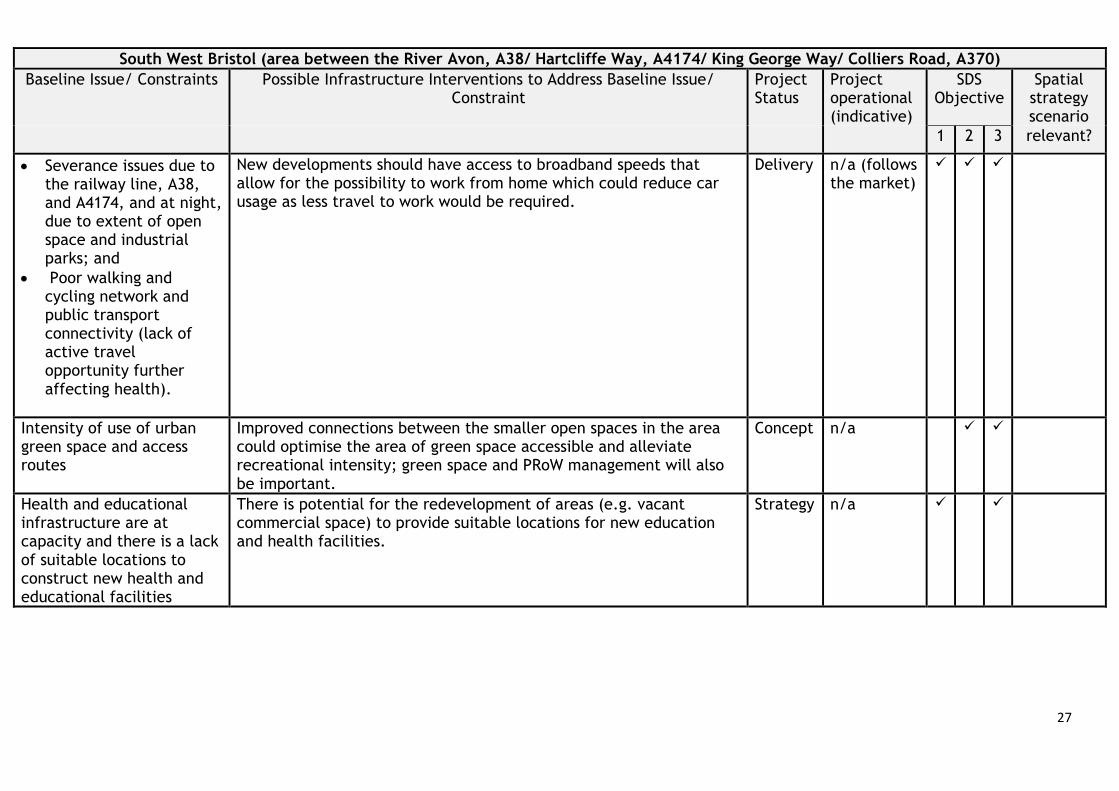
Table 8: South West Bristol
South West Bristol (area between the River Avon, A38/ Hartcliffe Way, A4174/ King George Way/ Colliers Road, A370) Baseline Issue/ Constraints Possible Infrastructure Interventions to Address Baseline Issue/
Constraint Project Status
Project operational (indicative)
SDS Objective
Spatial strategy scenario
1 2 3 relevant?
Peak time congestion on the A370, A38, A4174, and local roads result in adverse air quality impacts and makes bus transport unreliable and an unattractive alternative to driving, further affecting carbon emissions. Variously related to: • Poor public transport to
areas across Bristol city (apart from the city centre);
• Poor availability of public transport to rural settlements;
• Poor availability of east-west public transport services within South Bristol;
• Lack of transport interchanges connecting different public transport services;
Expansion to the Long Ashton park and ride site to create a [potentially multi-modal] transport interchange and intercept more traffic alleviating urban road space – creating more space for bus priority and walking/cycling.11,12
Active – Late Stage
2026
Increase first/last mile options, such as the expansion of the e-scooters range to better connect residential areas with the public transport network, and reduce short car journeys.11,14
Active – Late Stage
2023
A new rail station at Ashton Gate, with potential for further interchange links with the Long Ashton park and ride.13
Strategy 2030
A proposed Mass Transit route from Bristol city centre to Bristol Airport.11
Active – Early Stage
n/a
The South Bristol Link is constructed enabling a future metrobus service along the A4174/ Colliers Way towards the city centre, and potential link to the proposed Long Ashton expanded park and ride site and the M1 and M2 metrobus routes.11
Delivery/ Active – Late Stage
n/a
Increased bus services connecting south west Bristol to North and North West Bristol.
Concept n/a
Improvements to the walking and cycling network from Bristol city centre to range of destinations and the Long Ashton park and ride site.16
Strategy n/a
Increased crossing points along the A4174, A38 and the railway could better connect the green/ open spaces and potentially create a green corridor and road separated cycle and walking paths from Bishopsworth to Knowle.
Concept n/a
27
South West Bristol (area between the River Avon, A38/ Hartcliffe Way, A4174/ King George Way/ Colliers Road, A370) Baseline Issue/ Constraints Possible Infrastructure Interventions to Address Baseline Issue/
Constraint Project Status
Project operational (indicative)
SDS Objective
Spatial strategy scenario
1 2 3 relevant?
• Severance issues due to the railway line, A38, and A4174, and at night, due to extent of open space and industrial parks; and
• Poor walking and cycling network and public transport connectivity (lack of active travel opportunity further affecting health).
New developments should have access to broadband speeds that allow for the possibility to work from home which could reduce car usage as less travel to work would be required.
Delivery n/a (follows the market)
Intensity of use of urban green space and access routes
Improved connections between the smaller open spaces in the area could optimise the area of green space accessible and alleviate recreational intensity; green space and PRoW management will also be important.
Concept n/a
Health and educational infrastructure are at capacity and there is a lack of suitable locations to construct new health and educational facilities
There is potential for the redevelopment of areas (e.g. vacant commercial space) to provide suitable locations for new education and health facilities.
Strategy n/a

28
Table 9: A4 Corridor
A4 Corridor (from Hicks Gate to the A39/A4 junction) Baseline Issue/ Constraints Possible Infrastructure Interventions to Address Baseline Issue/
Constraint Project Status
Project operational (indicative)
SDS Objective
Spatial strategy scenario
1 2 3 relevant?
Congestion on the A4 and lack of bus priority measures along the entire road can make bus transport unreliable and an unattractive alternative to driving, with air quality, carbon and economic impacts. Variously related to: • Poor public transport to
South and East Bristol city;
• Poor availability of public transport to rural settlements;
• Lack of transport interchanges connecting different public transport services;
• Lack of capacity on peak hour trains; and
• Poor walking and cycling network and public transport connectivity
Mass Transit route along the A4 from Bristol to Bath.11,12 Active – Early Stage
2026
Proposed improvements to the A4 corridor by providing increased bus priority measures included segregated bus lanes to improve existing bus services from Bristol city centre to Bath.11,12,13 The bus enhancement measures could also provide improvements to the walking and cycling routes along the A4 which has potential to result in a modal shift away from car usage.
Active – Early Stage
2026-2036
Proposals to create a park and ride/ transport interchange near Hicks Gate to replace the Brislington Park and Ride.11,12 The Hicks Gate transport interchange could also provide last mile transport options and improve access from the interchange to surrounding settlements and the Keynsham rail station.
Active – Later Stage
2026-2036
The proposed Somerdale Bridge and proposed bridge that could be constructed as part of the Saltford Water Treatment Plant could provide additional River Avon crossing points to improve access to open space, and walking and cycling routes either side of the River Avon.
Active – Early Stage
n/a
Proposals to re-instate a rail station in Saltford, however, the reinstatement of Saltford rail station could impact the ability to and increase rail services at Keynsham station.13
Strategy n/a
Proposed walking and cycling routes from centre and south Keynsham to north Keynsham to provide road separated and increased cross-railway line routes.16
Strategy n/a

29
A4 Corridor (from Hicks Gate to the A39/A4 junction) Baseline Issue/ Constraints Possible Infrastructure Interventions to Address Baseline Issue/
Constraint Project Status
Project operational (indicative)
SDS Objective
Spatial strategy scenario
1 2 3 relevant?
(lack of active travel opportunity further affecting health).
Increase local bus services from the A4 corridor to the East Bristol and the A37 corridor in South East Bristol. These bus services could also make it easier to access the Keynsham rail station which could further reduce car usage for journeys.
Concept n/a
New developments should have access to broadband speeds that allow for the possibility to work from home, which could reduce car usage as less travel to work would be required.
Delivery n/a (follows the market)
Sewerage infrastructure in the Keynsham/ Saltford area insufficient to accommodate growth.
Planned expansion to Wessex Water Saltford Sewerage Treatment Plant, and upgrades to the Keynsham sewerage works may be required to accommodate further growth in the area.
Active – Early Stage
n/a
The land North of the A4 corridor close to the River Avon is located in Flood Zone 2 and 3, affecting resilience.
Due to updated climate change predictions, the flood defences along the A4 corridor may require upgrading especially were additional development to be indicated.22 Further flood risk assessments are required to determine the sufficiency of the defences and the extend of the necessary upgrades, if needed.
Active – Later Stage
n/a
Poor access to larger green spaces southwest of Keynsham and recreational pressure of the waterside green spaces resulting in environmental impacts
The Waterspace programme on the River Avon (see Figure 5) aims to improve the water quality of the River Avon and the riverine environment to provide additional green spaces along the River Avon. The Chew Valley Rediscovered programme is also located to the south of this area. This programme aims to increase walking routes and access to Chew Valley Lake, and to enhance biodiversity along the Chew River.
Active – early stage
n/a
22 Bath and North East Somerset Strategic Flood Risk Assessment (2018) https://www.bathnes.gov.uk/sites/default/files/sitedocuments/Planning-and-Building-Control/Planning-Policy/Evidence-Base/Flood-Risk/banes_level_1_sfra_final_report_nov_2018.pdf

30
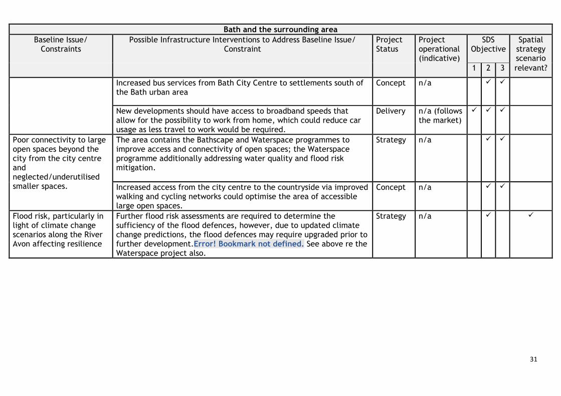
Table 10: Bath and the surrounding area
Bath and the surrounding area Baseline Issue/
Constraints Possible Infrastructure Interventions to Address Baseline Issue/
Constraint Project Status
Project operational (indicative)
SDS Objective
Spatial strategy scenario
1 2 3 relevant?
Peak time congestion on the A4, A36, and local roads adversely impacting air quality, sustainable transport reliability, carbon emissions and access to Bath and the surrounding area. Lack of wider rural-urban public transport connectivity affecting rural access to urban opportunities.
The Bath Clean Air Zone (CAZ) is operational and aims to dissuade commercial vehicles with older and more polluting engines from entering the city centre in order to improve air quality and reduce congestion in the cite centre.23
Delivered 2021
Increase first/last mile options, such as expanding the range of e-scooters, to better connect residential areas with the public transport network, and reduce car usage for short journeys.11,14
Active – Late Stage
2023
Proposals to increase bus priority measures on the A36 Lower Bristol Road, Wellsway Road, A367, and the A4 to improve central Bath bus access, with the aim to reduce congestion in Bath and promote a modal shift away from car usage.11
Active – Later Stage
n/a
Improvements to bus, walking and cycling access to the park and ride/ transport interchanges at Lansdown, Odd Down and Newbridge.11
Active – Early Stage
2026-2036
Improvements to cycling and walking routes between key destinations (notably Bath University Campus) and residential areas via the city centre, and improvements to cycle paths on the A36.16
Strategy n/a
Upgrades to the bus fleet within Bath are proposed, and aim to make the buses carbon neutral and reduce adverse air quality impacts.11,12
Strategy n/a
A transport interchange in East Bath to provide increased bus transport along the A4 to the Bath City Centre and reduce congestion on the A4/ London Road.
Concept n/a
23 Bath Clean Air Zone - https://beta.bathnes.gov.uk/bath-clean-air-zone
31
Bath and the surrounding area Baseline Issue/
Constraints Possible Infrastructure Interventions to Address Baseline Issue/
Constraint Project Status
Project operational (indicative)
SDS Objective
Spatial strategy scenario
1 2 3 relevant?
Increased bus services from Bath City Centre to settlements south of the Bath urban area
Concept n/a
New developments should have access to broadband speeds that allow for the possibility to work from home, which could reduce car usage as less travel to work would be required.
Delivery n/a (follows the market)
Poor connectivity to large open spaces beyond the city from the city centre and neglected/underutilised smaller spaces.
The area contains the Bathscape and Waterspace programmes to improve access and connectivity of open spaces; the Waterspace programme additionally addressing water quality and flood risk mitigation.
Strategy n/a
Increased access from the city centre to the countryside via improved walking and cycling networks could optimise the area of accessible large open spaces.
Concept n/a
Flood risk, particularly in light of climate change scenarios along the River Avon affecting resilience
Further flood risk assessments are required to determine the sufficiency of the flood defences, however, due to updated climate change predictions, the flood defences may require upgraded prior to further development.Error! Bookmark not defined. See above re the Waterspace project also.
Strategy n/a

32
Table 11: Somer Valley
Somer Valley including the A37 and A367 Corridors and Midsomer Norton and Radstock Baseline Issue/ Constraints Possible Infrastructure Interventions to Address Baseline Issue/
Constraint Project Status
Project operational(indicative)
SDS Objective
Spatial strategy scenario
1 2 3 relevant? There is a lack of sustainable, rapid and reliable transport from Midsomer Norton and Radstock to Bristol and Bath affecting access to economic and social opportunities within Bristol and Bath and increasing reliance on travel by private car with air quality and carbon impacts.
Bus priority measures such as segregated bus lanes could increase bus speed and reliability from Bristol and Bath to Midsomer North/ Radstock, and provide an opportunity to implement a rapid bus services to service this corridor.11,12 Furthermore, there are opportunities to improve the to the cycling and walking network along this corridor to be incorporated into the bus priority works. These bus services and improved walking and cycling could connect with the proposed park and ride/ transport interchange proposed in proximity to the A37 in South Bristol.
Active – Early Stage
2025
New developments should have access to broadband speeds that allow for the possibility to work from home, which could reduce car usage as less travel to work would be required.
Delivery n/a (follows the market)
Lack of walking and cycling connectivity between Radstock and Midsomer Norton increasing reliance on travel by private car with air quality, health and carbon impacts.
Improving walking and cycling routes from the centre of Radstock to the centre of Midsomer Norton to reduce car usage for these journeys.16
Strategy n/a
33
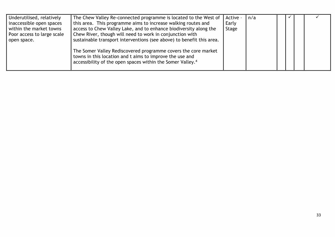
Underutilised, relatively inaccessible open spaces within the market towns Poor access to large scale open space.
The Chew Valley Re-connected programme is located to the West of this area. This programme aims to increase walking routes and access to Chew Valley Lake, and to enhance biodiversity along the Chew River, though will need to work in conjunction with sustainable transport interventions (see above) to benefit this area. The Somer Valley Rediscovered programme covers the core market towns in this location and t aims to improve the use and accessibility of the open spaces within the Somer Valley.4
Active – Early Stage
n/a

34
Figure 4: Intervention Categorisation (descriptions are not final and may be refined as IIDP work and engagement continues
Project Category (pathway stage)
Description Approximate WebTAG equivalent
Use in spatial strategy scenarios
Use in TAF
Delivery Project is either under construction or at consent/approval stage. To be treated as relatively low risk.
Certain/ More than likely
Included in core baseline assumptions
Part of the benchmark plus if there is a funding commitment in place
Active Later Stage
The intervention/project is being actively worked on and is being worked up in detail in relation to feasibility and funding strategy. Risk will vary and will need to be carefully evaluated in terms of impact on deliverability and phasing of development.
More than likely/ Reasonably foreseeable
May be included in alternative scenarios
If included in alternative scenarios will be factored into analysis for that scenario
Active Early Stage
Being actively worked on but is at an early stage in relation to feasibility and business case. Significant risk associated with intervention and will need to be considered carefully in relation to deliverability and phasing of development.
More than likely/ Reasonably foreseeable
May be included in alternative scenarios
If included in alternative scenarios will be factored into analysis for that scenario
Strategy Identified within a strategy but not being actively worked on. In some cases there is significant uncertainty over delivery and specification. High risk associated with delivery and phasing of development.
Reasonably foreseeable/ Hypothetical
May be included in alternative scenarios
If included in alternative scenarios will be factored into analysis for that scenario
Concept Not within a strategy or actively worked on but a plausible opportunity that logically builds on accepted intervention mechanisms. High level of uncertainty re delivery and specification and therefore greatest risk in relation to deliverability and phasing of development.
Hypothetical May be included in alternative scenarios
If included in alternative scenarios will be factored into analysis for that scenario

35
Figure 5: Indicative Regional Green Infrastructure Programme Areas. Note: areas not covered by a regional programme may have other GI interventions of more local significance being scoping and delivered.
River Frome Reconnected The River Frome Reconnected Partnership aims to deliver improvements and multiple benefits for the water environment.
Common Connections 4-year landscape scale habitat restoration project linking registered commons, unimproved grasslands, woodlands and habitats along the urban fringe.
Somer Valley Rediscovered The project aims to improve biodiversity and, increase people’s connections to nature, improve health and wellbeing.
Chew Valley Catchment Landscape programme to deliver on the benefits and options of achieving links between the two AONBs for wildlife and people.
North Somerset Levels and Moors The project supports improvements to water and soil quality; and focusses on coastal and floodplain grazing marsh adjacent to the Severn Estuary between the Mendip Hills and Bristol.
Waterspace A programme of work to the green spaces and rights of way along the River Avon including Bristol Harbour corridor, Avon Gorge, Keynsham, Saltford and Bath.
String Of Pearls Creation and expansion of a series of wetlands along the Severn Estuary to act as high tide roosts or ‘stepping stones’ for wildfowl/wading birds.

Appendix 1
Accessible natural green space (ANGSt) mapping – Technical note
July 2021
The provision of accessible green space within the Green Infrastructure (GI) networks is significant to creating places where people want to live and work, enabling access to the range of ecosystem services associated with accessible green and natural spaces. Natural England expects that, “People will have places to access and enjoy a high quality natural environment”(link). This is often more achievable in urban communities than in rural communities, where there is often poor access to quality green space. Combining the benefits of accessible open space, with natural space is becoming increasingly important in the design of multifunctional Green Infrastructure that enable benefits to people and the environment.
The definitions for ‘accessible natural green space’ tends to encapsulate terms including ‘open space, green space, natural green space and accessible green space’.
• The National Planning Policy Framework (NPPF) paragraph 99 requires local authorities to designate land as ‘Local Green Space’ through local and neighbourhood plans, consistent with enabling sustainable development.
• National Planning Practice Guidance (NPPG) further outlines that ‘open space’, includes all open space of public value, and can take many forms, from formal sports pitches to open areas within a development, linear corridors and country parks. It is for local planning authorities to assess the need for open space and opportunities for new provision in their areas.
• To supplement NPPF/NPPG definitions above, Natural England outline: • Accessible green space – places that are available for the public to
use free of charge and without time restrictions (although some sites may be closed to the public overnight and there may be fees for parking a vehicle).
• Natural green space – Places where human control and activities are not intensive and still enable nature as predominate feature to the site.
ANGSt guidance has been designed to support planners in understanding the quality, quantity and type of spaces and services required for communities. ANGSt was based on research into minimum distances people would travel to access the natural environment. ANGSt has three underlying principles:
• Improving access to green spaces • Improving naturalness of green spaces • Improving connectivity with green spaces
ANGSt outlines that people should have an accessible natural green space of: • at least 2 hectares in size, no more than 300 metres (5 minutes’ walk) from
home,

• at least one accessible 20-hectare site within 2 kilometres of home, • one accessible 100-hectare site within 5 kilometres of home, • one accessible 500-hectare site within 10 kilometres of home, • a minimum of one hectare of statutory Local Nature Reserves per thousand
population.
Natural England are now piloting an additional ANGSt to include a 200 metres distance requirement for ‘pocket parks’, spatially defined as accessible community spaces of up to 0.4 hectares (although many are around 0.02 hectares, the size of a tennis court).
In the West of England provision for open space will need to consider:
The existing provision and access to open space within the Combined Authority is varied dependent on location. In general, dense residential areas in Bristol, including the city centre, north fringe region, East, South Bristol, and the centre of Bath have poor access to large areas of open space. However, these areas have access to smaller opens spaces and parks, and are geographically close to larger open areas. Increasing and enhancing this access is required to ensure the entirety of the Combined Authority has access to large scale open spaces.
This will mainly be of relevance for masterplanning of large development which will need to respond to access deficits in defining the type and location of new provision, and new connections to new provision. It will also be of relevance to provision and consideration of detailed access improvements as part of wider transport planning. There may also be a relationship with addressing recreational intensity impacts on protected habitats that are identified as part of the Habitats Regulations Assessment process, and wider Green Infrastructure programme work. These issues and opportunities will be further explored through spatial strategy and strategic policy development processes in the next stage of plan preparation, with the SDS setting the key strategic parameters for more detailed Local Plan work.
The following mapping sets out the existing accessible natural green spaces in the WOE along with the Public Rights of Way (PRoW) networks and ANGSt buffers. Mapping is also provided for the current GI Programme areas that may play a role in coordinating development contributions towards new SANGs that act as mitigation for HRA impacts.
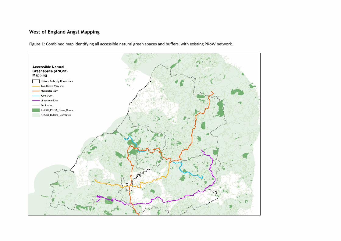
West of England Angst Mapping Figure 1: Combined map identifying all accessible natural green spaces and buffers, with existing PRoW network.

Figure 2: Accessible natural green spaces (500ha) and 10km buffers

Figure 3: Accessible natural green spaces (100ha) and 5km buffers.

Figure 4: Accessible natural green spaces (20ha) and 2km buffers.
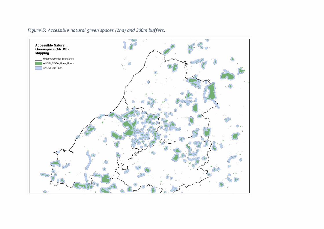
Figure 5: Accessible natural green spaces (2ha) and 300m buffers.

Figure 6: Accessible natural green spaces (0.4ha) and 200mtre buffers (new ANGSt standard)
Appendix 2 Benchmark Teletrac Data analysis
Transport Assessment Framework 08th October 2021
1
Introduction This note provides an overview of highway performance within the West of England Combined Authority region by analysing observed delay data on the highway network.
The data covers five time periods including the AM peak, inter-peak, and PM peak hours as shown below:
• 07:00 – 08:00 • 08:00 – 09:00 • 10:00 – 16:00 • 16:00 – 17:00 • 17:00 – 18:00
Analysing the delay data for these time periods enables identification of areas that experience changes in traffic conditions and vehicle speeds throughout a typical day. Allowing for the identification of areas of congestion on the highway network
Methodology The journey time data has been obtained from Teletrac and has been processed by the modelling team developing the West of England Regional Transport Model (WERTM).
The Teletrac data represents vehicles with GPS tracking fitted. The data analysed covers an average of Monday-Thursday in March, September and October in 2019 to represent typical pre-pandemic conditions. This year has been chosen as the Base year for the regional transport model and deemed the most recent representative year for analysis.
It should be noted that the Teletrac dataset provides the average delay experienced on the highway, and conditions in real life will fluctuate on a day to day basis and will also have seasonal variation. The M4 and M5 are particularly notable for increased seasonal traffic as holidaymakers travel to and from destinations in the south west by car. This analysis does not take account for summer holiday traffic.
To calculate delay on a particular link on the network, the journey time in free flow conditions has been subtracted from the journey time in each of the time periods covered within this analysis. This gives a journey time difference figure in seconds, which is the delay on that section of the highway network.
The delay data is presented visually in five interactive web maps for the region1, one being for each time period. These interactive maps classify the level of delay into three categories ranging from ‘Free-flow’ conditions (Green) to ‘Congested’ (Red), as 1 The five interactive maps are not publicly available but can be accessed via requesting permission to the Combined Authority’s Transport Team with a valid reason for required access.

Appendix 2 Benchmark Teletrac Data analysis
Transport Assessment Framework 08th October 2021
2
presented in the Tables below. The thresholds used in the methodology are as follows:
• Green = < 15s delay per km • Amber = 15 – 75s delay per km • Red = > 75s delay per km
Appendix 2 Benchmark Teletrac Data analysis
Transport Assessment Framework 08th October 2021
3
Spatial analysis The analysis of the highway performance has been split into spatial areas where to best align with the spatial analysis contained within the Infrastructure Investment Delivery Plan (IIDP). The Tables below present the analysis of the core highway routes throughout each spatial area and the level of delay compared to free-flowing conditions is shown with a red/amber/green rating for each time period, as per the above methodology.
North West Bristol (including Avonmouth and Severnside) The North West Bristol spatial area, which also includes Avonmouth and Severnside, performs relatively well based on the Teletrac highway delay data analysed, as shown in Table 1.
The highway links analysed in this spatial area include the following:
• M5 (between junction 16 and 18) • M49 (between M5 junction 18A and M4 junction 22) • A403 Avonmouth • A403 Severn Beach • Blackhorse Hill (approach to M5 junction 17)
The data shows little delay on the M5 (between junctions 16 and 18) in all time periods. However, there are delays on the approach arms at junction 16 (junction with A38 at Aztec West) during all time periods.
At junction 17 (Cribbs Causeway), the Blackhorse Hill B4055 approach arm experiences delay in the AM time periods of 07:00-08:00 and 08:00-09:00. Whereas the A4018 and Merlin Road approach arms experience delays in the PM (16:00-17:00 and 17:00-18:00).
The M49 experiences some delay (between 15 and 75 seconds per km) during the AM peaks but with little slow down during the remainder of a typical day.
The A403 in Avonmouth experiences delay throughout the majority of the day, particularly between the A4 and Poplar Way West during 0700-08:00 and 17:00-18:00.
The A403 in Severn Beach shows no delay in any time period.
Table 1 North West Bristol highway delay data summary
07:00 – 08:00
08:00 – 09:00
10:00 – 16:00
16:00 – 17:00
17:00 – 18:00

Appendix 2 Benchmark Teletrac Data analysis
Transport Assessment Framework 08th October 2021
4
M5 (between junction 16 and 18)
M49 (between M5 junction 18A and M4 junction 22)
A403 Avonmouth
A403 Severn Beach
Blackhorse Hill (approach to M5 junction 17)
North Bristol – A38 corridor and the North Fringe The A38 corridor in North Bristol and the North Fringe see substantial delay throughout a typical day.
The highway links analysed in this spatial area include the following:
• A38 (Filton to Almondsbury) • Merlin Road / Hayes Way • B4057 (A38 to M4 junction 19) • M4 (between junction 16 and 19 – M32 junction) • Bradley Stoke Way • A4174 (Filton to Lyde Green • M32 (junction 1) • M4/M5 junction - Almondsbury Interchange.
The summary table of the Teletrac highway delay data for this area is shown in Table 2.
The A38 between Filton and Almondsbury experiences delay between 75 and 750 seconds per km in the AM and PM peaks but is free flowing in the interpeak.
Merlin Road / Hayes Way in running between Cribbs Causeway and the A38 experiences delay of 15-75 seconds per km between 16:00-17:00 only. All other time periods are free flowing.
The B4057 between the A38 and M4 junction 19 experiences delay of 15-75 seconds per km in 07:00-08:00, 08:00-09:00 and 10:00-16:00, with the delay worsening to 75-750 seconds per km in the PM peaks.

Appendix 2 Benchmark Teletrac Data analysis
Transport Assessment Framework 08th October 2021
5
The M4 between junction 16 and 19 sees delay of 15-75 seconds per km between 07:00-08:00, 08:00-09:00 and 16:00-17:00 in an eastbound direction but between 17:00-18:00 the delay is seen in both directions.
Bradley Stoke Way provides a route between the A38 and the B4057 (Winterbourne Road) through the Bradley Stoke residential area. Between 07:00-08:00, 16:00-1700 and 17:00-18:00 the link is mostly free flowing but delay is observed on the approach to the junction with the A38. Delay on this approach to the A38 worsens between 08:00-0 9:00.
Substantial delay is observed on the A4174 between the A38 (Filton) and Lyde Green on a typical day. In both AM and PM peaks the delay observed is between 75 and 750 seconds per km. The flow in the link improves in the interpeak as delay reduces to between 15 and 75 seconds per km.
The M32 junction with the A4174 ring road (junction 1) has observed delay of 75-750 seconds per km on the A4174 and M32 approach arms in the AM peaks.
The M4 / M5 junction also known as the Almondsbury Interchange has also been reviewed by each arm approach. The western arm of the M4 approach to the junction is observed to experience moderate delay in both AM peak hours but remains free-flowing for the rest of the day.
The eastern M4 arm approach to the Almondsbury Interchange is free flowing between 07:00 to 16:00. During the PM peaks of 16:00-17:00 and 17:00-18:00, moderate delay is observed.
On the M5, the northern approach arm is observed to be free-flowing in all time periods, but some delay is observed on the southbound off-slips to the A38.
The southern M5 approach arm is free-flowing during the AM peak and the interpeak but between 17:00-18:00, moderate delay of between 15-75 seconds is observed.
Table 2 North Bristol highway delay data summary
07:00 – 08:00
08:00 – 09:00
10:00 – 16:00
16:00 – 17:00
17:00 – 18:00
A38 (Filton to Almondsbury)
Merlin Road / Hayes Way
B4057 (A38 to M4 junction 19)
M4 (between junction 16 and 19 – M32 junction)

Appendix 2 Benchmark Teletrac Data analysis
Transport Assessment Framework 08th October 2021
6
Bradley Stoke Way
A4174 (Filton to Lyde Green
M32 (junction 1)
Almondsbury Interchange (M4 western approach)
Almondsbury Interchange (M4 eastern approach)
Almondsbury Interchange (M5 northern approach)
Almondsbury Interchange (M5 southern approach)
A38 North Corridor – Almondsbury, Thornbury and West of the M5 The A38 North includes Almondsbury, Thornbury and the area West of the M5. The highway links analysed in this spatial area include the following:
• A38 (Almondsbury to Alveston) • A38 (Alveston to Falfield) • Grovesend Road (adjacent to A38) • B4059 (between A38 and M5 junction 14) • M5 between junction 15 and 14)
The summary table of the Teletrac highway delay data for this area is shown in Table 3.
The A38 between Almondsbury and Alveston typically experiences delay in the AM and PM peaks with little to no delay during the interpeak. Delay was observed between 15 and 75 seconds per km between 07:00-08:00, 16:00-17:00 and 17:00-18:00. Delay worsens to greater than 75 seconds per km between 08:00-09:00.
Delay is also observed on the A38 between Alveston and Falfield, although only between 08:00-09:00.
Grovesend Road runs between Thornbury and the A38. Delays of 75 seconds to 750 seconds per km are observed between 07:00-08:00, 08:00-09:00 and 17:00-18:00 in line with typical commuting patterns.

Appendix 2 Benchmark Teletrac Data analysis
Transport Assessment Framework 08th October 2021
7
The B4059 links the A38 and M5 junction 14. More than 75 seconds of delay per km is observed in the AM and PM peaks. The inter-peak between 10:00-16:00 sees less delay but vehicles are not free-flowing.
Between junction 14 and 15 on the M5, no delay was observed in the dataset with traffic identified as free-flowing.
Table 3 A38 North Corridor highway delay data summary
07:00 – 08:00
08:00 – 09:00
10:00 – 16:00
16:00 – 17:00
17:00 – 18:00
A38 (Almondsbury to Alveston)
A38 (Alveston to Falfield)
Grovesend Road (adjacent to A38)
B4059 (between A38 and M5 junction 14)
M5 between junction 15 and 14)
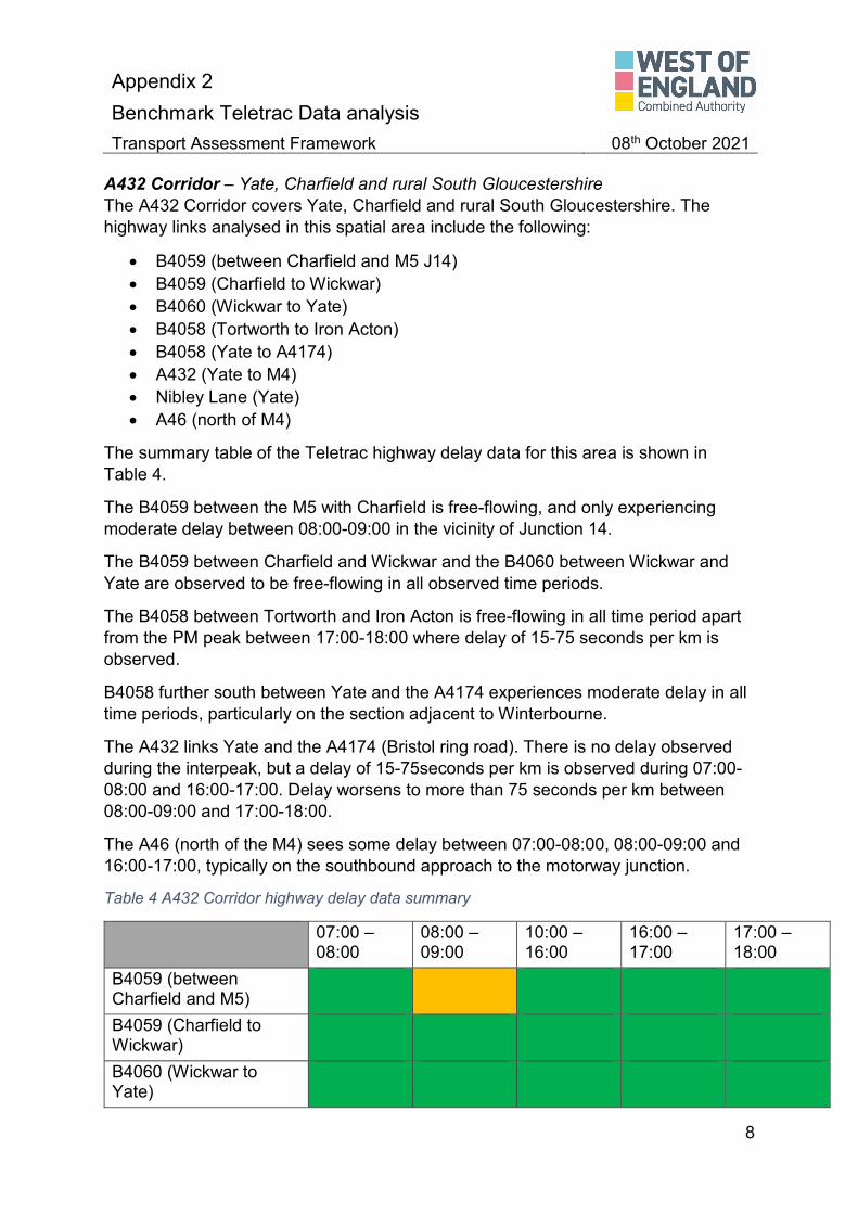
Appendix 2 Benchmark Teletrac Data analysis
Transport Assessment Framework 08th October 2021
8
A432 Corridor – Yate, Charfield and rural South Gloucestershire The A432 Corridor covers Yate, Charfield and rural South Gloucestershire. The highway links analysed in this spatial area include the following:
• B4059 (between Charfield and M5 J14) • B4059 (Charfield to Wickwar) • B4060 (Wickwar to Yate) • B4058 (Tortworth to Iron Acton) • B4058 (Yate to A4174) • A432 (Yate to M4) • Nibley Lane (Yate) • A46 (north of M4)
The summary table of the Teletrac highway delay data for this area is shown in Table 4.
The B4059 between the M5 with Charfield is free-flowing, and only experiencing moderate delay between 08:00-09:00 in the vicinity of Junction 14.
The B4059 between Charfield and Wickwar and the B4060 between Wickwar and Yate are observed to be free-flowing in all observed time periods.
The B4058 between Tortworth and Iron Acton is free-flowing in all time period apart from the PM peak between 17:00-18:00 where delay of 15-75 seconds per km is observed.
B4058 further south between Yate and the A4174 experiences moderate delay in all time periods, particularly on the section adjacent to Winterbourne.
The A432 links Yate and the A4174 (Bristol ring road). There is no delay observed during the interpeak, but a delay of 15-75seconds per km is observed during 07:00-08:00 and 16:00-17:00. Delay worsens to more than 75 seconds per km between 08:00-09:00 and 17:00-18:00.
The A46 (north of the M4) sees some delay between 07:00-08:00, 08:00-09:00 and 16:00-17:00, typically on the southbound approach to the motorway junction.
Table 4 A432 Corridor highway delay data summary
07:00 – 08:00
08:00 – 09:00
10:00 – 16:00
16:00 – 17:00
17:00 – 18:00
B4059 (between Charfield and M5)
B4059 (Charfield to Wickwar)
B4060 (Wickwar to Yate)

Appendix 2 Benchmark Teletrac Data analysis
Transport Assessment Framework 08th October 2021
9
B4058 (Tortworth to Iron Acton)
B4058 (Yate to A4174)
A432 (Yate to A4174)
Nibley Lane (Yate)
A46 (north of M4)
East Bristol The East Bristol spatial area analysis covers the following highway links:
• A4174 (Lyde Green to A420) • A420 (St George to Warmley) • A420 Warmley to Wick) • B4465 (A4174 to Pucklechurch) • A432 (Eastville to Fishponds) • A432 (Fishponds to A4174) • A431 (St George to A4174) • M32
The summary table of the Teletrac highway delay data for this area is shown in Table 5.
The majority of links analysed in the East Bristol spatial area show substantial delay. This is due to the relatively urban nature of the roads and high levels of commuter traffic on these routes.
The A432 between Eastville and Fishponds experiences delay between 75 and 750 seconds per km at all observed time periods throughout the day.
Substantial delay of between 75 and 750 seconds per km is observed in the PM peak of 17:00-18:00 on the A4174, the A420, A432, A431, and M32.
The B4465 between the A4174 ring road and Pucklechurch is however relatively free flowing with some delay only observed in the 16:00-17:00 time period.
Table 5 East Bristol highway delay data summary
07:00 – 08:00
08:00 – 09:00
10:00 – 16:00
16:00 – 17:00
17:00 – 18:00
A4174 (Lyde Green to A420)

Appendix 2 Benchmark Teletrac Data analysis
Transport Assessment Framework 08th October 2021
10
A420 (St George to Warmley)
A420 Warmley to Wick)
B4465 (A4174 to Pucklechurch)
A432 (Eastville to Fishponds)
A432 (Fishponds to A4174)
A431 (St George to A4174)
M32
Bristol City Centre – Redcliffe, St Phillips Marsh, Old Market, Broadmead, and Cabot Circus Bristol Centre Centre spatial area covers Redcliffe, St Phillips Marsh, Old Market, Broadmead, and Cabot Circus. The highway links analysed in this spatial area include the following:
• A4 Hotwell Road to A4176 Bridge Valley Road • A4 Hotwells to St James Barton roundabout (Bearpit) • A38 North Street • Cumberland Road • A370 Coronation Road • A370 Clarence Road • A370 York Road • A4 Bath Road • Temple Way • A4320 St Philips Causeway • A4032 Newfoundland Way / Bond Street
The summary table of the Teletrac highway delay data for this area is shown in Table 6.
Bristol city centre is urban in nature and a central hub for employment in the area. The delay is therefore substantial and focussed around AM and PM commuter trips.
All roads observed in Bristol city centre have substantial delay (75-750 seconds delay per km) on a typical weekday during 08:00-09:00. The A370, A4, Temple Way and A4320 see further delay between 07:00-08:00 and 17:00-18:00 also.

Appendix 2 Benchmark Teletrac Data analysis
Transport Assessment Framework 08th October 2021
11
Table 6 Bristol city centre highway delay data summary
07:00 – 08:00
08:00 – 09:00
10:00 – 16:00
16:00 – 17:00
17:00 – 18:00
A4 Hotwell Road to A4176 Bridge Valley Road
A4 Hotwells to St James Barton roundabout (Bearpit)
A38 North Street
Cumberland Road
A370 Coronation Road
A370 Clarence Road
A370 York Road
A4 Bath Road
Temple Way
A4320 St Philips Causeway
A4032 Newfoundland Way / Bond Street

Appendix 2 Benchmark Teletrac Data analysis
Transport Assessment Framework 08th October 2021
12
South East Bristol – Area between the A37 Wells Road, A38 and A4174 Hartcliffe Way corridors extended to Hartcliffe and Whitchurch The South East Bristol area covers between the A37 Wells Road, A38 and A4174 Hartcliffe Way corridors extended to Hartcliffe and Whitchurch. The highway links analysed in this spatial area include the following:
• A37 Wells Road (Totterdown) • A37 Wells Road (Knowle) • B3122 Bedminster Road • B3122 St Johns Lane • A4174 Hengrove Way / Airport Road
The summary table of the Teletrac highway delay data for this area is shown in Table 7.
South East Bristol is relatively constrained due to the proximity to the River Avon and strategic highway routes are limited as a result.
The A37 is substantially delayed through Totterdown and Knowle in both the AM and PM peak hours with delay between 75 and 750 seconds delay per km.
The B3122 Bedminster Road is delayed between 07:00 and 09:00 and 16:00-17:00 to the effect of 75-750 seconds per km also.
The A4174 ring road (Hengrove Way /Airport Road) sees moderate delay of 15-75 seconds per km between 07:00-08:00 but this worsens to 75-750 seconds per km in all other observed time periods.
Table 7 South East Bristol highway delay data summary
07:00 – 08:00
08:00 – 09:00
10:00 – 16:00
16:00 – 17:00
17:00 – 18:00
A37 Wells Road (Totterdown)
A37 Wells Road (Knowle)
B3122 Bedminster Road
B3122 St Johns Lane
A4174 Hengrove Way / Airport Road

Appendix 2 Benchmark Teletrac Data analysis
Transport Assessment Framework 08th October 2021
13
South West Bristol – Area between the River Avon, A38, Hartcliffe Way, A4174, King George Way, Colliers Road, A370 South West Bristol includes the area between the River Avon, A38, Hartcliffe Way, A4174, King George Way, Colliers Road, and A370. The highway links analysed in this spatial area include the following:
• A4174 Colliters Way / King George’s Road • A4174 Hartcliffe Way • A38 (Bedminster) • A38 (Bedminster Down) • A370
The summary table of the Teletrac highway delay data for this area is shown in Table 8.
The South West Bristol spatial area is similar to the South east spatial area in that the strategic routes are limited as a result of proximity to Bristol city centre and limited access over the River Avon.
The A4174 ring road covering the sections of Colliters Way and King George’s Road (adjacent to the A38) sees moderate delay of 15-75 seconds per km in the AM peaks and the interpeak. The PM peaks of 16:00-17:00 and 17:00-18:00 worsens to 75-750 seconds per km, particular on approach to the A38 junction.
The A4174 Hartcliffe Way links the A4174 Hengrove Way and the A38 Bedminster Road to the north. The delay is predominantly observed at the northern section of the link on approach to the A38 Bedminster Road. Moderate delay of 15-75 seconds is observed between the times of 07:00-08:00, 10:00-16:00 and 17:00-18:00. More severe delay is observed between 08:00-09:00 and 16:00-17:00.
The sections of the A38 through Bedminster and Bedminster Down are both congested and delay is observed in the AM peak times. However during the interpeak in Bedminster the delay is les severe and through Bedminster Down the A38 is free-flowing between 10:00-16:00 and 16:00-17:00.
The A370 between Ashton Gate and the junction with Colliters Way experiences substantial delay in the AM peak hours, particularly in the northbound direction. The inter peak and 16:00-17:00 is free-flowing and the 17:00-18:00 sees moderate delay.
Table 8 South West Bristol highway delay data summary
07:00 – 08:00
08:00 – 09:00
10:00 – 16:00
16:00 – 17:00
17:00 – 18:00
A4174 Colliters Way / King George’s Road

Appendix 2 Benchmark Teletrac Data analysis
Transport Assessment Framework 08th October 2021
14
A4174 Hartcliffe Way
A38 (Bedminster)
A38 (Bedminster Down)
A370
A4 Corridor – from Hicks Gate to the A39/A4 junction This spatial area covers the A4 Corridor area between Hicks Gate and the A39/A4 junction. The highway links analysed in this spatial area include the following:
• Hicks Gate Roundabout • Keynsham bypass • A4 Saltford • A4 / A39 junction • A431 • B316
The summary table of the Teletrac highway delay data for this area is shown in Table 9.
Hicks Gate Roundabout, Keynsham bypass, the A4 in Saltford and the A4/A39 all experience delay of 75-750 seconds per km between 08:00-09:00. Delay reduces to moderate levels on Hicks Gate Roundabout for the rest of the day. Conditions improve on Keynsham Bypass as it is observed to be free-flowing for the rest of the day.
The A4 in Saltford does however experience substantial delay of a similar magnitude to the morning peak between 16:00-17:00.
Table 9 A4 Corridor highway delay data summary
07:00 – 08:00
08:00 – 09:00
10:00 – 16:00
16:00 – 17:00
17:00 – 18:00
Hicks Gate Roundabout
Keynsham bypass
A4 Saltford

Appendix 2 Benchmark Teletrac Data analysis
Transport Assessment Framework 08th October 2021
15
A4 / A39 junction
A431
B316
Bath and the Surrounding area This spatial area covers Bath and the surrounding area. The highway links analysed in this spatial area include the following:
• A4 west, central and east • A431 Kelston Road • Lansdown Road • A46 • A36 west, central and east • A36 Limpley Stoke • A363 Sally in the Wood • A367 Odd Down • B3108 Bradford on Avon
The summary table of the Teletrac highway delay data for this area is shown in Table 10.
The A4 in Bath was split into three sections (West, Central, and East) for analysis purposes. The western section between Newbridge and Lower Weston is free flowing in between 07:00-08:00 and in the 10:00-16:00 interpeak. Between 08:00-09:00 and 16:00-17:00 delay of 15-75 seconds is observed. This worsens in the PM peak of 17:00-18:00.
The central area between Lower Weston and Walcot sees the worst delay in in the AM peak of 08:00-09:00 and the PM peak hours of 16:00-17:00 and 17:00-18:00.
The eastern section of the A4 between Walcot and the A46 is relatively free-flowing with substantial delay only observed in the AM peak between 08:00-09:00.
The A431 Kelston Road is free flowing in between 10:00 and 17:00. Moderate delay is observed between 07:00-08:00 and 17:00-18:00. And more severe delay is seen between 08:00-09:00.
Lansdown Road is free flowing during the inter peak but moderate levels of delay are observed between 07:00-09:00 and also in the PM peak between 16:00-18:00.
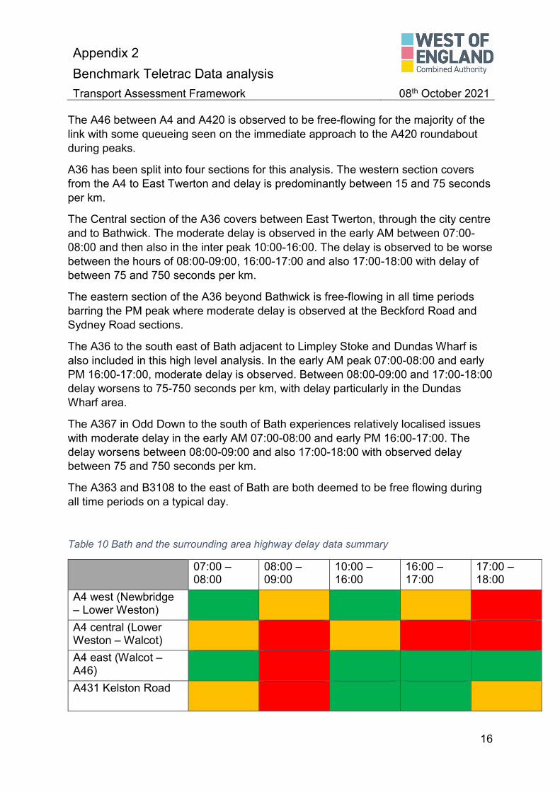
Appendix 2 Benchmark Teletrac Data analysis
Transport Assessment Framework 08th October 2021
16
The A46 between A4 and A420 is observed to be free-flowing for the majority of the link with some queueing seen on the immediate approach to the A420 roundabout during peaks.
A36 has been split into four sections for this analysis. The western section covers from the A4 to East Twerton and delay is predominantly between 15 and 75 seconds per km.
The Central section of the A36 covers between East Twerton, through the city centre and to Bathwick. The moderate delay is observed in the early AM between 07:00-08:00 and then also in the inter peak 10:00-16:00. The delay is observed to be worse between the hours of 08:00-09:00, 16:00-17:00 and also 17:00-18:00 with delay of between 75 and 750 seconds per km.
The eastern section of the A36 beyond Bathwick is free-flowing in all time periods barring the PM peak where moderate delay is observed at the Beckford Road and Sydney Road sections.
The A36 to the south east of Bath adjacent to Limpley Stoke and Dundas Wharf is also included in this high level analysis. In the early AM peak 07:00-08:00 and early PM 16:00-17:00, moderate delay is observed. Between 08:00-09:00 and 17:00-18:00 delay worsens to 75-750 seconds per km, with delay particularly in the Dundas Wharf area.
The A367 in Odd Down to the south of Bath experiences relatively localised issues with moderate delay in the early AM 07:00-08:00 and early PM 16:00-17:00. The delay worsens between 08:00-09:00 and also 17:00-18:00 with observed delay between 75 and 750 seconds per km.
The A363 and B3108 to the east of Bath are both deemed to be free flowing during all time periods on a typical day.
Table 10 Bath and the surrounding area highway delay data summary
07:00 – 08:00
08:00 – 09:00
10:00 – 16:00
16:00 – 17:00
17:00 – 18:00
A4 west (Newbridge – Lower Weston)
A4 central (Lower Weston – Walcot)
A4 east (Walcot – A46)
A431 Kelston Road

Appendix 2 Benchmark Teletrac Data analysis
Transport Assessment Framework 08th October 2021
17
Lansdown Road
A46
A36 west (A4 – East Twerton)
A36 central (East Twerton – Bathwick)
A36 east (Bathwick - )
A36 Limpley Stoke/Dundas Wharf
A363 Sally in the Wood
A367 Odd Down
B3108 Bradford on Avon
Somer Valley – including the A37 and A367 corridors and Midsomer Norton and Radstock The Somer Valley spatial area includes the A37 and A367 corridors as well as Midsomer Norton and Radstock. The highway links analysed in this spatial area include the following:
• A37 • B3115 (Paulton to A367) • A362 Midsomer Norton • A362 Radstock • A362 southeast of Radstock • A367 Peasedown St John • A367 south of Midsomer Norton
The summary table of the Teletrac highway delay data for this area is shown in Table 11.
The A37 in the Somer Valley area sees moderate delay throughout the morning and afternoon peak times, but is free-flowing in the inter-peak between 10:00-16:00.
The B3115 between Paulton to A367 is similar in that delay is observed in the AM and PM periods but less delay happens in the inter-peak hours. Where there is any slow down in traffic, the delay is observed in the Radford and Meadgate areas.

Appendix 2 Benchmark Teletrac Data analysis
Transport Assessment Framework 08th October 2021
18
The A362 has been divided into three sections for analysis purposes. The section through Midsomer Norton is relatively free flowing between 07:00-08:00 but the rest of a typical day it worsens at to moderate delay with most of the impact seen on the Radstock Road section.
On the A362 in Radstock, delay is observed throughout the day. In the early AM peak and during the inter-peak delay is moderate at 15-75 seconds per km. Delay worsens between 08:00-09:00 and between 16:00-18:00. The delay appears to be focussed around the centre of Radstock where the A362 and A367 converge.
To the south east of Radstock, no delay is observed throughout a typical day.
The A367 through Peasedown St John is observed to be free-flowing on a typical day with no delay recorded.
Table 11 Somer Valley highway delay data summary
07:00 – 08:00
08:00 – 09:00
10:00 – 16:00
16:00 – 17:00
17:00 – 18:00
A37
B3115 (Paulton to A367)
A362 Midsomer Norton
A362 Radstock
A362 southeast of Radstock
A367 Peasedown St John

Appendix 2 Benchmark Teletrac Data analysis
Transport Assessment Framework 08th October 2021
19
Summary The analysis of the Teletrac data shows that the majority of the core highway within the urban areas of Bristol experience congestion during peak and inter-peak times. The highway network within Bath experiences less congestion, with predominantly only the central roads (A4 central, A36 Centre, and A367) experiencing congestion during peak and inter-peak times.
The analysis also shows that the main connecting routes between the Bristol urban area and Thornbury, Yate, North Somerset, experience peak time congestion due to commuting traffic. The A4 corridor connecting the Bristol and Bath urban also sees peak time congestion.
The data shows that the Bath Urban area sees congestion on the main commuting roads but only within the urban area. This is most evidenced on the A367 from Bath to the Somer Valley, with congestion from Odd Down to Bath city centre, but free-flowing traffic throughout the rest of the route. However, the B3115 link from Paulton to the A367 does experience congestion.
Conclusions The Teletrac delay data provides a valuable insight into highway performance across the region, but does not provide demand or capacity information.
Delay data provides a high level indication where highway issues do or do not currently exist. This insight forms part of the broader analysis being undertaken within the Infrastructure Investment Delivery Plan (IIDP) exploring multi-modal sufficiency of the region.
The IIDP will identify where deficiencies in infrastructure exist across the region, and identify where intervention may be required to improve network performance, whether that be through new/improved infrastructure, or through demand management measures.