In the Depths of the Coiba Mare - Leica Geosystems · pears into the Lacul Mortii final sump. Cave...
4
14 | Reporter 67 In the summer of 2011, a cave research team from Austria set off to Romania on an expe- dition into the Western Carpathian Mountains. The objective was to survey the dry area, what speleologists consider the accessible area, of the Coiba Mare cave. Of particular interest was the course of the water in the cave system. Romanian experts have long suspected that the cave is connected to a much more extensive sys- tem of underground passages. The survey team took along a Leica DISTO™ D3a to survey the dry area of the Coiba Mare. by Walter Huber The Coiba Mare cave system extends over a total length of 5,042 m (16,540 ft). The major part of this cave system consists of a labyrinth, which begins just inside the huge entrance portal. After 727 m (2,385 ft), the water running through the cave disap- pears into the Lacul Mortii final sump. Cave research- ers use the term sump to describe a section of cave under water. Hydrological investigations have shown that the final sump must be connected to the Izbucul Tauz karst spring, which emerges about four kilome- In the Depths of the Coiba Mare
Transcript of In the Depths of the Coiba Mare - Leica Geosystems · pears into the Lacul Mortii final sump. Cave...

14 | Reporter 67
In the summer of 2011, a cave research team
from Austria set off to Romania on an expe-
dition into the Western Carpathian Mountains.
The objective was to survey the dry area, what
speleologists consider the accessible area, of
the Coiba Mare cave. Of particular interest was
the course of the water in the cave system.
Romanian experts have long suspected that the
cave is connected to a much more extensive sys-
tem of underground passages. The survey team
took along a Leica DISTO™ D3a to survey the dry
area of the Coiba Mare.
by Walter Huber
The Coiba Mare cave system extends over a total
length of 5,042 m (16,540 ft). The major part of this
cave system consists of a labyrinth, which begins
just inside the huge entrance portal. After 727 m
(2,385 ft), the water running through the cave disap-
pears into the Lacul Mortii final sump. Cave research-
ers use the term sump to describe a section of cave
under water. Hydrological investigations have shown
that the final sump must be connected to the Izbucul
Tauz karst spring, which emerges about four kilome-
In the Depths of the Coiba Mare

Small and efficient: The Leica DISTO™ D3a with integrated tilt sensor.
The Global Magazine of Leica Geosystems | 15
>>
ters further down the valley and, at –87 m (–285 ft)
lower than the cave opening, is one of the deepest
known sumps in Romania. This is where the water of
the Coiba Mare reappears at ground level.
Because of the complexity and extreme conditions in
the two connected cave systems a precise and con-
clusive layout drawing and a 3D model were required
to continue research. From the beginning, it was
clear that only extremely durable surveying equip-
ment could be used – in addition to everything else,
the humidity throughout the cave system is more
than 90 %, with areas of flowing or standing water
as well as some narrow partially water-filled partial-
sumps. A layout drawing would also be enormously
helpful for the planning of the transport of several
hundred kilograms of equipment. The small, robust
Leica DISTO™ D3a, with its precision laser for dis-
tance measurement and integrated tilt sensor, was
the ideal instrument for the job. An azimuth compass
provided the bearings. The team also had the impor-
tant task of determining the precise elevation of the
Coiba Mare final sump.
The cave entrance is gigantic – at more than 50 x 70 m
(165 x 230 ft), the cave portal is the second largest
found so far in Romania – and attracts many tourists
every year. In spite of direct sunlight and long sight
distances, it had never been possible to produce a
precise and detailed survey of the portal. The Leica
DISTO™ D3a performed brilliantly to overcome this
first challenge.
After the first 150 m (500 ft) the cave becomes wet
and narrow before it reaches the start of the first
partial-sump. At this point, the cave roof is as little
as 30 cm (12 in) above the water surface. For survey-
ing beyond here, we had to wear our drysuits. The
partial-sump is 11 m (36 ft) long and about one meter
(3 ft) deep. The next leg of the survey, a wet part
of the cave with over 90 % relative humidity and an
ambient temperature of 6° C (43° F), was a really hard
test for the Leica DISTO™ D3a.
After a further leg of 200 m (656 ft), we reached the
great hall, which has a branch leading into the Coiba
Mica cave. The longer distances in the hall were mea-
sured successfully despite the high relative humidity.
The passageway in this section is more than 10 m
(33 ft) high, several meters wide and breathtakingly
beautiful. The mineral deposits create fairy-tale rock
forms. We then made a 130 m (426 ft) detour along

16 | Reporter 67
the gallery to the north in the direction of the Coiba
Mica cave system.
Back in the great hall, after a leg of 140 m (459 ft) we
reached a 7 m (23 ft) deep waterfall, which required
safety harnesses and ropes to descend. The topo-
graphical features made the choice of survey points
difficult and the measurements had to be taken
while roped up. The reliability of the DISTO™ D3a
was a great advantage to us here.
Once we were down, the passage headed off in the
direction of the Lacul Mortii final sump, which trans-
lates as “Lake of Death”. After overcoming anoth-
er partial-sump, 40 m (131 ft) from the final sump,
we surveyed the leg down to the final sump, 285 m
(935 ft) from the waterfall. Unfortunately, we were
not able to survey the final sump due to driftwood
barring our path.
By using GPS to determine elevations above nation-
al datum of the entrance to the cave system and
the Izbucul Tauz karst spring, we hoped to confirm
our assumption that the passageway from the Lacul
Mortii final sump must rise again. We believed that
beyond the submerged section, which unfortunately
was blocked, there must be another dry passageway
before the water finally reaches –87 m (–285 ft), its
lowest level in the system, in Izbucul Tauz.
Based on the survey, we now know that there is a
height difference of over 200 m (656 ft) between the
Coiba Mare final sump and Izbucul Tauz. This means
the final sump of the Coiba Mare must actually be
higher. Therefore there must be another dry sec-
tion after this sump. Romanian researchers had long
speculated that there was a further major system
of passageways half-way (by distance and height)
between the final sump and Izbucul Tauz – which
would then be Romania's longest cave labyrinth.
Until now, however, nobody had found the “key”.
Using the Leica DISTO™ D3a, the team was able to
complete the survey in considerably less time than it
would otherwise have taken. The integrated tilt sen-
sor enormously increases efficiency when surveying
caves. Distance measurement produced extremely
reliable results because common sources of error,
Copyright Harald Wirnsberger
First partial-sump
Waterfall
Great Hall
Connecting passage to Coiba Mica
Last partial-sump
Final sump Lacul Mortii
Entrance
Coiba Mare Cave System
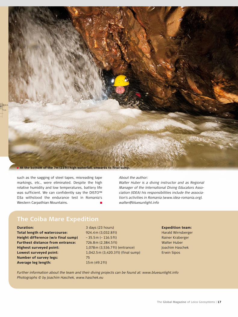
At the bottom of the 7m (23 ft) high waterfall, onwards to final sump.
The Global Magazine of Leica Geosystems | 17
such as the sagging of steel tapes, misreading tape
markings, etc., were eliminated. Despite the high
relative humidity and low temperatures, battery life
was sufficient. We can confidently say the DISTO™
D3a withstood the endurance test in Romania's
Western Carpathian Mountains.
The Coiba Mare ExpeditionDuration: 3 days (23 hours)
Total length of watercourse: 924.4 m (3,032.8 ft)
Height difference (w/o final sump) – 35.5 m (– 116.5 ft)
Furthest distance from entrance: 726.8 m (2,384.5 ft)
Highest surveyed point: 1,078 m (3,536.7 ft) (entrance)
Lowest surveyed point: 1,042.5 m (3,420.3 ft) (final sump)
Number of survey legs: 75
Average leg length: 15 m (49.2 ft)
Further information about the team and their diving projects can be found at: www.bluesunlight.info
Photographs © by Joachim Haschek, www.haschek.eu
Entrance
About the author:
Walter Huber is a diving instructor and as Regional
Manager of the International Diving Educators Asso-
ciation (IDEA) his responsibilities include the associa-
tion's activities in Romania (www.idea-romania.org).
Expedition team:
Harald Wirnsberger
Rainer Kraberger
Walter Huber
Joachim Haschek
Erwin Sipos


![Karl May - Opere Vol.7 - Slujitorii Mortii [v 1.0 BlankCd]](https://static.fdocuments.in/doc/165x107/577cd2b41a28ab9e7895cb0e/karl-may-opere-vol7-slujitorii-mortii-v-10-blankcd.jpg)