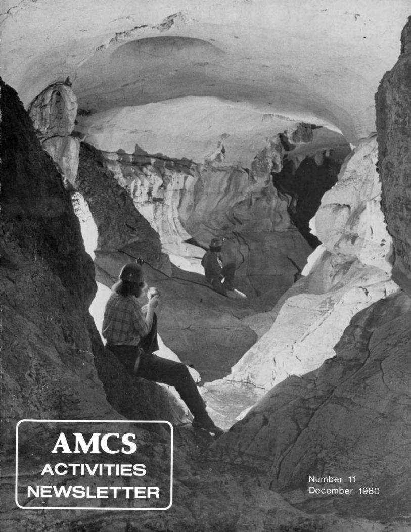
Number 11 December 1980 - MEXICAN CAVE S · sump in Cueva de las Colaciones, a resurgence cave...
100
Transcript of Number 11 December 1980 - MEXICAN CAVE S · sump in Cueva de las Colaciones, a resurgence cave...

Number 11 December 1980 EDITORIAL
Copyright 1980 by Association for Mexican Cave Studies
ASSOCIATION FORMEXICAN CAVE STUDIESP. O. Box 7672 U. T. Station
Austin, Texas 78712
The AMCS Activities Newsletter is published by the Associationfor Mexican Cave Studies, a non-profit group dedicated to the conservation and study of the caves of Mexico. Articles, maps, and photographs on caving and speleology in Mexico are solicited. A list ofpublications and prices is available on request.
PublisherAssociation for Mexican Cave Studies
EditorsTerri Treacy, Dale Pate
StaffJerry Atkinson, Anne Baxter, Steve Boehm, J ocie Hooper,
Jeff Horowitz, Peter Keys, David McKenzie, Mike McWhirter,Martha Meacham, Bill Mixon, Johanna Reece, William Russell,
Mark Shumate, Peter Sprouse, George VeniTranslations
Jose Cavazos, Steve Robertson, Peter Sprouse
The caves and caving in Mexico are spectacular,and it is not surprising that they have attracted worldwide attention. The dramatic increase in the numberof active cavers in Mexico over the last two decadeshas had, and is going to have, a significant impact onMexican caves and their exploration. For the mostpart, this impact has been very positive. The discover·ies, studies, and accomplishments have been carriedout cooperatively, and with continuous emphasis ontheir preservation by the\MCS, several Mexicancaving groups, and various groups from the U.S.,Canada, and Europe.
Recently, however, this impact has been showingnegative signs. The two most serious areas are that ofcave vandalism and rivalry. It has always been anAMCS policy that cavers conserve the fragile cave en·vironment; this means carrying out all personal belongings, including garbage and spent carbide. Caves are awilderness; some of the last wilderness left on theentire planet-let's keep them that way!
The unexplored caving areas of Mexico are vast;therefore, rivalry and unfriendly competition arepointless and non-productive. It has always beenAMCS tradition to cooperate with groups that areactively working in a cave. The cooperation enhancesthe quality of the work and avoids overpopulation ofthe caves. Initiative, not rivalry, is the key to successand satisfaction in the discovery and exploration ofcaves.
We would also like to take this opportunity toclear up some of the ambiguities of the AMCS. TheAMeS was conceived in 1962 by several Texas caversfor the "advancement of knowledge of Mexican caves."Through the years it has remained apolitical and un·structured. Today the AMCS as an "organization" isonly a post-office box and a small closet where thepublications are kept. It has very little in the way ofstructure-no actual membership, no meetings, noofficers, no office. It docs occasionally produce anewsletter or a bulletin, but again, even this aspect haslittle structure-the existence of the publicationsrelies exclusively on individual initiative.
In essence, the AMCS is a set of ideals: To exploreand study the great caves of Mexico; To preserve thewondrous beauty and magic of these caves; To produce a high level of quality in our surveys, studies,and publications; To impart a deep respect for thelands, caves, and peoples of Mexico; And to achievethese ideals in a friendly and cooperative way.
The AMCS is not a political, national, or rivalgroup. It is open to, and includes, all cavers who sharethese ideals. The Activities ewsletter is a tangibleexample of this, and we encourage everyone to participate by send ing in their trip reports, articles, maps,photos, etc. The newsletter is an invaluable repositoryfor the vast amount of information that is continuallybeing acquired. By developing a feeling of unity, weall stand a better chance of achieving our commongoals: to explore and learn about the caves we allthink are magnificent-the caves of Mexico.
Dale PateTerri Treacyby the Speleo Press
2 Mexico News4 International News8 Long and Deep Caves of Mexico
10 Xilitla Karst-Project Report13 Sistema Huautla-Project Report18 Tilaco-Project Report20 Sierra de Guatemala-Project Report24 Purificacion Area-Project Report30 A Eulogy to Dr. Federico Bonet Marco32 Golondrinas... j Otra Vez!37 Recent Biological Discoveries in Mexico40 The Piloztoc Connection42 Unstudied Karst Areas of Mexico46 Caving in Western Mexico54 The Exploration of Sumidero de Oyamel61 Across the Sima Grande64 AMCS Cave Map Symbols68 The Caves of Cuesta Colorada71 Sumidero de San Bernardo74 Short Penetration Sump Diving80 La Silleta86 Computer-Drawn Passage Walls90 Book Review91 Letter-Carta92 Traduccion de Editorial
Printed in U.S.A.
Peter SprouseJerry AtkinsonSergio ZambranoWilliam \{. 1':1IiottTerri TreacyJames ReddellDon BroussardJames ReddellBill LiebmanPeter Sprouse.lames \{eddellDale PateMark MintonRussell, SprouseGeorge VeniSteve KnutsonBill StonePeter SprouseDavid McKenzie

Mexico Nevvs
Three Florida divers of the NSSVertical Section have mapped over1100 meters in a largely submergedcave on the coast of the YucatanPeninsula called Cueva de Xcaret.Ned DeLoach, Sheck Exley, and KarenExley found that diving was hamperedby a strange phenomena: ceiling siltdisturbed by exhaust bubbles wouldcollect on the fresh water/salt watercontact, and create a "false floor"effect suspended in the passage.The system has a wide main entranceand several cenote entrances amongthe ruins of the Mayan city of Xcaret.It is the longest mapped underwatercave in Mexico.
South of Xcaret, the diversexplored the extensive cenote systemof Nonec. Visibility was so clearin the underwater tunnels that fromthe main cenote, the light from anadjacent cenote could be seen 116meters away. Troglobitic isopodstwo centimeters long were seen inthe salt water (lower) layer.
Source: Sheck Exley,Caving International No.8
Paul Duncan and members of theGreater South Texas Grotto havebeen exploring several deep cavesin the Sierra Sabinas, near SabinasHidalgo, Nuevo Leon. One cave hasa large chamber with three pits inthe floor, and has been mapped to atotal depth of 100 meters. Anotherpit has been bottomed at around-200 meters. The owner of the ranchis encouraging the cavers in thehope that they might find a watersource. Down the range, and considerably lower, is the large resurgenceof Ojo de Agua.
Source: Paul Duncan
MEXICO DESCONOCIDO is a monthlyoutdoor magazine published by Editorial Novaro in Mexico, D.F. Virtuallyevery issue contains references tocaves in Mexico. Number 47, October1980, is perhaps typical in that respect. It contains a well writtenarticle on the rescue of the Polishcavers fron Sotano de San Agustin,with excellent color photographs.Another well illustrated article describes the karst landforms aroundTaxco, Guerrero. Elsewhere, mentionis made of a Cueva de la Malinche, apictograph cave near San Agustln Mezquititlan, Hidalgo. There is anaccount of a helicopter trip to adeep canyon in Durango in search ofa cliff dwelling. Parking the helicopter at the canyon bottom, theauthor climbed 3 hours to reach theruin, located in a shelter 10 meterswide and 2 meters high.
The featured state in this issueis Coahuila, and many caves are mentioned around Torreon: Cueva delTabaco, Cueva de Candelaria, Cueva delos Indios, Cueva Tlaxcalteaca, Cuevadel Coyote, Cueva del Aguila, Cuevadel Macho, and Cueva Hundida. Severalof these are apparently those describedby James Reddell elsewhere in thisissue of the Activities Newsletter.
A group of Austin cavers visitedPozo de Gavilan near Galeana, NuevoLeon in May 1980. They initiallyfailed to recognize it because thelake, normally 100 meters below theentrance, had risen to within 30meters of the surface. Apparently,recent recharge had raised the watertable in the gypsum plain.
Source: Tom Byrd
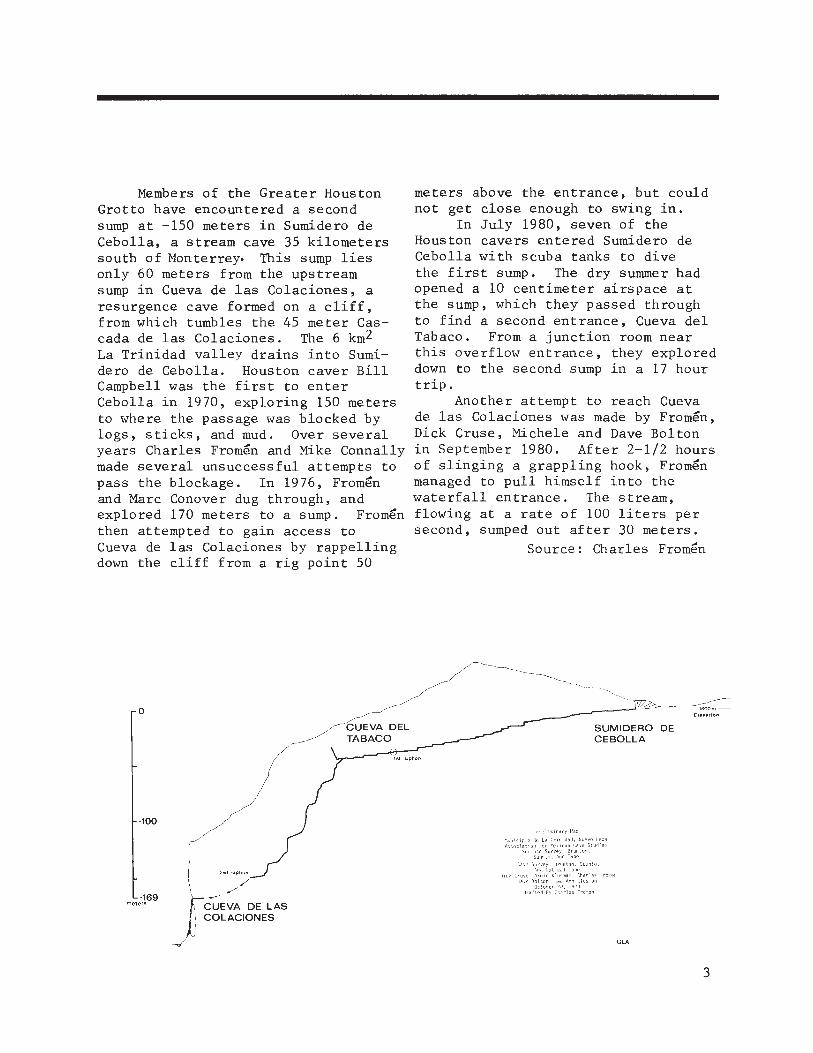
Members of the Greater HoustonGrotto have encountered a secondsump at -150 meters in Sumidero deCebolla, a stream cave 35 kilometerssouth of Monterrey- This sump liesonly 60 meters from the upstreamsump in Cueva de las Colaciones, aresurgence cave formed on a cliff,from which tumbles the 45 meter Cascada de las Colaciones. The 6 km2La Trinidad valley drains into Sumidero de Cebolla. Houston caver BillCampbell was the first to enterCebolla in 1970, exploring 150 metersto where the passage was blocked bylogs, sticks, and mud. Over severalyears Charles Fromen and Mike Connallymade several unsuccessful attempts topass the blockage. In 1976, Fromenand Marc Conover dug through, andexplored 170 meters to a sump. Fromenthen attempted to gain access toCueva de las Colaciones by rappellingdown the cliff from a rig point 50
meters above the entrance, but couldnot get close enough to swing in.
In July 1980, seven of theHouston cavers entered Sumidero deCebolla with scuba tanks to divethe first sump. The dry summer hadopened a 10 centimeter airspace atthe sump, which they passed throughto find a second entrance, Cueva delTabaco. From a junction room nearthis overflow entrance, they exploreddown to the second sump in a 17 hourtrip.
Another attempt to reach Cuevade las Colaciones was made by Fromen,Dick Cruse, Michele and Dave Boltonin September 1980. After 2-1/2 hoursof slinging a grappling hook, Fromenmanaged to pull himself into thewaterfall entrance. The stream,flowing at a rate of 100 liters persecond, sumped out after 30 meters.
Source: Charles Fromen
oCUEVA DELTABACO
SUMIDERO DECEBOLLA
Preliminaryl1ap
1st siphon
2nd siphon
,//'
CUEVA DE LASCOLACIONES
-169meters
-100
GLA
3
France
The Pierre St. Martin systemhas passed 40 kilometers in length.Connections are close but stillelusive with the grotte d'Arphidia,reseau de Arres Planeres, gouffreNo.3 de Bourrugues, and SC 60.
French divers have been quiteactive in long and deep cave dives.The Emergence de la Finou has beenpushed to 2100 meters in length,and in the Emergence de l'Infernet,divers have penetrated 1100 meters.The Emergence du Ressel has beenpushed by a Geneva groups to 1150meters, depth -56 meters. The SpeleoClub de Paris claims a "cold waterdepth record" (!) for their -99 meterdive in fontaine des Chartrea.
Source: Claude Chabert
In March 1980, French diverPatrick Penez succeeded in diving40 meters through the sump at thebottom of the 1358 meter deep reseauJean Bernard. He found a descendingpassage that went 300 meters to an 8meter drop. The depth at the bottomof this drop, 1410 meters, is a newworld depth record, although not surveyed.
Source: Paul Courbon
Italy
Climbing efforts in early 1980by Italian cavers to connect Antrodel Corchia with Abisso C. Fighierahave resulted in the discovery of aseries of high galleries and breakdown areas. This passage ascends180 meters thus far, and is stillgoing.
Source: Sottoterra 554
Spain
In the Picos de Europa, the Lancaster University Speleological Society has pushed Sima Tera to -550 meters. They had stopped at -484 metersin 1979.
The Pozu del Xitu, explored lastyear to -356 meters, has now beenpushed to -831 meters by the OxfordUniversity Caving Club.
The Speleo Club de la M.J.C. deRodez has connected Torca de los Caballos to Cueva del Valle, making a23 kilometer long system with athrough trip of 10.6 kilometers.
Source: Claude Chabert
During the summer of 1980, twomore Spanish systems passed belowthe kilometer level. Cavers of theGroupo Espeleologico Badalona connected Sima B.15 (elev. 2200 m) withFuente de Escuain, providing an 1105meter deep through trip. Unusualdrought conditions opened up sumpsthat normally would be closed.
In the PSM karst along theFrench border, a Spanish-Frenchteam pushed the new Sima Budoguiadown to a depth of 1195 meters.They stopped at the top of a largewaterfall.
Source: Paul Courbon
Turkey
French cavers have exploredTurkey's second and third deepestcaves. Sakal Tutan dudeni is 303meters deep, and Sakal Tutan deligiis 302 meters.
Source: Claude Chabert

Honduras
In spring 1980, an Americanexpedition led by Steve Knutsoninvestigated the 2700 meter "cloudforest" karst of the Montana SantaBarbara. Their major find was Sumidero Maigual, bottomed at -420meters.
Source: Steve Knutson
Texas
Honey Creek Cave, a resurgencewest of San Antonio, has been openedup after successful attempts to lowerthe water level in the low airspacecanals. Rapid mapping progress byTexas cavers has racked up 4.2 kilometers of survey. The cave involvesswimming long distances with lowceilings.
Source: Gary Poole
Sorcerer's Cave in West Texashas been connected to nearby Apprentice Cave through a short dig notfar from the entrance. This addeda few meters to the cave, which remains Texas' deepest at 178 meters.Completion of mapping to the upstreamsump in the Sirion River brought thetotal length to 2440 meters.
Source: George Veni
Texas cavers hauled dive gearto the downstream sump in 0-9 Wellfor a dive attempt in July, 1980.This Crockett County stream caveis one of the state's longest(1400 m) and deepest. DiversGeorge Veni and Steve Damon foundthe sump to silt up at 5.4 metersdepth, deepening the cave to 101meters.
Source: George Veni
U.S.A.
Wyoming's Great Ex Cave hasbeen bottomed and connected to aresurgence cave, Great Exit. Alaser theodolite survey betweenthe two entrances, and a surveybetween the lower entrance and thelowest point in the cave, show thedepth to be 429 meters, (1408 ft.),a new u.S. depth record. Effortsto survey the connection have beenhampered by a low, 300 meter longwatercrawl in wetsuit shredding rock.
Source: Louise Hose
American cavers continued exploration in Montana's Silvertip Cirqueduring the summer of 1980. The mainfocus of the expedition was BloodCave, where a new southern extensionwas discovered through a window in adomepit. This section has crossedunderneath Silvertip Mountain and outunder the cirque to the south, givingrise to hopes of another entrance.New surveys brought the length ofBlood Cave to 4 kilometers. While aconnection with Blood still proveselusive, the main Silvertip Systemgrew to 9.6 kilometers after a connection with Tipfish Cave and furthermapping in the Bell section.
Source: Mike McEachern
Ronald Langston, 33, a diverfrom Rome, Georgia, died in a smallcave near Sublinga, Georgia onAugust 1, 1980. Although he was anexperienced diver, he apparentlywasn't familiar with cave diving.Using a "pony" tank, he entered asump alone, with no dive line. Histank floated out a short time later.He had apparently taken if off ina constriction.
Source: The Potomac Caver
5

A thirty year old Denver caver,Bruce Unger (NSS 10663), drownedwhile exploring in one of the LostCreek granite caves in Park County,Colorado, on August 9, 1980. Bruce,Louise Hose, Tom Strong, and ScottTrossen followed a cold 600 l/s stream80 meters into the cave where Brucebegan ascending a steeply slopedwater chute. While attempting tobridge over the rushing stream atthe top of the chute, Bruce slippedand his leg jammed in an underwatercrack. Attempts by his companionsto help him were thwarted by theforce of the water and a lack offoot holds. They were repeatedlyflushed down the chute, while waterforced Bruce under. The body wascompletely inside the underwatervoid, and could not be pulled out.
A retrieval team of 8 cavers camein the next day, but also failed toremove the body from the crack.The body was successfully retrievedtwo weeks later with a winch andpulley system.
Source: Louise Hose
During the summer of 1980, aneight member British expeditionspent a successful five weeks investigating lava tubes on the island ofHawaii. Twenty-four kilometers ofpassages were mapped in many caves.The initial objective was the recent1974 Mauna Ulu lave flow on the southslope of Kilauea (1228 m). Apua Cave,a large, well decorated tube, wasmapped, totalling 1.3 kilometers.Two other 300 meter long caves weremapped in this flow. Further weston Kilauea, Ainahou Ranch Caveproved to be almost 7 kilometerslong; however, broken up in the middle by a large collapse. This system, and several others, contained
6
artifacts and burials left by earlyHawaiians. Interestingly, someimportant burial chambers were protected by booby traps, such asperched boulders with trippingmechanisms, which seemed to havebeen subsequently triggered by themany volcanic tremors.
Kazumura Cave, a long knowntube at the eastern end of theisland, was mapped by the expeditionto 11.55 kilometers. Thus, it passes Kenya's 11.1 kilometer LeviathanCave to become the world's longestlava tube. The expedition heldhigh hopes for the vast flow on 4170meter high Mauna Loa, stretching 50kilometers over a vertical range of3200 meters. Upward pushes in Kaumana Cave, a tourist cave near Hilo,and at the bottom of the flow, showedit to end after a kilometer, with thecave being surveyed to a length of2 kilometers. They point out however,that exploration on Hawaii's vast lavafields has hardly even begun.
Source: Chris Wood,Caving International
Rapid growth in West Virginia'sFriar's Hole System has recently madeit third longest in the U.S. at60.75 kilometers. Bill Stone andBob Jefferys completed the waterfallclimb in the Monster Cavern room inJuly, 1980, discovering 200 metersof canyon passage. In September,a large group hauled in diving gearfor Stone to attempt the downstreamCrookshank sump, only to find thesump open due to a summer drought.Over 2.5 kilometers of large passagewas mapped to another sump. Highleads with airflow provide hope formore progress towards the suspectedresurgence, over 11 kilometers away.At the northern end of the system,

a considerable amount of passage hasalso been surveyed in the area ofthe Rocky River II. The Friar's HoleSystem now stretches an amazing 6,280meters end to end in maximum linearextent.
Sources: Dug Medville, Roy Jameson
Recent explorations have openedup a new section at the bottom ofWest Virginia's Walt Allen Cave. Abase level crawlway was pushed throughtight squeezes, lots of mud, and along sump to a streamway. Downstream,a canyon crosses above the stream andleads to a large trunk passage. Thiswas surveyed 450 meters to a terminus.Several tight leads and an elusivewind still provide hope of a connectionto nearby Shinaberry Cave. Caversshould note that access to this caveis very tentative at this time.
Source: Bob Anderson
The survey of Roppel Cave nowstands at 36 kilometers. An interesting recent discovery was the presumed upper reaches of Flint-Mammoth'snew Hawkins River. Whether a connection can be made or not is problematicfor a permanent sump marks the upstream limit in Flint-Mammoth. Other
leads in Roppel are heading for 17kilometer Crump Spring Cave and otherpotential connections.
Source: Bob Anderson
Kentucky cavers have been busyin the caves surrounding the 345kilometer Flint-Mammoth Cave system.Whigpistle Cave now has 26 kilometers of surveyed passage. In thefirst part of 1980, a major upperlevel extension was pushed into aridge to the south of known partsof the cave. Many leads are within a few hundred meters of theSinkhole Plain. Northtown Cave isa new find with 3.5 kilometers ofpassage, and prospects are good fora connection with nearby RoppelCave.
Source: Don Coons
Hot Cave, a new find in PerryCounty, Missouri, could provide thelong sought link between MysteryCave (25.5 km) and Rimstone RiverCave (22.5 km). Tex Yokum and othershave thus far explored about 5 kilometers of passage, heading towardsMystery.
Source: Steve Boehm
The World's 1000 meter systems
1. Reseau Jean Bernard, France2. Complexe de la Pierre Sainte-Martin, France and Spain3. Sistema Huautla, Mexico4. Sima Budoguia, Spain5. Snieznaya, USSR6. Gouffre Berger, France7. Schneeloch, Austria8. Sima B.15-Fuente de Escuain, Spain9. Sima GESM, Spain
10. Lamprechtsofen, Austria11. Reseau Trombe, France
*Need verification by surveyor resurvey.
1410 meters*1332 meters1222 meters1195 meters1180 meters*1148 meters1111 meters1105 meters1098 meters1024 meters1018 meters
Source: Paul Courbon
7
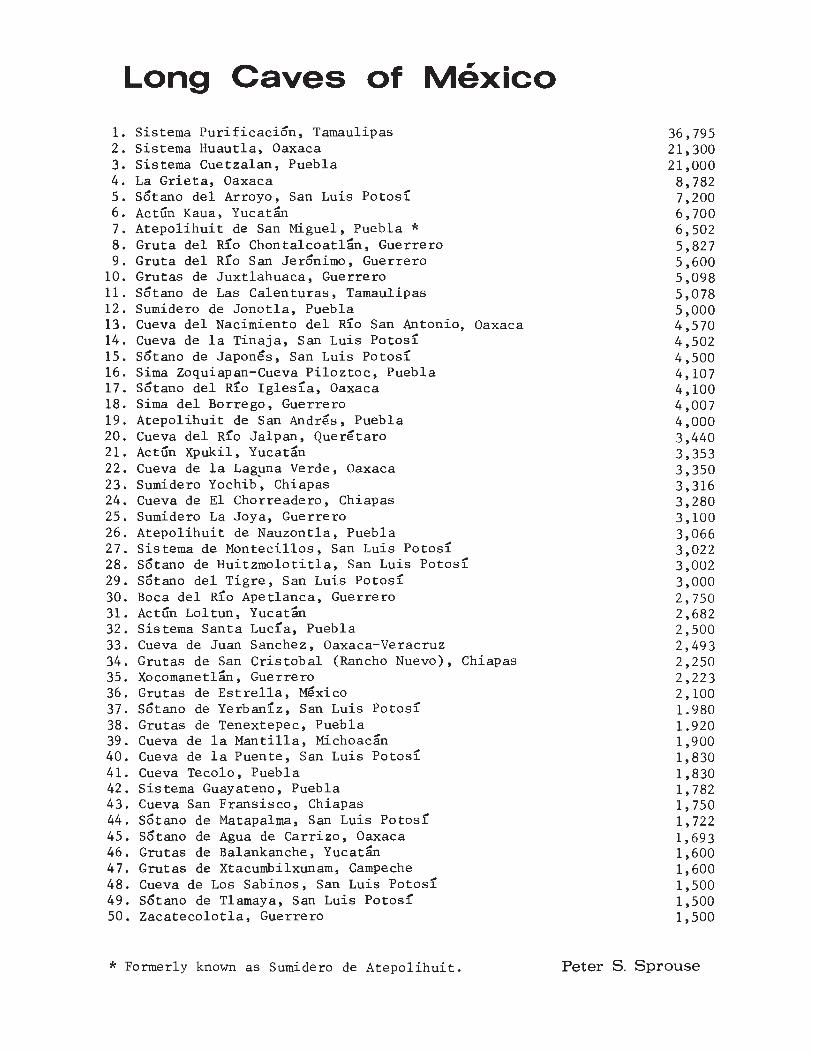
Long Caves of Mexico
1. Sistema Purificacion, Tamaulipas2. Sistema Huautla, Oaxaca3. Sistema Cuetzalan, Puebla4. La Grieta, Oaxaca5. Sotano del Arroyo, San Luis Potosl6. Actun Kaua, Yucatan7. Atepolihuit de San Miguel, Puebla *8. Gruta del R10 Chontalcoatlan, Guerrero9. Gruta del R10 San Jeronimo, Guerrero
10. Grutas de Juxtlahuaca, Guerrero11. Sotano de Las Calenturas, Tamaulipas12. Sumidero de Jonotla, Puebla13. Cueva del Nacimiento del Rlo San Antonio, Oaxaca14. Cueva de la Tinaja, San Luis Potosl15. Sotano de Japones, San Luis PotOS116. Sima Zoquiapan-Cueva Piloztoc, Puebla17. Sotano del Rlo Iglesla, Oaxaca18. Sima del Borrego, Guerrero19. Atepolihuit de San Andres, Puebla20. Cueva del Rro Jalpan, Queretaro21. Actun Xpukil, Yucatan22. Cueva de la Laguna Verde, Oaxaca23. Sumidero Yochib~ Chiapas24. Cueva de El Chorreadero, Chiapas25. Sumidero La Joya, Guerrero26. Atepolihuit de Nauzontla, Puebla27. Sistema de Montecillos, San Luis Potosl28. Sotano de Huitzmolotitla, San Luis Potosl29. Sotano del Tigre, San Luis POtOS130. Boca del Rlo Apetlanca, Guerrero31. Actun Loltun, Yucatan32. Sistema Santa Luc1a, Puebla33. Cueva de Juan Sanchez, Oaxaca-Veracruz34. Grutas de San Cristobal (Rancho Nuevo), Chiapas35. Xocomanetlan, Guerrero36. Grutas de Estrella, Mexico37. Sotano de Yerban1z, San Luis Potos138. Grutas de Tenextepec, Puebla39. Cueva de la Mantilla, Michoacan40. Cueva de la Puente, San Luis Potosl41. Cueva Tecolo, Puebla42. Sistema Guayateno, Puebla43. Cueva San Fransisco, Chiapas44. Sotano de Matapalma, San Luis Potos145. Sotano de Agua de Carrizo, Oaxaca46. Grutas de Balankanche, Yucatan47. Grutas de Xtacumbilxunam, Campeche48. Cueva de Los Sabinos, San Luis Potosl49. Sotano de Tlamaya, San Luis Potos!50. Zacatecolotla, Guerrero
* Formerly known as Sumidero de Atepolihuit.
36,79521,30021,0008,7827,2006,7006,5025,8275,6005,0985,0785,0004,5704,5024,5004,1074,1004,0074,0003,4403,3533,3503,3163,2803,1003,0663,0223,0023,0002,7502,6822,5002,4932,2502,2232,1001.9801.9201,9001,8301,8301,7821,7501,7221,6931,6001,6001,5001,5001,500
Peter S. Sprouse
Deep Caves of Mexico
1. Sistema Huautla, Oaxaca2. Sistema Purificacion, Tamaulipas3. Sotano de Agua De Carrizo, Oaxaca4. La Grieta, Oaxaca5. Cueva de Diamante, Tamaulipas6. Nita He, Oaxaca7. Sotano de Trinidad, San Luis Potosi8. Sotano del Rlo Iglesia, Oaxaca9. Sotano de Nogal, Queretaro
10. Sotano de las Golondrinas, San Luis Potosl11. Hoya de las Conchas, Queretaro12. Sotano del Buque, Queretaro13. Sistema Cuetzalan, Puebla14. Hoya de Las Guaguas, San Luis Potosi15. Cueva de San Agustin. Oaxaca16. Sotano del Barro. Queretaro17. Sotano Itamo. Veracruz18. Sotano de Tlamaya. San Luis Potosl19. Cueva de la Pena, San Luis Potosi20. Nita Nanta, Oaxaca21. Atepolihuit de San Miguel, Puebla *22. Sotano de La Joya de Salas, Tamaulipas23. Cueva de El Chorreadero, Chiapas24. Cueva de Xocotlat, Puebla25. Grutas de San Cristobal, Chiapas26. Sotano de los Hernandez, Queretaro27. Sotanito de Ahuacatlan. Queretaro28. Hoya de Zimapan, San Luis Potosi29. Cueva de Santa Cruz, Oaxaca30. Sotano de Javalin, Queretaro31. Sotano de los Monos, San Luis Potosi32. Sotano de Soyate, San Luis Potosi33. Cueva del Rancho de Agua Amarga, San Luis Potosi34. Sotano de Vasquez, Tamaulipas35. Sumidero La Joya, Guerrero36. Sotano de Huitzmolotitla, San Luis Potosi37. Sotano del Macho Rey. Queretaro38. Sotano de Otates. Tamaulipas39. Pozo Melendez. Guerrero40. Sotano de Ojo de Agua, Queretaro41. El Sotanito, Queretaro42. Sotano de Sendero, Tamaulipas43. Sotano de Sauz, Chihuahua44. Sotano de Co~timundi, San Luis Potosl45. Sotano de la Cuesta. San Luis Potosi46. Sotano de San Francisco, San Luis Potosi47. Sotano del Arbol Sangre, Tamaulipas48. Cueva de SaIto, Queretaro49. El Socavon, Queretaro50. Sumidero Yochib, Chiapas51. Sumidero de Tenejapa, Chiapas52. Sotano de la Navidad, San Luis Potosi
1,222895848760621600559535529512508506490478458455454454448445443376345339330330320320314308291287283275257245244244229228225223220219217217216215214213209200
all units in meters Peter S. Sprouse

PROJECT REPORT
THE XILITLA KARSTPeter Sprouse
View of the Xilitla cone karst from the top of La Silleta. (Terri Treacy)
The extensive Xilitla karstarea of San Luis Potosl and Quereterowas among the first studied by speleologists, namely Dr. FredericoBonet in 1953 and Dr. Robert W. Mitchell in 1958. It was the scene ofthe blossoming of Mexican caving during the 1960s. By the middle of thedecade Sotano de Tlamaya had beenbottomed at 454 meters, setting aWestern Hemisphere depth record. In1967, the world's deepest freefall pitwas descended, and still yields new
10
discoveries today. The pit isSotano de las Golondrinas.
A considerable amount of information on caves of the Xilitla areahas appeared in AMCS publications, andbeen documented. I am currently compiling, with John Fish, information onthe area for an AMCS Bulletin, hopefully to be published in 1981. Thegeographic boundaries of the area tobe covered are as follows: on thenorth, the Rlo Santa Marla; on theeast, the Inter-American Highway;

on the south, the Rio Moctezuma;and on the west, the eastern edgeof the San Juan Plateau, which wasdescribed in AMCS Bulletin 7. Elevations in the area range from 100to 2900 meters above sea level;vegetation changes correspondinglyfrom lush tropical jungle to highpine and hardwood communities.Karst landforms are spectacularthroughout the region, with some ofMexico's best examples of cone karstlocated south of Tampaxal.
Although the number of documented caves in the area currently totals206, there are undoubtedly hundredsmore remaining to be discovered.Field efforts towards the Xilitlabulletin have necessarily been limited to completing accurate surveysof major caves in the area. Whenthe bulletin is published, it maythen serve as a framework for futurework. Several mapping trips weremade to the area in 1980, and help1S needed to survey other major cavesin the coming months.
In March, 1980, 13 cavers participated in survey and explorationwork at Sotano de las Golondrinas.(See article in this issue.) DonBroussard led continued mapping efforts in The Crevice off the bottomof the entrance pit, while othersupplemental survey work was done onthe pit floor. A surface survey wasdone to the west to tie in nearbySotano de Guadalupe, a 22 meter deepcave, significant mostly for itsfauna.
During April, the same groupspent six days in the La Silletaarea. (See article in this issue.)They mapped Sotano de La Silleta,Cueva de La Silleta, and five newcaves.
In late August, another AMCSgroup attempted to collect troglobitic crayfish in the sump pool inRoya de las Guaguas, and began thesurvey of Cueva de Oxtalja nearTamapatz. Oxtalja is a 150 meterdeep cave formed along a thrust
fault between the Agua Nuevaand EI Doctor formations. Itwas explored in 1966 and 1968,but no mapping was done.
Cobble trail from Tamapatz to Sotano delas Golondrinas. (Dale Pate)
Several other significant cavesneed mapping and would be good forgroups looking for a project.These include:
SOTANO DE TLAMAYA - Needs to be surveyed. This 3 kilometer long, 454meter deep cave is one of the largestin the area, yet lacks a good map.It will be an extensive mapping project.
11
CUEVA DE POTRERILLOS - Located nearthe village of Potrerillos, 1 kilometer west of Ahuacatlan, S.L.P.Needs mapping.
CUEVA DE MURAUT - This is a450 meter long cave that needs mapping. It lies 300 meters southeastof Muhaut, south of Tamapatz.
SOTANO DE SIETE SEGUNDOS and SOTANODE LAS PENAS - Two undescended pits,with 6-7 and 5 second rockfall timesrespectively, that need checking.
SOTANO DE LA LINJA NO. 2 - A largepit 100 meters deep and needs map-
ping. It 1S located 1500 metersnortheast of La Linja, north ofLa Laj a.
SOTANO DE LA LAJA - A 100 meter undescended shaft near La Laja, firstlocated by aerial reconnaissance.Needs checking and mapping.
If you are interested in anyof these projects, or in the XilitlaBulletin, please contact PeterSprouse, P.O. Box 8424, Austin, Texas,78712. We are also looking for contributions of good photos or slidesto help illustrate the bulletin.
~ lEU 181 '8' 181 181 181 ;;;;tla 181 IElI 181 IElI IElI 181 I(;]~
G G
~Se comenzaron los estudios de la region karstica extensiva de Xilitla ~
W en S.L.P. y Queretaro en 1953 por el Dr. Federico Bonet, y por el Dr. WG Robert Mitchell en 1958. Aunque ya se han documentado 206 cuevas en la G
~region, sin duda quedan centenares para descubrir. ~
W Peter Sprouse y John Fish estan juntado informacion de la region para WG producir un boletin AMCS. Ademas de proporcionar la informacion recolec- G~'
~tada, servira como base para futuras investigaciones. I
W En las sigientes meses, se necesita ayuda para topografiar unas cuevasG principales en la region. Algunas de las cuevas importantes que no estan G~'
~ levantados son: Satano de Tlamaya, Cueva de Potrerillos, Cueva de Muhaut, IW Sotanito Occidental, Sotanito Escondido, Sotano de La Linja No.2, Satanom\ de La Laja. Si tiene interes en alguno de estos proyectos, 0 en el boletin, G~'W comunicase con Peter Sprouse, P.O. Box 8424, Austin, Texas 78712. Wr 1(;]1 181 181 181 lElI 181 '81 181 '81 181 '8' IElI 181 18@
TAKE NOTHING BUT PICTURES
LEAVE NOTHING BUT FOOTPRINTS
12
PROJE.CT RE.PORT HUAUTLA C!) PROJECT
Sistema HuautlaGerald Atkinson
On May 9, 1980 the Huautla Project composed of Jerry Atkinson, JillDorman, Jan Fitzsimmons, Bob Jeffreys,Dino Lowrey, Mark Minton, Doug Powell,Henry Schneicker, Ron Simmons, JimSmith, Bill Steele, Bill Stone, andSteve Zeman succeeded in connectingLi Nita and Sotano de San Agustln,achieving a total depth of 1221.5meters and a length of 21.3 kilometers. This brought Sistema Huautla up to the number 3 slot on theworld depth list. It is the only kilometer deep cave outside of Europe.The spring activities culminated manyyears of work in the area, as thefirst connection between any of theHuautla caves was realized. Althoughthe potential through-trip would bequite spectacular, it nonethelesswill be a rare event, as the Li NitaSan Agustln breakthrough requiredthe use of diving gear through aseries of 4 sumps.
The connection occurred late inthe expedition, which was fieldedfrom February 21 to May 21, andcame as the crowning even t in whatwas an extremely eventful trip. Onthe eve of departure, the expeditionwas notified that a member of a Polish caving team had received a serious back injury in Sotano de SanAgustln while attempting to giveaide to a fellow teammate with abroken ankle. Upon arrival inMexico City the next day, ourgroup learned that at least one ofthe injured men was still underground and that our assistancewas requested. Twenty hours laterfound us in the middle of a wildarray of tents strung around theSan Agustln schoolhouse and a barrage of inquiries in French, English,German, British, Spanish, and Polish. A PEMEX helicoptor lay park-
ed below the town with an armedguard quietly dozing in the hot sun.Winding our way down to the Sotanoamidst whirring movie cameras, weadded our energy to this alreadymassive international effort. Despite language barriers and sheerfatigue, the victim was successfullypulled out of the cave on the 22nd.
After the general hubbub dieddown, the expedition settled down tothe spring objectives, one of which
Rescuing Josef Cuber of the Polish Expeditionin Sotano de San Agustln. (Henry Schneiker)
13
was the possible connection of Sotano del Rio Iglesia to Sotano de SanAgustln. Although several hass1eintensive trips in Rlo Iglesia netted about 400 meters of new passage,all leads choked or led back toknown cave. The main passage itselfhad silted shut at the -400 meterlevel, precluding any digging attempts in thE: lower reaches wl,ichare nearest to Sotano de San Agustln.
Another cave that received considerable attention was Nita He(Deep Cave in Mazatec), which hadbeen discovered, but not entered,the December before. The cave wasexplored down a series of spectacular shafts and large rooms to asump at -599 meters. The sump presented a rather dismal diving prospect, and a general lack of airflowin the lower portions would seem topreclude any possible connectionto the larger caves.
Distractions aside, the mainfocus of the expedition became LiNi ta, which means "Flashlight Cave"in Mazatec. Discovered on December29, 1979 by Ernie Garza and others,it had been pushed to -162 metersprior to the spring expedition.Two trips down predominantly dipslope fissure-type passage broughtthe depth to -525 meters and thelength to a little over 2 kilometers.At this point, the bottom dropped outof the cave in a series of watershafts that led the third attempt to-681 meters. A fourth assault fromthe surface reached -812 meters, anda decision was made to establish acamp at the -630-meter level. Atotal of twenty-seven days were spentin this camp during three separatestays of seven, seven, and thirteendays.
The first push from camp seemedto be stymied when the team discovered
The entrance series of Li Nita. (Bill Stone)
14

o
500
1000
1221.5METERS
LI NITA
PROFILE - 2250
right
SISTEMA HUAUTLA - 1980OAXACA. MEXICO
SOTANODE SAN AGUSTIN Y(-355)
CAMP1 (-630)
S'PHON (-1221.5)
GLA

Li Nita. (Bill Stone)
a sump at -825 meters, but carefulchecking uncovered a high-level gallery bypass. This led to anothersump at -1020 meters and the discovery of the Mil Metro, a higher-leveltrunk passage at the -1005-meter level. With several high leads tocheck, the team left for the surface.
During the second camp, a combination of digging and aid-climbingbrought US to a dig within 50 metersof Sotano de San Agustln. Elsewhere,a nasty fissure was negotiated to anew downstream sump at -1028 meters.As this sump was plotted to be only130 meters from San Agustln, the teamopted to surface and return with divinggear for the sump and explosives forthe dig.
Accordingly, an attempt was madeon the -1028 sump early in the third
16
camp. Unfortunately, the sump continued well beyond the air capacityof the small tanks being used,and theteam turned to pushing other leads.A series of digging and aid-climbingtrips succeeded in extending thecave an additional kilometer to yetanother sump at -1030 meters. Inwhat was to be the final push of theexpedition, a last-ditch diving attempt was made on the -1030 sump.With only 2 meters of dive line left,Bill Stone emerged in the East Redball Canyon of Sotano de San Agustlnafter having dived four shallow sumps.Thus, ironically, an expedition thathad begun with a near tragedy hadmade the first major connection inthe Huautla system and broken thekilometer mark in Mexican speleology.

Jim Smith and Bill Stone preparing todive the 1030 Sump in Li Nita. (Ron Simmons)r 'e. '0' ,e, .e, ,e, Sis;:ma ""Hu~:'tla .e, ,e, "., ,." ,e, ,e~
8 La primera conexion entre cualquiera de las cuevas profundas de Huautla, ~
~ Oaxaca, fue descubrida despues de varios anos de trabajo en la region. La illG
conexion entre Li Nita y Sotano de San Agust1n fue hecha e19 de mayo de 1980. ~
G~' Despues de cuatro viajes para dentro de Li Nita, el grupo bajo 812 metros y
I se hizo una decision para establecer un campamento al nivel de -630 metros. G
En tres diferentes ocasiones el grupo paso siete, siete, y trece d1as respec·· ~8
~tivamente en este camp amento, haciendo un total de 27 dias. Del campamentosubterraneo el grupo encontro varios sifones, perc encontraron otros pasajes G
G para pasarlos. Finalmente, despues de varias excavaciones y escaladas ~
~artificiales alcanzaron un sifon a -1020 metros. Bill Stone, en equipo com- ill
lli pleto de buceo, paso este sifon y tres mas sifones. Emergio en el Sotano G
8 de San Agust1n. El Sistema Huautla tiene un total de 1,221.5 metros de pro- ~.
~el fun,:~dad I:' 21'~G~0 me,:~os d,:, lon~:,tud. 'SI 'S' lei 'st 'e' 'Si 'St "J17

PROJECT REPORT ASOCIACION ALPINA DE MEXICO, A. C.
TILACO
Grupo Expedicionario
XAMAN-EK
Our first V1Slt to Satano deTilaco, Queretaro was over Easterweek of 1975. At that time, RaulPerez Mart1nez, Hugo Montejo, andI (all members of the Asoci-acion Alpina de Mexico, A.C.) explored the cave to the 150 meterlevel. We returned 8 months later,in December of 1975, to continueour exploration. Raul P. Martinez,Enrique Mendoza, Guadalupe Hernandez, and myself (all A.A.M. members)explored down to the 250 meter levelwith the cave continuing downward.During Easter week of 1977, we returned with Gabriel Barrera joining our group. Our explorationsended at the 350 meter level. Wereturned in November of 1980and reached the 500 meter levelbefore running out of rope.
On March 24, 1980, members ofthe Grupo Expedicionario Xaman-Ekand the A.A.M. reached the bottomof Tilaco. A sump was encounteredat a depth of 600 meters plus. Agroup of cavers from the U.S. joinedus for the purpose of making a survey of the cave. The survey wasdone to the -175 meter level. Ajoint expedition is planned in 1981to complete the survey.18
Sergio Zambrano
Sergio Zambrano at entrance of Satano deTilaco. (Dale Pate)

Raul P. Martlnez in the Salon de las Columnas.(Sergio Zambrano)
TUaco
La primera visita a Sotano de Tilaco, Queretaro fue durante laSemana Santa en el ana 1975. En aquel tiempo, los espeleologos RaulPerez Martinez, Hugo Montego, y Sergio Zambrano (Miembros de la AsociacionAlpino de Mexico, A.c.) exploraron el sotano hacia la profundidad de 150metros. Volvieron ocho meses despues para continuar su exploracion. RaulPerez M., Enrique Mendoza, Guadalupe Hernandez, y Sergio Zambrano (todosmiembros de la AAM) exploraron hasta 250 metros can la cueva continuandohacia abajo. Durante la Semana Santa de 1977 regreso este grupo canGabriel Barrera. Sus exploraciones terminaron en el nivel de -350 metros.En Noviembre 1978, llegaron hasta 500 metros antes de que se les acabola cuerda. En el 29 de mayo 1980, miembros del Grupo Expedicionario XamanEk y la AAM llegaron al fonda del sotano. Encontraron un sifon al nivelde mas de 600 metros. Un grupo de espeleologos de los Estados Unidos sejuntaron can la intencion de levantar la cueva. Una mapa estaba hechahasta el nivel de 175 metros. Otra expedicion colectiva esta planeada enel futuro para completar el levantamiento.
19
PROJECT REPORT
Sierra de GuatemalaWilliam R. Elliott
At least 115 caves have beenreported in the Sierra de Guatemala region, a front range of theSierra Madre Oriental in southernTamaulipas, bordered (roughly) onthe north by the Rlo Guayalejo andon the south by the Rlo Boquillas/Comandante. Familiar towns in thearea are Encino, Joya de Salas,Gomez Farlas, Chamal, and Ocampo.Since the first AMCS trip to GomezFarlas in 1964, there have been atleast 70 speleological expeditionsto the area. The major cave of interest, Satano de La Joya de Salas,has been visited eleven times since1965. This satano continues tofrustrate the designs of verticalspeleologists despite its greatdepth potential.
Cave types abound in the area.Satanos in the lowland Gomez Farlasarea often have short arroyos leading to multi-pitch fissures and blindfish pools. Deep, open shafts arefound in the Chamal/Ocampo area.Many small blind pits are found inthe highly karsted highlands, alongwith 376 meter deep Satano de LaJoya de Salas. Small phreaticcaves and spacious, well-decorated"grutas" are found in many areas.Some caves, such as Cueva de losMisioneros, appear to be abandonedresurgences. Cerro Partido, a volcanic peak of Miocene age southwestof Ocampo, has several lava tubes,complete with troglobites.
In 1978, James Reddell andI conceived an AMCS Bulletin, Cavesof the Sierra de Guatemala, TamauIIp~ Mexico.--Work has been progressing slowly since then. A progress report by me appeared in AMCSActivities Newsletter #10. Since
20
then there have been five trips tothe area with several caves surveyedand studied biologically.
One of the goals of the Bulletin is to document about 65 cavesthat have been biologically sampled,and other caves as well. The cavesand pits of the area harbor a widevariety of cavernicoles that haveattracted biospeleologists from Mexico, the U.S.A., Switzerland, Italy,and Japan. The fauna ranges fromblind Astyanax fishes in the lowlandsto many species of troglobitic planarians and arthropods in the highlands and in between. The cavefauna is one of the more spectacularin North America. Reports on thecaves and fauna of the area may befound in AMCS Bulletins 1, 4, and 5,and many issues of the AMCS Newsletter(now moribund).
In November, 1979 I mailed adetailed Bulletin proposal to 25 interested cavers. Old surveys andphotographs have appeared and theAMCS files have disgorged many oldtrip reports, sketches, and BillRussell area maps. I am currentlycompiling a lengthy chronology ofall the t rips I know 0 f to the area.This will be a basic reference forwriting many of the cave descriptions in the Bulletin. We hope toreceive contributed articles ongeology/physiography and archaeology. Reddell and I are updatinga fauna checklist and will write anarticle on the fauna. I have drafted many maps and now have 22 inkedand several others nearing completion. The Bulletin will probablycontain 40 to 50 cave maps andmany photographs. It may also include a detailed area map to aid

Lake in Sotano de Caballo Moro. (William Elliott)
future field work. Considering theknown distribution of caves (nearroads), there may be many hundredsleft to be found. Finding caves isdifficult because of the rough terrain and dense forest. For instance, two large sotanos were discovered by airplane reconnaissancein 1969, but have never beenvisited.
In August, 1979 Paul Duncan,Jim Clements, and Wayne Russellvisited Cerro Partido and discovereda new lava tube, "Tubo del Piso Colorado" near the peak. Duncan rappelled down a 6 meter pit which hung into a lower level like a stovepipe.Further details are forthcoming.
In September, 1979 David McKenzie, Craig Rudolph, Frank Endres,and I returned to Cueva del Ojo deAgua de Manantiales and finished oursurvey in two days. The currentlength is 1293 meters, depth 56 meters. A few crawlways were left forfuture surveyors to take on. Blind
planarians were discovered in a pooland sent to Dr. Roman Kenk. Theyare the first ones from a lowlandcave in the area. A new species oftroglobitic Ptomaphagus beetle wasalso found in Man an tiales in January,1979. David McKenzie will soon havethe map of this cave ready for inking. We also investigated areasnorthwest of Ocampo where we located a 25 meter pit, Sotano del Monumento, near Aniceto Medrano (Allende).Craig and I collected in the pit andmade a sketch. We were amused bythe shaky ladder that had been placed by locals in the pit to aid anapparently aborted dig at the bottom.We continued to Los Flores and LaLaguna, on the west side of therange, where we hiked up to Joya deDon Juan Mesa. The Joya was a nicelarge dolina, but the rumored sotano proved to be only 8 or 10 metersdeep. We then drove back to Chamaland out to Cueva de los Misioneros,a cave I had not visited since 1969,
21
where we explored, collected, andphotographed. McKenzie rappelled40 meters into a pit at the end, butran out of rope before reaching bottom.
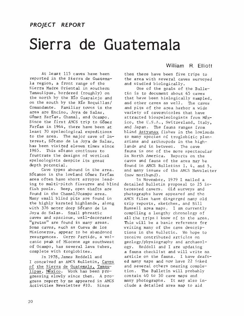
scending the 41° slope at the southeast end of the dolina was treacherous because of loose talus. Duwain,Del, and I surveyed the satano, whichhas a 49 meter entrance drop to a
In November, 1979 the eleventh slope that plunges into a large, deepexpedition to Joya de Salas was made. lake (see photo). A few fish wereI have not received a written report noted on this trip, but we didn'tof this trip, but Bill Stone, Mark spend much time looking at them.Minton, Bill Steele, and others push- The lake had a population of hybrided a new system of shafts paralleling eyed and blind fish in 1970. Wethe old section of the satano. Ap- surveyed along the right wall, thenparently little depth was added to across the lake on tubes and into athe survey. (See article in this Acti- 163 meter long passage with a second,vities News.) During the same trip, smaller lake and a terminal crawlwayTerry Sayther, Denis Breining, and that was not pushed for lack of time.Margaret Hart hiked 5 kilometers Back at the large lake I plumbed thenorth of Joya de Salas, then east depths in two places at 4 and 15 me-to check out sinks and intermittent ters. A strong current moves thelakes marked on the topographic clear water to a siphon at the northsheet. The sinks were heavily over- (far) end. At a constriction, I es-grown with scrub and thorns. No timated the surface flow at aboutcaves or particularly interesting 1 or 2 kilometers per hour (myfeatures were seen. They connected speed in a tube), and the volumewith a passable road leading south flow at 10-20 m3/sec. It would beto "La Trementinera." interesting to see a dye trace be-
In January, 1980 I travelled tween here and the Nacimiento delwith six cavers from Texas A&M Rlo Frlo, 15 kilometers to the north-(Barbra Vinson, Duwain Whitis, east. We surveyed 326 meters in theSteve Boehm, Del Holman, Sheila cave, which is 67.5 meters deep be-Jones, Heather Fannin) and two other low the entrance, or 196 meters inbiologists (Craig Rudolph and Jenni- cluding the dolina.fer Matos). We surveyed Cueva de The next day we hiked to Cerrolos Misioneros and found it to be Partido to see Cueva del Cerro Par-about 450 meters long and 60 meters tido. The volcanic peak was toodeep. Boehm and I descended the pit overgrown to locate the cave in theat the end, only to find terrifically short time available, but we did colbad air. Boehm's carbide lamp would lect fauna in a one-room cave on thenot burn, so he prusiked up by elec- south side. nvo species of blindtric light while I somehow managed to milliped were taken, and some othersketch the bottom and note a muddy arthropods as well. I noted an ap-pit at the end where a rock rattled parently unexplored pit in a smalldown for seven seconds. It took cone on the south side of the Cerro.most of our energy to climb back up. We returned to Texas the next day.The air did get progressively better Apparently Satano de los Guaca-toward the top of the 50 meter pi t. mayos was visi ted in January, 1980
The next day we were guided by by Mike Wharton and others, but fullAlfonso Herrera to Satano del Caballo details have not yet been obtained.Moro, which I had last visited in 1970. No other trips have been madeAlfonso, a local rancher, had been in to the area in 1980, to my knowledge.the satano with T.R. Evans and others A trip I planned for May never gelled.in 1969. The large, overgrown Dolina Much more field work could be donedel Caballo Moro was surveyed by half to add to the Bulletin, but the workof our crew and proved to be 128 me- could be endless, so at some pointters deep to the lip of the pit. De- we will just work up what is avail-
22

able and publish. Rumor has it thatRoy Jameson may resurvey Sotano deVasquez this fall. This would bewelcome as the old map was never finished and Vasquez is probably theworld's deepest (about 275 meters)blind fish cave. It is hoped thatsomeone will be able to do some geology work in the Sierra de Guatemala for the Bulletin.
No deadlines have been set forthe Bulletin, but I hope to haveit ready for publication in 1981.
I need finished maps of Sotano deLa Joya de Salas and Sotano de Vasquez. I could use some expertdrafting help on a myriad of smallmaps. Color slides or black andwhite prints of Salas and any othercaves would be appreciated. Ican copy the slides to black andwhite negatives and return thempromptly. Photos, trip reports,maps, and other material should besent to me, Bill Elliott, at 2225North Parkwood, Harlingen, Texas78550.
~ lSI lSI lSI 1(;)1 lSI lSI 101 lSI lSI lSI 1[;]1 101 lSI IEIi ~
ml' Sierra de Guatemala m,'
W William Elliott esta trabajando en un boletln del AMCS tratando con ill
~81' las cuevas de la Sierra de Guatemala, un parte de la Sierra Madre Oriental ~81'
en el sur de Tamaulipas. La region esta rodeado al norte por el RloGuayalejo, y al sur por el Rlo Boquillas/Comandant. Desde 1964, se han
~81' localizado 115 cuevas, y estudios biologicos extensivas se han realizado. ~81'
El boletln incluira descripciones de las cuevas y de 30 a 40 mapasy varias fotograflas. Contendra reportajes de la biologla de las cuevas.
ml' Elliott espera recibir articulos tratando con la geologla, fisiografla, y ~81'W arqueologla de la region. Posiblemente incluira una mapa detaIl ada del8 area para facilitar futuras exploraciones.
~' Elliott espera publicar el boletln en 1981. Aunque sin duda hay cientos m,'
W de cuevas por descubrir, ya es la hora de publicar la informacion en un solo ill8 informe. El informe sera de ayuda incalculable para futuras exploraciones 8
~ en Ie region. Si tiene algun interes en la region y el boletln, favor de ~W de ponerse en comunicacion con William R. Elliott, 2225 North Parkwood, W8
L' Harlingen, TX 78550. 8
LSi lSI 1[;]1 lSi lSI 101 lSI lSI 1(;)1 lSI 1[;]1 101 1[;]1 1[;]1 ~
PACK IT IN • • • •
PACK IT OUT!
23

PROJECT REPORT i~OVZC1'O
ESPELEOLCGICO
~ 0+~1"lC"~"
Terri Treacy
previously explored by a non-PEPgroup, who unfortunately saw fit towrite on the walls with carbidesoot, and leave spent carbide in thepassage and cans in the terminalsump. Below the Gonzo Pit, thispassage was surveyed for 1000 metersdown climbs, rope drops, and canalsto the sump at 683 meters below thehighest point of the system.
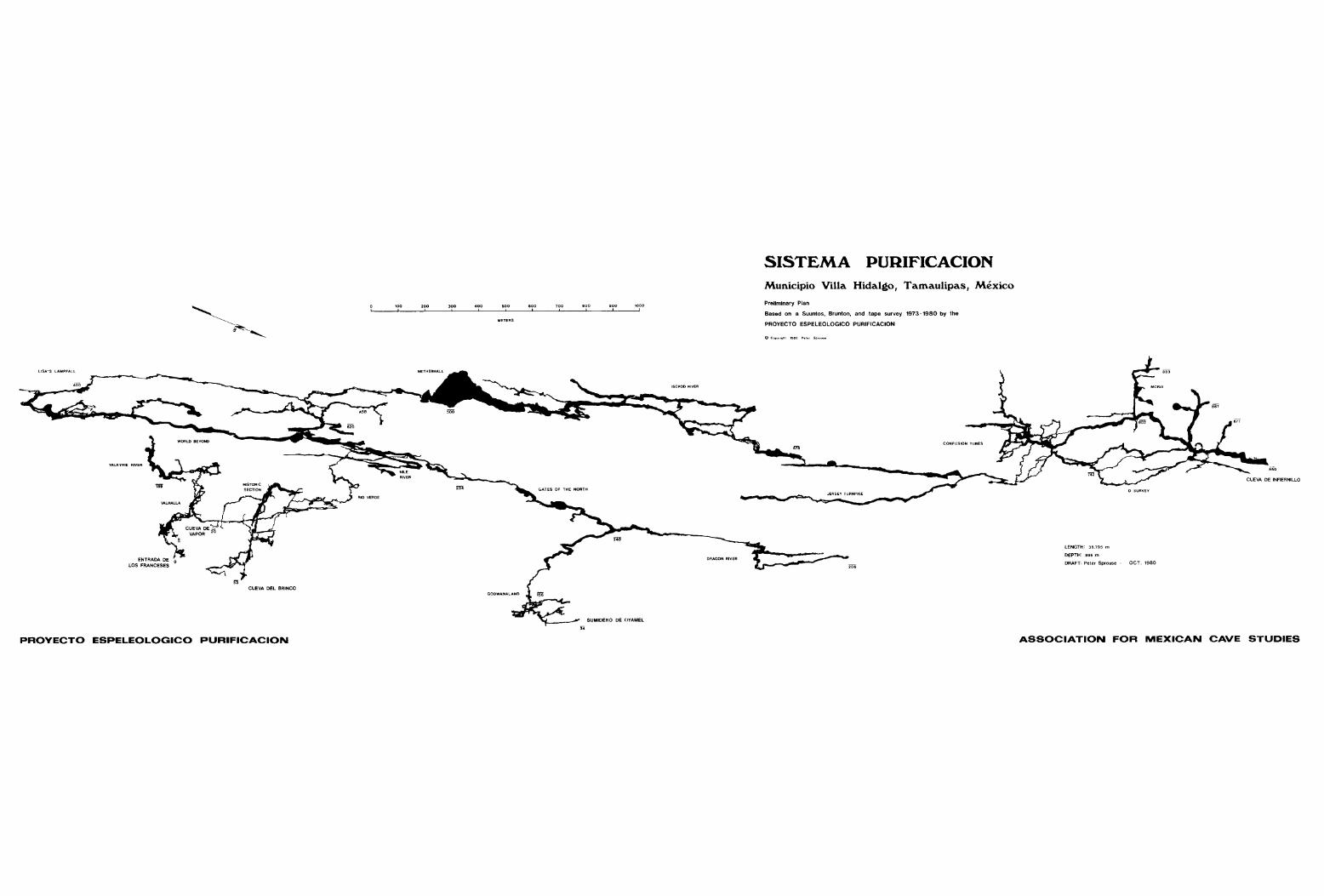
Since the last report in Activities Newsletter #10 J project members have spent 3-1/2 months in thePurificacion area. The length ofSistema Purificacion has increased8833 meters, bringing the totallength up to 36,795 meters. Due tosome new loops that were surveyed,the adjusted depth of the systemis 895 meters.
One large chunk of these kilometers came with the connection ofSumidero Oyamel to Upstream WorldBeyond. (Please see separate article in this newsletter.) A sidepassage J off the connection area,yielded an additional kilometer anda half of passage. The Dragon Riverbegins with a series of swims in awide passage with a very low ceiling.The passage continually becomes narrower and the ceiling rises. Eventually the passage takes the shape ofa narrow canyon with gravel bars,shallow pools,and small cascades. Atone point a large flows tone massfills the passage; the only way onwas a belly-crawl in water underneaththe mound. Growing from the underside of this flows tone was a forestof helictites, spawning the name Macaroon Saloon. Beyond, the sound ofwater cascading down Dragon Fallscould be heard. This flows tone cascadeled up to more stream passage withdeep, green pools and gravel bars.The passage walls were composed ofhighly sculptured and sharp limestoneand calcite. The passage was explored a short way beyond the survey;it appeared to be pinching down.
At the opposite end of the WorldBeyond, below the Fool's Paradise,the Angel's Staircase section wassurveyed. This section had been
24
Angles' Staircase. (Don Broussard)
karst area has numerous caves, thoughtime only permitted the explorationand mapping of a few. Most wereblind pits, 10 to 60 meters deep,filled at the bottom with sedimentand debris.
Sotano de la Cuchilla, to thenorth of the Cueva del Brinco entrance, is a multi-drop cave whichwas mapped to -177 meters where itended at a hopeless pinch. Themain route to the bottom consistedof 8 rope drops between 10-20 meters long. The nastiest drop, RockDrop, was named for the chunks ofrock that continually peeled off aspeople lowered themselves past several sharp ledges. The longest drop,
Another section of Sistemathat had been explored, but notmapped, was the Valkyrie River inValhalla. About 200 meters belowthe entrance,the water of the Valkyrie River flows from a large, deepsump through a pleasant stream passage of sand and gravel bars andclear pools; beautiful formationsadorn the ceiling. The passage narrows to a canyon filled with deepwater. Louise Hose placed fluorescein dye in this stream as part ofher thesis work, and when the downstream section was surveyed onemonth later the canals were stillvivid green.
Down in the lower portion ofSistema, 2 kilometers were addedto the Confusion Tubes. Dozens ofloops were surveyed in the unique,multi-level maze of bedrock tubes.Generally, the tubes are pleasantwalking-size passage, though, occasionally they shrink down to crawlway size or open up into large borehole. Naming the tubes is all partof the fun of "tubing," and some ofthe names adopted were Misty Borehole, Carrot Tube, Potato Tube, Mrs.Lubner's Tube, Octupus Tube, Redneck Borehole, and Silly RabbitTube.
Throughout the rest of the system smaller mapping projects wereundertaken, including the fall 1979connection of the fifth entrance toSistema through Cueva del oso. Onthe surface, much overland surveyingand cave hunting was done. To datethere are 65 caves in the Purificacion area which have been mapped, orin a few cases only sketched. Apre-numbered, aluminum tag has beenplaced at each entrance. The mainpurpose of the tags is to avoidconfusion and duplication; some cavesin the area have been "discovered"4 and 5 times!
A couple days were spent onthe highest point of the ridge (2700meters) in the Mesas Juarez areasearching for caves. This intense
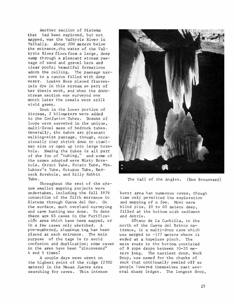
The Hall of the Angles. (Don Broussard)
25
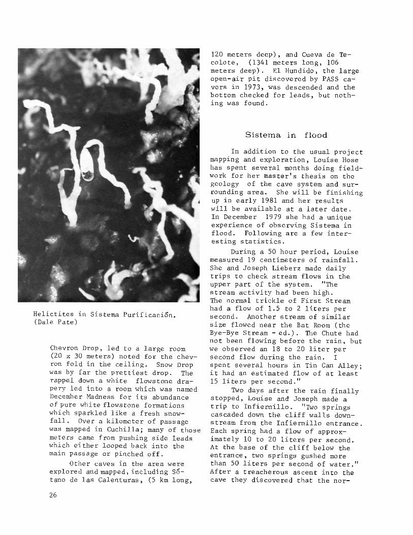
Helictites in Sistema Purificacion.(Dale Pate)
Chevron Drop, led to a large room(20 x 30 meters) noted for the chevron fold in the ceiling. Snow Dropwas by far the prettiest drop. Therappel down a white flows tone drapery led into a room which was namedDecember Madness for its abundanceof pure whi te flows tone formationswhich sparkled like a fresh snowfall. Over a kilometer of passagewas mapped in Cuchilla; many of thosemeters came from pushing side leadswhich either looped back into themain passage or pinched off.
Other caves in the area wereexplored and mapped, including s6tano de las Calenturas, (5 km long,
26
120 meters deep), and Cueva de Tecolote, (1341 meters long, 106meters deep). El Hundido, the largeopen-air pit discovered by PASS cavers in 1973, was descended and thebottom checked for leads, but nothing was found.
Sistema in flood
In addition to the usual projectmapping and exploration, Louise Hosehas spent several months doing fieldwork for her master's thesis on thegeology of the cave system and surrounding area. She will be finishingup in early 1981 and her resultswill be available at a later date.In December 1979 she had a uniqueexperience of observing Sistema inflood. Following are a few interesting statistics.
During a 50 hour period, Louisemeasured 19 centimeters of rainfall.She and Joseph Lieberz made dailytrips to check stream flows in theupper part of the system. "Thestream activity had been high.The normal trickle of First Streamhad a flow of 1.5 to 2 liters persecond. Another stream of similarsize flowed near the Bat Room (theBye-Bye Stream - ed.). The Chute hadnot been flowing before the rain, butwe observed an 18 to 20 liter persecond flow during the rain. Ispent several hours in Tin Can Alley;it had an estimated flow of at least15 liters per second."
Two days after the rain finallystopped, Louise and Joseph made atrip to Infiernillo. "Two springscascaded down the cliff walls downstream from the Infiernillo entrance.Each spring had a flow of approximately 10 to 20 liters per second.At the base of the cliff below theentrance, two springs gushed morethan 50 liters per second of water."After a treacherous ascent into thecave they discovered that the nor-
SISTEMA PURIFICACION
'00!
.00!
'00!
'00!
'00!
.00!
'00!
1000!
Municipio Villa Hidalgo, Tamaulipas, Mexico
Preliminary Plan
Based on a Suuntos, Brunton, and tape survey 1973 -1980 by the
PROYECTO ESPELEOLOG'CO PURIFICACION
CUEVA DEL BRINCO
PROYECTO ESPELEOLOGICO PURIFICACION
SUMIDERO DE OYAMEL
"
LENGTH: 36,795 m
DEPTH: 895 m
DRAFT: Peter Sprouse - OCT. 1980
ASSOCIATION FOR MEXICAN CAVE STUDIES


mally dry boulders were quite wetand slippery. "Just beyond daylight there was a pool of water whichnecessitated wading. Finally, atthe 4-Way Junction we encounteredthe sumps." At this point the sumps,normally below Camp I, were up 52meters from their normal level."Since Camp I was under 24 metersof water, we took our backpacks upthe now dry East Passage. Alongthe way we found the high waterline. The flood, issuing from thesumps, had reached -827 meters below the system's highest point, Entrada de los Franceses. This wasa rise of about 64 meters above thesurveyed level of the sumps. The
passage we camped in, which is alsothe main throughway into the system,had been closed by a sump only a fewhours previous to our arrival."
During this time Louise andJoseph were experiencing incredible,loud rumbling noises. Fearing atfirst that a wall of water was goingto come rushing at them, they laterconcluded that the noises were theresult of rooms and domes openingup to the cave's barometric systemas the water receded back into thesumps. "In the evening I returnedto the lakes to gather water and onceagain the passage roared. The soundwas rhythmic, but different from whatwe had heard before. It was a lowpitched noise similar to water beingdrained from a sink. I sat at theedge of the lake and watched theshoreline. After about a minute,small waves with an amplitude of 5millimeters were on the lake. Theypulsed in the same rhythm as thesound. The water level was droppingso rapidly that I could observe thechange. Since we had placed ourstone water-level marker 80 minutesprevious, the water level had dropped60 centimeters."
The two took a trip back to theNile River, four kilometers from theentrance. Water levels in the streamalong the way seemed to be back down
to near normal flow, however evidenceof recent flooding in these areaswas observed. Upon their return tothe upper portion of the system inBrinco they observed that the waterflows were almost back to normal."All the springs were dry except theperennial ones used as water supplies.The Chute and Tin Can Alley both weredown, but still flowing. Below thesystem, large rivers were flowingin the normally dry canyons of Infiernillo and Hervores." Eleven daysafter the rain had stopped Louiseand Joseph returned to the Infiernillo portion of the system. "TheMain Sump had dropped 24 meters sinceour first visit six days earlier.Camp I formed the shores of the Main
Sump. The sounds of the cave werestill present, but quieter, and mostof the front portion of Infiemillohad dried out, leaving no evidence ofthe very recent flood."
Two weeks later Louise made atrip to The Canal, at the end of theRio Verde in Brinco. "We discoveredthat The Canal had flooded to theceiling since my trip the previousmonth. Sistema Purificacion had definitely been sumped-off at both ends.This cave, and probably many othercaves in Mexico, are much more dangerous in early winter than commonlythought. They deserve our respectas well as our curiosity."
Following is a list of thepeople who participated in theabove mentioned projects: JerryAtkinson, Sheila Balsdon, DonBroussard, Leslie Clarfield, RuffDaniels, Frank Endress, Paul Fambro,David Honea, Jocie Hooper, JeffHorowitz, Louise Hose, Peter Keys,Joseph Lieberz, David McKenzie,Martha Meacham, Dale Pate, PeterQuick, James Reddell, Steve Robertson,Elizabeth Ross, Randy Rumer, WilliamRussell, Mark Shumate, Peter Sprouse,Peter Strickland, Terri Treacy, andLisa Wilko
27

In December 1979, Don AntonioGrimaldo Camero died at his home inPuerto Purificacion at the age of 81.Don Antonio was a great friend ofcavers in the area. He had spentmost of his years in the sierras,except for a period during the revolucion. His home was always open totravellers in the mountains, and manycavers sheltered there over the years.Don Antonio had a great knowledge ofthe caves of the area. He guidedCharles Fromen and others to theentrance of Cueva de Infiemillo in1976. He had complete confidencethat Brinco and Infiemillo wouldbe connected, as they were in 1978.Don Antonio's departure leaves agreat void in the sierras.
PSSDon Antonio Grimaldo. (Terri Treacy)
lir'81 181 181 181 181 181 181 181 181 181 181 181 181 1(;)1 !8llJ
, Purificacion ml'
rn Debido a los esfuerzos de los espeleologos del Proyecto Espeleologico illml' Purificacion, el Sistema Purificacion ha alcanzado una longitud de 36,795 ~GI'rn metros y una profundidad de 895 metros. La conexion del Sumidero de Oyamel
anadio 2.5 kilometros al sistema (vea el articulo en este boletin). Unml' pasaje cerca de la area de la conexion, el Dragon River (Rio Dragon), rendio ml'
rn dos kilometros adicionales. La seccion aguas abajo del World Beyond (Mundo ill
G Mas AlIa) fue levantado mil metros sobre subidas, tiros, y canales a un G
~' sifon en el nivel de -683 metros. Otro chorro, el Rio Valkyrie, fue mapeado ~'
rn aguas arriba a un sifon, y trescientos metros aguas abajo. En la porcion ill
8 baja del sistema, la Cueva de Infiernillo, mas de dos kilometros fueron 8
~levantados en los Confusion Tubes (Tubos de Confusion) un laberinto Gnico ~
rn con niveles multiples de pasajes tubolares. ill8 Otras cuevas en la region que fueron levantados son: Sotano de la 8
~ Cuchilla--mas de un kilometer de longitud y 177 metros de profundidad. ~rn Sotano de Las Calenturas--5 kilometros de longitud y 120 metros de profun- ill
~8 didad. Cueva del Tecolote--1341 metros de longitud, 106 metros de profun- G
I didad. El Hundido--un hoyo grande que fue descendidad y el piso fue exami- ~nado pero ningGn pasaje fue encontrado. ill
~8 Louise Hose, una geologa estudiando el sistema tuvo la experiencia ~G
I singular de observar Sistema Purificacion durante una indunacion en diciembre, I1979. En un periodo de cincuenta horas, 19 centimetros de lluvia fueron
~81' medidos. Chorros en Cueva del Brinco que previamente estaban secos tenian ~81'
corrientes de 10 a 20 litros de aguas por segundo durante la inundacion.Los sifones de Infiemillo subieron 64 metros arriba de SU nivel normal.
m Indicaciones de inundaciones fueron observadas desde el Nile River, a 4 ~GI'Wkilometros de la entrada de Cueva de Infiernillo. Tambien se observo queR El Canal, 180 metros bajo la entrada de Brinco se habia sifoneado. Louise G
I advierte que esta cueva, y quiza otras en Mexico, se inundan mas frecuentemente ~en el inviemo de 10 que previamente se pensaba. ill
B 8~, 181 lSI 181 181 181 lSI 181 IE)! 181 181 181 '81 1(;)1 'iJ
28


Federico Bonet Marco
1906 . 1980
Federico Bonet Marco was bornon October 18, 1906, in Madrid, Spain.He received his Doctor of Science degree from the Universidad Central inMadrid in 1931, becoming Professor ofZoology at the Escuela Veterinaria,Universidad de Madrid in 1932. Heremained in this position until heemigrated to Mexico in 1939. In 1940he became head of the Department ofZoology of the Escuela Nacional deCiencias Biologicas, Instituto Politecnico Nacional in Mexico City.During the latter part of his career,he held a position as a stratigraphicgeologist for Petroleos Mexicanos.He died in Mexico City on June 10,1980.
30
Dr. Bonet, like other biospeleologists from Spain (includingDr. Candido Bollvar y Pieltain),brought to Mexico an expertise andenthusiasm for cave biology notknown there at that time. Alreadyhaving published several paperson the Collembola (springtails) ofSpain, he immediately began an active program of collection and studyof the then virtually unknown caveand endogean fauna of Mexico. Hiscollecting forays, frequently incompany with Bollvar y Pieltain,took him throughout much of thecountry. Until the work of theAssociation for Mexican Cave Studies in the early 1960's, virtuallyeverything known about the cave faunaof Mexico was the direct result ofthe work of Dr. Bonet and his collegues. Although he published several major papers on the Collembola ofMexico, which included many troglobitic and troglophilic species, hismajor contribution to Mexican cavebiology was certainly his pioneeringcollections.
Bonet's studies on Mexican caveswere not restricted to biology, however,and he published three important reports on the caves of different regions in Mexico. A deep knowledgeof stratigraphic geology assisted himgreatly in his speleological work.The first of his reports on Mexicancave areas was published in 1953 andcovered the caves of the Sierra deEl Abra. In the same year he published a volume on the caves of theXilitla region, which included maps,careful descriptions, and meteorological and biological data. It remains an outstanding report and wascertainly as good as anything beingdone in North America at the time.His final major contribution tophysical speleology was a detailedstudy of the caves of the Cacahuamilpa region in Guerrero and adjacentMexico. This study, richly providedwith maps and photographs, is an outstanding contribution to our knowledge of the caves of Mexico.

A final word should be saidabout his other work of great valueto the study of Mexican speleology.In addition to many highly technicalreports on the geology of the SierraMadre Oriental and other areas, hepublished several papers on the general stratigraphy of the Sierra Madre Oriental. In particular, hisguides to the geology of the InterAmerican Highway between Ciudad Victoria and Tamazunchale, preparedfor the 20th International Congressof Geology in Mexico in 1956, are ofgreat value for an understanding of
the geology and karst hydrology ofthis area. In 1963 a paper with Dr.Jacques Butterlin defined the majorgeologic formations of the YucatanPeninsula; also included was a geologic map which remains the bestavailable map for the Peninsula.
The death of Dr. Bonet marksthe end of the first era of thestudy of Mexican speleology. Hiscontributions, both geological andbiological, to the study of Mexicoand its caves will remain for manyyears models to follow.
James Reddell
Photo by: Robert Mitchell
Select Bibliography
1947. Monografia de la familia Neelidae (Collembola). Rev. Soc.Mexicana Hist. Nat., 8:131-192.
1942. Notas sinonrmicas sabre elorden colembolos. Ciencia,Mexico, 3:56-59.
1943. Sobre la clasificacion de los 1947.onocopoduridae (Collembola),con descripcion de especiesnuevas. Anal. Esc. Nac. eiene.BioI., 3: 127-153
1944. Tullberginos de Mexico (Collem- 1953.bola). Rev. Soc. MexicanaHist. Nat., 5:51-72.
1945. Nuevas generos y especies dehipogastruridos de Mexico(Collembola). Rev. Soc. Mex- 1953.icana Hist. Nat., 6:13-45,pis. 2-6.
1946. Laboratorio de Zoologia. Bol.Informacion Esc. Nac. eiene.BioI., Mexico, 4:105-117. 1956.
1946. Mas hipogastruridos anoftalmosde Mexico (Collembola). Rev.Soc. Mexicana Hist. Nat.,7:51-62.
1956.(with C. Tellez). Un nuevo
genera de esminturidos (C01lernbola). Rev. Soc. MexicanaHist. Nat., 8:193-203, pis.22-23.
Cuevas de 1a Sierra Madre Oriental en la region de Xilitla.Univ. Nac. Auton. Mexico,lnst. Geol., Bol. 57. vi + 96 pp., 1963.11 pis.
Datos sabre las cavernas y atrasfenomenos erosivos de las calizas de la Sierra de EI Abra.Mem. Congr. Cient. Mexicana,5:238-273.
1963.Excursion A-14 (sentido norte
sur). Itinerario Cui dad Victoria, Tamps.-Taninul, S.L.P.pp. 69-91 in Estratigrafiadel Cenozoico y del Mesozoicoa 10 largo de la Carreterraentre Reynosa, Tamps. y Mexico,
D.F. Congr. Geol. Internac.,20th Sesion.
Excursion A-14 (sentido nortesur). Itinerario Taninul,S.L.P.-Tamazunchale, S.L.P.pp. 93-117 in Estratigrafiadel Cenozoico y del Mesozoico a 10 largo de 1a Carreterra entra Reynosa, Tamps.y Mexico, D.F. Congr. Geol.lntemac., 20th Sesion.
Biostratigraphic notes on theCretaceous of eastern Mexico.pp. 36-48 in Geolugy of Peregrina Canyon and Sierra deEl Abra, Mexico. CorpusChristi Geol. Soc. Ann. FieldTrip, May 23-26, 1963.
(with J. Butte rlin). Mapas geologicos de la Peninsula de Yucatan. I.-Las formaciones cenozoicas de 1a parte mexicanade 1a Peninsula de Yucatan.lng. Hidrau1. Mexico, 17(1):63-71, map.
rGI I(:JI I(:JI I(:JI 181 I(:JI IGII 181 l(:Ji I(:JI I(:JI I(:JI 181 I~
ml Federico Bonet Marco ~.ill El Dr. Federico Bonet M. murio en la Ciudad de Mexico el 10 de ~8 Junio, 1980. El Dr. Bonet fue un pionero en la recoleccion de fauna ~
~ de las c~vernas..-d~ Mexico. Sus contribucion:s geologicas y biologicas illill al estud~o de Mex~co y sus cuevas permaneceran como ejemplos admirables~88
m I(:JI IElI I(:JI 181 I(:JI I(:JI 181 I(:JI I(:JI 181 I(:JI I(:JI 18
31

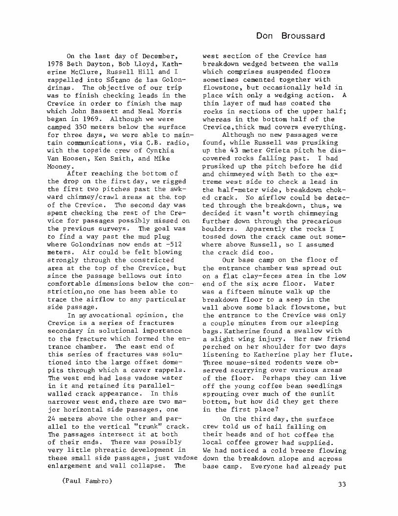
On the last day of December,1978 Beth Dayton, Bob Lloyd, Katherine McClure, Russell Hill and Irappelled into Sotano de las Golondrinas. The objective of our tripwas to finish checking leads in theCrevice in order to finish the mapwhich John Bassett and Neal Morrisbegan in 1969. Although we werecamped 350 meters below the surfacefor three days, we were able to maintain communications, via C.B. radio,with the topside crew of CynthiaVan Hoosen, Ken Smith, and MikeMooney.
After reaching the bottom ofthe drop on the first day, we riggedthe first two pitches past the awkward chimney/crawl areas at the. topof the Crevice. The second day wasspent checking the rest of the Crevice for passages possibly missed onthe previous surveys. The goal wasto find a way past the mud plugwhere Golondrinas now ends at -512meters. Air could be felt blowingstrongly through the constrictedarea at the top of the Crevice, butsince the passage bellows out intocomfortable dimensions below the constriction,no one has been able totrace the airflow to any particularside passage.
In myavocational opinion, theCrevice is a series of fracturessecondary in solutional importanceto the fracture which formed the entrance chamber. The east end ofthis series of fractures was solutioned into the large offset domepits through which a caver rappels.The west end had less vadose waterin it and retained its parallelwalled crack appearance. In thisnarrower west end, there are two major horizontal side passages, one24 meters above the other and parallel to the vertical "trunk" crack.The passages intersect it at bothof their ends. There was possiblyvery little phreatic development inthese small side passages, just vadoseenlargement and wall collapse. The
(Paul Fambro)
Don Broussard
west section of the Crevice hasbreakdown wedged between the wallswhich comprises suspended floorssometimes cemented together withflows tone , but occasionally held inplace with only a wedging action. Athin layer of mud has coated therocks in sections of the upper half;whereas in the bottom half of theCrevice,thick mud covers everything.
Although no new passages werefound, while Russell was prusikingup the 43 meter Grieta pitch he discovered rocks falling past. I hadprusiked up the pitch before he didand chimneyed with Beth to the extreme west side to check a lead inthe half-meter wide, breakdown choked crack. No airflow could be detected through the breakdown, thus, wedecided it wasn't worth chimneyingfurther down through the precariousboulders. Apparently the rocks Itossed down the crack came out somewhere above Russell, so I assumedthe crack did too.
Our base camp on the floor ofthe entrance chamber was spread outon a flat clay-feces area in the lowend of the six acre floor. Waterwas a fifteen minute walk up thebreakdown floor to a seep in thewall above some black flowstone, butthe entrance to the Crevice was onlya couple minutes from our sleepingbags. Katherine found a swallow witha slight wing injury. Her new friendperched on her shoulder for two dayslistening to Katherine play her flute.Three mouse-sized rodents were observed scurrying over various areasof the floor. Perhaps they can liveoff the young coffee bean seedlingssprouting over much of the sunlitbottom, but how did they get therein the first place?
On the third day, the surfacecrew told us of hail falling ontheir heads and of hot coffee thelocal coffee grower had supplied.We had noticed a cold breeze flowingdown the breakdown slope and acrossbase camp. Everyone had already put
33
Bob Lloyd in the top of the Crevice.(Don Broussard)
on extra shirts and were glad to beon the bottom. The surface crew hadice crystals growing on their mustaches. By the time everyone on thecold surface had waited for the lastcaver to prusik to the top they welcomed the activity of pulling out 50kilos of rope.
Return to the Crevice
Over a year later, in Marchof 1980, I returned to check outthe Crevice once again. The rocksbouncing down past Russell Hill in'79 meant that there was still some
34
cave I hadn't pushed yet.Sheila Balsdon, David Honea, and
I rappelled in the first night we arrived. I was first on rope. It wasrather eerie rappelling for 45 minutes in total darkness and not knowing for sure that the rope even reached the bottom until I was on the bottom! The night was spent to theaccompaniment of the birds twitteringincessantly.
The next morning Peter Sprousecame down to sketch in the entrancechamber, while Randy Rumer and PeterQuick came down to help Sheila, David,and I rig the Crevice. We stoppedat the top of the Grieta pitch because at this level is the nastycrack where I had stopped last year,and where we began surveying thisyear. The crack was easily climbableto a hole in the floor which dropped3 meters to a steeply sloping shelflooking out into a shaft. We thoughtat first this was the 43 meter Grietapitch, but it may not be. On theway out, at the room where the nastycrack began, we stopped at a leadwhich I had seen before, but not mapped. The 4 meter long, but low, passage turned 90 0 into a large breakdown maze. We mapped a few stationsinto the maze and called it quits.It had been a long day of Crevicepushing. As I squatted on top of aboulder trying to make sense out ofmy survey notes, Randy crawled up,Peter Q. wiggled away, and Davidscrambled off somewhere else. Thethree came back raving about roomsbig enough to stand in, formations,and enough passage descriptions toconvince me that it really does go.We left the maze for a future mapping trip. The Crevice still goes!
MAPnext page

~f-"-SOTANO DE
LAS GOLONDRINAS
r
360 meters below
entrance
LEVEL I
460 conlinues to
-512 m
GAIETA
o
PARTIAL PROFILE OF
THE CREVICEP,ov'SIQnal map by 0 B'oussa'd andP Sprouse, based on a map byJ Bassett, G Ed,ger, and N. Moms,and on slJIveys by the AMeS1975 -1980
view looking north
(
@ lUO ••'.,S.,"."
Editors' Note: On the Mar~h 1980trip to Sotano de las Golondrinas,an enormous quantity of garbagewas found on the floor of the pit.All of the trash, which includedan assortment of batteries, boots,cans, cooking pots, plastic, andpaper was packaged into three largebags and hauled out of the pit.Many thanks go to the crew forhauling the garbage out. Pleasecavers, take all of your belongingsand trash with you when you leavea cave. And should you have themisfortune of encountering trashwhich others have left previously,please do your share in helping toclean up.
~' '0' 'a' 'a' 'a' ,." G:;on~:;na$ ,a, 'a' ,," ,a, 'e' ,a, ~
~ Debajo de la inmensa entrada del Sotano de las Golondrinas, La ~S Grieta se extiende hasta los -512 metros y alIi termina en lodo. Una S
~ corriente de aire en la entrada de la fisura he causado que various ~m grupos traten del hallar una manera diferente de segiur adelante. Los mS utimos dos esfuerzos de espeleologos texanos conducieron a una fisura ~S
~ que circula hacia otras y continua metiendose a ambos la fisura principal Im y un laberinto de cantos rodados. Este laberinto esta parcialmenteml' explorado y levantado. Esta area puede ser extensiva, pero mas explora- ml'
m cion t topografia sera necesaria para averiguarla. WS El Grupo encontro mucha basura de otros visitantes. Limpiaron el S
ml' sotano completamente, y esperan que pueden conservirlo muy limpio en ~'m el futuro. WS Sfilii 113~GI IGI IGi 10! lei IGi IGI IGi IGI lei IGI IG!=ID
35

36
I>elightful by theO're covered in
~eatly wrapped inOrTrussing gutt
Trash canRubbish coulAll things I ving makeSome waste; it's justIIow things are done.
Yet thoughOuttasightlJnderneath the grounRanging over cavern
Trash is outta bouFteturn the giftsEntrusted to ourA sub terrain ofStrains eyeleslJnder calcit cuRimstone waExcrement s excremeSwine wer n' t desi

Recent Biological
Mexican Caves
Discoveries in
James Reddell
In the Tenth Anniversary issueof the Association for Mexican CaveStudies Newsletter (vol. 4, no. 1,1973),1 prepared a summary of thebiological work of the AMCS duringits ten years of existence. At thattime,145 species, including 64 troglobites, had been described on thebasis of collections made by membersof the AMCS. In the eight yearssince that report was written, workon the biological collections of theAMCS had continued unabated. An addtional 168 species, including 86troglobites, have now been added tothe Mexican cave fauna as a result ofthe collecting efforts of AMCS cavers.A large part of the material obtainedduring the last 18 years remains unstudied, particularly that mater-ial collected in the Purificacion,Huautla de Jimenez, and Cuetzalan regions. The purpose of this brief report is to summarize work in theseand a few other areas. Most of thespecies collected during the lastfew years remain undescribed, butmany will be published in a forthcoming biological bulletin of theAMCS.
Purificacion Area, Tamaulipas:The first collections to be made inthis area were by Roy Jameson andDavid McKenzie in 1973. This earlyreconnaissance trip resulted in thediscovery of several of the morenotable species known from this region, but by far the most excitingfinds were not to be made until theProyecto Espeleologico Purificaciongot well under way. The only troglobite described from the area is ablind leiodid beetle, Ptomaphagus(Adelops) mckenziei Peck, from Cueva de California and Cueva del Brinco. This is only the second known
troglobite in this family in Mexico,the other being known from the Sierrade Guatemala.
Other exciting species of terrestrial troglobites known from thisarea include a new genus and speciesof chactid scorpion (now known fromthree caves), three new species ofeyeless pseudoscorpion, a blind tarantula, blind harvestmen of the genus Hoplobunus, the most highly caveadapted centiped in Mexico (a newspecies of the scolopendrid genusNewportia), blind millipeds belonging to several families but stilllargely unstudied, and three speciesof eyeless trechine beetle of thegenus Mexaphaenops. This last findis particularly notable in that nowhere else in Mexico do more than twospecies of trechine beetle occur ina single area (and then they belongto very different genera). Furthermore, there are only four otherspecies of the genus known; thus,almost half of the known species ofthe genus occur in the limited confines of the Purificacion area.
Another remarkable aspect ofthe cave fauna of the region is thepresence in it of four species oftroglobitic aquatic isopod. Undescribed species of the delicate,elongate isopods of the genera Mexistenasellus and Caecidotea occur inthe sump lakes in Cueva del Infiernillo. A new species of Speocirolana is known only from Sotano delas Calenturas, where it is fairlyabundant in the deeper lakes in thatcave. Species of Mexistenasellusare know from caves and springs inCoahuila, Nuevo Leon, San Luis PotoSl, and Veracruz. The nearest records of Caecidotea are in Texas tothe north and Veracruz to the south.
37

Speocirolana is a widespread genusranging from Coahuila south toPuebla in the Sierra Madre Oriental.The most spectacular discovery inthe area, however, was a species ofmarine-derived isopod of the suborderValvifera. There are no records ofthis suborder from caves in the NewWorld and only one or two doubtfulrecords of its occurrence in freshwater. Its presence in the streamin the World Beyond in SistemaPurificacion is amazing.
Cuetzalan Area, Puebla: Although some collections were made inthis area in 1973 and 1976, little ofthis material has been studied. Theonly troglobite described from thearea is the spirobollelid millipedReddellobus troglobius Causey. Thisis the only New World troglobite inthe order Spirobolida and is a goodindication of the unique fauna ofthis region. Among the more unusualanimals known from the region areseveral species of blind spider(including a blind tarantula), glomerid millipeds (commonly referredto as pill millipeds because theyroll into a tight ball much likepillbugs, with which they can beeasily mistaken), a possibly troglobitic scorpion of the genus Vaejovis, and a troglobitic beetle of thegenus Mexisphodrus. Recent findshave included a new species of troglophilic crayfish of the genus Procambarus, subgenus Villalobosus-.-This brings to three the number ofcrayfish known from the caves of thearea, more than in any other part ofMexico.
San Pablo Zoquitlan Area, Pueb-la: Few collections have been madein this interesting karst region,but these give promise of many exciting things to follow. Includedin the fauna is a new genus and species of snail belonging to the family Charopidae and a completely eyeless spider of the genus Nesticus(only the second species in Mexicoto totally lack eyes.
Ruautla de Jimenez Area, Oaxaca:A few collections were made in this
38
area as early as 1966, anJ troglobitic millipeds, collembola, and carabid beetles have been described.The most notable finds, however,have been made during the recentexpeditions to La Grieta, Sotanode San Agustin, and other caves.One discovery stands out more thanany other: the largest and mosthighly cave adapted scorpion knownfrom caves in the world. Thisamazing new genus and species wasfound first by Roy Jameson and PattyMothes in Cueva del Escorpion. Ithas more recently been collected atdepths up to 820 meters in Sotanode San Agustin, La Grieta, and LiNita. Study has shown that itsclosest relatives are the smalltroglobitic and endogean speciesof the genus Typhlochactas. Othernotable finds in the Ruautla region include the first completelyeyeless tarantula in the world, onespecimen of which was found in LaGrieta.
Xilitla Plateau Area, San LuisPOtOSl and Queretaro: A few smallcollections were first made in thisarea in the late 1960s. Recentcollections have included specimensof blind planarian, a completelyeyeless diplurid spider, a new record for the troglobitic tarantulaSchizopelma stygia (Gertsch) (previously known only from caves nearAhuacatlan), and new species ofblind millipeds and harvestmen.Most of these collections remainunstudied.
Aquismon Area, San Luis Potosi:A few recent collections have beenmade by Peter Sprouse, Terri Treacy,and others in the area, but all remain unstudied. The most importantfind since the initial collectionsin the 1960s was of an eyeless cray-fish of the genus Procambarus fromthe sump pool in Roya de las Guaguas.This species, collected by Andy Grubbs,is the only troglobitic crayfish inMexico north of Oaxaca and Veracruzand possibly belongs to a subgenus(Scapulicambarus) not previouslyknown to have cave representatives.

The significance of this discoveryis that the deep base-level watersof more northern Mexico may harbor a very distinctive fauna.
Potrero Redondo Area, NuevoLeon: Recent collections weremade in this poorly known area byWilliam Elliott in May 1980. Theonly material identified from hiscollections are the carabid beetles.Surprisingly, a series of small eyeless beetles proved not to be trechines but instead were representativeof a new blind species of Rhadine.The only other record of blindRhadine from Mexico is from Cuestade Chipinque, Nuevo Leon, collectedin 1969 by Stewart Peck and lostuntil a few weeks before Elliott'sspecimens were identified. Thesetwo species are most closely related to Rhadine persephone Barr fromTooth Cave, Travis County, Texas.This indicates that the northernend of the Sierra Madre Oriental,sorely neglected by cavers, is potentially of great interest.
The most interesting thingabout all of the recent biologicalwork in Mexico, most of it quiteincidental to other goals (such asmapping record setting, and basicreconnaissance), is that we stillknow appallingly little about thebiology of Mexico's underground.The recent collections in Mexican
caves, in areas reasonably well knownnow, still produce startling finds.Only in the most intensively studiedregions (Sierra de Guatemala, Yucatan Peninsula, Sierra de El Abra)do we have any hope that we havefound the majority of the speciespresent. And even here we cannotbe all that sure. As an example,two recent collections made inSotano del Arroyo and Sotano de laTinaja, two of the best studiedcaves in Mexico, produced interestingspecimens: in one, a new record forthe rare troglobitic mysid, Spelaeomysis quinterensis (Villalobos),and in the other a new species oftroglobitic pseudoscorpion. Thesetwo casual collections point upvividly the need for collecting byany caver willing to stick a smallbottle of alcohol in his pocket andtake a few minutes to turn overrocks or look in a pool.(Editors' Note: All biological collections must be labeled with thefollowing information: 1) Name ofcave and its location, including thestate. 2) Name of person(s) whocollected. 3) Date collected.Print this information with a pencil(ink will smear in alcohol) on asmall piece of paper and put thepaper in the bottle. Send the collection to the AMCS, P.O. Box 7672,Austin, Texas 78712.
ro
, ':esu:en ':e =;osp':~eo';~ia ':'ex:ana'''' ".. ""~~ Un resumen de las colecciones biologicas del AMCS de 1963 ~W a 1973 se publico en el AMCS Newsletter, Vol. 4, No.1, 1973.ml' En aquel entonces, se habian descrito 145 especies, incluyendo ami'w 64 troglobios. Durante los 8 anos subsiguientes, otros 168 es- WG pecies adicionales, incluyendo 86 troglobios se han anadido a 8
~la fauna subterranea de Mexico. Este articulo es un resumen del ~
W trabajo que se ha realizado en varias regiones de Mexico desde WG 1973. G
~ "... "" "" "" '''' '0' '0' '''' ".., ,@ ,,,. ,,,J39

The Piloztoc Connection
Bill Liebman
On Christmas evening, 1978, inCuetzalan plans were made to investigate a 4.1 second virgin pit inCueva Piloztoc. The cave was foundin late 1977 by Peter Lord who explored it a short way to a 3 meter drop.In the late Spring of 1978 Peter,Rick Rigg, and others continued theexploration and mapping to 300 meterswhere they encountered the deep pitand they timed rockfalls at 4.1 seconds. Low on gear and time, the pitwas left to go unchallenged untilthe next season. Cueva Piloztoc isperched high along and at the opposite end of the valley from SimaZoquiapan. A connection seemed inevitable.
December 16 found Rick Rigg(ID), Will Howie (MS), Jim Eyre(England), Gareth Davies (England),Alejandro Villagomez (Mexico), andmyself (CA) getting the usual latemorning early start. With visionsof uncertain depth and a possibleconnection to Sima Zoquiapan a kilometer away, we loaded ourselves downwith gear and ropes. Cueva Piloztocis located in a large sink, a kilometer long, 500 meters wide and nearly 200 meters deep. Lying to thenorth, at the opposite end of thesink is the 62 meter entrance shaftto Sima Zoquiapan.
A relatively small stream entered the somewhat hidden entrance toCueva Piloztoc. The entrance issmall by Cuetzalan standards. Youcan stand up inside, but that'sabout all. The passage is 2 metershigh and averages 2 meters wide.It took about 30 minutes for us toscramble down the first few hundredmeters of cave to the lip of thepit. The upper portion of cave ismostly walking passage with a fewareas where you have to stoop. Thepassage is eroded out of a thinlyinterbedded shale seam that is black
40
in color with dark gray-black limestone. The shale seam cross sectionexposed in the wall of the passageis very contorted with individuallayers broken and discontinuous.Many kink folds are visible amongthe contortions displayed in thewalls of the passage. This explainsthe ease with which the passageformed where it is. Unlike thewalls, which you can pull pieces ofbroken rock out of, the ceiling isof good gray-black limestone. Thisupper section of cave exhibits signsof frequent flooding in the form ofstringers of clothing and debrishanging off of protrusions in thewalls. Considering the frequentflooding and the ease of erosionof the shale out of the country rock,it is not surprising that this section of cave is devoid of formations.
Upon reaching the pit, a fewrocks were tossed to stimulate oursenses, and then we began the taskof rigging. Looking across the pit,you can't help but notice that theshale seam does not continue in thefar limestone wall. The pit isformed on the plane of a verticalfault. The lip of the pit servesas a launching point for the debrispile and over an hour was spentcleaning loose material away fromthe edge. Finally the rope waslowered into the pit, and we allmade the descent. The bottom ofthe pit was unimpresseive. In fact,it was down-right disappointing.It was triangular in shape, about4 meters on a side. Not too bigfor a 4.1 second drop. There were3 leads off the bottom, all of themcrawlways.
We crawled off down the largestof the leads, a hands and kneescrawl that takes the main flow ofthe stream with a little airflow.After about 10 meters we got to a

1-1/2 meter waterfall and morecrawling. We crawled and periodically stooped on down the passagefor well over an hour. Due to thelogistics of six people in crawlingpassage, we were moving very slow.This however, gave one the opportunity to take in the features of thecave. This portion of the cave wasin limestone, unlike the upper portion of the cave that is a shaleseam. The passage is very low andvery narrow. The average height ofthe passage is 1.5 meters and widthabout a half meter on the floor,becoming narrower towards the nearbyceiling. The passage evidently haseroded down to the present floorwhich is a very resistant basal conglomerate, typical of most caves inthe area. Not being able to penetrate this resistant unit, the passage has eroded sideways, formingan upside down "T" shape. Manybends and half meter waterfalls andcascades constitute the continuationof the passage. Interesting sodastraws were seen in various places,including some which stair-steppeddownwind in helictite fashion. Manychert lenses were present in thewalls of the muddy brown coloredlimestone.
Finally, word came back thatwe had entered a borehole up ahead!This passage immediately split, going two directions. To our right,about 60 meters away, we could seedaylight. Wandering over to thelight, we found a large lake at thebottom of a beautiful sunlit shaft;a deep one. Although none of uShad visited Sima Zoquiapan, we assumed that we had made our connec-
tion. Everybody was rather burned outfrom having crawled at least a halfkilometer and knowing we had to returnthrough that nasty stuff. We discussedthe merits of getting this new sectionmapped and getting the heck out. Nobody really felt like mapping, but weall knew the rule: Map what you scoop!So we broke into two survey teams, andleapfrogged back through the crawl tothe pi t-
At the bottom of the pit somefossils were preserved in the limestone. I did not view them, buttheir description matches the cretaceous pelecypods and cephlapodsI have encountered in nearby CuevaLa Providencia. The climb out ofthe pit was interesting. The limestone is a muddy brown color with ahigh concentration of lensoidalchert interbeds. As you ascend thepit, the concentration and the thickness of the chert layers reducesdrastically. The chert is much moreresistant than the limestone andweathers out as ledges, sometimes upto 3 or 4 inches wide protruding fromthe wall. As you climb, the far walloverhangs the pit, and for a shortway you are virtually against thewall. The wall recedes again and itis once more free the last 20 feetto the lip.
After everybody was up top wegot the measurement of the pit ...it was 226 feet deep. We exitedthe cave at midnight, having spent12 hours underground. It was drizzling outside and a might chilly.We warmed up with some hot Boon Stewupon our return, mellowed out, andgot some much earned sleep. TheSewer was bigger!
Cueva Piloztoc
Este art1culo describe la Cueva Piloztoc en Cuetzalan, Puebla,y su conexion con Sima Zoquiapan en diciembre 1978. Las dos cuevasquedan en extremidades opuestas de una dolina que tiene un kilometrode longitud y 200 metros de profundidad.
41

Unstudied Karst Areas of Mexico
Peter Sprouse
Despite the intensive exploration over the last two decades, thecaves and karst of Mexico remainpoorly known. Many significantkarst areas have not been visited.This article will describe some,but by no means all, of the karsts(limestone, gypsum, and lava), thatare largely uninvestigated and likelyto be fruitful for cave exploration.These areas represent large voids inour knowledge of the caves of Mexico.The descriptions here are made inthe hope that groups investigatingthese cave areas will send in reports to the AMCS. The followinglist will generally describe areasrather than specific leads, as wasthe case in an article by WilliamRussell in Inside Earth No.1, (Russell, 1972). Many of the leadslisted in that article remain unchecked.
Areas are grouped by state and,if available, the Detenal 1:50,000topographic map is listed in parentheses. These maps were used to describe most of these areas, andshould be considered essential forfield use. The UTM coordinate gridon these maps provides a good methodfor recording cave locations. I havelisted high and low elevations forlocal areas, although these shouldnot necessarily be interpreted asthe vertical potential, which can beaffected by any number of geologicaland geographical factors.
ChihuahuaRIO BRAVO RANGES (covered by sev
eral topo maps). A string of isolated limestone ridges extends northwestfrom Ojinaga along the Texas border.
42
Only a few caves are known in thislarge (5000 km2) area.
Coahuila
SIERRA LA GAVIA (G14A83 Reata).A desert limestone ridge with twocaves, "Cueva (Guano), Cueva Prieta",shown at 1300 meters elevation.
LOS LIRIOS (G14C35 San Antoniode las Alazanas). Near the town ofLos Lirios are several high limestone ridges with good cave potential. Peaks at 3700 meters, baselevel at 2000 meters.
HUACHICHIL (G14C44 Huachichil)Coahuila and Nuevo Leon. Threeridges up to 3000 meters near Huachichil. Cave indicative featuresare shown on the topo: "Cerro laCueva, Canada la Cueva, Cerro lasCuevas."
Guerrero
PLAZA DE GALLaS (E14A67 Pilcayos). Plaza de Gallos is located ona limestone ridge 15 kilometers westof Taxco on the road to Ixcateopande Cuautemoc. The map shows severaldolinas at elevations up to 2400 meters, with nearby base levels at 1400meters.
TLAMACAZAPA (E14A68 Taxco, E14A78 Iguala). A 2200 meter high uvalakarst plateau containing the villageof Tlamacazapa, base level 1200 meters. Located 10 kilometers eastsoutheast of Taxco, and 15 kilometerssouth of Dos Bocas. Good cave potential.

HIDALGO HIGHLANDS. A large,high (2000+ meters) area along theInter-American highway between Tamazuncha1e and Actopan. Some cavesare known, but many parts of thearea remain uninvestigated. Grutasde Xofafi, an unmapped, but we11known cave northeast of Laguni11a,is a complex descending cave that1S rumored to be quite deep.
HIDALGO LOWLANDS. The easternflank of the Hidalgo highlands. Thisarea undoubtedly contains large cavesas does the adjacent Cuetza1an to theeast. Northeast of Ixmiqui1pan isanother well-known, but unmapped cave,The Grutas de Tono1tongo - a hot waterresurgence cave. The nearby Lagunade Meztit1an is rumored to mysteriously drain at times. A large riveris reported to go underground eastof Grutas de Xofafi.
Mexico
MONTE GRANDE AREA (E14A58 Tenancingo). A karst plateau 10 kilometers southwest of the religiousshrine of Cha1ma. Elevation 2300meters, base 1500 meters.
SIERRA LA GOLETA (E14A66 Amatepec). A wide range, elevation 2200meters, with several caves markedon the map: "Caverna Pedro Ascencio,Cavernas Leona Vicario, La Cueva(three of these)." Located 50 kilometers northwest of Igua1a.
NayaritLA CUEVA (F13B81 San Pedro
Ixtacan) . Two features called "LaCueva" and "La Cueva Prieta" at 1400meters, base level 500 meters, possibly in volcanics. Located in a remotearea 30 kilometers east northeast ofE1 Venado.
Nuevo LeonSIERRA EL AZUL (f14A35 Sierra e1
Azul). Nuevo Leon and San Luis Potosi.A 2500 meter high, 1400 meter baselevel range with a "Cueva de los Riscos" marked on the map. Located 30kilometers southeast of Matehua1a.
POTRERO LAS HOYAS (F14A36 Mier yNoriega). A 2000 meter high rangewith cave indicative localities:"Canon 1a Cueva Caida, Canon lasCuevas, Arroyo Cueva Urbana, Picachoe1 Socavon." Base around 1400 meters. Located 15 kilometers southwest of Mier y Noriega.
CANON DE HUASTECA (G14C25 GarzaGarcia). A series of highly foldedlimestone ridges with good cave potential, stretching west to Saltillo andbeyond. High elevations 2000 meters,base 900 meters. Several caves known.
LA VENTANA AREA (G14C46 Rayones).A high limestone area, 2700 meters,wi th a large "window" 100 meters widenear the top of a ridge. This entrance, La Ventana, apparently opensin the bottom of a large pit. Cavershave not reached it. Base level1n the area is around 1100 meters.
GALEANA AREA (G14C56 Galeana).A 2500 meter high gypsum karstplateau lies 10 kilometers southwest of Galeana and 6 kilometerssouthwest of Pozo de Gavi1an. Baselevel may be around 1800 meters,level of the Galeana plain. Goodpotential for deep gypsum caves.
LA POZA (G14C66 San Jose deRaices). A gypsum karst area 15kilometers north of Pabil10, at anelevation of 1800 meters. Two features marked on map are "Dolina"and "Resumidero."
LAGUNA SANTA ROSA (G 14C6 7Iturbide). AS km2 po1je sits atan elevation of 1500 meters, whosewater probably resurges to thenortheast at a wet weather resur-
43

gence on the road from Linares toIturbide, elevation 600 meters.Limestone peaks in between rise upto 2400 meters.
San Luis POtOSISIERRA LA TRINIDAD (F14A65
Guadalcazar). A gypsum karst ridge.6 kilometers northwest of the townof Guadalcazar. Elevation 2100 meters, base 1800 meters.
SIERRA EL PINAL (F14A68 Saitodel Agua). A massive limestonekarst ridge, 1800 meters with several parallel karst ridges. Base level 700 meters, 20 kilometers northeast of Cd. del Maiz.
PAPAGAYOS (F14A78 Cd. del Maiz).Four hundred square kilometers ofclosed drainage, tropical karst.A series of north-south ridges withlarge uvalas and several poljes.High points at 1800 meters, baselevel at 500 meters. This area issouth of Highway 80 between AntiguoMorelos and Cd. del Maiz. Few cavesare known.
SIERRA TREJO (F14A85 Santa Catarina). A ridge 6 kilometers northeast of Santa Catarina with a clusterof deep dolinas or pits on its westernslope. Elevation 1600 meters, baselevel at 1200 meters.
LLANO EL RESUMIDERO (F14A87 SanFrancisco). A gypsum plain, elevation 1000 meters, with sinkingstreams. Six kilometers southeast.of San Francisco.
LAGUNA GRANDE (F14A88 Alaquines).Six hundred plus square kilometers ofclosed drainage, tropical karst.A southern continuation of the Papagayos karst. Contains a 4 km2 polje,Laguna Grande. Located north ofHighway 70 between Cd. Valles andRio Verde. A few caves are known,but the area is mostly unexplored
44
and very promising.
MICaS (F14A89 Damian Carmona).A 700 meter high karst ridge cutthrough by the Rio Valles at Micos.Base level 100 meters. Few cavesare known in this highly karstedrange.
TamaulipasMESA LA LIBERTAD (F14A48 Llano
de Azuas). An extensive, 2000 meter high limestone karst ridge flanked by two parallel ridges. Baselevel 800 meters. Good cave potential.
LAGUNA LA ESCONDIDA (F14A58Ocampo). A wide limestone karstridge at 1400 meters. Base levelis probably at 400 meters in theMalpais Lavafield, although thisalso has underground drainage.The ridge contains several poljes,including Laguna la Escondida. Avery promising area located 20kilometers west of Ocampo.
SIERRA DE TAMAULIPAS. A largelimestone uplift southeast of Cd.Victoria. Pits and karst have beenseen on top from the air. A largeunmapped "drive thru" cave, Cuevade Cuarteles, is mined for phosphates northwest of Aldama, offHighway 180.
SIERRA CUCHARAS (F14A59 LomaAlta, F14A69 Quintero). The northern extension of the highly cavernousSierra de El Abra, this 35 kilometerlong ridge extends from the the northern El Abra pass to the Sierra deGuatemala. Elevation 400 meters,base level 100 meters. Severalsprings emerge at the base of therange including the large Nacimientodel Rio Mante (see Exley, 1979). Afew large caves are known in thesouthern section. In a rumored pitabove Quintero, rocks bounce for12 seconds to water.

TabascoNorthern extensions of the
Chiapas ranges in Tabasco are knownfor their cockpit karsts (Jennings,1971). However this promising arearemains almost entirely uninvestigated.
VeracruzCOFRE DE PEROTE. A volcanic
area of good lava tube potential.One tube, Cueva del Volcancillo,has been mapped to a length of 590meters and a depth of 140 metersand may continue (Reddell andElliott, 1974).
More information on these areas maybe obtained from the AMCS and itspublications. In Austin, the AMCSmaintains files on the caves ofMexico and also a collection oftopographic maps. The Detenal mapsmay be purchased in Mexico, D.F. atBalderas No. 71 P.B., Col. Centro,Mexico 1, and in Monterrey at 15de Mayo 545 Oriente, Escobedo yZaragoza.
Reports, maps and photos arerequested from all caving projectsin Mexico for AMCS publications.It is also hoped that groups cavingin Mexico will practice good caveconservation and extend utmostcourtesy to landowners and localinhabitants. It is generally AMCSpolicy to apply local names to caves.Should a cave not have a name, thenthe name of a local place or nearbyfeature is usually given.
References
Exley, Sheck,1979, jNacimientos:AMCS Activities News LetterNo.10, p.22-31.
Jennings, J.N.,1979, Karst, TheMIT Press ,p. 192.
Reddell, James and William Elliott.Trip report, Cofre de Perote,Veracruz. AMCS Newsletter V.1:7-13.
Russell, William 1972, Mexico, whatneeds doing. Inside Earth 1:8-10.
[ 181 101 181 181 181 18! 181 101 181 181 181 18! '~[;J
~ Regiones no estudiados del karst mexicano [;J
[;J~' Muchos regiones de karst en Mexico no han sido visitadas por ~
I espeleologos. Este artlculo describe varias de estas areas (de cal- Wiza, yeso, y lava) cuales son, por su mayor parte, inexploradas. [;J~'
[;J I~
Estas descripciones se presentan con esperanzas de que grupos inves-tigando estas regiones proporcionaran informes al AMCS. Las regiones
[;J estan agrupadas segun el estado en que se localizan, y si es disponible, ml'
~ se da el numero de la mapa topografica DETENAL 1:50,000. W
181 18! 18! 101 181 18! 18! 18! 18! 101 181 181 ISE= II!
PRACTICE CAVE CONSERVATION
45

Caving in Western Mexico
James Reddell
Entrance to Cueva Hundida ln the Sierra de San Lorenzo. (David MCKenzie)
Despite the proximity of northwestern Mexico to western Texas t NewMexico t and Arizona the vast limestoneareas of Chihuahua t Coahuila t and Durango have been seldom visited. In1977, I wrote a summary of our knowledge of the caves of Chihuahua andDurango (AMCS News. vol. St nos. 2-3 tpp. 84-93), in which I listed sevenexplored caves for Chihuahua and fourfor Durango. No new caves have beenvisited since that time. The cavesof Coahuila have been a little better studied, but with the exceptionof Cueva del Porvenir south of CuatroCienegas, no major finds have been
46
made in the last ten years. Thisentire area holds considerable promise for significant caves. The limestone exposures are extensive t andthere are many rumors of large cavesthroughout the region.
On June 6, 1980, David McKenzie,Mark Shumate, and I left Austin withthe intention of checking some ofthe many leads in southwestern Coahuila, Durango, and Chihuahua. Iwas hopeful that we would find somegood biological collecting cavessince all of the large caves thathad been previously visited containeda rich fauna. In this we _were dis-

appointed, partly because of the timeof year and partly because some ofour better leads could not be visitedthis trip.
Sierra de TexasSouth of Cuatro Cienegas in the
Sierra de Texas, the topographic mapshowed Cueva de Tabaco. We werestartled to see a highway sign pointing the way down a paved road to"Cueva de Tabaco." Certain that wewere on to a great start in some commercial or semi-commercial cave wesoon arrived at an impressive monument. This consisted of a largeplatform on which had been builtlarge stela-like pillars. On thesewere inscribed the names of theheroes of a battle in which BenitoJuarez had saved the archives ofMexico which had been hidden inCueva de Tabaco. The cave itself,however, was somewhat less impressive than the monument. It consisted of a single dusty chamber about6 meters long and 8 meters high,with only a narrow sloping fissureleading from it.
Sierra de San LorenzoAt the town of Coyote we found
an excellent guide who took us tothe Sierra de San Lorenzo, where Ihad heard of a cave containing alake with blind animals. Our guideproceeded to take us to six caveentrances: Cueva del Vapor, Cuevadel Granjeno, Cueva del Guano, Cuevade los Indios, Cueva Hundida, and anunnamed cave. Cueva de los Indios,supposedly once a long cave, hadonly a short crawlway left followinga collapse of the entrance. CuevaHundida was a large sinkhole about15 meters in diameter and 10 metersdeep. This drops into a large breakdown floored room, but we did notenter. It supposedly had held Indianmummies at one time. The unnamedcave was a climbable sink leadinginto a single breakdown floored
passage about 5 meters wide and upto 3 meters high. It ended in abreakdown choke after about 25 meters.We mapped Cueva del Vapor, which issituated at the base of the Sierraand has a large opening 10 meterswide and 5 meters high. A breakdown floored passage extends backfor about 50 meters before endingin collapse. To the left of themain passage, a low crawlway extendsdown a short slope before it drops3 meters into a high 200 meter longwalking passage. A strong air-flow throughout the cave indicatesthat additional passage might befound. Cueva del Granjeno is located on the opposite side of a ridgefrom Cueva del Vapor and is enteredby a steeply sloping sinkhole intowhich some water runs. At the bottom of the entrance slope a narrowwinding passage about 1.5 meterswide and up to 3 meters high extendsfor approximately 100 meters beforewashed-in silt makes it necessary todig to continue. Airflow indicatesthat the cave may be much longer. Awhite scorpion, and numerous deadtroglobitic millipedes indicate thatthe cave is of possible biologicalinterest and it should be revisitedduring a wetter time of year. Cuevadel Guano, once called Cueva de Aguabecause of a now dried-up stream init, was entered through a rubblefloored sinkhole between two limestone ridges. A scramble down thisslope leads into a large breakdownfloored room. After about 75 metersa mine shaft intersects the cave.Beyond the shaft the cave changescharacter and becomes a steeplysloping passage. The bottom sideof this slope soon ends in breakdown, but it is possible to walkalong the upper part of the passagefor several hundred meters to wherea narrow passage leads into an extension of the main passage for a hundred or more meters before apparentlyending. The most notable thing aboutthe cave was an enormous number ofdead bats. These littered the floorand some still hung from the cavewalls. No live bats were seen. The
47
presence of sick and dead bats wasalso noticed in Cueva del Vapor.Whether this represents poisoningfrom pesticides (heavily used in theLaguna District of Coahuila) or froma rabies epidemic is not known.
The caves investigated in theSierra de San Lorenzo appear to beformed as the result of the solutionof gypsum beds from the surroundinglimestone. In Cueva del Vapor andCueva del Guano, virtually no gypsumis left; only in a few places cangypsum be seen on the cave walls.Cueva del Granjeno, however, is agood intermediate example of cavedevelopment. With the exceptionof the entrance room, where a littlelimestone is exposed, the entirecave is formed in gypsum. It willbe interesting to look at more cavesin the Sierra de San Lorenzo to seeif there are any limestone caves.Many caves were known to our guidein the immediate vicinity and othersdoubtless exist in the more easternpart of the range.
Torreon AreaWe spent several days looking
for caves in the vicinity of Torreon.A copy of the Torreon 1:250,000 topographic map had three caves marked onthem. The first one, Cueva del Indio, was never reached. The secondlead led us to a high fissure-likeopening several hundred meters up ona cliff face. With no easy way toreach the cave, we decided to lookfor the third lead. Located nearPresa Francisco Zarca, Cueva delGuano was found to be a short cavewith a large shelter-like entrance.The cave was dry and dusty, and wasof little interest.
From Presa Francisco Zarca, wedrove through a short tunnel toemerge in a beautiful canyon. Highcliffs with knife-edged ridges ofvertical bedded limestone remindeduS of Hausteca Canyon near Monterrey.Several cave entrances were spotted,but only one 10 meter long cave waschecked.
48
Mapimi
Grutas de Mapimr is located inthe Sierra del Rosario and is about18 kilometers SSW of Mapimr. Aroad extends to just below the entrance, and some mining has beendone near the cave. The cave itself is gated and only our officialguide had a key. Just inside theentrance, an iron spiral staircaseleads down the 8 meter drop to thefloor of the cave. One enormous,well decorated room contains numerousformations, some of which remain intact. It was surprising to see thatthe cave had not been completelyvandalized, although somevery large formations had beensawed off. Still there remain anabundance of totem poles and otherdelicate formations. The cave wasnot mapped, but it is estimated tobe several hundred meters long andup to 50 meters wide in places.A collection here included a rareeyed species of Rhadine beetle. Ourguide knew of several other caves inthe area, and also described a long,lower-level passage (unknown to us)in Cueva de los Riscos. (Riscos islocated 6 kilometers south of Mapimi,and is described in the PEMEX Guideto Mexican Caves to be Grutas deMapimr. )
Gomez PalacioNear Gomez Palacio, there is
a cave described in Geografia deChihuahua as "one of the marvelsof the Sierra." This cave, Grutasde Santo Domingo, is located nearthe village of Guadalupe y Calvoclose to the border of Chihuahuaand Sinaloa. We learned that a 20to 30 kilometer hike through somerugged country is required to reachthe cave. We were not prepared forsuch a hike, so we turned back. Onroute, we stopped at Cueva del Diablonear Salaices (see AMCS News. vol. 5,
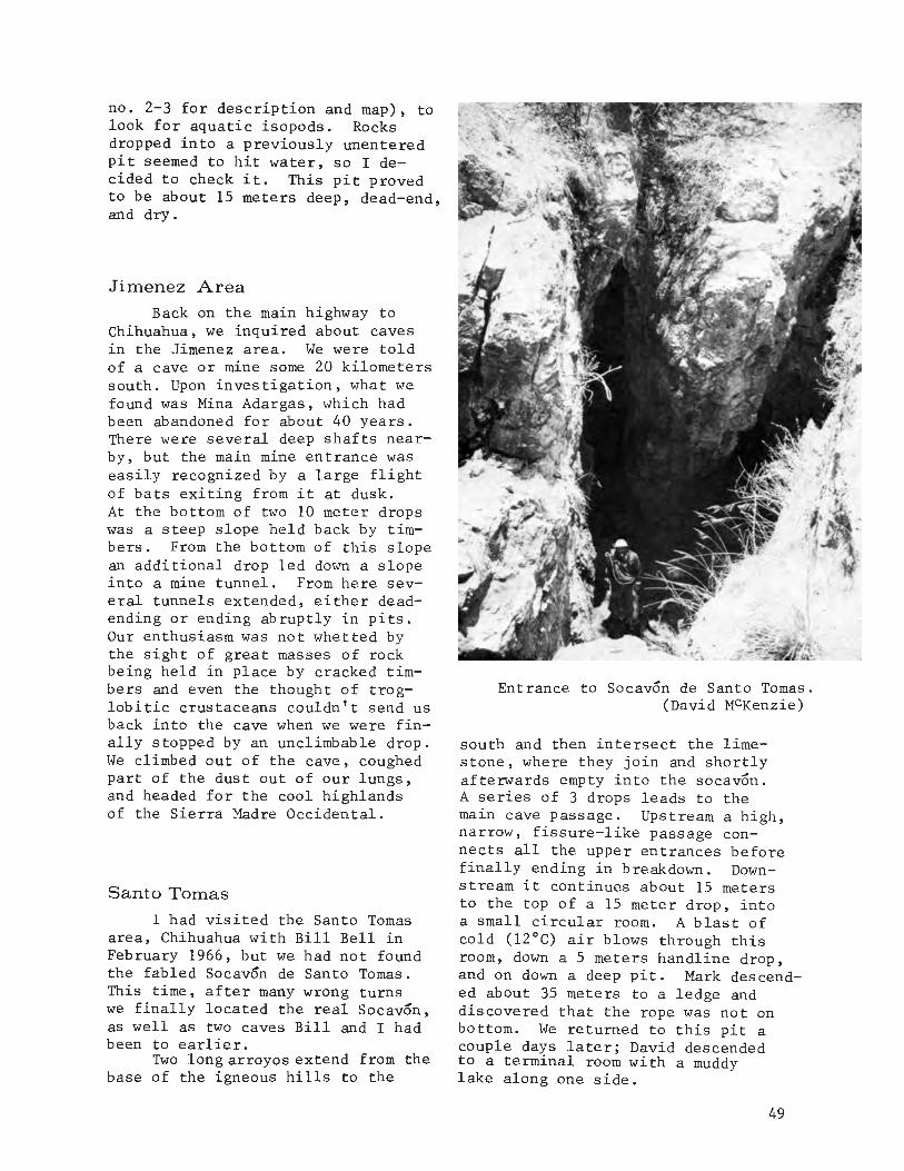
no. 2-3 for description and map)t tolook for aquatic isopods. Rocksdropped into a previously unenteredpit seemed to hit water t so I decided to check it. This pit provedto be about 15 meters deePt dead-end,and dry.
Jimenez Area
Back on the main highway toChihuahua t we inquired about cavesin the Jimenez area. We were toldof a cave or mine some 20 kilometerssouth. Upon investigation t what wefound was Mina Adargas t which hadbeen abandoned for about 40 years.There were several deep shafts nearbYt but the main mine entrance waseasily recognized by a large flightof bats exiting from it at dusk.At the bottom of two 10 meter dropswas a steep slope held back by timbers. From the bottom of this slopean additional drop led down a slopeinto a mine tunnel. From here several tunnels extended t either deadending or ending abruptly in pits.Our enthusiasm was not whetted bythe sight of great masses of rockbeing held in place by cracked timbers and even the thought of troglobitic crustaceans couldn't send usback into the cave when we were finally stopped by an unclimbable drop.We climbed out of the cave t coughedpart of the dust out of our lungs tand headed for the cool highlandsof the Sierra Madre Occidental.
Santo Tomas
I had visited the Santo Tomasarea t Chihuahua with Bill Bell inFebruary 1966 t but we had not foundthe fabled Socavon de Santo Tomas.This timet after many wrong turnswe finally located the real Socavon tas well as two caves Bill and I hadbeen to earlier.
Two long arroyos extend from thebase of the igneous hills to the
Entrance to Socavon de Santo Tomas.(David MCKenzie)
south and then intersect the limestone t where they join and shortlyafterwards empty into the socavon.A series of 3 drops leads to themain cave passage. Upstream a high tnarrow t fissure-like passage connects all the upper entrances beforefinally ending in breakdown. Downstream it continues about 15 metersto the top of a 15 meter droPt intoa small circular room. A blast ofcold (12°C) air blows through thisroom t down a 5 meters handline droPtand on down a deep pit. Mark descended about 35 meters to a ledge anddiscovered that the rope was not onbottom. We returned to this pit acouple days later; David descendedto a terminal room with a muddylake along one side.
49
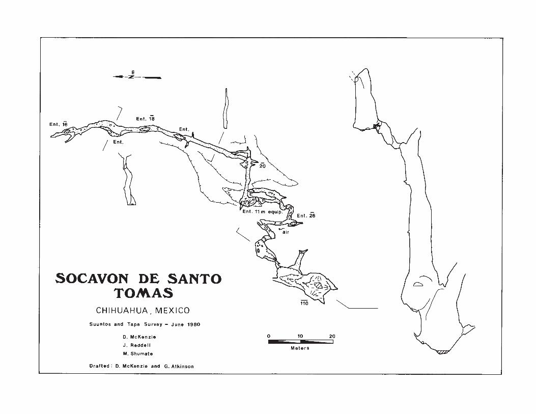
c:::::.~
/(V
,,\1')\
-===- 1
10 20
Meters
oD. McKenzie
J. Reddell
M. Shumate
E-z-__
CHIHUAHUA, MEXICO
Suuntos and Tape Survey - June 1980
SOCAVON DE SANTOTOMAS
Drafted: D. McKenzie and G. Atkinson

In Coyame, northeast of Chihuahua, I knew of a large cave whichhad been briefly visited by RonaldFieseler and others a couple yearsago. Grutas de Coyame was at onetime a commercial cave. The onemeter in diameter entrance dropsabout 10 meters to a sloping floor.At the bottom of the slope the caveopens into an elongate room about40 meters wide and more than 200meters long. This room must haveonce been extremely beautiful, butthere is now nothing left but thestubs of thousands of stalactitesand stalagmites. Trash and graffitiare everywhere. Alcoves along thesides and a narrow passage at theback leading into a series of smallrooms still retain much of theirbeauty, and indicate what the cavewas once like. Numerous delicate
Another cave in the area, whichwe named Socavon del Pino, has asmall arroyo emptying into it. TWoclimbable drops led to a diggingcrevice lead. I excavated my way tothe top of a 5 meter drop. I lookeddown into a small room in which thewalls were covered with names.
Creel AreaThe Geografla de Chihuahua had
described a large cave known asGrutas de Chumachi near Creel, andwas also marked on a tourist mapof the Creel area. Located near thelumber camp of Chumachi, the mostobvious cave in the canyon, Cueva deMurcielagos, is a large shelter entrance on the right side of the arroyo. The entrance is about 20meters wide and 10 meters high andextends over breakdown into a couplerooms about 10 meters in diameterand inhabited by a large colony ofbats. One short passage loops backto the main entrance. Several othersmall, nearby caves were checked,but none, we felt, could be theGrutas de Chumachi. A TarahumaraIndian appeared and told us themain cave was across the canyon.The crawlway entrance of Grutas deChumachi led into an elongated roomparalleling the cliff face. It continued through a constriction and upto another entrance. To the right,it led into another room with severalalcoves and finally back through afissure-like passage with breakdownalong one wall and ended. A thirdentrance was found near thesecond entrance. Mapping becamedifficult when several TarahuamaraIndians appeared in the cave carrying pitch-pine torches. Of interestis the fact that these caves arefound in ash-flow tuff, an igneousextrusive rock.
GRUTAS DE CHUMACHI
Ql.IHUAHUA. MEXICO
Suuntos and tape survey 19 June 1980D. Mc.Kenzie, J. Reddell, H. ShumateDrafted by D. McKenzie, P. Sprouse
E__;z~
'0I
20I
51

{j'
Gypsum~,;::" ~
:;" L1mnto" ~.. ~
d:J
~t
r6
I
r
10
Meters
CUEVA DEL VAPORRancho Coyote, Coahuila, Mexico
Suuntos and Tope Survey - June 1980
D. McKenzie
J. Reddell
M. Shumate
Drafted: D. McKenzie and G. Atkinson
Surveyed length: 286 m
£P/
Q
;0

formations, including helictites,can be found in these out-of-theway places. The floor of the roomis of mud and flows tone and generallyflat. A collection here includedtroglobitic isopods,many small spiders, and a species of Rhadine beetle.
This trip to northwestern Mexico was somewhat less successfulthan earlier trips, but still wewere able to locate and explore several nice medium-sized caves, and toobtain leads to many others. Cavingin western Mexico can be both a frustrating and a rewarding experience,but the potential is there for major
caves. For the caver interested ingeology, the caves are fascinating.For the biologist, there is the possibility of discovering completelynew groups of species. In the middleof the Chihuahuan Desert, two tropicalspecies of ricinuleid were discovered.Our trip yielded four new species ofspider and two new records for Rhadinebeetles in Mexico. Other collectionsare still not studied, but shouldprove of interest. Any caving triparmed with the new topo maps of thislarge area should result in the discovery of some major caves.
~ 181 lEI! IElI IElI 181 IElI IElI 181 IElI 181 IElI IElI lEI,
EJ Mexico Occidental ml
~ Este artlculo trata con exploracion de cuevas en los estados de WW EJ
~EJI' Chihuahua, Coahuila, y Durango. En Junio de 1980, las siguientes ~!
cuevas fueron levantados: Socavon de Santa Tomas (Chih.), Cueva deVapor (Sierra de San Lorenzo), y Grutas de Chumachi (Creel, Chih.).
EJ Ademas de Cueva de Vapor, cinco cuevas mas fueron visitadas en la ~
~ Sierra de San Lorenzo. Estas cuevas se formaron de la disolucion de EJW.
W yeso en la caliza. Cueva de Tabaco (Sierra de Texas), Grutas de
~EJI' Mapiml (Sierra del Rosario), y las Grutas de Coyame son cuevas semi- ffi!
comercializado para turistas. WLa posibilidad de encontrar cuevas mayo res en la occidental de
ml' Mexico es muy buena aunque muy poco trabajo se ha hecho en el area. ~W De las cuevas que han sido visitadas, la mayorla son muy interesantes WEJ geologicamente y biologicamente. EJ
LEI! lEI! I[OlI 18! IElI IElI IElI IElI IElI 181 lEI! IElI 18...J1
53

THE EXPLORATION OF
SUMIDERO DE OYAMEL
The Upper Sections of Oyamel. (Dale Pate)
54

Late one evening saw David Honea,William Russell, Peter Sprouse, TerriTreacy, Jerry Atkinson, and myselfrolling south, headed for the mountains of Tamaulipas and a cave calledCueva del Brinco. At this timeBrinco had been surveyed for a distance of 5.2 kilometers and The WorldBeyond was only recently discovered.We were planning on spending a fullweek during the Thanksgiving 1977 holidays in the Purificacion area andseeing how it was my first trip tothis particular area, I was eager tosee it. We were to meet Gill Ediger,Sara Cloyd, Cindy Kane, Wayne Ranney,John Delano, and Mark Burns at theProyecto Espeleologico Purificacioncampground located near Brinco, at anelevation of 1900 meters.
The first couple days werespent surveying in Brinco, so thefourth day was to be a day of rest.William, who is usually up beforeeveryone else, took a short hike toa high ridge south of Brinco andlooking back to the north, he saw aninteresting karst field that appeared to drain a small arroyo. It wasonly a kilometer or so from camp.Returning to camp, he persuaded Sara,Mark, John, Jerry, Wayne, and Cindyinto taking a short hike to checkout his new find. They discovereda small arroyo emptying into a karsted area and disappearing. Six entrances to Sumidero de Oyamel werefound on this day. Three small entrances led to a crawlway maze areanamed the Worm Tubes. A larger,double entrance shaft (the Sumideroentrance) fell 20 meters to a deeppool and the Lower Pit entrance dropped 8 meters to connect into a waterpassage that led to the 20 meter entrance to the north. Heading southfrom this point, the cave continued3 meters wide and 1 to 1-1/2 metershigh and had a strong airflow blowing in. It was known that Brincohad strong air movement, and alsofurther down the mountain, Cueva deInfiernillo at 4.1 kilometers inlength had strong air movement.This suggested to US that the cave
Dale Pate
was probably tied into the same system, though very little was known atthat time concerning the true extent of what lay before us. Thename, Sumidero de Oyamel, came fromthe many hemlock trees growing inthe area.
The following day William,John, Jerry, and myself returned tothis new find with the purpose ofexploring, mapping, and biologicalcollecting in it. Rigging the 8meter Lower Pit drop with a 10 meterlong cable ladder, we entered andimmediately began mapping. Jerryhad worn his wetsuit bottoms, whilethe rest of us wore regular cavingclothes. We started mapping to thesouth and the passage we followedstayed about the same, 3 meters by1 to 1-1/2 meters, for a good distance and then it began hittingsmall, climbable pits. The firstpit was named Apricot Pit (8 meters)which led to a tight verticalsqueeze aptly named Apricot Squeeze.Just ahead, we took a break forsome lunch and named the spot ComidaCorrida. Beyond this point, thingsstarted getting out of hand as faras names go. A little further downthe passage we came upon AvocadoPit, another 8 meter drop that hada beautifully scoured tinaja in thebottom of it. The passage turnedunderneath itself here and wadingaround a deep pool was necessarybefore reaching the next pit, ApplePi t. This 8 meter drop led into ajunction room where we continueddown, reaching another 10 meter dropnamed Anchovy Pit. We were able tobypass the pit and below this we tooka rest in a nice cozy room with apool and cobbles. We had been collecting insects on the way down,but here we found them in largernumbers, so we named the room TheBug Farm. Two new species of troglobitic psuedo-scorpions have beenfound in this small room as well asother insects. Exploring a shortdistance onward, we came upon a 7meter drop, Artichoke Pit, thatled to the top of yet another drop.
55
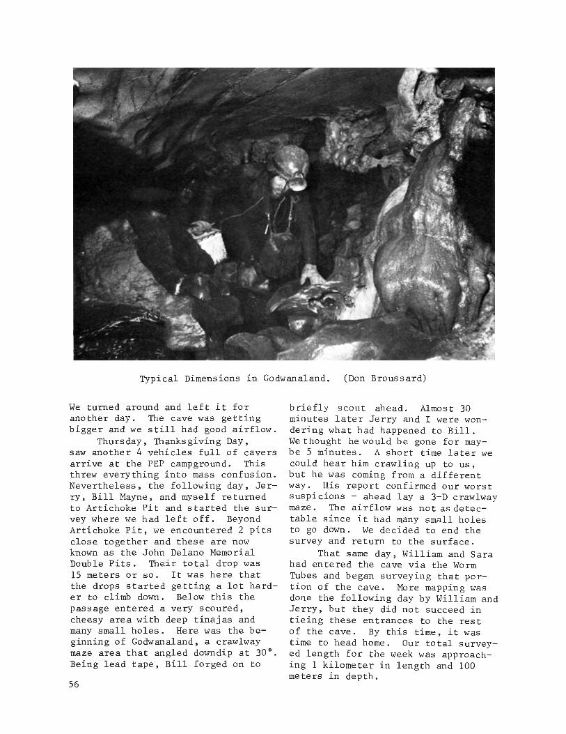
Typical Dimensions in Godwanaland. (Don Broussard)
We turned around and left it foranother day. The cave was gettingbigger and we still had good airflow.
Thursday, Thanksgiving Day,saw another 4 vehicles full of caversarrive at the PEP campground. Thisthrew everything into mass confusion.Nevertheless, the following day, Jerry, Bill Mayne, and myself returnedto Artichoke Pit and started the survey where we had left off. BeyondArtichoke Pit, we encountered 2 pitsclose together and these are nowknown as the John Delano MemorialDouble Pits. Their total drop was15 meters or so. It was here thatthe drops started getting a lot harder to climb down. Below this thepassage entered a very scoured,cheesy area with deep tinajas andmany small holes. Here was the beginning of Godwanaland, a crawlwaymaze area that angled downdip at 30°.Being lead tape, Bill forged on to
56
briefly scout ahead. Almost 30minutes later Jerry and I were wondering what had happened to Bill.We thought he would be gone for maybe 5 minutes. A short time later wecould hear him crawling up to us,but he was coming from a differentway. His report confirmed our worstsuspicions - ahead lay a 3-D crawlwaymaze. The airflow was not as detectable since it had many small holesto go down. We decided to end thesurvey and return to the surface.
That same day, William and Sarahad entered the cave via the WormTubes and began surveying that portion of the cave. More mapping wasdone the following day by William andJerry, but they did not succeed intieing these entrances to the restof the cave. By this time, it wastime to head home. Our total surveyed length for the week was approaching 1 kilometer in length and 100meters in depth.

Slightly more than 3 months later, Oyamel was revisited during theSpring of 1978. Brinco was now 6.5kilometers in length and 257 metersdeep. March 19, Marcia Cossey, CeceGreen, Andy Grubbs, and myself tooka short collecting trip into thecave. The following day turned outto be a push day wi th six of us entering the cave to continue the exploration and mapping. At this time,it had been thought that the cavecould possibly intercept the upstreamportion of the World Beyond in Brinco,but the possibilities of it missingthe World Beyond and continuing downdip to Infiernillo, 400 to 500 meters below were never ruled out.Robert Hemperly, Jocie Hooper, andmyself were to be the survey team,while Kurt Schultz, Henry Schneiker,and Pete Strickland were the leadexplorers marking the route throughGodwanaland. Fortunately, only 125meters or so away lay larger passagewhere a definite channelling of thewater flow was evident again. Alwaysdropping downward, the cave trendeddowndip to the west and the leadteam explored down tinaja lined passages and stopped in a canyon passage that was in places 8 to 10 meters high, but divided up by oldflowstone partitions. The airflowwas good. Meanwhile, our surveyteam spent hours mapping the crawlways and squeezes through Godwanaland. The two teams met just as wewere breaking out of the mazy areaand everyone opted for returningto the surface. This downstreamportion of Oyamel was not returnedto for 2 years after this. Themain effort of the PEP was concentrated in Brinco and Infiernillo,which were connected in July, 1978to form the Sistema Purificacion.
Work still continued in theupper levels, however. PeterSprouse and Jerry Atkinson return-ed to the Worm Tubes on March 21,1978 to begin a resurvey of thatsection, and they succeeded in tieingall the entrances together. Eventu-
ally 6 entrances were connected in.The total length of Oyamel was then1040 meters and 125 meters in depth.
In November, 1979 Peter S., TerriTreacy, and Mark Shumate began theresurvey from the main entrance downto the last surveyed station near theend of Godwanaland. The sketchesfrom the previous surveys had notbeen up to the high standards ofquality that were being used in Sistema Purificacion and we were allsure that the cave would eventuallyconnect in. On one such trip, thetrio found a nice horizontal passageat the top of Apricot Pit. Smallleads often yield large discoveries.This team succeeded in resurveyingto the point where the initial survey had ended in the Spring of 1978.
After a 3 week caving tour further south, a crew of ten caversarrived in the area on April 8, 1980.These cavers included David Honea,Peter Sprouse, Terri Treacy, RandyRumer, Peter Keys, Leslie Clarfield,Jeanne Williams, Don Broussard,Peter Quick, and myself. Alreadypresent was Louise Hose who is working on a Master's thesis of the geology of the cave system. By thistime, Sistema Purificacion had beena reality for almost 2 years and ithad become the deepest cave in thewestern hemisphere at 893 metersdeep and the longest in Mexico at29 kilometers. It was time to seewhat Oyamel was doing. It couldprovide a major link to the drainage that was corning in from thenorth if we could connect it in.
On March 10, Randy, Peter Q.,and myself entered Oyamel with wetsuits on. Our intentions were topush and map from the last surveystation the previous team had set,if we could find it. Although thewetsuits we wore were fairly comfortable, most plunge pools weresought out to cool off in. Aftermany moans and groans and severalwrong turns in Godwanaland, westopped for a much needed rest.Much to our surprise, the station
57

we sought lay right in front of us.Amazing! This was a good sign andwe began surveying in good spirits.The passage was dropping rapidly,but we were still able to climbdown everything we encountered. Inplaces we climbed from one waterfilled tinaja to the next. The passage continued to enlarge and thescoured limestone walls were beautiful. One area which was in the section the 1978 lead team had explored was named Pools and Jewels forthe many tinajas and rounded cobbleswe found there. Below this stretch,the passage started trending westand stopped the zig-zagging that hadbeen prevalent up to that time. Offto the right a passage emptied intothe main passage we were following.Naming this Pine Cone Junction, wecontinued on. Immediately past thiswe came to a piece of flagging tape;this indicated the point where theexploration team of 2 years ago hadstopped. Finally, we were enteringvirgin passage once again. Soon after Pine Cone Junction, the passagedropped into one of the more beautiful parts of the cave, Black Canyon.This was a steeply dipping, waterscoured, black limestone canyon. Asalways, it was dropping down. Aftera distance, the canyon became morenarrow and we were afraid that itwas going to enter another Godwanaland type area. Instead though, itemptied into a horizontal, widetrunk passage.
We knew this passage had tobe an extension of Upstream WorldBeyond in Brinco. We were at theright level, but we estimated thatwe were a kilometer or so from thelast surveyed station in the WorldBeyond. There was still a lot ofcave to go through, and that lastsurvey station in the World Beyondhad been set at the top of a veryslimy, muddy, 5 meter drop.
After mapping a short distancein this new passage, we came uponwhat appeared to be deep water andlow airspace. At this point weturned around and began the long
58
climb out, leaving the hoped forconnection for another day. Atthis point we were over 200 metersbelow the entrance. Up, up, up,and more up, the whole way out wasone climb after another. The pinescented mountains and twinklingstars were a perfect ending to thistrip.
A connection seemed imminent,and the following day Peter S.,Peter K., and Leslie entered Cuevadel Brinco to push upstream in theWorld Beyond. David, Don, and Terrientered Oyamel and traveled to thelast surveyed point and the low airspace. To the Oyamel team's dismay,the survey pencil had no lead in itso they couldn't survey. After going all that distance, they decidedto explore ahead. The low airspacestarted at 15 centimeters and gradually increased. Soon it was astoopway with a couple of large mudrooms and then more low airspace.They reached a "T" Junction, explored right to a sump, and then left toanother junction. There were nosigns of the other team, so theyplaced a cairn and left the cavewith plans to return the next dayto survey.
Meanwhile, Peter, Leslie andPeter had rigged the mud funnel drop,later named the Gates of the North.At the bottom, a clean scoured passageled two directions. Downstream wentthrough 200 meters of canal to a sump,but it was the upstream way whichpointed north towards Oyamel. Sixtymeters down this, a short passagewent right to a sump, and 80 metersfurther on the passage enlarged intoa high, 40 meter wide chamber witha mud mountain in the middle. PeterKeys attempted a climb into a highlead while Peter Sprouse investigatedthe continuation of the passage tothe north. There, where a sandbarcrossed the passage, were footprints!They hurriedly continued the surveyon from the Hall of the Footprintsand soon came to the other team'scairn. Surely the tie-in stationmust be close now, but Peter K. re-

The Nose Dives. (Dale Pate)
conned ahead for several hundredmeters without finding a station.But with a connection realized, thesurvey had to be done, so they mapped on past the "T" Junction, throughthe low airspace, The Nosedives,to tie into the station Randy, PeterQ., and I had set the day before.Their total survey was 922 meters ina 17 hours trip and they had made theconnection.
Oyamel was now officially partof Sistema Purificacion and it added6 entrances to the already known 5entrances. This connection addedapproximately 2.5 kilometers to thelength of Sistema, bringing it to afield total of 31,567 meters. PeterS., Peter K., and Leslie continued
on out of the Oyamel entrance, thusmaking the first entrance to entrancetrip from Brinco. A few days later,Louise and Don entered the Oyamelentrance to inspect the geology inthis part of the cave and came outthe Brinco entrance, thus, makingthe first entrance to entrancetrip from Oyamel to Brinco.
The connection of Oyamel to theWorld Beyond in Brinco added a significant link, another piece to thepuzzle, in the hydrologic researchpresently going on in Sistema Purificacion. The connection representsonly a part of the systematic exploration and surveying that members ofthe Proyecto Espeleologico Purificacion are involved in.
59

~ 'GJ' 'GJ' 'GJI IS' IGJI 'GJ' 'S' 'GJ' 'GJI 'GJI IGJI '8' 'GJ0
Gl~' Sumidero de Oyamel ~I
Gl
Las seis entradas de Sumidero de Oyamel se localizan al norte ~Gl de Cueva del Brinco, una entrada superior del Sistema Purificacion, ill
~ Tamaulipas. La exploracion y topograffa fue iniciada en 1977 y 1978 Gl
ill hasta 125 metros de profundidad y 1040 metros de longitude En 1979, ~8~' levantaron unos pasajes nuevos y repitieron unas partes de la topo- illI graffa. En la primavera de 1980, se continuo con la exploracion y 8~'
la topografla al nivel -200 en un lago con techo bajo. Se penso que IGl~' este pasaje era una extension del pasaje "World Beyond" de Sistema
\Purificacion. Al dfa siguiente, un equipo entro a Brinco y comenzo Gl~'1la topografla desde la ultima estacion en la parte aguas arriba del
8~' World Beyond. Al termino de 922 metros de levantamiento, se hablan Gl
ill conectado las dos cuevas. , ~
~GJ' 'GJ' '(;)I 'GJ' IGJI IGJ' 'GJ' 'GJI 18' 'GJ' IGJI 18
60

Across the Sima Grande
Mark Minton
The Entrance to Satano de La Joya de Salas. (Steve Robertson)
Still convinced that a majordeep system lay below Joya de Salas,a large group of cavers (DenisBreining, Tom Byrd, Monte Fisher,Margaret Hart, Russell Hill, HalLloyd, Johanna Reece, Steve Robertson, Terry Sayther, Bill Steele,BillStone, Lisa Wilk, and I), returnedfor yet another look at the Satanoand surrounding area over Thanksgiving of 1979. The main objective wasa series of passages and shaftsfound on the last day of our tripthe previous year by traversingaround the Sima Grande, the second
drop in Satano de la Joya de Salas(see AMCS Act. News. No.8). Inaddition, some interesting lookingsinks to the northeast and an oldlead near the lake were to be checkedout.
Bill Stone led the short, buttreacherous, traverse around theSima Grande. A side passage, previously assumed to end in a plungepool, was descended by Bill Steelewho beckoned us onward - it went!Keeping out of the scuz filled poolis no easy feat, and the passage wasdubbed "Can You Stay Dry." Unfor-
61

Monte Fisher on Rope Traverse.(Steve Robertson)
tunately it ends a couple hundred,enjoyable meters later at anotherpool. Back in the "main" passage,a sporting climb over a deep (Sam)hole, which connects to the "old"cave below, and a short section ofstoopway leads to a decorated crossfissure. A tight squeeze throughflowstone while on rope, followedby a short rappel, brings one to acomplex lower level. The prime leadwas a 100+ meter deep shaft complexat the end of a large, decoratedchamber. Several ledges break upthe descent, and provide access toother parallel shafts and interconnecting crawls. Unfortunately allof these end in mud fill or water.
62
Bill Steele diving the sump.(Steve Robertson)
The only remaining lead was anarrow canyon with tremendous airflow leading off the second ledgeof the shaft complex. It quicklyopens into another drop which endsin a spacious, dirt floored room.A tight, damp crawl leads to a balcony overlooking a short drop withwhat appeared to be walking passagebelow. By now we were sure we hadcracked the system, but our elationwas premature. The passage at thebottom became too tight to the left,and sumped to the right. In desperation we returned with heavy artillery: Kinepak and scuba gear. Theblast was spectacularly resonant inthe 30 meter dome where we stood,

but the passage didn't go. Stone'sdive, initiated through an extremelytight crevice, half filled with water,also failed to uncover going cave.
Meanwhile, a little searchingaround the karst near the main entrance finally turned up the "lost"second entrance to the Satano. Ashort drop through a tight crackleads to a trash floored room withsome beautiful flowstone. A pleasant canyon leads to a second drop.Both a crawlway taking off midwaydown the drop, and a canyon passageat the bottom of the drop loop backinto the Sima Grande near the mainentrance.
Most of the new passages weresurveyed, but the depth of the cave
was not increased, except perhaps byone or two meters gained by tying inthe second entrance. A few leadsstill remain unchecked, and the baffling air circulation in the cavemakes one wonder if the master system still eludes explorers.
We also checked a lead on theeast face of the range near a baritemine. Roya de la Mina Barita, whichhad been described as a very largepit, turned out to be at least 50meters across, but only a disappointing 40 meters deep. The overgrownbottom contained no further passage.We were also told of a large pit,bigger than Salas, 9 kilometers tothe northwest, but we didn't havetime to check it out.
~ lSI lSI lSI IB! 'S! lSI IBI lSI lSI lSI lSI IBI lSI IS1
[;]~. En Noviembre 1979, un grupo fue al Satano de la Joya de Salas en la [;]
I Sierra de Guatemala de Tamaulipas con el intento de explorar unos pasajes ~cuales hablan sido descubiertos el ano anterior. Dichos pasajes se ter- W
~[;]I' minaron 0 se volvieron a conectar con galerlas conocidas, y un pasaje con- [;]~.
dujo a una nueva entrada. Se mapearon todos los pasajes. En el ladooriental de la sierra, un satano llamado Roya de la Mina de Barita se
~ explora. Tiene 40 metros de profundidad, sin pasajes en el fondo. m
Ilksl lSI lSI IBI lSI lSI lSI lSI lSI lSI lSI IB! 'SI Isdl
BATS NEED
FRIENDS
63

AMCS CAVE MAP SYMBOLS
Peter Sprouse and William Russell
A current list of the AMCS Standard Cave Map Symbols has not been published since 1975 (Russell, 1975).Subsequent evolution of the symbolsis reflected in this 1980 list. Incompiling it, foremost considerationhas been given to the techniques ofAMCS cave mappers and to the components of modern cave maps.
A revision of the NSS cave mapsymbols was published in April,1979 in the NSS Bulletin, Vol. 41,No.2, compiled largely by JamesHedges. This list contained manyunconventional symbols and draftingtechniques and was widely regardedas impractical by American cavers.It contained a vast number of symbols for things rarely encounteredin caves, with most of the symbolsbearing no visual resemblance towhat they were supposed to represent.Although the NSS list is currentlyunder revision, there is littlehope of major changes. Therefore,cartographers are encouraged toutilize the AMCS list. It shouldbe used as desired by the drafter,who is encouraged to use his owndifferent or supplementary symbolsif needed.
Evolution and use of
the symbols
Some symbols have been changedor deleted, and symbols have beenadded for obvious needs. But anattempt has been made to keep thelist concise, and it has not changeddrastically since the first editionin 1965 (Anon., 1965). Changes,
64
additions, and suggestions for useare discussed in the order theyappear in the list.
The symbol for lower levelpassage walls, a dotted line, hasbeen stretched into short dashes tohelp show wall shape and aid clarity.A symbol for breakdown walls hasbeen added, which is essentiallyonly an explicit use of the passagewall symbol. Ceiling height andwater depth symbols have been eliminated for several reasons. Thesefeatures may best be shown in crosssections and profiles in a formthat conveys vastly more information.The plan view is intrinsically notdesigned to display these features,and their use inside the passagewalls displaces floor detail, aprimary function of the plan. Forthis reason also, the elevationabove and below the entrance shouldbe indicated outside the passagewalls when possible. In surveyswhere loops provide statisticalinformation on accuracy, the standard error may be indicated inparenthesis with the elevation.Arrows indicating airflow direction,scallop direction, or flow directionof a large stream should also beoutside the passage walls. Two newwater symbols: intermittent pools,and rapids (merely an undulationin the water symbol). The depictionof water in a blue screen is desirable and increasing in use. Whenblue screen is used, rapids may bedepicted as small parallel hachuresin solid blue. The floor flowstonesymbol is in common use, and is being increasingly used to also depict

the direction of slope on flowstone.Rimstone dams are drawn with boldlines, and should be drawn to theircorrect shape and scale when possible.The old solid black symbol for flowstone on walls was unpopular sinceit tended to produce a dominant, lopsided effect on the map. It is replaced with the floor flowstone symbol attached to the wall. The stalactite, stalagmite, and soda straw symbols remain unchanged, but again,these features may again be bestshown in profiles and cross sections,so their use should be minimized.Breakdown may be drawn "stacked" toindicate slope, and the larger breakdown blocks should be drawn to scaleand shape, rather than a standardblock shape. Shading or block detail may be shown, and if coveredwith mud, guano, etc., these symbolsmay be drawn on the breakdown. Thesymbol for survey stations should beused for the datum, or very importantstations; the depiction of all stations detracts from true floor detailand is of little interest to thereader. A trail symbol has beenadded and is useful in caves wherethere has been much prehistoric (ormodern) use. The splayed "crow'sfoot" slope symbol is another symbolthat like ceiling heights, is beingphased out of the modern cave map.Slopes are best shown in crosssection and profile, and the useof the slope symbol in a plan displaces floor symbols that depict
the actual floor content. In largerooms with complex relief, contourlines with elevations may be used.A symbol for organic debris has beenadded; the drafter may wish to drawlarger branches and logs to shapeand scale. The use of the geologysymbols increases the value of acave map; these should be moreutilized than they are. Again, thesegenerally appear outside the passagewalls.
Such basic map components as ascale and north arrow hardly needpointing out; this article isn'tintended as a complete guide tocave map drafting. However, we believe that these symbols can beused to construct a "state of theart" cave map. Such a map wouldhave three views, all necessary fordepicting a three dimensional cave:plan, profile, and cross sections.Floor detail should be complete,with no blank spots in the passage,for there is a symbol for any floorcomposition. The use of graphicsymbols (that look like what theyrepresent) and the de-emphasis ofnumbers and letters in the drawinghave resulted in more informativeand visually pleasing cave maps.
REFERENCES
Anon. 1965. AMCS Newsletter 1:9:93.
Russell, William H. 1975. AMCS MapSymbols. AMCS Activities LetterNo. 3 :29.
Simbolos topograficos
Este es un revision de los simbolos topograficos de la AMCS.El art1culo describe las tecnicas de construir mapas modernas decuevas con los simbolos. La mapa necesita tener detalla completa del piso con simbolos graficos, en lugar de numeros 0 palabras.Tambien se necesita las tres vistas: el plan, corto longitudinal,y las secciones transversales.
65
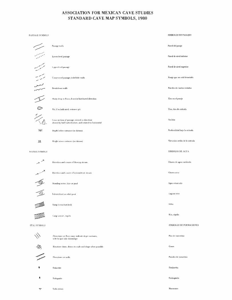
P,\SSAGE SYMOOLS
.. '
WATER sn1BOLS
STAL SY\lIlOLS
,
ASSOCIATION FOR MEXICAN CAVE STUDIESSTANDARD CAVE MAP SYMBOLS, 1980
Lower level pass.agc
Upper I~vd pa~sagc
Um:urvcycd passage; indefinite walls
Breakdown walls
Sharp drop in flour, down in hatchured direction
Pit; jf so indicated, entr<lnec pit
Cros,; section of passage, viewed in diredionshowl1 by haJf Larhed arruw, and rotated to horizontal
Depth below entrance (or datum)
Height above entrance (or datum)
Direction and course uf tlc)wing SLrp.Ufll
Direction and course of intermittent stream
Standing water, lake or pool
Intermittent or relid pool
Sump (cross hat<.:hed)
Large stream, rapids
Flow,,;lone on noor; may indicate slope contours,with bulged side downslope
Rimslune dams, drawn to seale ancl shape whf~n possible
FlowslolH~ 011 walls
Stalactite
Stalagmite
Soda :;Lraws
SIMBOLOS DE PASAJES
Pared del pasaje
Pared de nive1 inferior
Pared de nivel superior
Pasaje que no esta levantado
Paredes de cantos rodados
Tiro en el pasaje
Tiro, tiro de entrada
Profundidad bajo 1a entrada
Elevadull arriha de la entrada
SIMBOLOS DE AGUA
Chorra de lfglla corricntlo
Chorro sceu
Agua estaneatla
Laguna scca
Sirl'll]
Rio, nipido
SIMBOLOS DE FORMACIONES
Piso de traverLina
Gours
Pafl~des de travertina
Estalactita
Estalagrnita
,'\lacarones

CEILI'IG SnmOLS
FLOOR SY'IBOLS
'if
x X xx x
\
" .....
GEOLOGY SY'IBOLS
A 25
"\
Sharp drop in ceiling, hatchures point towaru low ceiling
Dome
Bt~drol;k flour
'lud or day
Sand or ~ilt
<; ra \'f~I
Rounded stream eobLIe:::
Talll::i
I1reakdowll
Largt~ ureakduwn, drawn 10 shape <.tlld ::icale
Guanu
Potter)' or other archeological matt~rjal
Trail
Survey station. survey datum point
Slrikl~ anrl dip of strata; dip in t1egrcl:s
Vp.rticaljoint
Dipping joint
Fault, D side moved down relative to U side
SIMBOLOS DEL TECHO
Techo Lajo
Domo
SIMBOLOS DEL PISO
Piso de piedra
Lodo. barro
Grava
Guijarros
Piedras
Rocas
Cantos rodados
Guano
Makria archcolog:ica
Pcndicnle
Materia organica
Vereda
ESlaci6n topogrMica
SIMBOLOS DE GEOLOGIA
Eehados
Fradura
Fradura inclinada
Falla

The Caves of Cuesta
George Veni
Mexico has been known as theland of "instant caves." Rumor hasit that it's hard not to find acave, even if you're not looking forone! This was the case in December,1979 when Scott Harden, Gary Pooleand I were cruising along Highway 85in the state of Hidalgo and Mr.Poole spoke those fateful words,"When we get past this town, stopthe car so I can go pee." Off hewent down the hillside and into thebushes. Careful not to offend thelocals, he kept glancing to eitherside until he finally looked downto see a large sink "taking water."Checking it out, he found that asmall arroyo actually did feed intothe sink and that its presently drywater course led to a small hole.Grinning like the proverbial cheshire cat, he returned to the vehiclefor a light. The 3 meter entrancechimney was descended and followeda short way to what appeared to bea 25 meter pit. Exiting the cave,the land's proprietor was encounteredand he told us of a "mas grandecueva" across the road and up thehill.
The cave wasn't quite up toits description, but it was nice;a 20 meter rappel into an oval room,20 by 8 meters. At one end a slopeled down a 5 meter drop, into a dry,decorated, terminal room. Decidingto get a better look at the firstcave, we rigged a 40 meter rope andwen t down. At 25 me te rs we foundthat the "bottom" was actually alarge ledge. Due to its steep overhanging nature, the true bottomcouldn't be seen. An added 33 meters of rope was tied on and I continued down. After going a ways, Idecided to stop and have a good lookaround.
A huge flows tone shield graced
68
COloradathe opposite wall that lay 8 to 10meters away. In contrast to thefirst 25 meters of dry pit walls,things here were starting to getmoist. Pools of water could beseen far below on the floor. Italso appeared that another large pitbordered the floor of this pit. Unfortunately, it couldn't be checkedout because the end of all our ropewas hanging 25 to 30 meters abovethe floor. As we drove off into thedark night, we were making plans toreturn.
Early May, 1980, Gary and I returned with Teeni Kern. Our firstgoal was to bottom and survey thisdeep pit cave. We had named itHoya de Cuesta Colorada, after thetown it is located near. As we carried all our gear to the sink, theproprietor's brother ran down togreet us. Excited by our return, hewanted to show us some other caves.He first took us to a couple holes,no real caves; but he soon made upfor it by taking us to a pit thatwas 5 meters in diameter and rockstossed in would bounce for 11-1/2seconds. We estimated it to be about100 meters deep. We weren't able tocheck it out then, however, becauseour enthusiastic guide had more cavesto show us, and that's just what hedid for the next couple days. Wespent more time looking at cave entrances than going into them andI'll admit I was starting to get abit flustered. We didn't want to berude, but we didn't have that muchtime and we wanted to get underground. Besides, out of the manycave entrances he showed us, noneshowed anything near the potentialof the Hoya or the 100 meter pit.
Deciding to do the 100 meterpit first, Gary and I rappelled toa small ledge about 17 meters down,

Hidalgo, Mexico
idealized profiles; memory sketches: g. veni, 9/30180
bottom. In view of the surface circumstances, my being alone, and thatwe were short on time, I turned backa t this point.
Other than doing the two maincaves, we surveyed Sotanito SinFrenos, a cave near a road whosedrainage ditch our car rolled into.The cave is simply a 22 meter pitfollowed by an 8 meter drop to a terminal room, noted for its incrediblyhigh arachnid population. While being shown the many caves, we observed that many large karst pinnacleshave associated pits at their base.The only one we checked was a 15meter blind pit. An 8 meter shafton the side of a huge sink dead ended, but the floor of the sink droppedinto a large open-air pit. From thesurface it didn't seem to have anyoffgoing passages, but it looked likea fun rappel. A couple of other caveswere briefly checked and locationswere made to various pit entrancesranging from about 8 to 25 meters indepth. We also saw lots of otherholes that we didn't get the chanceto draw up a location map for. Sofar, r'd say that this area has onlytwo major caves and plenty of leads.TI10ugh the caves from these leadsdon't appear that they'll go far,there is only one way to find outand that's what caving is all about.Big or small, the caves of this areapromise to give the visitor someeasygoing, interesting and fun times.
HOYA DECUESTA COLOR ADA
(m)
115
100
60
80
SOTANO DE lOSPARANOICOSthen I continued to a larger ledge
at about -80 meters. While waitingfor the others to come down, I noticed some commotion from above. Itseems that one of the locals, fromthe gathering crowd, had gone tothe rope and started to examine (7)the knot while we were on rope.Language differences made it difficult for Teeni to exert theauthority needed to politely keepthe people away from the rope andthe edge of the pit. Knowing amale presence would have a stronger effect, Gary climbed out. Because of this nervous incident thepit was named Satano de los Paranoicos. Hoping that the situation above was well taken care of, I proceeded 25 meters to the bottom ofthe pit. From there a downwardslope led to a flat, dirt flooredchamber with no apparent leads. Itwas also home to a small colony ofvampires.
From this first experience, wetried not to attract a crowd whenwe went to the Hoya. We were unsuccessful. Gary volunteered to stayat the top of the pit and watch therope. Teeni went to the ledge at25 meters to facilitate communication as I proceeded to the bottom.A fine rappel was spoiled when my90 meter rope proved to be 3 metersshort of reaching the floor. Ofcourse, I was carrying an extrarope for the pit I had seen inDecember, but at this point, 3 meters off the floor, I saw thatther~ was no second pit. What Isaw from far above were long shadows of large breakdown blocks thatgave the impression of anotherlarge pit. Imagine the frustrationof tying on another 90 meter rope,just to rappel three meters!
The cave's drain was into aseries of short freeclimbable drops.At one point it pinched small andsome sharp projections had to be removed. Even enlarged, it still toreoff a few shirt buttons and someskin. I went down about 12 metersbelow the main pit and saw yet another freeclimb of about 4 meters.There appeared to be passage at the
69

fu '0' '0' ".. '0' ~ues~: ~~'or:'do "... '0' '0' '0' '0' '~
~ En 1a region de 1a earretera Interamerieana (85), eerea del pueblo ~~
de Cuesta Colorada en el estado de Hidalgo, hay numerosas cuevas. Algunas Wm de las mas aprometadoras fueron explorados. Hoya de Cuesta Colorada: Una 8
8 chimenea corta conduce a un tiro de 90 metros. Al fondo, hay una serie de ~
~tiros cortos que se pueden escalar en libre. Exploracian fue terminada en m
m la borde de un tiro de 4 metros. Satano de los Paranoicos: Un tiro de 100 8
8 metros tiene un piso plano sin pasajes laterales. Una pequena colonia de ~
~ murcielagos vampiros habita el fondo. Satano sin Fresnos: Un tiro de mW entrada de 22 metros conduce a un tiro de 8 metros. Al fonda hay un gran 8~'ml' salon terminal con una gran cantidad de aracnidos. Un satano grande en una I
W inmensa dolina fue visto, pero no se explora. 8
@. IElI IEl' IEll '81 181 'Ell 181 181 18! 18! IEl! 18! 18! ill
ENTRANCE
o
4
8
12
16
PLAN
Sotanito sin FrenosMunicipio d. Cu••t. Color.claHid.leo . M ••'eo
Surv.y : T.an; K.rnGinI' Poole. Draft Oct 16. '80Caorg. Vani
Suuntos & tapa
SECTION
24
....
70
oMETERS
4 8 10
28
32
34

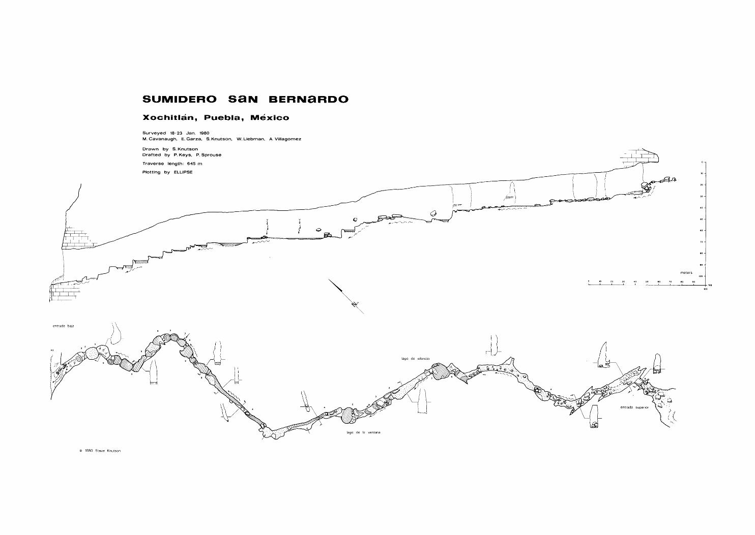
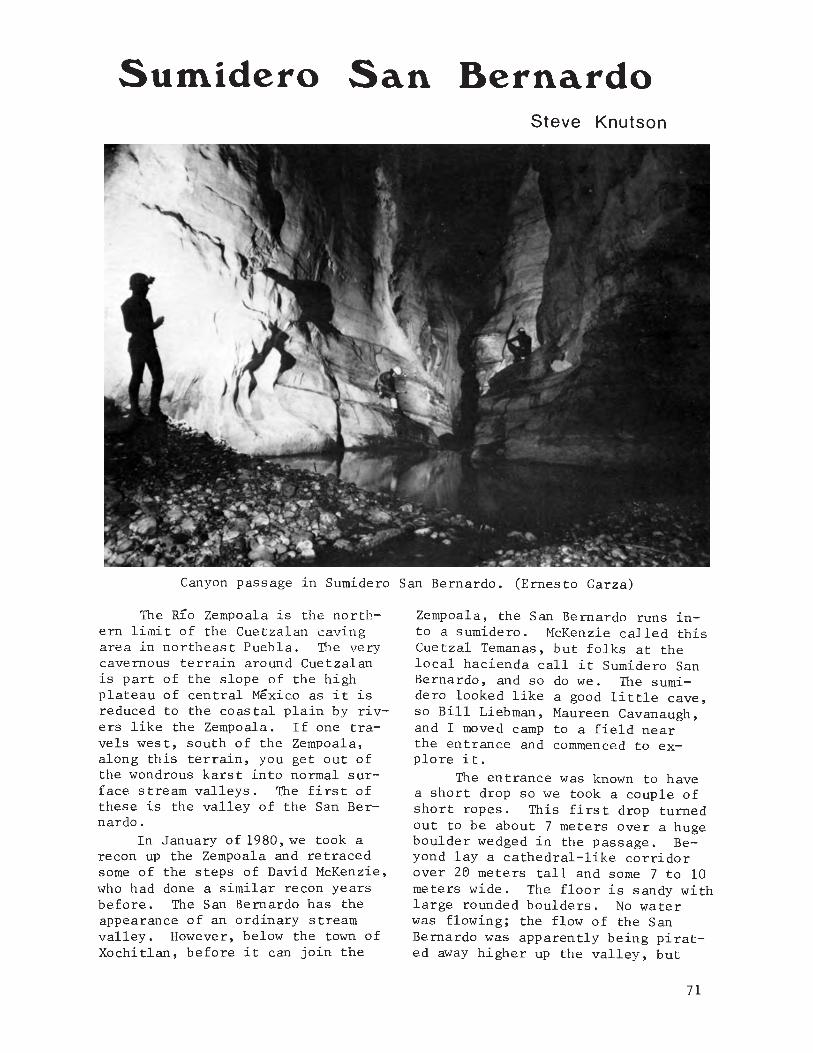
Surnidero San BernardoSteve Knutson
Canyon passage ln Sumidero San Bernardo. (Ernesto Garza)
The RlO Zempoala is the northern limit of the Cuetzalan cavingarea in northeast Puebla. The verycavernous terrain around Cuetzalanis part of the slope of the highplateau of central Mexico as it isreduced to the coastal plain by rivers like the Zempoala. If one travels west, south of the Zempoala,along this terrain, you get out ofthe wondrous karst into normal surface stream valleys. The first ofthese is the valley of the San Bernardo.
In January of 1980, we took arecon up the Zempoala and retracedsome of the steps of David McKenzie,who had done a similar recon yearsbefore. The San Bernardo has theappearance of an ordinary streamvalley. However, below the town ofXochitlan, before it can join the
Zempoala, the San Bernardo runs into a sumidero. McKenzie called thisCuetzal Temanas, but folks at thelocal hacienda call it Sumidero SanBernardo, and so do we. The sumidero looked like a good little cave,so Bill Liebman, Maureen Cavanaugh,and I moved camp to a field nearthe entrance and commenced to explore it.
The entrance was known to havea short drop so we took a couple ofshort ropes. This first drop turnedout to be about 7 meters over a hugeboulder wedged in the passage. Beyond lay a cathedral-like corridorover 26 meters tall and some 7 to 10meters wide. The floor is sandy withlarge rounded boulders. No waterwas flowing; the flow of the SanBernardo was apparently being pirated away higher up the valley, but
71

guano on some boulders indicatedseasonal flow at least a meter deep.The walls are smooth and vertical.This is not the typical bedrock ofthe Cuetzalan caves, which is thinner bedded and prone to breakdown.It appeared to be metamorphosed intoone complete bed, though a 2 meterfossiliferous band was obvious inthe smooth wall.
We continued past a secondshort drop, admiring the easy, magnificent passage. A couple hundred meters took us to a somewhatdeeper drop. A thrown rock took asecond or so to produce an echoingsplash. The 8 meter rappel tookone to a ledge beside a broad, silent lake. Two swims and we wereagain moving down our fine passage.Soon, though, it abruptly broadened,divided by a large phreatic archand sloped down steeply to a second
lake. The edge was two meters high,and overhung. We were out of rope.
The next day we were joined byAlejandro Villagomez and returnedto the cave with more rope. Thelake, which looked so deep, provedto have a sandy bottom and was neverover your head in depth. At theother side was a 7 meter drop. Beyond this, we ran into water showeringdown and the passage came alive withthe sounds of flowing water. A 4meter drop led to a long swim. Thepassage then became absolutely charming, with plunge pools, smooth surfaces, waterfalls and the same grandsize. With no rope left, we weresoon looking down a 5 meter dropneeding a bolt or piton. The caveconsistently showed signs of largevolume flow with all surfaces rounded and smooth, huge plunge pools andno narrow canyons. Certainly it was
72
Bill Liebman In Sumidero San Bernardo. (Ernie Garza)

showing more resistance to exploration than we had expected. Two tripshad gotten us only a little over 500meters and used 5 ropes.
The cave was heading for theprecipitous canyon of the Rio Ateno~
not far away. Maureen and I had ago at reaching the bottom~ but the"trail" we followed down for a hundred meters or so~ required the useof vines for vertical handline ~ andwe gave up.
On January 23~ Ernie Garza tookAlejandro's place and we pushed on.The swim below the 5 meter drop ledto a turn in the passage and fromthere you could see daylight - wehad a thru trip! A couple moredrops had to be done and by thetime we reached our exit~ daylighthad faded to night. The cave brokeout on a small shelf of the sheercanyon. Maureen and I tried todescend. To one side was a smallarea of coffee trees~ but searchingdid not produce the trail. Therewere cliffs above and to all sides.Oh well~ the cave had to be derigged anyway.
Sumidero San Bernardo is an extremely spiritual thru trip. Thecave is easy~ (only 600 meters long)~
but has 10 short rope drops and 5more drops requiring handlines.These 15 drops need several pitonsand bolts~ and there are severalswims. Both the cave and the canyon
it empties into are magnificent.
Steve Knutson in Sumidero San Bernardo.(Bill Liebman)
~! 181 IEll 181 181 181 18! 181 181 18! 181 181 181 181 3
1 Sumidero San Bernardo ~~
G
W Sumidero San Bernardo esta localizado debajo del pueblo de Xochitlan~ ~
~G Puebla. EI sumidero es una cueva grande con muchos tiros en su descenso WI
8que termina en una entrada baja en el canon del Rlo Ateno. El autor de- ~
scribe la cueva~ diciendo que es muy amplia~ tiene paredes lisas~ pisos are-G
~ :~:~~~ ~:~~~o~a~:~~~~iS~i~::c:~a~~ta~ie~ap~aq~:e~~om:i::: e~~~ :~~~~~l~e m,
~ largo y tiene 15 tiros que requieren el uso de varios pitones y clavijas W
~de expansion. Tambien hay lagunas donde es necesario nadar. 8
~I 18! 181 181 181 181 181 181 181 181 181 181 181 18! m
73
SHORT PENETRATION SUMP DIVING
Bill Stone
A few years ago there was a popular slogan in Austin, "A sump isGod's way of telling you the caveends there." Though it seemedlike good common sense at the time,caving has changed considerablysince then - teams now commonlywear full wetsuits, and use dualmountings for carbide and electriclights. Long duration undergroundcamps are being utilized for deepassaults. Climbers are scalingunderground "big walls." Cavingcan be a highly technical sport the cutting edge of which is closelydependent on the available technology and its adaptability to meet aspecific challenge.
Of all the "secondary" exploration techniques being used by caversthese days none is more controversial than sump diving. This stemsfrom the fact that it is closelyrelated to cave diving and itslong history of fatalities. True,sump diving does involve the useof similar technology, but the objectives and personnel involved arequite different. The sump diver isa caver who is hoping to break intocontinuing airspace. The cave diveris a diver who explores underwatercaves. The distinction is a profound one. With no restrictionson portability, cave divers havebeen able to develop sound methodsfor safely effecting explorationsof long (up to 3 kilometers) anddeep (up to 107 meters) underwatercaves. There is still, however, arelative paucity of information onwhat techniques are best for sumpdiving, owing largely to the factthat there are still only a fewserious groups of sump divers in the
74
U.S. We are at an evolving stateof the art where the limits of whathas been"acceptable" are beingchallenged. A timely forum of ideasand rebuttal is thus warranted.
The following discussion dealswith the very specialized topic ofshort penetration, deep cave sumpdiving, and the evolution of ideason how to do it with the leastamount of hassle. In essence, thegoal has been to achieve the "qualitypoke," one step in range beyond freesump diving.
The quality poke. That notiondropped into your mind every timeyou rappelled into the so-called"terminal sump" which punctuallyended so many deep systems. Someof them, of course, were quiteterminal - the kind of submergedmud plugs that required the flipof a coin to see who would check itout. The kind where everyone breathed a sigh of relief when the sludgeencrusted chosen-one flashed backa thin smile, eyebrows creased, andsaid, "Yep, terminal. Guess we oughtto derig, huh?" It was those oneswhere you could see the crystalgreen fluid receding beneath abroad arched ceiling ... the oneswith the clean gravel floors ...that drove you nuts! The more ambitious types - notably Jim Smithin the southeast - began carryingmasks as standard equipment. Freesump diving became an acceptable,if not respected, art. But thishad its limitations - a two to fivemeter penetration was about thesafe limit on one breath of air.Even then you ran a heavy risk.You could pop up into an airbellfilled with bad air (such as the

one in Langstroth Pot in Englandwhich claimed three lives in 1976),or you might get momentarily stuck counting down those precious seconds.
Meanwhile, cave divers inFlorida - Sheck Exley, John Zumrick,Court Smith, and other members ofthe NSS Caving Diving Section-wereroutinely effecting kilometer penetrations into the large spring systems there. In Colorado, Norm Pace,Torn Taylor, Jim Pisarowicz and crewwere working on the sump 4 in SpringCave. SCUBA appeared to be an attractive means of forging beyondthe free dive radius for deep cavesump diving. It was also clear, however, that the technology which theyhad so successfully applied to thebig springs of Florida would notwork in many deep cave situations.The twin hard-lined 100 cubic foottanks used by the Florida diversweighed well over 100 pounds - arather ponderous load to be ferrying 43 pitches in and out from asump at -800 meters. Add to thisanother 50 or 70 pounds of peripheral equipment - fins, four sourcesof light (the larger primary lampsused in Florida can weigh up to 20pounds), line reel, regulators,etc. - and you wind up with a serious logistical dilemma: how willyou get it all to the objective?
Enter Spring Cave, Colorado.Sump I, where they first began thediving effort, is approximately twokilometers from the entrance throughsome arduous territory, albeit horizontal. The Colorado cavers' planevolved into a series of mini-weekend-expeditions of the classicalBritish character: 10 or more"Sherpas" had to be rounded up soas to ferry the diving gear intoSump I. Things became more complexwhen Sump IV was reached. Then,mini expeditions, including divingsherpas, had to be organized tostage major mini-expedition penetration dives.
Various difficulties with sherpa organization at Spring Cave left
Carrying Sherwood steel 15 cubic foottank at -700m in San Agustin.
us all a bit pensive. Clearly itwas going to be a non-trivial matter to coerce 20 gung ho sherpasto leave their jobs for three monthsand gleefully carry those long,metal cylinders to -800 meters.Most times we were lucky to field5 to 8, including the divers. Thedescent was not all that bad, mindyou. I t was the ahh ...weight ofthe matter ... that first caught yourimagination (and breath) when itbecame time to derig. It gave youa wink of an insight into what motivated the unusual assault tacticsused for the French diving efforts
75

at the -1122 meter sump in the Gouffre Berger during the mid 1960s.SCUBA tanks, being the heaviestitem in their inventory, becameexpendable, and were conveniently"stored" at the bottom of the sumpfollowing the dive~
Being conservation minded, aswell as monetarily conscious, disposable dive gear never caught onin Austin. Which brings us back tocarrying all that metal out. Thelogical solution was to lightenthe load by removing all non-essential items, and use smaller tanks.Hand in hand with this went the understanding that the equipment forthree divers weighed 50% more thanthe gear for two divers and 300%more than the gear for ~ diver.The idea of solo cave diving hasalways been one of those not-tobe-discussed taboos among the sportdiving community. Certainly, it isnot to be recommended officially,and buddy diving should be adheredto whenever feasible. But the factsare that the majority of the serioussump divers in the world today - theones doing the original exploratorywork - will confirm that they preferto dive solo when laying a line intovirgin territory where vi~ibility
may be a problem. Anyone who hashad to worry about what a "buddY"was doing in a zero visibility siltout in constricted quarters canappreciate the statement. Additionally, diving solo actually increasesthe diver's air reserve safety factor when using the third rule. Theway the rule normally works is thatthe dive is called when the firstdiver reaches 2/3 of his startingpressure, read from a submersiblegauge. One half of what is leftshould be enough to get each diverout. The remaining is in case thereturn is slow, or for your buddy,should his life support malfunction.When diving solo, this extra airconstitutes a higher safety marginsince the probability of having tobuddy breathe is zero. For shortpenetration sump diving, this extra margin may be critical since
76
any delay will consume a larger percentage of the air supply in a smalltank. At the time I began divingit was common practice to use oneback-mounted tank with one regulatorand sub-gauge. The idea of solodiving with such equipment immediately beckoned the question: "Suppose it was your gear that malfunctioned?"
This left me wondering for sometime, until one day Mike Boon happened to pass through town. "So, Ihear you've taken up sump diving,"he said, raising his thick, blackrimmed glasses and rubbing a shortstubble of a beard, "dangerous stuffyou know." As I nodded, he pointeda bony finger at the Texas emblemon my T-shirt and cautioned, "Well,you had best get it right then."Boon, for those who have never metthe fellow, or read any of his books,is an engaging British Canadian whoseinternational caving escapades spanmore than a score of years. Perhapsmost notably he was Britian's bestsump diver throughout most of the1960s. Boon's system for sump divingcalled for using two completely independent, hip-mounted air supplies."The key is redundancy you understand," he lectured, "the odds ofboth of them going on the same diveare qui te small." "You moun t themon your hips, like this ... see," hemotioned, positioning the bottomin a holster-like fashion, "fortwo reasons. First it gives you alower diving profile, and second,perhaps more importantly, you caneasily reach the valve should yoursecond stage free flow - very important with small tanks, you know.I've known of chaps turning themon and off all the way out whensilt clogged the regulator."
Meanwhile, an alternate solution to the redundancy problem hadrecently been developed in Floridaby NSS divers. Instead of the standard double tank yoke - which allowedfor only one first stage to beattached - a "Dual Valve Manifold"was designed in which two independent regu~ators were attached to

the yoke, each capable of accessingthe entire air supply (both tanks),even if one regulator were turnedoff. Although this system was actually safer than two independenttanks - if the first stage on oneof the tanks jammed you could notaccess that reserve air - it waslogistically unacceptable. Singletanks are easier (and safer) tohandle in rugged terrain. In theory,as it is yet untested, the inher-ent safety of the Dual Valve Manifold could be obtained with singletanks by using "slingshot" Y-typevalves (instead of the standardK-valves), and linking them togetherwith a flexible, high pressure equalizer at the sump. Both items arecurrently available on the commercial market.
As for air consumption, the"British" method allowed for onehalf of the starting pressure onone tank (each tank has a completeregulator and sub-gauge) to beused before calling the dive. Onewould thus return with a completelyfull backup tank under normal circumstances. Most Brits dived dual"40s," but we considered this to betoo weighty for the short dives wehad in mind, preferring instead touse two of the much lighter 15 cubicfoot capacity "pony" tanks. Giventhe short duration of the air supplyfor these tanks, a more conservativerationing schedule was adopted: a"1/6 rule" whereby only 1/3 of onetank is used for exploration beforethe dive is called. Under good conditions (clear water, no silt, finsfor propulsion), this gives the divera 5 to 7 minute penetration radius,which can be a substantial distance(up to 100 meters) at shallow depth.This radius can be extended with minimal extra weight by "overfilling"the tanks to 150% of the rated capacity. A 2250 psi tank would thus befilled to slightly over 3000 psi,with the blowout disks plugged toprevent leakage. Although this mayappear to be an alarming procedureto some, hydrostatic ultimatestrength tests indicate that pres-
Zeman mounting 15 cubic foot steel tankfor portaging to 861m sump in San Agustin.Quick release seat belts are used for fastening the tanks. During a dive the tankis mounted at hip level.
sures as high as 10,000 psi can betolerated before rupture of a 2250psi rated steel tank. Engineersat the Luxfer Co. stated that 5625psi was the absolute minimum ultimate pressure achieved for theiraluminum tanks (2015 psi rated), andthat during the required hydrostatictest that all tanks must undergoevery five years, pressures reach5/3 of the rated value, or 3750 psi.It is to be emphasized that this3hould be done only with relativelynew, clean tanks. Weight wise,the 7 pound "Luxfer" 2015 psi aluminum tank (15 cu. ft.) is to bepreferred over the 8.5 pound "Sherwood" 3300 psi steel tank. It is
77

also much easier to obtain the 150%overfill in the former case sincemost dive shops are not yet capableof pumping 5000 psi pressures. Thealuminum tanks, although lighter,are at least 50% more bulky thanthe steel tanks. In some cases,the use of the lower profile tankmay be justified.
There are a few caveats to bebrought up concerning high pressuretanks. For one, it may not be possible to find a cooperative diveshop to do an overfill, despite thedata presented above. When dealingwith 3000 psi pressures in thealuminum tanks (2015 psi rated),there will be little problem withusing off-the-shelf regulators.The jump to 4000 and even 5000 psi,to the contrary, has a profoundeffect. The Teflon piston seatsfor the first stage of a 3000 psirated regulator can wear out, andbegin to leak seriously in fewer thanten tank fills. Worse, however,is the fact that the yolk-typearrangement which couple the regulator to the tank is subject torelatively large deflections underhigh pressure. The yolks are designed for what is known as a "plastic yield," that is to say not abrittle rupture. If extreme careis not taken in the seating of theregulator (tighten screws, pressurize to 3000 psi, release, retightenscrews, pressurize to 4000 psi, etc.up to 5000 psi) the possibility isgood for blowing the main O-ringpressure seal if the regulator isbanged during the course of thedive ...with rather disastrous consequences. The only system presently on the market that can solvethis problem is the Poseidon highpressure valve and regulator thatare rated to 6000 psi operatingpressures. In this system thefirst stage is actually screwed intothe valve - no yolk assembly is used.All major SCUBA manufacturers in theU.S. have prototype systems similarto this presently on the drawingboards, as high pressure technologywill be the next step forward inSCUBA during the 1980s.
78
It is interesting to note thatsystems very similar to the dualpony tank method mentioned abovewere independently developed andused recently by Belgian caversof the G.S.A.B. (Etienne Degrave)to dive the sump at -970 meters inSchneeloch (Austria), and by Frenchcavers (Frederics Poggia and Vergier)to dive the -1077 meter sump in theSima GESM (Spain). The basic philosophy appears to be the same: alimited penetration dive can be safely effected with a very small teamat great depth. The benefits ofsuch tactics are threefold: If asump turns out to be short (lessthan 10 meters), a handline can berigged for equipment hauling andfree diving. If the sump continuesbeyond the penetration limit itsexact nature can be ascertainedfor planning a more serious effort.And lastly, derigging logisticshave been minimized.
With the air supply out of theway, a few other modifications weremade to lessen the peripheral equipment load. Wheat Lamps (Koehler)have been used for primary divelights since 1978 for all deep system dives involving U.S. cavers.Similar lights are regularly usedby both British and European sumpdivers. Either two or three ofthese were mounted on a standardcaving helmet. This system of lighting offers numerous advantagesfor short penetration dives overthe large hand-held models used inFlorida; the helmet not only protects the diver from an unpleasantrap to the head, but it also freesthe hands for the intricate maneuvers more likely to be encounteredin a sump than in a big spring.Each lamp has a twin filament bulbso that in the rare event of a burnout one need only to flip the switch.The bulbs themselves have been tested to 70 meter water depths with noill effects. Although the headpiece will leak water at excessivedepths, this will not cause failureof the light, provided the workingparts and contacts are cleaned andgreased before each major dive.

technique may be quite useful. Dueto the lightness of the tanks, andthe lift given by the wetsuit, thediver will almost always have positive buoyancy. For this situation,it is possible, to flip upside-downand crawl along the roof for propulsion, provided that ceiling silting is not a major problem. Thistechnique has a number of advantages.All airbells will be easily located;the depth of the dive will be minimized (thus ilicreasing the allowable duration); and bottom siltingwill be avoided. If the diverfinds that he must decrease buoyancy,there is, technically, only the alternative of carrying in lead weightsand a Buoyancy Compensator, or if heis not greatly positive buoyant,tucking an appropriate rock underthe wetsuit to achieve the sameeffect. The former solution may bea difficult item to sell to thesherpas.
As for the future, we can counton technological improvements to enable bolder explorations than heretofore achieved. High pressure, lightweight Fiberglass and Kevlar wrappedtanks - such as those used on theSpace Shuttle - may be adaptable tocave diving. Hundred cubic foottanks weighing less than 20 poundswill be available soon. And thatwill mark the advent of the goldenage of deep cave diving.
The above data is presented for reference only. It is unlikely thatone would want to go much deeperthan 10 meters with pony tanks on ashort penetration dive. At shallowdepths, the Wheat Lamp can actuallybe made water tight. The specialemphasis placed here on using theWheat Lamp is due to the fact thatmost everyone on a deep caving teamwill already be using one for regular caving, and they need only tobe pooled for the diver when thesump is reached. Thus, no extraprimary lights have to be carriedin. This does not preclude,however,the necessity of having an additional two or three secondary lightsalong. Commercial lightweight models such as the "Tekna-lite" andthe "Super Q light" are preferable.
The last item, one of somecontroversy, is propulsion technique. The method to be used ona short penetration diving effortwill depend a great deal on thenature of what must be traversedon the way to the sump, and duringthe dive itself. There is noquestion that fins will give thediver a threefold increase in penetration radius, provided the sumpis a large one. In tight, awkwardsumps they may be more of a hinderance than a strategic edge; bothfrom their size and tendency to stirup silt. If fins are not used, thefollowing alternative propulsion
Note: Comments and suggestions on the above article are encouraged. Forfurther reading on the general subject of cave diving the reader is referredto "Basic Cave Diving - a Blueprint for Survival" by Sheck Exley, availablefrom the NSS Cave Diving Section, 10259 Crystal Springs Road, Jacksonville,Florida 32221.
~~Ell IElI IElI IElI lEI! lEI! IElI lEI! lEI! IElI 1(;)1 lEI,
(;J~, Espe/eobuceo (;J~,
ill Este artfculo discute las tecnicas que se estan usando y ill(;] desarrollando para bucear a traves de sifones. Las logfsticas (;]
~de traves de cuevas profundas requieren el uso de luces y tan- ~
ill ques pequenos y livianos. ill(;J (;]
bEll IElI 1(;)1 lEI! lEI! IElI 1(;)1 IElI IElI lEI! IElI IEld
79

80
Cerro de la Silleta. (Peter Keys)
LA SILLETAGateway to the Xilitla Plateau

Cerro de la Silleta, the Matterhorn-like pinnacle above Xilitla,San Luis Potosl, is a well knownlandmark to cavers. The karst ofthe Xilitla area was among the firstvisited by Texas cavers, and it'sstill not uncommon to run into oneof them in the streets of Xilitlatoday. After the successful exploration of 488 meter deep Sotano deTlamaya in the early sixties, cavers looked toward the high plateauaround La Silleta. On December 22,1966 a reconnaissance team of DannyEvans, Kirk Holland, Ken Krans,Richard Schreiber, and Tony Thompson set off for La Silleta with aguide who said he knew of a deepsotano no cavers had ever seen. Along, steep hike brought them toan impressive pit entrance in theshadow of La Silleta. The groupreturned two days later to exploreSotano de La Silleta, pushing thecave down to a pinch at an estimateddepth of 215 meters. Return tripsto the La Silleta area in 1967,1968, and 1969 resulted in the discovery of several more caves, including Sotano de la Navidad, a wetmulti-drop fissure cave which wassurveyed to a depth of 200 meters.Sotano de La Silleta, however, wasnot surveyed. No caving expeditionsreturned to La Silleta for elevenyears.
On March 28, 1980, an AMCSgroup returned to hike into thehighlands to map Sotano de La Silleta, to see if it could be pusheddeeper, and to locate any new caves.Don Broussard, Leslie Clairfield,David Honea, Peter Keys, Dale Pate,Peter Quick, Randy Rumer, TerriTreacy, and myself left our vehicles at the phosphate mine aboveTlamaya and packed up a westwardtrail towards the plateau. Wepassed through the small villagesof San Pedro and La Tinaja as wedrew ever closer to the toweringLa Silleta. We paused for a cerveza in Ejido La Silleta, located ina flat floored dolina 800 meters
Peter Sprouse
below the peak. About halfway upthe final climb to the peak,we located Gruta de la Navidad, a 200meter long, horizontal cave usedby the previous expeditions as acamp, and also our objective for theday. We found it to be a nice, flatfloored entrance passage, ample tohouse our whole crew. The cave hada well used feel to it -- hundredsof potsherds littered the floor.We later discovered that the localname for this cave is Cueva de losMuertos.
The following morning, we located a guide from the ejido, Gregorio Galfan, who would guide us up tothe sotano and also guide us to thetop of La Silleta. Gregorio saidhe had guided climbers up beforewhich surprised us, as the ascentlooked tricky at best. After breakfast, all of us, but Dale and Randy,hiked up the steep trail which ledthe final 300 meters up the rim ofthe plateau itself. The vegetationon the plateau (2000 meters elev.)was less tropical than lower down;tall hardwoods and pines were abundant. Gregorio showed us a smallcave about 500 meters east of LaSilleta he called Cueva del Silgero,then took us on to the entrance ofSotano de La Silleta. The high sideof the entrance is undercut for about15 meters horizontally, then dropsvertically in heavily flows tonedwalls. We left a duffle of ropeswe'd need for the next day's surveytrip and set off for the top of LaSilleta, 200 meters higher. A trailled around the south side and switchbacked up, getting progressivelysteeper. At only one point was arope really useful, and soon wereached the false west summit. Ourmountaineering guide led us alongthe windy, knife edge to the summitwhere an orgy of "sununit shot" picture taking ensued. The view wasspectacular. We could see northto Tamapatz and the valley in whichlies Sotano de las Golondrinas.East lay the coastal plain. To the
81

Entrance shaft of Sotano de La Silleta.(Don Broussard)
south we could see limestone karstbeyond Tamazunchale which led overtowards Cuetzalan. Just below uswere two funnel shaped dolinas containing Sotano de la Navidad andCueva (not Sotano) de La Silleta.And to the west, was the karst of theXilitla Plateau, gradually climbingsome 800 meters above us. Gregorioand some of his companions who hadjoined us said they knew of a deeppit about 2 kilometers to the west,so we set off with them to see it.On the way, we were shown anothercave called Cueva de los Ladrones.It consisted of alarge,sloping passage, 70 meters long, leading to aflat, mud floor with a few pools atthe depth of 36 meters. On further,
82
we encountered a small logging campwith a tree hut, which inspired thename "Cueva de los Viet Cong" for asmall cave that we located nearby.Further progress on vague trails gotus to their pit, called Sotano delTigre. It was a large fissure pitwith a double entrance. We couldwalk down partway into the east hole,but were stopped at a vertical pitchof around 30 meters. We made asketch of what we could see, butnever got back to this pit to do aproper exploration.
We split into two survey teamsfor the mapping of Sotano de LaSilleta. Randy Rumer, Peter Keys,and Peter Quick were to proceed tothe middle of the cave and map tothe bottom, while David Honea, TerriTreacy, and I surveyed in from theentrance. We dropped a minus ninetydegree shot for 51.6 meters and rappelled down the entrance drop, spectacularly adorned with huge draperies and stalactites. As I sketchedthe flows tone floor of the entrancechamber, David and Terri uncoveredseveral new troglobitic species inthe washed-in surface debris. Twostalagmites were encountered at thetop of a sloping flows tone handlinedrop. A ledge traverse on the leftled to a short side passage and abalcony overlooking the handlineslope, providing an excellent vistaof the spacious entrance room.
At the bottom of the 20 meterhandline, the passage abruptly constricted down to a half meter diameter hole. A reasonable breezeand a small, but cold, stream of water tumbled down a 7 meter drop.The bottom team had wetsuits, but wedid not, and the cave temperaturewas a surprisingly cold 11.5° Celsius. On a narrow ledge below, welooked at a small room off to theright and rappelled down another 7meter drop, basically a continuationof the one above (kindly rigged bythe bottom team~) At this level,we did a side shot into a circularmud floored room 12 meters in dia-

Sotano de La Silleta
Xllltla, SLP, MexIco
$uuntos and tape survey 30 March 1980
David Honea, Peter Keys. Peter Quick. Randy Rumer.
Peter Sprouse. Terri Treacy AMeS
Drawing by P. Keys. R. Rumer. P, Sprouse
Drafting by P. Sprouse
Plotting by Ellipse
Length: 638 m
Depth: 191 m
----~~
,
4> CO.''''~' ,no ~.,.' So,••"
,
~
~L!1I?J
~;llit .'~ 6
.;~ ::::,:

meter. A further 6 meter drop andflows tone climb down tied us into theother team's survey at a horizontalstream passage. We met them returning from having mapped 80 meters upstream, past two small side leads,to a flowing sump with a climbinglead on the far side. We agreedto survey these leads while thewetsuiters pushed on into the increasingly wet cave. The two sideleads ended shortly, and we passedup the wade to reach the climbinglead. It appeared to go, however,and pine needles in the stream suggest that it could lead to anotherentrance. This passage we namedthe Blindworm River, for its large,white, aquatic earthworms. The bottom team mapped 250 meters furtherto two terminal breakdown pinches at192 meters below the en trance. Oursurvey line through the cave was 638meters long. In our remaining fewdays on the plateau, we surveyedseveral caves to the south and westof La Silleta, including Cueva de LaSilleta. Don and David mapped 150meters in this cave to a half submerged, tight constriction. Astrong breeze indicated that thisconstriction might be worth pushing.Close by our base camp at Gruta de
la Navidad was 100 meter long Cuevade Agua, where we obtained ourdrinking water in pools near theentrance. While at the back of thecave adding information to RonBridgemon's map, I noticed a strangething. A well decorated stoopwaylowered to an apparent end in a mudfloor, but the rush of a fast streamcould plainly be heard beyond. Certainly a promising digging lead.
Peter, Peter, and Leslie returned to the west of La Silletato map Satano del Tigre, failed tolocate it, and instead found an interesting cave in an arroyo. Containing many potsherds and bones,the cave was named Cueva de los Antiguos. Peter, Peter, and Don stayedto map Antiguos while the rest of usbegan our hike down the mountain.In La Tinaja, David and I obtaineda guide to show us a pit we'd heardof 500 meters north of the village.It was called Satano de El Ranchito.We found it to be a large diameterpit dropping what looked to be 50meters or so into a large, welldecorated passage going two directions. This would be a good daylong mapping project accessible fromthe Tlamaya Mine road.
~ "." "." '''' ,., '"' ,., La ;';/Iet:" "" '"' ,., 'G' 'C" "'~
8 Este articulo discute la exploracion y levantamiento de varias cuevas ~
~debajo del pinaculo de Cerro de la Silleta. Satano de La Silleta fue ex- ill
ill plorada por la primera vez en 1966, pero no fue mapeada hasta 1980. La 8
8 bella entrada de travertina tiene 51.6 metros de profundidad. A treinta ~
~metros por enzima de cantos rodados hay un tiro empinado de 20 metros. El ill
ill pasaje bruscamente se encoje hacia una estrechura de medio metro en dia- 8
8 metro. Dos tiros cortos y una desescalada conducen a un pasaje horizontal ~
~con un chorro. Ochenta metros aguas arriba el pasaje termina en un sifan. ill
ill Un domo alto arriba del sifan aparece continuar mas pero no fue revisado. ~88 Aguas abajo del chorro el pasaje continua 250 metros mas y termina en un I~ canto rodado. La cueva tiene 192 metros de profundidad, con 638 metrosill de longitud. La temperatura registrada fue de 11.S o C. Tambien levantaron ml'
8~' varias otras cuevas, inclusiva la Cueva de La Silleta de 150 metros de illlongitud. 8
lSI IS! lSI lSi lSI lSI lSI IS! IEII IEli 101 lEI! IElI 11:10

XILITLA, SLP, MEXICO
SUUNTOS AND TAPE SURVEY 1
DON BROUSSARD. DAVID HONEA
.--airllow
E__:z~
large bone fragments
.i
skull.
bones
~
SILLETA
APRIL 1980
LADE
LENGTH: 166 m
DEPTH: 43 m
CUEVA
o 10 20 30 401 I I I I
.0
METERS
EXTENDED PROFILE
METERS 0
"'--;~~~
~"<J~c;;c.,,,--~.~._~~."r;""""',""QQ"'''<>;;;:~ /'\.~
l.~o~ooc> ..~ . t-- airllow
'0
20
30
4043
@ 1980 Peter Sprouse pss 8-80

Computer - Drawn Passage Walls
David McKenzie
Recently, while inspecting theexisting map of Powell's Cave, Texaswith the thought of "computerizing"the data, I noticed that the passageswere suffering from a self-avoidancesyndrome. Different parts of this 16kilometer long crawlway-maze wouldencroach each other on the map, butinstead of joining neatly, the passages on each side would suddenly justfade away, perhaps overlapping firstas if on different levels. You wouldrecognize the phenomenon if, likePete Lindsley, you have ever tried tocoordinate the efforts of many surveying teams in a large cave over aperiod of years. In this case, Petewas unwilling to severely distortnew surveys to make them fit the extensive drawings already made on hismaster map. So in fact they do notfit.
One of my interests during thepast several years has been in developing a computer program, ELLIPSE,for manipulating cave survey data.It is presently being used for mostAMCS mapping projects. One mightexpect that a modern computer system(unavailable to the Powell's Cave surveyors) would have eliminated thekind of problem described above. Now,with the addition of new surveys toa project, all of the existing information can be examined for consistency and then "averaged" in a statistically appropriate way. No longer do we have the confusion causedby "closing loops" sequentially -- anarchaic method with virtually no advantages.
Unfortunately, even thoughELLIPSE will do simultaneous adjustments and error analyses of thelargest networks, it still turns outthat drafted versions of major cave
86
systems hardly ever reflect the mostrecent station location estimates.For example, if you overlay PeterSprouse's pencil draft of SistemaPurificacion with the latest computer plot of the baseline, there willbe significant disagreement. Obviously, no one is going to redraw largeportions of his map each time a newadjustment changes the existing baseline.
The computer-processed information, however, is important to maintain if one cares about survey quality.Particularly important is the abilityto isolate bad measurements which new
loops may reveal. At the same time, upto-date maps with accurate passage outlines are nice to have if you are trying to survey a complex cave systematically. Therefore, I recently decidedto include in ELLIPSE a feature whichat an earlier time I would have judgedcompletely impractical: an option toprocess and draw passage "walls" inaddition to the usual baselines andannotation.
The computer-drawn walls I hadpreviously seen, which were derivedfrom passage dimensions recorded inthe cave at each station, were notrealistic enough. Besides, manysurveyors don't bother to obtainthis information. (Some maze cavesare bad enough to map without worrying about distances to "right andleft walls".) At the other extreme,adequate depiction of the detailedsketches made by good surveyorswould require, I thought, expensivegraphics hardware. Fortunately,this last point is no longer valid.Digitizing tablets, when comparedto line plotters and printers, areinexpensive computer periferals.(A fancy graphics tablet is avail-
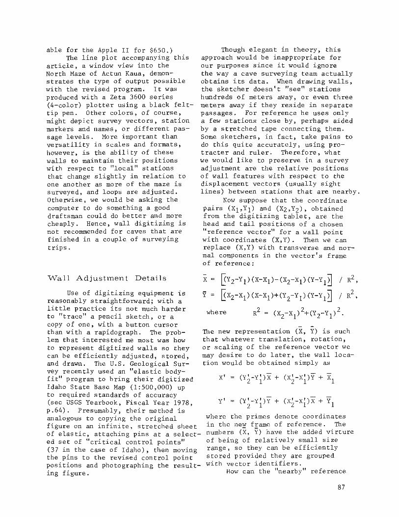
able for the Apple II for $650.)TIle line plot accompanying this
article, a window view into theNorth Maze of Actun Kaua, demonstrates the type of output possiblewith the revised program. It wasproduced with a Zeta 3600 series(4-color) plotter using a black felttip pen. Other colors, of course,might depict survey vectors, stationmarkers and names, or different passage levels. More important thanversatility in scales and formats,however, is the ability of thesewalls to maintain their positionswith respect to "local" stationsthat change slightly in relation toone another as more of the maze issurveyed, and loops are adjusted.Otherwise, we would be asking thecomputer to do something a gooddraftsman could do better and morecheaply. Hence, wall digitizing isnot recommended for caves that arefinished in a couple of surveyingtrips.
Though elegant in theory, thisapproach would be inappropriate forour purposes since it would ignorethe way a cave surveying team actuallyobtains its data. When drawing walls,the sketcher doesn't "see" stationshundreds of meters away, or even threemeters away if they reside in separatepassages. For reference he uses onlya few stations close by, perhaps aidedby a stretched tape connecting them.Some sketchers, in fact, take pains todo this quite accurately, using protracter and ruler. Therefore, whatwe would like to preserve in a surveyadjustment are the relative positionsof wall features with respect to thedisplacement vectors (usually sightlines) between stations that are nearby.
Now suppose that the coordinatepairs (X1,Y1) and (Xz,Yz), obtainedfrom the digitizing tablet, are thehead and tail positions of a chosen"reference vector" for a wall pointwith coordinates (X,Y). TIlen we canreplace (X,Y) with transverse and normal components in the vector's frameof reference:
Wall Adjustment Details
Use of digitizing equipment isreasonably straightforward; with alittle practice its not much harderto "trace" a pencil sketch, or acopy of one, with a button cursorthan with a rapidograph. TIle problem that interested me most was howto represent digitized walls so theycan be efficiently adjusted, stored,and drawn. TIle U.s. Geological Survey recently used an "elastic bodyfit" program to bring their digitizedIdaho State Base Map (1:500,000) upto required standards of accuracy(see USGS Yearbook, Fiscal Year 1978,p.64). Presumably, their method isanalogous to copying the originalfigure on an infinite, stretched sheetof elastic, attaching pins at a selected set of "critical control points"(37 in the case of Idaho), then movingthe pins to the revised control pointpositions and photographing the resulting figure.
x ~YZ-Y 1)(X-X1)- (XZ-X1)(Y-Y 1TI / RZ,
Y ~XZ-X1) (X-X1)+(Yz-Y 1) (Y-Y 1B / RZ,
h Z Z Zwere R = (XZ-X1) +(Y Z-Y 1) .
TIle new representation (X, Y) is suchthat whatever translation, rotation,or scaling of the reference vector wemay desire to do later, the wall location would be obtained simply as
Y' (Y;-Yi)Y + (X;-Xi)X + Y1
where the primes denote coordinatesin the ne~ fEame of reference. TIlenumbers (X, Y) have the added virtureof being of relatively small sizerange, so they can be efficientlystored provided they are groupedwith vector identifiers.
How can the "nearby" reference
87

Ioj~ • ('I'" • LI • vM • Lf" I t~QtIl • vh', aNOflY. (\lY • L2 • vll: • LI' I 1"'0,," • vyv,
..... TTTU L1N[~
.... QEFJ;R[JolCE !TI'rIl"N "'.., ME S , O..,E "Eq lIN!,'II;""''''''EO Q" 51 ... SH (11 IN COL I.
... _ lI"'[S 0" UALn C~OQD'"H'l!S 0' ""IolEOS1'ATlnltl$r 14 C II. V < lll'JI/l,
.... cID"cW"cV" •• lulL cOnQ!'I"'AHS IF'I'l.~ [lo U (", I'O"'"'! -P:q LINEl, ,..11PI"l5rTTO~ (IF "l~"'T LOCAL ll'fF'fllE"lC[ IFII'l_t CO~E "'1'l1 ... T Pl!Q LINn,
•• 1'l["'('ITES ["'0 tH' U"Lf:T "'OE"'~
•• f'lflolOTf:olo E~I") n" .... l.L 0"".( 1M/''00
... IUl":l:IpnCE'SEO Sq~VEV 0..,,., "'Ill IllE o! ... n ,.~nM FIL! .0 ... ' ......
.. h'F T ... ALt:' 0 ... ' ..... T"'Pf.1 .. , ",ILL Al' "1l!NTEI'I 1101 ..~r)Q"o\T rloUT F"'CTlIT""fS ~n'TT"li..
CT"'P"'ho CmIH["IS O"'E 00 .. C'Q'f U"L[T UP::"'~ ",. OICITrZEO .... \.lLT"'f'\~ ou ... FOq 9uIlV[TEn "4!1!'LI"lES WtLL 8 .. ~E"'O '00" COATA" 011"'ILL "'L~F.nT OFSIOE IN "' .... OllV. -ClOr.E.!S~O Ih ~'IoEII '!ole _COlOIltU't,-_('II .... n.fU!i>1'. nlOEC'VE~ (l~ I::LLI-:oIo[. [,Cw TtIIL!!' Altf' MAS 'lot[
1I"0I.LO"I"'r. lIt1h~lr,F.OIE"lTI
FOQ .. ,T nnl,fitT"i1 .... JP~N"CL1"CU:", .wE:QE L1 ... 'In L2 'liE ["IOICE!0'" hI':: ~UAIIE:'" n~" 'QC) ...... S1 nF II[CTt'Hf E"lI'll""I .. T! tF JPE"'-l, (10 ELSETloif. T... ANR\lF"Ai'H; "'''10 •.mA"HI. CO"'P('l,,~"'TS N' ~ "'L.L pnINT 'filTI" IIfSPECT'0 Tlol~ PA~\lrr'lllll \I[CT(11O IF IPEN:l2 O~ 3: T"'F u..,tT.Cj '''E 1£"'11-'8 OF ,°E~t::E="I,jT nil" T"'F v-:CTOIl1ll5 1oI(l0110"'T'L Lf"'CTIol. "'["tCE, IF ('H,IIY) 'liET"'F ~CALe:f) II~CT"'PIiS CO"O.,~f""!I ,~o CV)("l.\lV,,) ITS TAIL POSTTlO ....
.... 'ER T4f 11~F"RE"'CE !\T"'tO'" CO("l"l")t'l"'1'E!I. O"T. ,tOF r.~(lUPfO
ltV w'Ll S. 1o'{TW E ... C" IOI'LL HAvl"'C THF FnLLCl"'T'lr. '"~"''''G''~fNTr~TA"'Tt~G LnCAL qf~f.OF"CE flo:l', lULL "0,,,,, COOAntlt.i"TE -."asfl n _,- nq 0\. LnC"'L OF.~ED~tooCF. (11)~t), w"Ll £I0TNT COOADIJrrt"H",IAOj. :~:, ~ ... (\r"'G LOC"'L AEFE"E"'C! (Jn~t'.r"p~ I".: Tl-'F. "'ALL "'Y PI': l:'IoF.:~EJrrt', JI'J=:a wHL II!SUL' IJrrt , LINf.cn"'NJ:"C'TY"'r. T"4"'T ...... Le 1>0y""T "'1 Tiol '''IF I'1I~VIOIIS Prot"". COOADPUTf0, tlf~ 101'''' I"~A 'RE Iti'-lOofn.
4CCf;pTS l')lGITtlEO PAS!hGE ('iIITL!"!:! f2 l)t"~t,I~I"''''Sl ."0 TQf.N"'OQ .. S O.TA"AAl'::T cot'lQOpn"£5 TO "IE_ cnfiIlOPUT!S _trw IlE!tPtCT TO LrIC&I., PDSSIFILYAnJlJ"TF.11 SIIPVF't' 'P'TtONS. "HE OUTPUT "TL~. c""P£~•• IS y" • FOlhUTSUIHJIILE 1="01" Pll'fTllllG IIlIT'" "IoIE ."'::..:,,». !'lOTTnN r,..~ llol ELl.IPSE _PLANnPH:CTIII'. rN IS PI!'!I/ COLOR:)
AFTI:.:0 DOOr.F.,q !I I IlJi.. TIolE FtoST .. ..,n L'sr 1t1)'t'llT l"F , "'LL OlILL 8£FnEn .. tr ... RI!:SPECT TO ''''F. Lr'lC'L AF.FEAE"'cE~ "Ill f.tt"'fA SIn!':, ,UoIll[1",!:q"F.DIUF P(lI~T!I "'ILL I'll: 'OJI!"!!) '0 EFIl"Il"CT , !I~!)OTI" TA'I.IStTJONRF.tlOn.'ol LOC"L ~F.:FFAF."'C£S. T... ~llF.'OOE, Tn I"'!IUQ( CrlNTIlIlurrv. , JlALLLOC ... ,TO~ oqFSFNT " T~E REC'''''III'''C OR f!'Hlf\'o; O~ TIolO IIl'LLSF.:QU""Cf!t. I'A OF nNf: ClC'St"'f: ~€()UC""Cf CL!')nO\. S"'OUU~ IIlE 80U"'OEO Ill"TotE ~, .. ~ 0tlll OF" 1J€"EIlE""CE"!1 .. T QOTIo4 "L'CE! 1'" Toof F'L£.
c,."" **_er. ELLlp~f: WALL AD"lIST"l["lT ,t,U:"AITJolll ••eeeeee,c TJolE .IooALlS_ OIIlf:CT!vE ."!'lIT" nor "OLlClllll~r. 1(!v"Oliln ""'THIN!Ieerrer. ••• - _ _._ _.. ,. .. _ _.._ _ _••••_•••••err,e
,,eee,,eee,r; 1ll0T/;!\1eeeeeeee,r LOC', 0FFrOr"'r.F." ,Rt to!:"'TIFIEO floV eonJtnt~"'.E. '~,t.T 'Gon: TO ;/1'\o('NC te; ll",IYS ("",'; I"'CI"':S'. 'rIlO!\S.Iol .. 1ll Cllll!OD 15 E1STlv AEPOSJTIO"'EOC TO .. ,T"'T~ 'i \1"'ITll 0'" ... 2"'~ IINITS/INCH T"IIL!".eC·· _ _ .ee,e,,e,ee,,e,eC N(t't£, ..... r::'" OO"lOloJG "'LLS ElLIPSE _ILL IG"'Oof. "OrllH OUT!tDf TlotfC ~qA"E no r..,q,..~ y ... e trnr "LOCI(. Ort ,'''OS! WIIO.!" "fFJ;At"NCt" SUTIO"'SC ..... v! "'OT RI")'''' IIin:N SC'LEn RV TWE It.t.OTtCIIL'o .ltl.t.N. ntoECTIYf:,,C······.·· · · · · .
severe adjustments to the networkdue to earlier bad measurements orplotting errors could, on many occasions, result in an "acceptable"reshaping of the passage walls.
The methods outlined above canno doubt be improved upon, and Ihope this discussion encourages further experimentation. Digitizingthe passages of a large cave is certainly no less tedious than draftingwith pen and ink. But a computercan do remarkable things with digitaldata, and there is satisfaction inknowing that each passage need be"drawn" only once.
vector be chosen? After consideringseveral ways of automating the task~
none of which were consistently reasonable~ I decided it would be better anyway to let the draftsman havefull control. With the cursor in"point mode" he enters each wall asa sequence of two or more stationcoordinate pairs interspersed with amuch larger number of wall coordinate pairs. Each wall point in acoordinate sequence would then assume for reference the vector whoseendpoints are the stations oneither side. For signaling the typeof coordinate pair a 4-button cursorworks particularly well (buttonssignify "station~" "move to wall~"
"draw to wall," and "erase to laststation or terminate") ~ and the resulting data file is structured sothat it can be easily edited if necessary.
Having decided on such a representation~ we must solve a finalproblem relating to the wall adjustment itself. Many wall sequenceswill contain several points of transition from one reference vector tothe next. If we simply use theabove formula for (X~ Y) ~ allowingabrupt transitions between referencevectors, then there is a good chancethat our passages would literallycome apart at the seams when theyare finally drawn by the plotter.The reason for this~ of course~ isthat patterns formed by adj acen t survey vectors are not preserved in anadjustment. Therefore~ the equations for Xand Yhave to be complicated by the addition of a "smoothing"term.
Since we are dealing with relatively small local discrepancieswhich can be smoothed out over thewall points in a number of satisfactory ways~ I omit the particularequations used in ELLIPSE. The result is that~ strictly speaking~
each wall position inherits its adjustment~ not from one vector~ butfrom a weighted average of up tothree vectors in sequence. Itworks well enough, I believe, that
88

) qS01~
125
ACTUN KRUA - N~RTH MAZEYUCATAN, MEX I CelPRELIHINRRT HAP - 1975/76 [RHCS) tCURRENT LENGTH: 6643 H DEPTH: 2S H
PLAN: ROTATED 0.0 DEGREES M
? I I I I 2~METERS
5£- 17 Nav ~ o
BOOK REVIEW
ATLAS SOUTERRAIN DE LA PROVENCEET DES ALPES DE LUMIERE by PaulCourbon and S.C. Sanary. SecondEdition 1980.
Aha! It inevitablY happens toanyone who has been caving for anylength of time, and who has returnedto those beautiful caves of the pastto find them gone. The hole isstill there, but unrecognizableas that place that held so muchattraction. Like going back tosome childhood fishing spot andseeing only a mudhole. And boy,are you mad at wh:Jever did this,but ...maybe as a young, novicecaver you plucked a stalactite whenno one was looking? You can seethe results of your carelessnessnow, and you want to warn everybodyabout what you've learned. Andyou'd better do it because we humanshave the utterly amazing inabilityto see beyond our noses. We actwithout thinking.
The author of this publicationseems to have had this experience.He has been caving at least 25 yearsand has seen lots of caves fall bythe wayside, some at the hands ofcavers themselves. So, he has cleverly added anti-pollution chapters,cartoons and slogans to this deepcave publication. In fact, the publication begins with a chapter onthe respect and cleanliness of caves.
Why has it taken French caversso long to do something about thisproblem? Especially since theirhistory of caving goes a long wayback, and to some very renownedcavers who themselves recognizedsome of these problems? AlthoughMartel had his collection of formations (as Courbon states), he
realized the health danger presented by dumping animal carcasses incaves, and got a law passed outlawing this. Also, Norbert Casteretrepeatedly recounts tales of beautiful caverns being totally strippedof all formations. Courbon sug-
90
gests that since antipollution concern just isn't an integral part ofFrench daily life, much as it ishere in the U.S., then there is noconservation consciousness underlying French caving. Hence, Frenchcavers themselves just by their numbers (in an area half the size ofTexas there are more cavers than inthe entire U.S.), will wreak havocif they are not conservation minded.It seems pretty obvious that sincemost people aren't careful on theirown initiative, then they must betaught to be careful and "sneaking"this instruction into caving publications is one way of exposingconservation to the general cavingpublic.
As for the rest of the publication, it is basically a referencelist of the deepest vertical cave~
("gouffres" not "grottes" which arehorizontal caves), in the southeasternmost part of France. Nocaves under 100 meters deep are included in the descriptions and maps,but are merely named. One hundredand fifteen "gouffres" are brieflydescribed, (location, maps, history,bibliography, and resurgence whenappropriate). There is absolutelyno information on biology, andvery little on geology. This isstrictly big pits and deep caves.The maps are mostly profiles withvery few plans, and the profilesemphasize one thing, depth. However, for a reference book (Courbonimplicitly states that this is nota guide) it is poorly organized.There is no useful table of contents (the one given has no pagenumbers), and no list of caves andmaps with corresponding page numbers which would be immensely usefulin a publication such as this.Basically, this publication's mostfavorable feature is its concernfor the destruction of caves, andits attempt to teach other caversabout this problem. It is goodto see this happening in othercountries.
Teeni Kern

LETTER
Dear Cavers,Bill Stone, in cooperation with
the National Cave Rescue Commission(NCRC), is attempting to expand theNCR network to provide assistance tocavers in the event of a serious accident in Mexico. This might be organized along the lines of the present NCR system in the United Stateswhere arrangements have been madewith the American Air Force to fly ateam to a serious rescue when thelocal cavers request specializedhelp or additional manpower. To extend this service into Mexico and toenable the NCR to quickly reach thecave, advance arrangements need tobe made with the Mexican Governmentto allow the Air Force plane to enterMexico and with the Mexican RedCross to provide local transport andcoordination. In view of the eventual likelihood of a serious accidentdeep within a Mexican cave thatcould involve a rescue beyond thecapability of the group present,this service would be a valuable asset to all who cave in Mexico. Allinterested groups and persons areurged to send suggestions andletters of support to:
Lee Noon, DirectorN.C.R.C.169 S. Bath AvenueWaynsboro, VA 22980
William H. Russell
CARTA
Estimados espeleologos,Bill Stone, en cooperacion con
el Sistema Nacional de Rescate Cavernario, esta trabajando para extender este sistema para ayudar enaccidentes subterraneas en Mexico.En este plan, sera posible obtenerla ayuda de la Fuerza Aerea de unequipo de rescate a Mexico. Pareextender este servicio, es necesarioobtener permiso oficial y permanentepara la entrada de los aviones aMexico. Tambien, es necesario tenerla cooperacion de la Cruz Roja paraproporcionar la transportacion local y ayuda medica. Siendo alta laprobabilidad de un accidente graveen una cueva profunda, este sistemade rescate es importante para espeleologos en Mexico. Personas y grupos que quieren ayudar en este proyecto pueden comunicarse con:
Lee Noon, DirectorN.C.R.C.169 S. Bath AvenueWaynsboro, VA 22980
William H. Russell
Cave SafelV isNO aCCIDENT
91

Traduccion del
Las Cavernas y la espeleologlade Mexico son espectaculares, aSlque no es sorprendente que han atraidoatencion mundial. La multiplicacionfenomenal de espeleologos diligentesen Mexico durante los ultimos 20 anosha tenido y seguira teniendo un impacto significante sabre las cavernas ysu exploracion. Par su mayor parte,este impacto ha sido muy positivo.Los descubrimientos y estudios hansido llevadas a cabo, cooperativamente y can continuo enfasis sabrela conservacion par la AMCS, variosgrupos espeleologicos mexicanos yotros grupos del E.U.A., Europa, yCanada.
Sin embargo, recientemante esteimpacto ha demonstrado rastros negativos. Las dos temas mas serias sonel vandalismo y la rivalidad. Conservar el fragil ambiente subterraneosiempre ha sido el curso de acciondel AMCS; esto incluye el sacar detodos los equipos personales, incluyendo la basura y el carburo gastadode las cuevas. Las cuevas son unmundo virginal, el ultimo que quedamantenemoslos intactos y limpias.
Las areas de grutas inexploradasen Mexico son muy extensivos; par10 tanto, la rivalidad y competicionantipatico son sin razon y contraproductivos. La AMCS siempre haseguido la tradicion de cooperarcan grupos que estan trabajandoactivamente en una cueva a region.Este cooperacion enriquese la calidad del trabajo y evita el popularizacion de las cuevas. Iniciativasin rivalidad es la vla al exito ysatisfaccion en el descubrimientoy exploracion de las cuevas.
Quisieramos tamar este oportunidad para aclarar algunos de las
92
Editorial
ambigUedades sabre la AMCS. LaAMCS fue formado en 1962 par variosespeleologos texanos para el avanzamiento de los conocimientos de lascavernas mexicanas. A traves delos alios ha permanecido sin politicay estructera. Hoy dla el AMCS comoorganizacion es solamente un apartado postal y un gabinete en donde
se guardian las publicaciones.Tiene muy poca estructura -- no haymiembros officiales, ni asambleas.
De vez en cuando, produce boletlnes, pero hasta en esto tiene pocaestructura. La existencia de laspublicaciones cuenta exclusivamentecan la iniciativo individual.
En pocas palabras, el AMCS tieneciertos ideales: Explorar y estudiarlas cavernas magnlficas de Mexico;Conservar la belleza y magia de estascavernas; Para producir un nivel altode calidad en nuestras topograflas,estudios y publicaciones; Impartir ungran respeto para la tierra, lascuevas, y la gente de Mexico; yalcanzar estas metas de manera cooperativa y amistosa.
El AMCS no es un grupo polltico,ni nacionalista. Esta abierto atodos los espeleologos que compartenestas ideales. El "Activities Newsletter" es un ejemplo de esto, yquisieramos que todos participaran,mandando informes, artlculos, mapas,fotos, et. El boletln es un repositorio de valor incalculable, can unagran cantidad de informacion espeleologica que se esta juntando continuamente. Par media de desarollar unsentimiento de unidad, todos tendremas mejor probabilidad de alcanzarnuestra meta comun; la exploraciony estudio ace rca de las cavernas deMexico.
Dale PateTe rri Treacy