Implementing New Street Naming, Numbering and Signage ...
31
Transcript of Implementing New Street Naming, Numbering and Signage ...

Implementing new street naming, numbering and signage solutions with spatial analytics
October 20182018 European Transportation GIS Summit

|
Who we are…
Presentation date3
Working across cities, infrastructure and transport, Steer is a consultancy that combines commercial, economic, technical and planning expertise to find powerful answers to our clients’ complex questions.
• Global transportation consultancy;
• Operate in Rail, Aviation, Bus, Active travel, Major Developments and Digital Solutions;
• GIS team sits in our Design for Movement Team

|
Spatial analytics at Steer
Robust evidence base
Central to our work is our management of geo-spatial data. We have over 250 GIS layers in our central GIS warehouse that we maintain, update and are experts in using.
Advanced spatial analytics
We use geo-spatial analytical techniques to help answer complex questions. Combining multiple data sources in a spatial context often provides new insights.
Award winning cartography
Our mapping outputs have been recognised throughout the transport and cartography industry providing award winning cartography.
Digital Intelligence
We have expertise in working with new data sources and are developing with clients intuitive data collection methods and data visualisation products.
Core to our consultancy offer
Our projects teams appreciate the value of spatial analysis and our GIS consultants are embedded within our project teams to assist in the development of projects
October 20184

|
The team
October 20185
Oliver RussellGIS Manager
Clare SeldonPrincipal Cartographer
Ed BryanSenior GIS Consultant
Helen McKenzieSenior GIS Consultant
Tim GossAssistant Consultant

|
Our offices
We have 21 offices
across four continents.
Since 1978 we have
worked in over 150
countries.
Vancouver
Toronto
Washington DC
New York
Boston Manchester
Leeds
London
Bologna
Rome
San Juan
Panama City
Los Angeles
Mexico City Madrid
Brussels
Lima
Bogotá
Santiago São Paulo
Delhi
October 20186

Panama Nomenclature

|
Panama Nomenclature
Presentation date8
Commissioned through the mayor of Panama and the city authority, brief was to:
• Reviewing existing situation;
• Review international best practice and proposed methods;
• Recommend solutions for Panama;
• Implement and test in neighbourhoods;
• Design and implement new street signage.
Implementing a new street naming and numbering strategy

|
Panama Nomenclature
Presentation date9
More than just a canal!
• Comprised two cities – Panama and San Miguelito;
• Approximate population 2.5 million;
• Economic centre of Central America;
Implementing a new street naming and numbering strategy

| October 201810
Constrained by natural features
Pacific ocean to South;Canal to West
Mountains and Rain Forest to North and East
A growing city
Seeing rapid growth due to economic prosperity
Diverse neighbourhoods
Historic core, downtown, official and unofficial residential areas

Panama Nomenclature – review of existing situation

|
Panama Nomenclature
October 201812
International Best Practice
World bank: Street Addressing and the Management of Cities
Universal postal union: Addressing the world – An address for everyone
Geoplace – BS7666
Geosolutions provided consultancy support from Panama.
Implementing a new street naming and numbering strategy

|
Panama Nomenclature
Presentation date13
Initial data set to review contained approximately:
35 districts; 26 in Panama City and 9 in San Miguelito
Implementing a new street naming and numbering strategy

|
Panama Nomenclature
Presentation date14
Initial data set to review contained approximately:
• 35 districts; 26 in Panama City and 9 in San Miguelito
• 65,000 street segments – 45,000 of which had no naming convention
Implementing a new street naming and numbering strategy

|
Panama Nomenclature
Presentation date15
Initial data set to review contained approximately:
• 35 districts; 26 in Panama City and 9 in San Miguelito
• 65,000 street segments – 45,000 of which had no naming convention
Implementing a new street naming and numbering strategy

|
Panama Nomenclature
Presentation date16
Initial data set to review contained approximately:
• 35 districts; 26 in Panama City and 9 in San Miguelito
• 65,000 street segments – 45,000 of which had no naming convention
Implementing a new street naming and numbering strategy

Panama Nomenclature – applying a method
|
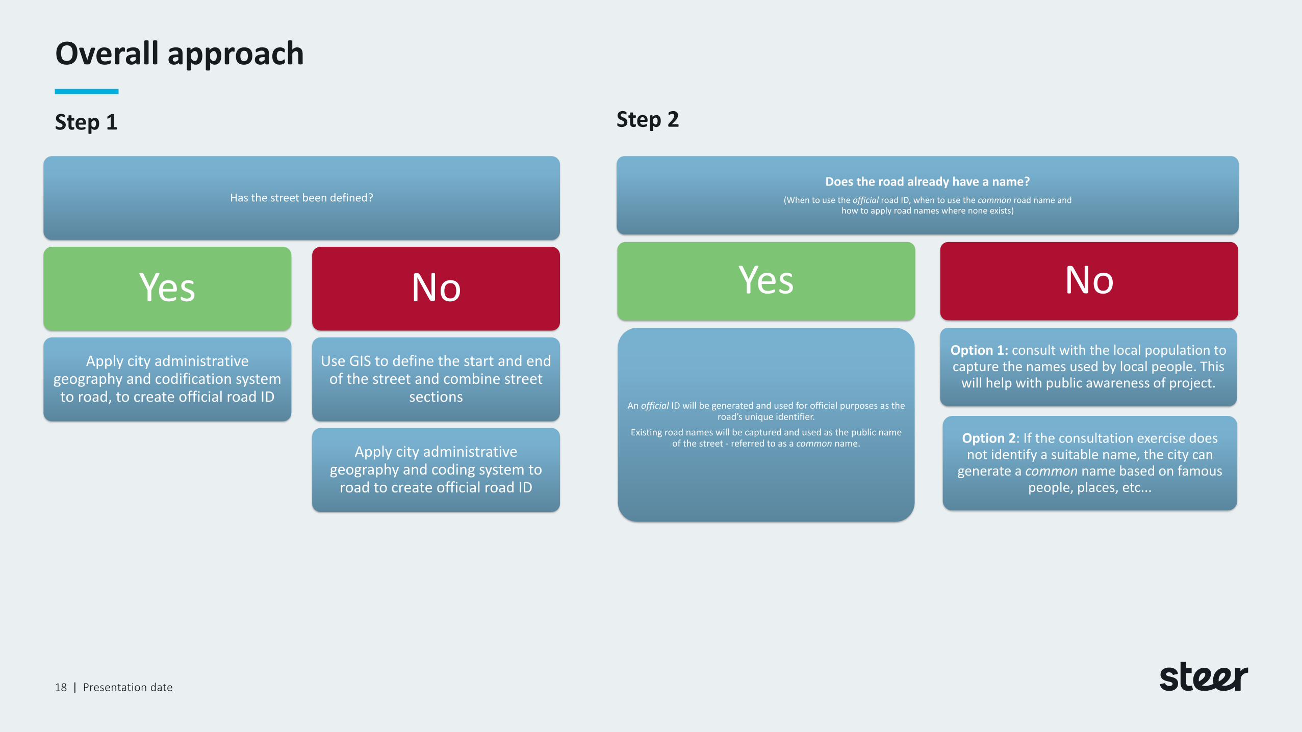
Overall approach
Presentation date18
Has the street been defined?
Yes
Apply city administrative geography and codification system to road, to create official road ID
No
Use GIS to define the start and end of the street and combine street
sections
Apply city administrative geography and coding system to
road to create official road ID
Does the road already have a name?
(When to use the official road ID, when to use the common road name and how to apply road names where none exists)
Yes
An official ID will be generated and used for official purposes as the road’s unique identifier.
Existing road names will be captured and used as the public name of the street - referred to as a common name.
No
Option 1: consult with the local population to capture the names used by local people. This
will help with public awareness of project.
Option 2: If the consultation exercise does not identify a suitable name, the city can
generate a common name based on famous people, places, etc...
Step 1 Step 2

|
Panama Nomenclature
October 201819
On review we recommended that the main priority of our project was to:
• Define a street extent; automate as much as possible!
• Quality control and reassign segments on visual inspection.
Implementing a new street naming and numbering strategy

|
Panama Nomenclature
October 201820
On review we recommended that the main priority of our project was to:
• Define a street extent;
• Apply a codification system to the street to create unique IDs;
Implementing a new street naming and numbering strategy

|
Panama Nomenclature
October 201821
On review we recommended that the main priority of our project was to:
• Define a street extent;
• Apply a codification system to the street to create unique IDs;
• Assign buildings to the street;
Implementing a new street naming and numbering strategy

|
Panama Nomenclature
October 201822
On review we recommended that the main priority of our project was to:
• Define a street extent;
• Apply a codification system to the street to create unique IDs;
• Assign buildings to the street;
• Implement a metric building numbering system;
Implementing a new street naming and numbering strategy

|
Panama Nomenclature
Presentation date23
What would an address look like?
Sample address:
Building Number: 229
Official ID: “PAJD 129”
Common Name: N/A or a new road name
Corregimientos: Juan Diaz
District: Panama
Implementing a new street naming and numbering strategy

Panama Nomenclature – next steps and challenges

|
Panama Nomenclature
October 201825
Next steps:
Apply method and approach to all areas in Panama: ensure the method can be applied at scale.
Communication plan: how will people find out their new address?
Development of street signs: How many and where to put them?
Implementing a new street naming and numbering strategy

|
Panama Nomenclature
Presentation date26
Challenges and how we overcame them
• Scale;
• Applying the method to a city as a whole;• Automating the solution;• Quality control and sense checking;• Some really long roads!
Solution – ArcGIS model builder and Network analyst allowed us to automate much of our analysis.
• Engagement;
• How can we get the public and business to buy into the changes?
Solution – online maps and website to help communicate the changes.
Implementing a new street naming and numbering strategy

|
Panama Nomenclature
Presentation date27
The future:
• Better wayfinding for city residents and visitors;
• A core dataset for which to build other data sets on;
• Improvements in congestion through better route planning; and
• How can other technology enhance an addressing solution?
Implementing a new street naming and numbering strategy

Success story – ArcGIS collector app
|
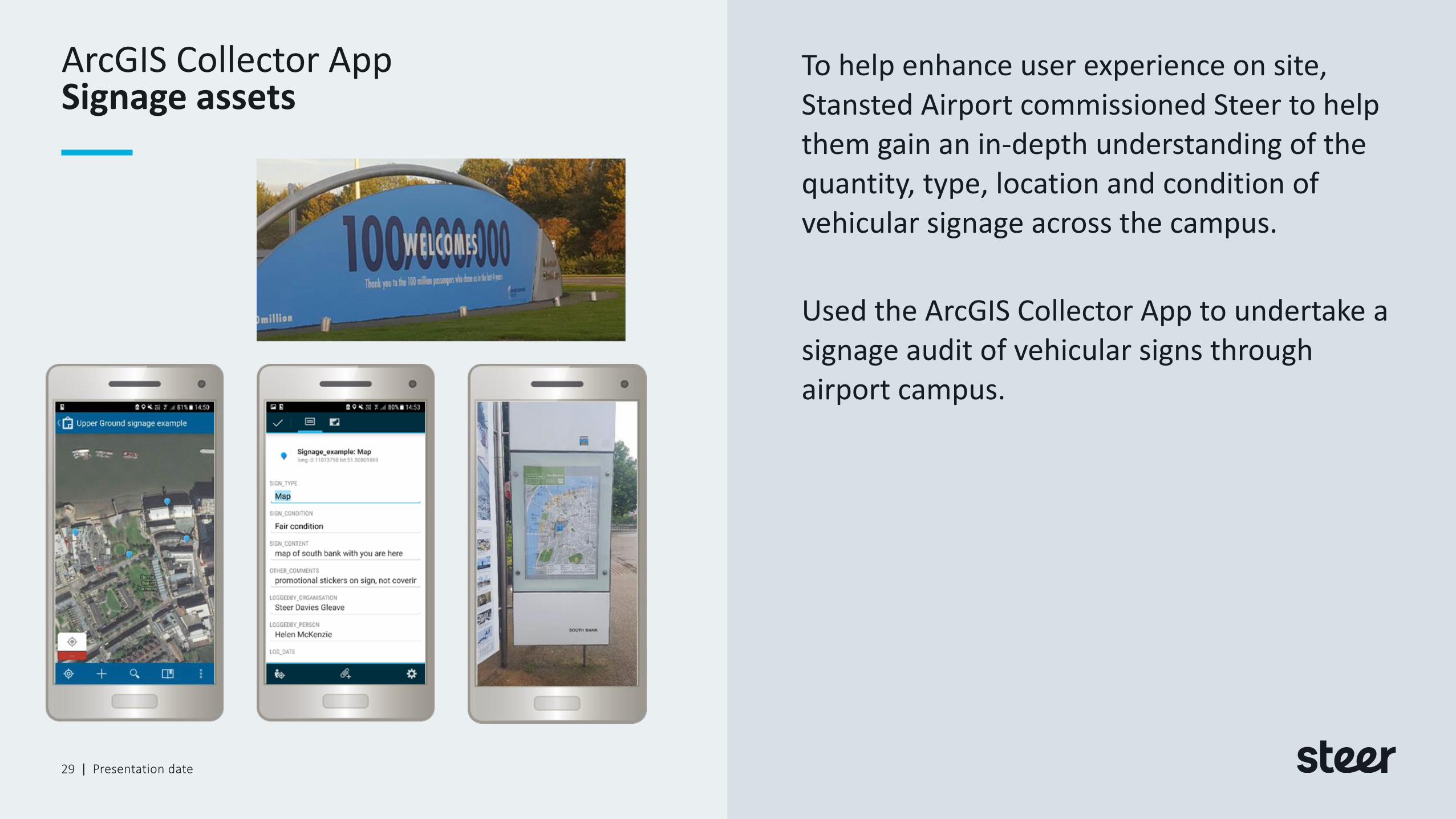
ArcGIS Collector App
Presentation date29
To help enhance user experience on site, Stansted Airport commissioned Steer to help them gain an in-depth understanding of the quantity, type, location and condition of vehicular signage across the campus.
Used the ArcGIS Collector App to undertake a signage audit of vehicular signs through airport campus.
Signage assets

|
Signage strategy for Leading UK airport
Presentation date30
ArcGIS collector app:
• Data collection was quick and easy, captured 1,500 plus signs in around 10 days:
• Displayed content in an online web map in ArcGIS online enabling using to quick and easily interrogate;
• Helping airport understand how they can improve signage to ease customer experience as they travel round the site.
Using ArcGIS online to manage assets

DISCLAIMER: This work may only be used within the context and scope of work for which Steer was commissioned and may not be relied upon in part or whole by any third party or be used for any other purpose. Any person choosing to use any part of this work without the express and written permission of Steer shall be deemed to confirm their agreement to indemnify Steer for all loss or damage resulting therefrom.
Thank you
Please contact:
Oliver Russell
GIS Manager
+44 (0) 20 7910 5577