II EASTERN AFRICA
30
II EASTERN AFRICA II-4 Agulhas Current LME II-5 Somali Coastal Current LME
Transcript of II EASTERN AFRICA

II EASTERN AFRICA
II-4 Agulhas Current LME II-5 Somali Coastal Current LME

144

II-4 Agulhas Current LME S. Heileman, J. R. E. Lutjeharms and L. E. P. Scott The Agulhas Current LME is located in the southwestern Indian Ocean, encompassing the continental shelves and coastal waters of mainland states Mozambique and eastern South Africa, as well as the archipelagos of the Comoros, the Seychelles, Mauritius and La Reunion (France). At the centre of the LME is Madagascar, the world’s fourth largest island, with an extensive coastline of more than 5000km (McKenna and Allen 2005). The dominant large-scale oceanographic feature of the LME is the Agulhas Current, a swift, warm western boundary current that forms part of the anticyclonic gyre of the South Indian Ocean (Lutjeharms 2006a). This LME is influenced by mixed climate conditions, with the upper layers being composed of both tropical and sub-tropical surface waters (Beckley 1998). Large parts of the system are characterised by high levels of mesoscale variability, particularly in the Mozambique Channel and south of Madagascar. About 1.5% and 0.3% of the world’s coral reefs and sea mounts, respectively, occur in this LME, which covers an area of about 2.6 million km², 0.64% of which is protected (Sea Around Us 2007). The coastal zones of both mainland and island states are characterised by a high faunal and floral diversity. At least 12 of the 38 marine and coastal habitats recognised as distinct by UNEP are found in every country of the LME, with Mozambique having 87% of habitat types (Kamukala and Payet 2001). Most of the Western Indian Ocean Islands exhibit a high level of endemism, with Madagascar classified as the country having the most endemic species in Africa, and the 6th most endemic species for a country, worldwide (UNEP 1999). The major mainland estuaries and river systems in this LME include the Mangoki and Zambezi, and provide considerable freshwater and sediment input into the coastal zones, particularly during seasonal tropical cyclone events..
I. Productivity
Lutjeharms (2006b) has provided descriptions of the oceanography and hydrology of the coastal oceans off southeastern Africa and their influence on biological productivity and biota. The Agulhas Current LME is a moderately productive ecosystem (150-300 gCm-2year-1). It is a dynamic region of nutrient cycling, localised upwelling and associated fisheries potential (Bakun et al. 1998, Lutjeharms 2006b). For instance, the region directly to the east of Madagascar has been shown to have a seasonal, deep-sea phytoplankton bloom (Longhurst, 2001) for which the causes are still being debated. Furthermore, episodic upwelling of colder water on the shoreward edge of the Agulhas Current has been shown to create a favourable environment for pelagic clupeoid fishes (Beckley 1998). Such localised, intermittent upwelling has also been observed at specific offsets in the coastline in the Mozambique Channel and at the southeastern tip of Madagascar (Lutjeharms 2006a). An upwelling cell observed at Angoche in Mozambique had the highest chlorophyll density in the Mozambique Channel; off Madagascar the chlorophyll is concentrated in a subsurface maximum. The ecosystem impact of these marked upwelling cells remains unknown due to very few observations. The Agulhas Current furthermore plays an important role in the southward dispersal of early life history stages of tropical fish species. The movement of water in the Mozambique Channel is, by contrast, dominated by eddies. Intense anticyclonic eddies are formed at the narrows of the Channel and move steadily southward. Cyclonic eddies are formed south of Madagascar and may in turn

146 4. Agulhas Current LME
move equatorward on the eastern side of the Mozambique Channel. These eddies seem to have disparate effects on the local ecosystems. It has been noted (Weimerskirch, 2004) that top marine predators feed preferentially at the edges of the anticyclones. It has also been noted in satellite remote sensing of ocean colour (e.g. Quartly and Srokosz 2004) that passing eddies may draw out more productive water from adjacent shelf regions into the deep ocean. The contribution these different processes make to the general productivity of the region is as yet not known. The primary flow of near-bottom water in the western Indian Ocean is South-East through the discordance zone in the Southwest Indian Ridge, via the Crozet Basin, northwards into the Madagascar basin, then into the shallower Mascarene basin, through the Amirante trench to the Somali basin (Schmitz 1996). The LME is considered a distinct biogeographic province of the Indo-West Pacific, with high levels of biodiversity and regional endemism in coastal habitats. Inhabiting the LME are at least 20 species of cetaceans, five species of marine turtles, numerous seabirds, as well as an important remnant population of the threatened dugong. The LME is also home to the CITES-listed coelacanth (Latimeria chalumnae), which belongs to a group of primitive fish earlier believed to be extinct. Ocean currents: The greater Agulhas Current system may be considered to consist of five generic parts: a source region, the northern Agulhas Current, the southern Agulhas Current, the Agulhas retroflection and the Agulhas Return Current, each of which has a different influence on the marine ecosystem (Figure II-4.1).
Figure II-4.1a. A simplified depiction of the circulation and currents of the greater Agulhas system. Red arrows denote anticyclonic motion; blue arrows cyclonic motion or eddies, and a broken, blue line gives the average location of the Subtropical Convergence. Open arrows denote inferred general motion of the Southwest Indian subgyre. Depth is given in kilometre. All the generic components of the current system are shown, including the source currents of the Agulhas Current, its outflows as well as the northern and southern Agulhas Current themselves, located to either side of Port Elizabeth (after Ansorge and Lutjeharms 2007).

II Eastern Africa 147
The Agulhas Current has three recognised sources, in order of volume flux: recirculation in a Southwest Indian Ocean subgyre, contributions by the southern branch of the East Madagascar Current and the flow through the Mozambique Channel (Stramma and Lutjeharms 1997). The recirculation gyre is found west of 70º E. Its waters are largely oligotrophic, but its circulation may play a decisive role in the lifecycle of leatherback sea turtles. The second source from the east of Madagascar is usually in the form of eddies consisting of warm tropical surface water. These eddies are formed at the southern termination of the East Madagascar Current and can be both cyclonic and anticyclonic. The smallest contribution to the flux of the Agulhas Current comes from the Mozambique Channel by the aforementioned eddies. The contribution to the volume flux of the Current by these eddies may be small, but their impact on downstream behaviour is substantial. The northern Agulhas Current flows along the east coast of South Africa following the shelf edge very closely. At irregular occasions this stability is interrupted by a single meander, the Natal Pulse, that is believed to be triggered by the impact of a Mozambique eddy (Schouten et al. 2002). The downstream passing of this meander causes a reversal in the shelf currents and may contribute to the upstream dispersal of biota. At two locations the Current passes form a narrow shelf to a wider shelf: at Cape St Lucia just upstream of Durban and at the eastern edge of the Agulhas Bank (vide Figure II-4.2). At both these locations there is a distinct upwelling cell with enhanced primary productivity. These cells may have a decisive influence on the ecosystems of the shelf segments of which they form part. The southern Agulhas Current has very different flow behaviour. When the Agulhas Current moves past the eastern side of the wider Agulhas Bank, it starts meandering quite extensively to either side (Lutjeharms 2006a). In this process shear edge eddies and warm plumes are formed on its shoreward side. On passing the southern tip of the Bank such warm plumes may move equatorward along the eastern edge of the Bank or may be turned back by lee eddies formed here (Lutjeharms et al. 2007, vide Figure II-4.1). This motion is crucial to the fisheries in the BCLME since the larvae of pelagic fish that spawn on the Bank may be carried to the west coast upwelling region or be removed to the deep sea, depending on the direction of the flow at its western edge. Having passed the most southern tip of Africa, the Agulhas Current retroflects. The Agulhas Current Retroflection is very unstable and the retroflection loop occludes at irregular intervals, creating large Agulhas Rings that drift off into the South Atlantic Ocean carrying with them Indo-Pacific species. The major part of the volume flux from the Retroflection is however eastward in the Agulhas Return Current. This current is either juxtapositioned or flows parallel to the Subtropical Convergence that is recognised for its high levels of primary production (e.g. Allanson et al. 1981). This primary production takes place as intermittent events of limited duration (Llido et al. 2005), an unusual behaviour to which the local, endemic biota have to be adjusted. Although this frontal system is one of the most intense in the world ocean, the currents mentioned above generate their own fronts. Oceanic fronts (Belkin 2008): The Agulhas Current Front (ACF) for instance is the inshore boundary of the Agulhas Current (Figure II-4.1). This front is very deep and is observed year-round. Also included in this LME are average fronts related to the movement of the abovementioned Mozambique eddies. The East Madagascar Current Front (EMCF) is most clearly observed off southeastern Madagascar, and off the northern tip of Madagascar, where the Glorioso Islands Front (GIF) protrudes northwestward from the Glorioso Islands at 11°30’S, 47°20’E. The latter was only described in the literature with the advent of satellite remote sensing, and was discovered during a global survey of oceanic fronts (Belkin et al. 2008). However, these fronts are

148 4. Agulhas Current LME
based on the mean circulation and some may be very intermittent or ephemeral.
Figure II-4.1b. Fronts of the Agulhas Current LME. AB, Agulhas Bank; ACF, Agulhas Current Front; EMadCF, East Madagascar Current Front; GIF, Glorioso Islands Front; IACF, Inshore Agulhas Current Front; MozCF, Mozambique Channel fronts; MozSSF, Mozambique Shelf-Slope Front; OACF, Offshore Agulhas Current Front; WMadSSF, West Madagascar Shelf-Slope Front (most probable location). Yellow line, LME boundary. After Belkin (2008). Agulhas Current SST (after Belkin 2008) Linear SST trend since 1957: 0.68°C Linear SST trend since 1982: 0.20°C Over the past decades the sea surface temperatures (SST) of the Agulhas Current LME have undergone some significant changes. A linear SST trend since 1957 has been an increase of 0.68°C and 0.20°C since 1982 (Figure II-4.2). The Agulhas Current’s long-term warming was punctuated by relatively small-scale cold/warm events with a magnitude of about 0.5°C. A substantial synchronism between increases in SST in the Somali and Agulhas LMEs has been observed. For example, the all-time minimum of 1964 occurred during the same year in the Somali and Agulhas LMEs, as well as the all-time maximum of 1983 in the Agulhas Current and the near-all-time maximum in the Somali Current. The post-1982 warming of the Agulhas Current was spatially non-uniform: the Agulhas Current Retroflection SST increased by up to 1.0°C, while SST in some inshore shelf areas of the Agulhas Bank decreased (Fidel and O’Toole 2007, after Pierre Florenchie, University of Cape Town, personal communication).

II Eastern Africa 149
Figure II-4.2 Agulhas Current LME mean annual SST (left) and SST anomalies (right), 1957-2006. After Belkin ( 2008). Agulhas Current LME Trends in Chlorophyll and Primary Productivity: The Agulhas Current LME is a moderately productive ecosystem (150-300 gCm-2year-1).
Figure II-4.3. Agulhas Current LME trends in chlorophyll a (left) and primary productivity (right) 1998-2006. Values are colour coded to the right hand ordinate. Figure courtesy of J. O’Reilly and K. Hyde. Sources discussed p. 15 this volume. II. Fish and Fisheries
Total reported landings in this LME peaked at just under 600,000 tonnes in 1974 with a record landings of Cape anchovy and South American pilchard (Figure II-4.4). However, with the collapse of these fisheries in the mid 1970s, the reported landings were diminished down to 180,000 tonnes and have remained at this low level for some time, Some signs of growth can be seen in recent years, particularly in the landings of South American pilchard, and total landings have reached 270,000 tonnes in 2004. The trend in the value of the reported landings has mirrored that of the tonnage, and as shown in Figure II-4.5, it peaked at just over 700 million US$ (in 2000 real US$) in 1973 (Sea around us 2007).

150 4. Agulhas Current LME
Figure II-4.4. Total reported landings in the Agulhas Current LME by species (Sea Around us 2007).
Figure II-4.5. Value of reported landings in the Agulhas Current LME by commercial groups (Sea Around Us 2007). The primary production required (PPR, Pauly & Christensen 1995) to sustain the reported landings in the LME reached close to 8% of the observed primary production in 1968, when the highest level of reported landings was recorded (Figure II-4.6). With the collapse of the Cape anchovy and South American pilchard fisheries in the mid 1970s, the PPR declined to around 2%. In the 1980s, however, it returned to about 5% (Sea Around Us 2007). South Africa and Madagascar account for the largest ecological footprints in the LME, though in the 1960s and the early 1970s, foreign fleets accounted for the majority of the footprint.

II Eastern Africa 151
Figure II-4.6. Primary production required to support reported landings (i.e., ecological footprint) as fraction of the observed primary production in the Agulhas Current LME (Sea Around Us 2007). The ‘Maximum fraction’ denotes the mean of the 5 highest values. The sharp increase in the mean trophic level of the fisheries catch (i.e., the MTI; Pauly & Watson 2005) observed in the mid-1970s reflects the collapse of the pilchard and anchovy fisheries, two species with low trophic levels (Figure II-4.7 top).
Figure II-4.7. Marine trophic level (i.e., Marine Trophic Index) (top) and Fishing-in-Balance Index (bottom) in the Agulhas Current LME (Sea Around Us 2007). Although the MTI has declined over the last few years, likely due to the increased pilchard landings, there is no observable decline indicative of a ‘fishing down’ of the food web (Pauly et al. 1998) in the LME. Over the same period, the FiB index showed at best a minor decline (Figure II-4.7 bottom), suggesting that the increasing catches over this period may not sufficiently compensate for the decline in the MTI (Pauly & Watson 2005). The Stock-Catch Status Plots show that the number of collapsed stocks is higher than that of overexploited or fully exploited stocks (Figure II-4.8, top), while the three groups contribute equally to the catch biomass (Figure II-4.8, bottom).
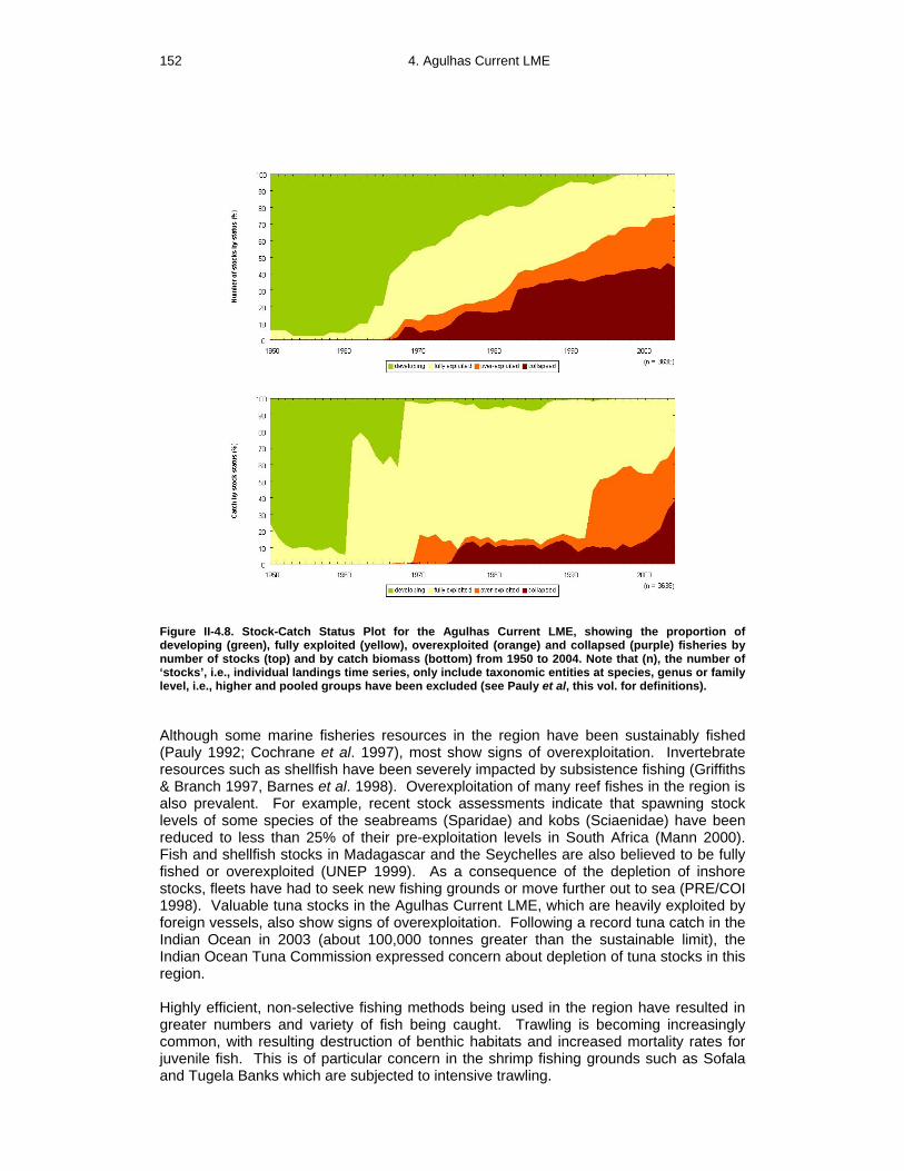
152 4. Agulhas Current LME
Figure II-4.8. Stock-Catch Status Plot for the Agulhas Current LME, showing the proportion of developing (green), fully exploited (yellow), overexploited (orange) and collapsed (purple) fisheries by number of stocks (top) and by catch biomass (bottom) from 1950 to 2004. Note that (n), the number of ‘stocks’, i.e., individual landings time series, only include taxonomic entities at species, genus or family level, i.e., higher and pooled groups have been excluded (see Pauly et al, this vol. for definitions). Although some marine fisheries resources in the region have been sustainably fished (Pauly 1992; Cochrane et al. 1997), most show signs of overexploitation. Invertebrate resources such as shellfish have been severely impacted by subsistence fishing (Griffiths & Branch 1997, Barnes et al. 1998). Overexploitation of many reef fishes in the region is also prevalent. For example, recent stock assessments indicate that spawning stock levels of some species of the seabreams (Sparidae) and kobs (Sciaenidae) have been reduced to less than 25% of their pre-exploitation levels in South Africa (Mann 2000). Fish and shellfish stocks in Madagascar and the Seychelles are also believed to be fully fished or overexploited (UNEP 1999). As a consequence of the depletion of inshore stocks, fleets have had to seek new fishing grounds or move further out to sea (PRE/COI 1998). Valuable tuna stocks in the Agulhas Current LME, which are heavily exploited by foreign vessels, also show signs of overexploitation. Following a record tuna catch in the Indian Ocean in 2003 (about 100,000 tonnes greater than the sustainable limit), the Indian Ocean Tuna Commission expressed concern about depletion of tuna stocks in this region. Highly efficient, non-selective fishing methods being used in the region have resulted in greater numbers and variety of fish being caught. Trawling is becoming increasingly common, with resulting destruction of benthic habitats and increased mortality rates for juvenile fish. This is of particular concern in the shrimp fishing grounds such as Sofala and Tugela Banks which are subjected to intensive trawling.

II Eastern Africa 153
Other destructive fishing practices include the use of dynamite, poisons and purse-seines, which are of concern especially around island areas. As a consequence of these destructive methods, fish stocks and biodiversity are declining in the LME, with several species now facing potential economic extinction. Reduced catch rates and decrease in mean sizes of fish caught are evident in the landings (UNEP 2002). In addition, catching of non-target endangered marine species, such as turtles, dolphins and dugongs are also cause for great concern. Fisheries bycatch is severe in both Mozambique and South African fisheries. Overall, overexploitation, excessive bycatch and discards, and destructive fishing practices appear to be severe in the Agulhas Current LME (UNEP 2006). This will continue to threaten fisheries sustainability and food security of the bordering countries. The situation, however, is expected to improve with the implementation of new approaches to the management of the LME’s fisheries resources (see Governance).
III. Pollution and Ecosystem Health
Pollution: While pollution in the Agulhas Current LME was found to be moderate and not to pose a regional threat, the inadequate treatment of wastes results in severe localised problems near cities and industrialised areas in all the countries. Marine pollution originates from both land- and sea-based sources and activities (Nguta 1998, Ruwa 2006). Among them are growing coastal populations and increasing tourism, for which sewage treatment facilities are inadequate. As a result, raw sewage is often discharged directly into rivers or the sea, leading to eutrophication in localised areas. In addition, untreated effluents from fish processing plants, abattoirs and chemical and manufacturing industries are frequently discharged into the sea, causing varying degrees of pollution in some localities. Severe localised pollution is caused by dumping of domestic and industrial solid wastes in government-approved sites on the coast, but with little or no environmental regulation in place. Leachates from dump sites flow into coastal areas, especially during the rainy season, further degrading coastal habitats. Plastics constitute an increasing proportion of coastal and marine litter, and pose a serious threat to protected species such as marine turtles, dugongs, whales and dolphins (UNEP 2002). The intensive use of agro-chemicals such as dichlorodiphenyltrichloroethane (DDT), dieldrin and toxophene is common throughout the region, with potential transboundary consequences. Use of fertilisers is also common and has caused localised occurrences of eutrophication and HABs (PRE/COI 1998). Poor farming practices and deforestation in the coastal and hinterland areas result in excessive siltation in the coastal and marine environments, smothering seagrass beds and coral reefs. Marine-based pollution in this LME stems from oil tanker traffic, exploitation of the seabed, construction, dredging and ocean dumping (Nguta 1998). Oil pollution caused by oil tanker traffic, discharge of waste oil in rivers, frequent oil spills in harbours and other maritime activities, is a major problem in some coastal areas. About 450 million tonnes of hydrocarbon products are transported annually through the Mozambique Channel, posing a high potential risk of oil spills (Salm 1996). The prevailing southeasterly Trade Winds make the Mozambican coast most vulnerable, as demonstrated by the Katina-P oil spill in 1992 near Maputo Bay (Massinga & Hutton 1997). Pollution of the coastal zone poses a direct threat to human health through the consumption of contaminated seafood or swimming in contaminated waters. Throughout the region, pollution has impacted the ecosystem in far less obvious but more significant

154 4. Agulhas Current LME
ways by reducing the abundance and variety of fish available for local consumption, indirectly leading to overexploitation of the remaining stocks of certain species and subsequent collapse of coral reef ecosystems (UNEP 1999). Polluted coastal areas and loss of charismatic species such as whales also reduce revenues from tourism.
Habitat and community modification: The productivity of coastal waters is highly dependent on the health of mangroves, coral reefs, estuaries and seagrass beds, as well as the quality of run-off from land. Estuaries play a significant role in providing food and shelter for juvenile organisms in the high energy marine environment of the LME. Some of these organisms, particularly shared and migratory fish stocks, are of transboundary importance. Modification of coastal habitats such as mangroves, coral reefs and seagrass beds is moderate but widespread and is a major threat to sustainable use of resources and development in the coastal zone. Coral reefs are under increasing pressure from urbanisation, tourism, dredging and extraction of coral and shells, limestone mining and destructive fishing methods including dynamite fishing. These activities are also depleting the buffer zone provided by coral reefs, making the shores more exposed to wave action, storm surges and inundation (UNEP 2002). The coral reefs of the islands have been severely degraded or even lost in several areas (Bryant et al. 1998, PRE/COI 1998). Some coral reefs of Seychelles have been classified as being under the highest threat and risk of degradation (Bryant et al. 1998). The most important immediate cause of mangrove loss is unsustainable harvesting, particularly for firewood, construction, and production of charcoal around the main cities. Other causes of mangrove loss include the clearing of mangrove for salt production, human settlements, urban development, mariculture ponds and sand mining. There has been considerable modification of coastal habitats by beach erosion as a result of coastal construction, beach replenishment schemes, coastal mining and dredging in harbours. Poor management of catchment basins has led to reduced freshwater inflow and degradation of estuaries, which are also under threat from excessive siltation and other anthropogenic factors. The water quality in about 20% of South Africa’s estuaries in this LME has been described as poor or very poor (Harrison et al. 2000). Seagrass beds have also been smothered by sediments, resulting in loss of shelter, food and nursery grounds for valuable fish, shellfish, dugong and turtles (UNEP 1999). Mining of titanium and zirconium, as well as other mining-related activities, have adverse environmental impacts on sand dune systems, wetlands and estuaries. As already discussed, pollution in the coastal zone has severe localised impacts and also contributes to habitat degradation and loss. Global climate change is expected to have grave impacts on the marine and coastal environments of the Agulhas Current LME and their living resources. The most notable impact of climate change has been widespread bleaching of corals in the Indian Ocean Islands. In 1998, a 1°C temperature rise, induced by El Niño, caused the bleaching and death of up to 90% of the region’s corals (Obura et al. 2000); in many instances, this loss was irreversible. Increasing economic development, growing urbanisation, and unsustainable use of the natural resources in the coastal areas will continue to threaten the health of the LME. Furthermore, the impacts of habitat modification and loss on the economy and people of the coastal areas will be magnified by global climate change. Appropriate measures based on sound scientific knowledge are urgently required to address the deterioration in ecosystem health which will otherwise severely undermine the economic stability of the region (Kamukala and Payet 2001) .

II Eastern Africa 155
IV. Socioeconomic Conditions
Coastal cities, commercial ports and industrial centres are rapidly developing in the Agulhas Current LME. The coastal population of Mozambique has been estimated at about 6.5 million (about 40% of the total population), while the coastal population of eastern South Africa is estimated at about 7 million. The total population of the Western Indian Ocean islands was about 17 million in 1998 and is expected to exceed 43 million by 2050 (UN Population Division 1998). The economy of the bordering countries is reliant on agriculture, forestry, wildlife, fisheries, tourism and exploitation of minerals. Island states share the characteristics of economies dependent on imports and high levels of unemployment (Gossling, 2006). International tourism makes a significant contribution to GDP, especially in South Africa and the Indian Ocean islands. For example, in the Seychelles, tourism contributes 15% to GDP, up to 75% of foreign exchange earnings and employs 20% of the labour force (Republic of Seychelles 1997, UNDP 1997). Tourism has grown exponentially in the past 15 years, in some countries by an order of magnitude. While providing some clear economic benefit through employment generation, foreign exchange earnings, the promotion of the development of infrastructure and the protection of cultural heritage, a lack of integrated planning has exacerbated negative impacts. These include the overuse of fresh water, overfishing, damage to coral reefs, land use transformation, clearing of mangroves, increased pollution and lack of benefit to local communities (Gossling 2006). Marine fisheries are a significant source of foreign exchange, employment, and protein in most countries. In Mozambique, the industrial and semi-industrial fleets generate about 40% of foreign currency income (Schleyer et al. 1999). In the Seychelles, fish and fish products account for 95% of domestic exports and are the second highest foreign exchange earner after tourism (UNDP 1997). In some of the countries, fish often represents the primary source of animal protein available to the local populations. The socioeconomic impacts of habitat modification are significant, considering that a large number of people are dependent on these resources and that they make a valuable contribution to the economies of the countries adjacent to the LME (Massinga & Hutton 1997, UNEP 1999, 2002). Destruction of these critical habitats results in loss of shelter, food and nursery grounds for commercially important fish, shellfish, turtle and dugong (UNEP 1999). The subsequent reduction in recruitment of shrimp and fish as well as reduced catches in subsistence and industrial fisheries will threaten food security, employment and national income. Sea level rise and associated impacts such as flooding and erosion will result in disruption of infrastructure and economic activities including loss of employment, income and food source. Other economic costs of sea level rise are associated with beach replenishment schemes, dredging and coastal protection to prevent beach erosion. The islands in particular will suffer significant economic losses in the tourist industry due to loss of beach and reef-based activities (IPCC 1995).
V. Governance
The lack of knowledge on the environment is a severe limiting factor for environmental governance in the Agulhas Current region. An exhaustive review by Lutjeharms (2006a) shows that we have a dearth of information and data, compared to that available for other similar regions. The gaps in knowledge must be addressed in order to identify critical concerns about fisheries, productivity and ecosystem health, as well as developing ameliorating measures. Governance in the Agulhas Current region is also constrained

156 4. Agulhas Current LME
by regionally incompatible laws and a paucity of environmental regulations. This LME is located within the UNEP Eastern Africa Regional Seas. All the countries have ratified the Convention for the Protection, Management and Development of the Marine and Coastal Environment of the Eastern African Region (Nairobi Convention) with its Protocols on Protected Areas and Wild Fauna and Flora, and on Co-operation in Combating Marine Pollution in cases of Emergency. Regional organisations involved in the management of coastal and marine resources in the West Indian Ocean are the Western Indian Ocean Fishery Sub-Commission, the Inter-governmental Oceanographic Commission’s Regional Committee for the Cooperative Investigation of the North and Central Western Indian Ocean and the Indian Ocean Commission. The GEF supported Agulhas and Somali Current Large Marine Ecosystems (ASCLME) Project is part of a multi-project, multi-agency Programme to institutionalize cooperative and adaptive management of the Agulhas and Somali LMEs. A phased approach is planned that progressively builds the knowledge base and strengthens technical and management capabilities at the regional scale to address transboundary environmental concerns within the LMEs, builds political will to undertake threat abatement activities and leverages finances proportionate to management needs. In addition to the ASCLME Project, the Programme includes two parallel projects, one that addresses land-based sources of pollution and coastal degradation (WIO-LaB, implemented by UNEP); and one that builds knowledge for the purposes of managing industrial fisheries (SWIOFP, implemented by the World Bank). The activities within the ASCLMEs Project are focused on filling the significant coastal and offshore data and information gaps for these LMEs by capturing essential information relating to the dynamic ocean-atmosphere interface and other interactions that define the LMEs, along with critical data on artisanal fisheries, larval transport and nursery areas along the coast. The overall objective of this excercise will be to deliver two Transboundary Diagnostic Analyses (TDAs), and two Strategic Action Programmes (SAPs); one for the Agulhas Current LME, and the other for the Somali Current LME. The parallel UNEP and World Bank Projects will also feed pertinent information into the TDAs/SAPs formulation process, and identify policy, legal and institutional reforms and needed investments to address transboundary priorities. Collectively, the projects build foundational capacities at regional scale for management of the LMEs. References Allanson, B. R., Hart, R. C. and Lutjeharms, J. R. E. (1981). Observations on the nutrients,
chlorophyll and primary production of the Southern Ocean south of Africa. South African Journal of Antarctic Research, 10/11: 3-14.
Ansorge, I. J. and Lutjeharms, J. R. E. (2007). The cetacean environment off southern Africa. in: The Whales and Dolphins of the Southern African Subregion, P. B. Best and P. A. Folkens, Cambridge University Press, Cambridge, p 5-13.
Bakun, A., Claude, R. and Lluch-Cota, S. (1998). Coastal upwelling and other processes regulating ecosystem productivity and fish production in the Western Indian Ocean, p 103-141 in: Sherman K., Okemwa, E.N. and Ntiba M.J. (eds), Large Marine Ecosystems of the Indian Ocean: Assessment, Sustainability and Management. Blackwell Science, Inc. Malden, U.S.
Barnes, D.K.A., Corrie, A., Whittington, M., Carvalho, M.A. and Gell, F. (1998). Coastal shellfish resource use in the Quirimba Archipelago, Mozambique. Journal of Shellfish Research 17(1):51-58.
Beckley, L.E. (1998). The Agulhas Current Ecosystem with particular reference to dispersal of fish larvae, p 255-276 in: Sherman, K., Okemwa, E.N. and Ntiba. M.J. (eds), Large Marine Ecosystems of the Indian Ocean: Assessment, Sustainability and Management. Blackwell

II Eastern Africa 157
Science, Inc. Malden, MA. Belkin, I.M. (2008) Rapid warming of Large Marine Ecosystems, Progress in Oceanography, in
press. Belkin, I.M., Cornillon, P.C. and Sherman, K. (2008). Fronts in Large Marine Ecosystems of the
world’s oceans. Progress in Oceanography, in press. Bryant, D., Burke, L., McManus, J. and Spalding, M. (1998). Reefs at Risk. A map-based indicator
of threats to the world’s coral reefs. WRI, ICLARM, WCMC and UNEP, Washington, D.C., U.S. Cochrane, K.L., Butterworth, D.S. and Payne, A.I.L. (1997). South Africa’s offshore living marine
resources: The scientific basis for management of the fisheries. Transactions of the Royal Society of South Africa 52(1).
Fidel, Q., and M. O’Toole (2007). Changing state of the Benguela LME: Forcing, climate variability and ecosystem impacts, presented at the 2nd Global Conference on Large Marine Ecosystems, Qingdao, China, 11-13 September 2007; www.ysfri.ac.cn/GLME-Conference2-Qingdao/ppt/18.1.ppt
GEF/UNDP/UNOPS (2004). Somali and Agulhas Large Marine Ecosystem Transboundary Diagnostic Analysis. Available online at< www.gefweb.org/uploadedFiles/Projects/Work _Programs /Project%20Document(4).pdf >-
GEF-UNDP. (2005). Governments of Comoros, Kenya, Madagascar, Mauritius, Mozambique, Seychelles, South Africa, Tanzania Programme for the Agulhas and Somali Current Large Marine Ecosystems. www.gef.org , International Waters Projects, Regional, approved.
Griffiths, C.L. and Branch, G.M. (1997). The exploitation of coastal invertebrates and seaweeds in South Africa; historical trends, ecological impacts and implications for management. Transactions of the Royal Society of South Africa 52(1).
Gossling, S. (2006). Towards sustainable tourism in the Western Indian Ocean. Western Indian Ocean Journal of Marine Science. Vol 5. p 55-70.
Harrison T.D., Cooper, J.A.G. and Ramm, A.E.L. (2000). State of South African Geomorphology, Ichthyofauna, Water Quality and Aesthetics – State of the Environment Series, Report 2. Department of Environmental Affairs and Tourism, Pretoria, South Africa.
IPCC (1995). Climate Change 1995. IPCC Second Assessment Report. Impacts, Adaptations and Mitigation of Climate Change: Scientific and Technical Analysis. Intergovernmental Panel on Climate Change/WHO/UNEP. Cambridge University Press, Cambridge, U.K.
Kamukala, G. and Payet, R. (2001). Regional report, p 152-180, in: Voabil, C. and Engdahl, S. (eds), The Voyage from Seychelles to Maputo. Successes and failures of integrated coastal zone management in Eastern Africa and Island States. Secretariat for Eastern African Coastal Area Management (SEACAM). Maputo, Mozambique.
Llido, J., Garçon, V., Lutjeharms, J. R. E. and Sudre, J. (2005). Event-scale blooms drive enhanced primary productivity at the Subtropical Convergence. Geophysical Research Letters, 32(15): L5611, doi. 10.1029/2005GL022880.
Longhurst, A. (2001). A major seasonal phytoplankton bloom in the Madagascar Basin, Deep-Sea Research I, 48: 2413–2422.
Lutjeharms, J. R. E. (2006a). The Agulhas Current. Springer-Verlag, Heidelberg, xiii + 329 p. Lutjeharms, J.R.E. (2006b). The coastal oceans of South-eastern Africa, p 781 - 832 in: Robinson,
A.R. and Brink, K. (eds), The Sea Volume 14B, The Global Coastal Ocean - Interdisciplinary Regional Studies and Syntheses. Harvard University Press, U.S.
Lutjeharms, J. R. E., Durgadoo, J. V. and Ansorge, I. J. (2007). Surface drift at the western edge of the Agulhas Bank. South African Journal of Science, 103(1/2): 63-67.
Mann, B.Q. (2000). Southern African Marine Linefish Status Reports. Special Publication, Oceanographic Research Institute Issue 7. Oceanographic Research Institute, Durban, South Africa.
Massinga, A . and Hutton, J. (1997). Status of the Coastal Zone of Mozambique, p 7-68 in: Lundin, C.G. and Linden, O. (eds), Integrated Coastal Zone Management in Mozambique. Proceedings of the National Workshop on Integrated Coastal Zone Management in Mozambique. Inhaca Island and Maputo, Mozambique, May 5-10, 1996.
McKenna, S. A. and Allen, G. R., (2005). A Rapid marine biodiversity assessment of northwest Madagascar. Bulletin of the Rapid Assessment Programme 31, Conservation International, Washington DC. 124p.
Nguta, C.M. (1998). An overview of the status of marine pollution in the East African region, p 61-71 in Sherman, K., Okemwa, E.N. and Ntiba, M.J. (eds), Large Marine Ecosystems of the Indian Ocean: Assessment, Sustainability and Management. Blackwell Science, Inc., Malden, U.S.
Obura, D.O., Muthiga, N.A. and Watson, M. (2000). Country profiles of coral reefs: Kenya, p 199-

158 4. Agulhas Current LME
230 in: McClanahan, T.R., Sheppard, C.R.C. and Obura, D.O. (eds), Coral Reefs of the Indian Ocean. Oxford University Press.
Pauly, D. (ed). (1992). Population dynamics of exploited fishes and crustaceans in Mozambique: Contributions from a course on the “Use of Computers for Fisheries Research”, held at the Instituto de Investigaçao Pesqueira, 23 February to 15 March 1988 in Maputo, Mozambique. Revista de Investigação. Pesqueira. (21), 135 p.
Pauly, D. and Christensen, V. (1995). Primary production required to sustain global fisheries. Nature 374: 255-257.
Pauly, D. and Watson, R. (2005). Background and interpretation of the ‘Marine Trophic Index’ as a measure of biodiversity. Philosophical Transactions of the Royal Society: Biological Sciences 360: 415-423.
Pauly, D., Christensen, V., Dalsgaard, J., Froese R. and Torres, F.C. Jr. (1998). Fishing down marine food webs. Science 279: 860-863.
PRE/COI (1998). Rapport Régional sur les Récifs. Programme Regional Environment, Commission de l’océan Indien, Quatres Bornes, Maurice.
Quartly, G. D. and Srokosz , M. A. (2004). Eddies in the southern Mozambique Channel. Deep-Sea Research II, 51(1-3): 69-83.
Republic of Seychelles (1997). Public Sector Investment Programme 1997-1999 (Revision of 1996-1999). Division of Planning, Ministry of Foreign Affairs, Planning and Environment, Government of Seychelles.
Ruwa, R. (2006). Eastern Africa, p 51–74 in UNEP/GPA (2006), The State of the Marine Environment: Regional Assessments. UNEP/GPA, The Hague.
Salm, R.V. (1996). The status of coral reefs in the western Indian Ocean with notes on the related ecosystems. The International Coral Reef Initiative (ICRI) Western Indian Ocean and Eastern African Regional Workshop Report, 29 March-2 April 1996, Mahé, Seychelles.
Schleyer, M., Obura, D., Motta, H. and Rodrigues, M.J. (1999). A preliminary assessment of coral bleaching in Mozambique. Coral Reef Degradation in the Indian Ocean. CORDIO Status Reports and Project Presentations 1999. SAREC Marine Science Programme, Stockholm University, Sweden.
Schmitz, W. J. (Jr). (1996). On the World Ocean Circulation: Volume II. The Pacific and Indian Oceans / A Global Update. Woods Hole Oceanographic Institution. Technical Report WHOI-96-98. 237p.
Schouten, M. W., de Ruijter, W. P. M. and van Leeuwen, P. J. (2002). Upstream control of Agulhas ring shedding. Journal of Geophysical Research, 107(C8), doi: 10.1029/2001JC000804.
Stramma, L. and Lutjeharms, J. R. E. (1997). The flow field of the subtropical gyre of the South Indian Ocean. Journal of Geophysical Research, 102(C3): 5513-5530.
Sea Around Us (2007). A Global Database on Marine Fisheries and Ecosystems. Fisheries Centre, University British Columbia, Vancouver, Canada. www.seaaroundus.org/lme/Summary Info.aspx?LME=30
UN Population Division (1998). World Population Estimates and Projections, 1998 Revision, United Nations, New York, U.S.
UNDP (1997) Development Cooperation Report: Seychelles. United Nations Development Programme. Port Louis, Mauritius.
UNEP (2006). Agulhas Current, GIWA Regional Assessment 45a. University of Kalmar, Kalmar, Sweden.
UNEP (2002). Africa Environment Outlook: Past, Present and Future Perspectives. United Nations Environment Programme, Nairobi, Kenya.
UNEP (1999). Western Indian Ocean Environment Outlook. United Nations Environment Programme, Nairobi, Kenya.
Weimerskirch, H., M. le Corre, S. Jaquemet, M. Potier and F. Marsac (2004). Foraging strategy of a top predator in tropical waters: great frigatebirds in the Mozambique Channel. Marine Ecology-Progress Series 275: 297-308.

II-5 Somali Coastal Current LME S. Heileman and L. E. P. Scott The Somali Coastal Current LME extends from the Comoro Islands and the northern tip of Madagascar in the south to the Horn of Africa in the north (Alexander 1998, Okemwa 1998). It is bordered by Somalia, Kenya and Tanzania. Early descriptions of the circulation patterns of the system related to the monsoons and oceanography are given by Newell (1957) and Johnson et al. (1982). Weather and ocean currents in the Somali Current LME are strongly influenced by the two distinct monsoon seasons. The prevailing winds during the monsoons are a particularly important influencing factor on water circulation (affecting the distribution of nutrients and marine organisms as well as biological processes), changing wave action, and affecting a wide range of human activities (Richmond 2002). From November to March, the prevailing trade wind is from the North-East, but more north-westerly in direction to the South of the Equator. From June to September, the stronger South-West monsoon wind prevails. South of the Equator, this wind is more south-easterly in direction (Newell 1957, Okemwa 1998, Richmond 2002). This LME’s unique bathymetry results from major submarine tectonic features of the Indian Ocean, including the mid-Indian Ridge, the Owen Fracture Zone and the Carlsberg Ridge (Okemwa 1998). Covering an area of about 840,710 km2, of which 0.86% is protected, the LME contains about 0.98% of the world’s coral reefs and 0.01% of the world’s sea mounts (Sea Around Us 2007). A volume edited by Sherman et al. (1998) on the Indian Ocean LMEs contains several articles on this LME.
I. Productivity
The Somali Current LME is a moderately productive ecosystem (150-300 gCm-2year-1). During the Southwest Monsoon, upwelling off Somalia becomes one of the most intense coastal upwelling systems in the world (Baars et al. 1998, Bakun et al. 1998). However, the mean phytoplankton density and productivity are lower than expected, possibly due to the dilution of the upwelling effects over a large area because of the strong winds and the high speed of the Somali Current (Baars et al. 1998). Productivity has been noted during some SW Monsoon seasons (in 1987, for example) to be highest two hundred kilometres offshore; likely due to the dynamics of the offshore eddy which enhances productivity, rather than any consequence of coastal upwelling (Hitchcock and Olson 1992). Euphausids make up about 25% of total zooplankton biomass while copepods make up most of the remainder (Okemwa 1998). Within the upwelling zone, the dominant zooplankton species include the large copepods Calanoides carinatus and Eucalanus elongatus, as well as several species of smaller copepods. Most taxa, with the exception of C. carinatus, persist throughout the Northeast Monsoon, during which primary productivity decreases but without a substantial decrease in the zooplankton stock (Baars et al. 1998). The LME encompasses a rich diversity of coastal habitats including coral reefs, mangroves, seagrass beds and estuaries that play an important role in its overall health and productivity (Okemwa 1998, WWF 2002). Several endangered marine turtle and whale species, as well as the dugong and the CITES-listed coelacanth, Latimeria chalumnae, occur in the LME. Oceanic fronts: (after Belkin 2008) The Somali Current (Figure II-5.1) velocity and direction are linked to the monsoon that dominates the meteorological and hydrographic regime of the Indian Ocean. In summer, the prevailing winds from the southwest accelerate the along-shore Somali Current that flows north. North of the Equator, the

160 5. Somali Current
Somali Current is deflected eastward, thus resulting in the upwelling of cold, nutrient-rich waters along the Somali coast. These waters are separated by a sharp front from the warm and salty waters carried by the Somali Current. With the advent of the boreal winter monsoon, the wind field reverses and the prevailing winds from the North-East shut down the coastal upwelling, spin down the Somali Gyre and cause downwelling along the Somali coast (Belkin et al. 2008).
Figure II-5.1. Fronts of the Somali Coastal Current LME. SSF, Shelf-Slope Front. Yellow line, LME boundary. After Belkin et al. 2008). Somali Coastal Current SST (after Belkin 2008) Linear SST trend since 1957: 0.46°C Linear SST trend since 1982: 0.18°C The Somali Current has warmed slowly and steadily from 1957 to the present. On the southern end, the Somali Current cold/warm events likely affected the Agulhas Current LME through sporadic southbound leakages. On the northern end, the Somali LME has no LME neighbour and its connection to the Arabian Sea LME is tenuous at best. And yet, the all-time maximum of 1998 occurred simultaneously in both LMEs, which could have resulted from large-scale forcing since this maximum has been observed more or less synchronously around the entire Indian Ocean. The two most conspicuous warm events, of 1983 and 1998, are linked to the extremely low values of the Southern Ocean Oscillation (SOI) Index (Annamalai & Murtugudde 2004; Reynolds & Smith 1994).

II Eastern Africa 161
Figure II-4.2. Somali Current LME annual mean SST (left) and annual SST anomalies (right), 1957-2006, based on Hadley climatology. After Belkin (2008). Somali Current LME Trends in Chlorophyll and Primary Productivity: The Somali Current LME is a moderately productive ecosystem (150-300 gCm-2year-1).
Figure II-4.3 Somali Current LME trends in chlorophyll a (left) and primary productivity (right) 1998-2006. Values are colour coded to the right hand ordinate. Figure courtesy of J. O’Reilly and K. Hyde. Sources discussed p. 15 this volume. II. Fish and Fisheries Over half of the reported landings in the Somali Coastal Current LME consists of the ‘mixed group.’ The LME contains a high level of subsistence and artisanal fisheries which are confined to its inshore areas, due to the ease of access and lack of appropriate expertise and technology to fish in offshore waters. In 1994 in Tanzania, more than 96 % of the total marine production was contributed by small-scale artisanal fishers, while in Kenya the value was 80%. In 1984 in Somalia, it was estimated that 90 000 – 100 000 people were directly or indirectly involved in the artisanal fishing industry. Fishing gears used include gillnets (drift and demersal), long lines, cast nets, traps and handlines (Marshall and Barnett 1997). There is no large fishery for small pelagic fish (Everett 1996) as there is in the Canary Current and Benguela Current LMEs. Oceanic fisheries in the LME are dominated by distant-water fishing fleets from Europe and East Asia.

162 5. Somali Current
Figure II-5.4. Total reported landings in the Somali Coastal Current LME by species (Sea Around Us 2007). Due to the poor quality of the available landings statistics in the region, a majority of the landings in the LME can only be classified as ‘unidentified marine fish’ (included in the ‘mixed group in Figure II-5.4), making interpretation of the status of marine fisheries in the LME extremely difficult. Total reported landings in the LME showed a general increase over the reported period, but with marked fluctuations, recording 52,000 tonnes in 2004 (Figure II-5.4). The value of the reported landings peaked in the late 1970s at around 70 million US$ (in 2000 real US$), with recent years between 50-60 million US$ (Figure II-5.5).
Figure II-5.5. Value of reported landings in the Somali Coastal Current LME by commercial groups (Sea Around Us 2007). The primary production required (PPR; Pauly & Christensen 1995) to sustain the reported landings in the LME has increased over the years, reaching 2.5% in recent years (Figure II-5.6). Tanzania accounts for the largest ecological footprint in the region, though a number of foreign fleets can also be found to be operating in the LME.

II Eastern Africa 163
Figure II-5.6. Primary production required to support reported landings (i.e., ecological footprint) as fraction of the observed primary production in the Somali Coastal Current LME (Sea Around Us 2007). The ‘Maximum fraction’ denotes the mean of the 5 highest values. Due the high proportion of unidentified catches in the underlying statistics, the mean trophic level (i.e., the MTI; Pauly & Watson 2005) and the FiB index of the reported landings estimated for this LME should not be viewed as good indicators of the state of its fisheries. The increase in the MTI from 1950 to the mid 1970 (Figure II-5.6 top) is likely a result of the improvement in the taxonomic details of the reported landings (see Figure II-5.4), while the increase in the FiB index (Figure II-5.6 bottom) seems to be informative, as it suggests the spatial expansion of fisheries in the region.
Figure II-5.7. Mean trophic level (i.e., Marine Trophic Index) (top) and Fishing-in-Balance Index (bottom) in the Somali Coastal Current LME (Sea Around Us 2007). The Stock-Catch Status Plots show that local fisheries predominantly target stocks that are classified as ‘overexploited’ (Figure II-5.8, top) and that fully and overexploited stocks contribute a majority of the reported landings biomass (Figure II-5.8, bottom). Again, we must stress the high level of taxonomic uncertainty in the underlying statistics.

164 5. Somali Current
Figure II-5.8. Stock-Catch Status Plots for the Somali Coastal Current LME, showing the proportion of developing (green), fully exploited (yellow), overexploited (orange) and collapsed (purple) fisheries by number of stocks (top) and by catch biomass (bottom) from 1950 to 2003. Note that (n), the number of ‘stocks’, i.e., individual landings time series, only include taxonomic entities at species, genus or family level, i.e., higher and pooled groups have been excluded (see Pauly et al, this vol. for definitions).
The fisheries of the Somali Coastal Current LME are heavily exploited, contrary to assumptions of huge unrealized potentials (Aden 2007), with indications of unsustainable exploitation documented in several areas (Kelleher & Everett 1997, Fielding & Mann 1999). Harvests of inshore resources are dwindling, including the giant mangrove mud-crab Scylla serrata, the mangrove oyster Saccostrea cucullata, lobsters (Panulirus sp.) and prawns (Penaeus sp.). The average size of lobsters caught has diminished, with most of the lobsters now caught before they have reached the age of maturity. Furthermore, berried females are often caught during the breeding season, when the fishery is not strictly managed (Fielding & Mann 1999). Shark populations are also on a rapid decline as a consequence of the harvest of shark fins by fishers from Yemen, Somalia, Djibouti and Sudan, despite such practice being banned in most cases (Pilcher & Alsuhaibany 2000). According to FAO (2000), most tuna stocks are fully exploited in all oceans, including the Western Indian Ocean and some are overexploited or severely depleted. While there is no evidence to suggest that the offshore stocks of the LME are at risk of collapse, this may well be due to the absence of adequate observations, including the lack of reliable data on fishing effort, total catch, and bycatch. The problem of Illegal, Unregulated and Unreported (IUU) fishing is particularly acute in Somalia, largely as a result of civil wars and the lack of a functioning government for the last decade (Gelchu & Pauly 2007). The status of the LME’s fish stocks is not known with any certainty and a need exists for stock assessments and enactment of appropriate management measures.

II Eastern Africa 165
Destructive fishing practices also pose a threat to coastal fisheries and coral reefs. In areas around coral reefs, unsustainable exploitation is related to increasing fishing effort and the use of destructive gear (McClanahan 1996, Obura et al. 2000). The use of dynamite, pull seine nets, poisons and selective fishing on certain species and juveniles are widespread in the region (UNEP 2002). Offshore trawling grounds, especially those targeting prawns, are showing signs of overexploitation with excessive bycatch and discards. A significant fraction of shrimp bycatch is composed of juvenile fish and on average, only 32% of the bycatch is retained, with a discard rate of up to 1.8 tonnes per trawler per day (KMFRI 2003). Purse seines yield a high bycatch of cetaceans and shark gill nets also catch non-target species such as turtles, dugong, dolphins and whales (Pilcher & Alsuhaibany 2000, Van der Elst & Salm 1998). The bycatch of shark gill nets in Somalia also includes sawfish (Pristis microdon and P. pectinata), which are of global concern as they have been overexploited worldwide (IUCN 1997). Somalia may be one of the last refuges for these vulnerable elasmobranchs (Van der Elst & Salm 1998). Problems of unsustainable exploitation are expected to persist in the future due to a lack of or inadequate capacity for effective management and surveillance, including failures in addressing illegal fishing and conducting stock assessments, and inadequate knowledge and information. The most important knowledge gaps that currently preclude optimal management of transboundary living resources are identified in the Somali Coastal Current LME TDA (GEF 2003). For the overexploited inshore resources, an approach that reduces fishing pressure, while promoting fisheries restoration and sustainable exploitation practices is indispensable. Sustainable exploitation of the offshore resources in the LME is of great interest for the countries of the region and there is an urgent need for fisheries surveys in order to determine the potential for development of these fisheries. However, efforts are being directed at developing the fisheries for small pelagic and mesopelagic fish (Okemwa 1998).
II. Pollution and Ecosystem Health
Pollution: The coastal areas of the Somali Coastal Current LME are under increasing pressure from land and sea-based sources of pollution, including agrochemical, industrial and municipal wastes as well as sea-based petroleum wastes, which cause varying degrees of localised pollution (Nguta 1998, Okemwa 1998, UNEP 2002, Ruwa 2006). Pollution is generally moderate in this LME (UNEP 2006), although estuaries and urban areas located along the coastline are pollution hot spots (UNEP 2001, Van der Elst & Salm 1998). Most of the coastal municipalities do not have the capacity to handle the vast quantities of sewage and solid wastes generated daily. Raw sewage containing organic materials, nutrients, suspended solids, parasitic worms and benign and pathogenic bacteria and viruses is discharged into waterways and coastal areas (Okemwa 1998). High microbial levels are observed in areas near to sewage outfalls (Mwaguni 2000). Large quantities of wastes from fish processing plants, slaughterhouses and tanneries also contribute to pollution along the coast (Nguta 1998, Van der Elst & Salm 1998). Because of the lack of purification facilities, industrial pollution is severe and includes solid and liquid industrial wastes such as noxious oils, organic and inorganic chemicals (Nguta 1998, Okemwa 1998). Large volumes of solid wastes are dumped on the shores or disposed of in an unsatisfactory manner and are blown or washed out to sea where they pose a threat to wildlife and human health (UNEP 2002). In addition, seepage and leakages from coastal dump sites pose serious pollution problems, especially during the rainy season (Nguta 1998). These leakages are high in BOD and contain significant amounts of dissolved toxic metals and organic chemicals. Fertilisers and pesticides are increasingly being manufactured and used in the region,

166 5. Somali Current
with resulting increase in agricultural-based sources of pollution in coastal areas, from both land run off and direct discharge of wastes from fertiliser factories. The latter is a severe problem in the region (Okemwa 1998). Likewise, poor land use practices such as slash and burn agriculture, overgrazing and nomadic pastoralism as well as farming in river basins contribute to increased suspended solids that are ultimately deposited in the ocean. For example, about 16-21 million tonnes of sediments are deposited into the ocean annually from the two perennial rivers, Tana and Athi Rivers in Kenya (Kitheka 2002). Mining, urban development and dredging also contribute to increased sedimentation in coastal areas (Okemwa 1998). As a consequence, the coastal configuration, accretion and erosion patterns and associated ecosystems are changing. For example, the size of river deltas and estuaries is increasing, and beach as well as seafloor composition has been altered. Eutrophication is not yet a serious issue, although isolated pockets are found in sheltered bays, with threat of occurrence of HABS (Mwaguni 2000). Maritime activities also contribute to pollution in the Somali Coastal Current LME, especially in harbours and along the coastline during the Southeast Monsoon. Oil and ballast water are the principal contaminants from shipping activities, with ballast waste water, waste oil, as well as sewage released directly into the sea (Okemwa 1998). Longshore currents and winds in the Western Indian Ocean are instrumental in the horizontal distribution of pollutants, particularly in bringing oil slicks and residues of degraded oil from the open sea to coastal waters (UNEP 2002). Beaches in this region are sometimes littered with tar balls, with deleterious effects on marine biota and humans (UNEP 2002). For instance, soluble PCBs from these products are toxic to marine life and also accumulate in the food chain. Plastic litter is a major concern at turtle beaches. Habitat and community modification: The Somali Coastal Current LME contains a variety of habitats including coral reefs, mangrove forests, estuaries and seagrass beds that serve as shelter, breeding grounds and nurseries for several commercially important fish species as well as endangered species of animals such as marine turtles and dugong. These habitats also have high biodiversity. For example, the coral reefs of Somalia, which are still in good, often pristine condition, especially in Marine Protected Areas (MPA), are among the most biologically diverse in the entire Indian Ocean (Pilcher & Alsuhaibany 2000). Coral cover distribution is more abundant in the area between the Athi/Sabaki river estuary and Ruvuma river estuary, which has been described as the ‘Coral Coast’ by virtue of its rich coral assemblage (WWF 2002). These coastal habitats also protect the adjacent land from erosion and wave damage. Coral reefs are impacted by several anthropogenic activities such as mining, pollution, exploitation of reef fishes and other organisms for food and ornamental trade, tourism and siltation. Many reefs outside of MPAs are overexploited and severely degraded (Spalding et al. 2001). High fishing effort and destructive fishing methods such as dynamiting not only cause overfishing in coral reefs but also lead to structural damage as well as changes in biodiversity, for instance, population explosions of sea-urchin (McClanahan 1996). Coral bleaching has had a significant impact on many of the LME’s coral reefs, especially during the 1998 El Niño (Muhando 2002). In Kenya, the surviving corals appeared to have recovered one year later, but severely damaged areas had still not been re-colonised. Another major threat to the marine habitats is increased sedimentation (Obura et al. 2000). Conversion of mangrove habitat for agricultural, industrial and residential uses and salt and lime production, as well as over-harvesting of mangrove wood for building, charcoal, firewood and trade purposes have caused deterioration of mangrove forests and their faunal communities. Destruction of mangrove forests is also leading to heavy offshore siltation and reduction in nutrients for offshore species with concomitant reduction in fish catches (Okemwa 1998).

II Eastern Africa 167
Seagrass meadows are under threat from destructive fishing methods such as drag nets, pollution from various sources and siltation (Okemwa 1998). Estuaries are being modified through pollution, sedimentation and infilling. Damming of rivers for hydropower and irrigation (e.g., Tana River) and abstraction of water for irrigation (e.g., Athi-Sabaki Rivers) have various impacts on the coastal, estuarine and marine habitats through reduced inflow of freshwater and nutrients into the coastal zone (Raal & Barwell 1995). Degradation of beaches in the region by mining, litter, oil pollution, dredging, erosion and coastal development is also a major problem. This has affected endangered sea turtles that use undisturbed beaches as their sole nesting sites (Okemwa 1998). Coastal erosion is a major environmental concern along the East African coast and leads to shifting coastal features such as dunes, beaches and shoreline (UNEP 2002). Mitigation measures for coastal erosion have in some cases exacerbated the problem due to inadequate information and technical support (UNEP/GPA 2004) Extreme droughts and floods linked with ENSO have been documented in the region in recent years (IPCC 2001, Kitheka & Ongwenyi 2002, UNEP 2001). These events induce strong responses in the LME, and have important effects on the distribution of fish stocks, as well as a potential negative impact on coastal habitats such as estuaries and mangroves in which inflow of freshwater is important for maintaining productivity. Sea level rise is also expected to have significant impacts in the Somali Coastal Current LME, since most of the low-lying coastal plains are only a few meters above the highest spring tide water level and therefore susceptible to sea water intrusion and flooding (Okemwa 1998). Anthropogenic pressures from increasing human populations and unrestricted coastal development continue to threaten the health of the Somali Coastal Current LME. This is exacerbated by inadequate monitoring as well as insufficient data needed to characterise the impact of these pressures on natural resources. An immediate need towards improving the health of this LME and sustainable use of its coastal and marine resources is to fill the existing gaps in knowledge (GEF 2003).
III. Socioeconomic Conditions
The Somali Coastal Current LME region supports about 15 million people, more than half of whom live in coastal areas (Kelleher & Everett 1997, UNEP 2001). Following an increase in the 1980s, the population growth rate has recently shown a marked decline. There is a high rate of urbanisation in the region, with major coastal cities such as Mombasa and Dar es Salaam growing at a rate of 5% and 6.7% respectively (Hatziolos et al. 1996). Other population movements are conflict-driven, e.g., the movement of refugees. Poverty is particularly acute among various vulnerable groups such as households headed by the elderly and children. Furthermore, there is a general food deficit, particularly of protein, causing a high level of under-nourishment, especially in Somalia. The main economic sectors are agriculture, fisheries, industry, manufacturing and services (the latter includes tourism and maritime transport). Coastal tourism is a significant industry, especially in Kenya which leads the region with some 940, 000 international arrivals in 1999 (Gossling 2006). Although the contribution of the industrial fisheries to GDP is small (0.04% for Kenya, 2% for Somalia, 2.7% for Tanzania), the artisanal fisheries are regarded as a significant source of employment and food. In Tanzania, more than 25% of the country accrues direct benefit from the coastal zone (Kamukala and Payet 2001), and the artisanal and traditional fisheries play a significant role in food security (Cunningham and Bodiguel 2005). The socioeconomic impact of overexploitation is severe in this LME and includes the loss of employment and reduction in the capacity of local communities to meet basic needs. Furthermore, the increase in

168 5. Somali Current
the industrial fisheries has further reduced the resources available to artisanal fishers and considerable friction between the two groups has arisen as a result of the destruction of stationary artisanal fishing gear by industrial vessels (Okemwa 1998). Mariculture of seaweed, shrimps, finfish, sea-cucumbers and pearl oysters is a growing sector of the economy (Richmond 2002). Degradation of the coastal zone poses a threat to economic returns and employment from activities such as fishing and tourism, through the loss of critical habitats and recreational areas. Economic costs of habitat modification and loss are associated with beach replenishment schemes, dredging and coastal protection to prevent beach erosion. Protected species such as marine turtles, dugongs, whales and dolphins are reportedly declining as a result of increasing levels of wastes, notably plastics (UNEP 2002). This could have a negative impact on tourism. Human health is also at risk from pollution through the consumption of contaminated sea food or through direct contact.
V. Governance:
Kenya and Tanzania have extensive legal and institutional frameworks to manage water resources. However, law enforcement is a major problem due to poor monitoring and surveillance systems. Somalia lacks specific laws and regulations to protect and preserve the marine environment, which has further been aggravated by the political situation and conflicts in this country. This LME comes under the UNEP Eastern Africa Regional Seas Programme. All three countries have ratified the Nairobi Convention. GEF is supporting three projects in this LME together with the Agulhas Current LME. As described in section II-4 for the Agulhas Current LME, The Agulhas and Somali Current Large Marine Ecosystems (ASCLME) Project, currently underway, will seek to institutionalize cooperative and adaptive management of the Agulhas and Somali LMEs. A phased approach is planned that progressively builds the knowledge base and strengthens technical and management capabilities at the regional scale to address transboundary environmental concerns within the LMEs, builds political will to undertake threat abatement activities and leverages finances proportionate to management needs. In addition to the ASCLME Project, the Programme includes two parallel projects, one that addresses land-based sources of pollution and coastal degradation (WIO-LaB, implemented by UNEP); and one that builds knowledge for the purposes of managing industrial fisheries (SWIOFP, implemented by the World Bank). The activities within the ASCLMEs Project are focused on filling the significant coastal and offshore data and information gaps for these LMEs by capturing essential information relating to the dynamic ocean-atmosphere interface and other interactions that define the LMEs, along with critical data on artisanal fisheries, larval transport and nursery areas along the coast. A Transboundary Diagnostic Analyses (TDA), and Strategic Action Programmes (SAP) will be developed for the Somali Current LME. The parallel UNEP and World Bank Projects will also feed pertinent information into the TDAs/SAPs formulation process, and identify policy, legal and institutional reforms and needed investments to address transboundary priorities. References Aden, A.M. (2007). The Somali fisheries: potentiality, challenges and needed interventions.
InfoSamak, January/February 2007(1): 13-16. Alexander, L. M. (1998). Somali Current Large Marine Ecosystem and related issues, p 327-331 in:
Sherman, K. Okemwa, E.N. and Ntiba, M.J. (eds), Large Marine Ecosystems of the Indian Ocean: Assessment, Sustainability and Management. Blackwell Science, Oxford, U.K.

II Eastern Africa 169
Annamalai, H., and R. Murtugudde (2004) Role of the Indian Ocean in regional climate variability, in: Earth's Climate: The Ocean-Atmosphere Interaction, C. Wang, S.-P. Xie, and J.A. Carton (eds.), AGU Geophysical Monograph, 147, 213-246.
Baars, M. A., Schalk, P. H. and Veldhuis, M. J. W. (1998). Seasonal fluctuations in plankton biomass and productivity in the ecosystems of the Somali Current, Gulf of Aden and Southern Red Sea, p 143-174 in: Sherman, K. Okemwa, E.N. and Ntiba, M.J. (eds), Large Marine Ecosystems of the Indian Ocean: Assessment, Sustainability and Management. Blackwell Science, Oxford, U.K.
Bakun, A., Claude, R. and Lluch-Cota, S. (1998). Coastal upwelling and other processes regulating ecosystem productivity and fish production in the western Indian Ocean, p 103-141 in: Sherman, K. Okemwa, E.N. and Ntiba, M.J. (eds), Large Marine Ecosystems of the Indian Ocean: Assessment, Sustainability and Management. Blackwell Science, Oxford, U.K.
Belkin, I.M. (2008) Rapid warming of Large Marine Ecosystems, Progress in Oceanography, in press.
Belkin, I.M. , Cornillon, P.C. and Sherman K. (2008). Fronts in Large Marine Ecosystems of the world’s oceans. Progress in Oceanography, in press.
Cunningham, S. and Bodiguel, C. (2005). Subregional review: Southwest Indian Ocean, p 67-84 in: De Young, C. (ed), Review of the state of the world marine capture fisheries management: Indian Ocean. FAO Fisheries Technical Paper 488. Rome. 458p.
Everett, G. V. (1996). Some observations on fisheries management related to monitoring, control and surveillance issues in the region of the southwest Indian Ocean and the Maldives. Appendix to the Report of a regional workshop on fisheries monitoring, control and surveillance. Albion, Mauritius. FAO field report 97/93.
FAO (2000). Fishery Statistics – Capture Production. FAO Yearbook, Vol.90/1. Fielding, P.J. and Mann, B. Q. (1999). The Somalia Inshore Lobster Resource – A Survey of the
Lobster Fishery of the North Eastern Region (Puntland) between Foar and Eyl during November 1998. IUCN Project No.6/50-82/95+6/50–83/04.
GEF (2003). Somali Coastal Current Transboundary Diagnostic Analysis. Global Environment Facility.
Gelchu, A. and Pauly, D. (2007). Growth and distribution of part-based fishing effort within countries’ EEZ from 1970 to 1995. Fisheries Centre Research Reports, 15(4)
Gossling, S. (2006). Towards sustainable tourism in the Western Indian Ocean. Western Indian Ocean Journal of Marine Science. Vol 5. p 55-70.
Hatziolos, M., Lundin, C.G. and Alm, A. (1996). Africa: A Framework for Integrated Coastal Zone Management. The World Bank, Washington D.C., U.S.
Hitchcock, G. L. and Olson, D. B. (1992). NE and SW monsoon conditions along the Somali coast during 1987, p 583-593, in: Desai, B. N. (ed), Oceanography of the Indian Ocean. National Institute of Oceanography, Goa, India.
IPCC (2001). Climate Change 2001: Impacts, Adaptation and Vulnerability, p 487-531 in: McCarthy, J.J., Ganziani, O.F., Leary, N.A., Dokken, D.J. and White, K.S. (eds), Contribution of Working Group II to the Third Assessment Report of the Intergovernmental Panel on Climate Change. Cambridge, U.K. and New York, U.S.
IUCN (1997). Somali Natural Resources Management Programme: Strategic Framework for Sustainable Natural Resources Management in Somalia. IUCN Eastern Africa Programme Project No.6/SO-82/95+6/SO-83/04.
Johnson, D.R., Mutua Nguli, M. and Kimani, E.J. (1982). Response to annually reversing monsoon winds at the southern boundary of the Somali Current. Deep Sea Research 29 (10A): 1217-1227.
Kamukala, G. and Payet, R. (2001). Regional report, p 152-180, in: Voabil, C. and Engdahl, S. (eds), The Voyage from Seychelles to Maputo. Successes and failures of integrated coastal zone management in Eastern Africa and Island States. Secretariat for Eastern African Coastal Area Management (SEACAM). Maputo, Mozambique.
Kelleher, K. and Everett, G.V. (1997). Approaches to Marine Fisheries Governance in Somalia. UNDP Project No.SOM/97/013/A/08/19 FAO TCP/SOM/6713.
Kitheka, J.U. (2002). Dry season sediment fluxes in the frontwater zone of the mangrove-fringed Mwache Creek, Kenya, p 194-202 in: Arthurton, R.S., Kremer, H.H., Odada, E., Salomons, W. and Crossland, J.I.M. (eds), African Basins: LOICZ Global Change Assessment and Synthesis of River Catchment – Coastal Area Interaction and Human Dimensions. Land-Ocean Interactions in the Coastal Zone. LOICZ Reports and Studies No.25, LOICZ, Texel, The Netherlands.
Kitheka, J.U. and Ongwenyi, G.S. (2002). The Tana River Basin and the opportunity for research

170 5. Somali Current
on the land-ocean interaction in the Tana Delta, in: Arthurton, R.S., Kremer, H.H., Odada, E., Salomons, W. and Crossland, J.I.M. (eds), African Basins: LOICZ Global Change Assessment and Synthesis of River Catchment – Coastal Area Interaction and Human Dimensions. Land-Ocean Interactions in the Coastal Zone. LOICZ Reports and Studies 25, LOICZ, Texel, The Netherlands.
KMFRI (2003). Current Status of Trawl Fishery of Malindi-Ungwana Bay. Kenya Marine and Fisheries Research Institute, Mombasa, Kenya.
Marshall, N.T. and Barnett, R. (1997). The trade in sharks and shark products in the Western Indian and Southeast Atlantic Oceans. Traffic. East/South Africa.
McClanahan, T.R. (1996). Oceanic Ecosystems and Pelagic Fisheries, p 39-66 in: McClanahan, T.R. and Young, T.P. (eds), East African Ecosystems and their Conservation. Oxford University Press, New York, U.S.
Muhando, C.A. (2002). Seawater temperature on shallow reefs off Zanzibar Town, Tanzania, p 40-46 in: Linden, O., Souter, D., Wilhelmsson, D. and Obura, D. (eds), Coral Reef Degradation in the Indian Ocean. Status Report 2002. Kalmar University, Kalmar, Sweden.
Mwaguni, S.M. (2000). The Cost and Benefits Associated with Addressing the Sewage Problem Affecting the Coastal Marine and Associated Freshwater Environment with Special Focus on the Town of Mombasa on the Kenyan Coast. A Contribution to the Implementation in East Africa of the UNEP/GPA Strategic Action Plan on Sewage.
Newell, B.S. (1957). A Preliminary Survey of the Hydrography of the British East African Coastal Waters. Colonial Office, Fishery Publication 9. Her Majesty’s Stationery Office, London, U.K.
Nguta, C. M. (1998). An overview of the status of marine pollution in the East African Region, p 61-71 in: Sherman, K., Okemwa, E.N. and Ntiba, M.J. (eds), Large Marine Ecosystems of the Indian Ocean: Assessment, Sustainability and Management. Blackwell Science, Oxford, U.K.
Obura, D.O., Muthiga, N.A. and Watson, M. (2000). Country Profiles of Coral Reefs: Kenya, p 199-230 in: McClanahan, T.R., Sheppard, C.R.C. and Obura, D.O. (eds), Coral Reefs of the Indian Ocean. Oxford University Press, U.K.
Okemwa, E. (1998). Application of the Large Marine Ecosystem concept to the Somali Current, p 73-99 in: Sherman, K. Okemwa, E.N. and Ntiba, M.J. (eds), Large Marine Ecosystems of the Indian Ocean: Assessment, Sustainability and Management. Blackwell Science, Oxford, U.K.
Pauly, D. and Christensen, V. (1995). Primary production required to sustain global fisheries. Nature 374: 255-257.
Pauly, D. and Watson, R. (2005). Background and interpretation of the ‘Marine Trophic Index’ as a measure of biodiversity. Philosophical Transactions of the Royal Society: Biological Sciences 360: 415-423.
Pilcher and Alsuhaibany (2000). The Status of coral reefs in the Red Sea and Gulf of Aden 2000, p 35-54 in: Wilkinson, C. (ed), Global Status of Coral Reefs: 2000. Australian Institute of Marine Sciences, Townsville, Australia.
Raal, P. and Barwell, L. (1995). Application of Integrated Environmental Management to the Tana River Delta and its Linkage with the Indian Ocean Large Marine Ecosystem, p 19-23 in: Okemwa, E., Ntiba, M.J. and Sherman, K. (eds), Status and Future of Large Marine Ecosystems of the Indian Ocean: A report of the International Symposium and Workshop. A Marine Conservation and Development Report. IUCN, Gland, Switzerland.
Reynolds, R.W., and T.M. Smith (1994) Improved global sea surface temperature analyses using optimal interpolation, J. Climate, 7(6), 929-948.
Richmond, M.D. (2002). (ed) A Field Guide to the Seashores of Eastern Africa and the Western Indian Ocean Islands. Sida/SAREC – UDSM. 461p.
Ruwa, R. (2006). Eastern Africa, p 51–74 in UNEP/GPA (2006), The State of the Marine Environment: Regional Assessments. UNEP/GPA, The Hague.
Sea Around Us (2007). A Global Database on Marine Fisheries and Ecosystems. Fisheries Centre, University British Columbia, Vancouver, Canada. www.seaaroundus.org /lme/SummaryInfo.aspx?LME=31
Sherman, K., Okemwa, E.N. and Ntiba, M.J., eds. (1998). Large Marine Ecosystems of the Indian Ocean: Assessment, Sustainability and Management. Blackwell Science. Cambridge, Massachusetts, U.S.
Spalding, M.D., Ravilious, C. and Green, E.P. (2001). World Atlas of Coral Reefs. UNEP World Conservation Monitoring Centre. University of California Press, Berkeley, U.S.
UNEP (2001). Eastern Africa Atlas of Coastal Resources: Tanzania. UNEP and BADC, Government of Belgium, Belgium.
UNEP (2002). State of the Environment: Maldives. Regional Resource Centre for Asia and the Pacific. Thailand.

II Eastern Africa 171
UNEP (2006). Ruwa, R.K., Kulmiye, A.J., Osore, M.K.W., Obura, D., Mutoro, D., Shunula, J.P., Ochiewo, J., Mwaguni, S., S. and Misana, S. Somali Coastal Current, GIWA Regional Assessment 46. University of Kalmar, Kalmar, Sweden.
UNEP/GPA (2004) Shoreline change in the Western Indian Ocean Region: An Overview. Western Indian Ocean Marine Science Association.
Van der Elst, R.P. and Salm, R. (1998). The Protection and Sustainable Development of Somalia Marine and Environment, Seaports and Coastal Areas Project – Overview of the Biodiversity of the Somali Coastal and Marine Environment. IMO-UNDP SOM/97/013/A/08/19, Nairobi, Kenya.
WWF (2002). Proceedings of the Eastern African Marine Ecoregion Visioning Workshop, 21-24 April 2001. Mombasa, Kenya.

172 5. Somali Current