IGAD CLIMATE PREDICTION AND APPLICATION CENTRE · 2017-04-10 · disaster management and...
11
IGAD CLIMATE PREDICTION AND APPLICATION CENTRE REF: ICPAC/CW/No.32 May 2016 CLIMATE WATCH “EL NIÑO STATUS OVER EASTERN EQUATORIAL OCEAN REGION AND POTENTIAL IMPACTS OVER THE GREATER HORN OF FRICA DURING THE JJAS, OND, & DJF 2015/2016 RAINFALL SEASONS” INTRODUCTION The Inter-Governmental Authority on Development (IGAD) Climate Prediction and Applications Centre (ICPAC) Mission is to foster climate information, prediction, timely early warning and applications for disaster risk reduction and sustainable development in the Greater Horn of Africa (GHA). ICPAC also supports capacity building, climate monitoring, prediction and early warning to ICPAC member countries for coping with current climate extremes as well as adapting to future climate changes in support of all relevant disaster management and sustainable development efforts. ICPAC produces regular regional 10 day, monthly and seasonal climate early warning updates. ICPAC also releases a special early warning Climate Watch bulletin to provide updates on the evolving global and/ or regional climate phenomena that may have profound impacts on the region. Climate watch is therefore intended to be a proactive climate impacts advisory. Climate extremes such as floods and droughts often have far reaching socio-economic impacts in the region. Among the ocean-atmosphere phenomenon that often cause greatest disruption of the normal climatic conditions worldwide is the El Niño-Southern Oscillation (ENSO). Impacts of strong ENSO events have been associated with worldwide occurrences of floods, droughts, cold/warm temperatures, and large scale winds and oceans currents anomalies in some regions. El- Niño updates from the global climate centres including the World Meteorological Organization (WMO) for May 2016 El-Niño report
Transcript of IGAD CLIMATE PREDICTION AND APPLICATION CENTRE · 2017-04-10 · disaster management and...

IGAD CLIMATE PREDICTION AND APPLICATION CENTRE
REF: ICPAC/CW/No.32 May 2016
CLIMATE WATCH
“EL NIÑO STATUS OVER EASTERN EQUATORIAL OCEAN REGION AND POTENTIAL IMPACTS OVER THE GREATER
HORN OF FRICA DURING THE JJAS, OND, & DJF 2015/2016 RAINFALL SEASONS”
INTRODUCTION
The Inter-Governmental Authority on Development (IGAD) Climate Prediction and Applications Centre (ICPAC) Mission is to foster
climate information, prediction, timely early warning and applications for disaster risk reduction and sustainable development in the
Greater Horn of Africa (GHA). ICPAC also supports capacity building, climate monitoring, prediction and early warning to ICPAC
member countries for coping with current climate extremes as well as adapting to future climate changes in support of all relevant
disaster management and sustainable development efforts. ICPAC produces regular regional 10 day, monthly and seasonal climate
early warning updates. ICPAC also releases a special early warning Climate Watch bulletin to provide updates on the evolving global
and/ or regional climate phenomena that may have profound impacts on the region. Climate watch is therefore intended to be a
proactive climate impacts advisory. Climate extremes such as floods and droughts often have far reaching socio-economic impacts in
the region. Among the ocean-atmosphere phenomenon that often cause greatest disruption of the normal climatic conditions
worldwide is the El Niño-Southern Oscillation (ENSO). Impacts of strong ENSO events have been associated with worldwide
occurrences of floods, droughts, cold/warm temperatures, and large scale winds and oceans currents anomalies in some regions. El-
Niño updates from the global climate centres including the World Meteorological Organization (WMO) for May 2016 El-Niño report

suggest that both the ocean and atmosphere over the tropical Pacific indicate weakening of the El Niño, poised towards a gradual
decline. The majority of the models surveyed and experts’ opinion on the 2015-16 El Niño suggest the tropical Pacific will reach
neutral ENSO conditions by June, with an increasing likelihood of La Niña development during third quarter, and virtually no chance
for a resurgence of El Niño (http://www.wmo.int/pages/prog/wcp/wcasp/documents/WMO_ENSO_May16_Eng.pdf). The peak 3-
month average strength of this El Niño, in terms of sea surface temperature anomalies was comparable to the very strong 1982-83 and
1997-98 El Niño events. Considering the situation, the impacts in some regions are expected to continue even during the decline of El
Niño events, especially for strong events such as this one. Such impacts in the affected regions are expected to endure till the middle
of 2016. It is important to note that El Niño and La Niña are not the only factors that drive global climate patterns. Further, the
strength of an El Niño event does not necessarily closely correspond to its effects on regional climate. At the regional level other
locally relevant climate drivers for example, the state of the Indian Ocean, the south-eastern Pacific or the tropical Atlantic sea surface
temperature are likely to affect the climate (http://www.wmo.int/pages/prog/wcp/wcasp/ enso_update_latest.html ).
This current climate watch gives an update of the 2015-16 El-Niño phenomenon, as well as the regional climate impacts during the
period extending from June 2015 to February 2016. Also included in the discussion are the modification of ENSO regional impacts
by the complex interactions with other global and regional systems such as Indian Ocean Dipole (IOD), Atlantic Oscillatory systems,
topographical systems; the large inland water bodies, among others. The major regional climate anomalies that were observed over
GHA during the seasons of JJAS, OND and DJF of 2015 are also included in this climate watch.
The evolution patterns of the current El-Niño event started from mid 2015. It should however be noted that significant unique
characteristics have been recorded that are similar with previous individual El Nino events such as the 1963, 1973, 1983, and 2002.

EL NIÑO, LA NIÑA AND EL NIÑO – SOUTHERN OSCILLATION (ENSO) EVENTS AND THE POTENTIAL IMPACT TO THE GHA REGION
El Niño refers to the periodic warming of the Eastern and Central Equatorial Pacific Ocean. It is a global scale phenomena that lead to
occurrences of worldwide weather and climate extremes which may cause floods and droughts. La Nina on the other hand is the
periodic build up of unusually cold waters in the eastern and central equatorial Pacific Ocean with reverse regional climate anomaly
conditions to those observed during El Nino.
Warm episodes (El-Niño events) are often, but not always, associated with suppressed (below normal) rainfall over most parts of the
northern sector of the GHA region during the peak rainfall season of July to September. On the other hand, cold events (La Niña) tend to
enhance (above normal) rainfall amounts over most parts of this sector during the same period. Several areas within the equatorial sector
usually experience enhanced rainfall during the October to December rainfall season during El Niño events. The enhanced rainfall
during October to December tends to extend into the following year, making wet the usually dry months of January and February. On
the other hand, rainfall tends to be suppressed during the June to September period in the western parts of the equatorial sector.
During a cold event, the rainfall in October to December tends to be suppressed in several places of the equatorial sector while rainfall
is enhanced in June to September in the western areas. Below or above average rainfall amounts are often observed over most parts of
the southern sector of the GHA during El-Niño or La Niña events respectively.
It should however be noted that not all El-Niño or La Niña events give the same impacts in the GHA. In other words, no two events
are exactly similar as to the nature of their occurrence and the impacts on local climate patterns. In addition, the overall influence on
the rainfall patterns is dictated by a number of other factors such as the time of onset, month of peak intensity, seasonal persistence
and withdrawal phases as well as strength of the event and the characteristics of the surrounding ocean basins. These ocean basins are
the moisture sources for rainfall generation. Indian Ocean Dipole (IOD) is one of the key regional systems over Indian Ocean that has
significant impacts on climate over GHA.

EVOLUTION OF THE NINO PHENOMENA
Positive equatorial sea surface temperature (SST) anomalies continued across most of the Pacific Ocean in the first quarter of 2016. A
transition to ENSO-neutral is likely during late Northern Hemisphere spring or early summer 2016, with an increasing chance of La
Niña during the second half of the year. Positive Niño 3.4 SST anomalies are predicted to weaken through 2016. Most models suggest
a transition to ENSO-neutral by May-June-July (MJJ) 2016 with the possibility of La Niña conditions during the Northern Hemisphere
fall.
SST anomaly (Source:
http://www.cpc.ncep.noaa.gov/products/analysis_monitoring/lanina/enso_evolution-status-
fcsts-web.ppt)
SST anomaly (Source: http://www.
cpc.ncep.noaa.gov/products/analysis_monitoring/lanina/enso_evolution-status-
fcsts-web.ppt)

ENSO Probability forecast extending to mid-2016 (Source :
http://iri.columbia.edu/wp-content/uploads/2016/04/figure1.gif)
Nino3.4 SST anomaly predictions
http://www.cpc.ncep.noaa.gov/products/analysis_monitoring/lanina/enso_evolution
-status-fcsts-web.ppt)
EVOLUTION OF THE INDIAN OCEAN DIPOLE (IOD)
The Indian Ocean Dipole (IOD) is a coupled ocean and atmosphere phenomenon in the equatorial Indian Ocean that affects the
climate over the surrounding Indian Ocean basin including GHA (Saji et al., 1999). A positive IOD period is characterized by cooler
than normal water in the tropical eastern Indian Ocean and warmer than normal water in the tropical western Indian Ocean. Owiti et
al. (2008) observed that ENSO linkages seemed to be stronger when the large positive IOD indices coincided with El Niño events. In
general, above or below normal rain-fall conditions are usually observed during the positive or negative IOD events respectively.

The Indian Ocean Dipole (IOD) is currently in neutral phase. The IOD is usually neutral from December to April and therefore is not
considered to have much impact on the GHA climate at this time of the year. As we progress into the year where the IOD may
influence the regional climate, and coupled with the warm equatorial Indian Ocean sea surface temperatures the influence may be
significant. The latest IOD outlooks (initialized in April) all suggest a negative IOD may develop in around July, however, model skill
for outlooks that far ahead is generally low.
Current IOD level and analogue years (source
http://www.icpac.net/wp-content/uploads/2016April_EN_Bull-.pdf)
IOD outlook: (source: http://www.bom.gov.au/climate/model-
summary/archive/20160418.iod_summary_4.png)

REGIONAL CLIMATE PATTERNS JUNE 2015 - FEBRUARY 2016
The northern and southern sector of GHA receives peak rainfall during the northern hemisphere summer and winter months of July-
August and December – February respectively. The equatorial areas of the GHA generally have two main rainfall peaks centered about
March-May and October-December months. However influence of topography and nearness to large water bodies ensures that some parts
of the equatorial sector receive rainfall all year round.
June-September 2015 rainfall percentage
of normal
October- December 2015 rainfall percentage of
normal
December 2015 - February 2016 rainfall
percentage of normal

July-September 2015 actual rainfall amounts October- December 2015 actual rainfall amounts December 2015 - February 2016 actual
rainfall amounts
The July to September season experienced depressed rainfall especially over the northern sector of the GHA where it is the main
rainfall. The impact of this was majorly experienced in north and eastern Ethiopia. During the October to December rainfall season
below normal rainfall performance was experienced over the north and eastern Ethiopia and eastern Kenya. The December to
February season rainfall performance was in the normal to wet conditions especially in the southern sector that receives its peak
rainfall within this season.
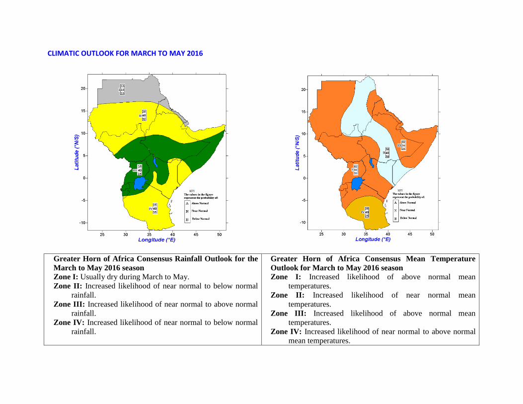
CLIMATIC OUTLOOK FOR MARCH TO MAY 2016
Greater Horn of Africa Consensus Rainfall Outlook for the
March to May 2016 season
Zone I: Usually dry during March to May.
Zone II: Increased likelihood of near normal to below normal
rainfall.
Zone III: Increased likelihood of near normal to above normal
rainfall.
Zone IV: Increased likelihood of near normal to below normal
rainfall.
Greater Horn of Africa Consensus Mean Temperature
Outlook for March to May 2016 season
Zone I: Increased likelihood of above normal mean
temperatures.
Zone II: Increased likelihood of near normal mean
temperatures.
Zone III: Increased likelihood of above normal mean
temperatures.
Zone IV: Increased likelihood of near normal to above normal
mean temperatures.

CLIMATE OUTLOOK FOR MAY 2016
GHA rainfall outlook for the May 2016
Zone I: Usually dry during March to May.
Zone II and IV: Increased likelihood of near normal to below
normal rainfall.
Zone III: Increased likelihood of near normal to above
normal rainfall.
GHA mean temperature outlook for the May 2016
Zone I: Increased likelihood of above normal mean
temperatures.
Zone II: Increased likelihood of near normal mean
temperatures tending to above.
Zone III and IV: Increased likelihood of near normal to below
normal mean temperatures.
Note: The numbers for each zone indicate the probabilities of rainfall and mean temperature in each of the three categories, above-, near-, and
below-normal. The top number indicates the probability of rainfall and mean temperature occurring in the above-normal category; the middle
number is for near-normal and the bottom number for the below-normal category.

References
Owiti Z., L. Ogallo, and J. Mutemi, 2008: Linkages between the Indian Ocean Dipole and East African Seasonal Rainfall Anomalies.
J.Kenya Meteorol. Soc., 2(1), 3 –17 (2008)
Saji N.H., Goswami B.N., Vinayachandran P.N., and T.Yamagata, 1999: A dipole mode in the tropical Indian Ocean, Nature, 401,
360-363.
WMO, 2014: El-Nino/ Southern Oscillation, Technical paper No. 1145, world meteorological organization.
NOAA Climate Prediction Center (NCEP),2016: ENSO: Recent Evolution, Current Status and Predictions. Retrieved on 22 April
2016, http://www.cpc.ncep.noaa.gov/products/analysis_monitoring/lanina/enso_evolution-status-fcsts-web.ppt