
I 'J~;r1111r?~l~Jr:~;:J~f;l~iW-/)·.•;,
142
i ! -~-IC' ..... NEIGHBORHOOD 8A· SPECIFIC PLAN/PRECISE PLAN - .. _,'?f< : ~, . - -1~ . .,. •~ t - '-" I . :~\~t~~~{\;;f r~ :-~ ~; r• ~--: - ,: ~". ···~!'-~J!i.~ :. /':JI.{ . }~}~ f: : [~ fr- - --., .. ..... - ~- _ .... _;- ;;.· "( -~-- . - . --~~:-~.;:: __ . 't· ~;,,t,~~ #~ ,-~" ff,· F.?r. . ;., . ~-;,_- ~-,& "~$ _;- :; . ,:.i·,•· '""' :'·: p,.' ,.. ,; . C/f; : :- . . . 7-~;1:,r:;~,J~'t~·:i, . . -~t ~\ ~Ir.}f ,J;'f <ii>i'7, :r~? . : ;, il~Jt,iy: > _;. '•;:M~,;: f' .- ., ·. "-' . .. : . ''~½'rJ:~1,r, .- :' " v,•.•-•l'~.)-1--,;,s."··· •. " I ' .: . '' . . . '. :. - ~':;Jf!'{,5.>.1 · ''···Y'c- . '. ·} ~\" h:,t . .. :: . 'i . Jti~ : '· ~;~~1.if tt~fu :: ; r; \;": · r-:t\l;i;J? ":i ?;:- . - .. . \ ., .. J-;j{ ~- ., ~j , '"' , .. ,~, ... .. , • • """-~i~ -- . ~--. .. -. "" · -·; -. :,,t. '..!11.. -• ·" - • • .:- . '• ~-: • ' C \ •. ,·. , < ', _.' • ).l,'~; •• ,; ffi.,<_;c e_- .,;-•,,~ . ' .,., • ~~•-.· .; '. , ·; __ '.,'_; >:: • , .;, . , '. . ;. ;, . . . C , ; ., :, ' , , c , _. -- ' , .., ' .' "~· _, ,.,., . ., .. -· ~·- ;;r- -· ' ' ·•<' .• • ·. . • ' _ .,. . . .-~- . ' . . ' : 'J~;r11 11r?~l~Jr:~;:J~f;l~iW-/) ·. • ;, . - ,f~:'. - ~- c( •• , . -- - .... ~~~ -;.. . ....:. ~=-- -· - -~ - A NEIGHBORHOOD 0 F CARMEL VALLEY
Transcript of I 'J~;r1111r?~l~Jr:~;:J~f;l~iW-/)·.•;,

i
!
-~-IC' .....
NEIGHBORHOOD 8A· SPECIFIC PLAN/PRECISE PLAN
- .. _,'?f<:~, . --1~ ~ . .,. •~ ~-~~~:!l~ t - ~ '-" I .:~\~t~~~{\;;fr~:-~~;r• ~--: -,:~". · ··~!'-~J!i.~ :. /':JI.{.}~}~f:: [~fr-
- --., ..
..... ~~ -~- _ .... _;- ;;.· "( -~-- ~ . -
. --~~:-~.;:: __
. 't·
~;,,t,~~ #~ ,-~" ff,· F.?r. . ;.,. ~-;,_- ~-,& "~$ _;-:; . ,:.i·,•· '""' :'·: p,.' ,.. ,; . C/f; : :- . . . 7-~;1:,r:;~,J~'t~·:i, . . ~;:.✓,:. -~t~\ ~Ir.}f ,J;'f <ii>i'7, :r~? . : ; , il~Jt,iy: > _;. '•;:M~,;: f' .- ., ·. "-' . . . : . ''~½'rJ:~1,r, .-:'" v,•.•-•l'~.)-1--,;,s."··· •. " I ' .: . '' . . . '. : . -~':;Jf!'{,5.>.1 · ''···Y'c-. '. ·} ~\" h:,t ... :: .'i.Jti~:'· ~;~~1.if tt~fu : : ;r; \;": · r-:t\l;i;J?":i?;:-
. - .. . \ ., .. J-;j{ ~-., ~j, '"' , .. , ~ , ..... , • • """-~i~-- . ~--. .. -. ""· -·; - . :,,t. '..!11.. - • ·" - • ~ • .:- . '• ~-: • ' C \ •. ,·. , < ', _.'• ).l,'~; •• ,;ffi.,<_;ce_-.,;-•,,~. ' .,.,•~~•-.·.; '. , · ; __ '.,'_; >:: • , .;, . ,, '. ~ . ;.;, . . . C , ; ., :, ' , , c , _. -- ' , .., ' . ' "~· _, ,.,., . ., .. -·~·-;;r--· ' ' ·•<' .• •·. . ~ • ' _.,. . . . -~ - . ' . . ' : 'J~;r1111r?~l~Jr:~;:J~f;l~iW-/)·.•;, . -,f~:'.-~- c( •• , .
---.... ~~~-;.. . ....:. ~=-- -· - -~-
A NEIGHBORHOOD 0 F CARMEL VALLEY

\.
( (
(
( (
(
( r
(
(
(
( (
( ( (
(
C (
C ( (_
C C (
C ( ( ( ( (
( ( ( /'
' ( (
(
(_ (
( ( (

&.. Neighborhood 8A Specific Plan/Precise Plan .& A Neighborhood of Carmel Valley
Applicants:
J.L. ELDER COMPANY
LOMA SORRENTO INVESTORS
PARDEE CONSTRUCTION COMPANY
TORREY PINES INVESTMENT GROUP
WESTBROOK COMMUNITIES
WESTERN PACIFIC HOUSING
Planning Services and Documentation Provided By:
T&B PLANNING CONSULTANTS, INC.
Environmental Impact Report Preparation Provided By:
T&B PLANNING CONSULTANTS, INC. WITHASSISTANCeFROM DUDEK & ASSOCIATES
Engineering Services Provided By:
CROSBY MEAD BENTON
Ci~y of San DiegQ Staff:
Keith Greer, Biologist Deborah Johnson, Development Project Manager
Robert Manis, Community Planning Program Manager Nick Osler, Senior Planner
Allison Raap, Associate Planner
Adopted: September 8, 1998 by City Council Ordinance No. 18572


~ Table of Contents .&
1. Introduction . . . . . . . . . . . . . . . . . . . . . . . . . . . . . . . . . . . . . . . . . . . . . . . . . . . . 1-1 1.1 Purpose and Authority . . . . . . . . . . . . . . . . . . . . . . . . . . . . . . . . . . . . . . . . . . . . . . 1-1 1.2 Project Location . . . . . . . . . . . . . . . . . . . . . . . . . . . . . . . . . . . . . . . . . . . . . . . . . . . 1-1 1.3 Community Planning Context . . . . . . . . . . . . . . . . . . . . . . . . . . . . . . . . . . . . . . . . . 1-2 1.4 Historical Overview . . . . . . . . . . . . . . . . . . . . . . . . . . . . . . . . . . . . . . . . . . . . . . . . 1-6 1.5 Surrounding Development . . . . . . . . . . . . . . . . . . . . . . . . . . . . . . . . . . . . . . . . . . . 1-7 1.6 Project Site Characteristics . . . . . . . . . . . . . . . . . . . . . . . . . . . . . . . . . . . . . . . . . . 1-1 O . 1. 7 Ownership Pattern . . . . . . . . . . . . . . . . . . . . . . . . . . . . . . . . . . . . . . . . . . . . . . . . . 1-13 1.8 Development Considerations . . . . . . . . . . . . . . . . . . . . . . . . . . . . . . . . . . . . . . . . 1-18 1.9 Specific Plan/Precise Plan Goals . . . . . . . . . . . . . . . . . . . . . . . . . . . . . . . . . . . . . 1-18
2. Land Use Element . . . . . . . . . . . . . . . . . . . . . . . . . . . . . . . . . . . . . . . . . . . . . . . 2-1 2.1 Land Use Plan Description . . . . . . . . . . . . . . . . . . . . . . . . . . . . . . . . . . . . . . . . . . . 2-1 2.1 Distribution of Development Rights . . . . . . . . . . . . . . . . . . . . . . . . . . . . . . . . . . . . 2-2
3. Housing Element . . . . . . . . . . . . . . . . . . . . . . . . . . . . . . . . . . . . . . . . . . . . . . . . 3-1 3.1 Residential Land Uses Description ..................................... 3-1 3.2 Housing Mix and Location ........................................... 3-3
4. Open Space and Recreation Element . . . . . . . . . . . . . . . . . . . . . . . . . . . . . . . 4-1 4.1 Open Space Summary ............................................... 4-1 4.2 Multi-Habitat Planning Area ......................................... 4-2 4.3 Public Park/School Site . . . . . . . . . . . . . . . . . . . . . . . . . . . . . . . . . . . . . . . . . . . . . 4-3 4.4 Trails . . . . . . . . . . . . . . . . . . . . . . . . . . . . . . . . . . . . . . . . . . . . . . . . . . . . . . . . . . . . 4-4
5. Circulation Element . . . . . . . . . . . . . . . . . . . . . . . . . . . . . . . . . . . . . . . . . . . . . . 5-1 5 .1 Regional Circulation ...................... ; . . . . . . . . . . . . . . . . . . . . . . . . . 5-1 5.2 Existing Local Vehicular Circulation ................................... 5-1 5.3 Vehicular Circulation ............................................... 5-4 5.4 Vehicular Circulation Standards ....................................... 5-4 5.5 Area Coordination .................................................. 5-5 5.6 Sound Attenuation Considerations ..................................... 5-5 5.7 Non-Vehicular Circulation ........................................... 5-5
6. Public Facilities and Services Element . . . . . . . . . . . . . . . . . . . . . . . . . . . . . . 6-1 6.1 Police and Fire Protection Services ............ : ................. : ..... 6-1 6.2 Schools . . . . . . . . . . . . . . . . . . . . . . . . . . . . . . . . . . . . . . . . . . . . . . . . . . . . . . . . . . 6-2 6.3 Utilities . . . . . . . . . . . . . . . . . . . . . . . . . . . . . . . . . . . . . . . . . . . . . . . . . . . . . . . . . . 6-3 6.4 Water Service . . . . . . . . . . . . . . . . . . . . . . . . . . . . . . . . . . . . . . . . . . . . . . . . . . . . . 6-3
Table of Contents Pagei

~ Neighborhood BA Specific Plan/Precise Plan -4
6.5 Sewer Service . . . . . . . . . . . . . . . . . . . . . . . . . . . . . . . . . . . . . . . . . . . . . . . . . . . . . 6-5 6.6 Drainage . . . . . . . . . . . . . . . . . . . . . . . . . . . . . . . . . . . . . . . . . . . . . . . . . . . . . . . . . 6-5
7. Design Element . . . . . . . . . . . . . . . . . . . . . . . . . . . . . . . . . . . . . . . . . . . . . . . . . 7 -1 7 .1 Grading Guidelines . . . . . . . . . . . . . . . . . . . . . . . . . . . . . . . . . . . . . . . . . . . . . . . . . 7-1 7.2 Drainage and Erosion Control Guidelines ............................... 7-3 7.3 Site Planning and Architectural Guidelines .............................. 7-4 7.4 Landscape Design Guidelines ......................................... 7-5 7 .5 Brush Management Guidelines . . . . . . . . . . . . . . . . . . . . . . . . . . . . . . . . . . . . . . . 7- I 0 7.6 Wall and Fence Guidelines .......................................... 7-12 7. 7 Lighting Guidelines . . . . . . . . . . . . . . . . . . . . . . . . . . . . . . . . . . . . . . . . . . . . . . . 7-13 7.8 Signage Guidelines ................................................ 7-13 7.9 Conservation Guidelines ............................................ 7-13
8. Implementation . . . . . . . . . . . . . . . . . . . . . . . . . . . . . . . . . . . . . . . . . . . . . . . . . 8-1 8.1 Implementation Process ............................................. 8-1 8.2 Modifications to the Specific Plan/Precise Plan . . . . . . . . . . . . . . . . . . . . . . . . . . . 8-1 8.3 Applicability of the Carmel Valley PDO ................................ 8-2 8.4 Applicability of California Coastal Zone Requirements .................... 8-3 8.5 Other Discretionary Approvals ........................................ 8-3 8.6 Development Phasing . . . . . . . . . . . . . . . . . . . . . . . . . . . . . . . . . . . . . . . . . . . . . . . 8-3 8.7 Public Facilities Financing Plan ....................................... 8-4 8.8 Reimbursement Program ............................................ 8-5 8.9 Density Transfer within Neighborhood 8A .............................. 8-6 8.10 Concurrent and Subsequent Discretionary Entitlements . . . . . . . . . . . . . . . . . . . . 8-7
9. Conformance with Plans and Policies . . . . . . . . . . . . . . . . . . . . . . . . . . . . . . . 9N1 9 .1 Conformance with the City of San Diego Progress Guide and General Plan . . . . . 9-1 9.2 Conformance with the Carmel Valley Community Plan .................... 9-3 9.3 Specific Plan/Precise Plan Development Criteria . . . . . . . . . . . . . . . . . . . . . . . . . . 9-6 9.4 Conformance with the Multiple Species Conservation Program .............. 9-8 9.5 Conformance with the North City Local Coastal Program ................... 9-9 9.6 Conformance with the Resource Protection Ordinance ..................... 9-9 9.7 Conformance with Council Policy 600-40 .............................. 9-16
Appendix A - Zoning Standards and Regulations
Appendix B - MHPA Equivalency Analysis
Table of Contents Page ii

~ Neighborhood BA Specific Plan/Precise Plan -4
~ List of Figures ~
1-1 Project Location ......................................................... 1-3 1-2 California Coastal Zone Boundary . . . . . . . . . . . . . . . . . . . . . . . . . . . . . . . . . . . . . . . . . . . 1-4 1-3 Neighborhood Precise Plans of Carmel Valley .................................. 1-5 1-4 Surrounding Areas Land Use Plan ............................ , . . . . . . . . . . . . . . 1-8 1-5 . Existing, Approved and Proposed Surrounding Development Approvals . . . . . . . . . . . . . 1-9 1-6 Existing Topography ..................................................... 1-11 1-7 Elevation Analysis . . . . . . . . . . . . . . . . . . . . . . . . . . . . . . . . . . . . . . . . . . . . . . . . . . . . . . . 1-12 1-8 Biological Tier Map . . . . . . . . . . . . . . . . . . . . . . . . . . . . . . . . . . . . . . . . . . . . . . . . . . . . . 1-14 1-9 Regional MHPAMap .................................................... 1-15 1-10 Place-Holder MHPA Boundary Within Neighborhood 8A ........................ 1-16 1-11 Ownership Map ......................................................... 1-17 2-1 Land Use Plan . . . . . . . . . . . . . . . . . . . . . . . . . . . . . . . . . . . . . . . . . . . . . . . . . . . . . . . . . . . 2-3 5-1 Regional Circulation Plan . . . . . . . . . . . . . . . . . . . . . . . . . . . . . . . . . . . . . . . . . . . . . . . . . . 5-2 5-2 Circulation Plan .......................................................... 5-3 6-1 Conceptual Water and Sewer Plan . . . . . . . . . . . . . . . . . . . . . . . . . . . . . . . . . . . . . . . . . . . 6-4 6-2 Conceptual Drainage Plan . . . . . . . . . . . . . . . . . . . . . . . . . . . . . . . . . . . . . . . . . . . . . . . . . . 6-7 7-1 Conceptual Grading Plan ................................................... 7-2 7-2 Typical Landscape Buffer Treatments ........................................ 7-8 7-3 Brush Management Plan .................................................. 7-11 9-1 Existing Carmel Valley Community Plan Land Use Plan for Neighborhood 8A ........ 9-4 9-2 Sensitive Slopes . . . . . . . . . . . . . . . . . . . . . . . . . . . . . . . . . . . . . . . . . . . . . . . . . . . . . . . . . 9-18 9-3 Development Suitability Analysis - Development Factors . . . . . . . . . . . . . . . . . . . . . . . . 9-19 9-4 Development Suitability Analysis - Development Potential ....................... 9-22
A-1 Zoning Plan ............................................................. A-8
~ List of Tables ~
2-1 Land Use Summary ....................................................... 2-1 2-2 Land Use Summary by Ownership ........................................... 2-4 3-1 Residential Summary ..................................................... 3-1 4-1 Open Space and Recreation Summary ........................................ 4-1 6-1 Projected Student Generation . . . . . . . . . . . . . . . . . . . . . . . . . . . . . . . . . . . . . . . . . . . . . . . 6-2 8-1 Specific Plan/Precise Plan Reimbursement Program . . . . . . . . . . . . . . . . . . . . . . . . . . . . . 8-6 9-1 RPO Resources Analysis . . . . . . . . . . . . . . . . . . . . . . . . . . . . . . . . . . . . . . . . . . . . . . . . . . 9-13 9-2 Neighborhood-Wide RPO Resources Analysis by Land Use Option . . . . . . . . . . . . . . . . 9-15
A-1 Residential Zones Development Regulations ................................... A-3 A-2 OC-1-1 Zone Prohibited and Permitted Uses ................................... A-5
Table of Contents Page iii

~Preface~
Neighborhood 8A is located on approximately 351.1 acres in the southern portion of the Carmel Valley Community Planning area. The neighborhood is located west of Carmel Valley Neighborhood 10, southeast of Carmel Valley Neighborhood 8B, south of Carmel Valley Neighborhood 8, and north of the Sorrento Hills community.
This document has been prepared to conform with the goals and objectives of the Carmel Valley Community Plan and to meet the requirement for preparation of a Precise Plan as established in the Community Plan. This document also has been prepared in accordance with the requirements for Specific Plans as outlined by California Government Code Title 7, Article 8, Section 65450, et. seq.
As a requirement of the Carmel Valley Community Plan, this document addresses land use patterns, development intensity, major road alignments, and public facilities for the neighborhood, within the larger Carmel Valley Community Plan context. In accordance with requirements for Specific Plans, this document also addresses standards and criteria by which the development will proceed, standards for the conservation of natural resources, and a program of implementation measures. This Specific Plan/Precise Plan will function as an important component in the development implementation process, and will constitute one of a series of steps in City approval of the development envisioned for Neighborhood 8A. The adopted Specific Plan/Precise Plan will serve as a basis for reviewing subsequent development plans, subdivisions, and other discretionary permits for the neighborhood.
Guidance for the formation of the land .use plan set forth in this document was provided by Neighborhood 8A property owners, the Carmel Valley community,.environmental protection groups, the San Diego City Planning Commission, City staff members, and the Neighborhood 8A Community Advisory Group (CAG). The Neighborhood 8A CAG was formed as an ad-hoc committee including Neighborhood 8A property owners, representatives from the Carmel Valley Community, representatives from environmental interest groups, representatives of City staff, and other interested parties.
This Specific Plan/Precise Plan document is organized into the following nine sections:
• Section 1 INTRODUCTION • Section 2 LAND USE ELEMENT • Section 3 HOUSING ELEMENT • Section 4 OPEN SPACE AND RECREATION ELEMENT . Section 5 CIRCULATION ELEMENT . Section 6 PUBLIC FACILITIES AND SERVICES ELEMENT . Section 7 DESIGN ELEMENT • Section 8 IMPLEMENTATION . Section 9 CONFORMANCE WITH ADOPTED PLANS AND POLICIES
Included in Section 1 is a review of the project's location, general setting, community plan background and the physical site characteristics considered in planning Neighborhood 8A. A detailed description of the land use plan, proposed project infrastructure, and open space and circulation plans are contained in Sections 2 - 6. Design guidelines for grading, architecture, landscaping, lighting, conservation and signage are included in Section 7. Section 8 discusses project implementation, phasing and financing and Section 9 includes an analysis of consistency with adopted plans and policies relevant to the site. Appendix A contains the project's zoning and development regulations. A consistency analysis with the Multiple Species Conservation Program is included as Appendix B.
Preface


~ Neighborhood SA Specific Plan/Precise Plan /A
Section
~1~ Introduction
1.1 Purpose and Authority
This Specific Plan/Precise Plan is the City of San Diego's detailed plan for the development of Carmel Valley's Neighborhood 8A. (Carmel Valley was previously called "North City West.") This plan implements the City's Progress Guide and General Plan and the City's Carmel Valley Community Plan by creating a bridge between general and community plan policies and the individual development proposals of Neighborhood 8A. This plan serves as both a Specific Plan, as addressed in California Government Code Title 7, Division 1, Chapter 3, Article 8, Sections 65450 through 65457, and as a Precise Plan, as addressed in the Carmel Valley Community Plan, Part II, Plan Implementation Section.
California Government Code Section 65450 states that a " ... planning agency may . .. prepare specific plans for the systematic implementation of the general plan for all or part of the area covered by the general plan. " The California Government Code authorizes cities to adopt specific plans by resolution to establish a policy document, or by ordinance to establish a regulatory document. This Specific Plan/Precise Plan for Neighborhood 8A is intended to be a regulatory document and is subject to City Council approval. When adopted by City legislative action, this Specific Plan/Precise Plan document will serve both planning and regulatory functions.
The Carmel Valley Community Plan, adopted by the City in 1975, requires that a Precise Plan be prepared for each of the development units (i.e.; neighborhoods) that comprise the community of Carmel Valley. The Carmel Valley Community Plan requires that Precise Plans contain development proposals that comply with the goals, concepts and objectives of the Community Plan, as well as meet the applicable policies and land use regulations that exist for the City of San Diego at the time of approval. These Precise Plans must be approved by the City Council in order to be formally adopted.
This Neighborhood 8A Specific Plan/Precise Plan meets the requirements for Specific Plans as outlined by California Government Code Section 65451 and for Precise Plans as outlined in the City of San Diego's Carmel Valley Community Plan. All future land use decisions regarding Neighborhood 8A must be found consistent with this Specific Plan/Precise Plan.
In conjunction with the implementation of this Specific Plan/Precise Plan, an amendment to the North City Local Coastal Program (LCP) will be required for portions of the project site located within the Coastal Zone. This amendment is required in order to modify the land use designations within Neighborhood 8A based on the approved land use plan and to change the existing zoning from A-1-1 · and A-1-10 to new Specific Plan/Precise Plan zoning.
1.2 Project Location
Neighborhood 8A is located on approximately 351.1 acres in the southern portion of the Carmel Valley Community planning area. The project site lies east oflnterstate 5 (1-5), south of State Route 56 (SR-56) and north of Carmel Mountain Road. Figure 1-1, Project Location Map, shows the general location of
Introduction Page 1-1

~ Neighborhood SA Specific Plan/Precise Plan .a
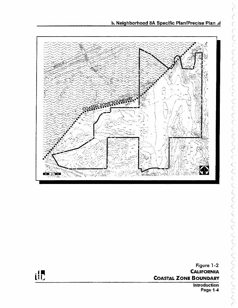
Neighborhood 8A. The California Coastal Zone boundary cuts through the northwestern portion of the neighborhood. Approximately 34 acres of Neighborhood 8A are located within the Coastal Zone, as shown on Figure 1-2, California Coastal Zone Boundary.
1.3 Community Planning Context
The North City West Community Plan was adopted by the City of San Diego in 1975. The community plan calls for the orderly development of residential, commercial, industrial, and public support uses in nine neighborhoods. In 1991, at the request of community residents, the City Council changed the name of the 4,286-acre community to Carmel Valley. Since adoption of the community plan, several of the nine original neighborhoods were split, creating fourteen neighborhoods. Only Neighborhood 8B lacks adoption of a Precise Plan. Figure 1-3, Neighborhood Precise Plans of Carmel Valley, illustrates the location of Neighborhood 8A within the Carmel Valley community.
As shown on Figure 1-3, Neighborhood 8C is a 40-acre parcel that was originally included as part of Neighborhood 8A. Pursuant to City Council direction, a separate, individual Precise Plan was prepared and processed for Neighborhood 8C. The Neighborhood 8C parcel is not included as part of this Neighborhood 8A Specific Plan/Precise Plan.
The Carmel Valley Community Plan identifies various land uses for Neighborhood 8A including approximately 2,000 dwelling units, a neighborhood commercial site, an elementary school site, a community park, and about 120 acres of open space. Also, a circulation system is identified for the neighborhood that extends a major street (Carmel Creek Road) through the property from SR-56 to Carmel Mountain Road. Although the Community Plan includes a land use plan for Neighborhood 8A, the plan requires that subsequent comprehensive planning be conducted for each individual neighborhood within the larger Carmel Valley plan context, to determine development specifics. Such subsequent comprehensive planning is directed to address issues of land use patterns, road alignments, community facility sites and phasing. ·
Five general goals are stated in the Carmel Valley Community Plan that summarize the overall planning approach of this Specific Plan/Precise Plan. These five goals are:
1. To establish a physically, socially, and economically balanced community.
2. To establish self-containment and feeling of community identity among the future residents of Carmel Valley.
3. To preserve the natural environment.
4. To establish a balanced transportation system which is used as a tool for shaping the urban environment.
5. To establish realistic phasing of development within the community based on maximum utilization of the privately financed public facilities.
Introduction Page 1-2

SOLANA BEACH
Pacific Ocean
LA JOLLA
~ Neighborhood BA Specific Plan/Precise Plan A
CARMEL VALLEY COMMUNITY PLAN
NEIGHBORHOOD SA
ROAD
Figure 1-1 PROJECT LOCATION MAP
Introduction Page 1-3
~ Neighborhood SA Specific Plan/Precise Plan -4
"-/ _.,... -,.,,..,;:: ·-.:;•t· "·-< -• ... .·-·:v .. .. . If-:~:. ··:=.: -···-...
. ,._~;. '."
• 04>~~-~~' :···: ;:- . -<~;-,·::: ::,;.,;.!_::_;_:.:i_T~:::--.. A. ~i'.~'t--=:<.::_~. ~~ ~.-:--. ' :°i,,;_•',,.~
-r~}:~~t;?:~-f;~;:~~~~---·::,'::;.t1t~~~,~~:;·-··,
Figure 1-2 CALIFORNIA
COASTAL ZONE BOUNDARY Introduction
Page 1-4

~ Neighborhood SA Specific Plan/Precise Plan ..d
NEIGHBORHOOD SA
fJI
SOltltENTO mu.s
I * I Previously Approved Precise Plans
Note: Roads shown in Neighborhood BA are per the 1975 Carmel Valley Community Plan
Figure 1-3 NEIGHBORHOOD PRECISE PLANS
OF CARMEL VALLEY
Introduction Page 1-5
~ Neighborhood SA Specific Plan/Precise Plan /4
1.4 Historical Overview
Planning for Neighborhood 8A has been ongoing by the Neighborhood 8A property owners since the mid-l 980's. In the early I 990's, a Precise Plan was prepared by the Neighborhood 8A property owners that generally conformed to the land use pattern called for by the Carmel Valley Community Plan for Neighborhood 8A. The plan was processed by the City of San Diego and brought before the City Council in 1994, but the plan was not approved. A revised Precise Plan, commonly referred to as the "Neighborhood 8A City Manager's Compromise Plan," was prepared in 1995 as a compromise between the desires of the property owners and the City's desire to preserve additional open space; however, that plan also was not approved by the City. A Final EIR was prepared for the Compromise Plan, but it was not certified. Since that time, the City of San Diego has proposed to purchase approximately 40 acres of Neighborhood 8A (the "Mesa Top Property") for open space preservation. The remainder of Neighborhood 8A is owned by private parties. Also since that time, a separate Precise Plan was approved for the 40-acre Parcel C, which is now an independent Precise Plan area known as Neighborhood 8C.
In response to individual parcel-specific development proposals being brought forth to the City in 1997, the City Council directed that City staff study a reasonable range of development options for the neighborhood. Three land use options and several sub-options for Neighborhood 8A were selected for further study. Guidance for the formation of the land use options was provided by Neighborhood 8A property owners, the Carmel Valley community, environmental protection groups, the San Diego City Planning Commission, City staff members, and a Neighborhood 8A Community Advisory Group (CAG). The Neighborhood 8A CAG was formed as an ad-hoc committee including Neighborhood 8A prope~y owners, representatives from the Carm~l Valley Community, representatives from environmental interest groups, representatives of City staff, and other interested parties. Each land use option called for substantially less development than anticipated for the neighborhood by the Carmel Valley Community Plan. An Environmental Impact Report (EIR) (LOR No. 96-7996) was prepared that evaluated the potential environmental impacts of each land use option and sub-option. On August 4, 1998, the San Diego City Council certified the project's Final EIR, and on September 8, 1998, the City Council adopted this Neighborhood 8A Specific Plan/Precise Plan and certified an addendum to the Final EIR. The land use plan that was approved for Neighborhood 8A, and that which is reflected by this document, .varies slightly from the three original land use options selected for study; the adopted plan generally reflects a mix between land use option nos. I and 2.
Ultimate development on Parcel A of Neighborhood 8A is tied to Pardee Construction Company's development proposal for Pacific Highlands Ranch located within Subarea III of the North City Future Urbanizing Area Framework Plan. Development proposed for Pacific Highlands Ranch and development on Parcel A are related through an agreement between the City of San Diego and Pardee Construction Company for the Pacific Highlands Ranch project. Pending a successful Phase Shift for Subarea III by ballot measure in November 1998, increased open space would be provided on Parcel A as identified by this Specific Plan/Precise Plan. Pending failure of a Phase Shift for Subarea III, an amendment to this Specific Plan/Precise Plan will be processed to propose residential development on portions of Parcel A.
Introduction Page 1-6
~ Neighborhood SA Specific Plan/Precise Plan ..d
1.5 Surrounding Development
Figure 14, Surrounding Areas Land Use Plan, shows the Neighborhood 8A Specific Plan/Precise Plan area in relation to approved and proposed development in the surrounding area. As shown on Figure 1-4, Neighborhood 8A is located west of Cannel Valley Neighborhood 10, south of Carmel Valley Neighborhood 8, southeast of Carmel Valley Neighborhood 8B, and north of the Sorrento Hills community. Precise Plans and subdivision maps have been approved for nearly all of the properties surrounding Neighborhood 8A, as described below and shown on Figure 1-5, Existing, Approved and Proposed Surrounding Development. ·
Neighborhood 10: Neighborhood 10 is located immediately east of Neighborhood SA. A Precise Plan and several subdivision maps were approved for Neighborhood 10 in 1994. Grading has occurred throughout the approved development areas, and construction of homes began in 1997. In the western portion of Neighborhood 10, adjacent to Neighborhood 8A, land uses include single-family residential, public park and open ·space.
Neighborhood 8: Neighborhood Sis located north ofNeighborhood 8A. Existing, approved, and proposed development in this neighborhood includes multi-family residential, single-family residential, and open space, as shown on Figures 1-4 and 1-5. The 348-multi-family unit Pinnacle Carmel Creek project is planned on 39.9 acres in Neighborhood 8, immediately north ofNeighborhood 8A's Torrey Pines Estates parcel.
Neighborhood 8B (Arroyo Sorrento): The adjacent Arroyo Sorrento neighborhood is a rural enclave of single family homes, on one-half acre and larger lots, dating back to 1913. Development is served by an unimproved rural street system having a singular access point at El Camino Real.
The Cannel Valley Community Plan, adopted in 1975, identifies Arroyo Sorrento for more intensive single family residential development, a neighborhood park, an elementary school and widening and extending Arroyo Sorrento Road to the east to serve additional community development areas. Initially, the Arroyo Sorrento area was identified in the Carmel Valley Community Plan as a subarea of a larger neighborhood unit that included Neighborhoods 8 and 8A. In 1984, Neighborhood S was split off and approved as a separate neighborhood plan. Subsequent processing of the Neighborhood SA Precise Plan included the Arroyo Sorrento subarea, designating it for the higher density development recommended by the Community Plan. In 1990, the Arroyo Sorrento property owners separated from the Neighborhood 8A planning process through the filing of their own Precise Plan (Neighborhood SB) in order to develop a land use plan that preserved the existing rural character of the subarea.
Sorrento Hills Community: The community of Sorrento Hills is located south ofNeighborhood 8A. Planned Residential Development permits, Planned Industrial Development pennits, and subdivision maps are approved in this community. Development of Sorrento Hills began in the mid-l 990's. Adjacent to Neighborhood 8A' s southern boundary, development includes industrial uses and single-family detached housing. In conjunction with approved vesting tentative maps for properties in Sorrento Hills, off-site grading was approved for areas within the southern portion of Neighborhood 8A.
Introduction Page 1-7

-I UI .., ~ NEIGHBORHOOD
8B I •
NEIGHBORHOOD SA I I I I I I
NEIGHBORHOOD ac 1
I I
SORRENTO HILLS
NEIGH. 10
~ Neighborhood BA Specific Plan/Precise Plan ~
SURROUNDING LAND USES
□ □ □ □ □ □
OPEN SPACE
RURAL RESIDENTIAL (0- 1 du/ac)
VERY LOW RESIDENTIAL (0-5 du/ac)
LOW RESIDENTIAL (5- 14 du/ac)
MEDIUM RESIDENTIAL (14-21 du/ac)
INDUSTRIAL
COMMERCIAL
Figure 1-4 SURROUNDING AREAS
LAND USE PLAN
lntoduction Page 1-8


---·· "- ----~--~-~
_ _.1-----..;-_-.,
~ Neighborhood SA Specific Plan/Precise Plan ~
APPROVED PROJECTS TENTATIVE MAP No. 85-0824 American Assests, Inc. Planned Commercial Development
AMENDED V.T.M. 96-0736 Pardee Construction Co. Neighborhood 10 North Single F an;iily Residential, Detached
AMENDED V.T.M. 96-0737 Pardee Construction Co . Neighborhood 10 Single Family Residential• Detached
V.T.M. 93-0141 Pardee Construction Co. Carmel Valley Neighborhood 10 Annex Single Family Residential• Detached
V. T.M. 95-0388 Carmel Oaks Single Family Residential• Detached
V.T.M. 95-0554 AG Land Associates, LLC Torrey Hills Planned Residential Development
V.T.M. 95-0554 AG Land Associates, LLC Torrey Hills Planned Commercial Development
V.T.M. 93-0142 Douglas Allred Co~ Torrey View Single Family Residential• Detached
T.M. 86-0573 Sorrento Hills Phase I Light Industrial
AMENDED PRD PERMIT No. 88-0205 California Pacific Homes
· Trilogy Multi-Family Detached
V.T.M. No. 98-0220 Pardee Construction Neighborhood 8C Single-Family Detached
PRD No. 96-7614 TCR Builders, Inc. Pinnacle Carmel Creek Multi-Family Attached
T.M. 96-0464 Harry Cl Cooper Torrey Reserve Gateway Multi-Family Residential-Attached
Figure 1-5 EXISTING, APPROVED
AND PROPOSED SURROUNDING DEVELOPMENT APPROVALS
lntoduction Page 1-9

(

~ Neighborhood SA Specific Plan/Precise Plan ~
Neighborhood SC: A Precise Plan for Neighborhood 8C was approved by the San Diego City Council on November 25, 1997 (Resolution No. R-289492). The approved Neighborhood 8C Precise Plan calls for the development of 156 single-family units on approximately 24 acres and the extension of Carmel Creek Road to the northeasterly boundary of the parcel. A revised Neighborhood 8C Precise Plan was brought forward to the City Council in 1998 and will be implemented pending approval of a Phase Shift for NCFUA Subarea III. If the Phase Shift is not approved by a vote of the people in November 1998, the Neighborhood 8C Precise Plan that was approved in 1997 will be implemented.
1.6 Project Site Characteristics
A. Topography
Neighborhood 8A is a Carmel Valley planning area of 351.1 acres. The central area of the site is characterized by ridges which fall off into a series of canyons and valleys below. The northern portion of the site contains bluffs which lie partially in Carmel Valley, a major east-west trending valley. The northern boundary of Neighborhood 8A is defined by the topographic variation along this valley. The lower portion of the valley hillside is in Neighborhood 8, while the higher portion is in Neighborhood 8A. Finger canyons with drainage courses in the southern portion of the Specific Plan/Precise Plan area run into an east-west canyon located predominantly within the Sorrento Hills community. Rolling hills divide the western portion of Neighborhood 8A from Neighborhood 8B. Similarly, a north-south canyon, commonly referred to as "Little Shaw Valley," provides a topographic separation from most of Neighborhood 10. A landform commonly referred to as the "mesa top" is located generally in the eastcentral portion of the site.
The elevation differential between the high and low points on the site is approximately 350 feet, with portions of the· Specific Plan/Precise Plan area having steep slopes and bluffs of 25 percent grades and steeper. Figure 1-6, Existing Topography, illustrates the existing topographic conditions of the Neighborhood 8A area. Figure 1-7, Elevational Analysis, graphically depicts the site's elevation changes at 20-foot contours.
B. Geology and Soils
The project site is underlain by Eocene marine sandstone formations of the La Jolla group approximately 40-50 million years old. The late Pliocene/early Pleistocene Lindavista Formation caps the Eocene deposits and is generally found on flat mesa areas. The formational units found on-site afford no specific geological hazards with the exception of potential compressibility of recent alluvial and colluvial materials. Erosion potential associated with soils found in the Specific Plan/Precise Plan area ranges from slight to severe. Soils with the highest runoff and erosion potential generally occur on steep slopes on the eastern, northern, and northwestern portions of the project.
Introduction Page 1-10


&. Neighborhood
'' ,-·--:: /'" ... ~· '\ .... ___ /
BA Specific Plan/P•e • ·· • c1se Plan /4
Existing Figure 1 -6 Topography
Introduction Page 1-11


" f • o-· 250• 500·
uC ---• 1000'
~ Neighborhood SA Specific Plan/Precise Plan A
ELEVATION RANGES
Figure 1-7 ELEVATIONAL ANALYSIS
Introduction Page 1-12


~ Neighborhood BA Specific Plan/Precise Plan ~
C. Biological Resources
Figure 1-8, Biological Tiers Map, illustrates the location of the various plant communities by biological tier in the Specific Plan/Precise Plan area. Vegetation in the Specific Plan/Precise Plan area is dominated by various types of chaparral which have been designated as Tier I, upland habitat, by the City of San Diego. In addition, Diegan coastal sage scrub, southern willow scrub, native and non-native grassland, isolated seasonal wetlands, and disturbed areas are present on the Specific Plan/Precise Plan site. Disturbed areas occur primarily within the SDG&E easement, in areas previously farmed, and along numerous private dirt roads, which traverse the Specific Plan/Precise Plan area. Small areas along the eastern and western boundaries have been cultivated in the past, however, they are not currently in agricultural use. A complete list of sensitive species located on the site can be found in the Neighborhood 8A EIR (LDR No. 96-7996).
The City of San Diego's Multiple Species Conservation Program (MSCP) Subarea Plan was approved in March 1997. The MSCP identifies a Multi-Habitat Planning Area (MHP A) in the City for preservation of core biological resource areas and corridors targeted for preservation. The City's MHP A is approximately 57,000 acres in size. A wildlife map, depicting the MHPA in the northern part of the City, is provided as Figure 1-9. The adopted MSCP Subarea Plan identified a portion ofNeighborhood 8A as being within the MHPA, however, the MHPA Guidelines for Carmel Valley stated that "the MHPA boundaries are unresolved and may be modified by City Council action on the Carmel Valley Neighborhood 8A Precise Plan." Further, City Council Resolution No. R-287583 (item 12) stated that "it shall be expressly noted for the record that any reflection of boundaries of the proposed MSCP Preserve i,:z any documents shall not be construed or interpreted by anyone as an expression or direction or predisposition by the City Council with respect to the pending application for the Carmel Valley Neighborhood 8A Precise Plan. " Based on this direction, a temporary or "place-holder" MHPA boundary line was included in the City's MSCP Subarea Plan for Neighborhood 8A as illustrated on Figure 1-10, Place-Holder MHPA Boundary Within Neighborhood 8A, pending adoption ofa long-range plan for Neighborhood 8A. The City of San Diego's MHPA Subarea Plan states that adjustments to the MHPA boundary line are permitted without the need to amend the City's Subarea Plan, provided the boundary adjustment results in an area of equivalent or higher biological value.
D. Utility Easements
A 150-foot wide San Diego Gas and Electric Company (SDG&E) easement bisects Neighborhood SA in a north/south direction and comprises approximately 4.5 acres of the Specific Plan/Precise Plan area on the Torrey Pines Estates parcel. The easement accommodates 230- and 138-kV overhead transmission lines, which link to the Pefiasquitos Substation in Sorrento Hills. A 30-inch high pressure gas line, and I 0- and 16-inch fuel lines also are sited within the easement.
1. 7 Ownership Pattern
An important element that was considered in developing this Specific Plan/Precise Plan for Neighborhood 8A was the multiple ownership pattern. As shown on Figure 1-11, Ownership Map, 19 property owners with parcels ranging in size from approximately one acre to over 140 acres comprise the 351.1-acre Specific Plan/Precise Plan area.
Introduction Page 1-13


I· /;=.
0' 250' 500' -' I -
, ,·
(:
1000'
I I
-·~
v
0 r ;::,
- 1,
~ .,,,..
::; -"\ ,._
~-... ·., ... --
' \ ~- \
r 1 ·· ~1 \ ';
')' .] _· . _,., .
\
I (,{
\ I\\
I\ \ . l'q
~ Neighborhood SA Specific Plan/Precise Plan ~
BIOLOGICAL TIERS
□ TIER I
■ TIER II
□ TIER 111-B
TIER IV
Figure 1-8 BIOLOGICAL TIER MAP
Introduction Page 1-14


~ Neighborhood SA Specific Plan/Precise Plan ~
Figure 1-9 REGIONAL MHPA MAP
Introduction Page 1-15

&. Neighborhood SA Specific Plan/Precise Plan A
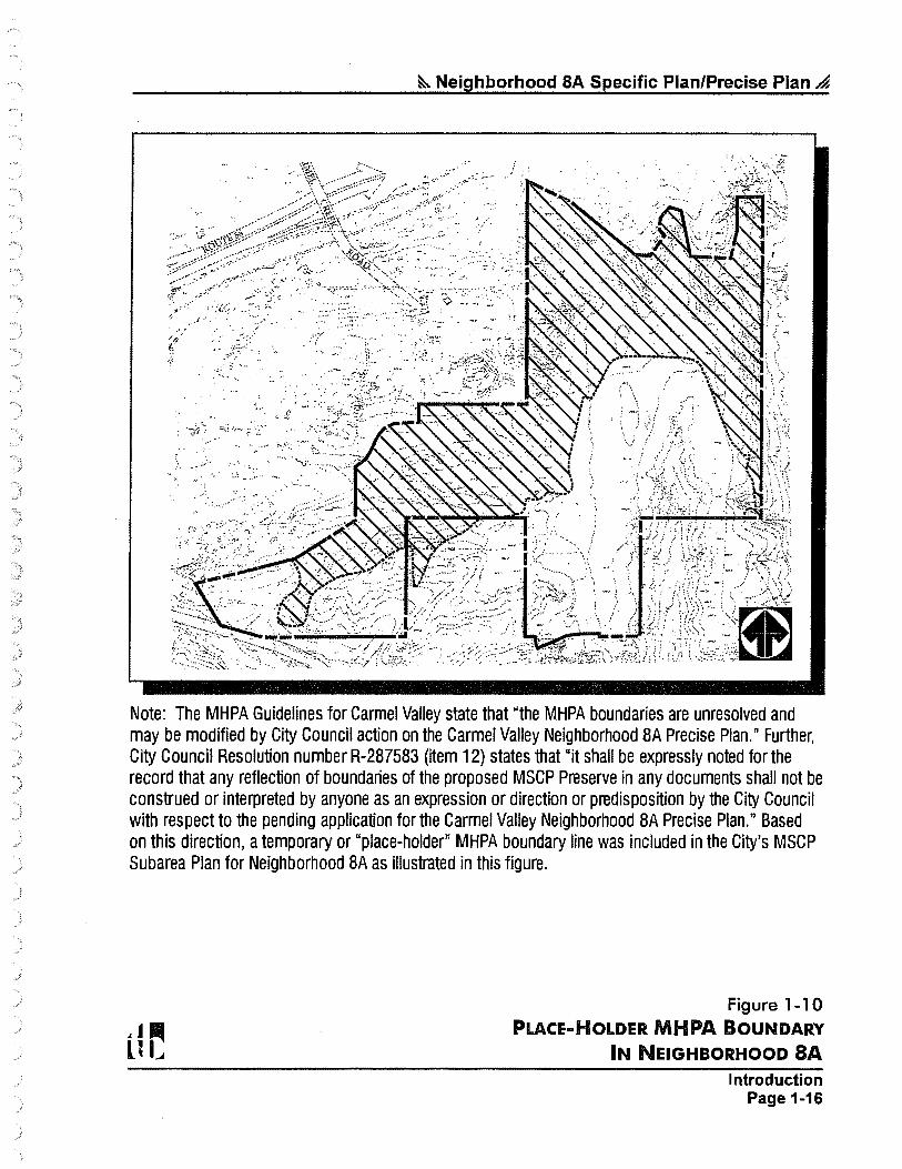
Note: The MHPA Guidelines for Carmel Valley state that "the MHPA boundaries are unresolved and may be modified by City Council action on the Carmel Valley Neighborhood BA Precise Plan." Further, City Council Resolution number R-287583 (item 12) states that "it shall be expressly noted for the record that any reflection of boundaries of the proposed MSCP Preserve in any documents shall not be construed or interpreted by anyone as an expression or direction or predisposition by the City Council with respect to the pending application for the Carmel Valley Neighborhood BA Precise Plan." Based on this direction, a temporary or "place-holder" MHPA boundary line was included in the City's MSCP Subarea Plan for Neighborhood SA as illustrated in this figure.
Figure 1-10 PLACE-HOLDER MHPA BOUNDARY
IN NEIGHBORHOOD SA
Introduction Page 1-16


+ Note: The Mesa Top parcel is proposed for acquisition by the City of San Diego.
r-.J°' 1000'
&. Neighborhood SA Specific Plan/Precise Plan ,,a
Figure 1 -11 PROPERTY OWNERSHIP MAP
Introduction Page 1-17

~ Neighborhood SA Specific Plan/Precise Plan .4
1.8 Development Considerations
In addition to existing site conditions and the multiple ownership pattern, other development factors which influence the planning proposals for Neighborhood 8A are listed below:
♦ Implementation of the goals and objectives contained in the City of San Diego Progress Guide and General Plan and the Carmel Valley (North City West) Community Plan.
♦ Compliance with the guidelines of the City's Multiple Species Conservation Program (MSCP).
♦ Provision of circulation and utility linkages to existing facilities.
♦ Compatibility ofland use and grading proposals for adjoining Carmel Valley neighborhoods and the Sorrento Hills community.
♦ Provision of population based public facilities, including a school and park site in Neighborhood 8A, per the Carmel Valley Community Plan and the Carmel Valley Facilities Benefit Assessment (FBA).
♦ Consideration of requirements for portions of the site located within the California Coastal Zone.
♦ Recognition of natural steep slopes and biologically sensitive areas as community resources.
♦ Recognition of anticipated noise levels along major roadways.
1.9 Specific Plan/Precise Plan Goals
The following project-wide goals have been established to guide development ofNeighborhood 8A. All development within.the neighborhood should strive to achieve the goals listed below.
♦ Provide for housing opportunities in the southern portion of Carmel Valley that complement and integrate with surrounding existing and planned devel9pment.
♦ Designate appropriate circulation linkages between Neighborhood 8A, adjoining Carmel Valley neighborhoods, and the Sorrento Hills Community. Also, provide opportunities for pedestrian and bicycle circulation within the neighborhood.
♦ Provide a public park and school site within the Specific Plan/Precise Plan area.
♦ Retain utilities within the existing SDG&E utility easement at existing grades.
♦ Preserve sensitive lands, including sensitive biological resources and natural steep slopes.
♦ Design individual development projects to positively contribute to the overall high quality character of Carmel Valley through architectural style, landscaping and signage.
♦ Accommodate existing and planned utility improvements such as water, sewer and_ drainage.
Introduction Page 1-18


Section
~2~ Land Use Element
2.1 Land Use Plan Description
Of the 351.1-acre Neighborhood 8A Specific Plan/Precise Plan area, 238.5 acres are designated open space, two (2.0) acres are designated rural residential, 90.6 acres are designated low and very low density residential, and 18.5 acres are designated for a public park/school site. An additional 1.5 acres of public park/school area will be provided in adjacent Neighborhood 10, resulting in a 20.0-acre public park/school site. Table 2-1, Land Use Summary, tabulates the land use areas for the overall Neighborhood 8A Specific Plan/Precise Plan area.
Figure 2-1, Land Use Plan, illustrates the distribution of land uses. Residential uses will be accommodated in three density categories: Rural Residential, Very Low Density and Low Density. The Very Low and Low Density uses are primarily concentrated in the southern portion of the neighborhood. Two one-acre parcels in the northwestern portion of the neighborhood are designated Rural Residential and could be developed with one unit per parcel. A detailed description of the residential development plan is provided in Section 3, Housing Element.
2.2 Distribution of Development Rights
As stated in the introductory section of this Specific Plan/Precise Plan, land within Neighborhood 8A is owned by 19 property owners with parcels ranging in size from 0.94-acre to over 140 acres. Distribution of development rights among the property owners is summarized in Table 2-2, Land Use Summary by Ownership. Figure 1-11, Ownership Map, in Section 1 of this Specific Plan/Precise Plan illustrates the location of the various parcels by ownership.
As shown on Figure 1-11, six large parcels are located in the neighborhood, owned by six private parties. These large parcels are referred to as Loma Sorrento, Torrey Pines Estates, Torrey Surf, Carmel Estates, Parcels A and B, and Mesa Top. The City of San Diego has proposed to purchase the Mesa Top parcel for open space preservation, and the parcel is designated as open space in this Specific Plan/Precise Plan. The other large parcels are proposed for residential, public park/school, and/or open space uses.
The remaining fourteen parcels are referred to as the "small property owner parcels." These parcels are approximately one acre in size and are owned by 13 private landowners. The City of San Diego has purchased one of these parcels (the Zimmerman parcel) for open space preservation. Eleven additional small property owner parcels are designated as open space and have entered into a private-party contract with the Torrey Pines Estates property owner to transfer their development rights to that parcel. Development of Torrey Pines Estates will include a condition of approval for extinguishment of all development rights (through a dedication in fee or open space easement) on 11 of the small property owner parcels. If any of the 11 parcels are not dedicated in fee or encumbered with an easement, the development area on the Torrey Pines Estates parcel would be reduced accordingly (i.e., dedication of 10 parcels = a 23-acre development area; dedication of 9 parcels = a 22-acre development area, etc.), and the nonparticipating small property owner parcel(s) will be permitted to develop with Rural
Land Use Element Page 2-1

&. Neighborhood SA Specific Plan/Precise Plan .4
Residential uses, subject to Resource Protection Ordinance (RPO) restrictions. A development footprint for the Torrey Pines Estates parcel and the small property owner parcels which substantially conforms to land use and zoning designations and required transfer of development rights will not require an amendment to this document. The two remaining small property owner parcels (the Kennedy and R&S Anuskiewicz parcels) have not entered into the private-party agreement with the Torrey Pines Estates parcel and are designa~ed for Rural Residential development. These two parcels could be developed with one residential unit per parcel, subject to RPO requirements.
Table 2-1 Land Use Summary
Residential Rural Residential (one unit per parcel)1
Very Low Density (0-5 du/ac)1•2
Low Density (5-14 du/ac)2
Public Park/School
Open Space2• 3
• 4
Primary Roads6
2.0ac 41.3 ac 49.3 ac
18.5 ac
238.5 ac
1.5 ac
2 du 147 du 294 du
1 Acreage and dwelling unit. totals assume successful perlormance of a private-party development area transfer agreement between the Torrey Pines Estates parcel and 11 small property owner parcels.
2. Ten Low Density residential units may be transferred to the Very Low Density category as it relates to the Loma Sorrento parcel. Such transfer will require a1 .5-acre reduction to the Low Density category and a 1.5-acre increase to the open space category.
3. Includes external manufactured slopes necessary to support development.
4. Includes an existing 4.5-acre SDG&E utility easement.
5. Primary roads include the Carmel Creek Road extension through the southeast comer of the Loma Sorrento parcel.
Land Use Element Page 2-2

..)
~ Neighborhood SA Specific Plan/Precise Plan A
. . {l;'
cl
RURAL-. ----+f-3.lll!<+--e RESIDENTIAL
1.0AC. l DU.
RURAL--~ RESIDENTIAL
1.0AC. l DU.
...,_...._._RESIDENTIAL LOW ·- - ·:o.7 AC. .
S'DU.
' . . RESIDENTIAL
LOW , , 13.SAC.
"'-'\< 43ou'. - ~"='"-",._:..,..•--. ....... · '~-__,•. ~ESID_ENTiA~,.L◊-~- J
.. ;,?-~-4'>~;~~:z~r:_:~}/:,'.: __.-\, •~ ..... ~. ·r ·•==1 .,~· .... ,i _ :.
Note: If a phase shift for Subarea Ill of the North City Future Urbanizing Area is not approved by a ballot measure on November 3, 1998, an amendmen~ to this Plan will be processed to propose residential development on Parcel A.
~ f • o-· 2so• 500'
uC · -1000'
LAND USES
□ □ □ CJ D
□
* ♦
X
Rural Residential 2.0 ac. 2 du
Very Low (0-5 du/ac) 41.3 ac. 147 du
Low (5-14 du/ac) 49.3 ac. 294 du
Open Space 238.5 ac.
Public Park/School 18.5 ac.
Carmel Creek Road 1.5 ac.
Totals 351.1 ac. 443du 1
Includes exterior manufactured slopes necessary to support development.
An additional 1 .5 aa-es of public park/school uses will be located in adjacent Neighborhood 10, bringing the total acn,age for this facility to 20.0 acres.
Ten dwelling units on the Loma Sorrento parcel may be transhtrred from the Low to Very Low Density area without requiring a formal amendment to this document, provided the northeostem portion of the Low Density development area is reduced by 1 .5 acres and the Very Low Density development area does not exceed 17 .4 acres.
Development of the Torrey Pines Estates parcel (23. 9 acres of Very Low Density) will include a condition of approval for extinguishment of all development rights (through a dedication in fee or open space easement) on 11 of the small property owner parcels. If any of the 11 parcels are not dedicated in fee or encumbered with an easement, the development area on the Torrey Pines Estates parcel would be reduced accordingly (i.e., dedication of 10 parcels = 23-acre development area; dedication of 9 parcels = 22-acre development area, etc.). Nonparticipating small property owner parcel(s) will be permitted to develop with Rural Residential uses, subject to Resource Protection Ordinance (RPO) restrictions. The maximum number of dwelling units on the Torrey Pines Estates parcel shall not exceed 97 units and a density of 5 du/ac. A development area footprint for the Torrey Pines Estates parcel and the small property owner parcels which substantially conforms to land use and zoning designations and required transfer of development rights will not require an amendment to this document.
Figure 2-1 LAND USE PLAN
Page 2-3


Torrey Pines Estates
Loma Sorrento
J.L. Elder Co. (Torrey Surf)
Westbrook Communities (Carmel Estates)
Pardee Parcel A5
Mesa Top Properties
Pardee Parcel B
Kennedy
R. & S. Anuskiewicz
Zimmerman
11 Small Property Owner Parcels
1.0
1.0
See following page for footnote references for this table.
Table 2-2
15.2
4.5
0.0
129.2
40.0
7.6
1.08
11.06
1.54
5.0
13.5
1Q.~ 1,.6
53.9
52.5
18.0
22.4
142.7
40.0
7.6
1.0
1.0
1.0
11.0
, .. :_ .. •,•,, 351.1
Land Use Element Page 2-4

~ Neighborhood SA Specific Plan/Precise Plan .4
Footnotes for Table 2-2
1. Acreage includes external manufactured slopes necessary to support development.
2. Acreage is rounded and approximate. Tentative subdivision maps filed for individual development projects within Neighborhood 8A will define exact acreage.
3. Includes approximately 4.5 acres for an existing SDG&E utility easement.
4. Refers to the Carmel Creek Road extension through the southeastern comer of the Loma Sorrento parcel.
5. If the Subarea III Phase Shift vote for the North City Future Urbanizing Area fails to pass by ballot measure on November 3, 1998, an amendment to this Neighborhood 8A Specific Plan/Precise Plan will be processed to propose residential development on Parcel A.
6. Development of Torrey Pines Estates will include a condition of approval for extinguishment of all development rights (through a dedication in fee or open space easement) on 11 of the small property owner parcels. If any of the 11 parcels are not dedicated in fee or encumbered with an easement, the development area on the Torrey Pines Estates parcel would be re.duced accordingly (i.e., dedication of 10 parcels= a 23-acre development area; dedication of 9 parcels = a 22-acre development area, etc.). Nonparticipating small property owner parcel(s) will be permitted to develop with Rural Residential uses, subject to Resource Protection Ordinance (RPO) restrictions. The maximum number of dwelling units on the Torrey Pines Estates parcel shall not exceed 97 units and a density of 5 du/ac. A development area footprint for the Torrey Pines Estates parcel and the small property owner parcels which substantially conforms to land use and zoning designations and required transfer of development rights will not require an amendment to this document.
7. Ten dwelling units on the Loma Sorrento parcel may be transferred from the Low to Very Low Density area without requiring a formal amendment to this document, provided the northeastern portion of the Low Density development area is reduced by 1.5 acres and the Very Low Density development area does not exceed 17.4 acres.
8. The Zimmerman parcel has been purchased by the City of San Diego for open space preservation.
Land Use Element Page 2-5

Section
~3~ Housing Element
3.1 Residential Land Uses Description
Three residential categories (Rural Residential, Very Low Density and Low Density) are included in Neighborhood 8A. The Rural Residential category allows development of one dwelling unit per ten acres, or one unit per parcel if the parcel is less than ten acres in size. The Very Low Density residential category accommodates densities of 0-5 dwelling units per acre (du/ac), while the Low Density residential category allows for densities of 5-14 du/ac.
Table 3-1, Residential Summary, provides an outline of residential acres, densities and the maximum number of dwelling units for each parcel of Neighborhood 8A. As shown, a total of 92.6 acres are designated for residential development with a maximum of 443 dwelling units. The maximum of 443 residential units is substantially less than the 2,000 homes assumed for Neighborhood 8A by the Carmel Valley Community Plan. The overall Specific Plan/Precise Plan density is just over one unit per acre (443 units maximum+ 351.1 acres= 1.26 du/ac).
Provided below is a description of the residential uses that will be developed in each of the parcels of Neighborhood 8A designated for residential development.
A. Rural Residential (1 unit per parcel)
In the northwestern portion of Neighborhood 8A, two one-acre parcels (the Kennedy and R&S Anuskiewicz parcels) are designated Rural Residential. The Rural Residential parcels will be developed under the A-1-10 zone, as defined within the Zoning Standards and Regulations of this Specific Plan/Precise Plan (see Appendix A). This zone allows the development of one residential dwelling unit per ten acres of land. If, however, a parcel is less than ten acres in size, one dwelling unit is permitted per parcel. One dwelling unit will be permitted on the Kennedy parcel and the R&S Anuskiewicz _parcel, for a total of two dwelling units.
B. Very Low Density Residential (0-5 du/ac)
A maximum of 14 7 Very Low Density units will be constructed on 41.3 acres in Neighborhood 8A at the density range of 0-5 du/ac. Very Low Density residential is designated for a portion of the Torrey Pines Estates parcel and for a portion of the Loma Sorrento parcel, as described below.
♦ Torrey Pines Estates Parcel: A 23.9-acre Very Low Density development area is identified on this parcel for the development of a maximum of 97 residential units. This area will be accessed via existing Arroyo Sorrento Road.
♦ Loma Sorrento Parcel: A 17. 7-acre Very Low Density area is designated on a portion of this parcel for the d~velopment of a maximum of 50 residential units. This area will be accessed from Carmel Creek Road, whii:;h will be extended through the southeastern corner of the Loma Sorrento parcel.
Housing Element Page 3-1

Kennedy
R&S Anuskiewicz
Torrey Pines Estates1
Loma Sorrento2
Loma Sorrento2
Torrey Surf
Carmel Estates
~ Neigh,borhood SA Specific Plan/Precise Plan ~
Table 3-1 Residential Summary
R'.~~.a~11t1J1U .. · . . ·• \i A¢te$ .;u·••
Rural Residential (1 unit per parcel/
1.0 1 unit per parcel
1.0 1 unit per parcel
Very Low Density Residential (0-5 dulac)
23.9 ac 4.0 du/ac
17.4 ac 3.0 du/ac
Low Density Residential (5-14 du/ac)
18.4 ac 7.5 du/ac
13.5 ac 5.0 du/ac
17.4 ac 6.0 du/ac
J ij2ii)i¢ })
1 du
1du
97 du
50 du
130 du
63 du
101 du
·•·• 4.#3:drii·•·•i 1. Development of Torrey Pines Estates will include a condition of approval for extinguishment of all development rights (through a dedication in fee or open space easement) on 11 of the small property owner parcels. If any of the 11 parcels are not dedicated in fee or encumbered with an easement, the development area on the Torrey Pines Estates parcel would be reduced accordingly (i.e., dedication of 10 parcels= a 23-acre development area; dedication of9 parcels= a 22-acre development area, etc.). Nonparticipating small property owner parcel(s) will be permitted to develop with Rural Residential uses, subject to Resource Protection Ordinance (RPO) restrictions. The maximum number of dwelling units on the Torrey Pines Estates parcel shall not exceed 97 units and a density of 5 du/ac. A development area footprint for the Torrey Pines Estates parcel and the small property owner parcels which substantially conforms to land use and zoning designations and required transfer of development rights will not require an amendment to this document.
2. Ten dwelling units on the Loma Sorrento parcel may be transferred from the western Low Density area t the Very Low Density area without requiring a formal amendment to this document, provided the northeastern portion of the western Low Density development area is reduced by 1.5 acres and the Very Lo Density development area does not exceed 17.4 acres.
Housing Element Page 3-2

~ Neighborhood SA Specific Plan/Precise Plan ~
C. · Low Density Residential (5-14 du/ac)
A maximum of 294 Low Density residential units are designated on 49.3 acres in the southern portion of Neighborhood 8A. These areas will serve as extensions of development approved in Neighborhood IO to the east and in the Sorrento Hills community to the south. Low Density residential uses are designated on portions of the Loma Sorrento parcel, the Torrey Surf parcel and the Carmel Estates parcel.
♦ Loma Sorrento Parcel: A 17. 7-acre area of Low Density residential is designated for the development of a maximum of 127 units in the western portion of this parcel. The units are anticipated to be sited in a courtyard layout, with units clustered around either an automobile or landscaped courtyard. In the southeastern comer of the parcel, a 0.7-acre Low Density area is designated to accommodate a maximum of three (3) homes. Access to this 0.7-acre area could be taken through adjacent Neighborhood 8C or directly from Carmel Creek Road.
♦ Torrey Surf Parcel: Torrey Surf is planned for the development of a maximum of 63 Low Density dwelling units on 13.5 acres. Access the Torrey Surf parcel will be provided through the Carmel Estates parcel from the south and east.
♦ Carmel Estates Parcel: In the southeasterly portion of the Specific Plan/Precise Plan area, an 17.4-acre portion of the Carmel Estates parcel will be developed with Low Density housing. A maximum total of IO I dwelling units are designated for this area. Several local roads approved as part of subdivision maps in the adjacent Sorrento Hills community to the south stub into the southern property boundary of the Carmel Estates parcel. It is anticipated that these local roads will be extended to serve all or a portion of the residential units planned for the parcel.
The actual number of dwelling units constructed in Neighborhood 8A shall not exceed the maximum total of 443 as defined in this Specific Plan/Precise Plan. The 1990 Census indicated a population per household for the North City Metropolitan Statistical Area (MSA) of San Diego of 2.54 persons per household. Using this figure as a base, Neighborhood 8A will provide housing for approximately 1,125 persons at buildout.
Appendix A, Zoning Standards and Regulations, of this Specific Plan/Precise Plan includes zoning standards for the residential areas of Neighborhood 8A. Primary uses permitted within residential areas include residential dwelling units, temporary real estate offices, and public or private parks and playgrounds.
3.2 Housing Mix and Location
The Carmel Valley Community Plan calls for the establishment of a balanced community housing program consistent with Council Policy 600-19. This means that a range of housing unit types and prices should be available in the community, suitable to households of varying income levels.
Housing Element Page 3-3

~ Neighborhood SA Specific Plan/Precise Plan A
The Carmel Valley Community Plan provides for a balanced housing program by correlating income levels to proposed housing categories and locations. The Community Plan designates portions of Carmel Valley's Low Medium Density (15-29 du/ac) and Medium Density (30-44 du/ac) units for low and moderate income households. A majority of these units are designated for Neighborhood 9 near the Town Center, outside of the Neighborhood 8A Specific Plan/Precise Plan area.
The 1975 Carmel Valley Community Plan designated approximately 35 acres of Neighborhood 8A for Low/Medium Density housing. Using an average density of 22 du/ac for the Low/Medium Density designation, these 35 acres were intended to provide about 780 homes for moderate income families. As reflected on· the Land Use Plan, no Low/Medium Density residential areas are planned for Neighborhood SA. Despite the deficiency oflow or moderate-income housing in the Neighborhood.SA, a range of housing types and prices will be available in neighboring communities of Carmel Valley.
Housing Element Page 3-4

Section
~4.4 Open Space and Recreation Element
This subsection describes the open space and recreational opportunities of Neighborhood 8A. A total of 238.5 acres of open space and an 18.5-acre public park/school site are designated for Neighborhood 8A. The open space and recreation plan is detailed in Table 4-1, Open Space and Recreation Summary.
Table 4-1 Open Space and Recreation Summary
·-Acres··
238.5 ac1•
2
18.5 ac3
1 Includes an existing 4.5-acre SDG&E utility easement on the Torrey Pines Estates parcel. 2 Includes exterior manufactured slopes. 3 An additional 1.5 acres of school/park area is designated in adjacent Neighborhood 10 to the east, bringing the total public park/school site to 20.0 apres.
4.1 Open Space Summary
The 1975 Carmel Valley Community Plan calls for approximately 30 percent of Neighborhood 8A to be preserved as open space. Under this Specific Plan/Precise Plan, more than twice as much open space will be provided in the neighborhood. A total of238.5 acres of the Specific Plan/Precise Plan area will be undeveloped with implementation of this plan, which represents approximately 70 percent of the neighborhood. Development of residential uses, a public park/school site and major roads will comprise only approximately 30 percent of the site.
Three categories of open space are defined by this plan. These include natural open space, exterior manufactured slopes, and the San Diego Gas and Electric (SDG&E) utility easement, as described below. The allocation of open space by property ownership was previously included in Table 2-2, Land Use Summary by Ownership. The City of San Diego has proposed to purchase 40 acres of land designated as open space in Neighborhood 8A (the Mesa Top parcel), and the one-acre Zimmerman parcel, also designated as open space. The remaining areas designated as open space are owned by private parties.
A. Natural Open Space
Portions of the Neighborhood 8A open space area contain southern maritime chaparral and Diegan coastal sage scrub, both considered sensitive biological resources in San Diego County. In addition to these sensitive coastal resources, portions of the areas targeted for open space preservation within Neighborhood 8A contain natural slopes with a 25 percent gradient or greater. According to the City of
Open Space and Recreation Element Page4-1

~ Neighborhood SA Specific Plan/Precise Plan .4
San Diego's Resource Protection 'Ordinance (RPO), natural slopes having a gradient of at least 25 percent and a height of at least 50 feet also are considered to be sensitive resources.
Natural open space areas of Neighborhood 8A would be preserved as part of the City of San Diego's Multiple Species Conservation Program (MSCP) through inclusion in the City's Multi-Habitat Planning Area (MHPA). A discussion ofMHPA open space preservation is discussed below in Subsection 4.2.
B. Exterior Manufactured Slopes
Some exterior manufactured slopes required to support development areas are included as part of the open space acres. Exterior manufactured slopes located on the perimeter of development and adjacent to natural open space are important transition areas in Neighborhood 8A. Where appropriate, these slopes, located between development and open space, will be revegetated with native plant materials that are compatible with the plant species in the adjacent natural open space areas. In order to complement the natural open space, these slopes will be landform graded where possible and will be landscaped to blend into the existing slopes. See Section 7, Design Element, for detailed standards on grading and landscaping of exterior manufactured slopes.
C. · SDG&E Utility Easement
An existing SDG&E utility easement is located in Neighborhood 8A. This easement is 150 feet wide and is aligned north/south along the eastern boundary of the Torrey Pines Estates parcel. The approximate 4.5-acre easement will be integrated into Neighborhood 8A as natural open space, while retaining access by SDG&E for maintenance purposes. Maintenance of the easement and the utility lines will be the responsibility of SDG&E.
4.2 Multi-Habitat Planning Area
The City of San Diego's Multiple Species Conservation Program (MSCP) Subarea Plan was approved in March 1997. The MSCP identifies a 57,000-acre Multi-Habitat Planning Area (MHPA) in the City for preservation of core biological resource areas and corridors targeted for preservation. The adopted MSCP Subarea Plan identified a portion of Neighborhood 8A as being witliin the MHP A, however, the MHPA Guidelines for Carmel Valley stated that "the MHPA boundaries are unresolved and may be modified by City Council action on the Carmel Valley Neighborhood 8A Precise Plan." Further, City Council Resolution No. R-287583 (item 12) stated that "it shall be expressly noted for the record that any reflection of boundaries of the proposed MSCP Preserve in any documents shall not be construed or interpreted by anyone as an expression or direction or predisposition by the City Council with respect to the pending application.for the Carmel Valley Neighborhood 8A Precise Plan." Based on this direction, a preliminary or "place-holder" MHPA boundary line was included in the City's MSCP Subarea Plan for Neighborhood 8A as previously illustrated on Figure 1-10, Place-Holder MHP A Boundary Within Neighborhood 8A. The City of San Diego's MHPA Subarea Plan states that adjustments to the MHPA boundary line are permitted without the need to amend the City's Subarea Plan, provided the boundary adjustment results in an area of equivalent or higher biological value. Adjustments to the MHPA boundary line as a result of adoption of this Specific Plan/Precise Plan are evaluated in the Neighborhood 8A EIR (LDR No. 96-9779). In addition, an MHPA biological equivalency discussion is included as Appendix B to this Specific Plan/Precise Plan. Land uses that are
Open Space and Recreation Element Page4-2

~ Neighborhood SA Specific Plan/Precise Plan -4
considered compatible with the objectives of the MSCP and which are permitted uses in MHPA open space include:
passive recreation; utility lines and roads (must adhere to MHPA construction and maintenance policies); limited water facilities and essential public facilities; limited low density residential use; brush management zone 2/3; and limited agriculture.
With the exception of residential use and agriculture, the remaining four permitted uses will be allowed within Neighborhood SA MHPA open space areas. Limited residential use (1 unit per parcel) will only be permitted on parcels designated Rural Residential.
·rn addition to the MSCP Subarea Plan-Framework Management Plan, the following guidelines also apply to MHPA open space in Neighborhood SA:
1. If trails are provided in the MHPA by the City of San Diego, or other public or private organization, existing dirt roads should be used to avoid cutting new trails through habitat areas.
2. Public access should be directed away from sensitive lands through signage and fencing as necessary to protect these sensitive areas. Signage should be limited to access, litter control and educational purposes.
3. Roads in the Neighborhood SA MHP A area should be limited to an access road traversing the SDG&E utility easement, and necessary roads to access A-1-10 properties. If needed, access roads should be improved as rural roadways with narrow rights-of-way.
4. Fencing may be placed on properties designated A-1-10. Fencing also may be used where it is determined to be the best method to achieve conservation goals, or where MHPA open space abuts development.
4.3 Public Park/School Site
This Specific Plan/Precise Plan provides an 1 S.5-acre site to accommodate a public park/school, with an additional 1.5 acres of the park/school site extending into adjacent Neighborhood 10. Access to this public park/school site will be provided from the southeast, through Carmel Valley Neighborhood 10. Because no through-streets will occur in Neighborhood SA, pedestrian and bicycle access from Loma Sorrento and Torrey Pines Estates parcels of Neighborhood SA will be provided by the surrounding communities' street systems. Due to the park's distance from the Loma Sorrento parcel and the Torrey Pines Estates parcel, additional automobile parking areas should be considered at the park site.
The design and selection of facilities for the park should be coordinated with appropriate community and neighborhood representatives and with City of San Diego staff. The park site should contain parking areas and active r~creational facilities which may include athletic playing fields, tennis courts, basketball courts, and other active play areas. A recreation building also may be provided at the park site. The City
Open Space and Recreation Element Page 4-3

~ Neighborhood SA Specific Plan/Precise Plan .4
shall be responsible for acquisition, design, construction, and maintenance of the park and its facilities through FBA contributions. The park will be owned by the City.
4.4 Trails
A multi-use trail is encouraged along the northern boundary of the Loma Sorrento parcel, between adjacent Neighborhood 8B and the Loma Sorrento Low Density residential area. Additionally, trails are a permitted use in MHPA open space and may be provided in the open space area ofNeighborhood 8A by the City of San Diego or other public or private organization. If provided, trails should follow existing dirt trails and roads located on the property as much as possible. Trails should not be provided through sensitive habitat areas and human access should be directed away from sensitive areas through signage, if necessary. All trail locations, excluding any trail segment included within an approved tentative map or PDDP, must be approved by the City of San Diego Parks and Recreation Department and Development Services. If trails are provided through MHPA open space, the following standards shall apply. Jn addition, the MSCP General Management Directives for trail design and maintenance are applicable.
1. Provide sufficient signage to clearly identify public access to the MHP A.
2. Locate trails, view overlooks, and staging areas in publicly-owned areas and in the least sensitive areas of the MHP A. Locate trails along the edges of urban development and follow existing dirt roads/trails and utility easements as much as possible.
3. Trails should not be paved, and trail widths should be minimized.
Open Space and Recreation Element Page4-4

Section
~5~ Circulation Element
This Section describes the Neighborhood 8A circulation system. Section 8, Implementation, addresses phasing and financing of transportation improvements.
5.1 Regional Circulation
The Carmel Valley community street system is planned to consist of a hierarchy of arterial, major, collector, and local streets. This system connects with Interstate 5 (1-5) at two existing interchanges, Carmel Valley Road and Del Mar Heights Road. The 1-5 and State Route 56 (SR-56) freeways and associated interchanges provide regional access from Carmel Valley to the entire San Diego metropolitan area. SR-56 will eventually connect 1-5 with Interstate 15 (1-15) to the east. In addition, a new interchange is planned on 1-5, approximately one mile south of the Carmel Valley Road interchange, at the location of Carmel Mountain Road. A Regional Circulation Plan is provided as Figure 5-1.
5.2 Existing Local Vehicular Circulation
Local access to the Neighborhood 8A area is provided by El Camino Real, Carmel Mountain Road, Carmel Creek Road, Arroyo Sorrento Road, and local streets approved in Carmel Valley Neighborhood 10 to the east and in the Sorrento Hills community to the south. A brief description of these existing and planned roadways is provided below (see Figure 5-2, Circulation Plan):
♦ El Camino Real: El Camino Real is a six-lane major street that generally parallels the east side of 1-5 from Carmel Valley Road to Carmel Mountain Road. A portion of this roadway abuts the southwestern comer of Neighborhood 8A.
♦ Carmel Mountain Road: Carmel Mountain Road is a six-lane primary arterial that extends from Sorrento Valley Road (east ofl-5) to its existing termination point at El Camino Real,just south ofN eighborhood 8A. An interchange is planned on Carmel Mountain Road at 1-5 that will be constructed as part of the Sorrento Hills Development Agreement. Carmel Mountain Road is planned to continue easterly through Sorrento Hills and Carmel Valley Neighborhood 10 as a four-lane major roadway.
♦ Carmel Creek Road: Carmel Creek Road, south of Neighborhood 8A, is a four-lane major street (with a design standard of 45 mph) from its origin at El Camino Real to its current termination point at the southerly property boundary of Neighborhood 8A. North of Neighborhood 8A, Carmel Creek Road exists as a four-lane road with an interchange at SR-56. South of SR-56, this roadway terminates just north of an existing resource extraction facility.
Circulation Element Page 5-1

~ Neighborhood SA Specific Plan/Precise Plan A
Figure 5-1 REGIONAL CIRCULATION PLAN
Page 5-2

;1 • ~ ,r 250' SOC' 1000'
L ~ L ~
~ Neighborhood SA Specific Plan/Precise Plan .4
CIRCULATION ELEMENTS
----• ➔
EXISTING ROADWAYS
PLANNED ROADWAYS
PROPOSED PROJECT ROADWAYS
PROPOSED ACCESS POINTS TO NEIGHBORHOOD SA
Figure 5-2 CIRCULATION PLAN
Page 5-3

/
~ Neighborhood SA Specific Plan/Precise Plan .d
♦ Arroyo Sorrento Road: Arroyo Sorrento Road is a rural roadway serving Neighborhood SB, located northwest of Neighborhood 8A. A majority of this roadway is not paved.
♦ Local Streets: Several local residential streets are approved as part of the Torrey Hills development in Sorrento Hills to the south and as part of Carmel Valley Neighborhood IO to the east. From the south and east, four local streets are approved to stub into the southeastern portion ofNeighborhood SA's Carmel Estates parcel. Also from the east, Street "A," approved as part ofNeighborhood I 0, is approved to stub into the eastern boundary ofNeighborhood SA, with the intention of serving Neighborhood SA.
5.3 Vehicular Circulation
The 1975 Carmel Valley Commµnity Plan designates two main roadways in Neighborhood SA-Carmel Creek Road (formerly Soleded Valley Road) and Street "A" to provide "mobility, accessibility and safety for residents of the community" (Community Plan pg. 99). The Neighborhood SA Circulation Plan is shown in Figure 5-2. As shown, and contrary to the Carmel Valley Community Plan, no major roadways and no through-streets will be provided in Neighborhood 8A. The development areas will primarily serve as extensions of development in Sorrento Hills to the south, Neighborhood SB to the northwest and Neighborhood 10 to the east. It is anticipated that Arroyo Sorrento Road would need to be paved along an approximate 3,500-foot length in order to provide access to the Torrey Pines Estates parcel.
Access to the development areas will be provided by public or private local roads, constructed to the satisfaction of the City Engineer. Public streets in Neighborhood SA will be dedicated to the City of San Diego for ownership and maintenance. Private streets in Neighborhood SA, if provided, may have gated entries and will be maintained by a homeowners' association or maintenance organization. Right-ofway specifications for local roads will be determined during the Planned District Development Permit (PDDP) process or the tentative subdivision map process for each development project within Neighborhood SA. For a discussion of the design treatment of project entrances, refer to Section 7, Design Element.
5.4 Vehicular Circulation Standards
1. Only collector and local streets shall be located in Neighborhood SA.
2. Residential lot driveways shall be accessed from local public streets or private project streets, not from collector streets, unless approved by the City Engineer.
3. Street design in Neighborhood 8A shall conform to the City of San Diego Street Design Manual or to the satisfaction of the City Engineer and the City Fire Marshall.
4. Intersections shall be designed to accommodate turning movements as needed.
Circulation Element Page5-4

&. Neighborhood SA Specific Plan/Precise Plan ~
5. Improvements to Arroyo Sorrento Road will be necessary to serve the Torrey Pines Estates parcel. Improvements shall be constructed to the satisfaction of the City Engineer and the City Fire Marshall.
6. Vehicular access to Rural Residential properties shall be permitted to traverse as necessary through MSCP open space. Access easement(s) to these parcels shall be granted by the City of San Diego.
7. On-street parking shall be provided according to City regulations.
5.5 Area Coordination
Neighborhood SA is surrounded on almost all sides by existing and planned development. The integration of Neighborhood SA's local roadway network with adjacent existing and planned roadways is an important consideration in developing and constructing project roadways. The design of roadways in the neighborhood will require coordination with surrounding development areas. Coordination should encompass street alignments; roadway cross-sections including bicycle and pedestrian paths; grades and grading; design treatments; and traffic controls as appropriate.
5.6 Sound Attenuation Considerations
Vehicular traffic on project roadways will create some level of noise. Portions of residential areas located adjacent to El Camino Real may exceed the City's criteria of 65 CNEL (exterior) and 45 CNEL (interior) for maximum acceptable noise levels. Mitigation measures such as increased building setbacks, sound attenuation walls, berms, or a combination thereof may be required in areas that are subject to noise levels in excess of City standards. An acoustical analysis shall be required for all future tentative maps identified in the accompanying Neighborhood SA EIR (LDR No. 96-7996) as having the potential for exposure to adverse noise levels. Any mitigation recommendations contained in the acoustical analysis shall be required as conditions of approval for all tentative maps and planned district development permits so affected.
5. 7 Non-Vehicular Circulation
The Carmel Valley Community Plan stresses the importance of transportation alternatives to the private automobile, including public transit, bicycle travel, and pedestrian movement. Complete transit, bikeway, and pedestrian systems are proposed in the community of Carmel Valley. The automobile, transit, bicycle, and pedestrian facilities are to be developed as an integrated network, providing a balanced transportation system assuring mobility and access to all parts of the community. Utilization of alternative modes of transportation can conserve energy, lessen air pollution, and reduce auto traffic volumes.
Alternative circulation and mobility options for Neighborhood SA include bus service, pedestrian linkages and bicycle access. These modes of transportation are described below.
Circulation Element Page 5-5

~ Neighborhood BA Specific Plan/Precise Plan ~
A. Mass Transit
Transit includes a number of travel alternatives such as local bus or tram service, para-transit, and dial-aride. Under the Carmel Valley Community Plan, a regional transportation terminal is proposed in the Carmel Valley Town Center (i.e., Neighborhood 9). Park-and-ride facilities to serve car pools and transit riders are sited at the Town Center neighborhood park and at the 1-5/Carmel Valley Road intersection. In addition, the 1-5/Carmel Valley Road park-and-ride is proposed for future expansion. A bus line is proposed to link Carmel Valley and North University City. A bus stop is planned at Del Mar Highlands Town Center located at the intersection of Del Mar Heights Road and El Camino Real, approximately two miles north of Neighborhood SA.
Public transit will be provided by the Metropolitan Transit Development Board (MTDB). A loop within Carmel Valley could include El Camino Real and Carmel Mountain Road to the west and south of the Specific Plan/Precise Plan area. MTDB and the North County Transit District (NCTD) will conduct a study during 1998 to identify recommendations for implementing transit service. Because no major roads or through-streets are planned in Neighborhood SA, local bus or tram routes are not anticipated in the neighborhood and public transit may not be available to the Neighborhood SA public park/school site. A transit stop may be located adjacent to the Loma Sorrento parcel's southern boundary along El Camino Real.
8. Bicycle Access
Bicycle travel will be accommodated by Class III bicycle routes on local neighborhood streets. Class III routes consist of a shared right-of-way designated by signs only, with bicycle traffic sharing the roadway with pedestrian and motor vehicles. The Neighborhood SA public park/school site, located in the southeast portion of the neighborhood, will not be directly accessible by bicyclists from the residential areas of the Loma Sorrento and Torrey Pines Estates parcels. To reach the public park, bicyclists will travel south to the Sorrento Hills community, east along Carmel Mountain Road, and then north through Carmel Valley Neighborhood IO to gain access to the park. From the Loma Sorrento access point at El Camino Real in the southwestern portion of Neighborhood 8A, the bicycling distance is approximately I ¾-miles. From the Torrey Pines Estates parcel, the distance is approximately three miles.
C. Pedestrian Circulation
Pedestrian circulation will be accommodated by sidewalks on local residential streets. Trails may be provided through City-owned open space, subject to approval by the City's Parks and Recreation Department, and as previously discussed in Section 4, Open Space and Recreation Element. Sidewalk connection to the public park/school site will be available from the Loma Sorrento parcel by traveling south to the Sorrento Hills community, east along Carmel Mountain Road, and then north through Carmel Valley Neighborhood I 0. No sidewalks will be constructed on Arroyo Sorrento Road; therefore, sidewalk access to the school/park site will not be available from the Torrey Pines Estates parcel; pedestrians will share the vehicular travel way on Arroyo Sorrento Road. From the Loma Sorrento access point at El Camino Real in the southwestern portion of Neighborhood SA, the walking distance is approximately I ¾-miles. From the Torrey Pines Estates parcel, the distance is approximately three miles.
Circulation Element Page 5-6

Section
~6~ Public Services and Facilities Element
This Section provides a general description of the public facilities and services that will serve Neighborhood 8A. On-site facilities will include dry utility, water, sewer and drainage improvements, and a public park/school site. Off-site facilities and services in the City of San Diego and the Carmel Valley community that will be utilized by residents of the Specific Plan/Precise Plan area include schools, police protection, fire protection, libraries, and other miscellaneous services.
Miscellaneous services that will be available to neighborhood residents include a range of services provided by the public, by community groups, and by private enterprises. The following public services will be provided to Neighborhood 8A by the City of San Diego:
♦ Library service in a library branch building in the Carmel Valley Town Center.
♦ Paramedic and ambulance service from existing City services.
♦ Trash collection and solid waste disposal at existing and proposed City landfills and disposal facilities.
Other institutions and services located in the Carmel Valley community and surrounding area that could serve Neighborhood 8A residents include:
♦ Medical and health care offices and/or clinics.
♦ Churches and religious institutions.
♦ Public transit facilities such as a transportation terminal and park and ride areas.
♦ Community and service-oriented organizations and facilities, such as the YMCA, youth clubs, and senior citizen groups.
6.1 Police and Fire Protection Services
A. Police Protection
Police protection in the Specific Plan/Precise Plan area will be provided by the Northern Division of the City of San Diego Police Department from its Northern Area substation. The substation is located at 4275 Eastgate Mall in the University City community. A Northwest Area substation is anticipated to be constructed within the northern portion of Carmel Valley. Funding for the Northwest Area substation is identified in the Carmel Valley Public Facilities and Financing Plan. Once this substation is constructed, it will be the primary station of service for Carmel Valley and adjacent communities.
Public Services and Facilities Element Page 6-1

~ Neighborhood SA Specific Plan/Precise Plan ~
B. Fire Protection
Fire protection service to Neighborhood 8A will be provided by the City of San Diego Fire Department. Fire Station 24, located in Carmel Valley Neighborhood 7 at the intersection of Hartfield Avenue and Del Mar Heights Road, is the primary fire station that will serve Neighborhood 8A. Additional fire stations in surrounding communities will provide additional support services, as necessary.
6.2 Schools
Neighborhood 8A is located within the Del Mar Union Elementary School District and the San Dieguito Union High School District. Six elementary schools are located or planned within three miles of Neighborhood 8A. Existing elementary schools that may serve the project include Del Mar Heights Elementary School, located south of Del Mar Heights Road and west ofI-5, Del Mar Hills Elementary School, located north of Del Mar Heights Road and west ofl-5, and Carmel del Mar Elementary School, located north of SR-56 and east of Carmel Creek Road. In addition, three planned elementary schools, in Neighborhood IO to the east, Neighborhood 4 to the north, and Sorrento Hills to the south, may also serve the project site once they are constructed. The elementary school in Neighborhood 4 is under construction. No time frames are available at this time for the construction of the other planned schools. Elementary school students in Neighborhood 8A will be accommodated by an elementary school located in the southeastern portion of the neighborhood in the public park/school site.
Junior high school students are expected to be accommodated at Earl Warren Junior High School, located south of Lomas Santa Fe Drive and west of I-5. A new junior high school is planned in Neighborhood 9, but is not yet constructed. Senior high school students are expected to attend Torrey Pines High School, located in Neighborhood 7.
According to the student generation factors outlined in the Carmel Valley School Facilities Master Plan, students will be generated by Neighborhood 8A. Table 6-1, Projected Student Generation, utilizes the student generation factors found in the Carmel Valley School Facilities Master Plan to illustrate Neighborhood 8A.
Table 6-1 Projected Student Generation
s~r. o····· o.·.· .. ··.'.·.···.L.••.•··e·•.· •. •.·.v.•· ~1.••.••·•···• .•.•• G~rie~tie>~ R~te>. . IVlaxtDU •·· {Sioa1¢ FamJIV) ....... . Students ·
Elementary 0.472
Junior High 0.11
Senior High 0.22
443 209
443 49
443 97
-roiat•.• ...
:355
Public Services and Facilities Element Page 6-2

~ Neighborhood BA Specific Plan/Precise Plan~
6.3 Utilities
A. Gas and Electric Service
Gas and electric service within the Specific Plan/Precise Plan area will be provided by the San Diego Gas & Electric Company (SDG&E). New local gas and electric distribution lines will be installed underground.
A 150-foot-wide SDG&E utility easement exists in a north/south alignment through Neighborhood 8A and the Carmel Valley community. The utility easement contains 69 kV and 230 kV overhead electrical transmission lines, 16-inch and 10-inch underground fuel lines, and a 30-inch underground gas main. The electric lines connect to the Pefi.asquitos Substation in Sorrento Hills. Any elevation changes within the easement resultii:ig from project-related grading operations must be approved by SDG&E.
B. Communication Services
Telephone and data services will be supplied by a local telephone company or long distance carrier via underground lines, connecting into individual service laterals and pre-wired buildings. Cable television/communications will be provided by a franchised cable television company through underground facilities installed in common trenches along with power and telephone lines. These facilities also will connect to individual service laterals and pre-wired buildings.
6.4 Water Service
Water service in the Neighborhood 8A Specific Plan/Precise Plan area will be provided by the City of San Diego. Several water mains are located near the project site that will convey potable water to the neighborhood. The Green Valley Pipeline (30-inch diameter) supplies the area's regional water system and connects the 30-inch Del Mar Heights pipeline to the north with the 51-inch Miramar Pipeline to the south. The Green Valley pipeline traverses westward from Carmel Creek Road at its intersection with SR-56, turns south along El Camino Real and continues southwest in Carmel Mountain Road.
In addition to the Green Valley Pipeline, a pipeline is proposed to run from the intersection of Carmel Mountain Road and El Camino Real,just south ofNeighborhood 8A, east along the extension of Carmel Mountain Road. This pipeline would continue through the Sorrento Hills community and Carmel Valley Neighborhood 10 to the eastern boundary of Carmel Valley.
Within the Specific Plan/Precise Plan area, most water lines will be located in local residential roadways to convey potable water to the development areas. Some water lines will be required through areas designated as open space. An easement will be required over water lines located in open space. The approximate location and sizing of water lines are shown in Figure 6-1, Conceptual Water and Sewer Plan. A study will be prepared as a condition of approval for the first tentative subdivision map in Neighborhood 8A to determine the exact size and location of the water distribution line(s).
Public Services and Facilities Element Page 6-3


1000·
~ Neighborhood SA Specific Plan/Precise Plan ..d
WATER AND SEWER ELEMENTS
EXISTING MTER
PROPOSED V\ATER
EXISTING SEVVER
PROPOSEDSEVIER
PIPE SIZES AS NOTED
Figure 6-1
WATER AND SEWER PLAN
Page 6-4


~ Neighborhood SA Specific Plan/Precise Plan ~
It is anticipated that residential development on the Rural Residential properties (the Kennedy parcel and the R&S Anuskiewicz parcel) will be delivered-water through wells located on each parcel. Subsequent studies will be required by the County of San Diego Department of Health for the approval of water wells. Water service also could be provided by the City of San Diego through the extension of water lines. The Specific Plan/Precise Plan neither suggests nor prohibits the extension of potable water lines to the A-1-10 properties.
6.5 Sewer Service
Sanitary sewer service will be provided to Neighborhood 8A by the City of San Diego. The existing major lines which will serve the neighborhood are the 24-inch Carmel Valley Trunk Sewer and the 12-inch to 18-inch Sorrento Hills Trunk Sewer in El Camino Real and Carmel Mountain Road. Sewage would flow through the existing and proposed lines to Lift Stations 64 and 65, and eventually reach the Point Loma Sewage Treatment Plant.
Within the Specific Plan/Precise Plan area, most wastewater collection lines will be located in local residential streets. Sewer lines connecting development areas also may be required in areas designated as open space. Where sewer lines cross open space, access to sewer manholes will require a 20-foot easement and a 15-foot-wide paved or gravel maintenance road. The approximate location and sizing on-site collection lines are shown in Figure 6-1, Conceptual Water and Sewer Plan. A sewer study will be prepared as a condition of approval for the first tentative subdivision map in Neighborhood 8A to determine the exact size and location of the wastewater collection Iine(s).
It is anticipated that wastewater generation on the Rural Residential properties (the Kennedy parcel and the R&S Anuskiewicz parcel) will be treated by a septic system located on each parcel. Subsequent studies will be required by the City of San Diego for the approval of septic systems. Sanitary sewer service could be provided by the City of San Diego through the extension of wastewater collection lines. The Specific Plan/Precise Plan neither suggests nor prohibits the extension of wastewater collection lines to these properties.
6.6 Drainage
The 351.1-acre Specific Plan/Precise Plan area lies within the Soledad Subarea of the Los Pefiasquitos Hydrologic Unit and within the Carmel Creek watershed. The watershed drains into Los Pefiasquitos Lagoon, located about ¾-mile west of Neighborhood 8A. Los Pefiasquitos Lagoon has been identified as a valuable and highly sensitive coastal resource. The Carmel Valley Restoration and Enhancement Program (CVREP) has been completed to provide sediment control for the section of the Carmel Valley community extending from I-5 to Carmel Country Road. CVREP involved the grading and planting of a riparian channel, south of SR-56 and north of the Neighborhood 8A Specific Plan/Precise Plan area. In addition, a 24½-acre-foot CVREP detention basin has been constructed in western Carmel Valley to control sediment.
Public Services and Facilities Element Page 6-5

~·Neighborhood SA Specific Plan/Precise Plan ~
A. Drainage Improvements
The development of natural areas often causes an increase in the amount of runoff as a direct result of creating impervious surfaces. Impervious surfaces include paved streets, patios, driveways, and foundations for structures. Drainage patterns will conform with the drainage patterns that occur on the site under its undeveloped condition, although some diversions from the natural drainage basins may occur. Natural open space areas in the northern portion of Neighborhood 8A will continue to drain toward Carmel Creek to the north, and the open space areas in the southern portion of the Specific Plan/Precise Plan area will continue draining to a small tributary drainage system that exists to the south.
As shown on Figure 6-2, Conceptual Drainage Plan, most storm drains will be installed in the various local street rights-of-way to handle the anticipated runoff from development areas. Storm drain inlets and outlets may be extended into open space to collect or deposit runoff in natural swales, and storm drains connecting development areas also may extend across open space areas. T.he majority of the runoff will be directed toward the existing drainage system in El Camino Real and the drainage system in Carmel Mountain Road, located south of Neighborhood 8A in the Sorrento Hills community. From this system, the runoff will be conveyed to the Carmel Valley Restoration and Enhancement Project (CVREP) sediment maintenance facility located northwest of Neighborhood 8A near the CVREP channel between El Camino Real and Interstate 5 (I-5). This facility was designed to support runoff flows anticipated upon build-out of the area.
8. Detention/Desiltation Basins
Detention basins, desilting basins, and associated drainage facilities such as pipelines are permitted uses in all areas designated as residential or open space. The exact location(s) of necessary detention basins or temporary desilting basins, if required to be constructed, will be determined at the final subdivision ·map planning stage of project development. The final map applicant shall provide access to all required basins subject to approval of the City Engineer. If possible, required desilting basins should be located at drainage confluence points to intercept storm water runoff from graded areas during construction. Dissipaters may be used as needed at discharge points to control downstream erosion.
Public Services and Facilities Element Page 6-6

• I ~ .- 250' soo·
Lu rm- . .-,I' 1111111111
1000'
~ Neighborhood SA Specific Plan/Precise Plan ..4
DRAINAGE ELEMENTS
EXISTING DRAINAGE
PROPOSED DRAINAGE
DETENTION BASIN
Figure 6-2 DRAINAGE PLAN
Page 6-7


~ Neighborhood SA Specific Plan/Precise Plan ~
Section
~7~ Design Element
The Neighborhood 8A Design Element provides general criteria for grading, drainage, site planning, architecture, landscaping, brush management, signage, lighting, and conservation, to ensure that a highquality living environment is provided in the portions ofN eighborhood 8A designated for development. • The overall goal of the Design Element is to create development areas that are aesthetically pleasing and complementary to surrounding development and to the community of Carmel Valley. The design guidelines included in this section are intended to provide general criteria for development, while also allowing flexibility for engineers, architects, developers, and others involved in the design of neighborhood elements. The guidelines included in this section are, therefore, conceptual in nature and are subject to refinement and modification during the Carmel Valley Planned District Development Permit (PDDP) and Tentative and Final Map stages of project development. The general objectives of the Design Element are to:
♦ Provide guidance to developers, builders, engineers, architects, landscape architects, and other professionals who will be responsible for implementation of development in Neighborhood 8A.
♦ Provide guidance to City staff, the Planning Commission and the City Council during their review of development projects within the Specific Plan/Precise Plan area.
♦ Encourage development in Neighborhood SA that complements adjacent existing and planned development.
♦ Provide direction in creating a high-quality neighborhood that will positively contribute to the Carmel Valley community.
7.1 Grading Guidelines
The Conceptual Grading Plan is provided as Figure 7-1. Grading also would be permitted in areas designated as A-1-10 in accordance with applicable city regulations. Individual tentative subdivision maps processed concurrent with or subsequent to approval of this Specific Plan/Precise Plan will refine the conceptual grading plans to reflect parcel-specific development plans. The following guidelines apply to the design and implementation of grading:
I. If possible, cut and fill quantities should be balanced within each property ownership.
2. Gradients for City streets should accommodate adequate site distances at street intersections, consistent with City standards.
3. Disruption of the SDG&E easement should be avoided by retaining existing underground pipelines and overhead lines at existing grades. Elevation changes within the easement resulting
Design Element Page 7-1


/ ,;~:---,t ~/? // !
/ ... . '· :: ~ ~::;.\~~-
:.· ,ff,
,.,, ~-,
:' ,:·'""'•,,,
~ Neighborhood SA Specific Plan/Precise Plan ..a
X
GRADING IS PERMITTED TO OCCUR ON THE TWO PROPERTIES DESIGNATED RURAL RESIDENTIAL IN ACCOR.PANCE WITH RESOURCE PROTECTION ORDINANCE RESTRICTIONS AND OTHER APPLICABLE CITY REGULATIONS.
This grading plan assumes successful execution of a privateparty agreement between the Torrey Pines Estates parcel and 11 small property owner parcels. Development of the Torrey Pines Estates parcel will include a condition of approval for exlinguishment of all development rights (through a dedication in fee or open space easement) on 11 of the small property owner parcels. If any of the 11 parcels are not dedicated in fee or encumbered with an easement, the disturi>ance area on the Torrey Pines Estates parcel would be reduced accordingly (i.e., dedication of 1 0 parcels = 23-acre development area; dedication ot9 parcels= 22-acre development area, etc.). Grading would be permitted on nonparticipating small property owner parcel(s), subject to Resource Protection Ordinance (RPO) restrictions and other applicable City regulations. A development area footprint for the Torrey Pines Estates parcel and the small property owner parcels which substantially conforms to land use and zoning designations and required transfer of development rights will not require an amendment to this document.
Figure 7-1
CONCEPTUAL GRADING PLAN
Page 7-2

~ Neighborhood SA Specific Plan/Precise Plan /J,
from project-related grading operations must be approved by SDG&E.
4. Manufactured slopes over ten feet in height visible from public roads or neighborhood and community public facilities should be contoured or undulated to produce a more naturalized appearance. This guideline shall not apply to obscured or partial views or to private rear yards. This guideline also shall not apply in areas where such contouring would conflict with a projectspecific soil engineer's recommendation, where the nature of the terrain makes it physical1y or economically infeasible, or where implementation of contour grading would result in a significant disturbance to sensitive vegetation. Landscaping techniques using plant material of varying heights can be used in conjunction with contour grading to create an undulated slope appearance.
5. Long, conventional straight slope faces should only be used where slopes are within the interior of a project, or are necessary to limit disturbance to sensitive vegetation.
6. A naturally-appearing transition should be provided between graded slopes and existing landforms.
7. For projects adjacent to and/or receiving access from adjacent neighborhoods, grading should be coordinated to achieve functional continuity.
8. All grading operations in Neighborhood 8A should minimize the potential for erosion and settling.
9. Manufactured slopes necessary to support development areas or roadways are permitted in areas designated as open space and Rural Residential.
I 0. All slopes should be prepared to readily support landscaping.
11. Subject to approval of the City, and in accordance with Resource Protection Ordinance requirements, grading shall be permitted in open space to allow for the improvement and construction of access to the Rural Residential properties.
7 .2 Drainage and Erosion Control Guidelines
The drainage concepts described in this section are based on the Carmel Valley Specific Drainage Plan and subsequent investigation of drainage requirements for Neighborhood 8A. Approval of the first final subdivision map in Neighborhood 8A is subject to City approval of a comprehensive drainage plan for the Neighborhood 8A area prior to recordation of a Final Map. This plan must show both temporary and permanent drainage facilities which are to be installed to control or mitigate soil erosion, silting oflower slopes, slide damage, and flooding problems.
The drainage concept for Neighborhood 8A generally conforms to the existing drainage pattern, with no significant diversion. Most of the natural open space area continues to drain toward Carmel Valley and is generally not irrigated. Most storm drains will be installed in project roadways to accept runoff
Design Element Page 7-3

~ Neighborhood SA Specific Plan/Precise Plan ~
from development areas. Storm drain inlets and outlets will be extended into open space to collect or deposit runoff in natural swales. Storm drains connecting development areas also may extend across open space areas. On the project or subdivision basis, the following guidelines should be considered to reduce runoff and minimize erosion.
1. Comply with current drainage design policies set forth in the City of San Diego's Drainage Design Manual.
2. Minimize and/or control any surface drainage to the coastal bluffs and slopes along the northern edge of Neighborhood 8A.
3. Sandbag roadbeds and create desiltation basins where necessary to minimize erosion and prevent sediment transport, until the storm drain system is in place and streets are paved.
4. Landscape all exposed, manufactured slopes per City of San Diego erosion control standards.
5. Minimize the time period between grading operations and slope landscaping to reduce the susceptibility of slopes to erosion.
6. Control sediment production from graded building pads with low perimeter berms, desilting basins, sandbags, bladed ditches, or other appropriate methods.
7. Construct required temporary and permanent erosion control facilities concurrently with grading operations. This includes such facilities as storm drains, desilting basins, and energy dissipaters.
7 .3 Site Planning and Architectural Guidelines
Each residential project should be developed in conformance with the appropriate zone according to the provisions of the Carmel Valley Planned District Ordinance (PDO) as amended by this Specific Plan/Precise Plan (refer to Appendix A, Zoning Standards and Regulations).
In addition to the zoning regulations, the following design guidelines shall be considered in the design, review, and approval of subdivision maps and development plans:
1. Each project area should be given a distinct identity through design treatments, delineation of project boundaries and project entries.
2. Access to residential lots should be confined to local streets, unless approved by the City Engineer. Special attention should be given to the siting of houses on the lots and the placement of driveways to permit adequate distances between driveways in order to accommodate on-street parking.
3. Residential structures on the Loma Sorrento parcel shall be set back from the parcel's northerly property boundary to avoid conflicts with adjoining off-site parcels.
Design Element Page 7-4

~ Neighborhood SA Specific Plan/Precise Plan -4
4. The design of buildings, fencing and streetscenes should be coordinated to create an overall project theme or character, while permitting a variety of floor plans and individuality in unit exteriors and yards.
5. Scale, colors, materials, and architectural style should be compatible within each residential project, although these elements may vary neighborhood-wide.
6. Roofs shall be constructed of nonflammable materials such as clay, terracotta, concrete tile, or other material consistent with the architecture.
7. Stucco, plaster, brick and stone should be the primary building wall and facade treatments for residential homes in Neighborhood 8A.
8. Color and materials of homes constructed on Rural Residential properties shall be earth-toned and complementary to open space systems.
9. Accessory structures, if provided, should be designed to reflect the scale, architectural style and materials of the primary residence on the residential lot.
10. Homes located adjacent to El Camino Real should be buffered from noise and traffic.
11. Homes shall be sited so that views from public viewing areas are not blocked.
7 .4 Landscape Design Guidelines
A harmonious visual effect is desired in the internal project landscaping of Neighborhood 8A, as well as in the transition areas between development and open space. Because no through-streets will occur in Neighborhood 8A, the landscape should be complementary to those areas to the south, northwest and east from which development will extend (i.e., Sorrento Hills, Neighborhood 8B and Neighborhood 10). The entire Specific Plan/Precise Plan area should, however, be developed in a compatible plant palette of trees, shrubs and ground covers to establish some sense of neighborhood character. The landscape design should be based on the following objectives:
♦ To create identifiable neighborhoods that complement adjacent neighborhoods from which development will extend.
♦ To provide adequate visual trans1t1ons and continuity with streetscapes in areas where Neighborhood 8A roadways will extend from streets in Sorrento Hills, Neighborhood 8B and Neighborhood 10.
♦ To soften the visual effect of slopes and walls.
♦ To stabilize and beautify manufactured slopes exposed to public view that are not adjacent to the MHPA.
Design Element Page 7-5

~ Neighborhood SA Specific Plan/Precise Plan A
♦ To provide transitional landscaping at interfaces between development and natural open space.
The landscape guidelines contained in this subsection outline general criteria for design of the landscape in Neighborhood 8A. All landscape and streetscape recommendations are conceptual in nature and are subject to refinement and modification during the development plan/subdivision map stages of project development. Detailed landscape plans are to accompany final plans for each residential project and for the public park/school site. For the streetscape, this subsection focuses on collector streets and project entries. No major or arterial roads will occur in Neighborhood SA. To aid in the implementation of the landscape concepts presented in this subsection, provided below are general plant selection criteria and landscape maintenance guidelines.
A. Plant Placement and Selection
The following guidelines apply to placement of plantings in the landscape design:
1. The spacing of trees, shrubs, and ground covers should be appropriate to the plant material species used and should conform to City standards.
2. Plant materials should be spaced to avoid interference with adequate area lighting or restrict access to emergency apparatus, such as fire hydrants or fire alarm boxes. Proper spacing should also ensure unobstructed access for vehicles and pedestrians ..
3. The selection and placement of plants shall take into consideration sight distance criteria for motorists, particularly at project entries.
4. The location and spacing of plantings shall consider solar access and energy conservation. Plants with similar water and sun exposure needs should be grouped together.
5. Plants located along the edges of natural slopes should be planted in an organic pattern, as opposed to a geometric pattern, to provide a gradual transition from revegetated manufactured slopes to existing natural vegetation on-site.
6. Exterior manufactured slopes should be landscaped with native plant species where they interface with natural open space. Naturalized and ornamental species should not occur adjacent to natu.ral open space. Irrigation systems on these slopes shall be designed to avoid alteration of natural water quantities supplied to native species.
7. For landscaping in public street rights-of-way and other public spaces, plant species should be approved by the City of San Diego. Plant size should be per the City's adopted Landscape Technical Manual, Vegetation Section.
8. In selecting specific plant materials for a certain location, consideration should be given to ensuring that the plants are aesthetically compatible with each other, relatively maintenance-free, visually pleasing, and appropriate in form, color, and texture. Plants that are adapted to the
Design Element Page 7-6

~ Neighborhood BA Specific Plan/Precise Plan ~
climatic and soil conditions of the Carmel Valley area should be used. All plants should be adapted to the micro-climatic, soils and drainage conditions of the area in which they are planted.
9. Coast live oak trees shall be incorporated as feasible around the perimeter of development areas and surrounding the public park/school site.
8. Streets capes
No major street or arterial roadways will occur in Neighborhood SA. The streetscape oflocal collector roads should be compatible with the streetscape established for those roadways in adjacent neighborhoods which will be extended into Neighborhood SA. Carmel Creek Road (extending from Sorrento Hills through the southeastern comer of the Loma Sorrento parcel) is the only collector road planned to extend into Neighborhood SA.
The streetscape for Carmel Creek Road should be a continuation of the intensity and image established for this roadway in the Sorrento Hills community to the south.· The use of similar street trees and shrubs will provide a sense of continuity for the streetscape. The primary street trees on Carmel Creek Road are California Sycamore (Platanus racemosa) and Western or Freemont Cottonwood (Populus fremontii). Trees within the public right-of-way must conform to the City's approved street tree list.
C. Residential Project Entries
Residential areas of Neighborhood SA may be provided with monument signage to create project identity from Carmel Creek Road, El Camino Real, Arroyo Sorrento Road, and internal project rnadways. Project entry signage should be complementary to adjacent Sorrento Hills or Carmel Valley neighborhood entrances for color, materials, typeface, and style. Accent plantings at entries should include trees that are distinctive in form, color or some other visual characteristic, and provide a contrast to the adjacent street tree(s). A clustering of accent trees and shrubs should be used to frame views.
Property walls at project entries should be set back and entry signage may be mounted on the walls, or alternately on monument walls. Signs should be front lighted. Accent plantings should frame and accentuate the entrance area and entry sign, while contributing to the parkway landscaping effect. Use of a landscaped median, enhanced paving, and/or a gate at project ·entries may be provided, but are not required. Sight distances shall be considered in the design of all project entrances. Maintenance of project walls, fences or entry monuments shall be the responsibility of private owners or a homeowners association.
D. Landscape Buffer Zones
Buffer zones provide areas of transition between dissimilar uses, grades, or other conditions. A landscape buffer should be provided in areas where development is adjacent to the SDG&E utility easement and along the northerly boundary of the Loma Sorrento parcel adjacent to Neighborhood SB. In these areas, landscaping, elevation changes (slopes or berms), and/or fences or walls should be used to create effective buffers. Figure 7-2, Typical Landscape Buffer Treatments, depicts typical crosssections of sample interfaces at the SDG&E easement. As shown, elevation changes, local roads, screen plantings, walls and/or fences are encouraged to provide a transition.
Design Element Page 7-7
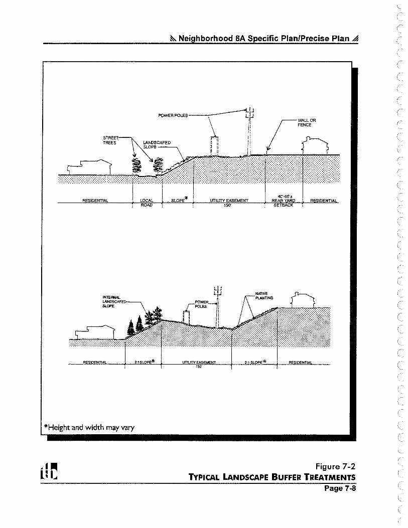
~ Neighborhood SA Specific Plan/Precise Plan~
~I 1 POWER POLES--------- LiJ
!: FENCE I' II i /: rWALLOR
STREET r. i1 0
TREES . LANDSCAPED g i; 11 ~ SLOPE l !1 1 · 1 (
I I 40'-60':!: RESIDENTIAL LOCAL _ SLOPE* , UTILITY EASEMENT RE R
A 150' SETBACK
2:1 L P
*Height and width may vary
UTILliYEA M 150'
2:1 SLOPE* RESI NTIA
Figure 7-2 TYPICAL LANDSCAPE BUFFER TREATMENTS
Page 7-8

~ Neighborhood SA Specific Plan/Precise Plan .a
E. Manufactured Slope Treatments
Manufactured slopes should be landscaped with native plant species where they interface with natural open space. Naturalized and ornamental species may be included on internal manufactured slopes, but should not occur adjacent to natural open space. Plantings on slopes adjacent to open space shall reflect the natural vegetation found in the vicinity. The plant palette selected for revegetating these slopes should be visually compatible with the surrounding natural landscape and allow for transitional slope coverage, natural ecological succession and, ultimately, a mature plant community that'integrates with the undisturbed natural areas.
An artificially-appearing manufactured slope outline should be avoided by using plant species that are similar in appearance to those on adjacent natural slopes. Such plantings will create a sense of undulation and visual relief along the vertical planes consistent with the characteristics of the surrounding hillsides.
The Carmel Valley PDO requires preparation of a landscaping and irrigation plan for all graded slopes to provide for rapid stabilization. Plant material on graded areas should be selected to control erosion, stabilize banks, and provide a visually pleasing background. Plant palettes should incorporate droughttolerant plant species that require minimal maintenance. Groundcovers and seed mixes should be used to provide consistent cover. In addition, consideration should be given to arranging trees and plant masses to avoid blocking views and vistas.
All manufactured slopes within open space areas that are planned for future ownership by the City of San Diego shall be planted only with native and naturalized plant materials. These slopes shall be hydroseeded with a mix of native and naturalized plant material to blend with either the coastal sage scrub or chaparral plant communities. A sample plant pallette for these slopes is as follows:
COASTAL SAGE SCRUB MIX
Artemesia californica
Encelia californica
Enogonum fasciculatum
Enogonum parvifolium
Enopliyllum confertiflorum
Eschschoizia californica
Helianthemum scoparium
Lotus scopanus
Lupinus bicolor
Coastal Sagebrush
Bush Sunflower
California Buckwheat
Sea Cliff Buckwheat
Golden Yarrow
California Poppy
Rush Rose
Deerweed
Pygmy-Leaf Lupine
Lupinus succulentus Arroyo Lupine
Mimulus puniceus Bush Monkeyflower
Salvia mellifera Black Sage
Vulpia microstachys Small Fescue
Design Element Page 7-9
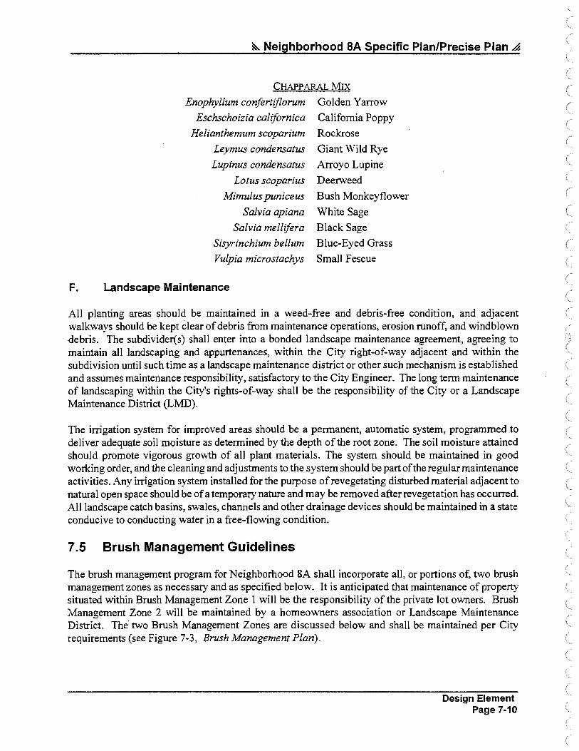
~ Neighborhood SA Specific Plan/Precise Plan A
CHAPP ARAL MIX
Enophyllum confertiflorum
Eschschoizia californica
Helianthemum scoparium
Leymus condensatus
Lupinus condensatus
Lotus scoparius
Mimulus puniceus
Salvia apiana
Salvia mellifera
Sisyrinchium bellum
Vulpia microstachys
F. Landscape Maintenance
Golden Yarrow
California Poppy
Rockrose
Giant Wild Rye
Arroyo Lupine
Deerweed
Bush Monkeyflower
White Sage
Black Sage
Blue-Eyed Grass
Small Fescue
All planting areas should be maintained in a weed-free and debris-free condition, and adjacent walkways should be kept clear of debris from maintenance operations, erosion runoff, and windblown debris. The subdivider(s) shall enter into a bonded landscape maintenance agreement, agreeing to maintain all landscaping and appurtenances, within the City right-of-way adjacent and within the subdivision until such time as a landscape maintenance district or other such mechanism is established and assumes maintenance responsibility, satisfactory to the City Engineer. The long term maintenance of landscaping within the City's rights-of-way shall be the responsibility of the City or a Landscape Maintenance District (LMD).
The irrigation system for improved areas should be a permanent, automatic system, programmed to deliver adequate soil moisture as determined by the depth of the root zone. The soil moisture attained should promote vigorous growth of all plant materials. The system should be maintained in good working order, and the cleaning and adjustments to the system should be part of the regular maintenance activities. Any irrigation system installed for the purpose of revegetating disturbed material adjacent to natural open space should be of a temporary nature and may be removed after revegetation has occurred. All landscape catch basins, swales, channels and other drainage devices should be maintained in a state conducive to conducting water in a free-flowing condition.
7 .5 Brush Management Guidelines
The brush management program for Neighborhood &A shall incorporate all, or portions of, two brush management zones as necessary and as specified below. It is anticipated that maintenance of property situated within Brush Management Zone 1 will be the responsibility of the private lot owners. Brush Management Zone 2 will be maintained by a homeowners association or Landscape Maintenance District. The· two Brush Management Zones are discussed below and shall be maintained per City requirements (see Figure 7-3, Brush Management Plan).
Design Element Page 7-10

....... .,.,
•'
"·
~ • ~ O' 250' 500' 1000'
LI I~ r--..r--,
...... __ .,,:.,:•:, ,;. ..
:f:.::" ...... -·
t,, ..... \
; .. ,, ... ,:
. , .... ,ois
; I
/
' '· \., ..
/''"):\/,\ :\ . ·, : \
.............. ~•··-· : :;.·
>-·'\~~-
-~,.;,; ·i' : • t t ,""
\ \ ;
\J,N~ \ \ E ";;:
\X
R;SJOEN'fJAl:LOW <J.1.-,, ,_,., ··, , '.\ , ....
-'.~:;;:f:::,·1~f )~,:~~~~-;tr/·:· t((\i) -
&. Neighborhood SA Specific Plan/Precise Plan ,a
BRUSH MANAGEMENT OPTIONS
II ·,,~11 BRUSH MANAGEMENT AREA
, ............. .. :L H NO BRUSH MANAGEMENT REQUIRED ............... 1
X This brush management plan assumes successful execution of a private-party agreement between the Torrey Pines Estates parcel and 11 small property owner parcels. Development of the Torrey Pines Estates parcel (23. 9 acres of Very Low Density) will include a condition of approval for extinguishment of all development rights (through a dedication in fee or open space easement) on 11 of the small property owner parcels. If any of the 11 parcels are not dedicated in fee or encumbered with an easement, the development area on the Torrey Pines Estates parcel would be reduced accordingly (i.e., dedication of 10 parcels = 23-acre development area; dedication of 9 parcels = 22-acre development area, etc.). Nonparticipating small property owner parcel(s) will be pennitted to develop with Rural Residential uses, subject to Resource Protection Ordinance (RPO) restrictions, and would be subject to brush management requirements.
Figure 7-3 BRUSH MANAGEMENT PLAN
Page 7-11


~ Neighborhood SA Specific Plan/Precise Plan ~
A. Zone 1
Zone 1 consists of plantings adjacent to structures. While these plantings typically consist of irrigated, ornamental non-native species, native plants may also be used. When used, native plants should be able to survive with summer water. Typically, Zone 1 is 40 feet to 30 feet wide. However, in cases where Zone 1 is less than 30 feet, additional area must be added to Zone 2 to compensate for the reduction.
Residential development located adjacent to or topographically above the MHPA (e.g. along canyon edges) must be set back from slope edges to incorporate Zone 1 brush management areas on the de-yelopment pad and outside of the MHPA.
8. Zone 2
In areas adjacent to or within City MHPA open space, typical brush management zones 2 and 3 will be combined into Zone 2. In this zone, the typical Zone 2 area is increased by 30 feet, but will not be greater in size than is required by the City's regulations. The amount of woody vegetation clearing shall not exceed 50 percent of the vegetation existing when the initial clearing is conducted. Vegetation clearing shall be done consistent with City standards and shall avoid/minimize impacts to covered MSCP species to the maximum extent possible. Regardless of ownership, brush management in the Zone 2 area will be the responsibility of a homeowners association or other private party. Brush management zone 2 is a permitted use in. MHP A open space. Zone 2 can be implemented in a variety of ways, the simplest being the selective thinning and pruning of the native plants. Long-term ongoing thinning cost may be reduced by the introduction of low growing fire retardant shrubs and ground covers that are visually and horticulturally compatible with the native vegetation. Plantings in Zone 2 may be established by hydroseeding, if desired.
C. Exceptions to Required Brush Management Zones
As depicted in Figure 7-3, Brush Management Plan, no brush management is required along the southern and eastern portion of the neighborhood because of the proximity of adjacent development in Sorrento Hills and Carmel Valley Neighborhood 10. Also, alternative measures such as intervening local streets may eliminate brush management requirements between areas of natural open space and development.
7.6 Wall and Fence Guidelines
All fences and walls in Neighborhood 8A should be designed as integral elements of building architecture or complementary to the architecture and landscape character. The following guidelines should be used for all fences and walls:
1. Appropriate materials include tubular steel, stone block, wrought iron, masonry, stucco, wood, and vinyl coated chain link. Transparent materials, such as glass, also may be used where views are desirable.
2. The maximum height for fences and walls should be six feet, except as required for earth retention or sound attenuation.
Design Element Page 7-12

~ Neighborhood SA Specific Plan/Precise Plan ~
3. Walls and fences located adjacent to natural open space shall be constructed of materials compatible with open space systems.
4. Solid fences and walls which are visible from public rights-of-way should include design elements incorporated to reduce monotony. These elements could include pilasters, pop:-outs, or planter pockets.
5. Development areas adjacent to MHPA open space may be required to provide a wall or fence along the MHPA boundary line to minimize disturbance of natural vegetation and to reduce domestic animal predation.
7.7 Lighting Guidelines
Lighting of project roadways should be provided in conformance with the City's Street Design Manual. The amount and intensity of lighting should be limited to that necessary for safety, security, and to compliment architectural character. Lighting of all areas adjacent to MHPA open space should be directed away from the MHPA. Where necessary, development should provide adequate shielding to protect the MHP A area from unnecessary night lighting.
7.8 Signage Guidelines
Signage shall be designed to fulfill identification, directional, information, and temporary marketing needs as required. At the same time, signage shall blend into community and neighborhood streetscapes and project architectural themes. Signs shall be designed to conform with the Carmel Valley Community Signage Guidelines and Criteria.
7 .9 Conservation Guidelines
Conservation guidelines for Neighborhood 8A are based on the following objectives:
♦ Consider site and landscape energy conservation measures in neighborhood design. Site planning and landscaping shall take advantage of solar access where possible.
♦ Promote water. conservation in building design and landscaping. Such measures include installation of low water use appliances and grouping of plants with similar water and sun requirements.
♦ Preserve areas designated as open space in their natural condition.
A conservation principle is proposed whereby conservation concerns are considered in both project design and construction, and also long-term usage and maintenance. This principle should apply to public facilities, to private developments, and to natural open space preservation.
Design Element Page 7-13

~ Neighborhood SA Specific Plan/Precise Plan ,4
A. Energy Conservation
For energy conservation, site planning should consider opportunities to utilize active and passive solar systems. Pertinent site factors include lot sizes ( as it influences proximity to other structures which may limit solar access), lot orientation (to maximize solar and breeze access), grading (to encourage proper lot orientation), and landscaping· (to encourage seasonal solar shading/access measures).
Building design in Neighborhood 8A should incorporate energy conservation practices to the extent feasible. This includes the design and construction of heating-ventilating and air-conditioning systems; water heating; window treatments; insulation and weather-stripping and lighting. Building design and equipment selection should consider life cycle costs rather than short-term capital and installation costs. Where practical, buildings may be sited and landscaped or provided with roof orientations according to passive solar energy concepts.
In addition, the role of landscaping in energy conservation should be recognized in the design of Neighborhood 8A projects. Plant materials should be utilized to control exterior radiation and to reduce glare. Deciduous trees with dense foliage are recommended on the south and west faces of buildings, to intercept radiation before it strikes or after it is reflected. To lessen the intensity of the heat and light reflected from paving or sidewalks, vines growing on a building wall or a ground cover may be used as buffers against solar radiation. In combiriation with shrubs, these will aid in the reduction of summer glare and also help to moderate evening and winter cool spells.
B. Water Conservation
Water conservation should be consistent with all current City standards at the time of approval. Emphasis should be placed on devices and design characterized by low water requirements and efficient utilization of water. In addition, landscape design and choice of plant materials should emphasize low water requirements and minimize water runoff. Landscape watering systems should supply water efficiently, minimizing waste.
C. Natural Open Space Preservation
During design, construction, and maintenance ofNeighborhood 8A developments, areas designated as natural open space should be left intact. Dumping of fill shall be prohibited, and trampling of native vegetation underfoot and by vehicles shall not be permitted. Control measures shall include signing, fencing, and close supervision of construction. In addition, natural open space areas shall be identified on engineering and construction plans. To discourage the illegal use of off-road vehicles and limit undesirable foot travel, appropriate design layouts, signing, and landscaping should be employed at potential access points from developed areas into natural open space. ·
Design Element Page 7-14


Section
~8~ Implementation
The purpose of this section is to provide for the timely implementation of development for the Neighborhood 8A Specific Plan/Precise Plan. This section presents the process for planned district development permit (PDDP) approval, tentative map approval, development phasing, and Specific Plan/Precise Plan amendments.
8.1 Implementation Process
Neighborhood 8A is located in the City of San Diego's Carmel Valley Community Planning area. The Carmel Valley Community Plan, which provides guidance for development within the community, requires that a Precise Plan be prepared for each of the neighborhoods that comprise the community plan area. This Specific Plan/Precise Plan has been prepared to guide the development of property within Neighborhood 8A. This Specific Plan/Precise Plan becomes the basis for City review of subsequent development permits, subdivisions and other permits proposed in the neighborhood. Parcels within the Specific Plan/Precise Plan area requiring subdivision will require approval of a Carmel Valley Planned District Development Permit (PDDP) and a Tentative Map to ensure compliance with this Specific Plan/Precise Plan and the Carmel Valley Planned District Ordinance (PDO).
8.2 Modifications to this Specific Plan/Precise Plan
All revisions (major or minor) to this Neighborhood 8A Specific Plan/Precise Plan shall take place in accordance with the process outlined in this section. Modifications are divided into two basic categories: I) Substantial Conformance, and 2) Specific Plan/Precise Plan Amendments. Proposed modifications should follow the criteria described below in Subsections 8.2(A) - 8.2(C).
A. Substantial Conformance
Minor changes and deviations in development from that described in this adopted Specific Plan/Precise Plan may be permitted if such changes or deviations are approved by the City Manager and substantially conform to the adopted Specific Plan/Precise Plan. The following are examples of modifications which may be considered in substantial conformance with this Specific Plan/Precise Plan:
♦ Realignment or modifications of major streets, lot lines, easement locations and grading adjustments, if also approved by the City Engineer.
♦ Modifications of design features such as fencing, lighting, entry treatments and landscaping.
♦ Density transfer of residential units with'in the Specific Plan/Precise Plan area provided the transfer does not result in exceeding the density range category assigned to the parcel(s) as described in this document. In no case shall the overall density or maximum unit count of the Specific Plan/Precise Plan exceed 443 units as the result of Substantial Conformance.
Implementation Page 8-1

~ Neighborhood SA Specific Plan/Precise Plan .4
♦ Designation of local residential streets as either public or private, subject to approval of the City Engineer.
♦ Changes to the phasing plan.
♦ Any other modifications of a similar magnitude that Development Services or the City Manager declares to be in substantial conformance.
Additional environmental review is not required for Substantial Conformance provided such changes are determined to be in accordance with the development concept of the adopted Specific Plan/Precise Plan.
8. Specific Plan/Precise Plan Amendments
All changes that do not meet the definition of a Substantial Conformance determination as noted in Subsection 8.2(A) will require an Amendment to this Specific Plan/Precise Plan. All Amendments shall be reviewed for approval by the San Diego City Planning Commission and the San Diego City Council. Increases in the maximum dwelling unit count of the Specific Plan/Precise Plan shall require a Specific Plan/Precise Plan Amendment. Additional environmental review also may be required by the City in accordance with the California Environmental Quality Act (CEQA).
C. Amendment Criteria
The applicant for an amendment to this Specific Plan/Precise Plan shall satisfy the following minimum criteria:
♦ Ensure that any environmental impacts resulting from the modification are mitigated, unless a statement of overriding considerations is adopted by the San Diego City Council.
♦ Providerevised Specific Plan/Precise Plan text, maps and exhibits, as necessary and as required by the City's Development Services Department.
8.3 Applicability of the Carmel Valley PDQ
This Specific Plan/Precise Plan provides guidelines for the development of Neighborhood 8A. These guidelines are intended to be used in the review of subsequent subdivisions and development permits proposed for Neighborhood 8A. The Zoning Standards and Regulations, provided within this Specific Plan/Precise Plan as Appendix A, have been crafted from the residential zones contained in the Carmel Valley Planned District Ordinance (PDO) and open space zones provided within the City of San Diego's Land Development Code, which had not been implemented at time this Specific Plan/Precise Plan was adopted. Detailed Zoning Standards and Regulations and the Zoning Plan are provided as Appendix A to this Specific Plan/Precise Plan and are incorporated herein by reference. Therefore, provisions of the Carmel Valley PDO are not applicable to Neighborhood 8A.
Implementation Page 8-2

&.. Neighborhood 8A Specific Plan/Precise Plan ~
8.4 Applicability of California Coastal Zone Requirements
A portion of the Neighborhood 8A Specific Plan/Precise Plan area (approximately 34 acres) lies within the designated California Coastal Zone. This boundary traverses the northern portion of the site in a northeast-southwest direction (see Figure 1-2, Coastal Zone Boundary, in the introductory section of this document). The California Coastal Commission must amend the Local Coastal Program and certify the Neighborhood 8A Specific Plan/Precise Plan before land uses within the coastal zone can be effectuated. The coastal zone area of Neighborhood 8A is designated as open space, with the exception of the oneacre Kennedy parcel that is designated Rural Residential. Development on this parcel will require a Coastal Development Permit. The remaining areas within the Coastal Zone (with the exception of the small property owner parcels) will be rezoned from A-1-10 to Open Space.
8.5 Other Discretionary Approvals
All subdivisions, rezonings and other discretionary actions required to implement this Specific Plan/Precise Plan are subject to environmental review under the provisions of the California Environmental Quality Act (CEQA) and the City of San Diego Municipal Code. Projects should be reviewed for compliance with the mitigation measures presented in the accompanying Neighborhood 8A Environmental Impact Report (LD R No. 96-7996). In addition, the following conditions shall be met during the development approval process:
♦ Prior to the approval of a Tentative Map or issuance of a Planned District Development Permit, compliance with the terms of the adopted Carmel Valley School Facilities Master Plan shall be demonstrated.
♦ Consistent with Vesting Tentative Map approval, a Planned District Development Permit shall be approved for the uses within the Vesting Tentative Map.
♦ A conceptual landscaping plan shall accompany each Planned District Development Permit and provide for the stabilization of all graded slopes.
♦ Approval of Tentative Map(s) for the neighborhood shall be subject to the approval of a comprehensive drainage plan by the City Engineer prior to recordation of a Final Map.
8.6 Development Phasing
The purpose of a development phasing program is to coordinate the timing and level of public facilities, and the sequence and amount of residential development. Carmel Valley is designated as a planned urbanizing area by the City of San Diego Progress Guide and General Plan. Under this designation and City Council Policy 600-28, a development phasing program must be adopted as part of the Precise Plan process for neighborhoods of Carmel Valley.
Each of the residential developments would proceed in accordance with availability of access and public facilities such as sewer and water. It is likely, but not required, that those parcels closest to existing infrastructure would be initiated first. The public school/park site would likely be developed in a second phase.
Implementation Page 8-3
&. Neighborhood SA Specific Plan/Precise Plan ~
The Neighborhood 8A Phasing Plan is consistent with the generalized phasing plan in the Carmel Valley Community Plan and, as such, can be·coordinated with the provision of major improvements as set forth in the Carmel Valley Public Fadlities Financing Plan.
A. Public Infrastructure, Facilities, and Services Phasing
Public infrastructure, facilities, and services will be provided as needed under the Public Facilities Financing Plan outlined in Subsection 8.7. Provision of facilities will be as follows:
♦ Street, utilities, and drainage facilities will be constructed along with residential development, ensuring sufficient capacity to meet residents' requirements.
♦ Community-level facilities outside Neighborhood 8A will be built when the service area is sufficient, with fees or assessments collected as residential construction progresses. A community-serving library and fire station have already been constructed in Carmel Valley; north of Carme'l Valley Road.
♦ Construction of the Neighborhood 8A public park will occur when adequate demand warrants as determined by the City of San Diego Parks and Recreation Department. The schedule for acquisition and construction of the park shall be based on the phasing and financing schedule contained in the FBA for Carmel Valley South. If constructed as a joint-use facility with the Neighborhood 8A elementary schoot site, the City of San Diego and the Del Mar Union School District should coordinate the phasing of these two facilities.
♦ The schedule for acquisition and construction of the Neighborhood 8A elementary school will be determined by the Del Mar Union Elementary School District. If constructed as a joint-use facility with the Neighborhood 8A park site, the Del Mar Union School District and the City of San Diego should coordinate the phasing of these two facilities.
B. Community Transportation Improvements Phasing
Improvements to the community-wide street system will be constructed in accordance with the Transportation Phasing Plan in effect for Carmel Valley as adopted by the City of San Diego. This encompasses regional transportation improvements for the Carmel Valley/Sorrento Hills area, including freeway improvements. The Plan is designed to ensure that adequate community transportation facilities are available in conjunction with development, in particular roadway vehicular capacity.Neighborhood street improvements should be phased in conjunction with residential development as described above in Section 8.6(A).
8. 7 Public Facilities Financing Plan .
The Carmel Valley Community Plan requires that Precise Plans address the financing of public facilities to ensure their availability concurrent with need. In addition, the City Council has stated the following:
Development in the North City West [Carmel Valley] area is contingent upon necessary public facilities beingfinanced by property owners in that area by a charge against the land only in the planning area.
Implementation Page 8-4

~ Neighborhood SA Specific Plan/Precise Plan ..4
The financing program for Neighborhood 8A is summarized below and is subject to refinement and adoption during City review of development permits and subdivisions.
♦ Carmel Valley Public Facilities Financing Plan (PFFP) and Facilities Benefit Assessment (FBA) fees shall be charged against dwelling units or the equivalent in the Specific Plan/Precise Plan area for public facilities and services. Credits for construction of community-serving facilities, such as the construction of community-serving roadways, are optional.
The current financing for facilities in Carmel Valley, north of Carmel Valley Road, shall be provided through the Carmel Valley FBA- Phase I. For development south of Carmel Valley Road, financing for facilities shall be provided by the Carmel Valley FBA - Phase IL The financing of facilities for Neighborhood 8A will be incorporated into Phase II.
♦ Standard subdivision agreements may be entered into by project applicants to finance on- and off-site improvements under the conventional subdivision process.
♦ School financing will be required, with fees payable to the Carmel Valley School Facilities Financing Authority per the Mello-Roos Community Finance District (CFD) #1. ·
The Neighborhoi;,d 8A Specific Plan/Precise Plan area should be added to the Carmel Valley community street lighting and open space maintenance district. The district should maintain and/or operate selected open space areas and street medians, parkways, and non-vehicular access ways within public rights-ofway. ·The proposed neighborhood or community park in Neighborhood 8A and the playground portion of the elementary school site should be maintained either via the City's operating budget or the appropriate Joint Parks Authority.
8.8 Reimbursement Program
In accordance with California Government Code §65456(a), the City of San Diego, after adopting the Neighborhood 8A Specific Plan/Precise Plan, shall impose a Specific Plan fee upon persons seeking government approvals which are required to be consistent with the Specific Plan/Precise Plan. The fee shall be established so that, in the aggregate, it defrays, but as estimated does not exceed, the cost of preparation, processing and adoption of the Specific Plan/Precise Plan and its associated Environmental Impact Report (EIR). The fee shall serve as a cost reimbursement to the applicants of the Specific Plan/Precise Plan, who funded the preparation, processing, and adoption of the Specific Plan/Precise Plan and EIR. .
The Neighborhood 8A Specific Plan fee shall be a prorated amount in accordance with future applicants' relative benefit derived from the Specific Plan/Precise Plan. The Neighborhood 8A Specific Plan/Precise Plan fee shall be calculated as follows:
Implementation Page 8-5

~ Neighborhood SA Specific Plan/Precise Plan ~
FEE= A[C(J + by)]
A: Number of gross acres in the future proposed project. C: The average cost per gross developable acre of preparing, processing and adopting the
Neighborhood SA Specific Plan/Precise Plan and EIR. b: Annual inflation rate. y: The number of years since the year of Specific Plan/Precise Plan adoption.
The Specific Plan fee shall not be imposed on the following parcels, for which their applicants/owners participated in the original funding. The Specific Plan fee collected by the City shall be reimbursed to the applicants of the following parcels in the allocation distribution set forth in Table 8-1, Specific Plan/Precise Plan Reimbursement Program. It shall be the responsibility of the parcel applicants to· keep the City informed as to any changes in ownership, mailing addresses, etc., for the purposes of reimbursement.
Table 8-1 Specific Plan/Precise Plan Reimbursement Program
e.a~~i···· /·. ? << · .. ····•· .. ·.·.'..· .· < Percentaae
Carmel Estates 27.14% (Westbrook Communities)
Loma Sorrento 36.11% (Western Pacific Housing)
Pardee Parcel A 0% (Pardee Construction Co.)
Torrey Pines Estates 15.52% (Torrey Pines Investment Group)
Torrey Surf 21.23% (J.L. Elder Co.)
Future development proposals on any parcel ofNeighborhood 8A not listed in Table 8-1 shall be charged the Neighborhood 8A Specific Plan fee as outlined in this section ..
8.9 Density Transfer within Neighborhood SA
If the total number of dwellings allowed by this Specific Plan/Precise Plan on a residential parcel is not achieved, the "unused" dwelling units may be transferred to another residential development area within Neighborhood 8A. Table 2-2, Land Use Summary by Ownership, indicate the maximum number of total dwelling units allocated to each parcel ofNeighborhood 8A. Density transfers between parcels shall be allowed within Neighborhood 8A without the need for a Specific Plan/Precise Plan Amendment, provided that the following conditions are met:
1. The maximum number of dwelling units allowed by this Specific Plan/Precise Plan ( 443) shall not be exceeded.
Implementation Page 8-6

~ Neighborhood 8A Specific Plan/Precise Plan ~
2. The density range designated for the receiving parcel shall not be exceeded (Rural Residential = I unit per parcel; Very Low Density= 0-5 du/ac; and Low Density= 5-15 du/ac).
3. The resultant development must be consistent with the development standards of the underlying zone as set forth in the Planned District Ordinance (PDO), as amended by this SpecificPlan/Precise Plan.
a.10 Concurrent and Subsequent Discretionary Entitlements
In conjunction with the adoption of this Specific Plan/Precise Plan, an applicant may simultaneously or subsequently process a subdivision map that implements entitlements set forth in this document. Related Development Permit(s) may be processed concurrently or subsequent to any such subdivision map. Should the provisions of this Specific Plan/Precise Plan conflict with any City of San Diego ordinance, policy or procedure, this Specific Plan/Precise Plan shall take precedence.
Implementation Page 8-7


Section
~9~ Conformance with Plans and Policies
This section includes a discussion of project consistency with adopted plans and policies. Land use development and policies for the City of San Diego are generally regulated by the City of San Diego Progress Guide and General Plan. According to the Progress Guide and General Plan, the project site is located within the Carmel Valley Community Plan Area. In addition to the City's Progress Guide and General Plan and the Carmel Valley Community Plan, four other plans and policies are relevant to the proposed project site. These are the Multiple Species Conservation Program (MSCP), the North City Local Coastal Program (LCP), the Resource Protection Ordinance (Municipal Code §101.0462), and Council Policy 600-40 (Preparation of Long-Range Plans).
Presented below is a summary of project consistency with the pertinent goals, objectives, and recommendations of the plans and policies that affect development of the project site.
9.1 Conformance with the City of San Diego Progress Guide and General Plan
In accordance with California Government Code §65451(b), a Specific Plan must contain a statement of the relationship of the Specific Plan with the General Plan. The Progress Guide and General Plan provides the basic policies for the Neighborhood 8A Specific Plan/Precise Plan. The Neighborhood 8A Specific Plan/Precise Plan is a refinement to the Progress Guide and General Plan for the 351.1 acres within Neighborhood 8A. An amendment to the Progress Guide and General Plan Land Use Map will occur concurrently with approval of this Specific Plan/Precise Plan to achieve consistency between the two plans.
The City's Progress Guide and General ~Ian is divided into 13 primary elements including Housing; Transportation; Commercial; Industrial; Public Facilities, Services and Safety; Open Space; Recreation; Redevelopment; Conservation; Energy Conservation; Cultural Resources Management; Seismic Safety; and Urban Design. A discussion of project consistency with the elements of the Progress Guide and General Plan that are applicable to land use planning is provided below. A discussion of project consistency with applicable environmental goals of the Progress Guide and General Plan can be found in the accompanying Neighborhood 8A EIR.
A. Housing Element
The Housing Element specifies programs that are intended to guide the City's commitment to make adequate provision for the housing needs of all economic segments of the community. Neighborhood 8A is located within the community of Carmel Valley. The Carmel Valley Community Plan provides for a balanced housing program by correlating income levels to housing categories and locations. The Community Plan designates portions of Carmel Valley's Low/Medium Density (15-29 du/ac) and Medium Density (30-44 du/ac) units for low and moderate income households. A majority of these units are planned in Carmel Valley Neighborhood 9 near the Town Center, outside of the Neighborhood 8A Specific Plan/Precise Plan area.
Conformance with Plans and Policies Page 9-1

&. Neighborhood SA Specific Plan/Precise Plan A
Three residential density categories will be provided in Neighborhood 8A. These include Rural Residential, Very Low Density and Low Density.
8. Transportation Element
The Transportation Element provides the framework for developing a comprehensive transportation system which includes vehicular and non-vehicular circulation. Relevant goals contained within the Transportation Element address the need to provide a transportation system that is in balance with the types and intensities of land uses that it serves, and to provide a transportation system that is safe, functional, efficient, environmentaliy acceptable, and aesthetically pleasing. The Progress Guide and General Plan, through the Carmel Valley Community Plan, designates two major roadways within Neighborhood 8A. These roadways include the extension of Carmel Creek Road North to connect Neighborhood 8A with SR-56, and the extension of Carmel Creek Road South and Street "A" to connect Neighborhood 8A and adjacent Neighborhood 10 with Carmel Mountain Road and EI Camino Real to the south.
No major or collector roads will occur in Neighborhood 8A with implementation of this Specific Plan/Precise Plan, including the two major roadways designated for this neighborhood by the 1975 Carmel Valley Community Plan. Without the construction of Carmel Creek Road South and Street "A.", direct vehicular, pedestrian, and bicycle access will not be available to the Neighborhood 8A public park/school site from all residential areas ofNeighborhood 8A. Most of the residential development will be oriented towards roads in the Sorrento Hills community to the south.
C. Public Facilities, Services and Safety Element
The Public Facilities, Services and Safety Element addresses the provision of schools, libraries, police, fire, water, sanitation and flood control. The Public Services and Facilities section discusses the provision of these essential public services in Neighborhood 8A. This Specific Plan/Precise Plan is consistent with the Public Facilities, Services and Safety Element of the Progress Guide and General Plan. Access to the Torrey Pines Estates parcel will be provided by Arroyo Sorrento Road, an unpaved rural roadway. This roadway will be improved to ensure the accessibility of fire protection services to residential homes on this parcel. Improvements to Arroyo Sorrento Road would be required in order for development to occur on the Torrey Pines Estates parcel.
This element of the Progress Guide and General Plan identifies schools and the provision of quality education as the most important area of public service and recommends cooperative assistance with school districts in resolving problems arising over the availability of schools in newly developing areas of the City. An elementary school site will be provided in Neighborhood 8A with implementation of this Specific Plan/Precise Plan.
D. Open Space Element
The Open Space Element supports the creation of new communities which strive to retain and enhance natural amenities. The Open Space Element calls for establishing "an open space system which provides for the preservation of natural resources, the managed production of resources, the provision of outdoor
Conformance with Plans and Policies Page9-2

~ Neighborhood SA Specific Plan/Precise Plan .4
recreation, the protection of public health and safety, and the utilization of the varied terrain and natural drainage systems of the San Diego community to guide the form of urban development. "
The Carmel Valley Community Plan calls for approximately 30 percent of Neighborhood SA to be preserved as open space. This Specific Plan/Precise Plan for Neighborhood 8A designates 238.5 acres (70 percent) ofNeighborhood SA as open space. Additionally, a permanent Multi-Habitat Planning Area (MHP A) boundary for Neighborhood SA is established through implementation of this plan. The MHP A boundary established by this Specific Plan/Precise Plan is comparable in biological value to the "placeholder" MHPA boundary. Trails may be provided in the MHPA to provide public access through the open space. Standards for the provision of trails through MHPA open space are included in this Specific Plan/Precise Plan.
E. Urban Design Element
The Urban Design Element addresses the integration of new development into the natural landscape and/or existing community. This element also addresses the integration of new development within the framework of an existing community, with minimum impact on that community's physical and social assets. Design Elements are included in this Specific Plan/Precise Plan that provide general criteria for grading, drainage, site planning, architecture, landscaping, brush management, signage, lighting, and conservation, to ensure that a high-quality living environment and strong community character is provided in Neighborhood 8A. The overall goal of the Design Element is to create a neighborhood that is cohesive and aesthetically pleasing and complementary to surrounding development and to the community of Carmel Valley as a whole.
The Progress Guide and General Plan Urban Design Element states a policy to '1maintain the character of undeveloped valleys, canyons, and hillsides." The Specific Plan/ Precise Plan places the majority of development in the valleys and finger canyons of Neighborhood 8A and preserves the on-site primary mesa top as open space.
9.2 Conformance with the Carmel Valley Community Plan
Community plans are defined in Section 21083 .3 of the Public Resources Code as being a part of the General Plan. Neighborhood 8A is located within the City of San Diego's Carmel Valley Community Planning Area. As such, a demonstration of project consistency with the Carmel Valley Community Plan is required.
The Carmel Valley Community Plan calls for an intensive land use pattern in Neighborhood 8A. These uses include approximately 2,000 dwelling units, a neighborhood commercial site, an elementary school site, a community park, and about 120 acres of open space as shown in Figure 9-1, Existing Carmel Valley Community Plan Land Use Plan for Neighborhood 8A. Also, a circulation system is identified for the neighborhood that extends Carmel Creek Road (formerly Soleded Valley Road) through the property from SR-56 to Carmel Mountain Road. Although the Community Plan includes a land use plan for Neighborhood 8A, the plan requires that subsequent comprehensive planning be conducted for each individual neighborhood within the larger Carmel Valley plan context, to determine development specifics. Such subsequent comprehensive planning is directed to address issues of land use patterns, road alignments, community facility sites and phasing.
Conformance with Plans and Policies Page 9-3


~ Neighborhood SA Specific Plan/Precise Plan A
LEGEND
LAND USE
RESIDENTIAL [fil VERY LOW 1SDU/AC1
t:I.:J LOW II0DU/A(.'I DJ'.D LOW-MEDIUM l10DU/ AC!
c::m:J NEIGHBORHOOD COMMERCIAL
ITJ ELEME~'TARY SCHOOL
fJ:EJ COMMUNITY PARK
rn::.J OPEN SPACE
c:J MAJOR ROADS
MAJOR STREET
- COLLECTOR STREET
BICYCLE PATH
PEDESTRIAN PATH
Figure 9-1 EXISTING 1975 CARMEL VALLEY
COMMUNITY PLAN LAND USE PLAN FOR NEIGHBORHOOD 8A
Conformance with Plans and Policies Page9-4

/ \

~ Neighborhood SA Specific Plan/Precise Plan A
This Specific Plan/Precise Plan sets forth a development plan that is substantially less intense than that called for by the Community Plan. Concurrent with the approval of this Specific Plan/Precise Plan for Neighborhood 8A, an amendment to the Carmel Valley Community Plan will be approved to reflect the adopted land use plan for Neighborhood 8A. Approval of the Community Plan Amendment wHl ensure consistency between this Specific Plan/Precise Plan and the Carmel Valley Community Plan.
The Carmel Valley Community Plan sets forth five broad goals to guide urbanization in the Carmel Valley community. These goals are stated below, along with a brief discussion of compliance by this Specific Plan/Precise Plan.
GOAL: To establish a physical, social, and economically balanced community.
To positively contribute to the establishment of a physically, socially, and economically balanced community, Neighborhood 8A integrates physical site development, land use, and utilities with surrounding planned and existing development. Approximately 92.6 acres of residential development will occur in the neighborhood, serving as extensions of approved and planned development to the south, east and west. Although only market rate housing will be provided in Neighborhood 8A, Neighborhood 8A will offer a variety single family residential housing at target density ranges of between 1 du/ac and 7.5 du/ac to provide a range of housing options and prices.
Recreational, neighborhood and community facilities located in Neighborhood 8A will include an elementary school site, a public park site and ~xtensive open space which will attract and serve a diverse population and be available equally for use by all residents of Neighborhood 8A and residents of other neighborhoods in Carmel Valley and Sorrento Hills. Approximately 70 percent, or 238.5 acres, of Neighborhood 8A is preserved as open space to protect sensitive resources and to provide a balance between development and nature.
The Specific Plan/Precise Plan reflects the community-wide desire to amend the Carmel Valley Community Plan to eliminate all Circulation Element roadways from the neighborhood and to reduce development intensity in the neighborhood as compared to the Carmel Valley Community Plan.
GOAL: To establish self-containment and feeling of community identity among the future residents of Carmel Valley.
Neighborhood 8A is intended to function as one unit of the overall Carmel Valley community. The Specific Plan Precise Plan achieves this intent by providing a unique mix of residential areas with a range of housing densities and centrally located facilities similar to other Carmel Valley residential neighborhoods. Neighborhood 8A will contribute community-level facilities such as a public park site and an elementary school site to the area as called for by the Community Plan.
Conformance with Plans and Policies Page 9-5

~ Neighborhood SA Specific Plan/Precise Plan A
GOAL: To preserve the natural environment.
The Carmel Valley Community Plan calls for approximately 30 percent of Neighborhood 8A to be preserved as open space. This Specific Plan/Precise Plan designates a total of238.5 acres (70 percent) ofNeighborhood 8A as open space. One of the primary objectives of this Specific Plan/Precise Plan is to preserve sensitive lands and the primary on-site mesa top as open space, and to preserve views from the mesa top. The Neighborhood 8A land use plan achieves this goal. Adjustments to the MHP A boundary line as a result of this Specific Plan/Precise Plan are evaluated in the Neighborhood 8A EIR (LDR No. 96-7996).
GOAL: To establish a balanced transportation system which is used as a tool for shaping the urban environment.
No major or collector roads will occur in Neighborhood 8A with implementation of this Specific Plan/Precise Plan, including the two major roadways designated for this neighborhood by the I 975 Carmel Valley Community Plan. These roadways include Carmel Creek Road South/Street "A" and Carmel Creek Road North. Without the construction of Carmel Creek Road South and Street "A", direct vehicular, pedestrian, and bicycle access will not be available to the Neighborhood 8A neighborhood park site from the Loma Sorrento and Torrey Pines Estates parcels of Neighborhood 8A. A General Plan/Community Plan Amendment, which deletes circulation element roadways in Neighborhood 8A from the transportation element of the Community Plan, was approved concurrent with adoption of this Specific Plan/Precise Plan.
GOAL: To establish realistic phasing of development within the community based on maximum utilization of the privately financed public facilities.
Approval of this Neighborhood 8A Specific Plan/Precise Plan in itself represents a step in development phasing. The Specific Plan/Precise Plan provides for the installation of public facilities by property owners as required for residential development. Financing of an adequate circulation system and necessary public facilities is described in the Specific Plan/Precise Plan, and a phasing program for Neighborhood 8A is outlined in Section 8, Implementation, in this document.
9.3 Specific Plan/Precise Plan Development Plan Criteria
The 1975 Carmel Valley Community Plan provides guidelines for the contents and preparation of Precise Plans for development units. These guidelines are restated below, each followed by a brief discussion of compliance by this Specific Plan/Precise Plan for Neighborhood 8A.
♦ The development unit Precise Plan must be in general conformance with the Carmel Valley Community Plan objectives and proposals in terms of overall density, neighborhood concept, major open space delineation and major and collector street patterns.
The Carmel Valley Community Plan identifies various land uses for Neighborhood 8A including approximately 2,000 dwelling units, a neighborhood commercial site, an elementary school site, a community park, and about 120 acres of open space. Also, a circulation system is identified for the neighborhood that extends a major street (Carmel Creek Road) through the property from SR-56 to
Conformance with Plans and Policies Page 9-6

~ Neighborhood 8A Specific Plan/Precise Plan ~
Carmel Mountain Road. The development plan set forth by this Specific Plan/Precise Plan is substantially less intense than that called for by the Community Plan.
This plan provides for a significantly reduced number of homes (approximately 75% less) than designated for Neighborhood 8A by the Carmel Valley Community Plan and does not provide for any circulation element roads as called for by the Community Plan.
♦ The Precise Plan must illustrate the complete circulation system, including local streets and transit, and further indicate how the system will relate to the total North City West (Carmel Valley) circulation system."
The Neighborhood 8A street system is described in Section 5, Circulation Element. This Specific Plan/Precise Plan does not provide for any major roadways within the neighborhood. Linkages to the total Carmel Valley system also are discussed in Section 5.
♦ The Precise Plan must illustrate a system of separate bicycle and pedestrian pathways linking the neighborhood center with the residential areas and open space system and also illustrate how these pathways can link to the town center.
The Circulation Element outlines the bicycle system and pedestrian path network linking the neighborhood/community facilities and residential areas within the Specific Plan/Precise Plan area. The connections to the community-wide bicycle, pedestrian and trail systems also are described. It should be noted that this Specific Plan/Precise Plan does not achieve an integrated circulation system because no through streets will occur in the neighborhood. At the discretion of the City, a trail system may be proposed at a later date through MSCP open space. Guidelines for future trails are included in Section 4, Open Space and Recreation Element.
♦ The Precise Plan must contain data describing the housing balance projected regarding the quantity and/or proportion of low and moderate income housing, as well as a plan describing efforts to be made to maintain an ethnic and racial balance.
Section 3, Housing Element, addresses the residential location and housing mix within Neighborhood 8A, as well as efforts in Neighborhood 8A to contribute to community-wide housi~g balance.
♦ The Precise Plan must contain a detailed design plan for the layout of the neighborhood center including shopping area and uses, neighborhood school and park; the City and local school district must agree to the sites and design of the facility.
Although a neighborhood commercial center is designed for Neighborhood 8A by the Carmel Valley Community Plan, this Specific Plan/Precise Plan does not call for commercial uses within the neighborhood. In the Land Use Element of this document, the location and characteristics of neighborhood/community facilities are discussed. These facilities include a public park and public school site. Prior to adoption of this Specific Plan/Precise Plan, the location of the public park/school site will be approved by the Del Mar Union Elementary School District and City Park and Recreation staff.
Conformance with Plans and Policies Page 9-7

R\. Neighborhood SA Specific Plan/Precise Plan A
♦ The Precise Plan must illustrate the timing of necessary public facilities through the assessment district and fees approach to serve the development.
Section 8, Implementation, outlines the phasing and financing of public facilities to be provided through the Public Facilities Financing Plan.
♦ The Precise Plan must contain an environmental impact statement.
An Environmental Impact Report for Neighborhood 8A (LDR No. 96-7996) accompanies this document.
9.4 Conformance with the Multiple Species Conservation Program
The City of San Diego's Multiple Species Conservation Program (MSCP) Subarea Plan was approved in March 1997. The MSCP identifies a 56,831-acre Multi-Habitat Planning Area (MHPA) in the City for preservation of core biological resource areas and corridors targeted for preservation. The portion of Neighborhood 8A located within the MHPA was previously illustrated on Figure 1-9, Regional MHP A Map, and Figure 1-10, Place-Holder MHPA Boundary Within Neighborhood 8A.. in the introductory section of this document. The Northern area consists primarily of wildlife corridors providing linkages to the core areas of Del Mar Mesa, Los Pefiasquitos Canyon Preserve, Los Pefiasquitos Lagoon, Torrey Pines State Park, the proposed San Dieguito River Valley Regional Park and the Black Mountain Area.
The City of San Diego's Multiple Species Conservation Program (MSCP) Subarea Plan was approved in March 1997. The MSCP identifies a Multi-Habitat Planning Area (MHPA) in the City for preservation of core biological resource areas and corridors targeted for preservation. The City's MHP A is approximately 5,700 acres .in size. The adopted MSCP Subarea Plan identified a portion of Neighborhood 8A as being located within the MHP A, however, the MHPA Guidelines for Carmel Valley stated that "the MHP A boundaries are unresolved and may be modified by City Council action on the Carmel Valley Neighborhood 8A Precise Plan." Further, City Council Resolution No. R-287583 (item 12) stated that "it shall be expressly noted/or the record that any reflection of boundaries of the proposed MSCP Preserve in any documents shall not be construed or interpreted by anyone as an expression or direction or predisposition by the City Council with respect to the pending application for the Carmel Valley Neighborhood 8A Precise Plan." Based on this direction, a temporary or "placeholder" MHP A boundary line was included in the City's MSCP Subarea Plan for Neighborhood 8A as previously illustrated on Figure 1-10. The City of San Diego's MHPA Subarea Plan states that adjustments to the MHPA boundary line are permitted without the need to amend the City's Subarea Plan, provided the boundary adjustment results in an area of equivalent or higher biological value. This guideline is met with implementation of this Specific Plan/Precise Plan.
Section 1.5.2 of the MSCP provides General Management Recommendations to implement guidelines for adjacency of development. This Specific Plan/Precise Plan and the VTMs/PDDPs processed concurrently with this document are consistent with these guidelines, as summarized below.
Drainage and Toxics: Runoff created from development areas would not drain directly into the MHPA.
Conformance with Plans and Policies Page 9-8

&.. Neighborhood SA Specific Plan/Precise Plan A
Lighting: Lighting of project roadways would be provided in conformance with the City's Street Design Manual. The Design Element recommends that the amount and intensity of lighting should be limited to that necessary for safety, security, and to compliment architectural character and that lighting of all areas adjacent to MHPA open space should be directed away from the MHP A.
Noise: No significant unmitigated noise impacts will from implementation of this Specific Plan/Precise Plan. Excessive noise would not impact the MHPA.
Barriers: This Specific Plan/Precise Plan includes a design guideline which states that development areas adjacent to MHPA open space may be required to provide a wall or fence along the MHPA boundary line to minimize disturbance of natural vegetation and to reduce domestic animal predation.
Invasives: Manufactured slopes will be landscaped with native plant species where they interface with natural open space, and naturalized and ornamental species will not be located adjacent to natural open space. ·
Brush Management: This Specific Plan/Precise Plan includes brush management guidelines for each Land Use Option and sub-option that reflect the brush management adjacency guidelines of the MSCP. Zone I brush management areas would be located on the development pads and outside of the MHP A. Zone 2 is a pennitted use in the MHP A upon granting of an easement to the City (or other acceptable agency).
Grading/Land Development: Manufactured slopes associated with site development will be included within the development footprint, and not within the MHP A.
9.5 Conformance with the North City Local Coastal Program
A portion of the Neighborhood 8A Specific Plan/Precise Plan area (approximately 34 acres) lies within · the designated California Coastal Zone. This boundary traverses the northern portion of the site in a
northwest-sou.thwest direction (see Figure 1-2, Coastal Zone Boundary, in the introductory section of this document). The California Coastal Commission must amend the Local Coastal Program and certify the Neighborhood 8A Specific Plan/Precise Plan before the land uses within the coastal zone can be effectuated.
Land within the coastal zone portion will be rezoned from A-1-10 to open space, with the exception of the one-acre Kennedy parcel which will retain A-1-10 zoning. Development on this one-acre parcel would require approval of a Coastal Development Permit.
9.6 Conformance with the Resource Protection Ordinance
A. Background
The City of San Diego regulates development of environmentally sensitive lands through the Resource Protection Ordinance (RPO). The Resource Protection Ordinance applies to wetlands, wetland buffers,
Conformance with Plans and Policies Page 9-9

~ Neighborhood SA Specific Plan/Precise Plan ~
floodplains, hillsides, sensitive biological resources and significant prehistoric and historic resources. An amendment to the City's RPO was adopted on January 12, 1998 (Ordinance No. 18456) to make the regulations of the Land Development Code which relate to biologically sensitive lands effective as part of the RPO during the interim period before the Land Development Code becomes effective. The Land Development Code was adopted by the City on December 9, 1997, but will not become effective until the spring of 1999. The purpose and intent of the Resource Protection Ordinance is "to protect, preserve, and, where damaged, restore the environmentally sensitive lands of San Diego, which include wetlands, wetland buffers, floodplains, hillsides, sensitive biological resources, and significant prehistoric and historic resources." Because sensitive habitats and hillsides occur on portions of the project site, in accordance with Section 101.0462 of the San Diego Municipal Code, a RPO Permit is required for implementation of the proposed project pursuant to the following order:
Within areas regulated by the provisions of the RPO no building, improvement or portion thereof shall be erected, constructed, converted, established, altered, enlarged, or demolished, nor shall any lot or premises be excavated or graded nor shall any vegetation be cleared or grubbed nor shall any property be subdivided or re-subdivided until a separate Resource Protection Permit is obtained in accordance with the procedures set forth in this section.
Where development is proposed on hillsides, an encroachment allowance is calculated based on the percentage of the site containing slopes in excess of25 percent with a minimum 50-foot rise. Also, an "exemptible area" is calculated to allow for additional encroachment by public streets, utilities and facilities. Where development is proposed on biologically sensitive lands, RPO's "Development Regulations for Sensitive Biological Resources" applies. This section states that for properties located inside the MHP A, 25 percent of the site may be developed, with a five percent encroachment allowance for essential public facilities. Outside of the MHP A, properties are permitted to develop up to 100 percent. Whether inside or outside the MHP A, disturbance shall not result in adverse impacts to wetlands, wetland buffers, vernal pools, or Listed species that are not covered by the City's MSCP Subarea Plan.
RPO requires that where a RPO Permit is requested with the processing of a long range plan (such as the proposed Neighborhood 8A Specific Plan/Precise Plan), a development suitability analysis be prepared. Preparation of development suitability analyses also is a requirement of Council Policy 600-40, as discussed below.
8. Resource Mapping - Overview of Existing Sensitive Resources
❖ Topography
Portions of the 351.1-acre Specific Plan/Precise Plan area contain slopes with a minimum gradient of25 percent and a minimum rise of 50 feet. These slopes are considered sensitive by RPO and are illustrated on Figure 9-2, Sensitive Slopes. The elevation differential between the high and low points on the site is approximately 350 feet. The central area of the Neighborhood 8A site is characterized by ridges which fall-off into a series of canyons and valleys below. The northern portion of the site contains bluffs which lie partially in Carmel Valley, a major east-
Conformance with Plans and Policies Page 9-10

~ Neighborhood SA Specific Plan/Precise Plan A
west trending valley. Finger canyons with drainage courses in the southern portion of the Specific Plan/Precise Plan area run into an east-west canyon located predominantly within the Sorrento Hills community. Rolling hills divide the western portion of Neighborhood 8A from Neighborhood 8B. Similarly, a north-south canyon, commonly referred to as "Little Shaw Valley," provides a topographic separation from most of Neighborhood l Oto the east.
❖ Biological Resources
Neighborhood 8A contains a variety of native and non-native habitats, including southern maritime chaparral, Diegan coastal sage scrub, non-native grasses, and small areas of wetland vegetation. The vegetation of the Neighborhood 8A site is predominantly native brush land habitat on the mesa top and slopes. Sensitive habitats include southern maritime chaparral, southern mixed chaparral, scrub oak chaparral, native grasslands, coastal sage scrub, southern willow scrub, and wetlands. A complete list of sensitive species located on the site can be found in the Neighborhood 8A EIR (LDR No. 96-7996).
❖ Isolated Seasonal WetlandsNernal Pools
Isolated seasonal wetlands occur within the study area as rain pools, basins and vernal pools. These occur in the .central and southern portion of the area, east of the SDG&E easement. Southern willow scrub (0.14 acre) occurs on-site in a ravine which drains the western slope of Carmel Mountain. It is limited in size and completely isolated from other riparian vegetation communities and is characterized by arroyo willow (Salix lasiolepis), mule fat (Baccharis glutinosa), and broom baccharis (Baccharis sarothroides). A total of 0.52 acre of isolated seasonal wetlands/vernal pools, primarily clustered just to the east of the SDG&E utility easement, have been identified on the project site. There is debate as to the exact definition of wetlands. Depending on the criteria used to define the wetlands, an additional 0.54 acre of isolated seasonal wetlands/vernal pools might be identified on-site.
❖ Significant Prehistoric and Historic Resources
The Specific Plan/Precise Plan area contains 16 prehistoric archaeological sites and one historic site. The majority of prehistoric sites were identified as lithic scatter. Although three of the sites (CA-SDi-4904, CA-SDi-11,724, and CA-SDi-11,726) were determined to be significant per CEQA definition, none qualifies as significant as judged by RPO. Two of the important sites (CA-SDi-11,724 and CA-SDi-11,726) are within the northernmost part of the Specific Plan/Precise Plan area on parcels denoted for open space by this Specific Plan/Precise Plan. No impacts will occur to CEQA-significant site CA-SDi-4904 as a result of project implementation.
RPO also requires the mapping of potential geologic hazards and floodplains. Geotechnical studies conducted for the Neighborhood 8A Specific Plan/Precise Plan area do not identify any geotechnical constraints on the property. Floodplains do not appear on-site and consequently are not mapped.
Conformance with Plans and Policies Page 9-11

~ Neighborhood SA Specific Plan/Precise Plan -4.
C. Parcel-by-Parcel Evaluation
This Specific Plan/Precise Plan is required to analyze RPO conformance on a parcel-by-parcel or ownership basis per Council Policy 600-40. The policy requires that long range plans be reviewed for consistency with the RPO. As previously shown on Figure 1-11, Ownership Map, in the introductory section of this document, l 9 property owners with parcels ranging in size from 0.94-acre to over 140 acres comprise the 351.1-acre Specific Plan/Precise Plan area. This parcel-by-parcel analysis is intended to provide an overall understanding and description of the effects of RPO among individual parcels and owners as required by Council Policy 600-40.
The small property owner parcels are exempt from RPO, if the lots, as they exist, are determined to be legal, buildable lots, pursuant to MC§ I 01.0462.l, which states that "A RPO Permit shall not be required for ....
7. The construction of a single-family house on an individually-owned single-family lot. "
The Resource Protection Ordinance determines an encroachment allowance for development based upon the percentage of sensitive lands within each parcel. Where development is proposed on hillsides or biologically sensitive lands, or both, an encroachment allowance is calculated based on site-specific data to determine compliance with RPO. The encroachment calculation is performed based on the percentage of the site containing slopes in excess of 25 percent with a minimum 50-foot rise, and/or biologically sensitive lands. Also, an "exemptible area" is calculated to allow for additional encroachment by public streets, utilities and facilities. RPO permits development and grading into biologically sensitive lands in excess of the RPO encroachment allowance, provided all feasible mitigation to protect and preserve such lands is required as a condition of project approval. A finding of alternative compliance is required for exceeding RPO encroachment allowances. Table 9-1, RPO Resources Analysis, quantifies the amount of development proposed by this Specific Plan/Precise Plan as compared to the encroachment permitted by RPO. The analysis is based on the procedures outlined in the Resource Protection Ordinance, 1991, and as amended January 12, 1998.
Conformance with Plans and Policies Page 9-12

~ Neighborhood SA Specific Plan/Precise Plan ~
Table 9-1 Resource Protection Ordinance Resources Analysis
Torrey Pines Estates 53.86 5.14 / 9.5% 0.00 + 0.00 = 0.00 1.25 No 51.66/95.9% 16.15 / 30.0%1 23.9 :Ves
Loma Sorrento 52.50 14.88 / 28.3% 0.30 + 0.74 1.04 6.15 No 39.01 / 74.3% 37 .0 I / 70.5%2 36.6 Yes
Torrey Smf 17.98 1.23 /6.8% 0.00 + 0.00 = 0.00 1.23 No 16.87 / 93.8% 17.95 / 99.8%3 13.5 Yes
Carmel Estates 22.46 0.94 I 4.2% 0.00 + 0.00 = 0.00 0.94 No 13.16 / 58.5% 22.40 I 99.1%3 22.3 No5
Parcel A 142.73 21.54 / 15.1% 0.00 + 0.00 0.00 0.33 No 141.45 /99.1% 78.28 / 54.8%2 I 5.0 Yes
Mesa Top 40.01 24.36 / 60. l % 0.00 + 0.00 = 0.00 0.00 Yes 40.01 / 100% 12.00 / 30.0%1 0.00 /0.0% Yes
Parcel B 7.64 4.97 / 65.1% 0.50 + 0.50 1.00 0.00 Yes 7.641100% 2.29 / 30.0%1 0.00/ 0.0% Yes -----------
Small Property 14.0 3.18 /22.7% Exempt 14.00 / 100%4 14.00 / 100%4 2.0/14.2% Yes
Owner Parcels
Totals 351.18 .88.74 / 22.7% 0.80 + 1.24 = 2.04 10.5 No 322.42 /82.4% 200.08 / 51.2% 113.3/32.2% No5
I Seventy-five percent or more of the parcel is located within the MHPA. Encroachment allowance is 25% for development area and 5% for public facilities. 2 Less than 75% of the parcel is located within the MHPA. Encroachment allowance is the area located outside ofMHPA. 3 Parcel is not located in the MHPA, but contains wetlands that RPO specifies shall not be disturbed. 4 Parcels of four acres or less may disturb up to one acre. Fourteen one-acre parcels comprise the small property owner parcels. 5 Found not consistent with RPO due to wetland disturbance. 6 Development areas and exempt area totals represent the maximum allowed encroachment if development and public facilities are proposed within the parcel.
Conformance with Plans and Policies Page 9-13
~ Neighborhood SA Specific Plan/Precise Plan .a
D. Neighborhood-Wide RPO Analysis
The City of San Diego's Progress Guide and General Plan states that "The General Plan embodies authoritative City goals and policies relating to the growth and development of San Diego. As such, the plan will function as the master yardstick for evaluating all significant future development proposals, of both government and private enterprise. " One of the primary goals of the Cann el Valley Community Plan, adopted in 1975, is "To establish a physical, social, and economically balanced community." This Neighborhood 8A Specific Plan/Precise Plan more closely implements the Community Plan than a plan which is consistent with RPO, because the Community Plan recommends development of the mesa areas and preservation of the canyons; provides for the development of essential circulation elements; and allows for the construction of more development which is more likely to be capable of funding anticipated and planned public facilities. One of the functions of the General Plan and its implementing documents, such as a community plan, is to resolve any potential conflicts between City policies. The Specific Plan/Precise Plan confonns with the intent and purpose of RPO, though not through a direct application of the encroachment section of the ordinance. A neighborhood-wide RPO analysis is presented below in Table 9-2, Neighborhood-Wide RPO Resources Analysis.
Conformance with Plans and Policies Page 9-14

Grnss Aci-cnge ·
351.1
&. Neighborhood BA Specific Plan/Precise Plan 4
Table 9-2 Neighborhood-Wide Resource Protection Ordinance Analysis
.. • .. -.-.-- , ..
• J·1it:dffi111ii · " .. --/-:::: . ::;•_Entr6rt:t1Hii'thtt.,:· .
.• Arc~icon~l)inl,,~ ·•· J1'ti> st~~ri:$1~pf~ ·•• Sloji~SQreiii~frtilit v~.dWR .
•.·. ts% ,vitii a // ·· •.· .. •.· •.•.· •.. •. . .. w .. ·.· .·
Mtniiliurn Rlseof50 .· ·.·· •]j/vel~p~1i~f .. ·• .. F~ei ( ·• ~fflt·.ttitiipi
(,\.chir•,;.v ····· > Areii;,. •···
88.74 22.7%
<•·.·. tit~i/./'.
0.00 + 0.00 = 0.00
10.5 No 322.42/ 82.4%
200.08 I 51.2% 113.2 / 32.2%
. Meets ... . tiif l'ii~ihc
. riient . Ail()t~iiic~.
··• rJf. Biology.?
No1
I Found not consistent with RPO due to wetland disturbance on the Carmel Estates parcel.
Conformance with Plans and Policies Page 9-15

&. Neighborhood SA Specific Plan/Precise Plan ..d
9. 7 Conformance with Council Policy 600-40
A. Purpose of Council Policy 600-40
The purpose of City Council Policy 600-40 is to provide guidelines for the preparation and approval of long range plans to accomplish the following:
♦ Ensure thorough analysis of site constraints and opportunities early in the planning process;
♦ Aid in the review of permits and maps for projects in the planning area;
♦ Ensure the protection of environmental resources by preserving contiguous open space systems and providing mechanisms to acquire or protect those resources; and
♦ · Ensure that adopted land use policies. and objectives are considered in the context of the suitability of the plan area for development.
Council Policy 600-40 requires that a development suitability analysis be conducted for all long range plans as a first step in preparation of a plan. This analysis is intended to ensure that environmental resources and other site constraints and opportunities are fully considered in preparation of a long range plan such as this Neighborhood 8A Specific Plan/Precise Plan. Furthermore, Council Policy 600-40 requires that development, including land uses, roads, and other facilities, be distributed so as to minimize encroachment into hillsides, biologically sensitive lands, significant prehistoric and historic resources, and other resources addressed in the City's Resource Protection Ordinance (RPO).
8. Development Suitability Analysis for the Neighborhood BA Specific Plan/Precise Plan
Council Policy 600-40 requires that the analysis "consider the resources addressed by the Resource Protection Ordinance, as well as other factors identified by the [Development Services] Department such as visual resources, topography, public facilities needs, public safety issues and adjacent land uses. The constraints and opportunities identified shall be used to determine the portions of the property that are most suitable for development. "
This subsection contains a comprehensive discussion of the various factors that influenced the ultimate design of the three Land Use Options which are addressed within this Neighborhood 8A Specific Plan/Precise Plan. The key factors are presented below:
❖ Slopes Greater than 25% and View Opportunities
Topographically, the Specific Plan/Precise Plan area is dominated by the relatively flat mesa top of Carmel Mountain ( elevation of approximately 425 feet above mean sea level [MSL]) in the eastern portion of the site. The mesa top is dissected by canyons, bluffs, and ridges which trend in nearly every direction. Major topographic features include a north-south tributary canyon near the eastern boundary, steep bluffs along the northern border, and a series of east-west ridges and valleys in the western portion of the Specific Plan/Precise Plan area. Elevations in the extreme
Conformance with Plans and Policies Page 9-16
&. Neighborhood 8A Specific Plan/Precise Plan A
southwestern comer of the property are approximately 75 feet above MSL. Portions of the site contain slopes with gradients in excess of 25% and a height differential of 50 feet or more. These slopes were previously illustrated on Figure 9-2, Sensitive Slopes.
The site topography is dominated by Carmel Valley in the eastern portion of the site, a series of northeast/southwest-trending ridges and valleys in the western portion of the site, and steeply sloping bluffs along the northern project border, abutting Neighborhood 8. Although the bluffs along the northern border and the edge of the nearly level mesa top are highly visible from Carmel Valley, the remainder of the Neighborhood 8A Specific Plan/Precise Plan area has limited visibility when viewed from off-site. Due to the lack of access and the presence of intervening topographic features, the areas internal to the site are well screened from I-5 and SR-56. The freeway cut slopes and topographic features screen northbound views from I-5 and the steep bluffs screen internal views from Carmel Valley and Shaw Valley.
❖ Sensitive Biological Resources
Neighborhood 8A contains a variety of sensitive habitats, including southern maritime chaparral, southern mixed chaparral, Diegan coastal sage scrub, native grasses, and small areas of wetland vegetation. A complete list of sensitive species located on the site can be found in the Neighborhood 8A EIR (LOR No. 96-7996).
The City of San Diego's Multiple Species Conservation Program (MSCP) Subarea Plan was approved in March 1997. The MSCP identifies a Multi-Habitat Planning Area (MHPA) in the City for preservation of core biological resource areas and corridors targeted for preservation. The City's MHPA is approximately 56,831 acres in size. The adopted MSCP Subarea Plan identified a portion of Neighborhood 8A as being located within the MHP A, however, the MHPA Guidelines for Carmel Valley stated that "the MHPA boundaries are unresolved and may be modified by City Council action on the Carmel Valley Neighborhood 8A Precise Plan." Further, City Council Resolution No. R-287583 (item 12) stated that "it shall be expressly noted for the record that any reflection of boundaries of the proposed MSCP Preserve in any documents shall not be construed or interpreted by anyone as an expression or direction or predisposition by the City Council with respect to the pending application for the Carmel Valley Neighborhood 8A Precise Plan." Based on this direction, a temporary or "place-holder" MHPA boundary line was included in the City's MSCP Subarea Plan for Neighborhood 8A as illustrated on Figure 1-10, Place-Holder MHP A Boundary Within Neighborhood 8A. The City of San Diego's MHPA Subarea Plan states that adjustments to the MHPA boundary line are permitted without the need to amend the City's Subarea Plan, provided the boundary adjustment results in an area of equivalent or higher biological value.
❖ Development Factors
This portion of the Council Policy 600-40 analysis involves the identification and mapping of development factors in and adjacent to Neighborhood 8A. These factors are depicted in Figure 9-3, Development Suitability Analysis - Development Factors.
Conformance with Plans and Policies Page 9-17


i
\' G
~ Neighborhood 8A Specific Plan/Precise Plan .4
SLOPES GREATER THAN 25%
*Slopes calculated using R.P.O. Criteria. Slopes 50' or greater in height shown only.
Figure 9-2 SENSITIVE SLOPES
Conformance with Plans and Policies Page 9-18


, ,• ·,,.· ~. . j ,::" ' /.
. , .. .,')._
.. -~~.
1000'
.... ,u .
.. •······· •.•• ······••« .•
r,•i'"" ,.:/ ..
' I .· .. -
~-
~ Neighborhood SA c1se Plan 4 Specific Plan/Pre .
TOPOGRA PHIC FEATURES
= .. !!~~~~~~y MESA : . . . . ........... .. • • . . . ..· .. ·• .. . .... · . ...... ~----·····-.~~. . . . : . . ....... ~ ..
PRIMARY RIDGELIN•; ..
MINOR RIDGELINE ----------• FINGER CANYON
~~~ VIEW OPPORTUNITIES
II■• HIGH POINT
[BJ LOW POINT
[L]
DEVELOPMENT SUIT Figure 9-3 D ABILITY ANALYSIS
Confonnanc:V;~~:~ENT FACTORS ans and Policies Page 9-19


~ Neighborhood BA Specific Plan/Precise Plan .a
Surrounding Development: The entire project site encompasses roughly 351.1 acres. The Neighborhood 8A Specific Plan/ Precise Plan area is surrounded by several distinct communities including Neighborhood 8 to the north, Neighborhood 8B to the northwest, Sorrento Hills to the south, and Neighborhood 10 to the east. In addition, an approximately 40-acre parcel, referred to as Neighborhood 8C, was approved by the San Diego City Council in November 1997 and is located south of the Torrey Pines Estates parcel, east of the Loma Sorrento parcel and west of the Torrey Surf parcel of Neighborhood 8A.
Utility Easements: San Diego Gas and Electric (SDG&E) maintains a 150-foot wide easement that is aligned north/south along the eastern boundary of the Torrey Pines Estates parcel. This easement contains two electrical lines: a 230-kV line and a 69-kV line. Also, two high pressure gas lines exist in the easement.
Planned Circulation Linkages: The Carmel Valley Community Plan designates transportation connections between Neighborhoods 8A, 8, and 10 and the community of Sorrento Hills. A portion of Carmel Creek Road has been built constructed in Sorrento Hills to the south and an overpass has been constructed over SR-56 to the north. The Carmel Valley Community Plan anticipates the connection of these two points to ultimately connect Neighborhood 8A with SR-56 to the north. A Community Plan Amendment, which would delete 'the northern extension of Carmel Creek Road from the transportation element of the Community Plan, is being processed concurrently with this Specific Plan/Precise Plan. The Community Plan also depicts a transportation linkage between Carmel Creek Road in Sorrento Hills and Street "A" in Neighborhood 10. This Specific Plan/Precise Plan does not provide for the construction of this connection
Wildlife Corridors: Neighborhood 8A is located in the vicinity of two wildlife corridors. The first corridor is the Carmel Valley Restoration and Enhancement Plan (CVREP) corridor, which is located parallel to and directly south of SR-56. The second wildlife corridor, commonly referred to as "Little Shaw Valley," extends from Los Pefiasquitos Canyon Preserve to the south, through the western portion ofNeighborhood 10 and the very eastern edge of Neighborhood 8A to connect with the CVREP corridor. These corridors are important from a regional perspective and to promote biological diversity.
View Opportunities: View opportunities on-site are primarily available from the tops of the on-site ridges. The primary ridgeline in Neighborhood 8A runs north-south and lies to the east of the SDG&E easement. Views from this ridgeline are available for nearly all directions, especially toward Carmel Valley and the Pacific Ocean. Two other smaller ridges are located west of the SDG&E easement. These ridges run northeast to southwest and offer views primarily to the west.
Conformance with Plans and Policies Page 9-20
~ Neighborhood SA Specific Plan/Precise Plan A
❖ Development Factors
The development suitability analysis prepared for the Neighborhood 8A Specific Plan/Precise Plan categorizes the 351.1-acre Specific Plan/Precise Plan area into three separate categories based on development potential.
These categories are rated as "high", "medium", and "low" and are delineated on Figure 9-4, Development Suitability Analysis-Development Potential. The areas designated as "high" have the greatest potential for development in the Specific Plan/Precise Plan area. The areas designated "medium" are also suitable for development, but may require implementation of
. specific measures to mitigate potential impacts to resources. Areas designated as "low" should, in most cases, be preserved as open space and should not be developed.
The category designations were arrived at using the foll_owing criteria:
High Development Potential:
• No sensitive biological resources or slopes greater than 25%.
• Disturbed land (no native vegetation or sensitive biological resources) with slopes less than 25%.
• Land is not located within the City's established MHPA.
• Land is located adjacent to existing or planned development and roadways.
Medium Development Potential:
• Most slope gradients are less than 25%.
• Development would complement existing and approved development and roadways.
• Development on land would not fragment. open space systems.
• Complements planned circulation patterns within the Carmel Valley Community Plan area.
Low Development Potential:
• Most slope gradients are greater than 25%.
• Contains state or federal listed sensitive, threatened, or endangered species.
• Contains state or federally sensitive habitat.
• Contains vegetation identified as sensitive by the City's MSCP.
Conformance with Plans and Policies Page 9-21

. .. . ... . ..
........ ,, ..
'··
'·1)~1'--~.
'. >i.
-"!M~ ··~·>\
. < ;::~}-,~~·..-:=·--~~.-J;J?~:~~~,1!4i:t(\di;;~;:; J !
·: -~•-. ...... ,:, ··-~
',, \ '<',•. >~ ::\~{!,: /' 1; \
>'•..:;;;, ~ \
;t f':..'J" ··.
. :·:
&. Neighborhood SA Specific Plan/Precise Plan .IA
DEVELOPMENT POTENTIAL
- LOW DEVELOPMENT POTENTIAL
MEDIUM DEVELOPMENT POTENTIAL
D HIGH DEVELOPMENT POTENTIAL
Figure 9,-4
DEVELOPMENT SUITABILITY ANALYSIS
DEVELOPMENT POTENTIAL
Conformance with Plans and Policies Page 9-22


•
•
•
~ Neighborhood SA Specific Plan/Precise Plan A
Contains sections of important regional wildlife corridors that should remain in place to ensure free travel and migration of regional fauna.
Contains large, continuous portions of natural open space .
Land is located adjacent to planned open space, thus providing the potential to preserve contiguous segments of regional open space systems.
Land is constrained by overhead or underground utility transmission lines .
The development suitability analysis weighs the individual factors contained within the three categories of development potential listed above and also considers factors such as community facilities and public safety, as required by Council Policy 600-40. The Carmel Valley Community Plan has defined the need for various public facilities in Neighborhood 8A including Circulation Element roadways. In addition, the Public Facilities Financing Plan (PFFP) for Neighborhood 8A has identified an obligation for Neighborhood 8A to participate in the funding of various off-site public facilities. Development suitability must consider the need to provide various on-site public facilities, as well as th~ funding of off-site public facilities.
This Specific Plan/Precise Plan designates 238.5 acres (70 percent) ofNeighborhood 8A as open space. The contiguous north-south open space in Neighborhood IO that forms the easterly boundary ofNeighborhood 8A will be preserved by implementation of this plan, consistent with the open space planning in Neighborhood l 0.
The development plan identifies urban-level development areas in areas adjacent to existing and planned development, which is consistent with the intent of Council Policy 600-40. Urban-level development would be located in the southern portions of the neighborhood, adjacent to development in Sorrento Hills to the south, Neighborhood 10 to the east, and Neighborhood 8B to the west.
This Specific Plan/Precise Plan also provides for a public park/school site, which will be located in the southeastern portion of the neighborhood. Contrary to the Carmel Valley Community Plan, no Circulation Element roadways will be constructed in Neighborhood 8A.
Conformance with Plans and Policies Page 9-23
/


Appendix
~A~ Zoning Standards and Regulations
These Zoning Standards and Regulations implement the planning and design concepts of this Neighborhood 8A Specific Plan/Precise Plan and are consistent with the land use goals and objectives of the Carmel Valley Planned District Ordinance (PDQ) and the City of San Diego Land Development Code, which was proposed for implementation but not adopted at the time these Zoning Standards and Regulations were prepared. These Zoning Standards and Regulations address site development issues not covered in other sections of this document and provide the basic criteria which govern all development. Any Zoning Standards and Regulations contained herein that differ from the City of San Diego Municipal Code, City of San Diego Land Development Code or the Carmel Valley PDQ shall take precedence over and supercede the afore-named ordinances. For City-wide Zoning Standards and Regulations that are not included or modified herein, the City-wide regulation shall apply.
The specific application of the Carmel Valley Neighborhood 8A Specific Plan/Precise Plan zones are illustrated on Figure A-1, Zoning Plan.
A. Residential Single Family Detached Zones
The following Zoning Standards shall apply to all Single-Family Detached residential zones within the Neighborhood 8A Specific Plan/Precise Plan area:
1. Purpose
The single family zones are designed to encourage a variety of housing types and to provide flexibility relative to the development regulations.
2. Use Regulations
The use regulations of the Carmel Valley Planned District Ordinance (PDO) for single-family residential zones shall apply.
3. Development Regulations
The regulations contained within Table A-1, Residential Zones Development Regulations, shall apply to Single Family Detached Zones. The development regulations are consistent with the Carmel Valley PDQ. All setbacks established by these Zoning Standards and Regulations, unless otherwise noted below, shall be measured from the property line.
Zoning Standards and Regulations PageA-1

&. Neighborhood SA Specific Plan/Precise Plan ~
B. Residential Multi-Family Zone
The following Zoning Standards shall apply to all Multi-Family residential uses within the Neighborhood 8A Specific Plan/Precise Plan area.
1. Purpose
The multi-family zones are intended primarily for the development of cluster and multiple residential structures at the densities designated in this section.
2. Uses Regulations
The use regulations of the Carmel Valley Planned District Ordinance (PDO) for multiple-family residential zones shall apply.
3. Development Regulations
The regulations contained within Table A-1, Residential Zones Development Regulations, shall apply to the Multi-Family Zones. The development regulations are consistent with the Carmel Valley PDO. All setbacks established by these Zoning Standards and Regulations, unless otherwise noted below, shall be measured from the property line.
Zoning Standards and Regulations PageA-2

~ Neighborhood SA Specific Plan/Precise Plan .4
TABLE A-1 RESIDENTIAL ZONES DEVELOPMENT REGULATIONS
SPECIFIC PLAN/ P~D;O. PRECISE PLAN
ZONING .LAND USE CATEGORY., ..
Very Low Density Residential
& Low Density Residential
Low Density Residential
Low Density Residential
SF2
SF3
MFl
PsDJO~L0T DIMENSIONS/
DENSITY RANGES**
Minimum Lot Area: 4,500SF 1
Minimum Lot Area: 3,000 SF1
7-15 DU/NET ACRE
DEVELOPMENTREGULA TIO NS*
Front Yard Setback: 10' Garage Setback: 15'7
Interior Side Yard Setback: 4':; Street Side Yard Setback: 1 0' Rear Yard Setback: 4'5
Min. Lot Width: 45'2
Min. Street Frontage: 40'4
Max. Structure Height: 35'
Front Yard Setback: 1 0' Garage Setback: 15'7
Interior Side Yard Setback: 4'3
Street Side Yard Setback: 1 0' Rear Yard Setback: 4'5
Min. Lot Width 30'2
Min. Street Frontage: 25'4
Max. Structure Height: 35'
Minimum Project Area: 6,000 s.f. Open Space Per D.U.:
Total Required - 1,800 s.f. Required Usable - 900 s.f.6
Max. Building Height: 50'
:
1. Minimum lot areas may be averaged. Where averaging is used, the minimum lot size may be reduced by a maximum of 500 SF.
2. Lot width shall be measured at the midpoint of the lot. 3. Building walls with no openings may be constructed on side property lines. 4. Street frontage may be reduced to 20' for any lot which fronts on a turnaround or curving street having a
radius of curvature of less than 100'. 5. Attached and detached one-story accessory buildings not to exceed 500 SF may disregard side and rear
yards if not used for sleeping or living purposes. 6. Usable open space is as defined by the Carmel Valley Planned District Ordinance. 7. All unit driveways shall be provided with a 20-foot minimum depth from the sidewalk to the garage
door, or 18 feet with a roll-up garage door. For side entry garages, the minimum front yard setback shall apply.
*
**
Lot configurations such as flag lots, clusters, etc., appropriate for certain product types may be approved by the appropriate decision maker. Each lot shall have a minimum frontage of 15' on a dedicated public street. This requirement will not apply to lots fronting on a private street. No building shall cover more than 60% of a lot.
Zoning Standards and Regulations Page A-3

~ Neighborhood BA Specific Plan/Precise Plan /4
C. Agricultural Uses (A-1-10) Zone
1. Purpose
The purpose of the A-1-10 zone is to allow for the reasonable use of privately owned properties that are surrounded by open space. This zone is intended to accommodate single family residential uses and related development. As with other use zones in Neighborhood 8A, the A-1-10 Zone requires approval of a Carmel Valley Planned District Development Permit prior to the issuance of grading permits.
2. Use Regulations
The use regulations of the Carmel Valley Planned District Ordinance (PDO) for agricultural zones shall apply.
3. Development Regulations
Within this zone, no structure or improvement shall be constructed, established, or altered, nor shall any premises be used for any purpose unless the premises complies with the regulations and standards in this section and with any applicable development regulations contained within the City of San Diego Municipal Code. The development regulations of the Carmel Valley PDO for the A-1-10 Zone shall apply (refer to the Carmel Valley PDO, Section 101.0619).
D. Educational and Park Area (EP) Zone
1. Purpose
The purpose oft.l1is zone is to provide for public parks and educational institutions.
2. Use Regulations
No premises may be used except for an elementary school and/or a neighborhood or community park. In the event an elementary school is not required, this portion of this zone shall be developed and regulated in accordance with the OC-1-1 zone, as defined within this Specific Plan/Precise Plan.
Zoning Standards and Regulations PageA-4

~ Neighborhood SA Specific Plan/Precise Plan .4
E. Open Space Conservation (OC-1-1) Zone
1. Purpose
The purpose of the OC-1-l zone is to protect natural and cultural resources and environmentally sensitive lands. It is intended that the uses permitted in this zone be limited to aid in the preservation of natural character of the land, thereby implementing land use plans.
2. Use Regulations
The regulations of Table A-2, OC-1-1 - Prohibited and Permitted Uses apply in the OC-1-l zone unless otherwise specifically provided by footnotes indicated in Table A-2. The uses permitted in this zone may be further limited if environmentally sensitive lands are present.
I
p
C
-
(a) Within the OC-1-1 zone no structure or improvement, or portion thereof, shall be constructed, established, or altered nor shall any premises be used or maintained except for one or more of the purposes or activities listed in Table A-2, OC-1-1 - Prohibited and Permitted Uses. It is unlawful to establish, maintain, or use any premises for any purpose or activity inconsistent with this section.
(b) All uses or activities permitted in the OC-1-1 zone shall be conducted entirely within an enclosed building unless the use or activity is traditionally conducted outdoors.
( c) Temporary uses may be permitted for a limited period of time with a Temporary Use Permit in accordance with the City of San Diego's regulations for Temporary Uses.
(d) For any use that cannot be readily classified, the City Manager shall determine the appropriate use category and use subcategory.
TABLEA-2 OC-1-1 ZONE - PROHIBITED AND PERMITTED USES
Use or use category is permitted. Regulations pertaining to a specific use may be referenced.
Conditional Use Permit Required.
Use or use category is not permitted.
USE CATEGORIES/SUB-CATEGORIES I USE CODES I OPEN SPACE
Active Recreation
Natural Resource Preservation
Park Maintenance Facilities
Passive Recreation
-
p
-p(l)
Zoning Standards and Regulations Page A-5

~ Neighborhood BA Specific Plan/Precise Plan .a
I USE CATEGORIES/SUB-CATEGORIES
AGRICULTURE
Agricultural Processing
Aquiculture Facilities
Horticulture Nurseries & Greenhouses
Raising & Harvesting of Crops
Raising, Maintaining & Keeping of Animals
Separately Regulated Agricultural Uses
Agricultural Equipment Repair Shops
Commercial Stables
Community Gardens
Equestrian Show & Exhibition Facilities
Open Air Markets for the Sale of Agriculture related products and flowers
RESIDENTIAL
All Types of Dwelling Units
INSTITUTIONAL
Separately Regulated Institutional Uses
Airports
Botanical Gardens & Arboretums
Cemeteries, Mausoleums, Crematories
Churches & Places of Religious Assembly
Communication Antennas:
Minor Telecommunication Facility
Major Telecommunication Facility
Satellite Antennas
Correctional Placement Centers
Educational Facilities (All types)
Energy Generation & Distribution Facilities
Exhibit Halls & Convention Facilities
Flood Control Facilities
I USE CODES
-
--
-
-
-
-
-
-
-
-
-
-
--
-
-c<2)
-
-
-
-
-
Zoning Standards and Regulations PageA-6
I

~ Neighborhood SA Specific Plan/Precise Plan ~
USE CATEGORIES/SUB-CATEGORIES USE CODES
Historical Buildings Used For Purposes Not Otherwise -Allowed
Homeless Facilities (All types) -
Hospitals, Intermediate Care Facilities & Nursing -Facilities
Interpretive Centers C
Museums -
Major Transmission, Relay or Communications -Switching Stations
Social Service Institutions -
RETAIL SALES
All categories of retail sales -
COMMERCIAL SERVICES
All categories of commercial services -
OFFICES
All categories of office uses -
VEHICLE & VEHICULAR EQUIPMENT SALES & SERVICE
All categories of vehicle & vehicular equipment sales -& services
WHOLESALE, DISTRIBUTION, STORAGE
All categories of wholesale, distribution, storage uses -
INDUSTRIAL
All categories of industrial uses -
SIGNS
Allowable Signs per the adopted Carmel Valley p
Signage Guidelines and Criteria
(!) The City Manager will determine if a particular use is appropriate as a passive use in conformance with an approved development
(2)
plan, park plan, or other plans applicable to the property.
Satellite antennas that are five feet in diameter or smaller are permitted with a Conditional Use Permit. Satellite antennas that exceed five feet in diameter are not permitted within the MHP A.
Zoning Standards and Regulations Page A-7


":• '. : ........ ~
'"I-r? :.
. ... .,., ~ . ,:,
_/·:..,-. .-·;"/ .,· ,<,.•·:,./
,/ ,,,.- ,,, -· / /
·: .. ~"•, . '•:
,.
'•···- .
~~,;{; \.:' ~: If'._ :t~:' C
---- ~::t?:::t\_.JJJ. -~- lk?--, · ·. _,~:,. ..,\\~ 1.,'\11~'-:-'.i
,. \ ".• ,J•. ' ' ' .•:- : : •
/-·--...,. !• U'I,-.,,~
\ ; .\ / oc.;.·1-... f ,,., ...... _ ..
/ .........
' \ \
0Ct1·1 \
•,.~
&. Neighborhood SA Specific Plan/Precise Plan ~
ZONING DESIGNATIONS
SF2
SF 3
MFl
EP
I oc-1-1I
Rural Residential/ Agricultural (1 unit per parcel )
Single Family Residential (Minimum 4,500 s.f.)
Single Family Residential (Minimum 3,000 s.f.)
Multi-Family Residential (7-15 du/ac))
Educational and Park Area
Open Space-Conseivation
Figure A-1 ZONING PLAN
Zoning Standards and Regulations PageA-8


Appendix
~B~ MHPA Equivalency Discussion
A. Introduction
Section 9.3 of the Neighborhood 8A Specific Plan/Precise Plan, which is entitled Conformance with the Multiple Species Conservation Program, discusses the City of San Diego's MSCP Subarea Plan, which was approved in March 1997, and describes the Multi-Habitat Planning Area (MHP A) identified by the MSCP Subarea Plan. This Neighborhood 8A Specific Plan/Precise Plan resolves the MHP A boundary for Neighborhood 8A.
The City of San Diego has determined that the "place-holder" MI-iP A boundary adopted in March 1997 shall serve as the basis for analysis of the effects of the proposed project on long-term conservation of biological resources. Proposed MHP A boundaries that would differ from the "place-holder" MHP A boundary must be determined to be functionally equivalent to the "place-holder" boundary. The City of San Diego's MSCP Subarea Plan allows adjustments to the MHPA if the adjustment would result in the same or higher biological value for the preserve. The comparison of biological value is based on the factors listed below:
1. Effects on significantly conserved habitats. 2. Effects on covered species. 3. Effects on habitat linkages and function of preserve areas. 4. Effects on preserve configuration and management. 5. Effects on ecotones or other conditions affecting species diversity. 6. Effects to species of concern not on the MSCP covered species list.
As appropriate, the analysis in this Appendix, which also is provided within the NEIGHBORHOOD BA EIR (LDR No. 96-7996, SCH No. 97111053), addresses these issues. Within Neighborhood 8A, two parcels - Torrey Surf and Carmel Estates - are located entirely outside the "place-holder" MHPA boundary and development of these parcels would not have significant effects on long-term conservation of biological resources, with respect to the MSCP, because such development would not preclude assembly and establishment of the MHPA as called for in the City's MSCP Subarea Plan. With respect to the Small Property Owner Parcels, under the City's MSCP Subarea Plan, the entire acreage of each one-acre parcel would be permitted to be developed. Therefore, development of the Kennedy and R&S Anuskiewicz parcels under A-1-10 zoning would not have significant effects on long-term conservation of biological resources, with respect to the MHPA, because such development would not preclude assembly and establishment of the MHP A as called for in the City's MSCP Subarea Plan. (Development of the Torrey Surf, Carmel Estates and Kennedy and R&S Anuskiewicz parcels would, however, result in direct impacts to biological resources that would require mitigation.)
The remaining parcels within Neighborhood 8A (Loma Sorrento, Torrey Pines Estates, Parcels A and Parcel B) contain lands within the "place-holder" MHPA, and the "place-holder" MHP A boundary. The discussion below is focused on these parcels.
MHPA Equivalency Page B-1

~ Neighborhood SA Specific Plan/Precise Plan ,a
8. Equivalency Discussion
1. Loma Sorrento
Under the Neighborhood 8A iand use plan, approximately 6.96 acres within the "place-holder" MHPA would be disturbed including 3.72 acres of Tier I resources, 1.68 acres of Tier II resources, 0.22 acres of Tier IIIB resources, and 1.34 acres of Tier IV resources. Also under the Neighborhood 8A land use plan, approximately 4.58 acres would be added to the MHPA, including 2.41 acres of Tier I resources, 1.79 acres of Tier II resources, 0.03 acres of Tier IIIB resources and 0.34 acres of Tier IV resources. Because the land use plan would result in a net decrease of Tier I, II and IIIB resources of 1.38 acres to the MHP A, mitigation is required. With implementation of appropriate mitigating measures, equivalency can be met.
2. Torrey Pines Estates
The Torrey Pines Estates parcel is located entirely within the Neighborhood 8A "place-holder" MHP A. Under the City's MSCP Subarea Plan, up to 25% of the least sensitive portions of this parcel would be permitted to be developed. For the 53.9-acre Torrey Pines Estates parcel, this 25% encroachment allowance equates to 13.47 acres. The 23.9-acre development footprint on this parcel is proposed to accommodate a development area transfer between 11 of the small property owner parcels (0.95 acres each) and the Torrey Pines Estates parcel. The small property owner parcels would be permitted to develop up to 100 percent based on MSCP criteria. Biological equivalency is thus calculated for the Torrey Pines Estates parcel as follows: [13.47 acres+ (11 x 0.95) = 23.9 acres. The MHPA boundary on the Torrey Pines Estates parcel is considered to be functionally equivalent to the "place-holder" MHP A boundary. .
3. Parcel A
Development on Parcel A is tied to Pardee Construction Company's development proposal for Pacific Highlands Ranch located within Subarea III of the North City Future Urbanizing Area Framework Plan. Development proposed for Pacific Highlands Ranch and development on Parcel A are related through an agreement between the City of San Diego and Pardee Construction Company for the Pacific Highlands Ranch project. Pending a successful Phase Shift for Subarea III by ballot measure in November 1998, increased open space would be provided on Parcel A as identified by this Specific Plan/Precise Plan to provide MHP A equivalency for Pacific Highland Ranch.
C. Equivalency Mitigation
In order to make a finding that MHP A equivalency has been achieved, the following mitigation would need to be implemented.
1. Loma Sorrento
Prior to the issuance of a grading permit for the Loma Sorrento Parcel, the applicant shall provide written verification to the Environmental Review Manager that 1.38 acres of habitat, located within or directly adjacent to the MHPA and providing functional equivalency has been acquired. The acquired
MHPA Equivalency Page 8-2

~ Neighborhood 8A Specific Plan/Precise Plan A
land shall provide long-term conservation of biological resources and shall be subject to the following criteria:
1) Acquisition shall be located within the MHP A or directly adjacent to the MHPA;
2) Acquisition sites shall be a minimum of 1.38 acres in size;
3) Acquisition sites shall be potentially developable property either by, (a) Being part of the 25% development area for property within the MHP A, or( b) Be a property located outside the MHP A, unencumbered by an easement or other open space restriction. Development rights obtained as part of the acquisition, will no longer be available for future development entitlements;
4) Acquisition sites shall replace habitat acreage eliminated from the MHPA in-Tier or, if in-Tier replacement is not provided, acquisition sites shall contribute positively to preserve functions and values by (a) providing for increased functionality with respect to wildlife movement, habitat linkages, connectivity; (b) providing for increased functionality by eliminating a potential development area in the preserve, thereby minimizing edge effects, fragmentation and management requirements; and ( c) providing for conservation of species of concern not on the MSCP covered species list.
2. Torrey Pines Estates
To mitigate impacts to long-term conservation ofbiological resources on the Torrey Pines Estates parcel, the applicant shall provide for off-site acquisition of 11 of the 14 small property owner parcels in Neighborhood 8A for dedication in fee to the City as open space.
MHPA Equivalency Page B-3


![The Sun. (New York, N.Y.) 1903-01-04 [p ].€¦ · r Cmirh-rt r l oik-l iw feet nl tti mirror Mutioi-rKurmu wii ronrh plit r 2 lnr r mil with I I 198 169 65c 98c J In t-to 98c f J](https://static.fdocuments.in/doc/165x107/5fff4d45abfc2b08874036f4/the-sun-new-york-ny-1903-01-04-p-r-cmirh-rt-r-l-oik-l-iw-feet-nl-tti-mirror.jpg)

