HYDRO A TOOL FOR MANAGING METEOROLOGICAL DATAcss.escwa.org.lb/SDPD/1608/18b.pdf · ARCHYDRO: A TOOL...
22
ARCHYDRO: A TOOL FOR MANAGING HYDRO-METEOROLOGICAL DATA Hamed Assaf Water Resources Section Sustainable Development & Productivity Division
Transcript of HYDRO A TOOL FOR MANAGING METEOROLOGICAL DATAcss.escwa.org.lb/SDPD/1608/18b.pdf · ARCHYDRO: A TOOL...

ARCHYDRO: A TOOL FOR MANAGING
HYDRO-METEOROLOGICAL DATA
Hamed Assaf
Water Resources Section
Sustainable Development &
Productivity Division
Water and Climate (W&C) Data Management and
Analysis Requirements
• W&C data is spatial.
• W&C data is temporal (time series &
simulations).
• W&C data is highly interrelated and can be
very large.
• W&C data need to be accessed by a diverse
and geographically dispersed groups of
users.

Does Geographic Information System (GIS) fulfill
these requirements?
• GIS was developed to provide a spatial context to
information.
• GIS is based on the relational database
approach.
• GIS provides a flexible, intuitive and visual
interface to manage and analyze data.
• GIS platforms are increasingly network oriented.
• GIS does not address temporal data adequately.

The GIS provides a spatial context to information.

The GIS is a relational database approach.

Arc Hydro
• Arc Hydro is an ArcGIS database model
designed to manage and analyze water
resources data.
• Arc Hydro handles both spatial and temporal data
• Contains several tools for hydrologic analysis,
time series analysis, river networking and
groundwater modeling.

Hamed Assaf 7
Arc Hydro Data Components
Hydrogeologic unit Boreholes
Layers Solid
Hydrography
Hydro Network
Channel System
Drainage System
Flow
Time
Time Series
Surface Water
Groundwater
Temporal
Representation
Arc Hydro Data
Components

8Source: “Arc Hydro: GIS for Water Resources (Maidment 2002)”
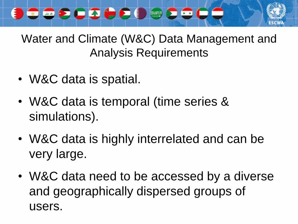
Time representation in Arc hydro

9
TSDateTime
FeatureID
TSType
TSValue
Time representation in Arc hydro
10
Time series for a spatial feature
(e.g. a given station)
TSDateTime
FeatureID
TSType
101

11
Time series of a given data type
(e.g. evaporation)
TSDateTime
FeatureID
TSType
Evaporation

12
Time series of a given data type for a single feature
(e.g. evaporation at a given location)
TSDateTime
FeatureID
TSType
Evaporation
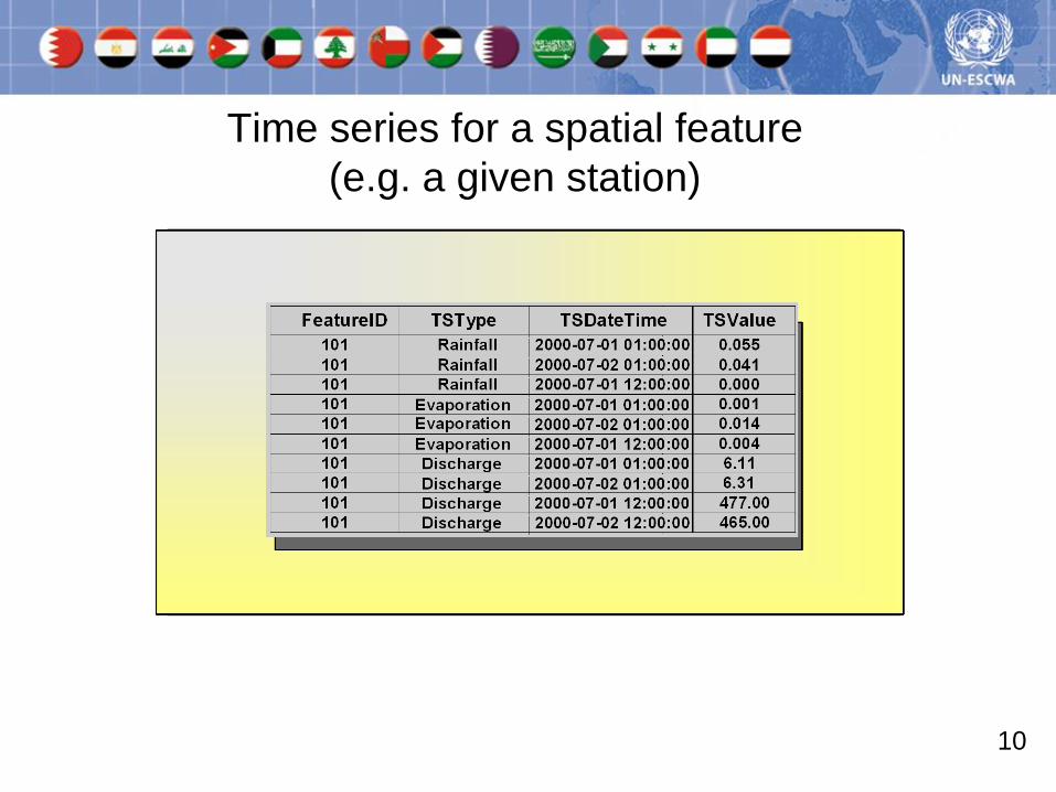
Example: representation of point time series
Well HydroID = 2791
Source: (Jones et al. 2010) “Arc Hydro Groundwater”.

Example: representation of variable raster data.
January 1991
January 1992
January 1993
Source: (Jones et al. 2010) “Arc Hydro Groundwater”.

Example: managing and animating downscaled
GCM output for Lebanon

Example: managing and animating downscaled
GCM output for Lebanon
ScenariosTimeLocation

Monthly temperatures (oC) from a
downscaled GCM output

Monthly precipitations (mm) from a
downscaled GCM output

Examples of hydrological analysis in Arc Hydro
Watershed delineation Flowpath

Online access & sharing of data
• GIS portals offer visual and intuitive interfaces to
access GIS data.
• Geoportal Server technology by ESRI (Environmental
Systems Research Institute).
• Examples of ESRI Geoportal sites:
– NOAA’s North American Drought Monitor
– CUAHSI (Consortium of Universities for the
Advancement of Hydrologic Science) Hydrologic Data
Access System

NOAA’s North American Drought Monitor

CUAHSI (Consortium of Universities for the Advancement of
Hydrologic Science) Hydrologic Data Access System