Hydraflow Table of Contents Lyons Table of Contents Lyons.gpw Hydraflow Hydrographs Extension for...
101
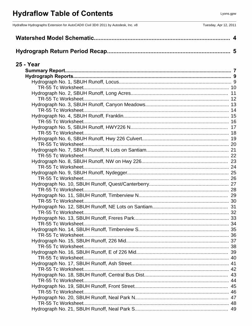
Hydraflow Table of Contents Lyons.gpw Hydraflow Hydrographs Extension for AutoCAD® Civil 3D® 2011 by Autodesk, Inc. v8 Tuesday, Apr 12, 2011 Watershed Model Schematic..................................................................................... 4 Hydrograph Return Period Recap............................................................................. 5 25 - Year Summary Report......................................................................................................................... 7 Hydrograph Reports................................................................................................................... 9 Hydrograph No. 1, SBUH Runoff, Locus.................................................................................. 9 TR-55 Tc Worksheet.......................................................................................................... 10 Hydrograph No. 2, SBUH Runoff, Long Acres....................................................................... 11 TR-55 Tc Worksheet.......................................................................................................... 12 Hydrograph No. 3, SBUH Runoff, Canyon Meadows............................................................. 13 TR-55 Tc Worksheet.......................................................................................................... 14 Hydrograph No. 4, SBUH Runoff, Franklin............................................................................. 15 TR-55 Tc Worksheet.......................................................................................................... 16 Hydrograph No. 5, SBUH Runoff, HWY226 N....................................................................... 17 TR-55 Tc Worksheet.......................................................................................................... 18 Hydrograph No. 6, SBUH Runoff, Hwy 226 Culvert............................................................... 19 TR-55 Tc Worksheet.......................................................................................................... 20 Hydrograph No. 7, SBUH Runoff, N Lots on Santiam............................................................ 21 TR-55 Tc Worksheet.......................................................................................................... 22 Hydrograph No. 8, SBUH Runoff, NW on Hwy 226............................................................... 23 TR-55 Tc Worksheet.......................................................................................................... 24 Hydrograph No. 9, SBUH Runoff, Nydegger.......................................................................... 25 TR-55 Tc Worksheet.......................................................................................................... 26 Hydrograph No. 10, SBUH Runoff, Quest/Canterberry.......................................................... 27 TR-55 Tc Worksheet.......................................................................................................... 28 Hydrograph No. 11, SBUH Runoff, Timberview N................................................................. 29 TR-55 Tc Worksheet.......................................................................................................... 30 Hydrograph No. 12, SBUH Runoff, NE Lots on Santiam....................................................... 31 TR-55 Tc Worksheet.......................................................................................................... 32 Hydrograph No. 13, SBUH Runoff, Freres Park..................................................................... 33 TR-55 Tc Worksheet.......................................................................................................... 34 Hydrograph No. 14, SBUH Runoff, Timberview S.................................................................. 35 TR-55 Tc Worksheet.......................................................................................................... 36 Hydrograph No. 15, SBUH Runoff, 226 Mid........................................................................... 37 TR-55 Tc Worksheet.......................................................................................................... 38 Hydrograph No. 16, SBUH Runoff, E of 226 Mid................................................................... 39 TR-55 Tc Worksheet.......................................................................................................... 40 Hydrograph No. 17, SBUH Runoff, Ash Street....................................................................... 41 TR-55 Tc Worksheet.......................................................................................................... 42 Hydrograph No. 18, SBUH Runoff, Central Bus Dist............................................................. 43 TR-55 Tc Worksheet.......................................................................................................... 44 Hydrograph No. 19, SBUH Runoff, Front Street.................................................................... 45 TR-55 Tc Worksheet.......................................................................................................... 46 Hydrograph No. 20, SBUH Runoff, Neal Park N.................................................................... 47 TR-55 Tc Worksheet.......................................................................................................... 48 Hydrograph No. 21, SBUH Runoff, Neal Park S.................................................................... 49
Transcript of Hydraflow Table of Contents Lyons Table of Contents Lyons.gpw Hydraflow Hydrographs Extension for...
Hydraflow Table of Contents Lyons.gpw
Hydraflow Hydrographs Extension for AutoCAD® Civil 3D® 2011 by Autodesk, Inc. v8 Tuesday, Apr 12, 2011
Watershed Model Schematic..................................................................................... 4
Hydrograph Return Period Recap............................................................................. 5
25 - YearSummary Report......................................................................................................................... 7Hydrograph Reports................................................................................................................... 9
Hydrograph No. 1, SBUH Runoff, Locus.................................................................................. 9TR-55 Tc Worksheet.......................................................................................................... 10
Hydrograph No. 2, SBUH Runoff, Long Acres....................................................................... 11TR-55 Tc Worksheet.......................................................................................................... 12
Hydrograph No. 3, SBUH Runoff, Canyon Meadows............................................................. 13TR-55 Tc Worksheet.......................................................................................................... 14
Hydrograph No. 4, SBUH Runoff, Franklin............................................................................. 15TR-55 Tc Worksheet.......................................................................................................... 16
Hydrograph No. 5, SBUH Runoff, HWY226 N....................................................................... 17TR-55 Tc Worksheet.......................................................................................................... 18
Hydrograph No. 6, SBUH Runoff, Hwy 226 Culvert............................................................... 19TR-55 Tc Worksheet.......................................................................................................... 20
Hydrograph No. 7, SBUH Runoff, N Lots on Santiam............................................................ 21TR-55 Tc Worksheet.......................................................................................................... 22
Hydrograph No. 8, SBUH Runoff, NW on Hwy 226............................................................... 23TR-55 Tc Worksheet.......................................................................................................... 24
Hydrograph No. 9, SBUH Runoff, Nydegger.......................................................................... 25TR-55 Tc Worksheet.......................................................................................................... 26
Hydrograph No. 10, SBUH Runoff, Quest/Canterberry.......................................................... 27TR-55 Tc Worksheet.......................................................................................................... 28
Hydrograph No. 11, SBUH Runoff, Timberview N................................................................. 29TR-55 Tc Worksheet.......................................................................................................... 30
Hydrograph No. 12, SBUH Runoff, NE Lots on Santiam....................................................... 31TR-55 Tc Worksheet.......................................................................................................... 32
Hydrograph No. 13, SBUH Runoff, Freres Park..................................................................... 33TR-55 Tc Worksheet.......................................................................................................... 34
Hydrograph No. 14, SBUH Runoff, Timberview S.................................................................. 35TR-55 Tc Worksheet.......................................................................................................... 36
Hydrograph No. 15, SBUH Runoff, 226 Mid........................................................................... 37TR-55 Tc Worksheet.......................................................................................................... 38
Hydrograph No. 16, SBUH Runoff, E of 226 Mid................................................................... 39TR-55 Tc Worksheet.......................................................................................................... 40
Hydrograph No. 17, SBUH Runoff, Ash Street....................................................................... 41TR-55 Tc Worksheet.......................................................................................................... 42
Hydrograph No. 18, SBUH Runoff, Central Bus Dist............................................................. 43TR-55 Tc Worksheet.......................................................................................................... 44
Hydrograph No. 19, SBUH Runoff, Front Street.................................................................... 45TR-55 Tc Worksheet.......................................................................................................... 46
Hydrograph No. 20, SBUH Runoff, Neal Park N.................................................................... 47TR-55 Tc Worksheet.......................................................................................................... 48
Hydrograph No. 21, SBUH Runoff, Neal Park S.................................................................... 49
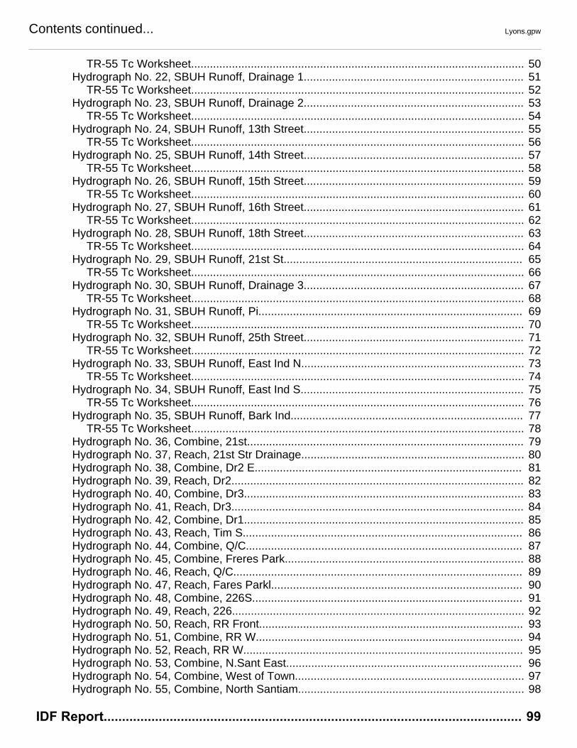
Contents continued... Lyons.gpw
TR-55 Tc Worksheet.......................................................................................................... 50Hydrograph No. 22, SBUH Runoff, Drainage 1...................................................................... 51
TR-55 Tc Worksheet.......................................................................................................... 52Hydrograph No. 23, SBUH Runoff, Drainage 2...................................................................... 53
TR-55 Tc Worksheet.......................................................................................................... 54Hydrograph No. 24, SBUH Runoff, 13th Street...................................................................... 55
TR-55 Tc Worksheet.......................................................................................................... 56Hydrograph No. 25, SBUH Runoff, 14th Street...................................................................... 57
TR-55 Tc Worksheet.......................................................................................................... 58Hydrograph No. 26, SBUH Runoff, 15th Street...................................................................... 59
TR-55 Tc Worksheet.......................................................................................................... 60Hydrograph No. 27, SBUH Runoff, 16th Street...................................................................... 61
TR-55 Tc Worksheet.......................................................................................................... 62Hydrograph No. 28, SBUH Runoff, 18th Street...................................................................... 63
TR-55 Tc Worksheet.......................................................................................................... 64Hydrograph No. 29, SBUH Runoff, 21st St............................................................................ 65
TR-55 Tc Worksheet.......................................................................................................... 66Hydrograph No. 30, SBUH Runoff, Drainage 3...................................................................... 67
TR-55 Tc Worksheet.......................................................................................................... 68Hydrograph No. 31, SBUH Runoff, Pi.................................................................................... 69
TR-55 Tc Worksheet.......................................................................................................... 70Hydrograph No. 32, SBUH Runoff, 25th Street...................................................................... 71
TR-55 Tc Worksheet.......................................................................................................... 72Hydrograph No. 33, SBUH Runoff, East Ind N....................................................................... 73
TR-55 Tc Worksheet.......................................................................................................... 74Hydrograph No. 34, SBUH Runoff, East Ind S....................................................................... 75
TR-55 Tc Worksheet.......................................................................................................... 76Hydrograph No. 35, SBUH Runoff, Bark Ind.......................................................................... 77
TR-55 Tc Worksheet.......................................................................................................... 78Hydrograph No. 36, Combine, 21st........................................................................................ 79Hydrograph No. 37, Reach, 21st Str Drainage....................................................................... 80Hydrograph No. 38, Combine, Dr2 E..................................................................................... 81Hydrograph No. 39, Reach, Dr2............................................................................................. 82Hydrograph No. 40, Combine, Dr3......................................................................................... 83Hydrograph No. 41, Reach, Dr3............................................................................................. 84Hydrograph No. 42, Combine, Dr1......................................................................................... 85Hydrograph No. 43, Reach, Tim S......................................................................................... 86Hydrograph No. 44, Combine, Q/C........................................................................................ 87Hydrograph No. 45, Combine, Freres Park............................................................................ 88Hydrograph No. 46, Reach, Q/C............................................................................................ 89Hydrograph No. 47, Reach, Fares Parkl................................................................................ 90Hydrograph No. 48, Combine, 226S...................................................................................... 91Hydrograph No. 49, Reach, 226............................................................................................. 92Hydrograph No. 50, Reach, RR Front.................................................................................... 93Hydrograph No. 51, Combine, RR W..................................................................................... 94Hydrograph No. 52, Reach, RR W......................................................................................... 95Hydrograph No. 53, Combine, N.Sant East........................................................................... 96Hydrograph No. 54, Combine, West of Town......................................................................... 97Hydrograph No. 55, Combine, North Santiam........................................................................ 98
IDF Report.................................................................................................................. 99

Michael
Text Box
4 Watershed Model Schematic Hydraflow Hydrographs Extension for AutoCAD® Civil 3D® 2011 by Autodesk, Inc. v8

Hydrograph Return Period Recap5
Hyd. Hydrograph Inflow Peak Outflow (cfs) HydrographNo. type hyd(s) Description
(origin) 1-yr 2-yr 3-yr 5-yr 10-yr 25-yr 50-yr 100-yr
1 SBUH Runoff ------ ------- 0.072 ------- 0.105 0.141 0.338 0.569 0.740 Locus
2 SBUH Runoff ------ ------- 0.133 ------- 0.193 0.260 0.427 0.639 0.800 Long Acres
3 SBUH Runoff ------ ------- 1.791 ------- 2.573 3.954 7.055 9.530 11.38 Canyon Meadows
4 SBUH Runoff ------ ------- 1.657 ------- 2.408 3.251 5.123 7.447 9.316 Franklin
5 SBUH Runoff ------ ------- 1.550 ------- 2.118 2.721 3.874 4.677 5.224 HWY226 N
6 SBUH Runoff ------ ------- 0.133 ------- 0.193 0.261 0.484 0.797 1.044 Hwy 226 Culvert
7 SBUH Runoff ------ ------- 0.662 ------- 1.011 1.394 2.147 2.686 3.058 N Lots on Santiam
8 SBUH Runoff ------ ------- 1.196 ------- 1.867 2.621 4.116 5.191 5.935 NW on Hwy 226
9 SBUH Runoff ------ ------- 0.542 ------- 0.847 1.187 1.860 2.343 2.678 Nydegger
10 SBUH Runoff ------ ------- 1.882 ------- 2.922 4.062 6.317 7.939 9.068 Quest/Canterberry
11 SBUH Runoff ------ ------- 1.230 ------- 1.905 2.664 4.193 5.301 6.072 Timberview N.
12 SBUH Runoff ------ ------- 0.662 ------- 1.011 1.394 2.147 2.686 3.058 NE Lots on Santiam
13 SBUH Runoff ------ ------- 2.176 ------- 3.162 4.268 6.727 9.778 12.23 Freres Park
14 SBUH Runoff ------ ------- 0.877 ------- 1.302 2.199 4.667 6.662 8.095 Timberview S
15 SBUH Runoff ------ ------- 0.654 ------- 0.912 1.191 1.728 2.105 2.362 226 Mid
16 SBUH Runoff ------ ------- 0.842 ------- 1.226 1.646 2.474 3.064 3.471 E of 226 Mid
17 SBUH Runoff ------ ------- 0.606 ------- 0.835 1.079 1.545 1.871 2.093 Ash Street
18 SBUH Runoff ------ ------- 20.01 ------- 23.90 27.79 34.78 39.41 42.49 Central Bus Dist
19 SBUH Runoff ------ ------- 5.526 ------- 6.587 7.646 9.547 10.81 11.65 Front Street
20 SBUH Runoff ------ ------- 0.178 ------- 0.258 0.348 0.563 0.839 1.050 Neal Park N
21 SBUH Runoff ------ ------- 0.444 ------- 0.644 0.870 1.510 2.255 2.877 Neal Park S.
22 SBUH Runoff ------ ------- 3.322 ------- 5.231 8.106 15.32 21.02 25.09 Drainage 1
23 SBUH Runoff ------ ------- 0.864 ------- 1.255 1.693 4.012 6.781 8.814 Drainage 2
24 SBUH Runoff ------ ------- 5.156 ------- 6.155 7.153 8.945 10.13 10.93 13th Street
25 SBUH Runoff ------ ------- 2.507 ------- 3.144 3.794 4.988 5.792 6.330 14th Street
26 SBUH Runoff ------ ------- 0.570 ------- 0.776 0.996 1.414 1.705 1.903 15th Street
27 SBUH Runoff ------ ------- 2.736 ------- 3.721 4.765 6.756 8.141 9.082 16th Street
28 SBUH Runoff ------ ------- 2.146 ------- 2.940 3.790 5.417 6.553 7.327 18th Street
29 SBUH Runoff ------ ------- 0.527 ------- 0.766 1.033 1.789 2.671 3.400 21st St
30 SBUH Runoff ------ ------- 1.260 ------- 1.851 2.923 5.594 7.786 9.367 Drainage 3
31 SBUH Runoff ------ ------- 9.832 ------- 11.72 13.61 17.01 19.26 20.75 Pi
32 SBUH Runoff ------ ------- 2.584 ------- 3.418 4.298 5.958 7.107 7.886 25th Street
33 SBUH Runoff ------ ------- 12.38 ------- 14.80 17.21 21.54 24.41 26.33 East Ind N.
34 SBUH Runoff ------ ------- 9.816 ------- 11.73 13.64 17.08 19.36 20.88 East Ind S.
Proj. file: Lyons.gpw Tuesday, Apr 12, 2011
Hydraflow Hydrographs Extension for AutoCAD® Civil 3D® 2011 by Autodesk, Inc. v8
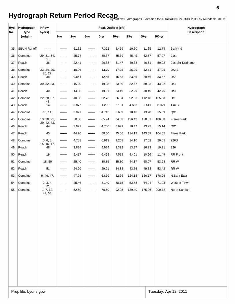
Hydrograph Return Period Recap6
Hyd. Hydrograph Inflow Peak Outflow (cfs) HydrographNo. type hyd(s) Description
(origin) 1-yr 2-yr 3-yr 5-yr 10-yr 25-yr 50-yr 100-yr
35 SBUH Runoff ------ ------- 6.182 ------- 7.322 8.459 10.50 11.85 12.74 Bark Ind
36 Combine 29, 31, 34,35
------- 25.74 ------- 30.67 35.69 45.49 52.37 57.07 21st
37 Reach 36 ------- 22.41 ------- 26.88 31.47 40.33 46.61 50.92 21st Str Drainage
38 Combine 23, 24, 25,26, 27,
------- 10.96 ------- 13.79 17.25 25.99 32.51 37.05 Dr2 E
39 Reach 38 ------- 9.844 ------- 12.45 15.68 23.46 29.46 33.67 Dr2
40 Combine 30, 32, 33, ------- 15.20 ------- 19.28 23.80 32.67 38.93 43.22 Dr3
41 Reach 40 ------- 14.98 ------- 19.01 23.49 32.29 38.49 42.75 Dr3
42 Combine 22, 28, 37,41
------- 40.86 ------- 52.73 66.04 92.83 112.18 125.58 Dr1
43 Reach 14 ------- 0.877 ------- 1.295 2.181 4.653 6.641 8.079 Tim S
44 Combine 10, 11, ------- 3.021 ------- 4.743 6.659 10.46 13.20 15.09 Q/C
45 Combine 13, 20, 21,39, 42, 43,
------- 50.80 ------- 65.94 84.63 126.42 158.31 180.88 Freres Park
46 Reach 44 ------- 3.021 ------- 4.756 6.671 10.47 13.23 15.14 Q/C
47 Reach 45 ------- 44.76 ------- 58.60 75.86 114.19 143.59 164.55 Fares Parkl
48 Combine 5, 6, 8,15, 16, 17,
------- 4.788 ------- 6.913 9.268 14.10 17.62 20.05 226S
49 Reach 48 ------- 3.899 ------- 5.999 8.382 13.27 16.83 19.31 226
50 Reach 19 ------- 5.417 ------- 6.468 7.519 9.401 10.66 11.49 RR Front
51 Combine 18, 50 ------- 25.40 ------- 30.35 35.30 44.17 50.07 53.98 RR W
52 Reach 51 ------- 24.99 ------- 29.91 34.83 43.66 49.53 53.42 RR W
53 Combine 9, 46, 47, ------- 47.98 ------- 63.39 82.36 124.18 156.17 178.96 N.Sant East
54 Combine 2, 3, 4,52,
------- 25.46 ------- 31.40 38.15 52.88 64.04 71.93 West of Town
55 Combine 1, 7, 12,49, 53,
------- 52.69 ------- 70.59 92.25 139.40 175.26 200.72 North Santiam
Proj. file: Lyons.gpw Tuesday, Apr 12, 2011
Hydraflow Hydrographs Extension for AutoCAD® Civil 3D® 2011 by Autodesk, Inc. v8
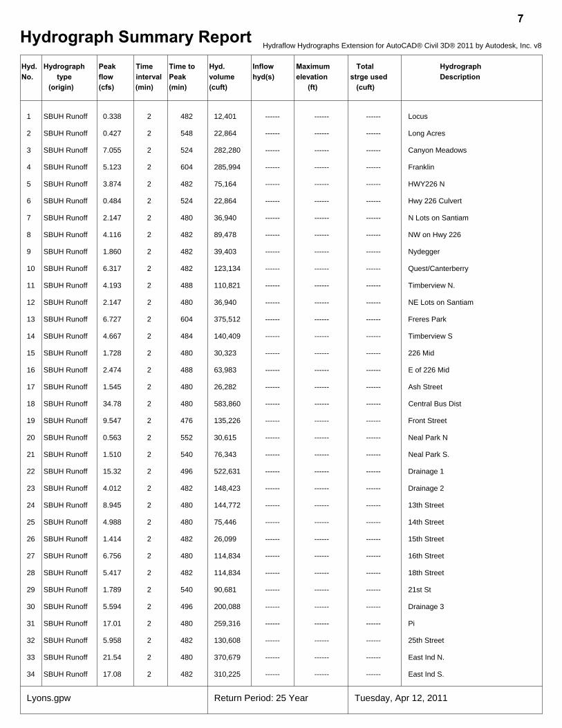
Hydrograph Summary Report7
Hyd. Hydrograph Peak Time Time to Hyd. Inflow Maximum Total HydrographNo. type flow interval Peak volume hyd(s) elevation strge used Description
(origin) (cfs) (min) (min) (cuft) (ft) (cuft)
1 SBUH Runoff 0.338 2 482 12,401 ------ ------ ------ Locus
2 SBUH Runoff 0.427 2 548 22,864 ------ ------ ------ Long Acres
3 SBUH Runoff 7.055 2 524 282,280 ------ ------ ------ Canyon Meadows
4 SBUH Runoff 5.123 2 604 285,994 ------ ------ ------ Franklin
5 SBUH Runoff 3.874 2 482 75,164 ------ ------ ------ HWY226 N
6 SBUH Runoff 0.484 2 524 22,864 ------ ------ ------ Hwy 226 Culvert
7 SBUH Runoff 2.147 2 480 36,940 ------ ------ ------ N Lots on Santiam
8 SBUH Runoff 4.116 2 482 89,478 ------ ------ ------ NW on Hwy 226
9 SBUH Runoff 1.860 2 482 39,403 ------ ------ ------ Nydegger
10 SBUH Runoff 6.317 2 482 123,134 ------ ------ ------ Quest/Canterberry
11 SBUH Runoff 4.193 2 488 110,821 ------ ------ ------ Timberview N.
12 SBUH Runoff 2.147 2 480 36,940 ------ ------ ------ NE Lots on Santiam
13 SBUH Runoff 6.727 2 604 375,512 ------ ------ ------ Freres Park
14 SBUH Runoff 4.667 2 484 140,409 ------ ------ ------ Timberview S
15 SBUH Runoff 1.728 2 480 30,323 ------ ------ ------ 226 Mid
16 SBUH Runoff 2.474 2 488 63,983 ------ ------ ------ E of 226 Mid
17 SBUH Runoff 1.545 2 480 26,282 ------ ------ ------ Ash Street
18 SBUH Runoff 34.78 2 480 583,860 ------ ------ ------ Central Bus Dist
19 SBUH Runoff 9.547 2 476 135,226 ------ ------ ------ Front Street
20 SBUH Runoff 0.563 2 552 30,615 ------ ------ ------ Neal Park N
21 SBUH Runoff 1.510 2 540 76,343 ------ ------ ------ Neal Park S.
22 SBUH Runoff 15.32 2 496 522,631 ------ ------ ------ Drainage 1
23 SBUH Runoff 4.012 2 482 148,423 ------ ------ ------ Drainage 2
24 SBUH Runoff 8.945 2 480 144,772 ------ ------ ------ 13th Street
25 SBUH Runoff 4.988 2 480 75,446 ------ ------ ------ 14th Street
26 SBUH Runoff 1.414 2 482 26,099 ------ ------ ------ 15th Street
27 SBUH Runoff 6.756 2 480 114,834 ------ ------ ------ 16th Street
28 SBUH Runoff 5.417 2 482 114,834 ------ ------ ------ 18th Street
29 SBUH Runoff 1.789 2 540 90,681 ------ ------ ------ 21st St
30 SBUH Runoff 5.594 2 496 200,088 ------ ------ ------ Drainage 3
31 SBUH Runoff 17.01 2 480 259,316 ------ ------ ------ Pi
32 SBUH Runoff 5.958 2 482 130,608 ------ ------ ------ 25th Street
33 SBUH Runoff 21.54 2 480 370,679 ------ ------ ------ East Ind N.
34 SBUH Runoff 17.08 2 482 310,225 ------ ------ ------ East Ind S.
Lyons.gpw Return Period: 25 Year Tuesday, Apr 12, 2011
Hydraflow Hydrographs Extension for AutoCAD® Civil 3D® 2011 by Autodesk, Inc. v8
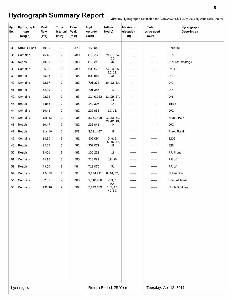
Hydrograph Summary Report8
Hyd. Hydrograph Peak Time Time to Hyd. Inflow Maximum Total HydrographNo. type flow interval Peak volume hyd(s) elevation strge used Description
(origin) (cfs) (min) (min) (cuft) (ft) (cuft)
35 SBUH Runoff 10.50 2 476 150,040 ------ ------ ------ Bark Ind
36 Combine 45.49 2 480 810,262 29, 31, 34,35
------ ------ 21st
37 Reach 40.33 2 488 810,245 36 ------ ------ 21st Str Drainage
38 Combine 25.99 2 480 509,573 23, 24, 25,26, 27,
------ ------ Dr2 E
39 Reach 23.46 2 488 509,564 38 ------ ------ Dr2
40 Combine 32.67 2 482 701,376 30, 32, 33, ------ ------ Dr3
41 Reach 32.29 2 486 701,355 40 ------ ------ Dr3
42 Combine 92.83 2 488 2,149,063 22, 28, 37,41
------ ------ Dr1
43 Reach 4.653 2 488 140,397 14 ------ ------ Tim S
44 Combine 10.46 2 482 233,955 10, 11, ------ ------ Q/C
45 Combine 126.42 2 488 3,281,496 13, 20, 21,39, 42, 43,
------ ------ Freres Park
46 Reach 10.47 2 482 233,941 44 ------ ------ Q/C
47 Reach 114.19 2 506 3,281,467 45 ------ ------ Fares Parkl
48 Combine 14.10 2 482 308,094 5, 6, 8,15, 16, 17,
------ ------ 226S
49 Reach 13.27 2 492 308,073 48 ------ ------ 226
50 Reach 9.401 2 482 135,222 19 ------ ------ RR Front
51 Combine 44.17 2 480 719,081 18, 50 ------ ------ RR W
52 Reach 43.66 2 484 719,070 51 ------ ------ RR W
53 Combine 124.18 2 504 3,554,811 9, 46, 47, ------ ------ N.Sant East
54 Combine 52.88 2 486 1,310,208 2, 3, 4,52,
------ ------ West of Town
55 Combine 139.40 2 502 3,949,163 1, 7, 12,49, 53,
------ ------ North Santiam
Lyons.gpw Return Period: 25 Year Tuesday, Apr 12, 2011
Hydraflow Hydrographs Extension for AutoCAD® Civil 3D® 2011 by Autodesk, Inc. v8
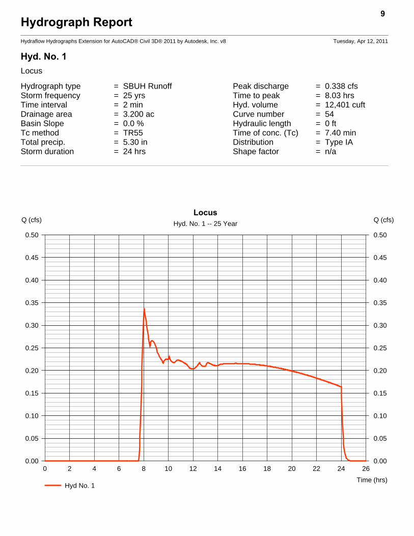
Hydrograph ReportHydraflow Hydrographs Extension for AutoCAD® Civil 3D® 2011 by Autodesk, Inc. v8 Tuesday, Apr 12, 2011
Hyd. No. 1Locus
Hydrograph type = SBUH Runoff Peak discharge = 0.338 cfsStorm frequency = 25 yrs Time to peak = 8.03 hrsTime interval = 2 min Hyd. volume = 12,401 cuftDrainage area = 3.200 ac Curve number = 54Basin Slope = 0.0 % Hydraulic length = 0 ftTc method = TR55 Time of conc. (Tc) = 7.40 minTotal precip. = 5.30 in Distribution = Type IAStorm duration = 24 hrs Shape factor = n/a
9
0 2 4 6 8 10 12 14 16 18 20 22 24 26
Q (cfs)
0.00 0.00
0.05 0.05
0.10 0.10
0.15 0.15
0.20 0.20
0.25 0.25
0.30 0.30
0.35 0.35
0.40 0.40
0.45 0.45
0.50 0.50
Q (cfs)
Time (hrs)
LocusHyd. No. 1 -- 25 Year
Hyd No. 1

TR55 Tc Worksheet10
Hydraflow Hydrographs Extension for AutoCAD® Civil 3D® 2011 by Autodesk, Inc. v8
Hyd. No. 1Locus
Description A B C Totals
Sheet FlowManning's n-value = 0.150 0.011 0.011Flow length (ft) = 134.0 0.0 0.0Two-year 24-hr precip. (in) = 3.40 0.00 0.00Land slope (%) = 6.70 0.00 0.00
Travel Time (min) = 7.41 + 0.00 + 0.00 = 7.41
Shallow Concentrated FlowFlow length (ft) = 0.00 0.00 0.00Watercourse slope (%) = 0.00 0.00 0.00Surface description = Paved Paved PavedAverage velocity (ft/s) =0.00 0.00 0.00
Travel Time (min) = 0.00 + 0.00 + 0.00 = 0.00
Channel FlowX sectional flow area (sqft) = 0.00 0.00 0.00Wetted perimeter (ft) = 0.00 0.00 0.00Channel slope (%) = 0.00 0.00 0.00Manning's n-value = 0.015 0.015 0.015Velocity (ft/s) =0.00
0.000.00
Flow length (ft) ({0})0.0 0.0 0.0
Travel Time (min) = 0.00 + 0.00 + 0.00 = 0.00
Total Travel Time, Tc .............................................................................. 7.40 min

Hydrograph ReportHydraflow Hydrographs Extension for AutoCAD® Civil 3D® 2011 by Autodesk, Inc. v8 Tuesday, Apr 12, 2011
Hyd. No. 2Long Acres
Hydrograph type = SBUH Runoff Peak discharge = 0.427 cfsStorm frequency = 25 yrs Time to peak = 9.13 hrsTime interval = 2 min Hyd. volume = 22,864 cuftDrainage area = 5.900 ac Curve number = 54Basin Slope = 0.0 % Hydraulic length = 0 ftTc method = TR55 Time of conc. (Tc) = 40.00 minTotal precip. = 5.30 in Distribution = Type IAStorm duration = 24 hrs Shape factor = n/a
11
0 2 4 6 8 10 12 14 16 18 20 22 24 26 28
Q (cfs)
0.00 0.00
0.05 0.05
0.10 0.10
0.15 0.15
0.20 0.20
0.25 0.25
0.30 0.30
0.35 0.35
0.40 0.40
0.45 0.45
0.50 0.50
Q (cfs)
Time (hrs)
Long AcresHyd. No. 2 -- 25 Year
Hyd No. 2

TR55 Tc Worksheet12
Hydraflow Hydrographs Extension for AutoCAD® Civil 3D® 2011 by Autodesk, Inc. v8
Hyd. No. 2Long Acres
Description A B C Totals
Sheet FlowManning's n-value = 0.150 0.011 0.011Flow length (ft) = 238.0 0.0 0.0Two-year 24-hr precip. (in) = 3.40 0.00 0.00Land slope (%) = 0.40 0.00 0.00
Travel Time (min) = 36.21 + 0.00 + 0.00 = 36.21
Shallow Concentrated FlowFlow length (ft) = 433.00 0.00 0.00Watercourse slope (%) = 0.90 0.00 0.00Surface description = Paved Paved PavedAverage velocity (ft/s) =1.93 0.00 0.00
Travel Time (min) = 3.74 + 0.00 + 0.00 = 3.74
Channel FlowX sectional flow area (sqft) = 0.00 0.00 0.00Wetted perimeter (ft) = 0.00 0.00 0.00Channel slope (%) = 0.00 0.00 0.00Manning's n-value = 0.015 0.015 0.015Velocity (ft/s) =0.00
0.000.00
Flow length (ft) ({0})0.0 0.0 0.0
Travel Time (min) = 0.00 + 0.00 + 0.00 = 0.00
Total Travel Time, Tc .............................................................................. 40.00 min
Hydrograph ReportHydraflow Hydrographs Extension for AutoCAD® Civil 3D® 2011 by Autodesk, Inc. v8 Tuesday, Apr 12, 2011
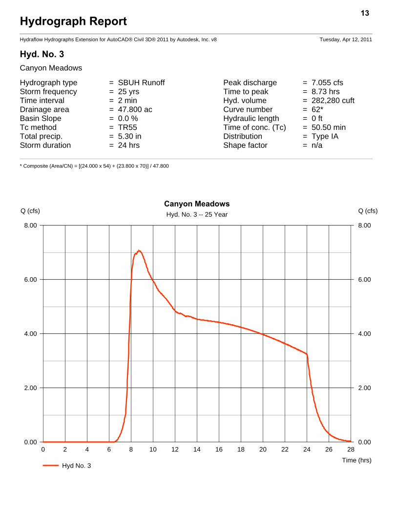
Hyd. No. 3Canyon Meadows
Hydrograph type = SBUH Runoff Peak discharge = 7.055 cfsStorm frequency = 25 yrs Time to peak = 8.73 hrsTime interval = 2 min Hyd. volume = 282,280 cuftDrainage area = 47.800 ac Curve number = 62*Basin Slope = 0.0 % Hydraulic length = 0 ftTc method = TR55 Time of conc. (Tc) = 50.50 minTotal precip. = 5.30 in Distribution = Type IAStorm duration = 24 hrs Shape factor = n/a
* Composite (Area/CN) = [(24.000 x 54) + (23.800 x 70)] / 47.800
13
0 2 4 6 8 10 12 14 16 18 20 22 24 26 28
Q (cfs)
0.00 0.00
2.00 2.00
4.00 4.00
6.00 6.00
8.00 8.00
Q (cfs)
Time (hrs)
Canyon MeadowsHyd. No. 3 -- 25 Year
Hyd No. 3

TR55 Tc Worksheet14
Hydraflow Hydrographs Extension for AutoCAD® Civil 3D® 2011 by Autodesk, Inc. v8
Hyd. No. 3Canyon Meadows
Description A B C Totals
Sheet FlowManning's n-value = 0.150 0.011 0.011Flow length (ft) = 275.0 0.0 0.0Two-year 24-hr precip. (in) = 3.40 0.00 0.00Land slope (%) = 0.40 0.00 0.00
Travel Time (min) = 40.65 + 0.00 + 0.00 = 40.65
Shallow Concentrated FlowFlow length (ft) = 801.00 0.00 0.00Watercourse slope (%) = 0.70 0.00 0.00Surface description = Unpaved Paved PavedAverage velocity (ft/s) =1.35 0.00 0.00
Travel Time (min) = 9.89 + 0.00 + 0.00 = 9.89
Channel FlowX sectional flow area (sqft) = 0.00 0.00 0.00Wetted perimeter (ft) = 0.00 0.00 0.00Channel slope (%) = 0.00 0.00 0.00Manning's n-value = 0.015 0.015 0.015Velocity (ft/s) =0.00
0.000.00
Flow length (ft) ({0})0.0 0.0 0.0
Travel Time (min) = 0.00 + 0.00 + 0.00 = 0.00
Total Travel Time, Tc .............................................................................. 50.50 min

Hydrograph ReportHydraflow Hydrographs Extension for AutoCAD® Civil 3D® 2011 by Autodesk, Inc. v8 Tuesday, Apr 12, 2011
Hyd. No. 4Franklin
Hydrograph type = SBUH Runoff Peak discharge = 5.123 cfsStorm frequency = 25 yrs Time to peak = 10.07 hrsTime interval = 2 min Hyd. volume = 285,994 cuftDrainage area = 73.800 ac Curve number = 54Basin Slope = 0.0 % Hydraulic length = 0 ftTc method = TR55 Time of conc. (Tc) = 51.40 minTotal precip. = 5.30 in Distribution = Type IAStorm duration = 24 hrs Shape factor = n/a
15
0 2 4 6 8 10 12 14 16 18 20 22 24 26 28
Q (cfs)
0.00 0.00
1.00 1.00
2.00 2.00
3.00 3.00
4.00 4.00
5.00 5.00
6.00 6.00
Q (cfs)
Time (hrs)
FranklinHyd. No. 4 -- 25 Year
Hyd No. 4

TR55 Tc Worksheet16
Hydraflow Hydrographs Extension for AutoCAD® Civil 3D® 2011 by Autodesk, Inc. v8
Hyd. No. 4Franklin
Description A B C Totals
Sheet FlowManning's n-value = 0.150 0.011 0.011Flow length (ft) = 245.0 0.0 0.0Two-year 24-hr precip. (in) = 3.40 0.00 0.00Land slope (%) = 0.40 0.00 0.00
Travel Time (min) = 37.06 + 0.00 + 0.00 = 37.06
Shallow Concentrated FlowFlow length (ft) = 1073.00 0.00 0.00Watercourse slope (%) = 0.60 0.00 0.00Surface description = Unpaved Paved PavedAverage velocity (ft/s) =1.25 0.00 0.00
Travel Time (min) = 14.31 + 0.00 + 0.00 = 14.31
Channel FlowX sectional flow area (sqft) = 0.00 0.00 0.00Wetted perimeter (ft) = 0.00 0.00 0.00Channel slope (%) = 0.00 0.00 0.00Manning's n-value = 0.015 0.015 0.015Velocity (ft/s) =0.00
0.000.00
Flow length (ft) ({0})0.0 0.0 0.0
Travel Time (min) = 0.00 + 0.00 + 0.00 = 0.00
Total Travel Time, Tc .............................................................................. 51.40 min
Hydrograph ReportHydraflow Hydrographs Extension for AutoCAD® Civil 3D® 2011 by Autodesk, Inc. v8 Tuesday, Apr 12, 2011
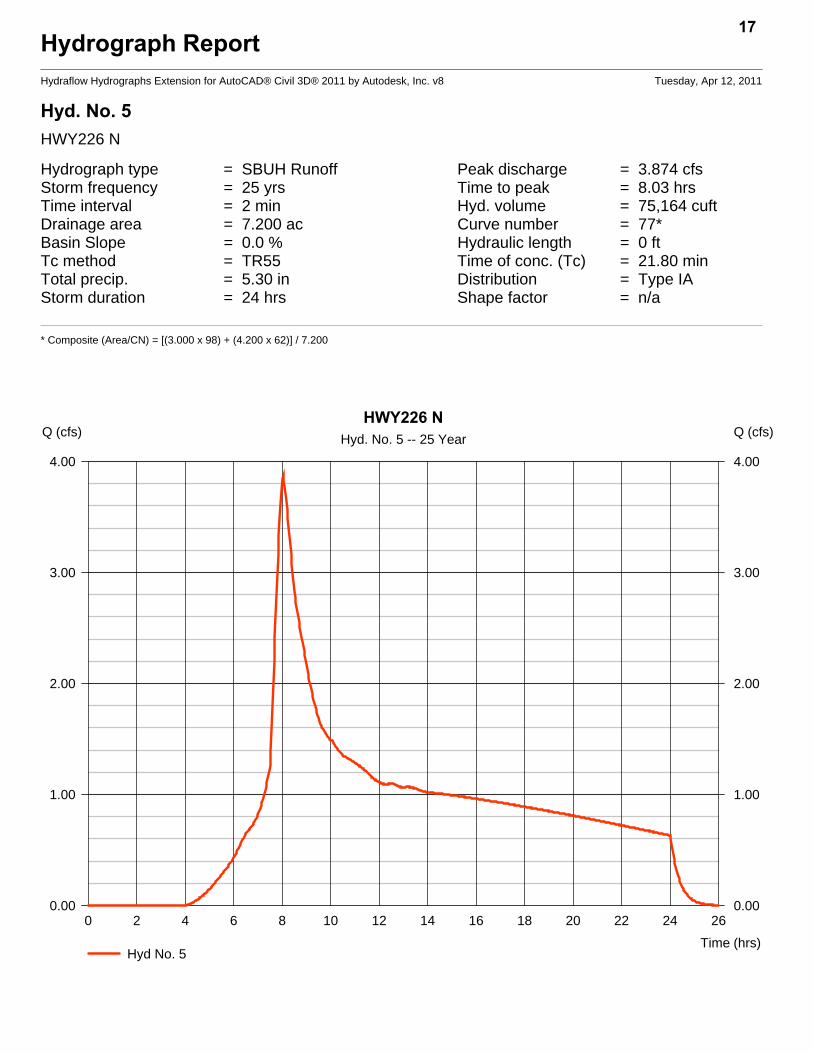
Hyd. No. 5HWY226 N
Hydrograph type = SBUH Runoff Peak discharge = 3.874 cfsStorm frequency = 25 yrs Time to peak = 8.03 hrsTime interval = 2 min Hyd. volume = 75,164 cuftDrainage area = 7.200 ac Curve number = 77*Basin Slope = 0.0 % Hydraulic length = 0 ftTc method = TR55 Time of conc. (Tc) = 21.80 minTotal precip. = 5.30 in Distribution = Type IAStorm duration = 24 hrs Shape factor = n/a
* Composite (Area/CN) = [(3.000 x 98) + (4.200 x 62)] / 7.200
17
0 2 4 6 8 10 12 14 16 18 20 22 24 26
Q (cfs)
0.00 0.00
1.00 1.00
2.00 2.00
3.00 3.00
4.00 4.00
Q (cfs)
Time (hrs)
HWY226 NHyd. No. 5 -- 25 Year
Hyd No. 5

TR55 Tc Worksheet18
Hydraflow Hydrographs Extension for AutoCAD® Civil 3D® 2011 by Autodesk, Inc. v8
Hyd. No. 5HWY226 N
Description A B C Totals
Sheet FlowManning's n-value = 0.150 0.011 0.011Flow length (ft) = 200.0 0.0 0.0Two-year 24-hr precip. (in) = 3.40 0.00 0.00Land slope (%) = 1.00 0.00 0.00
Travel Time (min) = 21.84 + 0.00 + 0.00 = 21.84
Shallow Concentrated FlowFlow length (ft) = 0.00 0.00 0.00Watercourse slope (%) = 0.00 0.00 0.00Surface description = Paved Paved PavedAverage velocity (ft/s) =0.00 0.00 0.00
Travel Time (min) = 0.00 + 0.00 + 0.00 = 0.00
Channel FlowX sectional flow area (sqft) = 0.00 0.00 0.00Wetted perimeter (ft) = 0.00 0.00 0.00Channel slope (%) = 0.00 0.00 0.00Manning's n-value = 0.015 0.015 0.015Velocity (ft/s) =0.00
0.000.00
Flow length (ft) ({0})0.0 0.0 0.0
Travel Time (min) = 0.00 + 0.00 + 0.00 = 0.00
Total Travel Time, Tc .............................................................................. 21.80 min

Hydrograph ReportHydraflow Hydrographs Extension for AutoCAD® Civil 3D® 2011 by Autodesk, Inc. v8 Tuesday, Apr 12, 2011
Hyd. No. 6Hwy 226 Culvert
Hydrograph type = SBUH Runoff Peak discharge = 0.484 cfsStorm frequency = 25 yrs Time to peak = 8.73 hrsTime interval = 2 min Hyd. volume = 22,864 cuftDrainage area = 5.900 ac Curve number = 54Basin Slope = 0.0 % Hydraulic length = 0 ftTc method = TR55 Time of conc. (Tc) = 18.50 minTotal precip. = 5.30 in Distribution = Type IAStorm duration = 24 hrs Shape factor = n/a
19
0 2 4 6 8 10 12 14 16 18 20 22 24 26
Q (cfs)
0.00 0.00
0.05 0.05
0.10 0.10
0.15 0.15
0.20 0.20
0.25 0.25
0.30 0.30
0.35 0.35
0.40 0.40
0.45 0.45
0.50 0.50
Q (cfs)
Time (hrs)
Hwy 226 CulvertHyd. No. 6 -- 25 Year
Hyd No. 6

TR55 Tc Worksheet20
Hydraflow Hydrographs Extension for AutoCAD® Civil 3D® 2011 by Autodesk, Inc. v8
Hyd. No. 6Hwy 226 Culvert
Description A B C Totals
Sheet FlowManning's n-value = 0.150 0.011 0.011Flow length (ft) = 150.0 0.0 0.0Two-year 24-hr precip. (in) = 3.40 0.00 0.00Land slope (%) = 2.00 0.00 0.00
Travel Time (min) = 13.15 + 0.00 + 0.00 = 13.15
Shallow Concentrated FlowFlow length (ft) = 430.00 0.00 0.00Watercourse slope (%) = 0.70 0.00 0.00Surface description = Unpaved Paved PavedAverage velocity (ft/s) =1.35 0.00 0.00
Travel Time (min) = 5.31 + 0.00 + 0.00 = 5.31
Channel FlowX sectional flow area (sqft) = 0.00 0.00 0.00Wetted perimeter (ft) = 0.00 0.00 0.00Channel slope (%) = 0.00 0.00 0.00Manning's n-value = 0.015 0.015 0.015Velocity (ft/s) =0.00
0.000.00
Flow length (ft) ({0})0.0 0.0 0.0
Travel Time (min) = 0.00 + 0.00 + 0.00 = 0.00
Total Travel Time, Tc .............................................................................. 18.50 min
Hydrograph ReportHydraflow Hydrographs Extension for AutoCAD® Civil 3D® 2011 by Autodesk, Inc. v8 Tuesday, Apr 12, 2011
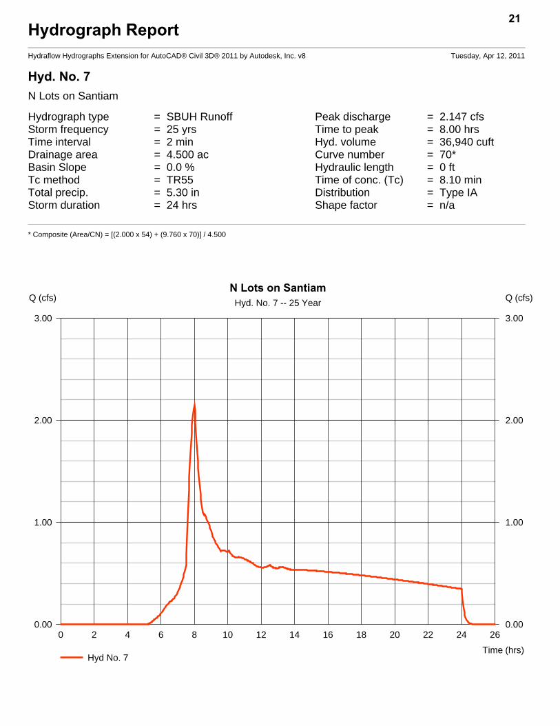
Hyd. No. 7N Lots on Santiam
Hydrograph type = SBUH Runoff Peak discharge = 2.147 cfsStorm frequency = 25 yrs Time to peak = 8.00 hrsTime interval = 2 min Hyd. volume = 36,940 cuftDrainage area = 4.500 ac Curve number = 70*Basin Slope = 0.0 % Hydraulic length = 0 ftTc method = TR55 Time of conc. (Tc) = 8.10 minTotal precip. = 5.30 in Distribution = Type IAStorm duration = 24 hrs Shape factor = n/a
* Composite (Area/CN) = [(2.000 x 54) + (9.760 x 70)] / 4.500
21
0 2 4 6 8 10 12 14 16 18 20 22 24 26
Q (cfs)
0.00 0.00
1.00 1.00
2.00 2.00
3.00 3.00
Q (cfs)
Time (hrs)
N Lots on SantiamHyd. No. 7 -- 25 Year
Hyd No. 7
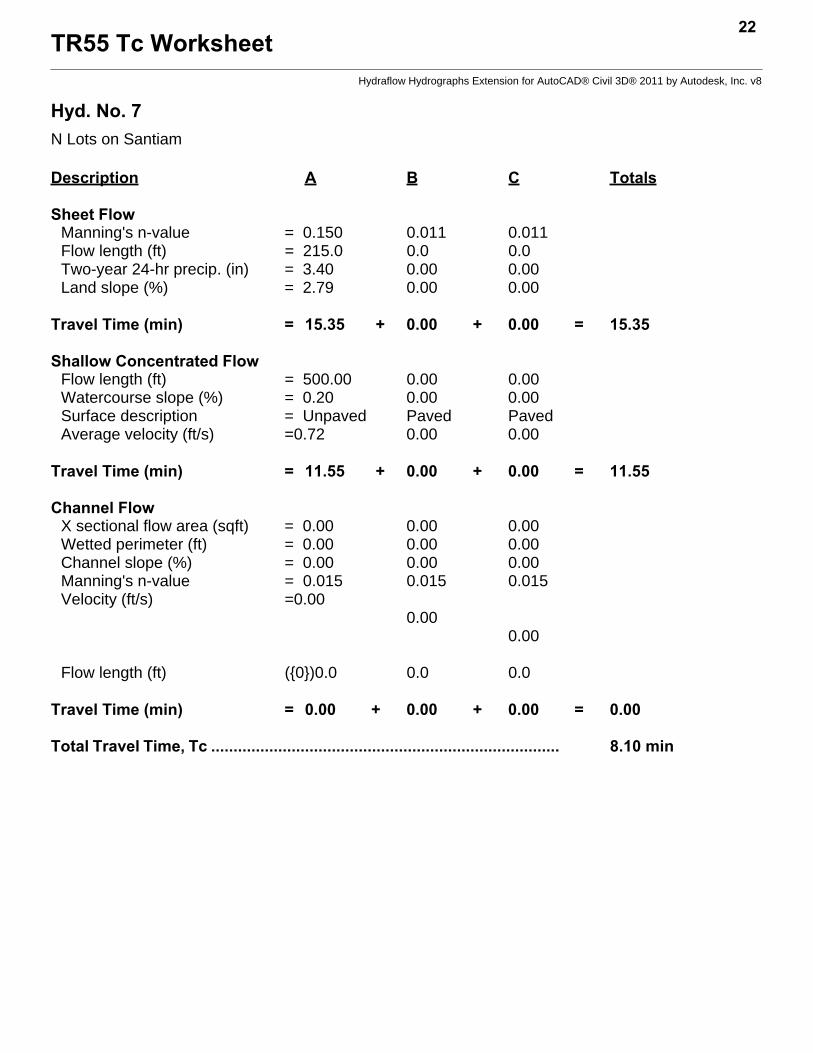
TR55 Tc Worksheet22
Hydraflow Hydrographs Extension for AutoCAD® Civil 3D® 2011 by Autodesk, Inc. v8
Hyd. No. 7N Lots on Santiam
Description A B C Totals
Sheet FlowManning's n-value = 0.150 0.011 0.011Flow length (ft) = 215.0 0.0 0.0Two-year 24-hr precip. (in) = 3.40 0.00 0.00Land slope (%) = 2.79 0.00 0.00
Travel Time (min) = 15.35 + 0.00 + 0.00 = 15.35
Shallow Concentrated FlowFlow length (ft) = 500.00 0.00 0.00Watercourse slope (%) = 0.20 0.00 0.00Surface description = Unpaved Paved PavedAverage velocity (ft/s) =0.72 0.00 0.00
Travel Time (min) = 11.55 + 0.00 + 0.00 = 11.55
Channel FlowX sectional flow area (sqft) = 0.00 0.00 0.00Wetted perimeter (ft) = 0.00 0.00 0.00Channel slope (%) = 0.00 0.00 0.00Manning's n-value = 0.015 0.015 0.015Velocity (ft/s) =0.00
0.000.00
Flow length (ft) ({0})0.0 0.0 0.0
Travel Time (min) = 0.00 + 0.00 + 0.00 = 0.00
Total Travel Time, Tc .............................................................................. 8.10 min
Hydrograph ReportHydraflow Hydrographs Extension for AutoCAD® Civil 3D® 2011 by Autodesk, Inc. v8 Tuesday, Apr 12, 2011
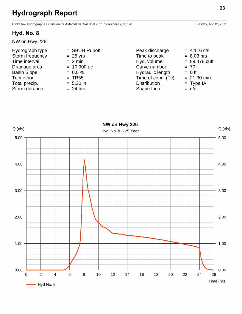
Hyd. No. 8NW on Hwy 226
Hydrograph type = SBUH Runoff Peak discharge = 4.116 cfsStorm frequency = 25 yrs Time to peak = 8.03 hrsTime interval = 2 min Hyd. volume = 89,478 cuftDrainage area = 10.900 ac Curve number = 70Basin Slope = 0.0 % Hydraulic length = 0 ftTc method = TR55 Time of conc. (Tc) = 21.30 minTotal precip. = 5.30 in Distribution = Type IAStorm duration = 24 hrs Shape factor = n/a
23
0 2 4 6 8 10 12 14 16 18 20 22 24 26
Q (cfs)
0.00 0.00
1.00 1.00
2.00 2.00
3.00 3.00
4.00 4.00
5.00 5.00
Q (cfs)
Time (hrs)
NW on Hwy 226Hyd. No. 8 -- 25 Year
Hyd No. 8

TR55 Tc Worksheet24
Hydraflow Hydrographs Extension for AutoCAD® Civil 3D® 2011 by Autodesk, Inc. v8
Hyd. No. 8NW on Hwy 226
Description A B C Totals
Sheet FlowManning's n-value = 0.150 0.011 0.011Flow length (ft) = 120.0 0.0 0.0Two-year 24-hr precip. (in) = 3.40 0.00 0.00Land slope (%) = 0.80 0.00 0.00
Travel Time (min) = 15.87 + 0.00 + 0.00 = 15.87
Shallow Concentrated FlowFlow length (ft) = 518.00 0.00 0.00Watercourse slope (%) = 0.60 0.00 0.00Surface description = Paved Paved PavedAverage velocity (ft/s) =1.57 0.00 0.00
Travel Time (min) = 5.48 + 0.00 + 0.00 = 5.48
Channel FlowX sectional flow area (sqft) = 0.00 0.00 0.00Wetted perimeter (ft) = 0.00 0.00 0.00Channel slope (%) = 0.00 0.00 0.00Manning's n-value = 0.015 0.015 0.015Velocity (ft/s) =0.00
0.000.00
Flow length (ft) ({0})0.0 0.0 0.0
Travel Time (min) = 0.00 + 0.00 + 0.00 = 0.00
Total Travel Time, Tc .............................................................................. 21.30 min
Hydrograph ReportHydraflow Hydrographs Extension for AutoCAD® Civil 3D® 2011 by Autodesk, Inc. v8 Tuesday, Apr 12, 2011
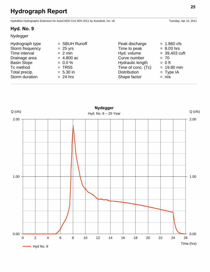
Hyd. No. 9Nydegger
Hydrograph type = SBUH Runoff Peak discharge = 1.860 cfsStorm frequency = 25 yrs Time to peak = 8.03 hrsTime interval = 2 min Hyd. volume = 39,403 cuftDrainage area = 4.800 ac Curve number = 70Basin Slope = 0.0 % Hydraulic length = 0 ftTc method = TR55 Time of conc. (Tc) = 19.80 minTotal precip. = 5.30 in Distribution = Type IAStorm duration = 24 hrs Shape factor = n/a
25
0 2 4 6 8 10 12 14 16 18 20 22 24 26
Q (cfs)
0.00 0.00
1.00 1.00
2.00 2.00
Q (cfs)
Time (hrs)
NydeggerHyd. No. 9 -- 25 Year
Hyd No. 9

TR55 Tc Worksheet26
Hydraflow Hydrographs Extension for AutoCAD® Civil 3D® 2011 by Autodesk, Inc. v8
Hyd. No. 9Nydegger
Description A B C Totals
Sheet FlowManning's n-value = 0.150 0.011 0.011Flow length (ft) = 130.0 0.0 0.0Two-year 24-hr precip. (in) = 3.40 0.00 0.00Land slope (%) = 0.80 0.00 0.00
Travel Time (min) = 16.92 + 0.00 + 0.00 = 16.92
Shallow Concentrated FlowFlow length (ft) = 200.00 0.00 0.00Watercourse slope (%) = 0.50 0.00 0.00Surface description = Unpaved Paved PavedAverage velocity (ft/s) =1.14 0.00 0.00
Travel Time (min) = 2.92 + 0.00 + 0.00 = 2.92
Channel FlowX sectional flow area (sqft) = 0.00 0.00 0.00Wetted perimeter (ft) = 0.00 0.00 0.00Channel slope (%) = 0.00 0.00 0.00Manning's n-value = 0.015 0.015 0.015Velocity (ft/s) =0.00
0.000.00
Flow length (ft) ({0})0.0 0.0 0.0
Travel Time (min) = 0.00 + 0.00 + 0.00 = 0.00
Total Travel Time, Tc .............................................................................. 19.80 min
Hydrograph ReportHydraflow Hydrographs Extension for AutoCAD® Civil 3D® 2011 by Autodesk, Inc. v8 Tuesday, Apr 12, 2011
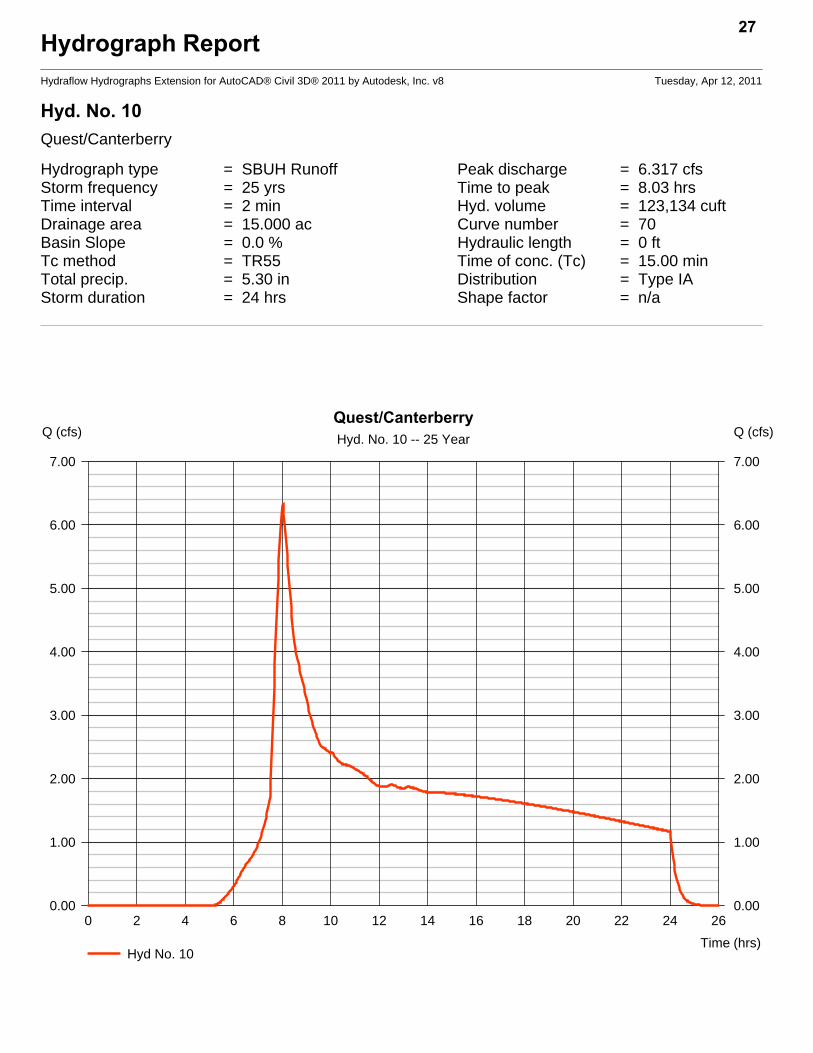
Hyd. No. 10Quest/Canterberry
Hydrograph type = SBUH Runoff Peak discharge = 6.317 cfsStorm frequency = 25 yrs Time to peak = 8.03 hrsTime interval = 2 min Hyd. volume = 123,134 cuftDrainage area = 15.000 ac Curve number = 70Basin Slope = 0.0 % Hydraulic length = 0 ftTc method = TR55 Time of conc. (Tc) = 15.00 minTotal precip. = 5.30 in Distribution = Type IAStorm duration = 24 hrs Shape factor = n/a
27
0 2 4 6 8 10 12 14 16 18 20 22 24 26
Q (cfs)
0.00 0.00
1.00 1.00
2.00 2.00
3.00 3.00
4.00 4.00
5.00 5.00
6.00 6.00
7.00 7.00
Q (cfs)
Time (hrs)
Quest/CanterberryHyd. No. 10 -- 25 Year
Hyd No. 10

TR55 Tc Worksheet28
Hydraflow Hydrographs Extension for AutoCAD® Civil 3D® 2011 by Autodesk, Inc. v8
Hyd. No. 10Quest/Canterberry
Description A B C Totals
Sheet FlowManning's n-value = 0.150 0.011 0.011Flow length (ft) = 181.0 0.0 0.0Two-year 24-hr precip. (in) = 3.40 0.00 0.00Land slope (%) = 2.10 0.00 0.00
Travel Time (min) = 14.98 + 0.00 + 0.00 = 14.98
Shallow Concentrated FlowFlow length (ft) = 0.00 0.00 0.00Watercourse slope (%) = 0.00 0.00 0.00Surface description = Paved Paved PavedAverage velocity (ft/s) =0.00 0.00 0.00
Travel Time (min) = 0.00 + 0.00 + 0.00 = 0.00
Channel FlowX sectional flow area (sqft) = 0.00 0.00 0.00Wetted perimeter (ft) = 0.00 0.00 0.00Channel slope (%) = 0.00 0.00 0.00Manning's n-value = 0.015 0.015 0.015Velocity (ft/s) =0.00
0.000.00
Flow length (ft) ({0})0.0 0.0 0.0
Travel Time (min) = 0.00 + 0.00 + 0.00 = 0.00
Total Travel Time, Tc .............................................................................. 15.00 min
Hydrograph ReportHydraflow Hydrographs Extension for AutoCAD® Civil 3D® 2011 by Autodesk, Inc. v8 Tuesday, Apr 12, 2011
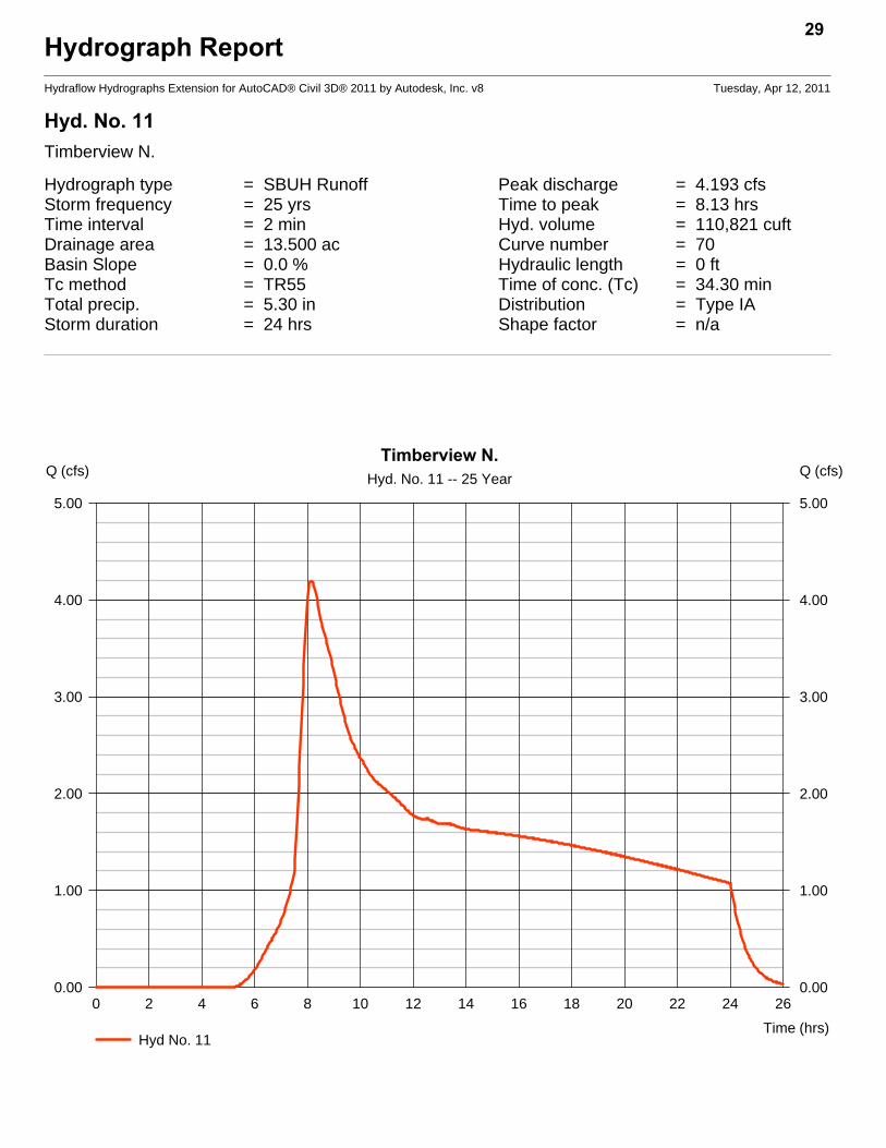
Hyd. No. 11Timberview N.
Hydrograph type = SBUH Runoff Peak discharge = 4.193 cfsStorm frequency = 25 yrs Time to peak = 8.13 hrsTime interval = 2 min Hyd. volume = 110,821 cuftDrainage area = 13.500 ac Curve number = 70Basin Slope = 0.0 % Hydraulic length = 0 ftTc method = TR55 Time of conc. (Tc) = 34.30 minTotal precip. = 5.30 in Distribution = Type IAStorm duration = 24 hrs Shape factor = n/a
29
0 2 4 6 8 10 12 14 16 18 20 22 24 26
Q (cfs)
0.00 0.00
1.00 1.00
2.00 2.00
3.00 3.00
4.00 4.00
5.00 5.00
Q (cfs)
Time (hrs)
Timberview N.Hyd. No. 11 -- 25 Year
Hyd No. 11

TR55 Tc Worksheet30
Hydraflow Hydrographs Extension for AutoCAD® Civil 3D® 2011 by Autodesk, Inc. v8
Hyd. No. 11Timberview N.
Description A B C Totals
Sheet FlowManning's n-value = 0.150 0.011 0.011Flow length (ft) = 294.0 0.0 0.0Two-year 24-hr precip. (in) = 3.40 0.00 0.00Land slope (%) = 0.70 0.00 0.00
Travel Time (min) = 34.28 + 0.00 + 0.00 = 34.28
Shallow Concentrated FlowFlow length (ft) = 0.00 0.00 0.00Watercourse slope (%) = 0.00 0.00 0.00Surface description = Paved Paved PavedAverage velocity (ft/s) =0.00 0.00 0.00
Travel Time (min) = 0.00 + 0.00 + 0.00 = 0.00
Channel FlowX sectional flow area (sqft) = 0.00 0.00 0.00Wetted perimeter (ft) = 0.00 0.00 0.00Channel slope (%) = 0.00 0.00 0.00Manning's n-value = 0.015 0.015 0.015Velocity (ft/s) =0.00
0.000.00
Flow length (ft) ({0})0.0 0.0 0.0
Travel Time (min) = 0.00 + 0.00 + 0.00 = 0.00
Total Travel Time, Tc .............................................................................. 34.30 min

Hydrograph ReportHydraflow Hydrographs Extension for AutoCAD® Civil 3D® 2011 by Autodesk, Inc. v8 Tuesday, Apr 12, 2011
Hyd. No. 12NE Lots on Santiam
Hydrograph type = SBUH Runoff Peak discharge = 2.147 cfsStorm frequency = 25 yrs Time to peak = 8.00 hrsTime interval = 2 min Hyd. volume = 36,940 cuftDrainage area = 4.500 ac Curve number = 70Basin Slope = 0.0 % Hydraulic length = 0 ftTc method = TR55 Time of conc. (Tc) = 8.10 minTotal precip. = 5.30 in Distribution = Type IAStorm duration = 24 hrs Shape factor = n/a
31
0 2 4 6 8 10 12 14 16 18 20 22 24 26
Q (cfs)
0.00 0.00
1.00 1.00
2.00 2.00
3.00 3.00
Q (cfs)
Time (hrs)
NE Lots on SantiamHyd. No. 12 -- 25 Year
Hyd No. 12

TR55 Tc Worksheet32
Hydraflow Hydrographs Extension for AutoCAD® Civil 3D® 2011 by Autodesk, Inc. v8
Hyd. No. 12NE Lots on Santiam
Description A B C Totals
Sheet FlowManning's n-value = 0.150 0.011 0.011Flow length (ft) = 168.0 0.0 0.0Two-year 24-hr precip. (in) = 3.40 0.00 0.00Land slope (%) = 8.33 0.00 0.00
Travel Time (min) = 8.14 + 0.00 + 0.00 = 8.14
Shallow Concentrated FlowFlow length (ft) = 0.00 0.00 0.00Watercourse slope (%) = 0.00 0.00 0.00Surface description = Paved Paved PavedAverage velocity (ft/s) =0.00 0.00 0.00
Travel Time (min) = 0.00 + 0.00 + 0.00 = 0.00
Channel FlowX sectional flow area (sqft) = 0.00 0.00 0.00Wetted perimeter (ft) = 0.00 0.00 0.00Channel slope (%) = 0.00 0.00 0.00Manning's n-value = 0.015 0.015 0.015Velocity (ft/s) =0.00
0.000.00
Flow length (ft) ({0})0.0 0.0 0.0
Travel Time (min) = 0.00 + 0.00 + 0.00 = 0.00
Total Travel Time, Tc .............................................................................. 8.10 min
Hydrograph ReportHydraflow Hydrographs Extension for AutoCAD® Civil 3D® 2011 by Autodesk, Inc. v8 Tuesday, Apr 12, 2011
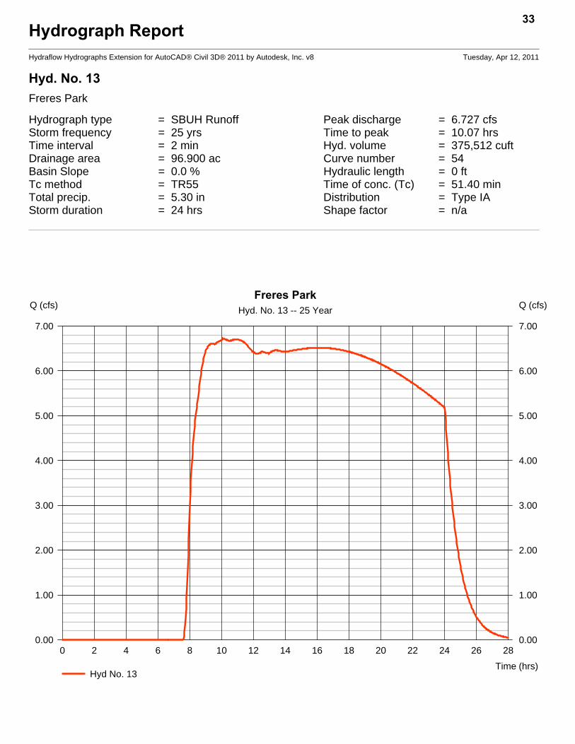
Hyd. No. 13Freres Park
Hydrograph type = SBUH Runoff Peak discharge = 6.727 cfsStorm frequency = 25 yrs Time to peak = 10.07 hrsTime interval = 2 min Hyd. volume = 375,512 cuftDrainage area = 96.900 ac Curve number = 54Basin Slope = 0.0 % Hydraulic length = 0 ftTc method = TR55 Time of conc. (Tc) = 51.40 minTotal precip. = 5.30 in Distribution = Type IAStorm duration = 24 hrs Shape factor = n/a
33
0 2 4 6 8 10 12 14 16 18 20 22 24 26 28
Q (cfs)
0.00 0.00
1.00 1.00
2.00 2.00
3.00 3.00
4.00 4.00
5.00 5.00
6.00 6.00
7.00 7.00
Q (cfs)
Time (hrs)
Freres ParkHyd. No. 13 -- 25 Year
Hyd No. 13

TR55 Tc Worksheet34
Hydraflow Hydrographs Extension for AutoCAD® Civil 3D® 2011 by Autodesk, Inc. v8
Hyd. No. 13Freres Park
Description A B C Totals
Sheet FlowManning's n-value = 0.240 0.011 0.011Flow length (ft) = 250.0 0.0 0.0Two-year 24-hr precip. (in) = 3.40 0.00 0.00Land slope (%) = 0.80 0.00 0.00
Travel Time (min) = 41.57 + 0.00 + 0.00 = 41.57
Shallow Concentrated FlowFlow length (ft) = 950.00 0.00 0.00Watercourse slope (%) = 1.00 0.00 0.00Surface description = Unpaved Paved PavedAverage velocity (ft/s) =1.61 0.00 0.00
Travel Time (min) = 9.81 + 0.00 + 0.00 = 9.81
Channel FlowX sectional flow area (sqft) = 0.00 0.00 0.00Wetted perimeter (ft) = 0.00 0.00 0.00Channel slope (%) = 0.00 0.00 0.00Manning's n-value = 0.015 0.015 0.015Velocity (ft/s) =0.00
0.000.00
Flow length (ft) ({0})0.0 0.0 0.0
Travel Time (min) = 0.00 + 0.00 + 0.00 = 0.00
Total Travel Time, Tc .............................................................................. 51.40 min

Hydrograph ReportHydraflow Hydrographs Extension for AutoCAD® Civil 3D® 2011 by Autodesk, Inc. v8 Tuesday, Apr 12, 2011
Hyd. No. 14Timberview S
Hydrograph type = SBUH Runoff Peak discharge = 4.667 cfsStorm frequency = 25 yrs Time to peak = 8.07 hrsTime interval = 2 min Hyd. volume = 140,409 cuftDrainage area = 26.140 ac Curve number = 60*Basin Slope = 0.0 % Hydraulic length = 0 ftTc method = TR55 Time of conc. (Tc) = 19.30 minTotal precip. = 5.30 in Distribution = Type IAStorm duration = 24 hrs Shape factor = n/a
* Composite (Area/CN) = + (9.000 x 70) + (17.140 x 54)] / 26.140
35
0 2 4 6 8 10 12 14 16 18 20 22 24 26
Q (cfs)
0.00 0.00
1.00 1.00
2.00 2.00
3.00 3.00
4.00 4.00
5.00 5.00
Q (cfs)
Time (hrs)
Timberview SHyd. No. 14 -- 25 Year
Hyd No. 14

TR55 Tc Worksheet36
Hydraflow Hydrographs Extension for AutoCAD® Civil 3D® 2011 by Autodesk, Inc. v8
Hyd. No. 14Timberview S
Description A B C Totals
Sheet FlowManning's n-value = 0.150 0.011 0.011Flow length (ft) = 112.0 0.0 0.0Two-year 24-hr precip. (in) = 3.40 0.00 0.00Land slope (%) = 0.90 0.00 0.00
Travel Time (min) = 14.32 + 0.00 + 0.00 = 14.32
Shallow Concentrated FlowFlow length (ft) = 520.00 0.00 0.00Watercourse slope (%) = 1.15 0.00 0.00Surface description = Unpaved Paved PavedAverage velocity (ft/s) =1.73 0.00 0.00
Travel Time (min) = 5.01 + 0.00 + 0.00 = 5.01
Channel FlowX sectional flow area (sqft) = 0.00 0.00 0.00Wetted perimeter (ft) = 0.00 0.00 0.00Channel slope (%) = 0.00 0.00 0.00Manning's n-value = 0.015 0.015 0.015Velocity (ft/s) =0.00
0.000.00
Flow length (ft) ({0})0.0 0.0 0.0
Travel Time (min) = 0.00 + 0.00 + 0.00 = 0.00
Total Travel Time, Tc .............................................................................. 19.30 min

Hydrograph ReportHydraflow Hydrographs Extension for AutoCAD® Civil 3D® 2011 by Autodesk, Inc. v8 Tuesday, Apr 12, 2011
Hyd. No. 15226 Mid
Hydrograph type = SBUH Runoff Peak discharge = 1.728 cfsStorm frequency = 25 yrs Time to peak = 8.00 hrsTime interval = 2 min Hyd. volume = 30,323 cuftDrainage area = 3.100 ac Curve number = 75*Basin Slope = 0.0 % Hydraulic length = 0 ftTc method = TR55 Time of conc. (Tc) = 14.00 minTotal precip. = 5.30 in Distribution = Type IAStorm duration = 24 hrs Shape factor = n/a
* Composite (Area/CN) = + (1.500 x 98) + (1.600 x 54)] / 3.100
37
0 2 4 6 8 10 12 14 16 18 20 22 24 26
Q (cfs)
0.00 0.00
1.00 1.00
2.00 2.00
Q (cfs)
Time (hrs)
226 MidHyd. No. 15 -- 25 Year
Hyd No. 15

TR55 Tc Worksheet38
Hydraflow Hydrographs Extension for AutoCAD® Civil 3D® 2011 by Autodesk, Inc. v8
Hyd. No. 15226 Mid
Description A B C Totals
Sheet FlowManning's n-value = 0.150 0.011 0.011Flow length (ft) = 150.0 0.0 0.0Two-year 24-hr precip. (in) = 3.40 0.00 0.00Land slope (%) = 2.00 0.00 0.00
Travel Time (min) = 13.15 + 0.00 + 0.00 = 13.15
Shallow Concentrated FlowFlow length (ft) = 0.00 0.00 0.00Watercourse slope (%) = 0.00 0.00 0.00Surface description = Paved Paved PavedAverage velocity (ft/s) =0.00 0.00 0.00
Travel Time (min) = 0.00 + 0.00 + 0.00 = 0.00
Channel FlowX sectional flow area (sqft) = 9.00 0.00 0.00Wetted perimeter (ft) = 8.00 0.00 0.00Channel slope (%) = 2.00 0.00 0.00Manning's n-value = 0.011 0.015 0.015Velocity (ft/s) =20.73
0.000.00
Flow length (ft) ({0})1100.0 0.0 0.0
Travel Time (min) = 0.88 + 0.00 + 0.00 = 0.88
Total Travel Time, Tc .............................................................................. 14.00 min

Hydrograph ReportHydraflow Hydrographs Extension for AutoCAD® Civil 3D® 2011 by Autodesk, Inc. v8 Tuesday, Apr 12, 2011
Hyd. No. 16E of 226 Mid
Hydrograph type = SBUH Runoff Peak discharge = 2.474 cfsStorm frequency = 25 yrs Time to peak = 8.13 hrsTime interval = 2 min Hyd. volume = 63,983 cuftDrainage area = 7.000 ac Curve number = 73*Basin Slope = 0.0 % Hydraulic length = 0 ftTc method = TR55 Time of conc. (Tc) = 37.80 minTotal precip. = 5.30 in Distribution = Type IAStorm duration = 24 hrs Shape factor = n/a
* Composite (Area/CN) = [(3.000 x 98) + (4.000 x 54)] / 7.000
39
0 2 4 6 8 10 12 14 16 18 20 22 24 26 28
Q (cfs)
0.00 0.00
1.00 1.00
2.00 2.00
3.00 3.00
Q (cfs)
Time (hrs)
E of 226 MidHyd. No. 16 -- 25 Year
Hyd No. 16

TR55 Tc Worksheet40
Hydraflow Hydrographs Extension for AutoCAD® Civil 3D® 2011 by Autodesk, Inc. v8
Hyd. No. 16E of 226 Mid
Description A B C Totals
Sheet FlowManning's n-value = 0.150 0.011 0.011Flow length (ft) = 286.0 0.0 0.0Two-year 24-hr precip. (in) = 3.40 0.00 0.00Land slope (%) = 1.00 0.00 0.00
Travel Time (min) = 29.07 + 0.00 + 0.00 = 29.07
Shallow Concentrated FlowFlow length (ft) = 657.00 0.00 0.00Watercourse slope (%) = 0.60 0.00 0.00Surface description = Unpaved Paved PavedAverage velocity (ft/s) =1.25 0.00 0.00
Travel Time (min) = 8.76 + 0.00 + 0.00 = 8.76
Channel FlowX sectional flow area (sqft) = 0.00 0.00 0.00Wetted perimeter (ft) = 0.00 0.00 0.00Channel slope (%) = 0.00 0.00 0.00Manning's n-value = 0.015 0.015 0.015Velocity (ft/s) =0.00
0.000.00
Flow length (ft) ({0})0.0 0.0 0.0
Travel Time (min) = 0.00 + 0.00 + 0.00 = 0.00
Total Travel Time, Tc .............................................................................. 37.80 min
Hydrograph ReportHydraflow Hydrographs Extension for AutoCAD® Civil 3D® 2011 by Autodesk, Inc. v8 Tuesday, Apr 12, 2011
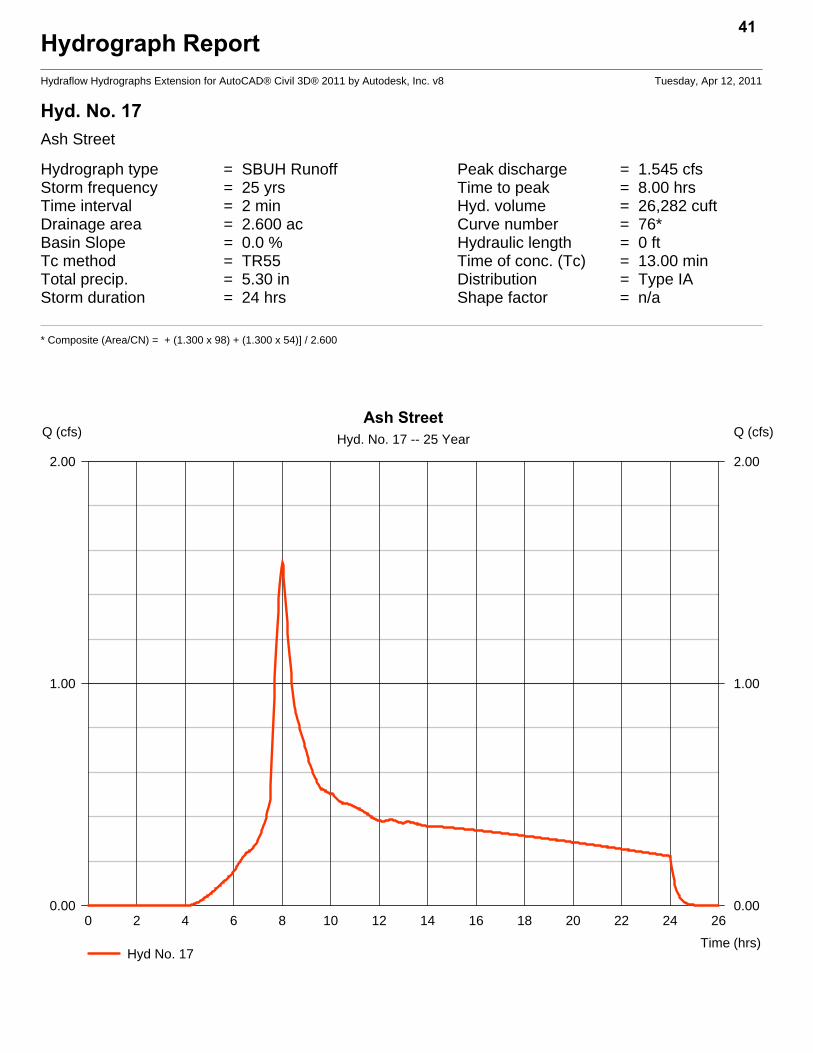
Hyd. No. 17Ash Street
Hydrograph type = SBUH Runoff Peak discharge = 1.545 cfsStorm frequency = 25 yrs Time to peak = 8.00 hrsTime interval = 2 min Hyd. volume = 26,282 cuftDrainage area = 2.600 ac Curve number = 76*Basin Slope = 0.0 % Hydraulic length = 0 ftTc method = TR55 Time of conc. (Tc) = 13.00 minTotal precip. = 5.30 in Distribution = Type IAStorm duration = 24 hrs Shape factor = n/a
* Composite (Area/CN) = + (1.300 x 98) + (1.300 x 54)] / 2.600
41
0 2 4 6 8 10 12 14 16 18 20 22 24 26
Q (cfs)
0.00 0.00
1.00 1.00
2.00 2.00
Q (cfs)
Time (hrs)
Ash StreetHyd. No. 17 -- 25 Year
Hyd No. 17

TR55 Tc Worksheet42
Hydraflow Hydrographs Extension for AutoCAD® Civil 3D® 2011 by Autodesk, Inc. v8
Hyd. No. 17Ash Street
Description A B C Totals
Sheet FlowManning's n-value = 0.150 0.011 0.011Flow length (ft) = 75.0 0.0 0.0Two-year 24-hr precip. (in) = 3.40 0.00 0.00Land slope (%) = 1.00 0.00 0.00
Travel Time (min) = 9.96 + 0.00 + 0.00 = 9.96
Shallow Concentrated FlowFlow length (ft) = 370.00 0.00 0.00Watercourse slope (%) = 1.00 0.00 0.00Surface description = Paved Paved PavedAverage velocity (ft/s) =2.03 0.00 0.00
Travel Time (min) = 3.03 + 0.00 + 0.00 = 3.03
Channel FlowX sectional flow area (sqft) = 0.00 0.00 0.00Wetted perimeter (ft) = 0.00 0.00 0.00Channel slope (%) = 0.00 0.00 0.00Manning's n-value = 0.015 0.015 0.015Velocity (ft/s) =0.00
0.000.00
Flow length (ft) ({0})0.0 0.0 0.0
Travel Time (min) = 0.00 + 0.00 + 0.00 = 0.00
Total Travel Time, Tc .............................................................................. 13.00 min

Hydrograph ReportHydraflow Hydrographs Extension for AutoCAD® Civil 3D® 2011 by Autodesk, Inc. v8 Tuesday, Apr 12, 2011
Hyd. No. 18Central Bus Dist
Hydrograph type = SBUH Runoff Peak discharge = 34.78 cfsStorm frequency = 25 yrs Time to peak = 8.00 hrsTime interval = 2 min Hyd. volume = 583,860 cuftDrainage area = 36.700 ac Curve number = 92Basin Slope = 0.0 % Hydraulic length = 0 ftTc method = TR55 Time of conc. (Tc) = 19.10 minTotal precip. = 5.30 in Distribution = Type IAStorm duration = 24 hrs Shape factor = n/a
43
0 2 4 6 8 10 12 14 16 18 20 22 24 26
Q (cfs)
0.00 0.00
5.00 5.00
10.00 10.00
15.00 15.00
20.00 20.00
25.00 25.00
30.00 30.00
35.00 35.00
Q (cfs)
Time (hrs)
Central Bus DistHyd. No. 18 -- 25 Year
Hyd No. 18

TR55 Tc Worksheet44
Hydraflow Hydrographs Extension for AutoCAD® Civil 3D® 2011 by Autodesk, Inc. v8
Hyd. No. 18Central Bus Dist
Description A B C Totals
Sheet FlowManning's n-value = 0.150 0.011 0.011Flow length (ft) = 191.0 0.0 0.0Two-year 24-hr precip. (in) = 3.40 0.00 0.00Land slope (%) = 1.60 0.00 0.00
Travel Time (min) = 17.44 + 0.00 + 0.00 = 17.44
Shallow Concentrated FlowFlow length (ft) = 270.00 0.00 0.00Watercourse slope (%) = 1.80 0.00 0.00Surface description = Paved Paved PavedAverage velocity (ft/s) =2.73 0.00 0.00
Travel Time (min) = 1.65 + 0.00 + 0.00 = 1.65
Channel FlowX sectional flow area (sqft) = 0.00 0.00 0.00Wetted perimeter (ft) = 0.00 0.00 0.00Channel slope (%) = 0.00 0.00 0.00Manning's n-value = 0.015 0.015 0.015Velocity (ft/s) =0.00
0.000.00
Flow length (ft) ({0})0.0 0.0 0.0
Travel Time (min) = 0.00 + 0.00 + 0.00 = 0.00
Total Travel Time, Tc .............................................................................. 19.10 min

Hydrograph ReportHydraflow Hydrographs Extension for AutoCAD® Civil 3D® 2011 by Autodesk, Inc. v8 Tuesday, Apr 12, 2011
Hyd. No. 19Front Street
Hydrograph type = SBUH Runoff Peak discharge = 9.547 cfsStorm frequency = 25 yrs Time to peak = 7.93 hrsTime interval = 2 min Hyd. volume = 135,226 cuftDrainage area = 8.500 ac Curve number = 92Basin Slope = 0.0 % Hydraulic length = 0 ftTc method = TR55 Time of conc. (Tc) = 6.00 minTotal precip. = 5.30 in Distribution = Type IAStorm duration = 24 hrs Shape factor = n/a
45
0 2 4 6 8 10 12 14 16 18 20 22 24 26
Q (cfs)
0.00 0.00
2.00 2.00
4.00 4.00
6.00 6.00
8.00 8.00
10.00 10.00
Q (cfs)
Time (hrs)
Front StreetHyd. No. 19 -- 25 Year
Hyd No. 19

TR55 Tc Worksheet46
Hydraflow Hydrographs Extension for AutoCAD® Civil 3D® 2011 by Autodesk, Inc. v8
Hyd. No. 19Front Street
Description A B C Totals
Sheet FlowManning's n-value = 0.150 0.011 0.011Flow length (ft) = 50.0 0.0 0.0Two-year 24-hr precip. (in) = 3.40 0.00 0.00Land slope (%) = 2.00 0.00 0.00
Travel Time (min) = 5.46 + 0.00 + 0.00 = 5.46
Shallow Concentrated FlowFlow length (ft) = 120.00 0.00 0.00Watercourse slope (%) = 3.00 0.00 0.00Surface description = Paved Paved PavedAverage velocity (ft/s) =3.52 0.00 0.00
Travel Time (min) = 0.57 + 0.00 + 0.00 = 0.57
Channel FlowX sectional flow area (sqft) = 0.00 0.00 0.00Wetted perimeter (ft) = 0.00 0.00 0.00Channel slope (%) = 0.00 0.00 0.00Manning's n-value = 0.015 0.015 0.015Velocity (ft/s) =0.00
0.000.00
Flow length (ft) ({0})0.0 0.0 0.0
Travel Time (min) = 0.00 + 0.00 + 0.00 = 0.00
Total Travel Time, Tc .............................................................................. 6.00 min
Hydrograph ReportHydraflow Hydrographs Extension for AutoCAD® Civil 3D® 2011 by Autodesk, Inc. v8 Tuesday, Apr 12, 2011
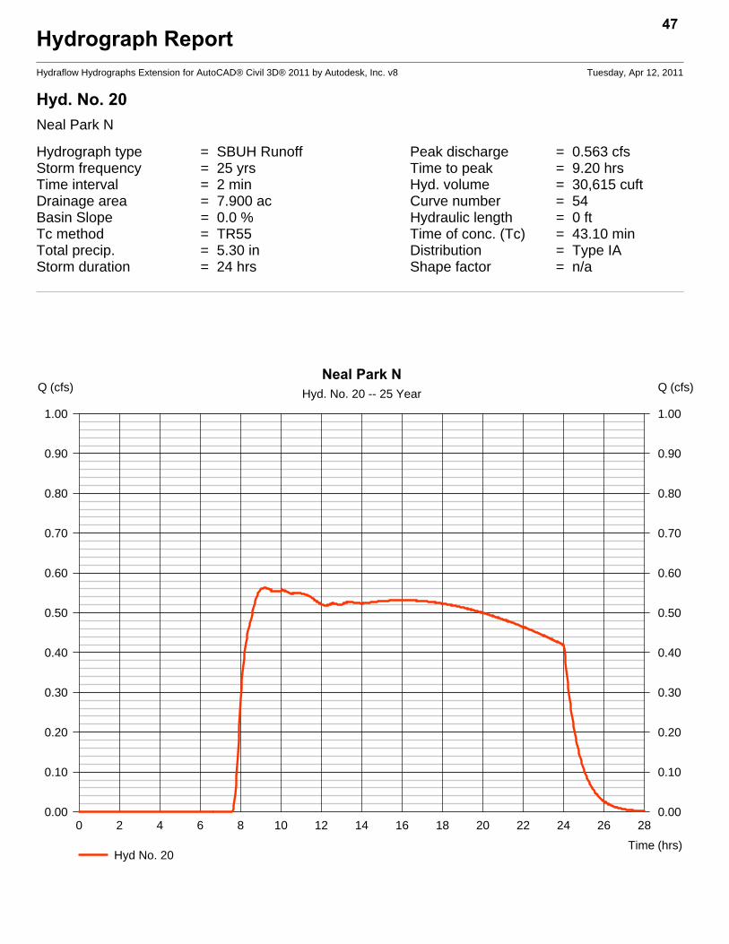
Hyd. No. 20Neal Park N
Hydrograph type = SBUH Runoff Peak discharge = 0.563 cfsStorm frequency = 25 yrs Time to peak = 9.20 hrsTime interval = 2 min Hyd. volume = 30,615 cuftDrainage area = 7.900 ac Curve number = 54Basin Slope = 0.0 % Hydraulic length = 0 ftTc method = TR55 Time of conc. (Tc) = 43.10 minTotal precip. = 5.30 in Distribution = Type IAStorm duration = 24 hrs Shape factor = n/a
47
0 2 4 6 8 10 12 14 16 18 20 22 24 26 28
Q (cfs)
0.00 0.00
0.10 0.10
0.20 0.20
0.30 0.30
0.40 0.40
0.50 0.50
0.60 0.60
0.70 0.70
0.80 0.80
0.90 0.90
1.00 1.00
Q (cfs)
Time (hrs)
Neal Park NHyd. No. 20 -- 25 Year
Hyd No. 20
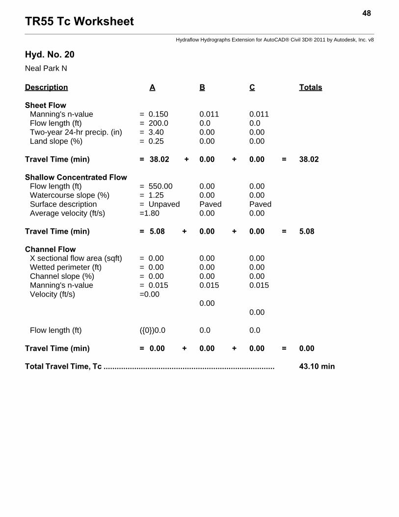
TR55 Tc Worksheet48
Hydraflow Hydrographs Extension for AutoCAD® Civil 3D® 2011 by Autodesk, Inc. v8
Hyd. No. 20Neal Park N
Description A B C Totals
Sheet FlowManning's n-value = 0.150 0.011 0.011Flow length (ft) = 200.0 0.0 0.0Two-year 24-hr precip. (in) = 3.40 0.00 0.00Land slope (%) = 0.25 0.00 0.00
Travel Time (min) = 38.02 + 0.00 + 0.00 = 38.02
Shallow Concentrated FlowFlow length (ft) = 550.00 0.00 0.00Watercourse slope (%) = 1.25 0.00 0.00Surface description = Unpaved Paved PavedAverage velocity (ft/s) =1.80 0.00 0.00
Travel Time (min) = 5.08 + 0.00 + 0.00 = 5.08
Channel FlowX sectional flow area (sqft) = 0.00 0.00 0.00Wetted perimeter (ft) = 0.00 0.00 0.00Channel slope (%) = 0.00 0.00 0.00Manning's n-value = 0.015 0.015 0.015Velocity (ft/s) =0.00
0.000.00
Flow length (ft) ({0})0.0 0.0 0.0
Travel Time (min) = 0.00 + 0.00 + 0.00 = 0.00
Total Travel Time, Tc .............................................................................. 43.10 min

Hydrograph ReportHydraflow Hydrographs Extension for AutoCAD® Civil 3D® 2011 by Autodesk, Inc. v8 Tuesday, Apr 12, 2011
Hyd. No. 21Neal Park S.
Hydrograph type = SBUH Runoff Peak discharge = 1.510 cfsStorm frequency = 25 yrs Time to peak = 9.00 hrsTime interval = 2 min Hyd. volume = 76,343 cuftDrainage area = 19.700 ac Curve number = 54Basin Slope = 0.0 % Hydraulic length = 0 ftTc method = TR55 Time of conc. (Tc) = 31.20 minTotal precip. = 5.30 in Distribution = Type IAStorm duration = 24 hrs Shape factor = n/a
49
0 2 4 6 8 10 12 14 16 18 20 22 24 26 28
Q (cfs)
0.00 0.00
1.00 1.00
2.00 2.00
Q (cfs)
Time (hrs)
Neal Park S.Hyd. No. 21 -- 25 Year
Hyd No. 21

TR55 Tc Worksheet50
Hydraflow Hydrographs Extension for AutoCAD® Civil 3D® 2011 by Autodesk, Inc. v8
Hyd. No. 21Neal Park S.
Description A B C Totals
Sheet FlowManning's n-value = 0.150 0.011 0.011Flow length (ft) = 200.0 0.0 0.0Two-year 24-hr precip. (in) = 3.40 0.00 0.00Land slope (%) = 1.00 0.00 0.00
Travel Time (min) = 21.84 + 0.00 + 0.00 = 21.84
Shallow Concentrated FlowFlow length (ft) = 700.00 0.00 0.00Watercourse slope (%) = 0.60 0.00 0.00Surface description = Unpaved Paved PavedAverage velocity (ft/s) =1.25 0.00 0.00
Travel Time (min) = 9.34 + 0.00 + 0.00 = 9.34
Channel FlowX sectional flow area (sqft) = 0.00 0.00 0.00Wetted perimeter (ft) = 0.00 0.00 0.00Channel slope (%) = 0.00 0.00 0.00Manning's n-value = 0.015 0.015 0.015Velocity (ft/s) =0.00
0.000.00
Flow length (ft) ({0})0.0 0.0 0.0
Travel Time (min) = 0.00 + 0.00 + 0.00 = 0.00
Total Travel Time, Tc .............................................................................. 31.20 min
Hydrograph ReportHydraflow Hydrographs Extension for AutoCAD® Civil 3D® 2011 by Autodesk, Inc. v8 Tuesday, Apr 12, 2011
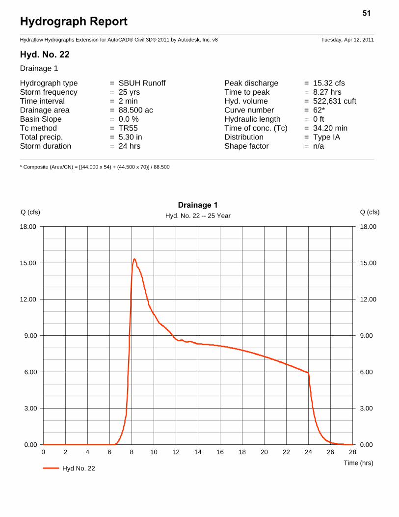
Hyd. No. 22Drainage 1
Hydrograph type = SBUH Runoff Peak discharge = 15.32 cfsStorm frequency = 25 yrs Time to peak = 8.27 hrsTime interval = 2 min Hyd. volume = 522,631 cuftDrainage area = 88.500 ac Curve number = 62*Basin Slope = 0.0 % Hydraulic length = 0 ftTc method = TR55 Time of conc. (Tc) = 34.20 minTotal precip. = 5.30 in Distribution = Type IAStorm duration = 24 hrs Shape factor = n/a
* Composite (Area/CN) = [(44.000 x 54) + (44.500 x 70)] / 88.500
51
0 2 4 6 8 10 12 14 16 18 20 22 24 26 28
Q (cfs)
0.00 0.00
3.00 3.00
6.00 6.00
9.00 9.00
12.00 12.00
15.00 15.00
18.00 18.00
Q (cfs)
Time (hrs)
Drainage 1Hyd. No. 22 -- 25 Year
Hyd No. 22

TR55 Tc Worksheet52
Hydraflow Hydrographs Extension for AutoCAD® Civil 3D® 2011 by Autodesk, Inc. v8
Hyd. No. 22Drainage 1
Description A B C Totals
Sheet FlowManning's n-value = 0.150 0.011 0.011Flow length (ft) = 200.0 0.0 0.0Two-year 24-hr precip. (in) = 3.40 0.00 0.00Land slope (%) = 0.50 0.00 0.00
Travel Time (min) = 28.82 + 0.00 + 0.00 = 28.82
Shallow Concentrated FlowFlow length (ft) = 300.00 0.00 0.00Watercourse slope (%) = 0.33 0.00 0.00Surface description = Unpaved Paved PavedAverage velocity (ft/s) =0.93 0.00 0.00
Travel Time (min) = 5.39 + 0.00 + 0.00 = 5.39
Channel FlowX sectional flow area (sqft) = 0.00 0.00 0.00Wetted perimeter (ft) = 0.00 0.00 0.00Channel slope (%) = 0.00 0.00 0.00Manning's n-value = 0.015 0.015 0.015Velocity (ft/s) =0.00
0.000.00
Flow length (ft) ({0})0.0 0.0 0.0
Travel Time (min) = 0.00 + 0.00 + 0.00 = 0.00
Total Travel Time, Tc .............................................................................. 34.20 min
Hydrograph ReportHydraflow Hydrographs Extension for AutoCAD® Civil 3D® 2011 by Autodesk, Inc. v8 Tuesday, Apr 12, 2011
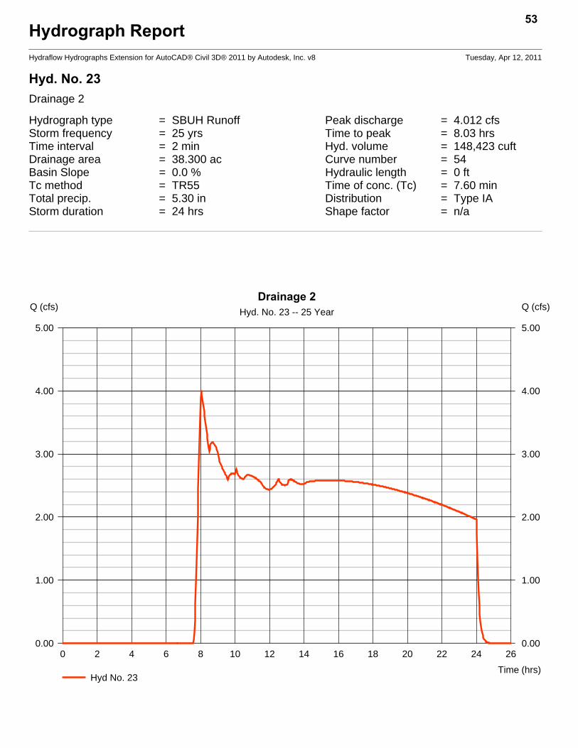
Hyd. No. 23Drainage 2
Hydrograph type = SBUH Runoff Peak discharge = 4.012 cfsStorm frequency = 25 yrs Time to peak = 8.03 hrsTime interval = 2 min Hyd. volume = 148,423 cuftDrainage area = 38.300 ac Curve number = 54Basin Slope = 0.0 % Hydraulic length = 0 ftTc method = TR55 Time of conc. (Tc) = 7.60 minTotal precip. = 5.30 in Distribution = Type IAStorm duration = 24 hrs Shape factor = n/a
53
0 2 4 6 8 10 12 14 16 18 20 22 24 26
Q (cfs)
0.00 0.00
1.00 1.00
2.00 2.00
3.00 3.00
4.00 4.00
5.00 5.00
Q (cfs)
Time (hrs)
Drainage 2Hyd. No. 23 -- 25 Year
Hyd No. 23

TR55 Tc Worksheet54
Hydraflow Hydrographs Extension for AutoCAD® Civil 3D® 2011 by Autodesk, Inc. v8
Hyd. No. 23Drainage 2
Description A B C Totals
Sheet FlowManning's n-value = 0.150 0.011 0.011Flow length (ft) = 100.0 0.0 0.0Two-year 24-hr precip. (in) = 3.40 0.00 0.00Land slope (%) = 4.00 0.00 0.00
Travel Time (min) = 7.20 + 0.00 + 0.00 = 7.20
Shallow Concentrated FlowFlow length (ft) = 100.00 0.00 0.00Watercourse slope (%) = 8.00 0.00 0.00Surface description = Unpaved Paved PavedAverage velocity (ft/s) =4.56 0.00 0.00
Travel Time (min) = 0.37 + 0.00 + 0.00 = 0.37
Channel FlowX sectional flow area (sqft) = 0.00 0.00 0.00Wetted perimeter (ft) = 0.00 0.00 0.00Channel slope (%) = 0.00 0.00 0.00Manning's n-value = 0.015 0.015 0.015Velocity (ft/s) =0.00
0.000.00
Flow length (ft) ({0})0.0 0.0 0.0
Travel Time (min) = 0.00 + 0.00 + 0.00 = 0.00
Total Travel Time, Tc .............................................................................. 7.60 min
Hydrograph ReportHydraflow Hydrographs Extension for AutoCAD® Civil 3D® 2011 by Autodesk, Inc. v8 Tuesday, Apr 12, 2011
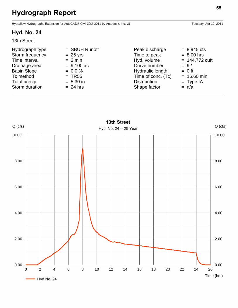
Hyd. No. 2413th Street
Hydrograph type = SBUH Runoff Peak discharge = 8.945 cfsStorm frequency = 25 yrs Time to peak = 8.00 hrsTime interval = 2 min Hyd. volume = 144,772 cuftDrainage area = 9.100 ac Curve number = 92Basin Slope = 0.0 % Hydraulic length = 0 ftTc method = TR55 Time of conc. (Tc) = 16.60 minTotal precip. = 5.30 in Distribution = Type IAStorm duration = 24 hrs Shape factor = n/a
55
0 2 4 6 8 10 12 14 16 18 20 22 24 26
Q (cfs)
0.00 0.00
2.00 2.00
4.00 4.00
6.00 6.00
8.00 8.00
10.00 10.00
Q (cfs)
Time (hrs)
13th StreetHyd. No. 24 -- 25 Year
Hyd No. 24

TR55 Tc Worksheet56
Hydraflow Hydrographs Extension for AutoCAD® Civil 3D® 2011 by Autodesk, Inc. v8
Hyd. No. 2413th Street
Description A B C Totals
Sheet FlowManning's n-value = 0.150 0.011 0.011Flow length (ft) = 100.0 0.0 0.0Two-year 24-hr precip. (in) = 3.40 0.00 0.00Land slope (%) = 1.00 0.00 0.00
Travel Time (min) = 12.54 + 0.00 + 0.00 = 12.54
Shallow Concentrated FlowFlow length (ft) = 530.00 0.00 0.00Watercourse slope (%) = 1.13 0.00 0.00Surface description = Paved Paved PavedAverage velocity (ft/s) =2.16 0.00 0.00
Travel Time (min) = 4.09 + 0.00 + 0.00 = 4.09
Channel FlowX sectional flow area (sqft) = 0.00 0.00 0.00Wetted perimeter (ft) = 0.00 0.00 0.00Channel slope (%) = 0.00 0.00 0.00Manning's n-value = 0.015 0.015 0.015Velocity (ft/s) =0.00
0.000.00
Flow length (ft) ({0})0.0 0.0 0.0
Travel Time (min) = 0.00 + 0.00 + 0.00 = 0.00
Total Travel Time, Tc .............................................................................. 16.60 min

Hydrograph ReportHydraflow Hydrographs Extension for AutoCAD® Civil 3D® 2011 by Autodesk, Inc. v8 Tuesday, Apr 12, 2011
Hyd. No. 2514th Street
Hydrograph type = SBUH Runoff Peak discharge = 4.988 cfsStorm frequency = 25 yrs Time to peak = 8.00 hrsTime interval = 2 min Hyd. volume = 75,446 cuftDrainage area = 5.700 ac Curve number = 85Basin Slope = 0.0 % Hydraulic length = 0 ftTc method = TR55 Time of conc. (Tc) = 10.70 minTotal precip. = 5.30 in Distribution = Type IAStorm duration = 24 hrs Shape factor = n/a
57
0 2 4 6 8 10 12 14 16 18 20 22 24 26
Q (cfs)
0.00 0.00
1.00 1.00
2.00 2.00
3.00 3.00
4.00 4.00
5.00 5.00
Q (cfs)
Time (hrs)
14th StreetHyd. No. 25 -- 25 Year
Hyd No. 25

TR55 Tc Worksheet58
Hydraflow Hydrographs Extension for AutoCAD® Civil 3D® 2011 by Autodesk, Inc. v8
Hyd. No. 2514th Street
Description A B C Totals
Sheet FlowManning's n-value = 0.150 0.011 0.011Flow length (ft) = 100.0 0.0 0.0Two-year 24-hr precip. (in) = 3.40 0.00 0.00Land slope (%) = 4.00 0.00 0.00
Travel Time (min) = 7.20 + 0.00 + 0.00 = 7.20
Shallow Concentrated FlowFlow length (ft) = 415.00 0.00 0.00Watercourse slope (%) = 1.00 0.00 0.00Surface description = Paved Paved PavedAverage velocity (ft/s) =2.03 0.00 0.00
Travel Time (min) = 3.40 + 0.00 + 0.00 = 3.40
Channel FlowX sectional flow area (sqft) = 1.00 0.00 0.00Wetted perimeter (ft) = 3.00 0.00 0.00Channel slope (%) = 5.00 0.00 0.00Manning's n-value = 0.011 0.015 0.015Velocity (ft/s) =14.51
0.000.00
Flow length (ft) ({0})85.0 0.0 0.0
Travel Time (min) = 0.10 + 0.00 + 0.00 = 0.10
Total Travel Time, Tc .............................................................................. 10.70 min
Hydrograph ReportHydraflow Hydrographs Extension for AutoCAD® Civil 3D® 2011 by Autodesk, Inc. v8 Tuesday, Apr 12, 2011
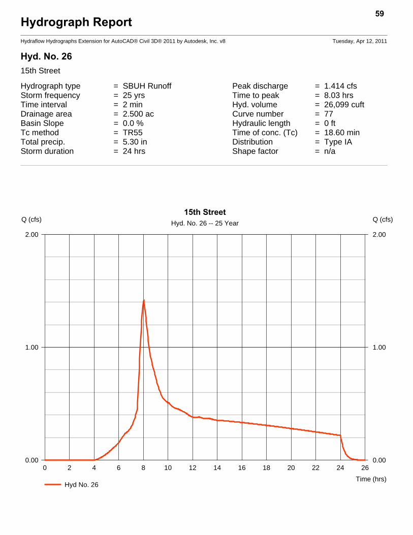
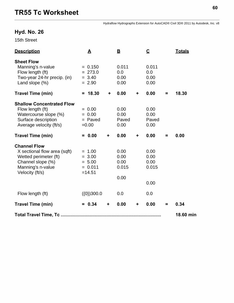
Hyd. No. 2615th Street
Hydrograph type = SBUH Runoff Peak discharge = 1.414 cfsStorm frequency = 25 yrs Time to peak = 8.03 hrsTime interval = 2 min Hyd. volume = 26,099 cuftDrainage area = 2.500 ac Curve number = 77Basin Slope = 0.0 % Hydraulic length = 0 ftTc method = TR55 Time of conc. (Tc) = 18.60 minTotal precip. = 5.30 in Distribution = Type IAStorm duration = 24 hrs Shape factor = n/a
59
0 2 4 6 8 10 12 14 16 18 20 22 24 26
Q (cfs)
0.00 0.00
1.00 1.00
2.00 2.00
Q (cfs)
Time (hrs)
15th StreetHyd. No. 26 -- 25 Year
Hyd No. 26
TR55 Tc Worksheet60
Hydraflow Hydrographs Extension for AutoCAD® Civil 3D® 2011 by Autodesk, Inc. v8
Hyd. No. 2615th Street
Description A B C Totals
Sheet FlowManning's n-value = 0.150 0.011 0.011Flow length (ft) = 273.0 0.0 0.0Two-year 24-hr precip. (in) = 3.40 0.00 0.00Land slope (%) = 2.90 0.00 0.00
Travel Time (min) = 18.30 + 0.00 + 0.00 = 18.30
Shallow Concentrated FlowFlow length (ft) = 0.00 0.00 0.00Watercourse slope (%) = 0.00 0.00 0.00Surface description = Paved Paved PavedAverage velocity (ft/s) =0.00 0.00 0.00
Travel Time (min) = 0.00 + 0.00 + 0.00 = 0.00
Channel FlowX sectional flow area (sqft) = 1.00 0.00 0.00Wetted perimeter (ft) = 3.00 0.00 0.00Channel slope (%) = 5.00 0.00 0.00Manning's n-value = 0.011 0.015 0.015Velocity (ft/s) =14.51
0.000.00
Flow length (ft) ({0})300.0 0.0 0.0
Travel Time (min) = 0.34 + 0.00 + 0.00 = 0.34
Total Travel Time, Tc .............................................................................. 18.60 min
Hydrograph ReportHydraflow Hydrographs Extension for AutoCAD® Civil 3D® 2011 by Autodesk, Inc. v8 Tuesday, Apr 12, 2011
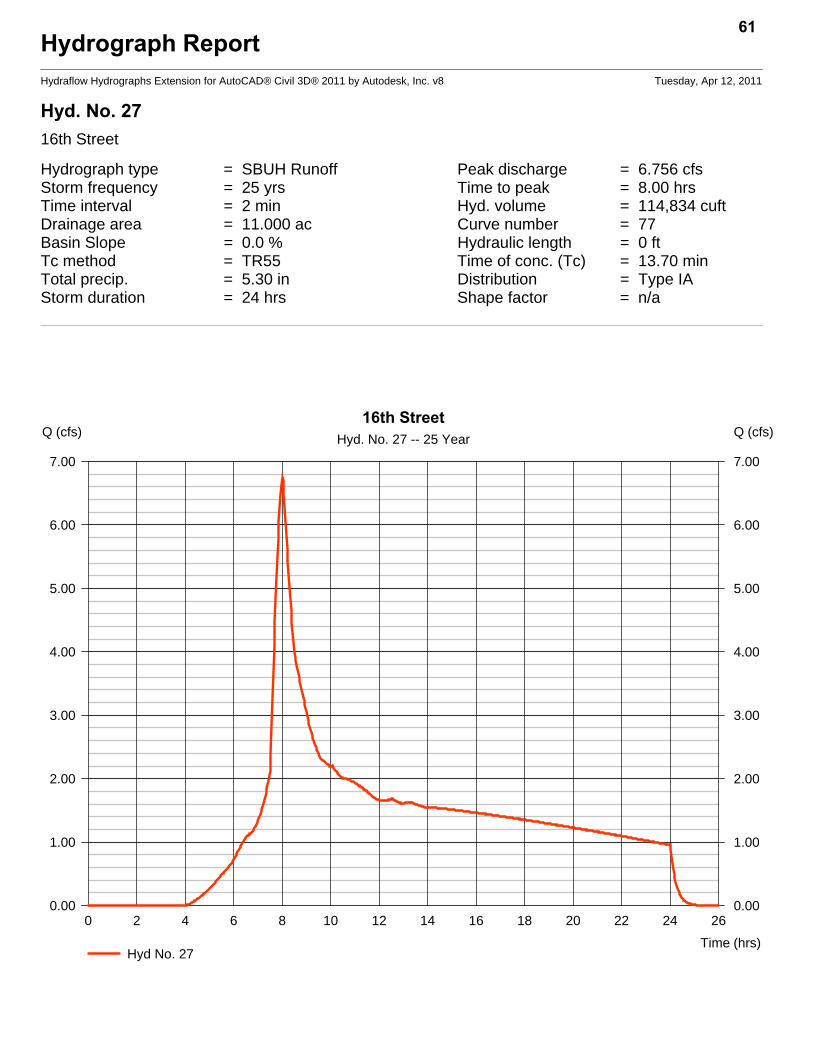
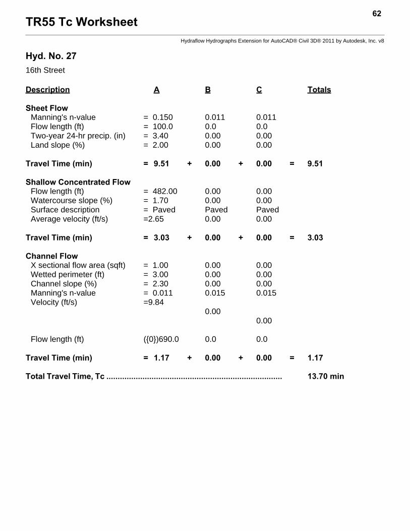
Hyd. No. 2716th Street
Hydrograph type = SBUH Runoff Peak discharge = 6.756 cfsStorm frequency = 25 yrs Time to peak = 8.00 hrsTime interval = 2 min Hyd. volume = 114,834 cuftDrainage area = 11.000 ac Curve number = 77Basin Slope = 0.0 % Hydraulic length = 0 ftTc method = TR55 Time of conc. (Tc) = 13.70 minTotal precip. = 5.30 in Distribution = Type IAStorm duration = 24 hrs Shape factor = n/a
61
0 2 4 6 8 10 12 14 16 18 20 22 24 26
Q (cfs)
0.00 0.00
1.00 1.00
2.00 2.00
3.00 3.00
4.00 4.00
5.00 5.00
6.00 6.00
7.00 7.00
Q (cfs)
Time (hrs)
16th StreetHyd. No. 27 -- 25 Year
Hyd No. 27
TR55 Tc Worksheet62
Hydraflow Hydrographs Extension for AutoCAD® Civil 3D® 2011 by Autodesk, Inc. v8
Hyd. No. 2716th Street
Description A B C Totals
Sheet FlowManning's n-value = 0.150 0.011 0.011Flow length (ft) = 100.0 0.0 0.0Two-year 24-hr precip. (in) = 3.40 0.00 0.00Land slope (%) = 2.00 0.00 0.00
Travel Time (min) = 9.51 + 0.00 + 0.00 = 9.51
Shallow Concentrated FlowFlow length (ft) = 482.00 0.00 0.00Watercourse slope (%) = 1.70 0.00 0.00Surface description = Paved Paved PavedAverage velocity (ft/s) =2.65 0.00 0.00
Travel Time (min) = 3.03 + 0.00 + 0.00 = 3.03
Channel FlowX sectional flow area (sqft) = 1.00 0.00 0.00Wetted perimeter (ft) = 3.00 0.00 0.00Channel slope (%) = 2.30 0.00 0.00Manning's n-value = 0.011 0.015 0.015Velocity (ft/s) =9.84
0.000.00
Flow length (ft) ({0})690.0 0.0 0.0
Travel Time (min) = 1.17 + 0.00 + 0.00 = 1.17
Total Travel Time, Tc .............................................................................. 13.70 min
Hydrograph ReportHydraflow Hydrographs Extension for AutoCAD® Civil 3D® 2011 by Autodesk, Inc. v8 Tuesday, Apr 12, 2011
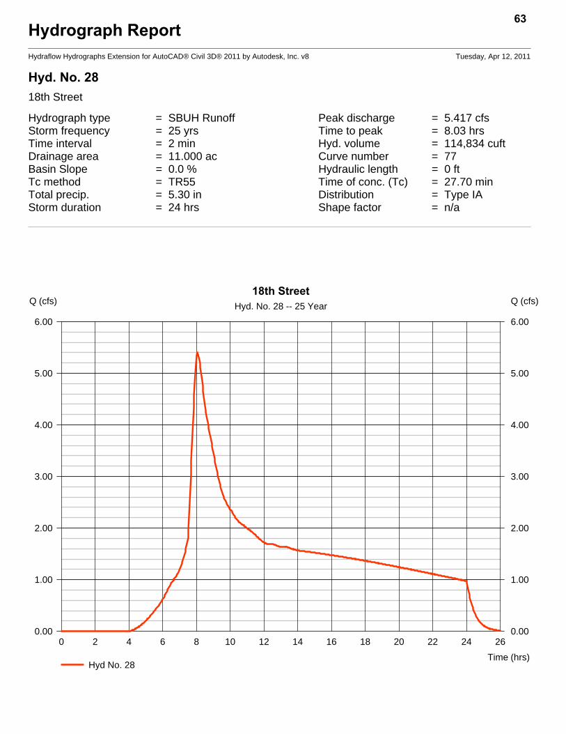
Hyd. No. 2818th Street
Hydrograph type = SBUH Runoff Peak discharge = 5.417 cfsStorm frequency = 25 yrs Time to peak = 8.03 hrsTime interval = 2 min Hyd. volume = 114,834 cuftDrainage area = 11.000 ac Curve number = 77Basin Slope = 0.0 % Hydraulic length = 0 ftTc method = TR55 Time of conc. (Tc) = 27.70 minTotal precip. = 5.30 in Distribution = Type IAStorm duration = 24 hrs Shape factor = n/a
63
0 2 4 6 8 10 12 14 16 18 20 22 24 26
Q (cfs)
0.00 0.00
1.00 1.00
2.00 2.00
3.00 3.00
4.00 4.00
5.00 5.00
6.00 6.00
Q (cfs)
Time (hrs)
18th StreetHyd. No. 28 -- 25 Year
Hyd No. 28

TR55 Tc Worksheet64
Hydraflow Hydrographs Extension for AutoCAD® Civil 3D® 2011 by Autodesk, Inc. v8
Hyd. No. 2818th Street
Description A B C Totals
Sheet FlowManning's n-value = 0.150 0.011 0.011Flow length (ft) = 160.0 0.0 0.0Two-year 24-hr precip. (in) = 3.40 0.00 0.00Land slope (%) = 0.60 0.00 0.00
Travel Time (min) = 22.41 + 0.00 + 0.00 = 22.41
Shallow Concentrated FlowFlow length (ft) = 700.00 0.00 0.00Watercourse slope (%) = 1.60 0.00 0.00Surface description = Paved Paved PavedAverage velocity (ft/s) =2.57 0.00 0.00
Travel Time (min) = 4.54 + 0.00 + 0.00 = 4.54
Channel FlowX sectional flow area (sqft) = 1.00 0.00 0.00Wetted perimeter (ft) = 3.00 0.00 0.00Channel slope (%) = 2.60 0.00 0.00Manning's n-value = 0.011 0.015 0.015Velocity (ft/s) =10.46
0.000.00
Flow length (ft) ({0})469.0 0.0 0.0
Travel Time (min) = 0.75 + 0.00 + 0.00 = 0.75
Total Travel Time, Tc .............................................................................. 27.70 min

Hydrograph ReportHydraflow Hydrographs Extension for AutoCAD® Civil 3D® 2011 by Autodesk, Inc. v8 Tuesday, Apr 12, 2011
Hyd. No. 2921st St
Hydrograph type = SBUH Runoff Peak discharge = 1.789 cfsStorm frequency = 25 yrs Time to peak = 9.00 hrsTime interval = 2 min Hyd. volume = 90,681 cuftDrainage area = 23.400 ac Curve number = 54Basin Slope = 0.0 % Hydraulic length = 0 ftTc method = TR55 Time of conc. (Tc) = 31.60 minTotal precip. = 5.30 in Distribution = Type IAStorm duration = 24 hrs Shape factor = n/a
65
0 2 4 6 8 10 12 14 16 18 20 22 24 26 28
Q (cfs)
0.00 0.00
1.00 1.00
2.00 2.00
Q (cfs)
Time (hrs)
21st StHyd. No. 29 -- 25 Year
Hyd No. 29

TR55 Tc Worksheet66
Hydraflow Hydrographs Extension for AutoCAD® Civil 3D® 2011 by Autodesk, Inc. v8
Hyd. No. 2921st St
Description A B C Totals
Sheet FlowManning's n-value = 0.150 0.011 0.011Flow length (ft) = 212.0 0.0 0.0Two-year 24-hr precip. (in) = 3.40 0.00 0.00Land slope (%) = 1.90 0.00 0.00
Travel Time (min) = 17.70 + 0.00 + 0.00 = 17.70
Shallow Concentrated FlowFlow length (ft) = 600.00 0.00 0.00Watercourse slope (%) = 0.20 0.00 0.00Surface description = Unpaved Paved PavedAverage velocity (ft/s) =0.72 0.00 0.00
Travel Time (min) = 13.86 + 0.00 + 0.00 = 13.86
Channel FlowX sectional flow area (sqft) = 0.00 0.00 0.00Wetted perimeter (ft) = 0.00 0.00 0.00Channel slope (%) = 0.00 0.00 0.00Manning's n-value = 0.011 0.015 0.015Velocity (ft/s) =0.00
0.000.00
Flow length (ft) ({0})0.0 0.0 0.0
Travel Time (min) = 0.00 + 0.00 + 0.00 = 0.00
Total Travel Time, Tc .............................................................................. 31.60 min
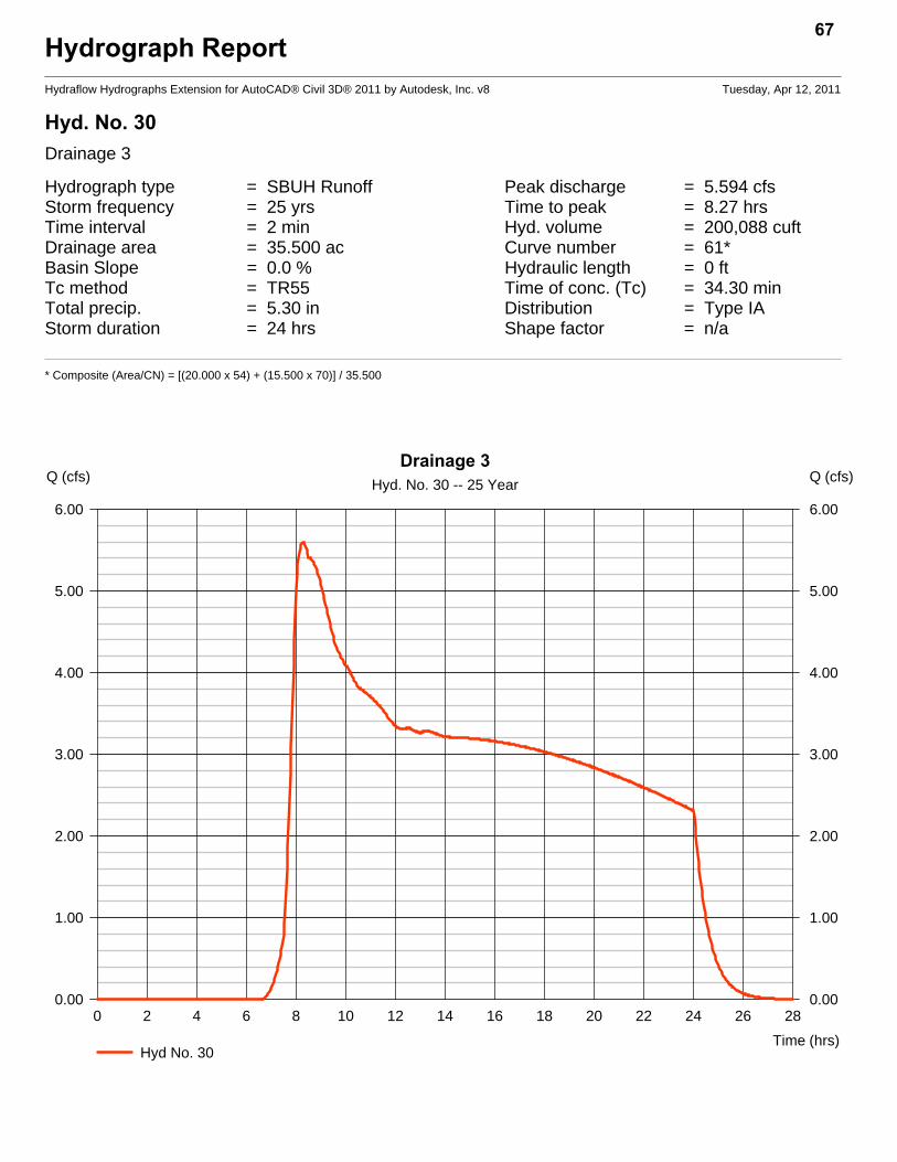
Hydrograph ReportHydraflow Hydrographs Extension for AutoCAD® Civil 3D® 2011 by Autodesk, Inc. v8 Tuesday, Apr 12, 2011
Hyd. No. 30Drainage 3
Hydrograph type = SBUH Runoff Peak discharge = 5.594 cfsStorm frequency = 25 yrs Time to peak = 8.27 hrsTime interval = 2 min Hyd. volume = 200,088 cuftDrainage area = 35.500 ac Curve number = 61*Basin Slope = 0.0 % Hydraulic length = 0 ftTc method = TR55 Time of conc. (Tc) = 34.30 minTotal precip. = 5.30 in Distribution = Type IAStorm duration = 24 hrs Shape factor = n/a
* Composite (Area/CN) = [(20.000 x 54) + (15.500 x 70)] / 35.500
67
0 2 4 6 8 10 12 14 16 18 20 22 24 26 28
Q (cfs)
0.00 0.00
1.00 1.00
2.00 2.00
3.00 3.00
4.00 4.00
5.00 5.00
6.00 6.00
Q (cfs)
Time (hrs)
Drainage 3Hyd. No. 30 -- 25 Year
Hyd No. 30

TR55 Tc Worksheet68
Hydraflow Hydrographs Extension for AutoCAD® Civil 3D® 2011 by Autodesk, Inc. v8
Hyd. No. 30Drainage 3
Description A B C Totals
Sheet FlowManning's n-value = 0.150 0.011 0.011Flow length (ft) = 212.0 0.0 0.0Two-year 24-hr precip. (in) = 3.40 0.00 0.00Land slope (%) = 1.90 0.00 0.00
Travel Time (min) = 17.70 + 0.00 + 0.00 = 17.70
Shallow Concentrated FlowFlow length (ft) = 1720.00 0.00 0.00Watercourse slope (%) = 1.20 0.00 0.00Surface description = Unpaved Paved PavedAverage velocity (ft/s) =1.77 0.00 0.00
Travel Time (min) = 16.22 + 0.00 + 0.00 = 16.22
Channel FlowX sectional flow area (sqft) = 1.00 0.00 0.00Wetted perimeter (ft) = 3.00 0.00 0.00Channel slope (%) = 5.00 0.00 0.00Manning's n-value = 0.011 0.015 0.015Velocity (ft/s) =14.51
0.000.00
Flow length (ft) ({0})300.0 0.0 0.0
Travel Time (min) = 0.34 + 0.00 + 0.00 = 0.34
Total Travel Time, Tc .............................................................................. 34.30 min
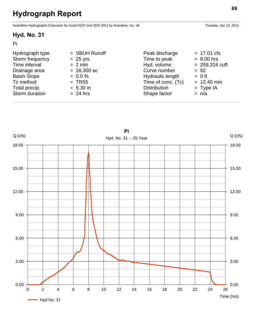
Hydrograph ReportHydraflow Hydrographs Extension for AutoCAD® Civil 3D® 2011 by Autodesk, Inc. v8 Tuesday, Apr 12, 2011
Hyd. No. 31Pi
Hydrograph type = SBUH Runoff Peak discharge = 17.01 cfsStorm frequency = 25 yrs Time to peak = 8.00 hrsTime interval = 2 min Hyd. volume = 259,316 cuftDrainage area = 16.300 ac Curve number = 92Basin Slope = 0.0 % Hydraulic length = 0 ftTc method = TR55 Time of conc. (Tc) = 12.40 minTotal precip. = 5.30 in Distribution = Type IAStorm duration = 24 hrs Shape factor = n/a
69
0 2 4 6 8 10 12 14 16 18 20 22 24 26
Q (cfs)
0.00 0.00
3.00 3.00
6.00 6.00
9.00 9.00
12.00 12.00
15.00 15.00
18.00 18.00
Q (cfs)
Time (hrs)
PiHyd. No. 31 -- 25 Year
Hyd No. 31
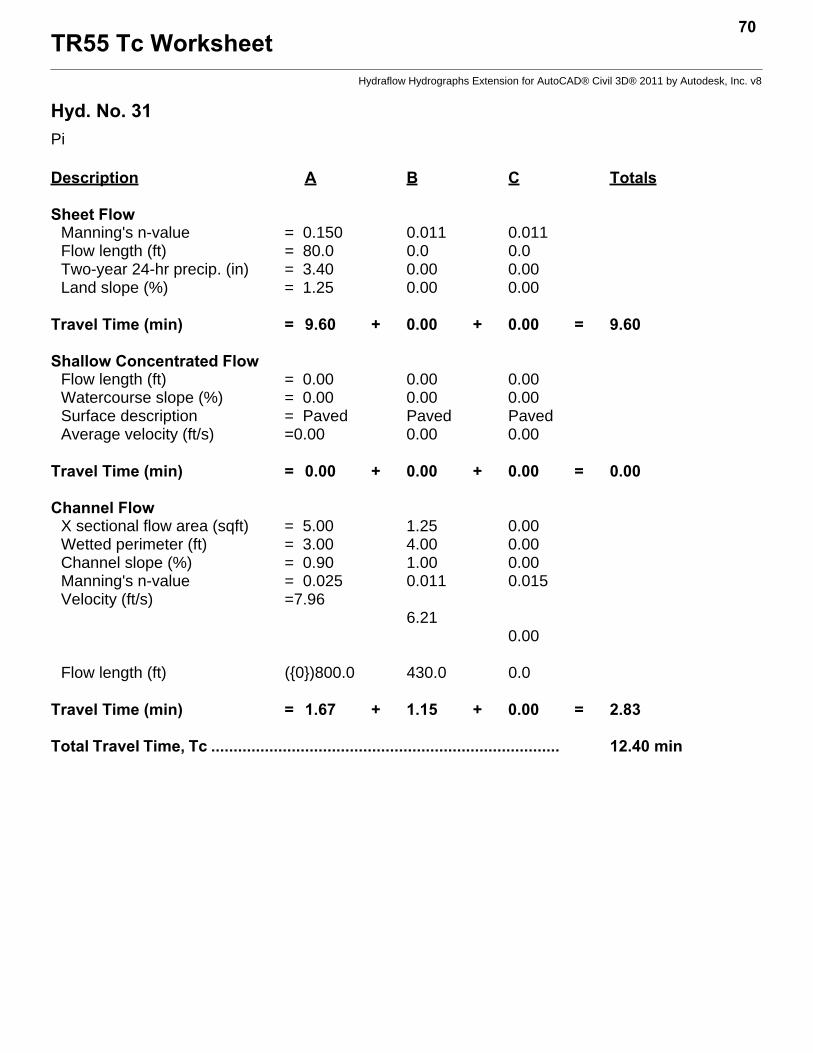
TR55 Tc Worksheet70
Hydraflow Hydrographs Extension for AutoCAD® Civil 3D® 2011 by Autodesk, Inc. v8
Hyd. No. 31Pi
Description A B C Totals
Sheet FlowManning's n-value = 0.150 0.011 0.011Flow length (ft) = 80.0 0.0 0.0Two-year 24-hr precip. (in) = 3.40 0.00 0.00Land slope (%) = 1.25 0.00 0.00
Travel Time (min) = 9.60 + 0.00 + 0.00 = 9.60
Shallow Concentrated FlowFlow length (ft) = 0.00 0.00 0.00Watercourse slope (%) = 0.00 0.00 0.00Surface description = Paved Paved PavedAverage velocity (ft/s) =0.00 0.00 0.00
Travel Time (min) = 0.00 + 0.00 + 0.00 = 0.00
Channel FlowX sectional flow area (sqft) = 5.00 1.25 0.00Wetted perimeter (ft) = 3.00 4.00 0.00Channel slope (%) = 0.90 1.00 0.00Manning's n-value = 0.025 0.011 0.015Velocity (ft/s) =7.96
6.210.00
Flow length (ft) ({0})800.0 430.0 0.0
Travel Time (min) = 1.67 + 1.15 + 0.00 = 2.83
Total Travel Time, Tc .............................................................................. 12.40 min
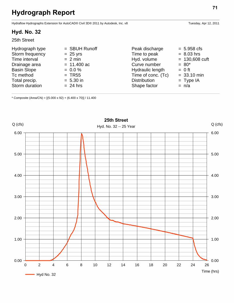
Hydrograph ReportHydraflow Hydrographs Extension for AutoCAD® Civil 3D® 2011 by Autodesk, Inc. v8 Tuesday, Apr 12, 2011
Hyd. No. 3225th Street
Hydrograph type = SBUH Runoff Peak discharge = 5.958 cfsStorm frequency = 25 yrs Time to peak = 8.03 hrsTime interval = 2 min Hyd. volume = 130,608 cuftDrainage area = 11.400 ac Curve number = 80*Basin Slope = 0.0 % Hydraulic length = 0 ftTc method = TR55 Time of conc. (Tc) = 33.10 minTotal precip. = 5.30 in Distribution = Type IAStorm duration = 24 hrs Shape factor = n/a
* Composite (Area/CN) = [(5.000 x 92) + (6.400 x 70)] / 11.400
71
0 2 4 6 8 10 12 14 16 18 20 22 24 26
Q (cfs)
0.00 0.00
1.00 1.00
2.00 2.00
3.00 3.00
4.00 4.00
5.00 5.00
6.00 6.00
Q (cfs)
Time (hrs)
25th StreetHyd. No. 32 -- 25 Year
Hyd No. 32

TR55 Tc Worksheet72
Hydraflow Hydrographs Extension for AutoCAD® Civil 3D® 2011 by Autodesk, Inc. v8
Hyd. No. 3225th Street
Description A B C Totals
Sheet FlowManning's n-value = 0.150 0.011 0.011Flow length (ft) = 200.0 0.0 0.0Two-year 24-hr precip. (in) = 3.40 0.00 0.00Land slope (%) = 1.50 0.00 0.00
Travel Time (min) = 18.57 + 0.00 + 0.00 = 18.57
Shallow Concentrated FlowFlow length (ft) = 1300.00 0.00 0.00Watercourse slope (%) = 0.90 0.00 0.00Surface description = Unpaved Paved PavedAverage velocity (ft/s) =1.53 0.00 0.00
Travel Time (min) = 14.16 + 0.00 + 0.00 = 14.16
Channel FlowX sectional flow area (sqft) = 1.00 0.00 0.00Wetted perimeter (ft) = 3.00 0.00 0.00Channel slope (%) = 5.00 0.00 0.00Manning's n-value = 0.011 0.015 0.015Velocity (ft/s) =14.51
0.000.00
Flow length (ft) ({0})300.0 0.0 0.0
Travel Time (min) = 0.34 + 0.00 + 0.00 = 0.34
Total Travel Time, Tc .............................................................................. 33.10 min
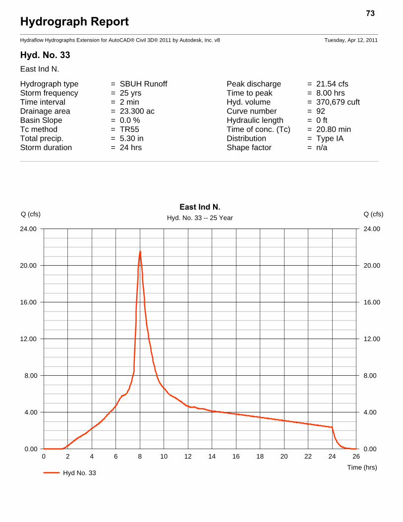
Hydrograph ReportHydraflow Hydrographs Extension for AutoCAD® Civil 3D® 2011 by Autodesk, Inc. v8 Tuesday, Apr 12, 2011
Hyd. No. 33East Ind N.
Hydrograph type = SBUH Runoff Peak discharge = 21.54 cfsStorm frequency = 25 yrs Time to peak = 8.00 hrsTime interval = 2 min Hyd. volume = 370,679 cuftDrainage area = 23.300 ac Curve number = 92Basin Slope = 0.0 % Hydraulic length = 0 ftTc method = TR55 Time of conc. (Tc) = 20.80 minTotal precip. = 5.30 in Distribution = Type IAStorm duration = 24 hrs Shape factor = n/a
73
0 2 4 6 8 10 12 14 16 18 20 22 24 26
Q (cfs)
0.00 0.00
4.00 4.00
8.00 8.00
12.00 12.00
16.00 16.00
20.00 20.00
24.00 24.00
Q (cfs)
Time (hrs)
East Ind N.Hyd. No. 33 -- 25 Year
Hyd No. 33

TR55 Tc Worksheet74
Hydraflow Hydrographs Extension for AutoCAD® Civil 3D® 2011 by Autodesk, Inc. v8
Hyd. No. 33East Ind N.
Description A B C Totals
Sheet FlowManning's n-value = 0.150 0.011 0.011Flow length (ft) = 100.0 0.0 0.0Two-year 24-hr precip. (in) = 3.40 0.00 0.00Land slope (%) = 1.00 0.00 0.00
Travel Time (min) = 12.54 + 0.00 + 0.00 = 12.54
Shallow Concentrated FlowFlow length (ft) = 1100.00 0.00 0.00Watercourse slope (%) = 1.20 0.00 0.00Surface description = Paved Paved PavedAverage velocity (ft/s) =2.23 0.00 0.00
Travel Time (min) = 8.23 + 0.00 + 0.00 = 8.23
Channel FlowX sectional flow area (sqft) = 0.00 0.00 0.00Wetted perimeter (ft) = 0.00 0.00 0.00Channel slope (%) = 0.00 0.00 0.00Manning's n-value = 0.011 0.015 0.015Velocity (ft/s) =0.00
0.000.00
Flow length (ft) ({0})0.0 0.0 0.0
Travel Time (min) = 0.00 + 0.00 + 0.00 = 0.00
Total Travel Time, Tc .............................................................................. 20.80 min
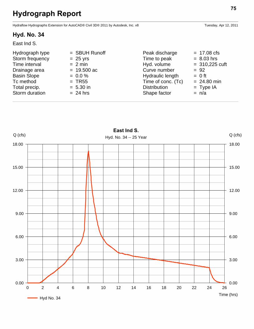
Hydrograph ReportHydraflow Hydrographs Extension for AutoCAD® Civil 3D® 2011 by Autodesk, Inc. v8 Tuesday, Apr 12, 2011
Hyd. No. 34East Ind S.
Hydrograph type = SBUH Runoff Peak discharge = 17.08 cfsStorm frequency = 25 yrs Time to peak = 8.03 hrsTime interval = 2 min Hyd. volume = 310,225 cuftDrainage area = 19.500 ac Curve number = 92Basin Slope = 0.0 % Hydraulic length = 0 ftTc method = TR55 Time of conc. (Tc) = 24.80 minTotal precip. = 5.30 in Distribution = Type IAStorm duration = 24 hrs Shape factor = n/a
75
0 2 4 6 8 10 12 14 16 18 20 22 24 26
Q (cfs)
0.00 0.00
3.00 3.00
6.00 6.00
9.00 9.00
12.00 12.00
15.00 15.00
18.00 18.00
Q (cfs)
Time (hrs)
East Ind S.Hyd. No. 34 -- 25 Year
Hyd No. 34
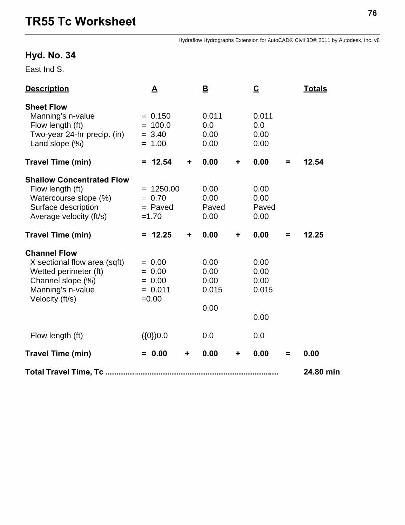
TR55 Tc Worksheet76
Hydraflow Hydrographs Extension for AutoCAD® Civil 3D® 2011 by Autodesk, Inc. v8
Hyd. No. 34East Ind S.
Description A B C Totals
Sheet FlowManning's n-value = 0.150 0.011 0.011Flow length (ft) = 100.0 0.0 0.0Two-year 24-hr precip. (in) = 3.40 0.00 0.00Land slope (%) = 1.00 0.00 0.00
Travel Time (min) = 12.54 + 0.00 + 0.00 = 12.54
Shallow Concentrated FlowFlow length (ft) = 1250.00 0.00 0.00Watercourse slope (%) = 0.70 0.00 0.00Surface description = Paved Paved PavedAverage velocity (ft/s) =1.70 0.00 0.00
Travel Time (min) = 12.25 + 0.00 + 0.00 = 12.25
Channel FlowX sectional flow area (sqft) = 0.00 0.00 0.00Wetted perimeter (ft) = 0.00 0.00 0.00Channel slope (%) = 0.00 0.00 0.00Manning's n-value = 0.011 0.015 0.015Velocity (ft/s) =0.00
0.000.00
Flow length (ft) ({0})0.0 0.0 0.0
Travel Time (min) = 0.00 + 0.00 + 0.00 = 0.00
Total Travel Time, Tc .............................................................................. 24.80 min
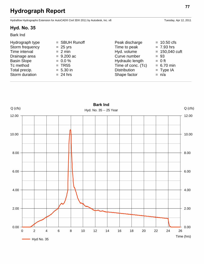
Hydrograph ReportHydraflow Hydrographs Extension for AutoCAD® Civil 3D® 2011 by Autodesk, Inc. v8 Tuesday, Apr 12, 2011
Hyd. No. 35Bark Ind
Hydrograph type = SBUH Runoff Peak discharge = 10.50 cfsStorm frequency = 25 yrs Time to peak = 7.93 hrsTime interval = 2 min Hyd. volume = 150,040 cuftDrainage area = 9.200 ac Curve number = 93Basin Slope = 0.0 % Hydraulic length = 0 ftTc method = TR55 Time of conc. (Tc) = 6.70 minTotal precip. = 5.30 in Distribution = Type IAStorm duration = 24 hrs Shape factor = n/a
77
0 2 4 6 8 10 12 14 16 18 20 22 24 26
Q (cfs)
0.00 0.00
2.00 2.00
4.00 4.00
6.00 6.00
8.00 8.00
10.00 10.00
12.00 12.00
Q (cfs)
Time (hrs)
Bark IndHyd. No. 35 -- 25 Year
Hyd No. 35
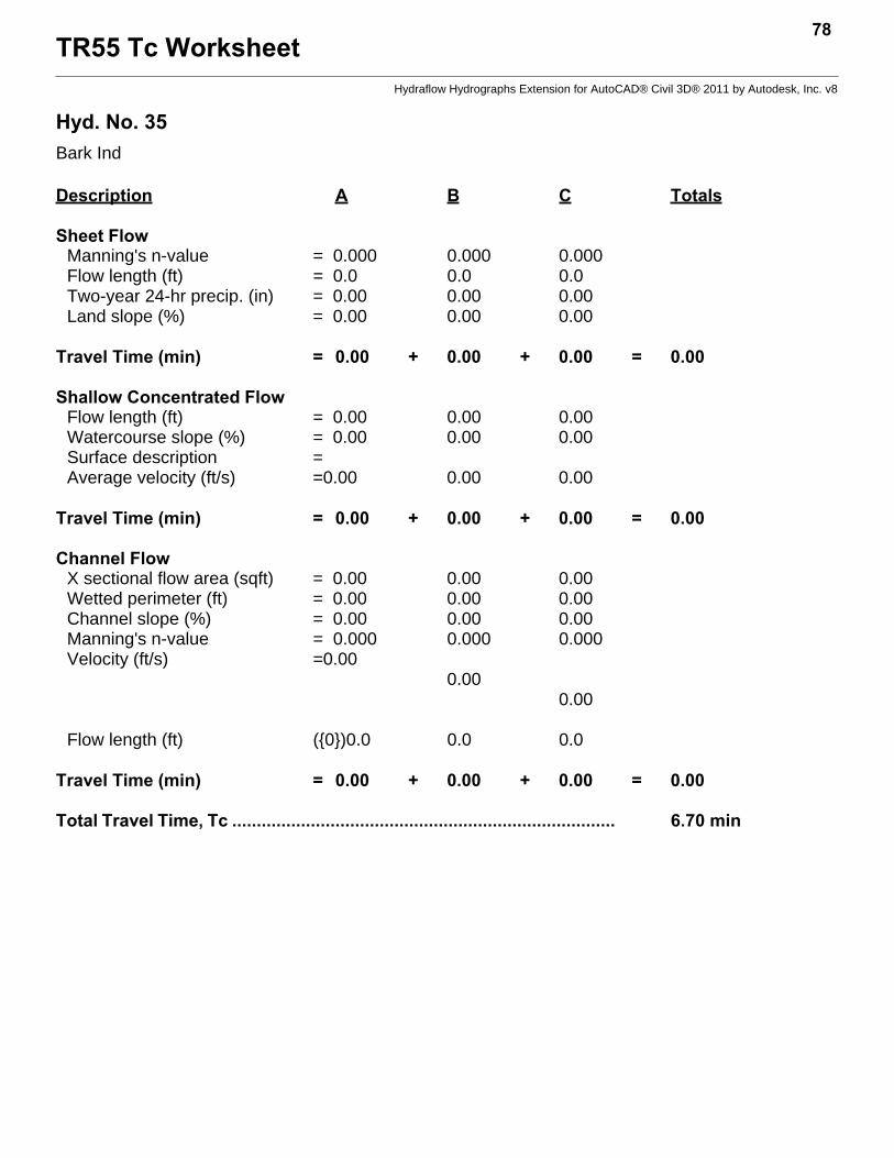
TR55 Tc Worksheet78
Hydraflow Hydrographs Extension for AutoCAD® Civil 3D® 2011 by Autodesk, Inc. v8
Hyd. No. 35Bark Ind
Description A B C Totals
Sheet FlowManning's n-value = 0.000 0.000 0.000Flow length (ft) = 0.0 0.0 0.0Two-year 24-hr precip. (in) = 0.00 0.00 0.00Land slope (%) = 0.00 0.00 0.00
Travel Time (min) = 0.00 + 0.00 + 0.00 = 0.00
Shallow Concentrated FlowFlow length (ft) = 0.00 0.00 0.00Watercourse slope (%) = 0.00 0.00 0.00Surface description =Average velocity (ft/s) =0.00 0.00 0.00
Travel Time (min) = 0.00 + 0.00 + 0.00 = 0.00
Channel FlowX sectional flow area (sqft) = 0.00 0.00 0.00Wetted perimeter (ft) = 0.00 0.00 0.00Channel slope (%) = 0.00 0.00 0.00Manning's n-value = 0.000 0.000 0.000Velocity (ft/s) =0.00
0.000.00
Flow length (ft) ({0})0.0 0.0 0.0
Travel Time (min) = 0.00 + 0.00 + 0.00 = 0.00
Total Travel Time, Tc .............................................................................. 6.70 min
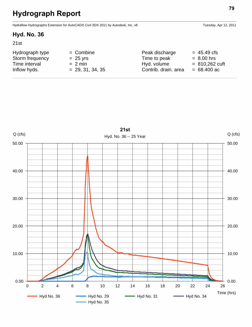
Hydrograph ReportHydraflow Hydrographs Extension for AutoCAD® Civil 3D® 2011 by Autodesk, Inc. v8 Tuesday, Apr 12, 2011
Hyd. No. 3621st
Hydrograph type = Combine Peak discharge = 45.49 cfsStorm frequency = 25 yrs Time to peak = 8.00 hrsTime interval = 2 min Hyd. volume = 810,262 cuftInflow hyds. = 29, 31, 34, 35 Contrib. drain. area = 68.400 ac
79
0 2 4 6 8 10 12 14 16 18 20 22 24 26
Q (cfs)
0.00 0.00
10.00 10.00
20.00 20.00
30.00 30.00
40.00 40.00
50.00 50.00
Q (cfs)
Time (hrs)
21stHyd. No. 36 -- 25 Year
Hyd No. 36 Hyd No. 29 Hyd No. 31 Hyd No. 34Hyd No. 35
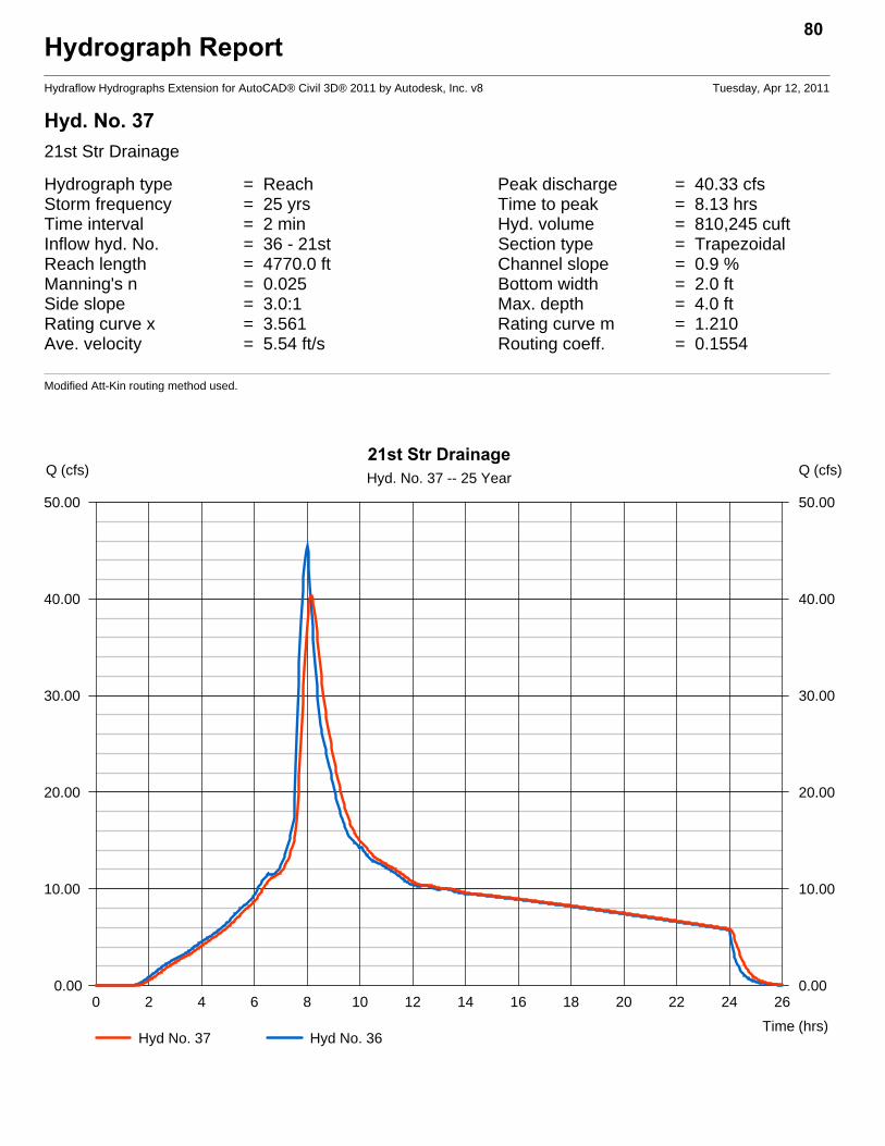
Hydrograph ReportHydraflow Hydrographs Extension for AutoCAD® Civil 3D® 2011 by Autodesk, Inc. v8 Tuesday, Apr 12, 2011
Hyd. No. 3721st Str Drainage
Hydrograph type = Reach Peak discharge = 40.33 cfsStorm frequency = 25 yrs Time to peak = 8.13 hrsTime interval = 2 min Hyd. volume = 810,245 cuftInflow hyd. No. = 36 - 21st Section type = TrapezoidalReach length = 4770.0 ft Channel slope = 0.9 %Manning's n = 0.025 Bottom width = 2.0 ftSide slope = 3.0:1 Max. depth = 4.0 ftRating curve x = 3.561 Rating curve m = 1.210Ave. velocity = 5.54 ft/s Routing coeff. = 0.1554
Modified Att-Kin routing method used.
80
0 2 4 6 8 10 12 14 16 18 20 22 24 26
Q (cfs)
0.00 0.00
10.00 10.00
20.00 20.00
30.00 30.00
40.00 40.00
50.00 50.00
Q (cfs)
Time (hrs)
21st Str DrainageHyd. No. 37 -- 25 Year
Hyd No. 37 Hyd No. 36
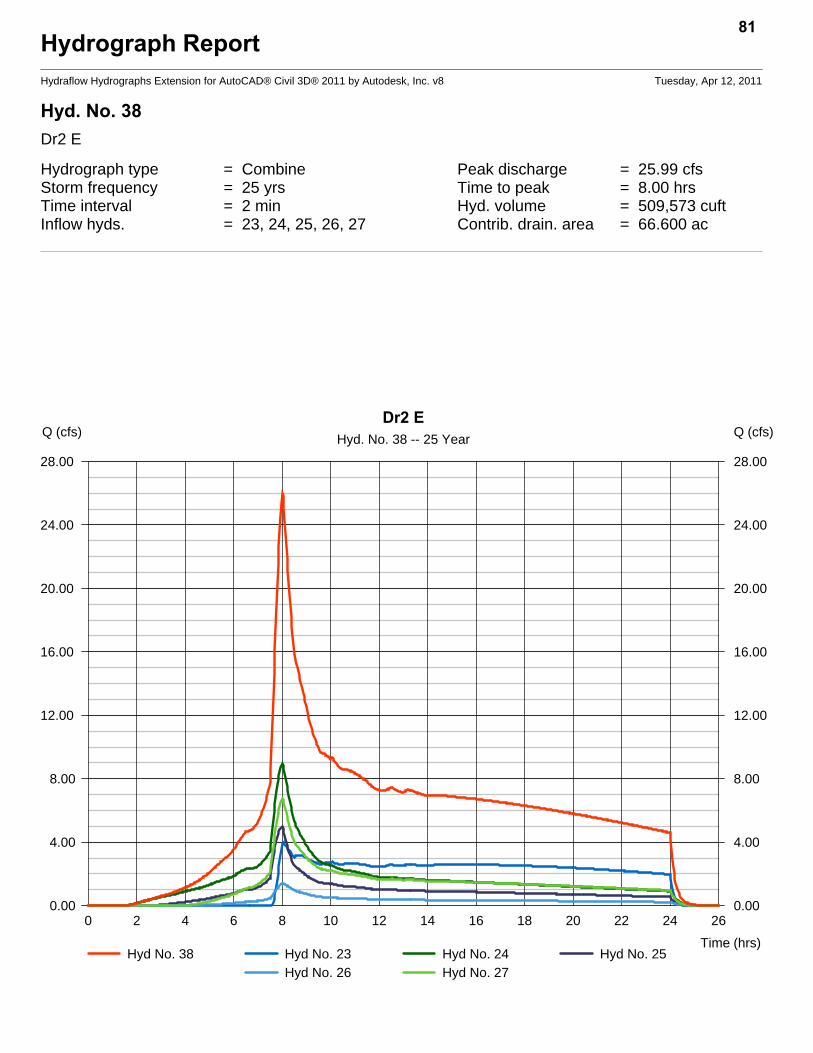
Hydrograph ReportHydraflow Hydrographs Extension for AutoCAD® Civil 3D® 2011 by Autodesk, Inc. v8 Tuesday, Apr 12, 2011
Hyd. No. 38Dr2 E
Hydrograph type = Combine Peak discharge = 25.99 cfsStorm frequency = 25 yrs Time to peak = 8.00 hrsTime interval = 2 min Hyd. volume = 509,573 cuftInflow hyds. = 23, 24, 25, 26, 27 Contrib. drain. area = 66.600 ac
81
0 2 4 6 8 10 12 14 16 18 20 22 24 26
Q (cfs)
0.00 0.00
4.00 4.00
8.00 8.00
12.00 12.00
16.00 16.00
20.00 20.00
24.00 24.00
28.00 28.00
Q (cfs)
Time (hrs)
Dr2 EHyd. No. 38 -- 25 Year
Hyd No. 38 Hyd No. 23 Hyd No. 24 Hyd No. 25Hyd No. 26 Hyd No. 27

Hydrograph ReportHydraflow Hydrographs Extension for AutoCAD® Civil 3D® 2011 by Autodesk, Inc. v8 Tuesday, Apr 12, 2011
Hyd. No. 39Dr2
Hydrograph type = Reach Peak discharge = 23.46 cfsStorm frequency = 25 yrs Time to peak = 8.13 hrsTime interval = 2 min Hyd. volume = 509,564 cuftInflow hyd. No. = 38 - Dr2 E Section type = TrapezoidalReach length = 3000.0 ft Channel slope = 1.0 %Manning's n = 0.025 Bottom width = 2.0 ftSide slope = 6.0:1 Max. depth = 3.0 ftRating curve x = 3.754 Rating curve m = 1.147Ave. velocity = 4.81 ft/s Routing coeff. = 0.1988
Modified Att-Kin routing method used.
82
0 2 4 6 8 10 12 14 16 18 20 22 24 26
Q (cfs)
0.00 0.00
4.00 4.00
8.00 8.00
12.00 12.00
16.00 16.00
20.00 20.00
24.00 24.00
28.00 28.00
Q (cfs)
Time (hrs)
Dr2Hyd. No. 39 -- 25 Year
Hyd No. 39 Hyd No. 38

Hydrograph ReportHydraflow Hydrographs Extension for AutoCAD® Civil 3D® 2011 by Autodesk, Inc. v8 Tuesday, Apr 12, 2011
Hyd. No. 40Dr3
Hydrograph type = Combine Peak discharge = 32.67 cfsStorm frequency = 25 yrs Time to peak = 8.03 hrsTime interval = 2 min Hyd. volume = 701,376 cuftInflow hyds. = 30, 32, 33 Contrib. drain. area = 70.200 ac
83
0 2 4 6 8 10 12 14 16 18 20 22 24 26
Q (cfs)
0.00 0.00
5.00 5.00
10.00 10.00
15.00 15.00
20.00 20.00
25.00 25.00
30.00 30.00
35.00 35.00
Q (cfs)
Time (hrs)
Dr3Hyd. No. 40 -- 25 Year
Hyd No. 40 Hyd No. 30 Hyd No. 32 Hyd No. 33
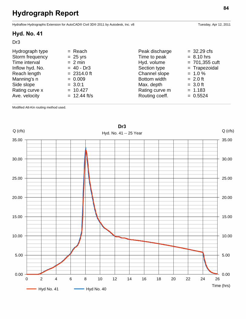
Hydrograph ReportHydraflow Hydrographs Extension for AutoCAD® Civil 3D® 2011 by Autodesk, Inc. v8 Tuesday, Apr 12, 2011
Hyd. No. 41Dr3
Hydrograph type = Reach Peak discharge = 32.29 cfsStorm frequency = 25 yrs Time to peak = 8.10 hrsTime interval = 2 min Hyd. volume = 701,355 cuftInflow hyd. No. = 40 - Dr3 Section type = TrapezoidalReach length = 2314.0 ft Channel slope = 1.0 %Manning's n = 0.009 Bottom width = 2.0 ftSide slope = 3.0:1 Max. depth = 3.0 ftRating curve x = 10.427 Rating curve m = 1.183Ave. velocity = 12.44 ft/s Routing coeff. = 0.5524
Modified Att-Kin routing method used.
84
0 2 4 6 8 10 12 14 16 18 20 22 24 26
Q (cfs)
0.00 0.00
5.00 5.00
10.00 10.00
15.00 15.00
20.00 20.00
25.00 25.00
30.00 30.00
35.00 35.00
Q (cfs)
Time (hrs)
Dr3Hyd. No. 41 -- 25 Year
Hyd No. 41 Hyd No. 40
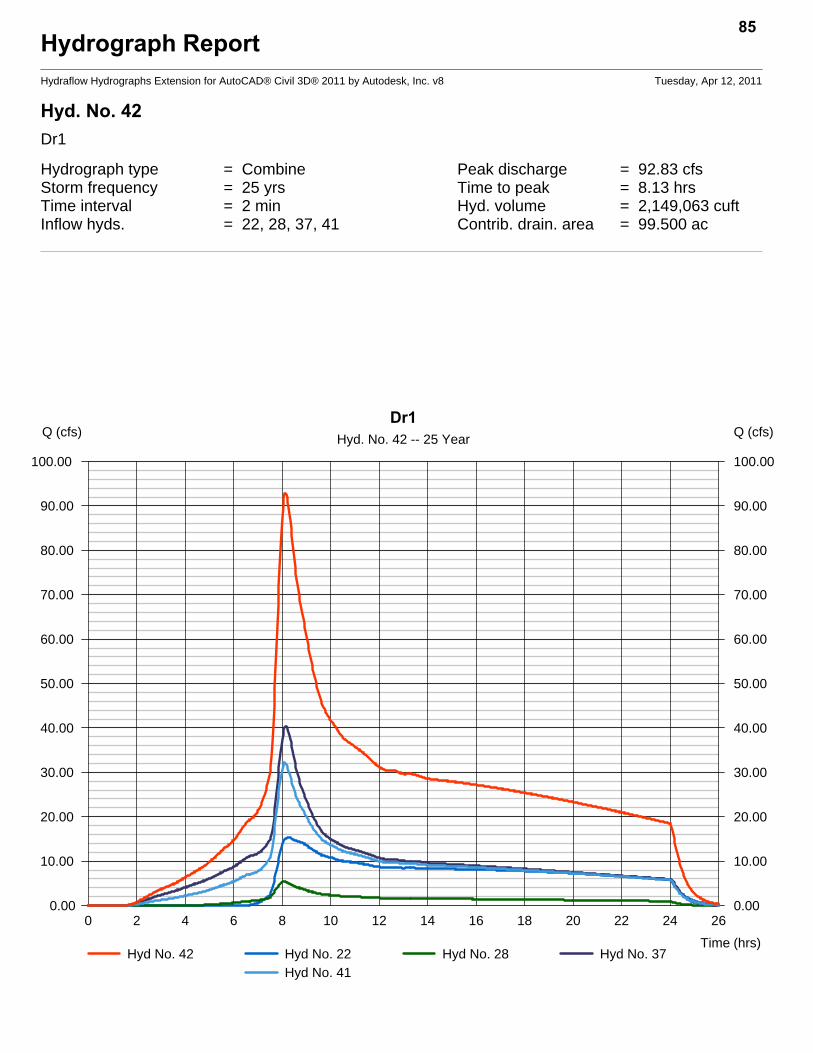
Hydrograph ReportHydraflow Hydrographs Extension for AutoCAD® Civil 3D® 2011 by Autodesk, Inc. v8 Tuesday, Apr 12, 2011
Hyd. No. 42Dr1
Hydrograph type = Combine Peak discharge = 92.83 cfsStorm frequency = 25 yrs Time to peak = 8.13 hrsTime interval = 2 min Hyd. volume = 2,149,063 cuftInflow hyds. = 22, 28, 37, 41 Contrib. drain. area = 99.500 ac
85
0 2 4 6 8 10 12 14 16 18 20 22 24 26
Q (cfs)
0.00 0.00
10.00 10.00
20.00 20.00
30.00 30.00
40.00 40.00
50.00 50.00
60.00 60.00
70.00 70.00
80.00 80.00
90.00 90.00
100.00 100.00
Q (cfs)
Time (hrs)
Dr1Hyd. No. 42 -- 25 Year
Hyd No. 42 Hyd No. 22 Hyd No. 28 Hyd No. 37Hyd No. 41
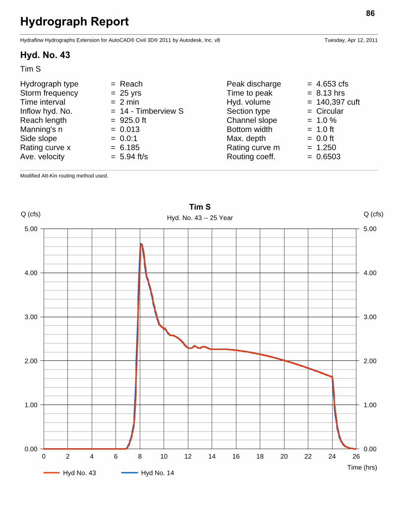
Hydrograph ReportHydraflow Hydrographs Extension for AutoCAD® Civil 3D® 2011 by Autodesk, Inc. v8 Tuesday, Apr 12, 2011
Hyd. No. 43Tim S
Hydrograph type = Reach Peak discharge = 4.653 cfsStorm frequency = 25 yrs Time to peak = 8.13 hrsTime interval = 2 min Hyd. volume = 140,397 cuftInflow hyd. No. = 14 - Timberview S Section type = CircularReach length = 925.0 ft Channel slope = 1.0 %Manning's n = 0.013 Bottom width = 1.0 ftSide slope = 0.0:1 Max. depth = 0.0 ftRating curve x = 6.185 Rating curve m = 1.250Ave. velocity = 5.94 ft/s Routing coeff. = 0.6503
Modified Att-Kin routing method used.
86
0 2 4 6 8 10 12 14 16 18 20 22 24 26
Q (cfs)
0.00 0.00
1.00 1.00
2.00 2.00
3.00 3.00
4.00 4.00
5.00 5.00
Q (cfs)
Time (hrs)
Tim SHyd. No. 43 -- 25 Year
Hyd No. 43 Hyd No. 14

Hydrograph ReportHydraflow Hydrographs Extension for AutoCAD® Civil 3D® 2011 by Autodesk, Inc. v8 Tuesday, Apr 12, 2011
Hyd. No. 44Q/C
Hydrograph type = Combine Peak discharge = 10.46 cfsStorm frequency = 25 yrs Time to peak = 8.03 hrsTime interval = 2 min Hyd. volume = 233,955 cuftInflow hyds. = 10, 11 Contrib. drain. area = 28.500 ac
87
0 2 4 6 8 10 12 14 16 18 20 22 24 26
Q (cfs)
0.00 0.00
2.00 2.00
4.00 4.00
6.00 6.00
8.00 8.00
10.00 10.00
12.00 12.00
Q (cfs)
Time (hrs)
Q/CHyd. No. 44 -- 25 Year
Hyd No. 44 Hyd No. 10 Hyd No. 11
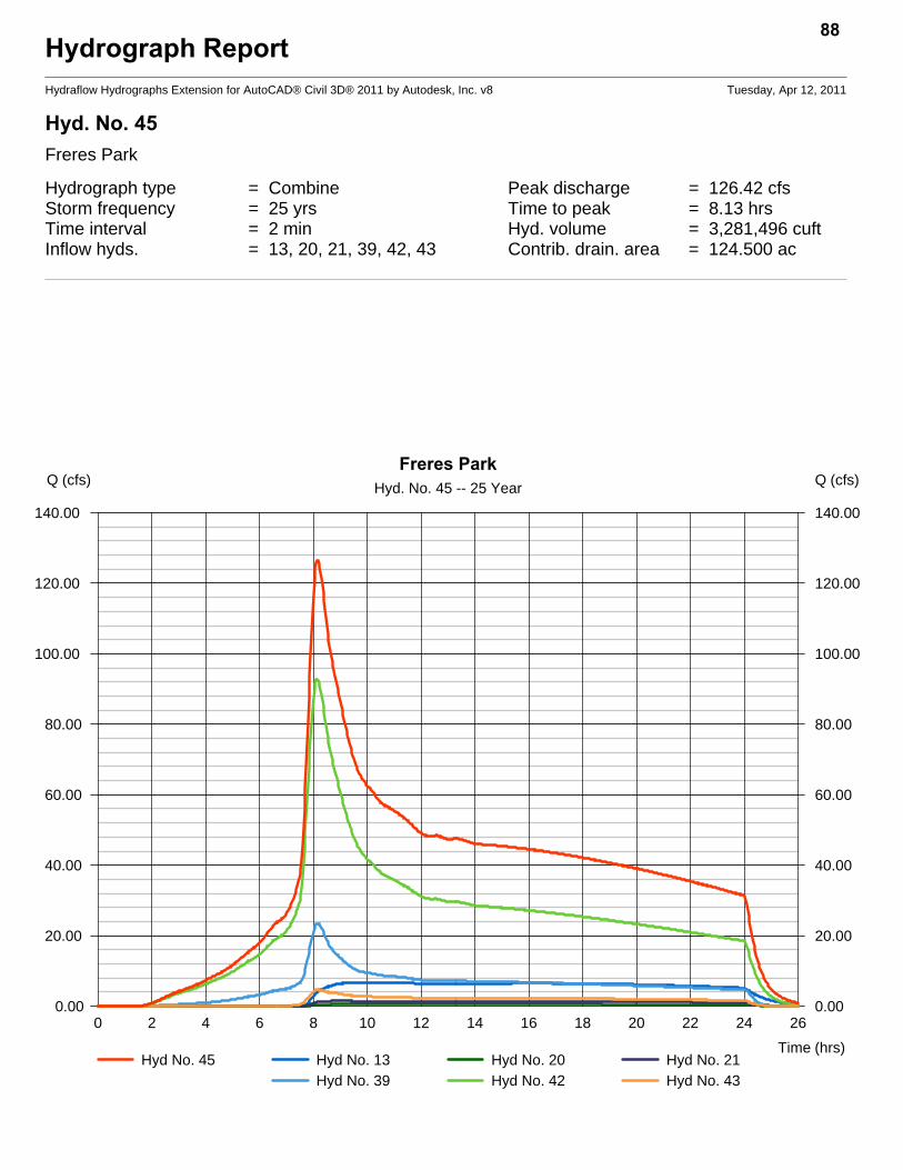
Hydrograph ReportHydraflow Hydrographs Extension for AutoCAD® Civil 3D® 2011 by Autodesk, Inc. v8 Tuesday, Apr 12, 2011
Hyd. No. 45Freres Park
Hydrograph type = Combine Peak discharge = 126.42 cfsStorm frequency = 25 yrs Time to peak = 8.13 hrsTime interval = 2 min Hyd. volume = 3,281,496 cuftInflow hyds. = 13, 20, 21, 39, 42, 43 Contrib. drain. area = 124.500 ac
88
0 2 4 6 8 10 12 14 16 18 20 22 24 26
Q (cfs)
0.00 0.00
20.00 20.00
40.00 40.00
60.00 60.00
80.00 80.00
100.00 100.00
120.00 120.00
140.00 140.00
Q (cfs)
Time (hrs)
Freres ParkHyd. No. 45 -- 25 Year
Hyd No. 45 Hyd No. 13 Hyd No. 20 Hyd No. 21Hyd No. 39 Hyd No. 42 Hyd No. 43
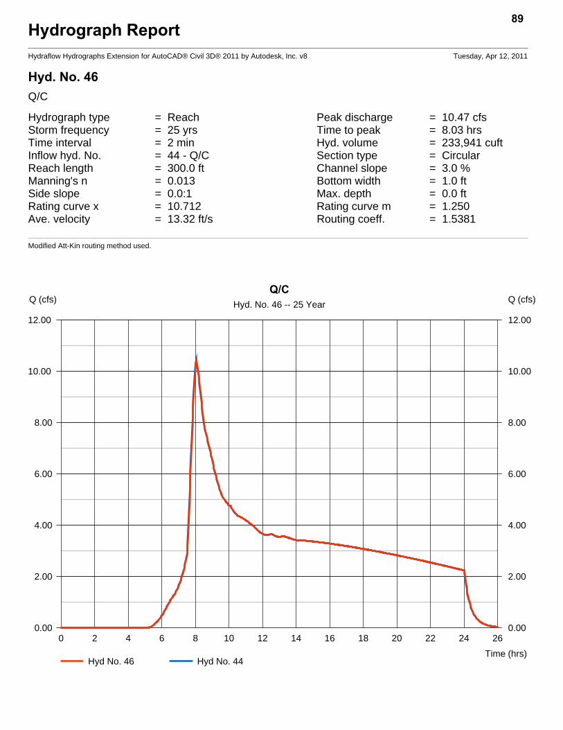
Hydrograph ReportHydraflow Hydrographs Extension for AutoCAD® Civil 3D® 2011 by Autodesk, Inc. v8 Tuesday, Apr 12, 2011
Hyd. No. 46Q/C
Hydrograph type = Reach Peak discharge = 10.47 cfsStorm frequency = 25 yrs Time to peak = 8.03 hrsTime interval = 2 min Hyd. volume = 233,941 cuftInflow hyd. No. = 44 - Q/C Section type = CircularReach length = 300.0 ft Channel slope = 3.0 %Manning's n = 0.013 Bottom width = 1.0 ftSide slope = 0.0:1 Max. depth = 0.0 ftRating curve x = 10.712 Rating curve m = 1.250Ave. velocity = 13.32 ft/s Routing coeff. = 1.5381
Modified Att-Kin routing method used.
89
0 2 4 6 8 10 12 14 16 18 20 22 24 26
Q (cfs)
0.00 0.00
2.00 2.00
4.00 4.00
6.00 6.00
8.00 8.00
10.00 10.00
12.00 12.00
Q (cfs)
Time (hrs)
Q/CHyd. No. 46 -- 25 Year
Hyd No. 46 Hyd No. 44
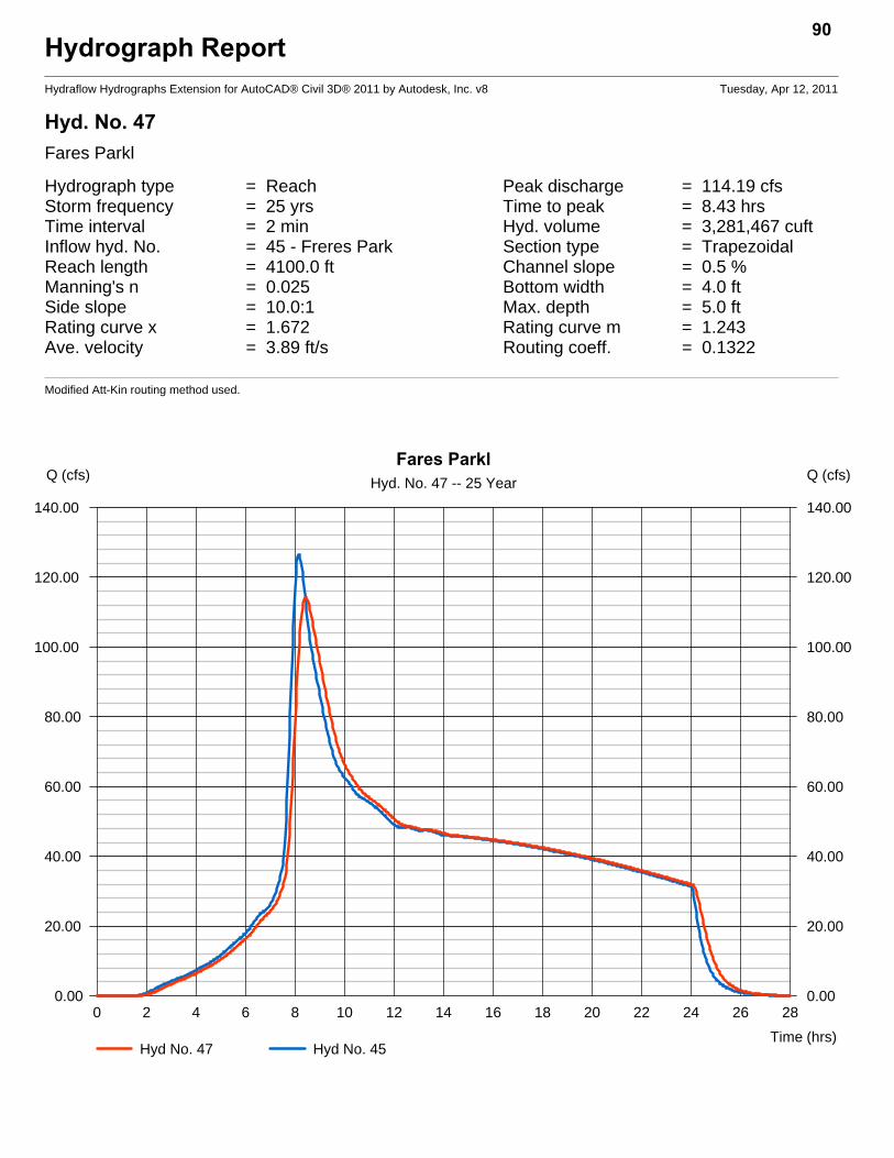
Hydrograph ReportHydraflow Hydrographs Extension for AutoCAD® Civil 3D® 2011 by Autodesk, Inc. v8 Tuesday, Apr 12, 2011
Hyd. No. 47Fares Parkl
Hydrograph type = Reach Peak discharge = 114.19 cfsStorm frequency = 25 yrs Time to peak = 8.43 hrsTime interval = 2 min Hyd. volume = 3,281,467 cuftInflow hyd. No. = 45 - Freres Park Section type = TrapezoidalReach length = 4100.0 ft Channel slope = 0.5 %Manning's n = 0.025 Bottom width = 4.0 ftSide slope = 10.0:1 Max. depth = 5.0 ftRating curve x = 1.672 Rating curve m = 1.243Ave. velocity = 3.89 ft/s Routing coeff. = 0.1322
Modified Att-Kin routing method used.
90
0 2 4 6 8 10 12 14 16 18 20 22 24 26 28
Q (cfs)
0.00 0.00
20.00 20.00
40.00 40.00
60.00 60.00
80.00 80.00
100.00 100.00
120.00 120.00
140.00 140.00
Q (cfs)
Time (hrs)
Fares ParklHyd. No. 47 -- 25 Year
Hyd No. 47 Hyd No. 45
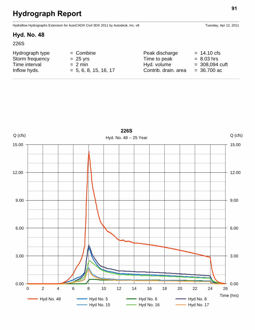
Hydrograph ReportHydraflow Hydrographs Extension for AutoCAD® Civil 3D® 2011 by Autodesk, Inc. v8 Tuesday, Apr 12, 2011
Hyd. No. 48226S
Hydrograph type = Combine Peak discharge = 14.10 cfsStorm frequency = 25 yrs Time to peak = 8.03 hrsTime interval = 2 min Hyd. volume = 308,094 cuftInflow hyds. = 5, 6, 8, 15, 16, 17 Contrib. drain. area = 36.700 ac
91
0 2 4 6 8 10 12 14 16 18 20 22 24 26
Q (cfs)
0.00 0.00
3.00 3.00
6.00 6.00
9.00 9.00
12.00 12.00
15.00 15.00
Q (cfs)
Time (hrs)
226SHyd. No. 48 -- 25 Year
Hyd No. 48 Hyd No. 5 Hyd No. 6 Hyd No. 8Hyd No. 15 Hyd No. 16 Hyd No. 17

Hydrograph ReportHydraflow Hydrographs Extension for AutoCAD® Civil 3D® 2011 by Autodesk, Inc. v8 Tuesday, Apr 12, 2011
Hyd. No. 49226
Hydrograph type = Reach Peak discharge = 13.27 cfsStorm frequency = 25 yrs Time to peak = 8.20 hrsTime interval = 2 min Hyd. volume = 308,073 cuftInflow hyd. No. = 48 - 226S Section type = CircularReach length = 2485.0 ft Channel slope = 1.3 %Manning's n = 0.013 Bottom width = 2.0 ftSide slope = 0.0:1 Max. depth = 0.0 ftRating curve x = 7.915 Rating curve m = 1.250Ave. velocity = 4.49 ft/s Routing coeff. = 0.2387
Modified Att-Kin routing method used.
92
0 2 4 6 8 10 12 14 16 18 20 22 24 26
Q (cfs)
0.00 0.00
3.00 3.00
6.00 6.00
9.00 9.00
12.00 12.00
15.00 15.00
Q (cfs)
Time (hrs)
226Hyd. No. 49 -- 25 Year
Hyd No. 49 Hyd No. 48
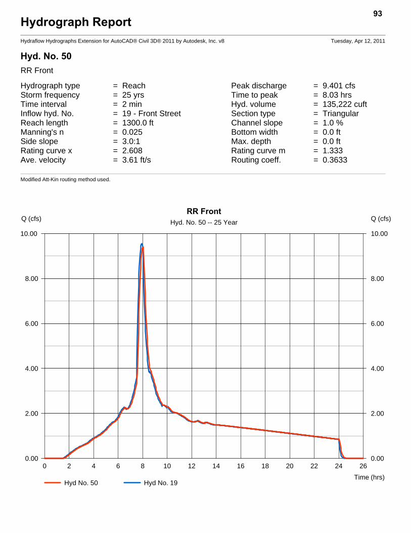
Hydrograph ReportHydraflow Hydrographs Extension for AutoCAD® Civil 3D® 2011 by Autodesk, Inc. v8 Tuesday, Apr 12, 2011
Hyd. No. 50RR Front
Hydrograph type = Reach Peak discharge = 9.401 cfsStorm frequency = 25 yrs Time to peak = 8.03 hrsTime interval = 2 min Hyd. volume = 135,222 cuftInflow hyd. No. = 19 - Front Street Section type = TriangularReach length = 1300.0 ft Channel slope = 1.0 %Manning's n = 0.025 Bottom width = 0.0 ftSide slope = 3.0:1 Max. depth = 0.0 ftRating curve x = 2.608 Rating curve m = 1.333Ave. velocity = 3.61 ft/s Routing coeff. = 0.3633
Modified Att-Kin routing method used.
93
0 2 4 6 8 10 12 14 16 18 20 22 24 26
Q (cfs)
0.00 0.00
2.00 2.00
4.00 4.00
6.00 6.00
8.00 8.00
10.00 10.00
Q (cfs)
Time (hrs)
RR FrontHyd. No. 50 -- 25 Year
Hyd No. 50 Hyd No. 19

Hydrograph ReportHydraflow Hydrographs Extension for AutoCAD® Civil 3D® 2011 by Autodesk, Inc. v8 Tuesday, Apr 12, 2011
Hyd. No. 51RR W
Hydrograph type = Combine Peak discharge = 44.17 cfsStorm frequency = 25 yrs Time to peak = 8.00 hrsTime interval = 2 min Hyd. volume = 719,081 cuftInflow hyds. = 18, 50 Contrib. drain. area = 36.700 ac
94
0 2 4 6 8 10 12 14 16 18 20 22 24 26
Q (cfs)
0.00 0.00
10.00 10.00
20.00 20.00
30.00 30.00
40.00 40.00
50.00 50.00
Q (cfs)
Time (hrs)
RR WHyd. No. 51 -- 25 Year
Hyd No. 51 Hyd No. 18 Hyd No. 50
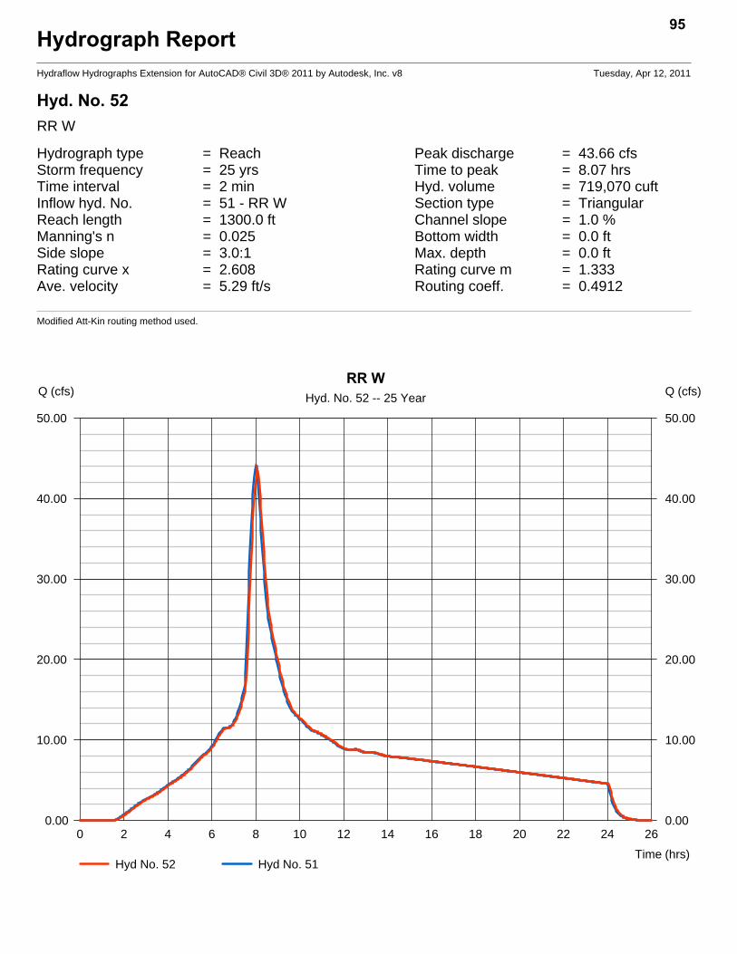
Hydrograph ReportHydraflow Hydrographs Extension for AutoCAD® Civil 3D® 2011 by Autodesk, Inc. v8 Tuesday, Apr 12, 2011
Hyd. No. 52RR W
Hydrograph type = Reach Peak discharge = 43.66 cfsStorm frequency = 25 yrs Time to peak = 8.07 hrsTime interval = 2 min Hyd. volume = 719,070 cuftInflow hyd. No. = 51 - RR W Section type = TriangularReach length = 1300.0 ft Channel slope = 1.0 %Manning's n = 0.025 Bottom width = 0.0 ftSide slope = 3.0:1 Max. depth = 0.0 ftRating curve x = 2.608 Rating curve m = 1.333Ave. velocity = 5.29 ft/s Routing coeff. = 0.4912
Modified Att-Kin routing method used.
95
0 2 4 6 8 10 12 14 16 18 20 22 24 26
Q (cfs)
0.00 0.00
10.00 10.00
20.00 20.00
30.00 30.00
40.00 40.00
50.00 50.00
Q (cfs)
Time (hrs)
RR WHyd. No. 52 -- 25 Year
Hyd No. 52 Hyd No. 51
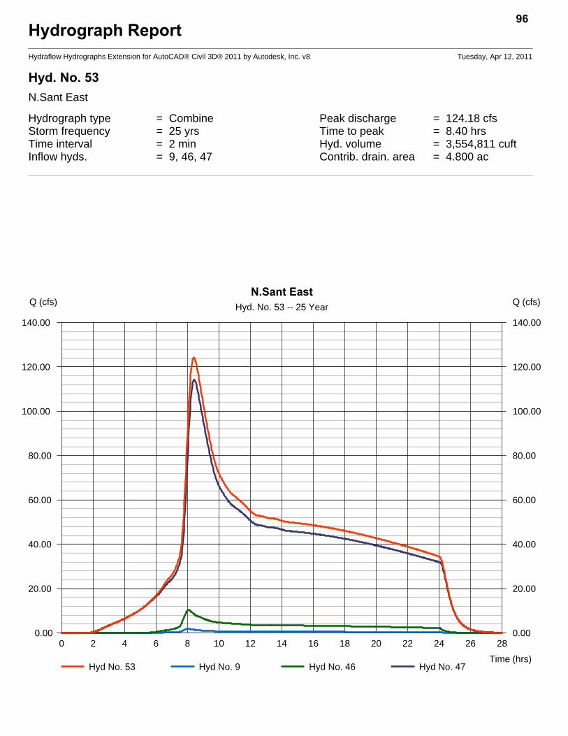
Hydrograph ReportHydraflow Hydrographs Extension for AutoCAD® Civil 3D® 2011 by Autodesk, Inc. v8 Tuesday, Apr 12, 2011
Hyd. No. 53N.Sant East
Hydrograph type = Combine Peak discharge = 124.18 cfsStorm frequency = 25 yrs Time to peak = 8.40 hrsTime interval = 2 min Hyd. volume = 3,554,811 cuftInflow hyds. = 9, 46, 47 Contrib. drain. area = 4.800 ac
96
0 2 4 6 8 10 12 14 16 18 20 22 24 26 28
Q (cfs)
0.00 0.00
20.00 20.00
40.00 40.00
60.00 60.00
80.00 80.00
100.00 100.00
120.00 120.00
140.00 140.00
Q (cfs)
Time (hrs)
N.Sant EastHyd. No. 53 -- 25 Year
Hyd No. 53 Hyd No. 9 Hyd No. 46 Hyd No. 47

Hydrograph ReportHydraflow Hydrographs Extension for AutoCAD® Civil 3D® 2011 by Autodesk, Inc. v8 Tuesday, Apr 12, 2011
Hyd. No. 54West of Town
Hydrograph type = Combine Peak discharge = 52.88 cfsStorm frequency = 25 yrs Time to peak = 8.10 hrsTime interval = 2 min Hyd. volume = 1,310,208 cuftInflow hyds. = 2, 3, 4, 52 Contrib. drain. area = 127.500 ac
97
0 2 4 6 8 10 12 14 16 18 20 22 24 26 28
Q (cfs)
0.00 0.00
10.00 10.00
20.00 20.00
30.00 30.00
40.00 40.00
50.00 50.00
60.00 60.00
Q (cfs)
Time (hrs)
West of TownHyd. No. 54 -- 25 Year
Hyd No. 54 Hyd No. 2 Hyd No. 3 Hyd No. 4Hyd No. 52

Hydrograph ReportHydraflow Hydrographs Extension for AutoCAD® Civil 3D® 2011 by Autodesk, Inc. v8 Tuesday, Apr 12, 2011
Hyd. No. 55North Santiam
Hydrograph type = Combine Peak discharge = 139.40 cfsStorm frequency = 25 yrs Time to peak = 8.37 hrsTime interval = 2 min Hyd. volume = 3,949,163 cuftInflow hyds. = 1, 7, 12, 49, 53 Contrib. drain. area = 12.200 ac
98
0 2 4 6 8 10 12 14 16 18 20 22 24 26 28
Q (cfs)
0.00 0.00
20.00 20.00
40.00 40.00
60.00 60.00
80.00 80.00
100.00 100.00
120.00 120.00
140.00 140.00
Q (cfs)
Time (hrs)
North SantiamHyd. No. 55 -- 25 Year
Hyd No. 55 Hyd No. 1 Hyd No. 7 Hyd No. 12Hyd No. 49 Hyd No. 53
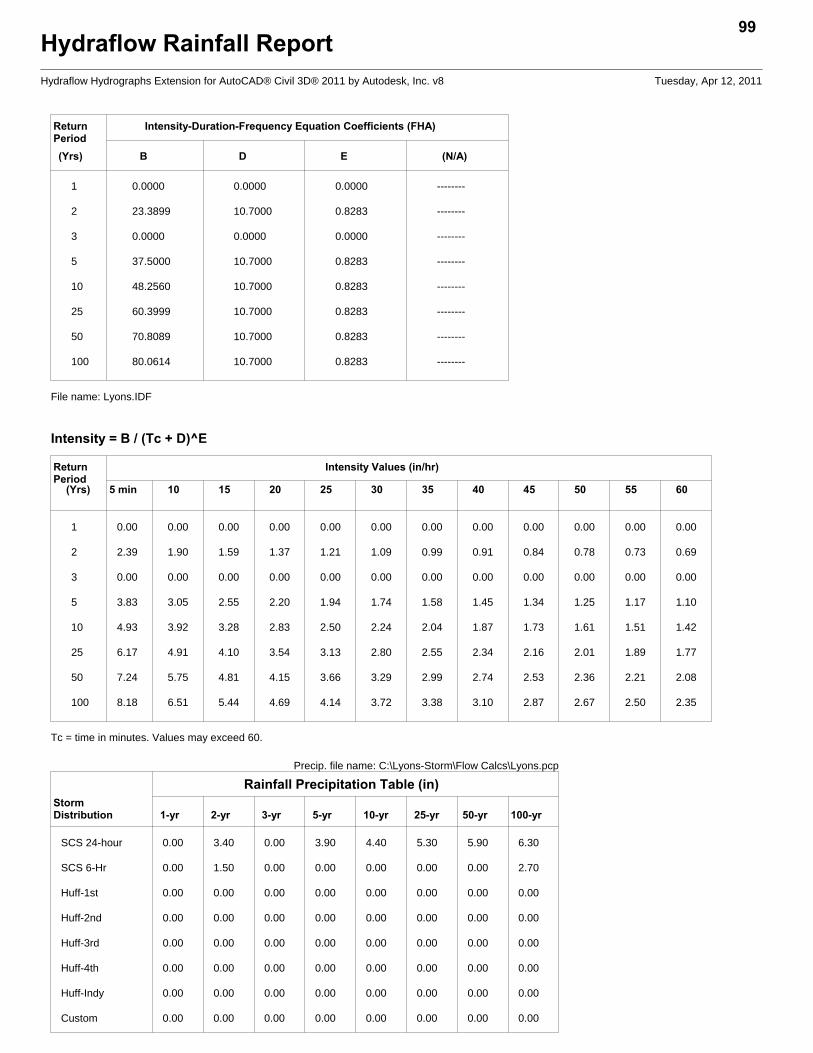
Hydraflow Rainfall Report99
Hydraflow Hydrographs Extension for AutoCAD® Civil 3D® 2011 by Autodesk, Inc. v8 Tuesday, Apr 12, 2011
Return Intensity-Duration-Frequency Equation Coefficients (FHA)Period(Yrs) B D E (N/A)
1 0.0000 0.0000 0.0000 --------
2 23.3899 10.7000 0.8283 --------
3 0.0000 0.0000 0.0000 --------
5 37.5000 10.7000 0.8283 --------
10 48.2560 10.7000 0.8283 --------
25 60.3999 10.7000 0.8283 --------
50 70.8089 10.7000 0.8283 --------
100 80.0614 10.7000 0.8283 --------
File name: Lyons.IDF
Intensity = B / (Tc + D)^E
Return Intensity Values (in/hr)Period
(Yrs) 5 min 10 15 20 25 30 35 40 45 50 55 60
1 0.00 0.00 0.00 0.00 0.00 0.00 0.00 0.00 0.00 0.00 0.00 0.00
2 2.39 1.90 1.59 1.37 1.21 1.09 0.99 0.91 0.84 0.78 0.73 0.69
3 0.00 0.00 0.00 0.00 0.00 0.00 0.00 0.00 0.00 0.00 0.00 0.00
5 3.83 3.05 2.55 2.20 1.94 1.74 1.58 1.45 1.34 1.25 1.17 1.10
10 4.93 3.92 3.28 2.83 2.50 2.24 2.04 1.87 1.73 1.61 1.51 1.42
25 6.17 4.91 4.10 3.54 3.13 2.80 2.55 2.34 2.16 2.01 1.89 1.77
50 7.24 5.75 4.81 4.15 3.66 3.29 2.99 2.74 2.53 2.36 2.21 2.08
100 8.18 6.51 5.44 4.69 4.14 3.72 3.38 3.10 2.87 2.67 2.50 2.35
Tc = time in minutes. Values may exceed 60.
Rainfall Precipitation Table (in)Precip. file name: C:\Lyons-Storm\Flow Calcs\Lyons.pcp
StormDistribution 1-yr 2-yr 3-yr 5-yr 10-yr 25-yr 50-yr 100-yr
SCS 24-hour 0.00 3.40 0.00 3.90 4.40 5.30 5.90 6.30
SCS 6-Hr 0.00 1.50 0.00 0.00 0.00 0.00 0.00 2.70
Huff-1st 0.00 0.00 0.00 0.00 0.00 0.00 0.00 0.00
Huff-2nd 0.00 0.00 0.00 0.00 0.00 0.00 0.00 0.00
Huff-3rd 0.00 0.00 0.00 0.00 0.00 0.00 0.00 0.00
Huff-4th 0.00 0.00 0.00 0.00 0.00 0.00 0.00 0.00
Huff-Indy 0.00 0.00 0.00 0.00 0.00 0.00 0.00 0.00
Custom 0.00 0.00 0.00 0.00 0.00 0.00 0.00 0.00
Appendix C ‐ Hydraulic Constraints
The hydrologic analysis consists of the following report from Hydraflow Express Extensions for AutoCad Civil 3D.
1. Central Business District Discharge Pipe ‐ Assumed 24" discharge pipe. No plans are available. Discharge pipe has assumed 0.002% slope per 1975 Drainage Map and County construction plans.
2. 24 th Street Culvert ‐ Culvert data from 1975 Drainage plan
Channel ReportHydraflow Express Extension for AutoCAD® Civil 3D® 2011 by Autodesk, Inc. Wednesday, Apr 13 2011
CBD Discharge Pipe
CircularDiameter (ft) = 2.00
Invert Elev (ft) = 658.00Slope (%) = 0.10N-Value = 0.013
CalculationsCompute by: Q vs DepthNo. Increments = 10
HighlightedDepth (ft) = 2.00Q (cfs) = 7.152Area (sqft) = 3.14Velocity (ft/s) = 2.28Wetted Perim (ft) = 6.28Crit Depth, Yc (ft) = 0.98Top Width (ft) = 0.00EGL (ft) = 2.08
0 1 2 3 4
Elev (ft) Depth (ft)Section
657.50 -0.50
658.00 0.00
658.50 0.50
659.00 1.00
659.50 1.50
660.00 2.00
660.50 2.50
661.00 3.00
Reach (ft)
Culvert ReportHydraflow Express Extension for AutoCAD® Civil 3D® 2011 by Autodesk, Inc. Wednesday, Apr 13 2011
Cir Culvert
Invert Elev Dn (ft) = 701.30Pipe Length (ft) = 75.00Slope (%) = 0.80Invert Elev Up (ft) = 701.90Rise (in) = 30.0Shape = CirSpan (in) = 30.0No. Barrels = 1n-Value = 0.012Inlet Edge = 0Coeff. K,M,c,Y,k = 0.0045, 2, 0.0317, 0.69, 0.5
EmbankmentTop Elevation (ft) = 706.00Top Width (ft) = 20.00Crest Width (ft) = 100.00
CalculationsQmin (cfs) = 20.00Qmax (cfs) = 45.00Tailwater Elev (ft) = (dc+D)/2
HighlightedQtotal (cfs) = 45.00Qpipe (cfs) = 42.87Qovertop (cfs) = 2.13Veloc Dn (ft/s) = 8.96Veloc Up (ft/s) = 8.94HGL Dn (ft) = 703.65HGL Up (ft) = 704.25Hw Elev (ft) = 706.03Hw/D (ft) = 1.65Flow Regime = Inlet Control