
HYDERABAD PHARMA CITY EIA STUDY -...
12
E P T R I Proposed Terms of Reference i PROPOSED TERMS OF REFERENCE FOR HYDERABAD PHARMA CITY EIA STUDY General Proposed Terms of Reference (ToR) for conducting EIA study are drawn keeping in view of EIA Notification dated September 14, 2006 (as amended) and also based on Draft Environmental Impact Assessment Technical Guidance Manual for Industrial Estates and Developmental activity specific terms of reference notified by Ministry of Environment and Forests and Climate Change (MoEF & CC). Project Background Hyderabad, the Bulk Drug Capital of India, accounts for almost 20% of pharma exports from India, while Telangana State contributes to 1/3rd of the total pharma production in the country. There are 412 pharma companies including 173 bulk drug units in Telangana. Hyderabad also has witnessed infrastructural development in the biotech domain wherein the Knowledge Park, the Biotech Park, Genome Valley and other projects have come up giving the city an advantage over others. Hyderabad is also a house for R&D Centres like Centre for Cellular and Molecular Biology (CCMB), Indian Institute of Chemical Technology (IICT), International Crop Research Institute for Semi-arid Tropics (ICRISAT), Central Food Technology Research Institute (CFTRI) and Institute for Life Sciences Centre (ILSC). Leveraging on this industry environment, several existing pharma companies have been working on expansions plans and several new units have been proposed in Hyderabad. Various industry associations such as the Bulk Drug Manufacturers Association (India) has already estimated the need for around 7,000 acres of plotted industrial land to meet the investment plans of its members. Therefore, in order to provide an impetus to the pharma industry in Telangana and also to provide an industry-friendly integrated environment for expansion units of existing pharma companies as well as to attract new investments in manufacturing and allied segments of pharma industry, Government of Telangana proposes to develop a Pharma City near Hyderabad, which is a prestigious and priority project. The Hyderabad Pharma City is proposed to be developed with integrated physical, environmental, social and technical infrastructure in an area of over 19,333 acres (~78.24 sq.km) of land in Rangareddy district of Telangana State. In order to comply with the EIA notification 2006 and Environment (Protection) Act, 1986; SEZs/industrial parks require an Environmental Clearance (EC) under certain conditions
Transcript of HYDERABAD PHARMA CITY EIA STUDY -...

E P T R I
Proposed Terms of Reference
i
PROPOSED TERMS OF REFERENCE
FOR
HYDERABAD PHARMA CITY EIA STUDY
General
Proposed Terms of Reference (ToR) for conducting EIA study are drawn keeping in view of
EIA Notification dated September 14, 2006 (as amended) and also based on Draft
Environmental Impact Assessment Technical Guidance Manual for Industrial Estates and
Developmental activity specific terms of reference notified by Ministry of Environment and
Forests and Climate Change (MoEF & CC).
Project Background
Hyderabad, the Bulk Drug Capital of India, accounts for almost 20% of pharma exports from
India, while Telangana State contributes to 1/3rd of the total pharma production in the
country. There are 412 pharma companies including 173 bulk drug units in Telangana.
Hyderabad also has witnessed infrastructural development in the biotech domain wherein
the Knowledge Park, the Biotech Park, Genome Valley and other projects have come up
giving the city an advantage over others. Hyderabad is also a house for R&D Centres like
Centre for Cellular and Molecular Biology (CCMB), Indian Institute of Chemical Technology
(IICT), International Crop Research Institute for Semi-arid Tropics (ICRISAT), Central Food
Technology Research Institute (CFTRI) and Institute for Life Sciences Centre (ILSC).
Leveraging on this industry environment, several existing pharma companies have been
working on expansions plans and several new units have been proposed in Hyderabad.
Various industry associations such as the Bulk Drug Manufacturers Association (India) has
already estimated the need for around 7,000 acres of plotted industrial land to meet the
investment plans of its members.
Therefore, in order to provide an impetus to the pharma industry in Telangana and also to
provide an industry-friendly integrated environment for expansion units of existing pharma
companies as well as to attract new investments in manufacturing and allied segments of
pharma industry, Government of Telangana proposes to develop a Pharma City near
Hyderabad, which is a prestigious and priority project. The Hyderabad Pharma City is
proposed to be developed with integrated physical, environmental, social and technical
infrastructure in an area of over 19,333 acres (~78.24 sq.km) of land in Rangareddy district
of Telangana State.
In order to comply with the EIA notification 2006 and Environment (Protection) Act, 1986;
SEZs/industrial parks require an Environmental Clearance (EC) under certain conditions
E P T R I
Proposed Terms of Reference
ii
from MoEF&CC. With a view to adhere to the policies and environmental sustainability,
TSIIC has appointed Environmental Protection and Training and Research Institute
(EPTRI) as Environmental Consultant to prepare Environmental Impact Assessment (EIA)
Report and obtain the Environmental Clearances from Statutory Authorities.
Project Details
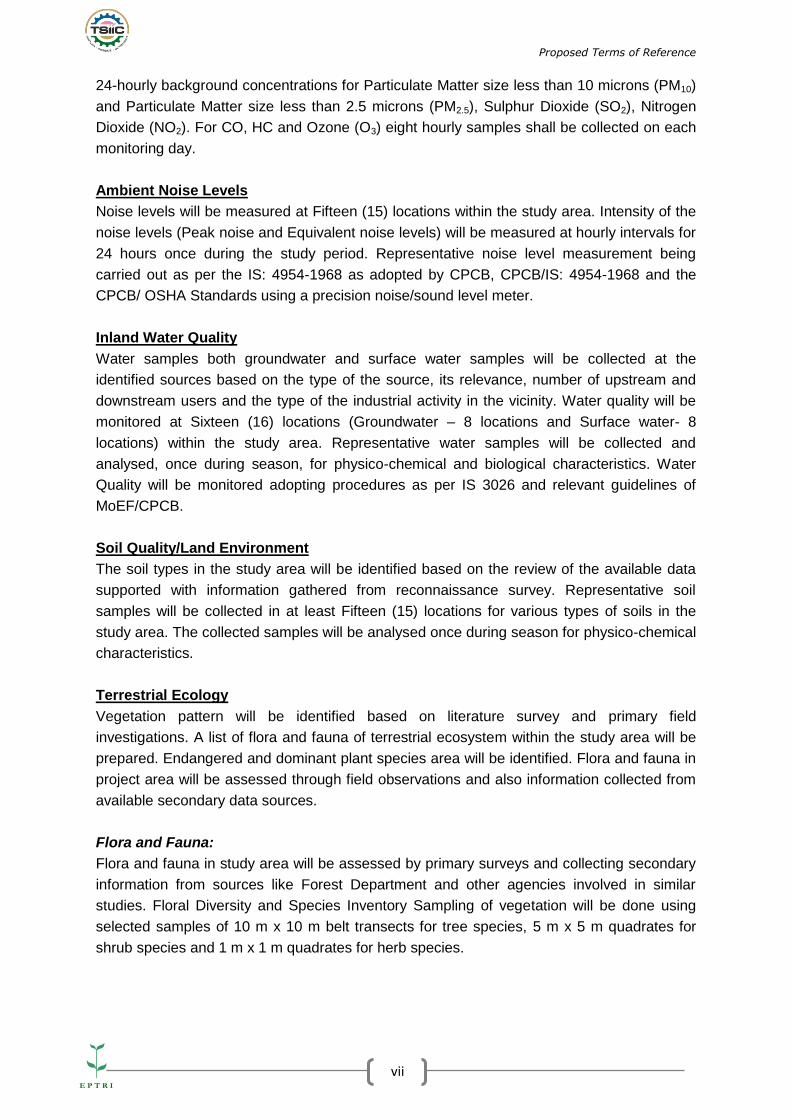
The proposed Hyderabad Pharma City Site covers 19,333 acres (78.24 sq.km) of land in
Rangareddy district of Telangana State. The key components of Pharma City are as follows:
Pharma City Component Area (acres) Area (sq.km)
Pharma NIMZ
(Pharma Manufacturing)
13030 52.73
Pharma City Township 1593 6.45
Pharma University 630 2.55
Pharma R&D and Ancillary
Hub
4080 16.51
Total Pharma City land 19333 78.24
The total land area covered by the proposed Hyderabad Pharma City Site is 19333.20 acres
(7824 ha./ 78.24 sq.km). This includes 52.80% of privately owned lands and 46.11% of
government lands. Apart from this, around 0.57% of the lands are covered by water bodies.
The proposed Hyderabad Pharma City Site along with geographical coordinates is shown in
the Figure-1.
Figure-1: Google imagery of the proposed Hyderabad Pharma City Site Extents

E P T R I
Proposed Terms of Reference
iii
Land Use Pattern:
Pharma NIMZ Site: The proposed NIMZ Site is completely a greenfield site with almost no
developments currently at the Site. The existing landuse within the Site is largely agricultural
fallow lands followed by agricultural cropped lands and scrub /barren rocky lands. There are
no settlements within the NIMZ Site, barring few scattered buildings and dwellings.
Pharma University Site: The existing landuse in the proposed Site for the University is
largely barren scrubland, followed some agricultural lands.
Township Site: The existing landuse in the proposed Site for the Township is largely fallow
agricultural land, followed by some barren scrublands.
R&D and Ancillary Hub Site: The existing landuse in the proposed Site for R&D and
Ancillary Hub Site is largely agricultural land, followed by few scattered patches of barren
scrublands. There is one tiny hamlet (spread in an area of around 2 acres) situated within
the northern part of this Site, located at 1.5 km to the east of Ganugumarla Tanda. Another
settlement named Marripally, spread over an area of around 15 acres, is located within the
southern part of this Site.
Road connectivity:
The site can be accessed from Hyderabad via Srisailam Highway (Nh-765) as well as
Nagarjunasagar Highway (SH-19). The site falls along the Kandukuru-Yacharam Road
which connects these two highways at Kandukur and Yacharam. Srisailam Highway runs at
about 6 km west of Hyderabad Pharma City site and connects the project region to
Hyderabad City. Nagarjunasagar Highway connects Hyderabad to Nagarjunasagar. It runs
at about 5 km to the east of Hyderabad Pharma City Site and connects the project region to
Hyderabad. The details of the road connectivity to the site are shown as Figure-2.

E P T R I
Proposed Terms of Reference
iv
Figure-2: Road Connectivity Map

E P T R I
Proposed Terms of Reference
v
Rail Connectivity:
The single line, broad gauge railway line that connects Secunderabad to Dhone via Kurnool
runs at about 33 km to the west of the Site in N-S direction. The nearest railway station to
the NIMZ Site is Shadnagar Railway Station.
Air Connectivity:
The Rajiv Gandhi International Airport (RGIA) is located 21 km to the north of NIMZ Site (32
km distance by road from site boundary) at Shamshabad. The airport can be accessed from
NIMZ site via Srisailam Highway and ORR. RGIA houses India’s first Pharma Zone that
offers temperature-controlled Truck-Dock to airside environment. 70% of exports from
the RGIA are pharmaceuticals.
Water Supply:
The water demand for the proposed site is to be met by Krishna water Supply Scheme.
Hyderabad Metropolitan Water Supply and Sewerage Board’s (HMWS&SB) Krishna Water
Supply Scheme envisages tapping 16.5 TMC of raw water from Krishna River i.e. 270 MGD,
in three phases; each phase of 5.5 TMC raw water tapping for adding 90 MGD of treated
water to the water supply system of Hyderabad Metropolitan area. As per the GoTS policy
for Industrial Development, 10% water can be allocated to industrial use.
As part of the Krishna Water Supply Scheme, two Master Balancing Reservoirs of 22.5 ML
capacity each are constructed at Gunagal. It is located at 12 km (distance by road) to the
north east of the Project Site along Nagarjunasagar Highway. GoTS proposes to tap water
for Hyderabad Pharma City from Phase III of the Krishna Water Supply Scheme.
Power Supply
It is proposed to draw power from the existing 220 kV sub-station at FAB City which is at a
distance of 16 km north to the HPC site in the initial stages of the project.
Corporation of Telangana Limited (TSTRANSCO) is currently constructing a 400/220 kV
substation within the Pharma City Site (close to PGCIL Station) for power evacuation from
the PGCIL Station. GoTS proposes that Pharma City shall source power from this
substation, with further power transmission infrastructure to be developed within Pharma
City.
The total estimated power demand for the Pharma City ultimate phase development is about
900 MW.

E P T R I
Proposed Terms of Reference
vi
Telecom
Optical Fibre network will also be provided along the water pipelines being laid in Kandukur
and Yacharam Mandals of Rangareddy district. Further it is also observed that OFC
networks of BSNL & Idea are also available on both NH 765 and SH 19. Hence no issues
are foreseen with regard to the Optical Fibre Connectivity to the HPC site.
Methodology
Methodology to carry out EIA study involves following stages:
Reconnaissance survey and site visit
Review of available literature
Compliance to statutory requirements
Baseline environmental monitoring (Terrestrial Environment)
Identification, Prediction and Evaluation of Impacts
Risk Assessment and Disaster Management Plan
Environmental Management Plan (including monitoring plan)
Baseline Environmental Monitoring
The baseline environmental studies will be carried out for terrestrial environment. The study
will be a combination of primary (field surveys) and secondary data collection.
Study Period: The study period shall be for one season i.e., post-monsoon (covering 12
weeks or 3 months).
Study Area: 10 km radius from project boundary is considered for study.
Terrestrial Environment:
Meteorology
Meteorological parameters such as wind speed, direction, relative humidity, rainfall,
temperature etc., will be recorded by using automatic weather monitoring station in the study
area at One (1) location during the study period. In addition, the general meteorological data
from Climatological Tables of Indian Meteorological Department (IMD) shall be used to
establish the baseline meteorological conditions of the site.
Ambient Air Quality
The ambient air quality monitoring will be carried out as per CPCB/MoEF&CC guidelines.
The locations will be identified with regard to the predominant wind direction, topography,
population, sensitive locations and possible impact zones. Representative Ambient Air
Quality (AAQ) will be monitored at Fifteen (15) locations in the study area with twice a week
frequency during the study period. The AAQ monitoring locations would be finalised keeping
in view of the guidelines of MoEF&CC. The measurement will be carried out for establishing
E P T R I
Proposed Terms of Reference
vii
24-hourly background concentrations for Particulate Matter size less than 10 microns (PM10)
and Particulate Matter size less than 2.5 microns (PM2.5), Sulphur Dioxide (SO2), Nitrogen
Dioxide (NO2). For CO, HC and Ozone (O3) eight hourly samples shall be collected on each
monitoring day.
Ambient Noise Levels
Noise levels will be measured at Fifteen (15) locations within the study area. Intensity of the
noise levels (Peak noise and Equivalent noise levels) will be measured at hourly intervals for
24 hours once during the study period. Representative noise level measurement being
carried out as per the IS: 4954-1968 as adopted by CPCB, CPCB/IS: 4954-1968 and the
CPCB/ OSHA Standards using a precision noise/sound level meter.
Inland Water Quality
Water samples both groundwater and surface water samples will be collected at the
identified sources based on the type of the source, its relevance, number of upstream and
downstream users and the type of the industrial activity in the vicinity. Water quality will be
monitored at Sixteen (16) locations (Groundwater – 8 locations and Surface water- 8
locations) within the study area. Representative water samples will be collected and
analysed, once during season, for physico-chemical and biological characteristics. Water
Quality will be monitored adopting procedures as per IS 3026 and relevant guidelines of
MoEF/CPCB.
Soil Quality/Land Environment
The soil types in the study area will be identified based on the review of the available data
supported with information gathered from reconnaissance survey. Representative soil
samples will be collected in at least Fifteen (15) locations for various types of soils in the
study area. The collected samples will be analysed once during season for physico-chemical
characteristics.
Terrestrial Ecology
Vegetation pattern will be identified based on literature survey and primary field
investigations. A list of flora and fauna of terrestrial ecosystem within the study area will be
prepared. Endangered and dominant plant species area will be identified. Flora and fauna in
project area will be assessed through field observations and also information collected from
available secondary data sources.
Flora and Fauna:
Flora and fauna in study area will be assessed by primary surveys and collecting secondary
information from sources like Forest Department and other agencies involved in similar
studies. Floral Diversity and Species Inventory Sampling of vegetation will be done using
selected samples of 10 m x 10 m belt transects for tree species, 5 m x 5 m quadrates for
shrub species and 1 m x 1 m quadrates for herb species.

E P T R I
Proposed Terms of Reference
viii
Faunal Diversity and Species Inventory (Vertebrates):
Inventory of animal species will be prepared based on following methodology:
Direct observation during field visits
Interviewing local villagers and forest officials
Secondary sources such as published literature on fauna
Bio-diversity index and relative abundance index of different types of flora will be
established. Cover of trees in different areas will be established. Canopy cover of trees in
different areas will also be established. Terrestrial flora and fauna survey will be carried out
as per standard practice.
The environmentally/ecologically sensitive locations such as such as National parks, Wild
Life Sanctuaries and Reserve Forests etc shall be mapped w.r.t. the project site and study
region.
Demography and Socio-Economics:
The socio-economic conditions in study area will be established through collection and
review of available secondary/ published data and socio-economic data including district
statistical handbooks. This will include:
Demographic structure covering total households, total population, population density,
sex ratio, schedule caste and schedule tribe, literacy and employment.
Health Status
Cultural and aesthetic attributes in study area including places of historical and
archaeological importance
Inventory of places of historical, cultural and religious importance in the study area
Details of various economic activities, industries if any, shall be collected
Establishment of Baseline Environmental Conditions
Baseline conditions (environment and social) will be established by compiling data
generated from field surveys and secondary data. Further, baseline environmental
conditions will also be graphically presented and critical locations in project area, if any, in
environmental and social context will be identified.
Anticipated Environmental and Social Impacts and their Mitigation
Measures
Environmental attributes likely to be affected by project activities of proposed development of
Hyderabad Pharma City will be identified and impacts will be assessed. Proposed activities
of the Hyderabad Pharma City project can be broadly classified into construction and
operation phase activities.

E P T R I
Proposed Terms of Reference
ix
Most appropriate and accepted methods will be used to quantify impacts likely to arise due
to development of proposed project. The mitigation measures proposed to minimise/avoid
each of the likely impacts that occur during construction and operation phases will be
discussed in detail.
Air Environment:
The construction phase will involve movement of construction materials to the project area,
site clearing/development, vehicular emissions, emissions from the construction machinery,
etc. which in turn could influence the ambient air quality in the region through build-up of the
dust levels and gaseous emission levels. The impacts from these will be covered.
Adverse impacts are envisaged on the air environment during the operation phase. There
will be stack emissions from industrial units proposed in the Hyderabad Pharma City, which
would affect the air environment through build-up of particulate matter and gaseous
emissions.
All the emission sources shall be inventoried and based on that the prediction of ground
level concentrations of SO2, NO2, PM10 and PM2.5 will be done along with the estimation of
the emissions into air due to use of various fuels and vehicular emissions. Prediction of
impacts on the air environment shall be represented in the form of Isopleths through the
application of appropriate air quality models (Gaussian Dispersion model such as
ISCST3/AERMOD) taking effects of terrain and requirements specified in the publication by
CPCB – “Assessment of Impacts on Air Environment: Guidelines for Conducting Air Quality
Modelling” (Programme Objective Series: PROBES/70/1997-98).
Noise:
Generally, activities impacting air environment also impact noise levels. Impacts on noise
levels during construction phase could be from vehicular traffic, construction machinery, DG
sets and transportation of raw material to site. During operation phase, noise might be
generated due to industrial activities involved in material handling and transportation and
same will be felt upon work personnel operating in respective areas. Using appropriate noise
level prediction models, likely impacts will be predicted taking into consideration noise
generating sources together with environmental conditions and receptors in project influence
area.
Water Environment:
Run-offs containing contaminated water during construction and operation phases of the
project can affect water environment. Impacts will be addressed and subsequent mitigation
measures (construction and operational phases of the project) will be accordingly included in
the study.
Land Environment:
The existing land use within the Site is largely agricultural fallow lands followed by
agricultural cropped lands and scrub /barren rocky lands. There are two settlements namely
Ganugamarla Tanda and Marripalli within the HPC Site. These settlements are proposed to

E P T R I
Proposed Terms of Reference
x
be retained within the HPC. However impacts on land environment during construction and
operation phase will largely result from soil erosion, soil permeability and change in land use
patterns. Impacts on land environment will be predicted considering activities involved in
construction and operation phases.
Analysis of Alternatives
Site alternative study has been carried out and the details are provided in the Prefeasibility
report.
Environmental Monitoring Programme
The chapter will elaborate details of the environmental monitoring program, and include
technical aspects of monitoring and its effectiveness in assessing the mitigation measures
which include
Summary matrix of environmental monitoring during construction and operation stage.
Monitoring facilities
Frequency, location, parameters need to be monitored will be listed
Detailed budget for both Construction and Operation phases.
Additional Studies
Traffic and Transport Management
Traffic surveys were carried out and analyse the adequacy of external existing road network,
connectivity to the National Highways, access locations. A transportation management plan
will be prepared.
Public Consultation
The public consultation will be carried out as per the procedure/guidelines stipulated by
MoEF&CC. Based on the minutes; the concerns raised by the public will be addressed and
submitted along with the Final EIA report.
Social Impact Assessment
The social impacts associated during construction phase, impact on local infrastructure, etc.
will be provided and social impacts during operation phase, employment generation etc will
be addressed.
Risk Analysis
Risk analysis shall be carried out for the project involving storage of hazardous
chemicals/materials and gases. Maximum inventory of storage at site shall be taken into
account. Potential hazards shall be identified and damage distances shall be calculated
using appropriate models and Material Safety Data Sheet (MSDS). Based on the hazard

E P T R I
Proposed Terms of Reference
xi
analysis through damage distance calculation from sources, appropriate mitigation
measures will be provided.
Greenbelt development Plan
A greenbelt shall be developed along the periphery of the project site as well within the
proposed Pharma city premises/ individual units wherever it is essential and as per the
statutory requirements.
Corporate Social Responsibility (CSR)
A CSR plan shall be prepared as per the Project Development plan.
Disaster Management Plan
A Broad Disaster Management Plan shall be prepared in conjunction with and taking into
consideration all technical reviews and suggestions as per acceptable norms. A broad
structure of on-site and off-site emergency preparedness plans shall be prepared.
Occupational health and safety aspects shall be covered.
Project Benefits
The project benefits in terms of improvements in the physical infrastructure and social
infrastructure, employment potential and other tangible benefits will be discussed in detail.
Environmental Management Plan
Environmental Management Plan will consist of mitigation measures for item-wise activity to
be undertaken for construction and operation of the facility for its entire life cycle to minimize
adverse environmental impacts. Also odour mitigation plan shall be prepared accordingly. It
will also delineate the environmental monitoring plan for compliance of various
environmental regulations.
Feasible and cost effective measures to prevent or reduce significant negative impacts to the
acceptable levels are to be developed, including the estimate of the impacts and cost of
these measures, and of the institutional and training requirements to implement them. When
impacts cannot be mitigated, compensation to affected parties shall be considered. The
management measures proposed to be suggested for the following aspects:
Environmental specifications for the contractors will contain adequate safeguards to ensure
that management measures will not be compromised under adverse field conditions or time
constraints.
Structure of EIA Report
E P T R I
Proposed Terms of Reference
xii
Based on above tasks, EIA report will be compiled and submitted to MoEF & CC for seeking
Environmental Clearance. Structure of EIA report is given below.
Chapter 1: Introduction
Chapter 2: Project Description
Chapter 3: Analysis of Alternatives
Chapter 4: Description of the Environment
Chapter 5: Anticipated Environmental Impacts & Mitigation Measures
Chapter 6: Environmental Monitoring Programme
Chapter 7: Additional studies
Chapter 8: Project Benefits
Chapter 9: Environmental Management Plan
Chapter 10: Summary and Conclusions
Chapter 11: Disclosure of Consultants Engaged


![INDEX [environmentclearance.nic.in]environmentclearance.nic.in/writereaddata/EIA/060220204GHFJCPR… · Master Plan 24 134 27. Location Map 25 135 28. Site Plan 26 136 29. Landscape](https://static.fdocuments.in/doc/165x107/5f43d21d66274300d7661deb/index-master-plan-24-134-27-location-map-25-135-28-site-plan-26-136-29-landscape.jpg)


![EIA/EMP REPORT For Proposed Expansion of Ammonia …environmentclearance.nic.in/writereaddata/EIA/100920159QXPL126EIA... · i [Type text] EIA/EMP REPORT For Proposed Expansion of](https://static.fdocuments.in/doc/165x107/5ad8c3257f8b9a9d5c8db8f8/eiaemp-report-for-proposed-expansion-of-ammonia-type-text-eiaemp-report.jpg)

