HPMS Field Manual & Software Updates - Home | Federal ... · Ronald Vaughn, PMP. Justin Clarke,...
61
HPMS Field Manual & Software Updates FHWA Highway Information Seminar Arlington, VA November 16, 2017
Transcript of HPMS Field Manual & Software Updates - Home | Federal ... · Ronald Vaughn, PMP. Justin Clarke,...
HPMS Field Manual & Software UpdatesFHWA Highway Information SeminarArlington, VANovember 16, 2017
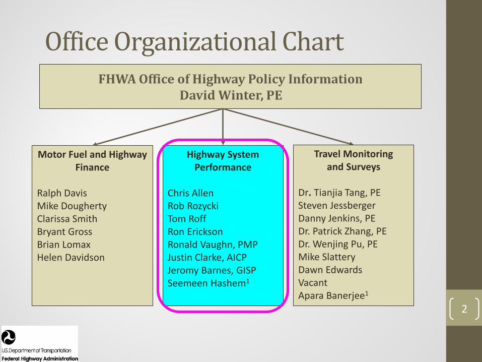
Office Organizational Chart
2
Motor Fuel and Highway Finance
Ralph DavisMike DoughertyClarissa SmithBryant GrossBrian LomaxHelen Davidson
Highway System Performance
Chris AllenRob RozyckiTom RoffRon EricksonRonald Vaughn, PMPJustin Clarke, AICPJeromy Barnes, GISPSeemeen Hashem1
Travel Monitoring and Surveys
Dr. Tianjia Tang, PESteven JessbergerDanny Jenkins, PEDr. Patrick Zhang, PEDr. Wenjing Pu, PEMike SlatteryDawn EdwardsVacantApara Banerjee1

3
HPMS References & Resources

Field Manual
4
5
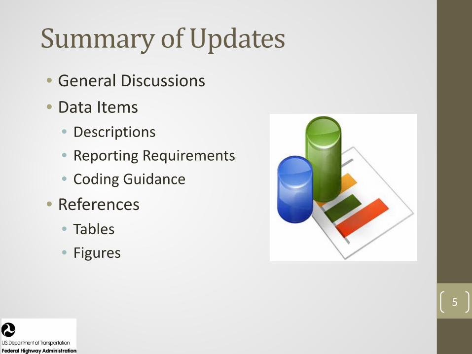
Summary of Updates• General Discussions• Data Items
• Descriptions• Reporting Requirements• Coding Guidance
• References• Tables• Figures
6
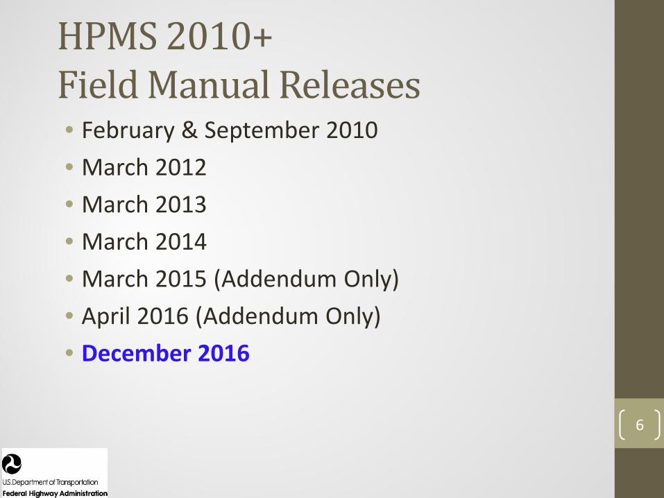
HPMS 2010+ Field Manual Releases• February & September 2010• March 2012• March 2013• March 2014• March 2015 (Addendum Only)• April 2016 (Addendum Only)• December 2016
7
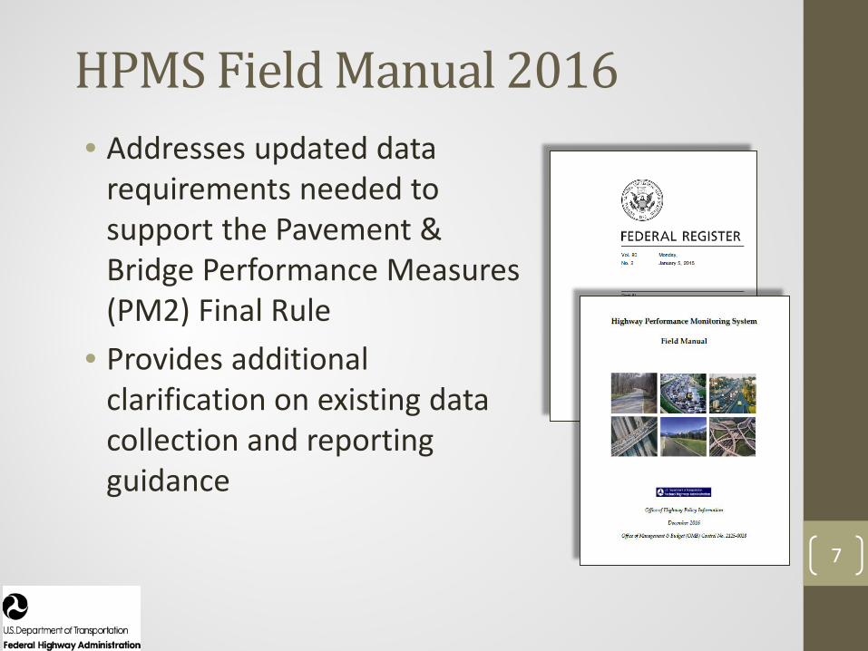
HPMS Field Manual 2016• Addresses updated data
requirements needed to support the Pavement & Bridge Performance Measures (PM2) Final Rule
• Provides additional clarification on existing data collection and reporting guidance
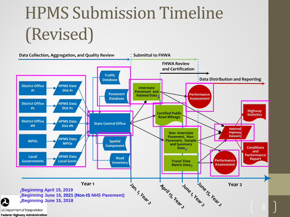
Year 2
State Central Office
Year 1
District Office #1
MPOs
District Office #N
District Office #2
Local Governments
HPMS Data Dist #1
HPMS Data Local Govts
HPMS Data MPOs
HPMS Data Dist #N
HPMS Data Dist #2
Data Collection, Aggregation, and Quality Review
Traffic Database
Pavement Database
Submittal to FHWA
Jan. 1, Year 2
April 15, Year 2
June 1, Year 2
June 15, Year 2
Certified Public Road Mileage
Interstate Pavement and Related Data
Non- Interstate Pavement, Non-
Pavement, Sample and Summary
Data
FHWA Review and Certification
Data Distribution and Reporting
Highway Statistics
Conditions and
Performance ReportRoad
Inventory
Spatial Component
Performance Assessment
National Highway Datasets
Travel Time Metric Data
Performance Assessment
1
3
2
1Beginning April 15, 20192Beginning June 15, 2021 (Non-IS NHS Pavement)3Beginning June 15, 2018
8
HPMS Submission Timeline (Revised)

METADATA TYPES AND VALUE NUMERIC SPECIFICATIONS
Type Description Value Numeric Class_Pct_Actual Percent of class AADTs (i.e., Single-unit Truck & Bus,
and Combination Truck AADT) reported that are based on actual counts for the reported data year
Enter value to the nearest whole percent.
Class_24 Number of permanent and portable classification count locations that were counted for a duration of 24 hours or more
Integer.
IRI_Equip_Type Type of equipment used predominately for measuring the International Roughness Index (IRI)
Code Description 1 3-dimensional (3-D) imaging
system/scanning laser 2 Laser 3 Other
Rutting_Interval For manual rutting method: sampling interval. (Ref: AASHTO Designation R48-10(2013); 7.1.6) or For automatic rutting method: report interval—the travel distance between the reported data. (Ref: AASHTO Designation PP70-14 (2016); 4.2)
Report interval to the nearest foot.
Faulting_Interval Sampling interval. (Ref: AASHTO Designation R36-13; 5.2.5)
Report interval to the nearest 0.1 inch.
9
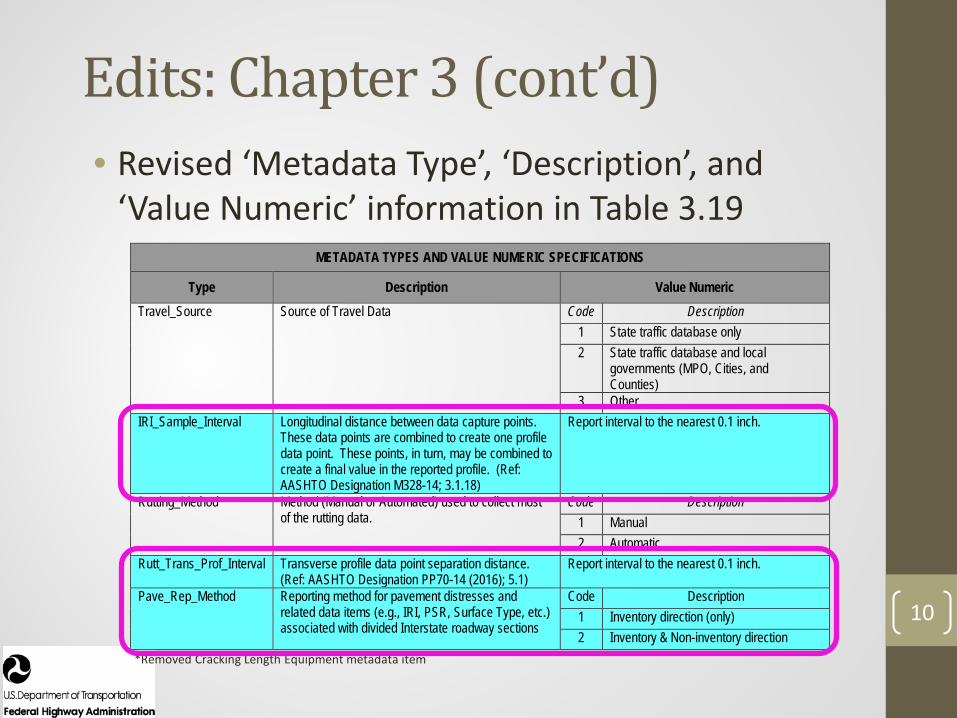
Edits: Chapter 3• Revised ‘Metadata Type’, ‘Description’, and
‘Value Numeric’ information in Table 3.19
10
Edits: Chapter 3 (cont’d)• Revised ‘Metadata Type’, ‘Description’, and
‘Value Numeric’ information in Table 3.19
*Removed Cracking Length Equipment metadata item
METADATA TYPES AND VALUE NUMERIC SPECIFICATIONS
Type Description Value Numeric Travel_Source Source of Travel Data Code Description
1 State traffic database only 2 State traffic database and local
governments (MPO, Cities, and Counties)
3 Other IRI_Sample_Interval Longitudinal distance between data capture points.
These data points are combined to create one profile data point. These points, in turn, may be combined to create a final value in the reported profile. (Ref: AASHTO Designation M328-14; 3.1.18)
Report interval to the nearest 0.1 inch.
Rutting_Method Method (Manual or Automated) used to collect most of the rutting data.
Code Description 1 Manual 2 Automatic
Rutt_Trans_Prof_Interval Transverse profile data point separation distance. (Ref: AASHTO Designation PP70-14 (2016); 5.1)
Report interval to the nearest 0.1 inch.
Pave_Rep_Method Reporting method for pavement distresses and related data items (e.g., IRI, PSR, Surface Type, etc.) associated with divided Interstate roadway sections
Code Description 1 Inventory direction (only) 2 Inventory & Non-inventory direction
11
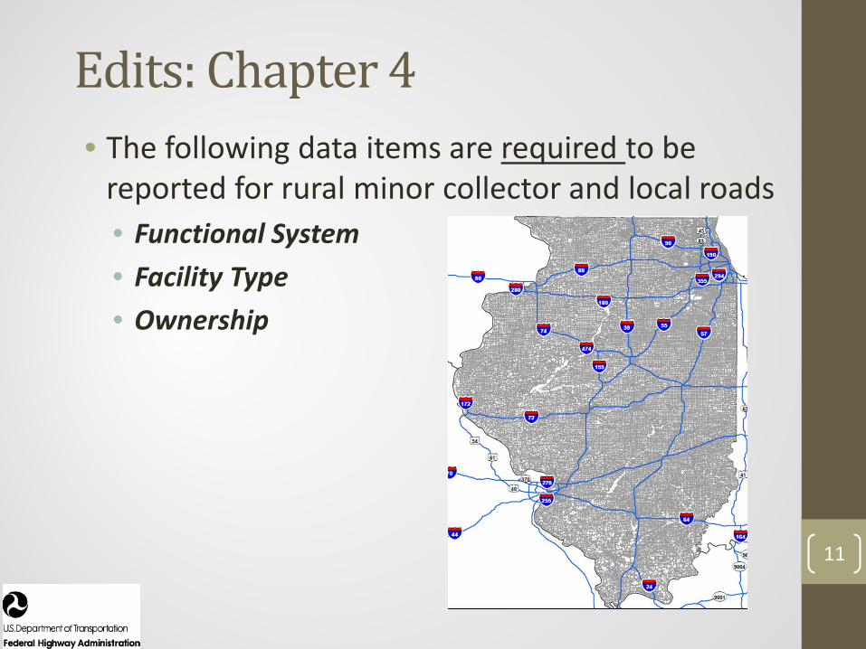
Edits: Chapter 4• The following data items are required to be
reported for rural minor collector and local roads• Functional System• Facility Type• Ownership

12
Edits: Chapter 4• The following data items are required to be
reported for both directions of travel on divided highway sections• Functional System• Facility Type• Ownership• NHS
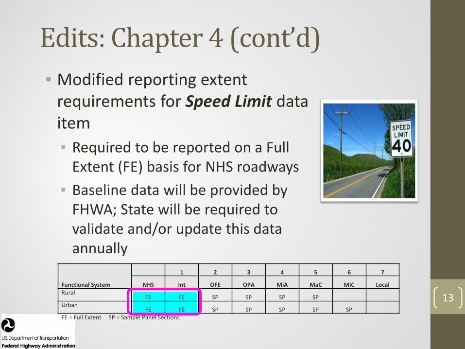
Functional System
1 2 3 4 5 6 7
NHS Int OFE OPA MiA MaC MiC LocalRural
FE FE SP SP SP SPUrban
FE FE SP SP SP SP SPFE = Full Extent SP = Sample Panel Sections
13
Edits: Chapter 4 (cont’d)• Modified reporting extent
requirements for Speed Limit data item• Required to be reported on a Full
Extent (FE) basis for NHS roadways• Baseline data will be provided by
FHWA; State will be required to validate and/or update this data annually
14
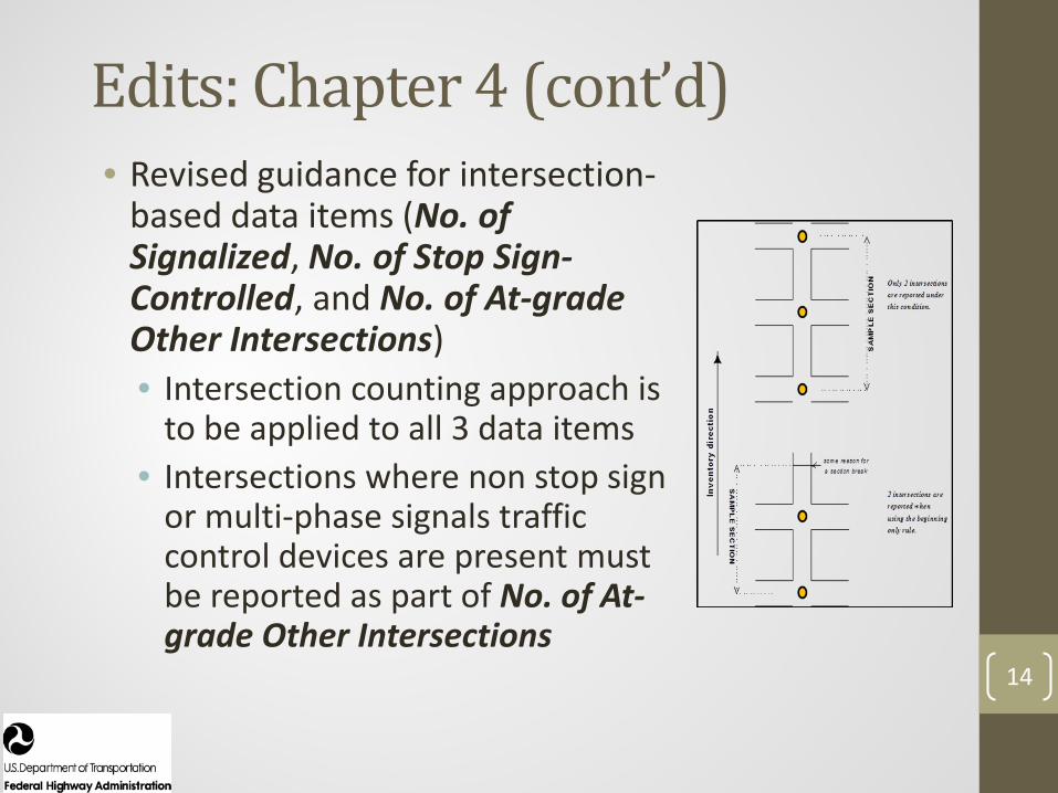
Edits: Chapter 4 (cont’d)• Revised guidance for intersection-
based data items (No. of Signalized, No. of Stop Sign-Controlled, and No. of At-grade Other Intersections)• Intersection counting approach is
to be applied to all 3 data items• Intersections where non stop sign
or multi-phase signals traffic control devices are present must be reported as part of No. of At-grade Other Intersections

15
HPMS Field Manual Errata• Contains revisions to various HPMS Field
Manual contents• Awaiting FHWA Office of Chief Counsel approval
• Release Date: TBD
16
HPMS Field Manual Errata (cont’d)• Revised the definitions for the following coverage
specifications used in Table 4.2 (“Data Items, Related Submission Deadlines and Required Reporting Formats”)• Full Extent (FE), FE*, FE**, FE+R (Ramps), Sample
Panel (SP), SP*• Clarified extent reporting requirements for:
• Urban Code, Through Lanes, and County Code• Clarified sample section reporting requirements for:
• PSR, Rutting, Faulting, and Cracking Percent

Software
17

Topics• Submission 2017 Review• Recent Software Updates• Changes for TPM
18

2017 Submissions
Subm
issio
n Re
view
19
39
40
15
18
12
19
88
85
100
86
120
2017
2016
2015
2014
2013
2012
Total # of Submissions & Resubmissions Submitted by June 15*
Data through September 7, 2017
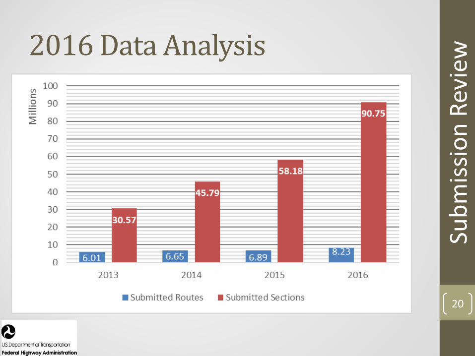
2016 Data Analysis
Subm
issio
n Re
view
20

May 16430
June 14546
June 28241
May 19345
May 30422 June 8
423
0
100
200
300
400
500
600
4/1/16 5/8/16 6/7/16 7/13/16 8/17/16 3/21/17 4/25/17 5/27/17 6/28/17 8/4/17
Count of Successful HPMS Jobs April 2016 - September 2017
21
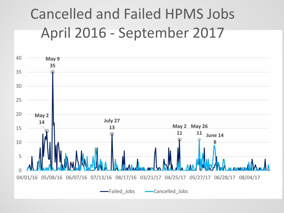
22
May 214
May 935
July 2713 May 2
11May 26
11 June 148
0
5
10
15
20
25
30
35
40
04/01/16 05/08/16 06/07/16 07/13/16 08/17/16 03/21/17 04/25/17 05/27/17 06/28/17 08/04/17
Failed_Jobs Cancelled_Jobs
Cancelled and Failed HPMS Jobs April 2016 - September 2017

Software Updates
23

Recent Software Updates• Fix for section map slowness• Remove report creation in Review and National• Pavement Report Card update for 2016 data• Sample Validation fix• Interstate and NHS Report updates (two year
comparison)• Urban Area updates• Metadata Update for 2016 Field Manual• Capacity Module updates• Sample Adequacy fix for large sample sets• Implement sample export tool with spatial output 24
Soft
war
e U
pdat
es

Recent Software Updates• Fix for section map slowness• Remove report creation in Review and National• Pavement Report Card update for 2016 data• Sample Validation fix• Interstate and NHS Report updates (two year
comparison)• Urban Area updates• Metadata Update for 2016 Field Manual• Capacity Module updates• Sample Adequacy fix for large sample sets• Implement sample export tool with spatial output
25
Soft
war
e U
pdat
es
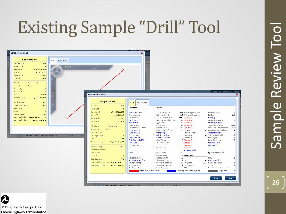
Existing Sample “Drill” Tool
26
Sam
ple
Revi
ew To
ol
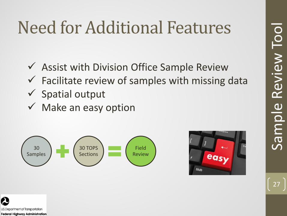
Need for Additional Features
27
Sam
ple
Revi
ew To
ol
30 Samples
30 TOPS Sections
Field Review
Assist with Division Office Sample Review Facilitate review of samples with missing data Spatial output Make an easy option
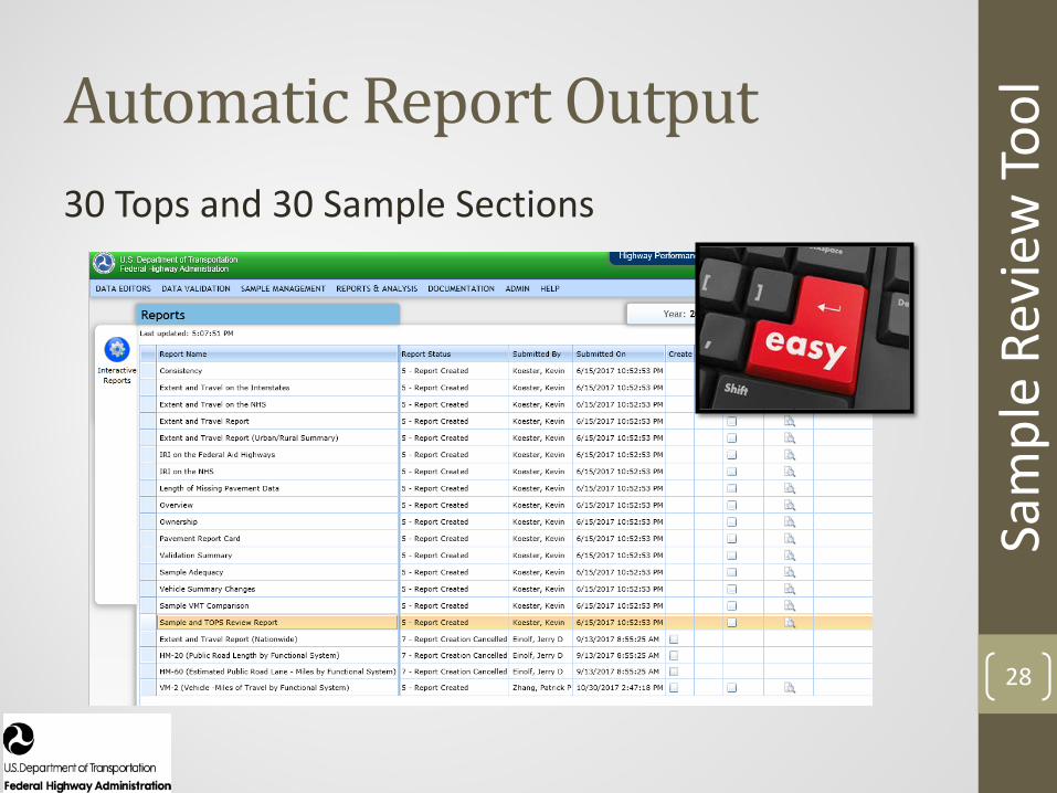
Automatic Report Output
28
Sam
ple
Revi
ew To
ol
30 Tops and 30 Sample Sections
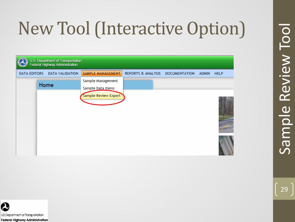
New Tool (Interactive Option)
29
Sam
ple
Revi
ew To
ol
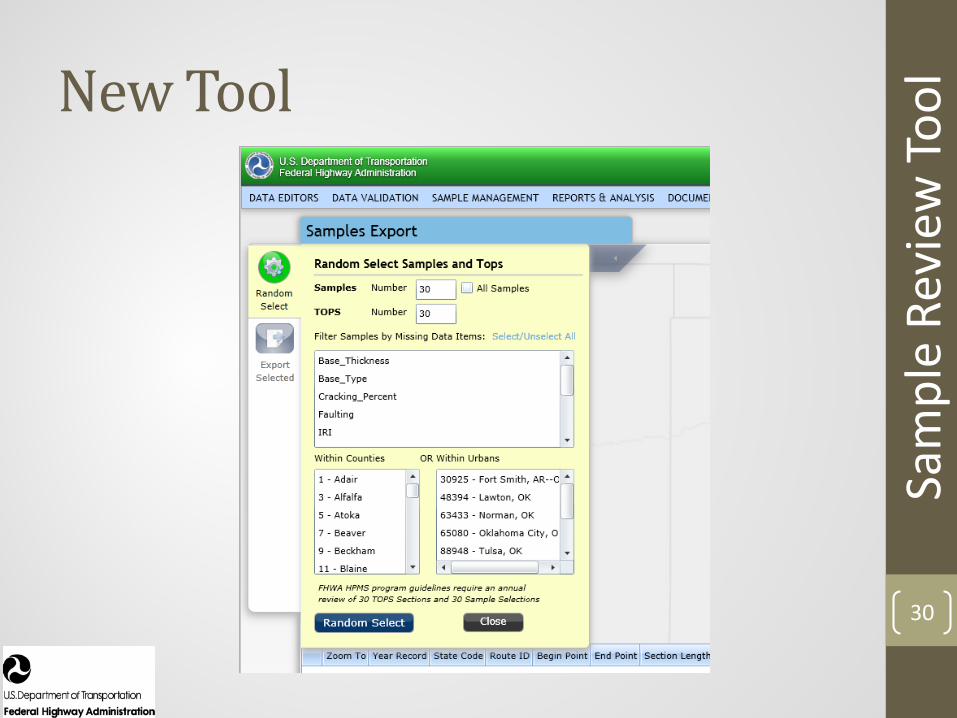
New Tool
30
Sam
ple
Revi
ew To
ol

New Tool
31
Sam
ple
Revi
ew To
ol
Filter for Missing Data Items
Filter/Select UAs or Counties
Adjust # of Samples/TOPS Sections
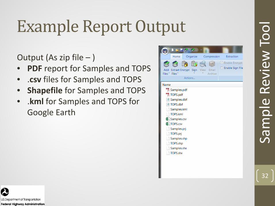
Example Report Output
32
Sam
ple
Revi
ew To
ol
Output (As zip file – )• PDF report for Samples and TOPS • .csv files for Samples and TOPS• Shapefile for Samples and TOPS• .kml for Samples and TOPS for
Google Earth
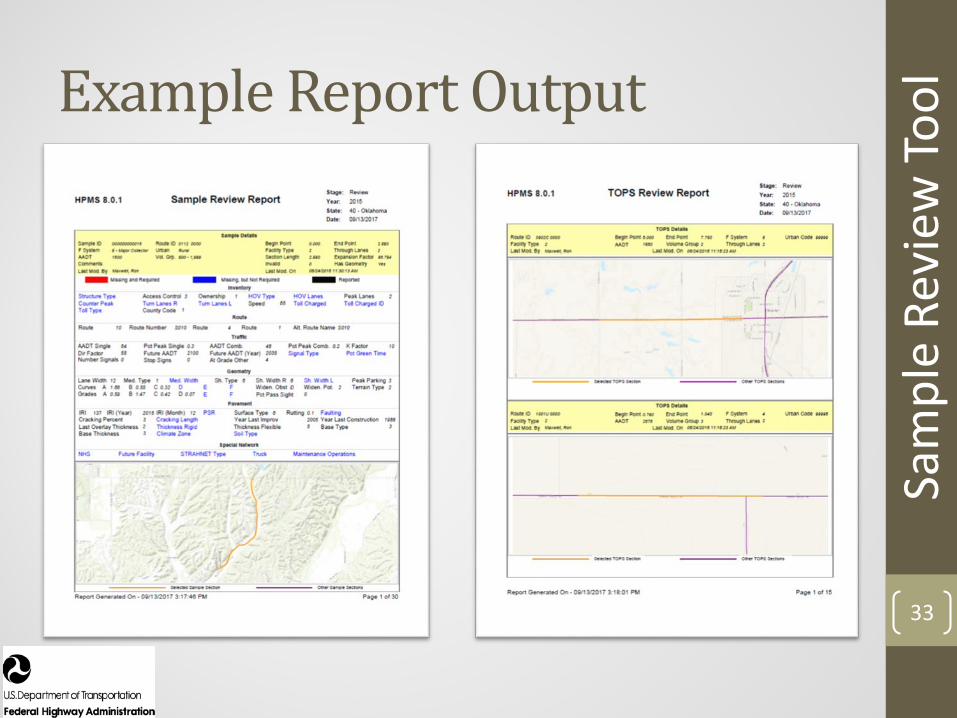
Example Report Output
33
Sam
ple
Revi
ew To
ol
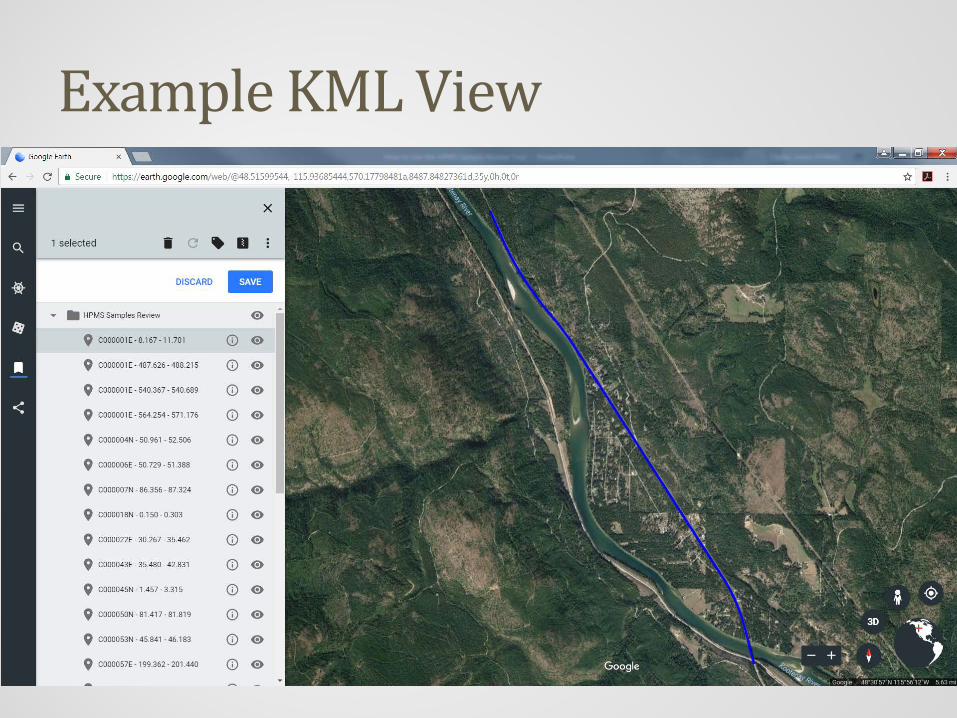
Example KML View
34

Example KML View
35
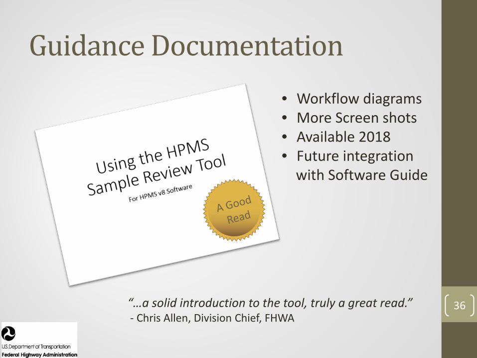
Guidance Documentation
36
• Workflow diagrams• More Screen shots• Available 2018• Future integration
with Software Guide
“…a solid introduction to the tool, truly a great read.”- Chris Allen, Division Chief, FHWA
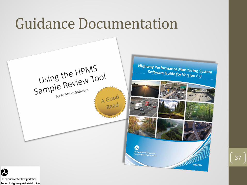
Guidance Documentation
37

38
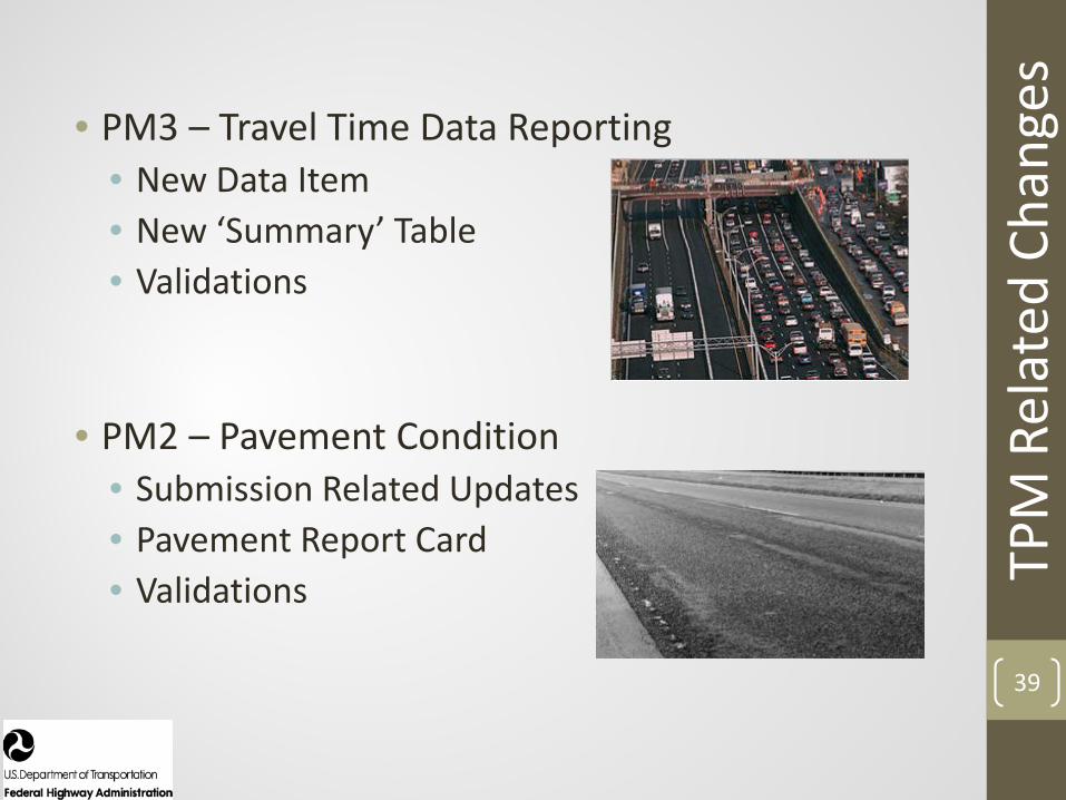
• PM3 – Travel Time Data Reporting• New Data Item• New ‘Summary’ Table• Validations
• PM2 – Pavement Condition• Submission Related Updates• Pavement Report Card• Validations TP
M R
elat
ed C
hang
es
39

PM3 Updates
40
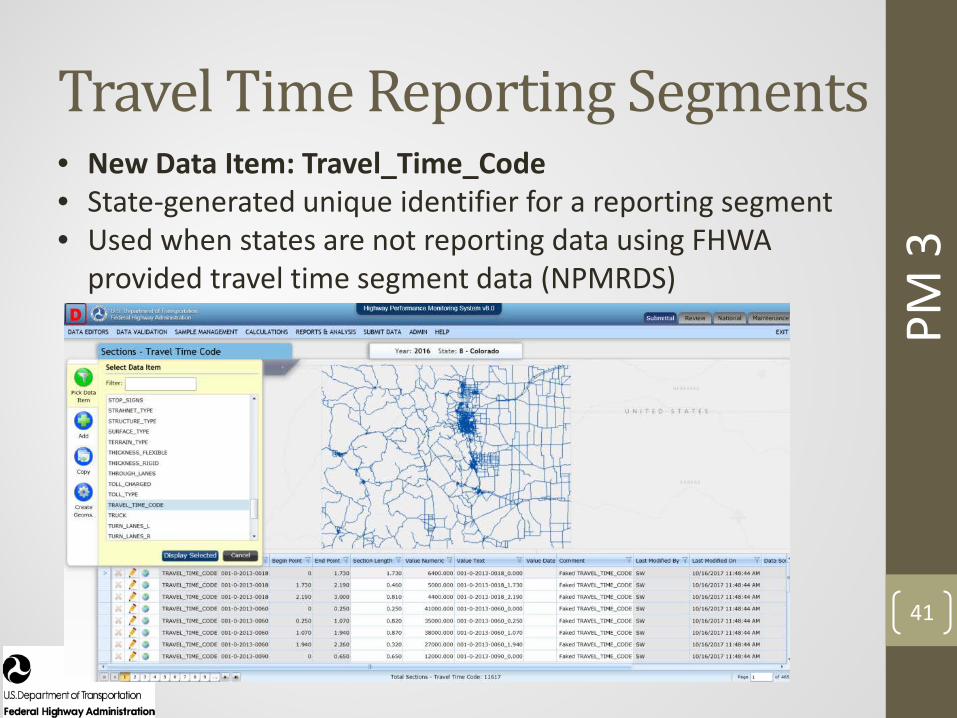
Travel Time Reporting Segments
PM 3
41
• New Data Item: Travel_Time_Code• State-generated unique identifier for a reporting segment • Used when states are not reporting data using FHWA
provided travel time segment data (NPMRDS)

Travel Time Metrics
PM 3
42
• New ‘Summary’ Data Table for Travel Time Metrics
• Fields for metric data e.g. AADT, Truck AADT, etc.
• One record for each travel time segment
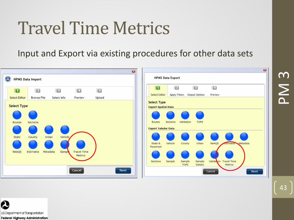
Travel Time Metrics
PM 3
43
Input and Export via existing procedures for other data sets

Travel Time Metrics
PM 3
44
• Requirement for valid submissions• Validations in development

PM2 Updates
45
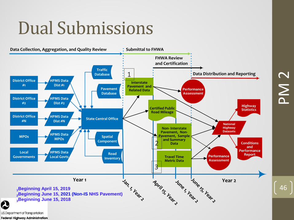
Dual Submissions
PM 2
46Year 2
State Central Office
Year 1
District Office #1
MPOs
District Office #N
District Office #2
Local Governments
HPMS Data Dist #1
HPMS Data Local Govts
HPMS Data MPOs
HPMS Data Dist #N
HPMS Data Dist #2
Data Collection, Aggregation, and Quality Review
Traffic Database
Pavement Database
Submittal to FHWA
Jan. 1, Year 2
April 15, Year 2
June 1, Year 2
June 15, Year 2
Certified Public Road Mileage
Interstate Pavement and Related Data
Non- Interstate Pavement, Non-
Pavement, Sample and Summary
Data
FHWA Review and Certification
Data Distribution and Reporting
Highway Statistics
Conditions and
Performance ReportRoad
Inventory
Spatial Component
Performance Assessment
National Highway Datasets
Travel Time Metric Data
Performance Assessment
1Beginning April 15, 20192Beginning June 15, 2021 (Non-IS NHS Pavement)3Beginning June 15, 2018
1
2
3
Dual Submissions
PM 2
47
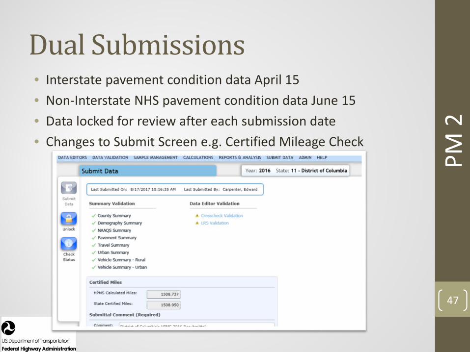
• Interstate pavement condition data April 15• Non-Interstate NHS pavement condition data June 15• Data locked for review after each submission date• Changes to Submit Screen e.g. Certified Mileage Check

Validations for Inventory Data
PM 2
48
Coverage Validations • NHS – based on approved NHS• Facility Type• Through lanes*• Functional system• Surface type• Structure type• Urban code
*Directional through lanes for dual-carriage reporting for Interstates

Validations for Condition Data
PM 2
49
Coverage and Cross Validations• Roughness (IRI) (MRI) – Collection Date• Rutting (asphalt pavements only) • Cracking Percent – by surface type• Faulting (concrete pavements only)• Can use Present Serviceability Rating (PSR) only
where speed limit < 40 mph

Pavement Report Card
PM 2
50
• Missing, Invalid and Unresolved Data – max limit, include Unresolved• PSR - other distress data not required unless it is on a sample • Dates for rutting/cracking/faulting (like IRI)
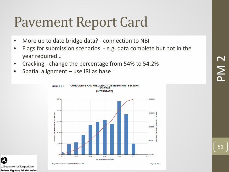
Pavement Report Card
PM 2
51
• More up to date bridge data? - connection to NBI• Flags for submission scenarios - e.g. data complete but not in the
year required…• Cracking - change the percentage from 54% to 54.2% • Spatial alignment – use IRI as base

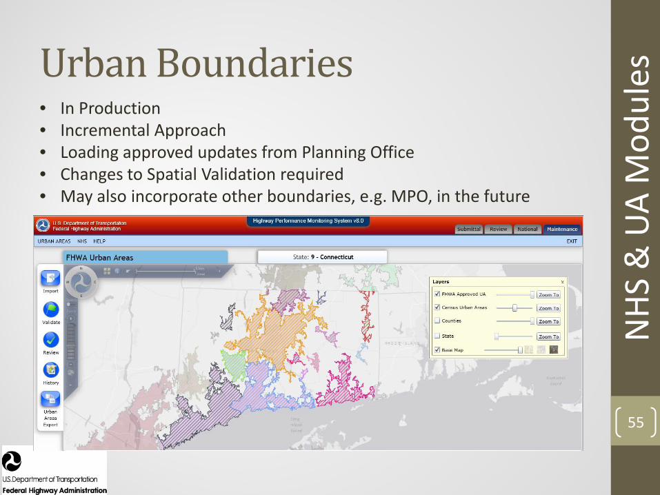
NHS and Urban Area Modules
52

Maintenance Module
53
NHS
& U
A M
odul
es

54
NHS
& U
A M
odul
esNHS• In Production• Incremental Approach• Working through process with Planning Office• Performance Improvements Underway
55
NHS
& U
A M
odul
esUrban Boundaries• In Production• Incremental Approach• Loading approved updates from Planning Office• Changes to Spatial Validation required• May also incorporate other boundaries, e.g. MPO, in the future

NHI HPMS Workshop/Training
56
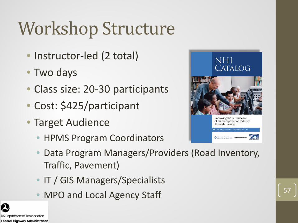
Workshop Structure• Instructor-led (2 total)• Two days • Class size: 20-30 participants• Cost: $425/participant• Target Audience
• HPMS Program Coordinators• Data Program Managers/Providers (Road Inventory,
Traffic, Pavement) • IT / GIS Managers/Specialists • MPO and Local Agency Staff 57
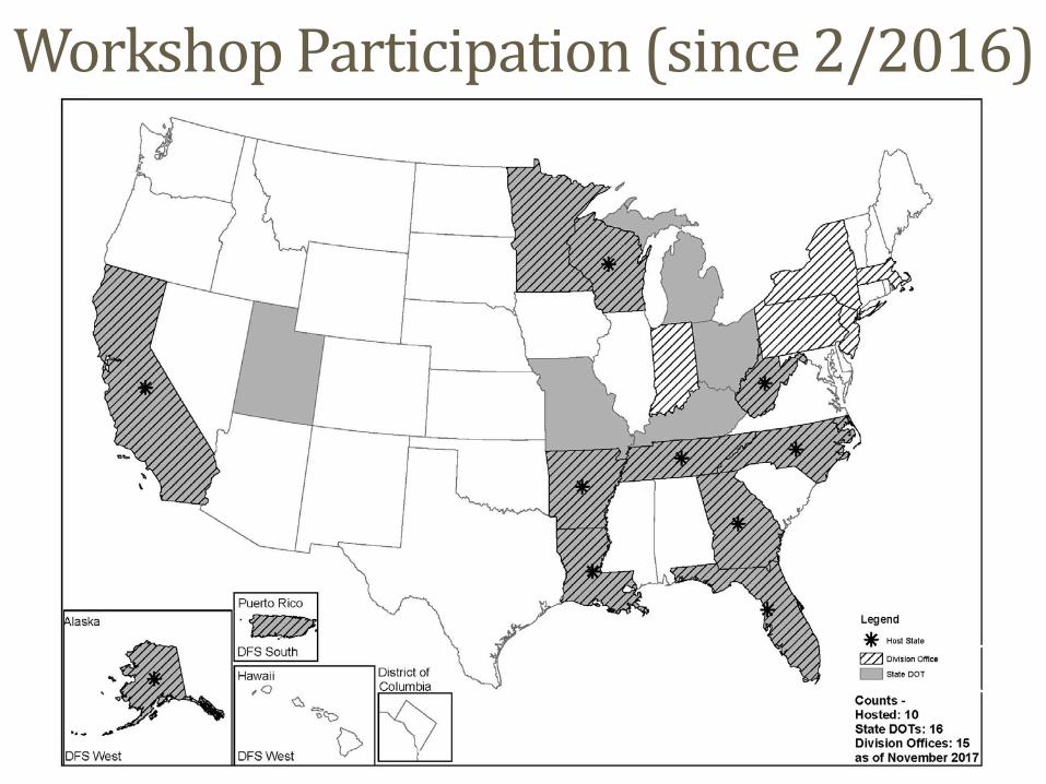
Workshop Participation (since 2/2016)
58

Questions / Comments?
59

60
Contacts• Ronald Vaughn, PMP
FHWA / Office of Highway Policy InformationOffice: (202) 366-9248Email: [email protected]
• Justin Clarke, AICPFHWA / Office of Highway Policy InformationOffice: (202) 366-9245Email: [email protected]

61


![5G Transport - Standardization Timetable (Draft) · 2018-07-13 · SGSN 2G MSC 2G a) b) c) PE PE PE PE PE PE P P [4] Abis Abis. TNL PW or TNL LSP T-PE S-PE T-PE S-PE P T-PE. e) f)](https://static.fdocuments.in/doc/165x107/5e6ee4b56af2236d0a20b376/5g-transport-standardization-timetable-draft-2018-07-13-sgsn-2g-msc-2g-a.jpg)