Historical Background Problem Definition- Part I · · 2010-11-101 1 Photogrammetric ... Problem...
6
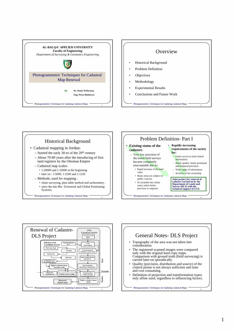
1 1 Photogrammetric Techniques for Updating Cadastral Maps Photogrammetric Techniques for Updating Cadastral Maps By: Dr. Rami Al-Ruzouq Eng. Petya Dimitrova AL-BALQA’ APPLIED UNIVERSITY Faculty of Engineering Department of Surveying & Geomatics Engineering Photogrammetric Techniques for Cadastral Photogrammetric Techniques for Cadastral Map Renewal Map Renewal 2 Photogrammetric Techniques for Updating Cadastral Maps Photogrammetric Techniques for Updating Cadastral Maps • Historical Background • Problem Definition • Objectives • Methodology • Experimental Results • Conclusions and Future Work Overview 3 Photogrammetric Techniques for Updating Cadastral Maps Photogrammetric Techniques for Updating Cadastral Maps Historical Background • Cadastral mapping in Jordan: – Started the early 30-es of the 20 th century – About 70-80 years after the introducing of first land registers by the Ottoman Empire – Cadastral map scales: • 1:20000 and 1:10000 at the beginning • later on : 1:5000, 1:2500 and 1:1250 – Methods, used for mapping : • chain surveying, plan table method and tacheometry. • since the late 80s: Terrestrial and Global Positioning Systems. 4 Photogrammetric Techniques for Updating Cadastral Maps Photogrammetric Techniques for Updating Cadastral Maps Problem Definition- Part I • Existing status of the cadastre: – Very low precision of the initial field surveys became completely unacceptable due to: • Rapid increase of the land value • Many areas are subject to public concern • Or included into urban zones where better precision is required. • Rapidly increasing requirements of the society for: – Faster access to land related information – Better quality- better positional and temporal precision – Wide range of information – Security of the ownership Joint project for renewal of cadastre carried on by the Department of Lands and Survey (DLS) with the technical support of GTZ. 5 Photogrammetric Techniques for Updating Cadastral Maps Photogrammetric Techniques for Updating Cadastral Maps Renewal of Cadastre- DLS Project 6 Photogrammetric Techniques for Updating Cadastral Maps Photogrammetric Techniques for Updating Cadastral Maps General Notes- DLS Project • Topography of the area was not taken into consideration. • The registered scanned images were compared only with the original hard copy maps. Comparison with ground truth (field surveying) is carried later-on sporadically. • Quality (precision, distribution and source) of the control points is not always sufficient and time and cost consuming. • Definition of projection and transformation types: only affine used, regardless to influencing factors.
Transcript of Historical Background Problem Definition- Part I · · 2010-11-101 1 Photogrammetric ... Problem...
1
1Photogrammetric Techniques for Updating Cadastral MapsPhotogrammetric Techniques for Updating Cadastral Maps
By: Dr. Rami Al-Ruzouq
Eng. Petya Dimitrova
AL-BALQA’ APPLIED UNIVERSITYFaculty of Engineering
Department of Surveying & Geomatics Engineering
Photogrammetric Techniques for Cadastral Photogrammetric Techniques for Cadastral Map RenewalMap Renewal
2Photogrammetric Techniques for Updating Cadastral MapsPhotogrammetric Techniques for Updating Cadastral Maps
• Historical Background
• Problem Definition
• Objectives
• Methodology
• Experimental Results
• Conclusions and Future Work
Overview
3Photogrammetric Techniques for Updating Cadastral MapsPhotogrammetric Techniques for Updating Cadastral Maps
Historical Background• Cadastral mapping in Jordan:
– Started the early 30-es of the 20th century– About 70-80 years after the introducing of first
land registers by the Ottoman Empire– Cadastral map scales:
• 1:20000 and 1:10000 at the beginning• later on : 1:5000, 1:2500 and 1:1250
– Methods, used for mapping :• chain surveying, plan table method and tacheometry. • since the late 80s: Terrestrial and Global Positioning
Systems.
4Photogrammetric Techniques for Updating Cadastral MapsPhotogrammetric Techniques for Updating Cadastral Maps
Problem Definition- Part I• Existing status of the
cadastre:– Very low precision of
the initial field surveys became completely unacceptable due to:
• Rapid increase of the land value
• Many areas are subject to public concern
• Or included into urban zones where better precision is required.
• Rapidly increasing requirements of the society for:– Faster access to land related
information– Better quality- better positional
and temporal precision– Wide range of information– Security of the ownership
Joint project for renewal of cadastre carried on by the Department of Lands and Survey (DLS) with the technical support of GTZ.
5Photogrammetric Techniques for Updating Cadastral MapsPhotogrammetric Techniques for Updating Cadastral Maps
Renewal of Cadastre-DLS Project
6Photogrammetric Techniques for Updating Cadastral MapsPhotogrammetric Techniques for Updating Cadastral Maps
General Notes- DLS Project• Topography of the area was not taken into
consideration.• The registered scanned images were compared
only with the original hard copy maps. Comparison with ground truth (field surveying) is carried later-on sporadically.
• Quality (precision, distribution and source) of the control points is not always sufficient and time and cost consuming.
• Definition of projection and transformation types: only affine used, regardless to influencing factors.

2
7Photogrammetric Techniques for Updating Cadastral MapsPhotogrammetric Techniques for Updating Cadastral Maps
Problem Definition- Part IIDiversity of Available Data
Satellite Satellite Imagery:Imagery:
IKONOSIKONOS--1m1m
8Photogrammetric Techniques for Updating Cadastral MapsPhotogrammetric Techniques for Updating Cadastral Maps
Problem Definition- Part IIDiversity of Available Data
Aerial Stereo Aerial Stereo Photography:Photography:
Scale 1:10000Scale 1:10000
9Photogrammetric Techniques for Updating Cadastral MapsPhotogrammetric Techniques for Updating Cadastral Maps
Problem Definition- Part IIDiversity of Available Data
•• Field Field Surveying:Surveying:
GPSGPS
10Photogrammetric Techniques for Updating Cadastral MapsPhotogrammetric Techniques for Updating Cadastral Maps
Problem Definition- Part IIDiversity of Available Data
•• Hard Copy Hard Copy Cadastral Cadastral Maps:Maps:
DLSDLS
11Photogrammetric Techniques for Updating Cadastral MapsPhotogrammetric Techniques for Updating Cadastral Maps
Problem Definition- Part IIDiversity of Available Data
•• Topographic Topographic Maps:Maps:
RJGCRJGC
12Photogrammetric Techniques for Updating Cadastral MapsPhotogrammetric Techniques for Updating Cadastral Maps
Objectives•• Data IntegrationData Integration: Well established procedure
that Fundamentally involves combining or merging data from multiple sources in an effort to extract better and/or more information
•• Evaluation of the factors, causing mismatch Evaluation of the factors, causing mismatch between different data sources- qualitative and quantitative methods Transformation FunctionTransformation Function: Establishing the mathematical function that relates different data (2D-similirty, affine and polynomial)
•• Ground TruthGround Truth: fairly representation the real object space in high accuracy taking into consideration the cost associated with such requirement.
3
13Photogrammetric Techniques for Updating Cadastral MapsPhotogrammetric Techniques for Updating Cadastral Maps
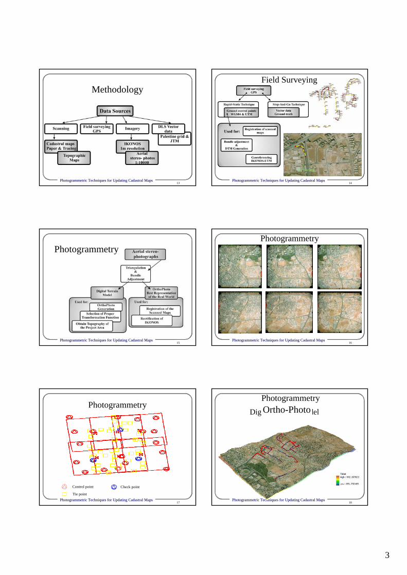
Methodology
14Photogrammetric Techniques for Updating Cadastral MapsPhotogrammetric Techniques for Updating Cadastral Maps
Reference
Field Surveying
15Photogrammetric Techniques for Updating Cadastral MapsPhotogrammetric Techniques for Updating Cadastral Maps
Photogrammetry
16Photogrammetric Techniques for Updating Cadastral MapsPhotogrammetric Techniques for Updating Cadastral Maps
Photogrammetry
17Photogrammetric Techniques for Updating Cadastral MapsPhotogrammetric Techniques for Updating Cadastral Maps
Control point
Tie point
Check point
Photogrammetry
18Photogrammetric Techniques for Updating Cadastral MapsPhotogrammetric Techniques for Updating Cadastral Maps
Digital Terrain ModelCountor LinesOrtho-PhotoPhotogrammetry

4
19Photogrammetric Techniques for Updating Cadastral MapsPhotogrammetric Techniques for Updating Cadastral Maps
Satellite imagesGeo-referencing IKONOS with
Ortho-photo
20Photogrammetric Techniques for Updating Cadastral MapsPhotogrammetric Techniques for Updating Cadastral Maps
Photogrammetry: Rectified IKONOS, overlaid with Ortho-photo and DLS vector data
21Photogrammetric Techniques for Updating Cadastral MapsPhotogrammetric Techniques for Updating Cadastral Maps
Scanning
• Hard copy cadastral maps-DLS
• Topographic maps- RJGC
22Photogrammetric Techniques for Updating Cadastral MapsPhotogrammetric Techniques for Updating Cadastral Maps
321 CYCXCx +−=
612 CYCXCy ++=
2-D Similarity
8765 BZBYBXBy +++=
4321 BZBYBXBx +++=
Parallel Projection
321 CYCXCx ++=
654 CYCXCy ++=
Standard Affine
4251 & CCCC −==YaXaaZ ⋅+⋅+= 210
Parallel Projection
Perspective Projection
Flight Directions
Object Space
High AltitudeNarrow AFOV
Planar Surface
Parallel Image-Object
Approximate Models
23Photogrammetric Techniques for Updating Cadastral MapsPhotogrammetric Techniques for Updating Cadastral Maps
Orthophoto
Object Space
Affine transformation
Affine Transformation Affine Transformation
Transformation
Cadastral map
24Photogrammetric Techniques for Updating Cadastral MapsPhotogrammetric Techniques for Updating Cadastral Maps
Registration Results (RMS)

5
25Photogrammetric Techniques for Updating Cadastral MapsPhotogrammetric Techniques for Updating Cadastral Maps
Vector Data- DLS
26Photogrammetric Techniques for Updating Cadastral MapsPhotogrammetric Techniques for Updating Cadastral Maps
Overlay of Vector Layer (from Palestine Grid) with Ortho-photo
27Photogrammetric Techniques for Updating Cadastral MapsPhotogrammetric Techniques for Updating Cadastral Maps
Results- Overlay
28Photogrammetric Techniques for Updating Cadastral MapsPhotogrammetric Techniques for Updating Cadastral Maps
Results- Data Fusion
29Photogrammetric Techniques for Updating Cadastral MapsPhotogrammetric Techniques for Updating Cadastral Maps
Conclusions • Application of the method for extraction of cadastral
boundaries:– Initial cadastral survey or resurveying:
• Using photogrammetric marks on ground (on top of boundary marks)
• Regardless to existence of physical boundaries– Check for consistence between legal boundaries-cadastral
maps and physical boundaries- orthophotos• Cadastral maps can be very successfully updated using orthophotos
in old settlement areas where agreements between neighbors existand the physical boundaries are obviously not changed since longtime.– physical boundaries == legal ones – systematic distortions of the digital map can be discovered and
eliminated
30Photogrammetric Techniques for Updating Cadastral MapsPhotogrammetric Techniques for Updating Cadastral Maps
• Application of the method:– Extraction of new features:
• Topography• Buildings• Land Marks• Land use• Environmental conditions• Other
MultiMulti--Purpose CadastrePurpose Cadastre
Conclusions
Play major role in Land Value!

6
31Photogrammetric Techniques for Updating Cadastral MapsPhotogrammetric Techniques for Updating Cadastral Maps
Conclusions• Application of transformation functions
– Affine: suitable for flat areas– Projective : for hilly areas
• Orthophoto is good and accurate source that represent ground truth which could be used as a base for registration
• Causes of mismatch:– Different accuracy in the primary sources: control
points, original survey and mapping, etc.– Projection types– Scanning– Digitizing– Transformation functions (with regard to topography)
32Photogrammetric Techniques for Updating Cadastral MapsPhotogrammetric Techniques for Updating Cadastral Maps
Future Work
• Applying feature extraction to produce true orthophoto for 3D modeling
• Overlaying other data sources with importance to multi-purpose cadastre:– Maps of infrastructure: on or under-ground– Land use planning– Other satellite imagery: Spot, Landsat– Other