SB Canto 1 Chapter 15 The Pandavas Retire Timely by Amritananda das.

1
HISTORICAL
BACKGROUND OF
DELHI
REGARDING CITY
PLANNING

2
HISTORICAL BACKGROUND OF DELHI REGARDING CITY PLANNING
(1) In the epics a city called Indraprastha, situated on the area where New Delhi stands today, is mentioned. In Indraprastha city, there were five plains each belonging to Pandavas. The City of Indraprastha was founded by Pandavas after their being exited by their cousin Korvas. from Hastinapur, It is further stated that the main part of the town developed by Pandavas was where the Purana Kila exists today It is also said that it was done in the tenth century B.C. This fort was a well- planned garden city with wide streets and palaces. (2) There is a belief that before the Macedonian invasions a King called Raja Dilu or Dhilu, a Member of the Mauryan dynasty, founded a city after his name somewhere near about Iron Pillar standing near Qutub Minar. It is also believed that the name Dilli is derived from the name of the King Dillu. (3) After this, city again fell into oblivion for about 750 years. (4) In the middle of eleventh century A.D., a Tumar Rajput King called Anangpal, forced by the terror of Mohammed of Ghazni, founded the city of Delhi on the old site of Raja Dilu. King Anangpal I, II & III built a walled city of Dal Kot and constructed dams and tanks for the supply of water. (5) After the death of Anangpal III in 1151, his son Prithviraj built a well-known eitadel, and a walled city of Raipithora. At this time, Delhi was 5 miles in circumference, having 27 Hindu Temples on the pattern of Rajput architecture. The King was defeated very soon, and after this it is remain the capital of Mohammed for a long time. (6) Qutab-ud-din-Aibek, who was appointed as the viceroy of Delhi, later became King and the capital was confined to the old Rajput city. As the population was more, so he extended it beyond the old Lal Kot to the plains in the north-east. The twenty-seven temples built the famous mosque (Quwaat-ul-Islam) out of remains. We also started the construction of Qutab Minar which is 234’ high with 47’-7” diameter. All the buildings of this period is a mixture of Hindu and Mohammedan architecture. (7) In 290 A.D. Jalal-ud-din Khil ji built a ford called Siri and turned it into a city of about 1 miles circumference. At a distance of few furlongs, he constructed a big tank called Hauz Khas. He enlarged the Quwaat-ul-Islam mosque built by Qutab-ud-din, and added a Gateway called Alai Darwaza. In this time, Delhi became an important commercial and cultural centre and different Carvan entered from different parts of the country to this capital. The poet Hazrat Amir Khuzru and Nizam-ud-din, the saint lived at that time at Delhi.

3
(8) Gaisu-din-Tughlak in 1321 built a new town called Tughlakabad in a circumference of about 4 miles. The city lacked the most indispensable commodity i.e. water, so it was never fully occupied. (9) Due to unsuccessful of Tughlakabad, the population again went to ancient Delhi City and they again began to extend it. Mohammed-bin-Tughlak in 1325 A.D. built a wall to enclose all the suburbs that has sprung up between Chohan Delhi and Siri and in the centres constructed palaces and mosques. The new city was named Jahanpanah. At this time, the city was in an area of 3 to 4 miles. (10) In 1354, Mohammed Tughlak’s nephew of Firoz Shah abandoned the old Delhi near Qutab and built a new city called Firozabad. He did it due to near-ness of River Yamuna, cool climate and more rain-fall and good water supply. Firozabad who was an open city without a wall and the shape was more or less a half hexagon with the base facing the river. It contained 8 mosques, 3 palaces, a hunting box, numerous large buildings, 60 rest houses. Firozshah founded a magnificent university for the study of Arabic near the Hauz Khas Tank. For some time, both the cities, Firozabad and Old Delhi near Qutab Minar, flourished together. (11) The next two dynasties, Sayyids and Lodis removed their capital to Agra, so the city of Delhi was faded away and for nearly 125 years it fell to the rank of a provincial town. (12) In 1526, Babar again regained the glory of Delhi and it became not only the political capital but a commercial and cultural centre too. The city was having 52 Bazaars, and 36 Mandis. (13) Humayun between 1530 and 1540 re-occupied the old site of Indraprastha and re-built it under the name Din-Panah. (14) After sometime he was expelled by Sher-Shah who founded the city under the name of Shirgarh on the site of Firozabad and Indraprastha. It was 9 miles in circumference and was from Humayun Tomb and Cricket Ground near Delhi Gate. He built a Fortress known as Salim Garh on a spot near Yamuna Bridge. (15) After 14 years, King Himayun again re-occupied Delhi, but after his death it was again sank to the level of a provincial town as Akbar and Jahangir from 1556 A.D. to 1627 A.D. resided in Agra and Lahore respectively. (16) In 1627, Shahjahan the great city planner among the Mugals built the magnificent city of Shahjahanabad with wide streets and parks; around it he built a wall having a circumference of about 4 miles. Persons living in old city near Qutab Minar migrated to Shahajahanabad and in its suburbs, so population rose to 1 ½ lakhs. On the eastern side Shahajahan built Red Fort and in the centre of Jama Masjid of red sand

4
stone and white marble dome. This time, Red jaina Temple was also constructed in Chandni Chowk. Several gardens; one after the name of eldest daughter Jahanara Begum (Queen Garden) another Roshanara Garden, named after second daughter. The other two were the Hajat-Baksh Bagh in the citadel and the Shalimar Bagh in the north was developed by Shahajahan. (17) In 1658, Aurangzeb constructed a deep-ditch and adjoining this a spacious garden was constructed. Many roads were constructed in the walled city; one was Chandni Chowk, the second was road to Jama Masjid and the third to Delhi Gate. The road to Jama Masjid and its bazaar was destroyed in the Mutiny of 1857. Chandni Chowk was very spacious and a canal which was directed into the citadel ran through it but this was closed after the capture of the city by British. On either side of this great avenue ran arcades of one-storeyed shops and in the back residences of traders. The buildings in the narrow-lanes running off Chandni Chowk housed the common troopers, clerks and servants of the Court. About ½ a mile to the West of Chandni Chowk were the fruit & meat markets which were later on shifted to Subzi Mandi. Trade flourished in the city and Caravans streamed into the city bringing in merchandize from distant lands. The population rose to 2 lakhs and suburbs spread as far as Firozabad in the South. Only poor people were living in Qutab Minar at that time. Peaceful atmosphere in the city did not last long. In 1737 A.D. , Nadir Shah entered it and ordered for massacre. The town was reduced to ashes and it was such that the labour of years could alone restore the town to its former state of grandeur. This was not the end of destruction. Between A.D. 1756-61 a civil war broke out between two ministers. This was followed by the invasion of Afgans and again of the Marathas. After 15 years in 1803 the British divided the Marathas and took the city under their protection. (18) The city was placed under the charge of an officer designated as resident and Chief Commissioner of Delhi in 1819. (19) In 1832 the office of Residents and Chief Commissioner was abolished and Administration was living to a Commissioner under the Government of North-West provinces (at present Uttar-Pradesh). The Delhi near Indraprastha was no more a city, but a suburb with dilapidated thatched houses. The order part near Qutab Minar became just like a rural area where nobles retired for sport. The well-planned parks and lakes of the Mughals were the things of the past. The suburbs of Shahajahanabad spread to the west and north-west i.e. Paharganj and Subzimandi respectively.

5
(20) There was problem of security, so Britishers first started living near Kashmere Gate by occupying the vacant places and gardens along the river; after sometime they start buildings outside Kashmere Gate, and the area was known as Civil Lines. The biggest structure built was called Ludlow Castle and another big building was Metcalf house built in 1830. The new Daryaganj area became the quarters of ordinary European Clerks and businessmen and the officers moved to Civil Line Areas. At that time, cantonment was built in the area where university exists today. Chandni Chowk became the centre of fashion and the hub of the city. Social and cultural activities began, clubs were opened. (21) In 1857 the mutiny was started from Meerut and the life in the city came to stand-still nearly about 3 months. Eventually after bombardment, the British recaptured the city and put it under Martial Law with a Military governor. (22) In January 1858, the city was handed over to Civil Authorities and then transferred from the juris-diction of North-West provinces to that of the Punjab. (23) In 1859 the citadel and Shahajahan was turned into military barracks for British infantry and a company of artillery. (24) In 1867 the railway came to Delhi and many lines were connected upto the end of the suburb. Many new roads were also constructed, so Delhi became the centre for goods for buying and selling. Modern Mills and Factory sprang up in the north-west along G.T. Road to Punjab and in 1889; two cottan spinning and weaving Mills were installed. The Chandni Chowk was still the principle thorough affair and in the space between Kashmere Gate and the Fort. There were a large number of public offices, a big Church, the Delhi College and the Metropolitan Hotel. The open space between the Fort and Daryaganj was turned into the public garden. Daryaganj was still occupied by the European residents. (25) In the year 1911, the Britishers announced the transfer of the capital from Calcutta to Delhi, and the Administration of the Town was put under the Chief Commissioner. In 1915 another territory comprising 65 villages from the united provinces was included in the Delhi district. The new city took an area of 68’ sqyds. and was planned by Sir Edwin Lutyens and Sir Herbert Baker. 29,000 persons worked for 18 years to built a city of gardens and excellent roads at the cost of nearly 15 crores of rupees. It was built to accommodate nearly 50, 000 persons and a retail business centres, namely Connaught Place was also constructed.

6
REPORT ON ZONAL DEVELOPMENT PLAN OF ZONE A-19 (PHATAK HABASH KHAN AREA). Introduction. Delhi’s Central Business District and Commercial and financial centre is of unique character. It has the linear form spreading ever a distance of more than two miles extending from Red Fort to Bare Tooti in Sadar Bazar with spurs towards north and south at various intervals in the form of bazars. The walled city is an age old business centre of great importance. Almost entire wholesale trade in textiles, hosiery, general merchandise and other innumerable consumer items is conducted in the narrow lanes and dark katras. Because of typical land-use pattern, many markets dealing in various commodities, such as food-grains, kirians, cosmetics, sanitary, stationery, hardware, bicycles and other such items tend to be located in their own epecialised and small areas. These areas are highly congested and unorganized having haphazard and chaotic conditions. The wholesale and retail business is at present mixed up and the space is highly inadequate to most the present day needs. The shortage of space results in storage of food grains along the road-side, loading and unloading on the street pavements itself. Parking of trucks and animal driven vehicles along the Kerb and so on is the usual scene. The conditions are still worsened whom the hawkers are also selling their goods on the pavements. All this has erested bottlenecks and the most chactic conditions. The streets which were already congested are now carrying many-fold increased mixed types of traffic. Parking of vehicles is a great problem. Apart from that, many of the problems are the result of unplanned development, the inefficient use of land, obsolete structures which are not designed for grain stores and such other purpose for which they are being used presently. Distributive trade also is the basic activity of the city of Delhi. Delhi is the hub of transportation network of northern and north-western India where many railways and highways converge. Being the capital of India and the largest city in northern India, as well, Delhi has dominance over all the other North Indian cities in the field of wholesale trade and has acquired a strong distributive function. Delhi improved its position as a centre of distributive activity in the northern India, as Lahore, the only other competing centre, was new in Pakistan. Other possible centre was Amritsar. Delhi now meets the business demand, the consumers’ demand not only of its own but also of the adjoining states of India. With the passage of time, the city started extending beyond the city walls resulting in the lack of proper sanitation and public health, serious physical disorder and unplanned concentration of people. All this created the above-mentioned problems.

7
Phatak Habash Khan is one of areas of walled city where there is concentration of wholesale business in commodities like food-grain, dry fruits, spices, pulses, chemicals, cloth, automobile spares, tyres and tubes etc. The business is conducted in extremely congested areas. There is practically no parking area. The streets and roads are of barying widths and shapes. Loading and unloading is great problem. The structures are very old and compact loading proper ventilation and suffers from all the problems mentioned above. The preparation of Zonal Development Plan for this area, therefore, requires a through and deep-strudy of the functioning of the wholesale trade and its problems so an to arrive at suitable planning standards for spatial requirements for wholesale business. Then only a Plan can be a realistic and functionally feasible one. Market: A market is a place where goods are offered for sale and where sellers and buyers meet. There are three factors involved in marketing: (1) goods; (2) People and (3) Functions. Through marketing activities, goods and services are moved from producers to consumers. Goods must be moved; people must move them and in the movement certain operations or functions must be performed. The object of marketing is to supply human wants-supply goods from producers to consumers. Marketing is one of the oldest urban functions. The heart of many early cities was the market place. Functions of the markets: The functions of the markets can be broadly classified into three categories: 1. Movement of ownership. 2. Movement of goods, and 3. Market management. (1) Movement of ownership creates possession utility and is effected by buying and selling involving following operations: (i) Finding buyers and sellers; (ii) Negotiating prices and terms; (iii) Standardising and (iv) Transferring title. (2) Movement of goods creates place and time utility involving: (i) Transporting; (ii) Storing; (iii) Packing, dividing and grading and (iv) Assembling orders.

8
(3) Market management covers the following functions: (i) Formulating policies; (ii) Providing organisation and equipment; (iii) Supervising; (iv) Financing (providing capital accepting credit, making collections); (v) Risking and (vi) Securing information (especially by accounting and research). Wholesale trade: Wholesale trade includes those marketing activities which move goods from producers or wholesalers to other producers or wholesalers or retailers. Wholesale includes the following functions: (i) Getting farm products to processors or retailers; (ii) Getting the products of forests and mines to manufacturers or retailers. (iii) Getting manufactured products to other manufacturers wholesalers or
retailers. Wholesaling moves many products through the marketing channels which re-enter the channels of trade again. In contrast to wholesaling, retailing moves goods to the ultimate consumers so that the goods leave the channels of trade.
Trade Channels: Trade channel is made up of the middlemen who move goods from producers to consumers. It is made up of these merchants who own the goods and of those agent middlemen who move the goods physically from producers to consumers. The shortest trade channel is followed when goods pass directly from the producer to the consumer. The next shortest trade channel has only one middlemen between producer and consumer. A common trade channel is followed when goods pass through the hands of two middlemen. The manufacturer wells to the wholesaler and the wholesaler sells to the retailer who sells to the consumer. Middlemen: There are two types of middlemen:
(i) Merchants and
(ii) Agents.

9
Merchant middlemen own the goods, they have title to them and take the risk involved in the ownership. They make the profit by acting for themselves. On the contrary, the agents negotiate the purchase or sale of goods for a principal. They do not have title to them and do not take risk involved in ownership. Their profit is their commission or fee. Wholesale Markets of Delhi. Most of the wholesale trades are carried on from within the old Delhi area, where the majority of the markets are located in close proximity to one another. The location of these markets are chiefly due to the proximity of the Delhi main station. The other markets which are not located in this area such as Subzimandi, Sadar Bazar and Desh Bandhu Gupta Road markets are in proximity of the railway stations of Subzimandi, Sadar Bazar and New Delhi respectively. The main wholesale a market of different commodities are as under. The wholesale a clothe Markets are located in Katras in the interior of Chandni Chowk which are accessible by small all eys from the main Bazar. A large wholesale market (called Krishna market) is located in Phatak Habash Khan area west of Church Mission Road. At the western and of Chandni Chowk, in Kheri Beoli is located the general provision market for household consumptions, dry and fresh fruits, pulses, chillies, dry and fresh vegetables etc. At the end of Khari Paoli, towards north of Naya Bazar and towards south on G.B. Road is located the grain market. The wholesale trade in food-grains is carried on in this area under extremely congested conditions. Hosiery, cosmetics and general merchandise markets are located in Sadar Bazar area in dark narrow lanes. Wholesale trade in hardware goods like utensils etc. , paper products and card boards are conducted in Chawri Bazar. The timber market is located in Desh Bandhu Gupta Road. Wholesale fruit and vegetable market is in Subzimandi. Bicycle trade is carried on mainly at Esplanade Road. Fodder Mandi is in Zakhira and Daya Basti Railway Station. Besides these major business and commercial centres, retail trade is carried on in Connaught Place and Ajmal Khan Road in Karol Bagh in particular and almost in every street in the city in general. In old city especially almost all the street frontages have commercial establishments.

10
Employment in Trade and Commerce in Delhi: In 1951 Delhi had 22.8% of its total working force in trade and commerce which was second to only services sector. In 1961, however, trade and commerce ranked third in order next to services and industries. The percentage reduced to 19.3% but the total number of workers increased from 1, 17, 338 to 1, 43, 809 during this period. It is now estimated that in 1969 the number of workers depending on trade and commerce is approximately two lakhs in the total working force of 10 lakhs, and in a population of about 36 lakhs. The Master Plan for Delhi recognized the importance of this sector and estimated that in 1981 about 20% of the total working force would continue to be engaged in this sector. This means that an approximate employment of 4.2 lakh workers in a population of about 55 lakhs projection for Delhi Metropolitan area. Total establishments and number of engaged persons: With the exception of a few, each major trade has at least 300 establishments. But trade of cloth has as many as 2,000 establishments. The trades in fodder, glass-sheets, cotton, furs, akins, and wools have each about 100 or less establishments. Dry fruits, spices and herbs, iron and steel, food-grains, timber, hosiery, hardware, bicycles, tyres and tubes have each between 100 and 300 establishments. Motor parts and machinery, iron scrap and junk, fruits and vegetables have upto 800 establishments. An estimate of the total number of people employed directly of indirectly with each trade either as owners, partners or as transport worker or Jhalliwala or broker is given below. Total number of engaged persons in all the trade is more than 70,000 persons. Out of this 70,000 persons, about 21,000 persons are engaged in cloth trade only. Other major trades employing large number of workers are in dry fruits and spices, motor parts and machinery, iron and steel, each employing nearly 8,000 workers. All the other wholesale traders employ between 1, 5000 to 4,000 workers each except the fodder trade which employ only 950 workers. Average number of persons per firm in each trade: The number of persons engaged per firm in various types of trades very from 5 persons to as high as 125 persons as per the information collected in 1969. The table given below shows the average number of persons in various trades.

11
S. No.
Trade No. of firms.
Total engaged
No. of persons.
Average persons
No. of per firm
1. Cloth 2,000 21,600 Persons. 10.8 Persons. 2. Dry fruits, spices
and hurbs 3000 8,200 Persons. 27.3 Persons
3. Old motor parts and machinery
770 8,000 Persons 10.4 Persons
4. Iron & Steel 200 8,000 Persons 40.0 Persons 5. Food grains 150 4,000 Persons 26.6 Persons 6. Iron scrap & Junk 920 4,000 Persons 4.3 Persons 7. Vegetables &
Fruits 511 3,870 Persons 7.6 Persons
8. Timber 157 3,100 Persons 20.0 Persons 9. Hosiery 300 2,515 Persons 8.4 Persons 10. Furs, skins &wools 56 2,400 Persons 43.0 Persons 11. Hardware 300 2,000 Persons 6.7 Persons 12. Bicycles, tyres &
tubes. 300 1,650 Persons 5.5 Persons
13. Fodder 104 950 Persons 9.0 Persons 14. Class sheets. 12 1,500 Persons 125.0 Persons Existing spatial characteristics of wholesale business: From the survey conducted for the preparation of Master Plan for Delhi, it was observed that a minimum floor area of 46 sq.ft. per engaged person is in wholesale business of food and food products, whereas in retail business in this trade the area per engaged person in 64 sq.ft. For various trades in wholesale business the floor area per engaged person various from 46 sq.ft. to 121sq.ft. and in retail business it various from 64 sq.ft. to 121sq.ft. The business units in higher employment sizes is a little more congested than the small size ones. This variation in floor area is due to the fact that the business and commerce sector contains diverse type of the people and business and because of this diversity, this sector is most difficult to analyse also, especially from the view point of providing adequate land for its anticipated activities. For the land requirements in the wholesale business, the most important aspect is the relationship of space to the employment size of a business unit and to the type of business. The following table a shows the floor area per engaged person by type of business in various employment categories.

12
Type of Business
Floor area per engaged person in sq.ft. Wholesale Retail
20 & above
10-9 6-9 3-5 Aver-age
20 & above
10-9 6-9 3-5 Aver-age
Food 38.8 37.2 12.0 43.6 36.2 43.3 10.1 84.6 54.8 64.4 Soft goods 116.3 75.9 83.8 99.7 102.3 81.5 98.8 117.1 66.3 88.1 Hard goods
104.2 199.6 97.7 79.8 120.9 74.7 56.1 84.6 56.7 70.0
Mixed. 78.2 82.4 143.0 60.0 81.1 57.6 157.1 59.2 63.0 76.4 Building Materials.
- - - - - 152.7 31.0 412.4 433.0 235.9
Petrol Pumps
40.9 - - - 40.9 - 222.0 162.5 - 125.0
Note: 1. Soft goods include, cloth, chemists and general merchants. 2. Hard goods include bookshops, radios, jwellery and hardware etc. 3. Mixed goods include furnishing stores etc. 4. Services include, tailors, dry-cleaners, barbers, timber and coal yards etc. Existing Land-use: In the existing land-use survey conducted by Town Planning Organisation in 1958-59, the total commercial area in Delhi was nearly 969 acres, which was 2.5% of the total urban area. Of this 969 acres, about 202 acres of land was in Planning Division ‘A’ and which was 7.7% of the total area of Planning Division ‘A’. Information regarding the number of persons engaged in various trades has already been discussed. The percentage of retail commercial area is not more than 25% of the total commercial areas in Delhi. But the frontages of 50 per cent of the commercial areas are dealing in retail business. Retail business is mixed-up with wholesale business in all the commercial areas. To the rear of commercial areas of retail business, there are residential uses and sometimes storage or even industries. In the old city in areas of large commercial market, the breakup of retail commercial is: (1) Food 30% (2) Soft and hard goods and mixed goods- 55% and (3) Services shops- 15%.

13
The highest number of shops per 1000 population was in old Delhi, i.e. 24 shops as against 10 shops per 1000 population in New Delhi in 1958-59. Proposed land-use till 1981: As per Delhi Master Plan, the total land proposed under commercial use is 2563 acres which is 2.3% of the total urban area of Delhi. The details of this area under various commercial uses are as under: S. No. Use Area in acres Percentage of total area in commercial
use 1. Wholesale 129 5.0% 2. Retail 288 11.2% 3. Business 561 21.8% 4. District Centre 591 23.4% 5. Ware-housing 994 38.6% Total 2563 100.00% Of the 2563 acres of commercial areas, 273 acres has been proposed in Planning Division ‘A’, which is 8.9% of the total commercial area. The breakup of 273 acres of land for various commercial uses as proposed in the Delhi Master Plan is as follows: S. No. Use Area in acres Percentage of total area in
commercial use 1. Wholesale 88 32.2% 2. Retail 71 26.0% 3. Business 114 41.8% Total 273 100.00% The break-up of the 129 acres of land under wholesale markets is as under: S. No. Type of wholesale market Area in acres 1. Fruit and vegetable 35 acres. 2. Foodgrain 15 acres. 3. Cloth 10 acres. 4. Dry fruit 2 acres 5. Hosiery and general merchandise. 61 acres 6. Fodder market 6 acres Total 129 acres.

14
Master Plan has anticipated that about 79,000 persons will be employed in wholesale business and specialized markets only. The total number of persons engaged in business and commerce will, however, be about 4, 20,000 persons which is about 20% of the total working force of 21,00,000 persons anticipated for 1981. The total area of wholesale and specialized markets as proposed in the Master Plan is 554 acres which is about 22% of the total commercial and business area. The following table shows that the area and number of persons that would be engaged in wholesale and specialized markets by 1981. S. No. Type of Market Proposed land
requirement in acres. Anticipated employment in 1981 (No. of persons)
1. Fruits & Vegetables 35 3,500 2. Wholesale Grains &
Other food stuffs. 17 2,500
3. Bi-cycle & accessories 10 2,000 4. Cloth market 10 4,000 5. General merchandise
and hosiery 61 24,500
6. Fodder Market. 6 300 7. Iron, Steel and Junk (a) 15
(b)200 2,000
20,000
8. Building Materials. 200 20,000 Total 554 79,000 Uses permitted in wholesale business in the Master Plan: The uses permitted in the wholesale business some in the Master Plan are as under: Wholesale and retail shops; storage for wholesale uses except when specifically prohibited; business offices; restaurants, residences, provided they are located in the first and the higher floors. Following are the uses which are permissible in the wholesale business zone only if allowed by the competent authority after special appeal. These are: Truck terminal and parking, schools, clinics, social and cultural institutions, recreational uses, storage and markets dealing in meat and fish.
15
The uses which are prohibited are as under: Storage of petroleum and other inflammable materials; storage of any material causing dust and colour, junk yards and all uses not specifically permitted herein. Development controls: Ground services: As per Master Plan, the ground coverage of the built up commercial areas of old Delhi will be strictly as per Municipal Corporation bye-laws i.e. 80% on the ground floor and 70% on first floor and so on. F.A.R. (1) For double storeyed construction, the maximum F.A.R. will be 150. (2) For three storeyed construction, the maximum F.A.R. will be 200. (3) For four storeyed construction, the maximum F.A.R. will be 250. The maximum F.A.R. will, however, not exceed 300. Central business district of Old Delhi: Master Plan has recommended an area of 114 acres for the purpose of C.B.D. for Old Delhi. This area will consist of Chandni Choek, Lajpat Rai Market, Khari Baoli (zone A-19) Sadar Bazar and will extant to the contiguous area of Nai Sarak, Chawri Bazar. Problems of C.B.D. of Old Delhi: The existing conditions of the whole complex of C.B.D. are far from satisfactory. Major portions are over-crowded, congested and to certain extent dilapidated also. Almost whole of the area suffers from acute shortage of parking, loading and unloading facilities. Approach to planning of C.B.D.: The planning of this area involves demolition of the dilapidated structures, decongesting and re-organizing streets and roads pattern, providing open spaces and other amenities, preventing incompatible uses which have a blighted effect on appropriate uses of land and buildings. A long term phased programme is more practicable in this case so as to make large areas available for orderly comprehensive re-development.

16
In order to relieve the pressure of population and business from the C.B.D., it is necessary to shift a portion of job opportunities outside to certain other areas. Resident families should be moved to transit camps with specific provision of their re-housing closer to areas of works, so that there is no dislocation must be re-housed in the same area. Phatak Habash Khan, an area, part of the walled city, measures 65 acres. This zone as per Master Plan has been earmarked as commercial area. The area is about 5.4% of the total walled city area. The built-up area of this zone is about 73.5% and the population in 1961 (according to census) was 25491 persons. The projected population for this zone 1968 was, however, 27190 persons. The existing populations may be more than what has been projected because of the over-all rapid increase of population throughout Delhi than what has been projected in the Master Plan. Thus the existing gross density is more than 420 persons per acre. This indicates the acute congestion prevailing in this area. The narrow lanes and blighted conditions of structures with the intermingling of conflicting land-uses, aggravate the situation of congestion and insanitation in this area. Because of the low rental value of the houses, the buildings are neglected for its physical improvements or even for periodical maintenance. The area is grossly devoid of open spaces for tot-lots or for parks. Structural conditions: There are very few structures in this zone which are in good condition. A majority of the structures are in fair condition but are fast deteriorating. The percentages in each categories is as follow: 1. Good – 3.03% 2. Fair – 73.81% 3. Poor – 23.16% Existing land-use: There are various types of business conducted in this area. Wholesale trade in cloth, dry fruits, spices, pulses, food grains, chemicals and tyres and tubes are the prominent commodities in which wholesale and retail business is conducted. Residential use is another prominent use of this area. Almost in all structures of commercial area, the second and subsequent floors are devoted for residential use, whereas on the ground floor and in most of the 1st floors, the business and commercial activities are carried out. The following table above the detailed existing land-use pattern of this zone.

17
Total Area of Zone A-19 – 65 Acres S. No. Use Area in acres Percentage 1. Residential 21.60 33.23 % 2. Commercial
(i) Local commercial (ii) Wholesale (iii) Commercial go downs & unroofed storage
3.58 acres
13.65 acres 3.52 acres
20.75 31.9
3. Industrial & manufacturing 0.31 0.5 4. Public & semi-public
facilities (i) Hospital (T.B.Clinic) (ii)Schools. (iii) Dharamshella (iv) Fire brigade
0.22 acres
0.71 “ 0.24 “ 0.20 “
1.37 2.1
5. Religious (i) Temples (ii) Mosques (iii) Church (iv) Gurudwara
0.265 “ 0.394 “ 0.188 “ 0.002 “
0.85 1.33
6. Roads & streets (i) Peripherial roads (ii) Internal roads
1.31 “
14.68 “
18.99 29.21
7. Demolished structure 1.13 1.73 Total 65.00 100.00
Residential area: 21.60 acres or 33.23% of the total area is under residential use. Most of the residential buildings are in the central area of the zone. Buildings abutting the prominent roads are having residences on the 2nd and subsequent floors whereas the ground and the 1st floors all the buildings are devoted to business and commercial activities. Retail business shops are in almost all the prominent streets of the area. Residential buildings sometimes have portions devoted to commercial go downs or household industries. The narrow lanes and open drains make the whole area unhygienic and ill-ventilated. There are practically no open spaces for tot-lots or parks. Commercial area: The area under commercial use is 20.75 acres or 31.9% of the total area of the zone. The business and commercial activities are mostly concentrated in buildings abutting all the prominent roads and streets. The shops abutting the Khari Baoli road and inner area at the back side deal mostly in dry fruits, spices, cereals etc. The business

18
is both wholesale as well as retail. A number of shops also deal in edible oils, sugar, ghee, khoya etc. A majority of shops in Tilak Bazar deal in chemicals, colours and biroza etc. Naya Bazar Road has the maximum number of shops dealing in wholesale business of food-grains. Business in machinery and transport companies are also located in Naya Bazar. Residential hotels are on 1st and subsequent floors of many buildings abutting Queen road and Church Mission Road, whereas the general merchandise and other retail business is carried out on the ground floors of these building. The inner area at the back of Church Mission Road is fully devoted for the wholesale market in cloth, whereas in the inner area at the back of Queens Road, there is a wholesale market of tyres and tubes with a few shops dealing in auto-spare parts. A cinema (Novelty) is also situated on the Queens Road. All these commercial areas suffer from acute shortage of loading and unloading facility. Parking areas are grossly inadequate even for cinema. The retail business and petty shops are wall distributed over the entire area of the zone. The total number of wholesale units in the area is about 960 and that of retail units is about 230 numbers. The number of engaged persons in this activity is about 21,000 (the table showing the number of units is given at page No. 16). The existing density of working population is, therefore, more than 1000 persons per acre, whereas the recommended density is 375 to 450 persons per acre, in the Master Plan. This shows an acute condition of congestion in this area. Manufacturing and Industrial Units: There are very few industries in this area. The total area under this use is only 0.31 acre or 0.5% of the total area. The industries are of household type. Public and Semi-public facilities: (A) Educational facilities: There are three higher secondary schools (one for boys and two for girls), one middle school for girls and one primary school in this zone. One of the higher secondary schools (for boys) is functioning in a building designed primarily for the purpose whereas the other schools are functioning in residential buildings. The area under each school is much below the minimum standard recommended for the walled city area. The total area of all the schools is only 0.71 acres. There is no play area in any of the school.

19
(B) Health facility: There is no other health facility except the T.B. Clinic which serves larger area beyond this zone. The hospital (T.B. Clinic) is situated at the corner of the junctions of Naya Bazar and Queens Road and occupies an area of 0.22 acres. (C) Recreational facilities: This zone like other areas of walled city has practically no open spaces for the tot-lots and parks etc. The children use the streets and lanes of the area for play and sometimes they use the open spaces created by the demolished structures for playing. Religious Buildings: There are about 17 numbers of temples, 7 numbers of mosques, one Gurdwara and one Church in the area. Collectively they occupy an area of 0.85 acre or 1.33% of the total area. The religious places of this area are of local importance and most of them are functioning in the semi-residential buildings. A few of the mosques and the Church are designed as such. Only Church has a large catchment area whereas the other religious buildings are serving the local area only. Utility Services: The basic civic amenities such as electricity and water connections have been provided in most of the buildings but the area lacks, in satisfactory sewage disposal arrangements. The open drains used for passing the night soil in most of the area are highly unhygienic. Majority of the houses have their own lavatories whether dry or flush. For others public laterines have been provided at different places. Circulation: The total area under circulation pattern including internal roads, and streets and half the peripheral roads works out to be 18.99 acres or 29.21% of the total area of the zone. The area is adequate but is not properly organized. Most of the streets lanes are as narrow as 3 to 4 feet. Space Standards: To work out the existing space standards in the wholesale as well as retail markets, the data regarding the number of units in both the trades was collected along with the average number of engaged persons in each type of business unit. The following table shows the total number of existing wholesale and retail trade units with approximate number of engaged persons in each type of trade:
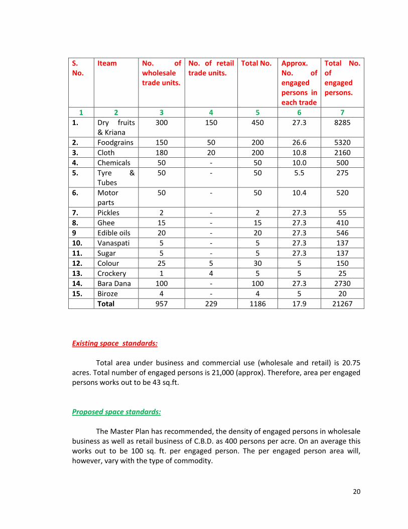
20
S. No.
Iteam No. of wholesale trade units.
No. of retail trade units.
Total No. Approx. No. of engaged persons in each trade
Total No. of engaged persons.
1 2 3 4 5 6 7 1. Dry fruits
& Kriana 300 150 450 27.3 8285
2. Foodgrains 150 50 200 26.6 5320 3. Cloth 180 20 200 10.8 2160 4. Chemicals 50 - 50 10.0 500 5. Tyre &
Tubes 50 - 50 5.5 275
6. Motor parts
50 - 50 10.4 520
7. Pickles 2 - 2 27.3 55 8. Ghee 15 - 15 27.3 410 9 Edible oils 20 - 20 27.3 546 10. Vanaspati 5 - 5 27.3 137 11. Sugar 5 - 5 27.3 137 12. Colour 25 5 30 5 150 13. Crockery 1 4 5 5 25 14. Bara Dana 100 - 100 27.3 2730 15. Biroze 4 - 4 5 20 Total 957 229 1186 17.9 21267 Existing space standards: Total area under business and commercial use (wholesale and retail) is 20.75 acres. Total number of engaged persons is 21,000 (approx). Therefore, area per engaged persons works out to be 43 sq.ft. Proposed space standards: The Master Plan has recommended, the density of engaged persons in wholesale business as well as retail business of C.B.D. as 400 persons per acre. On an average this works out to be 100 sq. ft. per engaged person. The per engaged person area will, however, vary with the type of commodity.

21
Proposals: The total proposed area 114 acres for old Delhi Central Business District includes zone A-19 area (Phatak Habash Khan area) as per Master Plan proposal. The wholesale market in dry fruits, spices and cereals etc. in Khari Baoli, food-grain market in Naya Bazar and Krishna Market for cloth will remain functioning in their respective locations with additional areas required for their smooth functioning as per Master Plan proposal. The deficient facilities such as loading and unloading, parking area for vehicles and thetas, and widening of roads for proper flow of traffic will be provided as a guide line in the zonal development plan till the whole area is planned under comprehensive redevelopment scheme in a detailed plan. Proposed land use: The following table shows the proposed land use of the zone A-19. S. No.
Land use Area in acres Detailed
Total
Percentage
1. Commercial (i) Wholesale (ii) General Business and Commercial
17.31 27.26
44.57
68.57 %
2. Public & Semi Public facilities: (i) T.B. Clinic (ii) Fire Station
0.22 0.20
0.92 0.65 %
3. Religious (i) Temples (ii) Mosques (iii) Church (iv) Gurudwara
0.265 0.395 0.258 0.002
0.92 1.41 %
4. Circulation (i) Peripherial Roads (ii) Zonal Roads. (iii) Parking areas.
6.29 9.95 2.85
19.09 29.37 %
Total area of the zone 65.00 65.00 100%

22
Commercial area: The proposed green area under Commercial activities is 44.57 acres as against the existing area of 20.75 acres. The proposed population that will be engaged in commercial activities (in wholesale as well as general business & commercial) works cut to be 17828 persons or say 18000 persons approximately on the basis of 400 persons per acre as per Master Plan recommendations. The existing population, however, is about 21000 persons engaged in this activity (in an area of 20.75 acres). This shows a condition of acute congestion with other connected problems of high degree of deficiency of loading and unloading and most inadequate parking facilities both for vehicles and animal and hand driven thelas. The Zonal Development plan aims at tackling the problems in a long term phased programme. The surplus population (engaged in commercial activity) will have to be shifted in stages to the areas recommended for the purpose in the Master Plan work studies. Since the whole of the area of the zone has been earmarked for the purpose of wholesale and general business and commercial in the Master Plan recommendations, the whole zone has, therefore, been brought under comprehensive redevelopment. The first phase of development will involve the improvement of traffic conditions with provision of parking, loading and unloading facilities. The ground and first floors of the structures will be permitted for business and commercial activities whereas the 2nd and subsequent floors will be used for residential purpose. In the final phase, the whole area will be planned under comprehensive redevelopment in various stages and the detailed plans of the various pockets will be drawn in an intograted form. Out of the total area of the zone of 65.00 acres, about 17.31 acres will be devoted for wholesale business in cloth, food grains, dry fruits, pulses and cereals etc. as per Master Plan proposals. Public and semi public facilities: a. Hospital: The only existing T.B. Clinic occupying an area of 0.22 acres, has been retained in the Zonal Development Plan which serves the needs of the other areas as well. b. Fire Bridge: Fire brigade occupies an area of 0.20 acres and serves the needs of the local area as well as the needs of the surrounding areas and as such it has been retained in the zonal development plan.

23
Religious buildings: The religious buildings numbering 17 temples, 7 mosques, one Ghurudwara and one Church occupying a total area of 0.92 acres have been retained in the zonal development plan, Circulation pattern: The area under circulation pattern is composed of two types of roads: i) Master Plan Roads and ii) Internal or zonal roads. i) The Master Plan roads are the peripheral roads, i.e., Khari Baoli Road, Queens Road and Naya Bazar Road, Khari Baoli Road and Naya Bazar Roads are each 100’ wide whereas Queens Road is 120’ wide as per Master Plan. The other peripharial road is Church Mission road with the proposed R/W as 60,. The area under peripherial roads (half the proposed widths) works out to be 6.29 acres or 9.67% of the total area of the zone. ii) The Internal roads or zonal roads measure 9.95 acres or 15.30 % of the total area of the zone. The road widths are varying from 24’ to 45’ depending upon the design concept and availability of space. The proposed widening of the roads is done with a view to keep the alignment of the existing roads and lanes intact but at the same time ensuring smooth flow of traffic. Effort has been made to keep the roads regular and uniform in width except where it was not possible to do no. Generally the centre line of the existing right of way has been considered for the proposed widening of the roads, and the properties on both sides of the roads irrespective of the structures are proposed to be acquired to give effect to the widening of the roads, except at places where religious building come in the right of way. In such cases, the entire chunk of land, required for the proposed widening, has been acquired from only one side of the road opposite to the religious building. The provision has been made for creating parking lots in the circulation pattern wherever it was possible. The total area under parking amounts is 2.85 acres and is 4.38 % of the total area of the zone. Action to be taken by local authorities: 1. No further reconstruction or any repair work at large scale be permitted without prior permission from the competent authority. 2. No pisoemeal commercial development shall be allowed to come up in the lanes and streets.

24
3. Existing commercial area along the main roads and streets shall be retained without permitting any changes, additions or alterations. However, the change in the use shall be permitted only after special appeal.
4. The local commercial activity must be allowed to the extent shown in the zonal development plan. This must be restricted to the ground floor, to the proscribed depth of 20’ or one plot depth whichever is less. 5. The existing non-nuisance industries which are least harmful to the life shall
only be allowed to continue in this area for the time being without permitting any change in their structure and with the clear understanding that they have to shift.
6. Unauthorized encroachments need immediate clearing up with strict check
so that these do not come up again. 7. In order to avoid traffic bottlenecks there is need to introduce a regulation,
presetting heavy vehicular traffic to the main peripherals roads only as far as possible.
8. Strict enforcement of building bye-laws and proper administration control. 9. The existing properly lines of the religious buildings should be honoured, but encroachment by them or change in land use shall not be permitted. 10. Acquiring of the vacant lots or area under poor structure and putting the areas, thus recovered by demolishing the poor structures, to the use of community facilities. 11. For clearance of any deteriorated area, the residents or that area shall be
served with notices that they will not be permitted to effect any change, addition or alteration in their property or change in use. However, the present use will continue till the structures are declared unfit for use and then the residents should be prepared to shift or accommodate in alternative accommodation in this area or the other part to give effect to rehabilitation problem.

25
PLANNING OF WALLED CITY BY RORY FONSECA THESIS AVAILABEL IN SCHOOLS OF PLANNING AND ARCHITECTURE: Chawri Bazar, Hamilton Road, Chandni-Chowk and Shyam Prasad Mukerjee Park, all are primary roads from east to west. All connected by a major road from North to South, joining Kashmere Gate to Delhi Gate. Second category is secondary roads and their names are Bazar Lal Kuan, Nai Sarak, Baidwara, Bazar Sita Ram and Bazar Chitli Qabar. The walled city is sub-divided into 11 Municipal wards separated by primary and secondary streets. Population of this area and density of this ward is given below:- WARD Area in
Gross Acres Net
% built up Population 1951 1961
% variation
Density net/acre
1. 216.5 119.0 54.8 28,359 30218 +6.5 254 2. 139.2 38.9 28.0 23,201 22816 -1.8 586 3. 65.6 57.5 87.0 37,814 39104 +3.5 419 4. 58.5 38.1 65.0 23,439 23689 +1.0 623 5. 41.6 36.5 88.0 21,546 23095 +6.9 630 6. 90.3 72.3 80.0 47,580 52034 +9.1 720 7. 102.6 90.8 88.5 46,079 51135 +11.0 564 8. 67.3 53.8 80.0 38,051 41281 +8.2 767 9. 72.8 65.9 90.5 32,796 39685 +21.2 603 10. 53.3 37.7 70.7 24,448 27742 +13.5 743 11. 195.5 145.5 74.4 51,005 56,730 +11.1 392 1,111.2 756.0 70.0 374,318 407,529 +8.15 540 Relating the primary streets, to secondary and secondary to tertiary streets in the interior of plots, an interesting pattern begins to develop. Tertiary streets tends to be closed system. The entire concept is a care of an introverted garden city, where the open space in the community is public, and not private. There is a criticism that the city is without form, possessing a collection of historical places does not seems to be correct. Though the city is not systematized according to Haxagons, Triangles and axial routes just in the case of New Delhi, yet it is a well suited pedestrian city, suitable to the harsh climate. Regarding collection of historical places, there is no city that does not have historical or period pieces. The walled city presents a way of life that is meaningful, vital and rich.

26
The present population of Sui Walan is approximately 23,500m (1951 census) giving a gross density of 485 persons per acre. In the redevelopment plan, however, it has been made possible to rehouse only 13,500 persons, on a proposed gross density of 300 persons per acre. In other areas, plan evicts 10,000 persons with a break up of 47% in Urban villages and 53% in their adjoining urban areas may be Mata Sundri Area. Similar problems are with other wards also. The concomitants of Urban renewal, slum clearance or rehabilitation are severe economic, social and cultural displacement; this has been the historical pattern and continues to remain so. The following is an alternate course which avoids the difficulties crowded by outmoded financial and planning policies. It represents a more realistic approach to the problem of urban reconstruction, and is directed to meeting and avoiding the mistakes of the past. In another context, it could with modifications be applied to the development of satellite town. The example is given of ward No. 9 bounded by Bazar Matia Mahal, Churi Gharan on the south, Chatta Sheikh Manglu on the west and bazaar zer jama Masjid on the north. The area is selected because it is one of the most crowded area of the Walled City, yielding a net density of 1300 persons per acre in 1961 covering an area of 5 acres or 20,000 square meters. Different types of analysis is given below:-
(i) DISTRIBUTION OF GROUND AREA IN SQUARE METERS Streets 12.15 % 2,770 sq. meters. Courtyards 24.70 % 4,950 sq. meters. Mosques, temple 7.05% 1,400 sq. meters. 1. Story Structures 14.60% 2,920 sq. meters. 2. Story Structures 22.20% 4,440 sq. meters. 3. Storey Structures 19.30% 3,340 sq. meters. 100.0 % 20,340 sq. meters An earlier survey (3), Table-I, for the same area gives the following breakdown of the building-up area;
(ii) ACTIVITY DISTRIBUTION OF BUILT-UP AREA
Residential 67.0% Commercial 12.5% Industrial 16.8% Public & Semi- Public 3.7% 100.0%

27
(iii) STREETS BY TYPES
Primary Streets 24.1 % (North and East boundaries) Secondary Streets 31.4% (South and West boundaries) Tertiary Streets 44.5% (Interior lanes and Galis) 100.0% = 500 Meters. Commercial activity is distributed aling primary and secondary streets. Relating the land use survey with the street frontage and story heights (plate 31), one can deduce net livable space at 2.0 sq. meters (21.5 sq.ft.) per capita. If interior courtyards and roof space is added as partially enclosed space, the per capita figure rises to 3.5 sq.mts. (37.7 sq. ft.) (3), an increase of 75 percent. It is obvious that the courtyards and roofs play an important part in providing an escape from what would otherwise be intolerable living conditions. Any transfer of population into multi-story structures must take into account this extra space, common to all members of families occupying a house, available in the courtyard and on the roof. In any event, the courtyard forms so important a place in the daily lives of the occupants that it must be transferred with them into multi-story apartment units. By reversing the investigation and allocating a critical envelope space per capital, specifying that each person must have at least sleeping space and passage way around his charpai (literally four feet, a bed), a per capital figure in region of 3.00 to 3.75 sq.mts. is reached. Either way, 3.5 square meters appears to be a critical value, first by natural processes and second by activity analysis. This figure represents net livable space. Assuming an efficiency of 70 per cent (1), the gross space per capital is 5.0 sq.mts. (54 sq.ft.). The question remains whether it is possible to build 5.0 sq. meters so that the economic rent of the space is within reach of the slum dweller; without any subsidies but a return on the investment comparable to other sectors of the economy; i.e. , 8 to 12 per cent. Unless density restrictions and irrational space standards are abandoned and the design process rationalized, the answer is “no”. The dilemma is that unless investment in the housing sector be made to yield returns comparable to other sectors of the economy, the housing stock will continue to diminish; and with it, the rate of urban growth as migrants are rebuffed, and productivity decreases. Thus, planners, architects, and the building industry have no choice but to accept the challenge or be edged out by other entreprenures or institution builders. In order to examine the feasibility of achieving such a goal, as a first step, I sought an answer to the question, “What is saturation density”? The following considerations were adopted as constraints.

28
1. No physical or economic dislocation of the population. 2. Utilize the existing networks of community contact and other indigenous institutions
that regulate behavior. Distinguish between positive and negative elements. 3. The physical solution must not inhibit social change or economic growth. 4. Integrated public programs in literacy, family planning, education and health into the
solution. 5. Increase density and capacity to absorb migrants. 6. Transform or provide substitutes for indigenous institutions that cannot be
transferred. 7. Resolve the problem within the limits of existing technology. 8. Aesthetic considerations allocated lowest priority. Avoid the manipulation of the
spatial environment at the expense of the community. 9. Preserve historical monuments, temples, mosques, and trees. While the economic implications of such an investigation are of prime importance, the welfare of the community should take precedence over the financial implications. In this first step, in response to the question posed, I was interested in discovering the degree to which I could close pack a community without destroying its viable character discernible in the indigenous city. This then is a search for a minimax solution, where because of the great risks and its innovative character, one has to minimize maximum losses and maximixe minimum yields. In order to arrive at a rough estimate of saturation density, one must know wha per cent of the ground is devoted to residential usage. It is also necessary to distinguish between built-up area and open space; i.e. , the area devoted to buildings and the area devoted to streets, chowks and parks. Replicating the indigenous city, these two figures would be: 1. Built-up area: 60 to 70 per cent 2. Open space: 30 to 40 per cent Residential usage falls between 60 and 70 per cent of the built-up area with the balance distributed between commerce and business, industry, recreation, historical monuments, public and semi-public usage. The open space is distributed between streets, 30 to 40 per cent; court-yards, 50 to 60 percent; and chowks, 10 per cent. Knowing the area of a site, once residential floor space is computed (1), it is relatively easy to find out the number of people involved. Thus, if technology and the availability of building materials limit building heights to eight floors, how many people can he place on an acre (approximately 4,000 sq.meters ) assuming a land use make-up similar to that presently found in the Walled City? The computation follows:
- Site area 4,000 sq. m. (approximately 1 acre) - Built up area 3,000 sq. m. (75% of site)

29
- Residential usage 1,950 sq. m. (65% of built-up area) - Total floor area(gross
Area) 15,600 sq. m. (eight floors) - Per capita gross floor
Area 5 sq. m. (net = 3.5 sq. m) Net Density (2) 3,120 persons per acre (15,600) (5)
1. Residential usage being the largest component is the easiest approach to the problem. One could also determine saturation density from commercial, usage, but the computation is a little more involved. 2. Gross floor area divided by per capital gross floor area yields the same number of persons per acre (p. p. a) as net floor area divided by per capital net floor area. I use the same efficiency in determining net floor area and net capital space. Suppose the ration of built-up area to open space is reversed, the other parameters remaining unchanged, what will the new net density be? The new figure is 1,040 persons per acre (1). What then accounts for net densities of 130 persons per acre in the suburbs or 25 persons per acre along Shahjahan Road in New Delhi? In the first case, building heights of one story will account for the drop in density (2), in the second cade only an increase in per capita gross floor space or a further reduction in the residential usage, or both (3), will explain the 25 persons per acre. The implications of arbitrary per capita floor space or land use allocations are now clear; both contribute to urban sprawl high maintenance costs and subsidies, the costs of which have been discussed earlier. 1. Site area = 4,000 m2; Built-up area = 1,000 m2 (25%); Residential usage = 650 m2 (65%); therefore, total floor area is 5,200 m2 (650x8). If per capital gross floor space is still 5 m2, then the net density is 1,040 p. p. a. 2. Since a 65% residential usage yields 650 m2 (see note 1), the net density is 650 divided by 5 or 130 p. p. a. One story structures will yield this figure. 3. Since one story structures yield 130 p. p. a. , 25 p. p. a. can be achieved by
reducing built-up area and increasing the per capita gross floor space, Shahjahan Road is reserved for housing senior government staff, and is 100% residential usage. The computation is: Built-up area = 200 m2 (5%); Residential usage = 200 m2 (100%); total floor area = 400 m2 (2 story); per capita gross floor space = 16 m2, hence net density is 25 p. p. a. Other combinations will yield the same result.

30
The criterion is that every dwelling unit should face on the courtyard, or the perimeter. By reorganizing the shape of the courtyards and the orientation of the dwelling units, it is possible to raise the efficiency of the sits layout from 46 per cent to 75 per cent. Although there is only a slight difference in efficiency between the second and third paradigms, the lack of axial symmetry and a capacity to fit points out the overwhelming advantages of the later. This is adopted as a principle to be adhered to in the task of achieving saturation density. The main points of the scheme as developed are summarized below:-
1. Co-operatives are organized on a courtyard basis. All residential units facing a courtyard belong to the same co-operative.
2. The light-industrial, commercial and community activity occur at the courtyard level with access to streets immediately adjoining the courtyard.
3. Street alignments follow closely the edges of buildings, passing under and alongside them where convenient, with shops or workshops to one side.
4. Vertical circulation is sited between courtyards to encourage community contact at all levels. Toilet, laundry and light commercial activity are located at “chowks” near the transfer points to internal corridors.
5. Groups of courtyards would become larger administrative units of the co-operatives, permitting the election of group representatives. The boundaries of these groups could approximate the old Mohall as, so that existing “hen-pecking” order is not radically changed.
6. At convenient points, large plazas occur, the periphery being zoned for special activities such as Police Station, department stores, offices of governmental agencies (family planning clinics, food-rationing office), post office, fire station, business offices, credit unions, and parking facilities. It is intended that the larger plaza becomes the core of groups of co-operatives that cluster around it. In terms of identification, these plazas replace the Mohallas of the indigenous city.
7. Courtyards fringing on primary streets would have a higher per cent of enclosed space reserved for non-residential activity. In time they would seek their own levels of activity distribution between commercial, industry, residential or community facilities. Being near primary streets, should need arise, redistribute ground space to allow for parking vehicles.
8. Schools will be developed along the principle of groups of class rooms, rather than large scale units. A set of classrooms would serve at least two courtyards; i.e., co-operatives, and will be utilized at night for adult education or meetings.
.-.-.-.-.-.-.-.-.-.-.-

31
APPENDIX A. CAPITAL INPUT OUTPUT RATION AND ECONOMC RENTS (Computed for every 3m length of structure) RESIDENTIAL AREAS Gross M2 (Liveable Net Area No. of Distribute % area) M2 persons Efficiency @3.5M2/p a. Single person unit 16.0 65.6% 10.5 3 10% b. Nuclear Family Unit 33.0 (1) 63.7 21.0 6(2) 53% c. Joint/extended unit 54.0 65.0% 35.0 10 37% Total 103.0 66.5 19 100% COMMERCIAL AREA d. Ground Floor shop 15.0 93.4% 14.0 4(3) 100% PUBLIC AREAS e. Level 3 street & Porch 27.0 f. Level 5 street & Porch 24.0 g. Level 6 street & Porch 6.0 h. Ramp, etc., (every 7 units) 36.0 (4) Total: 93.0 M2 OCCUPIED GROUND AREA (Built-up area = 60% of site) i. Area of building 3M increments 48.0 (16 mx 3) j. Ramp 20 x 2-7 5.71 Total 53.71 = 60% TOTAL STRUCTURE GROSS FLOOR AREA Residential a+3b+c 169 Commercial 2d 30 Public space e+f+g+h 93 292 M2

32
TOTAL LAND OCCUPIED BY STRUCTURE = 60% of site i. Area covered by structure 48.0 j. Area covered by 1/7 ramp 5.71 53.71 M2 = 60% 89.5 M2 = 100% (1) Men’s area 12M2; Upper of Women’s area 21M2 (2) Allows for one Lodger. (3) If a shop is used as residence, 4 persons could occupy such a space. Otherwise a
shop owner and / or assistant would sleep on the premise. (4) Assume ramp occurs at every 7th unit of 21 metres (69 feet); at 10% slope 6 storey
yields 252 metres run ÷ 36.0 M. COST OF STRUCTURE 292 M2; 3143.13 Ft.2
Rate M2 Cost A1 100 Rupees 29,200 100 Rs/M2 = 9.3 Rs/sq. ft. A2 150 Rupees 43,800 150 Rs/M2 = 13.95 Rs/sq. ft. A3 200 Rupees 58,400 200 Rs/M2 = 18.6 Rs/sq. ft. Mean = 43,800 COST OF LAND 89.5M2; 963.40 sq. ft. ‘ Rate M2 Cost B1 550 Rupees 49,200 550 Rs/M2 = 51.2 Rs/sq. ft. B2 1000 Rupees 89,500 1000 Rs/M2 = 93.0 Rs/sq. ft. B3 1500 Rupees 134,250 1500 Rs/M2 = 139.5 Rs/sq. ft. B4 2000 Rupees 179,000 2000 Rs/M2 = 186.1 Rs/sq. ft. B5 2750 Rupees 246,000 2750 Rs/ M2 = 256.0 Rs/sq. ft. Mean = 139,590

33
Sl no.
Investment
LAND COST AS % OF INVESTS.
YIELD ON INVESTMENT 10% 7% 5% 3%
1 A1 + B1 78,400 62.75% 7,840 5,188.0 3,920.0 2,352.0 2 A1 + B2 118,700 75.90 11,870 8,309.0 5,935.0 3,561.0 3 A1 + B3 163,450 82.20 16,345 11,441.5 8,172.5 4,903.5 4 A1 + B4 208,200 85.90 20,820 14,574.0 10,410.0 6,246.0 5 A1 + B5 275,200 89.40 27,520 19,264.0 13,760.0 8,256.0 6 A2 + B1 93,000 52.90 9,300 6,510.0 4,650.0 2,790.0 7 A2 + B2 133,300 67.10 13,330 9,331.0 6,665.0 3,999.0 8 A2 + B3 178,050 75.40 17,805 12,463.5 12,463.5 5,341.5 9 A2 +B4 222,800 80.40 22,280 15,596.0 11,140.0 6,684.0
10 A2 + B5 289,800 84.90 28,980 20,286.0 14,490.0 8,694.0 11 A3 + B1 107,600 45.65 10,760 7,532.0 5,380.0 3,228.0 12 A3 + B2 147,900 60.90 14,790 10,353.0 7,395.0 4,437.0 13 A3+ B3 192,650 69.70 19,265 13,485.5 9,632.5 5,779.5 14 A3 + B4 237,400 75.98 23,740 16,618.0 11,870.0 7,122.0 15 A3 + B5 304,400 80.80 30,440 21,308.0 15,220.0 9,132.0
Mean = 2,750,850 Rupees Mean Annual 272,215 192,259.5 136,007.5 82,485.5 183,390 Rupees Mean Monthly 18,135.3 12,817.3 9,067.65 5,499.03

34
Reprint from the “Civic Affairs”’ February, 1976. Book Review “Rebuilding Shahjahanabad: The Walled City of Delhi” The ideas highlighted for Rebuilding Shahjahanabad by Jagmohan (Vice- Chairman, Delhi Development Authority) are unique and as such should attract the attention of planners and administrators. Jogmohan rightly emphasizes the point that “Shahjahanabad does not deserve to be thrown into the dustbin of history. Its social and cultural life has much to commend itself. It has a rich tradition and heritage. It is, in fact, a treasure of accumulated human experience of wide variety. Here every stone, every street, has its own story to tell”. It is to the credit of Jagmohan that is was he who raised the emerging issues of Shahjahanabad which had been ignored for long. To attract the attention of planners and to reopen the issue of development of Shahjahanabad the author has written about rebuilding Shahjahanabad with a historical perspective. He has made some proposals for the building of a “Second Shahjahanabad” because he says: “Second Shahjahanabad stands before us today as a battered, sick and overburdened city. It seems to have lost its centre, its soul. Shahjahanabad presents a dismal picture of congestion, chaotic land use and sub-human existence” Second Shahanabad: Jagmohan suggests the creation of a second Shahjahanabad as a countermagnet so as to rehabilitate the inhabitants into Mata Sundri and Minto Road complex. The rehabilitation scheme is suggested by the author emphatically with an objective to decongest the present “Walled City” of Delhi in terms of residential units cum trade and commercial establishments. As such Jagmohan makes the point clear that “We must rule out any large-scale destruction and construction either in the name of modern requirements or under the pressure of speculators and profiteers”.

35
Author : Jagmohan Vice – Chairman, Delhi Development Authority Publisher : Vikas Publishing House (Pvt.) Ltd., New Delhi.
The Author Jagmohan is agitated by the materialistic and commercial outlook of the Walled City of Shahjahanabad and also feels emphatically that Shahjahanabad today is a cultural desert. “Its streets no longer vibrate with the songs of the musicians. Gone are the famous voice like those of Zahra, Mushtari, Lachmi, Bibboo and Doanni and Choanni”. At present, the Walled City of Shahjahanabad does not echo with mushairas and ghazals but is strangulated with the traffic and transportation bottlenecks and nuisance and “noxious industries which are functioning in a small area, polluting the atmosphere and creating the unhealthy environment”. It is agreed that the nuisance of obnoxious industries should be shifted. And as “the traffic conditions in Shahjahanabad are chaotic”, Jagmohan pleads for pedestrianising the streets of Walled City of Shahjahanabad. Who Will Rebuild? Then, the important question arises: who is going to rebuild Shahjahanabad with better flow of traffic and clean roads? Who is going to chech the conversion of residential units into commercial and industrial establishments? Who is going to provide a congenial environment in Shahjahanabad with the adequate public utility services like water supply, sanitation and sewer age? The above facts are ignored presently in the planning aspect of Shahjahanabad and Jagmohan rightly observes that “Shahjahanabad has no lovers, no committed well-wishers, if any, are cowards”.

36
Jagmohan is bold enough to suggest that there should be planned action by having the “Second” Shahjahanabad and by linking Old and New Delhi by extending the Parliament Street cutting through the Walled City right upto the footsteps of the Jama Masjid. The proposal involves an enormous expenditure as the author admits. One point of observation is that the large number of havelis and industrial and commercial establishment cannot be shifted as it is not feasible from the social, economic and political viewpoint. The suggestion of a Redevelopment Authority of Shahjahanabad, I fear, may involve the practices of favouritism, redtapism , bureaucracy and corruption. The book has additional value because of the nice photographs and sketches which depict the real way of life of Shahjahanabad. Jagmohan has lucidly dealt with the historical, social, cultural and economic aspects of the Walled City of Shahjahanabad. The book is a must for all those who are interested in the future of Delhi.
Gopal Bhargava
2 The Civic Affairs, February, 1976
37
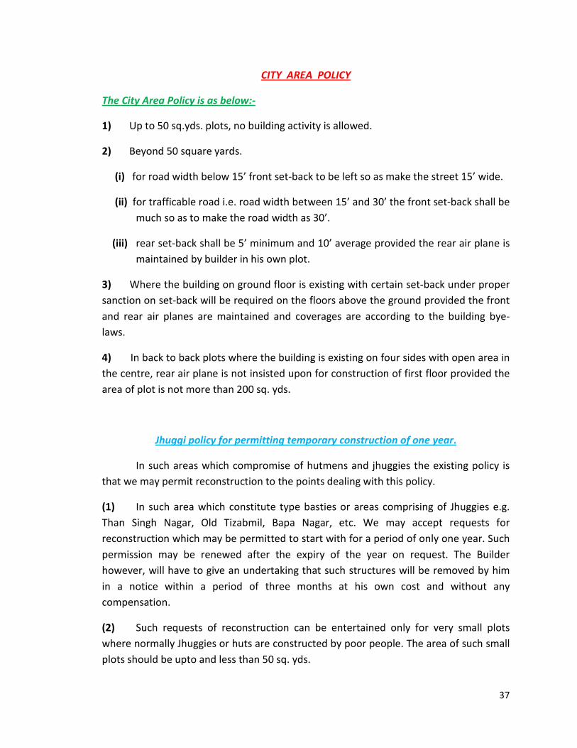
CITY AREA POLICY
The City Area Policy is as below:-
1) Up to 50 sq.yds. plots, no building activity is allowed.
2) Beyond 50 square yards.
(i) for road width below 15’ front set-back to be left so as make the street 15’ wide.
(ii) for trafficable road i.e. road width between 15’ and 30’ the front set-back shall be much so as to make the road width as 30’.
(iii) rear set-back shall be 5’ minimum and 10’ average provided the rear air plane is maintained by builder in his own plot.
3) Where the building on ground floor is existing with certain set-back under proper sanction on set-back will be required on the floors above the ground provided the front and rear air planes are maintained and coverages are according to the building bye-laws.
4) In back to back plots where the building is existing on four sides with open area in the centre, rear air plane is not insisted upon for construction of first floor provided the area of plot is not more than 200 sq. yds.
Jhuggi policy for permitting temporary construction of one year.
In such areas which compromise of hutmens and jhuggies the existing policy is that we may permit reconstruction to the points dealing with this policy.
(1) In such area which constitute type basties or areas comprising of Jhuggies e.g. Than Singh Nagar, Old Tizabmil, Bapa Nagar, etc. We may accept requests for reconstruction which may be permitted to start with for a period of only one year. Such permission may be renewed after the expiry of the year on request. The Builder however, will have to give an undertaking that such structures will be removed by him in a notice within a period of three months at his own cost and without any compensation.
(2) Such requests of reconstruction can be entertained only for very small plots where normally Jhuggies or huts are constructed by poor people. The area of such small plots should be upto and less than 50 sq. yds.

38
(3) Such requests shall be accompanied with a token fee of Rs. 10/- alongwith dimensioned sketches in triplicate which need not be prepared by licence architect. But must be signed by the owner. Proof of ownership should also be submitted. The sketches should show normally the structure as it exits today or had originally existed and should also show the proposal of reconstruction in red colour which should not exceed or be different from the accommodation previously existing.
(4) Permission for reconstruction will be on the same foundation and where no foundation exists the alignment of existing Jhuggies etc. will be followed. The sizes of room etc. shall not be widened. We may, however, permit raising of roof subject to maximum height prescribed in paragraph below:-
The reconstruction shall not have better specifications than the following:-
(a) Mud mortar, brick masonary in walls with only cement pointing on both sides.
(ab) Temporary roof or stone slabs or giles over wooden battens.
(ac) Height of the structure should not be more than 12 feet including plinth of 1½ feet.
(ad) Only reconstruction of single storey will be permitted.
Such permissions shall be given only to structures which are in a ruinous condition and have already wholly or partially collapsed.
The above concession will apply when prior permission is taken.
Commissioner has extended the application of the Jhuggi policy for permitting temporary construction for one year which is in vogue in certain limited localities at present, extended to all urban villages subject to the condition that the area of the existing building does not exceed 50 squ.ds. and that all other conditions enumerated in the Jhuggi policy approved by the Commissioner, are strictly observed.
Repairs Policy
(a) Plastering and patch repairs;
39
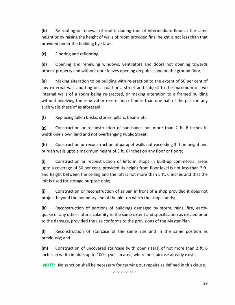
(b) Re-roofing or renewal of roof including roof of intermediate floor at the same height or by raising the height of walls of room provided final height is not less than that provided under the building bye-laws.
(c) Flooring and reflooring;
(d) Opening and renewing windows, ventilators and doors not opening towards others’ property and without door leaves opening on public land on the ground floor;
(e) Making alteration to be building with re-erection to the extent of 50 per cent of any external wall abutting on a road or a street and subject to the maximum of two internal walls of a room being re-erected, or making alteration to a framed building without involving the removal or re-erection of more than one-half of the parts in any such walls there of as aforesaid;
(f) Replacing fallen bricks, stones, pillars, beams etc.
(g) Construction or reconstruction of sunshades not more than 2 ft. 6 inches in width one’s own land and not overhanging Public Street.
(h) Construction or reconstruction of parapet walls not exceeding 3 ft. in height and purdah walls upto a maximum height of 5 ft. 6 inches on any floor or floors;
(i) Construction or reconstruction of lefts in shops in built-up commercial areas upto a coverage of 50 per cent, provided its height from floor level is not less than 7 ft. and height between the ceiling and the loft is not more than 5 ft. 6 inches and that the loft is used for storage purpose only;
(j) Construction or reconstruction of saiban in front of a shop provided it does not project beyond the boundary line of the plot on which the shop stands;
(k) Reconstruction of portions of buildings damaged by storm, rains, fire, earth-quake or any other natural calamity to the same extent and specification as existed prior to the damage, provided the use conforms to the provisions of the Master Plan.
(l) Reconstruction of staircase of the same size and in the same position as previously; and
(m) Construction of uncovered staircase (with open risers) of not more than 2 ft. 6 inches in width in plots up to 100 sq.yds. in area, where no staircase already exists.
NOTE: No sanction shall be necessary for carrying out repairs as defined in this clause. .-.-.-.-.-.-.-.-.-