Approved by Ministry of Urban Development, Govt. of …rgplan.org/Zonal...
50
Approved by Ministry of Urban Development, Govt. of India vide letter No. K- 12011/23/2009-DDIB dated the 8 th March, 2010 under Section 9(2) of DD Act, 1957 Authenticated on behalf of Government of India vide letter No. K-12011/3/Zone-O/2010-DDIB dated 30 th June, 2010. Sd/- (U. Viswanadham) Under Secretary to the Govt. of India Ministry of Urban Development, Nirman Bhawan, New Delhi
Transcript of Approved by Ministry of Urban Development, Govt. of …rgplan.org/Zonal...
Approved by Ministry of Urban Development Govt of India vide letter No K-
12011232009-DDIB dated the 8th
March 2010 under Section 9(2) of DD Act 1957
Authenticated on behalf of Government of India
vide letter No K-120113Zone-O2010-DDIB dated 30th
June 2010
Sd-
(U Viswanadham) Under Secretary to the Govt of India
Ministry of Urban Development
Nirman Bhawan New Delhi
ii
CONTENTS
Page
Number
Cover page i Contents ii Preamble v
10 Introduction 1 20 Statutory provisions and objectives 1 30 Location Boundaries and Area 1 40 Existing Characteristics Developments 2
41 Predominant characteristics of this Zone 2 42 Existing characteristics of various part stretches of River
Yamuna on either side 2
50 Various Proposals amp Recommendations 3 51 MPD - 1962 3 52 MPD - 2001 Proposals 4 53 DUAC - Conceptual Plan-2001 4 54 NCR - Regional Plan-2021 4 55 Yamuna Action Plan of Slum Wing MCDNCTD 4 56 MPD - 2021 5
60 Studies Undertaken for the Zone 5 61 CWPRS Hydraulic Model Studies on Channelisation 5 62 Inland Waterways Authority of India (IWAI) 6 63 Study on Planning amp Development of Yamuna River Bed
by School of Planning amp Architecture (SPA) New Delhi 6
64 NEERI Study on lsquoEnvironmental Management Plan for
Rejuvenation of River Yamunarsquo 8
65 Draft Zonal Plan based on MPD-2001 10 66 River YamunaRiver Front Zone lsquoOrsquo MPD-2021 10 67 DUAC lsquoImagining Delhirsquo -2006 11
70 Conservation Villages Squatter Settlements Resettlement
Colonies and Unauthorized Colonies 11
71 Conservation of built heritage 11 72 Villages 11 73 Squatter Settlement 11 74 Resettlement Colonies 12 75 Unauthorised Colonies 12
iii
80 Objectives and Framework for the Zonal Development Plan 12
81 Objectives of the Zonal Development Plan keeping in view
the various studies and their conclusions 12
82 Other critical concerns for the rejuvenation of the river
areas 12
83 Strategy 14 84 Rejuvenating the River Front 15 85 Strategies for riverfront development 16 86 Infrastructure Improvement 16 87 Cleaner Quieter and Multiple Use 16 88 Ensure availability of sufficient quantity of water in river 17 89 Capacity augmentation of the existing barrages can be done
by 17
810 Strategies of Pollution Abatement and Up-gradation of river
water quality to prescribed standards 17
90 Planning Proposals 22 91 Delineation of Sub-Zones 22 92 Proposed Land Use 23 93 Increased accessibility to the river 25 94 Development priority 25
100 Transportation 26 102 MRTS Corridors 27
110 Urban Design 27 120 Development Phasing 28
121 Development Phasing 28 130 Regularization of existing Health Educational Cultural amp
Religious (including spiritual) Institutes existing prior to
112006 on self-owned land not including gram sabha or
Ridge land
29
140 List of change of land use which has been notified by
MOUD upto 8th
March 2010 and shown in the Zonal
Development Plan
31
ANNEXURES I Action plan for unsewered area of NCT of Delhi 32
II Tentative list of Unauthorised Colonies 33 III Strategy for abatement of pollution in river Yamuna 34 IV List of the Institutions applied under Advertisement
NoF20(19)96-MP dated 010508 for rendering Cultural
Religious (Including Spiritual) Health Care and Education
Services(Existing Before 01012006)
37
iv
MAPS
I National Capital Territory of Delhi (Divisions) 38 II Proposed Land use Planning and Modified River
Topography from Wazirabad Barrage to Okhla Barrage 39
III Sub divisions for zones (divisions) A to H 40 IV Proposed Landuse Plan 41
v
PREAMBLE
The Zonal Development Plan for Zone lsquoOrsquo has been approved by
Ministry of Urban Development vide letter No K-12011232009-
DDIB dated the 8th
March 2010 under Section 9(2) of DD Act
1957 and notified under section 11 by DDA on 10082010
The regularization of Cultural Religious (including Spiritual)
Educational and Healthcare institutions shall be subject to
fulfillment of the Conditions as given in the Para No 13 of the
ZDP Govt directions issued from time to time
Indication of Influence Zone along MRTSMajor Transport
Corridor [as well as indication of uses other than residential and
facility corridor] shall be undertaken at the stage of Layout
PlansLocal Area Plans as per provisions of MPD-2021 and the
Guidelines Conditions as notified by DDA with the approval of
Government of India from time to time
- 1 -
ZONAL DEVELOPMENT PLAN FOR RIVER YAMUNA RIVER FRONT
(Zone lsquoOrsquo)
10 Introduction
11 As per MPD - 2021 notified on 722007 the National Capital Territory (NCT)of Delhi has been divided into fifteen zones (Divisions) designated bdquoA‟ to bdquoP‟ (except zone bdquoI‟) eight in urban Delhi (bdquoA‟ to bdquoH‟) six in Urban Extension (bdquoJ‟ to bdquoN‟ amp bdquoP‟) and one for River YamunaRiver front which has been designated as Zone bdquoO‟ (Map ndash I) 12 The River Yamuna River front Zone bdquoO‟ has special characteristics and ecological significance for which various studies have been conducted from time to time As such the Zonal Development Plan of Zone bdquoO‟ is conceived to set the strategies for rejuvenation of river Yamuna and eco-friendly development
20 Statutory provisions and objectives
21 The Zonal (divisional) Plan of the area is prepared under Section-8 and processed under Section -10 and simultaneously the modification of the land uses to be processed under Section 11(A) of the Delhi Development Act 1957 22 Section-8 of the Delhi Development Act 1957 defines the contents of the Zonal Plan As per the MPD - 2021 a Zonal Development Plan means a Plan for one of the zones (divisions) of the National Capital Territory of Delhi containing detailed information regarding provisions of social infrastructure parks and open spaces and circulation system etc The Zonal (Divisional) plan details out the policies of the Master Plan
30 Location Boundaries and Area
31 River Yamuna enters from Palla (on north side) traverses a length of 48 km through National Capital Territory of Delhi and leaves it at Jaitpur (south side) The zone ‟O‟ covers about 9700 ha area (as per MPD 2001) from Northern boundary of National Capital Territory of Delhi up to the Southern boundary of the National Capital Territory of Delhi The River Yamuna River front Zone ‟O‟ is bounded as under
North NCTD Boundary
South NCTD Boundary
East Marginal Bund and NCTD Boundary
West Marginal Bund Ring Road and proposed
NH-2 bypass along Agra canal
- 2 -
40 Existing Characteristics Developments
41 The following are the predominant characteristics of this Zone
i) River Yamuna in Delhi covers a length of about 48 km including 22 km in urban area and its spread varies from 15 km to 30 km ii) Seven Road Bridges two Railway Bridges one Metro Bridge and two fair weather Pontoon Bridges cross River Yamuna
iii) Twenty two major drains are discharging effluents into the river
iv) The river bed gently slopes from 208 msl in the north to 199 msl in the south Thus the gradient of the river from north to south is about 9m v) The zone has an assortment of activities like Delhi Secretariat Samadhi complex Cremation Grounds Sports Complexes and Thermal amp Gas Power Stations Bathing Ghats Sewerage Treatment Plants fly-ash ponds and fly ash brick plants etc Some of the pockets are under thick plantation and most of the river basin area in Zone bdquoO‟ is being used for agriculture horticulture and has a wealth of flora and fauna The encroachments in the River bed area aggravate the pollution in river Yamuna In some parts land from river basin has been reclaimed for unauthorized constructions
42 Existing characteristics of various part stretches of River Yamuna on
either side are as under
Table-1
Sub-Zone
Description of Area
Existing characteristics Developments in Zone lsquoOrsquo
West East
1 NCTD Boundary to Wazirabad Barrage
Agriculture Biodiversity park Jagatpur village Wazirabad Village monuments Unauthorized colonies Wazirabad Water works Ghats
Agriculture Water works Facility centre CRPF Camp Delhi Police Firing range Unauthorized colony
2
Wazirabad Barrage to ISBT Bridge
Unauthorised colonies Unauthorised religious structures CNG station Bathing ghat
220 KV ESS(Electric Sub-Station) water ponds grass farms Marshes Gurudwara amp Agriculture
3 ISBT Bridge to Old Yamuna Rail cum Road Bridge
Nigambodh ghat unauthorized growth of Yamuna Bazaar Salimgarh fort ghats ESS
Unauthorized colony Agriculture DMRC Depot IT Park PSP site
4 Old Yamuna Bridge to ITO Barrage
Electric crematorium Vijay ghat Shanti van Shakti sthal Raghat Gandhi darshan IG stadium complex Power house Delhi secretariat Fly ash brick plant
Agriculture cremation ground
- 3 -
5 ITO Barrage to Nizamuddin Rly Bridge
I P power house Gas turbine power house STP
Agriculture Forest Site for DMRC Depot amp Station
6 Nizamuddin Rly Bridge to N H 24
Fly ash pond Fly ash brick plant Agriculture PSP(Public and Semi-Public) site Akshardham temple complex Parking CWG Village Complex
7 NH24 to Okhla Barrage
Electric crematorium Rajiv Gandhi Smriti Van unauthorized petrol pump unauthorized encroachment Electric sub-station site of underground water reservoir unauthorised colonies
Agriculture
8 Okhla barrage to NCTD Boundary
Unauthorized colonies water body agriculture Madanpur Khadar resettlement scheme LPG bottling plant
Agriculture amp Water body
421 EXISTING LAND USE
Table-2
SNo LANDUSE AREA(Ha)
1 RESIDENTIAL
A 6221 064
B 98000 1010
2 COMMERCIAL 3950 041
3 INDUSTRIAL 3404 035
4 RECREATIONAL 52840 545
5 TRANSPORTATION 34565 356
6 UTILITIES 16600 171
7 GOVERNMENT 180 002
8 PUBLIC amp SEMIPUBLIC 17984 185
9
RIVER amp WATER BODY(including
Agriculture) 736256 7590
TOTAL 970000 10000
A=Approved residential scheme (Madanpur Khadar Resettlement colony (5121)Ha and 110 Ha
Residential Use at CWG-Village)
B=Unauthorized colonies falling in Zone bdquoO‟
The Transportation use includes the DMRC Depot amp Stations at Shastri Park and south of
Vikas Marg in addition to the area under circulation such as roads rail and metro corridor
50 Various Proposals amp Recommendations
51 MPD - 1962 The entire area north and south of Wazirabad barrage was shown as floodable and recommended development of District Parks Play Grounds and Open Spaces on the western bank of River Yamuna and in the area south of Wazirabad Barrage It further recommended shifting of existing Thermal Power Stations ie Rajghat and Indraprastha after their machinery becomes obsolete and formulation of scheme for discontinuing sewage outflow into the River Yamuna
- 4 -
52 MPD - 2001 Proposals River Yamuna to be made pollution free through various measures On the big expanse of its banks large recreational areas to be developed and to be integrated with other urban developments so that the river is an integral part of the city physically and visually It also recommended channelisation of river with the following provisions
i) After the result of the model studies for the channelisation of the river Yamuna become available development of river front should be taken up considering all the ecological and scientific aspects as a project of special significance for the city ii) Strict enforcement of Water Pollution Act is needed to keep the river clean
53 Delhi Urban Art Commission (DUAC) - Conceptual Plan-2001
The Conceptual Plan-2001 envisages that ldquothrough proper channelisation a sizeable area can be made available for recreational activities with some areas on either side of the river to be preserved for three dimensional developmentsrdquo 54 National Capital Region (NCR) - Regional Plan-2021 The Regional Plan-2021 has identified river zone as natural conservation zone and recommends that the water bodies be kept free from any encroachmentdevelopment to allow free flow of water Construction activity for human habitation or for any other ancillary purpose not to be permitted Suitable measures to be taken to maintain the water body with the minimal flowwater level
The following activities have been recommended in the natural conservation zone
i) Agriculture and horticulture ii) Pisiculture iii) Social forestry plantation including afforestation iv) Regional recreational activity with no construction exceeding 05 of the area with the permission of competent authority
55 Yamuna Action Plan of Slum Wing MCDNCTD
Under the Yamuna Action Plan the following facilities have been developed in this zone
i) Low cost toilets ii) Sewage treatment plants iii) Electric crematoria
- 5 -
iv) Bathing ghats v) Plantation
56 MPD - 2021
i) Rejuvenation of River Yamuna through a number of measures including ensuring adequate flow in river by release of water by riparian states refurbishment of trunk sewers treatment of drains sewering of unsewered areas treatment of industrial affluent recycling of treated effluent and removal of coliforms at STPs (ANNEXURE- I)
ii) The natural features such as Forest Wildlife Sanctuary River Yamuna and other water bodies should be conserved and kept free from unrestricted and unplanned urban development
iii) Designation and delineation of appropriate land uses and aesthetics of the river front which should be more fully integrated with the city and made more accessible-physically functionally and visually
iv) Water bodies having a minimum size of surface area of 1 ha shall be preserved by the concerned authorities Further effort shall be made at the local level to retain smaller water bodies
60 Studies Undertaken for the Zone
61 The Central Water amp Power Research Station (CWPRS) Pune‟s Hydraulic Model Studies on Channelisation
The CWPRS Pune submitted its Technical Report No3062 in May 1993 The summary of findings and recommendations are given as under
i) Indraprashtha barrage Nizamuddin railway bridge and Nizamuddin road bridge are closely located in river reach of 3 kms The waterways provided for these structures are around 550 m The river flow between these structures is more or less confined in a width of 550 m Therefore by joining the guide bunds of these structures in this reach it was seen that there was no increase in water level or change in flow conditions due to channelisation Hence it appears technically feasible to channelise the river in this reach
ii) The bottom of the old rail-cum-road bridge is at RL 2063 m and it was seen that with discharges above 7022 cums the bund was getting submerged with channelisation With channelisation the water level observed at this bridge was RL 2093 m when river discharge of 12750 cums In case of Wazirabad barrage the bottom of decking is RL 20975 m With the channelisation water level observed was RL 2111 m with a discharge of 12750 cums Thus channelisation between Indraprastha barrage and Wazirabad barrage could be taken up only after renovation of these two bridges The guide bunds of the structures which are not designed for water discharge of 12750 cums will have to be strengthened
- 6 -
as 22 drains discharging into the river Yamuna would face the problem of blockage due to increased water level in the river by channelisation At the outfall of these structures cross regulators would have to be provided along with arrangements for pumping the drain water into the river whenever water level in the river would be higher than the permissible water level in the drain
iii) It may be mentioned that due to channelisation the storage capacity at the three barrages namely Wazirabad Barrage Indraprastha barrage and Okhla barrage would reduce Overcoming all these limitationconstraints channelisation in three phases as mentioned below could be implemented i) Phase- I Indraprastha barrage to Okhla barrage ii) Phase-II Indraprastha barrage to Wazirabad barrage iii) Phase-III Wazirabad barrage to Palla
62 Inland Waterways Authority of India (IWAI)
i)The Inland Waterways Authority of India (IWAI) an autonomous body for the
development management maintenance and better utilization of national waterways carried out a pre-feasibility study for navigational potential of River Yamuna for passenger service cargo service development of water sports recreational facilities in River Yamuna in NovemberDecember 1988 and submitted its report in January 1989 to the Hon Lt Governor Delhi
ii) The study based on Talwegs Soundings Survey conducted between Wazirabad Barrage and Okhla Barrage noted that for the entire stretch except for few isolated locations a 20 m deep water channel is available The study suggested that to make available a 300 - 450 m wide continuous channel of min 20 m depth dredging efforts have to be made by excavating 90000 cum of earth every season which is possible using a single portable cutter suction dredger The study recommended that in-stream navigation should be integrated with the scheme for development pollution abatement and flood control
63 Study on Planning amp Development of Yamuna River Bed by School of
Planning amp Architecture (SPA) New Delhi A study was assigned to the School of Planning and Architecture New Delhi for identifying alternative approaches to planning and development Three alternative approaches have been suggested in this study They are
631 Eco-system Based Approach
This is purely an environmental approach to the river bed development and comprises of the following components
i) Augmenting water recharge potential in the form of retent and detention ponds
- 7 -
ii) Reducing pollution of Yamuna water through installation of STP at the outfall points and effluent management of adjoining rural areas
iii) Conservation of Natural areas
iv) Hierarchy of green areas to be developed with varying use like remnant forests landscaped parks zoological and botanical gardens with significant emphasis on pollution control
v) Recreation in form of bdquoeco-tourism‟ such as passive greens and water sports facilities where environmentally viable
vi) Continuation and Renewal of existing Areas
632 Integrated Development Scenario
With proper inclusion of such uses that would give citizens desirable proximity to the river
i) Retention of essential features of the eco-based scenario such as augmentation of ground water recharge pollution control and conservation of natural areas
ii) Assignment of uses according to demand and suitability mainly incorporating those uses which are either presently under consideration or are derived to facilitate improvement of the perceived quality of life of other areas iii) Modification of certain existing ongoing uses to improve their respective environmental qualities iv) Integrated tourism development through development of appropriate infrastructure networks and facilities v) Higher levels of recreational activities including water sports and other recreational uses vi) Inland water transportation is also envisaged for development subject to feasibility vii) Management of higher order as an essential requirement to ensure economic viability and sustenance of integrated development
633 Post Channelisation Development Scenario
It is an extension of the Integrated Development Scenario with
partiallimited channelisation as a precondition This Scenario also requires
- 8 -
i) Reduction of peak flood water release as flow volumes are likely to increase on channelisation
ii) Pumping regulation to prevent backflow of existing drains and consequent flooding in other areas of Delhi iii) Limited assignment of religious and other water bound facilities as channelisation will restrict the stream width will not permit stream bifurcation and will permit limited in stream uses
iv)The study proposes alternatives models of publicndashprivate partnerships and recommends integrated development model which foresees only partial channelisation
64 National Environmental Engineering amp Research Institute (NEERI) Study
on bdquoEnvironmental Management Plan for Rejuvenation of River Yamuna‟
DDA assigned a study on ldquoEnvironmental Management Plan for Rejuvenation of River Yamuna in NCTrdquo to the NEERI The NEERI in its report gives a study of the existing situation in the flood plains and guidelines for further development The NEERI has recommended sub-zone wise development based on which the zonal development plan proposals have been worked out Plan is placed at MAP-II
641 Recommended Activities in Sub Zones by NEERI
Table-3
Category
UseActivity
Suggested Location
Sub Zone Segment
I Low Development No
Built up
Botanical Garden Nurseries Forest amp Picnic Spots Golf Course amp Polo Ground Special Parks (Like Herbal Garden)
06 02 03 05 02 07 07 06 07
East East ampWest West East East East West East East
II Moderate
Development Low built
up
Open Air Stadia Amphitheatre Race Course Theme Parks(Like Rock Garden) Zoological Garden Aqua Sports Camping Grounds Recreational Clubs Congregation grounds Idle Parking
07 07 07 07 01 08 06 07 07
0608 03
East East West West West West East East East West East
- 9 -
III Extensive
Development Moderate
built-up
Convention Centres Secretariat amp Assembly Museums Financial District
07 04 04 07
East amp West West West East
642 Proposed Land Utilisation in different Sub Zones by NEERI
Table-4
Sub Zone Land Availability under Return Year flood
(Area in Ha)
Proposed land Use
10 50 100 Safe Western bank Eastern bank
01 Palla to Wazirabad Barrage
- - -
- Water Storage Flood water Moderation amp Tubewells
Water Storage Flood water Moderation amp Tubewells
02 Wazirabad barrage to ISBT Bridge
475 342 180 39 Nil Play grounds park zoological amp botanical gardens picnic spots nurseries (10 amp 50 yrs) Sport complex theatre food shops Parking area (100 yr amp safe)
03 ISBT Bridge to Old Railway Bridge
82 25 - - Nil (Metro Rail) Nurseries Idle parking
04 Old Railway Bridge to ITO Barrage
192 78 19 - Heritage Park Museum Garden
Play Fields
05 ITO Barrage to New Railway Bridge
179 106 50 - City cultural centre
Play fields (10 yr) Parks picnic spot (50 yr) Botanical garden mini-sport complex (100 yr)
06 New Railway Bridge to NH-24 Bridge
206 104 60 - Fly ash Brick Plant Parking amp constructed wet land
Garden parking camp site (10 amp 50 yrs) PublicSemipublic use (100 yr)
07 NH-24 Bridge to Okhla Barrage Block-1 Area between NH-24 and ILFS bridge Block-2 Area between ILFS bridge and Okhla Weir
1063 474 236 78 Block 1 amp 2 Play grounds golf course (10 yr) Botanical garden zoological park rock garden tourist cottages camping sites with public conveniences (50 amp 100 yrs) Convention centre small shopping plaza pleasure parks parking
Block 1 Golf course polo ground racecourse (10 amp 50 yrs)Congregation Ground (100 yr) Open air amp amphi-theatres (safe) Block 2 amp Block 3 Nil
- 10 -
Block-3 Area between Okhla Weir and Okhla Barage
facility(safe)
08 Okhla Barrage to Jaitpur
- - - - Agriculture ampTubewells
Agriculture ampTubewells
Total 2197 1129 545 117
Grand Total 3988 Ha
Source NEERI report on Environmental Plan for Rejuvenation of River Yamuna in NCT
65 Draft Zonal Plan based on MPD-2001
i) As per provisions of MPD-2001 the draft Zonal development Plan for Zone bdquoO‟ amp Part bdquoP‟ covering an area of 9700 ha was prepared and discussed in the 53rd meeting of NCR Planning Board held on 28th January 2005 The Board suggested that the draft Zonal development Plan should be within the framework of MPD-2021 ii) The draft Zonal development Plan of Zone bdquoO‟ and part bdquoP‟ based on MPD-2001 was published for inviting objections suggestions vide Public Notice dated 2182006 About 112 objections suggestions were received in response to the Public Notice which was considered by the Board of Enquiry and Hearing in its meeting held on 1152007 The Board of Enquiry and Hearing recommended that since MPD-2021 has already been notified on February 2007 the Zonal Plan may be based on the provisions of MPD-2021 thus it may be reviewed and revised as per provisions of MPD-2021 and the objections suggestions received in response to the Public Notice may be considered along with the objection suggestion to be received in response to the Public Notice on the draft Zonal Plan to be published based on the provisions of MPD-2021
66 River YamunaRiver Front Zone bdquoO‟ MPD-2021
i) As per MPD-2001 the area of Zone ‟O‟ and part bdquoP‟ is 9700 Ha As per
MPD-2021 the area of Zone ‟O‟ is 8070 Ha since the boundary of the
river zone shown in both the Plans is same modification in area of the
zone bdquoO‟ boundary in MPD-2021 needs to be carried out
ii) The zonal boundary of Zone‟O‟ as shown in the plan of National
Capital Territoryof Delhi Zones(Divisions) in MPD-2021 document be
modified as per the Plan bdquoSub-division for Zones (divisions) A to H
Modification in MPD-2021 in this regard needs to be carried out (MAP-
III)
- 11 -
67 DUAC bdquoImagining Delhi‟ -2006
DUAC exhibition 2006 on bdquoImagining Delhi‟ has recommended the conservation and rejuvenation of river Yamuna ndash a new space with green recreational area along the river bank
70 Conservation Villages Squatter Settlements Resettlement Colonies
unauthorized Colonies and Farm House
71 Conservation of built heritage
The list of monuments built heritage in and along River Yamuna as per the listing Delhi The Built Heritage by INTACH Delhi Chapter is given below
Protected
i) MosqueShah Alam‟s Tomb (north of Wazirabad Road) ii) Bridge at Wazirabad iii) Salimgarh Gateway Mosque
Un-protected
i) Embankment of Wazirabad Bridge ii) Nigambodh Ghat iii) Nili Chhatri Temple at Yamuna Bazaar iv) Jail Museum Ammunition room at Salim Garh
72 Villages
i) Villages are characterised by a mix of different land uses and have similarities in compact built form narrow circulation space and low-rise high-density developments These mainly accommodate residential commercial and industrial uses and function as a mix of such uses The list of urban villages in River Yamuna is given below
a Subhepur
b Jagatpur
c Wazirabad
d Jaitpur
e Mithapur
f Badarpur Khadar ii) The continuance of these villages in River Yamuna River front Zone‟O‟ is required to be examined in view of the eco-sensitive nature of the zone Preparation of the redevelopment plans by the concerned local bodies within three years Villages to be treated as special area where special area regulations shall be applicable 73 Squatter Settlement The Delhi High Court has passed orders from time to time the same are to be considered while planning and development of this zone
- 12 -
74 Resettlement Colonies
i) As per MPD 2021 provisions in-situ up-gradation of the land pockets of slum and JJ Clusters which are not required for public priority use is the first option for provision of affordable housing for rehabilitation of squatters Resettlement colonies though planned schemes are also to be upgraded in a similar way for infrastructure provision ii) A Resettlement colony Madanpur Khadar spreading over an area of 512 Ha wtih provisions for Public amp Semi-public facilities is existing in this zone
75 Unauthorised Colonies i) The process of regularization of unauthorized colonies is being coordinated by the govt of GNCTD Regularization of unauthorized colonies is a continuing process and is subject to the Government guidelines approved from time to time The tentative list of the unauthorized colonies falling in each Zone has been annexed to every Zonal Plan As in the case of village Abadis the landuse of the finally approved unauthorized colonies located in any use zone at any point of time within the boundaries specified by the competent authority would be residential ii) A tentative list of unauthorized colonies in River Yamuna River front Zone‟O‟ as per GNCTD is given as ANNEXURE - II The continuance of these unauthorized colonies in River Yamuna River front Zone‟O‟ is required to be examined in view of the eco-sensitive nature of the Zone Wherever required the change of land use will be processed separately as per approved Layout Regularisation Plan of the colony
80 Objectives and Framework for the Zonal Development Plan
81 Keeping in view the various studies and the conclusions arrived at the Zonal Development Plan strives to achieve the following objectives
i) Water Supply Augmentation
ii) Pollution Abatement iii) Land Utilization Management
iv) Eco-friendly development
82 Other critical concerns for the rejuvenation of the river areas are as under-
i) Involvement of multiple agencies
ii) High resource requirement
- 13 -
iii) Special significance of the area and its linkage with the other states upstream and downstream development re-development of the existing areas iv) The development should not increase the pollution within the River Yamuna River frontzone‟O‟ area rather it should regenerate a healthy environment v) The development should be safe from flood even at peak flood level vi) The resource requirement is partially recovered with the development of land in the river zone without imposing compromises on the quality of the environment
vii) Identifying the stretches which can be should be developed on priority and do not require large financial resources and are prone to encroachments
viii) To mitigate the constraints of land for public and semi-public uses of the adjoining areas more so of Trans Yamuna area ix) To prepare up-to-date digital maps using Geographical Information System (GIS) and satellite imagesAerial photography visual physical surveys
x) Overall ground truth assessment
xi) Study of Drainage and Flood Control including River EngineeringHydrology of Yamuna River
xii) Review of the study on Rejuvenation and Environmental Management Plan of Yamuna River front prepared by National Environmental Engineering Research Institute (NEERI) Nagpur
xiii) To study the plans of water supply augmentation
xiv) To study the plans of seweragesanitation and pollution abatement xv) Landscape florafauna and Urban Design studies
xvi) Transportationnetworks studies
xvii)To integrate the plans of water supply augmentation pollution abatement sanitation sewerage drainage flood control and environment management into a Sustainable Landuse Plan in a legal framework
- 14 -
83 Strategy
The basic goal of the Zonal Plan is to rejuvenate river Yamuna as a lsquoCITY
LIFELINE‟ by striking a balance between developmental parameters and
ecological aspects Several approaches have been integrated to achieve
sustainable Riverfront development as given below
831 Water supply augmentation
i) Availability of water in the river throughout the year
Capacity Augmentation of the existing barrages
Planning amp Development of bdquoregulated flood plain reservoirs‟
in low lying areas (25 year flood plain)
Construction of storage reservoir upstream to collect the
monsoon excess flow and regulate the flow
ii) Up-gradation of river water quality to prescribed
standards through
Innovative technologies for better output standards for
treated effluents
Effective and in-depth monitoring by concerned agencies to
take action and reduce impacts of waste and strict
enforcement of Water Pollution Act
Installation of treatment facilities by polluting units through
regime of control and command industry and ensure efficient
and effective functioning of the STP‟s and ETP‟s
Removing non-compatible and pollution generating land
uses from the river bed
iii) Increased accessibility to the river physical functional and
visual eg in the basin areas lying behind Raj Ghat Gandhi
Nagar between Wazirabad and ITO etc
iv) Development with suitable land forms landscape (in phases)
is recommended based on certain environmental and technical
limitations This will not only make more land available for
recreational development remunerative purposes but also
improve the aesthetics of the river front
- 15 -
v) Identification of developable un-developable and degraded
land based on identified environmental parameters as the
following
Conceptualize the river development in terraces and utilize
the high land areas by identifying the various inundation
levels
Removal of non-conforming and polluting landuses eg JJ
clusters and unauthorised construction
Adopting suitable positive compatible and conforming
landuses
vi) Better co-ordination among different agencies involved in the
management of the Yamuna its drains canals and water
treatment works in Delhi
vii) Adopting special zoning controls for a regulated three-
dimensional comprehensive development
viii) Strengthening commitments of various stakeholders by
addressing the issues and implementing mitigation measures
Promoting community awareness and participation methods-
conduct surveys workshops etc to significantly expand citizen
participation in the planning and design of the river front
ix) The riverfront development will be a lifeline for the community
and a mark of distinction and pride for generations to come
84 Rejuvenating the River Front
i) Preventing dumping of urban wastes untreated sewage etc
ii) Compatible and conforming landuses along the basin
iii) Use of infiltration beds buffer strips along the river to absorb and
filter contaminants and sediment in runoff from paved surfaces
iv) Utilising vegetation to stabilize banks from erosion
v) Designing with porous paving material that allow rain to be
absorbed rather than running off of trails parking lots etc carrying
sediment and other urban pollutants into river streams
vi) Adding natural in-stream elements eg root wads of downed trees
that provide essential slow-water habitat for young fish and insects
and replanting native wetland and upland plants and trees that will
- 16 -
provide ambient growth environment for fish migratory bird and
other wildlife habitat
vii) Providing wildlife observation areas theme parks and interpretive
nature historical trails that explain river ecology and the historical
significance
85 Strategies for riverfront development
i) To establish riverfront walkway trails parks
ii) To create visually pleasing order to the river‟s edge
iii) To attract people and investment to the riverfront
iv) To develop an artsentertainmentcultural district
v) To expand leisure and recreational use of the river and riverfront
vi) To emphasize pedestrian streets that connects to the riverfront
vii) To provide outdoor activities for the people
viii) To provide opportunities for boat launching and storage
851 Reclaiming the riverfront ensures not only its environmental integrity but
also stimulates the economy The aim is to achieve maximum economic
benefit with minimum public investment to ensure a self-sustaining set up
Thus the riverfront development will be based on financial and environmental
catalysts The revenue generated by the various activities will allow the
riverfront to further develop parks and trails commercial sites and
infrastructure improvement within the area for an economically and
environmentally healthier riverfront This healthier vision is critical as it is the
foundation for new long-term economic growth in the city and region
86 Infrastructure Improvement
Sufficient infrastructure is critical for developing the Riverfront Several
infrastructure improvements for this area that have been previously identified
as regional transportation priorities Improved infrastructure will serve the
riverfront and provide easy access to several recreational and development
sites This infrastructure will attract people and organizations expanding the
local tax bas and fueling economic growth for years to come
87 Cleaner Quieter and Multiple Use
The river front vision includes multiple land uses that will provide access to all people in several different ways These uses include parks and trails a riverfront park ndash including a trail system ndash would be a welcome addition to the riverfront area It allows the City to provide green spaces for use by the public and helps restore the area to its natural state
- 17 -
88 Ensure availability of sufficient quantity of water in river
i) By using bdquoregulated flood plain reservoirs‟ in identified low lying
areas in the river basin for water retention during dry seasons
ii) These reservoirs can be created at the existing barrages eg North
of Wazirabad at Okhla etc or by utilizing the existing embankments
iii) A survey of water bodies catchment area feeder channels and
water retention capacity is required to be undertaken with suggestion to
improve storage of water
iv) State Govt and city authority may take action for implementing
programme for renovation of water bodies
v) Central Water Commission(CWC) CPCB may estimate minimum
flow requirement at different points of River Yamuna
vi) CWC to prepare schemes for release of minimum flow in the
Yamuna in Delhi based on fresh water saved as per objective at v)
above and availability of water from lake and ponds
Source CSE (2007) Sewage Canal ndash How to clean the Yamuna
89 Capacity augmentation of the existing barrages can be done by
i) Desilting
ii) Increase the existing pondage areas
iii) Increase the height of the existing barrages
iv) As per the orders of the Supreme Court Min10 cumecs of water is
to be let downstream into the river to ensure water in the river through
out
v) Construction of Dams (micro) upstream to collect the monsoonal
excess flow and regulate the flow
810 Strategies of Pollution Abatement and Up-gradation of river water
quality to prescribed standards
i) By improving the quality of water in the drains (especially the major
ones eg Najafgarh etc) dumping untreated sewage into the river
This can be achieved by steps such as bio-remediation using
alternative technologies such as oxidation ponds aeration machines
etc
ii) There is a need to adopt innovative technologies which can treat sewage to such output standards to that the treated waste water can be used for non-potable purposes thereby reducing demand of fresh water
- 18 -
8101 For treatment of pesticide traces the following actions are
suggested
i) Capping the existing sand filter with bituminous charcoal or
coconut shells The filters would have to be extended by nearly
40 The advantage of this method is that the pesticide traces
would get absorbed for an additional cost of 10
ii) Increasing flocculants by adding powered activated carbon
(PAC) or bentonite clay with doses varying from 25-30 mgl
The costs would go up by 20 the use of granular activated
carbon on the other hand would double the present cost of
water treatment
iii) Use of clay beds Here raw water tanks need to be
protected by claybeds But this system would be difficult to
operate in the monsoons when clay beds may get washed
away
iv) The best way to get rid of the pesticides (non-point) and
industrial toxins is through bdquoSource protection measures‟ ie
protect the catchments itself through methods such as organic
or biological farming etc
v) Ensure upgradation of effective and more in-depth monitoring
capabilities by concerned agencies to take action and reduce
impacts of waste and strict enforcement of Water Pollution Act
vi) To enforce installation of treatment facilities by polluting units
though regime of control and command industry ensuring
efficient functioning of the STPs and the ETPs
8102 Strategies for Pollution Abatement
The city lifts raw water for meeting the drinking water requirement of citizens of Delhi upstream of Wazirabad Barrage and there is no water available for dilution on downstream side of Barrage except in Monsoon 18 drains carry waster water and are outfalling in River Out of these there major drains contribute the 70 of pollution load
- 19 -
8103 Key objectives of the strategy should be
i) Maximising utilization of existing treatment facilities
ii) Cleaning the drains in Delhi
iii) Ensuring reuse of treated effluent (so that treated and untreated sewage do
not mix)
iv) Improving monitoring systems and setting progressive standards
v) Achieving dilution in the river
8104 Cleaning the drains
i) Delhi‟s drains can also be cleaned by tapping and connecting them to existing
STPs
ii) Laying of interceptor sewers in a 59 Km length along the three major drains
(ie Najafgarh Supplementary and Shahdara) to intercept sewage flowing from
subsidiary small drains and convey it to the nearest Sewage Treatment Plants
(STPs) to ensure that only treated sewage is discharged
iii) Augmentation of the existing capacity of STPs at the mouth of Delhi Gate and
Dr Sen Nursing Home drains constructed at pilot plants from the existing 22 to
15 million gallons daily at each point
iv) Interception of 13 small drains into Bela Road and Ring Road Trunk sewers
after their rehabilitation
v) Construction of additional STPs after utilization of full capacity of existing
plants
vi) All waste legal and illegal generated in the catchment area is trapped and
treated
vii) Augment and optimize treatment facilities where needed to treat this waste
Appropriate technologies of scale (centralized or local) should be adopted
viii) Treated effluent to be reused and not mixed with untreated effluent before it
flows into river
ix) Trapping the residual waste of the drain before it outfalls into River Thereby
treating it at the nearest sewage treatment plant
x) Regular and accurate monitoring of flow and pollution in drains Monitor
pollution at outlet point at river
xi) Polluters in the catchment of each drain to pay for dirtying it
xii) To clean the Yamuna sewage from unsewered areas must also be treated
According to estimates 50 of Delhi is unsewered
- 20 -
xiii) There are five types of unsewered areas unauthorised and
unregularised unauthoised and regularized resettlement urban
villages and rural villages
8105 Action points for unsewered colonies
i) Estimate of water use and waste generation
ii) Preparing plans for decentralized sewage treatment in
unsewered colonies urban and rural villages
iii) Developing reuse plans for treated effluent
iv) Setting up pilot projects in selected representative colonies in
terms of water use density of population and type of colony
v) Review of pilot projects and preparing plans for replication in
other colonies
vi) Implementation of waste management projects
8106 Action points for promoting treatment at source
i) Putting out information on the best available technology for
localized wastewater treatment and its costs so that the users
can take an informed decision
ii) Setting up minimum quality standards for treatment and
setting up a monitoring protocol
iii) Document on how to operate and maintain localized
treatment systems so that local bodies and individuals can
efficiently manage their systems
iv) Pilot projects on decentralised waste treatment and reuse for
colonies so that we can demonstrate the effectiveness of the
systems
v)This needs a policy backing for promoting decentralised
wastewater systems Incentives may include rebate on property
tax subsidy on water charges if recycled water is used
Disincentives to include high sewerage charges for disposal
without treatment
8107 Treating wastewater
i) Wastewater treatment and recycling to be implemented at the
colony-level users to be alerted on best available technologies
- 21 -
ii) Minimum quality standards to which wastewater should be
treated before it is considered fit for reuse must be notified
iii) Incentives like rebate on property tax subsidy on water
charges or disincentives like high sewerage charges if waste is
released without treatment to be used
8108 Collection of waste water from the River
i) While there are 22 major drains in Delhi having 22 treatment
facilities is unfeasible Obstacles range from variation in flow to
lack of space
ii) While at some places the flow is too little and setting up
treatment facilities is not cost-effective at other land is not
available for construction
iii) It is important to provide treatment facilities right where drains
discharge into the Yamuna Drains must also be divided into
eight groups
8109 Strategy for abatement of pollution in river Yamuna is given in
ANNEXURE-III
81010 Action points for reusing treated sewage from STPs
i) Policy on wastewater reuse
ii) Notifying reuse standards based on health aspects and for
various uses of treated wastewater
iii) Implementation of strategies to make treated sewage safe
iv) Action plan for reuse of treated wastewater in each STP
should detail the options available
v) Implementation of action plan for reuse in a phased manner
a 40 per cent reuse
b 50 per cent reuse
c 75 per cent reuse
81011 Action points for waste reduction through water conservation
i) Policy on water saving gadgets and fixtures
ii) Policy on water efficiency rating of water gadgets
- 22 -
iii) Incentives for using water efficient gadgets and a public
campaign to promote awareness on the connection between
water use waste generation pollution and public health
iv)Leakage management in the centralized water supply
system By reducing leakage from present levels to half in
phase I and thereafter in phase II reducing leakage to 15 per
cent of best achievable level
v) Ensuring not only the adequate installation but also efficient
and effective functioning of the sewage and waste treatment
facilities
Source CSE(2007) Sewage Canal- How to clean the Yamuna
90 Planning Proposals
91 Delineation of Sub-Zones
Keeping in view the magnitude of the area and the nature of the problems which different stretches of river Yamuna are exposed to in its different reaches it is proposed to divide the entire area into sub zones keeping in view the following
i)Natural and man-made featuresbarriers
ii)Recommendationconclusions arrived at by the statuary plans and studies made so far
Accordingly following are the broad sub zones
Table-5
Sub Zone Reach Approx Area (Ha)
01 UP Border - Wazirabad Barrage 3620
02 Wazirabad Barrage - ISBT Bridge 1100
03 ISBT Bridge - Old Rly Bridge 225
04 Old Rly Bridge - IP Barrage 800
05 IP Barrage - New Rly Bridge 365
06 New Rly Bridge - NH 24 Bridge 390
07 NH 24 Bridge - Okhla Barrage 1300
08 Okhla Barrage - Haryana Border 1900
Total River Yamuna Area (NCTD) 9700
- 23 -
92 Proposed Land Use
Keeping in view the existing development in the various sub zones their proximity to the transportation network and other essential infrastructure land availability and suitability and flood zoning etc the following uses are proposed in the various sub zones The extent of land which can be utilized for various usesactivities can be determined at the time of the formulation of detailed schemes
921 Proposed Use Activities in Sub-Zones
Table-6
Sub - Zone
Segment
Proposed Use
01 East Recreation Pondage (Water Harvesting)Ghats
West Recreation Pondage (Water Harvesting) Ghats PSP
02 East Recreation Pondage (Water Harvesting) Ghats
West Recreation Ghats
03 East Recreation Pondage (Water Harvesting) Ghats
West Recreation Ghats
04 East Recreation Pondage (Water Harvesting)Ghats
West Recreation
05 East Recreation Metro Depot
West Recreation Ghat
06 East Recreation
West Recreation
07 (NH 24 to IL amp FS Bridge)
East Recreation
West Recreational Utilities
(IL amp FS bridge to Okhla Barage)
East Water body
West Recreational Water body
08 Okhla Barage to HaryanaBorder
West Water body Recreational
- 24 -
922 Proposed Land Use
Table-7
SNo LANDUSE Proposed
Area (Ha)
1 RESIDENTIAL 6221 064
2 COMMERCIAL 3950 041
3 INDUSTRIAL
(Fly ash brick plant)
3404 035
4 RECREATIONAL(GREEN) 204500 2108
5 TRANSPORTATION 58293 601
6 UTILITIES 17266 178
7 GOVERNMENT 180 002
8 PUBLIC amp SEMIPUBLIC 18174 187
9 RIVER amp WATER BODY 659112 6784
TOTAL 970000 10000
No additional areas other than existing earmarked have been proposed under Residential
Commercial Industrial Government and Public and Semi-Public use zones
Commercial includes existing IT Park (60 Ha) Bottling Plant (280 Ha) at Madanpur
Khadar CommercialHotel (55 Ha) Site at CWG Village
Proposed Recreational uses will be considered as Green use zone in which green stretches
bio-diversity park forest botanical park herbal park science park theme park etc will be
permitted without any pucca permanent construction‟
The area of ldquoRiver amp Water Bodyrdquo may decrease by 980Ha (apprx) after the regularization
and subsequent change of land use of Unauthorised Colonies as per Govt Guidelines
Govt policy falling in Zone bdquoO‟
i)The area known as Yamuna Bazaar located south of Nigambodh Ghat for which a layout plan was prepared by DIT and allotment of land has been made by DIT for Hospital and DDA for Gas godowns may be considered for redevelopment urban renewal within the framework of Govt policies The area has been shown as District Park in MPD-2021 ii) The continuance of unauthorized colonies in River Yamuna River front Zone‟O‟ is required to be examined in view of the eco-sensitive nature of the Zone Where ever required the change of land use will be processed separately as per the approved layout Regularisation plan iii) All thermal Power plants located in Zone‟O‟ either should be shifted or gradually be converted to gas based power plants Thus the existing fly ash brick plants located in this zone will not be required and thus to be closed The area under the plants will be developed for green recreational areas part of comprehensive scheme
- 25 -
iv) As development is a continuous process and has to appropriately respond to the needs and aspirations of its beneficiaries the Zonal Plan does not limit the variety of possible uses However it is absolutely necessary that any future use activity has to be planned in keeping in view with the overall spirit of this Zonal Plan ie all uses activities should be either environment regenerating or at least should not degrade the existing environment on any count and this may be interpreted to include even social and other physical aspects like safety aesthetics etc
v) The precise use of the Recreationalgreen area will be determined as per the detailed lay out plan to be prepared vi) The River zone has three distinct morphologies
a) River bed ie the area under River water b) River flood plain ie the area between River water course and
embankments c) River front ie the area outside the embankments
The area under water course is part of the river hydrology The area between water course and embankment is to be conserved as flood plain Any development in this areas should be taken up only after the detailed hydrological studies and with approval of Yamuna Standing Committee Central Water Commission The area out side the flood plain ie out side embankments (River front) should be conserved and developed considering the eco-sensitive nature of the river zone and based on comprehensive scheme
vii) The existing bottling plant near Madanpur Khadar be shifted to an
alternate site
93 Increased accessibility to the river
Pedestrian promenade (based on Ghats concept) construction of special
paving with benches ornamental street lighting etc to create a new
opportunity for citizens of the community to exercise and engage in active
recreation pursuits by providing an environment that is fully accessible to all
are proposed
94 Development priority
941 The development of stretch between Wazirabad and ITO and
between New Railway Bridge can be taken-up immediately
During the lean season with improved river water quality if developed
the river would be more accessible and also aesthetically pleasing
The development can be done between Wazirabad and ITO and
- 26 -
between ITO to Nizamuddin bridge wherever it is technically more
feasible than the former to make more land available for eco-sensitive
and remunerative uses
942 i) The river can be conceptualized into terraces therefore the
inundation levels in various flood levels have to be identified
(exercise in flood plain zoning)
ii) The floodplains are divided into 25 50 100 yrs floodplain
levels The highest flood levels reached was approx 207 m
above msl in September 1978 (the danger level mark of the Old
Railway Bridge was at 204 m above msl)
iii) Certain highland pockets can be identified in the river basin for
any kind of proposed development The lowland pockets can be
utilized to create reservoirs and store the excess monsoonal
over flow Simultaneously following actions should be taken
a) Identification of developable undevelopable and degraded land
based on identified environmental parameters
b) Removal of nonconforming and polluting landuses eg JJ
clusters and unauthorised construction
c) Adopting positive compatible and conforming landuses for
these lands NEERI recommendations
d) Recreational development like Sports water sports theme
parks stadiums (east of the proposed NH-2 bypass)
e) To create pedestrian links directly to this valuable resource and
provide additional access points to the riverfront to complement
the revitalization efforts
f) Better coordination and management of Yamuna its drains
canals and water treatment works
g) Special zoning controls and regulated three-dimensional
comprehensive development
100 Transportation
101 A number of Master Plan roads and Railway lines are passing over the River Yamuna connecting both sides of the city This zone has come to prominence after the proposed location of the Commonwealth Games Village The Eastern Bank of the Sub ndash zone 5 6 amp 7 has been proposed for locating the Recreational facilities Hence in addition to the present roads the following roads are proposed which will not only increase the efficiency of movement over the existing traffic corridors but will also
- 27 -
provide access to the new areas proposed for future development in the sub - zones
i) Signature Bridge Road (RW as per approved alignment plan) connecting NH -2 and Marginal bund Road south of Wazirabad Road
ii) Geeta Colony Bridge Road (30 m RW) connecting Marginal bund Road and Ring Road
iii) Urban Relief Road (RW as per approved alignment plan) from Salimgarh Fort to Yamuna Velodrome behind Samadhi Complex to function as a diversion route for Ring Road iv) NH - 2 by-pass (90 m RW) from Ring Road at DND fly way to UT Border along Agra canal
v) 30 m RW road from Ring Road along Barapula Nallah to Mayur
Vihar
vi) 30 m RW Road from Ring Road to Marginal Bund Road along north of Railway line
102 MRTS corridor
Presently the MRTS corridor from Shahadara to Rithala is passing along the ISBT Road Another Metro corridor from New Ashok Nagar to Barakhamba Road has been proposed to pass along Marginal bund Road connecting the proposed Commonwealth Games Village site to Connaught Place Further a MRTS corridor from Anand Vihar to Barakhamba Road has been proposed which will meet the New Ashok Nagar corridor south of Vikas Marg thus providing a changeover point in this zone
110 Urban design
The River Front Development provides a unique opportunity for developing a strong city image Keeping this in view broad urban design guidelines have been formulatedTwo levels of urban design inputs are envisaged
i)River Front Development At present the width of the river bed varies between 15 kms to 30 kms and at most sections neither the water course nor the opposite banks are visible In order to integrate the river within the larger framework of the city and to bring the river closer to the citizens at certain stretches bdquoaesthetic‟ and bdquoactive‟ river front development is desirable These stretches may comprise of the following activitiesuses with full complement of recreational activities for all sections of citizens
a) Bathing Ghats
b) Pedestrian Boulevards
c) Landscaped venues
d) Sports activities play fields
- 28 -
ii) Wherever feasible for short stretches of 23 kms light motorways may be developed suitably grade separated from the pedestrian corridors to provide exclusively for pleasure drives Strong emphases needs to given to selection and design of appropriate hard and soft landscapes signage system and outdoor furniture Outdoor publicity in the form of large hoardings to be totally discouraged iii) Development of other areas within existing bunds In keeping with the vision of the MPD 2021 and DUAC (Conceptual Plan 2001 and Imagining Delhi) three dimensional development(restricted) is envisaged in the central areas which have good locational potential and are either comparatively free from inundation or can be made free from inundation expeditiously andor at low cost
120 Development Phasing
i) Keeping in view the fact that the zone presents different characteristics in different proposed sub - zones and also that the total area which is to be judiciously planned phasing of development is imperative The phasing of the development works could be on the following basis ii) Certain proposals may not require any major development works and have relatively low financial implications Some such proposals also covered under the Yamuna Action Plan like afforestation and plantation etc similarly the pockets in the zone outside the Embankment will not require technical clearances of CWC (Yamuna committee) Lands under public ownership with no specific assignment of uses and having good accessibility is highly susceptible to encroachment and unauthorized development and construction Priority development of such lands will ease stress on the land management system The suggested phasing is as follows
121 Development Phasing
Table-8
Phase Stretch Segment Sub Zone
Approx Area(Ha)
Suggested Predominant
Use
1 i) New Rly Bridge -NH 24 Bridge ii) NH24 Bridge -Proposed ILampFS Bridge iii) ILampSF Bridge -Okhla barrage iv) ISBT Bridge -ITO Barrage
East amp West East amp West West East amp West
06
07
07
03amp04
To be decided based on data from concerned agencies considering safety against
floods
Recreational Recreational Utilities Recreational Recreation Water Harvesting
- 29 -
2
i) ITO Barrage -New Rly Bridge ii) OKhla Barrage -UP Border iii) Wazirabad Barrage -ISBT Bridge
East West(Part) East amp West
05
08
02
-do-
Recreational Transport Recreational Recreational Pondage (water Harvesting)
3
i) Wazirabad barrage - Haryana border
East amp West
01
-do-
Water Harvesting Recreational
However all areas susceptible to encroachments and or unauthorized
occupation will be taken up for planning and development on priority
irrespective of the phasing suggested above
130 Regularization of existing Health Care Educational Cultural amp Religious
(including Spiritual) institutes existing prior to 01012006 on self owned
land not including Gram Sabha or Ridge Land
131In pursuance of the Public Notice issued in this regard the Authority
resolved incorporation amp regularization of the above usesactivities in the
bdquoPublic amp Semi Public‟ land use category of the Master Plan The
applications of the existing institutions as listed in the Annexure - IV shall
be examined as per the Authority Resolution and as per the directions of
the Central Government issued from time to time However the
regularization of existing institutions located in the immediate vicinity of
notified RidgeReserved ForestRegional Park shall be subject to
finalization amp demarcation of the boundaries of the aforesaid respective
use zonesareas
132In case of cultural health care and educational institutions the structures
of such institutes as existed as on 112006 but not beyond the prevailing
relevant provisions of MPD-2021 shall be considered for regularization
- 30 -
However in case of the existing religious (including spiritual) institutions
and vis-a-vis the land presently owned by them regularization shall be
subject to the conditions that a) the built up area in these cases shall not
exceed FAR of 15 with maximum 15 ground coverage b) shall be
confined to the buildings which are directly related to the use activities ndash
religious (including Spiritual) c) the structures as existed on 112006
shall only be considered and d) the remaining area shall be kept as
ldquogreen areardquo with no construction to be permitted in future
The regularization of all the above institutions shall be confined to those
listed in the Annexure-IV of this Plan or those cases recommended by
DDA to the Government on or before 8th March 2010 amp shall be
undertaken only after ensuring that the change of land use us 11A of DD
Act 1957 is notified in conformity with the provisions of MPD-2021 as and
where required This is further subject to the condition that such individual
cases shall not be considered for regularization if the site in question is
located
a) On publicGovernment land or on land acquired by DDA b) On encroached land or on illegal occupied land c) In notified or reserved forest area d) In area of right of way infrastructure such as of existingproposed
railway linesmaster plan roads major trunk water supply and sewerage lines etc
e) Or if it violates the provisions of the Ancient Monuments and Archaeological Remains Act 1958 amended from time to time
f) Or in cases where there is a Court Order restraining change of land use or for evictionvacation of premises
133Further regularization orders of these categories of Institutions shall not
be considered as approved unless the requisite payment of
penaltylevyadditional FAR charges etc are deposited by the applicant
institutes all the conditions prescribed by the Govt are fulfilled and
formal bdquoRegularization Orders‟ are issued by the DDA None of the above
Institutes shall be entitled to put the land to any other land use at any
time and doing so shall invite take over of land by the DDA for alternative
uses on payment of reasonable compensation
- 31 -
(A list in total 35 Institutions who have applied is given as Annexure IV These institutions fall in River Bed and therefore none of them has been shown in the Landuse Plan as per terms amp conditions of the Advertisement NoF20(19)96-MP dated 01052008)
140 List of change of land use which has been notified by MOUD upto 8th March 2010 and shown in the Zonal Development Plan
Table-9
SNo Location Area in
Ha
Change of Land use Notification
No Date From To
1 Madanpur Khadar
105 Agricultural and
Water Body
Public amp Semi-
Public
(GraveyardCre
mation Ground)
SO 1334(E)
22052009
2 Buland Masjid area (Shastri Park Extension )
170 Agricultural and
Water Body
Public amp Semi-
Public facilities
SO 1748(E)
12102007
- 32 -
ANNEXURE -I
ACTION PLAN FOR UNSEWERED AREA OF NCT OF DELHI
1 Minimum flow in river Yamuna to be ensured by Riparian states by releasing
adequate water
2 Refurbishment of Trunk Sewerage System
DJB has a network of approx 150 Kms length of trunk sewerage system to convey to
collected sewage to different STPs for treatment Nearly 91 Kms of sewer lines required
rehabilitation and desilting Out of which 41 Kms were completed till 2007 and balance 50
Kms will be completed by 2010 Rehabilitation of following trunk sewers has been taken up
(a) Rehabilitation of Ring Road trunk sewer under Yamuna Action Plan-II (YAP-II)
(b) Rehabilitation of Bela Road trunk sewer under YAP-II
(c) Rehabilitation of trunk sewers of North and West Delhi
3 Treatment of the flows in Najafgarh and Shahdara drains
Laying of interceptor sewers in a 59 Kms length along the three major drains (ie Najafgarh
Supplementary and Shahdara) to intercept sewage flowing from subsidiary small drains and
convey it to the nearest Sewage Treatment Plants (STPs) to ensure that only treated sewage is
discharged
4 Laying of Sewer Lines in the un-sewered areas of Delhi
DJB has stated that it has laid internal sewerage system in 540 unauthorizedregularized
colonies and 111 urban villages of Delhi The sewerage systems in 545
unauthorizedregularized colonies 124 urban villages are likely to be laid by December 2010
5 Slum Cluster and Yamuna River Bed
One of the contributory factors to the flow of untreated sewage into river Yamuna is the slum clusters
that have come up unauthorisedly on both eastern and western bank of river Yamuna Local bodies
have already removed several JJ Clusters existing on the Western Bank Slum clusters need to be
cleared from riverbed
6 Treatment of Industrial Effluent
Delhi Small Industries Development Corporation has constructed 10 Common Effluent Treatment
Plants (CETPs) having an installed capacity of 133 mld for treating the industrial effluent before they
are discharged into the drainsriver Better capacity utilisation and laying of conveyance system
wherever required is needed
7 Utilisation of Treated Effluent
Currently 1095 MGD of treated deffluent is being supplied by DJB to CPWD DDA Pragati
Power Plant and Minor Irrigation Department Additional 241 MGD is available for other
user agencies Further 25 MGD treated Effluent will be supplied to Bawana Power Plant
8 Removal of Coliform at STPs
At all the new sewage Treatment Plants standards have been set to remove coliform
- 33 -
ANNEXURE-II
Tentative List of Unauthorised Colonies in Zone bdquoO‟
SNo Name of Colonies SNo Name of Colonies
1 A-II Block Meetha Pur Extn 32 Abul Fazal PtII Shaheen Bagh
2 Ekta Vihar Block AB amp C Jaitpur 33 Abul Fazal Enclave-I E to N Block
3 Sai Nagar Meetha Pur Extn 34 Prince Colony Hari Nagar Extn Pt III
4 G-Block Hari Nagar Extn Block GH Road 35 N-Block Hari Nagar Extn Jaitpur
5 Abdul Fazal Enclave Pt II Extn Block GH
Road 36 J-Block Arpan Vihar Jaitpur Extn PtII
6 Jasola Village Delhi-23 37 I-Block Jaitpur Vistar Badarpur
7 Shakti Vihar Meethapur New Delhi -11 38 Lakhapat Colony PtII Meethapur Vistar
8 F-I Block Jaitpur Extn Pt I 39 Madanpur Extn I Badarpur
9 B-Block Meetha Pur Colony 40 Meethapur Extn I Badarpur
10 Hari Nagar Extn A-Block Badarpur 41 Jaitpur Extn II Kalidi Kunj
11 Gagan Vihar Badarpur New Delhi-44 42 R-Block Saurabh Vihar Hari Nagar Extn Pt
I Jaitpur Badarpur
12 I-Block Hari Nagar Vistar Badarpur 43 Madanpur Khadar Extn III Block F
13 EFGH Block Jaitpur Extnn Jaipur 44 Laddakh Budh vihar Colony
14 K-Black Jait Pur Extn New Delhi-44 45 Sonia Vihar Shahdra Delhi-94
15 Block-D-II Hari Nagar Extn Jaitpur 46 Village Garhi Mando-Bhajanpura
16 Abul Fazal Enclave Bhaskar Compund 47 New Aruna Nagar Colony Majnu Ka Tila
17 S-Block Saurabh Vihar Jaitpur 48 Milan Garden Sabhapur Extn
18 A to F BlockHari Nagar Extn 49 Milan Garden Sabhapur Extn
19 D-Block Saurabh Vihar Hari Nagar Extn 50 Sonia Vihar G-Block
20 H-Block Hari Nagar Extn JaitPur Road 51 Abdul Fazal Enclave (Main) Block ABCampD
21 D-Block Meethapur Extn PtI 52 Nai Basti Harijan Colony Jamia Nagar Okhla
22 M-Block Hari Nagar Vistar Saurabh Vihar 53 A-Block Jaitpur Extn
23 Prince Colony Hari Nagar ExtnptIII
Badarpur 54 Chauhan Patti Vistar West Delhi -94
24 Peer Baba Basti Jaitpur Badarpur New
Delhi-44 55 Sangam Vihar (Wazirabad ) Delhi-84
25 Om Nagar Colony Badarpur 56 Sri Ram Colony Rajiv Nagar
26 Ekta Vihar Meethapur Vistar Badarpur 57 Ganga Vihar near Kailash Colony
27 Shiv Puri Meetapur ExtnBadarpur 58 Village Chauhan Patti Extn (Sabhapur Mazra)
28 Meethapur Extn Badarpur New Delhi -44 59 Lal Dora Extn Village- Sabhapur Delhi-94
29 Jaitpur Extn Pt I Badarpur 60 A-Block Mithapur Extn Badarpur New
Delhi-44
30 Madanpur Extn Pt III amp III 61 Old Village Usmanpur 3rd
Pustta RL Dhallan
Road New Delhi-53
31 Shakti Vihar A-Block Badarpur
Source As per the list of Un-authorised colonies received from UC DDA
- 34 -
ANNEXURE-III
STRATEGY FOR ABATEMENT OF POLLUTION IN RIVER YAMUNA
Keeping in view the ground condition that about 40-45 of area of the Capital is unsewered
DJB has proposed a general sewage arrangement providing
i) Laying of interceptor sewers in a 59 Km length along the three major drains (ie
Najafgarh Supplementary and Shahdara) to intercept sewage flowing from subsidiary
small drains and convey it to the nearest Sewage Treatment Plants (STPs) to ensure
that only treated sewage is discharged
ii) Augmentation of the existing capacity of STPs at the mouth of Delhi Gate and Dr
Sen Nursing Home drains constructed as pilot plants from the existing 22 to 15
million gallons daily at each point
iii) Interception of 13 small drains into Bela Road and Ring Road Trunk sewers after their
rehabilitation
iv) Construction of additional STPs after utilisation of full capacity of existing plants
The advantages of the Interceptor project are listed as below-
i) The project shall ensure protection of the river and the major drains from any
untreated effluent
ii) There would be no duplication of effort regarding treatment of effluent as would be
the case if STPs were set up at the mouth of the drain
iii) The sewage from over 1500 unauthorized colonies and other unsewered areas
including rural villages and JJ Clusters will be trapped before it is permitted to reach
all the major drains The interceptor sewers would be completely independent and
neutral to the time-frame within which unauthorised colonies will be provided
sewerage
iv) Since new STPs will be put up after the existing capacity of the STPs is fully utilised
it will have a positive impact on the cost factor
v) The interceptor sewer concept would need only two or three additional STPs in the
course of the next 2-3 years for around only 70 MGD capacity
vi) This would ensure that the three major drains which account for 75 of the pollution
problem receive only treated effluent and therefore the quality of water entering the
river will improve
- 35 -
Present status of the project
The work has been awarded to Ms Engineers India Ltd a Govt of India
Undertaking for complete project management This includes examination of data
available with DJB additional data required for the project topography survey pre-
feasibility survey geo-technical survey design of sewers preparation of estimates
and tender documents inviting tenders evaluation of bids awarding the contract and
supervision of work till commissioning
The consultancy work is limited to laying interceptor sewers along the three major
drains The other components of work ie construction of STP at the mouth of Delhi
Gate and Dr Sen Nursing Home drains rehabilitation of Ring Road and Bela Road
sewers and construction of other STPs will be handled by DJB
The Detailed Project Report has been submitted by Ms Engineers India Ltd and the
total cost of the project will Rs204331 Crore (capital cost as Rs135771 crore and
OampM cost as Rs68560 crore) The likely date of start of work is Oct 2010 and is
likely to be completed by 2012
Following other measures apart from interceptor sewer concept being implemented by DJB
will also help to make the River Yamuna-
i) Rehabilitation of 50 Kms of trunk sewer by June 2010
ii) Appropriate sewerage management system will be provided in all 189 Rural Villages
by 2010
iii) 1609 unsewered colonies will be sewered as per decision of the Cabinet and an
International consultant has been appointed to prepare a Master Plan for the same
iv) Action for desilting of peripherial internal sewer will be simultaneously carried out
v) Construction of 45 MGD STP at Kondli 25 MGD STP at Yamuna Vihar and 30
MGD STP at Okhla by December 2010 This will enhance the existing sewage
treatment capacity from 51240 to 61240 MGD This treatment capacity will be
progressively further enhanced to 71440 MGD by 2012
vi) Extending sewerage facilities in remaining unauthorized regularized colonies and
Urban Villages by 2010
KEY OUTCOME EXPECTED
The entire project will be completed in 48 months
Both major drains and the river expected to be pollution-free within 3-4 years
- 36 -
Action Plan to reduce waste flow into Yamuna
Action Plan Agency responsible
UTILISATION OF STPs
1 75 per cent of installed capacity DJB
2 85 per cent of installed capacity DJB
3 Full utilization of treatment capacity available in drain
catchment
DJB
FLOW FROM NEIGHBOURING STATES
4 Haryana to plug sewage outfall into Najafgarh drain Chief Secretary
Haryana Govt
5 Uttar Pradesh to stop outfalls through Loni and Sahibabad
drains into Shahdara drain
Chief Secretary Uttar
Pradesh Govt
6 AUGMENTATION OF TREATMENT CAPACITY
A Treatment at source
1 Standards for reuse CPCB
2 Policy on treatment of waste at source (wastewater recycling
and dual piping)
Delhi Government
DJB
B Estimating water use and waste generation in Delhi
(including seweredunseweredillegal areasurban and rural
villages) flows through drains and projecting the wastewater
scenario for 2021 and 2031
Central Pollution
Control Board (CPCB)
Central Water
Commission and DJB
C Based on the survey identifying the treatment technology
and locations for additional treatment capacity (looking at
options including decentralised and natural systems online
treatment of drains)
NEERIWAPCOS
D Project for treatment of major drains (three drains) CPCBDJB
E Final plans for outfall of 18 drains DJB
F Implementing plans for trapping flow of 18 drains DJB
G Implementing treatment capacity (minimum capacity for at
least year 2011)
DJB
Source CSE (2007) Sewage Canal ndash How to clean the Yamuna
- 37 -
ANNEXURE- IV
List of the Institutions applied under Advertisement NoF20(19)96-MP dated 010508
for rendering Cultural Religious (Including Spiritual) Health Care and Education
Services(Existing Before 01012006) are given below
S No Name amp Address
1 ldquoBALAK RAM MODEL PUBLIC SCHOOLrdquo A-Block Sonia Vihar Delhi-110094
2 ldquoYAMUNA PUBLIC SCHOOLrdquo Ch Saktu Ram Bhagat Ji Marg Sonia Vihar Delhi-110094
3 ldquoNEW ERA CONVENT SCHOOLrdquo E-4 St No2 4 frac12 Pusta Sonia Vihar Delhi-110094
4 ldquoRAM NATH MODEL SCHOOLrdquo IInd Pusta Sonia Vihar Delhi-110094
5 ldquoSAVITA PUBLIC SCHOOLrdquo Opp Gali No3 Main Road Wazirabad Delhi-110084
6 ldquoHARDAN PUBLIC SCHOOLrdquo E-Block 25 Futta Main Road Sonia Vihar Delhi-110094
7 ldquoRADHA SOAMI SATSANG BEASrdquoSonia Vihar Delhi
8 ldquoABHINAV BHARTI MODEL SCHOOLrdquo Gali No12 Part-III C-Block Road IInd Pusta Sonia Vihar
Delhi-110094
9 ldquoGREEN DAY PUBLIC SCHOOLrdquo E-Block Vth Pusta Sonia Vihar Delhi-110094
10 ldquoBHARTIYA VIDYA PUBLIC MIDDLE SCHOOLrdquo Ist Slope A-Block Sonia Vihar Delhi-110094
11 ldquoAPOLLO PUBLIC SCHOOLrdquo B-Block Sonia Vihar Delhi-110094
12 ldquoMOTHERHOOD SCHOOLrdquo Gandhi Mohalla 5th
Pusta Sonia Vihar Delhi
13 ldquoGYAN DEEP PUBLIC SCHOOLrdquo E-11201 5th
Pusta 25 Futa Road Shivaji Marg Sonia Vihar Delhi-
110094
14 ldquoNAV JEEVAN ADARSH PUBLIC SCHOOLrdquo Circular Road Sonia Vihar Delhi-110094
15 ldquoMANAV MANDIR MISSION TRUSTrdquo Jain Ashram Ring Road Opp Sarai Kale Khan New Delhi-
110013
16 ldquoNATIONAL RAJDHANI PUBLIC SCHOOLrdquo Ekta Vihar Jaitpur Badarpur New Delhi-110044
17 ldquoKRISHNA MODERN PUBLIC SCHOOLrdquo Prince Colony Tanki Road Harsh Vihar Badarpur New
Delhi-110044
18 ldquoSWEET ANGEL PUBLIC SCHOOLrdquo Meethapur Extension Badarpur New Delhi-110044
19 ldquoD S MODERN PUBLIC SCHOOLrdquo Sindhu Farm Mithapur Extn Badarpur New Delhi-110044
20 ldquoKALAWATI PUBLIC SCHOOLrdquo A-9728 Jaitpur Near Gyan Mandir Road Badarpur New Delhi-44
21 ldquoDC PUBLIC SCHOOLrdquo Madanpur Khadar Extension New Delhi-110076
22 ldquoGANGA DEVI PUBLIC SCHOOLrdquo E-6 Om Nagar Meethapur Badarpur New Delhi-110044
23 ldquoR R MODERN SCHOOLrdquo Sindhu Farm Road Meethapur Extn Badarpur New Delhi-110044
24 ldquoCOSMOS PUBLIC SCHOOLrdquo B-226 Ekta Vihar Jaitpur Extn Badarpur Delhi-110044
25 ldquoCOSMOS PUBLIC SCHOOLrdquo Harsh Vihar Meethapur Badarpur Delhi-110044
26 ldquoADHUNIK MANAV SIKSHA SANSTHArdquo Ganga Vihar Behlolpur New Delhi-110013
27 ldquoBHARAT PUBLIC SCHOOLrdquo J-110 Saurabh Vihar Near Shiv Mandir (Jaitpur) New Delhi-110044
28 ldquoGAGAN PUBLIC SCHOOLrdquo Lakhpat Colony-I Sudarshan Park Meethapur Extn New Delhi-110044
29 ldquoA S PUBLIC SCHOOLrdquo E-159A Hari Nagar Extn Badarpur New Delhi-110044
30 ldquoGREEN VALLEY PUBLIC SCHOOL EDUCATION SOCIETYrdquo I-515 Hari Nagar Extn Badarpur
New Delhi-110044
31 ldquoRAJ MODERN PUBLIC SCHOOLrdquo Hari Nagar Extension Badarpur New Delhi-110044
32 ldquoNEW KALINDI PUBLIC SCHOOLrdquo J-36 Saurabh Vihar New Delhi-110044
33 ldquoC G M PUBLIC SCHOOLrdquo F457 Hari Nagar Extn-III Opp D-II Badarpur New Delhi-110044
34 ldquoNAV PRAKASH PUBLIC SCHOOLrdquo E-155 Main 60ft RoadRajeev Nagar Delhi-110094
35 ldquoNAV JAGRITI SHIKSHA SADANrdquo A-155 Rajiv Nagar Delhi110094
Note 1 The above listed institutions fall in River Bed and therefore none of them has been shown in the Landuse Plan as per
terms amp conditions of the Advertisement NoF20(19)96-MP dated 01052008
2 Regularization of above institutions would be subject to examination by Zonal committee and further processing for approvals as per Authority resolution dated 1042008 and fulfillment of all the conditions contained in the Government directions in letter NoK-12011232009-DDIB dated the 8
th March 2010 from MOUD Govt of India
- 38 -
MAP - I
- 39 -
MAP - II
- 40 -
MAP-III
N0K-l2011232609-8DTB Government of India
Ministry of Urban Development (Delhi Division)
Nirman Bhawan Hew amp-ti Dated the 8B Marcb~2020- _ _ - - - -
The Vice-chairman DlRj Development AuthorityCrjk~sSadan INA -flaw +Delhic
I
Sub Ppfgval of the Central Government to the Zonal development ~ i a n i(2DP)-2021 forwarded by DDA
Ref DDAs letters -
i No ~amp3~3)2608MPf594dated 1 92009 ii) No F4(3)-2008MP43-G dated 66022009 (Zone X ampxf~d
done A amp C) iii) No F(2)2008MP42-G dated f 6022009 (Zone B)iv) No 4(5)2006MPPart-II39-G dgted ~3022009(ZoneCy) v1 No F(04)2006MPPt35-G dated 13022009 (Zone E)vi) 13-9datedNobF3(44)2b05MPPt34-G (Zone-F) vii) ko Fn4(2)2007JMPR32-Gdated X3022009(PoneGj viii) No F4(4)2006MPPt33-6 dated li022009 (Zone H) ix) No ~ 4 ( 1 ) 9 8 ~ ~ ~ t 3 1 - ~ dated 3$z-(~one-l) x) No ~ 4 (14 )2007 ~~ ~ 37 -~ dated 1322009(Zone K-Xr3 xi) No (5)19MPPt38- dated 13022009-(Zone M-113 xii) NQ F4(6)9ampMPPt36-G dated f 3022009 (Zone t)
_L__
xiii) No F4(PI)2007MPPk~4~0-Gdated IM)13022009(L1~pneC_C_
xiv) RloF4(15)2007111PLaP-6 dated $3022009 (Zone N xf) No F4(3)98MP44-G dated 1--0~$ (Zone P-If) xvi) NoF4(lO)oO7MP6Qr9 dated 17092009 (ZoneO)
Sir
1 am directed to refer to DDAs above mentioned letters whetreby stZDPs sf various zones pursuant to the notification of MPD-2021 as agpgoved by the Delhi ~eveloprnentAuthority were forwarded to the Mifaistry for approval of the Central Government and to state that the proposals contained in the above-mentioned letters and other rel~rvrart
seferences have been examined and iagsgroved by the competent 8 4 authority with the following stipulations conditions-
i ) The ZQPs forwarded by DDA for zones A to Y (except zone D) are approved us f f A of The DD Act 1957 __
ii) The ZDPs forwarded by DDA for the zones 1 to P (except P I ) are approed us 9(2) of The DD Act 1957 -
iii) Since the ZDPs also entail certain proposals recommended by DDA for change in land use which may not be in conformity with the Master Plan of Delhi (MPD)-2021 in- principle approval of Cenkral Govt to initiate the process of ~ h a n q e ~ e d for each such individual case subject to the stipulation that those individual cases may not be processed for forwarding
I to the Ministry if the site in question is located
a) on pubitcgovt land or on land acquired by DDA (the onPy exception to this shall be those unauthorized colonies which may be eligible for regularization as per the Revised Guideiinesl Regulations issued by the Government in this regard in October 2007 and March 2008)
) on encroached land or on illegally occupied land
c) in notified or reserved forest area
d ) in area of right of way infrastructure such as of existingproposed raitway lines master plan roads major trunk water supply and sewerage lines except in cases where it is meant for the canforming use
-0
e) or I f lt violates the provisions of the Ancient Monuments and Archaealogical Remains Act 1958 amended from time to time
f or in cases where there is a court order restraining change af land use or for evictionvacation of premises
- i f She above mentioned stipulation would also be applicable for the +roposed regularization of cultural religious (including spiritual)
_ 3 educational and health care institutions subject to final notification regarding change of land use in each case by the Central Government
- Front matter
- Main body
- Back matter
-
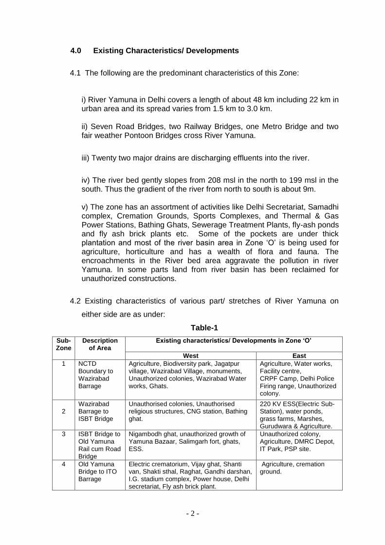
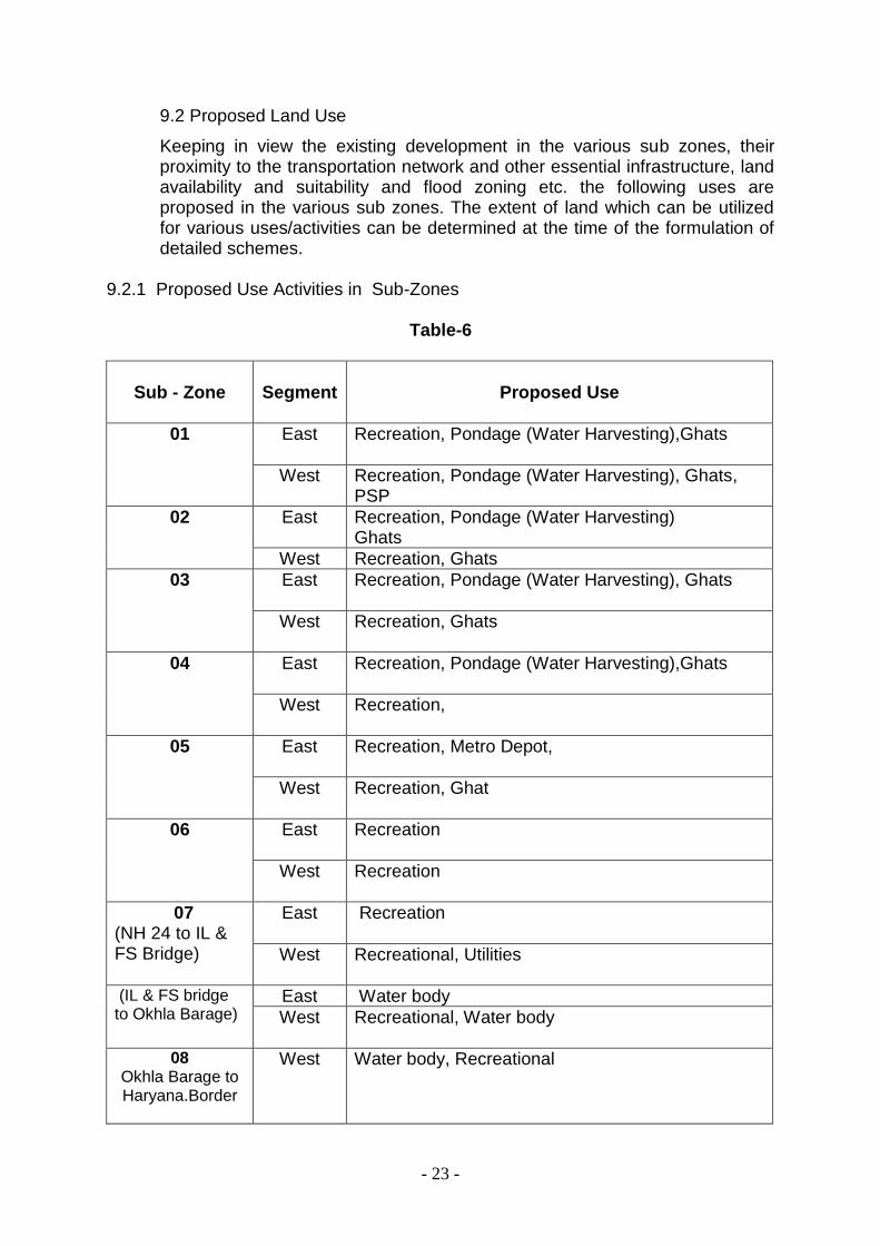
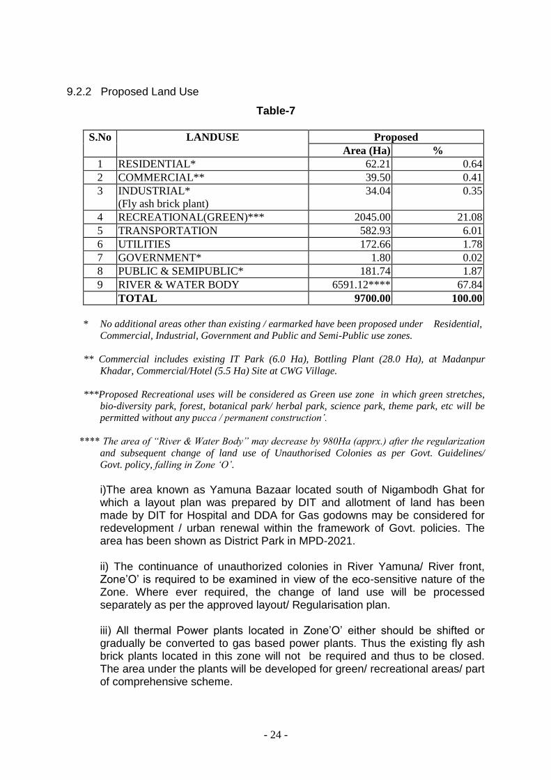
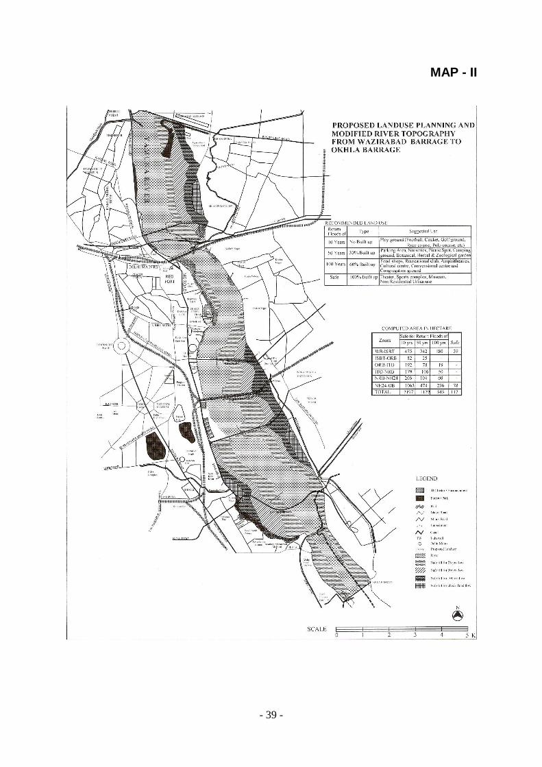
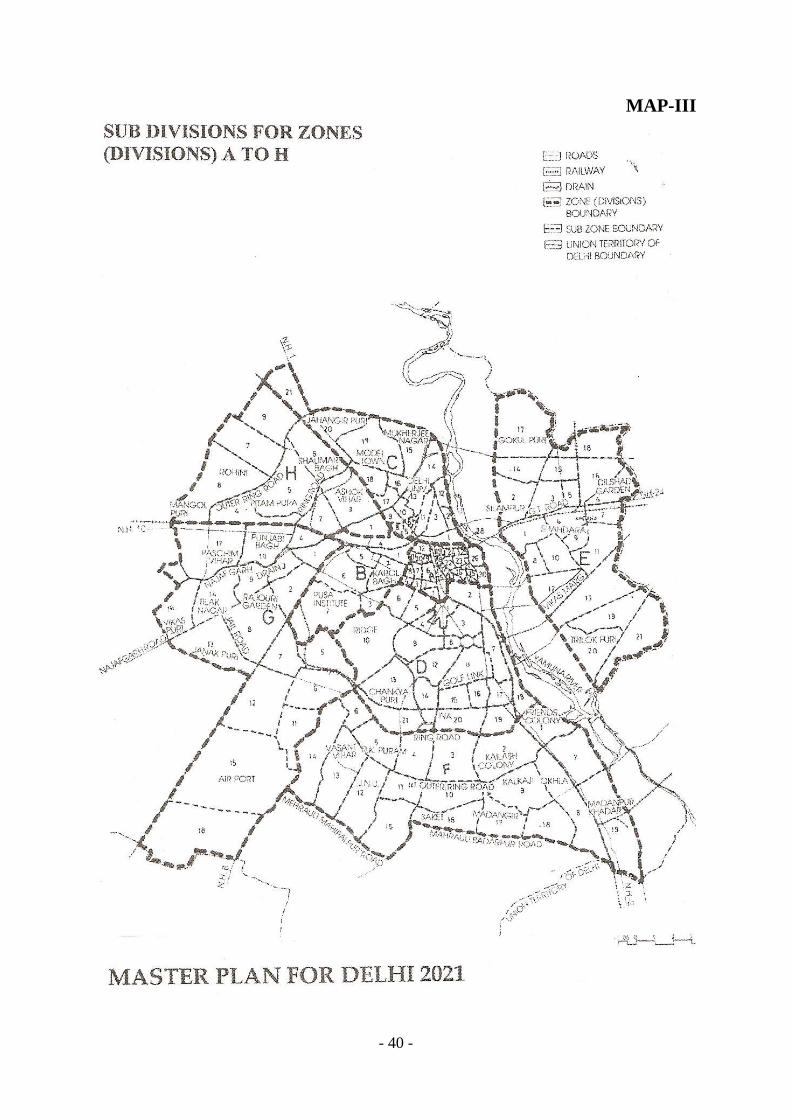
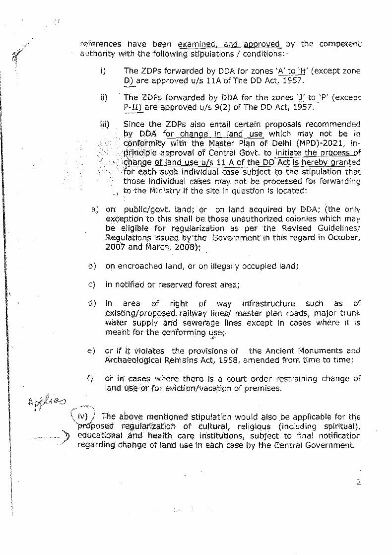

- Front matter
- Main body
- Back matter
-