High Precision GLONASS and ASCOS) AUTONOMOUS · PDF fileKEY FEATURES High Precision ^...
2
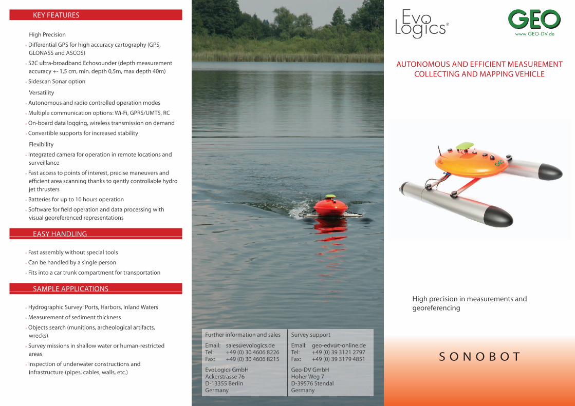
KEY FEATURES High Precision ^ Differential GPS for high accuracy cartography (GPS, GLONASS and ASCOS) ^ S2C ultra-broadband Echosounder (depth measurement accuracy +- 1,5 cm, min. depth 0,5m, max depth 40m) ^ Sidescan Sonar option Versatility ^ Autonomous and radio controlled operation modes ^ Multiple communication options: Wi-Fi, GPRS/UMTS, RC ^ On-board data logging, wireless transmission on demand ^ Convertible supports for increased stability Flexibility ^ Integrated camera for operation in remote locations and surveillance ^ Fast access to points of interest, precise maneuvers and efficient area scanning thanks to gently controllable hydro jet thrusters ^ Batteries for up to 10 hours operation ^ Software for field operation and data processing with visual georeferenced representations EASY HANDLING ^ Fast assembly without special tools ^ Can be handled by a single person ^ Fits into a car trunk compartment for transportation SAMPLE APPLICATIONS ^ Hydrographic Survey: Ports, Harbors, Inland Waters ^ Measurement of sediment thickness ^ Objects search (munitions, archeological artifacts, wrecks) ^ Survey missions in shallow water or human-restricted areas ^ Inspection of underwater constructions and infrastructure (pipes, cables, walls, etc.) AUTONOMOUS AND EFFICIENT MEASUREMENT COLLECTING AND MAPPING VEHICLE High precision in measurements and georeferencing SONOBOT Further information and sales Email: [email protected] Tel: +49 (0) 30 4606 8226 Fax: +49 (0) 30 4606 8215 EvoLogics GmbH Ackerstrasse 76 D-13355 Berlin Germany Survey support Email: [email protected] Tel: +49 (0) 39 3121 2797 Fax: +49 (0) 39 3179 4851 Geo-DV GmbH Hoher Weg 7 D-39576 Stendal Germany
Transcript of High Precision GLONASS and ASCOS) AUTONOMOUS · PDF fileKEY FEATURES High Precision ^...
KEY FEATURES
High Precision
^ Di� erential GPS for high accuracy cartography (GPS, GLONASS and ASCOS)
^ S2C ultra-broadband Echosounder (depth measurement accuracy +- 1,5 cm, min. depth 0,5m, max depth 40m)
^ Sidescan Sonar option
Versatility
^ Autonomous and radio controlled operation modes
^ Multiple communication options: Wi-Fi, GPRS/UMTS, RC
^ On-board data logging, wireless transmission on demand
^ Convertible supports for increased stability
Flexibility
^ Integrated camera for operation in remote locations and surveillance
^ Fast access to points of interest, precise maneuvers and e� cient area scanning thanks to gently controllable hydro jet thrusters
^ Batteries for up to 10 hours operation
^ Software for � eld operation and data processing with visual georeferenced representations
EASY HANDLING
^ Fast assembly without special tools
^ Can be handled by a single person
^ Fits into a car trunk compartment for transportation
SAMPLE APPLICATIONS
^ Hydrographic Survey: Ports, Harbors, Inland Waters
^ Measurement of sediment thickness
^ Objects search (munitions, archeological artifacts, wrecks)
^ Survey missions in shallow water or human-restricted areas
^ Inspection of underwater constructions and infrastructure (pipes, cables, walls, etc.)
AUTONOMOUS AND EFFICIENT MEASUREMENT COLLECTING AND MAPPING VEHICLE
High precision in measurements and georeferencing
S O N O B O T
Further information and sales
Email: [email protected]: +49 (0) 30 4606 8226Fax: +49 (0) 30 4606 8215
EvoLogics GmbHAckerstrasse 76D-13355 BerlinGermany
Survey support
Email: [email protected]: +49 (0) 39 3121 2797Fax: +49 (0) 39 3179 4851
Geo-DV GmbHHoher Weg 7D-39576 StendalGermany
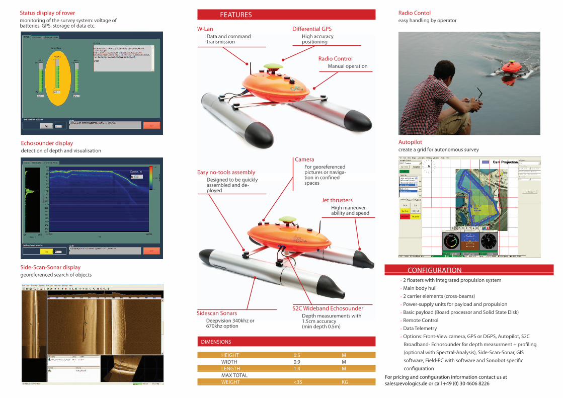
S2C Wideband EchosounderDepth measurements with 1.5cm accuracy(min depth 0.5m)
Sidescan SonarsDeepvision 340khz or 670khz option
Jet thrustersHigh maneuver-ability and speed
W-LanData and command transmission
Di� erential GPSHigh accuracy positioning
CameraFor georeferenced pictures or naviga-tion in con� ned spaces
Easy no-tools assemblyDesigned to be quickly assembled and de-ployed
DIMENSIONS
HEIGHT 0.5 M WIDTH 0.9 M LENGTH 1.4 M MAX TOTAL WEIGHT <35 KG
FEATURES
CONFIGURATION
Radio ControlManual operation
Status display of rovermonitoring of the survey system: voltage of batteries, GPS, storage of data etc.
Echosounder displaydetection of depth and visualisation
Side-Scan-Sonar displaygeoreferenced search of objects
Radio Contol easy handling by operator
Autopilot create a grid for autonomous survey
For pricing and con� guration information contact us at [email protected] or call +49 (0) 30 4606 8226
^ 2 � oaters with integrated propulsion system ^ Main body hull ^ 2 carrier elements (cross-beams) ^ Power-supply units for payload and propulsion ^ Basic payload (Board processor and Solid State Disk) ^ Remote Control ^ Data Telemetry ^ Options: Front-View camera, GPS or DGPS, Autopilot, S2C Broadband- Echosounder for depth measurment + pro� ling (optional with Spectral-Analysis), Side-Scan-Sonar, GIS software, Field-PC with software and Sonobot speci� c con� guration