Herschel Island - Yukon › sites › yukon.ca › files › env › env-guide...Checklist of the...
3
A GUIDE TO Publications Herschel Island Qikiqtaryuk: a natural and cultural history of Yukon’s Arctic island — Christopher R. Burn Qikiqtaruk – Inuvialuit Archaeology on Herschel Island — YG Herschel Island: A Guide to Historic Resources — YG Waves Upon the Shore: An historical Profile of Herschel Island — Rob Ingram & Helen Dobrowolsky Explore Herschel Island! & The Bishop Who Ate His Boots — virtualmuseum.ca Available at Environment Yukon offices, Visitor Information Centres or from: www.env.gov.yk.ca: Checklist of the Birds of Herschel Island Flora of Herschel Island Territorial Park Into the Yukon Wilderness Yukon Wildlife Viewing Guide How you can stay safe in bear country Maps 1:50,000 - Herschel Island (sheet 117D12E) 1:250,000 - Herschel Island (sheet 117D) Reuse first – pass it on ©Government of Yukon, 2013 ISBN 978-1-55362-609-1 All photos YG-Cameron Eckert except where noted. Cover photos: YG-Park Rangers and Anglican Church of Canada PHO 91, #105, Aoc#78/67 Contacts Yukon Parks 867-667-5648 (Whitehorse) 867-777-4058 (Inuvik) Toll-free in Yukon 1-800-661-0408, ext. 5648 [email protected] Historic Sites Unit 867-667-5386, or toll-free in Yukon 1-800-661-0408, ext. 5386 Emergency (RCMP Inuvik) 867-777-1111 www.yukonparks.ca Herschel Island Qikiqtaruk Territorial Park Wildlife Viewing Between land and sea, the island’s dry polar climate supports a surprising web of life. The answer lies in ocean currents. The huge driftwood trunks that litter the beaches in this tree- less land originate from as far away as the Liard Basin. They were delivered by the nutrient- rich outflow of the Mackenzie River. Billions of tiny organisms feed a diversity of fishes that, in turn, attract a myriad of air, sea and land animals, including one of the largest colonies of Black Guillemots in the Western Arctic. Listen to their gentle whistles near the old Anglican Mission House. Despite near extinction by early commercial whalers, Bowhead Whale migrate past the island in the fall, gorging on the abundance of tiny plankton. The white Beluga Whale is commonly seen from the island. If you are lucky, a Bearded Seal may pop its head out of the shallow bays. But the most common marine mammal is the Ringed Seal, who fish Arctic Cod, Arctic Char, Pacific Herring and Arctic Flounder along summer sea ice edges. Peregrine Falcon, Rough-Legged Hawk, and Snowy Owl hunt a variety of songbirds and small mammals. When the ocean freezes in winter, land mammals can walk to the island. They also swim across in summer. Grizzly Bear, Muskox, and Barren-ground Caribou are all commonly seen. Red and Arctic foxes hunt Collared and Brown lemmings and Tundra Vole, who nibble grasses, sedges and flowers. In winter, Polar Bears den on Qikiqtaruk’s northern slopes. When viewing and photographing wildlife, keep your distance. Use binoculars, scopes and telephoto lenses to get a better look. Our Island: Haven in the ice pack Qikiqtaruk has always been a gathering place. Inuvialuit have used the site for thousands of years and remnants of old dwellings are still visible. In the late 1800s, American whalers established a station at Pauline Cove where ships were protected from storms and sea ice. Since then, the Anglican Church, Hudson’s Bay Co., other fur traders, reindeer herders, the Royal Canadian Corps of Signals and the RCMP were all present on Herschel Island at some point in the past 100+ years. Today, Inuvialuit families continue to use the area for traditional activities while researchers from around the world study the unique and rapidly changing arctic environment. Park rangers manage the park, welcome visitors and share stories of the past. Hunting, trapping and fishing in the park Visitors may encounter Inuvialuit subsistence users within the park. When you see our friends or families harvesting caribou, seal or Arctic Char, you are witnessing an ancient and enduring way of arctic life. If you are an Inuvialuit hunter please respect other park users. Store meat and dispose of carcasses away from visitor areas. There are no-hunting zones in the historical and settlement areas. Qikiqtaryuk “ it is island” YG
Transcript of Herschel Island - Yukon › sites › yukon.ca › files › env › env-guide...Checklist of the...

A G
UID
E TO
PublicationsHerschel Island Qikiqtaryuk: a natural and cultural history of Yukon’s Arctic island — Christopher R. Burn
Qikiqtaruk – Inuvialuit Archaeology on Herschel Island — YG
Herschel Island: A Guide to Historic Resources — YG
Waves Upon the Shore: An historical Profile of Herschel Island — Rob Ingram & Helen Dobrowolsky
Explore Herschel Island! & The Bishop Who Ate His Boots — virtualmuseum.ca
Available at Environment Yukon offices, Visitor Information Centres or from: www.env.gov.yk.ca:
Checklist of the Birds of Herschel Island
Flora of Herschel Island Territorial Park
Into the Yukon Wilderness
Yukon Wildlife Viewing Guide
How you can stay safe in bear country
Maps 1:50,000 - Herschel Island (sheet 117D12E)1:250,000 - Herschel Island (sheet 117D)
Reuse first – pass it on
©Government of Yukon, 2013 ISBN 978-1-55362-609-1All photos YG-Cameron Eckert except where noted.Cover photos: YG-Park Rangers and Anglican Church of CanadaPHO 91, #105, Aoc#78/67
Contacts Yukon Parks867-667-5648 (Whitehorse) 867-777-4058 (Inuvik)Toll-free in Yukon 1-800-661-0408, ext. [email protected]
Historic Sites Unit867-667-5386, or toll-free in Yukon 1-800-661-0408, ext. 5386
Emergency (RCMP Inuvik)867-777-1111
www.yukonparks.ca
Herschel IslandQikiqtaruk Territorial Park
Wildlife ViewingBetween land and sea, the island’s dry polar climate supports
a surprising web of life. The answer lies in ocean currents. The huge driftwood trunks that litter the beaches in this tree-less land originate from as far away as the Liard Basin. They were delivered by the nutrient-rich outflow of the Mackenzie River. Billions of tiny organisms feed a diversity of fishes that, in turn, attract a myriad of air, sea and land animals, including one of the largest colonies of Black Guillemots in the Western Arctic. Listen to their gentle whistles near the old Anglican Mission House.
Despite near extinction by early commercial whalers, Bowhead Whale migrate past the island in the fall, gorging on the abundance of tiny plankton. The white Beluga Whale is commonly seen from
the island. If you are lucky, a Bearded Seal may pop its head out of the shallow bays. But the most common marine mammal is the Ringed Seal, who fish Arctic Cod, Arctic Char, Pacific Herring and Arctic Flounder along summer sea ice edges. Peregrine Falcon, Rough-Legged Hawk, and Snowy Owl hunt a variety of songbirds and small mammals.
When the ocean freezes in winter, land mammals can walk to the island. They also swim across in summer. Grizzly Bear, Muskox, and Barren-ground Caribou are all commonly seen. Red and Arctic foxes hunt Collared and Brown lemmings and Tundra Vole, who nibble grasses, sedges and flowers. In winter, Polar Bears den on Qikiqtaruk’s northern slopes.
When viewing and photographing wildlife, keep your distance. Use binoculars, scopes and telephoto lenses to get a better look.
Our Island: Haven in the ice packQikiqtaruk has always been a gathering place. Inuvialuit have used the site for thousands of years and remnants of old dwellings are still visible. In the late 1800s, American whalers established a station at Pauline Cove where ships were protected from storms and sea ice. Since then, the Anglican Church, Hudson’s Bay Co., other fur
traders, reindeer herders, the Royal Canadian Corps of Signals and the RCMP were all present on Herschel Island at some point in the past 100+ years.
Today, Inuvialuit families continue to use the area for traditional activities while researchers from around the world study the unique and rapidly changing arctic environment. Park rangers manage the park, welcome visitors and share stories of the past.
Hunting, trapping and fishing in the park
Visitors may encounter Inuvialuit subsistence users within the park. When you see our friends or families harvesting caribou, seal or Arctic Char, you are
witnessing an ancient and enduring way of arctic life.
If you are an Inuvialuit hunter please respect other park users. Store meat and dispose of carcasses away from visitor areas. There are no-hunting zones in the historical and settlement areas.
Qikiqtaryuk “it is island”
YG
VGFN-S. Smith
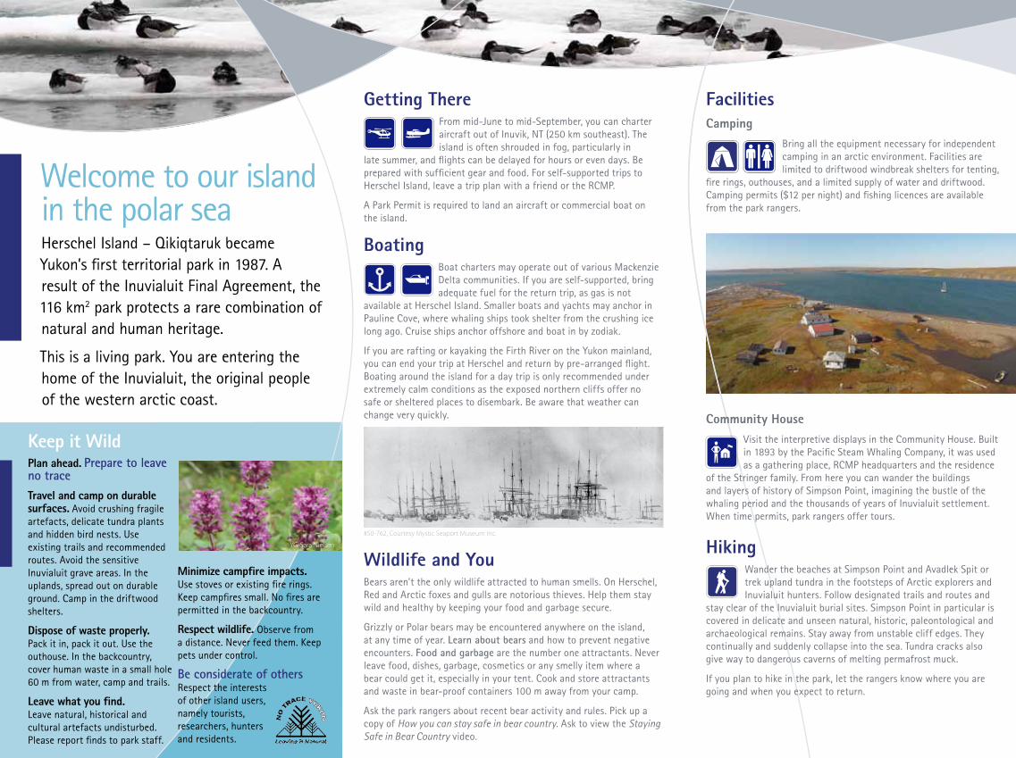
Welcome to our island in the polar seaHerschel Island – Qikiqtaruk became Yukon’s first territorial park in 1987. A result of the Inuvialuit Final Agreement, the 116 km2 park protects a rare combination of natural and human heritage.
This is a living park. You are entering the home of the Inuvialuit, the original people of the western arctic coast.
FacilitiesCamping
Bring all the equipment necessary for independent camping in an arctic environment. Facilities are limited to driftwood windbreak shelters for tenting,
fire rings, outhouses, and a limited supply of water and driftwood. Camping permits ($12 per night) and fishing licences are available from the park rangers.
Community HouseVisit the interpretive displays in the Community House. Built in 1893 by the Pacific Steam Whaling Company, it was used as a gathering place, RCMP headquarters and the residence
of the Stringer family. From here you can wander the buildings and layers of history of Simpson Point, imagining the bustle of the whaling period and the thousands of years of Inuvialuit settlement. When time permits, park rangers offer tours.
HikingWander the beaches at Simpson Point and Avadlek Spit or trek upland tundra in the footsteps of Arctic explorers and Inuvialuit hunters. Follow designated trails and routes and
stay clear of the Inuvialuit burial sites. Simpson Point in particular is covered in delicate and unseen natural, historic, paleontological and archaeological remains. Stay away from unstable cliff edges. They continually and suddenly collapse into the sea. Tundra cracks also give way to dangerous caverns of melting permafrost muck.
If you plan to hike in the park, let the rangers know where you are going and when you expect to return.
Getting ThereFrom mid-June to mid-September, you can charter aircraft out of Inuvik, NT (250 km southeast). The island is often shrouded in fog, particularly in
late summer, and flights can be delayed for hours or even days. Be prepared with sufficient gear and food. For self-supported trips to Herschel Island, leave a trip plan with a friend or the RCMP.
A Park Permit is required to land an aircraft or commercial boat on the island.
BoatingBoat charters may operate out of various Mackenzie Delta communities. If you are self-supported, bring adequate fuel for the return trip, as gas is not
available at Herschel Island. Smaller boats and yachts may anchor in Pauline Cove, where whaling ships took shelter from the crushing ice long ago. Cruise ships anchor offshore and boat in by zodiak.
If you are rafting or kayaking the Firth River on the Yukon mainland, you can end your trip at Herschel and return by pre-arranged flight. Boating around the island for a day trip is only recommended under extremely calm conditions as the exposed northern cliffs offer no safe or sheltered places to disembark. Be aware that weather can change very quickly.
Wildlife and YouBears aren’t the only wildlife attracted to human smells. On Herschel, Red and Arctic foxes and gulls are notorious thieves. Help them stay wild and healthy by keeping your food and garbage secure.
Grizzly or Polar bears may be encountered anywhere on the island, at any time of year. Learn about bears and how to prevent negative encounters. Food and garbage are the number one attractants. Never leave food, dishes, garbage, cosmetics or any smelly item where a bear could get it, especially in your tent. Cook and store attractants and waste in bear-proof containers 100 m away from your camp.
Ask the park rangers about recent bear activity and rules. Pick up a copy of How you can stay safe in bear country. Ask to view the Staying Safe in Bear Country video.
Keep it WildPlan ahead. Prepare to leave no traceTravel and camp on durable surfaces. Avoid crushing fragile artefacts, delicate tundra plants and hidden bird nests. Use existing trails and recommended routes. Avoid the sensitive Inuvialuit grave areas. In the uplands, spread out on durable ground. Camp in the driftwood shelters.
Dispose of waste properly. Pack it in, pack it out. Use the outhouse. In the backcountry, cover human waste in a small hole 60 m from water, camp and trails.
Leave what you find. Leave natural, historical and cultural artefacts undisturbed. Please report finds to park staff.
Minimize campfire impacts. Use stoves or existing fire rings. Keep campfires small. No fires are permitted in the backcountry.
Respect wildlife. Observe from a distance. Never feed them. Keep pets under control.
Be considerate of othersRespect the interests of other island users, namely tourists, researchers, hunters and residents.
#50-762, Courtesy Mystic Seaport Museum Inc.
YG-Sara Nielsen

200
100
400
300500
600
700
800
500
300
700
100
300
100
200
200
200
200
100
500
100
200
200
200
200
200
100
100
300
500
300
100
200
200
200
100
100
200
100
300
200
100
200
100
200
100
200
200
100
100
100
100200
100
300
200
100
200
400
100
100
200
100
100
200
200
100
100
100
100
100
100
200
300
100
300
200
200
100
500
100
300
100
100
100
200
300
100
300
100
200
600 800
300
500
200
200
300
300
200
200
300
100
200
100
100
100
200
200
200
200
300
100
100
100
100
200
300
300
100
200
100
300
300
100
100
800
100
200200
200
100
100
100
100
100
100
300
100200
100
100
100
200
100
100
300
200
300
200
200
100
100
200
200
100
100
400
100
100
300
200
200
200
100
100
100
300
200
100
400
200
300
!\
138°50'W
138°50'W
139°W
139°W
139°10'W
139°10'W
139°20'W
139°20'W69
°35'
N
69°3
5'N
69°3
0'N
69°3
0'N
69°2
5'N
69°2
5'N
Welles Point(Nuvaraak)
Lopez Point(Kuvlualuk)
WO
RK
B OA
TP A S S A G E
Catton Point
Osborn Point(Nuvuruaq)
Collinson Head(Nuvuruaq)
HERSCHEL ISLAND – Q IK IQTARUKTERR ITOR IAL PARK
T H E T I S B A Y( I L U T A Q )
B E A U F O R T S E A( T A R I U Q )
Pauline Cove(Ilutaq)
PtarmiganBay
Diff icul t
Cre ek
Simpson Point(Kuvluraq)ˆ
Avad
lek
Spit
(Nuv
ugru
ak)
ˆ
Orca Cove(Ilukraqnaq)ˆ
Thrasher Bay(Ilukraq)ˆ
Bell Bluff(Manikraq)ˆ
To Firth River (2 km)
IVVAV IKNAT IONAL PAR K
262
597
Herschel Island – Qikiqtaruk Territorial Park
1 0 1 2 3 4 km
Scale 1:80,000Area Enlarged
Whitehorse
Dawson
Inuvik
EaglePlains
Y U K O N
N O R T H W E S TT E R R I T O R I E S
AL
AS
KA
(U
SA
)
BR IT ISH COLU M BIA
Old Crow
Aklavik
Y U K O N
Map ID: ENV.012.012.02
±
±
Washroom
182
Park Rangers and information
Area Enlarged
Territorial Park boundary
Landing strip
Floating dock Driftwood shelter
Anchorage Elevation (feet)
Nunaluk Spit
300
200
200
200100
100
100
500
500
500400
300
200
300
300
200
100
100
200
400
500400
300
200
300
300
300
100
300
200
100
100
100
200
100
100
200
300
Existing structures / buildings
Euro-American
* Restricted access
Inuvialuit semi-subterranean house
Previous structures / buildings
Historic / Park Facilities
Historic Structures 1. Northern Whaling and Trading Company Store (1926) 2. N.W. & T. Co. Shed (1926) 3. N.W. & T. Co. Warehouse / Canada Customs Bonded Warehouse (1926) 4. Pacific Steam Whaling Company Community House (1893) / Police Detachment Headquarters and Barracks 5. P.S.W.Co. Bonehouse (c. 1894) 6. Triton Sank (1895) 7. Police Dog Kennels (c. 1950) 8. Royal Canadian Corps of Signals Transmitter Station (1930) 9. P.S.W.Co. Blubberhouse (c. 1890s) 10. Captain McKenna’s Cabin (c. 1893) 11. Dwelling (c. 1890’s) 12. Dwelling (c. 1890’s) 13. Anglican Mission House (1916) 14. Abandoned boat 15. Ice houses* 16. Whalers graveyard* 17. Inuvialuit graveyards* 18. RCMP graves*
Park Facilities 4. Welcome Building 19. Private residence 20. Hunters and Travellers Cabin 21. Sauna 22. Storage shed 23. Park monument 24. Interpretive sign 25. Ranger quarters
1
2
2419
2321
4
7
5 89 10
1112
22
20
13
14
15 1618
17
3
6 17Simpson Point (Kuvluraq)
25
0 50 100 150 200 m