
Handout NB-2 - PRRD
32
Site C Clean Energy Project Water Sustainability Act Section 11 – Cache Creek Bridge – Hwy 29 Description of Activities and Works 1. INTRODUCTION Highway 29 is two-lane rural arterial undivided highway under the jurisdiction of the British Columbia Ministry of Transportation and Infrastructure (MOTI) that connects Hudson’s Hope to Fort St. John. It runs along the north side of the Peace River. Segments of the highway will be inundated or rendered unstable by the Site C reservoir, resulting in the need to realign approximately 30 km of existing highway at Lynx Creek, Dry Creek, Farrell Creek, Halfway River, and Cache Creek, as described in the Site C Project’s EIS Volume 1 Section 4.1 The Cache Creek segment is 8.5 km long and will be the first section of Highway 29 to be realigned. Construction of the Cache Creek segment, including a new bridge over Cache Creek, is planned to commence in summer 2017 and be complete by the end of 2019. BC Hydro and/or its agents are requesting approval to undertake works in and about a stream as part of Highway 29 construction, required for the Site C Clean Energy Project (the Project). Works will involve the installation of a new Highway 29 bridge, which will cross Cache Creek 300 m upstream of the existing bridge. The new 400 m long bridge (Cache Creek Bridge) will be a four-span structure supported by three piers in the Cache Creek floodplain area east of the normal stream channel. The bridge abutments will be constructed at the top of slope and effects to the floodplain have been minimized. This document supports the Section 11 Water Sustainability Act application by providing information on existing conditions, proposed activities and works, schedule of work, access and equipment, and future use of the area. Additional applications will be submitted under separate cover to support the proposed highway construction works. These include: • Forest Act Occupant Licence to Cut • Land Act Application for a Licence of Occupation • Mines Act Notice of Work for Peaceview Pit • Water Sustainability Act Application for Short Term Use of Water (WSA s.10) 2. EXISTING CONDITIONS An overview of environmental information pertaining specifically to the Highway 29 realignment area is summarized in Appendix A. Channel Characteristics Cache Creek (Watershed Code: 230-760300) is a 5th Order stream tributary to the Peace River. Satellite imagery of the upstream drainage shows several unnamed tributary streams discharging to Cache Creek upstream of the proposed realigned highway crossing. Headwater waterbodies (i.e. lakes, ponds and wetlands) that drain into this stream are visible on the plateau upslope of the crossing site. At the bridge crossing site, the channel is confined by a steep valley wall on the right bank (looking downstream) and a floodplain area on the left bank. This floodplain area includes a 1 BC Hydro. 2013. Site C Clean Energy Project Environmental Impact Statement. Dated January 25, 2013; Amended August 2, 2013. Volume 1: Introduction, Project Planning, and Description. Available from: http://www.ceaa- acee.gc.ca/050/documents_staticpost/63919/85328/Vol1_Introduction_etc.pdf 2016-09-19 Page 1 of 5 Handout NB-2 March 9, 2017 (refer to CA-7)
Transcript of Handout NB-2 - PRRD
Site C Clean Energy Project Water Sustainability Act Section 11 – Cache Creek Bridge – Hwy 29
Description of Activities and Works
1. INTRODUCTION Highway 29 is two-lane rural arterial undivided highway under the jurisdiction of the British Columbia Ministry of Transportation and Infrastructure (MOTI) that connects Hudson’s Hope to Fort St. John. It runs along the north side of the Peace River. Segments of the highway will be inundated or rendered unstable by the Site C reservoir, resulting in the need to realign approximately 30 km of existing highway at Lynx Creek, Dry Creek, Farrell Creek, Halfway River, and Cache Creek, as described in the Site C Project’s EIS Volume 1 Section 4.P0F
1P The
Cache Creek segment is 8.5 km long and will be the first section of Highway 29 to be realigned. Construction of the Cache Creek segment, including a new bridge over Cache Creek, is planned to commence in summer 2017 and be complete by the end of 2019.
BC Hydro and/or its agents are requesting approval to undertake works in and about a stream as part of Highway 29 construction, required for the Site C Clean Energy Project (the Project). Works will involve the installation of a new Highway 29 bridge, which will cross Cache Creek 300 m upstream of the existing bridge. The new 400 m long bridge (Cache Creek Bridge) will be a four-span structure supported by three piers in the Cache Creek floodplain area east of the normal stream channel. The bridge abutments will be constructed at the top of slope and effects to the floodplain have been minimized.
This document supports the Section 11 Water Sustainability Act application by providing information on existing conditions, proposed activities and works, schedule of work, access and equipment, and future use of the area. Additional applications will be submitted under separate cover to support the proposed highway construction works. These include:
• Forest Act Occupant Licence to Cut
• Land Act Application for a Licence of Occupation
• Mines Act Notice of Work for Peaceview Pit
• Water Sustainability Act Application for Short Term Use of Water (WSA s.10)
2. EXISTING CONDITIONS An overview of environmental information pertaining specifically to the Highway 29 realignment area is summarized in Appendix A.
UChannel Characteristics
Cache Creek (Watershed Code: 230-760300) is a 5P
thP Order stream tributary to the Peace River.
Satellite imagery of the upstream drainage shows several unnamed tributary streams discharging to Cache Creek upstream of the proposed realigned highway crossing. Headwater waterbodies (i.e. lakes, ponds and wetlands) that drain into this stream are visible on the plateau upslope of the crossing site.
At the bridge crossing site, the channel is confined by a steep valley wall on the right bank (looking downstream) and a floodplain area on the left bank. This floodplain area includes a
1 BC Hydro. 2013. Site C Clean Energy Project Environmental Impact Statement. Dated January 25, 2013; Amended August 2, 2013. Volume 1: Introduction, Project Planning, and Description. Available from: http://www.ceaa-acee.gc.ca/050/documents_staticpost/63919/85328/Vol1_Introduction_etc.pdf
2016-09-19 Page 1 of 5
Handout NB-2
March 9, 2017
(refer to CA-7)

Site C Clean Energy Project Description of Activities and Works – Highway 29 – Cache Creek Bridge
historically eroded seasonal flood channel with a 5 year estimated return period. The lower end of this channel backfloods most years (1.25 year estimated return period) when water levels are at their highest.
The lower sections of Cache Creek consist of a series of large shallow pools connected by short riffle sections, which lack boulder, and runs with silt-embedded substrates. Channel widths average 23 m and substrate is dominated by cobble (29%), gravel/pebble (21%) and organic matter (21%). Wetted width and depth average 5 m and 0.24 m. Summer and fall water velocities in Cache Creek have been reported as nil / below measurable levels in multiple years.
UFish Use
A total of 20 fish species have been historically identified in Cache Creek (Habitat Wizard / Fisheries Information Summary System (FISS)). Of these, four are salmonids, while the remainder are non-sport (coarse) fish species.
Species of conservation concern in Cache Creek include Bull Trout, and Northern Pearl Dace, both of which are provincially Blue-listed species. Bull Trout is listed as a COSEWIC species of “Special Concern”. Spottail Shiner was also recorded in the drainage and is a provincially Red-listed species.
Several fish sampling studies conducted by Mainstream and AMEC & LGL, between 2006 and 2012, resulted in capture of high densities of coarse (non-sport) fish species and extremely limited densities of sport fish (i.e. trout, Arctic Grayling, Mountain Whitefish and Burbot).
Mainstream’s (2012) summary of fish and fish habitat for the Site C Clean Energy Project noted that temperatures in Cache Creek most likely limit use by coldwater sportfish species such as Rainbow Trout, Bull Trout, Arctic Grayling, and Mountain Whitefish.
Discharge is high in spring, but declines to base flow conditions by summer. The relationship between bankfull width and wetted width suggest highly variable flows. Low flows during the study reduced the availability and quantity of juvenile fish habitat where summer and fall flows reduced to the point of standing water in Cache Creek.
Evidence of high sediment loads in Cache Creek was observed during the survey, which can be detrimental to young fish.
Based on habitat characteristics, Mainstream concluded that Cache Creek has limited coldwater fish habitats, but does support populations of minnows and suckers. This was confirmed by the capture of suckers and minnows only in a 2013 sampling program.
3. DESCRIPTION OF WORK
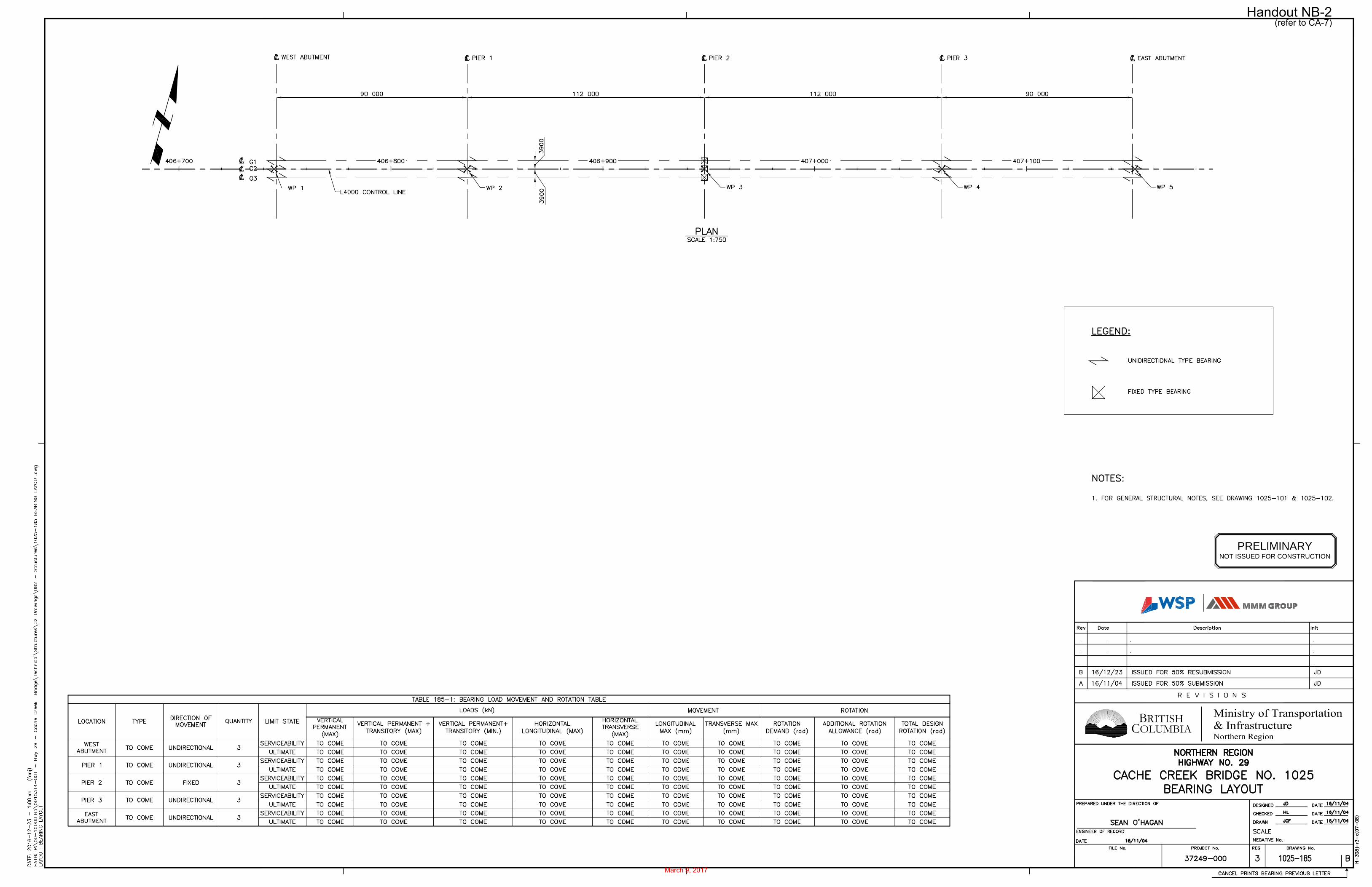
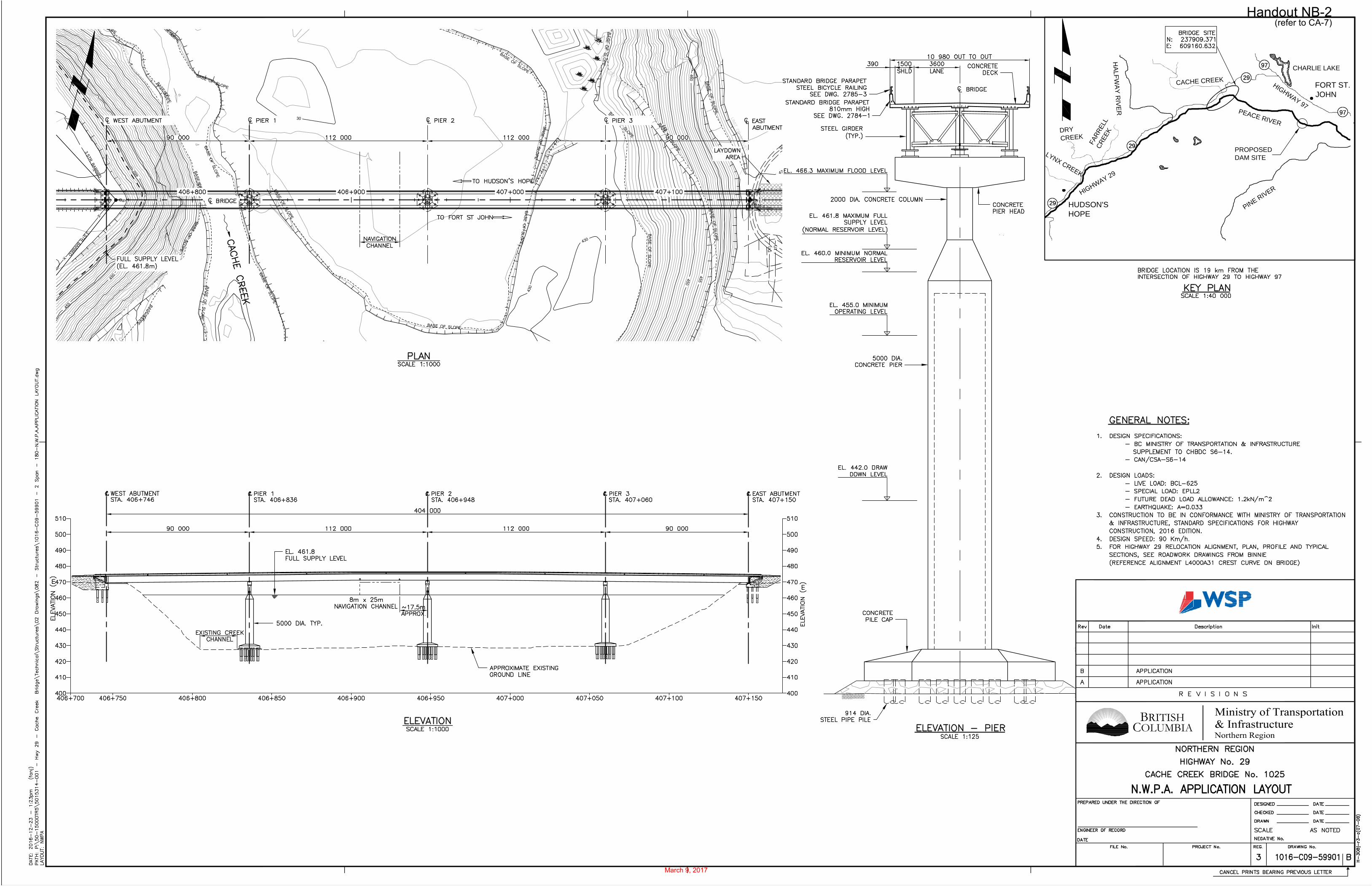
The proposed Cache Creek bridge will be constructed approximately 1,100 m upstream of the confluence with the Peace River, and be located approximately 300 m upstream from the existing Highway 29 bridge. The centre point coordinates for where the bridge will cross Cache Creek are 56°16’24.17”N, 121°14’15.57”W. See Drawing No. 1016-C14-07449 for the location of the bridge in relation to Cache Creek, existing Highway 29 and the proposed Highway 29 realignment.
The bridge will be 406 m long (from abutment to abutment) and 11 m wide. The new bridge deck will be approximately 45 m above Cache Creek. When the Site C reservoir is full (461.8 m ASL), the water level under the bridge is expected to be approximately 35 m above existing ground line. See Drawing No. 1016-C09-59901, 1016-C14-07473, and 90% Design drawings for further information.
2016-09-27 Page 2 of 5
Handout NB-2
March 9, 2017
(refer to CA-7)

Site C Clean Energy Project Description of Activities and Works – Highway 29 – Cache Creek Bridge
There will be no construction activities within the Cache Creek existing mainstem channel. Activities associated with the construction of the bridge will occur east of the normal stream channel, for installation of bridge piers. The permanent footprint of the three piers will be 570 mP
2 P(~190 mP
2P for each pier) in the riparian area and 5-year flood channel. This footprint includes
a gravel pad and the pile cap (see diagram below). No instream works are proposed within the normal stream channel.
Works that will occur within the flood channel and riparian area include:
1. Clearing of riparian vegetation (including shrubs and trees) within the bridge alignment.
2. Construction of a tote road along the left bank from Highway 29, and laydown areas. Thetote road will be utilized by heavy equipment such as a pile-driver, excavators, andtrucks to deliver materials including steel piles, concrete and rocks.
3. Bridge construction activities involving installation of steel footing piles to support thebridge piers and superstructure, filling each pile with concrete, pouring of a 2.5 m highconcrete pile cap, and pouring a 5 m diameter concrete pier.
The Contractor will conduct all works in accordance with their Environmental Protection Plan (EPP), which includes an Erosion and Sediment Control Plan.
4. LEGAL DESCRIPTION / TENURE
The proposed works described in the Water Sustainability Act Section 11 are on private property.
PID 014-791-528
The North West 1/4 of Section 10 Township 84 Range 21 West of the 6th Meridian Peace River District Except Plans 24410 and PGP38491.
5. SCHEDULE OF PROPOSED WORKS
Site preparation is scheduled to begin in February 2017. Works within the flood channeland riparian area are scheduled to begin as early as July 2017 and be completed by late
2019.
2016-09-27 Page 3 of 5
Handout NB-2
March 9, 2017
(refer to CA-7)
Site C Clean Energy Project Description of Activities and Works – Highway 29 – Cache Creek Bridge
6. ACCESS
Works will be accessed by tote road from Highway 29. The tote road will be designed by the construction contractor.
7. ENVIRONMENTAL MANAGEMENT AND MONITORING
Environmental protection during highway and bridge construction will comply with Section 165 of the BC MOTI Standard Specifications for Highway Construction (2016) (SS 165). SS 165.04.01 items a) to j) lists erosion and sediment control requirements that must be considered and addressed in the Contractor’s EPP. Environmental Requirements described in 37TUSection 2.1U37T of the Project’s Construction Environmental Management Plan (CEMP) provide supporting information.
Construction procedures and mitigation works to protect water flow and quality will be defined in the Contractor’s EPP, which will be prepared in advance of construction works by a Qualified Environmental Professional with expertise relevant to site preparation and construction activities.
The EPP will describe measures to [1] protect water quality (including containment of erodible material generated during construction), [2] avoid impacts on fish and fish habitat, and [3] comply with existing environmental Best Practices.
Mitigation measures:
• Construction activities within the Cache Creek valley are anticipated to occur during theperiod when Cache Creek flood channel is not flowing. However, if the stream (and / orflood channel) is flowing at the time of instream activities (and if required to complete thenear-water works), the Contractor will implement a temporary water bypass / diversionsystem to convey clean stream water around the construction zone. This system will bein place and fully functioning for the duration of the period in which it is required.
• Erosion and water quality protection measures will be installed as described in theContractor’s Erosion and Sediment Control Plan (ESCP). This may include theinstallation of dams upstream and downstream to isolate the construction zone.
• Suspended sediment (i.e. waste water) will be contained to prevent release to the river.The methods for containment will be appropriate to the site works and developed inconsideration of the Contractor’s work plan.
• If generated, disposal of sediment-laden water will be pumped from the construction siteto an infiltration area to prevent release to the creek. If an appropriate site is identified,sediment-laden water may be pumped to an upland settlement area (potentially withinthe floodplain) to allow for dispersal and infiltration. If an appropriate nearby uplandlocation is not available, contained sediment-laden water may be hauled off site fordisposal to a suitable location. Alternatively, collected water may be treated on site, forexample, by settlement in a portable baffled water treatment container, and releasedback to the stream provided it meets water quality objectives as outlined in the projectCEMP, and provincial water quality guidelines.
• Generation of sediment-laden water is not anticipated, since pile-driving is expected tobe completed in dry conditions. However, if sediment-laden water or other waste water isgenerated during this pile-driving, containment within the worksite will occur to preventspillage into Cache Creek.
2016-09-27 Page 4 of 5
Handout NB-2
March 9, 2017
(refer to CA-7)
Site C Clean Energy Project Description of Activities and Works – Highway 29 – Cache Creek Bridge
• Isolation from flowing water during the curing of cast-in-place concrete used to form the
pile cap. This isolation will be for a minimum period of 72 hours to ensure there is nodischarge of concrete-affected water to Cache Creek that is toxic (i.e., exceeding a pH of9) to aquatic organisms.
• Fish are not expected to be present at the construction site, since works will beundertaken in dry stream conditions and outside of the wetted perimeter. Fish salvageand measures to prevent fish from moving into the construction zone are not anticipatedto be necessary.
Works will be monitored by an independent environmental monitor retained by BC Hydro and by the contractor’s environmental monitor. The contractor’s monitoring plan will comply with Section 2.4.1 of the CEMP and will be approved before construction begins.
8. FUTURE USE
Once the replacement Cache Creek Bridge, associated realigned Highway 29 roadworks, and bridge approaches are completed, Highway 29 will be permanently routed along the new corridor.
Closure
Karen von Muehldorfer Regulatory Manager Site C Clean Energy Project
2016-09-27 Page 5 of 5
Handout NB-2
March 9, 2017
(refer to CA-7)
Page 1 of 12
Appendix A
Highway 29 Realignment
1.0 Environmental and Heritage Resources, Summary of Effects and Mitigation
Existing baseline conditions, potential effects of the Project and proposed mitigation measures on Fish and Fish Habitat, Vegetation and Ecological Communities, Wildlife Resources and Heritage Resources are described in the EIS Volume 2 Section 12, 13 and 14, and Volume 4 Section 32, respectively. A summary of the potential, effects of the Project as a whole is provided below. Where applicable, particular aspects of the environmental setting of, or potential effects, in the permit area are described. For more detail please refer to the following links:
Fish and Fish Habitat, Vegetation and Ecological Communities, Wildlife Resources:
http://a100.gov.bc.ca/appsdata/epic/html/deploy/epic_document_371_35994.html
Heritage Resources:
http://a100.gov.bc.ca/appsdata/epic/documents/p371/d35996/1377298976499_cfff53268beb4b1510174543f58cdf7611a4861269c501c35e1c5b2dfd931b06.pdf
1.1 Fish and Fish Habitat
1.1.1 Existing Baseline Conditions
1.1.1.1 Fish Species
The following sections summarize information on fish presence and ecology in the broader Project area, which includes the approximately 30 km Highway 29 Realignment area between Cache Creek and Lynx Creek as well as associated tributary confluences. Information at this broader scale provides context for the Highway 29 Realignment activities since fish use a range of habitats during their life, and since the potential effects of the Project on fish and fish habitat were assessed at this scale.
In total, 32 fish species have been recorded in the Peace River and associated tributaries in the vicinity of the Project. None of the species are listed as endangered, threatened, or a special concern under Schedule 1 of the Species at Risk Act (SARA), or are being considered for official listing under Schedule 2 or 3 of SARA.
In British Columbia, one species is listed as “red” (endangered or threatened): spottail shiner (not native to the Project area); and three are listed as “blue” (special concern): bull trout, goldeye, and
Handout NB-2
March 9, 2017
(refer to CA-7)

Page 2 of 12
pearl dace (pearl dace are not found in the mainstem Peace River). The remaining species are designated as “yellow”, described as secure and not at risk of extinction.
The B.C. Government considers bull trout as a species warranting special management (BCMOE 1994). A review of the status of bull trout populations in British Columbia ranked the conservation status in several core areas of the Lower Peace Ecological Drainage Unit (Hagen and Decker 2011). The Halfway/Peace core area, which would be potentially affected by the Project, received a Rank of C2 – At Risk. The BC Government has identified seven fish species of interest in the Lower Peace River Watershed Site C Project Area (BC Government 2011). These species are Arctic grayling, bull trout, burbot, goldeye, mountain whitefish, rainbow trout, and walleye.
Fish in the Project area can are categorized into two groups: coldwater and coolwater fish. As the name implies, coldwater species reside in coldwater habitats, and require large-textured sediments and clean, well-oxygenated water to complete their life requisites. These species spawn in summer or fall and have extended egg incubation periods. Coolwater species are able to tolerate higher water temperatures and are better adapted to inhabit turbid water and cope with higher fine sediment loads than the coldwater species. Most of these species spawn in spring and have short egg incubation periods. Coldwater species dominate the fish community primarily upstream of the Pine River confluence; however, coolwater fish also migrate or reside in the coldwater type habitat upstream of the Pine River. The abundance of the coolwater fish increases downstream of the Pine River confluence and becomes the dominant fish group at the B.C./Alberta boundary.
Seven sport fish species that are part of the fish community belong to the coldwater group. They include Arctic grayling, bull trout, kokanee, lake whitefish, lake trout, mountain whitefish, and rainbow trout. Rainbow trout and Arctic grayling are a spring spawners. Rainbow trout is also a species whose population has limited natural recruitment within the area, mainly from Maurice Creek.
Five sport fish species belong in the coolwater group including walleye, goldeye, northern pike, burbot, and yellow perch. Fish species that also occupy the coolwater habitats include the three sucker species and nine species listed in the minnow group. They include largescale sucker, longnose sucker, white sucker, flathead chub, lake chub, longnose dace, northern pikeminnow, redside shiner, spottail shiner, and trout-perch.
The three sculpin species occupy both types of environments. Slimy sculpin and prickly sculpin tend to do better in cold, clear water systems, while spoonhead sculpin do better in cool, turbid water systems.
A number of species recorded in the project area are rare and are not considered part of the existing fish community. These include brook trout, pygmy whitefish, brook stickleback, finescale dace, northern redbelly dace, peamouth, and pearl dace. They are present, but individuals of these species represent transients from populations that reside outside the influence of the project area.
Natural recruitment of fish populations originate from the mainstem Peace River and/or Peace River tributaries. Tributaries provide spawning and early rearing habitats for species populations that reside in the Peace River. In addition, some tributaries contain resident populations that provide recruitment to the Peace River via downstream dispersal. Baseline studies indicate that resident fish in Maurice Creek are a recruitment source for Peace River rainbow trout. The Halfway River, Pine River, and Beatton River are important sources for recruitment of Arctic grayling.
Handout NB-2
March 9, 2017
(refer to CA-7)
Page 3 of 12
Few fish populations rely entirely on mainstem Peace River for recruitment. Spawning sculpin species, mountain whitefish, sucker species, and walleye occur in the mainstem Peace River. However, the contribution of mainstem spawning to recruitment is minimal, given the temperature, flow, and ice regime of the system and evidence of rapid downstream dispersal of recently emerged fry. Sculpin, mountain whitefish, sucker, and walleye populations utilize tributary spawning and early rearing habitats that are located outside of the influence of the Peace River.
The Peace River fish community utilizes two primary habitat areas – main channel and side channel. Fish populations use one or both habitat areas depending on species life stage requirements, the physical characteristics of the side channel area, and the Peace River flow regime. Side channels can be more protected than habitats in main channel areas (i.e., lower water velocities). Side channels habitats are often used by smaller-sized fish species and younger age-classes of large-fish species. Side channel areas provide refuge during high river flows and during periods of fry emergence.
More detail on the fish species and their life histories in the Project are is described in EIS Volume 2, Appendix O, Fish and Fish Habitat Technical Data Report, found at:
http://a100.gov.bc.ca/appsdata/epic/documents/p371/d35994/1377199604703_0263c53e020fe5f023732f6213a2332790dcad7d2650fa0f8279feaa86fff482.pdf
1.1.1.2 Fish Habitat
Detailed information about fish habitat is described in EIS Volume 2 Appendix O Fish and Fish Habitat Technical Data Report.
Fish species in the Peace River can reside in habitats in the Peace River upstream and downstream of the Highway 29 Realignment area, and in Peace River tributaries within and outside of the inundation zone of the Site C reservoir.
In general, the lower sections of Peace River tributaries provide spawning and early rearing habitats for suckers and minnows. Spawning and rearing habitats for sport fish have been recorded only in upstream areas of large tributaries. The upper Halfway River watershed provides spawning and rearing habitats for the Peace River bull trout population. The Moberly River provides spawning and rearing habitats for the Peace River Arctic grayling population. Maurice Creek provides spawning and rearing habitats for the Peace River rainbow trout population. The Halfway River, Moberly River, and Pine River provide spawning habitats for the Peace River mountain whitefish population. The Beatton River provides spawning and rearing habitats for walleye and goldeye. All tributaries to the Peace River provide spawning and rearing habitats for suckers, minnows, and sculpins. The Peace River downstream of the Halfway River confluence provides rearing habitat for mountain whitefish. Side channels provide habitats for several fish species, in particular northern pike, yellow perch, and spottail shiner. Finally, the mainstem Peace River used for rearing by adult fish and is a migration area for several species by providing an upstream and/or downstream movement corridor between habitats.
Handout NB-2
March 9, 2017
(refer to CA-7)
Page 4 of 12
1.1.2 Potential Effects of the Project on Fish and Fish Habitat
As described in Section 12 of the EIS, the Project is likely to result in effects on fish habitat, on the health and survival of fish, on the movement of fish.
1.1.2.1 Potential Effects on Fish Habitat
Effects to fish habitat are predicted during the construction phase of the Highway 29 Realignment. The Highway 29 realignment bridge crossings will cause a direct loss of fish habitat. Construction of Highway 29 Realignment would result in the loss of an estimated 10.6 ha of fish habitat. This includes 0.2 ha of habitat in the Halfway River and 10.4 ha along a 1.76 km shoreline of the Peace River. The Halfway River within the Highway 29 Realignment construction footprint provides spawning and rearing habitats for suckers and minnows and feeding habitats for bull trout. The shoreline located along the north bank of the Peace River provides several types of high quality habitats. These include high quality spawning habitats for mountain whitefish, high quality rearing habitats for Arctic grayling, bull trout, mountain whitefish, and rainbow trout, and high quality feeding habitats for Arctic grayling, bull trout, and mountain whitefish.
1.1.2.2 Potential Effects on Fish Health and Survival
Effects to health and survival of fish are predicted to occur during the construction phase of the Highway 29 Realignment . Construction activities will cause sediment inputs that would reduce the quality of fish habitat and impair the health and survival of fish. Highway 29 Realignment includes construction of new bridge crossings on four fish bearing watercourses: Cache Creek, Halfway River, Farrell Creek, and Lynx Creek. Farrell Creek, Halfway River, Cache Creek, and Lynx Creek support primarily sucker and minnow species; however, sport fish species can be present. Life stages most affected would be adults, eggs, and fry during the spring period. During the summer, fall, and winter period, adults would be most affected.
The majority of construction activities would occur away from the current watercourses. The bridges would be clear span structures, with only the Halfway River bridge having piers in the current active river channel. In stream activities such as pier placement and abutment work could generate sediment inputs.
1.1.3 Mitigation Measures and Follow-up Program
Mitigation, management and monitoring activities to mitigate the potential effects of the Project on Fish and Fish Habitat have been developed taking into account the measures proposed in the EIS (see EIS Tables 12.19 and 39.1), information received during the Joint Review Panel hearing process, and the Report of the Joint Review Panel on the Project. Mitigation and management activities are described in the Fisheries and Aquatic Habitat Management Planin accordance with EAC condition 4 and Decision Statement condition 8. The CEMP also contains mitigation measures related to Fish and Fish Habitat.
A Fisheries and Aquatic Habitat Monitoring and Follow-up Program is also being developed in accordance with EAC condition 7 and Decision Statement conditions 8.4.3 and 8.4.4. This draft and final program will be respectively submitted to regulatory agencies and Aboriginal Groups 90 and 150 days following the commencement of construction and operation phases of the Project.
Handout NB-2
March 9, 2017
(refer to CA-7)
Page 5 of 12
1.1.4 Significance of the Potential Residual Effects of the Project on Fish and Fish Habitat
The Project is likely to result in a significant adverse effect on Fish and Fish Habitat as a result of the potential for the loss of indigenous fish populations or distinct groups of fish. The three distinct groups of fish that may be lost are the adfluvial component of the Moberly River Arctic grayling, migratory (adfluvial) bull trout that spawn in the Halfway River, and mountain whitefish that rear in the Peace River and spawn in tributaries of the Peace River or the Peace River mainstem upstream of the Site C Dam site. The loss of these distinct groups occurs because of loss of river habitat, reduced fish health and survival during construction and reservoir filling, and hindered fish movement. Although these distinct groups will be affected, the species as a whole of Arctic grayling, bull trout and mountain whitefish will continue to be present in Peace River tributaries and downstream of the reservoir and may persist in the reservoir.
1.2 Vegetation and Ecological Communities
A detailed description of Vegetation and Ecological Communities can be found in the EIS (Volume 2, Section 13 Vegetation and Ecological Communities) at:
http://a100.gov.bc.ca/appsdata/epic/documents/p371/d35994/1377196585659_0263c53e020fe5f023732f6213a2332790dcad7d2650fa0f8279feaa86fff482.pdf
1.2.1 Existing Baseline Conditions
A description of the ecosystems in the vicinity of the Project, including the Highway 29 realignment areas, are provided in the EIS, Volume 2, Appendix R, Part 1, and can be found at:
http://a100.gov.bc.ca/appsdata/epic/documents/p371/d35994/1379544273454_7699d0ab58f559c9de0cb3ba692409e8208d29aecc5d4289afad768ad8a0669b.pdf
The Peace River, from Hudson’s Hope to the Alberta border, lies within the Peace River Basin Ecoregion, one of the three ecoregions that make up the Boreal Plains Ecoprovince. The Peace Lowland Ecosection has the mildest climate and lowest snowfall within the ecoprovince, likely due to its relatively lower elevation (Demarchi 2011).
The Highawy 29 realignment areas are situated within the moist, warm Peace variant of the Boreal White and Black Spruce Biogeoclimatic Zone (BWBSmw1). The regional climate is relatively moist and warm with a longer growing season than other BWBS subzones. Trembling aspen (Populus tremuloides) is the dominant tree cover in large areas due to past history of frequent fires and recent anthropogenic disturbance. White spruce (Picea glauca) is present on moist to wetter sites where there has been limited fire history. Lodgepole pine (Pinus contorta) occurs as a seral species on drier and poorer sites. Balsam poplar (Populus balsamifera ssp.) grows on wetter depressional sites and riparian floodplains. Black spruce (Picea mariana) forests—often with a minor component of tamarack (Larix laricina)—is present on organic soils. The upland forest has an estimated natural disturbance interval of 100 years with fire as the major agent of disturbance (DeLong 2011). Alluvial forests on major rivers are also disturbed by flooding. The natural disturbance interval of flooding in the region is judged to be about 200 years (DeLong 2011).
Handout NB-2
March 9, 2017
(refer to CA-7)
Page 6 of 12
Highway 29 Realignment would affect the following ecosystem units that are associated with rare ecological communities: White spruce/Oak fern – Wild sarsaparilla, White spruce/Red swamp currant/ Horsetails, White spruce - Black spruce /Labrador tea/Glow moss, Black spruce/ Common horsetail/ Peat-mosses, Black spruce/ Lingonberry/ Peat-mosses, and Tamarack/ Water sedge /Golden fuzzy fen moss.
Realignment of Highway 29 to accommodate the Project could affect 12 known rare plant occurrences – comprising 7 vascular species and 3 lichen species. Five of the taxa are on the BC Ministry of Environment’s Red list (endangered or threatened), while the other five are on the Blue list (special concern). None of the 10 species are on Schedule 1 of the Canadian Species At Risk Act (SARA), and none are considered of conservation concern by the Committee on the Status of Endangered Wildlife in Canada (COSEWIC). The 12 occurrences are located in a variety of habitats ranging from upland forests to open shorelines.
Some of the occurrences would be extirpated during construction of the highway realignments due to direct disturbance and habitat alteration. Others may persist, depending on the exact routing of the realignments and associated ground disturbance. Indirect effects over time may reduce the viability of some of these remaining occurrences and may lead to their extirpation.
Additional inventory work was completed in proximity to the Highway 29 realignment areas. Within 5 km of the realignment zones, additional Red- and Blue-listed species were recorded, including 53 occurrences of 24 rare plant species. Within 5 to 10 km from the realignments, an additional 26 occurrences of 14 listed plant species were found. Additional Red- and Blue-listed species were observed more than 10 km from the realignment areas, including 177 occurrences of 34 rare plant species.
1.2.2 Potential Effects of the Project on Vegetation and Ecological Communities
1.2.2.1 Potential Effects on Vegetation and Ecological Communities
As described in Section 13 of the EIS, the Project would adversely affect vegetation, rare plants, and ecological communities through temporary and permanent habitat loss, by habitat alteration and fragmentation, and by the loss of occurrences of rare plants.
For the Project, the greatest potential for changes to vegetation and ecological communities would be expected to occur during the construction phase. Habitat alteration through clearing of vegetation and grubbing during site preparation would be predominant during the early stages of construction. As construction proceeds, water diversion associated with dam construction has the potential to change flow regimes on the Peace River and alter vegetation along the river margins. In the final stages of construction, reservoir filling would change the occurrence of terrestrial vegetation and ecological communities through inundation of existing habitats.
Clearing activities have the potential to indirectly change nearby vegetation and ecological communities as a result of the following:
Increased competition with invasive plant species introduced or dispersed by site clearing activities
Contamination from road salt, herbicide, silt, or accidental spills of industrial fluids
Changes to hydrologic regimes – drying of wetlands, flooding of uplands – due to vegetationclearing, road building, and ground disturbance nearby
Increased dust deposition on leaves and floral parts due to vegetation clearing and grubbingactivities
Handout NB-2
March 9, 2017
(refer to CA-7)
Page 7 of 12
Increased incidental human disturbance with foot and vehicle traffic
1.2.3 Mitigation Measures and Follow-up Program
Mitigation, management and monitoring activities to mitigate the potential effects of the Project on Vegetation and Ecological Communities have been developed taking into account the measures proposed in the EIS (see EIS Tables 13.15, 39.1, and 39.2), and in accordance with EAC conditions 9, 10, 11, 12, 13, and 14 and Decision Statement conditions 10, 11 and 16. Mitigation, management and monitoring activities are described in the CEMP, Vegetation Clearing and Debris Management Plan, and the Vegetation and Wildlife Mitigation and Monitoring Plan, submitted to regulatory agencies and Aboriginal Groups on June 5, 2015.
Implementation of the CEMP, the Vegetation Clearing and Debris Management Plan, and the Vegetation and Wildlife Mitigation and Monitoring Plan will be used to mitigate affects to vegetation and ecological communities during construction. This is discussed further in Section 3.5 below.
1.2.4 Significance of the Potential Residual Effects of the Project on Vegetation and Ecological Communities
The potential residual effect of the Project on certain ecological communities and rare plants would be significant because the sustainability of the regional population of these communities and plants, all of which are of provincial management concern, would be threatened.
1.3 Wildlife Resources
A detailed description of Wildlife Resources found in the vicinity of the Project activity zone, which includes the Highway 29 Realignment area, is provided in the EIS Volume 2, Section 14 Wildlife Resources, which can be found at:
http://a100.gov.bc.ca/appsdata/epic/documents/p371/d35994/1377196616722_0263c53e020fe5f023732f6213a2332790dcad7d2650fa0f8279feaa86fff482.pdf
1.3.1 Existing Baseline Conditions
Baseline conditions were characterized using information from existing literature and field studies that were conducted from 2005 to 2012. Baseline data on presence, distribution, and abundance of wildlife species was collected. Taxa identified in the scope of these studies included butterflies and dragonflies, amphibians and reptiles, migratory birds, non-migratory game birds, raptors, bats, fur-bearers, ungulates, and large carnivores.
Butterfly and dragonfly surveys, pond-breeding, road and auditory amphibian surveys, point count surveys for breeding birds, call playback surveys for Common Nighthawk (Chordeiles minor), marsh birds, owls, encounter transect surveys for fall migratory birds, waterfowl and shorebirds, owls, Northern Harrier (Circus cyaneus), bat capture and acoustic monitoring, moose, elk and fisher (Pekania pennanti) telemetry surveys were conducted within and adjacent to Highway 29 realignment areas.
Sixteen red- and blue-listed species were observed within or immediately adjacent to Highway 29 realignments including: 10 invertebrates, five birds and one mammal (BC Hydro 2013).
Inventory work was completed in proximity to Highway 29 realignments. Within 5 km of the Highway 29 realignment areas pond and auditory surveys for amphibians, call playback surveys for breeding songbirds,
Handout NB-2
March 9, 2017
(refer to CA-7)

Page 8 of 12
swallows, encounter transects for birds on migration and raptors, bat capture and acoustic surveys and radio tracking of fisher, moose, elk and deer were conducted. Eighteen red- and blue-listed species were observed including: 11 invertebrates, 4 songbirds, one amphibian, one non-migratory game bird and one mammal (BC Hydro 2013).
Within 5 to 10 km of Highway 29 Realignment areas, encounter transects for reptiles and swallows, encounter transects and call playback stations for raptors, bat capture and acoustic surveys and radio tracking of fisher, moose, elk and deer were conducted. Tweny-three red- and blue-listed species were observed: 11 invertegrates, 5 songbirds, 3 marsh birds, Common Nighthawk, two raptors and one mammal were observed (BC Hydro 2013).
Amphibian auditory and pond surveys, point count surveys for breeding songbirds, swallows and woodpeckers, call playback surveys for owls, broad-winged hawk (Buteo platypterus), northern goshawk (Accipiter gentilis), Common Nighthawk, encounter transects for northern harrier (Circus cyaneus), short-eared owl (Asio flammeus), butterflies, birds on migration, swallows, Bald Eagle (Haliaeetus leucocephalus) nests, beaver lodges and dens and radio-tracking of fisher, moose, deer and elk were also conducted in areas more than 10 km from the dam site. Twenty five red- and blue-listed species were observed including: one amphibian, 12 invertebrates, 5 songbirds, 3 raptors and 4 mammals (BC Hydro 2013).
1.3.2 Potential Effects of the Project on Wildlife Resources
As described in Section 14 of the EIS, the Project would affect wildlife resources through permanent and temporary habitat alteration and fragmentation, disturbance and displacement, and direct and indirect mortality to individuals.
1.3.2.1 Potential Effects on Wildlife Habitat Alteration and Fragmentation
The Project would cause alteration and fragmentation of habitat used by wildlife resources through: i) changes to the structural stage of habitats, ii) loss or reduction in the area of individual habitats, iii) changes to connectivity between habitats, iv) changes in hydrology and flow patterns, v) release of deleterious substance, and vi) loss or reduction in specific habitat features such as nests, winter range areas, and hibernacula.
Habitat alteration and fragmentation is considered the primary effect of the project on wildlife resources because the presence and use of the LAA by wildlife resources is driven by the presence and distribution of habitats.
1.3.2.2 Potential Effects on Wildlife Disturbance and Displacement
The Project would potentially cause disturbance and displacement of wildlife resources through: clearing, and human activity. Residual effects for disturbance and displacement would be secondary to the effects of habitat alteration and fragmentation, which represents a longer-term change to habitats and may have population-level effects.
1.3.2.3 Potential Effects on Wildlife Mortality
The Project would potentially cause direct and indirect mortality to wildlife resources through: i) habitat alteration due to flooding, including temporary flooding associated with the construction headpond, ii) collisions with vehicles and equipment, as well as increased harvest due to increases in roads and human activity, iii) the release of deleterious substance, and repeated affects to habitat (i.e., daily changes in reservoir stage during operations). The mortality effects would be secondary to the effects of habitat alteration and fragmentation and disturbance and displacement.
Handout NB-2
March 9, 2017
(refer to CA-7)
Page 9 of 12
This is because mortality effects represent a one-time loss of individuals during construction, and not longer-term changes to habitats, which may have population-level effects.
1.3.3 Mitigation Measures and Follow-up Program
Mitigation, management and monitoring activities to mitigate the potential effects of the Project on Wildlife Resources have been developed taking into account the measures proposed in the EIS (see EIS Tables 14.15, 14.16, 14.17, 39.1 and 39.2), and in accordance with EAC conditions 12, 15, 16, 17 and 21 and Decision Statement conditions 9, 10, 11 and 16. Mitigation, management and monitoring activities are described in the CEMP, the Vegetation Clearing and Debris Management Plan, and the Vegetation and Wildlife Mitigation and Monitoring Plan, submitted to regulatory agencies and Aboriginal Groups on June 5, 2015.
Implementation of the CEMP, the Vegetation Clearing and Debris Management Plan, and the Vegetation and Wildlife Mitigation and Monitoring Plan will mitigate effects on wildlife during construction. This is discussed further in Section 3.5 below.
1.3.4 Significance of the Potential Residual Effects of the Project on Wildlife Resources
Habitat alteration and fragmentation would be the primary effect of the Project on Wildlife Resources because the presence and use of the Project activity zone and surrounding areas by wildlife species is driven by the presence and distribution of habitats. Disturbance and displacement and mortality effects are secondary to the effects of habitat alteration and fragmentation. The available measures to mitigate the potential effects on Wildlife Resources may not be fully effective. The residual effect of alteration and fragmentation of habitat of certain species would be significant because the sustainability of the regional populations of these species would be threatened. The species are includes Yellow Rail (SARA-special concern, Red-listed), Canada Warbler (SARA-threatened, Blue-listed), Cape May Warbler (Red-listed), Bay-breasted Warbler (Red-listed), and Nelson’s Sparrow (Red-listed).
1.4 Heritage Resources
The potential effects to heritage resources include disturbing artifacts, features, human remains, heritage sites and fossils. The results of the Heritage Resources Impact Assessment (HRIA) are provided in Volume 4, Section 32 – Heritage Resources and Volume 4, Appendix C – Heritage Resources Assessment Report of the EIS., found on the BC Environmental Assessment Office website at:
http://a100.gov.bc.ca/appsdata/epic/html/deploy/epic_document_371_35996.html
The HRIA describes the baseline environment for heritage resources in the Project activity zone and presents an assessment of potential Project effects and mitigation measures (EIS Volume 4, Section 32, Table 32.7). As stated in the EIS, permission to enter has been denied to date on some private lands that contain areas requiring an archaeological impact assessment (AIA), and completion of the required AIA, and any resulting mitigation, will be completed prior to construction activities in these areas. Methods would be consistent with previous AIA for the Project in accordance with permits issued under the Heritage Conservation Act.
Handout NB-2
March 9, 2017
(refer to CA-7)
Page 10 of 12
Measures to mitigate potential effects on heritage resources include avoidance, partial avoidance, relocation, capping, systematic data recovery (ie, archaeological excavation), documentation, and the implementation of surface inspection, monitoring and chance find procedures, and compensation plans. These measures are further described in the CEMP and the Heritage Resources Management Plan, submitted to regulatory agencies and Aboriginal Groups on June 5, 2015 in accordance with EAC condition 62.
1.5 Mitigation Measures, Follow-up Program, Safety Management
The conditions of the EAC and Federal Decision Statement, issued on October 14, 2014 and November 25, 2014 respectively, require that mitigation, management and monitoring plans be developed and implemented during Project construction and operations. Conditions required that some plans be submitted to regulatory agencies, regional and municipal governments, and Aboriginal groups prior to the commencement of construction.
Draft versions of a number of the mitigation, management and monitoring plans required by the conditions were submitted to applicable government agencies and Aboriginal groups for comment on October 17, 2014.
Comments on these draft plans were received from various government agencies and Aboriginal groups during November and December 2014, and were considered in the revisions to these plans. BC Hydro’s consideration of these comments is provided in the consideration tracking tables that accompany each plan.
On December 15, 2014, Treaty 8 Tribal Association (T8TA), on behalf of West Moberly, Saulteau and Prophet River First Nations, submitted to BC Hydro a letter in response to BC Hydro’s request for comment on the Plans sent on October 17, 2014. The letter included several appendices, including the Joint Review Panel (JRP) Report and transcripts from the JRP hearings in December 2013 and January 2014. BC Hydro responded to the three First Nations on January 21, 2015 noting that the October 17 2014 request for comments on the plans was to provide an opportunity to the First Nations to submit to BC Hydro any information they wanted to provide in relation to the Plans. BC Hydro advised that it was aware of the information referred to in T8TA’s letter when the plans were prepared, and advised that it was preparing a table setting out where any mitigation measures identified by representatives of the three First Nations during the hearings are considered in the draft plans and would provide that to the First Nations once complete. Accordingly BC Hydro’s responses to those mitigation measures identified by the representatives of the three First Nations during the JRP hearings were provided to the EAO in a separate table by letter dated May 19, 2015. Aside from the December 15, 2014 letter, BC Hydro has not received further comments from these First Nations. A letter of understanding dated April 30, 2015 respecting provision of capacity funding to support review of the plans was entered into by BC Hydro and Saulteau First Nations (on behalf of Saulteau, West Moberly and Prophet River First Nations).
New draft plans (i.e., Housing Plan and Housing Monitoring and Follow-Up Program, and the quarry/pit development plans) were provided to the entities identified in the EAC conditions on April 7, 2015. The Vegetation and Wildlife Mitigation and Monitoring Plan was revised based on comments received on the October 17, 2014 version and based on discussions with Environment Canada and the BC Ministry of Environment, and was re-submitted to applicable entities on April 7, 2015.
Handout NB-2
March 9, 2017
(refer to CA-7)

Page 11 of 12
Comments on the revised plans were requested by May 11, 2015 to allow for review, consideration of comments and finalization of the plans 30 days prior to the commencement of construction.
Comments were received by this requested date from:
Fort Nelson First Nation
Ministry of Forests, Lands and Natural Resource Operations (FLNRO), and
Métis Nation British Columbia.
The Peace River Regional District submitted their comments on the plan on May 14, 2015. FLNRO submitted additional comments on May 15, 2015, including comments from the BC Ministry of Environment.
BC Hydro considered the comments provided and prepared final plans. On May 19, 2015, BC Hydro submitted the following mitigation, management and monitoring plans to the BC Environmental Assessment Office (BC EAO) for review:
Construction Environmental Management Plan, including Construction Communication Plan andAboriginal Communication Plan
Construction Safety Management Plan
Fisheries and Aquatic Habitat Management Plan
Vegetation and Wildlife Mitigation and Monitoring Plan
Vegetation Clearing and Debris Management Plan
Aboriginal Plant Use Mitigation Plan
Aboriginal Training and Inclusion Plan
Business Participation Plan
Emergency Services Plan
Healthcare Services Plan
Labour and Training Plan
Cultural Resources Mitigation Plan
Heritage Resources Management Plan
Housing Plan and Housing Monitoring and Follow-Up Program
Handout NB-2
March 9, 2017
(refer to CA-7)

Page 12 of 12
Wuthrich Quarry Development Plan
West Pine Quarry Development Plan; and
Del Rio Pit Development Plan.
The CEA Agency and Environment Canada submitted comments on the revised plan on May 22, 2015. These comments were considered and the final plans were revised accordingly and submitted on June 5, 2015 to the entities identified in the EAC conditions.
Handout NB-2
March 9, 2017
(refer to CA-7)

Ministry of Transportation and Infrastructure
Bridge Project
BRITISHCOLUMBIA
No. 37249-000
Cache Creek Bridge No. 1025
Highway No. 29
Handout NB-2
March 9, 2017
(refer to CA-7)
“ ”
“ ”
“ ”
:
PRELIMINARY
NOT ISSUED FOR CONSTRUCTION
Handout NB-2
March 9, 2017
(refer to CA-7)

³
PRELIMINARY
NOT ISSUED FOR CONSTRUCTION
Handout NB-2
March 9, 2017
(refer to CA-7)
PRELIMINARY
NOT ISSUED FOR CONSTRUCTION
29
29
97
97
2929
29
29
97
97
FORT ST.
JOHN
PROPOSED
DAM SITE
HUDSON'S
HOPE
H
I
G
H
W
A
Y
2
9
H
I
G
H
W
A
Y
9
7
F
A
R
R
E
L
L
C
R
E
E
K
P
E
A
C
E
R
IV
E
R
P
I
N
E
R
I
V
E
R
HA
LF
WA
Y R
IV
ER
CHARLIE LAKE
L
Y
N
X
C
R
E
E
K
DR
Y
CR
EE
K
CA
CH
E C
RE
EK
PROJECT
LOCATION
Handout NB-2
March 9, 2017
(refer to CA-7)
PRELIMINARY
NOT ISSUED FOR CONSTRUCTION
Handout NB-2
March 9, 2017
(refer to CA-7)
PRELIMINARY
NOT ISSUED FOR CONSTRUCTION
Handout NB-2
March 9, 2017
(refer to CA-7)

PRELIMINARY
NOT ISSUED FOR CONSTRUCTION
Handout NB-2
March 9, 2017
(refer to CA-7)
PRELIMINARY
NOT ISSUED FOR CONSTRUCTION
Handout NB-2
March 9, 2017
(refer to CA-7)

PRELIMINARY
NOT ISSUED FOR CONSTRUCTION
Handout NB-2
March 9, 2017
(refer to CA-7)
PRELIMINARY
NOT ISSUED FOR CONSTRUCTION
Handout NB-2
March 9, 2017
(refer to CA-7)
PRELIMINARY
NOT ISSUED FOR CONSTRUCTION
Handout NB-2
March 9, 2017
(refer to CA-7)
PRELIMINARY
NOT ISSUED FOR CONSTRUCTION
Handout NB-2
March 9, 2017
(refer to CA-7)

1016-C14-07449 R 1January 24, 2017Cons truction of the Site C Clean Energy Project is s ubject to required regulatory and permitting approvals.
Date DWG NO
Map Notes:1. Datum: NAD832. Projection: UTM Zone 10N3. Base Data: Province of B.C.4. Orthophotos created from 1:40,000photos taken Sept. 10th 2007.
1:3,500
Path
: X:\A
rcG
ISP
roje
cts\
Per
mitt
ing\
Con
stru
ctio
n\H
ighw
ays\
Cac
he_C
reek
\Wat
Sus
tAct
\Cac
heC
k_S
.11A
ppro
val_
Cac
heC
k_C
ross
ing_
Wat
erS
usta
inab
ility
Act
_101
6_C
14_0
7449
.mxd
© BC Hydro 2017 – all rights reserved. This map is for information purposes only and accuracy is not guaranteed.
CCaacchh ee CC rr ee ee kk
29
³
LegendCache Creek BridgePiersAbutments
Proposed HighwayRealignment CentrelineProposed HighwayRealignment ToeLicence to ConstructProposed HighwayRealignment Right-of-Way
Existing Highway!.
!.
!.
!(29
!(97
Index
Taylor
Hudson's Hope
Fort St. John
0 175 m
Cache Creek Crossing
Handout NB-2
March 9, 2017
(refer to CA-7)
29
29
29
97
97
29
29
97
97
29
FORT ST.
JOHN
PROPOSED
DAM SITE
HUDSON'S
HOPE
H
I
G
H
W
A
Y
2
9
H
I
G
H
W
A
Y
9
7
F
A
R
R
E
L
L
C
R
E
E
K
P
E
A
C
E
R
IV
E
R
P
I
N
E
R
I
V
E
R
HA
LF
WA
Y R
IV
ER
CHARLIE LAKE
L
Y
N
X
C
R
E
E
K
DR
Y
CR
EE
K
CA
CH
E C
RE
EK
Handout NB-2
March 9, 2017
(refer to CA-7)

1016-C14-07473 R 1January 25, 2017Cons truction of the Site C Clean Energy Project is s ubject to required regulatory and permitting approvals.
Date DWG NO
Map Notes:1. Datum: NAD832. Projection: UTM Zone 10N3. Base Data: Province of B.C.4. Orthophotos created from 1:40,000 photos taken Sept.10th 2007, 1:15,000 taken Aug. 26th 2011 TRIM.5. Property boundary locations are best available butshould be considered approximate. Property informationis a combination of surveyed data representing BCHydro's current ownership records and ICIS data. Propertydata is current as of Aug 11th, 2016.6. CAD file dated 2017-01-20.
1:1,400
Path
: X:\A
rcG
ISP
roje
cts\
Per
mitt
ing\
Con
stru
ctio
n\H
ighw
ays\
Cac
he_C
reek
\Cac
heC
k_D
esig
nDet
ail_
1016
_C14
_074
73.m
xd
© BC Hydro 2017 – all rights reserved. This map is for information purposes only and accuracy is not guaranteed.
HOUSE
HOUSE
BLDG
BLD
G
BUILDING
SHED
SHED
SHED
HO
US
EG
RAV
EL
GRAVEL
GRAVEL
DIRT R
OAD
DIRT ROAD
SHOULDERW/L
Y/L
W/LSHOULDER
HYDROMETER
WO
OD
SHED
100MMØ
150MMØ
PLASTIC
PLASTIC
BASE
OF SLO
PE
BASE OF SLO
PE
BASE
OF
SLOP
E
BASE OF SLOPE
BA
SE
OF S
LOP
E
BASE
OF SLO
PE
BASE
OF SLO
PE
BASE OF SLOPE
BASE OF SLOPEBASE OFSLOPE
BASE OF SLOPE
BASE OF SLOPEBASE OFSLOPE
BASE OF SLOPE
BASE OF SLO
PE
BASE OF SLO
PE
BASE OF SLOPE
OF
SLO
PE
BASE
OF
SLO
PE
BASE OF SLO
PE
BASE
OF
SLOPE
BASE
OF SLO
PE
BASE
OF
SLOP
EBASE O
F SLOPE
BASE OF
SLOPE
BASE OFSLO
PE
BASE OF SLO
PE
BASE OF SLOPE
BASE
OF SLO
PE
BASE
OF SLO
PE
LIMIT O
F S
UR
VE
Y
LIMIT O
F SURVEY
LIMIT O
F SURVEY
LIMIT OF SURVEY
LIMIT O
F SU
RVE
Y
LIMIT O
F SURVEY
LIMIT OF SURVEY
LIMIT OF SURVEY
LIMIT OF SURVEY
LIMIT OF SURVEY
LIMIT O
F SURVEY
LIMIT O
F SU
RVE
Y
LIMIT OF SURVEY
LIMIT O
F SU
RVE
Y
LIMIT OF SURVEY
LIMIT OF SURVEY
LIM
IT O
F S
URV
EY
LIMIT OF SURVEY
LIMIT OF SURVEY
BASE
09
238100
6090
00
238100
6091
00
238100
6092
00
238100
6093
00
238100
6094
00
238100
6095
00
238000
6091
00
237800
6090
00
237800
6091
00
237800
6092
00
237800
6093
00237800
6094
00
237800
6095
00
PRIVATE LAND90.1
27.6171242002PID 014-791-528
39The North West 1/4 of Section
10 Township 84 Range 21
West of the 6th MeridianPeace River District Except
Plans 24410 and PGP38491
The Fractional North East 1/4 of Section 10Township 84 Range 21 West of the 6th MeridianPeace River District
PID 014-791-528PRIVATE LAND
The North West 1/4 of Section 10 Township 84Range 21 West of the 6th Meridian Peace RiverDistrict Except Plans 24410 and PGP38491
PID 014-791-528PRIVATE LAND
CACHE CREEKC
AC
HE
CR
EE
K
E/P
E/P
TH16-A-051
BH16-A-015 BH16-A-017 BH16-A-018
BH16-A-019
BH16-A-020
BH16-A-021
BH16-A-022BH16-A-022A
BH16-A-023
BH16-A-024
BH16-A-025
CPT16-A-001
CPT16-A-002
PV16-026
TP16-A-042
TP16-A-043
TP16-A-044
TP16-A-045
TP16-A-046
TP16-A-047
TP16-A-048
TP16-A-049
TP16-A-050
PAGE WIRE
GARDEN
PAGE W
IRE
PAGE WIRE
PAGE W
IRE
3 STR. BARBED
3 STR. BAR
BED
4 STR. BARBEDDILAPITATED
4 STR. BARBED
DILAPITATED
4 STR. BARBED
DILAPITATED
09
L4000-LINE
ABUTMENT 1STA. 406+746
ABUTMENT 2STA. 407+150
NPE 238034.448
609607.455
L4000-LINE STA. 407+300.000 =L130-LINE STA. 130+000.000
NPE237765.325609023.866
RP?PADPARCPEc
"
55.000 RT26°53'2213.14825.8121.550
120+200
BC 120+253.511
EC 120+279.323
PI 120+266.659
97°34'47"
120+300
POT 120+319.058
15
16 17
29 30
1
T.L.C.A
.
T.L.C.A.
T.L.C.A.
T.L.C.A.
T.L.C.A.T.L.C.A.
T.L.C.A.
LsP?Ps 60
1°33'45"
CS
406+625.376
74°21'40"406+700 406+800 406+900 407+000 407+100 407+200
74°21'40"
ST 406+685.376
LIMIT OF CONSTRUCTIONEAST OF CACHE CREEKL4000-LINE STA. 407+150.000
NPE 237994.011
609463.008
BRIDGE CONSTRUCTIONBY OTHERS
LIMIT OF CONSTRUCTIONWEST OF CACHE CREEKL4000-LINE STA. 406+746.000
NPE 237885.103
609073.964
NPE
237761.356
LIMIT O
F CO
NS
TRU
CTIO
NL120-LIN
E S
TA. 120+296.268
SLOPE STAKE LINE
SLOPE STAKE LINESLOPE STAKE LINE
C
C
C
C
C C
C
SLOPE STAKE LINE
F
FF
F
F
F
F
F
F
F
F
F
FF
EDGE OF PAVEMENT
EDGE OF PAVEMENT
CONC. ROADSIDE BARRIER
CONC. ROADSIDE BARRIER
CONC. ROADSIDE BARRIER
2.4m x 7.3m STEELCATTLEGUARD
REMOVEEXISTING FENCE
PROPOSED TYPE-C1BARBED WIRE FENCE(SP 741-02.01)
2.1037 ha
CL & GR
CL
&G
R
CL & GR CL & GR
CL & GR
CL & GR
RELOCATE(BY OTHERS)
CL & GR
CL & GR
CL & GR
NEW TYPE-2GATE (SP741-04.05)
TIE TO EXISTING
FENCE
³
!.
!.
!.
!(29
!(97
Index
Taylor
Hudson's Hope
Fort St. John
Cache CreekDrawing
NR-159-109
0 70 m
Handout NB-2
March 9, 2017
(refer to CA-7)


![Logic Models Handout 1. Morehouse’s Logic Model [handout] Handout 2.](https://static.fdocuments.in/doc/165x107/56649e685503460f94b6500c/logic-models-handout-1-morehouses-logic-model-handout-handout-2.jpg)