procurement of timber for tsunami reconstruction in indonesia
Upload
laura-johnsonCategory
view
20download
0
Tectonophysics 570–571 (2012) 1–41
Contents lists available at SciVerse ScienceDirect
Tectonophysics
j ourna l homepage: www.e lsev ie r .com/ locate / tecto
Late Jurassic–Cenozoic reconstructions of the Indonesian region and the Indian Ocean
Robert Hall ⁎SE Asia Research Group, Department of Earth Sciences, Royal Holloway University of London, Egham, Surrey, TW20 0EX, United Kingdom
⁎ Tel.: +44 1784 443592; fax: +44 1784 434716.E-mail address: [email protected].
0040-1951/$ – see front matter © 2012 Robert Hall. Pubdoi:10.1016/j.tecto.2012.04.021
a b s t r a c t
a r t i c l e i n f oArticle history:Received 9 January 2012Received in revised form 18 April 2012Accepted 30 April 2012Available online 15 May 2012
Keywords:SundalandLuconia–Dangerous GroundsSW BorneoEast Java–West SulawesiSubductionExtension
The heterogeneous Sundaland region was assembled by closure of Tethyan oceans and addition of continen-tal fragments. Its Mesozoic and Cenozoic history is illustrated by a new plate tectonic reconstruction. A con-tinental block (Luconia–Dangerous Grounds) rifted from east Asia was added to eastern Sundaland north ofBorneo in the Cretaceous. Continental blocks that originated in western Australia from the Late Jurassic arenow in Borneo, Java and Sulawesi. West Burma was not rifted from western Australia in the Jurassic. TheBanda (SW Borneo) and Argo (East Java–West Sulawesi) blocks separated from western Australia and collid-ed with the SE Asian margin between 110 and 90 Ma, and at 90 Ma the Woyla intra-oceanic arc collided withthe Sumatra margin. Subduction beneath Sundaland terminated at this time. A marked change in deep man-tle structure at about 110°E reflects different subduction histories north of India and Australia since 90 Ma.India and Australia were separated by a transform boundary that was leaky from 90 to 75 Ma and slightlyconvergent from 75 to 55 Ma. From 80 Ma, India moved rapidly north with north-directed subduction withinTethys and at the Asian margin. It collided with an intra-oceanic arc at about 55 Ma, west of Sumatra, andcontinued north to collide with Asia in the Eocene. Between 90 and 45 Ma Australia remained close toAntarctica and there was no significant subduction beneath Sumatra and Java. During this interval Sundalandwas largely surrounded by inactive margins with some strike-slip deformation and extension, except for sub-duction beneath Sumba–West Sulawesi between 63 and 50 Ma. At 45 Ma Australia began to move north;subduction resumed beneath Indonesia and has continued to the present. There was never an active or re-cently active ridge subducted in the Late Cretaceous or Cenozoic beneath Sumatra and Java. The slab sub-ducted between Sumatra and east Indonesia in the Cenozoic was Cretaceous or older, except at the verywestern end of the Sunda Arc where Cenozoic lithosphere has been subducted in the last 20 million years.Cenozoic deformation of the region was influenced by the deep structure of Australian fragments added tothe Sundaland core, the shape of the Australian margin formed during Jurassic rifting, and the age of now-subducted ocean lithosphere within the Australian margin.
© 2012 Robert Hall. Published by Elsevier B.V. All rights reserved.
Contents
1. Introduction . . . . . . . . . . . . . . . . . . . . . . . . . . . . . . . . . . . . . . . . . . . . . . . . . . . . . . . . . . . . . . . 22. Growth of SE Asia: the western core. . . . . . . . . . . . . . . . . . . . . . . . . . . . . . . . . . . . . . . . . . . . . . . . . . . . 43. Fragments added to Sundaland since the Triassic and before the Cenozoic . . . . . . . . . . . . . . . . . . . . . . . . . . . . . . . . . . 5
3.1. West Burma. . . . . . . . . . . . . . . . . . . . . . . . . . . . . . . . . . . . . . . . . . . . . . . . . . . . . . . . . . . . 53.2. Fragments in Sumatra . . . . . . . . . . . . . . . . . . . . . . . . . . . . . . . . . . . . . . . . . . . . . . . . . . . . . . . 63.3. Fragments in Borneo. . . . . . . . . . . . . . . . . . . . . . . . . . . . . . . . . . . . . . . . . . . . . . . . . . . . . . . . 73.4. Meratus suture . . . . . . . . . . . . . . . . . . . . . . . . . . . . . . . . . . . . . . . . . . . . . . . . . . . . . . . . . . 93.5. West Sulawesi-Sumba . . . . . . . . . . . . . . . . . . . . . . . . . . . . . . . . . . . . . . . . . . . . . . . . . . . . . . . 103.6. East Java . . . . . . . . . . . . . . . . . . . . . . . . . . . . . . . . . . . . . . . . . . . . . . . . . . . . . . . . . . . . . 11
4. Subduction history . . . . . . . . . . . . . . . . . . . . . . . . . . . . . . . . . . . . . . . . . . . . . . . . . . . . . . . . . . . . 125. Mesozoic margins . . . . . . . . . . . . . . . . . . . . . . . . . . . . . . . . . . . . . . . . . . . . . . . . . . . . . . . . . . . . 13
5.1. Pacific margin . . . . . . . . . . . . . . . . . . . . . . . . . . . . . . . . . . . . . . . . . . . . . . . . . . . . . . . . . . . 135.2. North Australian margin . . . . . . . . . . . . . . . . . . . . . . . . . . . . . . . . . . . . . . . . . . . . . . . . . . . . . . 165.3. West Australian margin . . . . . . . . . . . . . . . . . . . . . . . . . . . . . . . . . . . . . . . . . . . . . . . . . . . . . . 16
lished by Elsevier B.V. All rights reserved.

2 R. Hall / Tectonophysics 570–571 (2012) 1–41
5.4. Indian margin . . . . . . . . . . . . . . . . . . . . . . . . . . . . . . . . . . . . . . . . . . . . . . . . . . . . . . . . . . . 185.5. Asian margin from Burma to the north and west . . . . . . . . . . . . . . . . . . . . . . . . . . . . . . . . . . . . . . . . . . . 19
6. Reconstructions . . . . . . . . . . . . . . . . . . . . . . . . . . . . . . . . . . . . . . . . . . . . . . . . . . . . . . . . . . . . . 206.1. 160 Ma to 140 Ma . . . . . . . . . . . . . . . . . . . . . . . . . . . . . . . . . . . . . . . . . . . . . . . . . . . . . . . . . 206.2. 140 Ma to 110 Ma . . . . . . . . . . . . . . . . . . . . . . . . . . . . . . . . . . . . . . . . . . . . . . . . . . . . . . . . . 216.3. 110 Ma collision . . . . . . . . . . . . . . . . . . . . . . . . . . . . . . . . . . . . . . . . . . . . . . . . . . . . . . . . . . 226.4. 110 Ma to 90 Ma. . . . . . . . . . . . . . . . . . . . . . . . . . . . . . . . . . . . . . . . . . . . . . . . . . . . . . . . . . 226.5. 90 Ma change . . . . . . . . . . . . . . . . . . . . . . . . . . . . . . . . . . . . . . . . . . . . . . . . . . . . . . . . . . . 236.6. 90 to 45 Ma . . . . . . . . . . . . . . . . . . . . . . . . . . . . . . . . . . . . . . . . . . . . . . . . . . . . . . . . . . . . 246.7. 45 Ma to present . . . . . . . . . . . . . . . . . . . . . . . . . . . . . . . . . . . . . . . . . . . . . . . . . . . . . . . . . . 26
7. Christmas Island volcanic province. . . . . . . . . . . . . . . . . . . . . . . . . . . . . . . . . . . . . . . . . . . . . . . . . . . . . 288. Conclusions . . . . . . . . . . . . . . . . . . . . . . . . . . . . . . . . . . . . . . . . . . . . . . . . . . . . . . . . . . . . . . . 29Acknowledgements . . . . . . . . . . . . . . . . . . . . . . . . . . . . . . . . . . . . . . . . . . . . . . . . . . . . . . . . . . . . . . 32Appendix A. Supplementary data. . . . . . . . . . . . . . . . . . . . . . . . . . . . . . . . . . . . . . . . . . . . . . . . . . . . . . . 32References . . . . . . . . . . . . . . . . . . . . . . . . . . . . . . . . . . . . . . . . . . . . . . . . . . . . . . . . . . . . . . . . . . 36
3637
1. Introduction
This paper updates and extends previous attempts (Hall, 1996,2002) at reconstructing the SE Asian and West Pacific regions(Fig. 1). The principal features of these Cenozoic models have sincebeen tested using information not used in constructing them (e.g.
110°E100°E90°E
20°N
10°N
0°
10°S
20°S
Inve
stig
ator
Rid
ge
Nin
ety
Eas
t Rid
ge
Toba
SundaShelf
Fig. 1. DEM of the region including SE Asia, the Western Pacific, eastern Indian Ocean and(Sandwell and Smith, 2009). The main geographical and tectonic features of the region are
Hall and Spakman, 2002; Miller et al., 2006; Richards et al., 2007).The Cenozoic model has been slightly modified but the major changesare the reconstruction of the growth of SE Asia during the Cretaceouswhich mainly involved modelling the rifting of fragments from theAustralian margins, interpreting a spreading history for the Ceno-Tethys, and tracing the subduction history of this oceanic crust
140°E130°E120°E
KimberleyBlock
PilbaraBlock
CanningBasin
Australia from satellite gravity-derived bathymetry combined with SRTM topographyidentified on Figs. 2, 3 and 4.

3R. Hall / Tectonophysics 570–571 (2012) 1–41
which has been almost completely subducted. Some growth occurredby addition of Asian fragments.
In the earlier papers I discussed the many problems with platereconstructions and assumptions of rigid fragments which do notneed to be repeated. In this region, because of its size, tropical set-ting, terrain, exposure, and number of studies we still lack detailedinformation about important matters such as ages of events, bound-aries between fragments, nature and thickness of the crust. Howev-er, there is enough information to discern the broad features of itshistory, data sets such as isotopic ages are being improved, andnew insights are being acquired from numerous sources such asSRTM and ASTER imagery of land, seismic surveys and multibeammapping of the sea floor, and seismic tomography. These justify re-constructions that go further back in time, if only to identify prob-lems and provide models for older orogenic belts, and that is whatis offered below.
The starting point is a brief summary of the Sundaland core of SEAsia which was broadly in its present form by the end of the Triassic.
Fig. 2. Principal geographical and tectonic features of Indochina and the Sunda region. Bathyand 6000 m. Double red line shows Andaman Sea spreading centre.
I then discuss the fragments that have been added to this core duringthe Cretaceous, and the different suggestions for their origin. Thereare some difficulties in unravelling previous interpretations of differ-ent blocks. Opinions have changed, even from the same authors, andnaming of blocks has been varied. Names of some blocks such asSibumasu have now become well established (see Metcalfe, 1986,1988) but a terrane in a similar position was previously given differ-ent names (e.g. Shan–Thai, SinoBurMalaya) and included differ-ent areas. For other blocks such as West Burma, a similar name hasbeen used in substantially different ways. Next there is a summaryof subduction history previously interpreted for SE Asia, principallyIndonesia, and the evidence for reconsidering earlier views, followedby a review of the Asian, Australian and Indian margins which ex-plains the fragments interpreted in this model and their original posi-tions. This is followed by an account of the reconstructions which isaccompanied by a number of computer animations. Geographical lo-cation information is given on Figs. 1 to 4, and the reconstructionsare also shown at 5 million year intervals on Figs. 5 to 36 with
metry is from the GEBCO (2003) digital atlas with contours at 200 m, 2000 m, 4000 m

Fig. 3. Principal geographical and tectonic features of the eastern Indian Ocean and western Australia. Bathymetry is from the GEBCO (2003) digital atlas with contours at 200 m,2000 m, 4000 m and 6000 m.
4 R. Hall / Tectonophysics 570–571 (2012) 1–41
annotation of key features to help the reader. It is expected that theaccount of the reconstructions will be read together with the com-puter animations.
2. Growth of SE Asia: the western core
The continental part of SE Asia grew largely by closure of severalTethyan oceans between Gondwana and Asia, and to a lesser extentby addition of material at the east-facing Pacific margin. This formedthe continental region commonly called Sundaland which wasassembled from blocks rifted from the Gondwana margins, forminga mosaic separated by sutures which typically include arc and ophi-olitic rocks. The former positions of many of the blocks that nowmake up SE Asia within the Gondwana margins are still uncertain.Mesozoic and older reconstructions are based on a variety of evi-dence including that from palaeomagnetism, lithofacies, faunal
provinces, ages of magmatism and dating of structural events andhave many uncertainties, and up to now there have been no reallydetailed reconstructions, although Metcalfe (1990, 1996, 2009,2011a,b) has provided maps for critical intervals during thePalaeozoic and Mesozoic. Reconstructing the intervening Tethyanoceans is also difficult since they have entirely disappeared by sub-duction. However, although there has been disagreement about theoriginal location, ages of rifting and arrival of blocks (cf. Audley-Charles, 1988; Metcalfe, 1988) it is now generally accepted thatthe western core of Sundaland was assembled from an Indochina–East Malaya block and a Sibumasu block that separated from Gond-wana in the Palaeozoic. They amalgamated with the South andNorth China blocks in the Triassic. The Permian and Triassic granitesof the Thai–Malay Tin Belt are the products of associated subductionand post-collisional magmatism (Hutchison, 1989). Sone andMetcalfe (2008), Barber and Crow (2009), Metcalfe (2011a,b) and
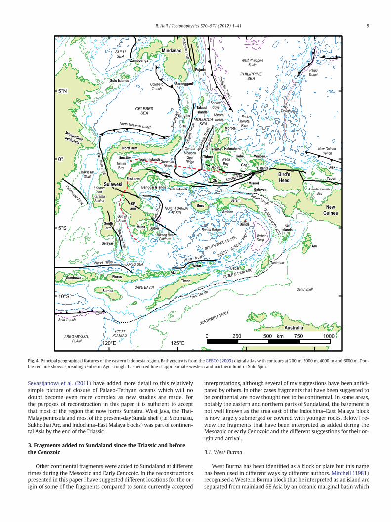
Fig. 4. Principal geographical features of the eastern Indonesia region. Bathymetry is from the GEBCO (2003) digital atlas with contours at 200 m, 2000 m, 4000 m and 6000 m. Dou-ble red line shows spreading centre in Ayu Trough. Dashed red line is approximate western and northern limit of Sulu Spur.
5R. Hall / Tectonophysics 570–571 (2012) 1–41
Sevastjanova et al. (2011) have added more detail to this relativelysimple picture of closure of Palaeo-Tethyan oceans which will nodoubt become even more complex as new studies are made. Forthe purposes of reconstruction in this paper it is sufficient to acceptthat most of the region that now forms Sumatra, West Java, the Thai-Malay peninsula andmost of the present-day Sunda shelf (i.e. Sibumasu,Sukhothai Arc, and Indochina–East Malaya blocks) was part of continen-tal Asia by the end of the Triassic.
3. Fragments added to Sundaland since the Triassic and beforethe Cenozoic
Other continental fragments were added to Sundaland at differenttimes during the Mesozoic and Early Cenozoic. In the reconstructionspresented in this paper I have suggested different locations for the or-igin of some of the fragments compared to some currently accepted
interpretations, although several of my suggestions have been antici-pated by others. In other cases fragments that have been suggested tobe continental are now thought not to be continental. In some areas,notably the eastern and northern parts of Sundaland, the basement isnot well known as the area east of the Indochina–East Malaya blockis now largely submerged or covered with younger rocks. Below I re-view the fragments that have been interpreted as added during theMesozoic or early Cenozoic and the different suggestions for their or-igin and arrival.
3.1. West Burma
West Burma has been identified as a block or plate but this namehas been used in different ways by different authors. Mitchell (1981)recognised aWestern Burma block that he interpreted as an island arcseparated from mainland SE Asia by an oceanic marginal basin which
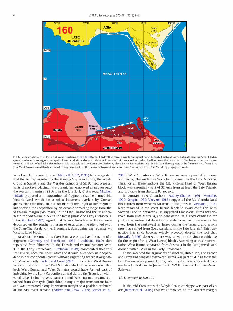
Fig. 5. Reconstruction at 160 Ma. On all reconstructions (Figs. 5 to 38) areas filled with green are mainly arc, ophiolitic, and accreted material formed at plate margins. Areas filled incyan are submarine arc regions, hot spot volcanic products, and oceanic plateaus. Eurasian crust is coloured in shades of yellow. Areas that were part of Gondwana in the Jurassic arecoloured in shades of red. Pil is the Archaean Pilbara block, and the Kim is the Kimberley block. Ex P is Exmouth Plateau, Sc P is Scott Plateau; Argo is the fragment now forms EastJava–West Sulawesi, and Banda is the rifted fragment that left the Banda Embayment and now forms SW Borneo. From 160 Ma rifting propagated west.
6 R. Hall / Tectonophysics 570–571 (2012) 1–41
had closed by the mid Jurassic. Mitchell (1992, 1993) later suggestedthat the arc, represented by the Mawgyi Nappe in Burma, the WoylaGroup in Sumatra and the Meratus ophiolite of SE Borneo, were allparts of northeast-facing intra-oceanic arc, emplaced as nappes ontothe western margin of SE Asia in the late Early Cretaceous. Mitchell(1986) proposed a microcontinental fragment that he named Mt.Victoria Land which has a schist basement overlain by Carnianquartz-rich turbidites. He did not identify the origin of the fragmentbut showed it as separated by an oceanic spreading ridge from theShan-Thai margin (Sibumasu) in the Late Triassic and thrust under-neath the Shan-Thai block in the latest Jurassic or Early Cretaceous.Later Mitchell (1992) argued that Triassic turbidites in Burma weredeposited on the southern margin of Asia, which he identified withthe Shan-Thai foreland (i.e. Sibumasu), abandoning the separate MtVictoria Land block.
At about the same time, West Burma was used as the name of afragment (Gatinsky and Hutchison, 1986; Hutchison, 1989) thatseparated from Sibumasu in the Triassic and re-amalgamated withit in the Early Cretaceous. Hutchison (1989) commented that thisscenario “is, of course, speculative and it could have been an indepen-dent minor continental block” without suggesting where it originat-ed. More recently, Barber and Crow (2009) interpreted West Burmaas a continuation of the West Sumatra block. They considered thatboth West Burma and West Sumatra would have formed part ofIndochina by the Early Carboniferous and during the Triassic an elon-gated slice, including West Sumatra and West Burma, became de-tached from Cathaysia (Indochina) along a major transcurrent faultand was translated along its western margin to a position outboardof the Sibumasu terrane (Barber and Crow, 2009; Barber et al.,
2005). West Sumatra and West Burma are now separated from oneanother by the Andaman Sea which opened in the Late Miocene.Thus, for all these authors the Mt. Victoria Land or West Burmablock was essentially part of SE Asia from at least the Late Triassicand probably from the Late Palaeozoic.
In contrast, several authors (Audley-Charles, 1991; Metcalfe,1990; Sengör, 1987; Veevers, 1988) suggested the Mt. Victoria Landblock rifted from western Australia in the Jurassic. Metcalfe (1996)later renamed it the West Burma block to avoid confusion withVictoria Land in Antarctica. He suggested that West Burma was de-rived from NW Australia, and considered “it a good candidate forpart of the continental sliver that provided a source for sediments de-rived from the northwest in Timor during the Triassic, and whichmust have rifted from Gondwanaland in the Late Jurassic”. This sug-gestion has since become widely accepted despite the fact thatMetcalfe (1996) observed there was “as yet no convincing evidencefor the origin of this [West Burma] block”. According to this interpre-tation West Burma separated from Australia in the Late Jurassic anddocked with SE Asia in the Early Cretaceous.
I have accepted the arguments of Mitchell, Hutchison, and Barberand Crow and consider that West Burma was part of SE Asia from theLate Triassic. As explained below, I identify the fragments rifted fromwestern Australia in the Jurassic with SW Borneo and East Java–WestSulawesi.
3.2. Fragments in Sumatra
In the mid Cretaceous the Woyla Group or Nappe was part of anarc (Barber et al., 2005) that was emplaced on the Sumatra margin

Fig. 6. Reconstruction at 155 Ma. Ocean spreading propagated east and theWoyla intra-oceanic arc formed either at the northern Indian margin, or within the Meso-Tethys north ofIndia. The Tethyan oceans and continental margins west of about 80°E have not been reconstructed.
7R. Hall / Tectonophysics 570–571 (2012) 1–41
and there have been suggestions that it includes microcontinentalfragments. Cameron et al. (1980) postulated that the western portionof the Woyla Arc overlies an older continental block which theynamed the Sikuleh Continental Fragment based on a clastic succes-sion of quartzites, grey phyllites and metasiltstones beneath the arc,and granites, Tertiary rhyolites and Mo-bearing breccia pipes thatcut the arc. Pulunggono and Cameron (1984) proposed that theNatal block was another continental fragment, for which the evidence“is less conclusive”, based largely on the presence of granites thatintrude the Woyla Arc. These blocks were suggested to have beenfragments rifted from Sundaland or exotic fragments accreted to it.In contrast, Wajzer et al. (1991) and Barber (2000) interpreted theWoyla Group as a Late Jurassic–Early Cretaceous intra-oceanic arcand accretionary complex which became sutured to Sumatra by clo-sure of a Tethyan ocean.
Like West Burma the early speculations about microcontinentalfragments have since become established in the literature andMetcalfe (1996) suggested the continental fragments had a NWAustralian origin. However, Barber (2000) and Barber and Crow(2005) reviewed these proposals and argued that there is no convinc-ing evidence for any microcontinental blocks accreted to the marginof Sundaland in the Cretaceous. They interpreted the Sikuleh andNatal fragments as part of the Woyla intra-oceanic arc that was thrustonto the Sumatran Sundaland margin in the mid Cretaceous. As dis-cussed above, Mitchell (1993) had similarly suggested that theMawgyi Nappe of West Burma was part of the same intra-oceanicarc thrust onto the Asian margin in the late Early Cretaceous. Howev-er, there is one important difference. In Burma, according to Mitchell(1993) the emplacement of the Mawgyi nappe was followed by re-sumption or continuation of subduction beneath the western Asian
margin indicated by abundant magmatism during the Late Cretaceousand Early Cenozoic, whereas he noted the limited evidence for arcmagmatism in Sumatra. I consider that the collision event markedby emplacement of the Woyla Arc and continental fragments furthereast (Smyth et al., 2007) terminated subduction from about 90 to45 Ma beneath Sumatra and Java. There is little magmatism inIndonesia during that interval (Hall, 2009) and a widespread regionalunconformity that Clements et al. (2011) interpreted as a dynamic to-pographic response to cessation of subduction.
3.3. Fragments in Borneo
Borneo is a composite region that includes several microcontinentalfragments and ophiolitic/arc zones. Hamilton (1970, 1973), Katili(1971) and Haile (1973) recognised very early that western Borneohad ancient subduction zones to the north and south and includedmicrocontinental fragments.
Traditionally, west Borneo has been interpreted as the most an-cient part of Borneo (Haile, 1974; van Bemmelen, 1949) and as a frag-ment of Asian/Cathaysian origin (e.g. Hutchison, 1989; Metcalfe,1988, 1990, 1996). However, these interpretations assume that allthe metamorphic rocks of west Borneo are part of the same basementdespite being separated by several sutures. Hamilton (1973, 1979)interpreted much of the area of north Sarawak and offshore as aTertiary subduction complex, implying west Borneo was part ofSundaland by sometime in the Cretaceous without specifying whereit came from or when it was added. It has been generally acceptedthere was subduction in the Cretaceous beneath Borneo althoughthe interpretation of Cenozoic subduction beneath NW Borneo has

Fig. 7. Reconstruction at 150 Ma. The postulated eastward continuation of the Woyla intra-oceanic arc is named the Incertus Arc. Possible arc terranes that may correspond to thisarc are now in Asia and are discussed in the text. Rifting of fragments from the Banda region left the Sula Spur north of the Banda Embayment as the northern extremity of con-tinental Australia.
8 R. Hall / Tectonophysics 570–571 (2012) 1–41
been challenged by some authors (e.g. Moss, 1998; Williams et al.,1988).
Haile (1973, 1974) divided NW Borneo into 4 zones, from south tonorth: the West Borneo Basement, and the Kuching, Sibu and MiriZones. He suggested that geological contrasts between the Kuchingand Sibu zones could be interpreted in terms of an Early Cretaceoussouthward-dipping subduction zone beneath a Borneo microcontinent(West Borneo Basement) although he also drew attention to somecharacters not typical of former subduction zones. The West BorneoBasement has been considered by some authors as part of Sundalandfrom the Late Triassic (e.g. Hutchison, 1989) or by others as a separateblock added later (e.g. Metcalfe, 1988, 1990, 1996, who named it theSW Borneo block). Both Hutchison and Metcalfe suggested it had aSouth China origin. Metcalfe originally interpreted it to have movedsouth after rifting in the Late Cretaceous, opening the Proto-SouthChina Sea, following Ben-Avraham (1973), Ben-Avraham and Emery(1973) and Ben-Avraham and Uyeda (1973). Many workers, includingKatili (1973), Hamilton (1973, 1979), Tan (1979), Metcalfe (1988,1990, 1996), Williams et al. (1988) have suggested broadly south-directed subduction (or west-directed if Borneo was rotated from itspresent position) beneath Borneo during the Cretaceous and EarlyCenozoic.
However, although Borneo has been considered by most authorsto have been broadly part of Asia since the Triassic this view has notbeen universally accepted. In a very early plate tectonic interpretationLuyendyk (1974) suggested that Borneo and Sulawesi had riftedaway from Australia in the Late Jurassic but this suggestion seemsto have been rejected, overlooked or forgotten. Hall et al. (2009a)proposed that SW Borneo rifted from western Australia in the Late
Jurassic to leave the Banda embayment (Spakman and Hall, 2010)and was added to Sundaland in the Early Cretaceous. The northernedge of the block would have been a south-dipping subductionzone as proposed by many authors (e.g. Hamilton, 1979; Hutchison,1996; Moss, 1998; Tate, 1991; Williams et al., 1988) south of theKuching Zone. The suture with Sundaland is suggested to run southfrom the Natuna area along the structural lineament named theBilliton Depression (Ben-Avraham, 1973; Ben-Avraham and Emery,1973) and originally interpreted by Ben-Avraham and Uyeda (1973)as a transform fault associated with Cretaceous opening of theSouth China Sea. The suggestion that SW Borneo is a fragment riftedfrom Australia in the Late Jurassic has been accepted by Metcalfe(2009, 2011a,b).
North of SW Borneo there are several continental areas thathave been assigned to different microcontinental blocks and givendifferent names (e.g. Hutchison, 1989; Metcalfe, 1990, 1996) includ-ing the Semitau, Luconia, Spratly Islands–Dangerous Ground, andKelabit–Longbowan blocks within areas shown as accreted or extend-ed continental crust. It is difficult to determine if all these blocksreally deserve the status of independent microcontinents, as theevidence for their age and character is often slight, and some couldbe relatively rigid high blocks within a stretched continental marginwith an older complex history of assembly and orogeny from thePalaeozoic or even earlier. Where there is evidence for their origin(e.g. Haile, 1974; Hutchison, 1989, 2005; Kudrass et al., 1986;Metcalfe, 1988, 1990, 1996; Williams et al., 1988) it supports a eastAsian origin for most of the blocks.
Haile (1974) and Gower (1990) suggested important strike-slipmovement on the northern boundary of the SW Borneo block and I

Fig. 8. Reconstruction at 145 Ma. The Woyla–Incertus Arc moved northward with the Australian continental Argo and Banda fragments as the Ceno-Tethys widened. In the westernPacific the Luconia–Dangerous Grounds continental fragment had rifted from the Asian margin but its position is very uncertain before 90 Ma.
9R. Hall / Tectonophysics 570–571 (2012) 1–41
consider this is supported by observations in northern Kalimantan(Doutch, 1992; Williams et al., 1988). Evidence for the origin of theblock is very limited and it is separated from the other blocks bymelanges and deformed ophiolites interpreted as representing oneor more sutures, including the Boyan zone (Williams et al., 1988)and Lupar Line (Haile, 1973; Tan, 1979, 1982). Interpretations of itsCathaysian origin (e.g. Hutchison, 1989; Metcalfe, 2006, 2009) haverelied on correlations across these sutures but there are a few piecesof evidence that favour an Australian origin. The Schwaner Mountainsare dominated by Cretaceous granitic rocks which intrude a meta-morphic basement suggested to be Permo-Triassic or older (e.g.Hutchison, 2005; Williams et al., 1988) but which is known only tobe older than the Cretaceous intrusive rocks, with the exception of asingle K–Ar age of 189±2 Ma from a biotite hornfels that is suggestedto indicate the minimum age for pre-intrusive regional metamor-phism (Pieters and Sanyoto, 1993). Work is in progress to betterdate the metamorphic rocks.
Alluvial diamonds are found in the Kapuas River ofWest Kalimantanand the Barito and Meratus areas of SE Kalimantan but their source isunknown. Barron et al. (2008) have suggested the SE Kalimantan dia-monds resemble diamonds from eastern Australia and have a subduc-tion origin and there are ultrahigh pressure rocks from the Meratusregion (Parkinson et al., 1998) which might contain such diamonds al-though none have so far been reported. However, this would notexplain the Kapuas River diamonds. Metcalfe (2009) has suggestedthat alluvial diamonds of Burma, Thailand and Sumatra were erodedfrom Permian glacial-marine diamictites of the Sibumasu block whichwas rifted from the western Australian part of Gondwanaland. Thus,an alternative explanation for the SW Borneo diamonds is that they
arrived with a different Australian block and have been reworked intoriver sediments from the basement or its original sedimentary cover.Resemblances to diamonds fromNWAustralia (Taylor et al., 1990) sup-port this interpretation which does not exclude a subduction origin forsome of the SE Kalimantan diamonds. Smith et al. (2009) found that theBorneo diamonds included several groups interpreted to have beenreworked from multiple primary sources but that all have characteris-tics of ancient lithosphericmantle-derived diamonds. Itmay also be sig-nificant that detrital diamonds have not been discovered on Cathaysianblocks in other parts of SE Asia (Metcalfe, 2009).
Devonian limestones are the oldest fossiliferous rocks knownfrom Borneo and occur as float in the Telen River, a tributary of theMahakam River, in the Upper Kutai basin (Rutten, 1940). The lime-stones are reported to be blocks in Permian debris flows and schistsfound nearby are interpreted to be older (Sugiaman and Andria,1999). The limestones contain coral and stromatoporoid fossils.Hutchison (1989) and Metcalfe (1990) considered these limestonesto belong to a separate Mangkalihat microcontinental block, possiblyrifted from New Guinea in the Late Jurassic (Metcalfe, 1996).Devonian corals but not stromatoporoids have been reported from NewGuinea (Oliver et al., 1995) and from the Canning Basin (Playford, 1980;Wood, 2000) of western Australia.
3.4. Meratus suture
Hamilton (1979) drew a NE–SW line fromWest Java to theMeratusMountains of SE Kalimantan (Fig. 2) as the approximate southeastboundary of Cretaceous continental crust and to the east of this line inJava and SE Borneo are ophiolitic, arc rocks and some high pressure-
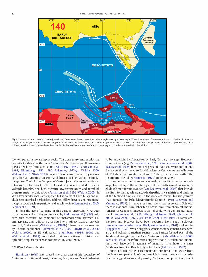
Fig. 9. Reconstruction at 140 Ma. In the Jurassic and Cretaceous the northern Australian margin was a passive margin. There is evidence of intra-oceanic arcs in the Pacific from theLate Jurassic–Early Cretaceous in the Philippines, Halmahera and New Guinea but their exact positions are unknown. The subduction margin north of the Banda (SW Borneo) blockis interpreted to have continued east into the Pacific but well to the north of the passive margin of northern Australia in New Guinea.
10 R. Hall / Tectonophysics 570–571 (2012) 1–41
low temperature metamorphic rocks. This zone represents subductionbeneath Sundaland in the Early Cretaceous. Accretionary-collision com-plexes resulting from subduction (Katili, 1971, 1973; Parkinson et al.,1998; Sikumbang, 1986, 1990; Sukamto, 1975a,b; Wakita, 2000;Wakita et al., 1994a,b, 1998) include tectonic units formed by oceanicspreading, arc volcanism, oceanic and forearc sedimentation, andmeta-morphism. The Luk Ulo Complex of Central Java includes serpentinisedultrabasic rocks, basalts, cherts, limestones, siliceous shales, shales,volcanic breccias, and high pressure-low temperature and ultrahighpressure metamorphic rocks (Parkinson et al., 1998; Wakita, 2000). InWest Java similar rocks are exposed to the south of Ciletuh Bay and in-clude serpentinised peridotites, gabbros, pillow basalts, and rare meta-morphic rocks such as quartzite and amphibolite (Clements et al., 2009;Schiller et al., 1991).
In Java the age of suturing in this zone is uncertain. K–Ar agesfrom metamorphic rocks summarised by Parkinson et al. (1998) indi-cate high pressure-low temperature metamorphism between 117and 124 Ma, and radiolaria associated with pillow lavas at Luk Uloare Early Cretaceous (Wakita et al., 1994b). These rocks are overlainby Eocene sediments (Clements et al., 2009; Smyth et al., 2008;Wakita, 2000). In SE Kalimantan Sikumbang (1986, 1990) andWakita et al. (1998) concluded that arc-continent collision andophiolite emplacement was completed by about 90 Ma.
3.5. West Sulawesi-Sumba
Hamilton (1979) interpreted the area east of his boundary ofCretaceous continental crust, including East Java and West Sulawesi,
to be underlain by Cretaceous or Early Tertiary melange. However,some authors (e.g. Parkinson et al., 1998; van Leeuwen et al., 2007;Wakita et al., 1996) have since suggested that Gondwana continentalfragments that accreted to Sundaland in the Cretaceous underlie partsof SE Kalimantan, western and south Sulawesi which are within theregion interpreted by Hamilton (1979) to be melange.
In some areas the basement is now dated, and it is clearly not mel-ange. For example, the western part of the north arm of Sulawesi in-cludes Carboniferous granites (van Leeuwen et al., 2007) that intrudemedium to high grade quartzo-feldspathic mica schists and gneissesof the Malino Complex, and in the neck are Permo-Triassic granitesthat intrude the Palu Metamorphic Complex (van Leeuwen andMuhardjo, 2005). In these areas and elsewhere in western Sulawesithere is evidence from inherited zircons, and from chemical charac-teristics of Cenozoic igneous rocks, of underlying continental base-ment (Bergman et al., 1996; Elburg and Foden, 1999; Elburg et al.,2003; Polvé et al., 1997, 2001; Priadi et al., 1993, 1994). Jurassic am-monites and bivalves have been reported from South Sulawesi(Sukamto and Westermann, 1993; Sukamto et al., 1990) and Sumba(Roggeveen, 1929) which suggest a continental basement. Geochem-istry and palaeomagnetism suggest that Sumba formed part of theSundaland margin by the Late Cretaceous (Abdullah et al., 2000;Wensink, 1994). 3He/4He ratios suggest that Australian continentalcrust was involved in genesis of magmas throughout the InnerBanda Arc from the Banda Ridges to Flores (Hilton et al., 1992).
Further north, Plio-Pleistocene basalts and basaltic andesites fromthe Semporna peninsula of southern Sabah have isotopic characteris-tics that suggest an ancient, possibly Archaean, component is present
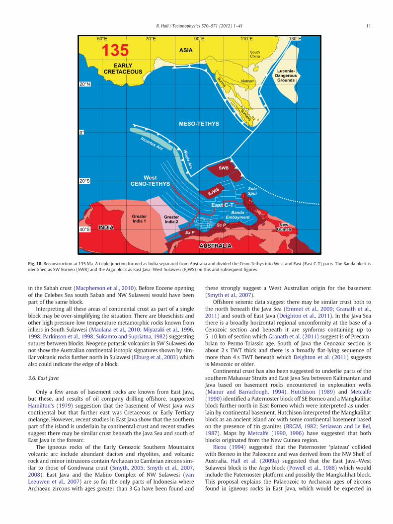
Fig. 10. Reconstruction at 135 Ma. A triple junction formed as India separated from Australia and divided the Ceno-Tethys into West and East (East C-T) parts. The Banda block isidentified as SW Borneo (SWB) and the Argo block as East Java–West Sulawesi (EJWS) on this and subsequent figures.
11R. Hall / Tectonophysics 570–571 (2012) 1–41
in the Sabah crust (Macpherson et al., 2010). Before Eocene openingof the Celebes Sea south Sabah and NW Sulawesi would have beenpart of the same block.
Interpreting all these areas of continental crust as part of a singleblock may be over-simplifying the situation. There are blueschists andother high pressure-low temperature metamorphic rocks known frominliers in South Sulawesi (Maulana et al., 2010; Miyazaki et al., 1996,1998; Parkinson et al., 1998; Sukamto and Supriatna, 1982) suggestingsutures between blocks. Neogene potassic volcanics in SW Sulawesi donot show the Australian continental isotopic signatures shown by sim-ilar volcanic rocks further north in Sulawesi (Elburg et al., 2003) whichalso could indicate the edge of a block.
3.6. East Java
Only a few areas of basement rocks are known from East Java,but these, and results of oil company drilling offshore, supportedHamilton's (1979) suggestion that the basement of West Java wascontinental but that further east was Cretaceous or Early Tertiarymelange. However, recent studies in East Java show that the southernpart of the island is underlain by continental crust and recent studiessuggest there may be similar crust beneath the Java Sea and south ofEast Java in the forearc.
The igneous rocks of the Early Cenozoic Southern Mountainsvolcanic arc include abundant dacites and rhyolites, and volcanicrock and minor intrusions contain Archaean to Cambrian zircons sim-ilar to those of Gondwana crust (Smyth, 2005; Smyth et al., 2007,2008). East Java and the Malino Complex of NW Sulawesi (vanLeeuwen et al., 2007) are so far the only parts of Indonesia whereArchaean zircons with ages greater than 3 Ga have been found and
these strongly suggest a West Australian origin for the basement(Smyth et al., 2007).
Offshore seismic data suggest there may be similar crust both tothe north beneath the Java Sea (Emmet et al., 2009; Granath et al.,2011) and south of East Java (Deighton et al., 2011). In the Java Seathere is a broadly horizontal regional unconformity at the base of aCenozoic section and beneath it are synforms containing up to5–10 km of section which Granath et al. (2011) suggest is of Precam-brian to Permo-Triassic age. South of Java the Cenozoic section isabout 2 s TWT thick and there is a broadly flat-lying sequence ofmore than 4 s TWT beneath which Deighton et al. (2011) suggestsis Mesozoic or older.
Continental crust has also been suggested to underlie parts of thesouthern Makassar Straits and East Java Sea between Kalimantan andJava based on basement rocks encountered in exploration wells(Manur and Barraclough, 1994). Hutchison (1989) and Metcalfe(1990) identified a Paternoster block off SE Borneo and a Mangkalihatblock further north in East Borneo which were interpreted as under-lain by continental basement. Hutchison interpreted the Mangkalihatblock as an ancient island arc with some continental basement basedon the presence of tin granites (BRGM, 1982; Setiawan and Le Bel,1987). Maps by Metcalfe (1990, 1996) have suggested that bothblocks originated from the New Guinea region.
Ricou (1994) suggested that the Paternoster ‘plateau’ collidedwith Borneo in the Paleocene and was derived from the NW Shelf ofAustralia. Hall et al. (2009a) suggested that the East Java–WestSulawesi block is the Argo block (Powell et al., 1988) which wouldinclude the Paternoster platform and possibly the Mangkalihat block.This proposal explains the Palaeozoic to Archaean ages of zirconsfound in igneous rocks in East Java, which would be expected in
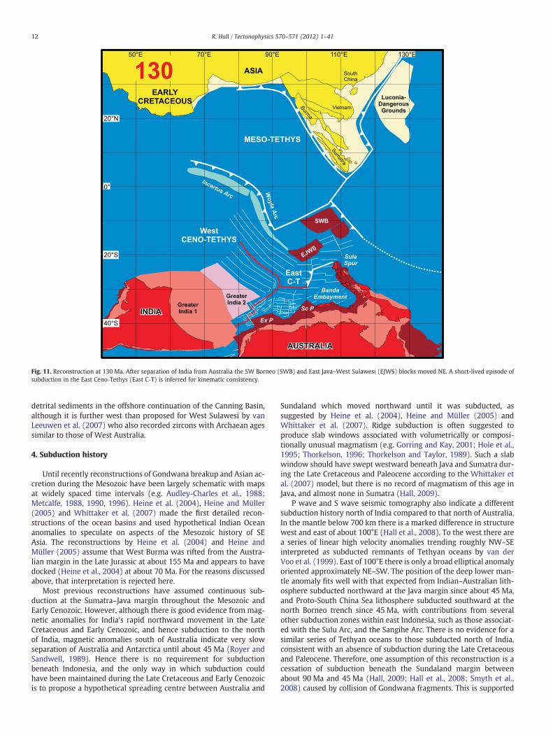
Fig. 11. Reconstruction at 130 Ma. After separation of India from Australia the SW Borneo (SWB) and East Java–West Sulawesi (EJWS) blocks moved NE. A short-lived episode ofsubduction in the East Ceno-Tethys (East C-T) is inferred for kinematic consistency.
12 R. Hall / Tectonophysics 570–571 (2012) 1–41
detrital sediments in the offshore continuation of the Canning Basin,although it is further west than proposed for West Sulawesi by vanLeeuwen et al. (2007) who also recorded zircons with Archaean agessimilar to those of West Australia.
4. Subduction history
Until recently reconstructions of Gondwana breakup and Asian ac-cretion during the Mesozoic have been largely schematic with mapsat widely spaced time intervals (e.g. Audley-Charles et al., 1988;Metcalfe, 1988, 1990, 1996). Heine et al. (2004), Heine and Müller(2005) and Whittaker et al. (2007) made the first detailed recon-structions of the ocean basins and used hypothetical Indian Oceananomalies to speculate on aspects of the Mesozoic history of SEAsia. The reconstructions by Heine et al. (2004) and Heine andMüller (2005) assume that West Burma was rifted from the Austra-lian margin in the Late Jurassic at about 155 Ma and appears to havedocked (Heine et al., 2004) at about 70 Ma. For the reasons discussedabove, that interpretation is rejected here.
Most previous reconstructions have assumed continuous sub-duction at the Sumatra–Java margin throughout the Mesozoic andEarly Cenozoic. However, although there is good evidence from mag-netic anomalies for India's rapid northward movement in the LateCretaceous and Early Cenozoic, and hence subduction to the northof India, magnetic anomalies south of Australia indicate very slowseparation of Australia and Antarctica until about 45 Ma (Royer andSandwell, 1989). Hence there is no requirement for subductionbeneath Indonesia, and the only way in which subduction couldhave been maintained during the Late Cretaceous and Early Cenozoicis to propose a hypothetical spreading centre between Australia and
Sundaland which moved northward until it was subducted, assuggested by Heine et al. (2004), Heine and Müller (2005) andWhittaker et al. (2007). Ridge subduction is often suggested toproduce slab windows associated with volumetrically or composi-tionally unusual magmatism (e.g. Gorring and Kay, 2001; Hole et al.,1995; Thorkelson, 1996; Thorkelson and Taylor, 1989). Such a slabwindow should have swept westward beneath Java and Sumatra dur-ing the Late Cretaceous and Paleocene according to the Whittaker etal. (2007) model, but there is no record of magmatism of this age inJava, and almost none in Sumatra (Hall, 2009).
P wave and S wave seismic tomography also indicate a differentsubduction history north of India compared to that north of Australia.In the mantle below 700 km there is a marked difference in structurewest and east of about 100°E (Hall et al., 2008). To the west there area series of linear high velocity anomalies trending roughly NW–SEinterpreted as subducted remnants of Tethyan oceans by van derVoo et al. (1999). East of 100°E there is only a broad elliptical anomalyoriented approximately NE–SW. The position of the deep lower man-tle anomaly fits well with that expected from Indian–Australian lith-osphere subducted northward at the Java margin since about 45 Ma,and Proto-South China Sea lithosphere subducted southward at thenorth Borneo trench since 45 Ma, with contributions from severalother subduction zones within east Indonesia, such as those associat-ed with the Sulu Arc, and the Sangihe Arc. There is no evidence for asimilar series of Tethyan oceans to those subducted north of India,consistent with an absence of subduction during the Late Cretaceousand Paleocene. Therefore, one assumption of this reconstruction is acessation of subduction beneath the Sundaland margin betweenabout 90 Ma and 45 Ma (Hall, 2009; Hall et al., 2008; Smyth et al.,2008) caused by collision of Gondwana fragments. This is supported
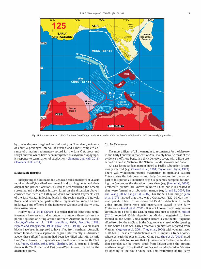
Fig. 12. Reconstruction at 125 Ma. The West Ceno-Tethys continued to widen while the East Ceno-Tethys (East C-T) became slightly smaller.
13R. Hall / Tectonophysics 570–571 (2012) 1–41
by the widespread regional unconformity in Sundaland, evidenceof uplift, a prolonged interval of erosion and almost complete ab-sence of a marine sedimentary record for the Late Cretaceous andEarly Cenozoic which have been interpreted as a dynamic topograph-ic response to termination of subduction (Clements and Hall, 2011;Clements et al., 2011).
5. Mesozoic margins
Interpreting the Mesozoic and Cenozoic collision history of SE Asiarequires identifying rifted continental and arc fragments and theiroriginal and present locations, as well as reconstructing the oceanicspreading and subduction history. Based on the discussion above Iconsider that there are Cathaysian/Asian continental fragments eastof the East Malaya–Indochina block in the region north of Sarawak,Brunei and Sabah. Small parts of these fragments are known on landin Sarawak and offshore in the Dangerous Grounds and clearly showtheir Asian origin.
Following Hall et al. (2009a) I consider that all other continentalfragments have an Australian origin. It is known there was an im-portant episode of rifting around northern Australia in the Jurassic(Audley-Charles et al., 1988; Hamilton, 1979; Metcalfe, 1988;Pigram and Panggabean, 1984; Powell et al., 1988). Several majorblocks have been interpreted to have rifted from northwest Australiabefore India–Australia separation began. Until recently, as discussedabove, these rifted fragments had been identified with Mt. VictoriaLand/West Burma, or fragments even further north in south Tibet(e.g. Audley-Charles, 1983, 1988; Charlton, 2001). Instead, I identifythem with SW Borneo and East Java–West Sulawesi based on thediscussion above.
5.1. Pacific margin
The most difficult of all the margins to reconstruct for the Mesozo-ic and Early Cenozoic is that east of Asia, mainly because most of theevidence is offshore beneath a thick Cenozoic cover, with a little pre-served on land in Vietnam, the Natuna Islands, Sarawak and Sabah.
An east-facing Andean margin linked to Pacific subduction is com-monly inferred (e.g. Charvet et al., 1994; Taylor and Hayes, 1983).There was widespread granite magmatism in mainland easternChina during the Late Jurassic and Early Cretaceous. For the earlierpart of this period a subduction origin is generally accepted but dur-ing the Cretaceous the situation is less clear (e.g. Jiang et al., 2009).Cretaceous granites are known in North China but it is debated ifthey were formed at a subduction margin (e.g. Li and Li, 2007; Linand Wang, 2006; Yang et al., 2007). For the SE China margin Jahnet al. (1976) argued that there was a Cretaceous (120–90 Ma) ther-mal episode related to west-directed Pacific subduction. In SouthChina around Hong Kong acid magmatism ceased in the EarlyCretaceous (Sewell et al., 2000). It is not known if acid magmatismcontinued in a belt to the east, because this area is offshore. Knittel(2010) reported 83 Ma rhyolites in Mindoro suggested to haveformed in the South China margin before a continental fragmentrifted from Southeast China in the Oligocene as a result of the openingof the South China Sea. Early Cretaceous granites are reported fromVietnam (Nguyen et al., 2004; Thuy et al., 2004) with youngest agesof 88 Ma. If these are subduction-related it implies a trench some-where beneath the present South China Sea. Zhou et al. (2008) usedgeophysical data to propose that a Jurassic–Early Cretaceous subduc-tion complex can be traced south from Taiwan along the presentnorthernmargin of the South China Sea and was displaced to Palawanby opening of the South China Sea. This restoration of the Early

Fig. 13. Reconstruction at 120 Ma. SW Borneo (SWB) was close to the SE Asia Sundaland margin and is interpreted to have moved along a strike-slip boundary at the Billitondepression.
14 R. Hall / Tectonophysics 570–571 (2012) 1–41
Cretaceous margin would account for subduction-related granites inVietnam but it is not clear where to continue this belt, or even if itdid continue south. Some authors have traced this subduction marginor belt of granites into Borneo (e.g. Fyhn et al., 2010b; Hamilton,1979; Wakita and Metcalfe, 2005; Williams et al., 1988) with the im-plicit or explicit assumption that SW Borneo was part of Sundaland bythis time.
Several workers have suggested collision of continental fragmentswith the Asian margin during the Cretaceous. Faure et al. (1989) andCharvet et al. (1994) proposed Cretaceous collision of a WestPhilippine block with the Asian margin in SE China. Zhou et al.(2008) interpreted a block that continued much further south fromSE China into Sarawak, that collided in the Cretaceous, which theynamed Cathaysia. Dredged samples (Kudrass et al., 1986) from theDangerous Grounds indicate the presence of continental material,including Upper Triassic to Lower Jurassic sandstones with plant re-mains, with east Asian affinities. Fyhn et al. (2010b) inferred a frag-ment they called the Luconia block which sutured to SE Asia in theearly Cenozoic. Hutchison (1996) introduced the term SarawakOrogeny for an inferred collision between a continental block andSW Borneo in the Late Eocene. I consider there is good evidence fora continental block, here termed the Luconia–Dangerous Groundsblock, of east Asian origin but suggest it docked in the early LateCretaceous and there was no Sarawak Orogeny, as discussed furtherbelow.
There is little evidence anywhere of subduction-related mag-matism younger than about 80 Ma and the Late Cretaceous after80 Mawas a period of rifting and extension of the South China margin(e.g. Taylor and Hayes, 1983; Zhou et al., 2008). As noted above, manyauthors have suggested west- or south-directed subduction beneath
northern Borneo in the Late Cretaceous and Early Cenozoic (e.g.Hamilton, 1979; Tate, 1991; Taylor and Hayes, 1983; Williams et al.,1988) but Moss (1998) drew attention to problems with asubduction-related interpretation for what he termed the Rajang–Embaluh Group. Hutchison (1996) also observed that the subductionhistory inferred by Tan and Lamy (1990) and Hazebroek and Tan(1993), from Late Cretaceous to Late Eocene, is not marked bysubduction-related post-Paleocene volcanic arcs in Borneo and sug-gested subduction had ceased by 60 Ma (Hutchison, 2010). Moss(1998) suggested that subduction had ceased by about 80 Ma afterarrival of micro-continental fragments now beneath the LuconiaShoals and Sarawak leaving a remnant ocean and a foreland basin innorthern Borneo. This explains the absence of subduction-relatedmagmatism but does not account for the Late Eocene deformationconsidered by Hutchison (1996) to record the Sarawak Orogeny.
Hutchison (1996) originally proposed the deep water sedimentsof the Rajang Group were deformed during the Sarawak Orogeny inthe Late Eocene at about 45 Ma, but in later papers at about 37 Ma(Hutchison, 2004, 2005). The orogeny was interpreted to be synchro-nous with the collision of India and Asia (Hutchison, 2005) and possi-bly linked to collision of a Balingian–Luconia continental block withSW Borneo (Hutchison, 2010). He interpreted the latter collision tohave followed southwards subduction beneath SW Borneo which ter-minated by about 60 Ma although compression and uplift apparentlydid not occur until more than 15 Ma after the block arrived at thetrench.
Hutchison (1996) dated the orogeny from a regional unconfor-mity described by Borneo Geological Survey geologists who recog-nised an episode of folding in the Late Eocene (Haile, 1962; Kirk,1957; Wolfenden, 1960), which occurred before 37 Ma and was a

Fig. 14. Reconstruction at 115 Ma. SW Borneo (SWB) was close to its final position and subduction began between it and the East Java–West Sulawesi (EJWS) blocks based on meta-morphic ages from the Meratus Suture in Java and SE Kalimantan. In the Ceno-Tethys selected anomalies are numbered with their age. On this and subsequent figures Jurassic andEarly Cretaceous ocean crust older than 120 Ma to the west of Australia is shaded green.
15R. Hall / Tectonophysics 570–571 (2012) 1–41
late event in a long Late Cretaceous to Eocene history of deformation.The original reports reveal some uncertainty in the age of the un-conformity. Wolfenden (1960) reported Upper Eocene limestonesunconformably above low-grade slates and phyllites assumed to beEocene based on a very poor fauna including no pre-Tertiary forami-nifera. Haile and Ho (1991), reproduced in Hutchison (2005), showedfolded turbidites overlain by undated conglomerates. Adams andHaak (1962) reported Upper Eocene limestones above a steeply dip-ping sequence of Cretaceous turbidites. All that can inferred with con-fidence is that Wolfenden (1960) showed the unconformity is olderthan uppermost Eocene, Haile and Ho (1991) did not date it, andAdams and Haak (1962) showed it was older than about 40 Ma.Wolfenden (1960) noted the absence of a marked angular unconfor-mity in some areas and commented that the “stratigraphic evidence isdifficult to reconcile with the concept of an Upper Eocene orogenythat caused the entire… …Rajang Group to be folded” and observedthat “deformation accompanied deposition”.
The idea of syn-depositional deformation has suggested to someauthors that the Rajang Group was an accretionary prism (e.g. Tan,1979, 1982) related to southward subduction. Hutchison (1996,2005, 2010) argued that older parts of the Rajang Group were accre-tionary but that subduction ceased in the Paleocene before most ofthe turbidites were deposited. For the younger turbidites he followedMoss (1998) who suggested they were deposited in a remnant oceanbasin, although Moss had specifically excluded an accretionary set-ting and argued that subduction had ceased in the Late Cretaceous.
Hutchison (2005) interpreted the unconformities to be synchro-nous with the collision of India with Asia but his 37 Ma age for theSarawak Orogeny (Hutchison, 2004, 2005, 2010) is significantly
younger than his Paleocene to Early Eocene preferred collision age,and most other estimates of India–Asia collision age (e.g. Chenet al., 2010; Green et al., 2008; Leech et al., 2005; Najman et al.,2010; Rowley, 1996), except for the c. 34 Ma age of Aitchison et al.(2007a) which he discounted (Hutchison, 2010).
No authors provide Cretaceous–Paleocene reconstructions butHutchison (2010) drew one map that shows an independent block,bounded by faults, that moved southwards during the Late Creta-ceous to collide at the Lupar Line in Sarawak. Such a block wouldnot explain the continuation of the Lupar Line eastwards intoKalimantan, nor is there any driving force for its movement, and thevolcanic arc to the south that would be expected by the subductionsuggested by Hutchison is missing.
The Lupar Line marks the southerly termination of the deep waterRajang Group rocks, although this was disputed by Hutchison (1996).Pieters and Supriatna (1990) showed the “Turbidite basin” terminatesto the south at a linear zone of “Oceanic basement and overlyingsediments” that can be traced from the Lupar River Lubok AntuMelange Belt of Sarawak (Tan, 1979) into Kalimantan. Doutch (1992)showed the Cretaceous–Eocene ‘flysch’ terminating in a similar way. Itappears that the Lupar Line is a profound structure, also associatedwith linear gravity and magnetic anomalies (Pieters and Supriatna,1990; Williams et al., 1988). However, it lacks many of the featuresexpected in a long-lived south-dipping subduction zone (Haile, 1973)which could be explained if itwere amajor strike-slip fault as suggestedby Haile (1973).
It is impossible to reconcile the many different interpretations,few of which provide palaeogeographic reconstructions, but it is diffi-cult to do better simply because there is so little evidence, and critical

Fig. 15. Reconstruction at 110 Ma. SW Borneo (SWB) completed docking with the Sundaland margin. Spreading ended in the Ceno-Tethys between India and the Woyla–IncertusArc. Subduction polarity flipped from south- to north-directed at the Woyla–Incertus Arc and the Ceno-Tethys began to subduct northwards. The India-Australia spreading centrepropagated north as India moved north.
16 R. Hall / Tectonophysics 570–571 (2012) 1–41
areas are offshore. I follow earlier authors in suggesting an east-facingAndean-type subduction margin close to the present Asian marginuntil the early Late Cretaceous, at about 90–80 Ma, when subductionterminated. I have assumed that this subduction ceased due to arrivalof the Luconia–Dangerous Grounds block that included the area ofoffshore Sarawak often described as Luconia, the Dangerous Groundsand parts of the offshore northern South China Sea continental mar-gin. An important difference from earlier interpretations is that thegranites of Borneo are not interpreted to be the result of the Asianmargin magmatism but are the result of south-directed subductionbeneath the SW Borneo block as it moved north from Australia. Eastor west-directed subduction could have continued in the area thatnow includes south and offshore Vietnam (Fyhn et al., 2010a,2010b), and on land and offshore Sarawak, into the early Cenozoic,and the simplest hypothesis to explain this is westward movementof a fragment along the Lupar Line, probably during the Late Creta-ceous and early Cenozoic. This could imply a small remnant of oceaniccrust to the west of the Luconia–Dangerous Grounds block eliminatedduring this interval.
5.2. North Australian margin
There is little information available to reconstruct the northernAustralian margin in New Guinea and the adjacent Pacific furthernorth before the Eocene. By the Early Jurassic New Guinea appearsto have been a passive continental margin but the age of oceancrust to the north is unknown. There is some magmatism indicatedby K–Ar and zircon fission track dating in central New Guinea(Page, 1976), the Bird's Head (Lunt and Djaafar, 1991; Sutriyono,
1999) and Misool (Visser and Hermes, 1962) during the Late Creta-ceous which includes basalts on Misool and granites elsewhere.There is little to indicate this is subduction-related as the stratigraphy(Pieters et al., 1983; Pigram and Panggabean, 1984; Visser andHermes, 1962) of New Guinea suggests a relatively quiet tectonic en-vironment. There is considerable evidence for Mesozoic intra-Pacificoceanic arcs north of Australia in the Philippine Sea, the Philippines,Halmahera and northern New Guinea (e.g. Davies and Jaques, 1984;Hall et al., 1988; Karig, 1983; Klein and Kobayashi, 1981; Lewiset al., 1982; Tokuyama, 1985). Palaeomagnetic data (Ali and Hall,1995; Hall et al., 1995) show the Halmahera Arc was close to theequator in the Late Cretaceous but this is insufficient to make a recon-struction and the positions of the other arcs at the time of formationare unknown.
5.3. West Australian margin
Reconstructing the early history of the Indian Ocean has alwaysbeen difficult since almost all Mesozoic ocean floor has been sub-ducted at the Sunda Trench. Some oceanic crust that formed soonafter rifting of fragments is still preserved close to western and north-ern Australia. A remnant is left in the Argo Abyssal Plain which is LateJurassic in age (Gradstein, 1992) and magnetic anomalies indicatetwo phases of spreading in the Late Jurassic and Early Cretaceous(Fullerton et al., 1989; Powell and Luyendyk, 1982). To the westthere is oceanic crust in the Wharton Basin south of Java but thisformed during the Cretaceous Quiet Zone (Fullerton et al., 1989)and anomalies there are not clear (Shreider et al., 1996). Magneticanomalies remain off west Australia but identifying the fragments

Fig. 16. Reconstruction at 105 Ma. East Java–West Sulawesi (EJWS) converged with SW Borneo (SWB). Spreading had ceased in the Ceno-Tethys between India and the Woyla–Incertus Arc but continued at the India-Australia spreading centre.
17R. Hall / Tectonophysics 570–571 (2012) 1–41
that rifted, leaving these anomalies in their wake, and their presentposition is controversial. Most authors have suggested that riftingpropagated west and south (Fullerton et al., 1989; Pigram andPanggabean, 1984; Powell et al., 1988; Robb et al., 2005) from theBanda region but Heine et al. (2002, 2004) and Heine and Müller(2005) have argued that rifting propagated in the opposite direction.I have preferred interpretations of SW-propagating rifting based onthe earlier papers, and the discussion by Robb et al. (2005) of theHeine and co-workers' interpretations.
The Heine et al. (2002, 2004) and Heine andMüller (2005) modelswere constructed with the assumption of West Burma as the riftedfragment, and its surmised Cretaceous collision age. As discussedabove there is now more evidence and agreement that West Burmahas been part of the Asian margin since the Triassic, and it favoursBorneo, East Java and West Sulawesi as the fragments rifted fromAustralia.
SW Borneo is interpreted here as a block that separated from theBanda embayment. This is consistent with evidence for its origin dis-cussed above, such as detrital diamonds and its size. The SW Borneoblock has its northern limit at about the position of the Boyan zoneand to the north are fragments of ophiolitic and Asian continentalmaterial accreted to it during the Cretaceous. The zone between theBoyan zone and Lupar Line appears to include fragments of bothAsian and SW Borneo origin which may have been mixed and de-formed with a wide WNW–ESE strike-slip zone. The suture betweenSW Borneo and Sundaland is along the Billiton Depression (Ben-Avraham, 1973; Ben-Avraham and Uyeda, 1973). A small InnerBanda block is shown on the reconstructions and is interpreted tomove mainly with the SW Borneo block, but to have moved relativeto it during the collision, and is speculated to now underlie part of
Sabah. This block could be dispensed with by allowing stretching ofthe Banda region as it rifted, and deformation after it docked, butthis is difficult to include in a rigid plate model.
The East Java–West Sulawesi block is interpreted to come fromfurther south in the West Australian margin. This is supported bythe Archaean ages of zircons from East Java (Smyth et al., 2007)and NW Sulawesi (van Leeuwen et al., 2007). The East Java–WestSulawesi block collided at about 90 Ma. The age of collision is inter-preted from ages of radiolaria in rocks associated with basic igneousrocks that represent accreted oceanic crust and sedimentary cover(e.g. Wakita et al., 1994a,b, 1998), the age of high pressure–lowtemperature (HP–LT) metamorphic rocks in accretionary complexes(Parkinson et al., 1998), ages of subduction-related magmatism,ages of post-collisional rocks (Sikumbang, 1986, 1990; Yuwonoet al., 1988a,b), and the widespread paucity of magmatism in Suma-tra, Java and Borneo after about 80 Ma until the Eocene (Hall, 2009).East Java–West Sulawesi may be more complex than a single frag-ment. There could be another continental block beneath southern-most Sulawesi, Sumba and Flores (e.g. Hilton et al., 1992) since highpressure-low temperature metamorphic rocks are known fromSouth Sulawesi suggesting a suture between East Java–West Sulawesiand a continental fragment to the southeast (e.g. Hasan, 1990, 1991;Parkinson et al., 1998; Sikumbang, 1986, 1990; Wakita et al., 1996).Another suture would explain the isotopic signature of Australiancontinental crust seen in most West Sulawesi volcanic rocks, but ab-sent in South Sulawesi (Elburg et al., 2003). Manur and Barraclough(1994) interpreted the area from SE Kalimantan to Sulawesi to in-clude several continental fragments separated by sutures or highlyextended crust. Evidence from modern Atlantic continental marginsshows that rifting and extension may lead to multiple blocks which

Fig. 17. Reconstruction at 100 Ma. The Ceno-Tethys was gradually reduced in area by subduction north of India but widened between India and Australia.
18 R. Hall / Tectonophysics 570–571 (2012) 1–41
are still effectively part of a single hyper-extended terrane (Peron-Pinvidic and Manatschal, 2010). Therefore, in this reconstruction asingle East Java–West Sulawesi block is a simplified entity that in-cludes all continental crust from the Meratus Suture to Sumba andFlores.
The age of separation of the blocks is interpreted from theirreconstructed positions in the West Australia margin. Late Jurassicoceanic crust (older than 155 Ma; Gradstein, 1992) preserved in theArgo abyssal plain is southwest of the Banda embayment whichimplies slightly older rifting of the Banda embayment. Anomalies offWest Australia indicate the oldest oceanic crust there is about132 Ma (Robb et al., 2005) which record the separation of Indiafrom Australia. I have assumed a simple model of separation of theSW Borneo block from the Banda embayment at 160 Ma, separationof the East Java–West Sulawesi block from the Exmouth Plateau at155 Ma, and beginning of separation of Greater India from Australiaat 140 Ma.
SW Borneo was part of Sundaland by the Early Cretaceous(Hamilton, 1979) but the exact age of arrival is uncertain. SW Borneomust have accreted to Sundaland before the arrival of the East Java–West Sulawesi block since it is inboard of it and is interpreted tohave left the Australian margin first. Its area and shape fit well intothe Banda embayment south of the Sula Spur and north of Timor.An alternative reconstruction with the SW Borneo block originally sit-uated further southwest of the East Java–West Sulawesi block assuggested by Granath et al. (2011) proved impossible to model with-out a very complex movement history. In contrast, the positions cho-sen satisfy the evidence for the origins of the blocks discussed earlier,and their rifting and accretion can be modelled in a simple way. TheSW Borneo fragment is interpreted to have arrived at the Sunda mar-gin at about 110 Ma and continued moving north along a strike-slip
suture until about 90 Ma. The East Java–West Sulawesi block isproposed to have docked at 90 Ma, leading to widespread uplift ofSundaland (Clements et al., 2011) and cessation of magmatism by80 Ma (Hall, 2009). The Late Jurassic–Early Cretaceous Woyla Arc(Barber, 2000; Barber et al., 2005; Wajzer et al., 1991) collided withthe Sumatra margin between 98 and 92 Ma (M.J. Crow, pers. comm.,2008) at the same time as docking of the East Java–West Sulawesiblock.
5.4. Indian margin
The pre-collision extent of India has implications for the ageof India–Asia collision which continues to be controversial (e.g.Aitchison et al., 2007a; Chen et al., 2010; Dupont-Nivet et al.,2010; Green et al., 2008; Henderson et al., 2011; Khan et al., 2009;Leech et al., 2005; Najman et al., 2010; Rowley, 1996). It is not theintention of this paper to enter into that controversy. However,there are a number of issues concerning India that are relevant toreconstruction of SE Asia. The extent of Greater India (Veeverset al., 1975) is important when reconstructing the blocks that riftedfrom the Australian margin, the Woyla intra-oceanic arc musthave been between northern India and Sumatra during the EarlyCretaceous (Barber et al., 2005), there is the difference in subduc-tion history to east and west of 110°E (Hall et al., 2008) outlinedabove, and there is now a linear anomaly in the lower mantlebeneath India interpreted by van der Voo et al. (1999) as a Tethyansubduction zone, which could represent an India–arc collision (Aliand Aitchison, 2008; Hall et al., 2009a).
Powell et al. (1988) discussed in some detail various positions forthe margins of Greater India. Ali and Aitchison (2005) reviewed mostsuggestions that have been made subsequently. They concluded that

Fig. 18. Reconstruction at 95 Ma. The Ceno-Tethys continued to be subducted north of India but widened between India and Australia.
19R. Hall / Tectonophysics 570–571 (2012) 1–41
the northern limit of Greater India was the Wallaby–Zenith FractureZone and suggested there was continental crust beneath the Wallabyand Zenith seamounts, in contrast to others (Colwell et al., 1994;Robb et al., 2005) who suggested that the seamounts are basaltic.This is the preferred limit of Greater India for many authors. In con-trast, others have traced Greater India as far north as the CapeRange Fracture Zone at the southern edge of the Exmouth Plateau(e.g. Greater India 5 of Powell et al., 1988) or to the Platypus Spurat the northern edge of the Exmouth Plateau (e.g. Lee and Lawver,1995). Both limits to Greater India are shown on the reconstructions.Greater India 1 is almost the same Greater India as that used by Hall(2002) and its northern limit is the Wallaby–Zenith Fracture Zone ad-vocated by Ali and Aitchison (2005). The northern limit of GreaterIndia 2 is aligned with the Platypus Spur as suggested by Lee andLawver (1995). The limit of Greater India 5 of Powell et al. (1988) isapproximately midway between these two suggestions.
The Woyla intra-oceanic arc (Barber et al., 2005) was initiated atabout 160 Ma and collided with the Sumatra margin at about 90 Ma.Its position during this interval is not known but I suggest that it wasformed by the westward propagation of rifting that separated the SWBorneo and East Java–West Sulawesi blocks from the NW Australianmargin. This is a very simple model that explains theWoyla Arc historyand could be tested by palaeomagnetic work. A possible consequence ofthis interpretation is that if the arc continuedwest into the IndianOceanit would have been in the position consistentwith an India–arc collisionat about 55 Ma whichwould account for the linear lowermantle tomo-graphic anomaly as discussed further below.
Determining how the different fragments reached their presentposition is a challenge and the model presented below shows my in-terpretation of how this occurred.
5.5. Asian margin from Burma to the north and west
This paper makes no claims about or any attempt to seriously re-construct the margin from Burma northwards. The Asian marginnorth of the India collision is drawn schematically at the position ofthe Main Boundary Thrust (Aitchison et al., 2007a; Green et al.,2008). The positions of the southern boundary of Asia and the north-ern boundary of Greater India, continue to be vexed questions and theonly plate reconstructions are those of Replumaz and Tapponnier(2003), and van Hinsbergen et al. (2011a) which show many con-tinental blocks between India and Asia. The Replumaz andTapponnier (2003) reconstruction treats most of SE Asia includingBorneo as a single rigid fragment (see also Replumaz et al., 2004)and has several problems summarised in Hall et al. (2008), forexample some of the large blocks interpreted to be extruded as a re-sult of the collision overlap before the Oligocene. van Hinsbergen etal. (2011a) avoid the overlaps and their reconstruction focuses onGreater India, which is the largest so far suggested, and its effectson Asia. They reconstruct only the western part of the region that isthe concern of this paper. The most obvious difference betweentheir model and that presented in this paper for southern Sundalandis an abrupt rotation of Sumatra and a large southward rollback of theSunda Trench between 30 and 20 Ma. This appears to be a conse-quence of rotations of linked rigid blocks south of the Red RiverFault in the van Hinsbergen et al. (2011a) model. There is no evidenceto support an advance of the Sunda Trench at this time and it is notobvious how such rollback would be accommodated further east,north of Java. A plausible way to reconcile the reconstructions is to ac-commodate the consequences of India–Asia convergence by internaldeformation within Indochina, and potentially further south.

Fig. 19. Reconstruction at 90 Ma. There were major changes in the Ceno-Tethys and at its margins. The India-Australia spreading centre died and as India continued to move north anew transform was initiated to form the new India–Australia plate boundary. The Woyla Arc and East Java–West Sulawesi (EJWS) blocks both docked at the Sundaland marginbetween Sumatra and Borneo, and the boundary between EJWS and SWB was the Meratus Suture. Part of the Inner Banda block was pushed north and now underlies Sabahand part of northern Borneo. The Luconia–Dangerous Grounds continental fragment docked with the Asian margin and became part of Sundaland.
20 R. Hall / Tectonophysics 570–571 (2012) 1–41
Here I simply note that if there was a collision at the generally pre-ferred age of about 50 Ma, or even earlier (e.g. Aitchison et al., 2007a;Chen et al., 2010; Dupont-Nivet et al., 2010; Green et al., 2008;Henderson et al., 2011; Khan et al., 2009; Leech et al., 2005; Najmanet al., 2010; Rowley, 1996), either India was even larger than GreaterIndia 2 (the solution chosen by van Hinsbergen et al., 2011a,b) orthe southern margin of Asia must have been significantly south ofthe present position of the Main Boundary Thrust. For this reason,in earlier reconstructions (Hall, 1996, 2002) which used GreaterIndia 1, I had schematically drawn the Asian margin several hundredkilometres south of the position shown on the reconstructions in thispaper.
6. Reconstructions
The reconstructions were made using the ATLAS computerprogram (Cambridge Paleomap Services, 1993) and the plate motionmodel for the major plates of Hall (2002). The model uses the Indian–Atlantic hotspot frame of Müller et al. (1993) from 0 to 120 Ma and apalaeomagnetic reference frame before 120 Ma using poles providedby A.G. Smith (pers. comm., 2001). The model now incorporatesabout 170 fragments, compared to approximately 60 of Hall (1996)and 120 of Hall (2002). Here, the model of Hall (2002) is extendedback to 160 Ma and a spreading history in the now-subducted Tethysand Indian Oceans has been constructed, based on the inferred age ofrifting of blocks from NW and western Australia, their interpretedpositions in SE Asia, and evidence from SE Asia about timing of mag-matism and collision. Movements of Australia and India are fromRoyer and Sandwell (1989). Some changes have been made to the
Cenozoic reconstructions, notably for the Indian Ocean from 55 to45 Ma, and for the Banda region (Spakman and Hall, 2010). I havefollowed Metcalfe (1996) in naming the different Tethyan oceanstrands (Figs. 5 to 36).
Animations of the reconstructions that accompany the followingsection can be downloaded from http://searg.rhul.ac.uk/FTP/tecto_2012/ or from http://dx.doi.org/10.1016/j.tecto.2012.04.021. Thereare 4 animations in formats including Powerpoint ppt files andQuickTime mov files. They include waus_breakup_2012 which runsfrom 160 Ma to the present at 1 Ma intervals, waus_breakup_2012_5Ma which runs from160 Ma to the present at 5 Ma intervals,xmas_island_volcanism which runs from 160 Ma to the present at1 Ma intervals and plots ages of volcanic rocks from the Christmas Is-land volcanic province (Hoernle et al., 2011) discussed below, andbanda_2012 is an animation of the eastern Indonesian region andruns from 30 Ma to the present.
6.1. 160 Ma to 140 Ma
Rifting in the Banda and Argo regions began at about 160 Ma(Fullerton et al., 1989) and is interpreted to have begun earlier inthe east, and propagated west (Fig. 5). The SW Borneo and Sabahblocks rifted to form the Banda embayment leaving the Sula Spur(Klompé, 1954; Stille, 1945) to its north. The East Java–West Sulawesiblock rifted away leaving the Argo abyssal plain which is now north ofthe Exmouth Plateau and west of the Scott Plateau. The reconstruc-tion implies that rifting followed the initiation of south-directedsubduction at the north Gondwana margin. After separation of theEast Java–West Sulawesi block the Ceno-Tethys spreading centre

Fig. 20. Reconstruction at 85 Ma. Subduction had ceased all round Sundaland. India and Australia continued to separate by spreading on a ridge south of India with strike-slip mo-tion along the I-A Transform.
21R. Hall / Tectonophysics 570–571 (2012) 1–41
propagated west to form theWoyla Arc either along the Greater India2 continent–ocean boundary or as an intra-oceanic arc at the south-ern edge of the Meso-Tethys (Fig. 6). At present there are no datathat can locate the Woyla Arc more precisely but this model leadsto a simpler reconstruction than an intra-oceanic position furthernorth which would require additional subduction zones and/ortransforms. The Woyla Arc is speculated to have continued westinto another intra-oceanic arc, here named the Incertus Arc. Possiblecandidates for this arc are the Spontang Arc (Pedersen et al., 2001),the Zedong Terrane of southern Tibet (Aitchison et al., 2007b)which is an intra-oceanic arc formed in the Late Jurassic, or theKohistan–Ladakh Arc which may have been in an equatorial positionin the Late Cretaceous and could have collided with India in the EarlyPaleocene (Khan et al., 2009; Petterson, 2010). The significance of thisarc is discussed further below.
The reconstructions use the simplest possible interpretation ofocean crust formation, generally with symmetrical spreading. The ori-entation and age of the magnetic anomalies in the Ceno-Tethys wasinferred from preserved oceanic crust close to western Australia,and the requirement that the Banda and Argo fragments arrive atthe Sundaland margin at 110 Ma and 90 Ma. This is essentially anOccam's Razor approach. No old oceanic crust is preserved in theBanda embayment so the initial movement of the SW Borneo frag-ment is determined by the orientation and size of the Sula Spur, andimplies a re-orientation of the spreading direction at about 150 Ma(Fig. 7). The movement of the East Java–West Sulawesi fragment(Fig. 8) is determined by the preserved magnetic anomalies of theArgo abyssal plain and the assumption of symmetrical spreading.
It is possible that the actual history of spreading was more compli-cated. Anomalies preserved in the Argo region (Fullerton et al., 1989)
show that in the Early Cretaceous there was at least one change inridge orientation, and south of the Exmouth Plateau there were re-peated ridge jumps in the Early Cretaceous (Robb et al., 2005). Ifthe identification of Late Jurassic anomalies in the Wharton Basin(Barckhausen et al., 2008) proves correct a more complex modelwill be required, but with relatively small modifications, such asother India–Australia ridge jumps, asymmetrical spreading at themid-ocean ridge, or small shifts in the position of the transformboundary that developed after 90 Ma (see below).
The Luconia–Dangerous Grounds block was derived from eastAsia, indicated by dredged material offshore and the geology ofSarawak discussed above, but when and where it separated fromAsia is not known and its position on the reconstructions from160 Ma is schematic. If it is accepted that the granite belt of SouthChina and Vietnam represents a Jurassic–Early Cretaceous subductionmargin (e.g. Charvet et al., 1994; Taylor and Hayes, 1983) either thisblock was rifted away from the Asian margin somewhere to thenorth of South China, or it could be a block separated by a backarcbasin from the Asian margin during subduction at the palaeo-Pacificmargin further east. An alternative is that the granite belt does nothave a subduction origin but may be the product of regional exten-sion at the east Asian margin as advocated for North China (e.g. Liand Li, 2007; Lin and Wang, 2006; Lin et al., 2008; Yang et al., 2007).
6.2. 140 Ma to 110 Ma
India began to separate from Australia at about 140 Ma (Fig. 9).The new spreading centre between Australia and India implies aridge-ridge-ridge triple junction with the three spreading centres ac-tive until 110 Ma. The narrow zone of old oceanic crust that today

Fig. 21. Reconstruction at 80 Ma. India's rate of northward motion increased. Localised magmatic activity is known from the Bird's Head and central New Guinea during the LateCretaceous. It seems unlikely that this was subduction-related but it may reflect strike-slip movements or extension within the northern Australian margin.
22 R. Hall / Tectonophysics 570–571 (2012) 1–41
remains off west Australia records a complex spreading history witha series of ridge jumps back to the continent–ocean boundary be-tween 132 Ma and 120 Ma (Robb et al., 2005) before an inferredfinal spreading centre was established close to the former Indiancontinent–ocean boundary. After the formation of the triple junction(Fig. 10) the western Ceno-Tethys had a simple symmetrical spread-ing history, but the model implies a short-lived interval (c. 10 Ma)of subduction in the eastern Ceno-Tethys between 130 (Fig. 11) and124 Ma (Fig. 12) followed by a resumption of spreading until110 Ma (Figs. 13 and 14). On the reconstructions oceanic crust olderthan 120 Ma between the Perth abyssal plain and the Banda embay-ment is coloured pale green from 120 to 0 Ma so that the subductionhistory of the Banda embayment can be seen more clearly.
6.3. 110 Ma collision
SW Borneo, East Java–West Sulawesi and the Woyla Arc movednorthwards as the subduction hinge rolled back and the Ceno-Tethys ocean widened to the south of them. In the early Cretaceousthe SW Borneo block was close to the Sundaland margin (Fig. 14)and is suggested to have moved along it on a NE–SW transformfault at the Billion Depression suture of Ben-Avraham (1973). Theage of final suturing of this block is uncertain. It must have arrivedearlier than the East Java–West Sulawesi block which was in placeby about 90 Ma. There is discontinuity in radiolaria ages in chertsfrom the Lubok Antu melange from Sarawak during the Aptian–Albian (Jasin, 2000) which suggests an interval between 125 and100 Ma. In the model presented here the block docked to form partof Sundaland at 110 Ma (Fig. 15). The 110 Ma age chosen is arbitrary
but there would be no significant difference to the model if an olderage such as 120 Ma were used.
Mitchell (1992, 1993) interpreted the Mawgyi Nappe in Burma asa northeast-facing intra-oceanic arc emplaced onto the western mar-gin of SE Asia in the Early Cretaceous. He correlated this event withcollisions of the Woyla Arc in Sumatra and the Meratus of SE Borneo,but these are now known to be early Late Cretaceous events. Thiscould indicate a diachronous collision starting earlier in Burma andprogressing southeastwards but I suggest instead that the Burmaevents may be correlated with the collision of the SW Borneo blockat 110 Ma. It seems unlikely to me that the Mawgyi Nappe is a contin-uation of the Woyla Arc. However, this reconstruction is primarilyconcerned with the rifting of fragments from western Australia, theSundaland region and Indonesia and there is insufficient informationfor the region from Burma to India to reconstruct it adequately, so thispart of the model should be regarded as schematic.
6.4. 110 Ma to 90 Ma
After collision of the SW Borneo block there was subduction po-larity flip and a new subduction zone was initiated on its south side(Fig. 15) which closed the ocean that remained between the WoylaArc–East Java–West Sulawesi and Sundaland from Sumatra to SWBorneo (Figs. 16 to 19). An Early Cretaceous active margin ranfrom Sumatra into West Java and continued northeast through SEBorneo into West Sulawesi and is marked by ophiolites and HP–LTsubduction-related metamorphic rocks in Central Java, the MeratusMountains of SE Borneo and West Sulawesi (e.g. Hamilton, 1979;Parkinson et al., 1998; Sikumbang, 1986, 1990). K–Ar ages of HP–LT metamorphic rocks compiled by Parkinson et al. (1998) from

Fig. 22. Reconstruction at 75 Ma. India's rapid northward movement continued. During this interval there was no major northward movement of Australia relative to Sundaland butthere could have been small amounts of localised subduction at the Sundaland margin between Sumatra and Java due to slow spreading south of Australia.
23R. Hall / Tectonophysics 570–571 (2012) 1–41
the Luk Ulo complex, Java range from 124 to 110 Ma, and those fromthe Meratus from 119 to 108 Ma, suggest subduction was underwayon the south side of the SW Borneo block during this interval.
After 110 Ma the model interprets north-dipping subduction onthe south side of the Woyla-Incertus Arc (Fig. 15) and it is possiblethat backarc basins formed above this subduction zone on the northside of the arc. Ophiolitic plagiogranite with a 95 Ma age from theAndaman Islands is suggested to have formed above a subductionzone (Pedersen et al., 2010) and would be a candidate for such abackarc basin.
The intra-oceanic Woyla Arc collided with the Sumatran margin inthe early Late Cretaceous (Fig. 19) adding arc and ophiolitic rocks tothe southern margin of Sumatra (Barber et al., 2005) at the sametime as the East Java–West Sulawesi fragment accreted to Sundaland(Smyth et al., 2007) and West Sulawesi (van Leeuwen et al., 2007).The age of this collision is inferred to be approximately 90 Ma, al-though the collision could have been diachronous, and an age be-tween about 92 and 80 Ma is possible, as indicated by ages of chertsin melanges (e.g. Wakita et al., 1994a,b, 1998) and the beginning ofa widespread hiatus in magmatism (e.g. Barber et al., 2005; Hall,2009; McCourt et al., 1996; Williams et al., 1988). In SE Borneo the in-ferred suture is a transpressional strike-slip boundary which mayhave been reactivated in the late Cenozoic. The present MeratusMountains currently form a relatively narrow linear elevated regionseparating the Barito and Asem-Asem basins which formed a broadsubsiding region from the Eocene until the Late Miocene (Wittset al., 2011). Cross-sections (e.g. Satyana and Silitonga, 1994) acrossthe mountains suggest a strike-slip-related flower structure.
It is worth considering what the southern Sundaland margin waslike during the Early Cretaceous until the termination of subduction.
This model represents it in a very simple way with two large blocksand two main sutures, with a possible third suture not shown whichcould have crossed south Sulawesi. It was probably much more com-plex. Subduction rollback is commonly associated with extensionand fragmentation of the upper plate. If the present complexity be-tween Sulawesi and New Guinea is any guide, after complete elimina-tion of the present Banda Basins and juxtaposition of Sundaland andAustralia, eastern Indonesia will be characterised by several oceanic/arc zones separating numerous continental fragments that recordmultiple phases of collision and extension. The southern Sundalandmargin was probably similar in the Early Cretaceous.
6.5. 90 Ma change
The collision at the south Sundaland margin (Fig. 19) coincidedwith the cessation of acid magmatism in Vietnam (Nguyen et al.,2004) and an interpreted change to extensional tectonics in theSouth China margin (e.g. Zhou et al., 2008). In this model theLuconia–Dangerous Grounds block is suggested to have become partof the Sundaland margin at about 90 Ma. Because most of the criticalregion is offshore, it is very difficult at present to do more than spec-ulate about the latest Cretaceous and Early Cenozoic history of east-ern Sundaland. In Sarawak there is an abrupt change from poorlydated terrestrial sediments south of the Lupar Line to deep water sed-iments of the Rajang Group to the north. As discussed above, theLupar Line is often considered to be an important suture but Haile(1973) argued that it lacked some features expected in a former sub-duction zone. Strike-slip movement on the Lupar Line with a west-moving block to the north could account for observations in northernBorneo (e.g. Doutch, 1992; Gower, 1990; Haile, 1974; Williams et al.,

Fig. 23. Reconstruction at 70 Ma. The northward trace of the subducted I-A transform was beneath northern Sumatra and the Thai peninsula. Localised magmatism is reported fromnorthern Sumatra and the Ranong and Khlong Marui faults in southern Thailand were active during the Late Cretaceous and Paleocene, parallel to this orientation, suggesting de-formation in the upper plate above the subducted transform.
24 R. Hall / Tectonophysics 570–571 (2012) 1–41
1988), limited subduction to the west, and suggestions of Paleocenesuturing of the Luconia block (Fyhn et al., 2010b).
The most important change at 90 Ma was the termination ofsubduction beneath Sundaland which did not resume until 45 Ma(Hall, 2009). It is from this time that Sundaland became an almostcompletely elevated and emergent continental region surroundedby inactive margins. Clements et al. (2011) suggest this was a dy-namic topographic response to termination of subduction beneathSundaland.
Further west, north of India, subduction continued and in factIndia's northward motion accelerated in the Late Cretaceous. I specu-lated above that the Woyla Arc continued west into the Incertus Arc.If there was a subduction polarity flip from SW- to NE-dipping at thisarc and a change to subduction at its south side at this time theIncertus Arc would have been in the position to collide with thenorthern margin of India, whether Greater India 1 or 2 is preferred,at about 55 Ma (see below).
6.6. 90 to 45 Ma
The change from subduction north of India west of about 110°E tono subduction north of Australia to the east was accommodated by atransform boundary between India and Australia (Fig. 19). This is arequirement that follows from the India-Australia plate motions de-termined by Royer and Sandwell (1989) not a feature created inthis model. The position of the fault is inferred by the extent of theWoyla Arc in Sumatra and by the change in deep mantle structureat about 110°E.
Between 90 and 75 Ma (Figs. 20 to 22) the boundary was a leakytransform with very slight extension of the order of a few tens ofkilometres. From 75 to 55 Ma (Figs. 23 to 26) the boundary was con-vergent, with the amount of convergence increasing northwards fromabout 10°S. This implies either subduction of the Indian Plate beneaththe Australian Plate or vice-versa. The amount is small and wouldhave been approximately 500 km at the northern end of the trans-form boundary. Since this region of the Indian and Australian Plateswas entirely subducted beneath north Sumatra before 10 Ma it is im-possible to knowwhat was the polarity of this subduction zone. How-ever, it is possible that its final remnants could be the enigmatic N–Sstriking slab dipping steeply east that lies beneath Burma (Guzman-Speziale and Ni, 2000; Ni et al., 1989; Satyabala, 1998, 2000) implyingIndia subducted beneath Asia.
Watkinson et al. (2008, 2011a) have shown that there was ductiledextral deformation on the Khlong Marui and Ranong Faults in south-ern Thailand before 81 Ma, and later between 59 and 49 Ma. Therewas a major phase of dextral shear between 45 and 37 Ma, followedthan by sinistral brittle deformation after 37 Ma. The early defor-mation in the shear zones is much older than India-Asia collisionand they were situated in the upper plate above the subducting activetransform fault from 90 to 45 Ma (Watkinson et al., 2008). It issuggested that the shear zones formed at the position where therewas a change from subduction north of India to no subductionnorth of Australia.
The reconstructions could also account for the very early agessuggested for India-Asia collision (55 Ma or older) by collision be-tween the Incertus intra-oceanic arc and the northern margin ofGreater India (Fig. 26). Arc–continent collision terminated subduction

Fig. 24. Reconstruction at 65 Ma. There was a brief episode of NW-directed subduction marked by volcanic activity in Sumba and West Sulawesi. There were many intra-oceanicarcs in the Pacific in the Late Cretaceous but their positions are uncertain. Arcs that later collided with New Guinea are speculated to have been situated above a north-dippingsubduction zone.
25R. Hall / Tectonophysics 570–571 (2012) 1–41
at this position, the arc was carried north with India and may be inAsia as the Spontang Arc (Pedersen et al., 2001), the Zedong Terrane(Aitchison et al., 2007b) or Kohistan-Ladakh Arc (Khan et al., 2009;Petterson, 2010). Each of these suggestions has problems. TheSpontang Arc was too far south at 80 Ma when it is suggested tohave collided with the Indian margin, little is known of the positionof the Zedong Terrane, and the Kohistan–Ladakh Arc has a deforma-tion history older than 75 Ma (Petterson and Windley, 1992) usuallyconsidered to be due to collision of the arc with the Asian margin.Petterson (2010) has reviewed many of the suggested scenarios forintra-oceanic arcs north of India which cannot be resolved here.Whichever arc collided with India it is suggested that the subductedslab broke off, was over-ridden by India, and the slab has now sunkdeep in the lower mantle where it is visible as the prominent linearanomaly trending NW–SE (Aitchison et al., 2007a; Hall et al., 2008;van der Voo et al., 1999) particularly clear at depths around 1100 km.
Because all the crust south of Sundaland was oceanic and has beensubducted it has been difficult to judge the character of the Late Cre-taceous–Paleocene Sundaland margins because there are no anoma-lies and there is little geological evidence on land. Many authors(e.g. Audley-Charles et al., 1988; Barber et al., 2005; Metcalfe, 1988,1990, 1996) have depicted subduction schematically, or assumed itfor reconstructions older than 45 Ma (e.g. Hall, 1996, 2002; Lee andLawver, 1995).
Pedersen et al. (2010) dated trondhjemite zircons from the SouthAndaman ophiolite at 95 Ma which they interpret to mark initiationof new subduction from Cyprus to the Andamans, and also furthereast to Sumatra and Java. They assume the ophiolitic basementrocks in the Sumatran forearc are Paleocene to Eocene based on the
fact that they are unconformably overlain by “Late Oligocene–Miocene turbidites and carbonates”. However, on Nias the ophioliticbasement rocks include Upper Cretaceous and Eocene pelagic lime-stones (Samuel et al., 1997) and it is more likely that the ophioliticrocks of the Sumatran forearc are correlatives of the Woyla intra-oceanic arc and do not mark the initiation of subduction, but wereemplaced during collision of the Woyla Arc at about 90 Ma. The tec-tonic setting during the remarkable interval of ophiolite formationin the Tethys from Cyprus to the Andamans in the Cretaceous is stillcontroversial (e.g. Agard et al., 2007; Dilek and Furnes, 2009; Dilekand Robinson, 2003; Nicolas and Boudier, 2011; Smith, 2006) andperhaps does mark initiation of a new subduction zone west ofSumatra although Mitchell (1993) previously identified the EarlyCretaceous as a period of ophiolite emplacement during collisionfrom Burma to Sumatra. However, as discussed above and elsewhere(Hall, 2009; Hall et al., 2009a) after about 90 Ma there is no record ofsubduction in Sumatra and Java and it is therefore unlikely that sub-duction was initiated there at 95 Ma, rather that this age records anevent in the Andamans and further west.
As discussed above, Heine et al. (2004), Heine and Müller (2005)and Whittaker et al. (2007) have made reconstructions using hypo-thetical Indian Ocean anomalies but their predictions of the natureof plate boundaries are inconsistent with the geology of Sumatraand Java. One would generally expect significant igneous activity toaccompany subduction, and during periods of slab window subduc-tion there should be a record of abundant and possibly composition-ally unusual magmatism. It would be unusual for igneous activity tocease for 35 million years along a subduction boundary more than2000 km in length. However, the period 80 to 45 Ma (Figs. 21 to 28)

Fig. 25. Reconstruction at 60 Ma. The NW-directed subduction beneath Sumba and West Sulawesi was possibly linked to strike-slip motion along the Lupar Line in Sarawak and inKalimantan along faults parallel to basement structures, contributing to formation of basins such as the Ketungau andMelawi Basins in NW Kalimantan. The reconstruction suggestsa strike-slip margin from Java to Sumatra accompanied by some extension of the Sundaland margin in south Sumatra.
26 R. Hall / Tectonophysics 570–571 (2012) 1–41
is marked by an almost complete absence of a volcanic and plu-tonic record in Java and Sumatra (Hall, 2009). Furthermore, theWhittaker et al. (2007) model predicts quite different intervals ofextension and compression in the Sundaland margins from thoseobserved. For example, it is claimed that in Java the interval of 60to 50 Ma “corresponds with a known period of extension” when infact this is an interval with almost no geological record in Java.Whittaker et al. (2007) observe that their “reconstructions from50 Ma show an advancing upper plate in Sumatra suggesting that acompressive regime should have existed, however extension is ob-served from geological evidence”.
The predictions of the model presented here for the Sundalandmargins of Indonesia are very different. For the period 90 Ma to45 Ma the rotation model is no different from that of Hall (2002),but with the addition of the hypothetical anomalies that wereconstructed from the inferred movement of the SW Borneo, EastJava–West Sulawesi and Woyla fragments it is possible to see and ex-amine the implications for the Sundaland margins. Around most ofSundaland, except north of Sumatra, there was no subduction duringmost of the 90 Ma to 45 Ma interval (Figs. 19 to 28). Australia was notmoving north and there was an inactive margin south of Sumatra andJava until 70 Ma. Thus, no significant igneous activity is expected, asobserved. There could have been some subduction in north Sumatra,west of the India–Australia transform boundary, where there is a re-cord of minor Paleocene volcanic activity (Crow, 2005). From 70 Ma(Fig. 23) the model predicts slight extension until 65 Ma (Fig. 24)and then significant dextral strike-slip motion at the Sumatra andJava margin (Fig. 25). Further east it predicts NW-directed subductionbeneath Sumba and West Sulawesi between 63 Ma and 50 Ma
(Figs. 26 to 27). In the latest Cretaceous and Paleocene there wascalc-alkaline volcanism in Sumba and West Sulawesi which hasbeen interpreted as subduction-related (e.g. van Leeuwen, 1981;Hasan, 1990; Abdullah et al., 2000; Elburg et al., 2002; see Hall,2009, for review) which fits well with the model.
It is difficult to interpret how the latest Cretaceous and PaleoceneNW-directed subduction zone continued north into the Pacific(Figs. 24 to 26). Extension is recorded in the East Asian margin inthe Late Cretaceous but it is possible there was a west-dippingsubduction system very far to the east. There are many small UpperCretaceous volcanic arc fragments remaining in Halmahera (Hallet al., 1988), the Philippines (e.g. Karig, 1983; Lewis et al., 1982),the Philippine Sea (Klein and Kobayashi, 1981; Tokuyama, 1985) toKamchatka (Levashova et al., 1998). At the moment it is impossibleto reconstruct the Cretaceous–Paleocene West Pacific with any detail.It is clear that there were many intra-oceanic arcs within the Pacificbasin but their polarities and positions are very uncertain.
6.7. 45 Ma to present
For the period after 45 Ma (Figs. 28 to 36), there are a few differ-ences between the model presented here and that of Hall (2002).The reconstruction of the Proto-South China Sea has changed slightlyto incorporate new information. The deeper rift structures in Sarawakand offshore Sarawak indicate that the Luconia shelf was part ofSundaland by the Eocene (Hutchison, 2005). As discussed above theSarawak Orogeny of Hutchison (1996, 2004, 2005) is interpreted asthe final phase of deformation in a remnant basin, not a collisionalevent. There was a major reorganisation of plate boundaries at
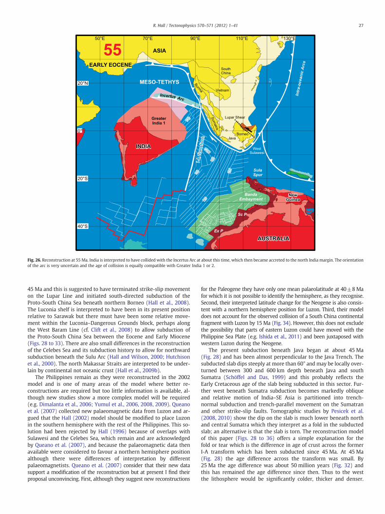
Fig. 26. Reconstruction at 55 Ma. India is interpreted to have collided with the Incertus Arc at about this time, which then became accreted to the north India margin. The orientationof the arc is very uncertain and the age of collision is equally compatible with Greater India 1 or 2.
27R. Hall / Tectonophysics 570–571 (2012) 1–41
45 Ma and this is suggested to have terminated strike-slip movementon the Lupar Line and initiated south-directed subduction of theProto-South China Sea beneath northern Borneo (Hall et al., 2008).The Luconia shelf is interpreted to have been in its present positionrelative to Sarawak but there must have been some relative move-ment within the Luconia–Dangerous Grounds block, perhaps alongthe West Baram Line (cf. Clift et al., 2008) to allow subduction ofthe Proto-South China Sea between the Eocene and Early Miocene(Figs. 28 to 33). There are also small differences in the reconstructionof the Celebes Sea and its subduction history to allow for northwardsubduction beneath the Sulu Arc (Hall and Wilson, 2000; Hutchisonet al., 2000). The north Makassar Straits are interpreted to be under-lain by continental not oceanic crust (Hall et al., 2009b).
The Philippines remain as they were reconstructed in the 2002model and is one of many areas of the model where better re-constructions are required but too little information is available, al-though new studies show a more complex model will be required(e.g. Dimalanta et al., 2006; Yumul et al., 2006, 2008, 2009). Queanoet al. (2007) collected new palaeomagnetic data from Luzon and ar-gued that the Hall (2002) model should be modified to place Luzonin the southern hemisphere with the rest of the Philippines. This so-lution had been rejected by Hall (1996) because of overlaps withSulawesi and the Celebes Sea, which remain and are acknowledgedby Queano et al. (2007), and because the palaeomagnetic data thenavailable were considered to favour a northern hemisphere positionalthough there were differences of interpretation by differentpalaeomagnetists. Queano et al. (2007) consider that their new datasupport a modification of the reconstruction but at present I find theirproposal unconvincing. First, although they suggest new reconstructions
for the Paleogene they have only one mean palaeolatitude at 40±8Mafor which it is not possible to identify the hemisphere, as they recognise.Second, their interpreted latitude change for the Neogene is also consis-tent with a northern hemisphere position for Luzon. Third, their modeldoes not account for the observed collision of a South China continentalfragment with Luzon by 15 Ma (Fig. 34). However, this does not excludethe possibility that parts of eastern Luzon could have moved with thePhilippine Sea Plate (e.g. Ishida et al., 2011) and been juxtaposed withwestern Luzon during the Neogene.
The present subduction beneath Java began at about 45 Ma(Fig. 28) and has been almost perpendicular to the Java Trench. Thesubducted slab dips steeply at more than 60° and may be locally over-turned between 300 and 600 km depth beneath Java and southSumatra (Schöffel and Das, 1999) and this probably reflects theEarly Cretaceous age of the slab being subducted in this sector. Fur-ther west beneath Sumatra subduction becomes markedly obliqueand relative motion of India–SE Asia is partitioned into trench-normal subduction and trench-parallel movement on the Sumatranand other strike-slip faults. Tomographic studies by Pesicek et al.(2008, 2010) show the dip on the slab is much lower beneath northand central Sumatra which they interpret as a fold in the subductedslab; an alternative is that the slab is torn. The reconstruction modelof this paper (Figs. 28 to 36) offers a simple explanation for thefold or tear which is the difference in age of crust across the formerI-A transform which has been subducted since 45 Ma. At 45 Ma(Fig. 28) the age difference across the transform was small. By25 Ma the age difference was about 50 million years (Fig. 32) andthis has remained the age difference since then. Thus to the westthe lithosphere would be significantly colder, thicker and denser.
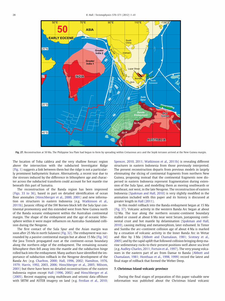
Fig. 27. Reconstruction at 50 Ma. The Philippine Sea Plate had begun to form by spreading within Cretaceous arcs and the Sepik terranes arrived at the New Guinea margin.
28 R. Hall / Tectonophysics 570–571 (2012) 1–41
The location of Toba caldera and the very shallow forearc regionabove the intersection with the subducted Investigator Ridge(Fig. 1) suggests a link between them but the ridge is not a particular-ly prominent bathymetric feature. Alternatively, a recent tear due tothe stresses induced by the difference in lithosphere age and charac-ter across the subducted transform could account for hot mantle risebeneath this part of Sumatra.
The reconstruction of the Banda region has been improved(Figs. 33 to 36), based in part on detailed identification of oceanfloor anomalies (Hinschberger et al., 2000, 2001) and new informa-tion on structures in eastern Indonesia (e.g. Watkinson et al.,2011b). Jurassic rifting of the SW Borneo block left the Sula Spur con-tinental promontory and this extended west from New Guinea northof the Banda oceanic embayment within the Australian continentalmargin. The shape of the embayment and the age of oceanic litho-sphere within it were major influences on Australia–Sundaland colli-sion during the Neogene.
The first contact of the Sula Spur and the Asian margin wassoon after 25 Ma in north Sulawesi (Fig. 32). The embayment was sur-rounded by a passive continental margin but at about 15 Ma (Fig. 34)the Java Trench propagated east at the continent–ocean boundaryalong the northern edge of the embayment. The remaining oceaniclithosphere then fell away into the mantle and the subduction hingerolled back into the embayment. Many authors have identified the im-portance of subduction rollback in the Neogene development of theBanda Arc (e.g. Charlton, 2000; Hall, 1996, 2002; Hamilton, 1976,1979; Harris, 1992, 2003, 2006; Hinschberger et al., 2005; Milsom,2001) but there have been no detailed reconstructions of the easternIndonesia region except Hall (1996, 2002) and Hinschberger et al.(2005). Recent mapping using multibeam and seismic data offshorewith SRTM and ASTER imagery on land (e.g. Ferdian et al., 2010;
Spencer, 2010, 2011; Watkinson et al., 2011b) is revealing differentstructures in eastern Indonesia from those previously interpreted.The present reconstruction departs from previous models in largelyeliminating the slicing of continental fragments from northern NewGuinea, proposing instead that the continental fragments now dis-persed in eastern Indonesia represent fragmentation during exten-sion of the Sula Spur, and modelling them as moving southwards orsoutheast, not west, in the late Neogene. The reconstruction of easternIndonesia (Spakman and Hall, 2010) is very slightly modified in theanimation included with this paper and its history is discussed atgreater length in Hall (2011).
In this model rollback into the Banda embayment began at 15 Ma(Fig. 37). Volcanic activity in the western Banda Arc began at about12 Ma. The tear along the northern oceanic-continent boundarystalled or ceased at about 6 Ma near west Seram, juxtaposing conti-nental crust and hot mantle by delamination (Spakman and Hall,2010), causing melting and metamorphism, later exhumed. In Timorand Sumba the arc–continent collision age of about 4 Ma is markedby a cessation of volcanic activity in the Inner Banda Arc in Wetarand Alor by 3 Ma (Abbott and Chamalaun, 1981; Scotney et al.,2005) and by the rapid uplift that followed collision bringing deepma-rine sedimentary rocks to their present positions well above sea level(e.g. Audley-Charles, 2011; Fortuin et al., 1997). The very young volca-noes in the eastern part of arc from Damar to Banda (Abbott andChamalaun, 1981; Honthaas et al., 1998, 1999) record the latest andfinal stage of rollback that formed the Weber Deep.
7. Christmas Island volcanic province
During the final stages of preparation of this paper valuable newinformation was published about the Christmas Island volcanic

Fig. 28. Reconstruction at 45 Ma. Australia began to move northwards and new subduction zones were initiated all round Sundaland. The Proto-South China Sea began to subductsouthwards at the Sabah margin. The Celebes and Philippine Sea were spreading in a backarc setting. The Ceno-Tethys was subducted northwards from Sumatra to Halmahera.
29R. Hall / Tectonophysics 570–571 (2012) 1–41
province in the Indian Ocean south of Java (Hoernle et al., 2011)about which almost nothing was previously known. From a tectonicviewpoint Hoernle et al. suggest three important conclusions: thatthe seamount province formed close to a new mid-ocean ridge atthe position where West Burma began separating from Australiaand India; that high 207Pb/204Pb ratios of volcanic rocks indicate acontribution from Archaean continental lithosphere; and that a sta-tionary mantle plume could account for volcanic activity at 136 Maand 115–94 Ma, but not at 93–70 Ma, 56–47 Ma and 4 Ma.
In this paper I have argued that the fragments that separated fromAustralia are not to be found in West Burma but in SW Borneo andEast Java–West Sulawesi. The data of Hoernle et al. (2011) are plottedon selected reconstructions of this paper (Fig. 38) and are shown in acomplete reconstruction animation (xmas_island_volcanism). Thesereconstructions support the interpretation of Hoernle et al. that thevolcanism occurred close to a new mid-ocean ridge, but it was theridge between Australia and East Java–West Sulawesi. Archaeancrust is present south of the spreading centre in the Pilbara andKimberley blocks of western Australia, and Archaean zircons withages up to 3.5 Ga are present in East Java (Smyth et al., 2007) andWest Sulawesi (van Leeuwen et al., 2007). Triassic sandstones in theMt Victoria area of the supposed West Burma block have not yetbeen sampled for zircon analysis, but detrital zircon studies inBurma that could expect to sample such rocks contain no zirconsolder than 2.8 Ga (Allen et al., 2008; Bodet and Schärer, 2000). The re-constructions also suggest that a stationary plume could account forvolcanic activity at 136 Ma, 115–94 Ma, 93–70 Ma, and 44–37 Ma.Volcanic activity in the Cocos-Keeling Province and at the Outside
Seamount is not explained by a plume and is more likely to be relatedto transform faults. The 4 Ma Christmas Island Upper Volcanics can-not be account for by a plume and are probably related to stressesin the bending subducting slab as it approached the trench.
8. Conclusions
SE Asia was built largely from continental fragments that separat-ed from Gondwana and have amalgamated from the Palaeozoic on-wards. The core of Sundaland, including the East Malaya–Indochina,Sukhothai Arc, Sibumasu, and West Sumatra blocks (Barber et al.,2005; Metcalfe, 2011a,b) was in place by the end of the Triassic. Inthis model there is no West Burma block rifted in the Jurassic andadded during the Cretaceous. West Burma is interpreted to havebeen part of the Asian margin from the Carboniferous and since theTriassic has moved only along strike-slip faults within the margin(Barber and Crow, 2009).
Continental fragments were added to the Sundaland core duringthe Cretaceous from north and south. Asian-origin fragments wereadded to form the Luconia–Dangerous Grounds region north of theLupar Line, and may have been modified by strike-slip movementsalong the northern Sundaland margin in the Early Cenozoic. By themid Eocene the Luconia–Dangerous Grounds block was part of theshallow Sunda Shelf. Rifting of the Asian margin that accompaniedelimination of the Proto-South China Sea and formed the presentSouth China Sea, partially fragmented the South China margin leavingextended continental crust on the south side of the South China Sea.This extended continental crust underthrust the active margin of

Fig. 29. Reconstruction at 40 Ma. India's movement slowed. The yellow dashed line shows the position of the subducting I-A transform. At the north end of the transform the crustwas similar in age on each side of the fault. Further south the age difference increased. Close to the spreading centre south of India the crust to the west was about 40 Ma old where-as to the east it was about 120 Ma old.
30 R. Hall / Tectonophysics 570–571 (2012) 1–41
the Sabah–Cagayan Arc in the Early Miocene during the final stages ofProto-South China Sea subduction. A relatively short-lived elevatedmountain range stretched from Borneo to Palawan formed by the col-lision but this was quickly reduced during the Miocene, partly by ero-sion, but mainly by extension caused by rollback at the north side ofthe Celebes Sea that formed the Dent–Semporna–Sulu Arc and SuluSea backarc basin.
Australian-origin fragments were added to form SW Borneo andEast Java–West Sulawesi. The SW Borneo–Sundaland boundary isthe Billiton depression and was a strike-slip suture. The east bound-ary of the SW Borneo block is also a strike-slip boundary with theEast Java–West Sulawesi from 110 to 90 Ma, and this may explainwhy the Meratus suture has been reactivated as an elongate narrowmountain belt resembling a strike-slip-related flower structure in SEBorneo. These blocks account for the areas of continental crust riftedfrom the Australian margin and fit into the areas where there is nowincreasing evidence for continental basement in Indonesia.
The East Java–West Sulawesi block may be underlain by Archaeanbasement as suggested by Smyth et al. (2007, 2008) but could also in-clude sedimentary and metamorphic rocks (up to Triassic age) whichcontain zircons inherited from Archaean, Proterozoic and Palaeozoicbasement in western Australia. This would also account for therange of ages in the zircon data. Work is underway to characterisethe basement of the SW Borneo block.
The Australian blocks also brought with them structures thatinfluenced Cenozoic deformation of Java, Borneo, and Sulawesi.Deep structural trends, now oriented approximately NW-SE, are
often identified across the whole of Borneo and commonly tracedsoutheastwards into Sulawesi and north towards the DangerousGrounds. Many of these features show no sign of having been activefaults during most of the Cenozoic, some may have been reactivatedat intervals during the Cenozoic but most are not active faults today,although they are commonly represented in this way on maps. How-ever, they do appear to have influenced the development of the re-gion during the Cenozoic, and there are indications of changingbasement character, depth to basement and changes in sedimentarythicknesses across them. The model provides two possible explana-tions for them. They could be basement features inherited fromAustralia where there are deep ancient structures that can be tracedoffshore across the NW Shelf and western Australia, for examplefrom the Canning or Browse Basins (Brown et al., 1984; Eyles et al.,2001; Goncharov, 2004). An alternative, or additional, explanation isthat these faults were active during the phase of Late Cretaceous–Paleocene subduction beneath Sumba and West Sulawesi. Their ori-entation means that they may have formed or been reactivatedat this stage as they were parallel to the NW-directed plate conver-gence direction. From 45 Ma there was a major change to broadlyNE-directed convergence as Australia began to move north and be-cause of their orientation movement on them would have ceased.This would explain why they influence Cenozoic development but,in most cases, do not appear to have been active structures.
The Woyla Arc initiated close to the northern edge of India. If theinitial rifting did occur along the continent–ocean boundary therecould have been some small microcontinental fragments brought
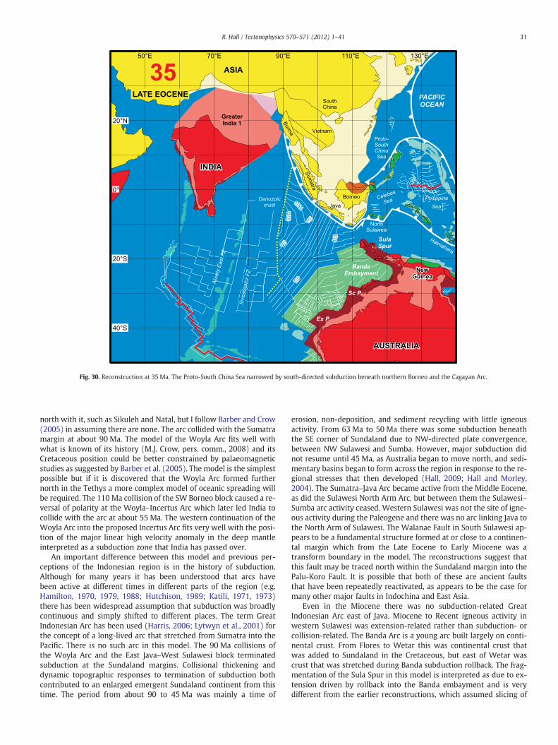
Fig. 30. Reconstruction at 35 Ma. The Proto-South China Sea narrowed by south-directed subduction beneath northern Borneo and the Cagayan Arc.
31R. Hall / Tectonophysics 570–571 (2012) 1–41
north with it, such as Sikuleh and Natal, but I follow Barber and Crow(2005) in assuming there are none. The arc collided with the Sumatramargin at about 90 Ma. The model of the Woyla Arc fits well withwhat is known of its history (M.J. Crow, pers. comm., 2008) and itsCretaceous position could be better constrained by palaeomagneticstudies as suggested by Barber et al. (2005). The model is the simplestpossible but if it is discovered that the Woyla Arc formed furthernorth in the Tethys a more complex model of oceanic spreading willbe required. The 110 Ma collision of the SW Borneo block caused a re-versal of polarity at the Woyla–Incertus Arc which later led India tocollide with the arc at about 55 Ma. The western continuation of theWoyla Arc into the proposed Incertus Arc fits very well with the posi-tion of the major linear high velocity anomaly in the deep mantleinterpreted as a subduction zone that India has passed over.
An important difference between this model and previous per-ceptions of the Indonesian region is in the history of subduction.Although for many years it has been understood that arcs havebeen active at different times in different parts of the region (e.g.Hamilton, 1970, 1979, 1988; Hutchison, 1989; Katili, 1971, 1973)there has been widespread assumption that subduction was broadlycontinuous and simply shifted to different places. The term GreatIndonesian Arc has been used (Harris, 2006; Lytwyn et al., 2001) forthe concept of a long-lived arc that stretched from Sumatra into thePacific. There is no such arc in this model. The 90 Ma collisions ofthe Woyla Arc and the East Java–West Sulawesi block terminatedsubduction at the Sundaland margins. Collisional thickening anddynamic topographic responses to termination of subduction bothcontributed to an enlarged emergent Sundaland continent from thistime. The period from about 90 to 45 Ma was mainly a time of
erosion, non-deposition, and sediment recycling with little igneousactivity. From 63 Ma to 50 Ma there was some subduction beneaththe SE corner of Sundaland due to NW-directed plate convergence,between NW Sulawesi and Sumba. However, major subduction didnot resume until 45 Ma, as Australia began to move north, and sedi-mentary basins began to form across the region in response to the re-gional stresses that then developed (Hall, 2009; Hall and Morley,2004). The Sumatra–Java Arc became active from the Middle Eocene,as did the Sulawesi North Arm Arc, but between them the Sulawesi–Sumba arc activity ceased. Western Sulawesi was not the site of igne-ous activity during the Paleogene and there was no arc linking Java tothe North Arm of Sulawesi. The Walanae Fault in South Sulawesi ap-pears to be a fundamental structure formed at or close to a continen-tal margin which from the Late Eocene to Early Miocene was atransform boundary in the model. The reconstructions suggest thatthis fault may be traced north within the Sundaland margin into thePalu-Koro Fault. It is possible that both of these are ancient faultsthat have been repeatedly reactivated, as appears to be the case formany other major faults in Indochina and East Asia.
Even in the Miocene there was no subduction-related GreatIndonesian Arc east of Java. Miocene to Recent igneous activity inwestern Sulawesi was extension-related rather than subduction- orcollision-related. The Banda Arc is a young arc built largely on conti-nental crust. From Flores to Wetar this was continental crust thatwas added to Sundaland in the Cretaceous, but east of Wetar wascrust that was stretched during Banda subduction rollback. The frag-mentation of the Sula Spur in this model is interpreted as due to ex-tension driven by rollback into the Banda embayment and is verydifferent from the earlier reconstructions, which assumed slicing of

Fig. 31. Reconstruction at 30 Ma. South China Sea oceanic crust formation was underway.
32 R. Hall / Tectonophysics 570–571 (2012) 1–41
continental fragments from northern New Guinea, which then collid-ed with Sulawesi.
A key feature of themodel presented in this paper is that there wasnever an active or recently active ridge subducted beneath Sumatraand Java as suggested previously (e.g. Hall, 2002; Whittaker et al.,2007). In fact, the slab subducted in the Cenozoic between Sumatraand east Indonesia was always Cretaceous or older, except at thevery western end of the Sunda Arc beneath north Sumatra and theAndamans, where Cenozoic lithosphere has been subducted sinceabout 20 Ma. Age contrasts of the lithosphere across the I-A transformcan explain the geometry of the subducted slab beneath Sumatra andwould also account for a tear that caused Toba volcanism and eleva-tion of the Sumatra forearc. The reconstructions presented here alsoaccount well for the new age data acquired from the Christmas Islandvolcanic province and most volcanism there could be explained by astationary hotspot. The reconstructions suggest that this hotspotcould be implicated in the tectonic development as its position coin-cides with the triple junction that developed at 135 Ma, and is closeto the end of the I-A transform initiated at 90 Ma.
Subduction has been the major influence on the development ofthe region. However, although there has been considerable growth,little material has been added by subduction accretion, or by accre-tion of oceanic plateaus or seamounts. Despite the many arcs, igne-ous activity seems to have contributed little new crust. Subduction-driven rollback is a clear feature of the reconstructions at numerousstages. The importance of rollback is now widely accepted around theworld but in SE Asia, particularly Indonesia, it is still common to inter-pret the region in terms of collision. The major growth of the regionhas been by addition of continental fragments but many of the
important features we observe today, from Sundaland, Borneo, Sulawesito the Banda Arc reflect extension mainly driven by subduction.
Tectonic reconstructions are useful at appropriate scales, encour-age useful new insights (e.g. Dewey and Casey, 2011), and mayhighlight problems and processes. However, it is also clear that theupper crust deforms in a complex way that cannot be modelled wellusing rigid fragments, by ‘plate tectonics’ at an increasingly micro-plate scale (Hall, 2011). Modelling the region requires deformablefragments for which currently few tools and rules exist. Thus, the re-constructions here should be considered a first order approximationrather than a literal description of the region.
Acknowledgements
This work has been supported mainly by the SE Asia ResearchGroup at Royal Holloway, funded by a consortium of oil companies.Financial support has also been provided at times by the Royal Socie-ty, the London University Central Research Fund, and the NaturalEnvironment Research Council. I thank members of the researchgroup who over many years have added to our knowledge of the re-gion, and I have listed some of the numerous colleagues who havehelped us here but I am aware that the list could be much longerand to those omitted I apologise. These include Jason Ali, JonathanAitchison, Mike Audley-Charles, Peter Baillie, Tony Barber, DianeCameron, Ben Clements, Mike Crow, Mike Cottam, John Decker, IanDeighton, Chris Elders, Marnie Forster, Tom Fraser, Piril Hall, CharlesHutchison, Gordon Lister, Jeff Malaihollo, Colin Macpherson, IanMetcalfe, Bob Morley, Chris Morley, Gary Nichols, Brian Rosen,Lawrence Rush, Inga Sevastjanova, Nafrizal Sikumbang, Alan Smith,
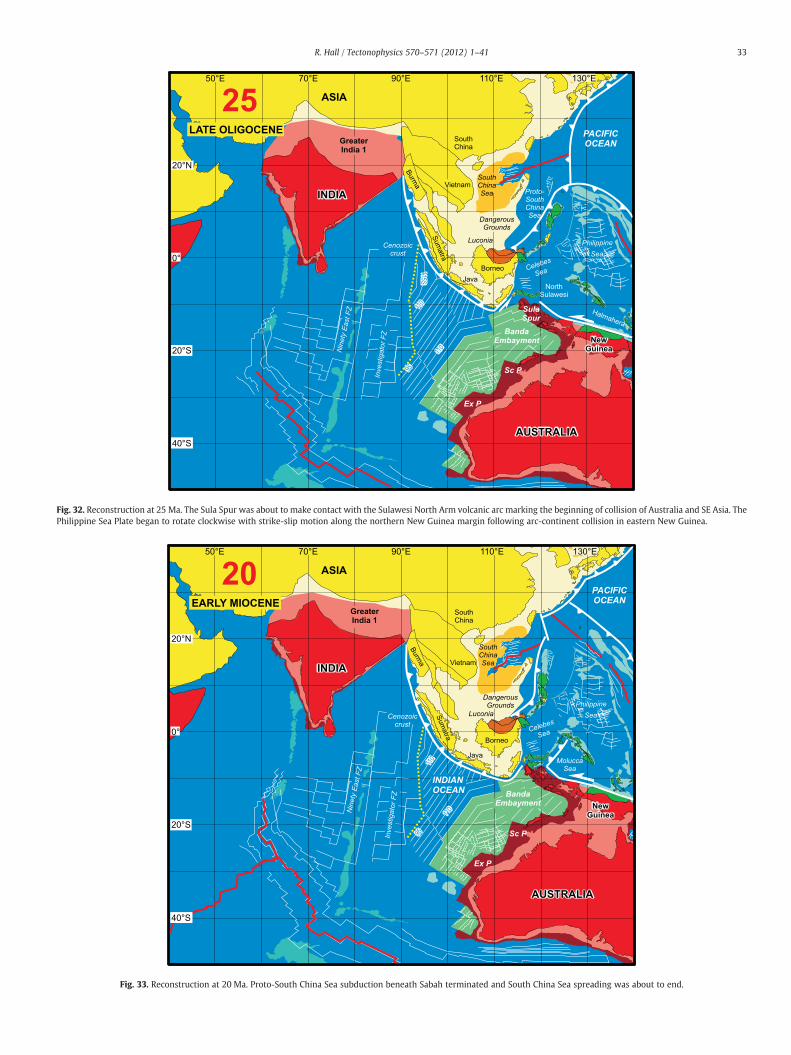
Fig. 32. Reconstruction at 25 Ma. The Sula Spur was about to make contact with the Sulawesi North Arm volcanic arc marking the beginning of collision of Australia and SE Asia. ThePhilippine Sea Plate began to rotate clockwise with strike-slip motion along the northern New Guinea margin following arc-continent collision in eastern New Guinea.
Fig. 33. Reconstruction at 20 Ma. Proto-South China Sea subduction beneath Sabah terminated and South China Sea spreading was about to end.
33R. Hall / Tectonophysics 570–571 (2012) 1–41
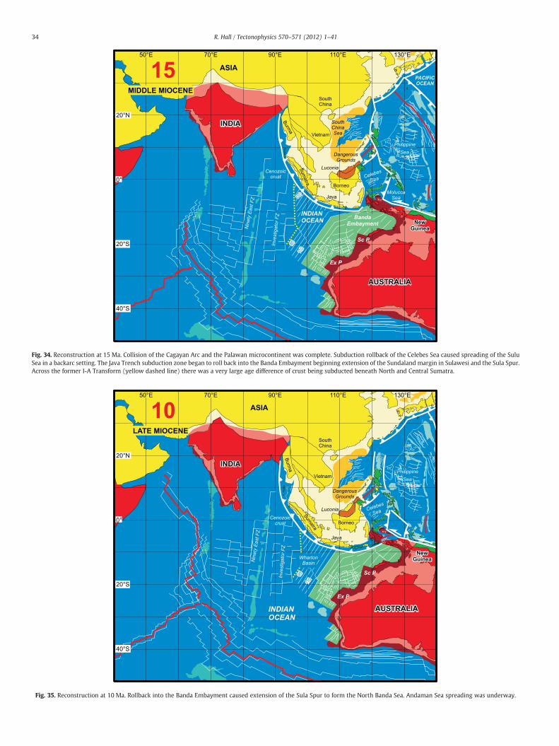
Fig. 34. Reconstruction at 15 Ma. Collision of the Cagayan Arc and the Palawan microcontinent was complete. Subduction rollback of the Celebes Sea caused spreading of the SuluSea in a backarc setting. The Java Trench subduction zone began to roll back into the Banda Embayment beginning extension of the Sundaland margin in Sulawesi and the Sula Spur.Across the former I-A Transform (yellow dashed line) there was a very large age difference of crust being subducted beneath North and Central Sumatra.
Fig. 35. Reconstruction at 10 Ma. Rollback into the Banda Embayment caused extension of the Sula Spur to form the North Banda Sea. Andaman Sea spreading was underway.
34 R. Hall / Tectonophysics 570–571 (2012) 1–41
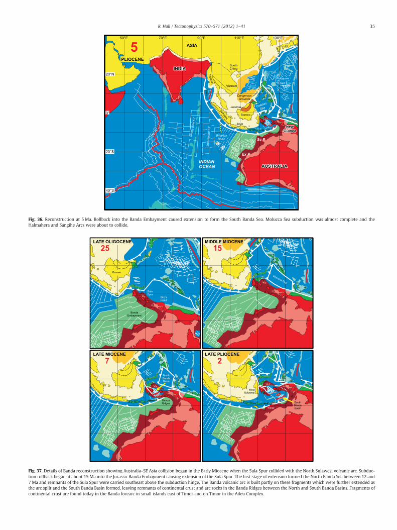
Fig. 36. Reconstruction at 5 Ma. Rollback into the Banda Embayment caused extension to form the South Banda Sea. Molucca Sea subduction was almost complete and theHalmahera and Sangihe Arcs were about to collide.
Fig. 37. Details of Banda reconstruction showing Australia–SE Asia collision began in the Early Miocene when the Sula Spur collided with the North Sulawesi volcanic arc. Subduc-tion rollback began at about 15 Ma into the Jurassic Banda Embayment causing extension of the Sula Spur. The first stage of extension formed the North Banda Sea between 12 and7 Ma and remnants of the Sula Spur were carried southeast above the subduction hinge. The Banda volcanic arc is built partly on these fragments which were further extended asthe arc split and the South Banda Basin formed, leaving remnants of continental crust and arc rocks in the Banda Ridges between the North and South Banda Basins. Fragments ofcontinental crust are found today in the Banda forearc in small islands east of Timor and on Timor in the Aileu Complex.
35R. Hall / Tectonophysics 570–571 (2012) 1–41
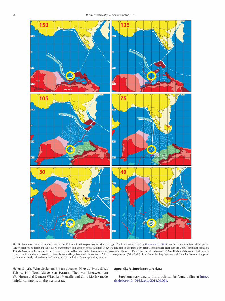
Fig. 38. Reconstructions of the Christmas Island Volcanic Province plotting location and ages of volcanic rocks dated by Hoernle et al. (2011) on the reconstructions of this paper.Larger coloured symbols indicate active magmatism and smaller white symbols show the location of samples after magmatism ceased. Numbers are ages. The oldest rocks are136 Ma. Most samples appear to have erupted a few million years after formation of ocean crust at the ridge. Magmatic episodes at about 135 Ma, 105 Ma, 75 Ma and 40 Ma appearto be close to a stationary mantle feature shown as the yellow circle. In contrast, Paleogene magmatism (56–47 Ma) of the Cocos-Keeling Province and Outsider Seamount appearsto be more closely related to transforms south of the Indian Ocean spreading centre.
36 R. Hall / Tectonophysics 570–571 (2012) 1–41
Helen Smyth, Wim Spakman, Simon Suggate, Mike Sullivan, SahatTobing, Phil Teas, Marco van Hattum, Theo van Leeuwen, IanWatkinson and Duncan Witts. Ian Metcalfe and Chris Morley madehelpful comments on the manuscript.
Appendix A. Supplementary data
Supplementary data to this article can be found online at http://dx.doi.org/10.1016/j.tecto.2012.04.021.

37R. Hall / Tectonophysics 570–571 (2012) 1–41
References
Abbott, M.J., Chamalaun, F.H., 1981. Geochronology of some Banda Arc volcanics. In:Barber, A.J., Wiryosujono, S. (Eds.), The Geology and Tectonics of EasternIndonesia: Geological Research and Development Centre, Bandung, Special Publi-cation, 2, pp. 253–268.
Abdullah, C.I., Rampnoux, J.-P., Bellon, H., Maury, R.C., Soeria-Atmadja, R., 2000. Theevolution of Sumba Island (Indonesia) revisited in the light of new data on the geo-chronology and geochemistry of the magmatic rocks. Journal of Asian Earth Sci-ences 18, 533–546.
Adams, C.G., Haak, R., 1962. The stratigraphical succession in the Batu Gading area,Middle Baram, North Sarawak. In: Haile, N.S. (Ed.), The Geology and Mineral Re-sources of the Suai-Baram area, North Sarawak: Geological Survey Department,British Territories in Borneo, Memoir, 13, pp. 141–150.
Agard, P., Jolivet, L., Vrielynck, B., Burov, E., Monié, P., 2007. Plate acceleration: theobduction trigger? Earth and Planetary Science Letters 258, 428–441.
Aitchison, J.C., Ali, J.R., Davis, A.M., 2007a.When andwhere did India andAsia collide? Jour-nal of Geophysical Research 112, B05423. http://dx.doi.org/10.1029/2006JB004706.
Aitchison, J.C., McDermid, I.R.C., Ali, J.R., Davis, A.M., Zyabrev, S.V., 2007b. Shoshonitesin southern Tibet record Late Jurassic rifting of a Tethyan intraoceanic island arc.Journal of Geology 115, 197–218.
Ali, J.R., Aitchison, J.C., 2005. Greater India. Earth-Science Reviews 72, 169–188.Ali, J.R., Aitchison, J.C., 2008. Gondwana to Asia: plate tectonics, paleogeography and
the biological connectivity of the Indian sub-continent from the Middle Jurassicthrough latest Eocene (166–35 Ma). Earth-Science Reviews 72, 145–166.
Ali, J.R., Hall, R., 1995. Evolution of the boundary between the Philippine Sea Plate andAustralia: palaeomagnetic evidence from eastern Indonesia. Tectonophysics 251,251–275.
Allen, R., Najman, Y., Carter, A., Barfod, D., Bickle, M.J., Chapman, H.J., Garzanti, E.,Vezzoli, G., Ando, S., Parrish, R.R., 2008. Provenance of the Tertiary sedimentaryrocks of the Indo-Burman Ranges, Burma (Myanmar): Burman arc or Himalayan-derived? Journal of the Geological Society of London 165, 1045–1057.
Audley-Charles, M.G., 1983. Reconstruction of eastern Gondwanaland. Nature 306,48–50.
Audley-Charles, M.G., 1988. Evolution of the southern margin of Tethys (NorthAustralian region) from early Permian to late Cretaceous. In: Audley-Charles,M.G., Hallam, A. (Eds.), Gondwana and TethysGeological Society of London SpecialPublication 37, 79–100.
Audley-Charles, M.G., 1991. Tectonics of the New Guinea area. Annual Reviews of Earthand Planetary Sciences 19, 17–41.
Audley-Charles, M.G., 2011. Tectonic post-collision processes in Timor. In: Hall, R., Cottam,M.A., Wilson, M.E.J. (Eds.), The SE Asian Gateway: History and Tectonics of theAustralia-Asia collisionGeological Society of London Special Publication 355, 241–266.
Audley-Charles, M.G., Ballantyne, P.D., Hall, R., 1988. Mesozoic–Cenozoic rift-drift se-quence of Asian fragments from Gondwanaland. Tectonophysics 155, 317–330.
Barber, A.J., 2000. The origin of the Woyla Terranes in Sumatra and the Late Mesozoicevolution of the Sundaland margin. Journal of Asian Earth Sciences 18, 713–738.
Barber, A.J., Crow, M.J., 2005. Chapter 4: Pre-Tertiary stratigraphy. In: Barber, A.J., Crow,M.J., Milsom, J.S. (Eds.), Sumatra: Geology, Resources and Tectonic Evolution: Geo-logical Society London Memoir, 31, pp. 24–53.
Barber, A.J., Crow, M.J., 2009. The structure of Sumatra and its implications for the tectonicassembly of Southeast Asia and the destruction of Paleotethys. Island Arc 18, 3–20.
Barber, A.J., Crow, M.J., de Smet, M.E.M., 2005. Chapter 14: Tectonic evolution. In:Barber. In: Barber, A.J., Crow, M.J., Milsom, J.S. (Eds.), Sumatra: Geology, Resourcesand Tectonic Evolution: Geological Society London Memoir, 31, pp. 234–259.
Barckhausen, U., Gibbons, A., Hoernle, K., Werner, R., Hauff, F., Mueller, D.R., 2008. Sea-floor spreading anomalies of the south-eastern Indian Ocean revisited. AmericanGeophysical Union, Fall Meeting 2008, abstract T53G-04.
Barron, L., Mernagh, T.P., Pogson, R., Barron, B.J., 2008. Alluvial ultrahigh pressure(UHP) macrodiamond at Copeton/Bingara (Eastern Australia), and Cempaka(Kalimantan, Indonesia). 9th International Kimberlite Conference, Extended Ab-stract, 9IKC-A-00039, pp. 1–3.
Ben-Avraham, Z., 1973. Structural framework of the Sunda shelf and vicinity. PhD The-sis, Woods Hole Oceanographic Institute & MIT, 269 pp.
Ben-Avraham, Z., Emery, K.O., 1973. Structural framework of Sunda Shelf. Bulletin ofthe American Association of Petroleum Geologists 57, 2323–2366.
Ben-Avraham, Z., Uyeda, S., 1973. The evolution of the China Basin and the Mesozoicpalaeogeography of Borneo. Earth and Planetary Science Letters 18, 365–376.
Bergman, S.C., Coffield, D.Q., Talbot, J.P., Garrard, R.J., 1996. Tertiary tectonic andmagmaticevolution ofWestern Sulawesi and theMakassar Strait, Indonesia: evidence for aMio-cene continent–continent collision. In: Hall, R., Blundell, D.J. (Eds.), Tectonic Evolutionof SE AsiaGeological Society of London Special Publication 106, 391–430.
Bodet, F., Schärer, U., 2000. Evolution of the SE-Asian continent from U–Pb and Hf iso-topes in single grains of zircon and baddeleyite from large rivers. Geochimica etCosmochimica Acta 64, 2067–2091.
BRGM, 1982. Geological mapping and mineral exploration in northeast Kalimantan1979–1982, Final Report. Rapport du Bureau de Recherches Géologique et Miniére.
Brown, S.A., Boserio, I.M., Jackson, K.S., Spence, K.W., 1984. The geological evolution ofthe Canning Basin—implications for petroleum exploration. In: Purcell, P.G. (Ed.),Proceedings Canning Basin Symposium. Petroleum Exploration Society of Australia,pp. 85–96.
Cambridge Paleomap Services, 1993. ATLAS version 3.3. Cambridge Paleomap Services,P.O. Box 246, Cambridge, U.K.
Cameron, N.R., Clarke, M.C.G., Aldiss, D.T., Aspden, J.A., Djunuddin, A., 1980. The geolog-ical evolution of northern Sumatra. Proceedings Indonesian Petroleum Association9th Annual Convention, pp. 149–187.
Charlton, T.R., 2000. Tertiary evolution of the Eastern Indonesia Collision Complex.Journal of Asian Earth Sciences 18, 603–631.
Charlton, T.R., 2001. Permo-Triassic evolution of Gondwanan eastern Indonesia, andthe final Mesozoic separation of SE Asia from Australia. Journal of Asian Earth Sci-ences 19, 595–617.
Charvet, J., Lapierre, H., Yu, Y., 1994. Geodynamic significance of the Mesozoic volca-nism of southeastern China. Journal of Southeast Asian Earth Sciences 9, 387–396.
Chen, J., Huang, B., Sun, L., 2010. New constraints to the onset of the India-Asia colli-sion: paleomagnetic reconnaissance on the Linzizong Group in the Lhasa Block,China. Tectonophysics 489, 189–209.
Clements, B., Hall, R., 2011. A record of continental collision and regional sediment fluxfor the Cretaceous and Palaeogene core of SE Asia: implications for early Cenozoicpalaeogeography. Journal of the Geological Society 168, 1187–1200.
Clements, B., Hall, R., Smyth, H.R., Cottam, M.A., 2009. Thrusting of a volcanic arc: a newstructural model for Java. Petroleum Geoscience 15, 159–174.
Clements, B., Burgess, P.M., Hall, R., Cottam, M.A., 2011. Subsidence and uplift by slab-related mantle dynamics: a driving mechanism for the late Cretaceous and Ceno-zoic evolution of continental SE Asia. In: Hall, R., Cottam, M.A., Wilson, M.E.J.(Eds.), The SE Asian Gateway: History and Tectonics of the Australia-AsiacollisionGeological Society of London Special Publication 355, 37–51.
Clift, P., Lee, G.H., Duc, N.A., Barckhausen, U., Long, H.V., Zhen, S., 2008. Seismic reflec-tion evidence for a Dangerous Grounds miniplate: no extrusion origin for the SouthChina Sea. Tectonics 27. http://dx.doi.org/10.1029/2007TC002216.
Colwell, J.B., Symonds, P.A., Crawford, A.J., 1994. The nature of the Wallaby (Cuvier)Plateau and other igneous provinces of the west Australian margin. AGSO Journalof Australian Geology and Geophysics 15, 137–156.
Crow, M.J., 2005. Chapter 8: Tertiary volcanicity. In: Barber, A.J., Crow, M.J., Milsom, J.S.(Eds.), Sumatra: Geology, Resources and Tectonic Evolution: Geological SocietyLondon Memoir, 31, pp. 98–119.
Davies, H.L., Jaques, A.L., 1984. Emplacement of ophiolite on Papua New Guinea. In:Gass, I.G., Lippard, S.J., Shelton, A.W. (Eds.), Ophiolites and Oceanic Lit-hosphereGeological Society of London Special Publication 14, 341–349.
Deighton, I., Hancock, T., Hudson, G., Tamannai, M., Conn, P., Oh, K., 2011. Infill seis-mic in the southeast Java Forearc Basin: implications for petroleum prospectivity.Proceedings Indonesian Petroleum Association 35th Annual Convention, IPA11-G-068.
Dewey, J.F., Casey, J.F., 2011. The origin of obducted large-slab ophiolite complexes. In:Brown, D., Ryan, P.D. (Eds.), Arc-Continent Collision. Frontiers in Earth Sciences.Springer-Verlag, Berlin, Heidelberg, pp. 431–444.
Dilek, Y., Furnes, H., 2009. Structure and geochemistry of Tethyan ophiolites and theirpetrogenesis in subduction rollback systems. Lithos 113, 1–20.
Dilek, Y., Robinson, P.T. (Eds.), 2003. Ophiolites in Earth HistoryGeological Society ofLondon Special Publication 218.
Dimalanta, C.B., Suerte, L.O., Yumul, G.P., Tamayo, R.A., Ramos, E.G.L., 2006. A Creta-ceous supra-subduction oceanic basin source for Central Philippine ophiolitic base-ment complexes: geological and geophysical constraints. Geosciences Journal 10,305–320.
Doutch, H.F., 1992. Aspects of the structural histories of the Tertiary sedimentary ba-sins of East, Central and West Kalimantan and their margins. BMR Journal ofAustralian Geology and Geophysics 13, 237–250.
Dupont-Nivet, G., van Hinsbergen, D.J.J., Torsvik, T.H., 2010. Persistently low Asian pal-eolatitudes: implications for the India–Asia collision history. Tectonics 29, TC5016.http://dx.doi.org/10.1029/2008TC002437.
Elburg, M., Foden, J., 1999. Sources for magmatism in central Sulawesi: geochemicaland Sr–Nd–Pb isotopic constraints. Chemical Geology 156, 67–93.
Elburg, M., van Leeuwen, T., Foden, J., Muhardjo, 2002. Origin of geochemical variabilityby arc–continent collision in the Biru area, Southern Sulawesi (Indonesia). Journalof Petrology 43, 581–606.
Elburg, M., van Leeuwen, T., Foden, J., Muhardjo, 2003. Spatial and temporal isotopicdomains of contrasting igneous suites in western and northern Sulawesi, Indone-sia. Chemical Geology 199, 243–276.
Emmet, P.A., Granath, J.W., Dinkelman, M.G., 2009. Pre-Tertiary sedimentary “keels”provide insights into tectonic assembly of basement terranes and present-day pe-troleum systems of the East Java Sea. Proceedings Indonesian Petroleum Associa-tion 33rd Annual Convention, IPA09-G-046 1–11.
Eyles, N., Eyles, C.H., Neil Apak, S., Carlsen, G.M., 2001. Permian–Carboniferous tectono-stratigraphic evolution and petroleum potential of the northern Canning basin,Western Australia. Bulletin of the American Association of Petroleum Geologists85, 989–1006.
Faure, M., Marchadier, Y., Rangin, C., 1989. Pre Eocene synmetamorphic structure in theMindoro Romblon Palawan area, West Philippines, and implications for the historyof Southeast Asia. Tectonics 8, 963–979.
Ferdian, F., Watkinson, I.M., Hall, R., 2010. A structural re-evaluation of the NorthBanggai-Sula area, eastern Sulawesi. Proceedings Indonesian Petroleum Associa-tion 34th Annual Convention, IPA10-G-009 1–20.
Fortuin, A.R., van der Werff, W., Wensink, H., 1997. Neogene basin history and paleo-magnetism of a rifted and inverted forearc region, on- and offshore Sumba, EasternIndonesia. Journal of Asian Earth Sciences 15, 61–88.
Fullerton, L.G., Sager, W.W., Handschumacher, D.W., 1989. Late Jurassic–EarlyCretaceous evolution of the eastern Indian Ocean adjacent to northwest Australia.Journal of Geophysical Research 94, 2937–2954.
Fyhn, M.B.W., Boldreel, L.O., Nielsen, L.H., 2010a. Escape tectonism in the Gulf ofThailand: Paleogene left-lateral pull-apart rifting in the Vietnamese part of theMalay Basin. Tectonophysics 483, 365–376.
Fyhn, M.B.W., Pedersen, S.A.S., Boldreel, L.O., Nielsen, L.H., Green, P.F., Dien, P.T., Huyen,L.T., Frei, D., 2010b. Palaeocene–early Eocene inversion of the Phuquoc-Kampot

38 R. Hall / Tectonophysics 570–571 (2012) 1–41
Som Basin: SE Asian deformation associated with the suturing of Luconia. Journalof the Geological Society of London 167, 281–295.
Gatinsky, Y.G., Hutchison, C.S., 1986. Cathaysia, Gondwanaland and the Paleotethys inthe evolution of continental Southeast Asia. Bulletin of the Geological Society ofMalaysia 20, 179–199.
GEBCO, 2003. IHO-UNESCO, General Bathymetric Chart of the OceansDigital Edition,http://www.gebco.net/.
Goncharov, A., 2004. Basement and crustal structure of the Bonaparte and Browsebasins, Australian northwest margin. Proceedings of the Timor Sea Sympo-sium, Northern Territory Geological Survey Australia, Special Publication 1,551–566.
Gorring, M.L., Kay, S.M., 2001. Mantle processes and sources of Neogene slab windowmagmas from Southern Patagonia, Argentina. Journal of Petrology 42, 1067–1094.
Gower, R.J.W., 1990. Early Tertiary plate reconstructions for the South China Sea re-gion: constraints from northwest Borneo. Journal of Southeast Asian Earth Sciences4, 29–35.
Gradstein, F.M., 1992. 43. Legs 122 and 123, northwestern Australian margin—astratigraphic and paleogeographic summary. In: Gradstein, F.M., Ludden, J.N., etal. (Eds.), Proceedings of the Ocean Drilling ProgramScientific Results 123,801–816.
Granath, J.W., Christ, J.M., Emmet, P.A., Dinkelman, M.G., 2011. Pre-Cenozoic sedimen-tary section and structure as reflected in the JavaSPAN crustal-scale PSDM seismicsurvey, and its implications regarding the basement terranes in the East Java Sea.In: Hall, R., Cottam, M.A., Wilson, M.E.J. (Eds.), The SE Asian Gateway: Historyand Tectonics of the Australia-Asia collisionGeological Society of London SpecialPublication 355, 53–74.
Green, O.R., Searle, M.P., Corfield, R.I., Corfield, R.M., 2008. Cretaceous–Tertiary carbon-ate platform evolution and the age of the India–Asia collision along the LadakhHimalaya (Northwest India). Journal of Geology 116, 331–353.
Guzman-Speziale,M., Ni, J.F., 2000. Comment on “Subduction in the Indo-Burma region: isit still active?” by S. P. Satyabala. Geophysical Research Letters 27, 1065–1066.
Haile, N.S., 1962. The Geology and Mineral Resources of the Suai-Baram area, NorthSarawak. Geological Survey Department, British Territories in Borneo, Memoir,13. 176 pp.
Haile, N.S., 1973. The recognition of former subduction zones in Southeast Asia. In:Tarling, D.H., Runcorn, S.K. (Eds.), Implications of continental drift to the Earth Sci-ences, 2. Academic Press, London, pp. 885–891.
Haile, N.S., 1974. Borneo. In: Spencer, A.M. (Ed.), Mesozoic–Cenozoic OrogenicBeltsGeological Society of London Special Publication 4, 333–347.
Haile, N.S., Ho, C.K., 1991. Geological Field Guide: Sibu-Miri traverse, Sarawak (24September–1 October 1991). Petronas Petroleum Research Institute. 37 pp.
Hall, R., 1996. Reconstructing Cenozoic SE Asia. In: Hall, R., Blundell, D.J. (Eds.), TectonicEvolution of SE AsiaGeological Society of London Special Publication 106, 153–184.
Hall, R., 2002. Cenozoic geological and plate tectonic evolution of SE Asia and the SWPacific: computer-based reconstructions, model and animations. Journal of AsianEarth Sciences 20, 353–434.
Hall, R., 2009. Hydrocarbon basins in SE Asia: understanding why they are there. Petro-leum Geoscience 15, 131–146.
Hall, R., 2011. Australia–SE Asia collision: plate tectonics and crustal flow. In: Hall, R.,Cottam, M.A., Wilson, M.E.J. (Eds.), The SE Asian Gateway: History and Tectonicsof the Australia–Asia collisionGeological Society of London Special Publication355, 75–109.
Hall, R., Morley, C.K., 2004. Sundaland Basins. In: Clift, P., Wang, P., Kuhnt, W., Hayes, D.E.(Eds.), Continent–Ocean Interactions within the East Asian Marginal Seas. : Geophys-ical Monograph, 149. American Geophysical Union, Washington, D.C., pp. 55–85.
Hall, R., Spakman, W., 2002. Subducted slabs beneath the eastern Indonesia–Tonga re-gion: insights from tomography. Earth and Planetary Science Letters 201, 321–336.
Hall, R., Wilson, M.E.J., 2000. Neogene sutures in eastern Indonesia. Journal of AsianEarth Sciences 18, 787–814.
Hall, R., Audley-Charles, M.G., Banner, F.T., Hidayat, S., Tobing, S.L., 1988. Basementrocks of the Halmahera region, eastern Indonesia: a Late Cretaceous–Early Tertiaryarc and fore-arc. Journal of the Geological Society of London 145, 65–84.
Hall, R., Ali, J.R., Anderson, C.D., 1995. Cenozoic motion of the Philippine Sea Plate:palaeomagnetic evidence from eastern Indonesia. Tectonics 14, 1117–1132.
Hall, R., van Hattum, M.W.A., Spakman, W., 2008. Impact of India–Asia collision on SEAsia: the record in Borneo. Tectonophysics 451, 366–389.
Hall, R., Clements, B., Smyth, H.R., 2009a. Sundaland: basement character, structure andplate tectonic development. Proceedings Indonesian Petroleum Association 33rdAnnual Convention, IPA09-G-134 1–27.
Hall, R., Cloke, I.R., Nur'Aini, S., Puspita, S.D., Calvert, S.J., Elders, C.F., 2009b. The NorthMakassar Straits: what lies beneath? Petroleum Geoscience 15, 147–158.
Hamilton, W., 1970. Tectonic map of the Indonesian region, a progress report. U.S. Geo-logical Survey Open File Report. 29 pp.
Hamilton, W., 1973. Tectonics of the Indonesian region. In: Tarling, D.H., Runcorn, S.K.(Eds.), Implications of Continental Drift to the Earth Sciences, 2. Academic Press,London, pp. 879–884.
Hamilton, W., 1976. Subduction in the Indonesian region. Proceedings Indonesian Pe-troleum Association 5th Annual Convention, pp. 3–24.
Hamilton, W., 1979. Tectonics of the Indonesian region. U.S. Geological Survey Profes-sional Paper, 1078. 345 pp.
Hamilton, W., 1988. Plate tectonics and island arcs. Geological Society of AmericaBulletin 100, 1503–1527.
Harris, R.A., 1992. Peri-collisional extension and the formation of Oman-type ophiolitesin the Banda arc and Brooks Range. In: Parson, L.M., Murton, B.J., Browning, P.(Eds.), Ophiolites and their Modern Oceanic AnaloguesGeological Society ofLondon Special Publication 60, 301–325.
Harris, R., 2003. Geodynamic patterns of ophiolites and marginal basins in the Indone-sian and New Guinea regions. In: Dilek, Y., Robinson, P.T. (Eds.), Ophiolites in EarthHistoryGeological Society of London Special Publication 218, 481–506.
Harris, R., 2006. Rise and fall of the Eastern Great Indonesian arc recorded by the as-sembly, dispersion and accretion of the Banda Terrane, Timor. Gondwana Research10, 207–231.
Hasan, K., 1990. The Upper Cretaceous flysch succession of the Balangbaru Formation,Southwest Sulawesi, Indonesia. PhD Thesis, University of London, 337 pp.
Hasan, K., 1991. Upper Cretaceous flysch succession of the Balangbaru Formation,Southwest Sulawesi. Proceedings Indonesian Petroleum Association 20th AnnualConvention, pp. 183–208.
Hazebroek, H.P., Tan, D.N.K., 1993. Tertiary tectonic evolution of the NW Sabah Conti-nental Margin. Bulletin of the Geological Society of Malaysia 33, 195–210.
Heine, C., Müller, R.D., 2005. Late Jurassic rifting along the Australian North West Shelf:margin geometry and spreading ridge configuration. Australian Journal of EarthSciences 52, 27–39.
Heine, C., Müller, R.D., Norvick, M.S., 2002. Revised tectonic evolution of the NorthwestShelf of Australia and adjacent abyssal plains. In: Keep, M., Moss, S. (Eds.), The Sed-imentary Basins of Western Australia, 3. Petroleum Exploration Society of Austra-lia, Perth, pp. 955–957.
Heine, C., Müller, D., Gaina, C., 2004. Reconstructing the Lost Eastern Tethys OceanBasin: convergence of the SE Asian Margin and marine gateways. In: Clift, P.,Wang, P., Kuhnt, W., Hayes, D.E. (Eds.), Continent–Ocean Interactions within theEast Asian Marginal Seas. : Geophysical Monograph, 149. American GeophysicalUnion, Washington, D.C., pp. 37–54.
Henderson, A.L., Najman, Y., Parrish, R., Mark, D.F., Foster, G.L., 2011. Constraints to thetiming of India–Eurasia collision; a re-evaluation of evidence from the Indus Basinsedimentary rocks of the Indus-Tsangpo Suture Zone, Ladakh, India. Earth-ScienceReviews 106, 265–292.
Hilton, D.R., Hoogewerff, J.A., van Bergen, M.J., Hammerschmidt, K., 1992. Mappingmagma sources in the east Sunda-Banda arcs, Indonesia: constraints from Heliumisotopes. Geochimica et Cosmochimica Acta 56, 851–859.
Hinschberger, F., Malod, J.-A., Rehault, J.-P., Dyment, J., Honthaas, C., Villeneuve, M.,Burhanuddin, S., 2000. Origine et evolution du bassin Nord-Banda (Indonesie):apport des donnees magnetiques. Comptes Rendus de l'Academie des Sciences,Paris 331, 507–514.
Hinschberger, F., Malod, J.A., Dyment, J., Honthaas, C., Rehault, J.P., Burhanuddin, S.,2001. Magnetic lineations constraints for the back-arc opening of the Late NeogeneSouth Banda Basin (eastern Indonesia). Tectonophysics 333, 47–59.
Hinschberger, F., Malod, J.-A., Rehault, J.-P., Villeneuve, M., Royer, J.-Y., Burhanuddin, S.,2005. Late Cenozoic geodynamic evolution of eastern Indonesia. Tectonophysics404, 91–118.
Hoernle, K., Hauff, F., Werner, R., van den Bogaard, P., Gibbons, A.D., Conrad, S., Müller,R.D., 2011. Origin of Indian Ocean Seamount Province by shallow recycling of con-tinental lithosphere. Nature Geoscience 4, 883–887. http://dx.doi.org/10.1038/ngeo1331.
Hole, M.J., Saunders, A.D., Rogers, G., Sykes, M.A., 1995. The relationship between alka-line magmatism, lithospheric extension and slab window formation along conti-nental destructive plate margins. In: Smellie, J.L. (Ed.), Volcanism Associatedwith Extension at Consuming Plate MarginsGeological Society of London SpecialPublication 81, 265–285.
Honthaas, C., Rehault, J.-P., Maury, R.C., Bellon, H., Hemond, C., Malod, J.-A., Cornee, J.-J.,Villeneuve, M., Cotten, J., Burhanuddin, S., Guillou, H., Arnaud, N., 1998. A Neogeneback-arc origin for the Banda Sea basins: geochemical and geochronological con-strains from the Banda ridges (East Indonesia). Techonophysics 298, 297–317.
Honthaas, C., Maury, R.C., Priadi, B., Bellon, H., Cotten, J., 1999. The Plio-QuaternaryAmbon arc, Eastern Indonesia. Techonophysics 301, 261–281.
Hutchison, C.S., 1989. Geological Evolution of South-East Asia, 13. Oxford Monographson Geology and Geophysics. Clarendon Press. 376 pp.
Hutchison, C.S., 1996. The ‘Rajang Accretionary Prism’ and ‘Lupar Line’ problem of Bor-neo. In: Hall, R., Blundell, D.J. (Eds.), Tectonic Evolution of SE AsiaGeological Societyof London Special Publication 106, 247–261.
Hutchison, C.S., 2004. Marginal basin evolution: the southern South China Sea. Marineand Petroleum Geology 21, 1129–1148.
Hutchison, C.S., 2005. Geology of North-West Borneo. Elsevier. 444 pp.Hutchison, C.S., 2010. Oroclines and paleomagnetism in Borneo and South-East Asia.
Tectonophysics 496, 53–67.Hutchison, C.S., Bergman, S.C., Swauger, D.A., Graves, J.E., 2000. A Miocene collisional
belt in north Borneo: uplift mechanism and isostatic adjustment quantified bythermochronology. Journal of the Geological Society of London 157, 783–793.
Ishida, K., Suzuki, S., Yumul Jr., G.P., Dimalanta, C.B., 2011. Middle Eocene low-paleolatitude radiolarian evidence for the Cabog Formation, Central East Luzon,Philippine Mobile Belt. Gondwana Research 19, 61–70.
Jahn, B.-M., Chen, P.Y., Yen, T.P., 1976. Rb–Sr ages of granitic rocks in southeastern Chinaand their tectonic significance. Geological Society of America Bulletin 87, 763–776.
Jasin, B., 2000. Significance of Mesozoic radiolarian chert in Sabah and Sarawak. Pro-ceedings Geological Society of Malaysia Annual Conference, pp. 123–130.
Jiang, Y.H., Jiang, S.Y., Dai, B.Z., Liao, S.Y., Zhao, K.D., Ling, H.F., 2009. Middle to lateJurassic felsic and mafic magmatism in southern Hunan province, southeastChina: implications for a continental arc to rifting. Lithos 107, 185–204.
Karig, D.E., 1983. Accreted terranes in the northern part of the Philippine archipelago.Tectonics 2, 211–236.
Katili, J.A., 1971. A review of the geotectonic theories and tectonic maps of Indonesia.Earth-Science Reviews 7, 143–163.
Katili, J.A., 1973. Geochronology of west Indonesia and its implication on plate tecton-ics. Tectonophysics 19, 195–212.
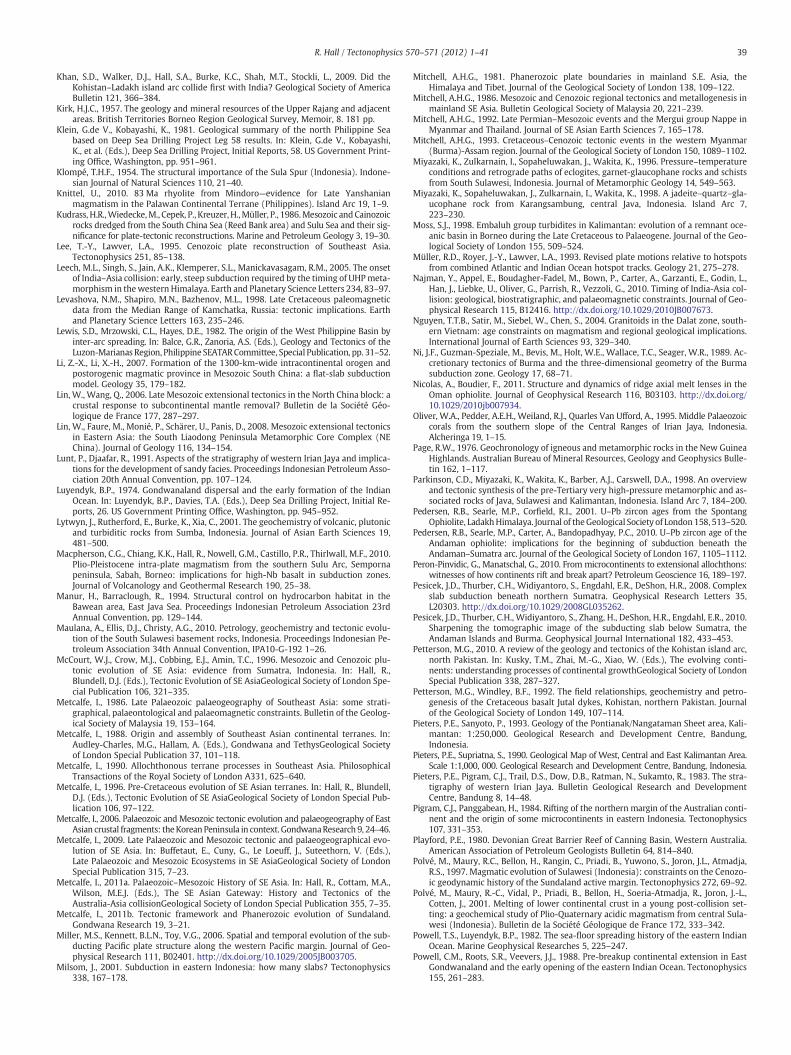
39R. Hall / Tectonophysics 570–571 (2012) 1–41
Khan, S.D., Walker, D.J., Hall, S.A., Burke, K.C., Shah, M.T., Stockli, L., 2009. Did theKohistan–Ladakh island arc collide first with India? Geological Society of AmericaBulletin 121, 366–384.
Kirk, H.J.C., 1957. The geology and mineral resources of the Upper Rajang and adjacentareas. British Territories Borneo Region Geological Survey, Memoir, 8. 181 pp.
Klein, G.de V., Kobayashi, K., 1981. Geological summary of the north Philippine Seabased on Deep Sea Drilling Project Leg 58 results. In: Klein, G.de V., Kobayashi,K., et al. (Eds.), Deep Sea Drilling Project, Initial Reports, 58. US Government Print-ing Office, Washington, pp. 951–961.
Klompé, T.H.F., 1954. The structural importance of the Sula Spur (Indonesia). Indone-sian Journal of Natural Sciences 110, 21–40.
Knittel, U., 2010. 83 Ma rhyolite from Mindoro—evidence for Late Yanshanianmagmatism in the Palawan Continental Terrane (Philippines). Island Arc 19, 1–9.
Kudrass, H.R.,Wiedecke,M., Cepek, P., Kreuzer, H.,Müller, P., 1986.Mesozoic andCainozoicrocks dredged from the South China Sea (Reed Bank area) and Sulu Sea and their sig-nificance for plate-tectonic reconstructions. Marine and Petroleum Geology 3, 19–30.
Lee, T.-Y., Lawver, L.A., 1995. Cenozoic plate reconstruction of Southeast Asia.Tectonophysics 251, 85–138.
Leech, M.L., Singh, S., Jain, A.K., Klemperer, S.L., Manickavasagam, R.M., 2005. The onsetof India–Asia collision: early, steep subduction required by the timing of UHPmeta-morphism in thewestern Himalaya. Earth and Planetary Science Letters 234, 83–97.
Levashova, N.M., Shapiro, M.N., Bazhenov, M.L., 1998. Late Cretaceous paleomagneticdata from the Median Range of Kamchatka, Russia: tectonic implications. Earthand Planetary Science Letters 163, 235–246.
Lewis, S.D., Mrzowski, C.L., Hayes, D.E., 1982. The origin of the West Philippine Basin byinter-arc spreading. In: Balce, G.R., Zanoria, A.S. (Eds.), Geology and Tectonics of theLuzon-Marianas Region, Philippine SEATARCommittee, Special Publication, pp. 31–52.
Li, Z.-X., Li, X.-H., 2007. Formation of the 1300-km-wide intracontinental orogen andpostorogenic magmatic province in Mesozoic South China: a flat-slab subductionmodel. Geology 35, 179–182.
Lin, W., Wang, Q., 2006. Late Mesozoic extensional tectonics in the North China block: acrustal response to subcontinental mantle removal? Bulletin de la Société Géo-logique de France 177, 287–297.
Lin, W., Faure, M., Monié, P., Schärer, U., Panis, D., 2008. Mesozoic extensional tectonicsin Eastern Asia: the South Liaodong Peninsula Metamorphic Core Complex (NEChina). Journal of Geology 116, 134–154.
Lunt, P., Djaafar, R., 1991. Aspects of the stratigraphy of western Irian Jaya and implica-tions for the development of sandy facies. Proceedings Indonesian Petroleum Asso-ciation 20th Annual Convention, pp. 107–124.
Luyendyk, B.P., 1974. Gondwanaland dispersal and the early formation of the IndianOcean. In: Luyendyk, B.P., Davies, T.A. (Eds.), Deep Sea Drilling Project, Initial Re-ports, 26. US Government Printing Office, Washington, pp. 945–952.
Lytwyn, J., Rutherford, E., Burke, K., Xia, C., 2001. The geochemistry of volcanic, plutonicand turbiditic rocks from Sumba, Indonesia. Journal of Asian Earth Sciences 19,481–500.
Macpherson, C.G., Chiang, K.K., Hall, R., Nowell, G.M., Castillo, P.R., Thirlwall, M.F., 2010.Plio-Pleistocene intra-plate magmatism from the southern Sulu Arc, Sempornapeninsula, Sabah, Borneo: implications for high-Nb basalt in subduction zones.Journal of Volcanology and Geothermal Research 190, 25–38.
Manur, H., Barraclough, R., 1994. Structural control on hydrocarbon habitat in theBawean area, East Java Sea. Proceedings Indonesian Petroleum Association 23rdAnnual Convention, pp. 129–144.
Maulana, A., Ellis, D.J., Christy, A.G., 2010. Petrology, geochemistry and tectonic evolu-tion of the South Sulawesi basement rocks, Indonesia. Proceedings Indonesian Pe-troleum Association 34th Annual Convention, IPA10-G-192 1–26.
McCourt, W.J., Crow, M.J., Cobbing, E.J., Amin, T.C., 1996. Mesozoic and Cenozoic plu-tonic evolution of SE Asia: evidence from Sumatra, Indonesia. In: Hall, R.,Blundell, D.J. (Eds.), Tectonic Evolution of SE AsiaGeological Society of London Spe-cial Publication 106, 321–335.
Metcalfe, I., 1986. Late Palaeozoic palaeogeography of Southeast Asia: some strati-graphical, palaeontological and palaeomagnetic constraints. Bulletin of the Geolog-ical Society of Malaysia 19, 153–164.
Metcalfe, I., 1988. Origin and assembly of Southeast Asian continental terranes. In:Audley-Charles, M.G., Hallam, A. (Eds.), Gondwana and TethysGeological Societyof London Special Publication 37, 101–118.
Metcalfe, I., 1990. Allochthonous terrane processes in Southeast Asia. PhilosophicalTransactions of the Royal Society of London A331, 625–640.
Metcalfe, I., 1996. Pre-Cretaceous evolution of SE Asian terranes. In: Hall, R., Blundell,D.J. (Eds.), Tectonic Evolution of SE AsiaGeological Society of London Special Pub-lication 106, 97–122.
Metcalfe, I., 2006. Palaeozoic and Mesozoic tectonic evolution and palaeogeography of EastAsian crustal fragments: theKorean Peninsula in context. GondwanaResearch 9, 24–46.
Metcalfe, I., 2009. Late Palaeozoic and Mesozoic tectonic and palaeogeographical evo-lution of SE Asia. In: Buffetaut, E., Cuny, G., Le Loeuff, J., Suteethorn, V. (Eds.),Late Palaeozoic and Mesozoic Ecosystems in SE AsiaGeological Society of LondonSpecial Publication 315, 7–23.
Metcalfe, I., 2011a. Palaeozoic–Mesozoic History of SE Asia. In: Hall, R., Cottam, M.A.,Wilson, M.E.J. (Eds.), The SE Asian Gateway: History and Tectonics of theAustralia-Asia collisionGeological Society of London Special Publication 355, 7–35.
Metcalfe, I., 2011b. Tectonic framework and Phanerozoic evolution of Sundaland.Gondwana Research 19, 3–21.
Miller, M.S., Kennett, B.L.N., Toy, V.G., 2006. Spatial and temporal evolution of the sub-ducting Pacific plate structure along the western Pacific margin. Journal of Geo-physical Research 111, B02401. http://dx.doi.org/10.1029/2005JB003705.
Milsom, J., 2001. Subduction in eastern Indonesia: how many slabs? Tectonophysics338, 167–178.
Mitchell, A.H.G., 1981. Phanerozoic plate boundaries in mainland S.E. Asia, theHimalaya and Tibet. Journal of the Geological Society of London 138, 109–122.
Mitchell, A.H.G., 1986. Mesozoic and Cenozoic regional tectonics and metallogenesis inmainland SE Asia. Bulletin Geological Society of Malaysia 20, 221–239.
Mitchell, A.H.G., 1992. Late Permian–Mesozoic events and the Mergui group Nappe inMyanmar and Thailand. Journal of SE Asian Earth Sciences 7, 165–178.
Mitchell, A.H.G., 1993. Cretaceous–Cenozoic tectonic events in the western Myanmar(Burma)-Assam region. Journal of the Geological Society of London 150, 1089–1102.
Miyazaki, K., Zulkarnain, I., Sopaheluwakan, J., Wakita, K., 1996. Pressure–temperatureconditions and retrograde paths of eclogites, garnet-glaucophane rocks and schistsfrom South Sulawesi, Indonesia. Journal of Metamorphic Geology 14, 549–563.
Miyazaki, K., Sopaheluwakan, J., Zulkarnain, I., Wakita, K., 1998. A jadeite–quartz–gla-ucophane rock from Karangsambung, central Java, Indonesia. Island Arc 7,223–230.
Moss, S.J., 1998. Embaluh group turbidites in Kalimantan: evolution of a remnant oce-anic basin in Borneo during the Late Cretaceous to Palaeogene. Journal of the Geo-logical Society of London 155, 509–524.
Müller, R.D., Royer, J.-Y., Lawver, L.A., 1993. Revised plate motions relative to hotspotsfrom combined Atlantic and Indian Ocean hotspot tracks. Geology 21, 275–278.
Najman, Y., Appel, E., Boudagher-Fadel, M., Bown, P., Carter, A., Garzanti, E., Godin, L.,Han, J., Liebke, U., Oliver, G., Parrish, R., Vezzoli, G., 2010. Timing of India-Asia col-lision: geological, biostratigraphic, and palaeomagnetic constraints. Journal of Geo-physical Research 115, B12416. http://dx.doi.org/10.1029/2010JB007673.
Nguyen, T.T.B., Satir, M., Siebel, W., Chen, S., 2004. Granitoids in the Dalat zone, south-ern Vietnam: age constraints on magmatism and regional geological implications.International Journal of Earth Sciences 93, 329–340.
Ni, J.F., Guzman-Speziale, M., Bevis, M., Holt, W.E., Wallace, T.C., Seager, W.R., 1989. Ac-cretionary tectonics of Burma and the three-dimensional geometry of the Burmasubduction zone. Geology 17, 68–71.
Nicolas, A., Boudier, F., 2011. Structure and dynamics of ridge axial melt lenses in theOman ophiolite. Journal of Geophysical Research 116, B03103. http://dx.doi.org/10.1029/2010jb007934.
Oliver, W.A., Pedder, A.E.H., Weiland, R.J., Quarles Van Ufford, A., 1995. Middle Palaeozoiccorals from the southern slope of the Central Ranges of Irian Jaya, Indonesia.Alcheringa 19, 1–15.
Page, R.W., 1976. Geochronology of igneous and metamorphic rocks in the New GuineaHighlands. Australian Bureau of Mineral Resources, Geology and Geophysics Bulle-tin 162, 1–117.
Parkinson, C.D., Miyazaki, K., Wakita, K., Barber, A.J., Carswell, D.A., 1998. An overviewand tectonic synthesis of the pre-Tertiary very high-pressure metamorphic and as-sociated rocks of Java, Sulawesi and Kalimantan, Indonesia. Island Arc 7, 184–200.
Pedersen, R.B., Searle, M.P., Corfield, R.I., 2001. U–Pb zircon ages from the SpontangOphiolite, LadakhHimalaya. Journal of theGeological Society of London158, 513–520.
Pedersen, R.B., Searle, M.P., Carter, A., Bandopadhyay, P.C., 2010. U–Pb zircon age of theAndaman ophiolite: implications for the beginning of subduction beneath theAndaman–Sumatra arc. Journal of the Geological Society of London 167, 1105–1112.
Peron-Pinvidic, G., Manatschal, G., 2010. From microcontinents to extensional allochthons:witnesses of how continents rift and break apart? Petroleum Geoscience 16, 189–197.
Pesicek, J.D., Thurber, C.H., Widiyantoro, S., Engdahl, E.R., DeShon, H.R., 2008. Complexslab subduction beneath northern Sumatra. Geophysical Research Letters 35,L20303. http://dx.doi.org/10.1029/2008GL035262.
Pesicek, J.D., Thurber, C.H., Widiyantoro, S., Zhang, H., DeShon, H.R., Engdahl, E.R., 2010.Sharpening the tomographic image of the subducting slab below Sumatra, theAndaman Islands and Burma. Geophysical Journal International 182, 433–453.
Petterson, M.G., 2010. A review of the geology and tectonics of the Kohistan island arc,north Pakistan. In: Kusky, T.M., Zhai, M.-G., Xiao, W. (Eds.), The evolving conti-nents: understanding processes of continental growthGeological Society of LondonSpecial Publication 338, 287–327.
Petterson, M.G., Windley, B.F., 1992. The field relationships, geochemistry and petro-genesis of the Cretaceous basalt Jutal dykes, Kohistan, northern Pakistan. Journalof the Geological Society of London 149, 107–114.
Pieters, P.E., Sanyoto, P., 1993. Geology of the Pontianak/Nangataman Sheet area, Kali-mantan: 1:250,000. Geological Research and Development Centre, Bandung,Indonesia.
Pieters, P.E., Supriatna, S., 1990. Geological Map of West, Central and East Kalimantan Area.Scale 1:1,000, 000. Geological Research and Development Centre, Bandung, Indonesia.
Pieters, P.E., Pigram, C.J., Trail, D.S., Dow, D.B., Ratman, N., Sukamto, R., 1983. The stra-tigraphy of western Irian Jaya. Bulletin Geological Research and DevelopmentCentre, Bandung 8, 14–48.
Pigram, C.J., Panggabean, H., 1984. Rifting of the northern margin of the Australian conti-nent and the origin of some microcontinents in eastern Indonesia. Tectonophysics107, 331–353.
Playford, P.E., 1980. Devonian Great Barrier Reef of Canning Basin, Western Australia.American Association of Petroleum Geologists Bulletin 64, 814–840.
Polvé, M., Maury, R.C., Bellon, H., Rangin, C., Priadi, B., Yuwono, S., Joron, J.L., Atmadja,R.S., 1997. Magmatic evolution of Sulawesi (Indonesia): constraints on the Cenozo-ic geodynamic history of the Sundaland active margin. Tectonophysics 272, 69–92.
Polvé, M., Maury, R.-C., Vidal, P., Priadi, B., Bellon, H., Soeria-Atmadja, R., Joron, J.-L.,Cotten, J., 2001. Melting of lower continental crust in a young post-collision set-ting: a geochemical study of Plio-Quaternary acidic magmatism from central Sula-wesi (Indonesia). Bulletin de la Société Géologique de France 172, 333–342.
Powell, T.S., Luyendyk, B.P., 1982. The sea-floor spreading history of the eastern IndianOcean. Marine Geophysical Researches 5, 225–247.
Powell, C.M., Roots, S.R., Veevers, J.J., 1988. Pre-breakup continental extension in EastGondwanaland and the early opening of the eastern Indian Ocean. Tectonophysics155, 261–283.

40 R. Hall / Tectonophysics 570–571 (2012) 1–41
Priadi, B., Polve, M., Maury, R., Soeria-Atmadja, R., Bellon, H., 1993. Geodynamic impli-cations of Neogene potassic calc alkaline magmatism in central of Sulawesi: geo-chemical and isotopic constraints. Proceedings of the 22nd Annual Convention ofthe Indonesian Association of Geologists (IAGI), pp. 59–81.
Priadi, B., Polve, M., Maury, R.C., Bellon, H., Soeria-Atmadia, R., Joron, J.L., Cotten, J.,1994. Tertiary and Quaternary magmatism in Central Sulawesi: chronologicaland petrological constraints. Journal of Southeast Asian Earth Sciences 9, 81–93.
Pulunggono, A., Cameron, N.R., 1984. Sumatran microplates, their characteristics andtheir role in the evolution of the Central and South Sumatra Basins. Proceedings In-donesian Petroleum Association 13th Annual Convention, pp. 121–144.
Queano, K.L., Ali, J.R., Milsom, J., Aitchison, J.C., Pubellier, M., 2007. North Luzon and thePhilippine Sea Plate motion model: insights following paleomagnetic, structural,and age-dating investigations. Journal of Geophysical Research 112, B05101.http://dx.doi.org/10.1029/2006JB004506.
Replumaz, A., Tapponnier, P., 2003. Reconstruction of the deformed collision zone be-tween India and Asia by backward motion of lithospheric blocks. Journal of Geo-physical Research 108. http://dx.doi.org/10.1029/2001 JB000661.
Replumaz, A., Karason, H., van der Hilst, R.D., Besse, J., Tapponnier, P., 2004. 4-D evolu-tion of SE Asia's mantle from geological reconstructions and seismic tomography.Earth and Planetary Science Letters 221, 103–115.
Richards, S., Lister, G., Kennett, B., 2007. A slab in depth: three-dimensional geometryand evolution of the Indo-Australian plate. Geochemistry, Geophysics, Geosystems8. http://dx.doi.org/10.1029/2007GC001657.
Ricou, L.E., 1994. Tethys reconstructed— plates, continental fragments and theirboundaries since 260 Ma from Central America to Southeastern Asia. GeodinamicaActa 7, 169–218.
Robb, M.S., Taylor, B., Goodliffe, A.M., 2005. Re-examination of the magnetic lineationsof the Gascoyne and Cuvier Abyssal Plains, off NW Australia. Geophysical JournalInternational 163, 42–55.
Roggeveen, P.M., 1929. Jurassic in the island of Sumba. Proceedings KoninklijkeNederlandse Akademie van Wetenschappen, Amsterdam 32, 512–514.
Rowley, D.B., 1996. Age of initiation of collision between India and Asia: a review ofstratigraphic data. Earth and Planetary Science Letters 145, 1–13.
Royer, J.-Y., Sandwell, D.T., 1989. Evolution of the eastern Indian Ocean since the LateCretaceous; constraints from Geosat altimetry. Journal of Geophysical Research94, 13755–13782.
Rutten, M.G., 1940. On Devonian limestones with Clathrodictyon cf. spatiosum andHeliolites porosus from eastern Borneo. Proceedings Koninklijke NederlandseAkademie van Wetenschappen. Amsterdam 43, 1061–1064.
Samuel, M.A., Harbury, N.A., Bakri, A., Banner, F.T., Hartono, L., 1997. A new stratigraphyfor the islands of the Sumatran Forearc, Indonesia. Journal of Asian Earth Sciences15, 339–380.
Sandwell, D.T., Smith, W.H.F., 2009. Global marine gravity from retracked Geosat andERS-1 altimetry: ridge segmentation versus spreading rate. Journal of GeophysicalResearch 114, B01411. http://dx.doi.org/10.1029/2008JB006008.
Satyabala, S.P., 1998. Subduction in the Indo-Burma region: is it still active? Geophys-ical Research Letters 25, 3189–3192.
Satyabala, S.P., 2000. Reply to comment on “Subduction in the Indo-Burma region: is itstill active?” by S. Satyabala. Geophysical Research Letters 27, 1067–1068.
Satyana, A.H., Silitonga, P.D., 1994. Tectonic reversal in East Barito Basin, SouthKalimantan: consideration of the types of inversion structures and petroleum sig-nificance. Proceedings Indonesian Petroleum Association 23rd Annual Convention,pp. 57–74.
Schiller, D.M., Garrad, R.A., Prasetyo, L., 1991. Eocene submarine fan sedimentation insouthwest Java. Proceedings Indonesian Petroleum Association 20th Annual Con-vention, pp. 125–182.
Schöffel, H.J., Das, S., 1999. Fine details of the Wadati-Benioff zone under Indonesia andits geodynamic implications. Journal of Geophysical Research 104, 13101–13114.
Scotney, P.M., Roberts, S., Herrington, R.J., Boyce, A.J., Burgess, R., 2005. The develop-ment of volcanic hosted massive sulfide and barite gold orebodies onWetar Island,Indonesia. Mineralium Deposita 40, 76–99.
Sengör, A.M.C., 1987. Tectonics of the Tethysides: orogenic collage development in acollisional setting. Annual Reviews of Earth and Planetary Sciences 15, 213–244.
Setiawan, B., Le Bel, L.M., 1987. Discovery of a new tin province, Long Laai area, eastKalimantan, Indonesia. In: Hutchison, C.S. (Ed.), Exploration and evaluation tech-niques for Tin/Tungsten granites in Southeast Asia and the western Pacific region.Proceedings of IGCP Project 220 Meeting, September 1986, SEATRAD Centre, Ipoh,Malaysia, pp. 61–82.
Sevastjanova, I., Clements, B., Hall, R., Belousova, E.A., Griffin, W.L., Pearson, N., 2011.Granitic magmatism, basement ages, and provenance indicators in the MalayPeninsula: insights from detrital zircon U–Pb and Hf-isotope data. Gondwana Re-search 19, 1024–1039.
Sewell, R.J., Campbell, S.D.G., Fletcher, C.J.N., Lai, K.W., Kirk, P.A., 2000. The Pre-Quaternary Geology of Hong Kong. Hong Kong Geological Survey, Geological Mem-oir. 181 pp.
Shreider, A.A., Stenszinski, S.B., Lygin, V.A., 1996. Chronology of the bottom of theWharton Basin. Physcis of the Solid Earth 31, 864–869.
Sikumbang, N., 1986. Geology and tectonics of Pre-Tertiary rocks in the Meratus Moun-tains, South-East Kalimantan, Indonesia. PhD Thesis, University of London 401 pp.
Sikumbang, N., 1990. The Geology and tectonics of the Meratus Mountains, SouthKalimantan, Indonesia. Geologi Indonesia. Journal of the Indonesian Associationof Geologists 13, 1–31.
Smith, A.G., 2006. Tethyan ophiolite emplacement, Africa to Europe motions, and At-lantic spreading. In: Robertson, A.H.F., Mountrakis, D. (Eds.), Tectonic Develop-ment of the Eastern Mediterranean RegionGeological Society of London SpecialPublication 260, 11–34.
Smith, C.B., Bulanova, G.P., Kohn, S.C., Milledge, J., Hall, A.E., Griffin, B.J., Pearson, G.,2009. Nature and genesis of Kalimantan diamonds. Lithos 112S, 822–832.
Smyth, H.R., 2005. Eocene to Miocene basin history and volcanic history in East Java,Indonesia. PhD Thesis, University of London, 476 pp.
Smyth, H.R., Hamilton, P.J., Hall, R., Kinny, P.D., 2007. The deep crust beneath islandarcs: inherited zircons reveal a Gondwana continental fragment beneath EastJava, Indonesia. Earth and Planetary Science Letters 258, 269–282.
Smyth, H.R., Hall, R., Nichols, G.J., 2008. Early Cenozoic volcanic arc history of East Java,Indonesia: the stratigraphic record of eruptions on a continental margin in a trop-ical setting. In: Draut, A.E., Clift, P.D., Scholl, D.W. (Eds.), Formation and Applica-tions of the Sedimentary Record in Arc Collision ZonesGeological Society AmericaSpecial Publication 436, 199–222.
Sone, M., Metcalfe, I., 2008. Parallel Tethyan sutures in mainland Southeast Asia: newinsights for Palaeo-Tethys closure and implications for the Indosinian orogeny.Comptes Rendus Geosciences 340, 166–179.
Spakman, W., Hall, R., 2010. Surface deformation and slab–mantle interaction duringBanda Arc subduction rollback. Nature Geoscience 3, 562–566. http://dx.doi.org/10.1038/ngeo917.
Spencer, J.E., 2010. Structural analysis of three extensional detachment faults with datafrom the 2000 Space-Shuttle Radar Topography Mission. GSA Today 20, 4–10.http://dx.doi.org/10.1130/GSATG59A.
Spencer, J.E., 2011. Gently dipping normal faults identified with Space Shuttle radar to-pography data in central Sulawesi, Indonesia, and some implications for fault me-chanics. Earth and Planetary Science Letters 308, 267–276.
Stille, H., 1945. Die tektonische Entwicklung der hinterindischen Festlands- undInselgebiete. In: Stille, H., Lotze, F. (Eds.), Die tektonische Entwicklung derpazifischen Randgebiete IIGeotektonische Forschungen 7/8, 34–153.
Sugiaman, F., Andria, L., 1999. Devonian carbonate of Telen River, East Kalimantan.Berita Sedimentologi 10, 18–19.
Sukamto, R., 1975a. The structure of Sulawesi in the light of plate tectonics. RegionalConference on the Geology and Mineral Resources of Southeast Asia, Jakarta, 4–7August 1975, pp. 121–141.
Sukamto, R., 1975a. Geological map of Indonesia, Ujung Pandang 1:1,000,000. Geolog-ical Survey of Indonesia, Directorate of Mineral Resources, Geological Research andDevelopment Centre, Bandung, Indonesia.
Sukamto, R., Supriatna, S., 1982. The geology of the Ujung Pandang, Benteng and Sinjaiquadrangles, Sulawesi 1:250, 000, Geological Research and Development Centre,Bandung, Indonesia, pp. 20.
Sukamto, R., Westermann, G.E.G., 1993. Indonesia and Papua New Guinea. In:Westermann, G.E.G. (Ed.), The Jurassic of the Circum-Pacific. Cambridge UniversityPress, pp. 181–193.
Sukamto, R., Setyogroho, B., Atmawinata, S., Aziz, S., Jamal, B., Suharsono, Mangga, S.A.,1990. The Jurassic rocks in Indonesia. Bulletin Geological Research and Develop-ment Centre Bandung Indonesia 14, 1–16.
Sutriyono, E., 1999. Structure and Thermochronology of the Bird's Head of Irian Jaya,Indonesia. PhD Thesis, La Trobe University, Australia, 321 pp.
Tan, D.N.K., 1979. Lupar Valley, west Sarawak. Geological Survey of Malaysia, Report 13.Tan, D.N.K., 1982. Lubok Antu Melange, Lupar Valley, West Sarawak: a Lower Tertiary
subduction complex. Bulletin of the Geological Society of Malaysia 15, 31–46.Tan, D.N.K., Lamy, J.M., 1990. Tectonic evolution of the NW Sabah continental margin
since the Late Eocene. Bulletin of the Geological Society of Malaysia 27, 241–260.Tate, R.B., 1991. Cross-border correlation of geological formations in Sarawak and Kali-
mantan. Bulletin of the Geological Society of Malaysia 28, 63–96.Taylor, B., Hayes, D.E., 1983. Origin and history of the South China Sea Basin. In: Hayes, D.E.
(Ed.), The Tectonic and Geologic Evolution of Southeast Asian Seas and Islands, Part 2.: Geophysical Monograph Series, 27. American Geophysical Union, pp. 23–56.
Taylor, W.R., Jaques, A.L., Ridd, M., 1990. Nitrogen-defect aggregation characteristics ofsome Australasian diamonds: time–temperature constraints on the source regionsof pipe and alluvial diamonds. American Mineralogist 75, 1290–1310.
Thorkelson, D.J., 1996. Subduction of diverging plates and the principles of slab win-dow formation. Tectonophysics 255, 47–63.
Thorkelson, D.J., Taylor, R.P., 1989. Cordilleran slab windows. Geology 17, 833–836.Thuy, N.T.B., Satir, M., Siebel, W., Venneman, T., Long, T.V., 2004. Geochemical and iso-
topic constraints on the petrogenesis of granitoids from the Dalat zone, southernVietnam. Journal of Asian Earth Sciences 23, 467–482.
Tokuyama, H., 1985. Dredged igneous rocks from the Amami Plateau. In: Shiki, T. (Ed.),Geology of the Northern Philippine Sea. Tokai University Press, pp. 50–56.
van Bemmelen, R.W., 1949. The Geology of Indonesia. Government Printing Office,Nijhoff, The Hague. 732 pp.
van der Voo, R., Spakman, W., Bijwaard, H., 1999. Tethyan subducted slabs under India.Earth and Planetary Science Letters 171, 7–20.
van Hinsbergen, D.J.J., Kapp, P., Dupont-Nivet, G., Lippert, P.C., DeCelles, P.G., Torsvik,T.H., 2011a. Restoration of Cenozoic deformation in Asia and the size of GreaterIndia. Tectonics 30, TC5003. http://dx.doi.org/10.1029/2011TC002908.
van Hinsbergen, D.J.J., Steinberger, B., Doubrovine, P.V., Gassmöller, R., 2011b. Acceler-ation and deceleration of India–Asia convergence since the Cretaceous: roles ofmantle plumes and continental collision. Journal of Geophysical Research 116,B06101. http://dx.doi.org/10.1029/2010jb008051.
van Leeuwen, T.M., 1981. The geology of southwest Sulawesi with special reference tothe Biru area. In: Barber, A.J., Wiryosujono, S. (Eds.), The Geology and Tectonics ofEastern Indonesia: Geological Research and Development Centre, Bandung, SpecialPublication, 2, pp. 277–304.
van Leeuwen, T., Muhardjo, 2005. Stratigraphy and tectonic setting of the Cretaceousand Paleogene volcanic-sedimentary successions in northwest Sulawesi, Indone-sia: implications for the Cenozoic evolution of Western and Northern Sulawesi.Journal of Asian Earth Sciences 25, 481–511.
41R. Hall / Tectonophysics 570–571 (2012) 1–41
van Leeuwen, T.M., Allen, C.M., Kadarusman, A., Elburg, M., Michael Palin, J., Muhardjo,Suwijanto, 2007. Petrologic, isotopic, and radiometric age constraints on the originand tectonic history of the Malino Metamorphic Complex, NW Sulawesi, Indonesia.Journal of Asian Earth Sciences 29, 751–777.
Veevers, J.J., 1988. Morphotectonics of Australia's northwestern margin—a review. In:Purcell, P.G., Purcell, R.R. (Eds.), The North West Shelf Proceedings of PetroleumExploration Society of Australia Symposium. PESA, Perth, WA, pp. 19–27.
Veevers, J.J., Powell, C.M., Johnson, B.D., 1975. Greater India's place in Gondwanalandand in Asia. Earth and Planetary Science Letters 27, 383–387.
Visser, W.A., Hermes, J.J., 1962. Geological results of the exploration for oil in Nether-lands New Guinea. Verhandelingen Koninklijk Nederlands Geologisch enMijnbouwkundig Genootschap, Geologische Serie 20, 1–265.
Wajzer, M.R., Barber, A.J., Hidayat, S., Suharsono, 1991. Accretion, collision and strike-slip faulting: the Woyla Group as a key to the tectonic evolution of North Sumatra.Journal of Southeast Asian Earth Sciences 6, 447–461.
Wakita, K., 2000. Cretaceous accretionary–collision complexes in central Indonesia.Journal of Asian Earth Sciences 18, 739–749.
Wakita, K., Metcalfe, I., 2005. Ocean plate stratigraphy in East and Southeast Asia. Jour-nal of Asian Earth Sciences 24, 679–702.
Wakita, K., Munasari, S.J., Zulkarnain, I., Miyazaki, K., 1994a. Early Cretaceous tectonicevents implied in the time-lag between age of radiolarian chert and its metamor-phic basement in the Bantimala area, South Sulawesi, Indonesia. The Island Arc 3,90–102.
Wakita, K., Munasri, Widoyoko, B., 1994b. Cretaceous radiolarians from the Luk-UloMelange Complex in the Karangsambung area, Central Java, Indonesia. Journal ofSoutheast Asian Earth Sciences 9, 29–43.
Wakita, K., Sopaheluwakan, J., Miyazaki, K., Zulkarnain, I., Munasri, 1996. Tectonic evo-lution of the Bantimala Complex, South Sulawesi, Indonesia. In: Hall, R., Blundell,D.J. (Eds.), Tectonic evolution of SE AsiaGeological Society of London Special Publi-cation 106, 353–364.
Wakita, K., Miyazaki, K., Zulkarnain, I., Sopaheluwakan, J., Sanyoto, P., 1998. Tectonicimplications of new age data for the Meratus complex of south Kalimantan, Indo-nesia. Island Arc 7, 202–222.
Watkinson, I., Elders, C., Hall, R., 2008. The kinematic history of the Khlong Marui andRanong Faults, southern Thailand. Journal of Structural Geology 30, 1554–1571.
Watkinson, I., Elders, C., Batt, G., Jourdan, F., Hall, R., McNaughton, N.J., 2011a. Thetiming of strike-slip shear along the Ranong and Khlong Marui faults, Thailand.Journal of Geophysical Research 116, B09403. http://dx.doi.org/10.1029/2011jb008379.
Watkinson, I.M., Hall, R., Ferdian, F., 2011b. Tectonic re-interpretation of theBanggai-Sula–Molucca Sea margin, Indonesia. In: Hall, R., Cottam, M.A.,Wilson, M.E.J. (Eds.), The SE Asian Gateway: History and Tectonics of the
Australia-Asia collisionGeological Society of London Special Publication 355,203–224.
Wensink, H., 1994. Paleomagnetism of rocks from Sumba: tectonic implications sincethe Late Cretaceous. Journal of Southeast Asian Earth Sciences 9, 51–65.
Whittaker, J.M., Müller, R.D., Sdrolias, M., Heine, C., 2007. Sunda-Java trench kinemat-ics, slab window formation and overriding plate deformation since the Cretaceous.Earth and Planetary Science Letters 255, 445–457.
Williams, P.R., Johnston, C.R., Almond, R.A., Simamora, W.H., 1988. Late Cretaceous toEarly Tertiary structural elements of West Kalimantan. Tectonophysics 148,279–298.
Witts, D., Hall, R., Morley, R.J., BouDagher-Fadel, M.K., 2011. Stratigraphy and sedimentprovenance, Barito basin, Southeast Kalimantan. Proceedings Indonesian Petro-leum Association 35th Annual Convention, IPA11-G-054 1–18.
Wolfenden, E.B., 1960. The Geology and Mineral Resources of the Lower Rajang Valleyand Adjoining Areas, Sarawak. British Territories Borneo Region Geological SurveyDepartment, Memoir, 11. 167 pp.
Wood, R., 2000. Palaeoecology of a Late Devonian back reef: Canning Basin, WesternAustralia. Palaeontology 43, 671–703.
Yang, J.-H., Wu, F.-Y., Chung, S.-L., Lo, C.-H., Wilde, S.A., Davis, G.A., 2007. Rapid exhu-mation and cooling of the Liaonan metamorphic core complex: inferences from40Ar/39Ar thermochronology and implications for Late Mesozoic extension in theeastern North China Craton. Bulletin of the Geological Society of America 119,1405–1414.
Yumul, G.P., Dimalanta, C.B., Tamayo, R.A., Zhou, M.F., 2006. Geology and geochemistryof the Rapu-Rapu Ophiolite Complex, Eastern Philippines: possible fragment of theProto-Philippine Sea Plate. International Geology Review 48, 329–348.
Yumul, G.P., Dimalanta, C.B., Maglambayan, V.B., Marquez, E.J., 2008. Tectonic setting ofa composite terrane: a review of the Philippine island arc system. GeosciencesJournal 12, 7–17.
Yumul, G.P., Dimalanta, C.B., Marquez, E.J., Queaño, K.L., 2009. Onland signatures of thePalawan microcontinental block and Philippine mobile belt collision and crustalgrowth process: a review. Journal of Asian Earth Sciences 34, 610–623.
Yuwono, Y.S., Bellon, H., Maury, R.C., Soeria-Atmadja, R., 1988a. Tertiary and Quaterna-ry geodynamic evolution of S Sulawesi: constraints from the study of volcanicunits. Geologi Indonesia 13, 32–48.
Yuwono, Y.S., Priyomarsono, S., Maury, R.C., Rampnoux, J.P., Soeria, A.R., Bellon, H.,Chotin, P., 1988b. Petrology of the Cretaceous magmatic rocks from MeratusRange, Southeast Kalimantan. Journal of Southeast Asian Earth Sciences 2, 15–22.
Zhou, D., Sun, Z., Chen, H., Xu, H., Wang, W., Pang, X., Cai, D., Hu, D., 2008. Mesozoic pa-leogeography and tectonic evolution of South China Sea and adjacent areas in thecontext of Tethyan and Paleo-Pacific interconnections. Island Arc 17, 186–207.