Gunung Stong State Forest Park: A...
17
Gunung Stong State Forest Park: A Guidebook
Transcript of Gunung Stong State Forest Park: A...

Gunung Stong State Forest Park:
A GuidebookGuidebook to Gunung Stong State Forest Park
The Gunung Stong State Forest Park (GSSFP), with her cascading waterfalls, mountain streams and pools, and the different habitat types, attracts visitors.
However, the visitors are more interested in the outdoor recreational activities, and are not aware of what GSSFP has to offer, especially her rich natural
resources. This guide is meant to initiate the reader with in-depth information about GSSFP, so that after a visit, the visitor will become more knowledgeable about what nature has to offer here, and make return visits, as GSSFP cannot
be savoured within one visit.
This GSSFP guide starts with a general background on the history of Kelantan state, to introduce the reader to the state, followed by a general history of GSSFP, with a timeline on its development into a state park. Access into GSSFP is then described, for readers to choose on the mode of travel, the
distances, and the estimated travel costs incurred.
This guide provides a brief description on the biodiversity of wildlife, and plants (especially the rare and endemic species) and their locations, with photos
for easy identification. As this guide is for the layman who is interested in nature, a full species checklist is not provided, but certain species are
highlighted. General geological background is then provided, followed by description of trails and summits to be attempted by the interested hiker,
especially those attempting to venture deeper into GSSFP.
Finally, there is also a list of accommodations offered at GSSFP and Dabong, with a list of prices, and the operators involved in providing guiding services and packages. This is for the visitors who are more interested to visit GSSFP
on guided packages. The latter part of the guide book is for other activities and places of interest in the areas surrounding GSSFP.
The Gunung Stong State Forest Park was formerly the Gunung Stong Tengah Forest Reserve,and lies in central Kelantan. Managed by the Kelantan State Forestry Department, it covers an area of 21,950 ha, and is surrounded by the Basor Forest Reserve (40,790ha), the Gunung Stong Utara Forest Reserve (11,044ha), Gunung Stong Selatan Forest Reserve (28,134ha), Balah Forest Reserve (56,010ha), and the Berangkat Forest Reserve (21,409ha). GSSFP and this group of forest reserves account for 157,087ha of forests.
The importance of GSSFP is its position as a corridor that links large blocks of forests in the east coast of the peninsula to the Main Range, and there on, to the Royal Belum State Park and the forests on the southern Thai side, such as the Hala Bala Wildlife Sanctuary and the Bang Lang National Park.
GSSFP is popular with visitors, who have been hiking to the mountains since the early 90s, and is on the map of Malaysian and Singaporean outdoor recreation enthusiasts. With an estimated 10,000 visitors for the past few years, it is an improvement over a decline in 1997-2003, due to the economic crisis, the SARS epidemic, and the terrorism scares after September 11. GSSFP has been identified as one of the top five ecotourism destinations by the Ministry of Tourism in Malaysia, and visitor numbers are expected to rise with the increase in promotions. In fact, in terms of visitor numbers, GSSFP is more popular than some other state parks.
Introduction
Jelawang waterfall WWF- Malaysia / N.M. Maseri
Contents
Guidebook to Gunung Stong State Forest Park
Introduction
History
Geology
Habitats
Biodiversity
Birds
Plants
Culture
Tourism
Trails & Summit
Other Activities
GSSFP Entry fees
Directions to GSSFP
Conclusion
1
2 - 4
5
6 - 7
8
9
10
11
12
13 - 18
19 - 20
21
22
23
Acknowledgements
This guidebook is part of project MY02740G
(Capacity-building of Local Community), which is an
extension of project MY02040G (Preparation of Preliminary
Management Plan of Gunung Stong State Forest Park),
funded by the generous contribution of the Malaysian public.
This guidebook is also made possible, by the support of the
Kelantan State Government, in having the vision of having a
state park,the Technical Committee (consisting of the State
Economic Development Corporation (UPEN), Kelantan
Forestry Department, Department of Wildlife and National
Parks (DWNP), Geological Department, KESEDAR (South
Kelantan Development Corporation), Majlis Daerah Dabong,
Jabatan Pengairan dan Saliran Kelantan, Universiti Malaysia
Trengganu, the Malaysian Nature Society (MNS), and World
Wide Fund for Nature, Malaysia (WWF-Malaysia)), in
translating this vision into a reality.
We are also indebted to Donovan Louis in contributing to the
layout, Dionysius S. K. Sharma, Surin Suksuwan, and
Ferdinand Pereira who provided suggestions on the draft
text.
Gunung Stong State Forest Park:
A GuidebookFront cover photo : A view of the mountains over Gunung Stong State Forest Park.
Text : N.M.Maseri Editor : Dionysius S. K. Sharma Surin Suksuwan Ferdinand Pereira Layout : Donovan Louis Publication date : 2009 ISBN : 978-983-99601-9-8
Copyright © 2009 WWF-MalaysiaNo part of this publication may be reproduced, stored in a retrieval system or transmitted in any form without priorpermission of the publisher, bona fide education and research use excepted.
Printed by:Sasyaz Holdings Sdn. Bhd.29, Jalan PJU3/48,Sunway Damansara Technology Park47810, Petaling JayaMalaysia
Printed on 100% Recycled Paper
This booklet was funded and produced as part of WWF-Malaysia’s project titled ‘Strengthening the Protected Areas System of Peninsular Malaysia’.

The Gunung Stong State Forest Park was formerly the Gunung Stong Tengah Forest Reserve,and lies in central Kelantan. Managed by the Kelantan State Forestry Department, it covers an area of 21,950 ha, and is surrounded by the Basor Forest Reserve (40,790ha), the Gunung Stong Utara Forest Reserve (11,044ha), Gunung Stong Selatan Forest Reserve (28,134ha), Balah Forest Reserve (56,010ha), and the Berangkat Forest Reserve (21,409ha). GSSFP and this group of forest reserves account for 157,087ha of forests.
The importance of GSSFP is its position as a corridor that links large blocks of forests in the east coast of the peninsula to the Main Range, and there on, to the Royal Belum State Park and the forests on the southern Thai side, such as the Hala Bala Wildlife Sanctuary and the Bang Lang National Park.
GSSFP is popular with visitors, who have been hiking to the mountains since the early 90s, and is on the map of Malaysian and Singaporean outdoor recreation enthusiasts. With an estimated 10,000 visitors for the past few years, it is an improvement over a decline in 1997-2003, due to the economic crisis, the SARS epidemic, and the terrorism scares after September 11. GSSFP has been identified as one of the top five ecotourism destinations by the Ministry of Tourism in Malaysia, and visitor numbers are expected to rise with the increase in promotions. In fact, in terms of visitor numbers, GSSFP is more popular than some other state parks.
Introduction
Jelawang waterfall WWF- Malaysia / N.M. Maseri
Contents
Guidebook to Gunung Stong State Forest Park
Introduction
History
Geology
Habitats
Biodiversity
Birds
Plants
Culture
Tourism
Trails & Summit
Other Activities
GSSFP Entry fees
Directions to GSSFP
Conclusion
1
2 - 4
5
6 - 7
8
9
10
11
12
13 - 18
19 - 20
21
22
23
Jedok
Bachok
Machang
Kuala Krai
Jeli
Pasir Putih
Gunung Stong State Forest Park
SOUTHCHINA SEA
THAILAND
KELANTAN
TERENGGANU
PERAK
PAHANG
Tanah Merah
RAILWAYROADS
GUNUNG STONG STATE FOREST PARK AREA
RIVER
FOREST COVER
5 10 15 20 KM
Kota BahruMeranti
Pengkalan Chepa
Tumpat
Dabong
BertamBaharu
Rantau Panjang
Gua Musang
Manek Urai
Pasir Mas
PengkalanKubur
Sg. Kelantan
Sg. Golok
Sg. Pergau
Sg. Nenggiri
General History of Kelantan
History
Before Melaka (circa 1400 CE), the history of Kelantan is obscure. In early history, Kelantan was known as Medang, Kalatana, Sampugita, Raktamrittika, among others. Possibly it was part of the Kingdom of Langkasuka (circa 100-1400 CE), then subservient to Palembang-based Srivijaya (circa 700-1300 CE), and in various parts of its history, also under the influence of the ancient indianised kingdoms of Funan (circa 100-627 CE), Chenla, Sukhotai, Ayutthaya, and Pattani. Travelers from Han and Tang China noted a thriving population in the fertile floodplains of the Sg. Kelantan, or Ho-lo-Tan, (the name known to them). Kelantan was then, already known as a stopover in the Middle-Eastern Indian-IndoChina-China trade route.
The rise of Melaka in the 15th Century, led to the assimilation of Melakan laws and court culture (which was the inheritor of Sriwijayan codes, laws, and culture) due to conquest and the resulting intermarriages between the Melakan and Kelantanese aristocracies.
In the 16th century, the fall of Melaka to the Portuguese, and her decline meant that Kelantan’s fortune, like Pattani, was tied to Siam, which was then expanding southwards. It was probably during this period that, as a token of allegiance, Kelantan had to pay a tri-annual tribute to Siam. It was also during this period that the history of Kelantan became more distinct, with the appearances of the semi-mythical Cik Siti Wan Kembang and Putri Saadong, two female rulers of the state.
The present Kelantan Royal House is derived from Long Yunus, one of the princes who managed to subdue his other rivals in the 19th century. This is a period of civil war, when the state was divided into several feudal lords, and an unstable period, when warring claimants fought their rivals, with interference of fighters from other states. This was also the period of increasing British intervention in the Malay Peninsula, and with their system of indirect rule (through British advisors), introducing British systems of administration and rule of law. For Kelantan, this happened after 1909, when Siam ceded her formal claim over Kelantan to the British, during the Treaty of Bangkok, where the Sphere of Influence between Great Britain and Siam was firmly established.
Except for a brief hiatus during the World War II, when the Japanese returned Kelantan back to Siam, Kelantan was part of the Unfederated Malay States, and joined the Federation of Malaya in 1948, (which, by the inclusion of Sabah and Sarawak, became Malaysia in 1963).
1

Jedok
Bachok
Machang
Kuala Krai
Jeli
Pasir Putih
Gunung Stong State Forest Park
SOUTHCHINA SEA
THAILAND
KELANTAN
TERENGGANU
PERAK
PAHANG
Tanah Merah
RAILWAYROADS
GUNUNG STONG STATE FOREST PARK AREA
RIVER
FOREST COVER
5 10 15 20 KM
Kota BahruMeranti
Pengkalan Chepa
Tumpat
Dabong
BertamBaharu
Rantau Panjang
Gua Musang
Manek Urai
Pasir Mas
PengkalanKubur
Sg. Kelantan
Sg. Golok
Sg. Pergau
Sg. Nenggiri
General History of Kelantan
History
Before Melaka (circa 1400 CE), the history of Kelantan is obscure. In early history, Kelantan was known as Medang, Kalatana, Sampugita, Raktamrittika, among others. Possibly it was part of the Kingdom of Langkasuka (circa 100-1400 CE), then subservient to Palembang-based Srivijaya (circa 700-1300 CE), and in various parts of its history, also under the influence of the ancient indianised kingdoms of Funan (circa 100-627 CE), Chenla, Sukhotai, Ayutthaya, and Pattani. Travelers from Han and Tang China noted a thriving population in the fertile floodplains of the Sg. Kelantan, or Ho-lo-Tan, (the name known to them). Kelantan was then, already known as a stopover in the Middle-Eastern Indian-IndoChina-China trade route.
The rise of Melaka in the 15th Century, led to the assimilation of Melakan laws and court culture (which was the inheritor of Sriwijayan codes, laws, and culture) due to conquest and the resulting intermarriages between the Melakan and Kelantanese aristocracies.
In the 16th century, the fall of Melaka to the Portuguese, and her decline meant that Kelantan’s fortune, like Pattani, was tied to Siam, which was then expanding southwards. It was probably during this period that, as a token of allegiance, Kelantan had to pay a tri-annual tribute to Siam. It was also during this period that the history of Kelantan became more distinct, with the appearances of the semi-mythical Cik Siti Wan Kembang and Putri Saadong, two female rulers of the state.
The present Kelantan Royal House is derived from Long Yunus, one of the princes who managed to subdue his other rivals in the 19th century. This is a period of civil war, when the state was divided into several feudal lords, and an unstable period, when warring claimants fought their rivals, with interference of fighters from other states. This was also the period of increasing British intervention in the Malay Peninsula, and with their system of indirect rule (through British advisors), introducing British systems of administration and rule of law. For Kelantan, this happened after 1909, when Siam ceded her formal claim over Kelantan to the British, during the Treaty of Bangkok, where the Sphere of Influence between Great Britain and Siam was firmly established.
Except for a brief hiatus during the World War II, when the Japanese returned Kelantan back to Siam, Kelantan was part of the Unfederated Malay States, and joined the Federation of Malaya in 1948, (which, by the inclusion of Sabah and Sarawak, became Malaysia in 1963).
Year
Major Yusoff uses GSSFP as a training area for his charges(early and mid-1980s), and by late 1980’s, the foothills of GSSFP is logged.
Logging completely stopped. Baha built his Baha Camp, promoted GSSFP to hikers and backpackers. Created BAT (Baha Adventure Team).
Forestry Department-UKM Scientific Expedition gave rise to the idea of a state park
The idea for a state park accepted by the Kelantan State Exco.
GSSFP Technical Working Committee formed. Amendments made to the state-adopted National Forestry Act 1984, to accommodate the creation of state parks in Kelantan.
Draft Preliminary Management Plan of GSSFP completed.
GSSFP gazetted as a state park.
Some logging, and active conversion of forests into land development schemes for agriculture under the RPT and KESEDAR. Some plant collections made by Symington, Foxworthy, and others (collections lodged at the FRIM Herbarium).
Malayan Emergency, not much extensive forest clearings and development.1948-1960
1960-1980
1980-1990
1990-2000
2003
2006
2005
2007
2004
Timeline of formation of GSSFP
Formation of GSSFP
Prior to 1985, GSSFP and the surrounding areas were not known for recreation, as the emphasis was on logging, and the clearing up of forestlands for agriculture schemes under KESEDAR or the RPT, state-owned land development schemes (Rancangan Pemulihan Tanah). It was only sometime in the 1980s that a retired Special Forces officer, a Major Yusoff, conducted outdoor recreational training programs in the area. His charges introduced their friends, and by the late 1980s, GSSFP (then known as the Stong Waterfall) was already on the map of local hikers.
Baha, a local guide, started taking several foreign hikers and backpackers in the early 1990s, and by 1992, decided to construct several basic huts with a dining area. Known as Baha Camp, the fame of GSSFP started to spread from this period onwards. Baha died in 2002, but by this time, a team comprising his friends and son, had been formed. Known as BAT (BAHA Adventure Team) Guides, the tradition of guiding has been continued until today.
In 2003, a team of local scientists in the Forestry Department - UKM organised a Scientific Expedition, suggested that the then Stong Tengah Forest Reserve be turned into a protected area. In 2004, the state government agreed to the proposal by the Forestry Department, with the formation of a technical committee overseeing the establishment of the park.
General History of Gunong Stong State Forest Park (GSSFP)
History
Sg.Kenerong Semuliang Trail WWF-Malaysia/N. M.Maseri
As the GSSFP area is thickly forested and lies beyond the more populous coastal and Sg. Kelantan plain, not much is known about its history. Legend has it that the near mythical Cik Siti Wan Kembang, during the 14th century, settled in Gunung Ayam (there are two Gunung Ayam’s, one in Gua Musang and the other in the Stong area). Far from the major trading centres, this may be a bit far-fetched. However, southern Kelantan and northern Pahang used to be known, in ancient times, for their alluvial gold, and as there are forest trading routes that connect south Thailand to these mines; there could have been a centre to control these routes and exact some form of protection and taxation.
Lacking extensive mineral resources (especially tin) as in the West Coast of the Peninsula, the East Coast states (Kelantan, Pahang, and Trengganu) is relatively backwater, bypassed by development, and the areas surrounding GSSFP are so remote that nothing much happened until the exploration of south Kelantan by Duff Development, which identified the junction of the Sg. Galas and Sg. Lebir as a potential site for a settlement, known as Kuala Lebir (now known as Kuala Krai) as a half-way point for geological exploration, and in the trade between the northern and southern parts of the state.
The opening of forestland for rubber at the turn of the 19th century and the greater use of mechanised boats, led to faster navigation of the Sg. Kelantan, and coupled with the introduction of the railway line (1934), sped up the opening of more forestlands in the south and west including areas surrounding GSSFP. Agricultural conversions slowed down during the advent of the Second World War, and the Emergency between 1948-1960. The end of the Emergency meant that areas that were formerly off-limits were now made available for logging and agriculture(principally rubber) conversion.
History
2 3

Gua Keris stalactite WWF- Malaysia / N.M. Maseri
Gua Ikan WWF- Malaysia / N.M. Maseri
View of some of the summits in GSSFP WWF- Malaysia / N.M. Maseri
Geologically, GSSFP is part of the Stong Migmatic Complex, composed of igneous rocks that have undergone metamorphosis, forming the Berangkat Tonalite, Kenerong Leucogranite, and the Noring Granite. The Migmatic Stong Complex has similarities with the Benta Complex in Pahang, and is part of the Central Zone Granite that also occurs in Gua Musang, Jeli, and Batang Merbau. In Dabong, the Gua Ikan group of caves and limestone hills are part of the Gua Musang Limestone Aggregates. The Stong Migmatic Complex and the Gua Ikan group of caves have been included into a list of geological heritage sites suggested by Dr. Ibrahim Komoo, a prominent Malaysian geologist.
Geology
How to get there
The means of access are summarised as follows:
Type
Train
Fees (RM unless stated otherwise)
Distance(km)Destination Route
Wakaf Baru to Dabong by local or express train
4.80 (local)7.00 (Express)
Kuala Lumpur to Dabong
From Singapore to Dabong
28.00 (Economy)48.00 (2nd Class Sleeper Coach)
S$29 (Economy Coach) S$50 (2nd Class Sleeper Berth)
East-West Highway (via Grik, then turning to Jeli, and straight to Dabong/Jelawang)
Kuala Lumpur-Gua Musang Highway (from Gua Musang, follow the signboard to Jelawang or Dabong (through Sg. Terah and Meranto).
Kota Bharu-Jeli Road (from Jeli proceed to Jelawang).
Kuala Krai-Gua Musang Federal Road (after Laloh, take the right turning to Sg. Sam, and proceed to Dabong and to Jelawang)
Motor-vehicle N/A
N/A
N/A
N/A
700
100
600
150
332
147
80
Previously access was only by train (completed in 1934) and riverboat, but by the early and mid-1980s, the completion of the East West Highway and the Kuala Lumpur-Gua Musang-Kota Bharu Highway greatly improved accessibility, making GSSFP less isolated. GSSFP can also be approached from Kuala Krai, where through the Kuala Krai-Gua Musang Highway, one makes a right turn after Laloh, and from there, proceed through Sg. Sam. The recently completed Dabong bridge has also made it possible for motorists to cross the Sg. Galas when previously, a boat ride was needed.
GSSFP is accessible by local and express trains, from Kota Bharu (Wakaf Baru), Gua Musang, Gemas, Singapore, and Kuala Lumpur. The train is a popular mode of transport for hikers from Singapore and Kuala Lumpur, and backpackers from Kota Bharu, who take the 10.30am Wakaf Bharu-Dabong shuttle.
Directionsto GSSFP
Year
Major Yusoff uses GSSFP as a training area for his charges(early and mid-1980s), and by late 1980’s, the foothills of GSSFP is logged.
Logging completely stopped. Baha built his Baha Camp, promoted GSSFP to hikers and backpackers. Created BAT (Baha Adventure Team).
Forestry Department-UKM Scientific Expedition gave rise to the idea of a state park
The idea for a state park accepted by the Kelantan State Exco.
GSSFP Technical Working Committee formed. Amendments made to the state-adopted National Forestry Act 1984, to accommodate the creation of state parks in Kelantan.
Draft Preliminary Management Plan of GSSFP completed.
GSSFP gazetted as a state park.
Some logging, and active conversion of forests into land development schemes for agriculture under the RPT and KESEDAR. Some plant collections made by Symington, Foxworthy, and others (collections lodged at the FRIM Herbarium).
Malayan Emergency, not much extensive forest clearings and development.1948-1960
1960-1980
1980-1990
1990-2000
2003
2006
2005
2007
2004
Timeline of formation of GSSFP
Formation of GSSFP
Prior to 1985, GSSFP and the surrounding areas were not known for recreation, as the emphasis was on logging, and the clearing up of forestlands for agriculture schemes under KESEDAR or the RPT, state-owned land development schemes (Rancangan Pemulihan Tanah). It was only sometime in the 1980s that a retired Special Forces officer, a Major Yusoff, conducted outdoor recreational training programs in the area. His charges introduced their friends, and by the late 1980s, GSSFP (then known as the Stong Waterfall) was already on the map of local hikers.
Baha, a local guide, started taking several foreign hikers and backpackers in the early 1990s, and by 1992, decided to construct several basic huts with a dining area. Known as Baha Camp, the fame of GSSFP started to spread from this period onwards. Baha died in 2002, but by this time, a team comprising his friends and son, had been formed. Known as BAT (BAHA Adventure Team) Guides, the tradition of guiding has been continued until today.
In 2003, a team of local scientists in the Forestry Department - UKM organised a Scientific Expedition, suggested that the then Stong Tengah Forest Reserve be turned into a protected area. In 2004, the state government agreed to the proposal by the Forestry Department, with the formation of a technical committee overseeing the establishment of the park.
General History of Gunong Stong State Forest Park (GSSFP)
History
Sg.Kenerong Semuliang Trail WWF-Malaysia/N. M.Maseri
As the GSSFP area is thickly forested and lies beyond the more populous coastal and Sg. Kelantan plain, not much is known about its history. Legend has it that the near mythical Cik Siti Wan Kembang, during the 14th century, settled in Gunung Ayam (there are two Gunung Ayam’s, one in Gua Musang and the other in the Stong area). Far from the major trading centres, this may be a bit far-fetched. However, southern Kelantan and northern Pahang used to be known, in ancient times, for their alluvial gold, and as there are forest trading routes that connect south Thailand to these mines; there could have been a centre to control these routes and exact some form of protection and taxation.
Lacking extensive mineral resources (especially tin) as in the West Coast of the Peninsula, the East Coast states (Kelantan, Pahang, and Trengganu) is relatively backwater, bypassed by development, and the areas surrounding GSSFP are so remote that nothing much happened until the exploration of south Kelantan by Duff Development, which identified the junction of the Sg. Galas and Sg. Lebir as a potential site for a settlement, known as Kuala Lebir (now known as Kuala Krai) as a half-way point for geological exploration, and in the trade between the northern and southern parts of the state.
The opening of forestland for rubber at the turn of the 19th century and the greater use of mechanised boats, led to faster navigation of the Sg. Kelantan, and coupled with the introduction of the railway line (1934), sped up the opening of more forestlands in the south and west including areas surrounding GSSFP. Agricultural conversions slowed down during the advent of the Second World War, and the Emergency between 1948-1960. The end of the Emergency meant that areas that were formerly off-limits were now made available for logging and agriculture(principally rubber) conversion.
History
4 5
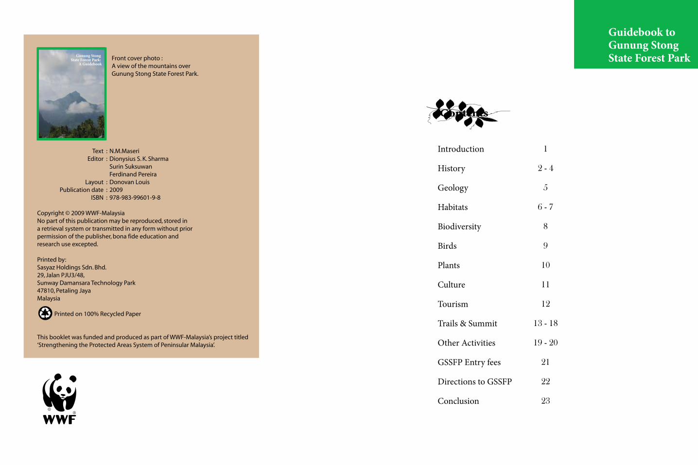
The altitude of this type of forest is generally from 1,100m asl to 1,600m asl, depending on the locality. Boles here are smaller, with a lower canopy layer, few, if any emergents are represented by the families Fagaceae and Lauraceae, with no dipterocarps.
Other Habitats
These are habitats that have been modified by humans, and
left undisturbed, have yet to really regenerate to their
original forms. Some of these habitats are: coastal padang (bris), Adinandra forests, Gelam swamp
forests, and Schima-bamboo forests.
Montane Oak Forests (MOF)
Upper Dipterocarp Forest (UDF)
Depending on whether the forest is on inland hills, or coastal hill ranges, the altitudinal range is from 800 m to 1300 m asl in the interior ranges, or from 600m asl to 900m asl on isolated mountains and coastal ranges. The dipterocarps are limited to a few species, with the typical species being the Shorea platyclados (meranti bukit), S. ovata(meranti sarang punai), S. submontana (balau gajah) and Hopea montana (merawan gunung).
Montane Ericaceous
Forests (MEF)
Frequently called the cloud forest, or
elfin forest, the canopy is
shorter, less than 10m tall, with gnarled
trunks, and is dominated by the families of Ericaceae,
and Myrtaceae and coniferous trees.
Hill Dipterocarp Forests (HDF)The altitudinal range of this type of forest is generally from 300m asl to 1,000m asl, but may be lower on isolated mountains like G. Ledang, and on coastal ranges, due to the Massernehebung Effect, varying along ridges and valleys. On coastal hills, there are dipterocarps that are lesser, or absent, further inland. There is a general decrease in size, and there are fewer of the LDF trees as one goes higher. A characteristic dipterocarp of this type of forest is the pale-coloured crown of the Shorea curtisii (seraya) that is usually noticed on hill-ridges, in association with the, Eugeissonia tristis (bertam).
Lowland Dipterocarp Forests (LDF)A forester’s delight, these forests are the richest in dipterocarps, representing the main groups (such as Dipterocarpus spp., Shorea spp., and Dryobalanops spp), with about 130 species. Originally ranging from the alluvial plains to 300m asl, these type of undisturbed forests are now mainly limited to Taman Negara and Endau-Rompin National Parks.
Forest on LimestonePlants here are adapted to grow on chalk (limestone calcium carbonate), an acidic substrate that experiences water stress, they grow on cliff faces and hillslopes, the trees having relatively lower canopies. Trees that are found here include the Hopea ferrea (malut), Shorea roxburghii (meranti), Shorea siamensis (temak batu) and Vatica cinerea (resak laut).
In the understorey and the base of limestone hills are balsams (Impatiens spp.), Cycas clivicola (bogak), the herbs Begonia, Boea, Chirita, and the one-leafed plant, Monophyllaea, not to mention orchids and gingers.
To the uninitiated, the forest is a mass of green, dominated by leeches, mosquitoes, and slimy creatures, with thorny plants that catch your shirts or backpacks. However, to the experienced, the forest is more than that. It is a treasure trove of plants and wildlife, depending on the altitude, moisture, slope, and substrate (soil and its contents). To better understand the habitats of GSSFP, a brief outline of some Malaysian forest types extant in GSSFP is introduced here:
Habitats
6 7

Asian fairy bluebird WWF- Malaysia / S.Hogg Mountain imperial pigeon WWF-Malaysia / Onn Swee Hock
Little spiderhunter WWF- Malaysia / Chew Yen Fook
The 2003 scientific expedition and a WWF-Malaysia commissioned survey in 2005 produced a checklist of 130 birds, notable of which are five species of hornbills: rhinoceros hornbill (Buceros rhinoceros), helmeted hornbill (Rhinoplax vigil), bushy-crested hornbill (Anorrhinus galeritus),white-crowned hornbill (Berenicornis comatus), wreathed hornbill (Aceros undulatus) and six montane species: white-throated fantail (Rhipidura albicollis), hill blue flycatcher (Cyornis banyumas), rufous-browned flycatcher (Ficedula solitaria), mountain tailorbird (Orthotomus cuculatus), mountain fulvetta (Alcippe peracensis), black-throated sunbird (Aethopyga saturata) and green-billed malkoha (Phaenicophaeus tristis). Other species in the list include the following: ferruginous partridge (Caloperdix oculeus), great argus (Argusianus argus), blue-crowned hanging parrot (Loriculus galgulus), mountain imperial pigeon (Ducula badia), crested serpent eagle (Spilornis cheela), Blyth’s hawk eagle (Spizaetus alboniger), Oriental honey-buzzard (Pernis ptilorhyncus), dusky broadbill (Corydon sumatranus), golden-bellied gerygone (Gerygone sulphurea), slaty-backed forktail (Enicurus schistaceus), yellow-breasted flowerpecker (Prionochilus maculatus), little spiderhunter (Arachnothera longirostra). However, this is only an initial checklist, further surveys and birding trips may expand the listing of birds.
BirdsBiodiversity
Mammals
The Malayan tapir WWF- Malaysia
GSSFP is teeming with wildlife and those who have managed to encounter them are the lucky few, and luckier still, are those who encountered large predators, and yet managed to live to tell the tale. Hikers venturing deeper in the forests have experienced the presence of elephants (Elephas maximus) through their droppings, calls, and broken bamboos, branches, and trampled undergrowth. The general presence of wildlife could be inferred through the numerous wildlife-human conflicts in the area, that includes tiger attacks and elephant raids on fruit orchards.
Some of the more interesting mammals recorded through direct observations and camera trapping in the adjacent forests are: the black panther (Panthera pardus), Malayan tapir (Tapirus indicus), serow (Capricornis sumatraensis), barking deer (Muntiacus muntjak), golden cat (Catopuma temminckii), leopard cat (Prionailurus bengalensis), pig-tailed macaque (Macaca nemestrina), banded leaf-monkey (Presbytis melalophos), and the banded linsang (Prionodon linsang).
The Malayan elephant WWF- Malaysia/ D.Sharma
Tigers (Panthera tigris jacksoni) are also common, with numerous prints, and roars heard within GSSFP, and have also been observed just outside GSSFP. The Malayan sun bear (Helarctos malayanus), has been observed along the trails, and also foraging for food at the dumpsites at Baha Camp and the Stong Resort. A juvenile siamang (Symphalangus syndactylus), has made Baha Camp home, and has been observed calling and crashing through the canopies throughout its range, and there are records of the leopard cat (Prionailurus bengalensis) prowling at Baha Camp.
GSSFP is a sanctuary surrounded by forest reserves which are experiencing selective logging, the forests extending into the Titiwangsa Range and beyond, into the Royal Belum State Park, Ulu Muda, and the Banglang and Hala Bala Wildlife Sanctuary in Thailand. This contiguity with large forested tracts accounts for its high wildlife diversity, and the importance of GSSFP in maintaining forest corridors.
The Malayan tigerWWF- Malaysia / Rahana
The siamangWWF- Malaysia / S.Hogg
8 9

12Monophyllaea hirticalyx
WWF-Malaysia/Mohd.Ros .A.H
Begonia foxworthyiWWF-Malaysia/Mohd.Ros .A.H
Gua Ikan WWF-Malaysia/Mohd.Ros .A.H
Impatiens spp WWF-Malaysia/Kamarudin S.
Holtummochloa pubescens WWF-Malaysia/Kamarudin S.
Licuala stongensis WWF-Malaysia/Kamarudin S.
Out of the 750 or so plant species that are endemic to Peninsular Malaysia, 200 are endemic (found only) to Kelantan, of which seven are hyper-endemics (found only in very specific locations and nowhere else in the world). GSSFP and the surrounding area is fortunate to harbor these species, some of the more prominent are as follows: Holtummochloa pubescens, (a small bamboo found only in GSSFP, nowhere else in the world), Licuala stongensis (a fan palm found only in GSSFP, and nowhere else in the world), Goniothalamus rotundisepalus (endemic to GSSFP and nearby areas). Of course, there are other endemics as well: some species of orchids, gingers, rafflesia, and other herbaceous plants.
The Gua Ikan group of caves, some 5 km south of Dabong, harbors some limestone specialists like the one-leafed plant (Monophyllaea hirticalyx), Begonia foxworthyi, the balsam, Impatiens opinata, and possibly, a new species of balsam. In the river flowing out of Gua Ikan is found the aquatic aroid, Cryptocoryne affinis.
Plants Culture
Almost all the local communities living in the GSSFP area are Malays, with the one or two exceptions consisting of government servants and banished criminals under the Restricted Residence Act. The locals are mostly involved in agriculture, tapping rubber and growing fruits in their orchards, on plots of land provided by the government, or illegally settled.
There are two Orang Asli communities, one at Kuala La (Temiar) and another Sg. Rual (Jahai), some 50km away, in Gua Musang and Jeli, respectively. A visit to these communities can provide a peek of their lifestyles, but be cautioned: with government aid and funding, they are not as “primitive” as one imagines them to be.
It has always been a tradition in Kelantan, where the poor and landless clears up land, and do some farming. However, since independence, the government has taken a formal role in land distribution, under which, large tracts of forests are cleared and parcelled out (in 6-10 acre plots, to be planted with rubber or oil-palm, with some for fruit orchards) to settlers from other parts of the state.
Known as the RKT (Rancangan Kemajuan Tanah), this role has been taken over by KESEDAR (the Southern Kelantan Development Authority). Lately, the role of KESEDAR has changed, from land development to providing infrastructure, and human development training to the settlers and their offsprings.
Locals during a healing ceremony at Kg.Jelawang WWF- Malaysia / N. M.Maseri
10 11

GunungAyam
Name of Trail Trail Description
2
Duration (Days)
GunungStong
1
GunungTera
GunungChe Tahir
3
4
The hiker can choose the numerous trails within GSSFP, normally leading to the summits. The trails were created by Baha and his BAT team, and range from half-day trips, to the more challenging 5-7 day hikes, as summarised in the table below :
The trail takes one through a logged-over, dipterocarp forest, then across two streams, then through an undisturbed oak-laurel forest, before reaching the summit ridge to the summit. The summit (1,500 m asl), being flat, can easily fit some 50 campers. The summit can be reached within one day from Baha Camp, and the return journey is another day. From the summit are excellent views of the neighboring peaks of Tera (1,556m asl) and Che Tahir (1,415m asl). After the second stream crossing, is a ridge populated with the rare endemic fan-palm, Licuala stongensis.
G. Stong (1,400m asl.) is some 4-5 hours from Baha Camp, and the return trip is some three hours. Like G. Ayam, the trail takes the hiker through an abandoned logging trail, before entering undisturbed oak-laurel forests. Like G. Ayam, on the summit ridge are found the rare endemic bamboo, Holtummochloa pubescens. Midway between the base-camp and the summit is a rock-shelter next to a spring, known as Bogo Rock-Shelter.
The trail is an extension of the G. Ayam trail, where the hiker descends G. Ayam, and ascends Tera, a day away. Midway between the two summits is a plateau (G. Saji) where there are plenty signs of elephants. The rare bamboo, H. pubescens, is also found here. The journey to G. Tera and back down again to Baha Camp takes four days.
This is also an extension of the G. Ayam trail, where the hiker goes down G. Ayam, and then ascends up the granite outcrop that is G. Che Tahir. The summit is not as spectacular as G. Ayam, but the trail is, with pristine rocky streams and cascades.
Trails& Summits
Jelawang waterfall WWF- Malaysia / S.Suksuwan
Tourism in the form of hiking activities is a major reason for visiting GSSFP. This is consistent with its setting as a protected area, and attracts both domestic and foreign visitors. They attempt its numerous summits or just do a spot of camping at Baha Camp, on top of the waterfall. Visitors stay for 3-7 days, depending on their destinations. Some backpackers come for short visits, like the place, and stay for months. GSSFP is popular with campers and hikers, with some 10,000 visitors per year, contributing to the local economy of some 5,000 inhabitants of Jelawang and Dabong.
Tourism
12 13

BAHA CAMP
Rock climbing at Baha Camp WWF- Malaysia / N.M. Maseri
Camping at the summit of G.Ayam WWF- Malaysia / N.M. Maseri
Name of Trail Duration (Days)
Trail Description
SungaiSemuliang
Seven Summits
Last Waterfall
Gua IkanCaves
7
5
0.5
0.5
Waterfall along Sungai Semuliang trail WWF- Malaysia / N.M.MaseriGunung Ayam scenery WWF- Malaysia / N.M. Maseri
This trail starts from where the Sg. Kenerong meets the Sg. Semuliang (near the Musteq Mini-Hydropower Dam), along an abandoned logging trail, and then upriver, before turning into the saddle separating G. Ayam from G. Stong. From the saddle, one can make an ascent to G. Ayam, or to G. Stong, and back down again to Baha Camp. Highlights of this trail include a Rafflesia site, and a rock-shelter with petrified wood.
This trail is a combination of the other trails, where the seven summits are attempted (Ayam, Tera, Stong, Che Kob, Che Tahir, Menyelit, Birut). Apart from Ayam, Stong, and Tera, the other peaks are named by Baha, and are not named in official maps.
This is the shortest hike, and is an easy walk from Baha camp, where one encounters rock-pools, and smaller falls. Along the rock-walls are gesneriads, a population of the endemic L. stongensis, and a population of the slipper orchid, Paphiopedilum barbatum.
Not officially part of GSSFP, there are several caves in Dabong that the guides take visitors to, either before entering or after returning from GSSFP.
Trails & Summits
Trails & Summits
GUNUNG AYAM
One of the most popular, this trail takes one through a logged-over dipterocarp forest, across two streams, then through an undis-turbed oak-laurel forest before reaching the summit ridge, and hence, to the summit. From Baha Camp, the summit can be reached in about 5-6 hours, for a fit hiker, and some 8 hours for the less fit. The summit is flat, and can easily fit some 50 campers, with a nearby waterhole for drink-ing and cooking only. From the summit (1,500m asl), one can have excellent views of the nearby peaks of G. Tera (1,556m asl), and Che Tahir (1,415m asl.). Along the summit ridge can be seen populations of the endemic bamboo, Holtummochloa pubescens. One usually camps at the summit of G. Ayam, and returns the next day along the same trail, or detours through G. Stong.
At about 460m asl, this is the staging point for further hikes within GSSFP, and is a popular site to linger, swim in the rock-pools, and watch the sunrise above the waterfall. Backpackers on 2-3 day packages by guesthouse operators stay here at the basic huts, do short hikes to the last waterfall, and swim, before returning home by train to Kota Bharu. Rental of huts is fixed at RM10 per head per day, camp-sites RM3 per person per night, with free use of the kitchen at the canteen. The trailhead to Baha Camp is through the rear of the Stong Resort, where one climbs a set of concrete steps to the base of the Jelawang Waterfall (some call it the Stong Waterfall), reputedly one of the highest in Malaysia, and follows the trail to the right, ascending all the way to a former logging trail, with further ascents until Baha Camp is reached. Alternatively, one crosses the hanging bridge at the small pool at the Stong Resort, and follows the ascending trail to meet the former logging trail, and ascending further till Baha Camp. An average person will take some 1-2 hours to reach Baha Camp.
14 15
SEMULIANG TRAIL
SEVEN SUMMITS
THE RIDGE TO NORENG
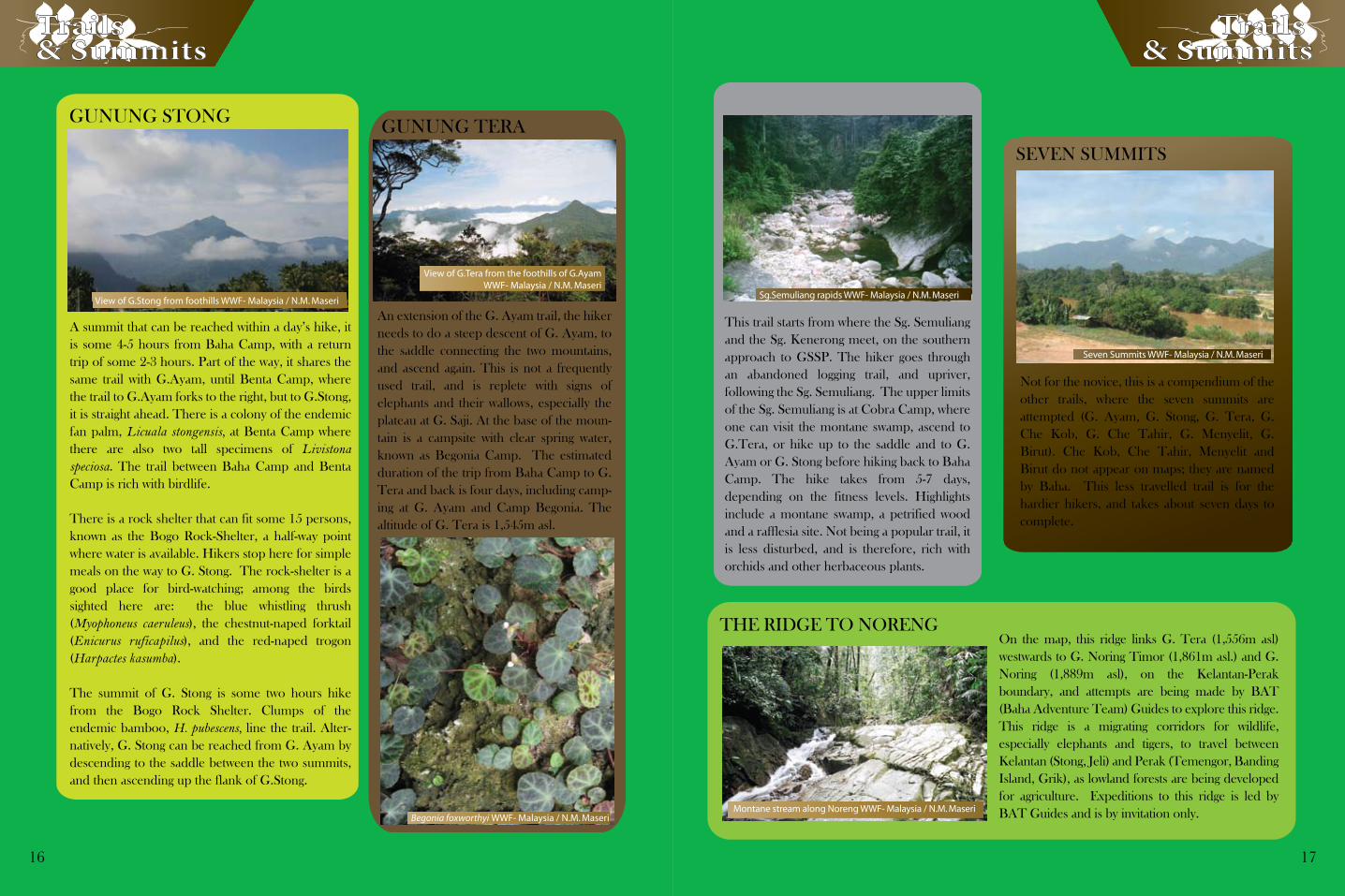
Seven Summits WWF- Malaysia / N.M. Maseri
Montane stream along Noreng WWF- Malaysia / N.M. Maseri
This trail starts from where the Sg. Semuliang and the Sg. Kenerong meets, on the southern approach to GSSP. The hiker goes through an abandoned logging trail, and upriver, following the Sg. Semuliang. The upper limits of the Sg. Semuliang is at Cobra Camp, where one can visit the montane swamp, ascend to G.Tera, or hike up to the saddle and to G. Ayam or G. Stong before hiking back to Baha Camp. The hike takes from 5-7 days, depending on the fitness levels. Highlights include a montane swamp, a petrified wood, and a rafflesia site. Not being a popular trail, it is less disturbed, and is therefore,
GUNUNG STONG GUNUNG TERA
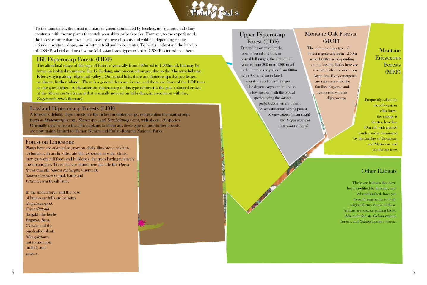
View of G.Stong from foothills WWF- Malaysia / N.M. Maseri
View of G.Tera from the foothills of G.AyamWWF- Malaysia / N.M. Maseri
Begonia foxworthyi WWF- Malaysia / N.M. Maseri
Trails & Summits
A summit that can be reached within a day’s hike, it is some 4-5 hours from Baha Camp, with a return trip of some 2-3 hours. Part of the way, it shares the same trail with G.Ayam, until Benta Camp, where the trail to G.Ayam forks to the right, but to G.Stong, it is straight ahead. There is a colony of the endemic fan palm, Licuala stongensis, at Benta Camp where there are also two tall specimens of Livistona speciosa. The trail between Baha Camp and Benta Camp is rich with birdlife.
There is a rock shelter that can fit some 15 persons, known as the Bogo Rock-Shelter, a half-way point where water is available. Hikers stop here for simple meals on the way to G. Stong. The rock-shelter is a good place for bird-watching; among the birds sighted here are: the blue whistling thrush (Myophoneus caeruleus), the chestnut-naped forktail (Enicurus ruficapilus), and the red-naped trogon (Harpactes kasumba).
The summit of G. Stong is some two hours hike from the Bogo Rock Shelter. Clumps of the endemic bamboo, H. pubescens, line the trail. Alter-natively, G. Stong can be reached from G. Ayam by descending to the saddle between the two summits, and then ascending up the flank of G.Stong.
An extension of the G. Ayam trail, the hiker needs to do a steep descent of G. Ayam, to the saddle connecting the two mountains, and ascend again. This is not a frequently used trail, and is replete with signs of elephants and their wallows, especially the plateau at G. Saji. At the base of the moun-tain is a campsite with clear spring water, known as Begonia Camp. The estimated duration of the trip from Baha Camp to G. Tera and back is four days, including camp-ing at G. Ayam and Camp Begonia. The altitude of G. Tera is 1,545m asl.
Trails & Summits
Not for the novice, this is a compendium of the other trails, where the seven summits are attempted (G. Ayam, G. Stong, G. Tera, G. Che Kob, G. Che Tahir, G. Menyelit, G. Birut). Che Kob, Che Tahir, Menyelit and Birut do not appear on maps; they are named by Baha. This less travelled trail is for the hardier hikers, and takes about seven days to complete.
On the map, this ridge links G. Tera (1,556m asl) westwards to G. Noring Timor (1,861m asl.) and G. Noring (1,889m asl), on the Kelantan-Perak boundary, and attempts are being made by BAT (Baha Adventure Team) Guides to explore this ridge. This ridge is a migrating corridors for wildlife, especially elephants and tigers, to travel between Kelantan (Stong, Jeli) and Perak (Temengor, Banding Island, Grik), as lowland forests are being developed for agriculture. Expeditions to this ridge is led by BAT Guides and is by invitation only.
This trail starts from where the Sg. Semuliang and the Sg. Kenerong meet, on the southern approach to GSSP. The hiker goes through an abandoned logging trail, and upriver, following the Sg. Semuliang. The upper limits of the Sg. Semuliang is at Cobra Camp, where one can visit the montane swamp, ascend to G.Tera, or hike up to the saddle and to G. Ayam or G. Stong before hiking back to Baha Camp. The hike takes from 5-7 days, depending on the fitness levels. Highlights include a montane swamp, a petrified wood and a rafflesia site. Not being a popular trail, it is less disturbed, and is therefore, rich with orchids and other herbaceous plants.
Sg.Semuliang rapids WWF- Malaysia / N.M. Maseri
16 17

Birding
Boat and White-Water Trips
Rock-Climbing and Limestone Hill Climbs
Climbing the hills at Dabong WWF- Malaysia/ S. Suksuwan
WWF- Malaysia/ N.M. Maseri
With some 130 species of birds from the checklist, GSSFP and the surrounding is rich in birdlife, due to its natural and near-natural habitats, where there is plenty of interface between primary forests, disturbed forests, and fruit farms. Birders need not climb GSSFP, they just need to take a walk near the big waterfall, the Dabong caves, or along the Sg. Galas, for their birding trips. During the fruit season in June-August, these jaunts will be well rewarded, as locals are generous with their fruits.
Before roads were introduced, the locals used to travel by long-tailed boat, or train, to Kuala Krai, and Gua Musang for their essential needs. Now, the boats are less used, only for shorter destinations, with rubber latex cargoes, and they can be hired for fishing or other trips. There is, as yet, no formal pricing system, but local boatmen can be approached, and prices negotiated. They are quite willing to take visitors around Sg. Galas and her tributaries.
White-water rafting is also organised (by
KESEDAR Travel and Friends of Sg. Nenggiri), down the Sg. Nenggiri, where Grade 3 rapids are encountered, and stops can be made at certain caves along the river (some caves are of historical interest, where Neolithic remains of some 5,000-10,000 years have been discovered).
Rock-climbing can be attempted at Taman Etnobotani in Gua Musang, where several pitches have been developed on a limestone cliff face. The limestone hills near the Gua Musang train station can be climbed, and one can appreciate the surrounding landscapes on their summits. There is a nominal charge for rock-climbing facilities operated by KESEDAR Travel, while for climbing the limestone hills, local guides can be arranged through the Friends of Sg. Nenggiri (SSN), at [email protected] or 013-6027140. The SSN is a local organisation made of local Malays and Orang Asli of the Temiar tribe.
LAST WATERFALL
Trekking towards the waterfallWWF- Malaysia / N.M. Maseri
GUA IKAN
Gua Keris WWF- Malaysia / N.M. Maseri
This is a popular trail for visitors who are not too keen on hiking long trails. This is a short trail some 30 minutes from Baha Camp, and could be effectively promoted as an interpre-tive trail. Following a rocky river, there are points of interest that could be highlighted by a keen naturalist guide, and this includes some dipterocarps of some interest, a pitcher plant (Nepenthes gracillima), some gesneriads attaching to a rock face (Cyrtandra anisophyllea, Cyrtandromoea grandis, Aeschynanthus sp.), the endemic fan-palm, L. stongensis, and the slipper orchid, Paphiopedilum barbatum. The trail ends at a waterfall, some 50m high, where one can have a swim in the many rock pools. The return trip takes 15 minutes.
This is a group of caves 5km south of Dabong, and includes Gua Ikan, Gua Keris, Gua Tembakau, Gua Pagar, Gua Puteri, and Gua Setol. Though not part of GSSFP, hikers usually visit these caves as part of their experience to GSSFP, guided by BAT Guides. Guided by a naturalist, the visitor will have an added value to the experience, as a limestone cave habitat demands special adaptations from their inhabitants. Limestone specialists here include a trap-door spider, fruit bats, cave racer snakes, and for plants, begonias (Begonia foxworthyi, B. nurii), some species of balsam, and the one-leafed plant (Monophyllaea hirticalyx).
Basically, Gua Ikan is named as such because there is a small stream flowing inside, possibly containing fishes, while at Gua Keris, there is a stalactite formation that resembles a keris, the Malay dagger. At Gua Setol, there is a small stream that flows into it, and following upriver, there is a wang, a valley enclosed by steep limestone faces. There is a small trail that connects Gua Setol to Gua Keris. Gua Pagar is a small passage, through which one needs to enter before entering Gua Keris and Gua Puteri. Gua Puteri is named for the gour pools that fill up with water during heavy rains, and is believed to be where fairies bath.
Trails & Summits
Other Activities
Birding WWF- Malaysia /S.Z. Abidin
18 19

20 21
Local Accommodation
Dabong RestHouse
Stong Resort
List of Tour Operators to GSSFP
Entry fees of RM2 are charged by the Stong Resort, while the Forestry Department charges RM5 for entry into GSSFP
Accommodation is limited in the Jelawang and Dabong area, and tends to be on the basic side, not suitable for the mass or leisure market. But then, GSSFP is for the adventurous and the nature-oriented, who are less concerned with comfort (In fact, they expect discomfort, and thrive on inconveniences). There is no place for the well-heeled in GSSFP.
This resthouse is operated by the Majlis Daerah Dabong. There are four rooms without air-conditioning, an air-conditioned room, a small hall, and two bungalow units. The rooms without air-conditioning are rented at the rate of RM40 per night, the air-conditioned room is priced at RM50, while the bungalow is at RM70 a night. The small hall is rented at RM60 per day. The caretaker is Abedin, who can be contacted at 019-960-6789.
WWF- Malaysia/ N.M. Maseri
This resort is currently operated by KPK, the state-owned agency awarded long-term logging concessions. Dormitory rates are RM20 per person per night, while the cabins are at RM150 per night. They can be contacted at 09-936-0027.
BAT GuidesResponsible for guiding in GSSFP since the early 1990s, this outfit charges daily rates at RM90 a day, to all the hiking destinations in GSSFP. They can be contacted at 019-959-1020, or [email protected]. They also operate campsites at RM3 per person per night, and basic huts above the waterfall at RM10 per head per night. BAT also organises packages to the hiking destinations.
KESEDAR TravelA wholly-owned subsidiary of KESEDAR, a Federal land development agency, KESEDAR Travel takes visitors on 2-3 day packages to GSSFP. Their contact number is 09-9121-788, or email to [email protected].
KB Backpackers Holidays Sdn. Bhd.Regular packaged trips are made by this agency to GSSFP. They can be contacted at 09-7737-077, or www.kb-backpackers.com.my.
Deer and Seladang (Bos frontalis )Farm
Pulai Village
Pergau Dam
Gunung Rabong (1,538 m asl)
Seladang WWF- Malaysia/ R.Lai
Kayaking WWF-Malaysia/ N.M. Maseri
This dam provides hydropower to the national electricity grid of Peninsular Malaysia, and was constructed by Kerjaya-Balfour Beatty Construction, where tunnels were drilled, channeling water down a sluice, pushing turbines, and generating electricity. There is a small resort on the dam, operated by KESEDAR. Hikes to G. Noreng (1889 m asl) and G. Noreng Timur (1861 m asl) through the Sg. Suda and Sg. Renyok Intakes, which are accessible through a metalled road off-the Jeli-Dabong Road Activi-ties are mostly water-based, and includes fishing, boating, and kayaking. For bookings, kindly contact the resort manager, En. Zaaba (019-929-1578).
This is a 1,538 m asl mountain in the G. Rabong Forest Reserve (16,355 ha) adjoining the northern boundary of the 434,300 ha Taman Negara National Park. This is a 3-day return trip, crossing rivers and with a vigorous ascent to the summit. Local guides are necessary, and can be obtained from KESEDAR Travel, BAT, or SSN.
Also in Gua Musang, this is a settlement peopled by Hakka Chinese who had been mining for alluvial gold in these parts, until the deposits were exhausted some 100 years ago. Now, the community is subsisting on agriculture. These are mixed-blood Chinese: due to the paucity of ethnic Chinese females in this remote part of the country, the miners married with the local Orang Asli, and their descendants are relatively darker.
This is a deer farm operated by the Department of Wildlife and National Parks, Malaysia (DWNP) in Gua Musang, where there is a captive rehabilitation programme for local deer, porcupine, and wild cattle (gaur). Permission for a visit and accommodation of up to 20 persons can be obtained by writing from their Kota Bharu Head-Office (tel. 09-744-1844) at this address:
Other Activities
GSSFPEntry Fees
PengarahJabatan PERHILITAN KelantanTingkat 12, Wisma Persekutuan
Jalan Bayam15664 Kota Bharu
Kelantan.

In Peninsular Malaysia, there are already several IUCN Class II protected areas: the Taman Negara National Park, Endau-Rompin National Park, Perlis State Park, Penang State Park, Royal Belum State Park, and the Selangor State Park. Gunung Stong State Forest Park (GSSFP), is only recently gazetted, the legal instruments are already in place, but much more is needed, in terms of operational systems, adequate staffing, and budgets for its management. This guide only provides preliminary and general information for the general visitor, providing only glimpses of what is to be found here. Special interest visitors such as birdwatchers and amateur botanists will find this inadequate and will need specialist guide books and specialist nature guides that cater for their interests. Hopefully, this will be provided once the volume of visitors increase and there is a need to cater for special interest groups.
Conclusion Further Reading
Symington, C.F. (2004). Forester’s Manual of Dipterocarps. Kuala Lumpur: FRIM.
Whitmore, T.C. (1986). Tropical Rainforests of the Far East. Oxford: Oxford University Press.
Kasim Osman, Rahimatsah Amat & Surin Suksuwan (eds.) (2002). Pearl of Perlis: Perlis State Park Guide. Kangar: Perlis Forestry Department.
Earl of Cranbrook (1994). A Tropical Rainforest: The Nature of Biodiversity in Borneo at Belalong, Brunei. London: Royal Geographical Society.
Bashah, A.H.(1994). Raja Campa dan Dinasti Jembal dalam Patani Besar. Kota Bharu: Pustaka Reka.
N.M. Maseri, A.H. Mohd. Ros & S. Suksuwan (2006). Preliminary Management Plan of the Gunong Stong State Park. WWF-Malaysia for the Kelantan State Government.
Gua Keris stalactite WWF- Malaysia / N.M. Maseri
Gua Ikan WWF- Malaysia / N.M. Maseri
View of some of the summits in GSSFP WWF- Malaysia / N.M. Maseri
Geologically, GSSFP is part of the Stong Migmatic Complex, composed of igneous rocks that have undergone metamorphosis, forming the Berangkat Tonalite, Kenerong Leucogranite, and the Noring Granite. The Migmatic Stong Complex has similarities with the Benta Complex in Pahang, and is part of the Central Zone Granite that also occurs in Gua Musang, Jeli, and Batang Merbau. In Dabong, the Gua Ikan group of caves and limestone hills are part of the Gua Musang Limestone Aggregates. The Stong Migmatic Complex and the Gua Ikan group of caves have been included into a list of geological heritage sites suggested by Dr. Ibrahim Komoo, a prominent Malaysian geologist.
Geology
How to get there
The means of access are summarised as follows:
Type
Train
Fees (RM unless stated otherwise)
Distance(km)Destination Route
Wakaf Baru to Dabong by local or express train
4.80 (local)7.00 (Express)
Kuala Lumpur to Dabong
From Singapore to Dabong
28.00 (Economy)48.00 (2nd Class Sleeper Coach)
S$29 (Economy Coach) S$50 (2nd Class Sleeper Berth)
East-West Highway (via Grik, then turning to Jeli, and straight to Dabong/Jelawang)
Kuala Lumpur-Gua Musang Highway (from Gua Musang, follow the signboard to Jelawang or Dabong (through Sg. Terah and Meranto).
Kota Bharu-Jeli Road (from Jeli proceed to Jelawang).
Kuala Krai-Gua Musang Federal Road (after Laloh, take the right turning to Sg. Sam, and proceed to Dabong and to Jelawang)
Motor-vehicle N/A
N/A
N/A
N/A
700
100
600
150
332
147
80
Previously access was only by train (completed in 1934) and riverboat, but by the early and mid-1980s, the completion of the East West Highway and the Kuala Lumpur-Gua Musang-Kota Bharu Highway greatly improved accessibility, making GSSFP less isolated. GSSFP can also be approached from Kuala Krai, where through the Kuala Krai-Gua Musang Highway, one makes a right turn after Laloh, and from there, proceed through Sg. Sam. The recently completed Dabong bridge has also made it possible for motorists to cross the Sg. Galas when previously, a boat ride was needed.
GSSFP is accessible by local and express trains, from Kota Bharu (Wakaf Baru), Gua Musang, Gemas, Singapore, and Kuala Lumpur. The train is a popular mode of transport for hikers from Singapore and Kuala Lumpur, and backpackers from Kota Bharu, who take the 10.30am Wakaf Bharu-Dabong shuttle.
Directionsto GSSFP
22 23

In Peninsular Malaysia, there are already several IUCN Class II protected areas: the Taman Negara National Park, Endau-Rompin National Park, Perlis State Park, Penang State Park, Royal Belum State Park, and the Selangor State Park. Gunung Stong State Forest Park (GSSFP), is only recently gazetted, the legal instruments are already in place, but much more is needed, in terms of operational systems, adequate staffing, and budgets for its management. This guide only provides preliminary and general information for the general visitor, providing only glimpses of what is to be found here. Special interest visitors such as birdwatchers and amateur botanists will find this inadequate and will need specialist guide books and specialist nature guides that cater for their interests. Hopefully, this will be provided once the volume of visitors increase and there is a need to cater for special interest groups.
Conclusion Further Reading
Symington, C.F. (2004). Forester’s Manual of Dipterocarps. Kuala Lumpur: FRIM.
Whitmore, T.C. (1986). Tropical Rainforests of the Far East. Oxford: Oxford University Press.
Kasim Osman, Rahimatsah Amat & Surin Suksuwan (eds.) (2002). Pearl of Perlis: Perlis State Park Guide. Kangar: Perlis Forestry Department.
Earl of Cranbrook (1994). A Tropical Rainforest: The Nature of Biodiversity in Borneo at Belalong, Brunei. London: Royal Geographical Society.
Bashah, A.H.(1994). Raja Campa dan Dinasti Jembal dalam Patani Besar. Kota Bharu: Pustaka Reka.
N.M. Maseri, A.H. Mohd. Ros & S. Suksuwan (2006). Preliminary Management Plan of the Gunong Stong State Park. WWF-Malaysia for the Kelantan State Government.
24

Acknowledgements
This guidebook is part of project MY02740G
(Capacity-building of Local Community), which is an
extension of project MY02040G (Preparation of Preliminary
Management Plan of Gunung Stong State Forest Park),
funded by the generous contribution of the Malaysian public.
This guidebook is also made possible, by the support of the
Kelantan State Government, in having the vision of having a
state park,the Technical Committee (consisting of the State
Economic Development Corporation (UPEN), Kelantan
Forestry Department, Department of Wildlife and National
Parks (DWNP), Geological Department, KESEDAR (South
Kelantan Development Corporation), Majlis Daerah Dabong,
Jabatan Pengairan dan Saliran Kelantan, Universiti Malaysia
Trengganu, the Malaysian Nature Society (MNS), and World
Wide Fund for Nature, Malaysia (WWF-Malaysia)), in
translating this vision into a reality.
We are also indebted to Donovan Louis in contributing to the
layout, Dionysius S. K. Sharma, Surin Suksuwan, and
Ferdinand Pereira who provided suggestions on the draft
text.
Gunung Stong State Forest Park:
A GuidebookFront cover photo : A view of the mountains over Gunung Stong State Forest Park.
Text : N.M.Maseri Editor : Dionysius S. K. Sharma Surin Suksuwan Ferdinand Pereira Layout : Donovan Louis Publication date : 2009 ISBN : 978-983-99601-9-8
Copyright © 2009 WWF-MalaysiaNo part of this publication may be reproduced, stored in a retrieval system or transmitted in any form without priorpermission of the publisher, bona fide education and research use excepted.
Printed by:Sasyaz Holdings Sdn. Bhd.29, Jalan PJU3/48,Sunway Damansara Technology Park47810, Petaling JayaMalaysia
Printed on 100% Recycled Paper
This booklet was funded and produced as part of WWF-Malaysia’s project titled ‘Strengthening the Protected Areas System of Peninsular Malaysia’.

Gunung Stong State Forest Park:
A GuidebookGuidebook to Gunung Stong State Forest Park
The Gunung Stong State Forest Park (GSSFP), with her cascading waterfalls, mountain streams and pools, and the different habitat types, attracts visitors.
However, the visitors are more interested in the outdoor recreational activities, and are not aware of what GSSFP has to offer, especially her rich natural
resources. This guide is meant to initiate the reader with in-depth information about GSSFP, so that after a visit, the visitor will become more knowledgeable about what nature has to offer here, and make return visits, as GSSFP cannot
be savoured within one visit.
This GSSFP guide starts with a general background on the history of Kelantan state, to introduce the reader to the state, followed by a general history of GSSFP, with a timeline on its development into a state park. Access into GSSFP is then described, for readers to choose on the mode of travel, the
distances, and the estimated travel costs incurred.
This guide provides a brief description on the biodiversity of wildlife, and plants (especially the rare and endemic species) and their locations, with photos
for easy identification. As this guide is for the layman who is interested in nature, a full species checklist is not provided, but certain species are
highlighted. General geological background is then provided, followed by description of trails and summits to be attempted by the interested hiker,
especially those attempting to venture deeper into GSSFP.
Finally, there is also a list of accommodations offered at GSSFP and Dabong, with a list of prices, and the operators involved in providing guiding services and packages. This is for the visitors who are more interested to visit GSSFP
on guided packages. The latter part of the guide book is for other activities and places of interest in the areas surrounding GSSFP.