![Workshop Hydropower and Fish.pptx [Schreibgeschützt] - Workshop Hydropower and Fish... · Workshop Hydropower and Fish Existing hydropower facilities: ... spawning grounds and shelter](https://static.fdocuments.in/doc/165x107/5a8733247f8b9afc5d8da3c5/workshop-hydropower-and-fishpptx-schreibgeschtzt-workshop-hydropower-and-fishworkshop.jpg)
Guidance on The requirements for hydropower in...
83
1 Guidance on The requirements for hydropower in relation to Natura 2000 Environment
Transcript of Guidance on The requirements for hydropower in...

1
Guidance on The requirements for hydropower
in relation to Natura 2000
Environment
2
Guidance document on the requirements for hydropower in relation to EU Nature legislation This document reflects the view of the European Commission and is not of a binding nature. European Commission, 2018 Reproduction is authorised provided the source is acknowledged.
This document has been prepared with the assistance of N2K GROUP EEIG — Ecosystems LTD, Brussels and Beleco, Czech Republic. Cover photo: Ain, Auvergne-Rhône-Alpes, Bugey, Built Structure, Europe.

3
TABLE OF CONTENTS
Purpose of the document 5
1. Overview of EU Policy and Legislative framework 7 1.1 The Birds and Habitats Directives 7 1.2 The Water Framework Directive (WFD) 10 1.3 Coordination between the WFD and the Nature Directives 11 1.4 The Floods Directive 13 1.5 The SEA and EIA Directives 14 1.6 The relationship between SEA,EIA and Article 6 15
2. Freshwater ecosystems and hydropower in the EU 17 2.1 The status of the EU’s river and lake ecosystems 17 2.2 Pressures and threats of Europe’s freshwater ecosystems 18 2.3 The effects of hydropower on freshwater ecosystems 21 2.4 Cumulative effects 27 2.5 Distinguishing between significant and insignificant effects 30
3. Good practice examples in mitigating effects and applying ecological restoration measures to hydropower 33 3.1 Aiming for the best practicable ecological condition of rivers in
the context of hydropower 33
3.2 Dealing with existing hydropower having a negative effect on a Natura 2000 site 33
3.3 Introducing ecological measures and restoration measures 35 3.4 Good practice examples of ecological restoration 40
4. Good practices in applying an integrated planning approach to hydropower 51 4.1 The benefits of integrated planning 51 4.2 Integrated national and regional plans 57 4.3 Wildlife sensitivity and zoning 58 4.4 Early consultation 62
5. The assessment procedure under the Habitats Directive 63
5.1 Introduction 63 5.2 When is the Article 6 procedure required 64 5.3 A step by step procedure for carrying out appropriate assessments 67 5.4 Exceptions under Article 6.4 80
Abbreviations 85
Bibliography 87

4
PURPOSE OF THE DOCUMENT This document offers guidance and presents a series of practical case studies on how hydropower can be made to operate in accordance with the requirements of the Habitats and Birds Directives. It examines the types of effects that might occur from hydropower activities and illustrates, through a series of practical experiences, how the effects of hydropower can be avoided or at least minimised under a range of different conditions. More generally, it aims to act as a conduit for fostering synergies between EU policies and practices on energy, nature and water in order to achieve EU targets in a more coordinated, and wherever possible, mutually supportive manner. Chapter 1 provides an overview of the EU policy and legislative framework in which hydropower is expected to operate in Europe. The key provisions of the Habitats and Birds Directives are briefly summarised as is their relationship with the Water Framework Directive and the EIA and SEA Directives. Chapter 2 outlines the generally poor state of the EU’s river and lake ecosystems, as well as their main pressures and threats, before going on to examine the range of effects hydropower can have on freshwater ecosystems, stressing the importance of potential cumulative effects in particular. A significant number of Europe’s wild fauna and flora species, including some 400 freshwater species protected under the Birds and Habitats Directives, depend on river and lake ecosystems for their survival. However, today most of Europe’s rivers are in a highly degraded state and under immense pressure from a wide range of socio-economic activities (including hydropower). From the latest State of Environment reports1 it is clear that much still needs to be done to meet the objectives of the Water Framework Directive and the two Nature Directives. This can only be achieved if priority is given not just to preventing a further deterioration of our rivers but also to actively restoring their ecological status and removing, or at least significantly reducing, the pressures and threats they face. Chapter 3 explores the ways in which this can be achieved, illustrating this with good practice examples of ecological restoration from across the EU. Particular attention is given in Chapter 4 to the need for strategic planning and to designing more integrated hydropower plans and projects that take account of the river’s ecological requirements early on in the planning process and wherever possible also include measures to improve the ecological status of the river. The document goes on to describe in detail (Chapter 5) the procedure to follow when carrying out an appropriate assessment for a hydropower plan or project under Article 6 of the Habitats Directive. Clarification is provided on certain key aspects of this approval process and of its relation with other EU environmental assessment procedures. Experience has shown, time and again, that problems with the Article 6 approval process are very often caused by poor quality and incomplete appropriate assessments.
1 https://www.eea.europa.eu/soer

5
The guidance is designed primarily for use by competent authorities, developers and consultants. It will also be of interest to non-governmental organisations and other stakeholders who are working in the hydropower sector. The document has been written in consultation with Member state authorities as well as a range of key stakeholder and interest groups all of whom have provided valuable feedback on the various drafts. The document is intended to be bound by, and faithful to, the text of the Birds and Habitats Directives and to the wider principles underpinning EU policy on the environment and hydropower. The good practice procedures and proposed methodologies are not prescriptive in their intent; rather they aim to offer useful advice, ideas and suggestions based on discussions with industry representatives, national and international authorities, NGOs, scientific experts and other stakeholders. The document reflects only the views of the Commission and is not of a legally binding nature. It rests with the European Court of Justice to provide definitive interpretation of EU directives. Wherever relevant, existing European case law has been included. The present guide is therefore best read in conjunction with the existing general guidance and relevant European Court of Justice rulings on the two directives2.
2 http://ec.europa.eu/environment/nature/natura2000/management/guidance_en.htm .
6
1. EU POLICY AND LEGISLATIVE FRAMEWORK
Hydropower plays a key role in the implementation of the Renewable Energy Directive3 and in contributing to the EU energy targets for 2020-2030. As with all other water-based activities, hydropower must conform to the requirements of EU environmental law, which has been introduced to protect and restore Europe’s rivers and lakes. These legal requirements are laid down in the Water Framework Directive, the Floods Directive, the Birds and Habitats Directives, and the Environmental Assessments Directives (Environmental Impact Assessment - EIA and Strategic Environmental Assessment - SEA Directives). This chapter outlines some of the key provisions of these EU laws that are relevant for hydropower. The focus is on the two Nature Directives in particular, as this is the main topic of the present document.
1.1 The Birds and Habitats Directives
Europe’s rivers are a major source of biodiversity and an important part of our rich natural heritage. They have, however, undergone major changes over the decades. This has reduced their resilience and capacity to provide for nature and wildlife. Most rivers are now in a degraded state and in need of restoration. Recognising the alarming loss of biodiversity in Europe, the EU Heads of State and Government set themselves the ambitious target of halting, and reversing, this loss by
2020. In May 2011, the Commission adopted an EU biodiversity strategy to 20204 setting
out a policy framework for achieving this. In April 2017, it launched a new action plan5 to rapidly improve the practical implementation of the Habitats and Birds Directives and accelerate progress towards the EU 2020 goal of halting and reversing the loss of biodiversity and ecosystem services. The Birds and Habitats Directives are the cornerstones of the EU’s nature and biodiversity policy. They enable all EU Member States to work together, within a common legislative framework, to conserve Europe’s most endangered, vulnerable and valuable species and habitats across their entire natural range within the EU, irrespective of political or administrative boundaries. The overall objective of the two Directives is to ensure that the species and habitat
types they protect are maintained and restored to a favourable conservation status6
throughout their natural range within the EU.
3 https://ec.europa.eu/energy/en/topics/renewable-energy/renewable-energy-directive . 4 http://ec.europa.eu/environment/nature/biodiversity/comm2006/2020.htm . 5 EU action plan for nature, people and the economy
http://ec.europa.eu/environment/nature/legislation/fitness_check/action_plan/index_en.htm . 6 Cf Article 2 of the Habitats Directive. ‘Measures taken pursuant to this Directive shall be designed to
maintain or restore, at favourable conservation status, natural habitats and species of wild fauna and flora
of Community interest.’ The concept of ‘favourable conservation status’ is not mentioned in the Birds
Directive but there are analogous requirements for special protection areas.

7
This target is defined in positive terms, oriented towards a favourable situation which needs to be reached and maintained. It therefore goes beyond the basic requirement of avoiding deterioration.
Definition of favourable conservation status (FCS) under the Habitats Directive Article 1 The conservation status of a natural habitat means the sum of the influences acting on a natural habitat and its typical species that may affect its long-term natural distribution, structure and functions as well as the long-term survival of its typical species within the territory of the EU. The conservation status of a natural habitat will be taken as ‘favourable’ when:
Its natural range and the areas it covers within that range are stable or increasing, and
the specific structure and functions which are necessary for its long-term maintenance exist and are likely to continue to exist for the foreseeable future, and
the conservation status of its typical species is favourable. The conservation status of a species means the sum of the influences acting on the species concerned that may affect the long-term distribution and abundance of its populations within the territory of the EU. The conservation status will be taken as ‘favourable’ when:
population dynamics data on the species concerned indicate that it is maintaining itself on a long-term basis as a viable component of its natural habitats, and
the natural range of the species is neither being reduced nor is likely to be reduced for the foreseeable future, and
there is, and will probably continue to be, a sufficiently large habitat to maintain its populations on a long-term basis.
To achieve this objective, the EU Nature Directives require Member States to implement two main types of measures in particular:
The designation and conservation of core sites for the protection of species and habitat types listed in Annex I and II of the Habitats Directive and Annex I of the Birds Directive, and for the protection of all regularly occurring migratory birds. These sites make up the EU-wide Natura 2000 Network which currently contains over 27 500 sites. Lake and river ecosystems cover around 4 % of the total surface area of Natura 2000 (European Environment Agency, 2010, for EU 27).
The establishment of a species protection regime for all wild European bird species and other species listed in Annex IV of the Habitats Directive. These measures apply across the species’ entire natural range within the EU, i.e. both within and outside protected sites such as Natura 2000.
8
Natura 2000 site protection provisions The protection and management of Natura 2000 sites is governed by the provisions of Article 6 of the Habitats Directive, which also determines the relationship between the site’s conservation and other land-uses, such as hydropower, in and around the area7. Article 6 is divided into two types of measures:
The first concerns the conservation management of all Natura 2000 sites and the setting of conservation objectives for these sites. It requires Member States to:
a) elaborate and implement positive conservation measures which correspond to the ecological requirements of the habitat types in Annex I and the species in Annex II present on the sites (Article 6.1); and b) take appropriate measures to avoid any deterioration of habitat types and habitats of species or any significant disturbance of the species present (Article 6.2).
The Habitats Directive recommends the development of Natura 2000 management plans as a means of identifying the necessary conservation measures for Natura 2000 sites in an open and transparent manner. They are useful tools for setting conservation objectives and helping to build a consensus view on the management solutions for the site amongst all stakeholders and interest groups. They also provide a mechanism for integrating conservation measures for Natura 2000 into the wider Water Framework Directive’s programme of measures.
The second type of measure (governed by Article 6.3) concerns the assessment procedure for any plan or project that could affect one or more Natura 2000 site (see Chapter 5 for full details). In essence, the assessment procedure requires that any plan or project that is likely to have a significant effect on a Natura 2000 site undergoes an appropriate assessment (AA) to study these effects in detail, in view of the site’s conservation objectives. The competent authority can only agree to the plan or project if, based on the findings of the AA, it has ascertained that it will not have an adverse effect on the integrity of the site concerned. It is important to note that the onus is on demonstrating the absence (rather than the presence) of significant negative effects.
In exceptional circumstances, a derogation (Article 6.4) may be invoked to approve a plan or project having an adverse effect on the integrity of a Natura 2000 site if it can be demonstrated that there is an absence of less damaging alternatives and the plan or project is considered to be necessary for imperative reasons of overriding public interest. In such cases, adequate compensation measures will need to be secured to ensure that the overall coherence of the Natura 2000 network is protected.
It is important to note that the assessment procedure under the Habitats Directive is not the same as that foreseen under the EIA or SEA Directives8 and Article 4.7 of the WFD even if they should ideally be integrated with one another or at least coordinated.
7 Details of all the guidance available on the management of Natura 2000 is given on
http://ec.europa.eu/environment/nature/natura2000/management/index_en.htm . 8 Commission web pages on EIA and SEA — http://ec.europa.eu/environment/eia/eia-legalcontext.htm and
http://ec.europa.eu/environment/eia/sea-legalcontext.htm.

9
Species protection provisions The second set of provisions of the Nature Directives concerns the protection of certain species across their entire natural range within the EU, i.e. regardless of whether they are inside or outside Natura 2000 sites. The species protection measures apply to species listed in Annex IV of the Habitats Directive and all wild bird species in the EU. The exact terms are laid down in Article 5 of the Birds Directive and Articles 12 (for animals) and 13 (for plants) of the Habitats Directive.
In essence Member States are required to prohibit, for these species:
their deliberate disturbance during breeding, rearing, hibernation and migration;
the deterioration or destruction of breeding sites or resting places;
the deliberate destruction of nests or eggs, or the uprooting or destruction of protected plants.
Derogations to the species protection provisions are only allowed in restricted cases — such as to prevent serious damage to crops or livestock or in the interests of public health and safety — provided that there is no other satisfactory solution and the consequences of these derogations are not incompatible with the overall aims of the Directives. The conditions for applying derogations are set out in Article 9 of the Birds Directive and Article 16 of the Habitats Directive.9 The species protection provisions are highly relevant to hydropower facilities operating also outside Natura 2000 sites. They aim to ensure that any new developments do not destroy the breeding and resting sites of any wild bird or any species listed under Annex IV of the Habitats Directive unless they have sought from the competent authorities a derogation in accordance with the terms of the Directives. This provision can be especially important for hydropower situated on a river harbouring migratory species, such as migratory birds or fish (eg European sea sturgeon Acipenser sturio or the apron Zingel asper both listed in Annex IV of the Habitats Directive). 1.2 The Water Framework Directive The Water Framework Directive (WFD) establishes a framework for the protection and sustainable management of inland surface waters (rivers and lakes), transitional waters (estuaries), coastal waters and groundwater. It aims to ensure that all water bodies meet ‘good status’ as a rule by 2015 (except for heavily modified and artificial water bodies where the objective is to achieve a good ecological potential). Like the Nature Directives, the WFD goes beyond the basic requirement of preventing the further deterioration of water bodies and the terrestrial ecosystems and wetlands directly depending on the aquatic ecosystem. To help achieve this objective, the WFD requires Member States to establish a river basin management plan for each river basin district. The Directive envisages a cyclical process where river basin management plans are prepared, implemented and reviewed every 6 years.
9 Commission guidance document on the strict protection of animal species of Community interest under the
‘Habitats’ Directive http://ec.europa.eu/environment/nature/conservation/species/guidance/index_en.htm .

10
1.3 Coordination between the WFD and the two Nature Directives The Water Framework Directive and the two Nature Directives are closely interlinked as they both aim to protect and restore Europe’s freshwater ecosystems. They should therefore be implemented in a coordinated way to ensure that they operate in an integrated manner. The following highlights some of the key points of interaction between the WFD and the two Nature Directives that are relevant for hydropower plants in particular, derived from the Commission’s FAQ on links between the Water Framework Directive and the Nature Directives10. Distinct objectives of the WFD and Nature Directives The WFD and the Nature Directives all operate, at least in part, on the same environment and have broadly similar ambitions of ensuring the non-deterioration of rivers and improving the status of aquatic ecosystems. However, while their overall objectives are similar, their specific aims are nevertheless distinct even if they are closely interlinked. The WFD aims to protect and improve all surface waters and groundwater so that they reach good status or potential and to avoid deterioration. The Birds and Habitats Directives, on the other hand, aim to protect, maintain and restore particular species and habitat types in order to bring them up to a favourable conservation status across their natural range within the EU. Achieving good ecological status under the WFD usually helps to achieve the conservation objectives of water-dependent habitats and species in Natura 2000, and vice versa. However, the requirement of ‘good ecological status’ refers to water bodies while favourable conservation status refers to specific habitat types and species. Thus, reaching good ecological status is not necessarily sufficient for reaching favourable conservation status, even if all water bodies would reach good ecological status. There may therefore be a need to implement additional conservation measures in order to achieve the Natura 2000 site’s conservation objectives for the species and habitat types for which it is designated. This is explicitly recognised in the WFD. Article 4.2 of the WFD states that ‘where more than one of the objectives […] relates to a given body of water, the most stringent shall apply’. For instance, if a Natura 2000 site is designated for otters or freshwater pearl mussels, it may also be necessary to regulate overfishing even if this is not necessary to achieve good ecological status under the WFD. These additional requirements should ideally be included, or at least referred to, in the WFD river basin management plan via specific provisions regarding protected areas to ensure coherence (and avoid conflicts) between the WFD measures and the Natura 2000 measures (see Article 4.1.c).
10 See the Commission FAQ on the WFD and Nature Directives:
http://ec.europa.eu/environment/nature/natura2000/management/docs/FAQ-WFD%20final.pdf.
11
Heavily modified water bodies or artificial water bodies and Natura 2000
According to Article 4.3 of the WFD, some water bodies that are significantly modified by human activities in their physical characteristics may be designated as heavily modified water bodies provided they fulfil all the provisions of Article 4.3.11 Water bodies that have been created by human activity where there was no water body before (e.g. a man-made reservoir or an artificial navigation canal) can be designated as artificial water bodies. For heavily modified water bodies and artificial water bodies the WFD objective of ‘good ecological potential’ applies (instead of good ecological status) if the requirements for less stringent objectives such as ‘moderate ecological potential’ are not applicable. In plain words this means the best practicable ecological condition that is compatible with the legitimate use which was the basis for its designation as a heavily modified water body or artificial water body12. A heavily modified water body or artificial water body may also be designated as a Natura 2000 site, if it harbours a species or habitat type listed in Annex I of the Birds Directive or in Annexes I or II of the Habitats Directive. In such cases, appropriate conservation measures will need to be implemented for that species or habitat as well, in accordance with the conservation objectives of the site. Again, these measures may be stricter than those required for achieving ‘good ecological potential’. They should also be integrated into the WFD river basin management plans by specific provisions on protected areas (see Article 4(1)c in conjunction with Article 4(2)). Assessing new developments under the WFD Like the Nature Directives, the WFD has specific provisions for assessing new developments on water bodies. According to Article 4.7 of the WFD, exemptions can be approved by the authorities for new modifications and sustainable human development activities that result in the deterioration of the status of the water body or that prevent the achievement of good ecological status or potential, or good groundwater status under certain conditions. This potentially includes new developments related to hydropower13.
If the development potentially affects both a WFD objective and a Natura 2000 site then both the Article 4(7) procedure under the WFD and the Natura 2000 assessment procedure under Article 6.3 of the Habitats Directive must be undertaken (ideally in a coordinated or integrated manner). Each has a different legal focus: one will assess if the project is likely to compromise the primary objectives of the WFD, the other will assess whether it will adversely affect the integrity of a Natura 2000 site. However, this does not prevent certain aspects of the assessment being coordinated, e.g. through surveys and consultations. The WFD makes it clear that a development cannot go ahead if it is not consistent with other EU environmental legislation. In other words, if the project does not compromise the objectives of the WFD but does adversely affect the integrity of a Natura 2000 site then it cannot be approved under the WFD unless an exemption under Article 6.4
11 Heavily modified water bodies are ones which as a result of physical alterations by human activity are
substantially changed in character and cannot, therefore, meet the ‘good ecological status’ (GES). . 12 More detailed information on the specific requirements can be obtained from CIS Guidance Document No
4 on the ‘Identification and Designation of Heavily Modified and Artificial Water Bodies’. 13 For jurisprudence on the application of Article 4.7 see Court rulings in case C-461/13 and C-346/14.

12
of the Habitats Directive has also been accepted. Clarification on the application of WFD Article 4(7), on the exemptions to the environmental objectives, including the linkage to the Nature Directives, is provided in CIS Guidance Document no. 36 on WFD Article 4.7 which was endorsed in 2017.14.
Conserving the freshwater pearl mussel in Ireland’s sub-river basins The freshwater pearl mussel Margaritifera margaritifera is one of the longest-living invertebrates on earth. Owing to its complicated life history and its need for near natural, clean flowing waters, it is a key biological indicator species for the quality of river ecosystems. The species is protected under the EU Habitats Directive but is in an unfavourable conservation status throughout Ireland. Sedimentation or sedimentation with nutrient enrichment has been identified as the main causes of this. In 2009, national legislation was developed to support the achievement of favourable conservation status for the freshwater pearl mussel. This legislation set obligatory environmental quality objectives for freshwater pearl mussel habitats within Natura 2000 sites. It also required that sub-basin management plans be prepared along with a programme of measures. The purpose of these plans was to address the catchment-wide issues that are contributing to the species decline. The format used mirrored that of the river basin management plans under the WFD so that the sub-basin management plans could operate under the umbrella of the river basin management plans later on. In Ireland, the close linkages between the Habitats and Birds Directives, and the WFD were highlighted at an early stage. In 2009, the National Technical Coordination Group for the Water Framework Directive established a subcommittee — the National Conservation Working Group, — to work on the development of nature conservation aspects of the WFD. The Working Group’s core objective was to ensure that this development of the nature conservation aspects of the Water Framework Directive were well coordinated and supported within Ireland and to facilitate effective communication between the relevant government agencies involved. For the sub-basin plans for the freshwater pearl mussels, the Group played a key role in refining and further developing a national set (‘toolkit’) of standard catchment measures for freshwater pearl mussels that are practical, functional and cost effective. It also reviewed the plans to ensure their practicality and effectiveness, and identified policy and guidance gaps, which would hinder their implementation. http://www.wfdireland.ie/docs/5_FreshwaterPearlMusselPlans/ http://kerrylife.ie http://www.environ.ie/en/Environment/Water/WaterQuality/WaterFrameworkDirective/
1.4 The Floods Directive In November 2007, Directive 2007/60/EC was adopted. It establishes a framework for assessing and managing flood risks and requires Member States to draw up:
14 CIS Guidance Document no. 36 on WFD Article 4.: https://circabc.europa.eu/sd/a/e0352ec3-9f3b-4d91-
bdbb-939185be3e89/CIS_Guidance_Article_4_7_FINAL.PDF

13
Flood hazard and flood risk maps, that map out the identified flood risk areas per river basin (or other agreed unit area of management). These maps should also show the potential adverse consequences associated with different flood scenarios, including information on potential sources of environmental pollution as a consequence of floods, as well as protected areas such as Natura 2000 sites in those areas (deadline December 2013).
Flood risk management plans for managing and reducing the potential adverse consequences of flooding. These plans should include a prioritised set of measures, addressing all aspects of flood risk management from prevention and protection to preparedness, taking into account the characteristics of the particular river basin or sub-basin (deadline December 2015).
Activities under the Floods Directive must be in line with the requirements of the Nature Directives. For instance, if a flood protection measure risks affecting one or more Natura 2000 sites, it too, must follow the procedure under Article 6 of the Habitats Directive, and an appropriate assessment should be carried out to assess the potential effects of the plan or project on the integrity of the Natura 2000 site(s). 1.5 The SEA and EIA Directives The SEA Directive
Directive 2001/42/EC on the assessment of the effects of certain plans and programmes on the environment (the ‘SEA Directive’) aims to provide for a high level of protection of the environment. It aims to do this by ensuring that the environmental consequences of certain plans and programmes are identified, assessed and taken into account during their preparation and before their adoption. A strategic environmental assessment is mandatory for a variety of plans and programmes which set the framework for future consent of the development of projects listed in the EIA Directive. It is also mandatory for any plans or programmes, which, because of their likely significant effect on Natura 2000 sites, require an assessment pursuant to Article 6.3 of the Habitats Directive. Under the SEA process, Member States are required to prepare an environmental report that assesses the likely significant environmental effects of the plans and programmes, and the effects of any reasonable alternatives. In addition, they must consult the authorities, which by reason of their specific environmental responsibilities, are likely to be concerned by the environmental effects of implementing plans and programmes (i.e. environmental authorities) and the public. The consultation should be early and effective, allowing the environmental authorities and the public to express their opinion on the draft plan or programme, and on the accompanying environmental report before the plan or programme is adopted. The process of developing the SEA is intended to be coordinated with the plan’s development leading to the inclusion of environmental considerations into the final version of this plan. Ultimately, the SEA aims to encourage a more integrated and efficient approach to territorial planning where environment, including biodiversity considerations, are taken into account much earlier on in the planning process and at a much more strategic level. This should lead to fewer conflicts further down the line at the level of individual projects. It also

14
allows for a more appropriate siting of future developments away from areas of potential conflict such as in Natura 2000 sites. The EIA Directive
While the SEA process is for plans and programmes, EIA Directive 2011/92/EU, as amended by Directive 2014/52/EU (commonly referred to as the ‘EIA Directive’), is for individual public and private projects. Thus, the consent to develop a project15 which is likely to have significant effects on the environment should be granted only after the project’s likely environmental effects have been assessed. The EIA Directive distinguishes between projects requiring a mandatory EIA (‘Annex I projects’16) and those where Member State authorities must determine if projects are likely to have significant effects (‘Annex II projects’). This is done through a ‘screening’ procedure that takes into account criteria in Annex III of the Directive. Most installations for hydroelectric energy production are Annex II projects17. 1.6 The relationship between SEA, EIA and Article 6.3 of the Habitats Directive
According to the EIA Directive (as amended by Directive 2014/52/EU), a coordinated and/or joint procedure should be undertaken if an assessment of a project is required under both the EIA Directive and the Nature Directives. The Commission issued guidance on setting up any coordinated and/or joint procedures for projects18 that simultaneously have to be assessed under the EIA, Habitats, Birds, Water Framework, and Industrial Emissions Directives.
Under the coordinated procedure, Member States must coordinate the various individual assessments of the environmental impact of a particular project, required by the relevant Union legislation, by designating an authority for this purpose. Under the joint procedure, Member States have to provide for a single assessment of the environmental impact of a particular project required by the relevant Union legislation. The appropriate assessment under EU nature legislation should nevertheless remain a clearly distinguishable and identifiable part of the overall environmental report. This is because the Habitats Directive’s appropriate assessment measures different aspects of the natural environment and has different criteria for determining ‘significance’ than the EIAs/SEAs. The EIA/SEAs consider all aspects of the environment, including biodiversity, whereas the Nature Directives’ assessment focuses specifically on possible effects on the species and habitat types for which the Natura 2000 site has been designated. There is also a distinction for the outcome of each assessment. The assessments under the SEA and EIA lay down procedural requirements but do not establish obligatory
15 The EIA Directive defines ‘project’ as the execution of construction works or of other installations,
schemes, or interventions in the natural surroundings and landscape. 16 Projects that fall under Annex I include those for ‘dams and other installations designed for the holding
back or permanent storage of water, where a new or additional amount of water held back or stored
exceeds 10 million cubic meters’. . 17 Projects falling under Annex II include dams and other installations designed to hold water or store it on a
long-term basis (projects not included in Annex I). 18 OJ C 273, 27.7.2016, p. 1-6.
15
environmental standards. The outcome of assessment under the Habitats Directive, on the other hand, is immediately binding for the competent authority and conditions its final decision. In other words, if the appropriate assessment cannot ascertain that the plan or project will not adversely affect the integrity of a Natura 2000 site, the authority cannot agree to the plan or project as it stands unless, in exceptional cases, they meet the conditions of the derogation procedure under Article 6.4. If an assessment has to be made under the Habitats Directive, the Court of Justice of the European Union clarified that the SEA Directive would apply on its own merits for plans
and programmes19.
Guidance Document ‘Streamlining environmental assessment procedures for energy infrastructure ‘projects of common interest’ (PCIs) Like all other development projects, hydropower is subject to a number of environment assessment procedures. The Commission has issued guidance on how to streamline these various procedures, in particular for projects of community interest (PCIs) under the Ten-E Regulation, while ensuring the maximum level of environmental protection in accordance with EU environmental law. The Commission guidance makes a series of recommendations, which, although designed with PCIs in mind, are also relevant for all energy plans or projects, including hydropower developments. The recommendations focus in particular on:
Early planning, ‘road mapping’ and scoping of assessments;
Early and effective integration of environmental assessments and of other environmental requirements;
Procedural coordination and time limits;
Data collection, data sharing and quality control;
Cross-border cooperation, and
Early and effective public participation. http://ec.europa.eu/environment/eia/pdf/PCI_guidance.pdf
19 C-177/11, EU:C:2012:378, p. 19-24.

16
2 FRESHWATER ECOSYSTEMS AND
HYDROPOWER IN THE EU 2.1 Status of the EU‘s river and lake ecosystems The structural complexity and highly dynamic nature of rivers and lakes make them exceptionally rich ecosystems, bringing lifeblood, or in this case water, to large parts of the surrounding countryside. As well as being valuable habitats in their own right, they act as vital ecological corridors, encouraging the dispersal and migration of species over long distances. They are also responsible for the development of a rich mosaic of interconnected, water dependent wetlands such as floodplain forests, marshes, fens, wet meadows, all of which further enhance their overall biodiversity. A significant number of Europe’s wild fauna and flora species, including some 400 freshwater species protected under the Birds and Habitats Directives, depend on river and lake ecosystems for their survival. Altogether, lakes and rivers cover around 4 % of the land surface of Natura 2000 (some 31 560 km2 — an area larger than Belgium) having been designated for species such as the Atlantic salmon Salmo salar, otter Lutra lutra, kingfisher Alcedo atthis, white-clawed crayfish Austropotamobius pallipes, thick-shelled river mussel (Unio crassus) as well as habitat types such as water courses of plain to montane levels, alluvial forests, wet meadows, humid grasslands and fens. In addition, rivers are also a vital multi-functional resource for Europe’s economy and social well-being, servicing a large number of different sectors and delivering many important goods and services to society. However their intensive use has put immense pressure on this valuable resource over the last 150 years, with the result that few of the major rivers are now in an entirely natural state. In addition to being subjected to varying degrees of pollution and high nutrient loads, which has led to a significant degradation in water quality, many rivers have also undergone major changes to their hydro-morphology, natural flow dynamics and ecological connectivity. In 2015, the European Environment Agency’s report on the State of Europe’s environment20 concluded that more than half of the rivers and lakes in Europe had not reached a good ecological status or potential. In 2009, only 43 % of surface water bodies were in a good or high ecological status. The situation was not expected to improve much by 2015 with only 53 % of water bodies expected to reach a good ecological status. This is far removed from the targets set by the WFD.
In terms of EU protected freshwater species and habitats, the situation is even more severe. According to the Commission’s latest State of Nature report on the conservation status of habitats and species protected under the two Nature Directives for 2007-201221, almost three quarters of freshwater species (74 %) and freshwater habitat types (73 %) had an unfavourable-inadequate or unfavourable-bad status. By contrast, only 17 % and 16 % respectively had a favourable status.
20 http://www.eea.europa.eu/soer . 21 http://www.eea.europa.eu/publications/state-of-nature-in-the-eu.

17
Conservation status Conservation status (a) Species (5615 assessments) (b) Habitats (94 assessments)
Favourable Unknown
Unfavourable-inadequate Unfavourable-bad
Conservation status and trends of species (a) and habitats (b) (Habitats Directive) associated with rivers and lakes ecosystem. Source EEA, 2015b, Article 17 reports and assessments.
The overall poor status of Europe’s rivers is a significant cause for concern. It is clear that many of Europe’s rivers are in a highly degraded state and that much still needs to be done to meet the objectives of the WFD and the two Nature Directives. This can only be achieved if the priority is not just to prevent their further deterioration but also to actively improve their ecological condition. 2.2 Pressures and threats of Europe’s freshwater ecosystems Water bodies are under pressure from a wide variety of activities. Hydro-morphological pressures in particular have had a major effect and affect more than 40 % of river and transitional water bodies. Based on the first characterisation of river basins in relation to the WFD22, most EU Member States indicated that pressures from urban development, flood defence, power generation including hydropower, inland water navigation, straightening and land drainage for agriculture are the strongest and affect the hydro-morphological status of water bodies to the highest degree.
22 Commission Communication: Towards Sustainable Water Management in the European Union’ First
stage in the implementation of the Water Framework Directive 2000/60/EC [COM(2007) 128 final].
18
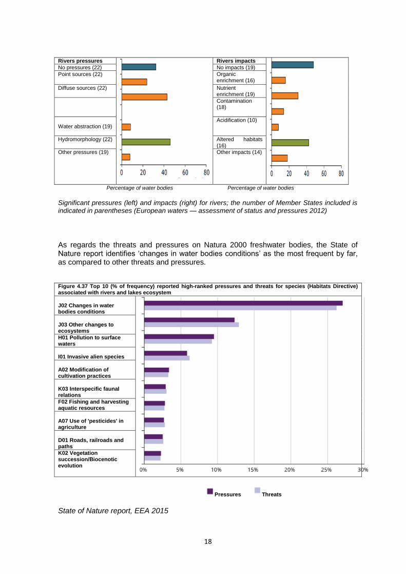
Rivers pressures
Rivers impacts
No pressures (22) No impacts (19)
Point sources (22)
Organic enrichment (16)
Diffuse sources (22)
Nutrient enrichment (19)
Contamination (18)
Water abstraction (19)
Acidification (10)
Hydromorphology (22)
Altered habitats (16)
Other pressures (19)
Other impacts (14)
Percentage of water bodies Percentage of water bodies
Significant pressures (left) and impacts (right) for rivers; the number of Member States included is indicated in parentheses (European waters — assessment of status and pressures 2012)
As regards the threats and pressures on Natura 2000 freshwater bodies, the State of Nature report identifies ‘changes in water bodies conditions’ as the most frequent by far, as compared to other threats and pressures. Figure 4.37 Top 10 (% of frequency) reported high-ranked pressures and threats for species (Habitats Directive) associated with rivers and lakes ecosystem
J02 Changes in water bodies conditions
J03 Other changes to ecosystems
H01 Pollution to surface waters
I01 Invasive alien species
A02 Modification of cultivation practices
K03 Interspecific faunal relations
F02 Fishing and harvesting aquatic resources
A07 Use of 'pesticides' in agriculture
D01 Roads, railroads and paths
K02 Vegetation succession/Biocenotic evolution
Pressures Threats State of Nature report, EEA 2015
19
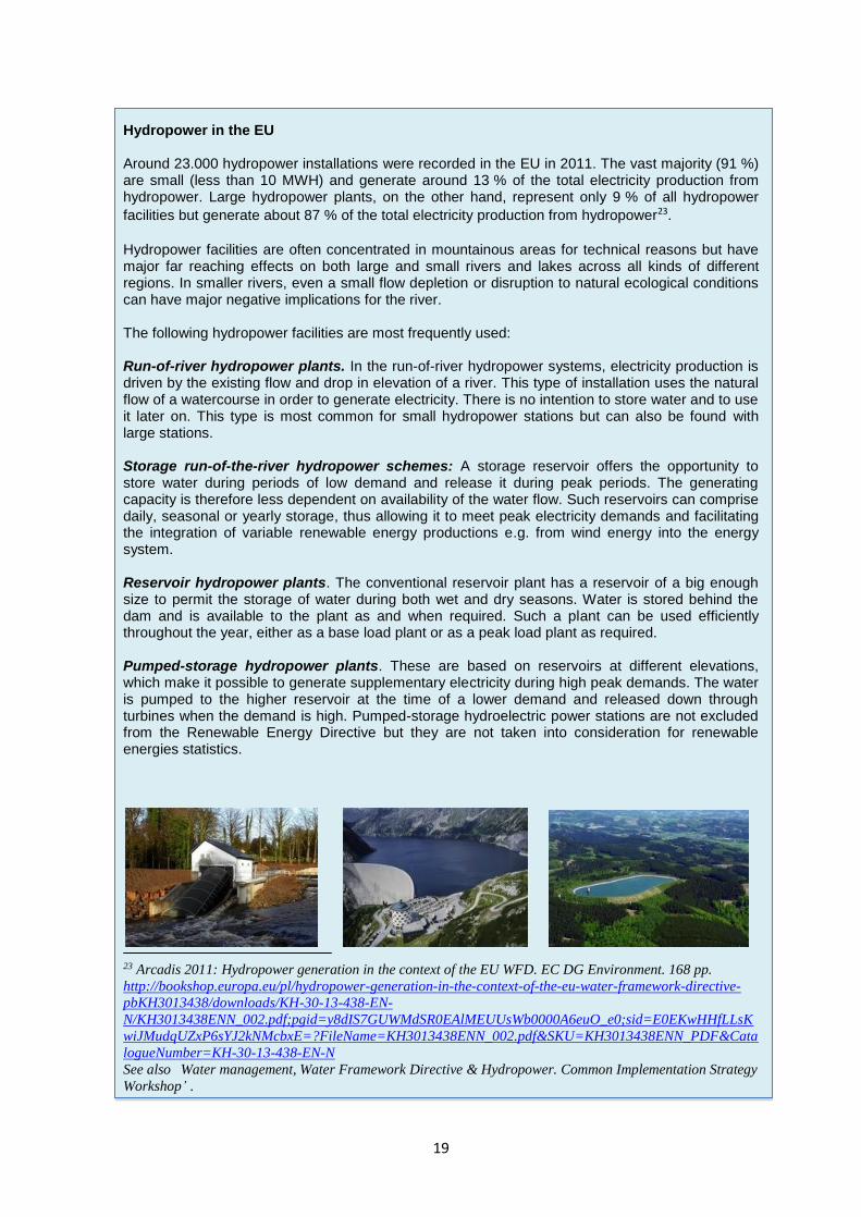
Hydropower in the EU Around 23.000 hydropower installations were recorded in the EU in 2011. The vast majority (91 %) are small (less than 10 MWH) and generate around 13 % of the total electricity production from hydropower. Large hydropower plants, on the other hand, represent only 9 % of all hydropower
facilities but generate about 87 % of the total electricity production from hydropower23.
Hydropower facilities are often concentrated in mountainous areas for technical reasons but have major far reaching effects on both large and small rivers and lakes across all kinds of different regions. In smaller rivers, even a small flow depletion or disruption to natural ecological conditions can have major negative implications for the river. The following hydropower facilities are most frequently used: Run-of-river hydropower plants. In the run-of-river hydropower systems, electricity production is driven by the existing flow and drop in elevation of a river. This type of installation uses the natural flow of a watercourse in order to generate electricity. There is no intention to store water and to use it later on. This type is most common for small hydropower stations but can also be found with large stations. Storage run-of-the-river hydropower schemes: A storage reservoir offers the opportunity to store water during periods of low demand and release it during peak periods. The generating capacity is therefore less dependent on availability of the water flow. Such reservoirs can comprise daily, seasonal or yearly storage, thus allowing it to meet peak electricity demands and facilitating the integration of variable renewable energy productions e.g. from wind energy into the energy system. Reservoir hydropower plants. The conventional reservoir plant has a reservoir of a big enough size to permit the storage of water during both wet and dry seasons. Water is stored behind the dam and is available to the plant as and when required. Such a plant can be used efficiently throughout the year, either as a base load plant or as a peak load plant as required. Pumped-storage hydropower plants. These are based on reservoirs at different elevations, which make it possible to generate supplementary electricity during high peak demands. The water is pumped to the higher reservoir at the time of a lower demand and released down through turbines when the demand is high. Pumped-storage hydroelectric power stations are not excluded from the Renewable Energy Directive but they are not taken into consideration for renewable energies statistics.
23 Arcadis 2011: Hydropower generation in the context of the EU WFD. EC DG Environment. 168 pp.
http://bookshop.europa.eu/pl/hydropower-generation-in-the-context-of-the-eu-water-framework-directive-
pbKH3013438/downloads/KH-30-13-438-EN-
N/KH3013438ENN_002.pdf;pgid=y8dIS7GUWMdSR0EAlMEUUsWb0000A6euO_e0;sid=E0EKwHHfLLsK
wiJMudqUZxP6sYJ2kNMcbxE=?FileName=KH3013438ENN_002.pdf&SKU=KH3013438ENN_PDF&Cata
logueNumber=KH-30-13-438-EN-N
See also Water management, Water Framework Directive & Hydropower. Common Implementation Strategy
Workshop’ .

20
2.3 The effects of hydropower on freshwater ecosystems The range of effects a hydropower facility can have on species and habitat types protected under the two EU Nature Directives will vary considerably from one site to another. It will depend on the individual characteristics of the river, its physical and ecological state — whether already degraded or still pristine, large or small, mountainous or lowland etc. — as well as on the type and scale of hydropower facilities and the species and habitats for which the site has been designated. There is therefore a need to look at each facility on a case-by-case basis. The effects can occur at any stage of the life cycle of a hydropower installation, from its initial construction to its renovation, decommissioning or their day-to-day operation and management. They can result in the loss, degradation and fragmentation of natural habitats and populations of species that depend on these habitats for their existence. The significance of loss depends on the scale of the effects as well as on the rarity and vulnerability of the habitats and species affected. The remainder of this chapter outlines the range of effects that hydropower can have on habitats and species under the EU Nature Directives in particular. Operators who are aware of the types of effects and who have an understanding of the complexities of the riverine ecosystems will be better placed to ensure that their activities are compatible with the requirements of the WFD and Nature Directives. They will also be better placed to identify potential win-win situations to help restore already degraded rivers wherever possible.
Changes in river morphology and riverine habitats Any physical modification to water bodies will affect the normal hydrological processes and disrupt the ecological continuity24 of freshwater systems both longitudinally and laterally, e.g. by disconnecting rivers from their surrounding floodplains and wetlands, or by creating a ponding effect around power plants. The most obvious form of habitat loss is the direct physical destruction of the habitats themselves upstream or downstream or in the surrounding area (e.g. land take, inundation, removal of riparian vegetation or physical structures in the river). But even without physical land take, the disruption of natural hydromorphological processes can also disrupt or alter the biotic and abiotic conditions that are vital for the habitat’s structure and functioning. Additionally, it can lead to the colonisation of degraded habitats by invasive species that could end up displacing the natural fauna.
Barriers to migration and dispersal of protected species Rivers, lakes and riparian zones play an important role in the dispersal and migration of freshwater species and in more localised movements between different feeding, breeding, resting and nesting areas. They act as vital ecological corridors or stepping stones across the landscape. Any barriers or impediments to their free movement up or down stream, however small, can have important consequences for the survival of these species.
24 further details provided in Common Implementation Strategy for the Water Framework Directive, WFD
and hydromorphological pressures, Technical Report, Good practice in managing the ecological impacts of
hydropower schemes. https://circabc.europa.eu/sd/a/68065c2b-1b08-462d-9f07-
413ae896ba67/HyMo_Technical_Report.pdf .

21
Range of impacts caused by different hydropower facilities Source: Veronika Koller-Kreimel
22
Hydropower installations can either directly or indirectly disrupt or prevent species dispersal and migration. The most obvious are dams and impounded areas which present physical barriers to fish migration, preventing the fish from travelling up and down the river. This has major effects on the survival of a wide range of freshwater species, resulting in the fragmentation, isolation and ultimate disappearance of some freshwater fish populations in particular. The barrier effect is especially severe when there is more than one obstacle on a river stretch. Even with very small structures or physical barriers, rivers can rapidly become un-passable. Artificial canals can also act as barriers to species movement because they cut through and consequently fragment terrestrial habitats. They may also create artificial connections between catchments which can enhance the spread of non-native species, to the detriment of native species. Although up- and downstream migration is important for all fish species, continuity is essential for diadromous species in particular. Upstream migration is most important for populations of anadromous fish and lamprey species like Salmo salar, sea lampreys Petromyzon marinus and Lampetra fluviatilis or some sturgeons as Acipenser sturio because of their need for periodical (optimally annual) long-distance migrations. Downstream migrations are essential for their juveniles and for adults of catadromous fish such as the eel Anguilla anguilla, which is protected under the Eel Regulation25.
Disruption of sediment dynamics Sediments are a natural part of aquatic ecosystems and are essential for the hydrological, geomorphological and ecological functioning of these systems. Sediment forms a variety of habitats which directly and indirectly support a broad range of species. Under natural conditions, there is a permanent downstream transport of sediments (mainly gravel) which maintains the ecological structure and function of the rivers. Transverse structures such as weirs or dams tend to disrupt the natural sediment dynamics. Large reservoirs can trap over 90 % of incoming sediment which can lead to increased erosion of the river bed and banks downstream as well as the local destruction of important hydromorphological structures such as gravel bars. Maintenance works on weirs and dams involving the periodic flushing of sediments (especially in summer when there is water scarcity) can also be detrimental for habitats and species if not managed properly. Upstream of a dam, in a reservoir or in impounded sections, the reduction of the sediment transport capacity causes sediment to accumulate which can have a negative effect on both species and habitats, e.g. by promoting the growth of algae and other aquatic weeds that crowd out the protected species. The accumulation of gravel or other silty sediments on the riverbed or in the water column may be especially detrimental to lithophile species, such as grayling Thymallus thymallus, which use these areas as spawning grounds for the freshwater pearl mussel Margaritifera margaritifera and the thick shelled river mussel Unio crassus. It is also detrimental for bird species, such as the plover or sandpiper that use dry gravel beds as nesting places.
25 Available under: http://eur-lex.europa.eu/legal-content/en/TXT/?uri=CELEX%3A32007R1100.
23
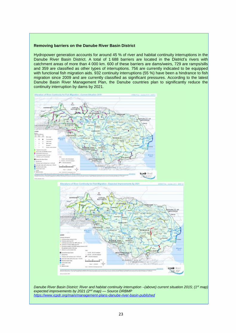
Removing barriers on the Danube River Basin District Hydropower generation accounts for around 45 % of river and habitat continuity interruptions in the Danube River Basin District. A total of 1 688 barriers are located in the District’s rivers with catchment areas of more than 4 000 km. 600 of these barriers are dams/weirs, 729 are ramps/sills and 359 are classified as other types of interruptions. 756 are currently indicated to be equipped with functional fish migration aids. 932 continuity interruptions (55 %) have been a hindrance to fish migration since 2009 and are currently classified as significant pressures. According to the latest Danube Basin River Management Plan, the Danube countries plan to significantly reduce the continuity interruption by dams by 2021.
Danube River Basin District: River and habitat continuity interruption –(above) current situation 2015; (1st map) expected improvements by 2021 (2nd map) — Source DRBMP https://www.icpdr.org/main/management-plans-danube-river-basin-published
24
Changes of the ecological flow regime Ecological flows are a vital mechanism for maintaining essential processes of healthy river ecosystems upon which EU protected species and habitats depend and to ensure a good ecological status of the water bodies26. A change in ecological flow can reduce or degrade
the extent of the aquatic habitat as well as its connectivity with riparian habitats. Too little water flow for instance can have a wide range of negative effects including the drying out of spawning sites for fish and lamprey species or preventing the development of fish eggs and juveniles. Fish migration upstream can also be hampered in the depleted reach, either because of blockages from the low flows or because of insufficient stimuli encouraging fish to migrate. Inadequate flow rates in the original riverbed can also cause the water to overheat and contain insufficient oxygenation (as described above). This creates unsuitable living conditions for a whole range of species such as fish, crayfish and lamprey species, bivalve molluscs, or dragonflies dependent on flowing water habitats.
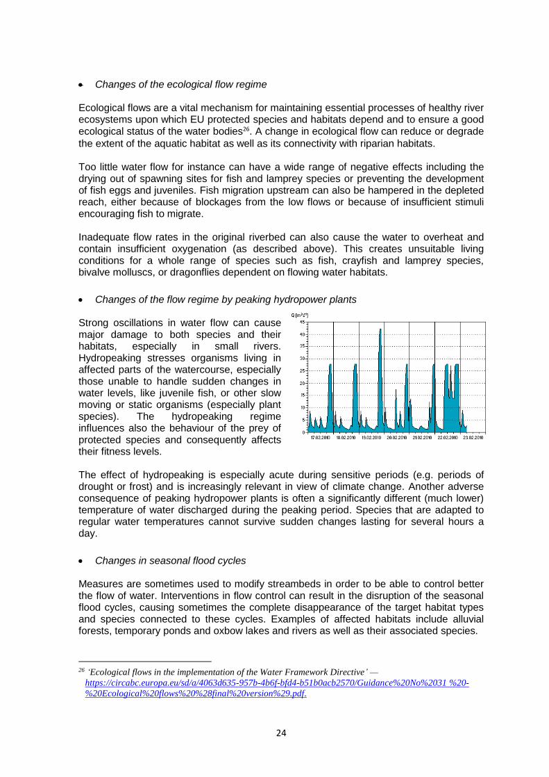
Changes of the flow regime by peaking hydropower plants Strong oscillations in water flow can cause major damage to both species and their habitats, especially in small rivers. Hydropeaking stresses organisms living in affected parts of the watercourse, especially those unable to handle sudden changes in water levels, like juvenile fish, or other slow moving or static organisms (especially plant species). The hydropeaking regime influences also the behaviour of the prey of protected species and consequently affects their fitness levels. The effect of hydropeaking is especially acute during sensitive periods (e.g. periods of drought or frost) and is increasingly relevant in view of climate change. Another adverse consequence of peaking hydropower plants is often a significantly different (much lower) temperature of water discharged during the peaking period. Species that are adapted to regular water temperatures cannot survive sudden changes lasting for several hours a day.
Changes in seasonal flood cycles Measures are sometimes used to modify streambeds in order to be able to control better the flow of water. Interventions in flow control can result in the disruption of the seasonal flood cycles, causing sometimes the complete disappearance of the target habitat types and species connected to these cycles. Examples of affected habitats include alluvial forests, temporary ponds and oxbow lakes and rivers as well as their associated species.
26 ‘Ecological flows in the implementation of the Water Framework Directive’ —
https://circabc.europa.eu/sd/a/4063d635-957b-4b6f-bfd4-b51b0acb2570/Guidance%20No%2031 %20-
%20Ecological%20flows%20%28final%20version%29.pdf.

25
RIPEAK — EU RESEARCH PROJECT: Responses of RiParian forests to hydroPeaking: towards a sustainable hydropower management Hydropeaking refers to short-term changes in river flow occurring within the span of a day caused either by turning on or off hydro-turbines to generate electricity according to variations in the market demand. As a result, downstream and upstream river hydrology, hydraulic parameters, water quality, river morphology, and ultimately the fluvial ecosystem, are modified. Scientific studies on the effects of hydropeaking are scarce and most of them have focused on fish fauna. Moreover, there are no studies on riparian vegetation. Hydropeaking might result in a failure of riparian species recruitment and hence affects the maintenance of riparian populations. Thus, by analysing seed germination and seedling performance, it might be possible to define hydropeaking — vegetation responses relationships that make it possible to quantify, correlate and predict biological responses to hydropeaking. Such relationships are crucial to objectively define thresholds which help to minimise ecological effects of hydropower generation without causing significant production losses. This project aims to shed some light on the sustainable management of rivers subjected to hydropower production. For this goal, an in-depth literature review, analysis of sub-daily flow series, field experiments and computer modelling are planned. The final contributions from the project expected are: (1) new hydrological and ecological (i.e. riparian vegetation) metrics of hydropeaking impact, (2) new hydrology-ecology models to quantify such effects and (3) new effective measures for a sustainable operation of hydropower dams. http://www.emg.umu.se/english/research/research-projects/responses-of-riparian-forests-to-hydropeaking/
Water chemical and temperature changes Dams can fundamentally change the chemical quality, mineral composition and the pH of the river both up and downstream, for instance by accumulating contaminants in sediments. All these changes influence the composition of plant and animal communities present. Organisms are also influenced by changes of water temperature and connected alterations of oxygen concentration. Reservoirs can lead to an important increase of temperature but also to a reduction in temperature if the water is taken from the bottom.
Injuries and killing of individual animals Fish and other species passing through a hydropower plant can be injured or killed. A hydropower plant can cause:27
- injuries through physical contact with guide vanes, turbine runner or turbine casing - damage from pressure fluctuations during the turbine passage
27 Arcadis 2011: Hydropower generation in the context of the EU WFD. EC DG Environment.168 pp.
26
- wedging onto intake screens or injuries caused by cleaning machines - injuries caused by intense flow and constructions of overflow in spillways - susceptibility to predation due to the disorientation.
The degree of mortality can vary from 0 to 100 % at a single hydro power plant28. Much depends on the type of fish present and on the type of hydropower construction and the mitigation measures used. The mortality rate of turbines increases with the velocity and number of rotor blades and with decreasing distance between the blades (Kaplan). Mortality can reach 100 % when fish pass through turbines that are mainly in high-pressure plants (e.g. with a Pelton turbine).
Displacement and disturbance River engineering works may cause disturbance to certain species and disrupt their life cycles both inside and outside Natura 2000 sites, especially in the case of benthic fauna and flora which rely on a good water quality. This may affect the species ability to breed, feed, rest or disperse and migrate. If the disturbance reaches significant levels it can lead to the exclusion of the species from that area and hence the loss of habitat use or it can result in poorer survival and/or breeding success. In the case of rare and endangered species even small or temporary disturbances can have serious repercussions for their long-term survival in the region. Such situations would be incompatible with the species protection provisions of the two Nature Directives.
Effects on terrestrial species and habitats Hydropower may have effects not just on freshwater species and habitats but also on terrestrial species and habitats. Again this can occur at any time e.g. during the construction, decommissioning or renovation of hydropower. It can also be caused by associated infrastructures such as access roads, pipe routes, or powerlines designed to connect the hydropower facility to the electricity grid. In addition to the loss, degradation or fragmentation of the habitats involved, these structures could cause the death or significant disturbance of terrestrial species. Birds for instance might collide with and be electrocuted by overhead electricity wires or their breeding sites could be severely disturbed by regular traffic on the access roads. Such effects may be especially significant when the hydropower plant and associated infrastructures are located along migration routes or along narrow valleys with cliffs used by raptors, or next to important bird wetlands. 2.4 Cumulative effects
As the EEA’s State of the Environment report illustrated, most European rivers are now in a degraded state and the majority have reached a saturation point where they can no longer host any new developments or activities without causing a further significant deterioration of the river’s status. Special consideration must therefore be given to
28 References: Ferguson, Absolon, Carlson and Sandford 2006. Transaction of the American Fisheries Society 135:139-150). Calles and Greenberg 2009. River Research and Applications 25:1268-1286. Gustafsson 2010. .

27
assessing the potential cumulative effects of any new activities, including those for hydropower plants, on rivers in general and on Natura 2000 site(s) in particular. The assessment of cumulative effects is especially important on near natural rivers, particularly small rivers, that are vulnerable to any changes in their hydromorphology. Even one or two small installations may bring about unacceptably high effects that are in conflict with the legal requirements of the WFD and the two Nature Directives. The assessment of cumulative effects should consider all of the hydropower plants and other developments in the catchment area, irrespective of whether they are situated in or outside the Natura 2000 sites. It may be that one hydropower project, taken on its own, will not have a significant effect, but if its effect is added to those of other already existing activities or approved projects their combined effects can become significant. Cumulative effects will often only occur over time. It is therefore important to consider all plans or projects during the assessment. This includes any plans and projects which have been approved in the past but which have not yet been implemented or completed, as well as any existing pressures and threats. In this context, information available in the WFD river basin management plans and Natura 2000 management plans may be useful for this. Also, it is important to note that an already approved plan or project does not create a presumption in favour of any other plans or projects that may be proposed in the future. For example, if a hydropower development does not give rise to a significant effect and is therefore approved, the approval does not create a presumption in favour of further hydropower developments in the future. On the contrary, the approval of this project may mean that the river will have reached its carrying capacity and will not be able to tolerate any further developments, however small. In addition, the assessment of cumulative and in combination effects is not restricted to the assessment of similar types of plans or projects in the same sector. Any other types of plans or projects that could, in combination with the plan or project under investigation, have a significant effect, should be taken into account during the assessment. Potential cumulative effects should be assessed using sound baseline data and not rely on qualitative criteria only. They should be assessed as an integral part of the overall assessment and not be treated as an ‘afterthought’ at the end of the assessment process. Lastly, a cumulative assessment must also consider already existing installations on the river (the so called ‘pre-load)29. For instance, if a new project is planned with a new turbine, its effect must be assessed in light of the existing hydropower plant even if this was built decades ago. If the cumulative effects are significant, the new project will be refused.
29 European Court of Justice Ruling C-142/16

28
Recommendations on small hydropower plants, Federal Environment Agency, Germany In Germany, around 80 % of the usable hydropower potential has already been exploited. The technological potential was also largely exhausted. This was reflected in the relatively low rates of support available for hydropower use in support programmes. The remaining exploitable potential therefore mainly concerns small, previously undeveloped, virtually undisturbed waters. Yet the possible harmful ecological effects on the few remaining small undisturbed watercourses in Germany are likely to be considerable. Macro-economic cost-benefit analysis has also shown that the economic costs can be considerable, compared with the benefit. The smaller the installation’s capacity and the more natural the watercourse, the less favourable the cost-benefit analysis is. Economic evaluations show that, especially with small hydroelectric power plants with a capacity of up to 100 kW, in all three cases of new construction, modernisation and reactivation, the cost of producing energy is higher than the rates of payment under the Renewable Energy Act. Therefore in many cases, even in favourable circumstances, electricity can hardly be produced economically. Economic considerations show that a subsidy that covers the operating costs of small hydroelectric power plants — in particular plants with a capacity of under 100 kW — leads to high macro-economic costs for the avoidance of CO2 emissions. Against the background of negative ecological effects, further exploitation of the potential of small hydroelectric power plants is not a priority for climate protection. Considering prevailing legal provisions and the requirements of the EC Water Framework Directive, the following recommendations have been put forward:
On account of their higher efficiency, large hydroelectric power plants are generally to be given preference to small and micro-installations for secondary use on waters already developed and impounded. When developing hydropower capacity attention should be focused on their optimisation.
With virtually undisturbed waters, or those where re-naturalisation is planned, the use of hydropower should be renounced.
The construction and reactivation of small hydroelectric power plants is unproblematic at existing weirs that cannot be demolished, in particular when, at the same time, ecological improvements — for instance, restoring free passage — can be achieved.
With the reactivation of installations currently not in operation, and the renewal of water rights, concerns of water protection should be more strongly considered and conditions laid down (for example, functional fish ladders, structurally-guaranteed dynamic minimum water flow, exclusion of flash floods downstream dams).
In the case of new installations, impounding of a water body for diversion is to be avoided. Constructional methods should be chosen, which divert the water used in such a way that the free passage and character of the watercourse is maintained (e.g. lateral water intake with a diversion structure in the water body). Requirements are to be issued on minimum flow and on measures for the avoidance of damage to fish from turbines. Flash floods downstream of dams are to be prohibited.
Abstract from: Hydroelectric Power Plants as a Source of Renewable Energy- legal and ecological aspects –Umweltbundesamt, November 2003 http://www.umweltbundesamt.de/sites/default/files/medien/publikation/long/2544.pdf

29
2.5 Distinguishing between significant and insignificant effects Identifying the range of effects on the species and habitats that are likely to be affected by a hydropower development plan or project is the first step of any impact assessment. After that, it is necessary to determine whether the effect is significant or not in view of the Natura 2000 site’s conservation objectives. Clearly, the assessment of significance needs to be done on a case-by-case basis, in function of the site-relevant species and habitats and of the precise characteristics of the project itself and on the basis of sound scientific expertise (see Chapter 5). The loss of a few individuals may be insignificant for some species but may have serious consequences for others. Population size, distribution, range, reproductive strategy and life-span will all influence the significance of the effects, and this will vary from one Natura 2000 site to another, even if they are designated for the same species. The interconnectivity of effects should also be taken into account. For instance, land take on its own may not be significant for a particular species, but when combined with major disruptions to natural river flows, the impact may become significant. The assessment of significance should be considered over an appropriate geographical scale. For migratory species that move over very long distances (such as Atlantic salmon Salmo salar), the effect at a specific site may have consequences for the species over a larger geographical area (river basin). Likewise, for resident species with large territories or changing habitat uses, it may be necessary to consider potential effects on a regional, rather than a local scale. The conservation objectives of the Natura 2000 sites are also essential for helping to determine if there is a likely significant effect. This is confirmed by the European Court of Justice Waddenzee ruling30 paragraph 49, ‘…where a plan or project not directly connected with or necessary to the management of a site is likely to undermine the site’s conservation objectives, it must be considered likely to have a significant effect on that site. The assessment of that risk must be made in the light inter alia of the characteristics and specific environmental conditions of the site concerned by such a plan or project.’ The appropriate assessment must be based on the best available data. This may require dedicated field surveys or monitoring programmes some time in advance of the project. The investors have to be able to anticipate this in their planning and ensure the relevant data from biological and hydrological surveillance includes information on all important aspects (life cycle and seasonal variability). Such studies can sometimes take several years before they are able to capture sufficiently the life cycle of the species and habitat types concerned (see Chapter 5 for details).
30 European Court of Justice Ruling C- C-127/02
30
Guidance on setting thresholds of significance in Germany In Germany, as elsewhere, because of a high level of subjectivity, it was difficult to assess the significance of effects on Natura 2000 target features, which is the core of the appropriate assessment. As a result, the competent authorities often did not have the reasonable scientific certainty they needed to back their decisions on whether or not to authorise a plan or project. It also left them open to legal challenges. To address this problem and ensure a more uniform and consistent approach when assessing the impact significance in practice, the German Federal Agency for Nature Protection (BfN) commissioned a research project to provide scientifically tested rules and conventions for all habitat types and species listed in the Birds and Habitats Directives that occur in
Germany31. The resulting guidance document was published in 2007.
The starting premise for the guide is that any permanent loss of habitat types and habitats for species in a Natura 2000 site should be considered a significant impact. However, a certain level of loss could nevertheless be treated as insignificant for some habitat types and species under certain conditions. The guide provides scientifically agreed thresholds and criteria for determining significance, which are based on qualitative as well as functional aspects — not just quantitative criteria. Thus, for an impact to be considered insignificant all the following conditions must be met:
- Specific features of the given habitat/ habitat for species or key habitats of the typical species must remain unaltered,
- Orientation values of ‘quantitative — absolute area loss’ are not exceeded, - Supplementary values of ‘quantitative — relative area loss’ of 1 % are not
exceeded, - Cumulative effects with other projects do not exceed the above threshold values,
and - Cumulative effects with other factors do not occur.
For the 2nd indent, 7 size classes for habitats and 8 for species were developed, providing ranges in which the threshold values for every habitat type/species lie; 3 threshold degrees for each class were set. In practice this means that for 21 of the 91 habitat types occurring in Germany, no loss is acceptable, while for the remaining habitats some loss may be considered insignificant if it is scaled according to size classes and degrees. As for the 53 species from Annex II, no tentative threshold values exist for 16 of them, nor for 20 of the 98 Birds Directive species. In other words, no impact is likely to be acceptable. All these conclusions/ figures/ thresholds are intended to act as guidance only. This means that a case-by-case approach within each AA is still required. Since its publication, the guidance document has been successfully tested in the German courts and is now applied across the country. http://www.bfn.de/0306_ffhvp.html
31 Lambrecht H., Trautner J. (2007) Fachinformationssystem und Fachkonventionen zur Bestimmung der
Erheblichkeit im Rahmen der FFH-VP — Endbericht zum Teil Fachkonventionen, Schlussstand Juni 2007.
(Expert information system and expert rules for significance assessment within the framework of appropriate
assessment — Final report part Expert rules, final status June 2007. In German.).
31
Scales used by experts licensed for AA in the Czech Republic
A practical issue is the scale used for evaluation of the significance of effects during the AA. There is no prescription, but based on long practical experience, the following scale has been recommended to be used by AA experts licensed by law in the Czech Republic32: Impact significance is to be assessed against each target feature of the given
site. If the impact on even a single target feature is marked with ‘-2’ it automatically means the site integrity is adversely affected and such a project must not be granted a permit within the Article 6.3 procedure.
Value Term Description Examples
-2 Significant adverse impact
Significant adverse impact. Excludes plan/project implementation Significant disturbance or destructive impact on habitat or species population or its substantial part; significant disturbance of ecological demands of the habitat or species; significant impact on the habitat or natural development of a species. Under certain conditions, the impact can be lowered by mitigation measures.
Disruption of migration routes to spawning places of anadromous species Destruction of habitat by inundation because of new dam. Hydrological changes because of derivation significantly influencing population.
-1 Moderately adverse impact
Limited/moderate/non-significant adverse impact. Plan/project implementation is not excluded. Moderate troublesome impact to habitat or species population; moderate disruption of ecological demands of habitat or species; marginal impact on habitat or natural development of a species. Its elimination through mitigation measures is possible but application of mitigation measures cannot be enforced, unless national legislation requires differently.
Modernisation — using technology less damaging to fish, building fish passes on existing barriers. Impact on margin parts of population. Influence on habitat common in surrounding area.
0 Zero impact The plan/project has no demonstrable impact.
Outside area of occurrence.
+1 Moderately positive impact
Moderate favourable impact on habitat or species population; moderate improvement of ecological demands of the habitat or a species; moderate favourable impact on the habitat or on the natural development of a species.
Reconstruction of peaking hydropower to run-of-river hydropower without weir or dam.
+2 Significantly positive impact
Significant favourable impact on habitat or species population; significant improvement of ecological demands of habitat or a species, significant favourable impact on the habitat or natural development of a species.
Demolition of hydropower plant.
32 This scale has been recommended to and used by experts licensed for AA by law in the Czech Republic
since 2007 - http://www.mzp.cz/cz/hodnoceni_vyznamnosti_vlivu_koncepci .

32
3. GOOD PRACTICE EXAMPLES IN MITIGATING
EFFECTS AND APPLYING ECOLOGICAL
RESTORATION MEASURES TO HYDROPOWER 3.1 Aiming for the best practicable ecological condition of rivers in the context of hydropower As stated in the previous chapter, few of Europe’s large rivers remain in a relatively natural state, having been physically altered over the years for a wide variety of reasons, including for hydropower generation. The modernisation of existing hydropower plants should therefore be prioritised over the construction of new ones, to improve their ecological footprint. A range of measures can be taken to mitigate hydropower plants’ negative effects on river ecosystems and surrounding habitats and species, and to help improve their conservation status. This is a major part of achieving the objectives of the WFD and the two Nature Directives. Opportunities should also be sought to decommission inefficient or obsolete installations and remove them entirely from the river system. It should be noted that the default action to be taken under the WFD if a body of water has been degraded by an existing installation is to restore the river to good ecological status. Significant physical modifications can only be made if they also serve a legitimate purpose that cannot be achieved by other better environmental options (see WFD Article 4.3 for more details on the requirements for HMWB/AWB designation and respective guidance). The possibilities for technically upgrading hydropower installations and introducing ecological restoration measures must be evaluated on a case-by-case basis taking account of their cumulative effects. The type of ecological measures that can be implemented will depend very much on local circumstances, such as the condition of the river, other ongoing pressures along the river and the facilities already in place, as well as the type of species and habitats present. 3.2 Dealing with existing hydropower plants having a negative effect on a Natura 2000 site Existing hydropower facilities located in or near, or having negative effects on, Natura 2000 sites must at all times conform to the provisions of Article 6.2 of the Habitats Directive. More specifically, Article 6.2 imposes an obligation to ensure that the site does not deteriorate as compared to the state it was in when it was first designated under Natura 2000. This means that Member States should take all appropriate action that they may be reasonably expected to take to ensure that there is no deterioration of habitats and/or significant disturbance of species.

33
This means that Member States are legally obliged to:
investigate the threats and pressures brought about by the presence of hydropower facilities on the species and habitat types for which the site was designated, and
take the necessary remedial measures if these existing pressures are causing a decline or degradation of the targeted species and habitats present.
The European Court of Justice confirmed this requirement in the Owenduff Case (C-
117/00)33, where it ruled that Article 6.2 was infringed because measures had not been
adopted to prevent the deterioration of habitats of the species for which an SPA was designated. Several CJEU Cases34 have further clarified the type of legal protection
regime that needs to be put in place for the purposes of Articles 4.1 and 4.2 of the Birds Directive and Article 6.2 of the Habitats Directive. They stress in particular the need for the legal regime to be specific, coherent and complete, capable of ensuring the sustainable management and the effective protection of the sites concerned (C-293/07). The Court also identified infringements in cases where the regime in place was ‘too general and did not concern specifically the SPA or the species that live in it’ (C-166/04), measures taken were ‘too partial, isolated measures, only some of which promote conservation of the bird populations concerned, and so did not constitute a coherent whole’ (C-418/04), or SPAs were submitted to ‘heterogeneous legal regimes which did not confer on the SPAs a sufficient protection’ (C-293/07). It also considered that purely administrative or voluntary measures were not sufficient for the purposes of Article 6.2 (C-96/98). It should be noted that, for Natura 2000 sites, Article 6.1 of the Habitats Directive also requires Member States to put in place conservation measures that correspond to the ecological requirements of the habitat types in Annex I and the species in Annex II present on the sites. This means that hydropower installations must also comply with any more ambitious conservation objectives going beyond non-deterioration set under Article 6.2. They should also be integrated into the programme of measures within the RBMP. Although not obligatory, the Habitats Directive encourages nature authorities to develop Natura 2000 management plans in close cooperation with local stakeholders and land owners concerned to identify the threats and pressures on each Natura 2000 site and to jointly determine the necessary conservation measures that need to be implemented. Hydropower operators’ good communication with authorities and/or bodies in charge of management planning is essential and can lead to the inclusion of measures which can benefit both the conservation objectives and the hydropower operation.
33 see also C-75/01, C-418/04, C-508/04. 34 See also Cases C-166/97, C-96/98, C-57/89, C-44/95, C-75/01, C-415/01, C-6/04, C-508/04, , C-241/08, C-491/08, C-90/10.

34
3.3 Introducing ecological mitigation and restoration measures A wide range of measures can be introduced for both existing and new hydropower plants to reduce their ecological effects.35 These can either mitigate potential effects before they happen or restore damage that has already been done. Such measures can for instance involve: - the restoration of river continuity and fish migration, for example by removing old or
obsolete structures or building fish passes;
- reducing fish mortality for example by installing screens at inlets and specially adapted turbines;
- the restoration of an adequate variable ecological flow (including mitigation of low flows, dynamic flows, fish flows and rapidly changing flows) and sediment dynamics that improves the structure and functioning of freshwater habitats.
A wide range of measures can also be introduced to actively restore, reconnect or recreate valuable natural riverine habitats and habitats for rare and endangered species in order to make a net positive contribution to improving a river’s ecological condition in line with the objectives of the WFD and the Nature Directives. The type of measure chosen will very much depend on the ecological condition of the body of water in question, the type of hydropower facility present, other pressures and threats, and the overall cost and potential for improving the hydropower facility’s efficiency and generating capacity. Once the measures have been implemented, monitoring systems should be put in place to ensure that they have the desired effect and, where this is not the case, remedial measures should be taken to address any failings. Distinguishing between mitigation, compensation and ecological restoration Mitigation measures are directly linked to the likely effects and form part of the project, or are introduced by the authority as a condition for authorising a plan or project. Based on the precautionary principle, they are designed to remove likely negative effects, pre-empt them or reduce them to a level where they will no longer adversely affect the integrity of the site. At the date of the decision authorising the project’s implementation, the mitigation measures under the project must ensure that there is no reasonable scientific doubt as to the absence of adverse effects on the integrity of the site in question.36 Compensatory measures are intended to compensate for any damage that may be caused by the project. They can only be considered under Article 6.4 if the plan or project has been accepted as being necessary for imperative reasons of overriding public interest and where no alternatives exist (see Section 5). Ecological restoration measures are not necessarily linked to an environmental impact assessment and are designed to make a net positive contribution to improving the ecological condition of an already degraded river in line with the objectives of the WFD and the Nature Directives.
35 It is important to note the significant difference between mitigation measures and compensation or
ecological restoration measures (see section 5.3, page 80). 36 See ECJ Ruling 142/16 http://curia.europa.eu/juris/liste.jsf?num=C-142/16 discussed on page 45. See
also page 47 for examples of potential mitigation measures for hydropower.

35
Table: Overview of the most widespread measures to mitigate water storage
Hydromorphological alterations
Main ecological impact
Mitigation of… Mitigation measure options
River continuity for upstream fish migration reduced or interrupted
Fish: populations of migratory and other riverine fish absent or abundance reduced
Upstream continuity for fish
- Ramp - Fish pass - By-pass channel
River continuity for downstream fish migration reduced or interrupted
Fish: Populations of migratory and other riverine fish absent or abundance reduced
Downstream continuity for fish
- Less damaging turbines for fish - Fish screens - By-pass channel - Fish pass
Artificially extreme low flows or extended low flows
Reduced abundance of plant & animal species. Alterations to composition of plant & animal species
Low flow - Provide additional flow - River morphology changes
Loss of or reduction in flows so that they are not sufficient to trigger and sustain fish migrations
Migratory fish absent or abundance reduced
Fish flow Provide fish flow
Loss, reduction or absence of variable flows sufficient for flushing
Alteration/reduced abundance of fish and invertebrate species
Variable flow - Passive flow variability - Active flow variability
Rapidly changing flows (including hydro peaking)
Reduction in abundance of animal and plant species due to stranding and wash out
Rapidly changing flows
- Balancing reservoir(s) (internal) - Relocate tailrace - Reduce rate - Modify river morphology - Balancing reservoirs (external)
Alteration of general physico-chemical conditions both up- and downstream (e.g. temperature, super saturation etc.)
Altered composition or growth of macro invertebrate communities and fish or fish mortality
Physico-chemical alteration
- Flexible intake - Multiple intakes - Management of reservoir level
River continuity for sediment disrupted or reduced leading to changes in substrate composition
Reduction in fish and invertebrate abundance and alterations in species composition
Sediment alterations
- Mechanical break-up of bed armouring - Removal of sediment - Re-introduce sediment (intake

36
Hydromorphological alterations
Main ecological impact
Mitigation of… Mitigation measure options
structures) - Re-introduce sediment (reservoirs) - Restore lateral erosion processes - Introduce mobilising flows
Artificially extreme changes in lake level, reductions in quality and extent of shallow water and shore zone habitat
Reduction in abundance of plant and animal species. Alterations to species composition.
Lake level alteration
- Reduce abstraction - Increase inflows - Create embayment(s) - Manage shore/shallow habitats - Connectivity to tributaries - Artificial floating islands
Dewatered shore line and reduced river flow — ponded river
Alterations to plant and animal species composition (e.g. favouring disturbance-intolerant species/still water species)
Ponded rivers (impoundments)
- Bypass channel - Reduce storage level - In-channel habitat improvements - Lateral reconnection
Source: Adapted from table 3 in ECOSTAT working group report on a common understanding of using mitigation measures for reaching good ecological potential for heavily modified water bodies, part 2: Impacted by water storage37
In hydropower facilities, particular attention is often paid to the potential range of techniques that can be used to restore or facilitate the upstream and downstream movement of fish and other aquatic fauna within river systems. This is an evolving science in which a wide variety of techniques and innovative solutions are regularly trialled out and re-evaluated. It is not however a cure-all. There are too many examples of fish migration aides that have been put in place as a supposed mitigation measure but which have turned out to be either ineffectual or even detrimental to the fish populations they are supposed to help. This may be because the devices were ill conceived and not fit for purpose, or that they did not take account of the cumulative effects of other already existing obstacles along the river stretch. It may also be because the conditions for device maintenance or management were not respected or that there was no monitoring system to check whether or not the device was actually doing the job it was designed to do.
37 https://ec.europa.eu/jrc/en/publication/working-group-ecostat-report-common-understanding-using-
mitigation-measures-reaching-good-ecological.

37
This is why it is important to ensure not only that the fish pass or adapted turbine is built according to state-of-the-art developments in this sector and current best practices, but also that a sound monitoring system is in place to provide feedback on its effectiveness. In general, monitoring should show that the device makes it possible for all riverine species to enter the pass and that the vast majority (e.g. 85 %) can also exit alive. In the case of a fish pass, where possible, nature-like passes should be preferred, because the general rule is that the more nature-like a pass is, the better it works. The choice of the most suitable type of fish pass (e.g. vertical slot, bypass, rock-ramp, lift) strongly depends on local conditions (height of barrier, character of the stream, usability of neighbouring sites, etc.) and requires careful study on a case-by-case basis. Likewise, the impact of turbines on fish is usually significant but can sometimes be reduced by making certain adaptations to the turbine geometry and their mode of operation. However, such adapted turbines have so far not proven to be a guarantee that no fish will be killed or that the turbine is not still a barrier for migration. Once again, effectiveness must be assessed and monitored on a case-by-case basis. The planning of fish passes or adapted turbines should also be dependent on evaluation of the cumulative effect of the barriers in the wider river system. Building one fish pass along a river riddled with barriers may prove to be both expensive and inefficient. It is therefore important to look more strategically at all the barriers on the river stretch in question in order to decide on the best course of remedial action. Finally, it is essential to have a regular maintenance plan for all new constructions. Many fish passes or turbines will no longer be effective over the medium- to long-term if they are not maintained regularly enough. When is a fish ladder deemed an adequate mitigation measure? Findings of the ECJ Ruling 142/16 on the Moorburg coal-fired powerplant The Moorburg coal-fired power plant is situated within the port of Hamburg, on the south bank of the southern section of the Elbe river. This is a migratory route for certain fish species listed in Annex II to the Habitats Directive and as such plays an important role in a number of Natura 2000 areas situated upstream of the Geesthacht weir (Germany) whose conservation objectives cover these species. These areas are situated up to a distance of approximately 600 km from the plant. The Geesthacht weir is situated on the Elbe corridor, in between the Moorburg power plant and the Natura 2000 areas. Before authorisation for construction of the Moorburg plant was granted on 30 September 2008, an environmental impact assessment was conducted under German water legislation. This assessment concluded that the authorisation was compatible with the conservation objectives of the Natura 2000 areas because the operator had agreed to install a second fish ladder approximately 30 km from the plant, by the Geesthacht weir. There was therefore an intention to compensate for fish killed during the operation of the cooling mechanism, which draws large quantities of water from the river in order to cool the Moorburg plant (‘the fish ladder’). In addition, the impact assessment prescribed multi-phase monitoring in order to verify the effectiveness of the fish pass. The Commission considered that the authority concerned had wrongly classified the fish ladder as a mitigating measure.

38
Findings of the Court: ‘In order to ensure that the construction of the Moorburg plant would not adversely affect the integrity of the Natura 2000 areas concerned, it was the responsibility of the German authorities to take account of the protective measures included in that construction project. In that regard, it is settled case-law that the application of the precautionary principle in the context of the implementation of Article 6(3) of the Habitats Directive requires the competent national authority to take into account, inter alia, the protective measures forming part of that project aimed at avoiding or reducing any direct adverse effects on the site, in order to ensure that it does not adversely affect the integrity of the protected site (…C-521/12,..C-387/15 and C-388/15…). In the present case, it is clear from the file submitted to the Court that …… the fish ladder was intended to increase migratory fish stocks by allowing those species to reach their breeding areas, along the middle and upper reaches of the Elbe, more quickly. Increasing stocks in this manner was expected to compensate for the fish deaths near the Moorburg plant so that the conservation objectives of the Natura 2000 areas upstream of the plant would not be significantly affected. However, it is clear that the impact assessment itself did not contain definitive data regarding the effectiveness of the fish ladder, and merely stated that its effectiveness could only be confirmed following several years of monitoring. It must therefore be held that, at the time the authorisation was granted, the fish ladder, even though it was intended to reduce direct significant effects on the Natura 2000 areas situated upstream of the Moorburg plant, could not guarantee beyond all reasonable doubt, together with the other measures referred to in paragraph 35 of the present judgment, that that plant would not adversely affect the integrity of the site, within the meaning of Article 6(3) of the Habitats Directive. As regards the estimates on which the impact assessment was based, it should be pointed out that the data relating to the years 2011 to 2014 was collected by the Federal Republic of Germany after the granting of the authorisation of 30 September 2008. In that regard, it should be noted that it is at the date of adoption of the decision authorising implementation of the project that there must be no reasonable scientific doubt remaining as to the absence of adverse effects on the integrity of the site in question (judgment of 26 October 2006, Commission v Portugal, C-239/04, EU:C:2006:665, paragraph 24 and the case-law cited).’ The Commission also stated that the city of Hamburg granted the authorisation without taking into account, in the impact assessment for the Moorburg plant, the potential cumulative effects with those stemming from the Geesthacht pumped-storage power plant, which dates back to 1958 and does not have any specific fish protection mechanisms. According to the Commission, it is irrelevant that the Geesthacht pumped-storage power plant was constructed before the transposition period of the Habitats Directive expired, for the provisions of Article 6(3) of that directive are not limited to plans and projects approved or completed after this deadline.

39
Findings of the Court Under Article 6(3) of the Habitats Directive, when assessing cumulative effects national authorities are required to take into account all projects which, in combination with the project for which an authorisation is sought, are likely to have a significant effect on a protected site in the light of the objectives pursued by that directive, even where those projects precede the date of transposition of that directive. Projects which, like the Geesthacht pumped-storage power plant, are likely to cause, as a result of their combination with the project to which the impact assessment relates, deterioration or disturbance likely to affect the migratory fish present in the river and consequently result in the deterioration of the site concerned in the light of the objectives pursued by the Habitats Directive, are not to be excluded from the impact assessment required under Article 6(3) of the Habitats Directive.
http://curia.europa.eu/juris/liste.jsf?num=C-142/16
ICPDR technical paper: Measures for ensuring fish migration at transversal structures This document aims to inform the Danubian countries about existing technical solutions for restoring river continuity for fish migration. All guidelines currently available in the upper Danube catchment were considered. Their comparison showed that their overall structure and content is basically consistent and that deviations are only marginal in most cases. Since most guiding documents are only available in the German language, this document aims to provide the most important facts in English.
https://www.icpdr.org/main/practical-advice-building-fish-migration-aids

40
3.4 Good practice examples of mitigation and/or ecological restoration The following good practice examples illustrate how various types of mitigation and/or ecological restoration measures have been introduced to hydropower installations under a range of different circumstances. The management of freshwater Natura 2000 sites in England, with particular reference to hydropower and river Special Areas of Conservation (SAC). Natural England is the statutory agency responsible for providing advice on protected sites in England, including Natura 2000 sites. Natural England’s approach to decision-making on protected freshwater sites is habitat-led but species-aware. Objectives are based on natural ecosystem function, with freshwater species conserved as characteristic components of the naturally functioning ecosystem wherever possible. A holistic view of protected freshwater habitat features is taken - river habitat (for instance, Habitats Directive Annex II feature H3260: watercourses with Ranunculion and Callitricho-Batrachion vegetation) comprises the whole river corridor, encompassing all of the small-scale biotopes within it. The key components of natural habitat function (flow regime, natural morphology and sediment regime, water chemistry and an absence of direct biological stresses such as non-native species) are an intrinsic part of the objectives agreed for the habitat feature. Target levels of naturalness for these components are set out in the UK guidance for protected sites. Effects on these components of natural function are addressed through a range of protection and restoration measures. The approach has much in common with the principles of ecological status objectives in the Water Framework Directive, but differs in terms of the level of precaution applied to decision making, the level of ambition for protecting natural function and addressing historical damage, and the level of consideration of effects on natural ecosystem functioning. The approach is also in tune with climate change adaptation principles for freshwater ecosystems, which require a focus on the restoration of natural function. The English surface water network (including freshwater SACs) contains many thousands of in-channel structures, considerably affecting natural river and lake ecosystem function. Some are large structures with major ecological effects, whilst others are small and numerous, creating considerable cumulative effects. Many are associated with existing abstraction licences, which may or may not be used. Some were built for hydropower whilst many could be retrofitted. Restoration plans have been drawn up to remove physical modifications to river SACs wherever possible, in order to restore natural habitat function. This is an ambitious and long-term programme, initiated ten years ago (Wheeldon et al. 2015). There are also programmes to alleviate abstraction stress and pollution, and tackle non-native species. A joint regulators’ statement on hydropower has been drawn up with the water regulator in England (the Environment Agency) to set out decision-making processes relating to protected sites. This recognises the need for environmental precaution, proper consideration of cumulative effects, and decisions to be taken in the light of the specific conservation objectives of the site and associated restoration plans.

41
Where a Natura 2000 river restoration plan considers an in-channel structure to be immovable, or where it will take a long time period to remove it, then there may be scope for hydropower generation (permanent or temporary). However, the structure should be modified to minimise its impact on natural habitat function, and target values for the natural flow regime should be met (including limits on the cumulative extent of depleted reaches caused by abstraction). Given the objectives of protected freshwater sites in England, and the precaution and ambition associated with restoring natural habitat function, the freshwater Natura 2000 network is not a natural focus for hydropower development. Whilst there may be local circumstances where hydropower would be compatible with Natura 2000 objectives, greater opportunities exist outside of the protected site series in the wider surface water network. If hydropower developments are particularly important on the Natura 2000 network but conflict with conservation objectives, then a case for overriding public interest can be made. However, alternative solutions involving other forms of renewable energy with less nature conservation impact are likely to be more cost-effective. http://publications.naturalengland.org.uk/publication/5478339747774464?category=5605910663659520 Release of controlled floods from hydropower plants in the Ebro River (Spain) In Spain, controlled floods were legally established in 2008. Since that time, a number of flooding events have been carried out in Mediterranean rivers. For example, controlled flood rates have been calculated and released in the Lower Ebro River (Northeast Spain) since 2002, from the dam complex that regulates the river (Mequinenza-Ribarroja-Flix Dams). The main goal of these floods has been to control macrophyte populations and improve sedimentary activity in the channel (Tena et al., 2013). The dam complex was constructed between 1948 and 1969 and has a total storage capacity of ca. 1700 hm3. The reservoir system was created with several goals in mind: hydropower generation, water supply (including supply to a downstream nuclear power plant), and flood control. Flood releases from the dams were managed by the hydroelectric operator (Endesa Generación S.A.) and controlled by the Ebro Basin authority. In 2002, an understanding was reached between the hydropower operator, the water authorities, and the scientific community to promote the release of floods. Since then controlled floods have been performed on a regular basis, twice a year (in autumn and spring). The discharged floods have normally required the delivery of about 36 hm3 over 16 hours, with peak flows of 900 to 1300 m3/s (each). The design and downstream effects of these floods have been monitored and discussed in several studies (Batalla et al., 2006; Batalla & Vericat, 2009; Tena et al., 2013). The cost of the release has also been calculated and analysed, showing that the provision of artificial floods had a cost equivalent to a small fraction of the energy delivered to the market and overall annual revenue (0.17 % for the two annual controlled floods) (Gómez et al., 2014). References Gómez, C.M., Pérez-Blanco, C.D., & Batalla, R.J. 2014. Tradeoffs in river restoration: Flushing flows vs hydropower generation in the Lower Ebro River, Spain. Journal of Hydrology 518: 130-139.
42
The national framework strategy for migratory fish in France France’s rivers host eleven species of diadromous fish that migrate long distances between the sea and freshwater to complete their complex lifecycles. Many, such as European sturgeon, the Atlantic salmon, the Allis shad and the river lamprey, are protected under the EU Habitats Directive. However, despite the efforts undertaken to conserve these species, they all remain in an unfavourable condition in France and elsewhere in the EU. Recognising the scale of the problems facing these species in France, the Ministry for Ecology and Sustainable Development launched a national strategy for the conservation of migratory fish species in 2010. Designed as an evolving framework strategy, it sets a number of overall targets and objectives that can be adjusted over time in function of the species’ ability to recover. Because of the many different administrations and stakeholders involved in or potentially affected by the conservation, use and restoration of these migratory fish, a major effort was made right from the start to involve everyone concerned in the strategy’s development so that they endorsed the overall approach taken and were ready to contribute to its implementation. The Ministry of Sustainable Development formally adopted the strategy in 2010; it was endorsed by all those involved. Several river basin management plans in France (known as Schémas directeurs d’amenagement et de gestion des eaux, SDAGE) propose a significant number of measures to improve the situation of migratory species present, as defined in the national strategy. A national plan for the restoration of river continuity, adopted in 2010, also plays an important role in implementing the national strategy for migratory species. It is built around five pillars:
Create a national inventory of the 60 000 obstacles that have significant repercussions for the functioning of the aquatic ecosystem.
Define priority areas for intervention at the level of each of the river basins (in line with the Plan Grenelle for green and blue infrastructure).
Revise the programmes of Water Agencies to make the necessary funding available for restoration works in priority areas.
Mobilise the services of the water police within the framework of a multiannual programme of controls on those obstacles that are most disruptive for fish migration.
Evaluate the environmental benefits of the restoration measures and ensure close monitoring of their effects.
Referenciel des obstables a L’ecoulement: une cartographe nationale des obstacles sur les cours d’eau: http://www.eaufrance.fr/referentiel-des-obstacles-a-l
43
Restoring river connectivity in Austria Austria’s river basin management plan states that the lack of longitudinal and lateral continuity is one of the principal pressures on the country’s rivers. It recognises that a good ecological status under the WFD is only achievable if the migration of aquatic species and the transportation of sediment is made possible both from the river’s head to the mouth and from the river to its wetlands. River connectivity is also vital for the recovery of species and habitats protected under the two Nature Directives. The restoration of the longitudinal continuum is therefore seen as one of the primary goals of the management plan. The priority areas for the removal of migratory barriers were identified in 2009, and a number of river restoration projects have since been implemented. Several have been co-financed under the EU LIFE programme. This has ensured that the restoration measures introduced are improving not only the river’s connectivity for the benefits of the WFD and migratory fish, but also the overall conservation condition of the various Natura 2000 sites along the river. In 2011, these efforts were taken to a new level with the launch of a major LIFE+ project designed to implement an extensive network of measures on the Austrian part of the Danube. Called ‘LIFE+ Network Danube’, it is the largest project of its kind in Austria so far, with a total budget of € 25 million. The project is run by VERBUND, Austria’s leading electricity company, with the support of the Federal Ministry of Environment and the Fishing Associations. It aims to build on the work done under previous LIFE projects along the Danube, which together have already succeeded in making 20 km of the rivers Melk, Pielach and Ybbs passable for migrating fish species. The project will implement a wide range of different actions along the upper part of the Danube in order to improve its overall ecological status and the conservation status of some 17 fish species listed in the Habitats Directive. Ecological stepping stones will also be created between four major Natura 2000 sites along the river, which should also improve their overall conservation status. More specifically, ‘Network Danube’ will restore uninterrupted, natural fish migration paths (at least 22 km) at five of the largest run-of-river power plants along the Austrian Danube using a multitude of ecological measures. It will also recreate important gravel habitats (gravel banks, gravel islands) in the reservoirs of these five power plants and restore 500 m of river branches along the Danube. Flood protection will also be included in this process. The individual projects are currently being discussed regionally and will be submitted to the responsible authorities for approval before being rolled out. One of them, the Ottensheim-Wilhering bypass channel, will be Austria’s longest fish ladder to date. The 14.2-km bypass route is being created through the Innbach-Aschach cost around 8 million euros. VERBUND’s ultimate goal is to make the part of the Danube that flows through Austria (some 352 km) completely passable for fish by 2027. http://www.life-netzwerk-donau.at/de/

44
Hydromorphological restoration priorities in Austria Hydromorphological pressures, such as water abstraction, impoundments and discharges, are affecting significant parts of Austria’s water bodies. This is largely the reason for why two-thirds of rivers do not have a good ecological status under the WFD (BMLFUW 2014). Austria’s latest draft river basin management plan, published in 2015, prioritises the improvement of the hydromorphology of its rivers. It emphasises the need for largescale environmental revitalisation programmes to improve river structure and aid the recovery of endangered rheophilic fish species. Restoring dynamic floodplains and their drift zones will not only help improve the rivers’ ecological status under the WFD but should also improve the conservation condition of the Natura 2000 sites, species and habitats present.
Working towards creating synergies between WFD, MSFD, and HBD: selected case studies
Ecosystems LTD /N2K GROUP – October 2015 44
Priority areas for revitalisation – hydromorphological pressures (Source: @ NGP 2015)8
Synergies with Natura 2000
Many of the riverine habitat types and species protected under the Habitats and Birds
Directives require dynamic river conditions for their existence. This is only possible
in rivers with good hydromorphological conditions.
Rheophilic fish species (grayling, Danube salmon, nose carp, and gudgeons), for instance, use river widenings in different life-stages. For instance, the shallow
sections with gravel beds are used as spawning sites while the deeper sections with larger cobbles are used for feeding. All these different structures can be found in
revitalised rivers, compared to channelised sections which can only support feeding.
The ecosystem approach adopted in Austria’ National Water Framework Plan and the
priority given to hydromorphological issues will have for Natura 2000 as well.
restoring dynamic floodplains and their drift zones will not only help to improve the ecological status of the rivers under the WFD but should also enhance the
conservation condition of the Natura 2000 sites, species and habitats present.
LIFE+ Nature Project at the River Upper Mur (2010-2015)
Home to the second largest alluvial forest in Austria, the upper part of the River Mur
is considered to be one of the most ecologically valuable river courses of Austria,
which is why a substantial part (1290 ha) of it has been designated as a Natura 2000
site. It is also one of the last remaining places in Austria where natural reproduction
8AlistofpriorityareascanbefoundintableFG-Maßnahmen-2021andmapsoftheNGP(http://wisa.bmlfuw.gv.at/fachinformation/ngp/ngp-2015/tabellen/OW/ow_tabellen.html;http://wisa.bmlfuw.gv.at/fachinformation/ngp/ngp-2015/gewaesserbewirtschaftungsplan-2015.html)
Considered a priority area, the upper Mur river has been the focus of several major restoration projects, often co-financed under EU LIFE.38 Thanks to these projects, new river structures were created and meanders were re-connected to the Mur. Artificial bank reinforcement structures were also partially removed over a total length of 4.7 km. This opened up over 90 km of the river for the free passage of fish. Work on a further seven new sections of the river is continuing under a second LIFE project. However, there is still the challenge of how to reconcile the needs of the WFD, Natura 2000 and the Floods Directive on the one hand, and the requirement to produce renewable energy on the other, over the entire length (330km) of the river in Austria. To address this, the authorities, in consultation with stakeholders, have developed a new plan that includes a carefully drawn-up zoning scheme with ecological priority zones, trade-off zones and zones with no particular restrictions or interest (mainly in the middle- to lower stretches of the river). This plan, which is valid until 2022, sets the foundations for complying with the mandatory energy targets, while maintaining/improving the river’s ecological status in accordance with EU environmental laws.
38 https://restorerivers.eu/wiki/index.php?title=Case_study%3AAustria_Upper_Mur_-
_River_widening_Lässer_Au_(LIFE%2B_(LIFE%2B_08_NAT_A_614)_„Inner-
Alpine_river_basin_management_–_Upper_River_Mur_-_murerleben_II%22_2010-2015).
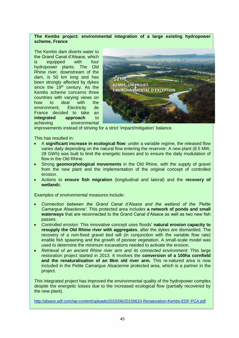
45
The Kembs project: environmental integration of a large existing hydropower scheme, France The Kembs dam diverts water to the Grand Canal d’Alsace, which is equipped with four hydropower plants. The Old Rhine river, downstream of the dam, is 50 km long and has been strongly affected by dykes since the 19th century. As the Kembs scheme concerns three countries with varying views on how to deal with the environment, Electricity de France decided to take an integrated approach to achieving environmental improvements instead of striving for a strict ‘impact/mitigation’ balance. This has resulted in:
A significant increase in ecological flow: under a variable regime, the released flow varies daily depending on the natural flow entering the reservoir. A new plant (8.5 MW, 28 GWh) was built to limit the energetic losses and to ensure the daily modulation of flow in the Old Rhine.
Strong geomorphological movements in the Old Rhine, with the supply of gravel from the new plant and the implementation of the original concept of controlled erosion.
Actions to ensure fish migration (longitudinal and lateral) and the recovery of wetlands.
Examples of environmental measures include:
Connection between the Grand Canal d’Alsace and the wetland of the ‘Petite Camargue Alsacienne’. This protected area includes a network of ponds and small waterways that are reconnected to the Grand Canal d’Alsace as well as two new fish passes.
Controlled erosion: This innovative concept uses floods’ natural erosion capacity to resupply the Old Rhine river with aggregates, after the dykes are dismantled. The recovery of a non-fixed gravel bed will (in conjunction with the variable flow rate) enable fish spawning and the growth of pioneer vegetation. A small-scale model was used to determine the minimum excavations needed to activate the erosion.
Retrieval of an ancient Rhine river arm and its connected environment: This large restoration project started in 2013. It involves the conversion of a 100ha cornfield and the renaturalisation of an 8km old river arm. This re-natured area is now included in the Petite Camargue Alsacienne protected area, which is a partner in the project.
This integrated project has improved the environmental quality of the hydropower complex despite the energetic losses due to the increased ecological flow (partially recovered by the new plant). http://alsace.edf.com/wp-content/uploads/2015/06/20150610-Renaturation-Kembs-EDF-PCA.pdf

46
Reactivation of sediment transport across a series of 11 hydropower stations along the transboundary High Rhine In total, 73 km of the Rhine River from Lake Constance to Basel is impounded, and only three free-flowing stretches provide conditions that are more natural. The sediment transport and balance are disrupted and highly disturbed not only by the dams and weirs in the main river, but also by the highly reduced sediment input from major tributaries and from bank erosion due to extensive rip-rap constructions. Since 1990, during the long process of issuing new concessions for individual hydropower plants, the problem of bed load sediment transport across the weirs was debated only within the concession perimeter. However, river sediment transport is clearly a large-scale, basin-wide issue, and if there is a series of hydropower stations then it must be tackled in a cooperative way. In 2006, on an initiative of the Swiss environmental NGO Rheinaubund, the 11 hydropower plants, loosely organised in a hydropower association (VAR, Verband der Aare-Rhein-Kraftwerke), decided to form a common platform (PGG, Projekt-Gruppe Geschiebe) and, together with the responsible governmental authorities (Bundesamt für Energie, BFE, Switzerland and Regierungspräsidium Freiburg, RPF, Germany), to launch and finance a master plan for the reactivation of sediment transport and ecological revitalisation in the High Rhine. The PGG has only an advisory function, but national and regional authorities see the master plan as an expert study. The master plan goes through the following process: (1) the PGG-Core Group of experts prepares the tender and contract, and the scientific/technical review of the master plan; (2) the PGG-Forum made up of delegates of various key stakeholders reviews the process of the Core Group and drafts the master plan; (3) the PGG-Plenum, composed of all interested stakeholders, is informed about the planned project in a first workshop, then about the progress of work by short reports, and about the final version of the master plan in a final workshop. The master plan aims to:
provide a scientific review of the natural and present status of sediment transport (i.e. with and without hydropower plants),
provide basic scientific background knowledge about sediment transport mechanisms and modelling, and
describe all possible and technically feasible measures and scenarios to improve sediment transport and fish habitats along the whole impacted river section.
The first phase (which set out the organisation of the PGG and preparation of the master plan) lasted from 2007 to 2013. In a second phase, led by the Swiss and German authorities, the Plenum are discussing the political feasibility of recommended individual or combined measures, and finding solutions for implementing certain follow-up measures. These were organised according to priority, restoration potential, cost-benefit analysis and risk assessment. For further information please visit: www.energiedienst.de
47
EU CH2OICE PROJECT Certification for HydrO: Improving clean energy This project, which ran from September 2008 to February 2011, developed a technically and economically feasible certification procedure for hydropower generation facilities of a high environmental standard. The procedure had to be coherent with the requirements of the WFD, used for ‘green labelled’ electricity products, and be integrated, as much as possible, with existing EU tools, such as Ecolabel, EMAS, environmental impact assessment and sustainable energy action. The project included the development and testing of an operational methodology to be used in marketable products and a set of guidelines to be used by developers and decision makers during planning and authorisation procedures. The partner countries were: Italy, Slovenia, France, Spain and Slovakia. In the long term, the project is expected to have a positive impact on hydropower generation in Europe, as it aim to focuses on directing new plants towards more sustainable solutions and facilitating the authorisation procedure. Detailed project outputs
1 A general methodological approach for WFD (Water Framework Directive) — coherent certification was agreed by project partners where all the main problematic issues arising from past experiences and from the positions of main stakeholders involved were tackled, and ‘strategic’ decisions were taken (e.g.: whether to apply a quantitative, objective-oriented approach or one based on best practices).
2 Italy and Slovenia each defined and tested a national operational method for certification, based on consultation of national experts and stakeholders. By the end of the project, the certification method was ready to be implemented in a marketable product.
3 Guidelines for decision makers and hydropower generation companies were agreed for placing, constructing and managing new ‘green hydro’ plants. They help decision makers to quickly identify ‘no impact’ installations — e.g. plants on artificial ‘not significant’ water bodies — and guide them and hydropower plant designers to produce the right information for plant evaluation and authorisation.
4 An analysis document for Spain was produced, including a roadmap for the development of volunteer certification of hydropower generation facilities of a high environmental standard.
5 Proposals on the integration of the label scheme in existing procedures were presented and a feasibility analysis was carried out (and included a collection of points of view and agreements from relevant actors, where possible), with a focus on Italy and France.
https://ec.europa.eu/energy/intelligent/projects/en/projects/ch2oice

48
Sturgeon 2020: A strategic programme for the Sturgeon in the Danube Sturgeon constitute an important part of the natural heritage of the Danube river basin and the Black Sea. They serve as excellent indicators of good water and habitat quality. Today, four out of the six species are critically endangered, one is considered vulnerable and one is extinct. All are now protected under the EU Habitats Directive. In June 2011, the EU Strategy for the Danube region set as one of its targets (PA6 target) to ‘secure viable populations of Danube sturgeon species and other indigenous fish species by 2020’. A Danube sturgeon task force was created a year later in January 2012 to determine how to work together towards achieving this target. It brought together sturgeon experts, NGO delegates, and representatives of the International Commission for the Protection of the Danube River, the Danube strategy and national governments. One of the task force’s first actions was to draw up a Sturgeon 2020 programme, to act as a framework for concerted action. The Sturgeon 2020 programme is a living document and its success depends on the long-term commitment and implementation power of the countries concerned, since it requires complex cooperation between governments, decision makers, local communities, stakeholders, scientists and NGOs. One obvious vehicle for taking forward the measures proposed under the Sturgeon 2020 programme is the Danube river basin management plan (DRBMP) and its joint programme of measures. The 2nd draft DRBMP, updated in 2015, sets as one of its visions and management objectives ‘that anthropogenic barriers and habitat deficits do not hinder fish migration and spawning anymore — sturgeon species and specified other migratory species are able to access the Danube River and relevant tributaries. Sturgeon species and specified other migratory species are represented with self-sustaining populations in the DRBD according to their historical distribution’. The following are amongst the identified measures to be implemented in order to reach this management objective: - Specification of number and location of fish migration aids and other measures to
achieve / improve river continuity, which will be implemented by 2021 by each country. - Specification of location and extent of measures for the improvement of river
morphology through restoration, conservation and improvements, which will be implemented by 2021 by each country.
- Avoidance of new barriers for fish migration imposed by new infrastructure projects; unavoidable new barriers must incorporate the necessary mitigation measures like fish migration aids or other suitable measures already in the project design
- Closing the knowledge gaps related to the possibility for sturgeon and other specified migratory species to migrate upstream and downstream through the Iron Gate I & II dams, including habitat surveys,
- If the results of these investigations are positive, the appropriate measures should be implemented and a feasibility study should be performed for the Gabčíkovo Dam and the upper Danube.
According to the DRBMP, by 2021 140 fish migration aids will be constructed in the river basin (120 have already been constructed since the first DRBMP.) These should ensure the migration of all fish species, including sturgeon, and age classes using the best available techniques. Around a further 330 measures to restore river continuity interruptions are planned to be implemented after 2021 (WFD Article 4.4). http://www.dstf.eu
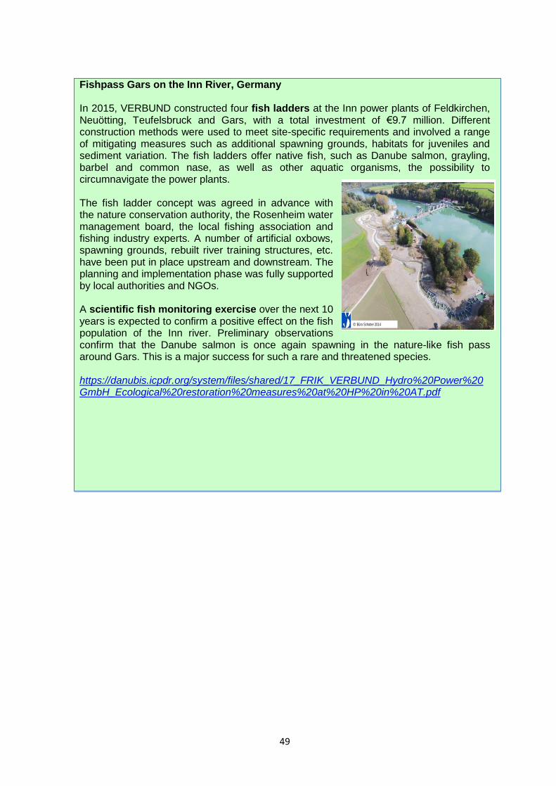
49
Fishpass Gars on the Inn River, Germany In 2015, VERBUND constructed four fish ladders at the Inn power plants of Feldkirchen, Neuötting, Teufelsbruck and Gars, with a total investment of €9.7 million. Different construction methods were used to meet site-specific requirements and involved a range of mitigating measures such as additional spawning grounds, habitats for juveniles and sediment variation. The fish ladders offer native fish, such as Danube salmon, grayling, barbel and common nase, as well as other aquatic organisms, the possibility to circumnavigate the power plants. The fish ladder concept was agreed in advance with the nature conservation authority, the Rosenheim water management board, the local fishing association and fishing industry experts. A number of artificial oxbows, spawning grounds, rebuilt river training structures, etc. have been put in place upstream and downstream. The planning and implementation phase was fully supported by local authorities and NGOs. A scientific fish monitoring exercise over the next 10 years is expected to confirm a positive effect on the fish population of the Inn river. Preliminary observations confirm that the Danube salmon is once again spawning in the nature-like fish pass around Gars. This is a major success for such a rare and threatened species. https://danubis.icpdr.org/system/files/shared/17_FRIK_VERBUND_Hydro%20Power%20GmbH_Ecological%20restoration%20measures%20at%20HP%20in%20AT.pdf
© VERBUND AG, www.verbund.com
Example no. 4: Inn River - Fischpass Gars
©: Büro Schober 2014
Page 31
50
4. GOOD PRACTICES IN APPLYING AN
INTEGRATED PLANNING APPROACH TO
HYDROPOWER 4.1 The benefits of integrated planning The requirement to ensure the production and use of energy from renewable sources and reduce greenhouse gases in line with the objectives of the EU Renewable Energy Directive represents a significant driver for the development and use of hydropower and other sources of renewable energy. At the same time, Member States must meet the objectives of the Water Framework Directive and the EU Nature Directives which aim to ensure that Europe’s water bodies are not only prevented from deteriorating further but also reach a good status (or potential), and that EU protected species and habitats achieve a favourable conservation status across the EU. These challenging tasks are best achieved through a strategic and integrated planning approach implemented through the national renewable action plans, river basin management plans and the conservation objectives of Natura 2000 sites39. A strategic planning approach:
is an excellent opportunity to integrate water, nature and energy policy objectives, as well as the objectives of other key policy areas;
makes it possible to link strategic planning for the aquatic environment and nature conservation with national energy planning on renewable electricity;
allows for the involvement of all interested parties, which can reduce subsequent potential conflicts and secure the projects;
uses the planning process to help set priorities (e.g. with respect to balancing energy, nature and water management priorities);
helps streamline the authorisation process on proposed new hydropower developments and improve transparency and predictability for hydropower developers;
allows the best environmental options and the overriding public interest of the project to be properly assessed;
provides upfront information to developers about where (geographically) gaining authorisation is likely to be possible as it identifies the most suitable and less suitable areas;
uses the policies and criteria established to help to manage the risks of cumulative effects from hydropower plants;
provides an opportunity through river basin management planning to integrate a strategic planning approach for hydropower development with water environment objectives, taking also into account the conservation objectives of the Natura 2000 sites involved.
39 Conclusions of the second CIS Workshop on the EU WFD and hydropower held in Brussels 2011,
https://circabc.europa.eu/sd/a/23d94d2d-6b9c-4f17-9e15-14045cd541f3/Issue.pdf.

51
This chapter looks at the various ways in which an integrated planning approach can be used to take account of potential negative effects on habitats and species during the early stages of the planning process. Chapter 5 looks at the requirements under the Nature Directives for a legal assessment of a proposed plan or project which is generally required to be made much later on, and then only in response to a ‘significant (negative) effect’. However, if a strategic plan for the development of hydropower contains any substantive spatial element such as the identification of potential areas for development, this should itself also be subject to assessment as a ‘plan’ under Article 6(3) of the Habitats Directive. This provides an opportunity, in accordance with Article 6(3), to mitigate the potential effects of hydropower development on the Natura 2000 network by steering development away from sites which are likely to cause conflict between development interests and the protection of a Natura 2000 site. The EU Blueprint to Safeguard Europe’s Water Resources, adopted in 2012, also stresses the importance of strategic integrated planning: ‘...in the context of Article 4(7), ... hydropower deserves specific attention … refurbishing and expanding existing installations should be given priority over new developments which should be underpinned by a strategic assessment at the river basin scale, selecting optimal locations in terms of energy production and lower environmental impact.’ It is clear that such an integrated planning process requires a more substantial initial investment for the public authorities concerned. However, all the evidence shows that, in the long run, integrated planning can deliver substantial benefits for all concerned — be it for the energy sector, the Water Framework Directive (WFD) objectives, the Natura 2000 objectives or other interests. These benefits often far exceed the initial extra investment required. Strategic integrated planning should be carried out on several different levels and at several stages of the planning process, by both authorities and/or developers as appropriate. It should be used in particular when:
Selecting the type of renewable energy source that aims to achieve the objectives of the Renewable Energy Directive while offering the best option for the environment. This search for alternative solutions is required both in the exemptions procedure under Article 4(7) of the WFD and in the appropriate assessment procedure under Article 6 of the Habitats Directive. However, it is equally important during the strategic planning phase or when drafting national/regional renewable energy plans.
Identifying the most suitable locations for hydropower generation that are potentially appropriate from both an energy and an environmental perspective. At the same time, strategic integrated planning helps to identify areas where there is a high risk of significant effects and where, as a consequence, there is little chance of obtaining a permit under the Article 4(7) WFD exemptions procedure or the Article 6 appropriate assessment procedure under the Habitats Directive. Developing such risk assessments or biodiversity sensitivity maps early on in the planning process can help avoid or reduce the number of potential site-specific conflicts at a later stage in the development process, when financial resources have been committed and there is less room for manoeuvre. It also provides developers with a more transparent and stable regulatory environment which offers them greater certainty over the likely success of their planning application.
52
EU water directors’ statement on hydropower development under the WFD, 2010 In 2010 the EU’s water directors endorsed a statement on ‘Hydropower development under the WFD’40 summarising the key principles and recommendations agreed during the common implementation strategy process (CIS). This statement was mainly based on elements of the CIS policy paper on WFD and hydro-morphological pressures41, the CIS guidance document No 20 on exemptions to the environmental objectives42 and the conclusions of the first CIS workshop on WFD and hydropower43.
Pre-planning mechanisms allocating ‘no-go’ areas for new hydropower projects should be developed. This designation should be based on a dialogue between the different competent authorities, stakeholders and NGOs.
In order to minimise the need for new sites, the development of hydropower capacities could be supported by modernising and upgrading existing infrastructures.
The development of hydropower should be accompanied by improved water ecology, clear ecological standards for new facilities or modernised existing facilities, and improved operating conditions. New hydropower plants should, for example, all have fish passages and should respect a minimum ecological flow.
An analysis of costs and benefits of the project is necessary to enable a judgment on whether the benefits to the environment and to society preventing deterioration of status or restoring a water body to good status are outweighed by the benefits of the new modifications. This does not mean that it will be necessary to monetise or even quantify all costs and benefits to make such judgment.
The size of the project is not the relevant criteria to trigger Article 4(7). The relevant approach is to assess whether a given project will result in deterioration of the status of a water body. Thus, projects of any size may fall under Article 4(7).
Choosing whether to renovate existing hydropower schemes or develop new hydropower facilities. As stated before, many factors have to be taken into consideration, such as the state of the water body under the WFD and the Habitats and Birds Directives, and the objectives in terms of reaching the target of good ecological status or favourable conservation status. The river assessments and Natura 2000 conservation objectives also help reveal the extent to which the river can absorb further developments without any deterioration of the water body or adverse effects on the integrity of one or more Natura 2000 sites.
Selecting the most appropriate project design that takes account of the potential effects already from the outset and builds into the initial design plan a series of mitigation measures that eliminates, or at least reduces, the final impact of the project
40 Informal meeting of water and marine directors of the European Union, candidate and EFTA countries,
Segovia, 27-28 May 2010, https://circabc.europa.eu/w/browse/6414c39b-3d08-433a-8e00-0d20bcb249ad. 41 Common implementation strategy for the Water Framework Directive 2006: WFD and hydro-
morphological pressures — policy paper. December 2006, https://circabc.europa.eu/sd/a/3dac5b10-1a16-
4a31-a178-2f5401f30c50/.pdf. 42 Common implementation strategy for the Water Framework Directive 2009: Guidance document No 20 on
exemptions to the environmental objectives. Technical report — 2009-027,
https://circabc.europa.eu/sd/a/2a3ec00a-d0e6-405f-bf66-60e212555db1/Guidance_document.pdf. 43 Key conclusions, common implementation strategy workshop on WFD & hydropower, Berlin, 4-5 June
2007, https://circabc.europa.eu/w/browse/062ef598-2126-4e76-a481-cfa68a28435c.

53
on the aquatic environment and on Natura 2000 in particular. The traditional approach to developing a plan or project, be it for hydropower or for any other interests, is to first design the plan or project for its purpose and then later to consider wider environmental and other use issues. However, this often results in potential conflicts being taken into consideration at a relatively late stage in the planning process, at a time when there is less room for manoeuvre. In practice, it also means that project or plan developers have little interaction with experts from the environmental sector before the project is submitted for an appropriate assessment.
When the design concept is already so far advanced, the environmental impact assessment often becomes an exercise in damage limitation. This means that, even if all the rules governing such assessments, including those under the Habitats Directive, were followed thoroughly, there is no guarantee of success. This traditional approach to project or plan design can also lead to long discussions with planning authorities, other interest groups and NGOs during the public consultation phase which can, in turn, cause significant delays to the planning process and incur additional costs.
Recognising these difficulties, more and more infrastructure planners are now adopting an integrated approach to project planning and design. The integrated approach considers both the infrastructure and the ecological needs of the site at the outset and factors these into the initial project design, together with other land uses of the river. This also promotes a more interactive and transparent planning process and encourages the active assistance and input from ecologists and other stakeholders from the beginning.
The hydropower sustainability assessment protocol The Hydro4LIFE project, run by the International Hydropower Association, aims to help support the implementation of a hydropower sustainability assessment protocol within the EU. The protocol proposes a methodology to measure the performance of a hydropower project across 20 environmental, social, technical and economic topics. It provides a common language to allow governments, civil society, financial institutions and the hydropower sector to talk about and evaluate sustainability issues. The protocol is the result of intensive work by the Hydropower Sustainability Assessment Forum, a global multi-stakeholder body with representatives from social and environmental NGOs, governments, banks and the hydropower sector. Assessments cover all stages of the project: early stage, preparation, implementation and operation. Each project is given a score from 1 to 5 (5 being proven best practice) for each of the 20 topics. One of the topics concerns biodiversity and invasive species. During the project preparation phase particular attention is paid to
ecosystem values;
habitats;
specific issues such as threatened species and fish passage in the catchment, reservoir and downstream areas; and
potential effects arising from invasive species associated with the planned project.
http://www.hydrosustainability.org/Protocol/The-Protocol-Documents.aspx

54
Developing sustainable hydropower in the Danube basin: guiding principles developed by the International Commission for the Protection of the Danube River (ICPDR) In 2010, the Ministers of the Danube countries asked for guiding principles to be developed on integrating environmental aspects in the use of hydropower in order to ensure balanced and integrated development, and that potential conflicts of interest are dealt with from the outset. The guiding principles were drafted as part of a broad participative process involving representatives from energy and environment administrations, the hydropower sector, NGOs and the scientific community. They were adopted by the ICPDR in 2013 and make the following key recommendations: General principles for developing sustainable hydropower 1) Hydropower development needs to respect the principles of sustainability, taking into
account environmental, social and economic factors in an equally balanced way. 2) Renewable energy generation like hydropower should be part of a holistic approach to
energy policies (national energy plan, including renewable energy action plans). Untapped renewable energy potential, energy savings and increasing energy efficiency are important points that should be considered in this approach.
3) In order to ensure sustainable hydropower development and to balance the different public interests, national/regional hydropower strategies should be drafted based on these basin-wide guiding principles. These strategies should consider the multifunctional use of hydropower infrastructure (flood control, water supply, etc.) and effects (including cumulative ones) on the environment.
4) Weighing the public interests at national/regional level has to be done in a transparent, structured and reproducible way based on criteria and relevant information, involving public participation at an early stage of the decision-making process.
5) Renewable energy production as such is not generally regarded as an overriding public interest. A hydropower project is not automatically of overriding public interest just because it will generate renewable energy. Each case has to be assessed on its own merits according to national legislation.
6) Involving citizens and citizens’ groups, interested parties and NGOs whose interests are affected by a hydropower project is crucial in optimising the planning processes and developing a common understanding and acceptance in the practical implementation of new hydropower projects.
7) Hydropower development has to take into account the effects of climate change on the aquatic ecosystems and water resources (resilience of river habitats, quantity of flow, and seasonal changes of flow).
Technical upgrade of existing hydropower plants and ecological restoration 8) Technical upgrading of existing hydropower plants should be promoted to increase
their energy production. These types of improvements are the most environmentally friendly way to achieve environmental objectives (e.g. WFD).
9) The technical upgrading of existing hydropower plants should be linked to ecological criteria for protecting and improving water status. National energy strategies and instruments should use incentives or eco-labels to promote and financially support technical upgrading.
10) The combination of technical upgrading with ecological restoration of existing hydropower installations implies a win-win situation both for energy production and for improving environmental conditions.
55
Strategic planning approach for new hydropower development 11) A strategic planning approach (linked to the renewable energy action plan and the
river basin management plan) is recommended for the development of new hydropower stations. This approach should be based on a two-level assessment (including lists of recommended criteria), the national/regional assessment followed by the project specific assessment. This approach is in line with the prevention and precautionary principle as well as the polluter pays principle.
12) A first step identifies river stretches where hydropower development is forbidden by national or regional legislation/agreements (exclusion zones). In a second step, all other stretches will be assessed using the assessment matrix and classification scheme (Figures 14 and 15).
13) The national/regional assessment is an instrument to help administrations direct new hydropower stations to those areas where minimum effects on the environment are expected. This can be achieved by integrating hydropower production and ecosystem demands and by supporting decision making through clear and transparent criteria, including aspects of energy management as well as the environment and landscape. Danube-basin-wide or trans-border aspects need to be taken into account where appropriate.
14) The national/regional assessment benefits both the environment and water sector but also the hydropower sector since it increases the predictability of the decision-making process and makes transparent where licences for new projects are likely to be issued.
15) While the assessment at national/regional level is more of general nature, the project-specific assessment classifying the appropriateness of river stretches for potential hydropower use provides a more detailed and in-depth assessment of the benefits and effects of a concrete project. This helps in assessing whether a project is appropriately tailored to a specific location. The project-specific assessment is carried out in response to an application for issuing the licence for a new hydropower plant and therefore depends on the specific project design.
16) Current and new policy developments, in particular the implementation of EU legislation and the EU Danube strategy, should be reflected accordingly.
17) In order to support hydropower in the most sustainable way, incentive schemes for new hydropower projects should take into account the results of the strategic planning approach and adequate mitigation measures.
Mitigation of negative effects of hydropower 18) Mitigation measures have to be set to minimise the negative effects of hydropower
installations on aquatic ecosystems. If national legislation provides for this, losses of hydropower generation from existing hydropower plants due to the implementation of mitigation measures may be compensated.
19) Ensuring fish migration and ecological flows are priority measures for maintaining and improving the ecological status of waters.
20) Other mitigation measures such as improving sediment management, minimising the negative effects of artificial water level fluctuations (hydropeaking), maintaining groundwater conditions or restoring type specific habitats and riparian zones are important for riverine ecology and wetlands directly depending on aquatic ecosystems. These measures should therefore be considered in the project design, taking into account cost-effectiveness and security of electricity supply.
https://www.icpdr.org/main/activities-projects/hydropower

56
4.2 Integrated national or regional hydropower plans Enacted at national, regional or local levels depending on the laws in place in each country, spatial plans allow different demands on the land to be examined across a broad geographical area. This enables an integrated sustainable development strategy to be drawn up that searches for synergies, and minimises conflicts, wherever possible. Spatial plans also provide for a more balanced development framework because they enable wider societal and environmental concerns to be taken into account early on in the planning process. This tends to lead to a more predictable and stable planning framework for all concerned which should help reduce the risk of difficulties and delays at later stages, for instance at the level of individual projects. They also encourage different economic sectors, interest groups and the general public to become engaged through public consultation, thereby ensuring greater transparency in the decision-making process. Spatial planning, and indeed sectoral planning, is therefore an important tool for the industry. In the case of hydropower energy generation, a number of countries have developed specific hydropower plans at national or regional level to decide on future developments in function of demand and opportunities. In addition, all Member States are required to draft national renewable energy plans under the Renewable Energy Directive in order to decide the most appropriate mix of renewable energy measures for a particular country or region in terms of meeting targets for use of renewables. Both types of plan not only enable an analysis of projected needs for different types of renewable energies, including hydropower generation, but also provide an opportunity to take into account wider socioeconomic considerations (river basin management plans or Natura 2000) at an early and strategic stage in the planning process. Appropriate assessment of plans Article 6 of the Habitats Directive also requires appropriate assessments for plans and programmes (e.g. national or regional hydropower plans or renewable energy action plans). This is confirmed by the European Court of Justice44. An appropriate assessment of a spatial plan or programme will of course be at a more strategic level, but the procedure is essentially the same as for projects. Thus, the appropriate assessment should consider the effect of the plan or programme on the integrity of the Natura 2000 sites, alone and in combination with other plans or projects. The assessment work undertaken should be proportionate to the geographical scope of the plan and the nature and extent of any potential effects. Sufficient information on the proposed plan must also be obtained to allow the appropriate assessment to be carried out correctly. The underlying aim at all times is to avoid or remove any foreseeable adverse effect on the integrity of Natura 2000 sites, or to remove any reasonable grounds for concern that such an adverse effect may occur. A key benefit of carrying out appropriate assessments for a particular plan is that it can pre-empt any potential later conflicts with Natura 2000 sites when assessing the effects of individual projects by, for instance, zoning activities away from Natura 2000 sites. It also requires those involved to consider less damaging solutions to meet the plan’s objectives at a very early stage in the planning process and encourages them to develop a more integrated and holistic approach to hydropower development.
44 ECJ ruling on case C-6/04, Commission v. United Kingdom, 20 October 2005.
57
4.3 Wildlife sensitivity maps and zoning Land use or sectoral plans usually cover a broad geographical area. This scale, combined with the spatial nature of the plans, enables strategic decisions to be made about the capacity and location of hydropower developments over a broad area, while taking into account the multifunctional role of the rivers and the potential environmental impact of the decisions. In this context, one effective way of avoiding or minimising potential conflicts with Natura 2000 sites is to identify locations along a river that are considered suitable or unsuitable for hydropower. This can then be overlaid on a map showing the nature conservation interests of the river in order to identify potential areas of conflict – for instance protected sites such as Natura 2000 sites, or migratory routes for EU protected species. Wildlife sensitivity maps are useful in helping to locate hydropower developments in areas that are away from areas such as Natura 2000 sites where there is a high risk of significant effects and where the various environmental permit procedures, be they under the WFD, Habitats Directive or EIA Directive, will necessarily be more onerous and likely to be refused. Sensitivity maps can also be developed for selected categories of species (e.g. fish species of European importance) or particular types of habitats or protected areas over a pre-determined area. However, it is important that the maps be based on the best available data and information and that the criteria for selection be transparent and clear for all concerned (and eventually subject to public consultation). The maps should also be at a sufficiently fine resolution to provide a reliable characterisation of the areas. The other major advantage of wildlife sensitivity maps is that they help pre-empt any potential conflicts with Articles 5 of the Birds Directive and 12 and 13 of the Habitats Directive. As explained in Chapter 1, these provisions aim to ensure the protection of species of European importance across their entire natural range in the EU, irrespective of whether they are in a Natura 2000 site or not. Hydropower developers or planners must therefore ensure that they operate in accordance with these strict species protection rules. However, sensitivity maps based on existing species distributions can be misleading since existing distributions can themselves be a product of existing effects that need to be addressed. Any use of such maps needs to take account of plans to restore species distributions. Once hydropower maps and wildlife sensitivity maps have been developed they can be overlaid and different stretches of the river can be allocated to one or more of the following broad categories:
Favourable areas — those areas that show good hydropower potential (also in terms of upgrading existing facilities) and where there is a low risk of conflict with nature conservation interests — e.g. on a heavily modified water body of low ecological interest and or where there are no Natura 2000 sites or EU protected migratory species.
Less favourable areas — where there is some risk of conflict with one or more Natura 2000 sites or EU protected species along the river.
Unfavourable areas — where there is a high risk of conflict with one or more Natura 2000 sites or EU protected species along the river. These areas are best avoided because it will be very difficult or impossible to meet all the conditions of the
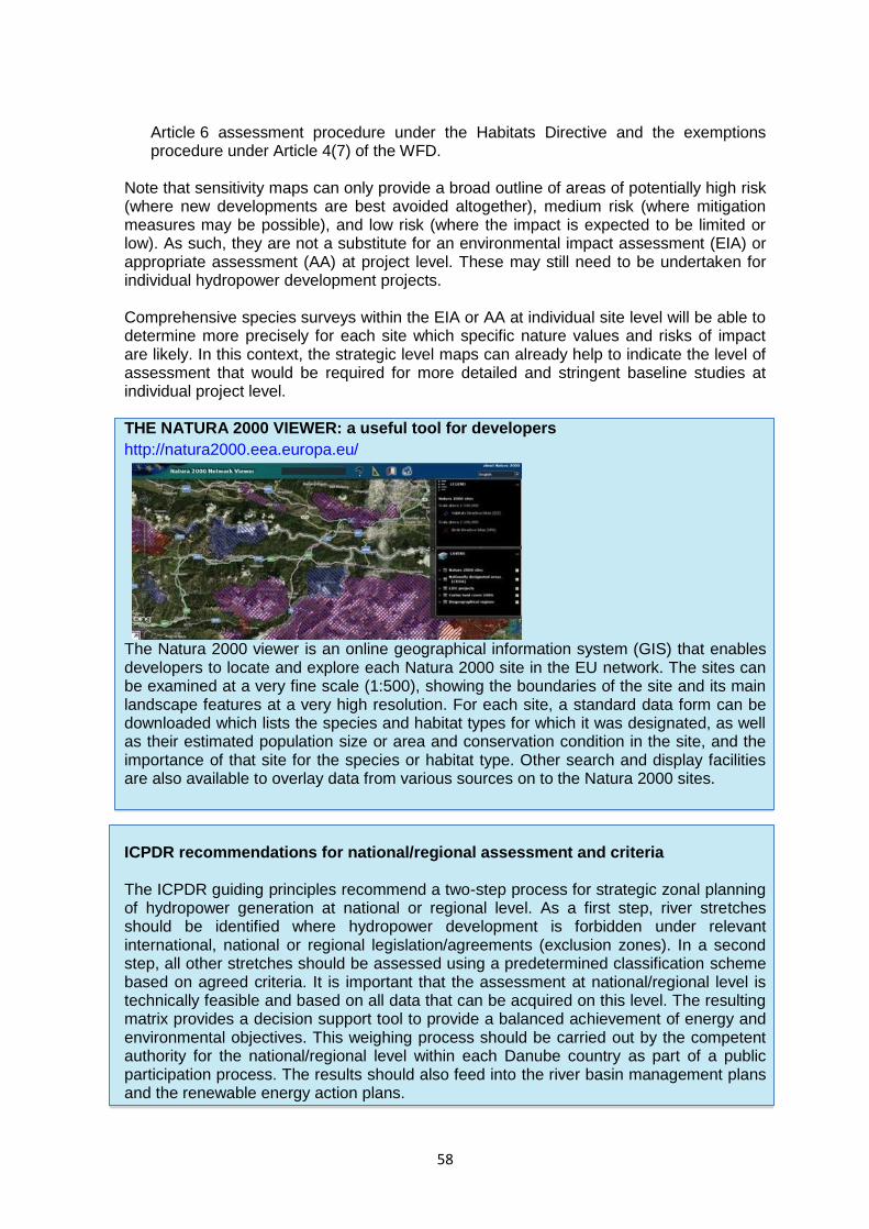
58
Article 6 assessment procedure under the Habitats Directive and the exemptions procedure under Article 4(7) of the WFD.
Note that sensitivity maps can only provide a broad outline of areas of potentially high risk (where new developments are best avoided altogether), medium risk (where mitigation measures may be possible), and low risk (where the impact is expected to be limited or low). As such, they are not a substitute for an environmental impact assessment (EIA) or appropriate assessment (AA) at project level. These may still need to be undertaken for individual hydropower development projects. Comprehensive species surveys within the EIA or AA at individual site level will be able to determine more precisely for each site which specific nature values and risks of impact are likely. In this context, the strategic level maps can already help to indicate the level of assessment that would be required for more detailed and stringent baseline studies at individual project level. THE NATURA 2000 VIEWER: a useful tool for developers
http://natura2000.eea.europa.eu/
The Natura 2000 viewer is an online geographical information system (GIS) that enables developers to locate and explore each Natura 2000 site in the EU network. The sites can be examined at a very fine scale (1:500), showing the boundaries of the site and its main landscape features at a very high resolution. For each site, a standard data form can be downloaded which lists the species and habitat types for which it was designated, as well as their estimated population size or area and conservation condition in the site, and the importance of that site for the species or habitat type. Other search and display facilities are also available to overlay data from various sources on to the Natura 2000 sites. ICPDR recommendations for national/regional assessment and criteria The ICPDR guiding principles recommend a two-step process for strategic zonal planning of hydropower generation at national or regional level. As a first step, river stretches should be identified where hydropower development is forbidden under relevant international, national or regional legislation/agreements (exclusion zones). In a second step, all other stretches should be assessed using a predetermined classification scheme based on agreed criteria. It is important that the assessment at national/regional level is technically feasible and based on all data that can be acquired on this level. The resulting matrix provides a decision support tool to provide a balanced achievement of energy and environmental objectives. This weighing process should be carried out by the competent authority for the national/regional level within each Danube country as part of a public participation process. The results should also feed into the river basin management plans and the renewable energy action plans.
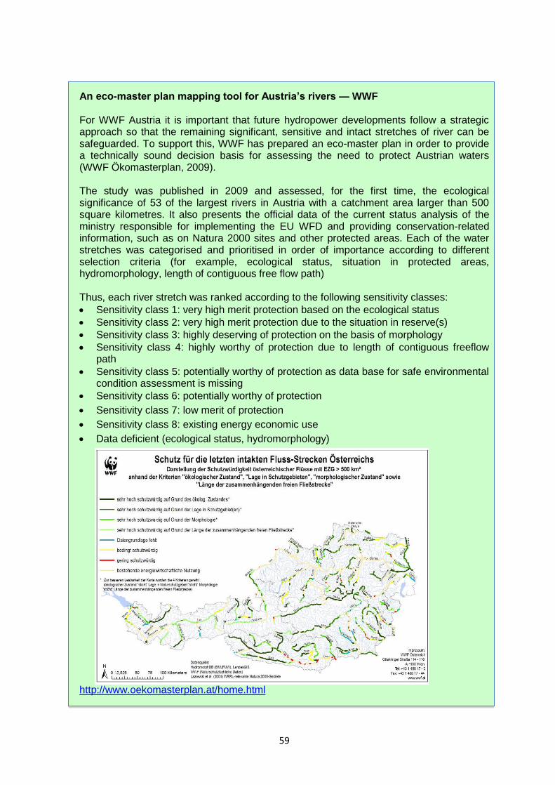
59
An eco-master plan mapping tool for Austria’s rivers — WWF For WWF Austria it is important that future hydropower developments follow a strategic approach so that the remaining significant, sensitive and intact stretches of river can be safeguarded. To support this, WWF has prepared an eco-master plan in order to provide a technically sound decision basis for assessing the need to protect Austrian waters (WWF Ökomasterplan, 2009). The study was published in 2009 and assessed, for the first time, the ecological significance of 53 of the largest rivers in Austria with a catchment area larger than 500 square kilometres. It also presents the official data of the current status analysis of the ministry responsible for implementing the EU WFD and providing conservation-related information, such as on Natura 2000 sites and other protected areas. Each of the water stretches was categorised and prioritised in order of importance according to different selection criteria (for example, ecological status, situation in protected areas, hydromorphology, length of contiguous free flow path) Thus, each river stretch was ranked according to the following sensitivity classes:
Sensitivity class 1: very high merit protection based on the ecological status
Sensitivity class 2: very high merit protection due to the situation in reserve(s)
Sensitivity class 3: highly deserving of protection on the basis of morphology
Sensitivity class 4: highly worthy of protection due to length of contiguous freeflow path
Sensitivity class 5: potentially worthy of protection as data base for safe environmental condition assessment is missing
Sensitivity class 6: potentially worthy of protection
Sensitivity class 7: low merit of protection
Sensitivity class 8: existing energy economic use
Data deficient (ecological status, hydromorphology)
http://www.oekomasterplan.at/home.html

60
Planning instruments to balance hydropower development and restore aquatic environments in France In 2008, the French Ministry of Ecology, Sustainable Development and Energy held a round table discussion on how to further develop sustainable hydropower while restoring the aquatic environment in France. Two objectives had to be achieved: the generation of an additional 3 TWh in terms of annual production by 2020 and the achievement of good status on 66 % of surface water bodies by 2015. After extensive discussions with local elected authorities, hydropower producers, the national committee for professional freshwater fishing and a number of NGOs, the Ministry signed an agreement containing four key objectives:
to support hydropower through an ongoing process of shared research into environmental integration, monitoring and controls;
to modernise and optimise existing plants by working towards an effective implementation of the regulations on raising the minimum flow by January 2014 and the introduction of obligatory fish passes. Further, any renewal of concessions should be accompanied by measures to improve both the energy and environmental performance of the plant;
to remove the most problematic obstacles to ecological continuity which have been identified in the national programme and to implement these restoration schemes with the help of funds from water supply agencies;
to develop a ‘high environmental quality’ hydropower development scheme with minimum effect on the environment. Construction of new plants must be sought and placed preferentially in areas where few environmental stakes exist and must avoid areas of rich biodiversity (e.g. no-go rivers and continuity rivers).
Between 2012 and 2015 the government therefore adopted two lists of protected rivers to ensure compliance with the WFD. The first list contains no-go rivers or preserved rivers where the construction of any new obstacle cannot be authorised and existing dams must ensure ecological continuity at the moment their licence is renewed. The second list contains rivers where restoring continuity on existing dams is a priority. On these rivers, existing dams must be adjusted within 5 years to ensure both up- and downstream fish migration and a sufficient transfer of sediments. The following are included in the first list: high status rivers (e.g. in Natura 2000), diadromous migratory fish rivers (also often in Natura 2000) and biological reservoirs. Together they represent around 25-30 % of the watercourses in France. The second list includes other diadromous migratory fish rivers, rivers at risk of failing the environmental objectives due to hydromorphological pressure and the inefficient functioning of biological reservoirs as determined in the river basin management plan. Together, they represent around 10 % of the watercourses. The identification of potential areas for new hydropower under the regional renewable energy plans is based mainly on hydropower data and on compatibility with lists 1 and 2 which identifies areas that are considered appropriate, less appropriate or not appropriate. Source: https://circabc.europa.eu/sd/a/85a4834a-5733-4474-9686-d6d94d722b95/Presentation-
Planning%20instruments%20for%20hydropower%20and%20preserved%20rivers%20in%20France.pdf

61
4.4 Early consultation Early consultation with environmental stakeholders, and indeed all stakeholders, is important in ensuring that acceptable and sustainable solutions are found. It is equally important in reaching a common understanding of the issues at stake and encouraging cooperation in the search for solutions, especially if the ecological effects of a project prove not to be amenable to conventional mitigation approaches. Often, conflicts have stemmed from a failure to involve environmental stakeholders sufficiently early in the planning procedure, and can result in lengthy and costly delays. Ideally, stakeholders and the wider public should participate in all stages of the project or plan development. Participation is especially important in the project or plan definition phase and during the interactive and iterative process of working out realistic alternative solutions for problematic areas. European legislation and procedures are not very specific about the requirement for public consultation and participation and usually envisage formal steps for public consultation only after completion of environmental impact studies and submission of plans of projects for approval. However, this should not prevent developers from making their own arrangements for organising the process of public consultation from as early on as possible. The objectives of any well organised public participation strategy should be to:
ensure a transparent planning and decision-making process for the infrastructure plan or project and openness regarding all relevant information and data;
raise awareness about the overall plan or project objectives and related issues;
gain public support for the planning process and for project or plan implementation;
integrate key stakeholders in the planning phase to create an atmosphere of mutual trust and respect, and thus facilitate the public acceptance and successful implementation of the plan or project.
In practice, the following are particularly important for ensuring a successful stakeholder consultation and participation process:
Timing of public participation: Stakeholder involvement should begin in the earliest stages of a plan or project so that environmental information can be used when considering alternatives for design, location and financial arrangements. Stakeholder consultation should continue throughout the environmental assessment process and the plan or project’s cycle.
Identifying relevant interest groups: Identifying the relevant interest groups or stakeholders is critical to successful public involvement, be it in a policy, plan, programme (e.g. sectoral or regional) or project. Analysing the social composition of the society in which the plan or project is planned will also help ensure that all relevant social actors or stakeholders are identified and included in consultation.
Choosing the right form of communication and consultation: Public involvement can range from simple dissemination of information to consultation and through to full participation in decision making:
o Informing: one-way flow of information from proponent to public. o Consulting: two-way flow of information between proponent and public, giving
the public an opportunity to express views and the proponent to respond. o Participating: two-way flow of information and ideas in which the proponent
and the public are involved in shared analysis and agenda-setting and the

62
public/stakeholders are voluntarily involved in decision making on project design and management through consensus on the main points. The level of public involvement required for a specific plan or project will vary according to the social and political context. A participation matrix can be drawn up for each of the main stakeholder groups to help determine the appropriate degree of participation. The matrix also can be used as a systematic tool for defining the roles and responsibilities of a stakeholder and identifying areas of potential disagreement between groups.
o Ownership and commitment: Early consultations with potentially affected groups can improve the environmental information supplied to decision makers (e.g. by identifying environmental effects or designing suitable mitigation measures) and help minimise potential conflicts and delays. Genuine efforts to provide the public with information and respond to suggestions or concerns also help prevent miss understandings and can result in more widely accepted projects with a greater sense of local ownership.
Undoubtedly, public consultation and participation can be time consuming and demanding, but when used positively they can reduce antagonism and enhance the potential for long-term success. Strategic planning and collaborative working at catchment level in England The catchment-based approach embeds collaborative working at a river catchment scale to deliver cross-cutting improvements to our water environments. Community partnerships, bringing local knowledge and expertise, are active in each of the 100+ Water Framework Directive catchments across England, including stretching across the border with Wales. More than 1 500 organisations are engaged in catchment-based approaches nationwide including NGOs, water companies, local authorities, government agencies, landowners, angling clubs, farmer representative bodies, academia and local businesses. Catchment-based approach partnerships drive cost-effective practical delivery on the ground, resulting in multiple benefits such as improvements to water quality, enhanced biodiversity, reduced flood risk, resilience to climate change and greater community engagement with their local river. Partnerships provide a catalyst to attract additional funds and to date some have levered up to eight times the initial investment. A number of research projects have now been able to demonstrate that an empowered catchment area partnership comprised of diverse stakeholders and technical specialists from in and around a catchment can be responsible for coordinating the planning, funding and delivery of good ecological health for that river and its catchment. They have also shown that an integrated stakeholder-driven assessment of a catchment can help develop a comprehensive understanding of the challenges and, following this, develop a strategic, targeted, balanced and therefore cost-effective catchment management intervention plan. http://www.catchmentbasedapproach.org/

63
CABA KNOWLEDGEBASE
The aim of the Catchment based Approach website is to showcase all of the great work being undertaken by catchment partnerships across the country. By sharing best practice we aim to avoid duplication of effort and to ensure that CaBA Hosts can benefit from all of the lessons that have been learnt over the years by those engaged in catchment management. Ultimately, this website is designed to empower CaBA partnerships by showing them the huge and varied ways that participatory catchment planning and catchment management delivery can be done.
ENGAGE
catchment stakeholders and build an effective
partnership
USE DATA
and evidence to inform stakeholder-led catchment
planning
DELIVER
Targeted and integrated catchment management
interventions
MONITOR
and model the environment to measure improvements
Learn More Learn More Learn More Learn More
64
5 THE ASSESSMENT PROCEDURE UNDER THE
HABITATS DIRECTIVE 5.1 Introduction EU nature legislation requires that any plan or project likely to have a significant effect on one or more Natura 2000 sites undergo appropriate assessment (AA) under Article 6(3) of the Habitats Directive. This chapter provides a step-by-step guide to carrying out the AA for hydropower plans and projects in particular45.
Because Natura 2000 concerns Europe’s most valuable and endangered habitats and species, it is logical that the procedures for approving developments likely to have a significant negative effect on these sites must be sufficiently rigorous to avoid undermining the overall objectives of the Birds and Habitats Directives. Particular attention is therefore given to the need for decisions to be taken on the basis of sound scientific information and expertise. Delays in the approval process are very often caused by a poor quality AA obstructing the competent authorities’ judgment of the effects of the plan or project. It is also important not to confuse environmental assessments carried out under the Environmental Impact (EIA) and Strategic Environmental Assessment (SEA) Directives or the exemptions procedure under Article 4(7) of the Water Framework Directive (WFD) with the AA carried out under Article 6(3) of the Habitats Directive. While such assessments are very often carried out together and can benefit from coordination, each has a different purpose and assesses effects on different aspects of the environment. So although they should all ideally be coordinated, the others cannot replace, or be a substitute for, an AA.
45 The Commission has produced guidance documents to help people understand and apply the appropriate
assessment procedure. They are available from the Commission’s Natura 2000 website, http://ec.europa.eu/environment/nature/natura2000/management/guidance_en.htm.
Article 6(3) Any plan or project not directly connected with or necessary to the management of the site but likely to have a significant effect thereon, either individually or in combination with other plans or projects, shall be subject to appropriate assessment of its implications for the site in view of the site’s conservation objectives. In the light of the conclusions of the assessment of the implications for the site and subject to the provisions of paragraph 4, the competent national authorities shall agree to the plan or project only after having ascertained that it will not adversely affect the integrity of the site concerned and, if appropriate, after having obtained the opinion of the general public. Article 6(4) If, in spite of a negative assessment of the implications for the site and in the absence of alternative solutions, a plan or project must nevertheless be carried out for imperative reasons of overriding public interest, including those of a social or economic nature, the Member State shall take all compensatory measures necessary to ensure that the overall coherence of Natura 2000 is protected. It shall inform the Commission of the compensatory measures adopted.

65
The focus of the AA is on species and habitat types protected by the Birds and Habitats Directives, and in particular those species and habitats for which the Natura 2000 site has been designated. An AA under Article 6(3) is therefore narrower in scope than an assessment under the WFD, EIA or SEA Directives, being confined to implications for Natura 2000 sites in view of their conservation objectives. The effects of each assessment procedure are also different. For the AA and the WFD, the outcome is legally binding on the competent authority and determines its final decision. So if the AA determines that there will be an adverse effect on the integrity of the Natura 2000 site, despite the introduction of mitigation measures, then the plan or project can only be approved if the conditions set out in Article 6(4) are met. 5.2 When is the Article 6 procedure required?
The procedural and substantive safeguards to be applied to any plan or project likely to have a significant effect on a Natura 2000 site are laid down in Article 6 of the Habitats Directive. This procedure is designed to:
assess the implications of a plan or project that is likely to have a significant effect on a Natura 2000 site in view of the site’s conservation objectives;
ascertain whether these implications will adversely affect the integrity of the site;
provide a mechanism for approving a plan or project that has an adverse effect if there are no alternative solutions that are less damaging and if it is considered necessary for imperative reasons of overriding public interest;
ensure that in the latter case, compensatory measures are taken to ensure the overall coherence of Natura 2000 is protected.
Several terms are used in Article 6(3) to specify whether an AA is required. It concerns:
any plan or project;
which is likely to have a significant effect on at least one Natura 2000 site;
alone or in combination with other plans or projects;
but which is not directly connected with the conservation management of the site. The Directive does not define the scope of the ‘plan’ or ‘project’. Instead, the deciding factor is whether or not it is likely to have a significant effect. The term ‘project’ should therefore be interpreted broadly, to include both construction works and any other interventions in the natural environment46. It also covers projects that aim to restore, upgrade, maintain or modernise an existing hydropower plant if it is deemed these might have a significant effect on a Natura 2000 site. As regards its geographical scope, Article 6(3) is not restricted to plans and projects in a Natura 2000 site; it also covers development anywhere outside a Natura 2000 site if it is likely to have a significant effect on the site. Just because a proposed development is outside the boundary of a Natura 2000 site, it is not exempt from requiring an AA under Article 6(3).
46 European Court of Justice Ruling C-127/02.

66
Thus, the need for an assessment depends on whether development is likely to have a significant effect on a Natura 2000 site either individually or in combination with other plans or projects, irrespective of whether the project is located within or outside Natura 2000. For instance, a project some distance upstream of a Natura 2000 site might still cause damage the integrity of site located downstream as a result of water flow disruption, changes in sediment transport, pollution or barriers to species movement and migration. In such cases, the project needs to be assessed under Article 6(3). This should ideally also include consideration of any likely transboundary effects. If a plan or project in one country is likely to have a significant effect on a Natura 2000 site in another country, either individually or in combination with other plans or projects, then the AA must also assess the effects on the integrity of Natura 2000 sites in that other country. This is in line with the Espoo Convention, which is implemented in the EU through the EIA and SEA Directives. 5.3 A step-by-step procedure The procedure set out in Article 6(3) must be carried out in sequence. Each step determines whether a further step in the process is required. For instance if, after screening, it is concluded that there will be no adverse effects on the Natura 2000 site, then the plan or project can be approved without the need for further assessment. The steps are as follows (see flow chart): - Screening — this first step determines whether a plan or project requires an AA or not.
If it is impossible to exclude the likelihood that the plan or project will have a significant effect on any Natura 2000 site, then an AA is required.
- Appropriate assessment — once it has been decided that an AA is required, a detailed
analysis must be made of the potential effects of the plan or project, alone or in combination with other plans or projects, on the integrity of Natura 2000 site(s) in view of its conservation objectives.
- Decision making — if the AA does not prove that there are no adverse effects on the
integrity of the site, or that any adverse effects can be mitigated, then the competent authorities must reject the plan or project. On the other hand, if the AA proves that there will be no adverse effects on the integrity of a Natura 2000 site, the project can be approved.
Article 6(4) allows certain exceptions to this general rule. The proponent of the plan or project can ask for the plan or project to be approved in exceptional circumstances provided the conditions of Article 6(4) are met. It is clear from the above that this decision-making process is underpinned by the precautionary principle. The emphasis is on objectively demonstrating, with reliable supporting evidence, that there will be no adverse effects on the Natura 2000 site; the onus lies on the proponent of the plan or project to demonstrate that there will be no adverse effects.

67
Figure 6: Flow chart of Article 6(3) and 6(4) procedure (based on European Commission methodological guide)
Istheplanorproject(PP)directlyconnectedwith,ornecessarytothe
conservationmanagementofthesite?
No Yes
Yes
IsthePPlikelytohavesignificanteffectsonthesite?
Assessimplicationsinviewofthesite’sconservationobjectives
Assesscumulativeandin-combinationeffectswithotherplansand/orprojects
CanitbeconcludedthatthePPwillnotadverselyaffecttheintegrityofthesite?
Canthenegativeimpactsberemovede.g.throughmitigationmeasures?
No
AppropriateAssessment
Doesthesitehostapriorityhabitatorspecies?
Aretherehumanhealthorsafetyconsiderationsorimportantenvironmental
benefits?
No
Arethereimperativereasonsofoverridingpublicinterest?
Authorisationmay
begranted
Authorisationcannotbegranted
No
Redesigntheplan/
project
Aretherealternativesolutions?
Yes
No
Yes
Yes
Screening
DerogationArticle6.4
No Yes
Authorisationcannotbegranted
No
Authorisationcanonlybegrantedforotherimperativereasonsofoverridingpublic
interestiftheCommissionissuesapositiveOpinionandadequate
compensationmeasuresaretaken
Authorisationmaybegrantedprovidedthatadequate
compensationmeasuresaretaken
Yes Yes Yes

68
The first step in the Article 6(3) procedure is to determine whether or not an AA is needed, i.e. whether a plan or project is likely to have a significant effect on a Natura 2000 site. If it can be determined with sufficient certainty that the plan or project is not likely to have a significant effect, either individually or in combination with other plans or projects, then it can be approved without further assessment. However, if there is any doubt whatsoever as to the likelihood of effects, an AA must be undertaken so that the potential effects can be studied in full. This was confirmed by the European Court of Justice in the Waddenzee ruling (C-127/02) in which the Court concluded that: ‘the environmental protection mechanism provided for in Article 6(3) does not presume that the plan or project considered definitely has significant effects on the site concerned but follows from the mere probability that such an effect attaches to that plan or project. In case of doubt as to the absence of significant effects such an assessment must be carried out, this makes it possible to ensure effectively that plans or projects which adversely affect the integrity of the site concerned are not authorised, and thereby contributes to achieving, the overall objectives of the Habitats Directive.’ The reasons for the final decision on whether to carry out an AA should be recorded. Sufficient information should be given to support the conclusion that has been reached.
Environmental permit for a hydropower scheme The UK government has introduced an electronic application form — called the ‘Environmental site audit checklist for hydropower schemes’ — to assist with screening potential projects at a pre-planning stage. The checklist helps the applicant to identify the information that needs to be sent to the competent authorities so that they can fully assess the impact of the proposed hydroelectric scheme and provides them with an opportunity to seek initial advice on the planned project. This may help to avoid spending time and resources on projects that are unlikely to obtain a permit. Applicants are specifically asked to complete a checklist containing questions on:
1. Water abstraction and flow management 2. Conservation 3. Water quality 4. Biodiversity and fisheries 5. Managing flood risk 6. Navigation
The government has also issued a series of guidance documents to help developers with applications for run-of-the-river hydropower schemes. These documents explain
how the UK Environment Agency regulates hydropower; the environmental issues to consider; advice on how to design a scheme; how to apply for the necessary permits and licences.
https://www.gov.uk/government/publications/wr325-hydropower-schemes-environmental-site-audit-checklist https://www.gov.uk/government/publications/good-practice-guidelines-to-the-environment-agency-hydropower-handbook
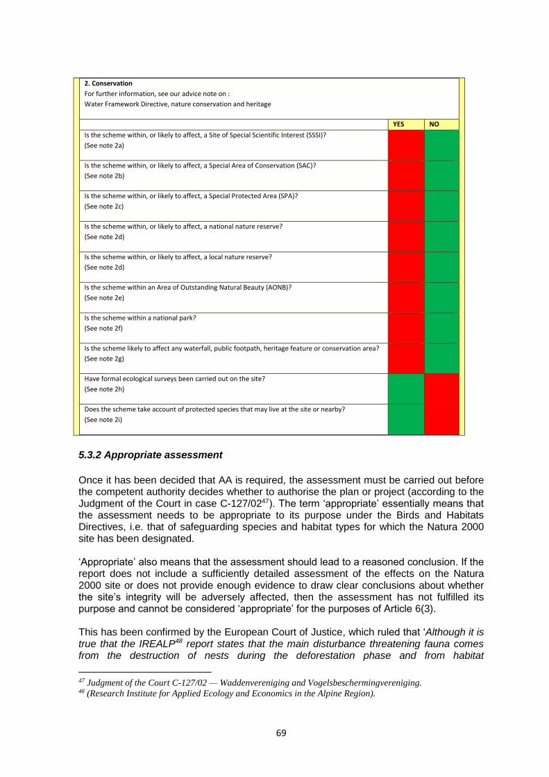
69
2. Conservation
For further information, see our advice note on :
Water Framework Directive, nature conservation and heritage
YES NO
Is the scheme within, or likely to affect, a Site of Special Scientific Interest (SSSI)?
(See note 2a)
Is the scheme within, or likely to affect, a Special Area of Conservation (SAC)?
(See note 2b)
Is the scheme within, or likely to affect, a Special Protected Area (SPA)?
(See note 2c)
Is the scheme within, or likely to affect, a national nature reserve?
(See note 2d)
Is the scheme within, or likely to affect, a local nature reserve?
(See note 2d)
Is the scheme within an Area of Outstanding Natural Beauty (AONB)?
(See note 2e)
Is the scheme within a national park?
(See note 2f)
Is the scheme likely to affect any waterfall, public footpath, heritage feature or conservation area?
(See note 2g)
Have formal ecological surveys been carried out on the site?
(See note 2h)
Does the scheme take account of protected species that may live at the site or nearby?
(See note 2i)
5.3.2 Appropriate assessment
Once it has been decided that AA is required, the assessment must be carried out before the competent authority decides whether to authorise the plan or project (according to the Judgment of the Court in case C-127/0247). The term ‘appropriate’ essentially means that the assessment needs to be appropriate to its purpose under the Birds and Habitats Directives, i.e. that of safeguarding species and habitat types for which the Natura 2000 site has been designated. ‘Appropriate’ also means that the assessment should lead to a reasoned conclusion. If the report does not include a sufficiently detailed assessment of the effects on the Natura 2000 site or does not provide enough evidence to draw clear conclusions about whether the site’s integrity will be adversely affected, then the assessment has not fulfilled its purpose and cannot be considered ‘appropriate’ for the purposes of Article 6(3). This has been confirmed by the European Court of Justice, which ruled that ‘Although it is true that the IREALP48 report states that the main disturbance threatening fauna comes from the destruction of nests during the deforestation phase and from habitat
47 Judgment of the Court C-127/02 — Waddenvereniging and Vogelsbeschermingvereniging. 48 (Research Institute for Applied Ecology and Economics in the Alpine Region).

70
fragmentation, it nonetheless contains numerous findings that are preliminary in nature and it lacks definitive conclusions. The report refers to the importance of assessments to be carried out progressively, in particular on the basis of knowledge and details likely to come to light during the process of implementation of the project. Furthermore, the report was designed as an opportunity to introduce other proposals for improvement of the environmental impact of the operations proposed.’ ‘These factors mean that the IREALP report cannot be considered an appropriate assessment of the impact of the disputed works on SPA IT 2040044 either’. ‘It follows from all the foregoing that both the study of 2000 and the report of 2002 have gaps and lack complete, precise and definitive findings and conclusions capable of removing all reasonable scientific doubt as to the effects of the works proposed on the SPA concerned. Such findings and conclusions were essential in order that the competent authorities might gain the necessary level of certainty to take the decision to authorise the works’. (Case C-304/05, Commission v Italy, paragraphs 46-73) The Court also emphasised the importance of using best scientific knowledge when carrying out the AA in order to enable the competent authorities to conclude with a sufficient degree of certainty that there will be no adverse effects on the site’s integrity. It considered that ‘all the aspects of the plan or project which can, either individually or in combination with other plans or projects, affect those objectives must be identified in the light of the best scientific knowledge in the field.’ (C-127/02, para. 54) The assessment report should in particular:
describe the project or plan in detail to understand its size, scale and objectives;
describe the baseline conditions and conservation objectives of the Natura 2000 site;
describe all possible effects that might occur;
analyse the interaction between those characteristics of the project and the ecological requirements of the species and habitat types for which the site has been designated in order to identify the potential effects of the project or plan on the Natura 2000 site and their level of significance;
explain how such effects will be avoided or mitigated to the extent possible;
set out a timescale and the mechanisms through which any mitigation measures will be secured, implemented and monitored;
contain a reference list of all sources of information. Finally, the project proponent is responsible for commissioning and informing the AA and for ensuring that it is of a suitable quality. The authorities are responsible for ensuring a fair and complete evaluation of the data provided in the AA and for checking whether the findings on the effects and their significance are correct and that there will not be any adverse effects on the integrity of the Natura 2000 site, in light of its conservation objectives. Assessing effects in view of the site’s conservation objectives As stated above, the assessment should assess the possible effects on the site of the plan or project in view of the site’s conservation objectives. At a minimum, the conservation objective is to prevent any deterioration in the species and habitats for which the site was designated. If more ambitious conservation objectives have been set under Article 6(1), then the potential effects of the plan or project must be assessed against these more ambitious
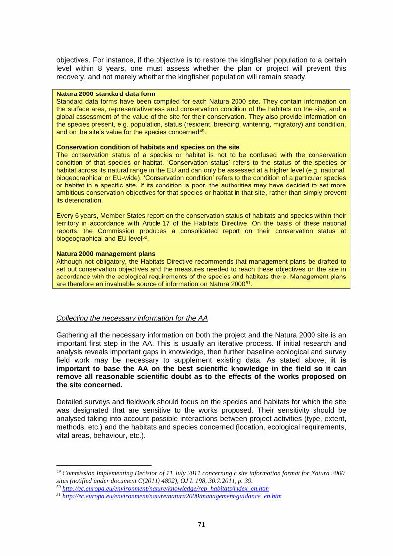
71
objectives. For instance, if the objective is to restore the kingfisher population to a certain level within 8 years, one must assess whether the plan or project will prevent this recovery, and not merely whether the kingfisher population will remain steady.
Natura 2000 standard data form
Standard data forms have been compiled for each Natura 2000 site. They contain information on the surface area, representativeness and conservation condition of the habitats on the site, and a global assessment of the value of the site for their conservation. They also provide information on the species present, e.g. population, status (resident, breeding, wintering, migratory) and condition, and on the site’s value for the species concerned49. Conservation condition of habitats and species on the site The conservation status of a species or habitat is not to be confused with the conservation condition of that species or habitat. ‘Conservation status’ refers to the status of the species or habitat across its natural range in the EU and can only be assessed at a higher level (e.g. national, biogeographical or EU-wide). ‘Conservation condition’ refers to the condition of a particular species or habitat in a specific site. If its condition is poor, the authorities may have decided to set more ambitious conservation objectives for that species or habitat in that site, rather than simply prevent its deterioration. Every 6 years, Member States report on the conservation status of habitats and species within their territory in accordance with Article 17 of the Habitats Directive. On the basis of these national reports, the Commission produces a consolidated report on their conservation status at biogeographical and EU level50. Natura 2000 management plans Although not obligatory, the Habitats Directive recommends that management plans be drafted to set out conservation objectives and the measures needed to reach these objectives on the site in accordance with the ecological requirements of the species and habitats there. Management plans are therefore an invaluable source of information on Natura 200051.
Collecting the necessary information for the AA Gathering all the necessary information on both the project and the Natura 2000 site is an important first step in the AA. This is usually an iterative process. If initial research and analysis reveals important gaps in knowledge, then further baseline ecological and survey field work may be necessary to supplement existing data. As stated above, it is important to base the AA on the best scientific knowledge in the field so it can remove all reasonable scientific doubt as to the effects of the works proposed on the site concerned. Detailed surveys and fieldwork should focus on the species and habitats for which the site was designated that are sensitive to the works proposed. Their sensitivity should be analysed taking into account possible interactions between project activities (type, extent, methods, etc.) and the habitats and species concerned (location, ecological requirements, vital areas, behaviour, etc.).
49 Commission Implementing Decision of 11 July 2011 concerning a site information format for Natura 2000
sites (notified under document C(2011) 4892), OJ L 198, 30.7.2011, p. 39. 50 http://ec.europa.eu/environment/nature/knowledge/rep_habitats/index_en.htm 51 http://ec.europa.eu/environment/nature/natura2000/management/guidance_en.htm

72
Any field studies must be sufficiently robust and long-lasting to take account of the fact that ecological conditions may vary significantly according to the seasons and indeed between years. For instance, doing a field survey on a species for a few days in winter will not capture their habitat usage in other, more important, periods of the year (e.g. the migration or breeding season). Consulting nature authorities, scientific experts, scientists and conservation organisations early on in the process will also help to build up a complete picture of the site, the species/habitats there and the type of effects to be analysed. These different bodies can also offer advice on the latest scientific information available about the site and its EU-protected species and habitats, and on any additional baseline studies and field surveys that may be needed to assess the likely effects of the project. Identifying adverse effects Once all of the necessary baseline data has been gathered, the implications of the plan or project on the Natura site can be assessed. The description of potential adverse effects of hydropower facility projects, as outlined in Chapter 3, should help to identify the type of effects to look out for. It is evident that the effects of each project will be unique and must be evaluated on a case-by-case basis. This is in line with the Waddenzee ruling (see above): ‘in assessing the potential effects of a plan or project, their significance must be established in the light, inter alia, of the characteristics and specific environmental conditions of the site concerned by that plan or project.’ The first step is to analyse fully which EU protected species or habitats for which the site has been designated within each site could be potentially affected and should be subject to further in-depth assessment. This is important, as every species and habitat type has its own ecological lifecycle and conservation requirements. The effects on each will also vary from one site to another depending on their conservation condition and the underlying ecological conditions of that particular site. For each effect identified, the assessment should also look at the magnitude of the impact, type of impact, extent, duration, intensity and timing. The AA also involves looking at all aspects of the plan or project that could have implications for the site. Each one should be examined in turn (e.g. not just the dam to be built but new access roads or any other infrastructure planned for the dam). The potential effects should also be considered for each of the species or habitat types for which the site has been designated (often referred to as ‘target features’ or ‘features’). The effects on the different features should then be looked at together, and in relation to one another, so that the interactions between them can also be identified.

73
DEFINE STUDY
AREA
IDENTIFY THE
CONSERVATION OBJECTIVES OF
THE NATURA 2000
SITE(S)
ASSESS THE EFFECTS AND THEIR SIGNIFICANCE
On the targeted habitat types, the habitats of the species and the
species as well as on the ecological structure and function of
the site
IDENTIFY THE ECOLOGICAL CHARACTERISTICS TO BE
CONSIDERED IN THE ASSESSMENT
Analyse potential effects of project actions on species and habitats
present
DESIGN A MONITORING
PROGRAMME
GATHER EXISTING INFORMATION AND
CARRY OUT ADDITIONAL FIELD
STUDIES AND
SURVEYS AS
REQUIRED
CONSULT
COMPETENT AUTHORITIES AND
STAKEHOLDERS
DETERMINE IF THERE
ARE ANY RESIDUAL
EFFECTS ON THE
INTEGRITY OF THE SITE
GATHER INFORMATION
ABOUT OTHER
PLANS AND PROJECTS
in order to be able to assess cumulative
effects
IDENTIFY /ASSESS
PREVENTIVE AND MITIGATION MEASURES
to remove or reduce the effects to a non significant
level
Steps to be taken as part of the appropriate assessment (adapted European Commission, 2014)

74
While the focus should be on the species and habitats of EU interest that justified the site designation, it should not be forgotten that these target features interact with other species and habitats and with the physical environment in complex ways. It is therefore important that all essential components of the structure, functioning and dynamics of the ecosystem are examined. Any alteration in these components, however small, could also have a negative effect on the habitat types and species present. Effects should be predicted as precisely as possible, and the basis of these predictions should be made clear and recorded in the AA (so a clear explanation of the degree of certainty in the prediction of effects should also be included, as this is key — the assessment must be able to conclude that the effects are beyond reasonable scientific doubt). As with all impact assessments, the AA should be structured to ensure that predictions can be made as objectively as possible, using quantifiable criteria. This will also facilitate the task of designing mitigation measures that can help remove the predicted effects or reduce them to a non-significant level. Finally, when assessing potential effects it is important to bear in mind that they may appear in any of the phases of the hydropower development, from initial construction to operation and management, and on to re-powering or decommissioning. So the effects may be temporary or permanent, on-site or off-site, or cumulative, and may come into play at different times in the project cycle. Commonly used methods for predicting effects The AA should apply best-practice techniques and methods to estimate the extent of effects.
- Direct measurements may be taken, for example of areas of habitat lost or affected, proportionate losses from species populations, habitats and communities.
- Flow charts, networks and systems diagrams can identify chains of effects resulting from direct effects; indirect effects are termed secondary, tertiary, etc. effects in line with how they are caused. Systems diagrams are more flexible than networks in illustrating interrelationships.
- Quantitative predictive models can provide mathematically derived predictions based on data and assumptions about the force and direction of effects. Models may extrapolate predictions that are consistent with past and present data (trend analysis, scenarios, analogies which transfer information from other relevant locations) and intuitive forecasting. Normative approaches to modelling work backwards from a desired outcome to assess whether the proposed project will achieve these aims. Predictive modelling often plays an important role as the main effects often follow from changes in hydromorphological structures, resulting in changes in sedimentation regime with serious consequences for underwater biota.
- Population-level studies are potentially beneficial for determining population-level effects of effects on bird or bat or marine mammal species, for instance.
- Geographical information systems (GISs) are used to produce models of spatial relationships, such as constraint overlays, or to map sensitive areas and locations of habitat loss. GISs are a combination of computerised cartography, stored map data, and a database-management system storing attributes such as land use or slope. GISs enable the variables stored to be displayed, combined, and analysed speedily.
- Information from previous similar hydropower projects may be useful, especially if quantitative predictions were made and have been monitored in operation.
- Expert opinion and judgment can be obtained from previous experience and consultations on similar projects, and from local experts with experience and knowledge
75
of the site.
- Description and correlation: physical factors (e.g. the water regime, current, substrate) may be directly related to the distribution and abundance of species. If future physical conditions can be predicted then it may be possible to predict the future development of habitats and populations or the responses of species and habitats on this basis.
- Capacity analyses involve identifying the threshold of stress below which populations and ecosystem functions can be sustained. It involves identifying potentially limiting factors, and devising mathematical equations to describe the capacity of the resource or system in terms of the threshold imposed by each limiting factor.
Methodological guidance on the provisions of Article 6(3) and 6(4) of the Habitats Directive
Assessing potential cumulative effects The cumulative effects form a crucial part of the assessment. Not only is this a legal requirement but it can also have major implications for the plan or project, and for other subsequent plans or projects proposed for the same area. This is especially relevant for hydropower, where the cumulative effects of even small installations can be unacceptably high. A series of individually modest effects may on their own be insignificant but when assessed together may have a significant impact. Article 6(3) addresses this by taking into account the combination of effects from other plans or projects. It does not specify which other plans and projects are within the scope of this provision but it is clear that one should consider plans or projects which have been completed (i.e. already existing infrastructures) and approved. Here, information available in river basin management plans (RBMPs) under the WFD may be useful, as will any management plans developed for the relevant Natura 2000 sites. It should be understood that, by considering a proposed plan or project, a Member State is not creating a presumption in favour of any other, similar plans or projects that might be proposed in future. On the contrary, if one or more projects have already been approved in an area, it may have the effect of lowering the ecological threshold for future plans or projects in that area. For instance, if a series of hydropower facilities within or around Natura 2000 sites are submitted one after another, the assessment of the first project could well conclude that it will not adversely affect the site, while the second and third projects might not be approved because their effects, when combined with those of the previous project, will be enough to adversely affect the site’s integrity. In this context, it is important to look at hydropower projects strategically and in combination with each other over a reasonably large geographical area, and not simply view them as individual, isolated projects. The assessment of cumulative effects should consider all of the hydropower plants and other developments in the catchment area, irrespective of whether they are situated in or outside a Natura 2000 site. The task of identifying cumulative effects should ideally be done in close consultation with the relevant authorities, who will have access to information about other plans and projects that need to be taken into account. The information contained in the WFD RBMPs should also be consulted, as it compiles information on all pressures and effects on the aquatic environment for the entire catchment area.
76
Potential cumulative effects should be assessed using sound baseline data and not rely on qualitative criteria only. They should also be an integral part of the overall assessment and not be treated merely as an ‘afterthought’ at the end of the assessment process. Determining the significance of the effects Once the effects have been identified (see also Section 4.7), there needs to be an appraisal of their significance52 for the species and habitats in the site, in view of the site’s conservation objectives. The following parameters can be considered when assessing significance: - Quantitative parameters of the target feature (i.e. the species or habitat type for which
the site has been designated): for instance, how much habitat is lost for that species or habitat type. For some, the loss of even single units or small percentage areas of occurrence within a given Natura 2000 site (e.g. for priority habitat types and species) should be taken as being a significant impact. For others, the significance threshold may be higher. Again, it depends on the species and habitat types, their conservation condition in that site and their future prospects.
- Qualitative parameters of the target feature: independently of quantitative parameters, the significance of the effects should take into account the quality of the target feature’s occurrence. For instance, it may be:
the only site in a particular region or country with that target feature (i.e. the target feature may be abundant in a given site but that is the only place where it occurs and is protected);
a site with an important occurrence of the species (e.g. a core area for the occurrence, larger areas of representative stands, etc.);
a site where the species is at the limit of its existing distribution range (bearing in mind the potential influences of climate change in the future).
- The importance of the site for species ́biology, e.g. as a breeding site (nesting places,
spawning areas, etc.); feeding habitat; place of shelter; migration pathway or stop-over.
- Ecological functions and structures needed to maintain the target features and hence site integrity.
Where there is doubt or differences of opinion over the degree of significance, it is best to find broader agreement among relevant experts, e.g. regional and/or national specialists in the affected target feature, so that a consensus is built on this. Determining whether the site’s integrity is affected Once the effects of the project have been predicted as accurately as possible, their level of significance assessed and all possible mitigation measures explored, the AA must conclude whether they will adversely affect the integrity of the Natura 2000 site.
52 ‘Significance’ here refers to the significance of the effects. It is not to be confused with the screening stage
which places the emphasis on the likelihood of significant effects.

77
The term ‘integrity’ clearly relates to ecological integrity. The ‘integrity of the site’ can be usefully defined as the sum of the site’s ecological structure, function and ecological processes, across its whole area, or the habitats, complex of habitats and/or populations of species for which the site is designated. A site can be described as having a high degree of integrity if the inherent potential for meeting site conservation objectives is achieved, its capacity for self-repair and self-renewal under dynamic conditions is maintained, and a minimum of external management support is required. If a plan or project adversely affects the site visual appearance of aesthetic quality or causes significant effects to habitat types or species other than those for which the site was designated as Natura 2000, this is not an adverse effect for the purposes of Article 6(3). On the other hand, if one of the species or habitat types for which the site has been designated is significantly affected then site integrity is necessarily also adversely affected. The expression ‘integrity of the site’ shows that the focus is on the specific site. Thus, damage to part or all of a site cannot be justified by arguing that the conservation status of the habitat types and species it hosts will remain favourable overall in the European territory of the Member State. In practice, the assessment of site integrity should focus in particular on determining whether the project prevents the site from meeting its conservation objectives, and:
causes changes to significant ecological functions necessary for the target features (i.e. the species or habitat type for which the site was designated);
significantly reduces the area of occurrence of habitat types (even of those of lower quality) or the viability of species populations that are target features of the given site;
reduces the site’s diversity;
leads to the site’s fragmentation;
leads to a loss or reduction of key site characteristics (e.g. tree cover, regular annual flooding) on which the status of the target feature depends;
causes mortality among the target species. Introducing measures to remove adverse effects If assessment of a hydropower development plan or project under Article 6 of the Habitats Directive identifies a number of adverse effects on a Natura 2000 site, the plan or project might not be automatically rejected. Depending on the severity of the potential effects, it may be possible to introduce (further) mitigation measures that will eliminate them, or at least render them insignificant, if such protective measures have not already been included in the project. Identifying mitigation measures, like impact assessment itself, must be based on a sound understanding of the species/habitats concerned and on dialogue between the proponent, the competent authority and conservation experts.
Approach to mitigation Preference
Avoid impacts at source Highest
Lowest
Reduce impacts at source
Abate impacts on site
Abate impacts at receptor

78
Mitigation measures can involve changes to the size, location, design and technology used by the hydropower plan or project (e.g. preventing migration barriers and/or injuries to fish caused by turbines). Or they can take the form of temporary adjustments during construction or operational phases (e.g. avoiding water pollution if sensitive parts or populations of target species are located downstream). See Chapter 3 for more information on potential mitigation measures for hydropower. For each mitigation measure proposed, it is important to:
explain how the measures will prevent or render non-significant the known adverse effects on the site;
provide evidence of how they will be secured and implemented and by whom;
provide evidence of the degree of confidence in their likely success;
provide a timescale, relative to the project or plan, for their implementation;
provide evidence of how the measures will be monitored and how additional measures will be introduced if mitigation proves insufficient.
Once suitable mitigation measures have been identified and worked out in detail, the plan or project may be approved under the Article 6 (Habitats Directive) assessment procedure on condition that the mitigation measures: (1) ensure that the effects are not significant in view of the conservation objectives of the site, and (2) are implemented as an intrinsic part of the project. If, however, there is still a significant residual effect on the site, even after mitigation measures have been introduced, then alternative solutions need to be examined instead (e.g. different location of the project, different scales or designs of development, or alternative processes). If there are none, then the plan or project may still be approved in exceptional cases, provided the conditions of Article 6(4) are met and suitable measures are approved that will compensate for the remaining adverse significant effects so that the Natura 2000 network is not compromised. 5.3.3 Conclusions of the appropriate assessment It is up to the competent national authorities, in the light of the conclusions of the AA, to approve the plan or project. This can be done only after having ascertained that it will not adversely affect the integrity of that site. If the conclusions are positive, in the sense that no reasonable scientific doubt remains as to the absence of effects on the site, the competent authorities can approve the plan or project. The onus is therefore on proving the absence of effects rather than their presence, reflecting the precautionary principle (Case C-157/96). This has been confirmed in several ECJ rulings. In the Waddenzee case (C-127/02) the Court confirmed that ‘a plan or project […] may be granted authorisation only on the condition that the competent national authorities are convinced that it will not adversely affect the integrity of the site concerned. Where doubt remains as to the absence of adverse effects on the integrity of the site linked to the plan or project being considered, the competent authority will have to refuse authorisation. In other words they must have made certain, beyond reasonable scientific doubt that it will not adversely affect the integrity of that site’. The AA and its conclusions should be clearly recorded. The report should be sufficiently detailed to demonstrate how the final decision was reached, and on what scientific grounds the decision was made.
79
5.4 Exceptions under Article 6(4) Article 6(4) provides for exceptions to the rule set out in Article 6(3). This is not an automatic process; it is up to the project or plan proponent to decide whether it wishes to apply for this. Article 6(4) lays down the conditions that need to be met in such cases and the steps that need to be followed before a competent national authority can authorise a plan or project that has been assessed as adversely affecting the integrity of a site under Article 6(3). Article 6(4) requires the competent authorities to ensure the following conditions are met before a decision can be taken on whether or not to authorise a plan or project that may adversely affect a site:
The alternative put forward for approval is the least damaging for habitats, for species and for the integrity of a Natura 2000 site, and no feasible alternative exists that would not affect the integrity of the site.
There are imperative reasons of overriding public interest for authorising the plan or project.
All compensatory measures required to ensure protection of the overall coherence of the Natura 2000 network have been taken.
The order in which these conditions are examined is important, as each step determines whether the next step is required. If, for instance, an alternative to the plan or project in question is found, there is no point in examining whether the original plan or project is of overriding public interest or devising suitable compensation measures, since the plan or project cannot be authorised if a viable alternative exists. Demonstrating the absence of alternative solutions The search for alternatives can be quite broad and should be linked to the public interest objectives of the plan or project. It could involve alternative locations, different scales or designs of development, different methods of construction or alternative processes and approaches to producing renewable energy. This requirement is also closely linked to WFD Article 4(7)(d), which requires the authorities to ensure that there is no better environmental option53. Although the requirement to search for alternatives falls within the scope of Article 6(4), in practice it is useful for the planner to consider all possible alternatives as early as possible when first planning the development project. If an appropriate alternative is found at that stage which is not likely to have a significant effect on a Natura 2000 site, then it can be approved immediately and an AA will not be required (although other environmental assessment might still be needed). However, if the project goes through an AA which concludes that an adverse effect on the integrity of the site is unavoidable, the competent authority must then determine whether alternative solutions exist. All feasible alternatives should be analysed, and in particular their relative performance on the conservation objectives of the Natura 2000 site and the site’s integrity.
53 See CIS guidance No 20.
80
If there is a feasible alternative solution that meets the project aims, it should also undergo a new appropriate assessment if it is likely to have a significant effect on the same or another Natura 2000 site. Usually, if the alternative is similar to the original proposal, the new assessment may be able to draw a lot of the information needed from the first AA. Imperative reasons of overriding public interest In the absence of alternative solutions, or if the alternative has even more adverse effects on the conservation objectives or integrity of the site concerned, the competent authorities must examine whether there are imperative reasons of overriding public interest54 that justify authorising the plan or project even though it may adversely affect the integrity of one or more Natura 2000 sites. The concept of ‘imperative reason of overriding public interest’ is not defined in the Directive. However, it is clear from the wording that, for a plan or project to be authorised under Article 6(4), it must meet all three of the following conditions:
It must be in the public interest — it is clear from the wording that only the public interest can be balanced against the conservation aims of the Directive. Thus, projects developed by private bodies can only be considered if the public interest it serves is demonstrated (Case C-182/10 Solvay and Others, para. 71-79).
There must be imperative reasons for undertaking the plan or project — imperative in this sense clearly means that the project is essential for society, rather than merely desirable or useful.
The plan or project must be of overriding interest — in other words it must be demonstrated that implementing the plan or project is even more important than safeguarding the particular N2000 site in question in line with its conservation objectives. It is clear that not every kind of public interest of a social or economic nature is sufficient, in particular when seen against the particular weight of the interests protected by the Directive (see e.g. its fourth recital, referring to ‘the Community’s natural heritage’). It seems also reasonable to assume that the public interest can only be overriding if it is a long-term interest; short-term economic interests or other interests which would only yield short-term benefits for the society would not be sufficient to outweigh the long-term conservation interests protected by the Directive.
Note that the conditions relating to an overriding public interest are even stricter for a plan or project that is likely to adversely affect the integrity of a Natura 2000 site that hosts priority habitat types and/or species, if those habitat types and/or species are affected. Imperative reasons of overriding public interest can only be accepted in that case if they concern:
human health and public safety, or
overriding beneficial consequences for the environment, or
other imperative reasons if, before the plan or project is approved, the Commission has given an opinion.
54 This concept is also used in Article 4(7) of the WFD.

81
Flowchart of Article 6.4 conditions
Compensatory measures If there are no alternatives and there are imperative reasons of overriding public interest, the authorities must then ensure that compensatory measures are adopted and put in place before the project can begin. Compensatory measures are therefore a ‘last resort’ and are used only when the decision has been taken under the conditions described above. Strictly speaking, compensatory measures are independent of the project and, as a rule, implemented outside the project area. They must be able to compensate fully for the damage caused to the site and to its target features and must be sufficient to ensure that the overall coherence of the Natura 2000 Network is protected.

82
To ensure that the overall coherence of Natura 2000 is protected, the compensatory measures proposed for a plan or project should in particular:
contribute to the conservation of affected habitat types and species within the biogeographical region concerned or within the same range, migration route or wintering area for species in the Member State concerned;
provide functions comparable to those which justified the selection of the original site, particularly regarding adequate geographical distribution;
be additional to the normal duties under the Directive, i.e. they cannot substitute for existing commitments, such as the implementation of Natura 2000 management plans.
According to existing Commission guidance, compensatory measures under Article 6(4) may consist of one or more of the following:
the recreation of a comparable habitat or the biological improvement of a degraded habitat within an existing designated site, provided this goes beyond the site’s conservation objectives and does not damage other Natura 2000 target features in that site;
the recreation of a comparable habitat or the biological improvement of a degraded habitat outside a designated site which is then included in the Natura 2000 network;
the addition to the Natura 2000 network of a new site, of a quality and condition comparable to or better than the original site55.
The habitat types and species adversely affected must, as a minimum, be compensated for in comparable proportions, but, considering the high risks and scientific uncertainty involved in attempting to recreate or restore degraded habitats it is strongly recommended that ratios well above 1:1 are applied, to be sure that the measures really do provide the necessary compensation. Member States should pay particular attention when the adverse effects of a plan or project are felt in vulnerable natural habitats or in natural habitats of species that need a long time to regain the same ecological function. For some habitats and species it may simply not be possible to compensate for any loss within a reasonable time, as their development may take decades. Moreover, some habitat types and habitats of species cannot be compensated for at all because their ecological characteristics cannot be artificially simulated or created. Therefore, proponents of every new hydropower development should inform themselves about the scope for compensating for particular habitat types and species well before starting to draft the plan or project. Finally, the compensatory measures should be in place and fully functional before work on the plan or project has begun. This is to help buffer the damaging effects of the project on species and habitats by offering them suitable alternative locations in the compensation area. If this is not fully achievable, the competent authorities should require extra compensation for the interim losses to occur in the meantime. The information on compensatory measures should be submitted to the Commission as soon as they have been adopted in the planning process, to allow the Commission, in its role as guardian of the Treaties, to assess whether the Directive is being correctly applied.
55 This addition must be formally designated by the Member State authorities after EC approval.

83
Abbreviations
AA Appropriate assessment according to the Article 6.3 of the Habitats Directive
AWB Artificial water body under the WFD
ECJ European Court of Justice (Court of Justice of the EU — CJEU) https://curia.europa.eu/jcms/jcms/j_6/en/
EEA European Environment Agency (http://www.eea.europa.eu/)
EIA Environmental impact assessment of projects
EU European Union (EU-28)
FCS Favourable conservation status — main objective of the Habitats Directive
HMWB Heavily modified water body under WFD
GES Good ecological status — main objective of the Water Framework Directive
Natura 2000
Sites designated under the Habitats and Birds Directives (pSCI, SCI, SAC and SPAs) and included in the Natura 2000 Network
NGOs non-governmental organisations
PCIs Projects of community interest
pSCI proposed site of community importance to the Commission
RBMP River basin management plan according to the Water Framework Directive
SAC Special area of conservation with necessary conservation measures applied
SCI Site of community importance approved by the Commission
SDF Standard data form for a Natura 2000 site
SEA Strategic environmental assessment of plans and programmes
SPA Special protection area designated under the Birds Directive
WFD Water Framework Directive