GRÜNER WEG DER REGION GENF - impacts.org · Chose the route and propose alternatives. ... to get...
35
GENEVA GREEN WAY NON-MOTORIZED TRAFFIC WITHOUT BORDERS IMPACTS 2013 16.05.2013 GRÜNER WEG DER REGION GENF LANGSAMVERKEHR OHNE GRENZEN
Transcript of GRÜNER WEG DER REGION GENF - impacts.org · Chose the route and propose alternatives. ... to get...

1.
GENEVA GREEN WAY NON-MOTORIZED TRAFFIC WITHOUT BORDERS
IMPACTS 2013
16.05.2013
GRÜNER WEG DER REGION GENF LANGSAMVERKEHR OHNE GRENZEN

PLAN
Introducing the context
Genfer Zusammenhang
What is the Greenway
Was ist der Grüne Weg
Objectives, issues
Ziele
Implementation planning
Einsatzplannung
Charter: exemples
Charta: Beispiele
Local Studies
Locale Studien
1.

Source: projet d’agglomération; données 2005
10km
2.5km
10km
Agglo-
meration
Grossraum
Canton
(district
Kanton
City of
Geneva
Stadt
Surface km2
Oberfläche
1898 km2
100%
246
km2
13%
15.8
km2
0,8%
Inhabitants
Einwöhner
769’000
100%
438’000
57%
186’000
24%
Density
Verdichtung
610
(pers/km2)
2967
p/km2
11’742
p/km2
Grows
rate/year
Wachstum
1.2% 1% 0.6%
Housing
Wohnung
373’000 211’000 103’700
Jobs
Arbeitsplätze
389’000
100%
291’000
75%
145’800
37%
CONTEXT OF GENEVA
GENFER ZUSAMMENHANG
2.

CONTEXT OF GENEVA : modal split
GENFER ZUSAMMENHANG : Verkehrsmittel
3.
…in the city
…in relation with
the city
…in the periphery

Development of the
network of trams and
trains
Entwicklung des
Strassenbahn - und
Zügenetzes
Connection with CH
and F train networks
Verbindung zwischen
der Zugsnetz CH und F
Opportunity to
improve
interchanges
Gelengenheit
Umsteigepünkte zu
verbessern
CONTEXT OF GENEVA
GENFER ZUSAMMENHANG
4.

WHAT IS THE GREEN WAY
WAS IST DER GRÜN WEG ?
5.
In the extension of the
greenway CEVA
22 km
13 municipalities
2 countries
2009 City of Geneva
Masterplan
Major public space
project
Grenzüberschreitendes
Projekt von 22 Km, das
in der Verlängerung des
grünen Weges CEVA
gelegt ist
13 Gemeinden
2 Länder
2009 Beschriftung im
kommunalen Richtplan
Großen öffentlichen
Raum Projekt

OBJECTIVES, ISSUES
ZIELE
6.
Create a continuous itinerary:
- 13 municipalities and 2 countries
- Dedicated to pedestrian, cyclists, disabled
people and rollers,
- Readable,
- Attractive,
- Safe (crossings)
- In different settings (urban, industrial, natural)
- Give value to public space
- Offer opportunities for socialization
- Develop a network of public spaces
- Sanitation of noise
- Give connections to the neiborhoods and
public equipments
- Ecological interest
- Promote tourism
Tool to give value to the territory and
promote a modal shift towards slow modes!

7.
• 2009: commitment about objectives: landscape, mobility, urbanization, natural and agricultural spaces, leisure activities and tourism
• 2009/2010 : feasability study
Chose the route and propose alternatives.
Establishing priorities for development of each section.
1 WAY – 7 SEQUENCES – 8 NODES
IMPLEMENTATION PLANNING
EINSATZPLANNUNG

2010/2011
Intercommunal charter/ Interkommunale
Einrichtungscharta
Definition of guidelines, principles, rules for making
public spaces
Consultation and dialogue with a large audience
(representatives of the Confederation, state,
municipalities, interest groups, associations, etc.)
2011/2012
Local studies - draft projects for a few sections /
Locale Studien – erste Projekte
2013-2014
Advanced studies, projects and administrative work
to get autorizations for construction Weiterte
Studien, Projekte und administrative Arbeit
2014-2015 Implementation and studies for the next
sections Unsetzund und studien für weitere
Abschnitte
IMPLEMENTATION PLANNING
EINSATZPLANNUNG
8.

9. 9.
ENVIRONMENT
UMGEBUNG
Urban –
city
center

ENVIRONMENT
UMGEBUNG
9. 10.
Urban -
periphery

9. 11.
ENVIRONMENT
UMGEBUNG
Village

9. 12.
ENVIRONMENT
UMGEBUNG
Industrial

9. 13.
ENVIRONMENT
UMGEBUNG
Natural

9. 14.
ENVIRONMENT
UMGEBUNG
Natural-
forest

9. 15.
ENVIRONMENT
UMGEBUNG
Urban -
park

16.

17.

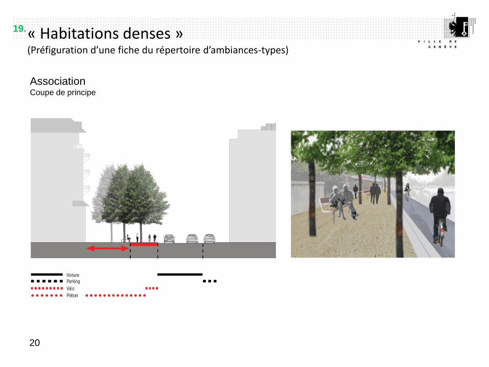
« Habitations denses » (Préfiguration d’une fiche du répertoire d’ambiances-types)
19
La VVA jouera en milieu urbain avec 3 types de revêtement dans des proportions qui varieront suivant les situations, les
largeurs disponibles, la nature des sols auxquels elle se raccorde, etc. :
Revêtement
Lyon Lyon
• L’enrobé bitumineux donne la continuité latérale avec les trottoirs existants et permet d’accueillir toute signalisation au sol
(peintures ou pépites, écritures ou motifs, …)
• Le revêtement perméable, outre ses propriétés modulables de drainage, est le moyen d’introduire de la couleur (cf. ghore,
sobrena ou autre stabilisés)
• Entre deux, le béton permet de collecter les eaux (rigoles, écoulements, équipements) et de marquer
discrètement une continuité longitudinale entre des revêtements qui changent ou qui varient (rigole centrale
ou latérale)
18.
« Habitations denses » (Préfiguration d’une fiche du répertoire d’ambiances-types)
20
Association Coupe de principe
19.

21
Dissociation Coupe de principe
« Habitations denses » (Préfiguration d’une fiche du répertoire d’ambiances-types)
20.

« Habitations denses » (Préfiguration d’une fiche du répertoire d’ambiances-types)
22
Superposition Coupe de principe
21.

LOCAL STUDIES/ LOCALE STUDIEN
Requierments of CH :
- Financial planning and
draft project before
31.12.2012.
- Start of construction
before 31.12.2014.
Forderungen CH
Finanzierung und
Vorentwurf spätestens
am 31.12.2012.
Bauöffnung spätestens
am 31.12.2014.
8 km in the City of Geneva / 8 Km auf dem Gebiet der Gemeinde Genf
Extrémité nord de la couverture des voies de Saint-Jean
et franchissement de l’avenue d’Aïre
Pont de la Jonction - Sentier du promeneur solitaire –
Rue du Contrat-Social
Quai du Cheval-Blanc
Ascenseur du Bois de la Bâtie
Passage dit ‘’Chemin des Infirmières’’
Rue Henri-Mussard
22.

Rue Henri-Mussard
Urban context - first footprint of the
Greenway
Link between 2 parks
Change the atmosphere of the street
Den „Abdruck“ des grünen Weges in
einem Stadtzusammenhang zu
kennzeichnen
Den Park Théodore-Weber mit dem Park
Agasse zu verbinden
Die Umgebung und die Stimmung des
Strassenraum zu verbessern
Parc Théodore-Weber /
Agasse
Parc des
Contamines
Rue Henri-Mussard
23.
LOCAL STUDIES/ LOCALE STUDIEN

24.

Quai du Cheval-Blanc
Linking 2 municipalities, the city and the
river
Carouge mit Genf , die Stadt mit dem Fluss
(Arve) zu verbinden
Sanitation of noise (Federal law)
Auf die Besorgnisse der Verordnung von
Lärmschutz ( LSV) zu antworten
25.
LOCAL STUDIES/ LOCALE STUDIEN

Quai du Cheval-Blanc
Linking 2 municipalities, the city and the
river
Carouge mit Genf , die Stadt mit dem Fluss
(Arve) zu verbinden
Sanitation of noise (Federal law)
Auf die Besorgnisse der Verordnung von
Lärmschutz ( LSV) zu antworten
26.
LOCAL STUDIES/ LOCALE STUDIEN

Viaduc de la Jonction
Connect the 2 sides of the river
Connect parks and housing
Improve continuity for slow modes
Das rechte Ufer an das linke Ufer
anzuschließen
Pärke mit Wohnumgebungen zu verbinden
Strecken-Kontinuitäten zu verfeinern und zu
bestätigen
27.
LOCAL STUDIES/ LOCALE STUDIEN

28.
• Verbreitung der
Überkragung des
Viaduktes.
• Réaménagement
des accès au
viaduc .
• Neugestaltung
der Zugänge zum
Viadukt.
• Elargissement du
porte à faux du
viaduc .
Viaduc de la jonction
LOCAL STUDIES/ LOCALE STUDIEN

Franchissement des niveaux du Bois-de-la-Bâtie / Uebersteigen des Höhenunterschiedes
29.
LOCAL STUDIES/ LOCALE STUDIEN
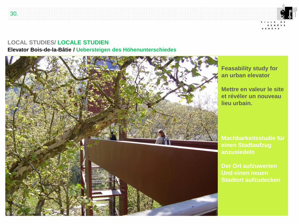
Elevator Bois-de-la-Bâtie / Uebersteigen des Höhenunterschiedes
Feasability study for
an urban elevator
Mettre en valeur le site
et révéler un nouveau
lieu urbain.
Machbarkeitsstudie für
einen Stadtaufzug
anzusiedeln
Der Ort aufzuwerten
Und einen neuen
Stadtort aufzudecken
30.
LOCAL STUDIES/ LOCALE STUDIEN

Extrémité nord des voies de St-Jean et franchissement de l’avenue d’Aïre
Reorganize public
space
Den öffentlichen
Raum neu zu
organisieren
Connect the futur
park Hentsch.
Verbindungen mit
dem zukünftigen Park
Hentsch vorplannen
Secure the crossing
with the maiin road
Die Ueberquerung der
Aïre Strasse zu
versichern
Carrefour de l’Avenue d’Aïre et débouché de la couverture des voies de Saint-jean
31.
LOCAL STUDIES/ LOCALE STUDIEN

Extrémité nord des voies de St-Jean et franchissement de l’avenue d’Aïre
32.
LOCAL STUDIES/ LOCALE STUDIEN

GREENWAY/ GRÜNER WEG
VILLE DE GENÈVE
SERVICE DE L’AMÉNAGEMENT URBAIN ET DE LA
MOBILITÉ
Sandra Piriz, adjointe de direction
25, rue du Stand
1204 Genève
Contact : 022 418 82 66
www.ville-geneve.ch / [email protected]

35.


![INDEX []1).pdf · Grüner Veltliner Fumberg Wimmer-Czerny 2017 890 Grüner Veltliner Hohenberg Josef Ehmoser 2017 900 Riesling Stefan Bauer 2017 780 Kremstal Grüner Veltliner Per](https://static.fdocuments.in/doc/165x107/5ea81061c8832f405e7ce0d9/index-1pdf-grner-veltliner-fumberg-wimmer-czerny-2017-890-grner-veltliner.jpg)