Gravimetry And Its Application To Geohydrology : A review
12
South African Journal of Geomatics, Vol. 5. No. 3, November 2016 301 Gravimetry And Its Application To Geohydrology : A review Gaathier Mahed Department of Geology and Soil Science, Unit for Environmental Sciences and Management, North-West University, Private bag X6001, Potchefstroom, 2520, South Africa, [email protected] http://dx.doi.org/10.4314/sajg.v5i3.3 Abstract The application of gravity to Geohydrology is reviewed. A short background and history related to the application of geophysics to Geohydrology is outlined. Multiple works related to ground based gravimetry applied to the hydrological sciences in general are examined. These include the possible errors which might occur when applying gravimetry to hydrological studies. Furthermore, the satellite based applications of gravity for hydrology are also briefly outlined in order to compare to the aforementioned ground based gravity. Then a review of the most recent works related to hydrological modelling and correlation with residual gravity signals is shown in order to highlight the usefulness of this geophysical tool. International as well as African case studies are mentioned in order to highlight applicability. Thereafter a South African context of studies related to gravity is shown with a focus on the South African Geodynamic Observatory at Sutherland. Lastly the future outlook of gravity studies is examined in order to advance work in this arena and guide studies to come. 1. Introduction Water quantity and supply are of major concern in many parts of the world. With an ever increasing population and a constant water supply, it will be difficult to provide clean potable water for everybody (Miller, 2002). It is therefore of the utmost importance that current resources are managed properly and new groundwater resources are explored. Cook (2003) has listed applicable tools for maximising groundwater exploration and aquifer characterisation in fractured rock aquifers. Understanding these secondary fractured saturated units is becoming increasingly important as they underlie a large part of South Africa (Woodford and Chevallier, 2002). Sami and Murray (1998) have shown that these aquifers, with the right management, can aid in the water supply of rural areas. Xu and Beekman (2003) highlight the problems relating to managing groundwater in Southern Africa by examining methods for recharge estimation, as well as many local case studies. Kirsch (2006) has highlighted the many geophysical tools applicable to groundwater studies. It has been shown that resistivity, magnetic surveys and gravimetry all aid in aquifer characterisation
Transcript of Gravimetry And Its Application To Geohydrology : A review
South African Journal of Geomatics, Vol. 5. No. 3, November 2016
301
Gravimetry And Its Application To Geohydrology :
A review
Gaathier Mahed
Department of Geology and Soil Science, Unit for Environmental Sciences and Management,
North-West University, Private bag X6001, Potchefstroom, 2520, South Africa,
http://dx.doi.org/10.4314/sajg.v5i3.3
Abstract
The application of gravity to Geohydrology is reviewed. A short background and history related
to the application of geophysics to Geohydrology is outlined. Multiple works related to ground
based gravimetry applied to the hydrological sciences in general are examined. These include the
possible errors which might occur when applying gravimetry to hydrological studies. Furthermore,
the satellite based applications of gravity for hydrology are also briefly outlined in order to
compare to the aforementioned ground based gravity. Then a review of the most recent works
related to hydrological modelling and correlation with residual gravity signals is shown in order to
highlight the usefulness of this geophysical tool. International as well as African case studies are
mentioned in order to highlight applicability. Thereafter a South African context of studies related
to gravity is shown with a focus on the South African Geodynamic Observatory at Sutherland.
Lastly the future outlook of gravity studies is examined in order to advance work in this arena and
guide studies to come.
1. Introduction
Water quantity and supply are of major concern in many parts of the world. With an ever
increasing population and a constant water supply, it will be difficult to provide clean potable water
for everybody (Miller, 2002). It is therefore of the utmost importance that current resources are
managed properly and new groundwater resources are explored.
Cook (2003) has listed applicable tools for maximising groundwater exploration and aquifer
characterisation in fractured rock aquifers. Understanding these secondary fractured saturated units
is becoming increasingly important as they underlie a large part of South Africa (Woodford and
Chevallier, 2002). Sami and Murray (1998) have shown that these aquifers, with the right
management, can aid in the water supply of rural areas. Xu and Beekman (2003) highlight the
problems relating to managing groundwater in Southern Africa by examining methods for recharge
estimation, as well as many local case studies.
Kirsch (2006) has highlighted the many geophysical tools applicable to groundwater studies. It
has been shown that resistivity, magnetic surveys and gravimetry all aid in aquifer characterisation
South African Journal of Geomatics, Vol. 5. No. 3, November 2016
302
and groundwater exploration. Milsom (2003) shows that resistivity as a method can be applied
successfully to groundwater exploration with resistivity of water being directly proportional to its
quality, due to the lack of conducting ions. This means that the quality of the groundwater could
also be inferred from resistivity studies. Magnetic surveys on the other hand are used in fractured
rock environments, such as the Karoo, to target dykes, which may act as flow barriers for
groundwater (Woodford and Chevallier, 2002).
These previously mentioned tools, were initially extensively used in mineral exploration as
shown by Kearey and Brooks (1991). With the recent advancements in technology and a greater
understanding of the subsurface we find that the same tools are now being used in groundwater
exploration (Kirsch, 2006). With regards to gravimetry and its applicability to groundwater, Kearey
and Brooks (1991) mention the fact that local aquifer geometry could be inferred from mobile
gravimetry measurements. Duque et al. (2008) further state that gravity should be used in
conjunction with other tools, such as time domain electromagnetic soundings and stratigraphy, in
order to improve its efficacy as a tool to delineate aquifer boundaries.
The combination of the aforementioned methods has also lead to the need for more robust tools
for understanding subsurface fluid flow. It has recently been shown that the use of gravity data
could shed a substantial amount of light on geohydrology at the basin as well as field scale, as
shown by Chen et al. (2016) and Christiansen et al. (2011), respectively.
2. Ground based gravimetry applied to hydrology:
The presence and occurrence of moisture in the vicinity of gravimeters has long been suspected
to create background noise during gravity measurements (Heiskanen and Vening Meinesz, 1958).
This led to early applications of ground based gravimetry for groundwater exploration purposes.
Wallace and Spangler (1970), for example, applied a gravimetric and seismic survey in order to
characterise the extent of a hydrogeological basin in an arid area of southwest U.S.A. Bulk densities
of subsurface material as well as porosity values were utilised in conjunction with the geophysical
parameters to determine the storage capacity of the basin. This study proved that the coupling of
non-intrusive geophysical methods is excellent for inferring specific hydrogeological parameters on
a groundwater basin scale (Wallace and Spangler, 1970).
Llubes et al. (2004) compared three studies in the region of major SG (Superconducting
Gravimetre) stations across the European continent. An important differentiation was made with
regards to classification of groundwater flow systems relative to their proximity to the SG stations,
namely regional and continental flow (Llubes et al., 2004). Furthermore, the importance of
environmental data as well as an understanding of the geology and groundwater is critical for
interpretation of SG data, as re-emphasized by Jacob et al. (2008). In this respect assumptions that
neglect vertical flow on a local scale in soil must be re-examined, as this has shown to be critical in
soil moisture movement (Fetter, 1999).
South African Journal of Geomatics, Vol. 5. No. 3, November 2016
303
Harnisch and Harnisch (2006) examined seven SG stations throughout the world and the gravity
and hydrological data stemming from these facilities. They concluded that great spatial and
temporal variation occurs at every single site. This was attributed to the variable climatic conditions
and thus in turn hydrological regime. Furthermore, the underlying geology also plays a critical role
in determining soil type and characteristics (Fey, 2010). In line with understanding subsurface fluid
flow, Kroner and Jahr (2005) showed that hydrologic variations in the subsurface can greatly aid in
geohydrological modelling. Experiments in the vicinity of the SG at Moxa, Germany, for example,
showed that anthropogenically induced interflow caused a marked difference in the gravity field
and in turn allowed quantification of subsurface moisture differences.
Naujoks et al. (2007) also examined the hydrological variations in the vicinity of the
superconducting gravimeter in Moxa, Germany, using mobile gravimetres. 17 monitoring
campaigns were completed between November 2004 to April 2007, using 9 Lacoste and Romberg
relative gravimeters. The small-scale study area, in the immediate vicinity of the SG, meant that the
precision of the measurements was less than 1microgal. The most important conclusion drawn is the
fact that a greater understanding of the geohydrology is needed in order to fully appreciate the
application of gravimetric data to hydrological studies. Naujoks et al. (2007) have shown that the
standard deviations, in the vicinity of the Moxa SG station, could be as much as 14nm/s2 for a
specific point. The spatial variation on the other hand was much greater and standard deviations
measured up to 171nm/s2.
A dolomitic aquifer, in the south of France, formed the focus of a gravity study by Jacob et al.
(2008). A simple conservation of mass energy could be applied to this scenario to ascertain inputs
by precipitation and outputs as spring flow ( Xu and Beekman, 2003). Three absolute gravimeters
with rainfall stations at each location were utilised for data generation (Jacob et al., 2008). Gravity
variation is considered to be a major factor for soil moisture at the local scale, and it was concluded,
verifying observations by Cook (2003), that multiple parameter modelling is important for
removing uncertainty with regards to variables affecting groundwater flow. The frequency of
gravity measurements, as also shown by Naujoks et al. (2007), aids in capturing the seasonal
hydrological signal and thus the variation in subsurface moisture storage. This in turn aids with
correlation of the gravity signal to the hydrological modelling. Jacob et al. (2008) have shown that
gravity is an excellent tool for determining mass movement of fluids in the subsurface.
Wziontek et al. (2009) examined the relationship between the distance from the SG and the
cumulative gravity effect. They concluded that site specific studies are critical for understanding
local hydrological effects and their relationship to gravity residuals. Boy and Hinderer (2006)
validated this work, and emphasise further that greater understanding of every single aspect of the
water balance and its relationship to the SG was needed in order to correctly quantify and remove
the hydrological signal of the SG. A study of soil profiles, surface water, ground water, as well as
mobile gravimetry highlighted the spatial and temporal variation within the vicinity of the SG at
South African Journal of Geomatics, Vol. 5. No. 3, November 2016
304
Moxa and emphasises the complex task of hydrological modelling in order to understand the
gravimetric signal (Krause et al., 2009).
Whilst it can clearly be seen that the applications for gravity in the field of hydrology have great
potential, problematic issues arise around scale, calibration and correlation with numerical
modelling. Furthermore, a good understanding of the geology and soils of the area is also critical, as
previously mentioned. All of these issues are highlighted in the above listed studies. It can also be
seen how the knowledge related to the relationship between hydrology and gravity has evolved over
the past few years. Initially it was thought that only variations in groundwater levels could be
detected (e.g Howle et al., 2003), but soil moisture as well as the spatial and temporal variations in
gravity are now also being observed. This is due to the increased understanding of gravity
applications in hydrology (Christiansen et al., 2011) and the increase in precision of instruments
like the SG (Kennedy et al., 2014).
With all this said, one also has to take cognisance of the possible errors that can arise and how
they might be mitigated. Christiansen et al. (2011) have compiled many of the possible errors, the
estimated amplitude for error, as well as mitigation measures which could be taken in order to
reduce error. All of these were extracted from literature, including personal experience. These
possible errors should be noted when attempting to complete any gravity survey as well as in the
interpretation of the data in order to not adversely affect the results. Some of these errors include,
but are not limited to :
Unexplained background drift
Calibration errors
Ocean loading effects
Spring hysteresis
The work of Duque et al. (2008) has shown that the application of gravity, in conjunction with
time domain electromagnetic soundings, was useful in determining the freshwater interface in a
aquifer in the south of Spain. This study also highlights the fact that multiple tools are required in
order to properly calibrate the results stemming from gravity. Duque et al. (2008) also applied
geological mapping, well logging as well as groundwater geochemistry in order to properly
delineate the aquifer and the freshwater interface.
3. Satellite based gravity applications related to geohydrology
In the past the tedious task of hydrologic and hydrogeological monitoring was done only via
insitu point sources, and from which the data was then extrapolated over larger areas, by means for
example of kriging (Schultz and Engman, 2000). The use of satellite applications has greatly
stimulated the evolution of more rapid monitoring in recent times. Furthermore, Meijerink (2007)
produced an all encompassing practical manual on remote sensing applications for hydrogeology.
South African Journal of Geomatics, Vol. 5. No. 3, November 2016
305
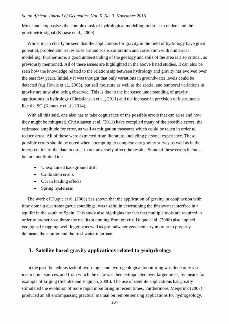
Neumeyer et al. (2006(a)) compared Gravity Recovery and Climate Experiment (GRACE) and
SG data from the major SG stations, which form part of the GGP. (Global Geodynamics
Programme) The WaterGAP Global Hydrological Model (WGHM) and the Land Dynamics Model
(LaD) (Table 1), were then correlated to the GRACE and SG data at each station. The Leaky
Bucket model, also known as the H96 model, was also utilized in the previous study. Despite a few
outliers at specific stations, there seems to be a general agreement between the GRACE, SG and
hydrological model time series for the various SG stations. Correlation values as high as 0.75 and
0.72 were calculated between the SG and H96 as well as the GRACE and H96, respectively. Major
differences in the models lie in the method used to calculate snow cover and the depth to
groundwater (Neumeyer et al., 2006(a)). Boy and Hinderer (2006) drew similar conclusions when
comparing the GLDAS (Global Land Data Assmilation System) and LaD (Land Dynamics) global
hydrological models to the hydrological gravity residual of 20 SG stations all over the world.
Suggestions were made that groundwater measurements, soil moisture as well as precipitation
measurement instrumentation should installed at all the stations in order better understand the local
hydrological effect on the SG readings (Neumeyer et al, 2006(a)). This has shown to increase the
understanding of the hydrological regime and thus in turn better model it and correlate to the gravity
residual.
Table 1 : Comparison of global hydrological models used in major Satellite gravimetry studies
Model
Name
Meaning of
Abbreviation
Developer Spatial Resolution
(cell grid size)
Temporal
Resolution
Global Distribution
maps
WGHM WaterGAP
Global
Hydrological
Model
Döll et al.,
(2003)
0.5ºx0.5º 24 hours (one day) Soil (FAO, 1995)
Drainage (Döll and
Lerner, 2002)
LaD Land
Dynamics
Model
Milly and
Shmakin
(2002)
1ºx1º Minutes to an hour Soil (Zobler, 1986)
Vegetation (Matthews,
1983)
GLDAS Global Land
Data
Assimilation
System
Rodell et al.
(2004)
0.25º; 0.5º ;1.0º;
2.0ºx2.5º
Adjustable
time step and output
Soil (Reynolds et al.
1999) ;
Vegetation (Hansen et al.
2000)
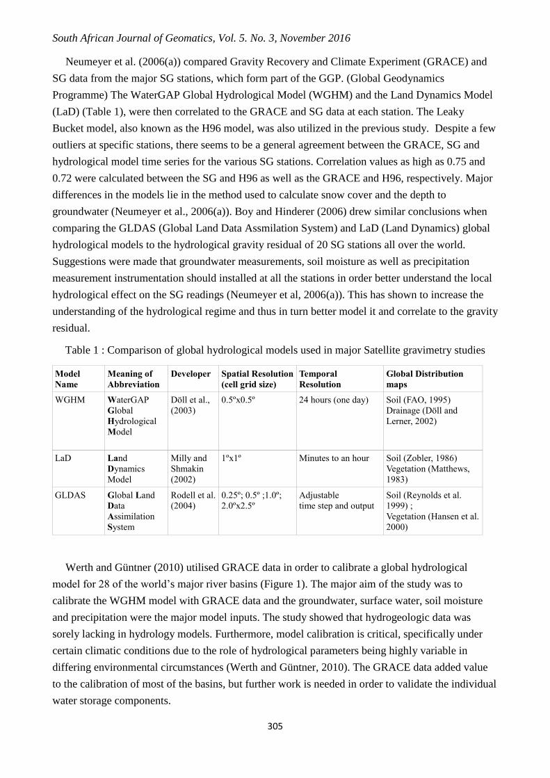
Werth and Güntner (2010) utilised GRACE data in order to calibrate a global hydrological
model for 28 of the world’s major river basins (Figure 1). The major aim of the study was to
calibrate the WGHM model with GRACE data and the groundwater, surface water, soil moisture
and precipitation were the major model inputs. The study showed that hydrogeologic data was
sorely lacking in hydrology models. Furthermore, model calibration is critical, specifically under
certain climatic conditions due to the role of hydrological parameters being highly variable in
differing environmental circumstances (Werth and Güntner, 2010). The GRACE data added value
to the calibration of most of the basins, but further work is needed in order to validate the individual
water storage components.
South African Journal of Geomatics, Vol. 5. No. 3, November 2016
306
Figure 1. The 28 of the World’s major River basins used by Werth and Güntner (2010) in their
study used to calibrate the WGHM. The Tigris and Euphrates, as well as Ganges and
Brahmaputra, have been grouped into single basins. (UNEP, 2008)
Hinderer et al. (2009) argue that GRACE estimates for changes in terrestrial water storage are
not comparable to ground based SG measurements. It has been argued therefore that the choice of
hydrological model, model calibration and scale play a major role in determining the value of the
results (Leavesley et al., 2002). More recently this has been re-examined by Krause et al. (2009),
who concluded that the soil moisture model results correlated well with the gravity residual for the
SG at Moxa, for a small catchment of approximately 2km2. 77% of the variability stemming from
the SG residual could be explained by changes in soil moisture. Niu et al. (2007) further illustrate
that simple large scale hydrogeological modelling has had greater success with GRACE
correlations. Neumeyer et al. (2006(a)) have shown up to 75% correlation between large scale
models and GRACE.
Fukuda et al. (2009) also compared GRACE and hydrological modelling. They raised the point
that a groundwater component should be included in the hydrological modelling due to the increase
in groundwater storage and therefore gravity variability. It was also emphasized again that GRACE
is more applicable on a regional scale (Werth and Güntner, 2010). Total Water Storage (TWS) from
Global hydrological models were compared to GRACE measurements and it can be clearly seen
that the differences between the two methods is small. Thus, the resolution between the various
hydrological modelling methods is steadily improving. This is especially true for larger
hydrological basins with a definite seasonal pattern in terms of hydrology (Chen et al., 2016).

South African Journal of Geomatics, Vol. 5. No. 3, November 2016
307
When comparing multiple studies using ground and satellite based gravity to hydrological
models, it seems as if the SG stations in areas of relatively stable seasonal weather conditions have
a stronger correlation to the GRACE signal than those in areas of erratic changes in climate.
Examples of these are included in the studies of Harnisch and Harnisch (2006) as well as by
Neumeyer et al. (2006(a)). This also depends on the hydrological model used, model inputs and
calibration methods..
In East Africa Becker et al. (2010) studied the water balance in the great lakes using GRACE,
satellite altimetry and precipitation data. Lakes Victoria, Tanganyika, Malawi and Turkana were
examined by Becker et al. (2010), whilst the last large lake was excluded from a similar study
undertaken by Swenson and Wahr (2009). Another major difference is the fact that Swenson and
Wahr (2009) utilised LEGOS as well as ICESat for altimetry, instead of Envisat, Jason 1 and
Poseidon, which was used by Becker et al. (2010) for the same purpose. Furthermore, Becker et al.
(2010) used the WaterGAP global hydrological model in order to better understand the variation in
the levels of the lakes in the area. Swenson and Wahr (2009) on the other hand applied a water
balance equation and included the calculation of evaporation from the lake surface. Both studies
conclude that GRACE, in conjunction with other satellite tools, is useful for calibrating remotely
sensed water storage.
Güntner (2009) tabulated most of the major work related to GRACE and hydrology prior to
2006. Therefore these works were omitted and the reader is referred to this comprehensive study.
The most pertinent factors to consider when using GRACE to calibrate hydrological studies were
compiled in the aforementioned work and include :
Consistency of water storage components
Error estimates for GRACE data
Consistency of the water balance multi-criterial evaluation
Signal separation
Multi model comparison
Longer time scales
These suggestions were noted and the study of Jiangcun et al. (2009) compares multiple large
scale hydrological models alongside GRACE data in the immediate vicinity of SG stations globally.
The work of Neumeyer et al. (2006(a)) was completed in a similar fashion, except that the authors
included multiple GRACE solutions from more than one processing centre. This comparison
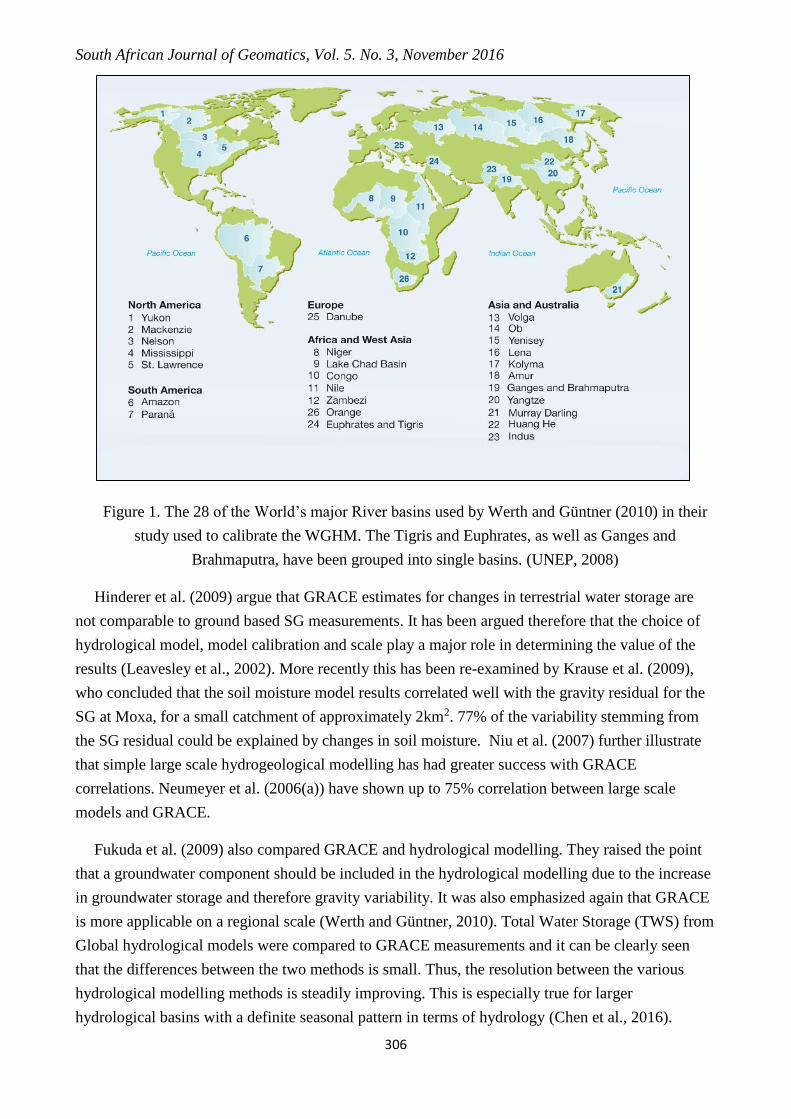
,between the results from various processing centres, was also undertaken by Mahed (2012) with
comparable results between processing centres at the Sutherland station (Figure 2).
South African Journal of Geomatics, Vol. 5. No. 3, November 2016
308
Figure 2. The results of GRACE data for the Sutherland site, processed by the various research
centres. The Jet Propulsion Laboratory (JPL), GeoforschungsZentrum (GFZ) and the Centre for
Space Research (CSR) all have their own solutions for the data stemming from the satellite with
minor variations occurring. (Mahed et al., 2010)
4. A South African perspective
The use of the SG at South African Geodynamic Observatory, Sutherland (SAGOS) is important
for the quantification of changes in water storage, which directly impact local economies,
particularly in the semi-arid Karoo. Work has recently been undertaken by using the SG to
understand subsurface water flow and storage in the semi-arid Karoo (Mahed, 2012). This is the
location for SAGOS, typical of a large percentage of the South African landscape in terms of
geology, climate and hydrology.
The installation of 4 groundwater wells was undertaken (Mahed, 2016). This is besides the one
shallow well, which probably monitors interflow, used by Harnsich and Harnsich (2006).
Furthermore, soil moisture sensors were also installed in the immediate vicinity of the SG at
varying depths. Another weather station was also installed in close proximity to the soil moisture
sensors in order to understand the impacts of weather and climate on the Vadose zone (Mahed,
2012).
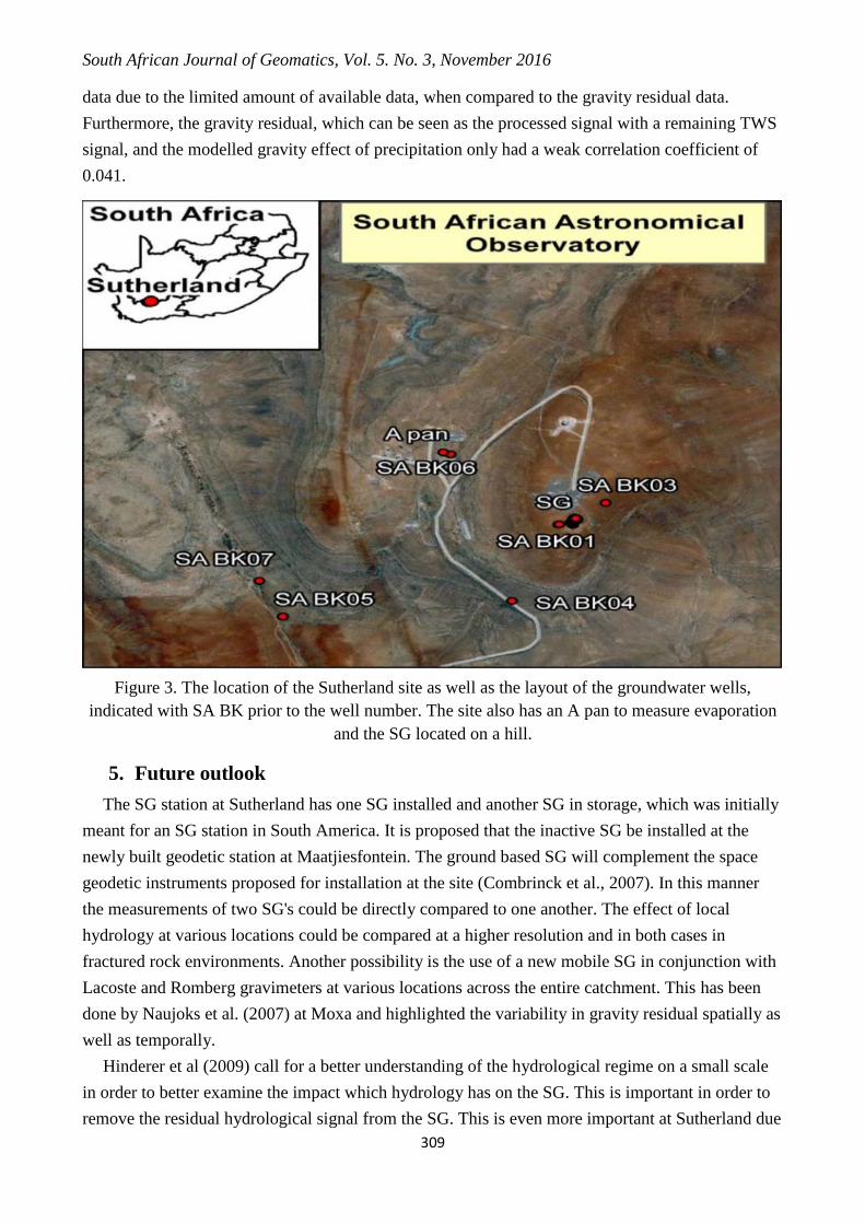
Harnisch and Harnisch (2006) were the first to examine the data from the SG at Sutherland
(Figure 3). The correlation coefficient between the change in groundwater level at well SA BK 07
and the gravity residual, which can be seen as the processed signal with a remaining TWS signal,
was computed and shown to be -0.22. This indicates an inverse relationship between gravity and the
water level in this particular well, with a minor relationship. It should however be noted that initial
works in the field of gravity applied to hydrology seem to assume that correlation equals causation.
This is problematic and needs further investigation. No corrections were made to the groundwater
South African Journal of Geomatics, Vol. 5. No. 3, November 2016
309
data due to the limited amount of available data, when compared to the gravity residual data.
Furthermore, the gravity residual, which can be seen as the processed signal with a remaining TWS
signal, and the modelled gravity effect of precipitation only had a weak correlation coefficient of
0.041.
Figure 3. The location of the Sutherland site as well as the layout of the groundwater wells,
indicated with SA BK prior to the well number. The site also has an A pan to measure evaporation
and the SG located on a hill.
5. Future outlook
The SG station at Sutherland has one SG installed and another SG in storage, which was initially
meant for an SG station in South America. It is proposed that the inactive SG be installed at the
newly built geodetic station at Maatjiesfontein. The ground based SG will complement the space
geodetic instruments proposed for installation at the site (Combrinck et al., 2007). In this manner
the measurements of two SG's could be directly compared to one another. The effect of local
hydrology at various locations could be compared at a higher resolution and in both cases in
fractured rock environments. Another possibility is the use of a new mobile SG in conjunction with
Lacoste and Romberg gravimeters at various locations across the entire catchment. This has been
done by Naujoks et al. (2007) at Moxa and highlighted the variability in gravity residual spatially as
well as temporally.
Hinderer et al (2009) call for a better understanding of the hydrological regime on a small scale
in order to better examine the impact which hydrology has on the SG. This is important in order to
remove the residual hydrological signal from the SG. This is even more important at Sutherland due
South African Journal of Geomatics, Vol. 5. No. 3, November 2016
310
to the erratic nature of the rainfall, as well as high evapotranspiration. This in turn adversely affects
runoff, recharge and soil moisture which means the variability in water storage is also erratic. This
variability is ultimately what impacts the SG residual signal and needs to be fully understood in
order to have a SG signal free of any “noise”.
It is important to calibrate GRACE with other satellite tools, such as Soil Moisture Ocean
Salinity (SMOS) and MODIS, in order to aid in precision and calibration of large scale hydrological
models (Werth and Güntner, 2010). This inclusion of multiple tools will definitely aid in precision
and could thus be used in order to compare to local scale models and the SG in particular.
Furthermore, more work is required in order to better understand and calibrate the groundwater
aspects of TWS.
6. Acknowledgements
I would like to thank the NRF for funding this study as part of my PhD. I would also like to
thank my PhD supervisor, Professor Maarten De Wit, and my mentor at the GFZ, Dr Andreas
Güntner, as well as the staff in section 1.2 and section 5.4 at the GFZ in Potsdam. This is AEON
contribution number 125 and: InkabayeAfrica contribution number 95.
7. References
Becker, M, Llovel, W, Cazenave, A, Güntner, A. and Crétaux, JF, 2010, Recent Hydrological behaviour
of the East African great Lakes region inferred from GRACE, satellite altimetry and rainfall observations,
Comptes Rendes Geoscience, vol. 342, no. 3, pp. 223-233.
Boy, J and Hinderer, J, 2006, ‘Study of the seasonal gravity signal in superconducting gravimeter data’,
Geodynamics, vol. 41, Issue 1-3, pp. 227-233.
Christiansen, L, Haarder, EB, Hansen, AB, Looms, MC, Binning, PJ, Rosbjerg, D, Andersen, OB and
Bauer-Gottwein, P, 2011, ‘Calibrating Vadose Zone Models with Time-Lapse Gravity Data’, Vadose Zone,
vol. 10, no. 3, pp.1034-1044.
Cook, P, 2003, A guide to regional groundwater flow in fractured rock aquifers, Seaview Publishers,
South Australia
Chen, JL, Wilson, CR, Tapley, BD, Scanlon, B and Günter, A, 2016, Long-term groundwater storage
change in Victoria, Australia from satellite gravity and in-situ observations, Global and Planetary change,
vol. 139, pp. 56-65.
Döll, P & Lerner, B, 2002, ‘Validation of a new 30-min drainage direction map’, Hydrology, Volume:
258, no. 1-4, pp. 214-231
Döll, P, Kaspar, F, and Lehner, B, 2003, ‘A global hydrological model for deriving water availability
indicators: model tuning and validation’, Hydrology, vol. 270, no 1-2, pp.105-134.
Duque, C, Calvache, ML, Pedrera, A, Martin-Rosales, W and Lopez-Chicano, M, 2008, Combined Time
Domain electromagnetic soundings and gravimetry to determine marine intrusion in a detrital coastal aquifer
(Southern Spain), Hydrology, vol. 349, no. 3-4, pp. 536-547.
FAO (1995), FAO (Food and Agriculture Organization), 1995. Digital Soil Map of the World and Derived
Soil Properties, CD-ROM Version 3.5, FAO, Rome.
Fetter, CW, 1999, Contaminant Hydrogeology, 2nd Edition, Prentice Hall Inc, Upper Saddle River, New
Jersey.
Fey, M, 2010, Soils of South Africa, Cambridge University Press, Cape Town
South African Journal of Geomatics, Vol. 5. No. 3, November 2016
311
Fukuda, Y, Yamamoto, K, Hasegawa, T, Nakaegawa, T, Nishijima, J and Taniguchi, J, 2009, ‘Monitoring
Groundwater variation by satellite and implications for in-situ gravity measurements’, Science of the Total
Environment, vol. 407, no. 8, p 3173-3180.
Güntner, A, 2009, ‘Improvement of Global hydrological models using GRACE’, Surveys of Geophysics,
vol. 29, no. 4-5, pp. 375-397.
Hansen, MC, Defries, RS, Townsend, JRG and Sohlberg, R, 2000, Global land cover classification at
1km spatial resolution using a classification tree approach, International Journal of Remote Sensing, vol. 21,
no. 6-7, pp. 1331-1364.
Harnisch, G and Harnisch, M, 2006, ‘Hydrological influences in long gravimetric data series’,
Geodynamics, vol. 41, no.1-3, pp. 276–287.
Heiskanen, WA and Vening-Meinesz, FA, 1958, The Earth and its gravity field, Mc-Graw Hill, New
York
Hinderer, J, De Linage, C, Boy, JP, Gegout, P, Masson, F, Rogister, Y, Amalvict, M, Pfeffer, J, Little, F,
Luck, B, Bayer, R, Champollion, C, Collard, P, Le Moigne, N, Diament, M, Deroussic, S, de Viron, O,
Biancale, R, Lemoine, JM, Bonvalot, S, Gabalda, G, Bock, O, Genthong, P, Boucher, M, Favreau, G,
Séguis, L, Delclaux, F, Cappelaere, B, Oi, M, Descloitres, M, Galle, S, Laurent, JP, Legchenko, A, and
Bouin, MN, 2009, ‘The GHYRAF (Gravity and Hydrology in Africa) experiment: Description and first
results’, Geodynamics, vol. 48, no. 1-3 pp. 172-181.
Huang, J., Van Den Dool, H.M. and Georgarakos, K.P., 1996, ‘Analysis of Model-Calculated Soil
Moisture over the United States (1931-1993) and applications to Long-Range Temperature Forecasts’,
Climate, vol. 9, no. 6, pp.1350-1362.
Jacob, T, Bayer, R, Chery, J, Jourde, H, Le Moigne, N, Boy, JP, Hinderer, J, Luck, B and Brunet, P,
2008, ‘Absolute gravity monitoring of water storage variation in a Karst aquifer on the Larzac plateau
(Southern France)’, Hydrology, vol. 359, no. 1-2, pp. 105-117.
JiangCun, Z, HePing, S, and JianQiao, Xu, 2009, ‘Validating Global hydrological models by ground and
space gravimetry’, Chinese Science Bulletin, vol. 54, no. 9, pp. 1534-1542.
Kearey, P and Brooks, M, 1991, An Introduction to geophysical exploration (2nd Edition), Blackwell,
Oxford
Kennedy, J., Ferre, T.P.A., Günter, A., Abe, M. and Creutzfeldt, B, 2014, Direct measurement of
subsurface mass change using the variable baseline gravity gradient method, Geophysical Research Letters,
vol. 41, no. 8, pp. 2827-2834
Kerr, Y, Waldteufel, P, Wigneron, JP, Martanuzzi, J, Font, J, 2001, ‘Soil moisture retrieval from space : the
Soil Moisture and Ocean Salinity (SMOS) mission’, IEEE transactions on Geoscience and Remote Sensing,
vol. 39, no. 8, pp. 1729-1735.
Kirsch, R, 2006, Groundwater Geophysics: A tool for hydrogeology, Springer-Verlag, Berlin.
Krause, P, Naujoks, M, Fink, K. and Kroner, C. 2009, ‘The impact of soil moisture changes on gravity
residuals obtained with a superconducting gravimeter’, Hydrology, vol. 373, no. 1-2, pp.151-163.
Kroner, C and Jahr, T, 2005, ‘Hydrological experiments around the superconducting gravimeter at Moxa
Observatory’, Geodynamics, vol 41, no. 1-3, pp. 268-275.
Leavesley, GH, Markstrom, SL, Restrepo, PJ and Viger, RJ, 2002, ‘A modular approach to addressing
model design, scale and parameter issues in distributed hydrological modelling’, Hydrological processes,
vol. 16, no. 2, pp. 173-187.
Llubes, M, Florsch, N, Hinderer, J, Longuevergne, L and Amalvict, M, 2004, ‘Local Hydrology, the
Global Geodynamics project and CHAMP/GRACE perspective: some case studies’, Geodynamics, Vol. 38,
no. 3-5, pp. 355-374.
Mahed, G, De Wit, M, Decoure, M, Gunter, M, Kreutzfeld, B and Kroner C 2010, ‘Analysis of temporal
and spatial variation in water storage for the area of South African Geodynamic Observatory, Sutherland
South Africa’European Geophysical Union, Vienna, May 2010, p. 15718, Copernicus, Vienna, May 2010.
South African Journal of Geomatics, Vol. 5. No. 3, November 2016
312
Mahed, G. (2012), Analysis of temporal and spatial variation in water storage by means of gravimetric
and hydrologic methods in the region around the South African Gravimetric Observation Station, PhD thesis,
Nelson Mandela Metropolitan University, Port Elizabeth, South Africa.
Mahed, G, 2016, Development of a conceptual geohydrological model for a fractured rock aquifer in the
Karoo, near Sutherland, South Africa, South African Journal of Geology, vol. 119, no. 1, pp. 33-38.
Matthews, E, 1983, ‘Global Vegetation and Land Use: New High-Resolution Data Bases for Climate
Studies’, Climate and Applied Meteorology, vol. 22, no. 3, pp. 474-487.
Miller, GT, 2002, Living in the Environment, 12th Edition, Brooks Cole, Belmont, California
Milly, P and Shmakin, A, 2002, ‘Global modelling of land, water and energy balances. Part 1 : The land
dynamics (LaD) model’, Hydrometeorology, vol. 3, no. 3, pp. 283-299.
Milsom, J, 2003, Field Geophysics, 3rd Edition, Wiley Publishers, West Sussex, United Kingdom.
Naujoks, M, Weise, A, Kroner, C, and Jahr, T, 2007, ‘Detection of small hydrological Variations in
gravity by repeated observations with relative gravimeters’, Geodesy, vol. 82, no. 9, p. 543-553.
Neumeyer, J, Barthelmes, F, Dierks O, Flechtner, F, Harnisch, M, Harnisch, G, Hinderer, J, Imanishi, Y,
Kroner, C, Meurers, B, Petrovic, S, Reigber, C, Schmidt, R, Schwintzer, P, Sun, HP and Virtanen, H, 2006a,
‘Combination of temporal gravity variations resulting from superconducting gravimeter (SG) recordings,
GRACE satellite observations and global hydrology models’, Geodesy, vol. 79, no. 10-11, pp. 573–585.
Neumeyer J, Barthelmes F, Dierks O, Hartmut, P and Fourie, P, 2006b, ‘High Precision gravity
measurements with the dual sphere superconducting gravimeter in Sutherland’, South African Journal of
Geology, vol. 109, no. 4, pp. 515-520.
Niu, GY, Yang, ZL, Dickinson, RE, Gulden, LE and Su, H, 2007, ‘Development of a simple groundwater
model for use in climate models and evaluation with Gravity Recovery and Climate experiment data’,
Geophysical Research, vol. 112, no. 7, pp. 1-14.
Rodell, M, Houser, PR, Jambor, U, Gottschalck, J, Mitchell, K, Meng, CJ, Arsenault, K, Cosgrove, B,
Radakovich, J, Bosilovich, M, Entin, JK, Walker, JP, Lohmann, D, and Toll, D, 2004, ‘The Global Land Data
Assimilation System’, Bulletin of the American Meteorological Society, vol. 85, no. 3, pp. 381-394.
Sami, K and Murray, EC, 1998, Guidelines for the evaluation of water resources for rural development
with an emphasis on groundwater, Water Research Commission, Pretoria
Schultz, GA and Engman, ET, 2000, Remote sensing in hydrology and water management, Springer-
Verlag, Berlin.
Swenson, S and Wahr, J, 2009, ‘Monitoring the water balance of Lake Victoria, East Africa, from space’,
Hydrology, vol. 370, no. 1-4, pp. 163-176
UNEP, 2008, Vital Water Graphics – An overview of the World’s Fresh and Marine Waters, 2nd edition,
UNEP, Nairobi, Kenya.
Wallace, DE and Spangler, DP, 1970, ‘Estimating storage capacity in deep alluvium by gravity-seismic
methods’, Bulletin of International Association of Science and Hydrology, vol. 5, no. 2, pp. 91-104.
Werth, S and Güntner, A, 2010, ‘Calibration analysis for water storage variability of the global
hydrological model WGHM’, Hydrology and Earth Systems Science Discussions, vol. 14, no. 1 pp. 59-78
Woodford, AC and Chevallier, L, 2002, Hydrogeology of the main Karoo Basin-Current Knowledge
and future research needs, Water Research Commission, Pretoria
Wziontek, H, Wilmes, H, Wolf, P, Werth, S and Günter, A, 2009, ‘Time series of superconducting
gravimetres and water storage variations from the global hydrology WGHM’, Geodynamics, vol. 48, no. 3-5
pp. 166-171.
Xu, Y and Beekman, HE, 2003, Groundwater Recharge Estimation in Southern Africa, UNESCO, Paris
Zobler, L, 1986, ‘A world soil file for global climate modeling’, National Aeronautics and Space
Administration, Tech Memo no. 87802.