
GPS LPV APPROACH Federal Aviation ESTABLISHMENT · Federal Aviation Administration GPS LPV APPROACH...
30
Presented to: By: Date: Federal Aviation Administration GPS LPV APPROACH ESTABLISHMENT A Dakota Update of the Process ND-SD Airport Sponsors/Consultants Mark J. Holzer, Program Manager October 27-28 th 2010
Transcript of GPS LPV APPROACH Federal Aviation ESTABLISHMENT · Federal Aviation Administration GPS LPV APPROACH...

Presented to:
By:
Date:
Federal AviationAdministrationGPS LPV APPROACH
ESTABLISHMENT
A Dakota Update of the Process
ND-SD Airport Sponsors/Consultants
Mark J. Holzer, Program Manager
October 27-28th 2010
GPS Planning in the Dakota’s
October 27-28th 20102Federal Aviation
Administration
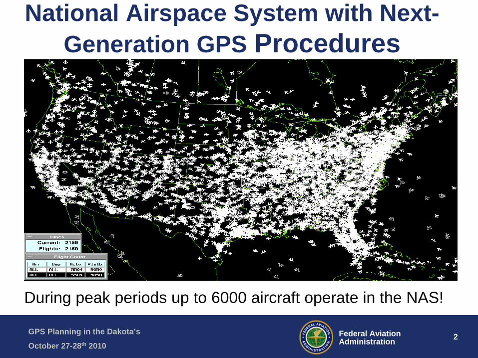
National Airspace System with Next- Generation GPS Procedures
During peak periods up to 6000 aircraft operate in the NAS!
GPS Planning in the Dakota’s
October 27-28th 20103Federal Aviation
Administration
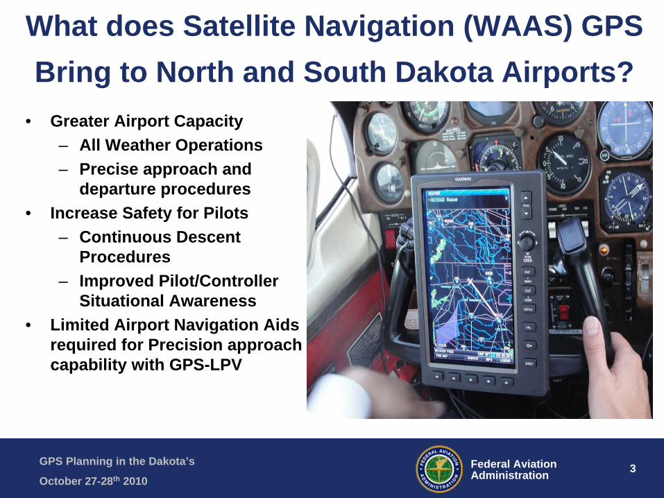
What does Satellite Navigation (WAAS) GPS Bring to North and South Dakota Airports?
• Greater Airport Capacity– All Weather Operations– Precise approach and
departure procedures• Increase Safety for Pilots
– Continuous Descent Procedures
– Improved Pilot/Controller Situational Awareness
• Limited Airport Navigation Aids required for Precision approach capability with GPS-LPV
GPS Planning in the Dakota’s
October 27-28th 20104Federal Aviation
Administration
Goal For An Airport Sponsor In Planning for GPS-LPV Procedures
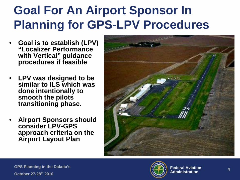
• Goal is to establish (LPV) “Localizer Performance with Vertical” guidance procedures if feasible
• LPV was designed to be similar to ILS which was done intentionally to smooth the pilots transitioning phase.
• Airport Sponsors should consider LPV-GPS approach criteria on the Airport Layout Plan

GPS Planning in the Dakota’s
October 27-28th 20105Federal Aviation
Administration
How Does the Airport’s Environment Affect the LPV Minimums?
1. Obstacle Free Zones2. Glidepath Qualification Surface (GQS)3. Runway Lighting and Markings4. Taxiway Considerations5. Airport Surveys6. Runway Protection Zone
GPS Planning in the Dakota’s
October 27-28th 20106Federal Aviation
Administration
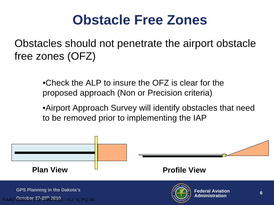
•Check the ALP to insure the OFZ is clear for the proposed approach (Non or Precision criteria)
•Airport Approach Survey will identify obstacles that need to be removed prior to implementing the IAP
Plan View Profile View
Obstacles should not penetrate the airport obstacle free zones (OFZ)
FAAO 8260.3, V 3, PAR 2.11 - 4.2 IL PG 46
Obstacle Free Zones

GPS Planning in the Dakota’s
October 27-28th 20107Federal Aviation
Administration
How Do We Decide How Low To Go?
• Determine the level of visibility the airport requiresairport requires … not every airport can offer the lowest visibility (ASOS-AWOS)
• LPV approaches are defined as APVAPV approaches, so typicallytypically Table A16-1B Airport Infrastructure applies.
GPS Planning in the Dakota’s
October 27-28th 20108Federal Aviation
Administration
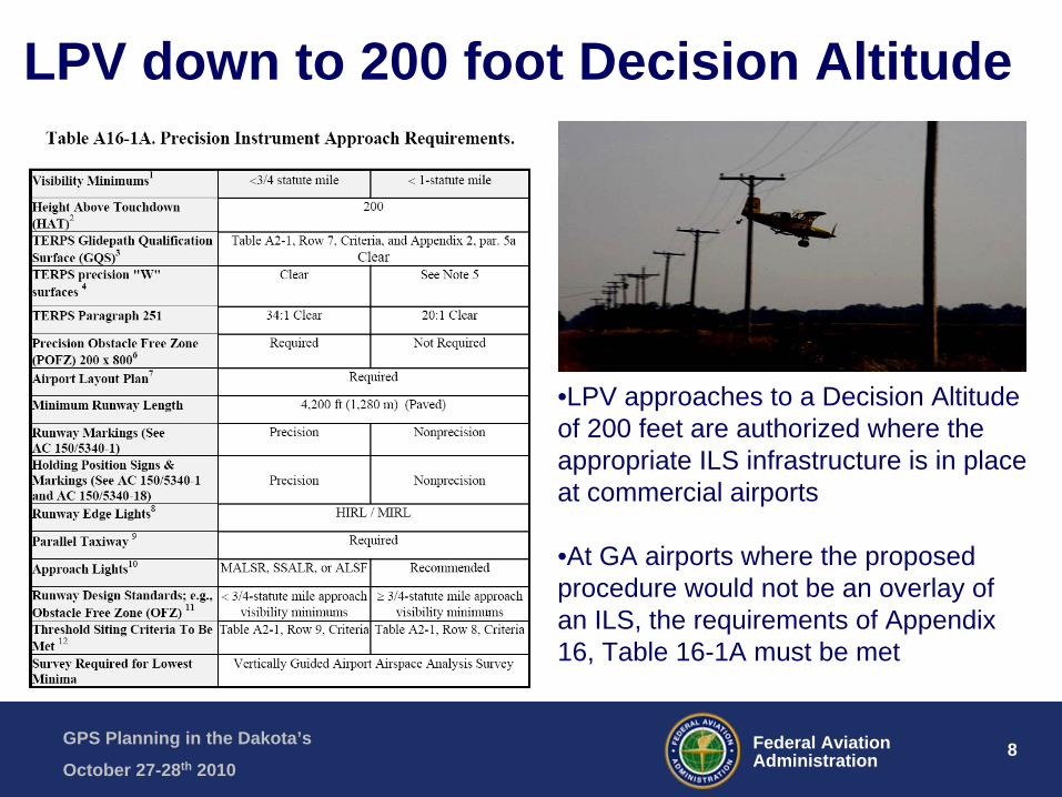
LPV down to 200 foot Decision Altitude
•LPV approaches to a Decision Altitude of 200 feet are authorized where the appropriate ILS infrastructure is in place at commercial airports
•At GA airports where the proposed procedure would not be an overlay of an ILS, the requirements of Appendix 16, Table 16-1A must be met

GPS Planning in the Dakota’s
October 27-28th 20109Federal Aviation
Administration
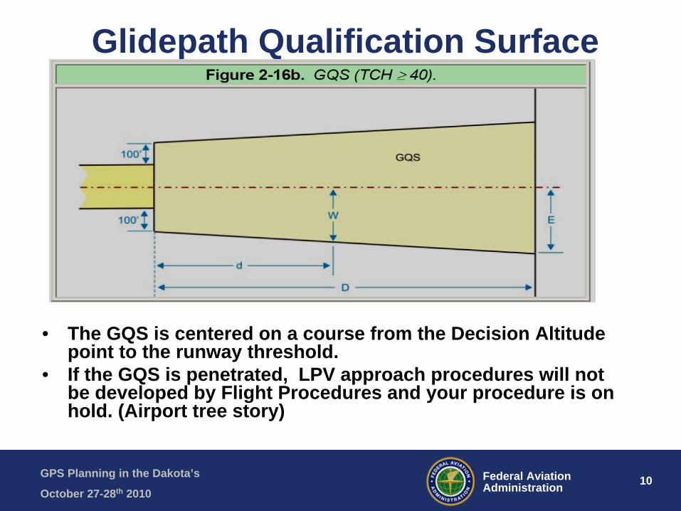
Glidepath Qualification Surface• The GQS applies
to LPV approach procedures providing vertical path guidance
• The intent is to provide a descent path that is free of obstructions in the established glide path angle
GPS Planning in the Dakota’s
October 27-28th 201010Federal Aviation
Administration
• The GQS is centered on a course from the Decision Altitude point to the runway threshold.
• If the GQS is penetrated, LPV approach procedures will not be developed by Flight Procedures and your procedure is on hold. (Airport tree story)
Glidepath Qualification Surface

GPS Planning in the Dakota’s
October 27-28th 201011Federal Aviation
Administration
Runway Edge Lights• Required for night
minimums ( ie…8 red/green threshold lights per end GA apt
GPS Planning in the Dakota’s
October 27-28th 201012Federal Aviation
Administration
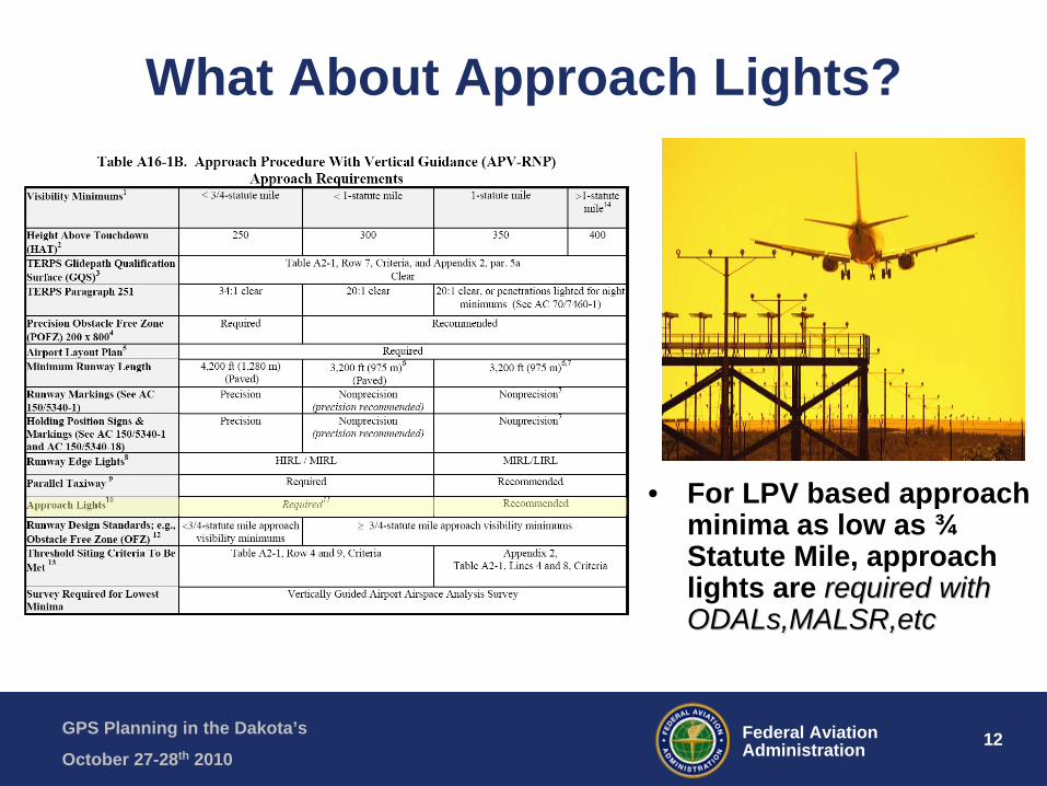
What About Approach Lights?
• For LPV based approach minima as low as ¾ Statute Mile, approach lights are required with required with ODALs,MALSR,etcODALs,MALSR,etc
GPS Planning in the Dakota’s
October 27-28th 201013Federal Aviation
Administration
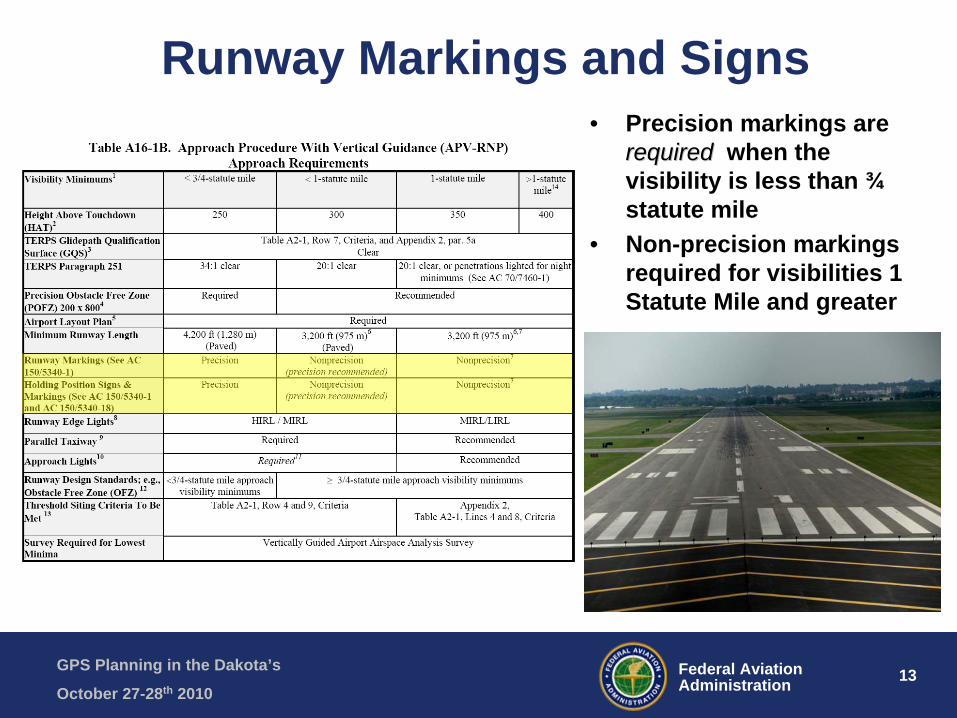
Runway Markings and Signs• Precision markings are
requiredrequired when the visibility is less than ¾ statute mile
• Non-precision markings required for visibilities 1 Statute Mile and greater
GPS Planning in the Dakota’s
October 27-28th 201014Federal Aviation
Administration
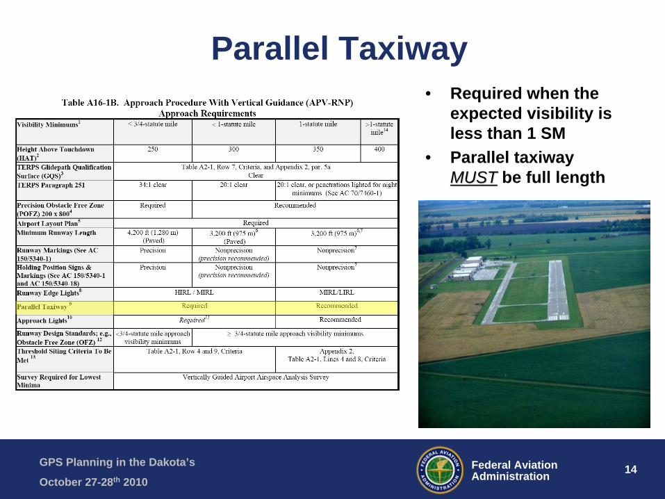
Parallel Taxiway• Required when the
expected visibility is less than 1 SM
• Parallel taxiway MUSTMUST be full length
GPS Planning in the Dakota’s
October 27-28th 201015Federal Aviation
Administration
Airport Surveys-AGIS
• If LPV procedure is feasible, Airport sponsor may consider contracting with a Consultant (Entitlements) or seek a Third Party Survey (FAA sponsored in Flight Procedures budget) which complies with FAA AC 150/5300 16-17-18 following AGIS process. Future AC 19 upcoming will review GA survey process. Need more than a current ALP
• AGIS process will be discussed later in the seminar.

GPS Planning in the Dakota’s
October 27-28th 201016Federal Aviation
Administration
Check Your Runway Protection Zones (RPZ)
• RPZ’s function is to enhance the protection of people and property on the ground.
• Prohibited land uses are residences, churches, hospitals, schools, offices, shopping centers, so avoid places of public assembly.
• Purchase first the RPZ and if impracticable, then secure airspace easements with land use controls that consider wildlife impacts
GPS Planning in the Dakota’s
October 27-28th 201017Federal Aviation
Administration
GPS Production Schedule Go to Handout behind this presentation
• The Schedule is produced by FAA Flight Procedure Office for monitoring LPV production (ND and SD Airports)
• Schedule is forward to FAA BIS ADO and state aeronautics to coordinate with airports/consultants
• Color Coded is Helpful: Black-LPV established, Green-survey done and validated by NGS, Orange- survey completed, Red- LPV on hold due to GQS violation (Must Correct), Violet- pending candidates
• This schedule should help you understand the status of your airports LPV pending procedures

GPS Planning in the Dakota’s
October 27-28th 201018Federal Aviation
Administration
ND Airports with LPV-Black• Bismarck• Bottineau• Casselton• Devils Lake• Dickinson• Fargo• Grafton• Grand Forks• Gwinner• Harvey• Hazen• Jamestown• Langdon• Minot• Valley City• Watford City• Williston

GPS Planning in the Dakota’s
October 27-28th 201019Federal Aviation
Administration
SD Airports with LPV-Black
• Aberdeen• Brookings• Huron• Mitchell• Pierre• Rapid City• Vermillion• Watertown• Winner• Yankton
GPS Planning in the Dakota’s
October 27-28th 201020Federal Aviation
Administration
ND-LPV “GREEN-READY To Go” GPS Production Status (7 Airports) http://aeronav.faa.gov/index.asp?xml=aeronav/PIT/ifpform
• Carrington-Rwy 31• Cavalier-Rwy 34• Dickinson-Rwy 25• Wahpeton- Rwy 15/33• Mandan- Rwy 13/31• Rolla- Rwy 32• Tioga- Rwy 30• Airport manager should log-in and reply “survey
completed and validated-please process IFR-LPV procedure to Runway XX” and do RAPT Worksheet

GPS Planning in the Dakota’s
October 27-28th 201021Federal Aviation
Administration
Instrument Flight Procedure Request Form for Airport Manager –Overview http://aeronav.faa.gov/index.asp?xml=aeronav/PIT/ifpform
– Initiate an Instrument Flight Procedure– Please fill out as many fields as possible.– Required fields are indicated with an * asterisk.– Complete your Request by clicking the "Submit" button at the bottom of this form.– 1. Your Point of Contact Information:– * First Name: – * Last Name: – Address: – City: – State: – Zip Code: – Country: – * Daytime Phone: – Fax: – * E-mail Address: – Company or Organization: –
– 2. Instrument Flight Procedure (IFP) Information:– * Airport Name: – * Airport ICAO Ident: – * City/County: – * State: – * Country: – * Type of Aircraft: – * Airport has a Published IFP? – * Have you contacted the Airport Manager regarding this Request?– * Procedure(s) Requested and/or Additional Remarks:
GPS Planning in the Dakota’s
October 27-28th 201022Federal Aviation
Administration
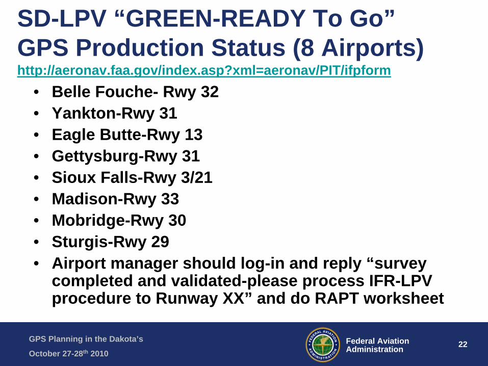
SD-LPV “GREEN-READY To Go” GPS Production Status (8 Airports) http://aeronav.faa.gov/index.asp?xml=aeronav/PIT/ifpform
• Belle Fouche- Rwy 32• Yankton-Rwy 31• Eagle Butte-Rwy 13• Gettysburg-Rwy 31• Sioux Falls-Rwy 3/21• Madison-Rwy 33• Mobridge-Rwy 30• Sturgis-Rwy 29• Airport manager should log-in and reply “survey
completed and validated-please process IFR-LPV procedure to Runway XX” and do RAPT worksheet

GPS Planning in the Dakota’s
October 27-28th 201023Federal Aviation
Administration
REGIONAL AIRSPACE PROCEDURES TEAM (RAPT)
New regional policy of RAPT team is to require completion of Approach Design Worksheet before they approve the charting LPV-RNAV-ILS-VOR
EXCELLENT PLANNING TOOL!
GPS Planning in the Dakota’s
October 27-28th 201024Federal Aviation
Administration
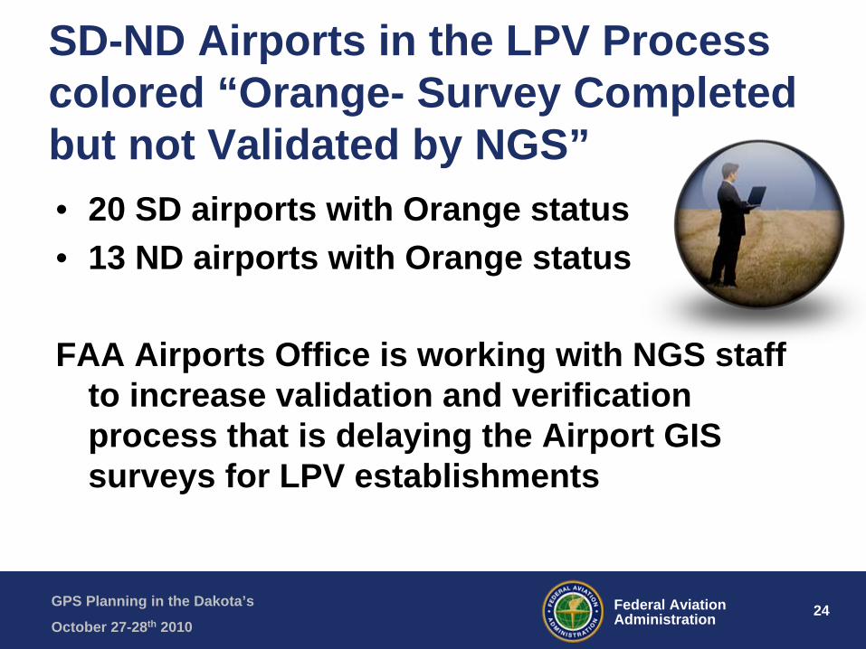
SD-ND Airports in the LPV Process colored “Orange- Survey Completed but not Validated by NGS”• 20 SD airports with Orange status• 13 ND airports with Orange status
FAA Airports Office is working with NGS staff to increase validation and verification process that is delaying the Airport GIS surveys for LPV establishments

GPS Planning in the Dakota’s
October 27-28th 201025Federal Aviation
Administration
Dakota Airports- LPV Candidates That Penetrated The GQS – “RED-STATUS On Hold For LPV Establishment” (6)
• Eagle Butte-Rwy 31 but has existing RNAV(GPS) Rwy 31• Hot Springs-Rwy 01 without an approach procedure• Milbank-Rwy 31 but has existing RNAV(GPS) Rwy 31• Pine Ridge-Rwy 30 but has existing RNAV(GPS) Rwy 30• Bismarck-Rwy 21 due to tree penetration that was removed but
still has RNAV(GPS) Rwy 21• Williston-Rwy 11 with EA planning study on obstruction removal
but still has RNAV(GPS) Rwy 11
Removal of the GQS penetration is critical to continuance of the LPV development within Flight Procedures Design Team
GPS Planning in the Dakota’s
October 27-28th 201026Federal Aviation
Administration
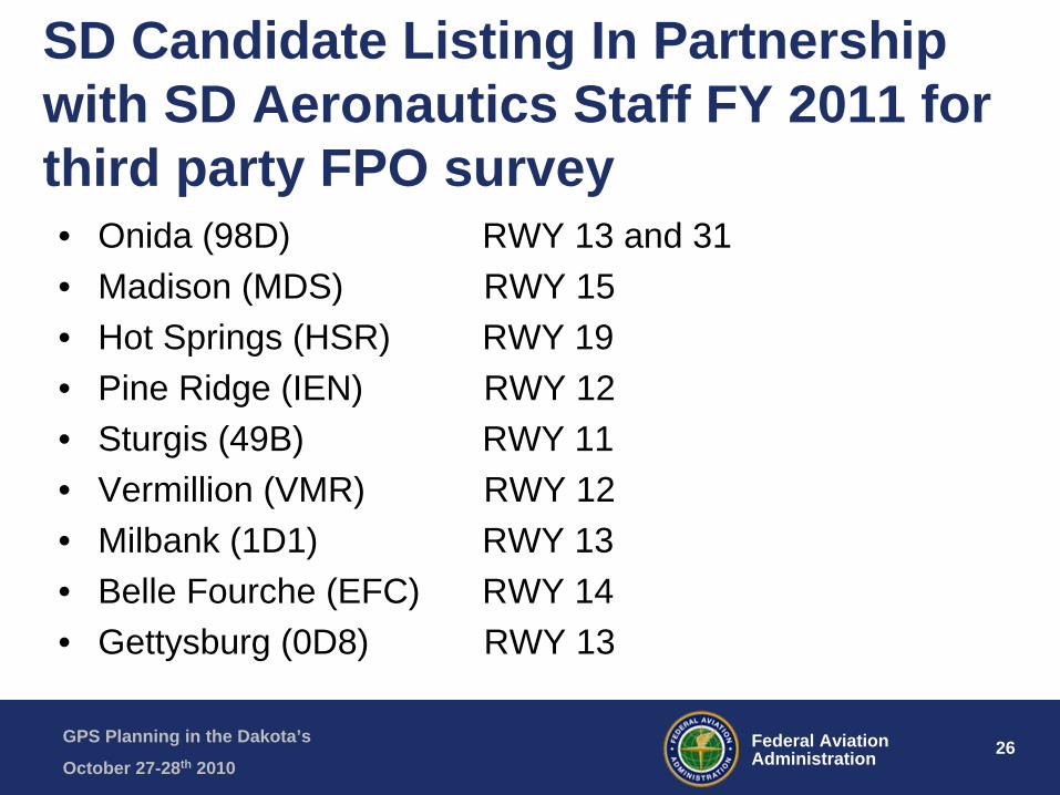
SD Candidate Listing In Partnership with SD Aeronautics Staff FY 2011 for third party FPO survey • Onida (98D) RWY 13 and 31• Madison (MDS) RWY 15• Hot Springs (HSR) RWY 19• Pine Ridge (IEN) RWY 12• Sturgis (49B) RWY 11• Vermillion (VMR) RWY 12• Milbank (1D1) RWY 13• Belle Fourche (EFC) RWY 14• Gettysburg (0D8) RWY 13
GPS Planning in the Dakota’s
October 27-28th 201027Federal Aviation
Administration
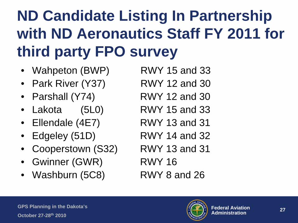
ND Candidate Listing In Partnership with ND Aeronautics Staff FY 2011 for third party FPO survey• Wahpeton (BWP) RWY 15 and 33• Park River (Y37) RWY 12 and 30• Parshall (Y74) RWY 12 and 30• Lakota (5L0) RWY 15 and 33• Ellendale (4E7) RWY 13 and 31• Edgeley (51D) RWY 14 and 32• Cooperstown (S32) RWY 13 and 31• Gwinner (GWR) RWY 16• Washburn (5C8) RWY 8 and 26

GPS Planning in the Dakota’s
October 27-28th 201028Federal Aviation
Administration
GPS Establishment Process Review• Airport Sponsors establish IFR need with local pilots and
transient traffic (air ambulance, flying doctor, tourism and business flying)
• Work with Consultant to update Airport Layout Plan to insure IFR marking, signage, land, lighting and that airspace is clear in OFZ and RPZ controlled
• Submit FAA FPO website for Instrument Approach Request to make candidate list to design LPV for Violet status
• Submit new RAPT Worksheet to State and FAA BIS ADO to Review and Prioritize your procedure (Violet)
• Consider Contracting with Consultant using (Entitlements) or seek a Third Party Survey (FPO sponsored) FAA AC 150/5300 16-17-18 survey following AGIS process for Vertical or Non-Vertical Guidance
GPS Planning in the Dakota’s
October 27-28th 201029Federal Aviation
Administration
GPS Establishment Process Review• Complete and Submit LPV Survey Data on AGIS web site
(Orange)• Await NGS validation of survey data• Submit FAA FPO website as Airport Manager to Request for
Flight Procedures to design LPV (Green)- Justify traffic• Await Flight Check and Approach Plate Publications (Black)• Overall LPV Process can take 18-24 months on average in
review of recent new establishments in the Dakotas• Get ready by updating 5010/AFD data so that aviation
businesses, charter and air medical flights will have correct airport information
• Buy yourself the new LPV avionics for your own airplane
GPS Planning in the Dakota’s
October 27-28th 201030Federal Aviation
Administration
Questions about the Dakota LPV Planning Session? Thank you!