
GPS 12XL REV A - Garmin · an imaginary circle that passes through the north and south poles....
66
O w n e r ’ s M a n u a l & R e f e r e n c e G P S 1 2 X L P e r s o n a l N a v i g a t o r ®
Transcript of GPS 12XL REV A - Garmin · an imaginary circle that passes through the north and south poles....

O w n e r ’ sM a n u a l
& R e f e r e n c e
G P S1 2 X L
P e r s o n a l
N a v i g a t o r
®
GPS 12XL NEW Manual Rev �A 2/6/98 3:17 PM Page 1
Software Version 4.0 or above
© 1998 GARMINCorporation, 1200 E. 151st Street, Olathe, Kansas 66062 USA
Tel: 913-397-8200 or 800-800-1020 Fax: 913-397-8282
GARMIN (Europe) Ltd., Unit 5, The Quadrangle, Abbey Park, Romsey, Hampshire SO51 9AQ UK
Tel: 011-44-1794-519944 Fax: 011-44-1794-519222
GARMIN (Asia) Corp., 4th Fl., No. 1, Lane 45, Pao-Hsing Road, Hsin Tien, Taiwan R.O.C.
Tel: 011-886-02-917-3773 Fax: 011-886-02-917-1758
Web Site Address: www.garmin.com
All rights reserved. No part of this manual may be reproduced or transmitted in anyform or by any means including photocopying and recording, for any purpose with-out the express written permission of GARMIN.
Information in this document is subject to change without notice. GARMIN reservesthe right to change or improve its products and to make changes in the content with-out obligation to notify any person or organization of such changes.
GARMIN, Personal Navigator, AutoLocate, TracBack, and PhaseTrac12 are all trade-marks of GARMIN Corporation and may not be used without the expressed permis-sion of GARMIN.
February 1998 - Part Number 190-00134-10 Rev. A - Printed in Taiwan.
GPS 12XL NEW Manual Rev �A 2/6/98 3:17 PM Page 2

GPS 12XL Operator’s
Manual
Thank you for choosing the GARMIN GPS 12XL —the smallest, easi-est-to-use GPS navigator for outdoor use! The GPS 12XL representsGARMIN’s continuing commitment to provide quality navigation informa-tion in a versatile and user-friendly flexible design you’ll enjoy for years.To get the most from your new GPS, take the time to read through theowner’s manual in order to understand the operating features of the GPS12XL. This manual is organized into four sections for your convenience:
Introduction gives a quick overview of the manual and contains thetable of contents and the glossary of navigational terms.
Getting Started introduces you to the basic features of the unit andprovides a quick-start orientation to the GPS 12XL.
Reference provides details about the advanced features and opera-tions of the GPS 12XL by topic.
The Appendix section contains initialization instructions and itemswith multiple listings, such as map datums, time offsets, and theindex.
Before getting started with your GPS, check to see that your GARMINGPS 12XL package includes the following items. If you are missing anyparts, please contact your dealer immediately.
Standard Package:
• GPS 12XL Unit • Owner’s Manual
• Wrist Strap • Quick Reference Guide
• Carrying Case • 4 AA Batteries
See your GARMIN dealer for accessories including our PC kit, swivelmounts, external antennas, and power/data cables.
We at GARMIN hope the GPS 12XL will help you meet all of your navigation needs and know it will become a valuable piece of your outdoor gear.
i
INTRODUCTION
Packing List
GPS 12XL NEW Manual Rev �A 2/6/98 3:17 PM Page 3
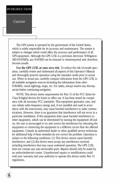
Caution
INTRODUCTION
ii
The GPS system is operated by the government of the United States,which is solely responsible for its accuracy and maintenance. The system issubject to changes which could affect the accuracy and performance of allGPS equipment. Although the GPS 12XL is a precision electronic NAVigationAID (NAVAID), any NAVAID can be misused or misinterpreted and, therefore,become unsafe.
Use the GPS 12XL at your own risk. To reduce the risk of unsafe oper-ation, carefully review and understand all aspects of this Operator’s Manualand thoroughly practice operation using the simulator mode prior to actualuse. When in actual use, carefully compare indications from the GPS 12XL toall available navigation sources including the information from otherNAVAIDs, visual sightings, maps, etc. For safety, always resolve any discrep-ancies before continuing navigation.
NOTE: This device meets requirements for Part 15 of the FCC limits forClass B digital devices for home or office use. It has been tested for compli-ance with all necessary FCC standards. This equipment generates, uses, andcan radiate radio frequency energy and, if not installed and used in accor-dance with the instructions, may cause harmful interference to radio commu-nications. However, there is no guarantee that interference will not occur in aparticular installation. If this equipment does cause harmful interference toother equipment, which can be determined by turning the equipment off andon, the user is encouraged to try and correct the interference by relocating theequipment or connecting the equipment to a different circuit than the affectedequipment. Consult an authorized dealer or other qualified service technicianfor additional help if these remedies do not correct the problem. Operation issubject to the following conditions: (1) This device cannot cause harmfulinterference, and (2) this device must accept any interference received,including interference that may cause undesired operation. The GPS 12XLdoes not contain any user-serviceable parts. Repairs should only be made byan authorizedservice center. Unauthorized repairs or modifications couldvoid your warranty and your authority to operate this device under Part 15regulations.
GPS 12XL NEW Manual Rev �A 2/6/98 3:17 PM Page 4

1
INTRODUCTION
Table ofContents
SECTION ONE IntroductionGlossary . . . . . . . . . . . . . . . . . . . . . . . . . . . . . . . . . . . . . . . . . . .2-3Battery & Remote Antenna Installation . . . . . . . . . . . . . . . . . . . . . . .4Keypad Usage & Data Entry . . . . . . . . . . . . . . . . . . . . . . . . . . . . . .5Primary Page Overview . . . . . . . . . . . . . . . . . . . . . . . . . . . . . . . .6-7
SECTION TWO Getting StartedPower On & Marking a Position . . . . . . . . . . . . . . . . . . . . . . . . . . .8Position Page, Map Page, & Going To A Waypoint . . . . . . . . . . . . . .9Compass Page & Cancelling A GOTO . . . . . . . . . . . . . . . . . . . . . .10Clearing the Map, Screen Contrast, & Power Off . . . . . . . . . . . . . .11
SECTION THREE ReferenceSatellite Page . . . . . . . . . . . . . . . . . . . . . . . . . . . . . . . . . . . . . .12-13Battery Level Indicator, Backlighting, and Emergency Erase . . . . . . .14Position Page . . . . . . . . . . . . . . . . . . . . . . . . . . . . . . . . . . . . . .15-16Marking a Position & Position Averaging Function . . . . . . . . . . . . .17Waypoint Pages . . . . . . . . . . . . . . . . . . . . . . . . . . . . . . . . . . . .18-22GOTO & Man Overboard . . . . . . . . . . . . . . . . . . . . . . . . . . . . . . .23TracBack Navigation . . . . . . . . . . . . . . . . . . . . . . . . . . . . . . . . .24-25Creating and Using Routes . . . . . . . . . . . . . . . . . . . . . . . . . . . .26-30Compass & Highway Pages . . . . . . . . . . . . . . . . . . . . . . . . . . .31-34Map Page, Zooming, & Panning . . . . . . . . . . . . . . . . . . . . . . . .35-37Map Options & Map Setup . . . . . . . . . . . . . . . . . . . . . . . . . . . . . .38Track Log Setup . . . . . . . . . . . . . . . . . . . . . . . . . . . . . . . . . . . . . .39Find City Functions . . . . . . . . . . . . . . . . . . . . . . . . . . . . . . . . . . . .40City Setup, Main Menu Page & Distance/Sun Calculations . . . . . . .41Setup Menu & System Setup . . . . . . . . . . . . . . . . . . . . . . . . . .42-43Navigation Setup . . . . . . . . . . . . . . . . . . . . . . . . . . . . . . . . . . .44-45Alarms . . . . . . . . . . . . . . . . . . . . . . . . . . . . . . . . . . . . . . . . . . . . .46Interface Setup & DGPS . . . . . . . . . . . . . . . . . . . . . . . . . . . . . .47-48Navigation Simulator . . . . . . . . . . . . . . . . . . . . . . . . . . . . . . . . . . .49
SECTION FOUR AppendicesAppendix A––Initialization . . . . . . . . . . . . . . . . . . . . . . . . . . . .50-51Appendix B—Specifications & Wiring . . . . . . . . . . . . . . . . . . . .52-53Appendix C—Messages and Time Offsets . . . . . . . . . . . . . . . . .54-55Appendix D—Map Datums . . . . . . . . . . . . . . . . . . . . . . . . . . . .56-57Appendix E––Index . . . . . . . . . . . . . . . . . . . . . . . . . . . . . . . . .58-60
GPS 12XL NEW Manual Rev �A 2/6/98 3:17 PM Page 1

Glossary
INTRODUCTION
2
The GPS 12XL is a powerful navigation tool that can guide you anywherein the world. To better understand its operation and capabilities, it may behelpful to review the basic terms and concepts briefly explained below.
Other navigation and GPS definitions used in the manual are defined in theappropriate reference sections of the manual.
Almanac DataSatellite constellation information (including location and health of satel-
lites) that is transmitted to your receiver from every GPS satellite. Almanac datamust be acquired before GPS navigation can begin.
Bearing (BRG)
The compass direction from your position to a destination.
Course Made Good (CMG)
The bearing from the “active from” position (your starting point) to yourpresent position.
Crosstrack Error (XTK)The distance you are off a desired course in either direction.
Desired Track (DTK)
The compass course between the “from” and “to” waypoints.
Differential GPS (DGPS)
An extension of the GPS system that uses land-based radio beacons totransmit position corrections to GPS receivers.
Estimated Time of Arrival (ETA)The time of day of your arrival at a destination.
Estimated Time Enroute (ETE)The time left to your destination at your present speed.
GPS 12XL NEW Manual Rev �A 2/6/98 3:17 PM Page 2

3
INTRODUCTION
Glossary
GridCoordinate system that projects the earth on a flat surface, using square
zones for position measurements. UTM/UPS and Maidenhead formats are gridsystems.
Ground Speed (SPD)
The velocity you are traveling relative to a ground position.
Latitude
The north/south measurement of position perpendicular to the earth’spolar axis.
LongitudeAn east/west measurement of position in relation to the Prime Meridian,
an imaginary circle that passes through the north and south poles.
Navigation
The process of traveling from one place to another and knowing whereyou are in relation to your desired course.
Position
An exact, unique location based on a geographic coordinate system.
Track (TRK)The direction of movement relative to a ground position.
Universal Transverse Mercator (UTM)
A grid coordinate system that projects global sections onto a flat surface tomeasure position in specific zones.
Velocity Made Good (VMG)
The speed you are traveling in the direction of the destination.
WaypointA specific location saved in the receiver’s memory.
GPS 12XL NEW Manual Rev �A 2/6/98 3:17 PM Page 3
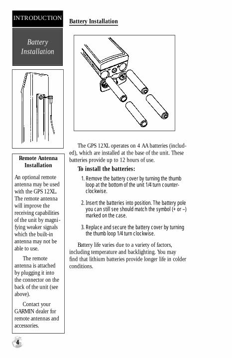
Battery Installation
The GPS 12XL operates on 4 AA batteries (includ-ed), which are installed at the base of the unit. Thesebatteries provide up to 12 hours of use.
To install the batteries:
1. Remove the battery cover by turning the thumbloop at the bottom of the unit 1/4 turn counter-clockwise.
2. Insert the batteries into position. The battery poleyou can still see should match the symbol (+ or –)marked on the case.
3. Replace and secure the battery cover by turningthe thumb loop 1/4 turn clockwise.
Battery life varies due to a variety of factors, including temperature and backlighting. You may find that lithium batteries provide longer life in colderconditions.
BatteryInstallation
INTRODUCTION
4
Remote AntennaInstallation
An optional remoteantenna may be usedwith the GPS 12XL.The remote antennawill improve thereceiving capabilitiesof the unit by magni -fying weaker signalswhich the built-inantenna may not beable to use.
The remoteantenna is attachedby plugging it intothe connector on theback of the unit (seeabove).
Contact yourGARMIN dealer forremote antennas andaccessories.
GPS 12XL NEW Manual Rev �A 2/6/98 3:17 PM Page 4

5
DATA ENTRY
The arrow keypad isused for all data entry.Use the andkeys to select letters,numbers, and menuoptions; use the and
keys to move the cur-sor forw a rd or back-w a rd along the line.Press to confirmyour entry.
INTRODUCTION
Keypad Usage &Data Entry
Turns the unit on and off andactivates screen backlighting.
Scrolls through the main datapages in sequence and returnsdisplay from a submenu pageto a primary page.
Captures a position and dis-plays the mark position page.
Displays GOTO page with the waypoint highlighted forGOTO operation. PressingGOTO twice activates MOB.
Confirms data entry and activates highlighted fields to allow data entry.
Returns display to a previouspage, or restores a data field’sprevious value.
Selects alphanumerical characters and menu choicesand moves the field highlightfrom field to field.
Moves the selected characterfield and moves the field highlight from field to field.
GPS 12XL NEW Manual Rev �A 2/6/98 3:17 PM Page 5
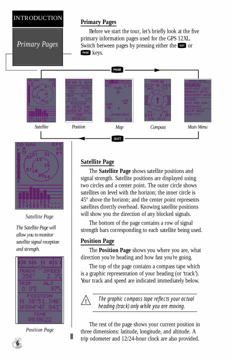
Primary Pages
Before we start the tour, let’s briefly look at the fiveprimary information pages used for the GPS 12XL.Switch between pages by pressing either the or
keys.
Satellite Page
The Satellite Page shows satellite positions andsignal strength. Satellite positions are displayed usingtwo circles and a center point. The outer circle showssatellites on level with the horizon; the inner circle is45º above the horizon; and the center point representssatellites directly overhead. Knowing satellite positionswill show you the direction of any blocked signals.
The bottom of the page contains a row of signalstrength bars corresponding to each satellite being used.
Position Page
The Position Page shows you where you are, whatdirection you’re heading and how fast you’re going.
The top of the page contains a compass tape whichis a graphic representation of your heading (or ‘track’).Your track and speed are indicated immediately below.
The graphic compass tape reflects your actualheading (track) only while you are moving.
The rest of the page shows your current position inthree dimensions: latitude, longitude, and altitude. Atrip odometer and 12/24-hour clock are also provided.
Primary Pages
INTRODUCTION
6
Satellite Page
The Satellite Page willallow you to monitorsatellite signal receptionand strength.
!
Position Page
Satellite Position Map Compass Main Menu
GPS 12XL NEW Manual Rev �A 2/6/98 3:17 PM Page 6

Map Page
The Map Page acts as a window. It allows you toview your position, the “path” you have traveled over,and nearby waypoints.
A diamond icon in the center of the screen repre-sents your current position. As you move, you will seea thin line—called a track log—appear along the pathyou have just covered. Names of stored waypoints andnearby cities can also be shown on the map.
The bottom corners of the map will always displayyour current track and speed. When going to a way-point, highlighting an on-screen waypoint, or using thepanning target crosshair, the corresponding distanceand bearing are shown at the top corners of the map.The top of the screen contains the zoom, pan, and con-figuration fields.
Navigation Page
A navigation page gives you steering guidancewhen going to a waypoint. The GPS 12XL has two nav-igation page choices: the Compass Page and theHighway Page. The Compass Page is the default andwill be briefly explained here. The Highway Page iscovered on page 34.
The Compass Page shows the destination way-point at the top of the page with the bearing (BRG) anddistance (DST) to the waypoint shown below. The cen-ter of the page contains a compass ring and arrow toshow you the direction of the waypoint from the direc-tion you are moving. The bottom of the page givesyour track (TRK), speed (SPD), and a selectable fieldfor estimated time to arrival (ETA), estimated timeenroute (ETE), course to steer (CTS), crosstrack error,(XTK), velocity made good (VMG), or turn bearing(TRN).
Main Menu PageThe last primary page is the Main Menu Page.
The Main Menu Page gives you access to the GPS12XL’s waypoint management, route, track log, andsetup features through a list of submenus.
7
Map Page
The Map Page showsyour progress on a mov-ing map plotter and givesa bird’s-eye-view of sur-rounding waypoints andcities.
INTRODUCTION
Primary Pages
Compass Page
The Compass Page is thedefault navigation pageand will show you theway to the waypoint fromthe direction you aremoving.
GPS 12XL NEW Manual Rev �A 2/6/98 3:17 PM Page 7
Getting Started Tour
Now that you’ve seen the primary pages, let’s getstarted by taking a simple tour to show you the basicsabout using your GPS 12XL. The tour assumes thatyour unit has been turned on and that none of the fac-tory settings ( units of measure, selectable fields, etc.)have been changed. If these settings have beenchanged, the pictures and descriptions you see in thismanual may not match what you see on your screen.
Turning the GPS 12XL On
1. Press until the receiver turns on.
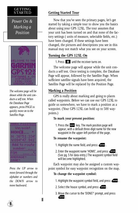
The welcome page will appear while the unit con-ducts a self test. Once testing is complete, the DatabasePage will appear, followed by the Satellite Page. Whensufficient satellite signals have been acquired, theSatellite Page will be replaced by the Position Page.
Marking a Position
GPS is really about marking and going to placescalled waypoints. Before we can use our GPS 12XL toguide us somewhere, we have to mark a position as awaypoint. (Your GPS 12XL can hold up to 500 way-points.)
To mark your present position:
1. Press the key. The mark position page willappear, with a default three-digit name for the newwaypoint in the upper-left portion of the page.
To rename the waypoint:
1. Highlight the name field, and press .
2. Enter the waypoint name ‘HOME’, and press .(See pg. 5 for data entry.) The waypoint symbol fieldwill become highlighted.
Each waypoint may also be assigned a custom way-point symbol for easy waypoint recognition on the map.
To change the waypoint symbol:
1. Highlight the waypoint symbol field, and press .
2. Select the house symbol, and press .
3. Move the cursor to the ‘DONE?’ prompt, and press.
Power On &Marking aPosition
GETTINGSTARTED
8
The welcome page will beshown while the unit con-ducts a self test. Whenthe Database Pageappears, press PAGE toquickly move on to theSatellite Page.
P ress the UP arrow tomove forward through thealphabet or numbers andthe DOWN arrow tomove backward.
GPS 12XL NEW Manual Rev �A 2/6/98 3:17 PM Page 8
Using the Position Page
Walk for 3-4 minutes and watch the Position Page.The direction you are moving (track), your speed, tripdistance, and altitude are shown on the upper half ofthe screen. The latitude and longitude of your positionare displayed in the middle of the page, with the timeof day shown below.
Let’s continue by moving to the next page:
1. Press .
Map PageThe next page is the Map Page. To ensure we can
see our entire trip on the map, lets change the mapscale from 0.2nm (default) to 1.0 nm.
1. Use the arrow keys to highlight the ‘ZM’ field at thetop left of the Map Page and press .
2. Press the arrow until ‘1nm’ is shown and press.
The Map Page shows your present position as adiamond icon in the center of the map. The housesymbol labeled ‘HOME’ is the waypoint you createdand the line connecting the two is your track log.
1. Now turn approximately 90º to your right and continuewalking for another 2-3 minutes. Notice how the dis-play changes, always keeping the direction you aremoving at the top of the map (see right).
Going to a WaypointOnce you’ve stored a waypoint in memory, you
may return to it by performing a GOTO. A GOTO is astraight-line course from your present position to thedestination you’ve selected. Let’s navigate back to ourstarting position, the HOME waypoint.
To select a GOTO destination:
1. Press .
2.Highlight the ‘HOME’ waypoint, and press .
You’ll notice that you’ll automatically return to theMap Page, and a straight line will connect your currentposition to the position of the destination waypoint.
Let’s continue by moving to the next page:
1. Press . 9
The Map Page displaysyour present position as adiamond icon and pro-vides a real-time graphic“ b re a d c rumb” display ofyour track right on thescreen.
GETTINGSTARTED
Position/MapPages & GoingTo a Waypoint
The GOTO waypointpage allows you to selecta destination from a list of all available way-points in the GPS 12XL’smemory.
GPS 12XL NEW Manual Rev �A 2/6/98 3:17 PM Page 9

Compass Page
Whenever you select a destination waypoint, theGPS 12XL provides graphic steering guidance with theCompass Page (the default navigation page). The “com-pass ring” in the middle of the page shows your courseover ground while you’re moving, with a pointer arrowto the destination displayed in the center. The arrowshows the direction of your destination relative to thedirection you are moving. For instance, if the arrowpoints up, you are going directly to the waypoint. If thearrow points any other direction (left, right, down, etc.),turn toward the arrow until it points up. Then continuein that direction.
The bearing and distance to a waypoint are dis-played at the top of the screen, and your current trackand speed are shown below. The default ‘ETE’ field, atthe bottom of the screen, is a user-selectable field thatcan provide a variety of navigation information. We’llcover more about that field in the reference section (seepage 32).
As you get close to ‘HOME’, you’ll be alerted topress PAGE. The GPS 12XL will give you the message“Arrival at HOME”. Once you’ve arrived, you’ll noticethe distance field will read 0.00.
Cancelling a GOTOIf you decide to stop navigating to the active way-
point, all you have to do is cancel the GOTO.
To cancel an active GOTO:
1. Press the key.
2. Use the arrow keypad to move the field highlight to the‘CANCEL GOTO’ prompt at the bottom of the page andpress .
Compass Pageand Cancelling
a GOTO
GETTINGSTARTED
10
The GPS 12XL will alsoprovide steering guidancewith a Highway Page.
To change the displayfrom the Compass Page,press ENTER twice.
Once a GOTO is activat-ed, the GPS 12XL pro-vides steering guidanceuntil the GOTO is can-celed. To cancel a GOTO,highlight the cancelprompt at the bottom ofthe page and pre s sENTER.
Bearing toWaypoint
Pointer toWaypoint
Selectable Field
Distance toWaypoint
Speed OverGround
DestinationWaypoint
Track OverGround
GraphicCompass
GPS 12XL NEW Manual Rev �A 2/6/98 3:17 PM Page 10

Clearing a Cluttered Map Display
After you’ve used the GPS12XL for a few trips, youmay find that your map display has become a bit messyfrom keeping track of your every move. For practice,let’s clean up the screen by clearing the track log (theplot points left on the Map Page) we’ve just createdduring the Getting Started tour.
1. Press or until the Map Page appears.
2. Highlight the ‘OPT’ field and press .
3. Highlight ‘Track Setup’ and press .
4. Highlight the ‘CLEARLOG?’ option and press .The clear log confirmation page will appear.
5. Use the key to highlight the ‘Yes’ prompt.
6. Press to finish.
Adjusting Screen Contrast
You can access the GPS 12XL’s contrast feature fromthe Satellite Page.
To adjust the screen contrast:
1. Press or until the Satellite Pageappears.
2. Press or to adjust the level of contrast, and press.
Screen Backlighting
Screen backlighting is available for nighttime use.Activate backlighting by pressing the key briefly.Backlighting will remain on for the time specified onthe system setup page (See page 43).
Turning the Receiver OffYou’ve now gone through the basic operation of
your new GPS receiver and probably know a little morethan you think about how it works. We encourage youto experiment with the GPS12XL until it becomes anextension of your own navigation skills. If youencounter any problems using the unit or want to takeadvantage of the GPS 12XL’s more advanced features,turn to the reference section.
To turn the GPS 12XL off:
1. Press and hold the key for 3 seconds.11
Highlight the ‘CLEARLOG?’ prompt and pressENTER to clear the tracklog.
Note: With the ‘Wr a p ’re c o rd option, once all1024 points are used dur-ing normal operation, theoldest point will be contin-uously deleted to makeroom for the latest tracklog point to be stored.
GETTINGSTARTED
Clearing theMap, Adjusting
Contrast, &Power Off
Pressing the LEFT orRIGHT arrows from theSatellite Page will auto-matically activate thescreen contrast bar.
GPS 12XL NEW Manual Rev �A 2/6/98 3:18 PM Page 11
Satellite Page
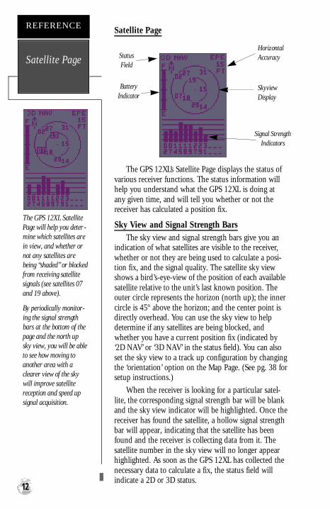
The GPS 12XL’s Satellite Page displays the status ofvarious receiver functions. The status information willhelp you understand what the GPS 12XL is doing atany given time, and will tell you whether or not thereceiver has calculated a position fix.
Sky View and Signal Strength BarsThe sky view and signal strength bars give you an
indication of what satellites are visible to the receiver,whether or not they are being used to calculate a posi-tion fix, and the signal quality. The satellite sky viewshows a bird’s-eye-view of the position of each availablesatellite relative to the unit’s last known position. Theouter circle represents the horizon (north up); the innercircle is 45º above the horizon; and the center point isdirectly overhead. You can use the sky view to helpdetermine if any satellites are being blocked, andwhether you have a current position fix (indicated by‘2D NAV’ or ‘3D NAV’ in the status field). You can alsoset the sky view to a track up configuration by changingthe ‘orientation’ option on the Map Page. (See pg. 38 forsetup instructions.)
When the receiver is looking for a particular satel-lite, the corresponding signal strength bar will be blankand the sky view indicator will be highlighted. Once thereceiver has found the satellite, a hollow signal strengthbar will appear, indicating that the satellite has beenfound and the receiver is collecting data from it. Thesatellite number in the sky view will no longer appearhighlighted. As soon as the GPS 12XL has collected thenecessary data to calculate a fix, the status field willindicate a 2D or 3D status.
Satellite Page
REFERENCE
12
The GPS 12XL SatellitePage will help you deter -mine which satellites arein view, and whether ornot any satellites arebeing “shaded” or blockedfrom receiving satellitesignals (see satellites 07and 19 above).
By periodically monitor-ing the signal strengthbars at the bottom of thepage and the north upsky view, you will be ableto see how moving toanother area with aclearer view of the skywill improve satellitereception and speed upsignal acquisition.
BatteryIndicator
HorizontalAccuracy
Signal StrengthIndicators
SkyviewDisplay
StatusField
GPS 12XL NEW Manual Rev �A 2/6/98 3:18 PM Page 12

Receiver StatusReceiver status is indicated at the top left of the
page, with the current horizontal accuracy (estimatedposition error, in feet or meters) at the top right. Thestatus will be shown as one of the following conditions:
Searching— the GPS 12XL is looking for anyavailable satellites in view.
AutoLocate— the GPS 12XLis initializing andcollecting new almanac data. This process can take5 minutes, depending on the satellites currently inview.Acquiring— the receiver is collecting data fromavailable satellites, but has not collected enoughdata to calculate a 2D fix.
2D Nav (2D Navigation)— at least three satel-lites with good geometry have been locked onto anda 2-dimensional position fix (latitude and longitude)is being calculated. ‘2D Diff ’ will appear when youare receiving DGPS corrections in 2D mode.
3D Nav (3D Navigation)— at least four satelliteswith good geometry have been locked onto, andyour position is now being calculated in lati t u d e ,longitude and altitude. ‘3D Diff’ will appear when youare receiving DGPS corrections in 3D mode.
Poor Cvg (Poor GPS Coverage)— the receiveri s n ’t tracking enough satellites for a 2D or 3D fixdue to bad satellite geometr y.
Not Usable— the receiver is unusable, possiblydue to incorrect initialization or abnormal satelliteconditions. Turn the unit off and back on to reset,and reinitialize the receiver if necessary.
Simulator— the receiver is in simulator mode.
EZinit Option PromptThe Satellite Page also provides access to the EZinit
prompt whenever a position fix has not been calculated.(The unit must be in searching, AutoLocate, acquiring,simulator, or poor coverage mode.) This allows you toreinitialize the unit (see Appendix A), and is useful ifyou have traveled over 500 miles with the receiver offand must initialize your new position. (The EZinitprompt will automatically appear if the receiver needsto be initialized. The prompt may also appear duringnormal use if the antenna is shaded or the unit is oper-ated indoors.) 13
The signal strength bars atthe bottom of the page willnot appear until the GPS12XL has found the satel-lites indicated at the bot-tom of the screen.
REFERENCE
Receiver Status& EZinit
If you travel more than500 miles with the receiv-er off, reinitialize the unitto your new position byusing the EZinit feature.To access EZinit, pre s sENTER from the SatellitePage before any satellitesare acquired.
GPS 12XL NEW Manual Rev �A 2/6/98 3:18 PM Page 13
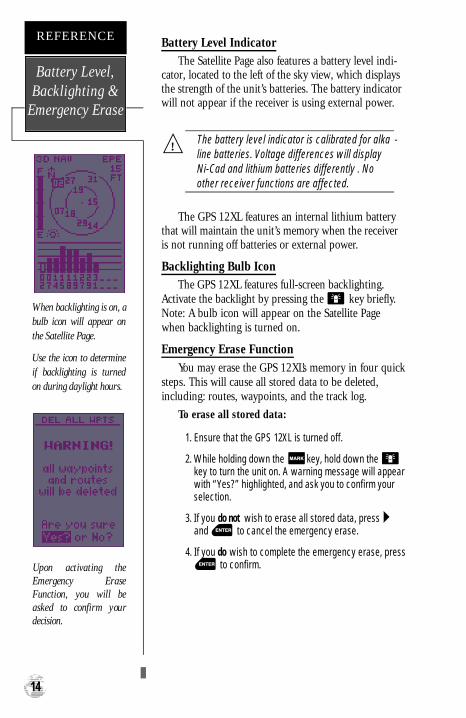
Battery Level IndicatorThe Satellite Page also features a battery level indi-
cator, located to the left of the sky view, which displaysthe strength of the unit’s batteries. The battery indicatorwill not appear if the receiver is using external power.
The battery level indicator is calibrated for alka -line batteries. Voltage differences will displayNi-Cad and lithium batteries differently . Noother receiver functions are affected.
The GPS 12XL features an internal lithium batterythat will maintain the unit’s memory when the receiveris not running off batteries or external power.
Backlighting Bulb IconThe GPS 12XL features full-screen backlighting.
Activate the backlight by pressing the key briefly.Note: A bulb icon will appear on the Satellite Pagewhen backlighting is turned on.
Emergency Erase Function
You may erase the GPS 12XL’s memory in four quicksteps. This will cause all stored data to be deleted,including: routes, waypoints, and the track log.
To erase all stored data:
1. Ensure that the GPS 12XL is turned off.
2. While holding down the key, hold down the key to turn the unit on. A warning message will appearwith “Yes?” highlighted, and ask you to confirm yourselection.
3. If you do not wish to erase all stored data, press and to cancel the emergency erase.
4. If you do wish to complete the emergency erase, pressto confirm.
Battery Level,Backlighting &
Emergency Erase
REFERENCE
14
When backlighting is on, abulb icon will appear onthe Satellite Page.
Use the icon to determineif backlighting is turnedon during daylight hours.
Upon activating theE m e rgency EraseFunction, you will beasked to confirm yourdecision.
!
GPS 12XL NEW Manual Rev �A 2/6/98 3:18 PM Page 14
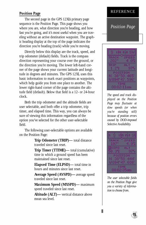
Position Page
The second page in the GPS 12XL’s primary pagesequence is the Position Page. This page shows youwhere you are, what direction you’re heading, and howfast you’re going, and it’s most useful when you are trav-eling without an active destination waypoint. The graph-ic heading display at the top of the page indicates thedirection you’re heading (track) while you’re moving.
Directly below this display are the track, speed, andtrip odometer (default) fields. Track is the compassdirection representing your course over the ground, orthe direction you’re moving. The lower left-hand cor-ner of the page shows your current latitude and longi-tude in degrees and minutes. The GPS 12XL uses thisbasic information to mark exact positions as waypoints,which help guide you from one place to another. Thelower right-hand corner of the page contains the alti-tude field (default). Below that field is a 12- or 24-hourclock.
Both the trip odometer and the altitude fields areuser selectable, and both offer a trip odometer, triptimer, and elapsed time. This way, you can always besure of viewing this information regardless of theoption you’ve selected for the other user-selectablefield.
The following user-selectable options are availableon the Position Page:
Trip Odometer (TRIP)— total distancetraveled since last reset.
Trip Timer (TTIME)— total (cumulative)time in which a ground speed has beenmaintained since last reset.
Elapsed Time (ELPSD)— total time inhours and minutes since last reset.
Average Speed (AVSPD)— average speedtraveled since last reset.
Maximum Speed (MXSPD)— maximumspeed traveled since last reset.
Altitude (ALT)— vertical distance abovemean sea level.
15
The speed and track dis-played on the PositionPage may fluctuate atslow speeds (or wheny o u ’ re standing still)because of position errorscaused by DOD-imposedSelective Availability.
REFERENCE
Position Page
The user selectable fieldson the Position Page giveyou a variety of informa-tion to choose from.
GPS 12XL NEW Manual Rev �A 2/6/98 3:18 PM Page 15

To reset timer, speed measurement, or odometer:
1. Highlight the user-selectable field, and press .‘Reset’ will appear as a selectable option (see left).
2. Press to confirm or to exit.
The trip odometer, trip timer, and average speedfields are linked. Resetting one of these options in auser-selectable field will automatically reset the corre-sponding data in the other. This ensures that informa-tion shown in these fields reflects your current trip.
Maximum Speed FieldTo obtain the most accurate reading of average
speed, keep in mind that due to the sensitivity of theGPS 12XL’s antenna, your maximum speed value mayinclude the effects of rapid movement, such as swingingyour arm while holding the unit.
To reset the maximum speed field:
1. Highlight the ‘MXSPD’ field, and press .
2. Press to confirm the ‘RESET?’ prompt.
Altitude FieldWhen the GPS 12XL is acquiring satellites or navi-
gating in the 2D mode, the last known altitude is usedto compute your position. You may also manually enteryour altitude for greater accuracy. In cases where theGPS 12XL has 2D coverage, entering your approximatealtitude will enable the receiver to determine a moreaccurate position fix.
To enter an altitude:
1. Highlight the ‘ALT’ field, and press .
2. Enter a value, and press .
Maximum Speed& Altitude
Fields
REFERENCE
16
Resetting the trip odome-ter will erase the previousmileage and set theodometer to zero. Averagespeed, maximum speedand timer readouts willalso be reset to zero.
You may enter a knownaltitude to assist the GPS12XL in establishing amore accurate 2D positionfix.
GPS 12XL NEW Manual Rev �A 2/6/98 3:18 PM Page 16

Marking a Position
The GPS 12XL allows you to mark and store up to500 positions as waypoints. A waypoint can be enteredby taking an instant electronic fix, by manually enter-ing coordinates (pg. 20), or by using the bearing anddistance to a known position (pg. 20).
To mark your present position:
1. Press . The mark position page will appear,showing the captured position and a default three-digit name.
2. To save a default name and symbol, press toconfirm the ‘SAVE?’ prompt.
Position Averaging Function
The GPS 12XL positioning averaging function willhelp reduce the effects of selective availability uponposition error when marking a waypoint, providingmore accurate saved positions.
1. After you have pressed the key, highlight the‘AVERAGE?’ field and press . The Figure ofMerit (FOM) field will display a value reflecting esti-mated accuracy of the averaged position. Note: Asthe GPS 12XL calculates the FOM, it will rapidlychange initially then begin to stabilize over time.
2. The unit will continue averaging until you have high-lighted ‘SAVE?’ and pressed .
To enter a different waypoint name:
1. Highlight the waypoint name field, and press .
2. Make the appropriate changes, and press .
3. Highlight ‘SAVE?’, and press .
Note: To enter a different waypoint symbol or com-ment, see pg. 21.
To add this waypoint to a route:
1. Highlight the ‘Add to route number’ field, and press.
2. Enter a route number, press to confirm theroute number, and again to save the waypoint.The waypoint will be added to the end of the selectedroute—after any other waypoints already in the route.
17
After initiating the posi-tion averaging function, aFigure of Merit value willbe displayed, and the‘ S AVE?’ field will auto-matically be highlighted.
REFERENCE
PositionAveraging
The GPS 12XL will savenew waypoints with adefault three-digit name.To add the waypoint to aroute, enter the desire droute number, highlight‘ S AVE?’ and pre s sENTER.
GPS 12XL NEW Manual Rev �A 2/6/98 3:18 PM Page 17

Waypoint PagesThe GPS 12XL has three waypoint pages that let you
quickly manage up to 500 waypoints. These pages—nearest waypoints, waypoint list, and waypoint defini-tion—can be accessed through the Main Menu Page.
To select a waypoint page:
1. Access the Main Menu, and highlight a waypoint pageoption: ‘Waypoint’, ‘Waypoint List’ or ‘Nearest Wpts’.
2. Press .
Nearest Waypoints PageThe nearest waypoints page shows the nine nearest
waypoints that are within 100 miles of your presentposition, with the bearing and distance noted for eachwaypoint. This page will also let you retrieve a waypointdefinition page or GOTO a selected waypoint right fromthe list.
To review the waypoint definition page of a select-ed waypoint:
1. Highlight the desired waypoint.
2. Press .
To return to the nearest waypoint page:
1. Highlight ‘DONE?’.
2. Press .
To go to a highlighted list waypoint:
1. Highlight the desired waypoint, and press .
2. Press .
Waypoint List PageThe waypoint list page provides a complete list of all
waypoints currently stored in the GPS 12XL and theirrespective waypoint symbols. The total number ofempty and used waypoint locations in memory is alsoindicated. From the waypoint list page, you can retrievea waypoint definition page, delete all user-defined way-points, delete waypoints by symbol, or review and per-form a GOTO to a selected waypoint.
To delete all user-defined waypoints:
1. Highlight ‘DELETE WPTS?’ and press .
2. Highlight ‘DELETE ALL’ and press .
3. Highlight the ‘YES’ prompt and press .
NearestWaypoints &Waypoint List
REFERENCE
18
To select a waypoint sub-menu, highlight thedesired option and pressENTER.
Nearest WaypointsPage
The compass heading(BRG) and distance(DST) to the nine nearestwaypoints are updatedcontinuously.
GPS 12XL NEW Manual Rev �A 2/6/98 3:18 PM Page 18

Waypoint List Page (continued)
To delete waypoints by symbol:
1. Follow step one from the previous page, under ‘deleteall user-defined waypoints’.
2. Select ‘DELETE BY SYMBOL’ and press .
3. Select the symbol corresponding to the waypointsyou wish to delete. Press .
4. Press to confirm the ‘DONE’ prompt, highlightthe ‘YES?’ prompt, and press .
Note: This feature is handy for deleting temporarywaypoints created by the TracBack function.
Proximity Waypoints
The GPS 12XL’s proximity waypoint function warnsyou when you are getting too close to hazardous way-points. This function allows you to create up to nineproximity waypoints and designate an alarm circle foreach waypoint. If you enter this circle, a warning mes-sage will alert you.
To enter a proximity waypoint from the MainMain Menu Page:
1. Highlight ‘PROXIMITY WPTS’ and press .
2. Highlight the first empty waypoint field and press.
3. Use the or key to scroll through storedwaypoints until the desired waypoint appears.
4. Press . The distance (DST) field will be auto-matically highlighted. Press and enter thedesired distance.
5.Press the key.
To review or remove a proximity waypoint:
1. Use and to select a proximity waypoint andpress .
2. Highlight ‘REVIEW?’ or ‘REMOVE?’ and press .
If ‘REVIEW?’ is chosen, the waypoint page willappear, and you may make any changes to the selectedwaypoint. If ‘REMOVE?’ is chosen, the proximity way-point will be removed from the list. Press or
to return to the Main Menu Page.
19
Deleting waypoints bysymbol enables you todelete a specific group ofwaypoints without losingall other waypoints.
REFERENCE
Waypoint List &ProximityWaypoints
Quickly edit or deletep roximity waypoints byhighlighting the waypointname and pre s s i n gENTER.
GPS 12XL NEW Manual Rev �A 2/6/98 3:18 PM Page 19

Waypoint Definition Page
The waypoint definition page lets you create newwaypoints manually or review and edit an existing way-point’s coordinates, symbols, and comments. It is alsoused to delete an individual waypoint from memory(see pg. 22). To create a new waypoint manually, you’llneed to know its position coordinates or its approxi-mate distance and bearing from an existing waypoint.
To create a waypoint by entering coordinates:
1. From the waypoint definition page, highlight ‘NEW?’,and press .
2. Enter a waypoint name, and press .
3. Press to select a waypoint symbol, make yourselection, and press .
4. Highlight the ‘DONE?’ prompt, and press toreturn to the waypoint page.
5. Highlight the position field, enter your position usingthe arrow keys, and press .
6. Press to confirm the ‘DONE?’ prompt.
Reference WaypointsTo create a new waypoint manually without know-
ing its position coordinates, you’ll need to enter itsbearing and distance from an existing waypoint or yourpresent position.
To create a new waypoint by referencing a storedwaypoint:
1. From the waypoint definition page, highlight ‘NEW?’,and press .
2. Enter a waypoint name, and press .
WaypointDefinition &
ReferenceWaypoints
REFERENCE
20
The GPS 12XL’s advancedwaypoint planning fea-tures allow you to createnew waypoints and prac-tice navigation withoutever setting foot outside.
If you create a new way-point by entering coordi-nates from a map, youmay want to re-mark thewaypoint’s exact positiononce you get there.
To re-define an existingwaypoint’s position coor-dinates from the waypointdefinition page, simplyhighlight the DST fieldand press ENTER. Use theLEFT arrow key to set thedistance to 0.00, and pressENTER to confirm.
The old coordinates will bereplaced by the coord i-nates of your present posi-t i o n (you must have avalid 2D or 3D positionfix and the reference way-point name field must beblank).
WaypointName
ReferenceWaypoint
(leave blank forpresent position)
Distance fromReferenceWaypoint
PositionCoordinates
Bearing fromReferenceWaypoint
Function Prompts
Waypoint Comment
GPS 12XL NEW Manual Rev �A 2/6/98 3:18 PM Page 20
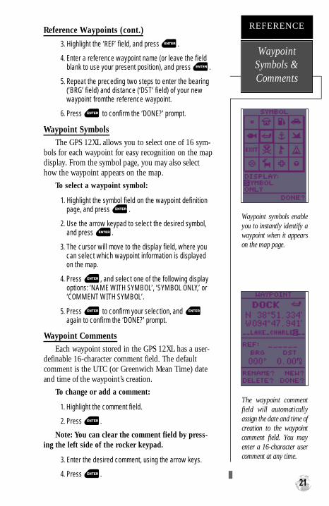
Reference Waypoints (cont.)
3. Highlight the ‘REF’ field, and press .
4. Enter a reference waypoint name (or leave the fieldblank to use your present position), and press .
5. Repeat the preceding two steps to enter the bearing(‘BRG’ field) and distance (‘DST’ field) of your newwaypoint fromthe reference waypoint.
6. Press to confirm the ‘DONE?’ prompt.
Waypoint Symbols
The GPS 12XL allows you to select one of 16 sym-bols for each waypoint for easy recognition on the mapdisplay. From the symbol page, you may also selecthow the waypoint appears on the map.
To select a waypoint symbol:
1. Highlight the symbol field on the waypoint definitionpage, and press .
2. Use the arrow keypad to select the desired symbol,and press .
3. The cursor will move to the display field, where youcan select which waypoint information is displayedon the map.
4. Press , and select one of the following displayoptions: ‘NAME WITH SYMBOL’, ‘SYMBOL ONLY,’ or‘COMMENT WITH SYMBOL’.
5. Press to confirm your selection, and again to confirm the ‘DONE?’ prompt.
Waypoint Comments
Each waypoint stored in the GPS 12XL has a user-definable 16-character comment field. The defaultcomment is the UTC (or Greenwich Mean Time) dateand time of the waypoint’s creation.
To change or add a comment:
1. Highlight the comment field.
2. Press .
Note: You can clear the comment field by press-ing the left side of the rocker keypad.
3. Enter the desired comment, using the arrow keys.
4. Press .21
Waypoint symbols enableyou to instantly identify awaypoint when it appearson the map page.
REFERENCE
WaypointSymbols &Comments
The waypoint commentfield will automaticallyassign the date and time ofcreation to the waypointcomment field. You mayenter a 16-character usercomment at any time.
GPS 12XL NEW Manual Rev �A 2/6/98 3:18 PM Page 21
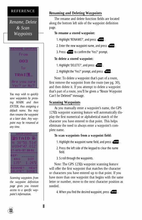
Renaming and Deleting Waypoints
The rename and delete function fields are locatedalong the bottom left side of the waypoint definitionpage.
To rename a stored waypoint:
1. Highlight ‘RENAME?’, and press .
2. Enter the new waypoint name, and press .
3. Press to confirm the ‘Yes?’ prompt.
To delete a stored waypoint:
1. Highlight ‘DELETE?’, and press .
2. Highlight the ‘Yes?’ prompt, and press .
Note: To delete a waypoint that’s part of a route,first remove the waypoint from the route (see pg. 30),and then delete it. If you attempt to delete a waypointthat’s part of a route, you’ll be given a “Route WaypointCan’t be Deleted” message.
Scanning Waypoints
As you manually enter a waypoint’s name, the GPS12XL’s waypoint scanning feature will automatically dis-play the first numerical or alphabetical match of thecharacter you have entered to that point. This helpseliminate the need to always enter a waypoint’s com-plete name.
To scan waypoints from a waypoint field:
1. Highlight the waypoint name field, and press .
2. Press the left side of the keypad to clear the namefield.
3. Scroll through the waypoints.
Note: The GPS 12XL’s waypoint scanning featurewill offer the first waypoint that matches the characteror characters you have entered up to that point. If youhave more than one waypoint that begins with the sameletter or number, move to the next character position asneeded.
4. When you find the desired waypoint, press .
Rename, Delete& Scan
Waypoints
REFERENCE
22
You may wish to quicklysave waypoints by press-ing MARK and thenENTER, thus assigning adefault name. You maythen rename the waypointat a later date. Any way-point may be renamed atany time.
Scanning waypoints fromthe waypoint definitionpage gives you instantaccess to a specific way-point’s information.
GPS 12XL NEW Manual Rev �A 2/6/98 3:18 PM Page 22

Selecting a GOTO DestinationThe GPS 12XL provides four ways to navigate to a
destination: GOTO, MOB, TracBack, and route naviga-tion. The most basic method of selecting a destinationis the GOTO function, which lets you choose anystored waypoint as the destination and quickly sets adirect course from your present position.
To activate the GOTO function:
1. Press .
2. Select the waypoint you want to navigate to, andpress .
Once a GOTO waypoint has been activated, theCompass Page or Highway Page will provide steeringguidance to the destination until either the GOTO iscancelled or the unit has resumed navigating the activeroute (see pg 30).
To cancel an active GOTO:
1. Press the key.
2. Highlight ‘CANCELGOTO?’, and press .
Selecting a City as Your DestinationThe GPS 12XL also features a built-in database of
city locations. You can quickly select any one of theselocations as your destination waypoint, using the FindCity feature. Once selected, the GPS 12XL will create awaypoint named after the city and place it in user way-point memory.
To select a city as your destination:
1. Highlight ‘FIND CITY?’ and press . Then followthe GOTO steps for the find city page (described onpages 40-42).
Man Overboard FunctionThe GPS 12XL’s man overboard function (MOB) lets
you simultaneously mark and set a course to a positionfor quick response to passing positions.
To activate the MOB mode:
1. Press twice. The GOTO waypoint page willappear with ‘MOB’ selected.
2 Press to begin MOB navigation.
The GPS 12XL will now guide you to the MOB way-point until the MOB GOTO is cancelled. If you want tosave the MOB waypoint, be sure to rename it because itwill be overwritten the next time a MOB is activated. 23
Select a destination way-point from the GOTOwaypoint list.
REFERENCE
GOTO & MOBFunctions
Once the MOB mode hasbeen activated, steeringguidance will be providedby the Compass orHighway Page. Activatinganother MOB will over-write the previous MOBwaypoint.
GPS 12XL NEW Manual Rev �A 2/6/98 3:18 PM Page 23

TracBack NavigationGARMIN’s patented TracBack feature allows you to
quickly retrace your path using the track log automati-cally stored in the receiver. This feature eliminates theneed to mark waypoints along the way and manuallycreate and activate a route back to where you beganyour trip. Three track recording options are available:
Off—no plot will be recorded.Fill—a track log will be recorded until track mem-ory is full.Wrap—a track log will be continuously recorded,wrapping through the available memory (replacingthe oldest data with new data).To select a track log option:
1. Highlight ‘OPT’ field on the map page and press .
2. Highlight ‘TRACK SETUP’ and press .
3. Highlight the ‘RECORD’ field, press , select anoption, and press .
Once a TracBack route is activated, it will lead youback to the oldest track log point stored in memory, soit’s usually a good idea to clear the existing track log atthe start of each trip.
To clear the track log and define a starting pointfor a TracBack route:
1. From the Map Page, press , highlight the ‘TRACKSETUP’ option, and press .
2. Highlight ‘CLEARLOG?’, press , highlight ‘Yes?’,and press .
To activate a TracBack route:
1. Press , highlight ‘TRACBACK?’, and press .
Once the TracBack function has been activated, theGPS 12XL will take the track log currently stored inmemory and divide it into segments called legs. Up to30 temporary waypoints will be created to mark themost significant features of the track log in order toduplicate your exact path as closely as possible. Thesepoints will be indicated by ‘T###’ (e.g., ‘T001’) on thewaypoint list, and by a ‘T’ symbol on the Map Page.
The active route page will appear, showing a routefrom your present position to the oldest track log pointin memory. Steering guidance to each waypoint will bep rovided back to the starting point of your track log. Note:You may delete a TracBack waypoint from a route, butonly if the route is not active.
TracBack
REFERENCE
24
WARNING:
Setting the track recordingto OFFwill also disablethe TracBack function.
Highlight ‘TRACBACK?’and press ENTER to beginTracBack navigation. Amessage box will appearwhile the GPS 12XL ana-lyzes the data and createsthe TracBack route.
GPS 12XL NEW Manual Rev �A 2/6/98 3:18 PM Page 24
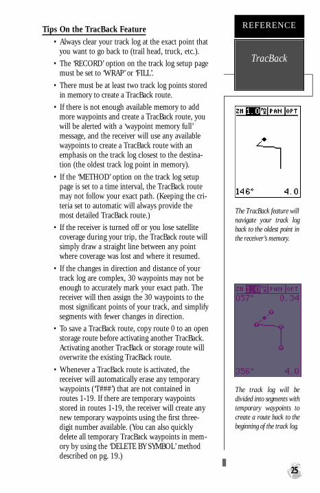
Tips On the TracBack Feature• Always clear your track log at the exact point that
you want to go back to (trail head, truck, etc.).
• The ‘RECORD’ option on the track log setup pagemust be set to ‘WRAP’ or ‘FILL’.
• There must be at least two track log points storedin memory to create a TracBack route.
• If there is not enough available memory to addmore waypoints and create a TracBack route, youwill be alerted with a ‘waypoint memory full’message, and the receiver will use any availablewaypoints to create a TracBack route with anemphasis on the track log closest to the destina-tion (the oldest track log point in memory).
• If the ‘METHOD’ option on the track log setuppage is set to a time interval, the TracBack routemay not follow your exact path. (Keeping the cri-teria set to automatic will always provide themost detailed TracBack route.)
• If the receiver is turned off or you lose satellitecoverage during your trip, the TracBack route willsimply draw a straight line between any pointwhere coverage was lost and where it resumed.
• If the changes in direction and distance of yourtrack log are complex, 30 waypoints may not beenough to accurately mark your exact path. Thereceiver will then assign the 30 waypoints to themost significant points of your track, and simplifysegments with fewer changes in direction.
• To save a TracBack route, copy route 0 to an openstorage route before activating another TracBack.Activating another TracBack or storage route willoverwrite the existing TracBack route.
• Whenever a TracBack route is activated, thereceiver will automatically erase any temporarywaypoints (‘T###’) that are not contained inroutes 1-19. If there are temporary waypointsstored in routes 1-19, the receiver will create anynew temporary waypoints using the first three-digit number available. (You can also quicklydelete all temporary TracBack waypoints in mem-ory by using the ‘DELETE BY SYMBOL’ methoddescribed on pg. 19.)
25
The TracBack feature willnavigate your track logback to the oldest point inthe receiver’s memory.
REFERENCE
TracBack
The track log will bedivided into segments witht e m p o r a ry waypoints tocreate a route back to thebeginning of the track log.
GPS 12XL NEW Manual Rev �A 2/6/98 3:18 PM Page 25

Route NavigationThe last form of navigating to a destination with the
GPS 12XL is by creating a user-defined route. The routenavigation feature lets you plan and navigate a coursefrom one place to another using a set of pre-definedwaypoints. Routes are often used when it’s not practical,safe, or possible to navigate a direct course to a particu-lar destination (e.g., through a body of water or impass-able terrain).
Routes are broken down and navigated in smallersegments called “legs”. The waypoint you are going toin a leg is called the “active to” waypoint and the way-point immediately behind you is called the “active from”waypoint. The line between the “active to” and the“active from” waypoint is called the “active leg”.
Whenever you activate a route with the GPS 12XL,it will automatically select the route leg closest to yourposition as the active leg. As you pass each waypoint inthe route, the receiver will automatically sequence andselect the next waypoint as the “active to” waypoint.
Routes
REFERENCE
26
GPS 12XL NEW Manual Rev �A 2/6/98 3:18 PM Page 26

Route Definition Page
The last form of navigating to a destination withthe GPS 12XL is by creating a user-defined route. TheGPS 12XL lets you create and store up to 20 routes of30 waypoints each.
Routes can be copied, cleared, inverted, and acti-vated through the route definition page.
To select the route definition page:
1. Highlight ‘ROUTES’ from the Main Menu Page, andpress .
The ‘route number’ field is displayed at the top ofthe page, with a 16-character ‘user comment’ fielddirectly below. If no user comment is entered, the fielddisplays the first and last waypoint in the route.
To edit the route comment:
1. Highlight the comment field and press .
2. Use the arrow keys to enter a new comment and press.
The waypoint list along the left side of the pageaccepts up to 30 waypoints for each route, with fieldsfor desired track and distance between legs. The totalroute distance is indicated below the waypoint list.
The bottom of the route definition page featuresseveral ‘function’ fields which let you copy, clear, invert,or activate the displayed route. Routes 1-19 are used asstorage routes, with route 0 always serving as the activeroute you are navigating. If you want to save a routethat’s currently in route 0, be sure to copy it to anotheropen route, as it will be overwritten by the next routeactivation.
27
Routes enable you to storegroups of frequently usedwaypoints together anduse this information fornavigation guidance.
REFERENCE
Route DefinitionPage
Enter each waypoint inthe order you would like tonavigate them. If youenter a waypoint notstored in memory, you’llneed to define the positionon the waypoint definitionpage.
CommentField
DesiredTrack of Leg
Total Route
Distance
Route Number
Copy Field
Function Prompts
Leg Distance
GPS 12XL NEW Manual Rev �A 2/6/98 3:18 PM Page 27
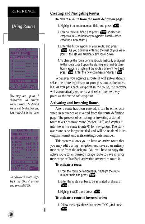
Creating and Navigating Routes
To create a route from the route definition page:
1. Highlight the route number field, and press .
2. Enter a route number, and press . (Select anempty route—without any waypoints listed—whencreating a new route.)
3. Enter the first waypoint of your route, and press. As you continue entering the rest of your way-
points, the list will automatically scroll down.
4. To change the route comment (automatically assignedto the route based upon the starting and final destina-tion waypoints), highlight the route comment field andpress . Enter the new comment and press .
Whenever you activate a route, it will automaticallyselect the route leg closest to your position as the activeleg. As you pass each waypoint in the route, the receiverwill automatically sequence and select the next way-point as the ‘active to’ waypoint.
Activating and Inverting Routes
After a route has been entered, it can be either acti-vated in sequence or inverted from the route definitionpage. The process of activating or inverting a storedroute takes a storage route (routes 1-19) and copies itinto the active route (route 0) for navigation. The stor-age route is no longer needed and will be retained in itsoriginal format under its existing route number.
This system allows you to have an active route thatyou may edit during navigation and save as an entirelynew route from the original. You will have to copy theactive route to an unused storage route to save it, sincenew route or TracBack activation overwrites route 0.
To activate a route:
1. From the route definition page, highlight the routenumber field and press .
2. Enter the route number to be activated, and press.
3. Highlight ‘ACT?’, and press .
To activate a route in inverted order:
1. Follow the steps above, but select ‘INV?’, and press.
Using Routes
REFERENCE
28
You may use up to 16characters to customname a route. The defaultname will be the first andlast waypoint in the route.
To activate a route, high-light the ‘ACT?’ promptand press ENTER.
GPS 12XL NEW Manual Rev �A 2/6/98 3:18 PM Page 28
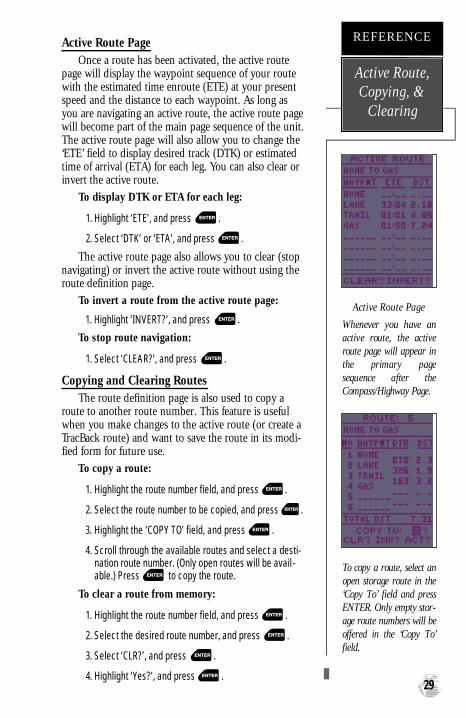
Active Route PageOnce a route has been activated, the active route
page will display the waypoint sequence of your routewith the estimated time enroute (ETE) at your presentspeed and the distance to each waypoint. As long asyou are navigating an active route, the active route pagewill become part of the main page sequence of the unit.The active route page will also allow you to change the‘ETE’ field to display desired track (DTK) or estimatedtime of arrival (ETA) for each leg. You can also clear orinvert the active route.
To display DTK or ETA for each leg:
1. Highlight ‘ETE’, and press .
2. Select ‘DTK’ or ‘ETA’, and press .
The active route page also allows you to clear (stopnavigating) or invert the active route without using theroute definition page.
To invert a route from the active route page:
1. Highlight ‘INVERT?’, and press .
To stop route navigation:
1. Select ‘CLEAR?’, and press .
Copying and Clearing RoutesThe route definition page is also used to copy a
route to another route number. This feature is usefulwhen you make changes to the active route (or create aTracBack route) and want to save the route in its modi-fied form for future use.
To copy a route:
1. Highlight the route number field, and press .
2. Select the route number to be copied, and press .
3. Highlight the ‘COPY TO’ field, and press .
4. Scroll through the available routes and select a desti-nation route number. (Only open routes will be avail-able.) Press to copy the route.
To clear a route from memory:
1. Highlight the route number field, and press .
2. Select the desired route number, and press .
3. Select ‘CLR?’, and press .
4. Highlight ‘Yes?’, and press .29
Active Route Page
Whenever you have anactive route, the activeroute page will appear inthe primary pagesequence after theCompass/Highway Page.
REFERENCE
Active Route,Copying, &
Clearing
To copy a route, select anopen storage route in the‘Copy To’ field and pressENTER. Only empty stor-age route numbers will beoffered in the ‘Copy To’field.
GPS 12XL NEW Manual Rev �A 2/6/98 3:18 PM Page 29

Editing RoutesA route can be edited any time after its creation.
To edit a route from the active route page orthe route definition page:
1. Select the waypoint you want to edit, and press .
An on-screen menu of editing choices will appear,with options for reviewing, inserting, deleting, orchanging the waypoint field highlighted. This field con-tains the following options:
• Review?— displays the waypoint definition pagefor the selected waypoint
• Insert?— adds a new waypoint directly in frontof the selected waypoint
• Remove?— deletes the selected waypoint fromthe route
• Change?— allows you to replace the selectedwaypoint with a new waypoint
Note: Editing the original storage route will notaffect route 0. If you want to save an edited version ofroute 0, save it to an open storage route.
On-Route GOTOsAt the beginning of this section, we mentioned that
the GPS 12XL will automatically select the route legclosest to your position as the active leg. This will giveyou steering guidance to the desired track (desiredcourse) of the active leg. Note that the first waypointselected as the destination waypoint will be along theroute leg closest to your present position. This maymean you’re not navigating to the first waypoint in theactive route—you may even be navigating to the last.You can manually navigate a route out of sequence atany time (bypassing one or more interim waypoints) byperform an “on-route GOTO” from the active route page.
To perform an “on-route GOTO” from the activeroute page:
1. Highlight the desired route waypoint, and press .
2. Once the GOTO waypoint page appears with the way-point highlighted, press .
Note that after you reach the on-route GOTO way-point, the GPS 12XL will automatically resume navigat-ing the rest of the route in sequence.
Editing Routes& On-Route
GOTO’s
REFERENCE
30
Use the on-screen menu toselect the desired editingfunction. The on-scre e nmenu is displayed byhighlighting a route waypoint and pre s s i n gENTER..
You can ‘skip ahead’ andbypass one or more legs ofthe route by highlighting awaypoint further alongthe route, pressing GOTOand ENTER.
GPS 12XL NEW Manual Rev �A 2/6/98 3:18 PM Page 30

Selecting a Navigation Page
Once you’ve selected a GOTO destination or acti-vated a TracBack, MOB, or route; the GPS 12XL willprovide graphic steering guidance to the destinationwith one of two navigation pages:
•The Compass Page (default) provides a direc-tional pointer indicating the bearing to your desti-nation and a rotating compass ring which showsyour direction of travel (track) at the top of thering. The Compass Page provides better guidancefor car travel, hiking, or biking; where straight-line navigation is often not possible.
•The Highway Page provides a graphic highwaydisplay that shows your movement relative to thedesired course, with an emphasis on your crosstrack error ( the distance and direction you are offcourse). The cross track error (XTK) is depictedon a course deviation indicator (CDI) (see pg. 34).The Highway Page is well-suited for boating orsome types of off-road recreation where straightline navigation is typically possible and maintain-ing a specified course is desirable.
Both pages provide a digital display of the bearingand distance to the destination, and your current speedand track over the ground. You can switch to eitherNavigation Page at any time.
To select either Navigation Page:
1. Press from the existing Navigation Page, andagain to change the page. 31
To switch the navigationpage to the CompassPage, press ENTER twice.
REFERENCE
NavigationPages
To switch the navigationpage to the Highway Page,press ENTER twice.
Compass Page Highway Page
GPS 12XL NEW Manual Rev �A 2/6/98 3:18 PM Page 31

Selecting a Navigation Page (cont.)
The ‘ETE’ field, located at bottom center on bothpages, is a user-selectable field that allows you to dis-play a variety of navigation values for your trip.
To access the user-selectable field:
1. Highlight ‘ETE’, and press .
2. Use the keypad to scroll through the possible options.
The following data options are available for theNavigation Pages:
Estimated Time Enroute (ETE)— the estimatedtime remaining to reach your destination based onyour present speed and track.Estimated Time of Arrival (ETA)— the estimat-ed time of day at which you will arrive at your desti-nation based on current ground speed and track.Course to Steer (CTS)— the recommendedcourse to follow in order to reduce cross track errorand stay on course. Provides the most efficientheading to get back on course and proceed alongyour route or GOTO.Crosstrack Error (XTK)— the distance you areoff the desired course in either direction, left orright. This field will give you a digital readout of thedata depicted by the CDI.Velocity Made Good (VMG)— the speed youare closing in on a destination along the desiredcourse. Also referred to as the ‘vector velocity’ toyour destination.Turn (TRN)— the angle difference between thebearing to your destination and your current track.‘L’ indicates you should turn left, ‘R’ indicates youshould turn right.
NavigationPages
REFERENCE
32
The user selectable fieldallows you to customizethe navigation pages,selecting the desired datareadout.
The turn option shows thenumber of degrees youneed to turn (left or right)to head directly to yourdestination.
Track OverGround
User-SelectableField
Distance toWaypointGraphic
CompassRing
GPS 12XL NEW Manual Rev �A 2/6/98 3:18 PM Page 32

Using the Compass Page
The Compass Page provides better steering guid-ance than the Highway Page for travel at slower speeds(e.g., walking), travel with many directional changesand when it’s not necessary to follow an exact course.
The bearing (BRG) and distance (DST) to the way-point are displayed at the top of the page, below thedestination waypoint name. The distance displayed isthe straight-line distance from your present position tothe destination waypoint. The bearing indicates theexact compass heading from you to the destination.
The middle of the page features a rotating “compassring” that shows your course over ground while youare moving (track indicated at the top of the ring), witha pointer arrow to the destination displayed in the cen-ter. The arrow shows the direction of your destinationfrom the direction you are moving. For instance, if thearrow points up, you are going directly to the way-point. If the arrow points any direction (left, right,down, etc.), turn toward the arrow until it points up.Then continue in that direction.
The bottom of the page shows your track (TRK),speed (SPD), and a user-selectable field for ETE, ETA,CTS, XTK, VMG, or TRN.
When you are one minute away from your destina-tion (based on your current speed and track overground), the GPS 12XL will alert you with a flashingon-screen message box.
33
In this example, theCompass Page indicatesthat you are travelingwest (261 degrees) andthe destination waypointis to the northwest (291d e g rees). Tu rn right 30degrees and continue on.
REFERENCE
Compass Page
In this example, theCompass Page indicatesthat you are travelingnorth (350 degrees) andthe destination waypointis to the northwest (291degrees). Turn left 59degrees and continue onto reach your destination.
Pointer toWaypoint
Speed OverGround
DestinationWaypoint
Bearing toWaypoint
GPS 12XL NEW Manual Rev �A 2/6/98 3:18 PM Page 33

Using the Highway Page
The GPS 12XL’s Highway Page provides graphicsteering guidance to a destination waypoint, with agreater emphasis on the straight-line desired course andthe distance and direction you are off course. The bear-ing and distance to a waypoint—along with your cur-rent track and speed—are displayed at the top of thescreen.
As you head toward your destination, the middle ofthe screen provides visual guidance to your waypointon a moving graphic “highway.” Your present position isrepresented by the diamond in the center of a coursedeviation indicator (CDI) scale. The line down the mid-dle of the highway represents your desired track. As younavigate toward a waypoint, the highway will actuallymove—indicating the direction you’re off course—rela-tive to the position diamond on the CDI scale. Whenthe highway is pointing straight up the screen, the way-point is directly ahead. If the destination waypoint is tothe left, the top of the highway will lead to the left, andvice versa. To stay on course, simply steer in the direc-tion the highway leads (left or right) until the highwayleads straight up the page.
If you do get off the desired course by more than1/5th of the selected CDI range, the exact distance youare off course will be displayed where the CDI scale set-ting normally appears. If you get too far off course (thehighway has disappeared off either side of the highwaydisplay), a message box will appear to indicate whatcourse to steer to get back on course. (For informationon how to set this scale, see pg. 45.) As you approach awaypoint, a horizontal “finish line” will move towardthe bottom of the highway. When the finish line re a c h e sthe CDI scale, you’ve arrived at your destination.
Highway Page
REFERENCE
34
In this example, theHighway Page indicatesthat you are off course tothe left. Steer right to getback on course. Notice thehighway always shows thedirection to turn. If thehighway leads straight upthe page, you should con-tinue in your curre n tdirection.
If you get too far offcourse, a message box willappear to indicate themost efficient heading toget you back on course.
Bearing toWaypoint
GraphicHighwayDisplay
CDI Scale
Distance toWaypoint
User SelectableField
Speed OverGround
Track
DestinationWaypoint
GPS 12XL NEW Manual Rev �A 2/6/98 3:18 PM Page 34

Map Page
The Map Page shows your position and surround-ings, and provides you with a target cursor that letsyou pan ahead to nearby waypoints, determine the dis-tance and bearing to a map position, and mark newwaypoints while you navigate. The Map Page is brokendown into two sections: control fields and map section.
The zoom function, panning control, and configu-ration fields are located at the top of the screen. Thezoom function uses 18 selectable zoom ranges from 0.2to 500 miles, or 0.3 to 800 km. (Using the zoom, pan-ning, and configure fields will be addressed in the nextsection.)
The map portion of the page displays your presentposition as a diamond icon, with your track and/orroute displayed as a solid line. Nearby waypoints arerepresented using symbols, with the waypoint namealso listed. You may select which of these features areshown through the map options pages (see pgs. 37-39for more information).
The four corners of the Map Page are used to dis-play various navigation data: the bearing and distanceto a destination waypoint and your current track andspeed over the ground. The two fields at the top cor-ners of the map show your bearing and distance to oneof three selectable destinations: an active destinationwaypoint, a highlighted on-screen waypoint, or thepanning target crosshair. If you are not navigating to awaypoint or using the panning function, the top datafields will not be displayed. Your current track andspeed are shown at the bottom corners of the display.
35
Note: The map scale rep-resents the distance fromthe top to the bottom ofthe Map Page. For exam-ple, when viewing the 10mile scale, the distancerepresented between thetop of the screen and bot-tom is 10 miles.
REFERENCE
Map Page
The four corners of theMap Page are used toshow your track andspeed, along with distanceand bearing to either acursor or to a destinationwaypoint.
Bearing toWaypoint
Pan & OptionFields
Track Speed
Distance toWaypoint
Zoom Scale
PresentPosition
GPS 12XL NEW Manual Rev �A 2/6/98 3:18 PM Page 35

Zooming, Panning, and Map Options
There are three main functions you can performfrom the Map Page— zooming, pointing & panning,and options (changing the map/track setup and findingcities). Each of these functions has its own “field”,which may be selected and activated for use. Wheneverthe Map Page first appears, the zoom field (at the topleft) is always highlighted. The map has 18 map scaleswhich are selected through the zoom function field.
To select a zoom scale:
1. Highlight the zoom field, if not already highlighted.
2. Press the key to begin map scale selection.
3. Select a map scale and press .
The second function field on the Map Page is thepan field, located at the top middle of the screen. Thepan function allows you to move the map with the fourarrow keys to view areas outside the current map area.
To activate the pan function:
1. Highlight the pan field.
2. Press the key to activate the pan function.
3. Use the arrow keys to move the map in any direction.
4. To cancel the pan function, press .
As you begin to move the map, a crosshair (plussign) will appear. This crosshair will now serve as a tar-get marker for the moving map. The distance and bear-ing to your destination will now be replaced by the dis-tance and bearing from your present position to the tar-get crosshair.
When you pan around the map, you’ll notice thetarget crosshair will “snap to” on-screen waypoints andhighlight the waypoint name. Once a waypoint name ishighlighted, you can either review its waypoint defini-tion page and waypoint display options, or execute aGOTO function and navigate directly to the waypoint.
To review the waypoint definition page for a high-lighted waypoint:
1. Press while the waypoint is highlighted by thecrosshair.
Zooming,Panning, &
Map Options
REFERENCE
36
A crosshair will appearwhen you activate the panfunction. The distance anddirection of the crosshairfrom your current positionis shown in the upper cor -ners of the Map Page.
On-Screen Pointing
The crosshair will “snapto” displayed waypoints,which allows you to quick-ly review or go to theselected waypoint rightfrom the Map Page.
GPS 12XL NEW Manual Rev �A 2/6/98 3:18 PM Page 36

Zooming, Panning, and Map Options (cont.)From the waypoint definition page, you can also
define how each individual waypoint is displayed onthe map. The GPS 12XL displays waypoints as a namewith a corresponding symbol (e.g., “fuel” and a gaspump symbol), a symbol only (e.g., a fish symbol), or a16-character comment and corresponding symbol (e.g.,“great view” and the camp site symbol). The waypointname has a six character limit while the “comment”field has a 16-character limit, and there are 16 differentwaypoint symbols available.
To select a waypoint display option:
1. Display the waypoint definition page for the desiredwaypoint (by selecting a waypoint from the Map Pageor from a waypoint list).
2. Highlight the “symbol” field (to the right of the namefield), and press display the Symbol Options.
3. Move the cursor to the ‘DISPLAY’ field, and press.
4. Select a display option, and press to select oneof the following display options: ‘NAME WITH SYM-BOL,’ ‘SYMBOL ONLY,’ or ‘COMMENT WITH SYMBOL.’
5. Press to confirm the ‘DONE?’ prompt.
6. Press again (on the waypoint definition page)to return to the Map Page.
The last function you can perform with a waypointhighlighted on the Map Page is a GOTO directly to thewaypoint.
To go to a waypoint highlighted on the Map Page:
1. Press while the waypoint is highlight by thecrosshair.
2. Press to confirm the GOTOwaypoint page.
Using the Cursor to Mark and Go to WaypointsDuring panning, the crosshair represents a target
position right on the Map Page, with the range andbearing to the target displayed at the top corners of thescreen. You can also use the target crosshair to mark anew waypoint position or as a GOTO destination rightfrom the map field.
To mark the target crosshair as a new waypoint:
1. Pan to the desired position on the map and press .
2. Enter a name and/or route number, and press . 37
You can custom tailor theMap Page to display way-points by any of thre eoptions: Symbol Only,Name With Symbol orComment With Symbol.
REFERENCE
WaypointDisplay &
Marking Cursor
Marking a CursorPosition
To mark a new waypointwith the crosshair, simplypan to the desired positionand press the MARK key.
GPS 12XL NEW Manual Rev �A 2/6/98 3:18 PM Page 37

Using the Cursor to Mark and Go to (cont.)You can also use the target crosshair as an instant
GOTO destination. This feature is similar to the MOBmode, and will allow you to mark and instantly set acourse for a new waypoint called ‘MAP’.
To go to the target crosshair:
1. Place the target crosshair on the desired location.2. Press , and press .
Note: To save the MAP waypoint, be sure to renameit because it will be overwritten the next time a GOTOis performed using the target crosshair.
Accessing Map Option WindowsYou can access four additional pages—map setup,
track setup, find city and city setup—by highlightingthe ‘OPT’ field at the top right of the Map Page, andpressing . The map options window will appear,ready for you to select one.
To select a map option:
1. Highlight the ‘OPT’ field and press .
2. Select the desired option and press .
Map Setup Page and OrientationThe map setup page lets you select the Map Page
and satellite sky view (see pg. 12) orientation, as well asspecify what items are displayed. The Map and SatellitePages may be oriented to ‘NORTH UP,’ ‘TRACK UP’ (thedirection of current travel), or ‘DTK UP’ (desired trackup, or the direction of the desired course). The defaultsetting is ‘TRACKUP’.
To change the map orientation:
1. Highlight the ‘map’ field and press .
2. Select the desired orientation and press .
Note: Selecting the ‘DTK UP’ option will set thesatellite sky view to ‘track up’ orientation.
The rest of the map setup page lets you specify whatitems are displayed or plotted on the Map Page byselecting ‘YES’ or ‘NO’ in the appropriate field.
• ’Rings’— displays three range rings on the map atincrements of 1/5th the selected map scale.
• ’Route’— plots the straight-leg lines between way-points of an active route and displays allroute waypoint names.
Using theCursor & Map
Options
REFERENCE
38
The ‘OPT’ field givesaccess to the map setup,track setup, city setup andfind city pages, right fromthe Map Page.
The Map Page’s defaultscreen orientation is ‘trackup’. ‘Track Up’ means thatthe top of the map displaycorresponds to your cur-rent direction of travel.With this setting, the maprotates as your trackchanges. It can also be setfor north up or desiredtrack (dtk) up orientation.
GPS 12XL NEW Manual Rev �A 2/6/98 3:18 PM Page 38

Map Setup Page and Orientation (cont.)
• ’Nearest’— shows up to nine nearest waypoints (fromyour present position) on the map.
• ’Names’— displays the waypoint name for up to ninenearest waypoints.
• ’Track Log’— displays and plots track log points on themap.
To turn a map item on or off:
1. Highlight the data field next to the desired option andpress .
2. Select ‘YES’ or ‘NO’ and press .
Track Setup PageThe track setup page lets you manage the GPS 12XL’s
track log data (see pg 24). You can also select whether torecord a track log and define how it is recorded.
To turn the track log on or off:
1. Highlight the ‘RECORD’ field, and press .
2. Select ‘OFF’, ‘FILL’, or ‘WRAP’, and press .(Note: Turning the track recording off will prevent youfrom using TracBack).
Track MethodThe track ‘method’ option determines how often
positions are stored in the track log. The default settingis ‘auto’, which records track points based upon a setvariance from your projected course over ground.. Thissetting gives the most efficient use of track memoryand provides the best TracBack performance.
To change the method to record points based ona specific time interval:
1. Highlight the ‘METHOD’ field, and press .
2. Select ‘TIME INTERVAL’, and press twice.
3. Enter hours, minutes, and seconds, and press .
Track Log DisplayThe track log option sets the number of points the
unit will attempt to display on the Map Page. Thedefault setting of 250 points provides good resolutionwith minimal screen clutter. The maximum setting is1024 points. Once you’ve reached the maximum num-ber of track points, the older points will be lost as newpoints are added. Note that adjusting the track pointsdisplayed will not affect how the receiver records tracklog data or the ability to create a TracBack route. 39
Use the track setup pageto control the way the GPS12XL manages track logdata.
REFERENCE
Map & TrackSetup
Entering a large timei n t e rval into the trackre c o rding criteria mayplot your position pointsf u rther apart than theywould be in the ‘AUTO’setting. This will increasethe distance you can trav-el without using up yourtrack log, but will greatlyreduce the effectiveness ofTracBack.
GPS 12XL NEW Manual Rev �A 2/6/98 3:18 PM Page 39

Managing and Clearing the Track LogThe rest of the track setup window displays the per-
centage of available memory currently used to storetrack log data, as well as a function field to clear thetrack log memory.
To clear the track log:
1. Highlight ‘CLEAR LOG?’, and press .
2. Highlight ‘Yes?’, and press .
Note: It’s a good idea to clear the track log at thebeginning of the trail, etc., in order to make the best useof the TracBack feature (see pg. 24).
Using the Find City FunctionThe find city page lets you search the built-in city
database for a city location, by spelling the city name.To search for a city by name:
1. Highlight the city name field (top line) and press .
2. Select the city name, using the arrow keys, and press.
If the city name includes a space(s), you must selecta blank character in the appropriate place(s) whilespelling out the city name. Once selected, the latitudeand longitude for the city location will appear, alongwith bearing and distance from either current positionor a reference waypoint.
To view the city location on the map:
1. Highlight ‘SHOWMAP’ and press . The MapPage will appear with the selected city at the center ofthe page.
2. To return the map to your present position, press .
Note: The city location may not be visible if themap is zoomed to a large scale. Select a lower mapscale, if necessary to view the city.
You can also GOTO a city location from the map orfind city page. The GPS 12XL will create a user way-point, using the city name, and add this point to theuser waypoint list. Keep in mind that city names will beabbreviated to six characters when creating a user waypoint.
To GOTO the city location from the map:
1. With the crosshair on the city location press .
2. Press to active the GOTO.
Track Setup& Find City
REFERENCE
40
Clear the track log anytime your screen gets clut-t e red or to make moreroom to store points foruse with the TracBack fea-ture.
GARMIN’s exclusive findcity function allows you tos e a rch for a city byspelling the city name. Thecity can be displayed onthe Map Page or selectedas a GOTO destination.
GPS 12XL NEW Manual Rev �A 2/6/98 3:18 PM Page 40
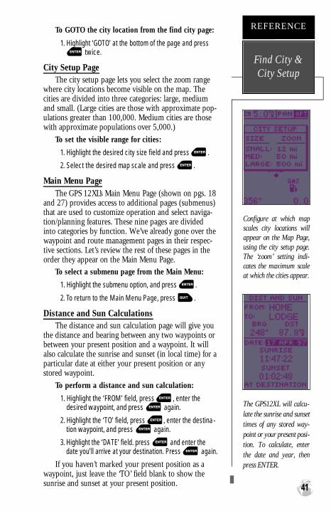
To GOTO the city location from the find city page:
1. Highlight ‘GOTO’ at the bottom of the page and presstwice.
City Setup PageThe city setup page lets you select the zoom range
where city locations become visible on the map. Thecities are divided into three categories: large, mediumand small. (Large cities are those with approximate pop-ulations greater than 100,000. Medium cities are thosewith approximate populations over 5,000.)
To set the visible range for cities:
1. Highlight the desired city size field and press .
2. Select the desired map scale and press .
Main Menu PageThe GPS 12XL’s Main Menu Page (shown on pgs. 18
and 27) provides access to additional pages (submenus)that are used to customize operation and select naviga-tion/planning features. These nine pages are dividedinto categories by function. We’ve already gone over thewaypoint and route management pages in their respec-tive sections. Let’s review the rest of these pages in theorder they appear on the Main Menu Page.
To select a submenu page from the Main Menu:
1. Highlight the submenu option, and press .
2. To return to the Main Menu Page, press .
Distance and Sun CalculationsThe distance and sun calculation page will give you
the distance and bearing between any two waypoints orbetween your present position and a waypoint. It willalso calculate the sunrise and sunset (in local time) for aparticular date at either your present position or anystored waypoint.
To perform a distance and sun calculation:
1. Highlight the ‘FROM’ field, press , enter thedesired waypoint, and press again.
2. Highlight the ‘TO’ field, press , enter the destina-tion waypoint, and press again.
3. Highlight the ‘DATE’ field. press and enter thedate you’ll arrive at your destination. Press again.
If you haven’t marked your present position as awaypoint, just leave the ‘TO’ field blank to show thesunrise and sunset at your present position. 41
Configure at which mapscales city locations willappear on the Map Page,using the city setup page.The ‘zoom’ setting indi-cates the maximum scaleat which the cities appear.
REFERENCE
Find City &City Setup
The GPS12XL will calcu-late the sunrise and sunsettimes of any stored way-point or your present posi-tion. To calculate, enterthe date and year, thenpress ENTER.
GPS 12XL NEW Manual Rev �A 2/6/98 3:18 PM Page 41

MessagesThe messages page displays any current message
alerts. There are two types of messages: temporary alerts(e.g., approaching a waypoint) and condition alerts(e.g., battery power low). All messages are initially indi-cated by a flashing on-screen indicator. Temporary alertsare then cleared, while condition alerts can be viewedagain from the messages page.
Find City FunctionThe find city page provides the same features as the
find city selection from the map options window. Seepage 40 for more information on the find city page.
Setup MenuThe setup menu displays an additional list of four
menu options used exclusively for configuring the GPS12XL to your preferences. Menu selections for ‘system’setup, ‘navigation’ setup, ‘interface’ setup and ‘alarms’settings are available.
System Setup: ModeThe system setup page is used to select the operat-
ing mode, time offset, and screen preferences. The GPS12XL has two operating modes:
• Normal Mode operates the unit at maximumperformance, and provides battery life of up to 24hours on alkaline batteries.
• Simulator Mode allows you to operate the unitwithout acquiring satellites, and is ideal for prac-ticing, or entering waypoints and routes while athome.
To select an operating mode:
1. Highlight the ‘MODE’ field, and press .2. Select a mode and press .
System Setup: OffsetThe date and time offset is located directly below
the mode field. Note: Date and time information isderived from the GPS satellites and cannot be changedby the user. Because the time shown is UTC (GreenwichMean Time) time, you will need to enter a time offset todisplay the correct local time for your area. To deter-mine the time offset for your area, note your positionand refer to the chart in Appendix C.
Messages &Setup Menu
REFERENCE
42
Select the ‘Setup Menu’option from the MainMenu to access configura-tion options for your GPS12 XL.
The GPS 12XL’s two oper-ating modes are accessedthrough the system setupsubmenu.
GPS 12XL NEW Manual Rev �A 2/6/98 3:18 PM Page 42

To enter the time offset:
1. Highlight the ‘OFFSET’ field, and press .
2. Enter the time offset, and press . Note: Movethe cursor to the left to change the plus or minus sign.
System Setup: Hours (Time Format)The time display shown on the system setup and
Position Pages may be set to display the time in a 12-or 24-hour format.
To select the time format:
1. Highlight the ‘HOURS’ field, and press .
2. Select 12- or 24-hour display, and press .
System Setup: Screen ContrastThe GPS 12XL has adjustable screen contrast con-
trolled by an on-screen bar scale.To set the screen contrast:
1. Highlight the ‘CONTRAST’ field, and press .
2. Adjust the bar scale to the desired contrast, andpress .
Note: The screen contrast can also be adjusted bypressing the rocker keypad while on the Satellite Page(see pg. 11).
System Setup: Backlighting TimeoutThe screen backlight timeout is adjustable for 15,
30, 60, 120, or 240 seconds. The timeout may be can-celled by setting it to ‘Stay On’ continuously. Wheneverbacklighting is on, a bulb icon will appear on theSatellite Page.
To set the backlight timeout:
1. Highlight the ‘LIGHT’ field, and press .
2. Select the desired setting, and press .
3. To turn lighting on and off, press briefly.
System Setup: Tone Setting
The GPS 12XL allows you to choose a tone for mes-sages only, messages and keystrokes, or no tone at all.
To set the tone:
1. Highlight the ‘TONE’ field and press the key.
2. Select the desired setting and press .
43
To display the corre c tlocal time, you must enterthe appropriate offset. Seethe chart at the end ofAppendix C.
REFERENCE
System Setup
The “Stay On” setting willkeep your backlighting oncontinuously. However, ifyou use backlighting fre-quently, this setting willsignificantly reduce yourbattery life.
GPS 12XL NEW Manual Rev �A 2/6/98 3:18 PM Page 43

Navigation Setup Page
The navigation setup page is used to select thedesired position format, map datum, CDI scale, units ofmeasure for speed and distance, and a heading reference.
Navigation Setup: Position FormatsThe default position format for the GPS 12XL is lati-
tude and longitude in degrees and minutes (hdddºmm.mmm’). You may also select degrees, minutes andseconds (hdddºmm’ss.s’’); degrees only (hddd.dddddº);UTM/UPS; MGRS; Maidenhead; User-defined Grid; orregional British, German, Irish, Indonesian, Indian,Swedish, Swiss, Taiwan, or West Malayan grids.
To select a position format:
1. Highlight the ‘POSITION FRMT’ field, and press .
2. Select the desired setting, and press .
Navigation Setup: User Grid Position FormatThe ‘User Grid’ option lets you create a user-defined
position format by establishing factors such as longitudeof origin, scale, and false Easting or Northing.
To define a user grid:1. Select ‘User Grid’, and press .
2. Enter values for longitude origin, scale, and falseEasting and Northing, and press .
3. Highlight ‘SAVE?’, and press .
Navigation Setup: Map DatumsThe ‘MAP DATUM’ field comes with a ‘WGS 84’
default setting. Although over 100 map datums areavailable for use (see Appendix D for map datums), youshould only change the datum if you are using maps orcharts that specify a different datum than WGS 84. If nodatum is specified, you may select each datum applica-ble to your region until you find the datum that pro-vides the best positioning at a known point.
To select a map datum:
1. Highlight the ‘MAP DATUM’ field, and press .
2. Select the desired setting, and press .
Warning: Selecting the wrong map datum can resultin substantial position errors. When in doubt, use thedefault WGS 84 datum for best overall performance.
NavigationSetup
REFERENCE
44
The position format maybe set to display yourchoice of many formats.Note: degree and minutesis the default setting.
The default map datumcovers world-wide naviga-tion. However, if you areusing a paper map orchart which uses a differ-ent map datum that WGS84, then you may wish toswitch to that datum tomake your GPS 12XLposition readout corre-spond to the chart.
GPS 12XL NEW Manual Rev �A 2/6/98 3:18 PM Page 44

Navigation Setup: Map Datums (continued)To define a user datum:
1. Highlight the ‘MAP DATUM’ field, and press .
2. Scroll through the map datum options until ‘User’appears, and press .
3. Enter the five parameters of the map datum—‘DX’,‘DY’, ‘DZ’, ‘DA’, and ‘DF’—using the rocker keypad,and press . The signs of each value should fol-low the convention: WGS 84 +/- local geodetic system.
4. Highlight ‘SAVE?’, and press .
Navigation Setup: CDI ScaleThe course deviation indicator (CDI) field lets you
select the range of the CDI bar scale on the HighwayPage. Four scales are available: +/- 0.02, 0.25 (default),1.25, and 5.0 miles or kilometers. Note: This CDIvalue represents the full scale limits (left or right fromcenter) of the CDI.
To enter a CDI scale setting:
1. Highlight the ‘CDI’ field, and press .
2. Select the desired setting, and press .
Navigation Setup: Units of MeasureThe GPS 12XL lets you select statute (default), nau-
tical, or metric units of measure for all speed and dis-tance readouts.
To change the unit of measure:
1. Highlight the ‘UNITS’ field, and press .
2. Select the desired units of measure, and press .
Navigation Setup: Heading ReferenceThe GPS 12XL’s heading information can be dis-
played referencing magnetic north (automatic or user-defined), true north, or calculated grid headings. Thedefault setting is automatically-calculated magneticnorth, which is suitable for most applications.
To select a heading reference:
1. Highlight the ‘HEADING’ field, and press .
2. Select the desired heading reference, and press .
To enter a user-defined magnetic heading:
. 1. Select ‘User Mag’ and press .
2. Enter the degrees and direction of magnetic variation,and press . 45
The user datum featureallows you to define theearth model used to calcu-late position coordinates.
WA R N I N G: Incorre c tentries may result in sub-stantial position errors.
REFERENCE
NavigationSetup
To enter a user- d e f i n e dmagnetic variation, selectthe ‘User Mag’ option andenter the desired directionand degrees.
GPS 12XL NEW Manual Rev �A 2/6/98 3:18 PM Page 45

AlarmsThe alarms page is used to set two alarms on the
GPS 12XL: arrival and CDI. The arrival alarm will alertyou when you are approaching a waypoint. The arrivalalarm has three available settings:
• ’Off’— No alarm will occur.
• ’On’— The alarm will occur at the user-specified dis-tance from the destination waypoint.
• ’Auto’— The alarm will occur at one minute away(based upon current speed, distance & track)from the each waypoint in the active route orfrom the GOTO destination.
Note: When using a route, the arrival alarm willonly occur for the final destination waypoint—not anyinterim waypoints along the route.
To set the arrival alarm:
1. Highlight the ‘ARRIVAL’ field and press .
2. Select ‘On’, ‘Auto’ or ‘Off’, and press .
3. If ‘On’ is selected, highlight the distance field, press, enter the desired distance and press .
The CDI alarm will alert you if your position devi-ates off course (left or right) beyond the limits specified.
To set the CDI alarm:
1. Highlight the ‘CDI Alarm’ field and press .
2. Select ‘On’ or ‘Off’, and press .
3. If ‘On’ is selected, highlight the distance field, press, enter the desired distance and press .
Note: The arrival and CDI alarms both have settingranges from 0.0 to 9.9 units (statute miles/nauticalmiles/kilometers). Setting the CDI alarm to its lowestlimits may cause false alarms due to the effects of DOD-imposed Selective Availability. SelectiveAvailability can degrade your GPS position by as muchas 100 meters.
Alarms
REFERENCE
46
The arrival alarm alertsyou when you’ve reachedyour destination. ‘Auto’provides an alert at oneminute from your destina-tion. ‘On’ allows you todefine an alarm distance.
The CDI alarm warns youwhen you deviate offcourse (left or right)beyond the limits that youset.
GPS 12XL NEW Manual Rev �A 2/6/98 3:18 PM Page 46
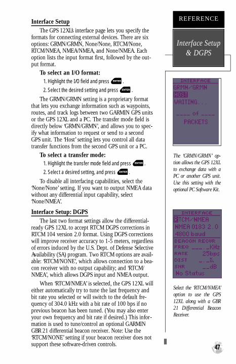
Interface SetupThe GPS 12XL’s interface page lets you specify the
formats for connecting external devices. There are sixoptions: GRMN/GRMN, None/None, RTCM/None,RTCM/NMEA, NMEA/NMEA, and None/NMEA. Eachoption lists the input format first, followed by the out-put format.
To select an I/O format:1. Highlight the I/O field and press .2. Select the desired setting and press .
The GRMN/GRMN setting is a proprietary formatthat lets you exchange information such as waypoints,routes, and track logs between two GARMIN GPS unitsor the GPS 12XL and a PC. The transfer mode field isdirectly below ‘GRMN/GRMN’, and allows you to spec-ify what information to request or send to a secondGPS unit. The ‘Host’ setting lets you control all datatransfer functions from the second GPS unit or a PC.
To select a transfer mode:1. Highlight the transfer mode field and press .2. Select a desired setting, and press .
To disable all interfacing capabilities, select the‘None/None’ setting. If you want to output NMEA datawithout any differential input capability, select‘None/NMEA’.
Interface Setup: DGPSThe last two format settings allow the differential-
ready GPS 12XL to accept RTCM DGPS corrections inRTCM 104 version 2.0 format. Using DGPS correctionswill improve receiver accuracy to 1-5 meters, regardlessof errors induced by the U.S. Dept. of Defense SelectiveAvailability (SA) program. Two RTCM options are avail-able: ‘RTCM/NONE’, which allows connection to a bea-con receiver with no output capability; and ‘RTCM/NMEA’, which allows DGPS input and NMEA output.
When ‘RTCM/NMEA’ is selected, the GPS 12XL willeither automatically try to tune the last frequency andbit rate you selected or will switch to the default fre-quency of 304.0 kHz with a bit rate of 100 bps if noprevious beacon has been tuned. (You may also enteryour own frequency and bit rate if desired.) This infor-mation is used to tune/control an optional GARMINGBR 21 differential beacon receiver. Note: Use the‘RTCM/NONE’ setting if your beacon receiver does notsupport these software-driven controls. 47
The ‘GRMN/GRMN’ op-tion allows the GPS 12XLto exchange data with aPC or another GPS unit.Use this setting with theoptional PC Software Kit.
REFERENCE
Interface Setup& DGPS
Select the ‘RTCM/NMEA’option to use the GPS12XL along with a GBR21 Diff e rential BeaconReceiver.
GPS 12XL NEW Manual Rev �A 2/6/98 3:18 PM Page 47

Interface Setup: DGPS (continued)To enter a DGPS beacon frequency:
1. Highlight the ‘FREQ’ field, and press .
2. Enter the desired frequency, and press .
3. Highlight the ‘RATE’ field, and press .
4. Select the desired bit rate (bps), and press .
Note: The frequency and bit rate fields are disabledwhen the ‘RTCM/NONE’ option is selected.
When the GPS 12XL is receiving DGPS correctionsfrom the GBR 21, the ‘BEACON RECVR’ section of theI/O setup page will display the beacon frequency andsignal strength, as well as the distance from the beacontransmitter to your present position. At the bottom ofthe beacon receiver field, a status message will keep youinformed of DGPS activity:
• A ‘Tuning’ message will be displayed while a bea-con receiver is selecting a frequency/bit rate andwaiting for signal reception.
• Once a valid beacon signal has been received, a‘Receiving’ message will be displayed.
• If the beacon signal is received and no correctiondata is being received, a ‘No Data’ message will bedisplayed.
• If a beacon frequency cannot be tuned and/or nosignal is received, a ‘No Status’ message will bedisplayed.
The message page will alert you to any problemsrelating to DGPS operation. You may also monitor theDGPS status from the status field on the interface page.The GPS12XL will display one of three alert messagesconcerning DGPS operation:
No DGPS Position— there is not enough correc-tion data available to compute a DGPS position.
No RTCM Input— the beacon receiver is notproperly connected, the baud rates do not match orno signal is being provided.
RTCM Input Failed— DGPS data was beingreceived but has been lost.
DGPS
REFERENCE
48
The baud rate is selec-table for all RTCM andNMEA interface options.
Alert messages will signalany problems with DGPSoperation.
GPS 12XL NEW Manual Rev �A 2/6/98 3:18 PM Page 48

Navigation SimulatorThe GPS 12XL’s simulator mode lets you practice all
aspects of its operation without active satellite acquisi-tion. You can plan and practice trips, enter new way-points and routes, and save them for use during nor-mal operation.
To activate the simulator:
1. From the Main Menu Page, highlight ‘SYSTEMSETUP’, and press .
2. Highlight the ‘MODE’ field, and press .
3. Select ‘Simulator?’, and press .
Once the simulator mode has been activated, usethe Position, Compass, or Highway Page to set yourspeed and track by highlighting the appropriate field,entering the desired value, and pressing . Youmay also enter a new position if you desire (from thePosition Page).
The GPS 12XLdoes not track satellites in simu -lator mode. Although you can create and savewaypoints and routes while using the simulatormode, never attempt to use the simulator modefor actual navigation.
49
Select the simulator modefrom the operation modechoices and press ENTER.You may return to normaloperation by changing theoperation mode or byturning the unit off andback on.
REFERENCE
NavigationSimulator
!
GPS 12XL NEW Manual Rev �A 2/6/98 3:18 PM Page 49

Initializing Your GPS 12XL for First-Time Use
The GPS 12XL typically acquires a position fastenough that initialization is not required. However, ini-tialization may be necessary for the following:
• After memory loss
• When the receiver has been moved more than500 miles with the power off.
Additionally, it may be necessary to initialize theunit the first time you use it, if it does not acquire a fixafter the first few minutes.
The receiver is shipped from the factory inAutoLocate™ mode, which enables the GPS 12XL todetermine its location anywhere in the world. To speedup the initialization process, we recommend using thegraphic initialization described below, which will usual-ly provide a fix in a few minutes.
To turn the GPS 12XL on:
1. Press and hold until the receiver turns on.
The welcome page will be displayed while the unitconducts a self test.
Once testing is complete, the welcome page will bereplaced by the Satellite Page, and the EZinit promptmay appear prompting you to select one of two initial-ization methods:
•Select Country––allows you to initialize thereceiver by selecting your present position from alist of countries in the GPS 12XL’s internal data-base. This typically provides a position fix in underthree minutes.
•AutolocateTM ––allows the GPS 12XL to initializeitself and calculate a position fix without knowingyour present position. This usually provides a posi-tion fix in 3-5 minutes.
If the EZinit prompt has not automaticallyappeared on the Satellite Page:
1. Press the key.
Note: If the EZinit prompt ever appears after youhave initialized the receiver (due to the antenna’s viewof satellites being obstructed by trees, etc.), highlightthe ‘NO RE-INIT’ selection with the arrow keypad andpress .
Initialization
APPENDIX A
50
Welcome Page
The EZinit prompt willautomatically appear ifthe receiver needs to beinitialized. The pro m p tmay also appear duringnormal use if the antennais shaded, thereby block-ing satellite reception.
GPS 12XL NEW Manual Rev �A 2/6/98 3:18 PM Page 50

To initialize the receiver:
1. If the ‘COUNTRY’ option is not highlighted, press thekey repeatedly to move the field highlight to the
‘COUNTRY’ option.
2. Press the key.
3. Use the key to scroll through the list options untilthe country of your present position appears.
4. Use the key to highlight the country/state/region you’re in. If the country you’re in is not listed, selectany other country within 500 miles of your presentposition.
5. Press to finish.
The GPS 12XL will now begin searching for theappropriate satellites for your location and shouldacquire a position in under three minutes. You can ver-ify that you have acquired a position by watching theSatellite Page transition to the Position Page (providedyou haven’t pressed any other buttons) or by lookingfor a ‘2D NAV’ or ‘3D NAV’ status at the top-left cornerof the Satellite Page.
Initialization Troubleshooting
If you have trouble initializing the receiver oracquiring a position, check the following:
• Does the unit have a clear view of the sky?
If there are large buildings or mountains nearby, orif there is heavy tree cover, the receiver may not bereceiving enough satellite signals to calculate aposition.
• Have you selected the right country/state/regionfrom the EZinit list?
Check for the correct approximate lat/lon on thePosition Page, or reselect the appropriate countryfrom the list to restart the initialization.
• Have you moved more than 500 miles from thelast calculated position with the receiver off?
Reinitialize the receiver, selecting the country/state/region of your new location from the EZinit list.
Your unit should now be initialized.
51
Use the arrow keypad tohighlight the country,region, or state of yourpresent position from thelist and press ENTER. Ifthe country is not listed,select the closest countryinstead.
APPENDIX A
Initialization
GPS 12XL NEW Manual Rev �A 2/6/98 3:18 PM Page 51

Specifications & Wiring
APPENDIX B
52
Never attempt any repairs yourself. To protect your GPS 12XL,keep it in its car rying case when not in use, and never allow gaso-line or other solvents to come into contact with the case. Clean thecase and lens with a soft cloth and a household window cleaner.
PHYSICAL
Case: waterproof*
Size: 14.6 x 5.1 x 3.4 cm
Weight: Approx 9.5 ounces (269g) w/ batteries
Temperature Range: 5º to 158ºF (-15º to 70ºC)
PERFORMANCE
Receiver: 12 parallel channel, differential-ready
Acquisition Time: Approx. 15 seconds (warm start)
Approx. 45 seconds (cold start)
Approx. 5 minutes (AutoLocateTM)
Update Rate: 1/second, continuous
Position Accuracy: 1-5 meters (3-17 ft.) with DGPS corrections**
15 meters (49 ft.) RMS***
Velocity Accuracy: 0.1 knot RMS steady state
Dynamics: 6g
POWER
Input: Four 1.5 volt AA batteries or 10-32 vDC
Power Consumption: 1 watt
Battery Life: Up to 24 hours (with 4 AA batteries)
Internal Backup: lithium battery
NOTE: Alkaline batteries lose a significant amount of their capacity as temperature decreas-es. If you’re using the GPS 12XL in below freezing temperatures, use lithium batter-ies for longer battery life. Extensive use of screen backlighting will significantlyreduce battery life.
Specifications subject to change without notice.* Meets IEC (European Community Specification) 529 IPX7 for protection against immersion for
30 minutes at a depth of 1 meter.** With optional DGPS input.
*** Subject to accuracy degradation to 100m 2DRMS under the US DOD-imposed SelectiveAvailability Program.
GPS 12XL NEW Manual Rev �A 2/6/98 3:18 PM Page 52

APPENDIX B
Specifications &Wiring
Three optional cables are available to connect the GPS 12XL to an externalpower source or interface with another unit or PC:
• Cigarette Lighter Adapter— Allows connection to a 12-volt DC cigarettelighter plug. Part No. 010-10085-00.
• Data Transfer Cable— Allows data transfer between GARMIN GPS units. TheGPS 12XL is compatible with the following units: GPS 38/40/45/45XL, GPSII/II plus, GPS12, and GPS 12XL. Information that can be transferredincludes the almanac, waypoints, routes, and tracklog. However, waypointsymbols are only transferrable from or to units that support waypoint symbolssuch as the GPS II plus, GPS 12, and GPS 12XL software version 3.01 orlater. Part No. 010-10142-00.
• PC Kit Interface Cable— PC interface cable with 9-pin ‘D’ serial data connec-tor. Part No. 010-10141-00. (A combined Cigarette Lighter Adapter and PCInterface Cable is also available as Part No. 010-10165-00.)
The following interface formats are supported by the GPS 12XL for connectionto up to three NMEA devices:
unit view
NMEA 0180
NMEA 0182
NMEA 0183 version 1.5
Approved sentences:
GPRMB, GPRMC, GPWPL
Proprietary sentences:
PGRMM (map datum),PGRMZ (altitude), PSLIB(beacon rec. control)
NMEA 0183 version 2.0
Approved sentences:
GPGGA, GPGSA, GPGSV,GPRMB, GPRMC, GPRTE,GPWPL
Proprietary sentences:
PGRME (estimated error),PGRMM (map datum), PSLIB(beacon receiver control)
DGPS corrections are accepted onRTCM-104 v. 2.1 format.
53
GPS 12XL NEW Manual Rev �A 2/6/98 3:18 PM Page 53

Messages &Time Offsets
APPENDIX C The GPS 12XL uses a flashing on-screen message indi-cator to alert you to important information. Whenever themessage indicator appears, press PAGE to view the mes-sage page. There are two types of messages: temporaryalerts and condition alerts. Temporary alerts are clearedfrom the message page after viewing, while conditionalerts remain until the condition has been resolved. Paycareful attention to all messages for your own safety.
Active WPT Can’t be Deletd—You have attempted to change the “active to” or “active from”waypoint. Clear the active route or GOTO before making your changes.
Accuracy has been Degraded—The accuracy of the GPS 12XL has been degraded beyond 500meters due to poor satellite geometry or data quality. You should check other navigationalsources to verify the position indicated.
Already Exists—The name you are entering already exists in the GPS 12XL’s memory.
Arrival at (or Approaching)____—You are one minute away from reaching a destination way-point or at the distance specified on the alarms submenu.
Battery Power is Low—Thebatteries are low and should be replaced.
CDI Alarm—You are left or right of course, beyond the limits set on the alarms submenu.
No DGPSPosition—Not enough data is available to compute a DGPS position.
No RTCM Input—Beacon receiver is improperly connected or baud rates do not match.
Poor GPS Coverage—The GPS 12XL cannot acquire the necessary number of satellites to com-pute a position. Try another location with a clearer view of the sky.
Power Down and Re-init—The GPS 12XL is not able to calculate a position due to abnormalsatellite conditions. Turn the unit off and verify the last position shown by other means. Try theunit again later, possibly in a different location.
PROX Alarm—You have entered the alarm circle for a specific proximity waypoint.
Proximity Overlapped—The alarm circles of two proximity waypoints overlap which couldcause difficulty in monitoring distances to each waypoint.
Proximity Wpt can’t be Deleted—The waypoint you are trying to delete is listed as a proximi-ty waypoint and must be removed from the list before it can be deleted.
Read Only Mem has Failed—The permanent memory has failed and the unit is not operable.
Received an Invalid WPT—A waypoint was received during upload transfer that has aninvalid identifier.
Receiver has Failed—A failure in receiver hardware has been detected. If this message persists,do not use the unit and take it to an authorized dealer for repair.
Route is Full—You have attempted to add more than 30 waypoints to a route.
Route is not Empty—You have attempted to copy into a route already in use.
Route Waypoint Can’t be Deleted—The waypoint you are trying to delete is part of a route.Delete the waypoint from the route before removing it from memory.
54
GPS 12XL NEW Manual Rev �A 2/6/98 3:18 PM Page 54

APPENDIX C
Messages &Time Offsets
Route Waypoint was Deleted—A route waypoint entered does not exist in the database andhas been deleted from the route.
RTCMInput has Failed—DGPS data being received has been lost. You are no longer receiv-ing the beacon signal.
Searching the Sky—The GPS 12XL is in searching the sky for almanac data or the unit is inAutoLocateTM mode.
Stored Data was Lost—All waypoints, routes, time and almanac data has been lost due tobattery failure or clearing the receiver’s memory.
Track Memory is Full—All track log points in memory have been used. You must eitherdelete the current tracklog or switch the record option to ‘WRAP’ which will begin erasing theoldest tracklog points as new ones are added.
Transfer has been Completed—The receiver is finished uploading or downloading informa-tion to the connected device.
WPT Memory is Full—You have used all 500 waypoints in the GPS 12XL. Delete unwantedwaypoints to make room for new entries.
Time Offset Chart
The table below gives approximate UTC time offset for various longitudinalzones. If you are in daylight savings time, add one hour to the offset.
Longitudinal Zone Offset Longitudinal Zone OffsetW180.0º to W172.5º -12 E007.5º to E022.5º 1
W172.5º to W157.5º -11 E022.5º to E037.5º 2
W157.5º to W142.5º -10 E037.5º to E052.5º 3
W142.5º to W127.5º -9 E052.5º to E067.5º 4
W127.5º to W112.5º -8 E067.5º to E082.5º 5
W112.5º to W097.5º -7 E082.5º to E097.5º 6
W097.5º to W082.5º -6 E097.5º to E112.5º 7
W082.5º to W067.5º -5 E112.5º to E127.5º 8
W067.5º to W052.5º -4 E127.5º to E142.5º 9
W052.5º to W037.5º -3 E142.5º to E157.5º 10
W037.5º to W022.5º -2 E157.5º to E172.5º 11
W022.5º to W007.5º -1 E172.5º to E180.0º 12
W007.5º to E007.5º 0
55
GPS 12XL NEW Manual Rev �A 2/6/98 3:18 PM Page 55

Map Datums
APPENDIX D
56
The following list shows the map datums available forthe GPS 12XL. Menu abbreviations are listed first, fol-lowed by the corresponding map datum name and area.The default map datum for the GPS 12XL is WGS 84.
Adindan Adindan- Ethiopia, Mali,Senegal, Sudan
Afgooye Afgooye- Somalia
AINELABD ‘70 AIN ELANBD 1970- BahrainIsland, Saudi Arabia
Anna 1 Ast ‘65 Anna 1 Astro ‘65- Cocos Isl.
ARC 1950 ARC 1950- Botswana,Lesotho, Malawi, Swaziland,Zaire, Zambia, Zimbabwe
ARC 1960 ARC 1960- Kenya, Tanzania
Ascnsn Isld ‘58 Ascension Island ‘58-Ascension Island
Astro B4 Sorol Astro B4 Sorol Atoll- TernIsland
Astro Bcn “E” Astro Beacon “E”- Iwo Jima
Astro Dos 71/4 Astro Dos 71/4- St. Helena
Astr Stn ‘52 Astronomic Stn ‘52- MarcusIsland
Astrln Geod ‘66 Australian Geod ‘66-Australia, Tasmania Island
Astrln Geod ‘84 Australian Geod ‘84-Australia, Tasmania Island
Austria Austria
Bellevue (IGN) Efate and Erromango Islands
Bermuda 1957 Bermuda 1957- BermudaIslands
Bogata Observ Bogata Obsrvatry- Colombia
Campo Inchspe Campo Inchauspe- Argentina
Canton Ast ‘66 Canton Astro 1966- PhoenixIslands
Cape Cape- South Africa
Cape Canavrl Cape Canaveral- Florida,Bahama Islands
Carthage Carthage- Tunisia
CH-1903 CH 1903- Switzerland
Chatham 1971 Chatham 1971- ChathamIsland (New Zealand)
Chua Astro Chua Astro- Paraguay
Corrego Alegr Corrego Alegre- Brazil
Djakarta Djakarta (Batavia)- SumatraIsland (Indonesia)
Dos 1968 Dos 1968- Gizo Island
(New Georgia Islands)
Easter Isld 67 Easter Island 1967
European 1950 European 1950- Austria,Belgium, Denmark, Finland,France, Germany, Gibraltar,Greece, Italy, Luxembourg,Netherlands, Norway,Portugal, Spain, Sweden,Switzerland
European 1979 European 1979- Austria,Finland, Netherlands,Norway, Spain, Sweden,Switzerland
Finland Hayfrd Finland Hayford- Finland
Gandajika Base Gandajika Base- Republic ofMaldives
Geod Datm ‘49 Geodetic Datum ‘49- New Zealand
Guam 1963 Guam 1963- Guam Island
Gux 1 Astro Gux 1 Astro- GuadalcanalIsland
Hjorsey 1955 Hjorsey 1955- Iceland
Hong Kong ‘63 Hong Kong ‘63- Hong Kong
Hu-Tzu-Shan Taiwan
Indian Bngldsh Indian- Bangladesh, India,Nepal
Indian Thailand Indian- Thailand, Vietnam
Indonesia ‘74 Indonesia 1974- Indonesia
Ireland 1965 Ireland 1965- Ireland
ISTS 073 Astro ISTS 073 ASTRO ‘69- Diego Garcia
Johnston Island Johnston Island KandawalaKandawala- Sri Lanka
Kerguelen Islnd Kerguelen Island, Kandawala, Sri Lanka
Kertau 1948 Kertau 1948- West Malaysia,Singapore
L. C. 5 Astro Cayman Brac Island
Liberia 1964 Liberia 1964- Liberia
Luzon Mindanao Luzon- Mindanao Island
Luzon Philippine Luzon- Philippines (excluding Mindanao Island)
GPS 12XL NEW Manual Rev �A 2/6/98 3:18 PM Page 56

Mahe 1971 Mahe 1971- Mahe Island
Marco Astro Marco Astro- Salvage Island
Massawa Massawa- Eritrea (Ethiopia)
Merchich Merchich- Morocco
Midway Ast ‘61 Midway Astro ‘61- Midway
Minna Minna- Nigeria
NAD27 Alaska North American 1927- Alaska
NAD27 Bahamas North American 1927- Bahamas (excluding SanSalvador Island)
NAD27 Canada North American 1927-Canada and Newfoundland
NAD27 Canal Zone North Am. 1927- Canal Zone
NAD27 Caribbn North American 1927-Caribbean (Barbados, CaicosIslands, Cuba, Dom. Rep.,Grand Cayman, Jamaica, Leeward and Turks Islands)
NAD27 Central North American 1927-Central America (Belize, CostaRica, El Salvador, Guatemala,Honduras, Nicaragua)
NAD27 CONUS North Am. 1927- Mean Value
NAD27 Cuba North American 1927- Cuba
NAD27 Grnland North American 1927- Greenland (Hayes Peninsula)
NAD27 Mexico N. American 1927- Mexico
NAD27 San Sal North American 1927- SanSalvador Island
NAD83 North American 1983- Alaska,Canada, Central America,CONUS, Mexico
Nhrwn Masirah Nahrwn- Masirah Island(Oman)
Nhrwn Saudi A Nahrwn- Saudi Arabia
Nhrwn United A Nahrwn- United ArabEmirates
Naparima BWI Naparima BWI- Trinidad andTobago
Obsrvtorio ‘66 Observatorio 1966- Corvo and Flores Islands (Azores)
Old Egyptian Old Egyptian- Egypt
Old Hawaiian Old Hawaiian- Mean Value
Oman Oman- Oman
Ord Srvy GB Old Survey Grt Britn-England, Isle of Man,Scotland, Shetland Isl., Wales
Pico De Las Nv Canary Islands
Potsdam Potsdam-Germany
Ptcairn Ast ‘67 Pitcairn Astro ‘67- Pitcairn Is
Prov S Am ‘56 Prov So Amricn ‘56- Bolivia,Chile,Colombia, Ecuador,Guyana, Peru, Venezuela
Prov S Chln ‘63 Prov So Chilean ‘63- S. Chile
Puerto Rico Puerto Rico & Virgin Islands
Qatar National Qatar National- Qatar
Qornoq Qornoq- South Greenland
Reunion Reunion- Mascarene Island
Rome 1940 Rome 1940- Sardinia Island
RT 90 Sweden
Santo (Dos) Santo (Dos)- Espirito SantoIsland
Sao Braz Sao Braz- Sao Miguel, Santa Maria Islands (Azores)
Sapper Hill ‘43 Sapper Hill 1943- EastFalkland Island
Schwarzeck Schwarzeck- Namibia
Sth Amrcn ‘69 South American ‘69-Argentina, Bolivia, Brazil,Chile, Colombia, Ecuador,Guyana, Paraguay, Peru, Venezuela, Trinidad andTobago
South Asia South Asia- Singapore
SE Base Southeast Base- Porto Santo and Madiera Islands
SW Base Southwest Base- Faial,Graciosa, Pico, Sao Jorge andTerceira Islands (Azores)
Timbalai 1948 Timbalai 1948- Brunei and E.Malaysia (Sarawak and Sabah)
Tokyo Tokyo- Japan, Korea, Okinawa
Tristan Ast ‘68 Tristan Astro 1968- Tristan daCunha
Viti Levu 1916 Viti Levu 1916- Viti Levu/ FijiIslands
Wake-Eniwetok Wake-Eniwetok- Marshall Isl.
WGS 72 World Geodetic System 1972
WGS 84 World Geodetic System 1984
Zanderij Zanderij- Surinam
APPENDIX D
Map Datums
57
GPS 12XL NEW Manual Rev �A 2/6/98 3:18 PM Page 57

AActivating a Route . . . . . .28Active Route Page . . . . . .29Acquiring a position . . . . . .8Alarms . . . . . . . . . . . . . . .46Altitude (ALT) . . . . . . . . .15Arrival Alarm . . . . . . . . . .46AutoLocate™ . . . . . . . . . .50Average Speed (AVSPD) . .15Averaging positions . . . . .17
BBattery Installation . . . . . . .4Battery Level . . . . . . . . . .14Battery Life . . . . . . . . .4, 52
CCancelling a GOTO . .10, 23Cautions . . . . . . . . . . . . . .iiCDI . . . . . . . . . . .34, 45-46CDI Alarm . . . . . . . . . . . .46Cigarette Lighter Adapter .53City database . . . . . . .23, 40City Setup . . . . . . . . . . . .41Clearing Routes . . . . . . . .29Clearing Track Log .11,24,40Compass Page .7, 10, 31, 33Configuring the Map . . . .38Copying Routes . . . . . . . .29Course to Steer (CTS) . . .32Creating Routes . . . . . . . .28Crosstrack Error (XTK) . .32
DDate and Time . . . . . . . . .43Deleting Waypoints . . . . .22DGPS Interface . . . . . .47-48Distance/Sun Calculations 41
EEditing Routes . . . . . . . . .30Elapsed Time (ELPSD) . . .15Emergency Erase . . . . . . .14Est. Time Enroute (ETE) .32Est. Time of Arrival (ETA) 32EZinit . . . . . . . . . . . .13, 50
FFinding cities . . . .23, 40, 42
GGOTO . . . . . . . . . . . .23, 30Going To a City . . . . . . . .40Going To a Waypoint . .9, 23Graphic heading display . .15
HHighway Page . . . . . .31, 34
II/O format . . . . . . . . . . . .47Initializing . . . . . . . . . . . .50Interface Setup . . . . . . . . .47Inverting a Route . . . . . . .28
Index
APPENDIX E
58
GPS 12XL NEW Manual Rev �A 2/6/98 3:18 PM Page 58

MMag. Heading Reference . .45Man Overboard . . . . . . . .23Map Cursor . . . . . . . . . . .37Map Datums . . . . . . .44, 56Map Options . . . . . . .37-38Map Orientation . . . . . . .38Map Page . . . . . . . . .7, 9, 35Map Setup . . . . . . . . . . . .38Marking a Position . . . .8, 17Max. Speed (MXSPD) .15-16Maximum Speed (MXSPD)15Main Menu Page . . . . .7, 41Messages . . . . . . . . . .42, 54
NNMEA Formats . . . . . . . . 53Navigation Pages . . . . .7, 31Navigation Setup . . . .44-45Nearest Waypoints . . . . . .18
OOn-Route GOTOs . . . . . .30Operating modes . . . . . . .42
PPage Sequence . . . . . . . . . .6Panning . . . . . . . . . . . . . .36Position Averaging . . . . . .17Position Formats . . . . . . .44Position Page . . . . . . . .6, 15Primary Pages . . . . . . . . . .6Proximity Waypoints . . . .19
RReceiver Status . . . . . . . . .13Reference Waypoints . . . .20Renaming Waypoints . . . .22Routes
Clearing . . . . . . . . . . . .29Copying . . . . . . . . . . . .29Creating . . . . . . . . . . . .28Editing . . . . . . . . . . . . .30Inverting . . . . . . . . . . .28Navigating Routes . . . . .28On-Route GOTO’s . . . .30Route Definition Page . .27Route Navigation . . . . .26
SSatellite Page . . . . . . . .6, 12Scanning Waypoints . . . . .22Screen Backlighting 11,14,43Screen Contrast . . . . .11, 43Signal Strength Bars . . . . .12Simulator . . . . . . . . . . . . .49Sky View . . . . . . . . . . . . .12Specifications . . . . . . . . . .52Symbols . . . . . . . . . . .21, 37System Setup . . . . . . .42-43
59
APPENDIX E
Index
GPS 12XL NEW Manual Rev �A 2/6/98 3:18 PM Page 59

TTime Format . . . . . . . . . .43Time Offset . . . . . . . . . . .42TracBack Navigation . . . . .24TracBack Tips . . . . . . . . .25Track Log Display . . .24, 39Track Method . . . . . . . . .39Track Setup . . . . . . . . . . .39Trip odometer . . . . . . . . .15Trip Timer (TTIME) . . . . .15Troubleshooting . . . . . . . .49Turn (TRN) . . . . . . . . . . .32
UUnits of Measure . . . . . . .45User Grid . . . . . . . . . . . .44User Heading . . . . . . . . . .45Using the Keypad . . . . . . .5
VVelocity Made Good (VMG) 32
WWarranty . . . . . . . . . . . . .61Waypoints
Comments . . . . . . . . . .21Definition Page . . . . . . .20Deleting . . . . . . . . . . . .22Going to a Waypoint .9, 23Nearest Waypoints . . . .18Proximity Waypoints . . .19Reference Waypoints . . .20Renaming . . . . . . . . . . .22
Scanning . . . . . . . . . . .22Waypoint List . . . . . . . 18Waypoint Pages . . . . . .18Waypoint Symbols .21, 37
ZZooming . . . . . . . . . . . . .36
Index
APPENDIX E
60
GPS 12XL NEW Manual Rev �A 2/6/98 3:18 PM Page 60

GARMIN Corporation warrants this product to be free fromdefects in materials and workmanship for one year from the date ofpurchase. GARMIN will at its sole option, repair or replace any com-ponents which fail in normal use. Such repairs or replacement willbe made at no charge to the customer for parts or labor. The cus-tomer is, however, responsible for any transportation costs. This war-ranty does not cover failures due to abuse, misuse, accident or unau-thorized alteration or repairs. GARMIN assumes no responsibility forspecial, incidental, punitive or consequential damages, or loss of use.
The warranties and remedies contained herein are exclusive andin lieu of all other warranties expressed or implied, including any lia-bility arising under warranty of merchantability or fitness for a par-ticular purpose, statutory or otherwise. This warranty gives you spe-cific legal rights, which may vary from state to state.
To obtain warranty service, call the GARMIN Customer Servicedepartment (913-397-8200) for a returned merchandise trackingnumber. The unit should be securely packaged with the trackingnumber clearly marked on the outside of the package, and sentfreight prepaid and insured to a GARMIN warranty service station. Acopy of the original sales receipt is required as the proof of purchasefor warranty repairs. GARMIN retains the exclusive right to repair orreplace the unit or software at its sole discretion.
GPS 12XL NEW Manual Rev �A 2/6/98 3:18 PM Page 61

© 1998 GARMIN Corporation
1200 E. 151st Street, Olathe, KS 66062 USA
Web Site Address: www.garmin.com
GARMIN (Europe) Ltd. - Unit 5, The Quadrangle, Abbey Park, Romsey, Hampshire, SO51 9AQ, UK
GARMIN (Asia) Corp., 4th Fl., No. 1, Lane 45, Pao-Hsing Road, Hsin Tien, Taiwan R.O.C.
Part Number 190-00134-10 Rev. A Printed in Taiwan
®
GPS 12XL NEW Manual Rev �A 2/6/98 3:18 PM Page 62