Kusdhianto Setiawan Gadjah Mada University Defining the Project.

Universitas Gadjah Mada,GNS Science International,
Ministry of Foreign Affairs and Trade (MFAT)New Zealand Aid Programme
Strengthened Indonesian Resilience: Reducing Risk from Disasters (StIRRRD)
StIRRRD Disaster Risk Reduction Mid-Term Seminar, Yogyakarta, February 2017
Summary Report
GNS Science International Consultancy Report 2017/07
MC DalyTF FathaniPG GlasseyN FournierE AnantasariA Retnowati
M GoldsmithW WilopoR WoodsI SatyamoA Setianto
July 2017
Project Number 470W1300
DISCLAIMER
This report has been prepared by GNS Science International Limited and Universitas Gadjah Mada (UGM) exclusively for and under contract to Ministry of Foreign Affairs and Trade. Unless otherwise agreed in writing by GNS Science International Limited and UGM, GNS Science and UGM accepts no responsibility for any use of, or reliance on any contents of this Report by any person other than Ministry of Foreign Affairs and Trade and shall not be liable to any person other than Ministry of Foreign Affairs and Trade, on any ground, for any loss, damage or expense arising from such use or reliance.
Use of Data:
Date that GNS Science International can use associated data:
31 August 2017
BIBLIOGRAPHIC REFERENCE
Daly MC, Goldsmith M, Fathani TF, Wilopu W, Glassey PG, Woods R, Fournier N. 2017. StIRRRD Disaster Risk Reduction Mid-Term Seminar, Yogyakarta, February 2017 – Summary Report. Lower Hutt (NZ): GNS Science. 73 p. (GNS Science international consultancy report 2017/07).
Confidential 2017
GNS Science International Consultancy Report 2017/07 i
CONTENTS
EXECUTIVE SUMMARY ............................................................................................. IV
1.0 INTRODUCTION ............................................................................................... 1
1.1 PURPOSE AND OBJECTIVES ...................................................................... 1 1.2 OVERVIEW OF PROGRAM ........................................................................... 2 1.3 ATTENDANCE............................................................................................ 2
2.0 SEMINAR CONTENT ........................................................................................ 5
2.1 OPENING SESSION — KEY MESSAGES ...................................................... 5 2.1.1 Prof. Dwikorita Karnawati, Rector of UGM .............................................. 5 2.1.2 H.E. Dr. Trevor Matheson, NZ Ambassador to Indonesia ...................... 5 2.1.3 Willem Rampangilei, Head of National Disaster Management Agency
(BNPB) .................................................................................................... 6 2.1.4 Dr. Suprayoga Hadi, Director General for the Development of Special
Region, Ministry of Village, Disadvantaged Region, and Transmigration (Kemendesa) ........................................................................................... 7
2.2 PLENARY SESSIONS ................................................................................. 8 2.2.1 Plenary Session 1 — DRR Benefits and Practice ................................... 8 2.2.2 Plenary Session 2 — District DRR Forums ........................................... 11 2.2.3 Plenary Session 3 — Kaikoura/ Aceh Earthquakes .............................. 13 2.2.4 Plenary Session 4 — Community Engagement and Education ............ 14 2.2.5 Plenary Session 5 — Vulnerable Groups .............................................. 18 2.2.6 Plenary Session 6 — Land Use Planning ............................................. 21 2.2.7 Plenary Session 7 — DRR and the Environment .................................. 23
2.3 TECHNICAL SESSIONS ............................................................................ 26 2.3.1 Understanding Risk ............................................................................... 27 2.3.2 Budgeting and Regulations ................................................................... 28 2.3.3 Community Engagement ....................................................................... 29 2.3.4 Resilient Buildings ................................................................................. 30
2.4 ACTION PLAN DISCUSSION SESSIONS ...................................................... 32 2.4.1 West Sumatra and Bengkulu ................................................................. 32 2.4.2 Nusa Tengara Barat and Central Sulawesi ........................................... 34
3.0 FIELD TRIP ..................................................................................................... 38
4.0 RISKSCAPE INTRODUCTION WORKSHOP .................................................. 41
4.1.1 Introduction ............................................................................................ 41 5.0 SEMINAR DEBRIEF ........................................................................................ 43
5.1 HIGHLIGHTS ........................................................................................... 43 5.2 LESSONS LEARNED ................................................................................. 43
6.0 OTHER CONCURRENT ACTIVITIES .............................................................. 46
6.1 AGG MEETING ......................................................................................... 46 6.2 ALGG MEETING ....................................................................................... 47
7.0 SUMMARY AND IMPLICATIONS FOR THE STIRRRD PROGRAMME .......... 49
Confidential 2017
ii GNS Science International Consultancy Report 2017/07
FIGURES Figure 1.1 A breakdown of the delegates to the Disaster Risk Reduction seminar. .......................... 3 Figure 1.2 The proportion of male and female attendees at the Disaster Risk Reduction Seminar,
including those who gave presentations or led discussions. ............................................ 4 Figure 2.1 H.E. Trevor Matheson speaking at the Opening Session in the Great Hall at Universitas
Gadjah Mada. (photo credit: Michele Daly) ...................................................................... 7 Figure 2.2 A slide from Lilik Kurniawan’s presentation which explains in part the risk reduction index
for Indonesia and current downward trend in the total risk. .............................................. 9 Figure 2.3 MoU signing between the Rector of UGM and Bupati Trenggalek witnessed by the Head
of BNPB and the NZ Ambassador to Indonesia (photo credit: Phil Glassey).................. 10 Figure 2.4 A slide from Bambang Warsito’s presentation showing the function of the DRR Forum in
Agam (source: Bambang Warsito) ................................................................................. 12 Figure 2.5 Seminar participants during Plenary Session 2 (photo credit: Avantio Pramaditya). ...... 13 Figure 2.6 Damage to road and rail infrastructure, Kaikoura earthquake (left) and collapsed 3-storey
building following the Pidie Jaya earthquake (right). (photo credits: Kelvin Berryman (L), Iman Satyarno (R)) ......................................................................................................... 13
Figure 2.7 Speakers at Plenary Session 2 and 3, L-R: Richard Woods, Bambang Warsito, Kelvin Beryman and Iman Satyarno (photo credit: Avantio Pramaditya) ................................... 14
Figure 2.8 Blue lines on Island Bay streets showing tsunami-safe zones. Source: Wellington City Council (L), Wellington Region Emergency Management (R). (photo credit: Wellington Emergency Management Office) .................................................................................... 15
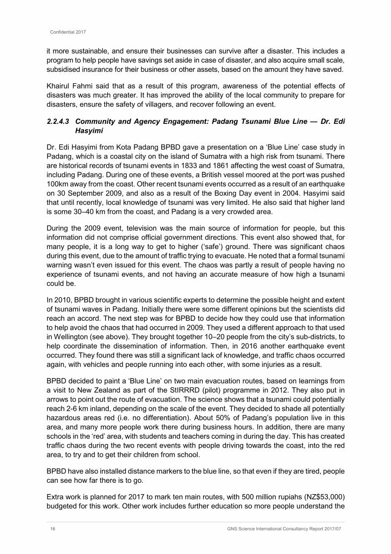
Figure 2.9 Speakers at Plenary Session 4, L–R: Iain Dawe, Khairul Fahmi and Edi Hasyimi. (photo credit: Phil Glassey) ....................................................................................................... 17
Figure 2.10 Spectrum of public participation (Original Source: International Association of Public Participation) .................................................................................................................. 19
Figure 2.11 Speakers at Plenary Session 5, L–R: Hepi Rahmawati, Wendy Saunders, Esti Anantasari. (photo credit: Phil Glassey) ............................................................................................ 20
Figure 2.12 Images from Wayan Sugita’s presentation, showing how natural hazards can affect land-use in Morowali (photo credit: Wayan Sugita). ............................................................... 22
Figure 2.13 New Zealand legislation with relevance to reducing risk from disasters (source: Wendy Saunders). ...................................................................................................................... 22
Figure 2.14 Opening slide from Dr. Agus Maryono's talk. (photo credit: Phil Glassey) ...................... 23 Figure 2.15 Poor waste management combined with water = water-related hazards. (Photo credit:
Michiel Zwijnenburg) ...................................................................................................... 24 Figure 2.16 Stylised images showing mangroves’ ability to reduce wave energy (top), and reduce
storm surge impact (bottom). (Source: Eko Pradjoko) .................................................... 26 Figure 2.17 Components of risk (source: GNS Science) ................................................................... 27 Figure 2.18 Important aspects of good community engagement as noted by workshop participants. 30 Figure 2.19 Weaknesses in Indonesian constriction sector and DRP activities to help strengthen these
weaknesses (source: Victor Rembath) ........................................................................... 31 Figure 2.20 Rumah bidai (bamboo house) under construction (photo credit: Ade Wahyuni) ............. 31 Figure 2.21 Slide from Dr. Yunus’ presentation showing the increase in budget between 2010 and
2017 (Source: Dr. Akris Fattah Yunus) ........................................................................... 35 Figure 3.1 Left: EWS site, Gemawang Village, on the outskirts of Yogyakarta. Right: 3D image of Mt.
Merapi, looking towards the north. ................................................................................. 38 Figure 3.2 View of part of the relocated village on the upper slopes of Mt. Merapi (photo credit:
Michael Goldsmith). ........................................................................................................ 39

Confidential 2017
GNS Science International Consultancy Report 2017/07 iii
Figure 3.3 Head of village (right, in orange shirt) answering questions about the process of village relocation (photo credit: Michael Goldsmith). ................................................................. 39
Figure 3.4 View of field trip participants at the ‘Lost World’ tourist attraction on the upper slopes of Mt. Merapi (photo credit: Michael Goldsmith). ................................................................ 40
Figure 4.1 Workshop participants at the Riskscape Workshop (left) and during small group discussions during the workshop (photo credits: Richard Woods). ................................ 42
Figure 5.1 One of the StIRRRD Team debrief sessions (photo credit: Michele Daly)...................... 45 Figure 6.1 Pressing issues identified for discussion at the 9th AGG meeting (source: UGM &
GNS). ............................................................................................................................. 46 Figure 6.2 Participants at the ALGG meeting, held on February 17, 2017, UC Hotel Yogyakarta. .. 48
APPENDICES
SEMINAR PROGRAM .............................................................. 53
DELEGATES ............................................................................ 55
FIELDTRIP OUTLINE AND GUIDE .......................................... 62
RISKSCAPE WORKSHOP PROGRAM AND DETAILS ........... 71
APPENDIX FIGURES
Figure A3.1 Peta Daerah Rawan Bencana Lahar Gunung Merapi .................................................... 62 Figure A3.2 Lokasi sistem pemantauan banjir lahar Merapi .............................................................. 63 Figure A3.3 Contoh data pengamatan ketinggian muka air sungai (AWLR) di pos Gemawang. ....... 63 Figure A3.4 Contoh data CCTV di pos Gemawang. .......................................................................... 64 Figure A3.5 Citra Google Earth Huntap Pagerjurang Tahun 2006 (a), 2011 (b), 2012 (c) dan 2013 (d).
Sumber: Google Earth, 2016 .......................................................................................... 66 Figure A3.6 Perbandingan antara Kenampakan Model Rumah Standar (a) dan Model rumah yang
Telah Dimodifikasi (b) ..................................................................................................... 66 Figure A3.7 Fasilitas Gedung Serba Guna dan Papan Petunjuk Jalur Evakuasi yang Telah Disediakan
oleh Pemerintah ............................................................................................................. 67 Figure A3.8 Peta Administrasi dan Sebaran Usaha Mikro, Kecil, dan Menengah (UMKM) di Huntap
Pagerjurang .................................................................................................................... 68 Figure A3.1 Bangunan The Lost World Castle ................................................................................... 69 Figure A3.2 Lokasi The Lost World Castle di Kawasan KRB III Gunung Merapi. .............................. 70

Confidential 2017
iv GNS Science International Consultancy Report 2017/07
EXECUTIVE SUMMARY
The StIRRRD (Strengthened Indonesian Resilience: Reducing Risk from Disasters) Mid-Term Disaster Risk Reduction Seminar was held at Universitas Gadjah Mada (UGM) in Yogyakarta, Indonesia in February 2017, with approximately 175 participants. The event was well supported by central government, and speakers from national agencies such as BNPB (National Disaster Management Agency), Bappenas (Ministry of National Development Planning) and Kemendesa (Ministry of Villages, Development of Underdeveloped Regions and Transmigration) provided the national context and links to their respective work programs as well as the Sendai Framework.
The number of Indonesian speakers from StIRRRD districts and universities was a highlight of the seminar program, and demonstrated the additional capacity that is developing amongst the agencies involved in the program. Many delegates were from non-StIRRRD districts, and the seminar provided an ideal opportunity for them to learn and consider how they might implement additional DRR actions in their local communities.
The seminar provided an opportunity for a range of disaster risk reduction (DRR) groups and agencies to come together to re-affirm their commitment to reducing risk from disasters, to evaluate the progress made by districts involved in the StIRRRD program, and to determine future work to be undertaken. Enabling additional peer support amongst these groups was a critical objective of the workshop.
Rather than simply having a technical focus (e.g. natural hazard assessment and physical mitigation works), the seminar provided an opportunity to discuss a broad range of other risk reduction themes. These included topics such as vulnerability, community engagement, gender and disability issues, environmental management and land use planning.
The seminar also provided an opportunity for four of the eight districts within the program to share their experiences of implementing their StIRRRD Action Plans, and to discuss the range of issues they face (such as staff turnover, and budget restraints).
There were a number of other activities included within, or subsequent to, the seminar program. These included a useful field trip upslope from Yogyakarta towards Mt. Merapi and return; a workshop on the RiskScape software; and meetings of the Activity Governance Group (AGG – comprising central government, MFAT, UGM and GNS Science representatives) and the Activity Local Government Group (ALGG – which promotes networking, sharing ideas and peer-learning between the StIRRRD districts).
The Seminar has provided important DRR resource material for the districts. Analysis of discussions held during sessions and also in associated meetings has provided learnings for the StIRRRD Activity, both in terms of future seminar organisation and for the Activity in general.

Confidential 2017
GNS Science International Consultancy Report 2017/07 1
1.0 INTRODUCTION
A Disaster Risk Reduction Seminar was held at Universitas Gadjah Mada (UGM) in Yogyakarta, Indonesia, from 14–17 February 2017, as part of the StIRRRD (Strengthened Indonesian Resilience: Reducing Risk from Disasters) program. The StIRRRD program commenced in 2014 and is intended to run for 5 years with funding from the New Zealand Aid Programme. UGM and GNS Science have partnered to implement the program. The program supports the Indonesian Government to reduce the impacts of natural disasters through increasing the disaster risk reduction (DRR) capability of local government and local universities. The program assists selected districts and their universities to understand their DRR issues and priorities, helps develop their capability to understand and capacity to manage these issues, and then to develop an action plan and implementation programme. More detail can be found on the StIRRRD website (https://stirrrd.org/).
This national seminar was held in the Senate Hall of UGM, and was officially opened by the Head of BNPB (National Disaster Management Agency), Willem Rampangilei. Other key speakers at the opening ceremony included:
• Dr. Trevor Matheson, New Zealand Ambassador to Indonesia; • Dr. Suprayoga Hadi, Director General for the Development of Specific Areas –
Kemendesa (Ministry of Villages, Development of Underdeveloped Regions and Transmigration);
• Prof. Dwikorita Karnawati, Rector of the University of Gadjah Mada.
1.1 PURPOSE AND OBJECTIVES
A key part of the StIRRRD program is to build relationships and increase cooperation between the various groups who are tasked with reducing risk from disasters - including central and local government agencies, UGM and local universities, as well as the private sector and non-governmental or Not for Profit organisations (NGOs). The 4-day seminar provided an opportunity, mid-way through the StIRRRD program, for these groups to come together to re-affirm their commitment to reducing risk from disasters, to evaluate the progress made by districts involved in the program, and to determine future work to be undertaken. It was also an opportunity for different groups to provide peer support to each other on the journey towards a more resilient and sustainable community.
The objectives of the risk reduction seminar were:
1. Provide an overview of progress made and lessons learnt, as part of the StIRRRD program.
2. Confirm the context within which DRR occurs in Indonesia, including the Sendai Framework, and modern risk reduction, disaster preparedness and management practices.
3. Review, discuss, and plan for further work to be undertaken as part of the district DRR Action Plans.
4. Facilitate peer support and peer learning amongst national agencies, districts, NGO’s and universities.

Confidential 2017
2 GNS Science International Consultancy Report 2017/07
1.2 OVERVIEW OF PROGRAM
The Risk Reduction Seminar program included presentations in a number of plenary and technical sessions, as well as a forum for reviewing the district level Action Plans. Opportunities for questions and discussion were provided throughout the seminar. Other components included a field trip and a workshop on the RiskScape risk modelling tool.
Presenters were from both Indonesia and New Zealand, and included local and central government staff, risk reduction experts from GNS Science and Greater Wellington Regional Council, universities, NGOs and the private sector. Several of the sessions were designed to be interactive, with a mix of presentations and group discussions. A number of separate meetings were also held, as discussed in later sections.
Two significant highlights of the program were:
• the number of Indonesian local speakers from StIRRRD districts and universities. Capacity has grown in the districts to an extent that a range of DRR topics and experiences can be sourced locally. This is beneficial for the peer support network StIRRRD aims to create;
• the breadth of topics covered. A more conventional approach to risk reduction often focuses on hazard information (e.g. technical information about tsunamis and earthquakes) and physical approaches to mitigating risk (e.g. engineering solutions). This seminar included topics on vulnerability, community engagement, gender and disability issues, environmental management and land use planning. This breadth was embraced by workshop participants.
Each session is described in further detail in section 2 and the overall programme outline can be found in Appendix 1.
1.3 ATTENDANCE
The seminar was attended by approximately 175 participants (Figure 1.1), including:
• 11 staff from central government agencies including BNPB (National Disaster Management Agency), Kemendesa (Ministry of Villages, Development of Underdeveloped Regions and Transmigration) and Bappenas (Ministry of National Development Planning).
• 36 staff from the various districts, municipalities and provinces which have been involved in the StIRRRD program (including staff from BPBD (local disaster management agency) and other OPD1 agencies).
• 22 staff representing districts, municipalities and provinces which are not currently engaged in the program.
• 17 DRR experts from GNS Science, UGM, Wellington Regional Council, and the Netherlands (StIRRRD staff in Figure 1.1).
1 OPD is an abbreviation for Organisasi Perangkat Daerah (English translation: Organisation of Regional Devices). These are Regional Work Units at the local government level in Indonesia. Prior to December 2016, these agencies were referred to as SKPD (Satuan Kerja Perangkat Daerah – English translation: Regional Device Work Unit).

Confidential 2017
GNS Science International Consultancy Report 2017/07 3
• 25 university staff, including researchers from Andalas University (West Sumatra), University of Bengkulu (Bengkulu), Tadulako University (Sulawesi) and the University of Mataram (NTB).
Delegates from the local governments included Head of District BPBDs, Planning Department (Bappeda), Spatial Planning, District Secretary, and the Head of Parliament from Agam, Pesisir Selatan, Sumbawa, Mataram, Seluma, Donggala and Morowali districts. Two NGOs were represented, along with a large number of university students. The students were from a mix of graduate and undergraduate programs2. Most of the graduate students are also working as national or district government staff within various OPDs such as Public Works (PU), Bappeda, or as lecturers at other universities. A full list of participants can be found in Appendix 2.
Figure 1.1 A breakdown of the delegates to the Disaster Risk Reduction seminar.
Practitioners in the disaster risk reduction field are traditionally male. This applies to both developed and developing countries. The StIRRRD Activity has a focus on lifting female participation in DRR across the districts and in general at its training and district workshop sessions. To date (end December 2016) the achievement has been 19% against a stretch target of 33%. The Mid-Term Seminar achieved an improved 26% female attendance (45 out of 169 attendees were female) (Figure 1.2). Another highlight from the seminar was the number of women who not only attended, but who also presented on a wide range of topics. Of the 6 female presenters (out of 38; 16%), 4 were Indonesian. Four of the female presenters, presented or facilitated multiple times. It was heartening to see an emerging, albeit small, group of Indonesian women having the confidence to speak and lead discussions in a traditionally male dominated sector.
2 including Master of Engineering on Natural Disaster Management, Master of Disaster Management, Geological Engineering, and Civil and Environmental Engineering

Confidential 2017
4 GNS Science International Consultancy Report 2017/07
Figure 1.2 The proportion of male and female attendees at the Disaster Risk Reduction Seminar, including those who gave presentations or led discussions.
Confidential 2017
GNS Science International Consultancy Report 2017/07 5
2.0 SEMINAR CONTENT
This section provides summaries of the various components of the seminar, including the keynote addresses, and plenary, technical and workshop sessions. A copy of the seminar proceedings can be found on the StIRRRD website3. Attendees were also provided with a printed copy of the presentations as a handout. Soft copies of the presentations in PDF format can be made available on request.
2.1 OPENING SESSION — KEY MESSAGES
The Opening Ceremony included keynote addresses from the Rector of UGM (Prof. Dwikorita Karnawati), the New Zealand Ambassador to Indonesia (H.E. Dr. Trevor Matheson), the Head of BNPB (Willem Rampangilei), and the Director General for the Development of Special Regions, Kemendesa, (Dr. Suprayoga Hadi, M.S.P.).
2.1.1 Prof. Dwikorita Karnawati, Rector of UGM
Prof. Karnawati’s presentation began by stressing that DRR is an integral part of UGM’s mission — to help people through knowledge creation, and to promote ‘humanitarian values’. She noted that Indonesia is still primarily an agricultural country with 82,000 villages, 17,000 islands, and more than 500 districts (including cities) in the country. However, the percentage of people living in rural areas has decreased from 85% in 1960 to 46% in 2015.
There are many older people who live in villages, and many widows, with few adolescents. Therefore, the population of many villages is more vulnerable. Poverty rates are roughly twice that of cities than in villages. Prof. Karnawati suggested that this vulnerability, and the gap between villages and cities could be addressed by creating ‘smart and resilient villages’ through improvements to human resources and disaster related research.
UGM has had a partnership with NZ through StIRRRD (including its precursor pilot program) since 2012. Prof. Karnawati emphasised that this program was not just about DRR, but also about increasing the productivity of villages — so that “life there feels more like life in a city”. Villagers need to realise they can do business and be productive in a village. Online businesses should be an option, and young people should not lack access to technology if they live in villages.
The vision outlined by Prof. Karnawati was that DRR programs (such as StIRRRD) will help lead to smart resilient villages, including allowing local industry to be more productive. DRR needs to be better integrated with industry to reduce the current reliance on central and local government. This will help regional development and result in less population drift to the cities.
2.1.2 H.E. Dr. Trevor Matheson, NZ Ambassador to Indonesia
Dr. Matheson explained that New Zealand works closely with the Government of Indonesia to support government efforts at both the national and district levels. Indonesia’s rapid growth and development means the focus needs to shift away from aid to developing strategic opportunities. Both countries have
agreed that they will work together to encourage development in the following sectors:
3 https://stirrrd.org/technical-training/mid-term-drr-seminar-2017/

Confidential 2017
6 GNS Science International Consultancy Report 2017/07
1. Renewable Energy
2. Agriculture
3. Disaster Risk Reduction
4. Knowledge and Skills.
Dr. Matheson then explained the methods used to enable improvements in these sectors, particularly in the disadvantaged areas of Indonesia. The key components of this are:
1. Targeting work to areas where New Zealand has existing historical networks, and providing scholarships / training to selected candidates.
2. Working in partnership with a range of stakeholders, including Government to Government, Donor to Donor e.g. Unicef, World Bank, and with regional agencies e.g. the AHA Centre.
3. Working within the local context.
4. Facilitating access to technical assistance — exchange of knowledge.
The StIRRRD program is a 5-year activity that brings GNS Science and UGM together to help Indonesia be better prepared for, and reduce the impacts from disasters. This activity is helping the New Zealand government meet its obligations to assist Indonesia to reduce its risk. It is a far-reaching activity, focussing in 10 districts across 4 provinces and reaching a total of 3.75 million people.
Other support provided by New Zealand includes contributing to the Natural Disaster Response Framework, tertiary scholarships, access to short-term training on resilience, and better warehousing for the Indonesian Red Cross.
2.1.3 Willem Rampangilei, Head of National Disaster Management Agency (BNPB)
Minister Rampangilei began his keynote address by stressing that in many cases, the consequences of natural hazards have, and will continue to become worse. For example, he noted that rainfall intensities are increasing in some areas – i.e. it is becoming more common to get the same amount of rainfall, but in a shorter time. He also highlighted that DRR is ‘common business’, and that central and local government, universities and communities need to increasingly work together to reduce risk. He said that BNPB is working to
obtain ISO accreditation for their relationship with UGM.
Other key points made by the Head of BNPB were:
1. That it is becoming increasingly hard to manage the donations and work undertaken by NGOs and other private contributors, but that this should be a priority as “collaboration between all parties makes us stronger”.
2. That he considers Indonesia, because of its natural characteristics, has become a centre of disaster and DRR research for the world. However, he believes that there is a need to develop the disaster industry further, to improve technology and create jobs.
3. Previously, if governments spent money on DRR, they only saw that as an expense. This is changing, so that politicians now see that this activity will lead to economic growth — i.e. that money spent on DRR is an investment.
4. That Law #27 (2007) was drafted after the Aceh tsunami in 2004, and that BNPB was established soon after, in 2008.

Confidential 2017
GNS Science International Consultancy Report 2017/07 7
2.1.4 Dr. Suprayoga Hadi, Director General for the Development of Special Region, Ministry of Village, Disadvantaged Region, and Transmigration (Kemendesa)
Dr. Hadi stressed that in Indonesia, one of the main issues was accessibility — disasters in remote areas are difficult to respond to. He also highlighted that DRR should be seen as a form of investment (not expenditure), but that there is a long way to go before everyone sees this investment as important.
Dr. Hadi identified 3 things which should be seen as critical to improving DRR in Indonesia:
1. Regulations: these are needed at the local level to really drive risk reduction measures, particularly in rural and remote areas.
2. Institutions: building strength at all levels is important, as this will help to reduce reliance on donors post-disaster, as these can only provide a short-term fix to problems.
3. Investment: it is important to show that investment in risk reduction can also have other benefits — e.g. a well-designed seawall can also be a tourist destination.
He encouraged local government to be more proactive in utilising village funds for DRR. There is a 1–2 billion rupiah (NZ$107,000–214,000) sum per village which can be applied to a variety of different activities, including DRR. Dr. Hadi stressed that local government’s assertion that there is a shortage of funds for DRR locally is no longer a valid claim. The government has appointed village facilitators in about 2,000 villages to date (out of 74,910). These facilitators should be seen as ‘agents of development’ and are able to facilitate the provision of DRR. The goal is that in the future, BNPB won’t have to deploy their own staff, but rather response and risk reduction activities will be undertaken by local people, underpinning the concept that “the origin or foundation is the village”.
He went on to explain Kemendesa’s focus in its work programmes. Kemendesa is aligning itself with StIRRRD and has fed directly into StIRRRD outcomes. The StIRRRD approach now needs to make its way into the villages and Dr. Hadi encouraged local government and the StIRRRD program to work together to make this happen.
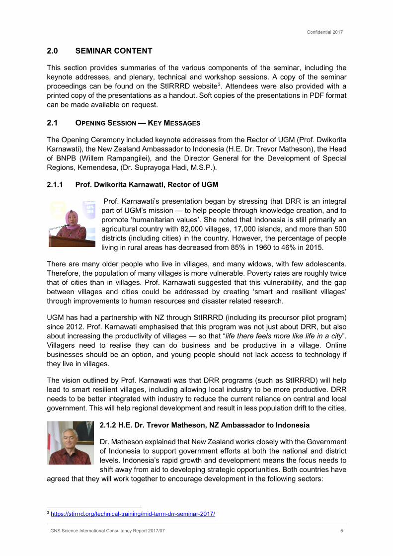
Figure 2.1 H.E. Trevor Matheson speaking at the Opening Session in the Great Hall at Universitas Gadjah Mada. (photo credit: Michele Daly)
Confidential 2017
8 GNS Science International Consultancy Report 2017/07
2.2 PLENARY SESSIONS
Seven plenary sessions were held during the seminar. A summary of the key points made by each speaker is listed below, along with the discussion which followed the presentations in each session.
2.2.1 Plenary Session 1 — DRR Benefits and Practice
2.2.1.1 StIRRRD Lessons Overview — Dr. Teuku Faisal Fathani
Director of the StIRRRD program, Dr. Fathani, provided an overview of the lessons learnt to date. The program is intended to help districts develop their own Action Plans to reduce the potential risks from disasters, rather than waiting to respond after a disaster occurs. It comprises work in 10 districts / cities. StIRRRD initially visited each district, assessed their needs, and worked with each district to support them to develop a DRR Action Plan. This was followed by a study visit to NZ for selected staff from each district to explore, in a mutual learning environment, a range of risk reduction strategies. Subsequent work by the StIRRRD team includes helping with action plan implementation, mentoring and evaluation. Four MOUs between the Provinces and local Universities and UGM have been signed and will form the basis of ongoing work once the program formally finishes. A number of specialist trainings have also been provided including base isolation and risk modelling. This is the 4th StIRRRD DRR seminar, hosted by UGM in Yogyakarta.
2.2.1.2 Indonesia Disaster Risk Index and the Sendai Framework — Lilik Kurniawan, S.T., M.Si.
BNPB Director of Disaster Risk Reduction, Lilik Kurniawan, talked of the consequences of climate change and that it will likely mean more disasters, and more people living in poverty. He re-iterated that Indonesia is an archipelago country, and therefore different to continental countries. He stated that Indonesia requires ‘good’ development — i.e. development is needed, but it needs to occur in a way that does not expose more people to risk from disasters. He gave the example of new children born to parents who live in disaster-prone areas. The subsequent increase in population (and particularly an increase in the proportion of vulnerable people in that population) will likely increase the risk in that area, and it may be difficult to encourage people to move to areas which have less risk.
Kurniawan also noted that not only does Indonesia lie on the Pacific ‘Ring of Fire’, it lies at the junction of 3 tectonic plates (Pacific, Eurasia and Indo/Australia), and that therefore the potential for disasters is particularly high.
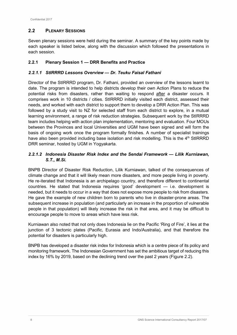
BNPB has developed a disaster risk index for Indonesia which is a centre piece of its policy and monitoring framework. The Indonesian Government has set the ambitious target of reducing this index by 16% by 2019, based on the declining trend over the past 2 years (Figure 2.2).
Confidential 2017
GNS Science International Consultancy Report 2017/07 9
Figure 2.2 A slide from Lilik Kurniawan’s presentation which explains in part the risk reduction index for Indonesia and current downward trend in the total risk. The goal is a 16% reduction in risk by 2019 (source: BNPB).
Kurniawan reinforced the importance of StIRRRD working at building capacity at the local government level and the improving access to early warning systems (such as UGM’s landslide early warning system). These activities help to reduce Indonesia’s disaster risk. He reminded the audience of BPBD’s important coordination function in planning for DRR in their districts.
2.2.1.3 DRR-based National Development Planning — Dr. Sumedi Andono Mulyo
Dr. Mulyo is the Director of Disadvantaged Regions, Transmigration and Rural Affairs at Bappenas (Ministry of National Development Planning). He began his keynote address by stating that disasters have a negative impact on development, and noting that a key contributing factor of disaster is poverty. He asked the question “how can DRR help poor people who live on agricultural land?” He said that enforcement is becoming increasingly important and required — in particular to prevent houses being built in vulnerable areas. He said that the first people to be affected are often the poor, and that if we can reduce disaster risk, then we can alleviate poverty.
Improved technical engineering was a key method for reducing risk from disasters. For example, improving the conveyance of floodwater and alleviating drainage issues on floodplains would allow more people to live and use these valuable areas. He also noted that any increase in population of areas should be in good and ‘stable’ areas (i.e. those less prone to disasters), and that high-risk areas should be avoided. More accurate maps are needed to inform land-use planning, and help to better understand risk.
Dr. Mulyo questioned the current capacity of regional government to include disaster risk management (DRM) in development planning. A community based approach was needed across all phases (reduction, preparedness, response and recovery). The success and speed of rehabilitation after a disaster, for example, was determined by the social capital of the community affected. Mainstreaming disaster risk and knowledge should become the foundation for budgeting and priority setting.
Confidential 2017
10 GNS Science International Consultancy Report 2017/07
2.2.1.4 DRR-based Spatial Planning in Indonesia — Dr. Emil Elestianto Dardak
Dr. Emil Elstianto Dardak has been the Head of Trenggalek District since 2015. He is currently the Deputy Chair of the Indonesian Local Government Association (APKASI). His keynote addressed the integration of disaster risk mitigation into the strategic development policy of this district. Trenggalek has a geological and topographical profile that increases the district’s exposure to hazard, particularly landslides. Landslides often block the main road that connects Surabaya and Malang to Surakarta.
As the district is projected to play a prominent role in the economic growth of the southern area that connects Yogyakarta-Prigi-Blitar-Malang (National Strategic Development Area), it is highly necessary for Trenggalek to take fundamental steps to ensure that the development will not be hindered by the existing hazards. Therefore, the government of Trenggalek District plans to integrate landslide and soil movement mitigation efforts into the revision of Medium-Term Development Plan (RPJMD) and the re-assessment of Urban Planning Rencana Tata Ruang Wilayah (RTRW).
The revision of the RPJMD will increase the resilience of vital infrastructure from hazard risk, encourage a more suitable economic basis for long term development planning and manage the transition in revising land use. The reassessment of the RTRW ensures the spatial development is compatible with the geographic and topographic conditions in Trenggalek. These two instuments realise the integration of soil movement and landslide risk mitigation efforts into an integrated development strategy that takes a multi sectoral approach to hazard risk mitigation.
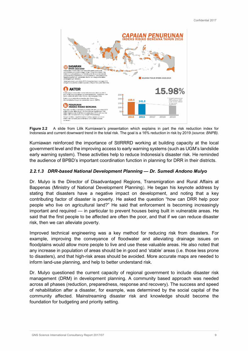
To further give effect to a multi-sectoral approach, the Rector of UGM and the Head of Trenggalek District signed an MOU on Disaster Risk Reduction during the opening ceremony of the Mid-Term Workshop, which was witnessed by the Head of BNPB and the New Zealand Ambassador to Indonesia (Figure 2.3).
Figure 2.3 MoU signing between the Rector of UGM and Bupati Trenggalek witnessed by the Head of BNPB and the NZ Ambassador to Indonesia (photo credit: Phil Glassey)

Confidential 2017
GNS Science International Consultancy Report 2017/07 11
2.2.1.5 Discussion and Questions
Discussion centred around practical steps that could be taken to address poverty (specifically those living in marginal areas) and how to improve the effectiveness of regional budgets and regulations. Issues raised in relation to regulations included they were not sustainable and often conflicting. Regional budgets were perceived to be inflexible, hard to access and DRM wasn’t prioritised. Districts expressed frustration at the different authorities between local government departments (OPD) (i.e. BPBD, Bappeda, Health etc.) and the impact this had on the ability to budget effectively.
Speakers spoke of the need for a ‘one map policy’ for planning which built the links between different functional units as well as levels of government as one way to achieve a common understanding of risk in each district. The investment needs of the district could be mapped and compared to the risk map (or index). Mapping development with and without risk reduction measures (such as avoidance in marginal areas) could be done to assess the potential losses. It was suggested that rather than wait for regional budgets to be determined, existing budgets could be mainstreamed (integrated).
In relation to poverty, it is important to design transition programs to move people out of marginal areas or change the land use. It takes time to move, for example, from agriculture to forestry. Assistance packages may need to be provided for people while this occurs. Better enforcement of the existing regulations is needed and the community itself needs to become a better watchdog.
2.2.2 Plenary Session 2 — District DRR Forums
2.2.2.1 Disaster Risk Reduction Coordination in New Zealand — Richard Woods
A key component of Action Plans in all StIRRRD districts is the establishment of a DRR Forum. To highlight the importance of these forums, Richard Woods from GNS Science provided a presentation on DRR coordination in New Zealand. The presentation discussed the existing DRR legislative framework in New Zealand while making synergies with both national and local DRR regulations in Indonesia. A significant objective of this session was to highlight the importance of multi-stakeholder coordination and integration across sectors to address DRR interdependencies.
The presentation described how New Zealand’s emergency management structure provides a platform for delivering DRR activities across all sectors and levels of government. How this structure is supported by an integrated planning framework was also discussed. Finally, the presentation described the legislated governance structures in New Zealand and noted how both local government and private sector lifeline utility companies are required to coordinate DRR activities.
2.2.2.2 What does a DRR Forum look like in an Indonesian District? — Bambang Warsito
Bambang Warsito from Agam BPBD gave a presentation on how his district has successfully established a functioning DRR Forum as a result of the StIRRRD programme. Initially, Warsito provided an overview of Agam Regency and its respective sub-districts for context. He then described the legislative platforms for which the Agam DRR Forum is founded. These included the National Law no. 24/2007, associated government regulations and the Agam regency regulations that came into effect in 2010 (No.1) and 2016 (No. 2).

Confidential 2017
12 GNS Science International Consultancy Report 2017/07
Warsito noted that the Disaster Risk Reduction Forum (F-PRB Agam) was formed as a vehicle to integrate various initiatives so as to build synergies of cooperation between various parties (government, civil society and private sector) in DRR efforts and increase the resilience of Agam Regency. The Forum comprises representatives from local government, local universities, NGOs and the professional group of Indonesian Red Cross amongst others, and functions across three key areas; coordination, advocacy and advisory.
Warsito went into some detail to describe the areas of focus for the Agam Forum (Forum action plan; films and documentaries; working meetings to assist with regulations), and identified multi-stakeholder coordination with a particular emphasis on OPD engagement as being fundamental.
Figure 2.4 A slide from Bambang Warsito’s presentation showing the function of the DRR Forum in Agam (source: Bambang Warsito)
2.2.2.3 Discussion and Questions
Discussion centred around the membership of the forums, their cost to run and their ability to go beyond being just a ‘discussion’ forum. Some districts had provincial level forums but none at the local level, which was deemed a disadvantage. Giving the forums more power, or a statutory role as in New Zealand, was suggested as a way to make them more effective. It was suggested that the head of the district should be invited (not just the head of the legislature). Forum members should fund their own attendance rather than relying on receiving funding from the forum itself.
Warsito noted in response that their DRR Forum has had a positive impact on BPBD and a greater range of activities was being undertaken than previously. Cooperation amongst OPD and DRR awareness had increased.
Confidential 2017
GNS Science International Consultancy Report 2017/07 13
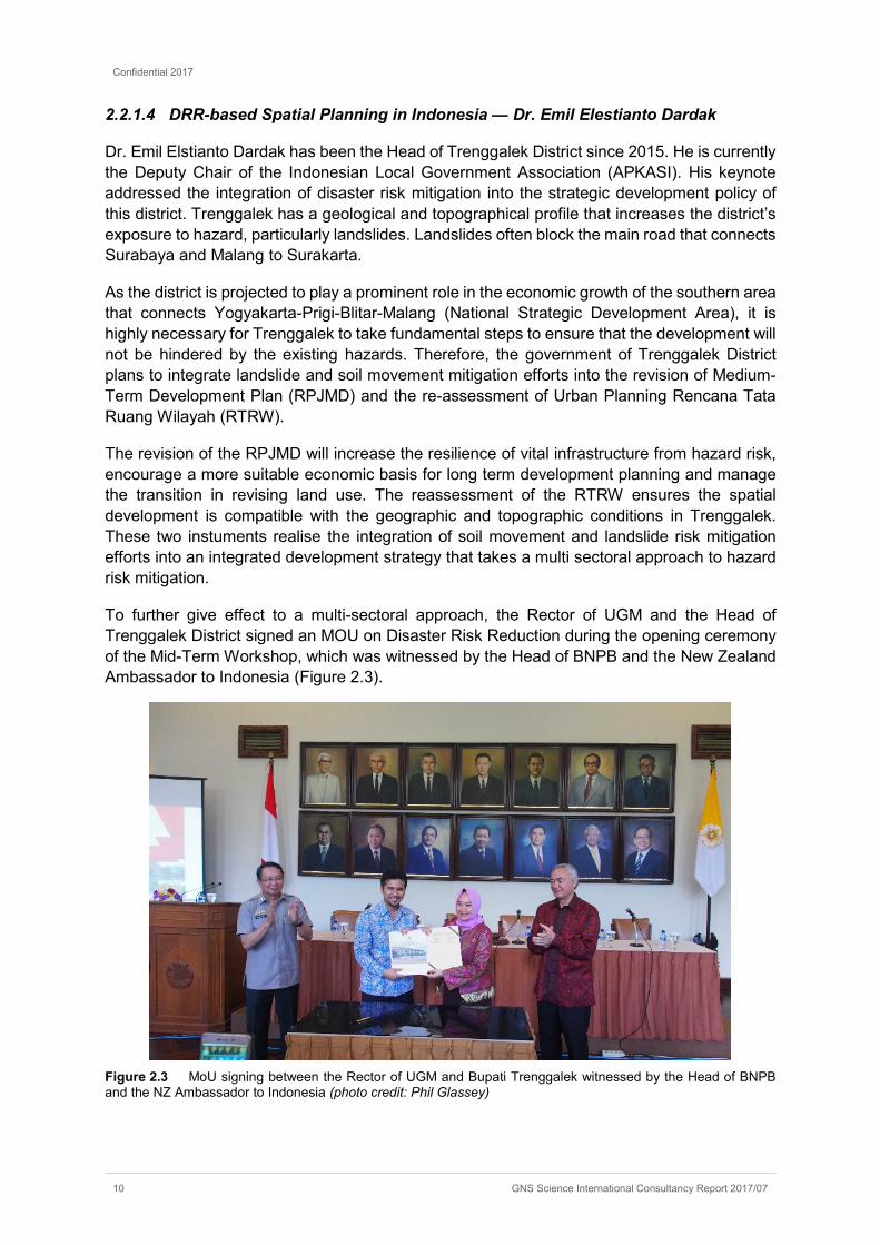
Figure 2.5 Seminar participants during Plenary Session 2 (photo credit: Avantio Pramaditya).
2.2.3 Plenary Session 3 — Kaikoura/ Aceh Earthquakes
2.2.3.1 M7.8 Kaikoura Earthquake, 14 November 2016
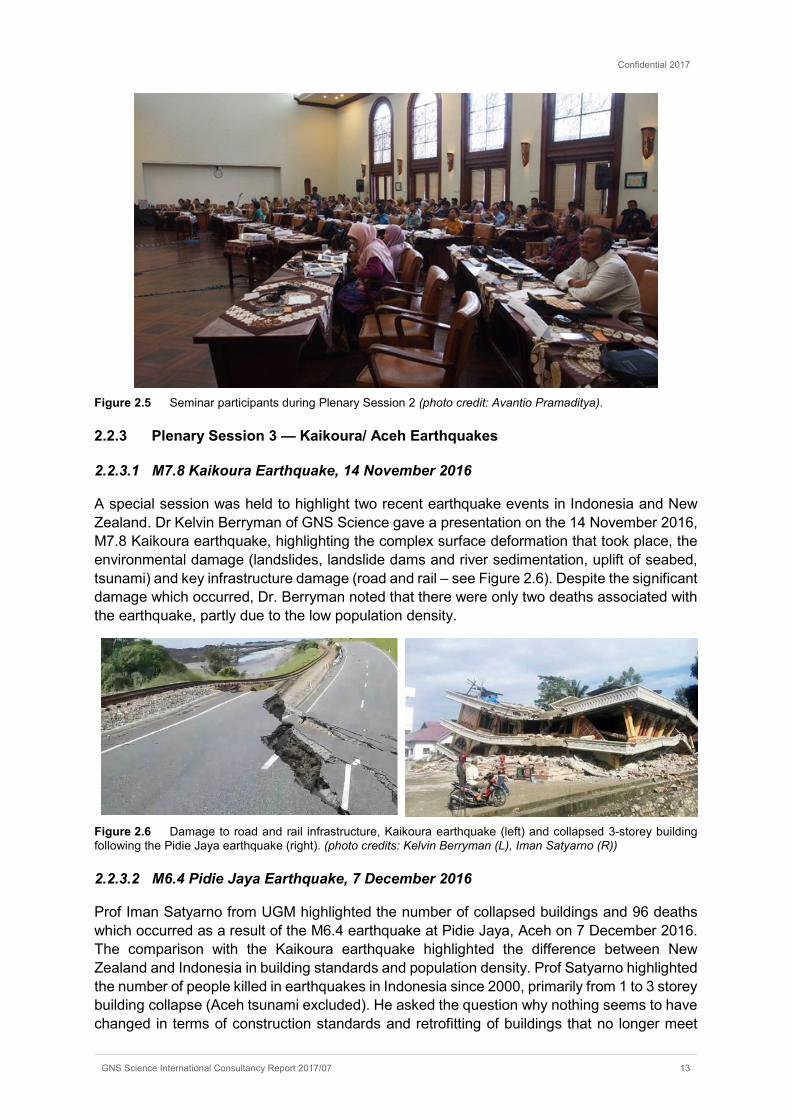
A special session was held to highlight two recent earthquake events in Indonesia and New Zealand. Dr Kelvin Berryman of GNS Science gave a presentation on the 14 November 2016, M7.8 Kaikoura earthquake, highlighting the complex surface deformation that took place, the environmental damage (landslides, landslide dams and river sedimentation, uplift of seabed, tsunami) and key infrastructure damage (road and rail – see Figure 2.6). Despite the significant damage which occurred, Dr. Berryman noted that there were only two deaths associated with the earthquake, partly due to the low population density.
Figure 2.6 Damage to road and rail infrastructure, Kaikoura earthquake (left) and collapsed 3-storey building following the Pidie Jaya earthquake (right). (photo credits: Kelvin Berryman (L), Iman Satyarno (R))
2.2.3.2 M6.4 Pidie Jaya Earthquake, 7 December 2016
Prof Iman Satyarno from UGM highlighted the number of collapsed buildings and 96 deaths which occurred as a result of the M6.4 earthquake at Pidie Jaya, Aceh on 7 December 2016. The comparison with the Kaikoura earthquake highlighted the difference between New Zealand and Indonesia in building standards and population density. Prof Satyarno highlighted the number of people killed in earthquakes in Indonesia since 2000, primarily from 1 to 3 storey building collapse (Aceh tsunami excluded). He asked the question why nothing seems to have changed in terms of construction standards and retrofitting of buildings that no longer meet

Confidential 2017
14 GNS Science International Consultancy Report 2017/07
updated seismic codes. He highlighted a number of available documents outlining best construction practice for non-engineered buildings.
2.2.3.3 Discussion and Questions
The general consensus from the discussion was that Indonesia still has some way to go to reduce the risk from earthquakes in the context of the built environment in particular. Specific concerns raised included:
• The lack of requirement to evaluate large buildings against the new code — many won’t meet the new standards;
• The lack of building evaluation in general;
• The scale of the earthquake hazard map, which is very high level (lack of granularity). As new faults are identified, soon most of Indonesia will fall into a high hazard zone;
• The lack of guidelines for use of buildings such as vertical evacuation shelters, which should be designed to a higher earthquake standard due to their intended use as shelters. The FEMA standard is used in the absence of Indonesia-specific guidelines.
Figure 2.7 Speakers at Plenary Session 2 and 3, L-R: Richard Woods, Bambang Warsito, Kelvin Beryman and Iman Satyarno (photo credit: Avantio Pramaditya)
2.2.4 Plenary Session 4 — Community Engagement and Education
2.2.4.1 Community Engagement and Natural Hazards; Blue Line project, Wellington New Zealand — Iain Dawe
Iain Dawe from the Greater Wellington Regional Council spoke about the Tsunami Blue Line project, which originated in the suburb of Island Bay in Wellington, New Zealand. Following some new research on tsunami hazard, the council developed tsunami evacuation maps for affected areas in Wellington. The short warning time for tsunami generated in these areas meant that a coordinated evacuation would not be possible. As a result, people living in potentially affected areas would need to self-evacuate to safe areas, based on natural warnings such as a long and strong earthquake.
The council undertook a survey to see how well people in the suburb of Island Bay understood their hazards and risks. This showed that, overall, the community was not as aware as it should be, and there was some misunderstanding about tsunami hazard. Many people were not sure if they lived or worked in an evacuation area or not. The council then arranged talks with the community regarding the risk from tsunami, to help understand their concerns. A group was formed and met regularly to discuss this hazard and generate ideas to better convey

Confidential 2017
GNS Science International Consultancy Report 2017/07 15
information to the community. A ‘buddy system’ was initiated (e.g. know your neighbour, check they are ok, can evacuate etc.) and vulnerable groups identified. An information centre at the local school was also set up as a safe place to go, with water, food and information. The group also identified evacuation routes such as shortcuts and tracks that allowed people to get to higher ground quickly.
The group found that the community thought the tsunami maps were good, but that it was sometimes difficult to know where you are when on the ground. A local resident came up with the idea of painting a ‘blue line’ on the road, to clearly identify the boundary of the tsunami affected areas. The group talked to the council who gave it the go-ahead, and the first lines were created. The project generated huge interest in the community and media discussion. Later work involved arrows pointing to blue lines, and showing the distance to them.
Iain said that this program was a good way to engage with the local community, to understand what the local risks are, to identify safe routes and vulnerable groups, and to educate the community on hazards and risks. It helped to raise awareness through good education, and empowered the community to own their own problems.
Figure 2.8 Blue lines on Island Bay streets showing tsunami-safe zones. Source: Wellington City Council (L), Wellington Region Emergency Management (R). (photo credit: Wellington Emergency Management Office)
2.2.4.2 Community engagement, tsunami hazard, Agam — Khairul Fahmi
Khairul Fahmi began his presentation with a video of the coastal area in the district of Agam where the Jemari Sakato NGO is undertaking work with the local community. The area is low, close to the coast, with fishing the mainstay of the local economy. The program is based around helping people to have ‘disaster alert savings’ — money they can use if there is a disaster, and which will therefore make them better prepared.
An important part of the program is helping to ensure the sustainability of businesses following a disaster, so that people can support themselves and don’t have to rely on outside aid. In one village, it was identified that a 360-hectare area of land currently used as a rice field could be affected by tsunami, and therefore couldn’t be used to grow food following a major event. Jemari Sakato has worked with the community to plant extra land to create a food reserve. This means that following a tsunami disaster, people will still have their own supply of food available before they get assistance from outside. As a result, about 100 families in this village now have access to a ‘foodbank’, and it is hoped to have more.
The NGO has provided one year of assistance, education and information. This has helped develop the community’s capacity to be more resilient — to save lives, buildings and houses. Villagers can now see how their local economy can be affected, and have taken steps to make
Confidential 2017
16 GNS Science International Consultancy Report 2017/07
it more sustainable, and ensure their businesses can survive after a disaster. This includes a program to help people have savings set aside in case of disaster, and also acquire small scale, subsidised insurance for their business or other assets, based on the amount they have saved.
Khairul Fahmi said that as a result of this program, awareness of the potential effects of disasters was much greater. It has improved the ability of the local community to prepare for disasters, ensure the safety of villagers, and recover following an event.
2.2.4.3 Community and Agency Engagement: Padang Tsunami Blue Line — Dr. Edi Hasyimi
Dr. Edi Hasyimi from Kota Padang BPBD gave a presentation on a ‘Blue Line’ case study in Padang, which is a coastal city on the island of Sumatra with a high risk from tsunami. There are historical records of tsunami events in 1833 and 1861 affecting the west coast of Sumatra, including Padang. During one of these events, a British vessel moored at the port was pushed 100km away from the coast. Other recent tsunami events occurred as a result of an earthquake on 30 September 2009, and also as a result of the Boxing Day event in 2004. Hasyimi said that until recently, local knowledge of tsunami was very limited. He also said that higher land is some 30–40 km from the coast, and Padang is a very crowded area.
During the 2009 event, television was the main source of information for people, but this information did not comprise official government directions. This event also showed that, for many people, it is a long way to get to higher (‘safe’) ground. There was significant chaos during this event, due to the amount of traffic trying to evacuate. He noted that a formal tsunami warning wasn’t even issued for this event. The chaos was partly a result of people having no experience of tsunami events, and not having an accurate measure of how high a tsunami could be.
In 2010, BPBD brought in various scientific experts to determine the possible height and extent of tsunami waves in Padang. Initially there were some different opinions but the scientists did reach an accord. The next step was for BPBD to decide how they could use that information to help avoid the chaos that had occurred in 2009. They used a different approach to that used in Wellington (see above). They brought together 10–20 people from the city’s sub-districts, to help coordinate the dissemination of information. Then, in 2016 another earthquake event occurred. They found there was still a significant lack of knowledge, and traffic chaos occurred again, with vehicles and people running into each other, with some injuries as a result.
BPBD decided to paint a ‘Blue Line’ on two main evacuation routes, based on learnings from a visit to New Zealand as part of the StIRRRD (pilot) programme in 2012. They also put in arrows to point out the route of evacuation. The science shows that a tsunami could potentially reach 2-6 km inland, depending on the scale of the event. They decided to shade all potentially hazardous areas red (i.e. no differentiation). About 50% of Padang’s population live in this area, and many more people work there during business hours. In addition, there are many schools in the ‘red’ area, with students and teachers coming in during the day. This has created traffic chaos during the two recent events with people driving towards the coast, into the red area, to try and to get their children from school.
BPBD have also installed distance markers to the blue line, so that even if they are tired, people can see how far there is to go.
Extra work is planned for 2017 to mark ten main routes, with 500 million rupiahs (NZ$53,000) budgeted for this work. Other work includes further education so more people understand the
Confidential 2017
GNS Science International Consultancy Report 2017/07 17
extent of the safe zone, and this will be targeted to schools, as they are most vulnerable. BPBD also plan to disseminate official information by radio in the future, and will also add the ‘Blue Line’ on vertical illuminated signs as at night-time the line on the road is not visible.
Figure 2.9 Speakers at Plenary Session 4, L–R: Iain Dawe, Khairul Fahmi and Edi Hasyimi. (photo credit: Phil Glassey)
2.2.4.4 Discussion and Questions
There was quite a bit of discussion relating to the tsunami preparedness work undertaken in NZ and Padang.
There was clarification as to the technical information required in support of the Blue Lines. There needed to be synchronisation between the tsunami science (maximum run-up) and the ‘safe’ zones. The Blue Lines were noted as the ‘end-point’ for a maximum, or worst case, event.
While the Blue Line was a good option for many communities, it may not be the best option in every case. For example, in a highly urbanised environment such as Wellington City, with many high-rise buildings and lots of small narrow streets, vertical evacuation may be a better option than encouraging evacuation outside the area affected. In response to concerns about parents travelling into red zones to pick children up from school, Iain Dawe noted that the advice in New Zealand is for parents not to do that and rely on the plans that schools have to evacuate. All schools are required to have evacuation plans in place. This might be an issue that communities need to discuss. Schools need to be supported to enable them to evacuate or have access to vertical evacuation shelters, to enable parents to have enough confidence not to travel into the red zone to collect children.
Concerns were again expressed about the lack of monitoring and enforcement in Indonesia of building codes (for example for new and existing buildings used as vertical evacuation shelters; schools). People are cutting costs in construction. BPBD were encouraged to develop good partnerships with the media and ensure that the media had access to mandated information for the public to ensure consistent and accurate messaging.
Another important theme emerging from this session was the importance of local government working through NGOs that are active in their communities. The two groups should work together to achieve goals related to community development. NGOs can also help establish public-private sector partnerships, particularly around micro-insurance and savings schemes which are good risk transfer mechanisms.
Confidential 2017
18 GNS Science International Consultancy Report 2017/07
2.2.5 Plenary Session 5 — Vulnerable Groups
2.2.5.1 Disabilities — Hepi Rahmawati
Rahmawati from the YAKKUM Emergency Unit provided a succinct overview of the issues faced by people with disabilities, both during disaster events, and during the planning process for disasters in communities. She stated that the objective should be to protect the rights of people with disabilities, and to fulfil their medical and welfare needs so they can participate in the community. Disabilities may include problems with mobility, sight, hearing, and challenges with simply living in their environment.
Rahmawati said that people often consider that those with disabilities are not able to support themselves. The disabled often have a low level of confidence, and people sometimes consider that it gives them a bad reputation if a family member has a disability. As a result, the social interactions of people with disabilities are often limited — they are “hidden”, or not sent to school. There are also environmental constraints, such as access issues.
She said that during disasters, the disabled are vulnerable to being left behind during the evacuation process, as people feel they will slow them down. Therefore, people with disabilities (and their families) need alternative warning methods, so they can begin to evacuate quickly and efficiently. Another issue which affects DRR planning is that when lists of fatalities and injuries are compiled after disaster, they usually don’t list the types of disabilities, or the numbers within different categories.
Rahmawati outlined 3 key principles, which should be applied when planning for disasters:
1. Participation — disabled people should be able to participate in the DRR process so that others understand their issues when planning.
2. Accessibility — Consider how access routes can be used by those with disabilities, do they cater for the disabled?
3. Construction — post disaster reconstruction should help to empower those with disabilities.
Other suggestions included making maps of vulnerable groups — i.e. mapping the houses in the village where they live. Priority should be given to those houses (in terms of evacuation, and access). Rahmawati said she believes that if they are given training, people with disabilities can help themselves, and also be part of the prepared team in the community. She also added that it is important to note that disasters can result in more people with disabilities.
2.2.5.2 Women’s role in DRR — Esti Anantasari
Esti Anantasari from UGM also highlighted some characteristics of the role women play in DRR, based on work she has done with communities in the regency of Agam. She began by saying that there are different challenges for men and women. She said that some villages are led by women in Agam, and this part of the world is a matriarchal society whereby land is passed down from mother to daughter. Although the matriarch therefore has some influence and power, women overall are still deemed by men:
• to be ‘weak’,
• that they should only be responsible for the family,
• that they ‘can’t make a decision’,
• that they should rescue children during a disaster, and

Confidential 2017
GNS Science International Consultancy Report 2017/07 19
• that it is ‘God’s will’ when injuries and fatalities occur.
Anantasari said that women are often only involved in ‘after-event’ activity, not in the planning process. The majority of women are silent in Agam with regards to DRR activity — they are reluctant to speak up as they lack the confidence to do so. However, she said that women do play an important role in DRR, as they have the capacity to mobilise community, through their networks, and that they have their own way to express wishes. They are more meticulous, and have more concerns for the family. She said that a woman can be the leader, but require men’s support to do this. Women should be involved in decision making and not just in the provision of logistics. She said that a priority should be for men to allow their wives to mobilise the community. She encouraged the DPRD (parliament) to help facilitate budget for women’s DRR activities.
2.2.5.3 Value based community decision-making — Dr. Wendy Saunders
The main theme of Dr. Saunder’s presentation was that good-quality decision-making (in regards to DRR) should incorporate stakeholder values as well as the best available scientific evidence, and requires some critical thinking to be truly effective. Local wisdom should be an important part of the decision-making process — for example, records and photos of historical disasters. Wendy used the following graphic (Figure 2.10) to illustrate types of public participation that can occur.
Figure 2.10 Spectrum of public participation (Original Source: International Association of Public Participation)
Value-based decision-making is about building trust, making sure decisions are documented and transparent, and allowing the community to see their input incorporated and valued. It is about asking for the communities’ good judgement — to guide the process of decision–making. Dr. Saunders noted that people can often be too optimistic, or too fatalistic in their views, and this can contribute to how they respond to, and recover from an event. It is important for people to understand what it (a disaster) will mean for their lives.
When talking to communities, it is important to stress that although they can’t control the disaster, they can control the response and recovery. They need to understand what is the cost of planning for a disaster, and what are the implications for their recovery.
She explained different types of risk:
• Acceptable — ok, part of life,

Confidential 2017
20 GNS Science International Consultancy Report 2017/07
• Tolerable — awful, but can get through it,
• Intolerable — not alright for it to happen.
DRR policy and planning should link to this. For example, where existing risk is ‘tolerable’, it may simply be a matter of placing some minor restrictions on particular activities, or changing the way things are done. Where the risk is intolerable, it may mean that certain activities (e.g. residential land-use) cannot occur in some areas.
Dr. Saunders listed some questions which can be put to all stakeholders, as part of a good decision-making process for evaluating engagement outcomes:
1. Where is there common agreement, where is there strong disagreement?
2. What is the method to process disagreement — how will we deal with that?
The result should be an increased understanding of issues (hazard and risk). There should be an increased understanding of decision-making outcomes, and acceptance that there has been a transparent and robust process. It is about building trust and credibility. She also noted that values can change over time — they should be reviewed and evaluated after a set time.
Figure 2.11 Speakers at Plenary Session 5, L–R: Hepi Rahmawati, Wendy Saunders, Esti Anantasari. (photo credit: Phil Glassey)
2.2.5.4 Discussion and Questions
Following Dr. Saunders’ presentation, a speaker from the floor talked about programs to reduce risk for vulnerable groups. As part of any program, women must have the same opportunities as men. Any program should be tailored to suit the situation / needs of the relevant community. Women have the ability to contribute after a disaster event — make money for the family. It is important to ensure engagement includes all groups, and it may need to be targeted, e.g. young, elderly, disabled. Timing is critical so there is engagement with all groups, e.g. providing child support during engagement. It should also be an iterative process. If it is realised there are gaps in the engagement process, then it is important to go back and make the extra effort to engage those groups.
Other comments from the floor included:
• Women’s empowerment, e.g. involving women in planning (including any construction / reconstruction plans) in the village. In Padang, the culture restricts women, but they are trying to improve this. Volunteers become the ‘engine’ in the region — need to think how to develop volunteers, especially women.

Confidential 2017
GNS Science International Consultancy Report 2017/07 21
• Use of data — describe vulnerable groups in villages, including disabled, poor, elderly. Create an information system / list for the village. This can be part of the reference for any social assistance program, i.e. add to government records.
• There are lots of different vehicles to undertake community engagement (online; interviews; open days; focus group discussions; market days; one-on-one etc) — but it’s important to incorporate values and consider the best outcome for each situation, within the available budget.
2.2.6 Plenary Session 6 — Land Use Planning
2.2.6.1 DRR-based Spatial Planning in Morowali — Wayan Sugita
Wayan Sugita from Morowali gave a presentation on DRR-based spatial management in this somewhat isolated regency in Central Sulawesi, which comprises 126 villages (100 of which are in the coastal area), and which has a total current population of 108,000.
Until fairly recently, Morowali has been relatively untouched, with limited development. However, the speed of development that is now occurring in Morowali means that DRR-based spatial management is not a government priority. Rather, the philosophy is to build first, and then undertake planning later. Sugita commented that in many cases, this will be too late. Much of the development that is currently occurring is based around the mining industry.
Sugita stressed that a disaster risk index needs to be included in national planning development documents, to ensure that the safety of people is paramount. The job of staff at the regional level is to integrate national level principles and requirements into regional planning. He said that regional planning documents must determine spatial management methods — to ensure prosperity and safety. There is a requirement that land should be used according to the existing planning regulations:
• Firstly, make a conscious decision to use spatial control over land,
• Then decide how to obey the spatial planning requirements,
• Lastly, ensure there is some control — which includes monitoring (e.g., location of residents, agricultural activities etc.).
Sugita said that land use which is not in line with these requirements should not be tolerated.
An important theme of Sugita’s presentation was that land use decisions firstly require some strategic environmental assessment — and mining areas in particular need detailed assessment. He noted that spatial plans prepared by the spatial planning department are different to those prepared in the environment department. This affects the ability to make good decisions about the appropriate use of land. In many cases, the maps which are available lack sufficient detail, and therefore are not suitable to inform land-use planning decisions
However, Sugita said he remains positive about the role of good planning in Morowali, and hopefully this can be DRR based. He said there is a need to discuss risks to biodiversity from industrial activity. For example, waste from a nickel factory during a flood event swept away all of the seaweed and had significant effects on the environment. However, people realise that it is impossible to close the mining as they rely on this for income.
Morowali is close to one of the many active faults that exist in Indonesia, the Matano Fault. This needs to be taken into consideration in land use planning because the Matano Fault passes through the residential zone and is very close to the central government in Morowali.

Confidential 2017
22 GNS Science International Consultancy Report 2017/07
Figure 2.12 Images from Wayan Sugita’s presentation, showing how natural hazards can affect land-use in Morowali (photo credit: Wayan Sugita).
2.2.6.2 Land use planning in NZ — Dr. Wendy Saunders
Dr. Saunders gave an overview of New Zealand legislation which has relevance for reducing risk from disasters. This includes the Resource Management Act 1991, the Civil Defence and Emergency Management Act 2002, the Building Act 2004, the Local Government Official Information and Meetings Act 1987, and the Local Government Act 2002 (Figure 2.13).
Each of these pieces of legislation has a role to play in DRR. Sustainability is a common theme, but being ‘resilient’ is not necessarily sustainable — i.e. resilience is just part of sustainability. She noted that different acts have different definitions of hazards, but that none of these acts addressed risk.
However, the New Zealand Coastal Policy Statement (NZCPS) does address risk, so there was some precedent for addressing risk in New Zealand legislation. The NZCPS requires consideration of the effects of climate change, cumulative risks, and high risks including tsunami.
The challenge for New Zealand moving forward is to include consideration of risk in more pieces of legislation and to start tackling the difficult questions such as defining what’s an acceptable level of risk and to whom.
Figure 2.13 New Zealand legislation with relevance to reducing risk from disasters (source: Wendy Saunders).
Confidential 2017
GNS Science International Consultancy Report 2017/07 23
2.2.6.3 Discussion and Questions
During the discussion following this plenary session, it was noted that like Indonesia, New Zealand has a complex legislative structure for managing natural hazards, and that many professionals working within this area don’t fully understand this structure. More effort is required in both countries to improve understanding about the range of policy instruments avialble to achieve DRR.
There are poor connections horizontally between different pieces of legislation, and inconsistencies between plans and policies at provincial level with those at district level. In New Zealand, there is not one Ministry clearly responsible for the implementation of DRR, and implementation falls to different Ministries under different pieces of legislation. This promotes a ‘whole-of-government’ approach, but in practice coordination is difficult to achieve.
The relative time horizon of different plans was discussed. Local regulations in Indonesia are often developed on an annual cycle. Local plans are often not consistent with longer term mid-term development plans. In New Zealand land-use plans have a 10-year time frame. Growth Strategies are developed to consider future needs and guide district and regional development plans.
A perennial problem in Indonesia is development on river banks within set back limits. It was discussed that planners needed to collaborate with social agencies to offer a broad range of alternatives such as new housing solutions.
2.2.7 Plenary Session 7 — DRR and the Environment
2.2.7.1 River Keepers Program — Dr. Agus Maryono
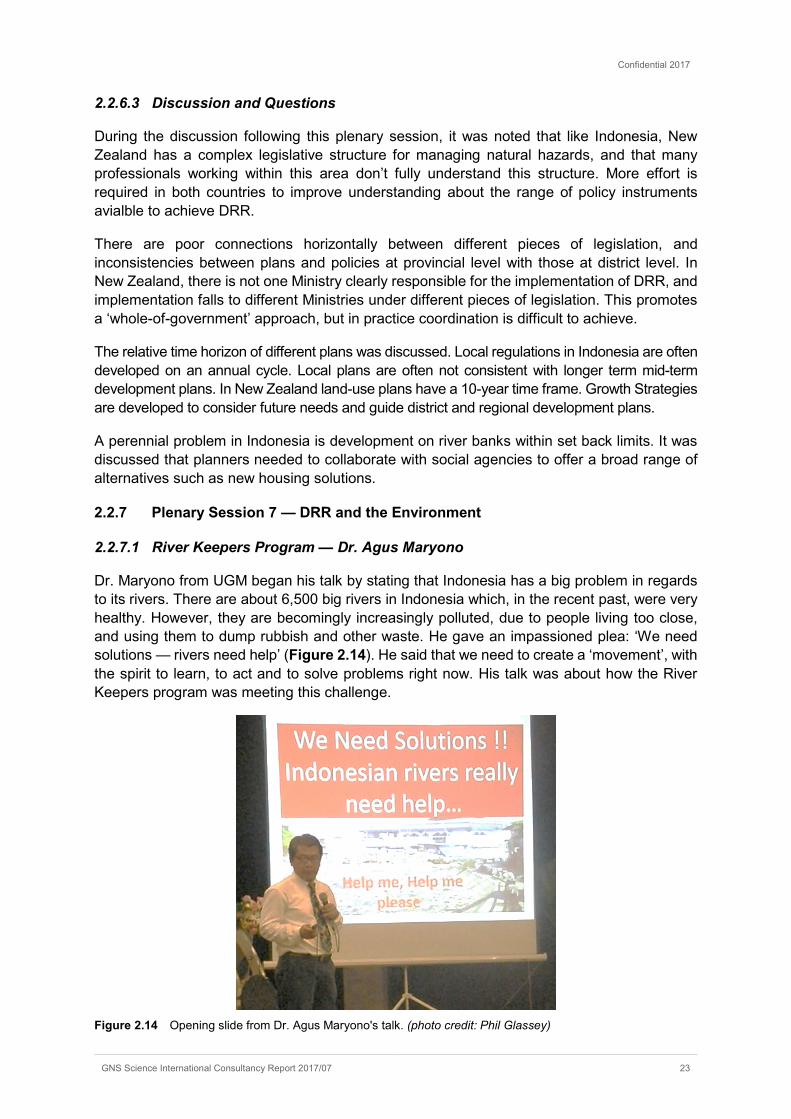
Dr. Maryono from UGM began his talk by stating that Indonesia has a big problem in regards to its rivers. There are about 6,500 big rivers in Indonesia which, in the recent past, were very healthy. However, they are becomingly increasingly polluted, due to people living too close, and using them to dump rubbish and other waste. He gave an impassioned plea: ‘We need solutions — rivers need help’ (Figure 2.14). He said that we need to create a ‘movement’, with the spirit to learn, to act and to solve problems right now. His talk was about how the River Keepers program was meeting this challenge.
Figure 2.14 Opening slide from Dr. Agus Maryono's talk. (photo credit: Phil Glassey)

Confidential 2017
24 GNS Science International Consultancy Report 2017/07
Dr. Maryono talked about needing a systematic approach, involving all stakeholders and experts from different fields — knowledge is key. Tools used by the River Keepers program include tapping into the ‘online’ community, using applications such as WhatsApp. He stressed that to be successful, there needs to be community involvement and movement. Giving people the knowledge on how to undertake river restoration is important.
Dr. Maryono then asked ‘what is river restoration?’ The goals of the River Keepers program include having rivers that are clean, healthy, productive, safe, and useful for all. It is important for people to understand that a river is an ecosystem, as well as being a key part of our social system. He stressed that rivers belong to all, not just one person, and people should not treat them as their own personal property (e.g., as a place to dump their waste).
Lastly, Dr. Maryono asked ‘How can we start such a movement?’ He believes that human traits such as love and togetherness can provide the spirit and motivation to build such a movement. This in turn leads to different sectors of the community working together in harmony, to be productive and bring about positive changes. He also spoke about the next challenge — how to enlarge the movement to the whole Indonesian archipelago.
2.2.7.2 Waste management & relationship to DRR — Michiel Zwijnenburg
Michiel Zwijnenburg, from University College (Dublin), talked about the wide range of effects that waste can have on disaster risk. He said that poor waste management creates problems in terms of public health and on the environment, and can result in significant economic, technological and social costs. It can also cause problems for DRR, in that waste can create or exacerbate hazards. Examples of hazards which can occur due to poor waste management affecting waterways include:
• excess waste in waterways restricting the conveyance of floodwater,
• waterborne-waste providing a place for Zika and Dengue virus type mosquitos to breed,
• rubbish (particularly small particles of plastic) gets into plankton, then fish, then the food chain.
Figure 2.15 Poor waste management combined with water = water-related hazards. (Photo credit: Michiel Zwijnenburg)

Confidential 2017
GNS Science International Consultancy Report 2017/07 25
Other hazards include the potential for technological hazards (e.g., an explosion or a landslide on a landfill). Zwijnenburg also said that poor waste management weakens the community and its mechanisms to cope with shocks as it increases vulnerability in 3 ways:
• reducing resilience;
• increasing vulnerability; and
• affecting poor individuals the most
He believes that improved waste management should be seen as a useful tool for DRR in Indonesia because the country has a waste problem and has difficulty managing the growing volume of garbage; is disaster prone; and is a large emitter of greenhouse gases. Improved solid waste management creates a safer and cleaner environment, reduces vulnerability and poverty and promotes sustainable development.
In summary, Zwijnenburg stated that waste management is a unique opportunity to address some of Indonesia’s challenges, that the cost of inaction is enormous, and that waste management should be seen to be a part of a holistic approach to DRR.
2.2.7.3 Importance of mangroves — Dr. Eko Pradjoko
Dr. Eko Pradjoko from the University of Mataram said there has been a rapid decline in mangroves along the Indonesian coastline, from 8.6 million ha in 1999 to 3 million ha in 2005. His presentation addressed whether mangroves can be used to prevent erosion, and whether they could they be planted in more locations along the coast.
He began by summarising the ecology of mangrove forest, and the requirements for mangroves to flourish. There are many different species of mangroves, and Indonesia has a diverse range of species. Mangrove plants needs specific conditions — brackish water, muddy sediment, low current and waves. However, mangrove forest can be highly influenced by human activity and climate change.
Dr. Pradjoko said that mangrove forest can effectively reduce wave height and wave energy during typical tidal conditions (Figure 2.16). However, it may only reduce (rather than eliminate) the impact of storm surge and tsunami — he said that storm surge height can be reduced by 5 to 50 cm over a 1 km width of forest. Another benefit of dense mangrove forest is that it acts as an effective debris trap, and may also act as a safety net for human victims during tsunami events.

Confidential 2017
26 GNS Science International Consultancy Report 2017/07
Figure 2.16 Stylised images showing mangroves’ ability to reduce wave energy (top), and reduce storm surge impact (bottom). (Source: Eko Pradjoko)
Dr. Pradjoko concluded his talk by saying that the application of mangrove forest as a means of protecting coastal areas needs careful consideration, and may well be a suitable mitigation method for a range of coastal hazards in many parts of Indonesia.
2.2.7.4 Discussion and Questions
The discussion picked up on earlier themes around managing illegal buildings on riverbanks (refer section 2.2.6.3) and the difference between river normalisation (returning the river to its natural river function) versus river restoration (combining hydraulic (or flow) function of the river with social and ecological functions). Ideally, river programmes should be attempting to restore rivers, however current effort is mostly directed to normalising rivers in terms of flow only, rather than looking at the river’s ecological and social functions.
There was discussion around the loss of income for waste scavengers if the waste stream is reduced. Michiel Zwijnenburg clarified that waste scavengers fulfilled an important function as they sought to recycle waste. The informal sector was important as part of waste management. There was a need to integrate the formal system (municipal waste collection) with the informal sector who viewed waste as a resource.
2.3 TECHNICAL SESSIONS
Four technical sessions were held during the seminar, providing an opportunity to examine in more detail some topics which frequently form part of DRR work programs. The topics included understanding risk; budgeting and regulations; community engagement; and resilient buildings. A summary of the key points made by each speaker is listed below, along with any discussion or questions which followed the presentations.

Confidential 2017
GNS Science International Consultancy Report 2017/07 27
2.3.1 Understanding Risk
In this session, the speakers and other participants attempted to reach some common agreement on understanding risk, as it relates to DRR. Dr. Wendy Saunders of GNS Science outlined the components of risk, and provided an explanation of key concepts, as summarised in the text below, and illustrated in Figure 2.17.
1. Natural events occur — they only become a natural hazard when they interact with human life and property.
2. A disaster is when an affected community cannot cope using its own resources. Not all events will cause a disaster.
3. Natural hazard characteristics include the magnitude, duration, extent and speed of onset of an event. It is important for communities to understand the characteristics of natural hazards, as this allows people to manage them appropriately.
4. Exposure refers to the people, property or assets in a hazard area that are subject to potential losses (e.g. a building built on an active floodplain).
5. Vulnerability refers to the characteristics of a community or asset that makes it susceptible to the effects of a hazard. Vulnerability can change over time (e.g. raising the level of a building may make it less vulnerable to flooding).
6. The consequences of a hazard are determined by a combination of exposure and vulnerability.
7. Likelihood refers to the chance of an event occurring within a certain timeframe (e.g. the likelihood of a major flood occurring during the expected lifetime of a building).
8. Risk is determined by a combination of likelihood and consequences. 9. To manage the risk associated with natural hazards, it is necessary to consider both the
likelihood and consequences of a potential or actual event.
Figure 2.17 Components of risk (source: GNS Science)
An interactive workshop was held at the end of the session, where attendees split into small groups to consider these various components of risk, based on their own understanding and experience. An additional insight, which came from a workshop participant, was that when assessing the likelihood component of risk (e.g., for a proposed development), the chance of that development being affected over its entire lifespan should be considered, rather than just
Confidential 2017
28 GNS Science International Consultancy Report 2017/07
the likelihood of the event occurring in one particular year. Similarly, the chance of being affected by other sources of hazard should be included in the assessment of likelihood (e.g., a coastal village may be prone to inundation not only from tsunami (which occur rarely), but also from storm surge, and from the effects of sea level rise).
It was also noted that the consequences of a natural hazard may be such that the risk to a particular development or community may be intolerable, regardless of how unlikely a particular hazard event may be.
2.3.2 Budgeting and Regulations
The objective of this session was to encourage sharing of information across districts on challenges and successes encountered while including DRR in both local and regional budgets, and regulations. The sessions comprised of presentations by speakers from a range of districts, questions and discussions amongst the group. Key points are reported below.
2.3.2.1 Budget
Budget needs to cover both before (preparedness) and during/after an event (response) (M. Yasin, Donggala). Until quite recently, the main focus across OPDs has been on event response (and still is, to a certain extent). The former therefore needs to be emphasised in budgeting.
One key discussion point about budget was how DRR activities in OPDs other than BPBD are taken into account in the overall DPRD’s DRR budget. Reported DRR budget is often confined to BPBD, while DRR activities also occur in other OPDs (e.g., Public Works may be building a bridge or increase drainage to mitigate the impact of floods). How to integrate DRR activities across OPDs remains a challenge.
Related to the previous point, there were questions about what the nominal 2% of DPRD budget dedicated to DRR actually includes (and whether it is across OPD’s or exclusively for BPBD). No consensus was reached. Questions were raised about whether or not increases in total DPRD budget actually translates into an increase of budget dedicated to DRR. Again, no clear consensus was reached and there may be differences across districts and provinces.
2.3.2.2 Regulations
Agam was the second region after Padang City to issue a DRR regulation. It is the Parliament's (DPRD’s) prerogative to issue these regulations ("perda") (Marga Indra Putra, Agam). This illustrates how important it is to have a Parliament well versed and engaged in DRR efforts. In Agam, the DPRD initiated the inclusion of DRR in regulations. They interacted with the BPBD when they needed to get relevant information.
Regulations (perda) is one way to tie political parties to action on DRR, regardless of their agenda and potential favouritism: once it is a regulation, they have no choice but to consider DRR (Didi Sumardi Haamdan, Mataram)
DPRD has a monitoring function but only for policy, not for technical matters (Husni Thamrin, Seluma). In many districts, there is confusion and DPRD is also conducting technical monitoring (e.g., measuring how wide a road is). Technical monitoring is part of some OPDs’ role (e.g. Public Works).
Confidential 2017
GNS Science International Consultancy Report 2017/07 29
2.3.3 Community Engagement
The objective of this session was to extend the discussion from the previous Plenary Session on Community Engagement and Education (section 2.2.4). Two case studies were presented which showcased good elements of community engagement. This was followed by a breakout session in which participants discussed in six small groups of 4–6 people what they had learned and what the key aspects of good community engagement were. Most of the workshop participants were former students and some NGO representatives. The StIRRRD districts’ BPBD and other representatives mostly attended the parallel “Resilient Buildings” session. This had been anticipated, and was why a Plenary Session on community engagement had been programmed to ensure maximum attendance from BPBD staff at that.
The first case study was presented by Dr. Adam Pamudji Rahardjo and looked at the research UGM were doing around community empowerment in a small island context. Small islands face particular challenges due to access, not only during and after a disaster, but also pre-disaster as they often miss out on development assistance and consequently get left behind communities on the main islands in terms of resources, and awareness of and preparedness for disasters.
Drawing on the communities in Kota (city) Ende in East Nusa Tenggara (NTT) and Kecamatan (sub-district) Huamual in the Moluccas as examples, the team’s overall approach included:
• A preliminary survey of the areas concerned (assessing the population potential, mapping flood impacts and producing flood risk maps and evacuation zone recommendations),
• A mitigation workshop with BPBD and other OPD (e.g. health, social services),
• Formation of a disaster preparedness team in each village,
• Design and implementation of some activities which included disaster preparedness information for the school curriculum, training for teachers, training in river monitoring and managing agriculture land on slopes (to prevent soil loss),
• Simulations.
Dr. Rahardjo stressed that a comprehensive cultural approach was required if communities were to be successfully empowered. Such an approach acknowledged the different cultural contexts of the communities involved.
Dr. Fathani presented the second case study which looked at the work UGM had done with communities in lahar paths around Mt Merapi volcano. Community structures had been established and community action plans developed which focussed on improving practices in the way natural resources (sediment) were managed and the way sabo dams were protected. Work with the community resulted in sediment mining guidelines to help prevent the undermining of the sabo dams which were important community protection structures.
Dr. Fathani stressed that disaster management at the community level was integral to the social, economic and cultural life of the community. DRR programmes would not be sustainable unless the community was involved and programmes integrated with the socio-cultural environment. He also emphasised the need to strengthen university connections into communities. When questioned about why there were still disasters and losses despite all the research and activities in place, Dr. Fathani responded that it was difficult to talk about DRR with communities when basic needs weren’t being met. Poverty is a major issue. People will look to feed themselves first, even if this means planting crops on flood prone land. This was

Confidential 2017
30 GNS Science International Consultancy Report 2017/07
why DRR programmes needed to be appropriate for the context and recognise the socio-economic conditions of communities. The district regulatory environment was also important and needed to be addressed as regulations reflected the values of the community and what was important to them.
Participants were then split into six groups and asked to each come up with three key concepts that were the cornerstones of good community engagement (Figure 2.18).
The discussion that followed concluded that there were several key concepts: community engagement needed to be effective and sustainable. It needed to consider social, cultural and economic aspects of the communities involved. Of these, dealing with the economic aspects (livelihoods; incomes etc.) was probably the most difficult. An overriding concept when working with communities was to be culturally aware — community engagement needed to respect the socio-cultural context of the community otherwise it would not be effective or sustainable.
Figure 2.18 Important aspects of good community engagement as noted by workshop participants.
2.3.4 Resilient Buildings
This session was primarily aimed at reiterating the importance of earthquake resistant construction for single storey dwellings, and 2-storey plus buildings, such as schools. The importance of this was highlighted by the Aceh M6.4 earthquake of December 2016 where most victims were killed in collapsed 2–3 storey buildings (Figure 2.6). The best mitigation against building collapse is earthquake resistant design and good construction. The session also explored research into traditional construction and alternative construction materials.
Victor Rembeth, from the Disaster Resource Partnership, outlined the activities of the partnership, which is a consortium of consultant engineers and construction companies. They provide resources after an event such as personnel for building damage assessments. They are involved in “Resilient Markets” and “Resilient Schools” initiatives, aimed at providing well-constructed structures. They also provide training in vocational schools in the architects and building sectors. They have identified weak areas in construction practice and have activities to strengthen these (Figure 2.19).

Confidential 2017
GNS Science International Consultancy Report 2017/07 31
Figure 2.19 Weaknesses in Indonesian constriction sector and DRP activities to help strengthen these weaknesses (source: Victor Rembath)
Dr. Fauzan from Andalas University (UNAND), outlined the earthquake resistance, or otherwise, of buildings in Padang given the new seismic codes. The updated seismic code has applied to school buildings and where the structures are found wanting, retrofitting options recommended. He reiterated the need for multi-storey buildings to be reassessed not only for earthquake forces, but also lateral forces of tsunami and determine whether they are adequate to act as vertical evacuation structures.
Dr. Ade Sri Wahyuni from University of Bengkulu (UNIB), presented the research that the engineering school are doing on the use of alternative and traditional materials in construction, such as the use of rice paddy waste and shellfish shells as extenders of concrete, palm fibre to provide structural strength, and adding ash, palm fibre or rice waste to bricks to add strength, and reduce shrinkage. The use of waste products is more economic and more environmentally sustainable but they need to provide requisite strength. She also talked about the Bidai Rumah (Figure 2.20), which are traditional woven bamboo houses which have gone out of fashion in favour of “more modern” concrete houses. These bamboo houses are cheaper, lightweight and therefore perform better in earthquakes, and are more environmentally friendly than wooden or concrete houses. The awareness of these alternative construction materials needs to be raised amongst the public through vehicles such as the construction of a “show home” and building clinics.
Figure 2.20 Rumah bidai (bamboo house) under construction (photo credit: Ade Wahyuni)
Confidential 2017
32 GNS Science International Consultancy Report 2017/07
2.4 ACTION PLAN DISCUSSION SESSIONS
The theme of this session was “the challenges and some solutions to designing and implementing DRR Action Plans”. Its purpose was to provide an opportunity for BPBD staff to share their experiences in terms of implementing the DRR Action Plans for their district4. It was also a chance for a range of stakeholders from various districts to come together to share their experiences, gain input from others and learn what other districts are doing. The intent was that other districts involved in the StIRRRD program would benefit from this information, along with other districts which are not part of the program5.
Time constraints meant that only four of the eight StIRRRD districts presented on their Action Plans. In addition, the technical session was split into two parallel meetings (West Sumatra / Bengkulu in one meeting; and Nusa Tengara Barat / Central Sulawesi in another), which meant that seminar delegates were unable to attend all of the four presentations.
A summary of the four Action Plans which were discussed is provided below. Senior BPBD staff discussed the progress made towards implementing their Action Plans, as well as some of the major issues that need to be addressed to further improve resilience to disasters in their district. As well as describing the successes and challenges faced by each district, comments are also provided about how BPBD are working to address these issues, within their local context.
Action Plan presentations are available on request or can be accessed through the StIRRRD website at https://stirrrd.org/technical-training/mid-term-drr-seminar-2017/.
2.4.1 West Sumatra and Bengkulu
2.4.1.1 Pesisir Selatan
S. Marpaung, Head of Prevention and Preparedness, BPBD, Pesisir Selatan, outlined progress on the district’s Action Plan, and overall progress on DRR initiatives. Some of the key actions and issues reported on are listed below.
Actions: • They have established and developed disaster preparedness groups in six Nagari
(villages).
• They have started socialising DRR concepts with women’s groups and schools.
• Progress has been made in the development of evacuation shelters, tsunami evacuation routes, stairs, signage, and the ‘Blue Line’ concept.
• Planting of Casuarina pines and mangroves has occurred at some coastal locations.
Issues: • Pesisir Selatan’s DRR plans are not yet official documents.
• There is a lack of skilled and trained staff to implement their plans. Staff rotation is an ongoing issue, and there is a need to strengthen the capacity of BPBD staff.
• They lack adequate technology, as well as the skills to use it.
4 These plans were previously brought together by a range of stakeholders in each district, as part of the StIRRRD program. 5 It is noted that several staff from non-StIRRRD districts attended the Risk Reduction Seminar (Figure 1.1).
Confidential 2017
GNS Science International Consultancy Report 2017/07 33
• There are many stakeholders, and it is important to have agreements with them to help implement DRR initiatives. However, there are limitations in BPBD’s capacity to liaise and reach agreements with all of these stakeholders.
• Spatial Planning is important.
• Funding for DRR work is required from the village budget.
Alternative solutions to address some of these issues were identified by Marpaung. In particular, he noted that with the recent increase to village funding, it can be expected that each village can channel some of this increased budget towards DRR programs. He noted that there is an affirmation from central government that villages may use funding in this manner, for example in the form of socialisation. Another solution identified was the potential to increase the role of universities to strengthen the capacity of community institutions at the village level.
2.4.1.2 Seluma
Azwardi Pangkuak, Head of BPBD Seluma, outlined progress on the district’s Action Plan, and overall progress on DRR initiatives. Some of the key actions and issues reported on are listed below.
Actions:
• Seven out of 24 villages are now part of the Resilient Village programme.
• 12 schools have had (or will have) socialisation as part of a disaster protected school initiative funded by the BPBD.
• Discussions have been had with five schools to act as tsunami shelters.
• PU (Public Works) are undertaking physical bridge abutment, river and coastal erosion protection works.
Issues:
• Formulating regulations and having them passed by the district parliament has become a complex issue and regulations are not yet official.
• A strategic DRR plan that is integrated into the provincial plan is required, particularly to ensure funding.
• The lack of budget and budget cuts.
• Similar to Pesisir Selatan, there is a lack of skilled and trained staff to implement their plans. Staff rotation is an ongoing issue, and there is a need to strengthen the capacity of BPBD staff.
• The district has one tsunami shelter (another three are planned), but it is yet to be handed over by the National Government Agency to the district, and is therefore yet to be fully functional.
• The DRR Forum is not functioning as it has little authority, i.e. no high-level staff of other agencies attend. Therefore, there is weak cross-agency communication.
• Low participation of private sector.
Pangkuak proposed some methods that he considered could be used to address the issues faced by Seluma District, and help to reduce the risk from disasters over the longer term. Some of these are already being implemented on a limited scale, while others are new ideas. They included:
Confidential 2017
34 GNS Science International Consultancy Report 2017/07
• Improving the capacity of BPBD staff by sending them to various training courses.
• Enhancing community knowledge and capacity through various forms of socialisation and training.
• The budget for the work program coming not only from Seluma Regency BPBD, but also from BNPB and Bengkulu Province BPBD.
• Coordination and Communication between OPD should be enhanced through coordination meetings regarding disaster management (i.e. a forum).
• The business community in Seluma District needs to be invited to be part of disaster management.
• For disaster management on a large scale, BPBD Seluma proposes ‘Ready-Use’ funds issued by BNPB.
2.4.1.3 Discussion
A common and major issue identified by both Seluma and Pesisir Selatan is the lack of skilled and trained staff within BPBD, along with the regular rotation of staff into, and out of the agency. StIRRRD staff are aware of this issue; and the experience of other districts, and their views on how to deal with it, were discussed during the ALGG meeting on the last day of the seminar (see section 6.2). It is noted that other StIRRRD districts in West Sumatra and Bengkulu do not necessarily see this as such an issue. There is perhaps a greater team approach inside BPBD in the districts in these Provinces.
Despite the challenges and issues faced by both these districts, it is encouraging that BPBD staff remain positive about their ability to implement DRR into their communities, and continue to have a range of ideas to make further progress.
2.4.2 Nusa Tengara Barat and Central Sulawesi
2.4.2.1 Donggala
Dr. Akris Fattah Yunus, Head of BPBD, Donggala, outlined progress on the district’s Action Plan, and overall progress on DRR initiatives. Some of the key actions and issues reported are listed below.
Actions: • Local regulations on construction and DRM established in 2016.
• Increases to budget achieved by tapping into multiple sources (e.g. provincial funds; parliamentarians’ discretionary/aspiration funds).
• Socialisation activities including the distribution of pamphlets and booklets in each village in Donggala.
• Planning for and construction of physical works in coastal areas and rivers has progressed, including in Tonggolobibi village.
• Working with health agencies to further develop local budgets and coordination meetings for 16 health units.
• DRR socialisation activities in both primary and secondary schools.
• Establishing community ‘disaster management groups’ and providing basic response training to increase capacity.

Confidential 2017
GNS Science International Consultancy Report 2017/07 35
• Advanced planning for placement of warning signs, restricting entry to disaster impacted areas and evacuation route planning.
• Construction of temporary housing for flood victims (made of wood).
Figure 2.21 Slide from Dr. Yunus’ presentation showing the increase in budget between 2010 and 2017 (Source: Dr. Akris Fattah Yunus)
Issues: • There are challenges to definitively link DRR actions to a reduction in the national
disaster index.
• The exacerbation of flooding due to illegal logging and mining of catchments is problematic. Need an impact analysis of mining and an understanding from mining companies of what their obligations are.
• The ability to effectively engage with communities regarding the maintenance of rivers is challenging for Donggala.
Overall, Donggala are pleased with their progress to date. Dr. Yunus has suggested that further research is conducted by the University of Tadulako (UNTAD) on the impacts of mining to identify solutions which will mitigate the exacerbation of flooding. BPBD are prepared to offer training to mining companies on the broader impacts that their activities are having on downstream communities. Dr. Yunus invited the StIRRRD team to present a basic Hazards and Risk training to the heads of the sub-districts to help increase their capability6.
2.4.2.2 Sumbawa
Lalu Budi Suryata, Head of Parliament, Sumbawa, outlined progress on the district’s Action Plan, and overall progress on DRR initiatives. Some of the key actions and issues reported are listed below.
6 This was undertaken by UGM and UNTAD in March 2017.
Confidential 2017
36 GNS Science International Consultancy Report 2017/07
Actions: • Developing a Disaster Management Regulation (Perda No.5, 2016) and conducting
socialisation of local regulations related to disaster management to the community and OPD.
• Significant increase in budget (by 500 million rupiahs to 6.2 billion rupiahs in 2016)7.
• Established DRR forums at sub-district and city / district levels.
• Meetings between OPD to conduct joint activities on DRR, minimum twice a year.
• Developed an MOU or Cooperation Agreement with educational institutions and academics.
• Mapping potential alternative financing of DRR activities.
• Increasing the capacity of BPBD and OPD staff in disaster risk analysis.
Issues: • Staff rotation is an ongoing issue, particularly with Mukmin, previous Head of BPBD,
leaving for a different role. He noted that while this was career advancement for Mukmin, it was not good for the DRR programme.
• There are many stakeholders, and it is important to have agreements with them to help implement DRR initiatives. However, there are limitations in BPBD’s capacity to liaise and reach agreements with these stakeholders.
• Provincial changes in the responsibility for the management of forests presents challenges for the management of illegal logging and the subsequent exacerbation of flooding.
• Getting the private sector more involved.
Suryata noted that people’s mindset was starting to change with more talk about ‘prevention’. Flooding is the priority for them due mainly to the degradation of the environment. He noted that the regulations took over two months to develop due to different factions within local government. It can be difficult to convince everyone.
Suryata proposed some methods that he considered could be used to address the issues faced by Sumbawa District, and help to reduce the risk from disasters over the longer term. These included:
• Encourage the alignment of district, provincial and central government DRR budgets.
• Better use of village budgets — he noted there were eight urban villages with quite large local budgets.
• Better engagement with Bappeda, noting their role in budgeting.
• Encourage the role of private, state-owned and local enterprises in DRR activities.
• Establish a local government DRR Aspiration Programme.
• Establish DRR forums at village, sub-district and district levels as platforms to deliver socialisation and coordination across sectors.
• Deliver more response training at community level.
7 The NZ equivalent is a $51,000 increase to $639,000.

Confidential 2017
GNS Science International Consultancy Report 2017/07 37
2.4.2.3 Discussion
There was a range of topics covered during a spirited discussion session. It was encouraging to see the level of discussion and debate on what was working and whether actions undertaken in one district would work in others.
Monitoring and evaluation were discussed in the context of how the districts should be tracking their performance in reducing risk and what indicators they should they be using. Options included using a local risk index, however this would need to be defined. It was noted that Donggala uses the time it takes to receive situation reports after floods as a measure of preparedness (i.e. they get good information from localities in less than an hour). Donggala also issue each sub-district with a tailored hazard profile, which is included in dissemination material. This makes the hazards and risks more real for them and changes are more easily measured.
The need to implement regulations was identified as important. It was noted that there are many regulations and implementation is difficult with politics often influencing where activities are undertaken (to influence votes). How do the districts achieve better implementation in an often-challenging political environment? Solutions proposed included making sure proposed programs were concrete and achievable; harnessing the leadership of the Head of Parliament, who can advocate for DRR; and reducing budgets to those OPD that did not factor DRR into their programs.
The need for better synchronisation of policy was discussed. In general, Provincial and Central Government policies are not synchronised. Suryata gave an example of this — it took two years for the budget to come from central government for a village relocation project. The people gave up and went back to their old houses and got flooded again. Central government needs to react more quickly to local needs.
Public Works (PU) and BPBD in Central Sulawesi share the responsibility for the construction of physical mitigation works. In Donggala, PU concentrate on roads and buildings, whereas BPBD focus on river works and coastal protection measures. Some concern was expressed as to the relative engineering expertise that BPBD has (compared to PU which is perceived to be higher). For this sharing of responsibility to work, there needs to be good coordination and the same quality of engineering design and construction.
Illegal logging was a common issue and posed significant challenges for local government. Cut logs frequently exacerbate floods causing damage to a range of structures downstream. A range of options was discussed as to how this problem could be tackled, ranging from licensing the use of chainsaws to having police and army monitor (and confiscate) logging trucks. It was noted that everyone needed to work together on this issue — BPBD, forestry agency, environment agency, Parliament, Police, Army etc.
On the issue of staff rotation, it was noted that staff take their DRR skills with them to new positions in other departments which assists with cross-departmental understanding of DRR. Staff rotation for BPBD should be looked at as a short-term problem. Staff moving into other departments remain a resource and should be encouraged to promote DRR and continue to work on DRR implementation programmes in their new departments.

Confidential 2017
38 GNS Science International Consultancy Report 2017/07
3.0 FIELD TRIP
Approximately 40 seminar delegates undertook a field trip on the afternoon of 15 February, from Yogyakarta upslope towards Mt. Merapi and return. The field trip handout (in Bahasa Indonesia) is attached as Appendix 3. Delegates travelled in vans, with local experts providing commentary along the way. The trip lasted for five hours, with three main stops, as described below.
The first stop was to a lahar and debris flow monitoring site in the village of Gemawang, on a stream which drains from Mt. Merapi, to the north of Yogyakarta (Figure 3.1). The site is operated by local volunteers, and is part of a wider network of early warning system (EWS) devices, installed by the Hydraulics Laboratory of Civil and Environmental Engineering, UGM.
Figure 3.1 Left: EWS site, Gemawang Village, on the outskirts of Yogyakarta. Right: 3D image of Mt. Merapi, looking towards the north. The approximate location of the relocated village is marked as a blue star, and the ‘castle’ tourist attraction is marked with a red star. Image created using Google Earth, vertical exaggeration 1.2.
The second stop was to Pagerjurang, a relocated village higher up on the slopes of an active volcano, Mt. Merapi (Figure 3.1), which was created following an eruption in 2010. Following this eruption (with associated hazards such as lava and debris flows) it was decided to relocate an entire village to this safer location, as the risk was deemed too high for it to remain in its existing location. Villagers still owned and were able to farm their land higher up the mountain, although access to that land is more difficult, due to a lack of road maintenance. It is also prohibited for people to live on or create permanent residences on that land.
The head of the village described the process of relocating the village, and the positives and negatives that had come from it (Figure 3.3). Overall, he described the process as being a good one for the village, and that people were generally happy with the outcome. Some villagers were now able to supplement their income by working at the nearby golf course but it was noted that the houses were smaller than those in the original village.

Confidential 2017
GNS Science International Consultancy Report 2017/07 39
Figure 3.2 View of part of the relocated village on the upper slopes of Mt. Merapi (photo credit: Michael Goldsmith).
Figure 3.3 Head of village (right, in orange shirt) answering questions about the process of village relocation (photo credit: Michael Goldsmith).
The last stop was to a new business venture further up Mt. Merapi — the ‘Lost World’ Castle, a tourist attraction located in Petung Hamlet, Kepuharjo Village (Figure 3.1 and Figure 3.4) which is located in a high-risk area, that is often exposed to hot ash clouds, lava flows, rock fall, incandescent rocks, and heavy ash rains when Merapi erupts. The attraction is currently closed, and subject to legal proceedings due to its location. The main issues discussed at this stop were compliance (or lack of) with planning regulations, and assessing the risk associated with such an attraction. The buildings had been built without approval, and just prior to the visit, local authorities had instructed the owners to close the facility to visitors. An argument was put forward by an invited speaker (the head of a nearby village) that the risk associated with such an attraction was low as people would not be living permanently on site, and that the attraction should therefore be re-opened. It provided important employment opportunities for people in the nearby (relocated) village. The time taken to evacuate large numbers of tourists, should a sudden eruption occur, was noted as a possible issue, given the poor state of roads and slow travel times, and lack of knowledge of evacuation routes by visitors.
Comparisons were made with the situation in New Zealand, where tourist attractions did exist in high risk areas (e.g. skiing on active volcanoes; geothermal tourist areas). They were generally regarded as ‘discretionary’ or ‘non-complying’ activities and were tightly controlled with various conditions attached to permits. Owners had to demonstrate they were able to mitigate risks, e.g. having good access and evacuation plans, installation of warning systems, public education and awareness activities. It was noted that monitoring and compliance of permit conditions in New Zealand was good, but was not necessarily the case in Indonesia.
Confidential 2017
40 GNS Science International Consultancy Report 2017/07
Figure 3.4 View of field trip participants at the ‘Lost World’ tourist attraction on the upper slopes of Mt. Merapi (photo credit: Michael Goldsmith).

Confidential 2017
GNS Science International Consultancy Report 2017/07 41
4.0 RISKSCAPE INTRODUCTION WORKSHOP
4.1.1 Introduction
The RiskScape software workshop was designed to demonstrate the RiskScape software in natural hazard risk analysis, through a series of presentations and tutorials. It was intended to provide participants with an overview of risk model components, the data representing the risk model components, and how risk information generated from the RiskScape software can be applied in DRM activities.
A summary of the workshop, including feedback and comments, is provided below, while Appendix 4 comprises the workshop program and details, including a description of the software and datasets used.
4.1.1.1 Workshop activities
The first session was presented by Ryan Paulik of NIWA, who described the RiskScape software’s risk model framework and components, along with software tools that enable users to import and export natural hazard risk data. Ryan presented a RiskScape software overview, then three case studies on software delivery of natural hazard risk information to support DRM activities. These case studies helped to reinforce the software’s risk model framework components, and their data requirements. These presentations were followed by a group activity where participants identified natural hazard risk data and information needs for DRM activities in Indonesia.
Technical issues encountered during the installation of RiskScape software on participants’ personal computers (PCs) forced an amendment to the second session. The intention for this session was for workshop participants to work through two tutorials using RiskScape software to model and output flood and tsunami loss information for Palu City buildings. In place of the tutorials, Ryan provided a ‘walk through’ demonstration of each tutorial using RiskScape, explaining software features and the risk modelling process for each tutorial step.
Following the demonstration, Phil Glassey (GNS Science) and Iman Satyarno (UGM) conducted a Q&A session on risk data needs and risk information applications. This session replaced the planned group activities, as information from participants on risk data needs was sufficiently covered in the first session group activity. The session finished early at 11:30am for participants to attend Friday prayers.
4.1.1.2 Workshop participant feedback and comments
Workshop participants provided useful feedback on the workshop content and risk modelling in Indonesia during and after the sessions. A summary of feedback from the NIWA facilitator (Ryan Paulik) is provided as follows:
• The research sector is enthusiastic about the opportunities to collect risk datasets and undertake risk modelling for DRM activities in Indonesia.
• Compartmentalise the workshop into risk model component themes, e.g. hazard, asset, vulnerability, loss, risk models.
• Consider the use of local examples in risk modelling demonstrations and tutorials.
• Post-graduate student research projects provide an opportunity to develop risk datasets.
• Software applications, risk datasets and support materials must be translated into Bahasa.
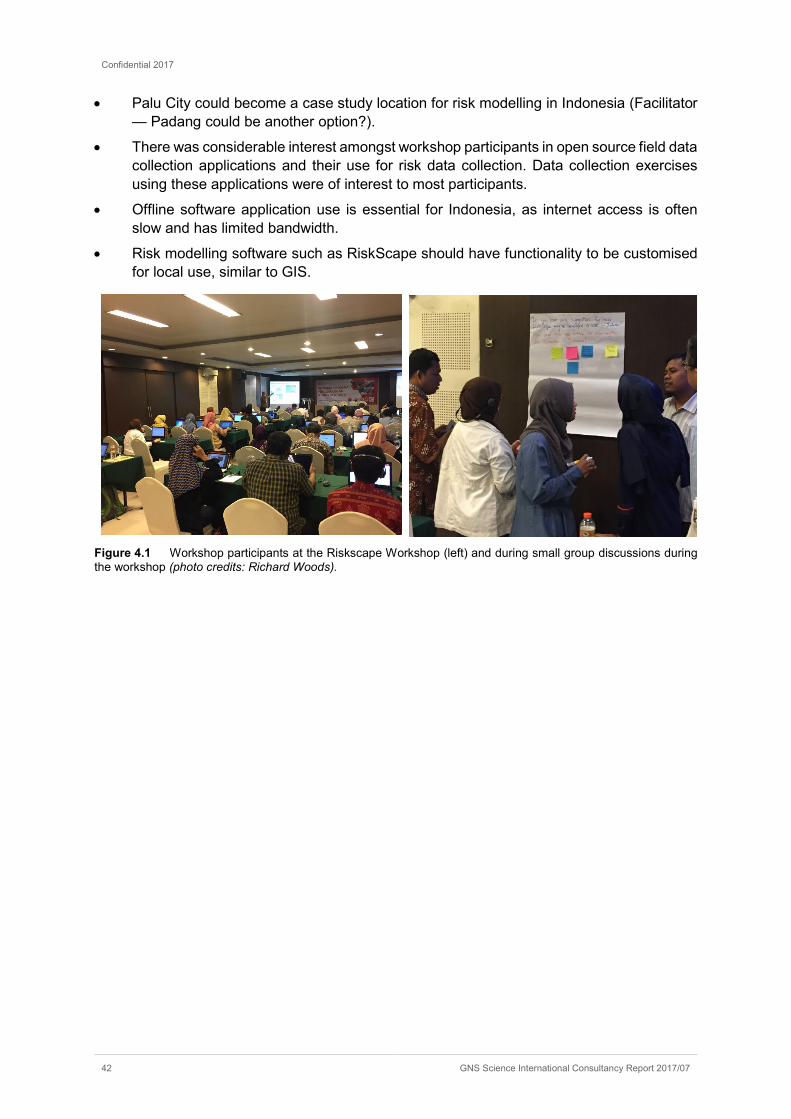
Confidential 2017
42 GNS Science International Consultancy Report 2017/07
• Palu City could become a case study location for risk modelling in Indonesia (Facilitator — Padang could be another option?).
• There was considerable interest amongst workshop participants in open source field data collection applications and their use for risk data collection. Data collection exercises using these applications were of interest to most participants.
• Offline software application use is essential for Indonesia, as internet access is often slow and has limited bandwidth.
• Risk modelling software such as RiskScape should have functionality to be customised for local use, similar to GIS.
Figure 4.1 Workshop participants at the Riskscape Workshop (left) and during small group discussions during the workshop (photo credits: Richard Woods).

Confidential 2017
GNS Science International Consultancy Report 2017/07 43
5.0 SEMINAR DEBRIEF
5.1 HIGHLIGHTS
The Mid-Term Seminar was a well organised and well supported event which met its objectives (section 1.1).
The Seminar incorporated a lot of program learnings through tailoring content to meet the observed needs of the StIRRRD districts. Content was developed through an analysis of the Action Plans and from the StIRRRD team field observations.
The event was well supported by central government, and speakers from national agencies such as BNPB, Bappenas and Kemendesa provided the national context and links to their respective work programs as well as the Sendai Framework.
The broad range of participants included representatives from twelve districts not part of the StIRRRD program, continuing the strong tradition that StIRRRD has in encouraging other districts to connect. These districts funded their own participation at the Seminar.
The broad range of participants also encouraged a good degree of debate and discussion, fostering peer learning across national agencies, districts, NGOs and universities.
Particular highlights included:
• the number of Indonesian local speakers from StIRRRD districts and universities. Capacity has grown in the districts to an extent that a range of DRR topics and experiences can be sourced locally. This is beneficial for the peer support network StIRRRD aims to create.
• the breadth of topics covered. A more conventional approach to risk reduction often focuses on hazard information (e.g. technical information about tsunamis and earthquakes) and physical approaches to mitigating risk (e.g. engineering solutions). This seminar included topics on vulnerability, community engagement, gender and disability issues, environmental management and land use planning. This breadth was embraced by workshop participants.
• the workshop sessions on StIRRRD Action Plans. These successfully created an environment where several of the districts were able to share their experience with Action Plan implementation, budgeting, and dealing with issues such as staff turnover and perceptions of BPBD. There was a high degree of openness, respect and trust between districts in sharing their experiences.
• the degree of parliamentary engagement at the Seminar, reflecting the degree to which local parliaments are driving DRR in a number of districts.
5.2 LESSONS LEARNED
There is a second StIRRRD DRR Seminar scheduled for the end of the programme in 2018. A number of lessons are noted for future workshops:
• Aspects of the program that worked particularly well included:
˗ Translation support.
˗ Catering and venue.
˗ The mix of plenary and parallel sessions.
Confidential 2017
44 GNS Science International Consultancy Report 2017/07
˗ The mix of presentation, discussion and break-out groups.
˗ Subject areas identified as needing focus were given plenary sessions (e.g. Vulnerable Groups; Land-Use Planning). There was no option provided to participants to move to a different topic area.
˗ Workshop materials (Proceedings; Presentation Handout; Field Trip Notes; Fieldtrip T-shirts; Seminar ‘bag’ etc.) were all of good quality and appreciated by participants.
˗ The DRR Action Plan sessions worked well and were a good opportunity to have district lead discussions.
• Hosting a range of concurrent activities (section 6.0) presented some logistical challenges and some of these events did not have quite the same preparation or time spent on them as the main Seminar. In future, more effort is needed to organise these side events and ensure they run smoothly.
• A venue map would have been useful showing the locations of the various sessions.
• There was still not enough time for discussion in all sessions. In some sessions (e.g. Budget and Regulations) there was very animated discussion and the session could have gone on longer. This particular topic needs some more focus over the rest of the StIRRRD program.
• Some of the local university speakers still have a focus on technical details and don’t tailor their presentations to the audience, although this aspect has improved since the early days of the program.
• While the translation support was good, the translators needed more regular breaks and occasionally stopped translating at times when translation was needed the most. Better communication with the translators about their requirements and our expectations is needed ahead of time.
• Consider holding a session devoted to local issues and problems. Many districts were bringing their specific problems to the attention of team members and hoping for assistance with resolving them. The Action Plan sessions had been designed with this in mind, however there was not enough time in these to address all the issues coming up. A suggestion from StIRRRD team member Dr. Wahyu Wilopo was for participants to lodge issues/ideas on post-it notes at the registration desk and these could form the basis for a separate and dedicated discussion session.
• Mix up the Action Plan sessions next time so that the Western provinces have more of a chance to listen to and contribute to the Eastern province sessions and vice versa.
• Consider having a session or forum so that students were able to present their work. e.g. 5 minute ‘bites’ or poster sessions.
• While central government representatives attended the first day of the Seminar and made a valuable contribution to discussions on this first day, most did not stay for the duration of the Seminar, which was disappointing. They missed an opportunity to interact with local government representatives and understand their issues. Their absence was noted by local government representatives who wanted the opportunity to raise issues with their central government counterparts. Trying to ensure some central government representatives stay on is something to consider for the next Seminar. One suggestion is to include one or two of them on the organising committee.

Confidential 2017
GNS Science International Consultancy Report 2017/07 45
Figure 5.1 One of the StIRRRD Team debrief sessions (photo credit: Michele Daly)

Confidential 2017
46 GNS Science International Consultancy Report 2017/07
6.0 OTHER CONCURRENT ACTIVITIES
There were a number of meetings organised to take advantage of participants already being present for the Seminar. This had the advantage of avoiding separate travel and additional time commitments, which would have been incurred had the meetings been organised at other times. These meetings are described briefly below. Minutes for both meetings are available separately.
6.1 AGG MEETING
The ninth meeting of the AGG (Activity Governance Group8) was held on Tuesday 14th February, 2017. Agencies represented at the meeting included BNPB, Kemendesa, Bappenas, MFAT, UGM and GNS Science. It was a smaller meeting than usual, due to the meeting being held in Yogyakarta and not Jakarta as is usual. Central government representatives had presented keynotes at the Mid-Term Seminar earlier in the day.
Members were given an update on StIRRRD progress and some of the outcomes and activities in the districts as a result of the Activity. A usual agenda item features a matrix of policy recommendations to address issues arising from the work with the districts. Notably these include ways to deal with staff rotation, BPBD’s role in coordination, establishing a competency framework for the professional development of BPBD staff, and the need to review the position (structural level) of BPBD relative to other OPD in the local government structure.
Figure 6.1 Pressing issues identified for discussion at the 9th AGG meeting (source: UGM & GNS).
8 The AGG is the StiRRRD Activity’s Governance Group comprising central government representatives. Its role is
to provide oversight and advice to the project management team, and ensure central government commitment to the Activity.

Confidential 2017
GNS Science International Consultancy Report 2017/07 47
6.2 ALGG MEETING
The second meeting of the ALGG (Activity Local Government Group9) was held on Friday, 17th February, 2017. Districts represented at the meeting were Agam, Seluma, Palu, Pesisir Selatan, Mataram, and Sumbawa.
The Terms of Reference for the group was discussed. It was agreed that Akris Fattah (BPBD Donggala) would serve as Chairman of the ALGG for the 2017-18 year, and Bambang Warsito (BPBD Agam) would serve as Vice Chairman.
Some of the main concerns identified at previous ALGG meetings were noted and recent developments in regards to these concerns discussed. These items are listed below.
• How to address staff turnover within BPBD.
• A desire for the Head of BPBD to hold appropriate qualifications for that role. It was noted some staff were now unhappy when being transferred out of BPBD — they would rather stay as they see it as critical work.
• Position and relative importance of BPBD within government structure.
• Understanding / standardisation of tsunami guidelines, and management of coastal hazards.
• Role of the private sector, including plantations and mining industries. The need for a validated document to support higher level discussions.
• Importance of the involvement of women in DRR.
• Capability of ministry staff at central government level with DRR responsibilities.
• Understanding hazard and vulnerability is important — determine priorities in DRR planning and include both hazard and vulnerability in District Profiles.
Further detail can be found in the Meeting Minutes. It is noted that many of these topics were also discussed during various session of the DRR Seminar, in particular during the Action Plan Session (section 2.4).
Recommendations from the meeting included:
• The need to further strengthen the link between the ALGG and the AGG, including sharing results from meetings.
• The need to ensure the District Secretary (Sekda) has a good understanding of disaster related problems. The District Secretary is the formal head of BPBD.
• Increasing OPD awareness about DRR.
• Raising the Head of BPBD echelon to level 2A, so the Head of Division becomes level 3A.
• Engage more with the Head of BPBD direct reports as these positions are the ‘implementers’ and are rotated less often than the more senior position.
• Further work and discussion is required to determine how to disseminate the experience from the StIRRRD Program to other areas in Indonesia.
9 The ALGG is a group set up for the Activity to promote networking, sharing ideas and peer-learning between the
StIRRRD districts. Key objectives of the group are to ensure the sustainability of the StIRRRD program and provide policy advice and input to the AGG.

Confidential 2017
48 GNS Science International Consultancy Report 2017/07
Figure 6.2 Participants at the ALGG meeting, held on February 17, 2017, UC Hotel Yogyakarta. L-R: Wahyu Wilopo (UGM), Michael Goldsmith (GNS Science), Presly Tampubolon (BPBD Palu), Bambang Warsito (BPBD Agam), Iqbal Hakim (BPBD Mataram), Michele Daly (GNS Science), Esti Anantasari (UGM), Lalu Budi (Head of Parliament, Sumbawa), Faisal Fathani (UGM), S. Marpaung (BPBD Pesisir Selatan), Nico Fournier (GNS Science). Absent from the photo due to an early departure is an additional representative from Sumbawa’s parliament.

Confidential 2017
GNS Science International Consultancy Report 2017/07 49
7.0 SUMMARY AND IMPLICATIONS FOR THE STIRRRD PROGRAMME
The StIRRRD Disaster Risk Reduction Mid-Term Seminar attracted keen national and local interest, and participation across the districts was very high. Highlights of the Seminar included the number of speakers from the districts talking about their experiences with the Action Plans and also talking on topics such as budgeting and regulations. Another highlight was the diverse program, which included themes ranging from building construction and community resilience, to environmental management and risk nomenclature. The Seminar included a field-trip to a relocated village on Mt Merapi and a business venture in the red-zone which is subject to legal proceedings due to its location. A RiskScape Training workshop was also held as an optional training for university participants (and anyone else who wanted to join). A media statement on UGM’s website provides additional information https://ugm.ac.id/en/news/13310-important.disaster.risk.reduction and the Seminar proceedings can be found on the StIRRRD website https://stirrrd.org/technical-training/mid-term-drr-seminar-2017/.
The Seminar provided an environment for a range of rich and spirited discussions on challenges and opportunities across a number of districts.
In terms of follow-up opportunities for the StIRRRD Activity, the following suggestions are noted for further discussion:
1. The need to increase central government attendance and participation at these events, not just during the key-note and plenary sessions. Their absence at the remainder of the Seminar was noted by local government who wanted an opportunity to interact with them. Another opportunity to increase central government participation is for staff to participate in StIRRRD field visits to the districts to increase their understanding of local issues. This occurred during the Pilot and at the very beginning of the Activity, but has stopped due mainly to central government budget cuts.
2. Develop a better understanding of the National Risk Index and how it is compiled (for monitoring and evaluation purposes) so that StIRRRD can better contribute to reducing the risk index in the StIRRRD districts. This indicator has already been added to the Activity’s Results Framework. How the Risk Index has been compiled is not very transparent, and information is not readily available. It would be useful for districts to also better understand how this important measure has been constructed.
3. Better awareness of the use of Village Funds is needed for districts. This is an important source of funds that was highlighted several times during the course of the Seminar.
4. Extend hazard and risk basic training in districts to sub-district and village level. This is already happening in some districts and is identified as a priority in several Action Plans. The StIRRRD team and local universities are already contributing to this level of training.
5. Revise Toolbox content to include Indonesian policy and structure guidance (e.g. legislative process; plan hierarchy; budgeting process etc.). Some of the material presented by Indonesian presenters will be useful to carry forward into a Toolbox of guidance material.
6. Consider how more guidance on environmental impacts, particularly mining, can be provided via the StIRRRD Activity. UGM is currently working with Donggala on this, including interacting with mining companies to make them aware of environmental impacts and what their obligations are.

Confidential 2017
50 GNS Science International Consultancy Report 2017/07
7. Mapping community vulnerabilities is important to be undertaken to village level and would help considerably with statistics and need assessments. Encourage more of this to be undertaken by KSB Groups and university community service projects. This could be incorporated into one of StIRRRD’s community projects.

APPENDICES

This page is intentionally left blank.
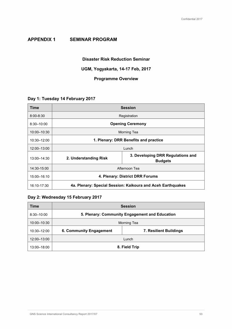
Confidential 2017
GNS Science International Consultancy Report 2017/07 53
SEMINAR PROGRAM
Disaster Risk Reduction Seminar
UGM, Yogyakarta, 14-17 Feb, 2017
Programme Overview
Day 1: Tuesday 14 February 2017
Time Session
8:00-8:30 Registration
8:30–10:00 Opening Ceremony
10:00–10:30 Morning Tea
10:30–12:00 1. Plenary: DRR Benefits and practice
12:00–13:00 Lunch
13:00–14:30 2. Understanding Risk 3. Developing DRR Regulations and Budgets
14:30-15:00 Afternoon Tea
15:00–16:10 4. Plenary: District DRR Forums
16:10-17:30 4a. Plenary: Special Session: Kaikoura and Aceh Earthquakes
Day 2: Wednesday 15 February 2017
Time Session
8:30–10:00 5. Plenary: Community Engagement and Education
10:00–10:30 Morning Tea
10:30–12:00 6. Community Engagement 7. Resilient Buildings
12:00–13:00 Lunch
13:00–18:00 8. Field Trip

Confidential 2017
54 GNS Science International Consultancy Report 2017/07
Day 3: Thursday 16 February 2017
Time Session
8:30–10:00 9: Plenary Vulnerable Groups
10:00–10:30 Morning Tea
10:30 -12:00 10. Plenary: Land-use planning and DRR
12:00–13:00 Lunch
13:00–14:30 11. DRR Action Plans (1)
West Sumatra and Bengkulu 12. DRR Action Plans (2)
NTB and Central Sulawesi
14:30–15:00 Afternoon tea
15:00 – 16:20
13. Plenary: DRR and the Environment
16:20–17:00 Closing Ceremony
Day 4: Friday 17 February 2017
Time Session
9:00–10:00
14. ALGG Meeting (Local Government Network
Meeting)
15. RiskScape workshop
10:00–10:30 Morning Tea
10:30 -12:00 ALGG Meeting (continued) RiskScape workshop (continued)
12:00–14:00 Lunch
14:00-15:30
StIRRRD Working Session

Confidential 2017
GNS Science International Consultancy Report 2017/07 55
DELEGATES
No Name Position Institution Gender F Count
StIRRRD representatives10
1 Abdul Hakam Disaster Study Center
Universitas Andalas M
2 Ade Sri Wahyuni Lecturer Universitas Bengkulu F 1
3 Agung Setianto Geologist Universitas Gadjah Mada M
4 Agustin Gunawan Lecturer Universitas Bengkulu M
5 Akris Fattah Head of BPBD BPBD Kabupaten Donggala M
6 Alkisman Nurman Staff DPRD Pesisir Selatan M
7 Arry Retnowati Human Geographer
Esti Anantasari F 2
8 Azwardi Pangkuak Head of BPBD BPBD Seluma M
9 Bambang Warsito Head of BPBD BPBD Kabupaten Agam M
10 Diana Atik Prastiwi StIRRRD Treasurer
Universitas Gadjah Mada F 3
11 Dedi Henidal Staff Padang Government M
12 Dedi Rhamanto Putra Staff DPRD Pesisir Selatan M
13 Didi Sumardi Head of Parliament
DPRD Mataram M
14 Dr. M. Farid, MS Head of Disaster Study Center
Universitas Bengkulu M
15 Edi Hasymi Head of BPBD BPBD Kota Padang M
16 Eko Pradjoko Lecturer Universitas Mataram M
17 Esti Anantasari Anthropologist Universitas Gadjah Mada F 4
18 Faisal Teuku Fathani Geotechnical Engineer
Esti Anantasari M
19 Fauzan Lecturer Universitas Andalas M
20 Fikri Dewantara Staff Setwan Kota Mataram M
21 Gunawan, S.Kom Head of Subsection
BPBD Morowali M
22 Herry Sapto Head of Division BPBD Seluma M
23 Husni Thamrin Staff DPRD Seluma M
24 Iain Dawe Senior Hazards Scientist
Greater Wellington Regional Council, New Zealand
M
25 I Ketut Sulendra Lecturer Universitas Tadulako M
26 I Wayan Sugita Staff Kabupaten Morowali M
10 Comprising staff from the districts involved in the StIRRRD project, and staff from UGM, GNS Science, and other
agencies who comprise the project management team.

Confidential 2017
56 GNS Science International Consultancy Report 2017/07
No Name Position Institution Gender F Count
27 Ida Rahayu Head of 4th Commission
DPRD Sumbawa F 5
28 Ida Sri Oktaviana Lecturer Universitas Tadulako F 6
29 Iqbal Hakim Head of Division BPBD Kabupaten Morowali M
30 Iqbal, S.T. Head of BPBD BPBD Kota Mataram M
31 Ismail Mustaram Secretary General DPRD Kabupaten Sumbawa M
32 Kamaluddin Vice Head of Parliament
DPRD Kabupaten Sumbawa M
33 Kelvin Berryman Scientist GNS Science New Zealand M
34 L. Budi Suryata Head of Parliament
DPRD Kabupaten Sumbawa M
35 Marga Indra Putra, S.Pd. Staff DPRD Agam M
36 Martias Wanto District Secretary Agam Government M
37 Michael Goldsmith Scientist GNS Science New Zealand M
38 Michele Daly Scientist GNS Science New Zealand F 7
39 Mohammad Yasin Head of Parliament
DPRD Donggala M
40 Nico Fournier Scientist GNS Science New Zealand M
41 Phil Glassey Scientist GNS Science New Zealand M
42 Presly Tampubolon Head of BPBD BPBD Kota Palu M
43 Richard Woods Scientist GNS Science New Zealand M
44 Rr. Yudhy H B Lecturer Universitas Bengkulu F 8
45 Rudi Rinaldy Head of BAPPEDA
BAPPEDA Padang M
46 Ryan Paulik Scientist NIWA M
47 S. Marpaung Head of Division BPBD Pesisir Selatan M
48 Sisca Ediningtyas StIRRRD Project Manager
Universitas Gadjah Mada F 9
49 Syafril Saputra Staff DPRD Pesisir Selatan M
50 Tahirudin Head of BPBD BPBD Kota Bengkulu M
51 Taslim, S.Ag. Staff DPRD Agam M
52 Wahyu Wilopo Engineering Geologist
Universitas Gadjah Mada M
53 Welly Hendra Staff DPRD Pesisir Selatan M
54 Wendy Saunders Natural Hazards Planner and Policy Researcher
GNS Science New Zealand F 10
55 Yuli Alber Rozi Staff DPRD Pesisir Selatan M
56 Yusron Saadi Dean of Engineering
Universitas Mataram M
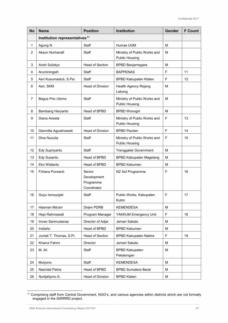
Confidential 2017
GNS Science International Consultancy Report 2017/07 57
No Name Position Institution Gender F Count
Institution representatives11
1 Agung N Staff Humas UGM M
2 Akson Nurhanafi Staff Ministry of Public Works and Public Housing
M
3 Andri Sulistyo Head of Section BPBD Banjarnegara M
4 Aruminingsih Staff BAPPENAS F 11
5 Asri Kusumastuti, S.Psi. Staff BPBD Kabupaten Klaten F 12
6 Asri, SKM Head of Division Health Agency Rejang Lebong
M
7 Bagus Prio Utomo Staff Ministry of Public Works and Public Housing
M
8 Bambang Haryanto Head of BPBD BPBD Wonogiri M
9 Diana Ariesta Staff Ministry of Public Works and Public Housing
F 13
10 Diannitta Agustinawati Head of Division BPBD Pacitan F 14
11 Dina Nuzulia Staff Ministry of Public Works and Public Housing
F 15
12 Edy Supriyanto Staff Trenggalek Government M
13 Edy Susanto Head of BPBD BPBD Kabupaten Magelang M
14 Eko Widianto Head of BPBD BPBD Kebumen M
15 Firliana Purwanti Senior Development Programme Coordinator
NZ Aid Programme F 16
16 Goyu Ismoyojati Staff Public Works, Kabupaten Kutim
F 17
17 Hasman Ma'ani Dirjen PDRB KEMENDESA M
18 Hepi Rahmawati Program Manager YAKKUM Emergency Unit F 18
19 Imran Sarimudanas Director of Adjar Jemari Sakato M
20 Indiarto Head of BPBD BPBD Kebumen M
21 Juniati T. Thomas, S.Pi. Head of Section BPBD Kabupaten Nabire F 19
22 Khairul Fahmi Director Jemari Sakato M
23 M. Ali Staff BPBD Kabupaten Pekalongan
M
24 Mulyono Staff KEMENDESA M
25 Nasridal Patria Head of BPBD BPBD Sumatera Barat M
26 Nurtjahjono S. Head of Division BPBD Klaten M
11 Comprising staff from Central Government, NGO’s, and various agencies within districts which are not formally
engaged in the StIRRRD project.

Confidential 2017
58 GNS Science International Consultancy Report 2017/07
No Name Position Institution Gender F Count
27 Putri Sari Ariyati Staff Ministry of Public Work and Public Housing
F 20
28 P. Bambang Hariyanto Head of BPBD BPBD Wonogiri M
29 Rahmat Salasa Staff BPBD Pacitan M
30 Rahmawati Husein Staff MDMC/UPMP BNPB M
31 Rumainur Head of Division BPBD Sumatera Barat M
32 S. Arif Praptomo, S, Ip., M.M.
Head of Section BPBD Kabupaten Cilacap M
33 Sofan Wahyudi Staff Health Agency Rejag Lebong
M
34 Sudir Staff BNPB M
35 Suprayoga Hadi Dirjen PDT KEMENDESA M
36 Syamsir, SKM, MKM Secretary Health Agency Rejang Lebong
M
37 Theodorus Irianto Head of Division BPBD Kabupaten Nabire M
38 Wahyu B Head of Division BPBD Kulonprogo M
39 Wibawa Staff BPBD Wonogiri M
University representatives
1 A. M. D. Anggraeni Student Universitas Gadjah Mada F 21
2 Aang Panji Permana Lecturer Universitas Negeri Gorontalo M
3 Adi Mawardin Universitas Gadjah Mada M
4 Agnes Isha F. Dj. Student Universitas Gadjah Mada F 22
5 Agus Winarno Lecturer Universitas Mulawarman M
6 Ahmad Junaidi Student Universitas Gadjah Mada M
7 Ainul Fatayaatis S Student Universitas Gadjah Mada F 23
8 Alpiana Student Universitas Gadjah Mada F 24
9 Amalia Siti Rohmah Student MTPBA, Universitas Gadjah Mada
F 25
10 AMD Anggraeni Student Universitas Gadjah Mada F 26
11 Aminudin Syah Student Geotechnical Engineering, Universitas Gadjah Mada
M
12 Anafi Minmahddun Student Universitas Gadjah Mada M
13 Ardy Simanjuntak Staff EWS Team, Universitas Gadjah Mada
M
14 Aris Sukandar Staff EWS Team, Universitas Gadjah Mada
M
15 Atma Galih Dharmawan Student Geotechnical Engineering, Universitas Gadjah Mada
M
16 Bagus Kamarullah Student Universitas Gadjah Mada M

Confidential 2017
GNS Science International Consultancy Report 2017/07 59
No Name Position Institution Gender F Count
17 Bella Restu Juliarka Student Geological Engineering, Universitas Gadjah Mada
M
18 Bima Eko Student Universitas Gadjah Mada M
19 Candra Dian Lukita Tauhid
Student MTPBA, Universitas Gadjah Mada
F 27
20 Devita Wahyu Asriantin Student Universitas Gadjah Mada F 28
21 Dian Annisa Fitri Student Geotechnical Engineering, Universitas Gadjah Mada
F 29
22 Didik Dwi A. Student Universitas Gadjah Mada M
23 Dwi Winarti Lecturer Universitas Muhammadiyah Mataram
F 30
24 Dwitiko Wibowo Student Geotechnical Engineering, Universitas Gadjah Mada
M
25 Dwitya Okky Azanna Student Universitas Gadjah Mada F 31
26 Eka Priangga Student MTPBA, Universitas Gadjah Mada
M
27 Ekasisca Contesa Student Universitas Gadjah Mada F 32
28 Elva Yunita Student MMB, Universitas Gadjah Mada
F 33
29 Emil W. Staff Bina marga, East Java Province
M
30 Emil Wahyudianto Student MTPBA, Universitas Gadjah Mada
M
31 Franto Lecturer Universitas Bangka Belitung M
32 Gema Rezki M Staff EWS Team, Universitas Gadjah Mada
M
33 Hadi Sutrisno Student MMB, Universitas Gadjah Mada
M
34 Hadi Wira Nasarani Student Universitas Gadjah Mada M
35 Hafiz Fatah Student Universitas Gadjah Mada M
36 Herni Suryani Student Geological Engineering, Universitas Gadjah Mada
F 34
37 Herwin Lukito Lecturer Universitas Pembangunan Nasional Veteran
M
38 Ikramullah S Staff EWS Team, Universitas Gadjah Mada
M
39 Intan Putra Student Universitas Gadjah Mada M
40 Jaingot Parhusip Lecturer Universitas Cendrawasih M
41 Kirana Budiastari Student MMB, Universitas Gadjah Mada
F 35

Confidential 2017
60 GNS Science International Consultancy Report 2017/07
No Name Position Institution Gender F Count
42 Krisna Mutiara Wati Student MMB, Universitas Gadjah Mada
F 36
43 La Ode Muhammad I J Student Universitas Gadjah Mada M
44 M. Akmal Putera Student Universitas Gadjah Mada M
45 Ma'ruf Hadi Sutanto Student MTPBA, Universitas Gadjah Mada
M
46 Meita Eka Fitrianingrum Student MMB, Universitas Gadjah Mada
F 37
47 Moh. Nasril Student Geotechnical Engineering, Universitas Gadjah Mada
M
48 Mohamad Sakar Staff EWS Team, Universitas Gadjah Mada
M
49 Muh. Handy Dwi Adityawan
Student Geotechnical Engineering, Universitas Gadjah Mada
M
50 Muhammad Akmal Putera Student Geotechnical Engineering, Universitas Gadjah Mada
M
51 Muhammad Efendi Student MTPBA, Universitas Gadjah Mada
M
52 Muhammad Rusli M Student Geological Engineering, Universitas Gadjah Mada
M
53 Mutia Rima Student MMB, Universitas Gadjah Mada
F 38
54 Myat Thu Naing Student MTPBA, Universitas Gadjah Mada
F 39
55 Nanu Karunia Wiguna Student Universitas Gadjah Mada M
56 Nasrudin Student MMB, Universitas Gadjah Mada
M
57 Novian Adhitya Student Universitas Gadjah Mada M
58 Nuril Maghrifah Student MMB, Universitas Gadjah Mada
M
59 Panji Ardhana Respati Student MMB, Universitas Gadjah Mada
M
60 Preti Askunala Wikan Student MMB, Universitas Gadjah Mada
F 40
61 Rahim Achmad Lecturer Universitas Khairun Ternate M
62 Ramdani Salam Student Universitas Khairun M
63 Resi Sadewa Permana Student MMB, Universitas Gadjah Mada
M
64 Resti Kinanthi Student MMB, Universitas Gadjah Mada
F 41
65 Retno Anjarwati Student Universitas Mulawarman Samarinda
F 42

Confidential 2017
GNS Science International Consultancy Report 2017/07 61
No Name Position Institution Gender F Count
66 Rika Ernawati Student Universitas Pembangunan Nasional Veteran
F 43
67 Saraswati Student Universitas Gadjah Mada F 44
68 Suprapto Student MTPBA, Universitas Gadjah Mada
M
69 Thema A Student Geotechnical Engineering, Universitas Gadjah Mada
M
70 Thomas S Student MMB, Universitas Gadjah Mada
M
71 Wahyu Hermansyah Student Universitas Gadjah Mada M
72 Widy Cahyono Student Geotechnical Engineering, Universitas Gadjah Mada
M
73 Wiwin Winarti Student MTPBA, Universitas Gadjah Mada
F 45
74 Yefri Falson, SP Student MMB, Universitas Gadjah Mada
M
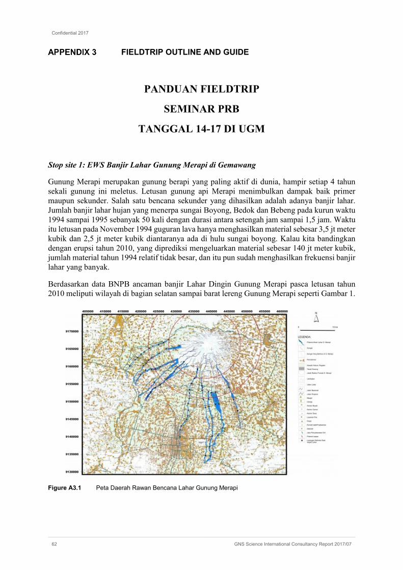
Confidential 2017
62 GNS Science International Consultancy Report 2017/07
FIELDTRIP OUTLINE AND GUIDE
PANDUAN FIELDTRIP
SEMINAR PRB
TANGGAL 14-17 DI UGM
Stop site 1: EWS Banjir Lahar Gunung Merapi di Gemawang
Gunung Merapi merupakan gunung berapi yang paling aktif di dunia, hampir setiap 4 tahun sekali gunung ini meletus. Letusan gunung api Merapi menimbulkan dampak baik primer maupun sekunder. Salah satu bencana sekunder yang dihasilkan adalah adanya banjir lahar. Jumlah banjir lahar hujan yang menerpa sungai Boyong, Bedok dan Bebeng pada kurun waktu 1994 sampai 1995 sebanyak 50 kali dengan durasi antara setengah jam sampai 1,5 jam. Waktu itu letusan pada November 1994 guguran lava hanya menghasilkan material sebesar 3,5 jt meter kubik dan 2,5 jt meter kubik diantaranya ada di hulu sungai boyong. Kalau kita bandingkan dengan erupsi tahun 2010, yang diprediksi mengeluarkan material sebesar 140 jt meter kubik, jumlah material tahun 1994 relatif tidak besar, dan itu pun sudah menghasilkan frekuensi banjir lahar yang banyak.
Berdasarkan data BNPB ancaman banjir Lahar Dingin Gunung Merapi pasca letusan tahun 2010 meliputi wilayah di bagian selatan sampai barat lereng Gunung Merapi seperti Gambar 1.
Figure A3.1 Peta Daerah Rawan Bencana Lahar Gunung Merapi

Confidential 2017
GNS Science International Consultancy Report 2017/07 63
Untuk itu mengantisipasi kejadian banjir bandang tersebut beberapa instansi memasang sistem peringatan dini banjir lahar antara lain Laboratorium Hidrolika Teknik Sipil dan Lingkungan, UGM. Alat ini mulai dikembangkan sejak tahun 2010 dengan menempatkan sensor lebih dari 10 lokasi yang berada di daerah yang dilewati lahar Merapi seperti Gambar 2. Sistem monitoring ini bisa dipantau secara online di http://data.hydraulic.lab.cee-ugm.ac.id/. Salah satu pos monitoring berada di Gemawang, Sinduadi, Ngaglik pada Cungai Code seperti Gambar 3 dan 4.
Figure A3.2 Lokasi sistem pemantauan banjir lahar Merapi
Figure A3.3 Contoh data pengamatan ketinggian muka air sungai (AWLR) di pos Gemawang.

Confidential 2017
64 GNS Science International Consultancy Report 2017/07
Figure A3.4 Contoh data CCTV di pos Gemawang.
Stop site 2: Huntap Pagerjurang
Erupsi Gunung Merapi yang terjadi pada tahun 2010 merupakan salah satu letusan besar dalam catatan sejarah terjadinya erupsi Gunung Merapi. Kerusakan yang diakibatkan oleh erupsi Gunung Merapi berdampak pada sektor permukiman, infrastruktur, sosial, ekonomi, dan lintas sektor yang mengakibatkan terganggunya aktivitas dan layanan umum di wilayah sekitar Gunung Merapi. Material semburan Gunung Merapi telah mengakibatkan terkuburnya beberapa dusun di Kabupaten Sleman, Provinsi Daerah Istimewa Yogyakarta (DIY) dan menimbun serta merusak ribuan rumah penduduk. Tercatat sebanyak 3.424 rumah di Provinsi DIY mengalami kerusakan dengan rincian 2.636 rumah rusak berat, 156 rumah rusak sedang, dan 632 rusak ringan (BNPB, 2011). Permukiman yang terletak di sekitar lereng Gunung Merapi mengalami kerusakan yang cukup parah. Beberapa pemukiman bahkan sampai terkubur oleh material yang keluar pada saat erupsi terjadi.
Setelah letusan terjadi, warga yang terkena dampak erupsi direlokasi ke tempat tinggal yang masih berupa hunian sementara (Huntara). Rumah bantuan tersebut dibuat dari bahan material bambu dan gedhek. Warga menempati hunian sementara sekitar dua tahun, yaitu dari tahun 2010—2012. Mulai tahun 2011—2013, pemerintah membuat rencana dan telah berhasil membangun rumah permanen atau hunian tetap (Huntap) bagi para korban yang kehilangan tempat tinggal. Selain itu, beberapa sektor lengkap dengan infrastrukturnya yang sempat rusak akibat bencana juga sempat diperbaiki. Pembangunan Huntap ini merupakan suatu program rehabilitasi dan rekonstruksi yang dilakukan oleh pemerintah dalam menangani bencana erupsi Gunung Merapi. Masyarakat yang sebelumnya tinggal di Huntara mulai dipindah ke Huntap yang telah disediakan pemerintah.
Terdapat sekitar delapan belas Huntap tersebar di lokasi-lokasi yang lebih aman dibandingkan lokasi rumah tinggal mereka sebelumnya. Huntap tersebut tersebar di Desa Umbulharjo, terdiri dari Huntap Bulak Susukan, Karangkendal, dan Plosokerep; Desa Kepuharjo, terdiri dari Huntap Batur dan Pagerjurang; Desa Wukirsari, terdiri dari Huntap Gondang 2, Gondang 3, dan Dongkelsari; Desa Glagaharjo, terdiri dari Huntap Gading, Banjarsari, dan Jetis Sumur; Desa Argomulyo, terdiri dari Huntap Kuwang dan Randusari; Desa Sendangagung, terdiri dari Huntap Kisik, Gambretan, dan Cancangan; Desa Sindumartani, terdiri dari Huntap Klenthingan dan Jlapan, dan beberapa Huntap mandiri individu. Kondisi kehidupan masyarakat korban
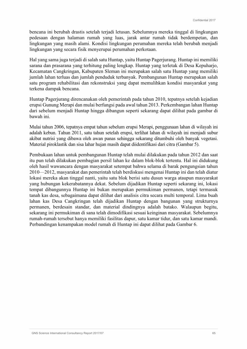
Confidential 2017
GNS Science International Consultancy Report 2017/07 65
bencana ini berubah drastis setelah terjadi letusan. Sebelumnya mereka tinggal di lingkungan pedesaan dengan halaman rumah yang luas, jarak antar rumah tidak berdempetan, dan lingkungan yang masih alami. Kondisi lingkungan perumahan mereka telah berubah menjadi lingkungan yang secara fisik menyerupai perumahan perkotaan.
Hal yang sama juga terjadi di salah satu Huntap, yaitu Huntap Pagerjurang. Huntap ini memiliki sarana dan prasarana yang terhitung paling lengkap. Huntap yang terletak di Desa Kepuharjo, Kecamatan Cangkringan, Kabupaten Sleman ini merupakan salah satu Huntap yang memiliki jumlah lahan terluas dan jumlah penduduk terbanyak. Pembangunan Huntap merupakan salah satu program rehabilitasi dan rekonstruksi yang dapat memulihkan kondisi masyarakat yang terkena dampak bencana.
Huntap Pagerjurang direncanakan oleh pemerintah pada tahun 2010, tepatnya setelah kejadian erupsi Gunung Merapi dan mulai berfungsi pada awal tahun 2013. Perkembangan lahan Huntap dari sebelum menjadi Huntap hingga dibangun seperti sekarang dapat dilihat pada gambar di bawah ini.
Mulai tahun 2006, tepatnya empat tahun sebelum erupsi Merapi, penggunaan lahan di wilayah ini adalah kebun. Tahun 2011, satu tahun setelah erupsi, terlihat lahan di wilayah ini menjadi subur akibat nutrisi yang dibawa oleh awan panas sehingga sekarang ditumbuhi oleh banyak vegetasi. Material piroklastik dan sisa lahar hujan masih dapat diidentifikasi dari citra (Gambar 5).
Pembukaan lahan untuk pembangunan Huntap telah mulai dilakukan pada tahun 2012 dan saat itu pun telah dilakukan pembagian persil lahan ke dalam blok-blok tertentu. Hal ini didukung oleh hasil wawancara dengan masyarakat setempat bahwa selama di barak pengungsian tahun 2010—2012, masyarakat dan pemerintah telah berdiskusi mengenai Huntap ini dan telah diatur lokasi mereka akan tinggal nanti, yaitu satu blok berisi satu dusun warga ataupun masyarakat yang hubungan kekerabatannya dekat. Sebelum dijadikan Huntap seperti sekarang ini, lokasi tempat dibangunnya Huntap ini bukan merupakan permukiman permanen, tetapi termasuk tanah kas desa, sebagaimana dapat dilihat dari analisis citra secara multi temporal. Lima buah lahan kas Desa Cangkringan telah dijadikan Huntap dengan bangunan yang strukturnya permanen, berdesain standar, dan material dindingnya adalah batako. Walaupun begitu, sekarang ini permukiman di sana telah dimodifikasi sesuai keinginan masyarakat. Sebelumnya rumah-rumah tersebut hanya memiliki fasilitas dapur, satu kamar tidur, dan satu kamar mandi. Perbandingan kenampakan model rumah di Huntap ini dapat dilihat pada Gambar 6.

Confidential 2017
66 GNS Science International Consultancy Report 2017/07
Figure A3.5 Citra Google Earth Huntap Pagerjurang Tahun 2006 (a), 2011 (b), 2012 (c) dan 2013 (d). Sumber: Google Earth, 2016
Figure A3.6 Perbandingan antara Kenampakan Model Rumah Standar (a) dan Model rumah yang Telah Dimodifikasi (b)
Gambar di atas menunjukkan perbedaan kondisi rumah antara model standar dan model yang telah dimodifikasi oleh pemiliknya. Huntap ini terdiri dari lima dusun, yaitu Dusun Manggong, Pagerjurang, Kepuh, Kaliadem, dan Petung. Hasil observasi di lapangan menemukan bahwa akibat pengelompokan tempat tinggal berakibat pada timbulnya kesenjangan sosial antar masyarakat yang berbeda blok rumah. Gambar berikut ini menunjukkan perbedaan kondisi lingkungan masyarakat di Dusun Manggong yang merupakan dusun paling utara dan Dusun Petung yang merupakan dusun paling selatan. Pembangunan Huntap difasilitatori oleh pihak Rehabilitasi dan Rekonstruksi Masyarakat dan Permukiman Berbasis Komunitaa (Rekompak). Bantuan yang disalurkan lewat program Rekompak, yaitu bantuan dana lingkungan, bantuan dana rumah, komponen pendampingan masyarakat, dan komponen pendampingan teknis
Huntap Pagerjurang ini masuk dalam Kawasan Rawan Bencana (KRB) II. KRB II diartikan bahwa masyarakat harus mengungsi jika terjadi peningkatan kegiatan gunung api sesuai dengan saran Pusat Vulkanologi dan Mitigasi Bencana Geologi sampai daerah tersebut dinyataan

Confidential 2017
GNS Science International Consultancy Report 2017/07 67
kembali. Batas KRB II ditentukan berdasarkan sejarah kegiatan lebih tua dari seratus tahun, dengan indeks erupsi VEI 3―4, baik untuk bahaya aliran masa ataupun bahaya material awan panas. Peta Kawasan Rawan Bencana Gunung api di bawah ini menunjukkan KRB II dengan warna merah muda.
Walaupun telah banyak dilakukan pelatihan kebencanaan kepada masyarakat Huntap Pagerjurang, tetapi masyarakat dinilai masih lalai dan kurang kesadaran terhadap bencana. Sebagaimana hasil wawancara terhadap masyarakat, dikatakan bahwa sering dilakukan sosialisasi terkait kebencanaan bahkan pembuatan jalur evakuasi dan papan petunjuk jalur evakuasi telah banyak tersebar di berbagai lokasi di Huntap ini, yang disediakan oleh pemerintah bersama dengan lembaga swasta (Gambar 7). Namun, dari masyarakat karena telah lama tidak terjadi aktivitas Gunung Merapi membuat kewaspadaan mereka berkurang dan hasil sosialisasi pun dinilai kurang berdampak bagi masyarakat. Terbukti ketika dilakukan wawancara dengan masyarakat di sana, sebagian dari mereka telah lupa dengan apa yang telah diajarkan ketika sosialisasi kebencanaan. Selain sarana dan prasarana yang mendukung untuk upaya mitigasi bencana, di Huntap Pagerjurang ini juga dibangun gedung serba guna yang bisa digunakan oleh masyarakat setempat dan umum untuk tempat berdiskusi (Gambar 7). Sebagaimana juga diketahui dari hasil wawancara dengan masyarakat, gedung serba guna tersebut sering digunakan untuk kegiatan nasional ataupun pemerintah daerah.
Figure A3.7 Fasilitas Gedung Serba Guna dan Papan Petunjuk Jalur Evakuasi yang Telah Disediakan oleh Pemerintah
Upaya peningkatan keterampilan masyarakat di Huntap ini telah dilakukan sejak mereka berada di barak pengungsian. Tercatat sekarang sudah ada sembilan jenis usaha kecil menengah (UKM) di Huntap Pagerjurang ini, antara lain bakpia telo, wedang uwuh vulkanik, tas rajut, tempe, kripik jamur, jahe wangi, jahe susu, stik aneka rasa, dan aksesoris kristal. Sekali pun telah dibekali dengan keterampilan khusus, namun mata pencaharian masyarakat tidak sepenuhnya berubah dibandingkan sebelum menetap di Huntap ini.
Masih banyak masyarakat yang masih pergi ke hulu sungai untuk menambang pasir sebagaimana mata pencaharian mereka dulu. Berbeda dengan lokasi awal tempat mereka tinggal yang mudah menjangkau area penambangan, lokasi Huntap terhadap area pertambangan pasir relatif lebih jauh sehingga mereka memerlukan biaya tambahan untuk berangkat ke lokasi. Walaupun demikian, dari segi akses kesehatan, perekonomian, dan pendidikan, mereka menilai lokasi Huntap ini lebih baik dibandingkan tempat mereka tinggal dulu.
Secara umum, masyarakat menilai fasilitas yang menunjang kehidupan layak bagi mereka telah terpenuhi dan mereka merasa nyaman tinggal di Huntap ini. Walaupun begitu, perlu diingat kembali terkait tujuan masyarakat direlokasi ke tempat seperti sekarang ini adalah memberikan rasa aman kepada masyarakat terhadap bahaya dari Gunung Merapi. Akan tetapi, kondisi masyarakat sekarang ini dinilai belum siap menghadapai bencana dan perlu disadarkan kembali
Confidential 2017
68 GNS Science International Consultancy Report 2017/07
mengenai kesiapsiagaan mereka untuk menghadapi bencana erupsi Gunung Merapi karena mereka hidup berdampingan dengan bencana. Peningkatan upaya mitigasi non struktural selain yang telah dilakukan di lokasi ini adalah sebaiknya memperkuat kelembagaan masyarakat di Hutap Pagerjurang yang fokus pada kajian kebencanaan.
Figure A3.8 Peta Administrasi dan Sebaran Usaha Mikro, Kecil, dan Menengah (UMKM) di Huntap Pagerjurang
Stop site 3: The Lost World Castle Sleman
Satu lagi tempat wisata baru jogja yang kini sedang hangat-hangatnya dibicarakan yaitu Wisata The Lost World Castle Sleman, sebuah kawasan wisata yang terletak di lereng Gunung Merapi, alamatnya berada di Dusun Petung, Kepuharjo, Cangkringan Kabupaten Sleman, Yogjakarta.
Ada yang mengatakan The Lost World Castle sebagai benteng takeshi, walaupun masih belum diresmikan, namun saat ini wisatawan yang berkunjung ke bangunan kastil besar yang bernama The Lost World Castle ini semakin ramai saja (Gambar 8). Mungkin itu karena bentuk bangunannya yang unik menyerupai benteng kuno.

Confidential 2017
GNS Science International Consultancy Report 2017/07 69
Figure A3.1 Bangunan The Lost World Castle
The Lost World Castle merupakan obyek wisata berbentuk kastil atau rumah benteng yang terletak di Dusun Petung, Desa Kepuharjo, Kecamatan Cangkringan. Meskipun pembangunan belum selesai, obyek wisata seluas 1,3 hektar tersebut sudah dibuka sejak Januari 2017, dan setiap hari didatangi banyak wisatawan. Jarak lokasi kastil itu ke puncak Gunung Merapi sekitar 6 kilometer. The Lost World Castle sendiri digunakan sebagai gambaran kedahsyatan erupsi merapi hingga menghilangkan desa yang ada di daerah sana. Lokasi The Lost World Castle berada di kawasan rawan bencana (KRB) III erupsi Gunung Merapi. KRB III adalah kawasan yang sering terkena awan panas, aliran lava, guguran batu, lontaran batu pijar, serta hujan abu lebat apabila Merapi mengalami erupsi.
The Lost World yang ada di Sleman ini juga menyajikan beberapa artefak-artefak erupsi Merapi yang turut menjadi daya tarik untuk paket wisata di masa yang akan datang. Proses pembangunannya juga melibatkan masyarakat sekitar. Salah satu pengelola The Lost World Castle mengakui kalau sebenarnya tempat ini masih belum resmi dioperasikan, jadi masih dalam tahap pembangunan. Kendati demikian, warga maupun wisatawan mulai berdatangan untuk mengunjungi dan berfoto-foto dengan background castle tersebut.
Di sisi lain Pemerintah Kabupaten Sleman melalui Dinas Pekerjaan Umum, Perumahan, dan Kawasan Pemukiman (DPUP dan KP) meminta pembangunan obyek wisata The Lost World Castle di lereng Gunung Merapi dihentikan. Selain tidak dilengkapi izin mendirikan bangunan, pembangunan obyek wisata itu juga dinilai melanggar aturan karena berlokasi di kawasan rawan bencana III erupsi Gunung Merapi. Pembangunan ini melanggar dua aturan, yakni Peraturan Presiden Nomor 70 Tahun 2014 tentang Rencana Tata Ruang Kawasan Taman Nasional Gunung Merapi serta Peraturan Bupati Sleman Nomor 20 Tahun 2011 tentang Kawasan Rawan Bencana Gunungapi Merapi.

Confidential 2017
70 GNS Science International Consultancy Report 2017/07
Figure A3.2 Lokasi The Lost World Castle di Kawasan KRB III Gunung Merapi.
Lokasi The Lost World Castle
Confidential 2017
GNS Science International Consultancy Report 2017/07 71
RISKSCAPE WORKSHOP PROGRAM AND DETAILS
Workshop Aim: Demonstrate the application of RiskScape software in natural hazard risk analysis through a series of presentations and tutorials.
Workshop Facilitators: Richard Woods (GNS Science) Phil Glassey (GNS Science) Ryan Paulik (NIWA)
Workshop Agenda:
Session 9-10am
• RiskScape Introduction – 10mins
• Software walk through – 20mins
• RiskScape Case Studies – 10mins
• Risk information needs for workshop participants – 20mins
Session 10.30am-12pm
• Palu City test case introduction – 5mins.
• Palu City test case tutorial – 30 mins
• Modelling flood and tsunami losses for Palu buildings.
• Group Exercise: Risk tools for Indonesia – 30 mins
• Group feedback and discussion on risk tools for Indonesia – 20mins
• Close workshop – 5mins
RiskScape Datasets:
• HAZ-FLD-NZ-NTL-Waiarohia-Hatea Catchment Flood Inundation Model
• VUN-FLD-BLD-NZ-National Buildings
• AST-BLD-NZ-NTL-Regional Buildings
• AGG-NZ-Area Units
• Palu Flood - Fake Scenario
• Palu Tsunami - Fake Scenario
• Palu-Buildings
• Palu Desas
RiskScape software
RiskScape release candidate 20 (RC20) was used by the facilitators in presentations and provided to workshop participants for tutorials. Although the software operated efficiently on the facilitators PC, an unforeseen software bug prevented software operation on all participant’s PCs. This limited the activity in the second session to group demonstrations and discussions on risk modelling, risk data needs and risk information applications.
On return to New Zealand, RiskScape software programmers have identified and fixed the bug that prevented software operation. RiskScape team members advise the software application

Confidential 2017
72 GNS Science International Consultancy Report 2017/07
is sent to a select group of StIRRRD members in Indonesia to identify any potential bugs that prevent software operation in future workshops. This will help to ensure that software bugs not identified by New Zealand or other users are fixed prior to travel.
RiskScape datasets
RiskScape hazard (flood and tsunami), asset and aggregation modules were created for Palu City, Sulawesi, Indonesia. The modules represent key risk data types required for risk analysis though hazard and loss modules are based on fictitious datasets prepared for demonstration purposes in Indonesia. Workshop participants engage more proactively in risk modelling demonstrations and tutorials when local examples are used. In future workshops, it would be useful to apply local risk datasets in risk modelling demonstrations. Risk data development will require coordination from StIRRRD project members to acquire and prepare datasets for use in RiskScape. One or two case study locations could be identified for risk data collection (e.g. Palu City). The process to collect and prepare datasets can form the basis for software tutorial and help resources to encourage future risk modelling in Indonesia. Access to risk datasets would also help to facilitate more interactive workshop sessions on risk modelling and help to further contextualise the risk data requirements to support informed DRM activities in Indonesia.