Geospatial+BIM key to transforming construction to...
36
Between The Poles Geoff Zeiss Principal Between the Poles Geospatial+BIM key to transforming construction to ensure resilience
Transcript of Geospatial+BIM key to transforming construction to...

Geospatial Media Between The Poles
Geoff Zeiss
Principal
Between the Poles
Geospatial+BIM key to transforming
construction to ensure resilience

Between The Poles
Massive urban development is happening
Delhi-Mumbai Industrial Corridor (DMIC)
US$ 90 billion project
180 million people will be affected
1,500 km in length between Delhi and Mumbai.
Nine large Industrial zones of about 200-250 km2
High speed freight line, three ports, six airports and a 4,000 MW power plant.
Intended to be a smart city
Between The Poles Between The Poles
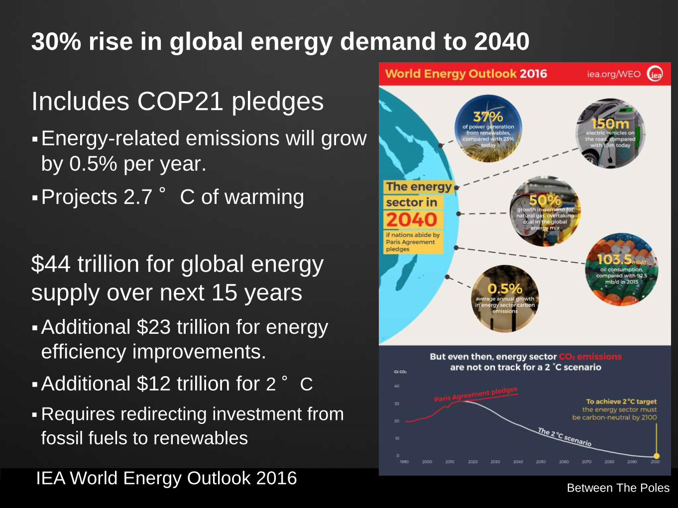
30% rise in global energy demand to 2040
Includes COP21 pledges
Energy-related emissions will grow
by 0.5% per year.
Projects 2.7 °C of warming
$44 trillion for global energy
supply over next 15 years
Additional $23 trillion for energy
efficiency improvements.
Additional $12 trillion for 2 °C
Requires redirecting investment from
fossil fuels to renewables
IEA World Energy Outlook 2016

Between The Poles
60% of world’s greenhouse
gas emissions sourced from
infrastructure including
buildings
New buildings in EU must be designed to be
“nearly zero energy”
2018 - deadline for new public buildings
2020 - deadline for all new buildings
Energy Independence and Security Act of 2007
mandates
2030 - all new Federal facilities must be “net zero
energy” buildings.

Between The Poles
$90 trillion in sustainable infrastructure
investment required over the next 15 years
New approach to
investment in
sustainable infrastructure
required
Requires shift in the world's construction and financial sectors to ensure
that this money, increasingly private, is spent on low-carbon, energy-
efficient project
Global Commission is chaired by former President of Mexico Felipe Calderón and co-chaired by the climate
economist Lord Nicholas Stern.
$90 trillion in
infrastructure
next 15 years

© 2009 Autodesk Between The Poles
Who is going to do all this ?

© 2009 Autodesk Between The Poles
Historical Productivity in Construction
McKinsey & Company

Geospatial Media Between The Poles
Funding increasingly private
http://www.hm-treasury.gov.uk/national_infrastructure_plan2011.htm
The National Infrastructure Plan brings together the first
ever comprehensive cross-sectoral analysis of the UK’s
infrastructure networks and sets out a clear pipeline of
over 500 infrastructure projects. worth over £250 billion
over the next 5 years.
The Government will use all the tools at its disposal to
facilitate the private investment that will finance the
majority of the UK’s infrastructure.
£400 billion over next decade
Target 70% private funding
Drives
investment
in technology

© 2009 Autodesk Between The Poles Between The Poles
Geospatial and BIM are key to transforming
construction
Construction is ripe for disruption
key technologies: Geospatial and BIM Reality modeling using phodar and LiDAR
technologies
Above and below-ground: Ground-penetrating
radar, magnetometers, and other equipment,
integrated with LiDAR
5D BIM
Geocoordination enables full-lifecycle BIM -
integrating BIM and geospatial by georeferencing
everything
Imagining construction’s digital future, McKinsey & Company

Geospatial Media Between The Poles
McKinsey: 5D BIM key for construction transformation
Geospatial Media Between The Poles
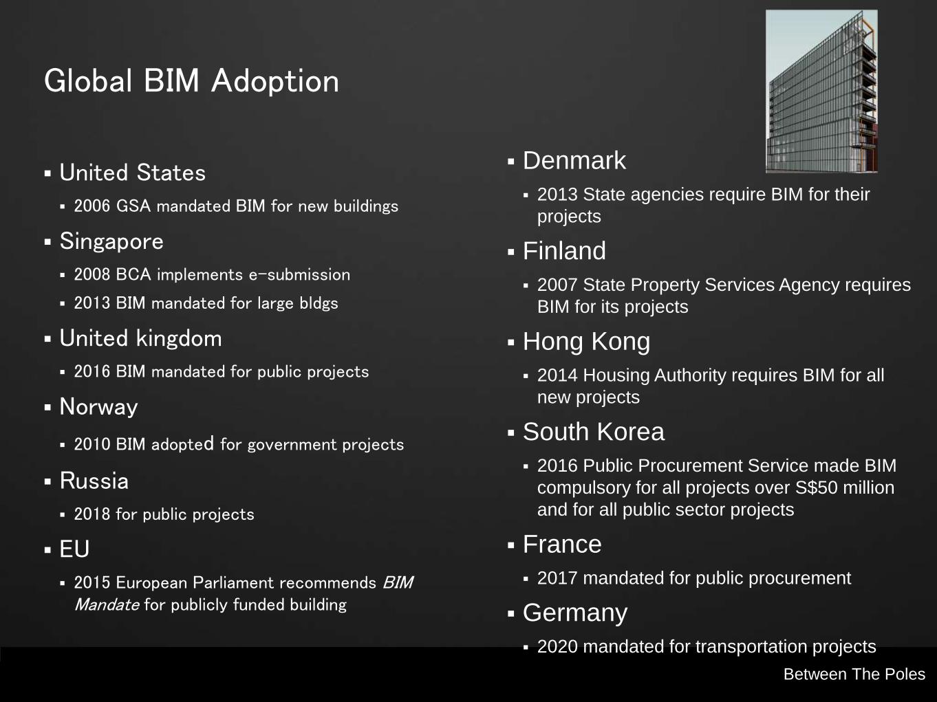
Global BIM Adoption
United States 2006 GSA mandated BIM for new buildings
Singapore 2008 BCA implements e-submission
2013 BIM mandated for large bldgs
United kingdom 2016 BIM mandated for public projects
Norway
2010 BIM adopted for government projects
Russia 2018 for public projects
EU 2015 European Parliament recommends BIM
Mandate for publicly funded building
Denmark
2013 State agencies require BIM for their
projects
Finland
2007 State Property Services Agency requires
BIM for its projects
Hong Kong
2014 Housing Authority requires BIM for all
new projects
South Korea
2016 Public Procurement Service made BIM
compulsory for all projects over S$50 million
and for all public sector projects
France
2017 mandated for public procurement
Germany
2020 mandated for transportation projects

Between The Poles
McKinsey: 5D BIM a key technology
Caltrans - Parsons Brinckerhoff
SF Presidio Parkway Project
Geospatial Media Between The Poles
McKinsey: New geospatial technologies key for construction transformation

Geospatial Media Between The Poles
PhoDAR (phtogrammetric detection and ranging) based on
Structure from Motion (SfM)
Improved Vegetation Management with PhoDAR
Dave Twichell, Brian Baldwin, David Shear
Reality modeling (AKA phodar)

Geospatial Media Between The Poles
New imaging laser scanner lowers bar
Full-color panoramic images on a high
accuracy point cloud
Infrared sensors for thermal imaging
360,000 points per second
Range of 60 meters with 4 mm
accuracy
Weighs one kilogram
Anticipated retail price of scanner and
software $15,990/€15,000
BLK360, Leica Geosystems+Autodesk

Between The Poles Between The Poles
UAVs - Beyond visual line of sight (BVLOS)
Xcel launched UAV Proof of Concept project in 2015 with seven
UAV missions in 2015
Beyond visual line of sight
(BVLOS) pilots
Feb 3, 2016 Xcel completed the
first beyond visual line of sight
mission with UAV flights over 20
miles of transmission lines.
Convinced that FAA will permit
commercial BVLOS flights in the
near future.

Between The Poles Between The Poles
Advances in Earth-observation satellites
Digital Globe
• Revisit same place four times per day with
30 cm resolution
• Online access to 16 years of earth imagery,
about 90 petabytes
Planet Labs
• Whole Earth imagery very hour (future)
Terra Bella – was Skybox, acquired by Google
• Frequent high-resolution imagery
urthecast
• Four cameras on ISS
• Near-real time - 0.75 m resolution
• OptiSAR constellation - optical + radar (future)

Between The Poles Between The Poles
Ground penetrating radar (GPR)
Geotec

Between The Poles Between The Poles
Indoor navigation
Wearable reality-capture
technology combines five
high-dynamic cameras and
two LiDAR profilers
Creates a 3D view indoors
or outdoors for engineering
or professional
documentation
Uses SLAM (simultaneous
localisation and mapping)
to determine position in
GNSS-denied areas.
Leica Pegasus: Backpack
Map the interior of buildings by simply
walking through the building

Geospatial Media Between The Poles
Full-lifecyle BIM requires integrated geospatial+ BIM

Between The Poles Between The Poles
Full-lifecycle BIM: Netherlands
Design, build, finance and maintain
(DBFM)
Contractor responsible for
designing, building, financing, and
maintenance.
Royal BAM Group nv / BAM Infraconsult
BIM for Infrastructure process based around a geospatially-enabled
database.
Everything georeferenced
Data collected during design and construction migrated to an integrated
GIS+FM system for maintenance activities
Reality capture at the beginning of the project, before design, using laser
scanning.

Between The Poles Between The Poles
Full-lifecyle BIM: Crossrail
UK Government mandated
BIM Level 2 April 2016
Expects 20% savings on
design and construction
Biggest benefit 40% savings
during operations and
maintenance
Crossrail largest engineering project in Europe
Full-lifecycle BIM - 3D model used during design and construction
intended for oprations and maintenance
Between The Poles Between The Poles
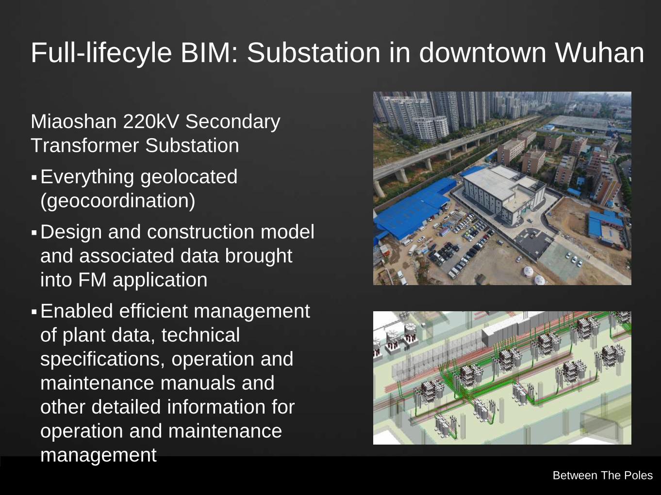
Full-lifecyle BIM: Substation in downtown Wuhan
Miaoshan 220kV Secondary
Transformer Substation
Everything geolocated
(geocoordination)
Design and construction model
and associated data brought
into FM application
Enabled efficient management
of plant data, technical
specifications, operation and
maintenance manuals and
other detailed information for
operation and maintenance
management

Between The Poles Between The Poles
Full-lifecyle BIM: Hydropower generation plant
Longkaikou Hydropower Station
3D BIM design shortened
design cycle, improved project
and service quality, and
reduced construction costs
Everything geolocated
(geocordination)
BIM model provided the basis
for digital operation and
maintenance of the facility by
the owner.

© 2009 Autodesk Between The Poles
Modeling existing infrastructure

Between The Poles Between The Poles
Scan to BIM
Mollenhauer sees a major future business opportunity
Has identified major business opportunity in energy performance modeling for existing buildings.
“Scan to BIM” model is the starting point for energy performance modeling and redesign
Mollenhauer (Los Angeles)

Geospatial Media Between The Poles
Modeling underground infrastructure
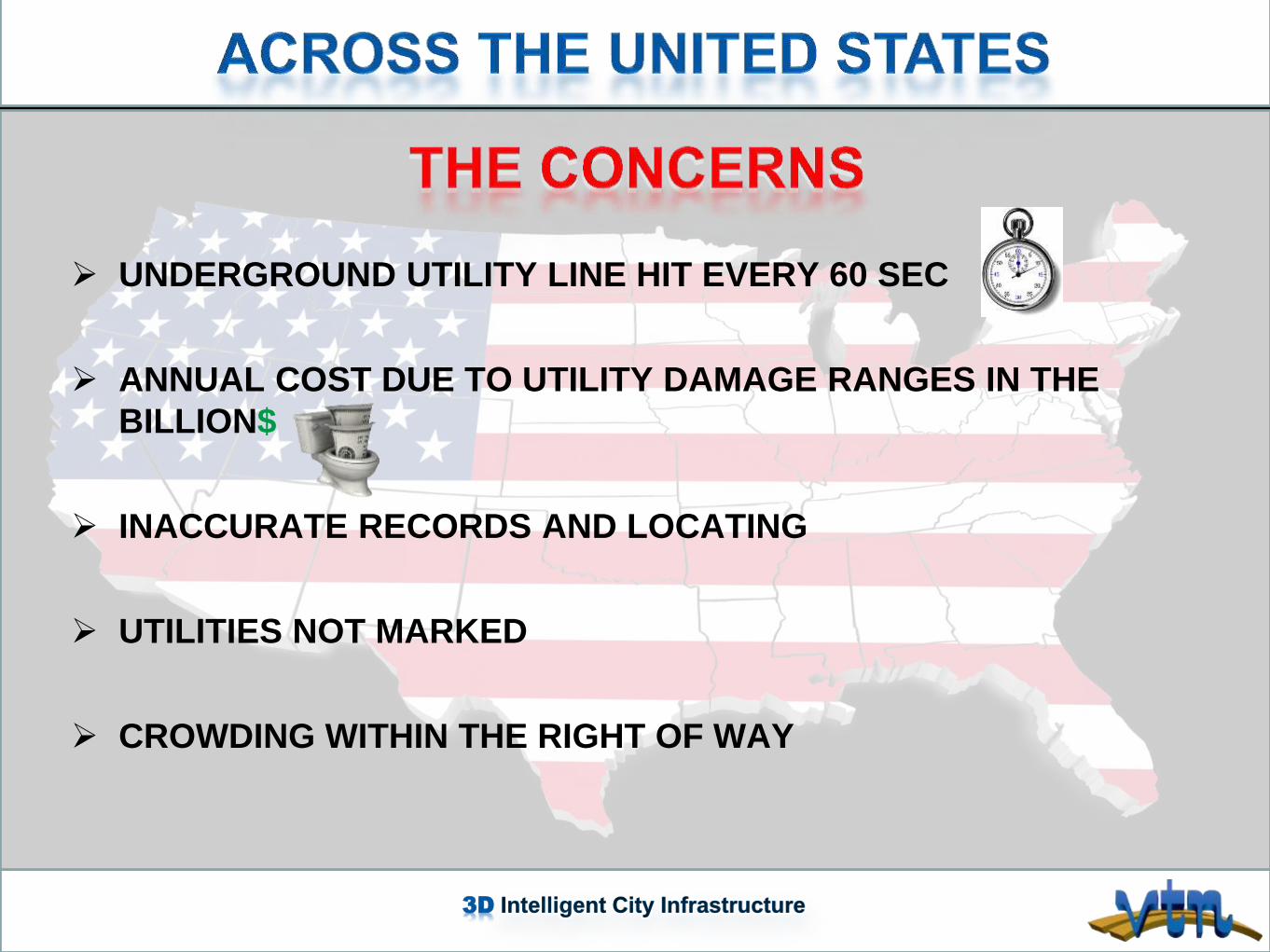
3D Intelligent City Infrastructure
UNDERGROUND UTILITY LINE HIT EVERY 60 SEC
ANNUAL COST DUE TO UTILITY DAMAGE RANGES IN THE
BILLION$
INACCURATE RECORDS AND LOCATING
UTILITIES NOT MARKED
CROWDING WITHIN THE RIGHT OF WAY

Geospatial Media Between The Poles
VTN Consulting
Las Vegas 3D infrastructure model
Geospatial Media Geospatial Media Between The Poles
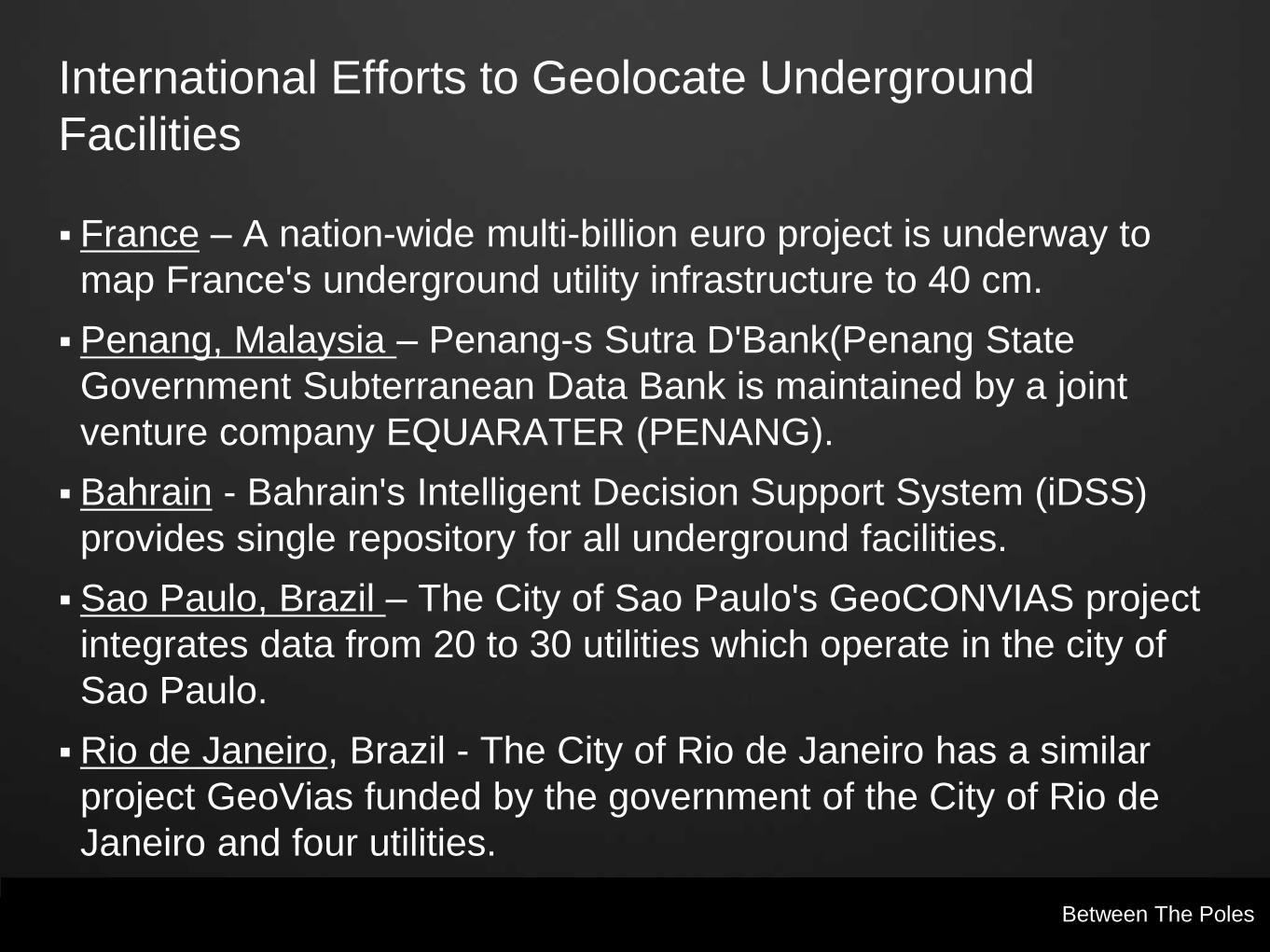
International Efforts to Geolocate Underground
Facilities
France – A nation-wide multi-billion euro project is underway to
map France's underground utility infrastructure to 40 cm.
Penang, Malaysia – Penang-s Sutra D'Bank(Penang State
Government Subterranean Data Bank is maintained by a joint
venture company EQUARATER (PENANG).
Bahrain - Bahrain's Intelligent Decision Support System (iDSS)
provides single repository for all underground facilities.
Sao Paulo, Brazil – The City of Sao Paulo's GeoCONVIAS project
integrates data from 20 to 30 utilities which operate in the city of
Sao Paulo.
Rio de Janeiro, Brazil - The City of Rio de Janeiro has a similar
project GeoVias funded by the government of the City of Rio de
Janeiro and four utilities.

Geospatial Media Geospatial Media Between The Poles
International Efforts to Geolocate Underground
Facilities (cont.)
Tokyo, Japan (now deployed in major Japanese cities) – Many years
ago Tokyo developed the mainframe-based Road Administration
Information Center (ROADIC) system
Sarajevo, Bosnia – Over 40 years ago as part of the permitting process,
Sarajevo mandated the recording the location of all utility and
telecommunications infrastructure in the city.
Calgary, Alberta – A number of years ago the City Government passed a
by-law which mandated that all utilities and telecoms working within city
limits must provide data showing the geolocation of their infrastructure to
the city's Joint Utility Mapping Project (JUMP).
State of Jalisco, Mexico - The Instituto de Información Territorial del
Estado de Jalisco developed an integrated infrastructure database for
the State of Jalisco.
Edmonton, Alberta - Edmonton, Alberta has a shared facilities mapping
database.

Geospatial Media Between The Poles
Intelligent cities
Geospatial Media Between The Poles
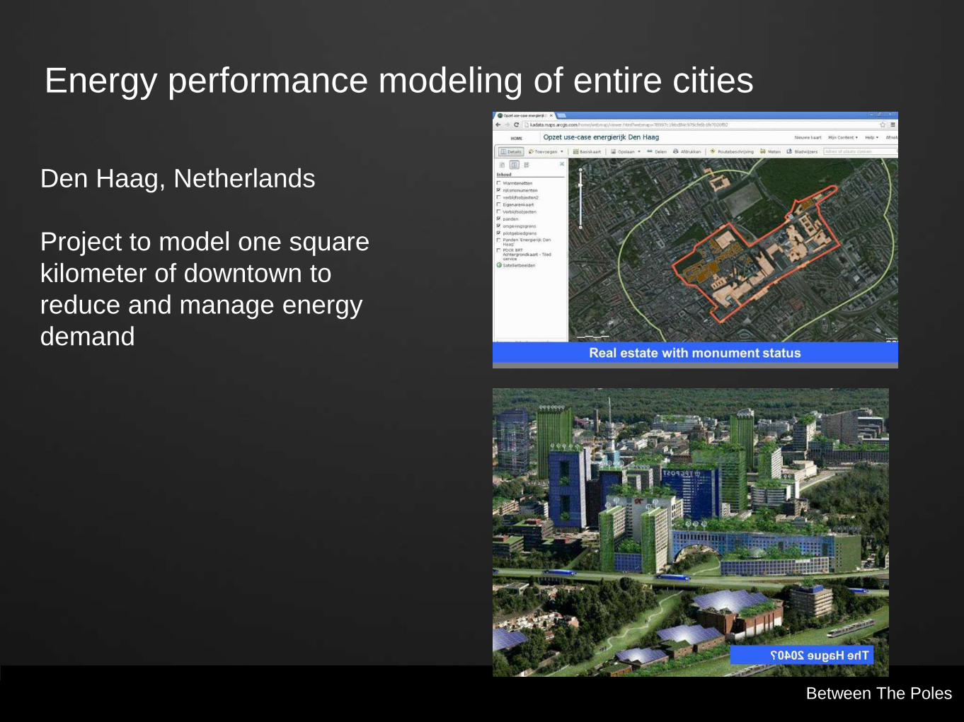
Energy performance modeling of entire cities
Den Haag, Netherlands
Project to model one square
kilometer of downtown to
reduce and manage energy
demand
Geospatial Media Geospatial Media Between The Poles Parsons Brinckerhoff
Modeling entire cities

Geospatial Media Between The Poles
Maintained infrastructure/building information
models are essential fir resilience
Urbanization and environmental challenges
means massive investment in infrastructure
More private investment
Drives investment in technology
Advances in construction productivity
BIM + geospatial technologies
Full-lifecycle BIM model
Requires undergroumd infrastructure modeling
Maintained above and below ground models
Intelliigent infrastructure models enable
resilient cities
Geospatial Media
http://geospatial.blogs.com
Geoff Zeiss, Principal
Between The Poles