Geology of the Powder River Basin Wyoming and Montana with
84
/' -9 - 7 /A >^ J£j±r-__ 7 /n/ -J5JJ& TEI " 8 Geology of the Powder River Basin Wyoming and Montana with reference to subsurface disposal of radioactive wastes By Helen M. Beikman Trace Elements Investigations Report 823 UNITED STATES DEPARTMENT OF THE INTERIOR GEOLOGICAL SURVEY
Transcript of Geology of the Powder River Basin Wyoming and Montana with
/' -9 - 7 /A >^ J£j±r-__ 7
/n/ -J5JJ& TEI " 8
Geology of the Powder River Basin
Wyoming and Montana
with reference to
subsurface disposal
of radioactive wastes
By Helen M. Beikman
Trace Elements Investigations Report 823
UNITED STATES DEPARTMENT OF THE INTERIOR
GEOLOGICAL SURVEY
TEI-823
UNITED STATES DEPARTMENT OF THE INTERIOR
GEOLOGICAL SURVEY
GEOLOGY OF THE POWDER RIVER BASIN, WYOMING AND MONTANA,
WITH REFERENCE TO SUBSURFACE DISPOSAL OF
RADIOACTIVE WASTES*
By
Helen M. Beikman
February, 1962
Trace Elements Investigations Report TEI-823
This report is preliminary and has not been edited for conformity with Geological Survey format.
Prepared on behalf of the U.S, Atomic Energy Commission
WQV 2
2
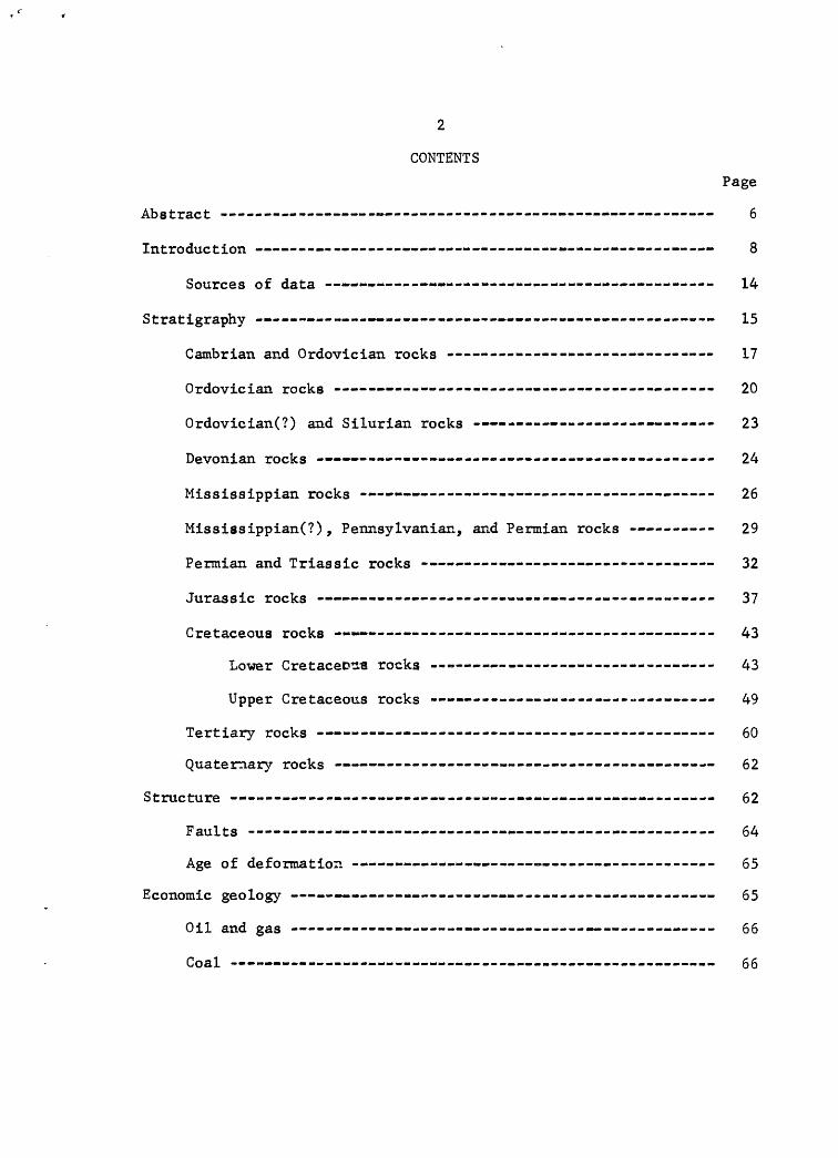
CONTENTS
Page
Abstract - -- - - - 6
Introduction -- . . ......... .... ........ 8
Sources of data - . .. .- ..»., . 14
Stratigraphy ------ ........ .... ............. ..... 15
Cambrian and Ordovician rocks ------------------------- - -- 17
Ordovician rocks ---- - - .- ., .---- 20
Ordovician(?) and Silurian rocks - - - 23
Devonian rocks - - ~ - .. ...... - - 24
Mississippian rocks ------ -- -- - - 26
Mississippian(?), Pennsylvanian, and Permian rocks -- - 29
Permian and Triassic rocks - -- ----- 32
Jurassic rocks ---------------------- - ----------------- 37
Cretaceous rocks » -- ---- -- ---------- ------ 43
Lower Cretacefcns rocks --- - 43
Upper Cretaceous rocks - - --- 49
Tertiary rocks - - - ----- - . - . 60
Quaternary rocks - -- -- - -- 62
Structure -- < -- 62
Faults -- 64
Age of deformation - -- ...- .- ---------------- 65
Economic geology - - ........ .... .. 65
Oil and gas - - -- --«-- - -------- 66
Coal -- --- --------------------- ---- -- - ------ ----- 66
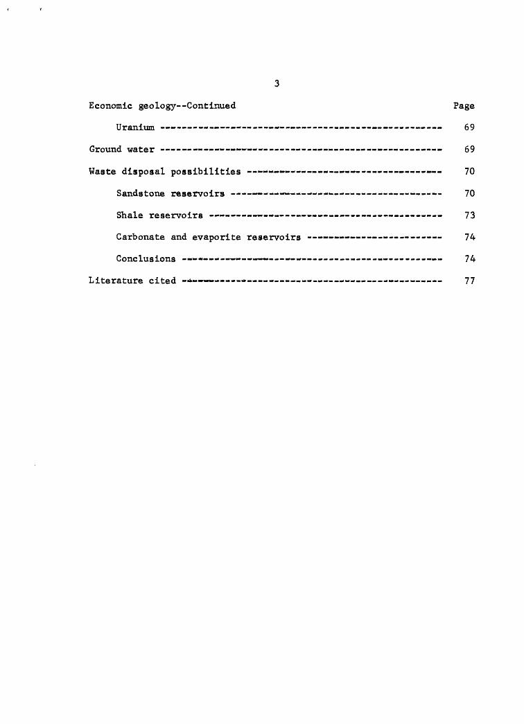
3
Economic geology Continued Page
Uranium - ...... ,_. , .......... .... 69
Ground water - - . . - ..... ....... . ..... 69
Waste disposal possibilities - . .-.- .... - , 70
Sandstone reservoirs -.- ..- --..-..- ................. 70
Shale reservoirs - -- .- .... ....... . 73
Carbonate and evaporite reservoirs ........ ............. 74
Conclusions - «* -- .- -....................... .... 74
Literature cited -* -*.- ...- -.- ..... ........... 77
4
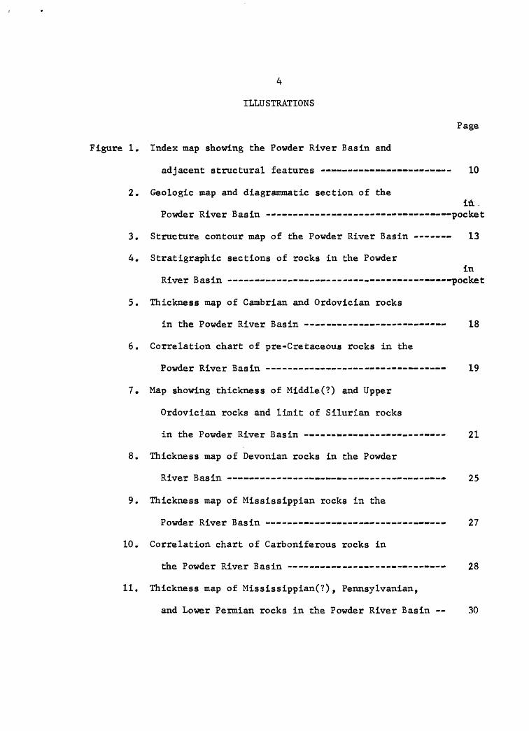
ILLUSTRATIONS
Page
Figure 1. Index map showing the Powder River Basin and
adjacent structural features - 10
2. Geologic map and diagrammatic section of thein..
Powder River Basin '--- . pocket
3* Structure contour map of the Powder River Basin ------ 13
4. Stratigraphlc sections of rocks in the Powderin
River Basin -- _ . pocket
5. Thickness map of Cambrian and Ordovlcian rocks
in the Powder River Basin * 18
6. Correlation chart of pre-Cretaceous rocks in the
Powder River Basin - . 19
7. Map showing thickness of Mlddle(?) and Upper
Ordovician rocks and limit of Silurian rocks
in the Powder River Basin - _- 21
8. Thickness map of Devonian rocks in the Powder
River Basin * 25
9. Thickness map of Mlssissippian rocks in the
Powder River Basin - * *- 27
10. Correlation chart of Carboniferous rocks in
the Powder River Basin - - - 28
11. Thickness map of Mississippian(?), Pennsylvanlan,
and Lower Permian rocks in the Powder River Basin 30
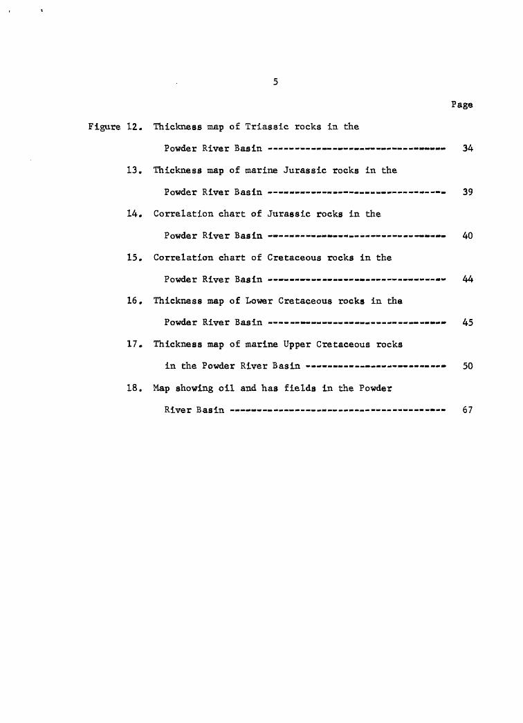
Page
Figure 12, Thickness map of Triassic rocks in the
Powder River Basin - -- .- » » » 34
13. Thickness map of marine Jurassic rocks in the
Powder River Basin - - - 39
14. Correlation chart of Jurassic rocks in the
Powder River Basin . -- -»- 40
15. Correlation chart of Cretaceous rocks in the
Powder River Basin . -'- «-»- - - 44
16. Thickness map of Lower Cretaceous rocks in the
Powder River Basin « > - 45
17. Thickness map of marine Upper Cretaceous rocks
in the Powder River Basin - -- 50
18. Map showing oil and has fields in the Powder
River Basin - ..»- -.- -. 67
GEOLOGY OF THE POWDER RIVER BASIN WITH REFERENCE TO
SUBSURFACE DISPOSAL OF RADIOACTIVE WASTES
By Helen M. Beikman
ABSTRACT
The Powder River Basin is a structural and topographic basin occu
pying an area of about 20,000 square miles in northeastern Wyoming and
southeastern Montana, The Basin is about 230 miles long in a northwest-
southeast direction and is about 100 miles wide. It is bounded on
three sides by mountains in which rocks of Precambrian age are exposed.
The Basin is asymmetrical with a steep west limb adjacent to the
Bighorn Mountains and a gentle east limb adjacent to the Black Hills.
Sedimentary rocks within the Basin have a maximum thickness of
about 18,000 feet and rocks of every geologic period are represented.
Paleozoic rocks are about 2,500 feet thick and consist of marine car»
bonate rocks and sandstone; Mesozoic rocks are about 9,500 feet thick
and consist of both marine and nonmarine siltstone and sandstone; a:id
Cenozoic rocks are from 4,000 to 6,000 feet thick and consist of coal-
bearing sandstone and shale. Radioactive waste could be stored i~ the
pore space of permeable sandstone or in shale where apace could be
developed. Many such rock units that could be used for storing
radioactive wastes are present within the Powder River Basin.
7
Permeable sandstone beds that may be possible reservoirs for
storage of radioactive waste are present throughout the Powder River
Basin. These include sandstone beds in the Flathead Sandstone and
equivalent strata in the Deadwood Formation, the Tensleep Sandstone
and equivalent strata in the Minnelusa FormatioUy'sn^-the Sundance
Formation in rocks of pre-Cretaceous age. However, most of the
possible sandstone reservoirs are in rocks of Cretaceous age and
include sandstone beds in the Fall River, Lakota, Newcastle, Frontier,
Cody, and Mesaverde Formations. Problems of containment of waste such
as clogging of pore space and chemical incompatibility would have to
be solved before a particular sandstone unit could be selected for
waste disposal.
Several thick sequences of impermeable shale such as those in the
Skull Creek, Mowry, Frontier, Belle Fourche, Cody, Lewis, and Pierre
Formations, occur in rocks of Cretaceous age in the Basin. Limited
storage space for liquid waste might be developed in impermeable shale
by fracturing the shale and space for calcined or fused waste could be
developed by mining cavities.
8
INTRODUCTION
This report on the geology of the Powder River Basin is one of a
series of reports by the Geological Survey on sedimentary basins in
the United States. It has been prepared for the Division of Reactor
Development, Atomic Energy Commission, as a part of their radioactive
waste disposal program. The regional geology and the stratigraphy of
the Basin is described in order to provide a geologic summary for a
preliminary evaluation of the radioactive waste disposal possibilities.
Safe disposal of radioactive waste necessitates that the waste be
placed where it will be contained within certain limits until the
fission products it contains have disintegrated to a safe level of
radioactivity. The length of time for the disintegration varies
according to the contained isotopes; some require only a few years to
disintegrate, others several hundreds of years. Subsurface storage in
rock is one possible way to safely dispose of radioactive waste.
Radioactive waste stored in subsurface rock must be placed where it
will remain contained. Liquid radioactive waste has a higher specific
gravity than unmineralized ground water. Therefore, one possibility in
subsurface storage is in a structural basin, sticr. as the Powder River
Basin, where updip migration of liquid waste would be inhibited because
of its higher specific gravity. The major geologic factors to be con
sidered in evaluating rock units in the Powder River Basin as possible
storage reservoirs for radioactive waste are that the rock unit be
capable of receiving and containing the waste, and that it is not a
reservoir for potable ground water or oil and gas, and one that is at
suitable depth.
9
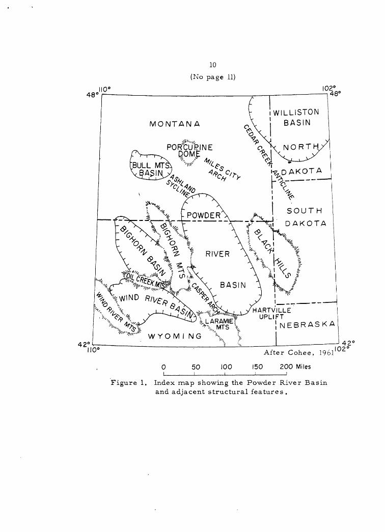
The Powder River Basin underlies an area of about 20,000 square
miles and occupies most of northeastern Wyoming and part of south
eastern Montana (fig, 1). It is a structural and topographic basin
bounded on the west by the Bighorn Mountains, on the southwest by the
Casper arch, on the south by the north end of the Laramie Mountains
and by the Hartville uplift, and on the east by the Black Hills. The
northeastern limit is the Miles City arch, a low arch that extends
northwest from the Black Hills uplift to Porcupine Dome, and the
northwestern limit is a low arch within the Ashland syncline that
separates the Powder River Basin from the Bull Mountain Basin.
Rocks of Precambrian age, consisting of granite and lesser amounts
of metasedimentary and other igneous and metamorphic rocks, form the
cores of the mountain uplifts on three sides of the Basin (fig. 2).
Paleozoic and Mesozoic rocks crop out in a steeply dipping belt along
the east front of the Bighorn'Mountains and in a more moderately dipping
belt along the west flank of the Black Hills. In north and south
directions away from the Bighorn Mountains and from the Black Hills,
the dip of these rocks decreases and the widths of outcrop become
greater. At the southern margin of the Basin, rocks of Miocene and
Oligocene age overlap Paleozoic and Mesozoic rocks which are exposed
only in small areas of the Laramie Mountains and Hartville uplift.
The central and northern parts of the Basin are covered by thick
continental deposits of Cenozoic age.
10
(No page 11)
WILLISTON BASINMONTANA
^' "t/, PORCUPINE
I , poo A SKA NEBRASKA-/, WS Y O M I N G ''''*-
100
After Cohee, 1961
150 200 Miles
102'
Figure 1. Index map showing the Powder River Basin and adjacent structural features.
12
The largest towns in the Powder River Basin are Casper, with a
population of about 40,000 and Sheridan, with a population of about
12,000. Buffalo, Gillette, Sundance, Douglas, Newcastle, and Lusk all
have a population of less than 5,000. The total population of the
area, according to the 1960 census, is about 120,000 (The world
almanac and book of facts for 1961).
The Basin is drained by the Powder River, for which it is named,
and by the Belle Fourche, Cheyenne, and North Platte Rivers and their
tributaries. The climate is semiarid and is characterized by large
annual changes in temperature, which ranges from as low as -45° F to
as high as 110° F. The maximum topographic relief within the Basin is
about 1,000 feet and local relief is only several hundred feet. The
floor of much of the Basin is characterized by badland topography,
which together with a shortage of roads, makes access difficult in a
few parts of the basin.
The Powder River Basin is about 230 miles long and 100 miles wide
and is one of the largest Rocky Mountain intermontane basins. It is an
asymmetrical syncline whose trough trends N. 15° to N. 20° W. parallel
to the central Bighorn Mountains (fig. 3). The west limb of the syn
cline is very steeply dipping and at places the rocks are overturned to
the east. The east limb has a gentle dip of 3° to 5° westward from the
Black Hills. The deepest part of the Basin is on the west adjacent to
the Bighorn Mountains. Paleozoic rocks are in places about 21,000 feet
higher in elevation on the east flank of the Bighorn Mountains than they
are in the deepest part of the trough of the Basin; thus structural
relief is about 21,000 feet.

13
,..-!ROSEBUD!'"---.' . Broadusji
,' POW-OER
__....-,-' -. Wt&M ING
D A N ',. ; \
44°
43°
108°LA&AMTH 1M OUNTAIN^ j~lL.L-Jfe.
!07° 106° " 105°l04°
Dota from Pierce and girard(l952), Dobbin and Erdmann(!955), Dobbin and others(!957),and Mqpel and others (1959)
25 0 i ii iii
25 50i
75 mi Fes
Figure 3.- -Structure contour map of the Powder River Basin.
EXPLANATION
-lOOO ......
Structure contour Drawn on top of the Fall River Formation (or an equivalent horizon) of Early Cretaceous age, Contours dashed where approx imately located; dotted where schematic. Contour interval is 1, 000 feet; 5, 000 feet in areas of maximum relief
Fault
Trough of sync line
14
The Basin was formed during Late Cretaceous and early Tertiary
time when the bordering mountain masses were elevated. During the
Paleozoic and Mesozoic, the area of the Powder River Basin was part of
a relatively stable interior platform. This platform was at times
flooded by epicontinental seas in which carbonate and clastic sediments
were deposited. Rocks ranging in age from Cambrian to Cretaceous are
essentially concordant. Several unconformities are present which
represent intervals of erosion or of nondeposition, A major uncon
formity at the base of the Mississippian is indicated by the southward
truncation of progressively older rocks, ranging in age from Devonian
to Cambrian, beneath the Madison Limestone. The badland topography
of the Basin resulted from Recent erosion which has largely removed
the continental deposits that covered the Basin during Oligocene and
Miocene time and has deeply dissected the underlying Eocene and
Paleocene rocks.
Sources of data
This summary of the geology of the Powder River Basin has been
drawn from many published and unpublished reports which are cited in
the text. Most of the lithologic descriptions and thickness data,
which are not individually credited, were obtained from recent reports
on the geology of uplifted areas adjacent to the Powder River Basin.
Richards (1955) was used for the northwest part, Hose (1955) and Mapel
(1961) for the west-central part, and Robinson, Mapel, and Bergendahl
(in prep.) for the eastern part. Reports by Sandberg and Hammond
(1958) and Sandberg (1961) were sources for data on Devonian rocks.
Much information concerning Jurassic and Triassic strata was taken from
15 (r:a page 16)
the folio reports on these systems (McKee and others, 1956 and 1959).
The Guidebooks to the 4th and 13th Annual Field Conferences in the
Powder River Basin (1949, 1958) and Wyoming Stratigraphy (1956) by the
Wyoming Geological Association contain numerous papers that were very-
helpful in the preparation of this report.
STRATIGRAPHY
Sedimentary rocks aggregate a maximum thickness of about 18,000
feet in the Powder River Basin. Rocks of all geologic systems are
represented; however, rocks of Silurian and Devonian age are limited
in extent. Paleozoic rocks are about 2,500 feet thick and consist
predominantly of marine carbonate and sandstone. Mesozoic rocks are
about 9,500 feet thick, and consist mostly of claystone, siltstone,
and sandstone of both marine and nonmarine origin. Cenozoic rocks are
from 4,000 to 6,000 feet thick and are coal-bearing sandstone and
shale. Quaternary deposits comprise alluvium, terrace gravel, and
landslide debris.*
Different nomenclature for equivalent units is used for a number
of the outcropping rocks on the major uplifts surrounding the Basin
because of variations in lithology, thickness, and age of the rock
units. The correlation of the formation r^ames used in the various
uplifts is shown diagrammatically on several charts (figs. 6, 10, 14,
and 15) and the changes in both nomenclature and lithology from west
to east across the Basin are shown in figure 4. Where practicable,
the stratigraphic units are described first on the west side of the
Basin in the Bighorn Mountains and then correlated with equivalent
units in the Black Hills to the east.
17
Cambrian and Ordovician rocks
Rocks of Cambrian and Early Ordovician age comprise a predomi
nantly clastic sequence that underlies the Powder River Basin. They
are about 1,000 feet thick near the Bighorn. Mountains in the northern
part of the Basin, but they thin progressively southeastward to 90 feet
in the Laramie Mountains and to only 60 feet in the Hartville uplift
(fig. 5).
In the Bighorn Mountains, the clastic sequence is divided into
three formations (fig. 6). The Flathead Sandstone overlies Precambrian
rocks. It is 260 to 500 feet thick and consists of fine- to coarse
grained quartzite sandstone with thin interbeds of shale and siltstone.
It is overlain by the Gros Ventre Formation, as much as 700 feet thick.
The Gros Ventre consists mostly of shale and sandstone with thin
interbeds of limestone. The uppermost formation, the Gallatin
Limestone, consists of grayish-red limestone. It thins southward along
the flank of the Bighorn Mountains from 150 feet to a wedge edge.
Paleontologic evidence suggests that part of the Gallatin is of
Early Ordovician age (Shaw, 1954).
In the Black Hills, the Deadwood Formation of Late Cambrian age
is equivalent in part to the three formations in the Bighorn Mountains.
It consists of sandstone, shale, and some limestone, which are glaucon-
itic in part (Barton and Paige, 1925, p. 5). The Deadwood thins
southeastward from about 500 feet at the north end of the Black Hills
to 200 feet near Newcastle, Wyoming (fig. 5).
18
108°
43°
\ ^ S\H E Ri. 'Sheridan / *.. n
v*--V-/L- -/ .. v.,^ i / yop0 i/ca 7B//i
]| JOHNSON44° 44°
108° 107° 106° 105°
Based on McCoy, 1958, fig. 1
25i_ 0 i i
25 50 75 mil es _i
Figure 5.-- Thickness map of Cambrian and Ordovician rocks in the Powder River Basin. (Thickness interval is 100 feet).
19
Gypsum Spring Formation Gypsum Spring Formation Gypsum Sprlug Formatio
PERMIANMinnekahta Ls. equiv. Minnekahta Limestone
TRIASSIC
PENNSYLVANIAN
MISSISSIPPI
DEVONIAN
Lower
Middle
Lower
Lower
Upper
BIGHORN MOUNTAINSSUBSURFACE OF
POWDER RIVER BASIN BLACK HILLS
Chugwater FormationRed shale and gypsum _______sequence_______
Red shale and gypsum _____sequence_______
Spearfis'n Formation
Minnekahta Limestone Opeone Snale
Minnelusa FormationAmsden Formation
Madison Limestone j ^^ison Limestone Pai^asapa Linestor.e
^<^^^Jefferson Formation j Duperow Formation
Interlake Group of Baillie (1951)
and Gros Ventre Form ation, undivided
Figure 6.-- Correlation chart of pre-Cretaeeous rocks in the Povder
20
The thin Cambrian rocks in the Laramie Mountains consist of
sandstone and conglomerate. In the Hartville uplift, a conglomeratic
quartzite, 0 to 60 feet thick, may be correlative with a basal
sandstone of the Deadwood Formation (Denser, and Botinelly, 1949).
The Deadwood Formation and related rocks, 500-1,000 feet thick in
the northern part of the Powder River Basin, are overlain by rocks of
Middle and Late Ordovician age. However, the thin wedge of Cambrian
rocks 60 feet thick at the south end of the Basin is overlain by rocks
of Late Devonian or Early Mississippian age. This southward thinning
is largely by disappearance of beds from the top of the sequence.
Together with southward truncation of Upper Devonian, Silurian, and
Middle and Upper Ordovician rocks, discussed later, it indicates a
major regional unconformity beneath Mississippian rocks.
Ordovician rocks
Rocks of Middle(?) and Upper Ordovician age underlie the northern
part of the Powder River Basin but are absent south of a line con
necting the southern part of the Bighorn Mountains and the central
part of the Black Hills (fig. 7). Northwestward from this line
Ordovician rocks thicken uniformly to about 500 feet near the Wyoming-
Montana border and in Montana they thicken northeastward to about
750 feet in Carter County. Ordovician rocks comprise a lower clastic
sequence, 0 to 100 feet thick and an upper carbonate sequence,
0 to 650 feet thick (Richards and Nieschmidt, 1961). They unconform-
ably overlie rocks of Early Ordovician and Late Cambrian age. In the
21
108° 107° 106° 105° I04C
-3^ 45°
\ <S> S %4 E'R I D A"N
\ N A T R 0 N A f1
44°
108° 107° 106° 105°
Based on Richards and Nieschmidf 0961]
25 0 i i i i i i 25 50 75 miles _i
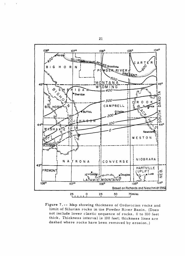
Figure 7.-- Map showing thickness of Ordovician rocks and limit of Silurian rocks in the Powder River Basin. (Does not include lower clastic sequence of rocks, 0 to 100 feet thick. Thickness interval is 100 feet; thickness lines are dashed where rocks have been removed by erosion.)
22
northern part of the Basin Ordovician rocks are either conformably
overlain by Silurian rocks or unconformably overlain by Devonian rocks
and to the south are truncated by Mississippian rocks.
In the Bighorn Mountains, Ordovician rocks are represented by the
Harding(?) Sandstone and the Bighorn Dolomite, which includes the
Lander(?) Sandstone Member at its base (Ross, 1957, pi. 44). The
Harding(?) strata consist of fine- to coarse-grained quartzitic sand
stone which ranges in thickness from a few inches to about 60 feet
(Hose, 1955, p. 45, 46). The Bighorn Dolomite is 0-480 feet thick.
The Lander(?) Sandstone Member at the base of the Bighorn is a 3-foot-
thick medium-grained sandstone. Above the Lander(?) Member is a lower
285-foot unit of massive microcrystalline dolomite and dolomitic
limestone overlain by thin-bedded slabby-and blocky weathering
dolomite and an upper 200-foot unit of massive and thin-bedded dolo
mite (Richards and Nieschmidt, 1961).
The northern part of the Basin is underlain, in ascending order,
by the Winnipeg, Red River, and Stony Mountain Formations (Ross, 1957;
Richards and Nieschmidt, 1961). The Winnipeg Formation is from 0 to
about 100 feet thick in the Powder River Basin (Fuller, 1961, fig. 7)
and is composed of shale interbedded with numerous thin layers of
quartzitic sandstone. The distribution of sandstone and shale is
probably highly variable (Ross, 1957, p. 449). The Red River Formation,
0-500 feet thick, consists of 245 feet of cryptocrystalline to micro-
crystalline limestone and 250 feet of microcrystalline dolomite. The
23
Stony Mountain Formation consists of 0-150 feet of calcareous and
argillaceous siltstone and limestone (Richards and Nieschmidt, 1961).
The Red River and much of the Stony Mountain Formation correspond to
the Bighorn Dolomite in the Bighorn Mountains (Ross, 1957, p. 4A4).
In the Black Hills, Ordovician rocks include about 70 feet of
shale and siltstone overlain by 40 to 80 feet of massive, silty
dolomite. The age and correlation of the shale and siltstone sequence
has been uncertain (Darton and Paige, 1925, p. 7j Furnish, Barragy, and
Miller, 1936; McCoy, 1958aj and Ross, 1957). According to Ross (1957,
p. 468) this sequence is presumed to be of Middle Ordovician age and
supposedly is correlative with the Winnipeg Formation in the subsurface
and with the Lander(?) Sandstone Member of the Bighorn Dolomite in the
Bighorn Mountains. The overlying dolomite sequence, the Whitewood
Limestone of Darton and Paige (1925, p. 7), renamed the Whitewood
Dolomite by Ross (1957, p. 443), appears to be stratigraphically
equivalent to part of the lower beds in Red River Formation in the
subsurface in the Powder River Basin (Richards and Nieschmidt, 1961).
Ordovician(?) and Silurian rocks
The Interlake Group of Baillie (1951), of Ordovician(?) and
Silurian age, underlies the extreme northeastern part of the Powder
River Basin (fig. 7). Rocks of the Interlake Group conformably
overlie Ordovician rocks, to which they are lithologically similar
and from which they are difficult to distinguish, and are unconform-
ably overlain by Devonian rocks. The Interlake Group of Baillie (1951)
24
is from 0 to about 150 feet thick in the Powder River Basin and consists
mostly of cryptocrystalline to sublithographic dolomite (Richards and
Nieschmidt, 1961) .
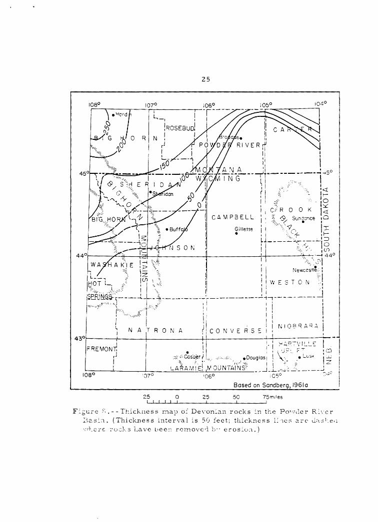
Devonian rocks
Rocks of Devonian age underlie only the northern part of the
Powder River Basin (fig. 8). Lower Devonian rocks are thin discontin
uous channel-fill deposits of the Beartooth Butte Formation and Upper
Devonian rocks are predominantly carbonate deposits, 0 to 210 feet
thick, of the Duperow Formation and equivalent strata in the Jefferson
Formation.
The Beartooth Butte Formation, which unconformably overlies Upper
Ordovician and Silurian rocks, has been recognized in widely scattered
outcrops and wells in northern Wyoming and southern and central
Montana (Sandberg, 1961) . It consists of silty, sandy, limestone con
glomerate and in most places is less than 10 feet thick; however, at
several localities it increases in thickness from a few feet to about
150 feet in less than half a mile. In the Powder River Basin, the
Beartooth Butte Formation consists of continental deposits that fill
sinkholes and channels in the underlying Upper Ordovician and Silurian
rocks. The formation is thought to have been deposited near the
eastern margin of an Early Devonian sea which invaded bays and estu
aries on the west.
The Upper Devonian Duperow Formation rests unconformably on rocks
of Silurian age as well as on the Stony Mountain Formation and upper
part of the Red River Formation, both of Late Ordovician age
25
108° 107°
H E R ! D
I , C/R 0 0 K \ <CAMPBELL ! , * <£x Sunacnce
WAH A K!ENewcastle;
w E s T o N
44°
43°
'"" "I!'1 '
FREMON
\J
K,,,r"!
,,^'i^ i
i! i j N A T R 0 N A f
H
T!rJ
1ii
i i !i1 |\j | 0 R R A R A
CONVERSE 1 1!
. ] HARTViLLE! ; UPL r^
* - ' ' i \ ^''Cas'peri1 |^, ,,1:.,,^.-.. »0ougias 1 \\ LUSK
LA^AMIE MOUNTAINS5 J ]_ .J> ---
1
<1:
i i
!dtj -^r
_l
108° '07° 105°
Based on Sandberg, 1961 a
25 0 i i i i i i
25 50 75mi!es
Figure ^.--Thickness map of Devonian rocks in the Po^ Basin. (Thickness interval is 50 feet; thickness lines
vder R: arc da
rucks uave beer, removed b" erosion.
26
(Sandberg and Hammond, 1958). The Duperow Formation consists of lime
stone, dolomite, and anhydrite with some interbeds of shale and
siltstone; dolomitic shale or shaly dolomite is predominant in the upper
part. It is correlated with the Jefferson Formation of the Bighorn
Mountains, which probably represents a near-shore facies of the lower
part of the type Jefferson. The southward thinning of Upper Devonian
strata in the Powder River Basin results from onlap at the base and
truncation by the Madison Limestone of Mississippian age at the top.
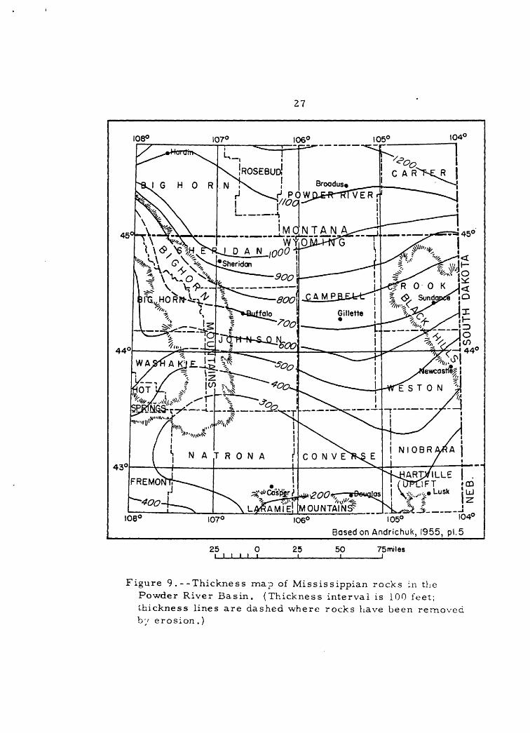
Mississippian rocks
Following a period of uplift the Powder River Basin area was
completely covered by Early Mississippian seas which transgressed from
the north. The Basin received widespread deposits of carbonate rocks
which southward truncate Upper Devonian, Silurian, and Upper and Middle
Ordovician rocks. Mississippian strata are about 1,200 feet thick at
the north end of the Basin and thin with relative uniformity to about
200 feet at the south end (fig. 9). This southward thinning is in
part depositional but is largely due to pre-Chester or pre-Pennsylvanian
erosion. The formation names used on mountain uplifts flanking the
Basin are shown on figure 10.
In the Bighorn Mountains rocks of Mississippian age are repre
sented by the Madison Limestone, a finely crystalline, thin-bedded to
massive sequence of limy dolomite and limestone, 400 to 1,000 feet
thick. In the Black Hills, Mississippian rocks are included in the
Englewood Limestone below and the Pahasapa Limestone above
27
108° 107°
43°
44° 44°
l05°
Based on Andrichuk, 1955, pi.5
25 0 i i i i i i
25 50 75miles
Figure 9 .--Thickness map of Mississippian rocks in the Powder River Basin. (Thickness interval is 100 feet; thickness lines are dashed where rocks have been removed by erosion.)

BIG
HO
RN
MO
UN
TA
INS
L
AR
AM
IE
MO
UN
TA
INS
H
AR
TV
ILL
E U
PL
IFT
BL
AC
K H
ILL
S
PE
RM
IAN
Casp
er
Fo
rmati
on
Ten
sleep
San
dst
on
eH
art
vil
le F
orm
ati
on
Mm
nelu
sa F
orm
ati
on
Am
sden F
orm
ati
on
Mad
iso
n L
imest
on
eP
ah
asa
pa L
imest
on
eG
uern
sey F
orm
ati
on
Madis
on L
imest
one
\\\\
\\\\
\\\\
\\\\
\\\\
\\\\
\\\\
\\\\
\\\
Engle
wood L
imest
on
e
ts)
00
Fig
ure
10
.--C
orr
ela
tio
n chart
of
Carb
onif
ero
us
rock
s in
the
Po
wd
er
Riv
er
Basi
n.

29
(Barton and Paige, 1925, p. 7-8). The Englewood is30to60feet thick arid
is typically a thin-bedded, lavender limestone which grades upward into
limestone of the Pahasapa and in places grades downward into shale. The
overlying Pahasapa ranges from 300 to 630 feet in thickness and is a
fine-grained massive limestone which in places contains thin beds of
shale or slabby limestone. In the northern part of the Hartville area,
the Guernsey Formation includes 200-300 feet of rocks of Mississippian
age, which consist of cherty coarsely crystalline dolomite that grades
upward into cherty limestone. Fossils of Devonian age have been found
at the base of the Guernsey Formation below a probable equivalent of
the Englewood Limestone (Love and others, 1953).
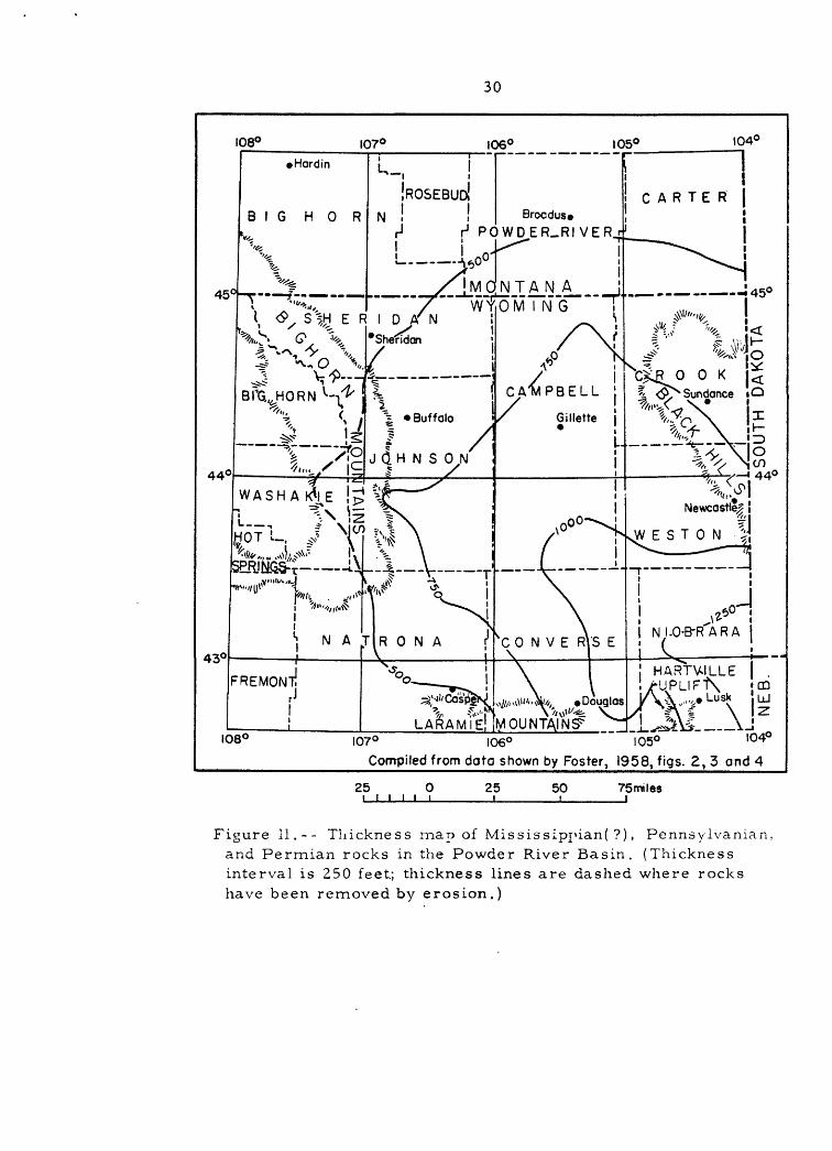
Mississippian(?), Pennsylvanian. and Permian rocks
A diverse sequence of clastic, carbonate, and evaporite rocks,
characterized by marked changes in thickness and lithology, discon-
formably overlies the Mississippian carbonate rocks and is overlain by
a relatively uniform Permian red bed sequence. These rocks are largely
Pennsylvanian in age but some possibly extend down into the Mississippian
and some very probably extend up into the Permian. The formation names
used for this heterogeneous sequence on the mountain uplifts flanking
the Basin are shown on figure 10.
In the Bighorn Mountains, Pennsylvanian rocks, represented by the
Amsden Formation below and Tensleep Sandstone above, are about 600 feet
thick (fig. 11). The Amsden Formation, about 250 feet thick, consists
of sandstone and shale in the lower half and limestone and dolomite in
30
108° 107°
43°
Brocdus* r1 POWDER-RIVER
44° 44°
! HARTVILLE | . UUxPLIF t\. !P°
108°
LJ
107° 106° 105° I04° Compiled from do to shown by Foster, 1958, figs. 2, 3 and 4
25 0 i i i i i i 25 50 75miles
Figure 11.-- Thickness map of Mississippian( ?), Pennsylvania!!, and Permian rocks in the Powder River Basin. (Thickness interval is 250 feet; thickness lines are dashed where rocks have been removed by erosion.)

31
the upper half. The Tensleep Sandstone is less than 75 feet thick in
the northern part of the Bighorn Mountains, but it thickens to more
than 350 feet in the southern part. It is a fine- to medium-grained
quartz sandstone with some interbedded limestone a~d dolomite in the
lower part. The combined Amsden and Tensleep range in age from Early
through Middle Pennsylvanian..
In the southwest part of the Basin along the north er.d of the
Laramie Mountains, the Casper Formation, about 500 feet thick,
consists predominantly of alternating thicker beds of sandstone and
thinner beds of limestone (Thomas and others, 1953, p. 6). It ranges
in age from Late Pennsylvanian to Early Permian.
On the Hartville uplift, the Hartville Formation includes as
much as 1,300 feet of rocks between the top of the Guernsey Formation
and the base of the Opeche Shale (Love and others, 1953). On the basis
of gross lithology, the Hartville Formation can be divided ir.to three
units: a basal sandstone, 50 to 100 feet thick; a middle carbonate
sequence, about 700 feet thick, consisting of limestone, dolomite,
shale, and sandstone; and a sandstone and breccia sequence, whose
upper part is 50 to 200 feet of soft porous sandstone. The Hartville
Formation ranges in age from Late Mississippian(?) or Early
Pennsylvanian to Early Permian.
In the Black Hills, rocks of Pennsylvanian age are included in the
Minnelusa Formation, which ranges in thickness from 650 to 800 feet.
It consists of interbedded sandstone, sandy dolomite and limestone,
32
some shale and siltstone, and local beds of gypsum and anhydrite. The
upper 250 to 300 feet of the formation are assigned to the Permian or.
the basis of correlation with the Hartville Formation to the south
(Foster, 1958, p. 39-44).
The age relationships of the rock sequence between the
Mississippian carbonate rocks below and the Permian red beds above
are complex. In the Bighorn Mountains, the Amsden Formation and
overlying Tensleep Sandstone probably are not younger than Middle
Pennsylvanian (Thomas, 1949, p. 44). At the north end of the
Laramie Mountains, the lower part of the Casper Formation is Late
Pennsylvanian (Thomas, 1949, p. 7), slightly younger than the upper
part of the Tensleep Sandstone. To the east in the Hartville uplift
and Black Hills, respectively, the Hartville and Minnelusa Formations
are equivalent in age to the combined Amsden, Tensleep, and Gasper
Formations. In Early Pennsylvanian time, a sea probably covered the
entire Powder River Basin, except the area of the Laramie Mountains.
In Late Pennsylvanian time, the sea probably covered the Laramie
Mountain area, but retreated to the south and east from the area of
the Bighorn Mountains. This sea covered the southern Black Hills arid
the Hartville uplift during the entire Pennsylvanian, as evidenced by
continuous deposition there.
Permian and Triassic rocks
Permian rocks in the Powder River Basin are represented by a
red-bed facies, about 300 feet thick, consisting of thin beds of
33
marine limestone, red shale and siltstone, gypsum, and anhydrite.
They attain a maximum thickness of about 380 feet in the southern part,
but thin to less than 100 feet in the northern part. The lower part of
the Permian sequence consists of a basal shale, the Opeche Shale, and
an overlying limestone, the Minnekahta Limestone, which are recognizable
throughout the Basin. The lithology of the Permian rocks above the
Minnekahta Limestone grades from limestone and red shale in the
southern part of the Basin to red shale a~d gypsum in the northern
part. The boundary between Permian and Triassic rocks falls within
the upper red-bed sequence.
Triassic rocks consist of nonmarine red siltstone and lesser
amounts of red shale and fine-grained silty sandstone. Triassic strata
are thickest in the southwestern part of the Basin and thin eastward
and northeastward. An unconformity representing most of Triassic and
all of Early Jurassic time is present between Triassic and younger
rocks. Triassic rocks have been more deeply eroded to the east, which
accounts for their thinning in that direction (fig. 12).
A break between Permian and Triassic rocks cannot be recognized in
most places in the Powder River Basin area (McKee and others, 1959, p. 1),
The boundary between the systems falls within the Goose Egg Formation of
Burk and Thomas (1956) or equivalent strata on the west side of the Basin
and within the Spearfish Formation on the east side.
In the southwestern part of the Basin, near Casper Mountain, the
Goose Egg Formation of Burk and Thomas (1956), 380 feet thick, consists

34
108° 107° 104°
n^.^^Dougtos VI K^-"^ Lur i^ wi / \ W A V J 2OUNTAlW/ _Lk> J\ -^
44°
108° 107° 106°
Based on M-Kee and others, 1959, pi. 3
104-
25 0 i i i i t i 25 50 75 miles
Figure 12 .--Thickness mar) of Triassic rocks in the Powder River Basin, (Thickness interval is 100 feet.)
35
of eight alternating shale and limestone members. The lowermost
member, the Opeche Shale Member of Burk and Thomas, 1956), is 70 feet
thick ar.d consists of shale and siltstone, and their overlying member,
the Minnekahta Limestone Member, is a 10-foot-thick dense limestone.
The remaining 300 feet is composed predominantly of shale and siltstone,
some gypsum, and interbedded limestone members. To the north and east,
the upper limestone members lens out into red shale a::d gypsum, and
only the Opeche Shale and Minnekahta Limestone are recognizable. The
Goose Egg includes beds that are placed in the lower part of the
Chugwater Formation in northeastern Wyoming. Most of the Goose Egg
Formation is Permian in age, but it includes strata of Triassic age in
the upper part. The overlying Chugwater Formation is from 200 to more
than 500 feet thick along the southern margin of the Basin. It consists
of red siltstone with lesser amounts of red shale and fine-grained red
silty sandstone, and a few thin beds of gyp«.;m and anhydrite (Love,
1958, p. 64). The Chugwater thins eastward.
In the Hartville uplift, the Opeche Shale consists of about 60
feet of silty shale with some sandstone near the base (Denson and
Botinelly, 1949). The Minnekahta Limestone is approximately 35 feet
thick. Overlying the Minnekahta is a sequence of gypsum ar.d red shale,
ranging in thickness from 230 to 310 feet. The Opeche Shale,
Minnekahta Limestone and gypsum and red shale sequence of this area are
equivalent to the Goose Egg Formation of Burk and Thomas (1956)
(McKee and others, 1959, p. 3). The Chugwater Formation in the

36
Hartville area consists of 150 to 435 feet of red siltstone and small
amounts of red shale and fine-grained red silty sandstone.
la the Black Hills, the Opeche Shale is 60 to 90 feet thick and
consists mostly of siltstone and shale. The Miiiriekahta Limestone id
40 feet thick. The overlying Spearfish Formation ranges in thickness
from 450 to 825 feet and consists of red shale, siltstone, and sand
stone, with thick beds of gypsum near the base (Robinson and others,
in prep.). The Spearfish Formation includes all the beds between the
Minnekahta Limestone and the Gypsum Spring Formation of Middle Jurassic
age, therefore includes rocks of both Permian and Triassic age (McKee
and others, 1959, p. 3). The Opeche Shale, Minnekahta Limestone, plus
the lower gypsiferous sequence of the Spearfish Formation are equivalent
in age to the Goose Egg Formation of Burk and Thomas (1956) .
In the Bighorn Mountains Permian rocks consist of a sequence of
interbedded gypsum, red shale and siltstone, and thir. beds of lime-
store, which Barton (1906, p. 36-42) included in the basal part of the
Triassic Chugwater Formation (Mapel, 1959, p. 24). Permian rocks are
about 100 feet thick in the extreme northwest part of the Basin, where
Richards (1955, p. 32-34) referred them to tie Em>ar Formation.
Southward they thicken to 250 feet, and consist of a basal 50-foot
silty claystone which seems correlative with the Opeche Shale; a
50-foot red siltstone containing thin-bedded limestone which is at the
same stratigraphic position as the Minnekahta Limestone; and an upper
150-foot sequence of interbedded gypsum and red siltstone
37
(Hose, 1955, p. 50, 51). The Chugwater Formation ranges in thickness
from 450 feet in Montana to more than 800 feet in the southwest part
of the Basin (Hose, 1955, p. 51). The basal Red Peak Member consists
of interbedded siltstone, shale, and silty fine-grained sandstone
about 700 feet thick. Above this is the Alcova Limestone Member, a
5- to 10-foot-thick slabby thin-bedded limestone. The upper member,
the Crow Mountain Sandstone Member, consists of about 50 to 100 feet
of fine-grained massive sandstone.
Jurassic rocks
Jurassic rocks are about 700 feet thick at the north end of the
Powder River Basin and thin to about 200 feet at the south end. This
southward thinning is both depositional and erosional.
Jurassic rocks represent deposits of three marine transgressive
cycles, each of which extended farther south than the previous one,
followed by deposits of a terrestial environment. Tie first incursion
of the sea, in Middle Jurassic time, covered or.ly the norther:: part of
the Basin and resulted in deposition of the Gypsum Spring Formation in
Wyoming and its equivalent, the Piper Formation in Montana. The
second and third transgressions covered the entire area. During the
second the "lower Sundar.ce" strata of the Bighorn Mountains area and
their equivalents, the Canyon Springs, Stockade Beaver, Stockade
Beaver, Hulett, and Lak Members of the Sundance Formation of the
Black Hills and the Rierdon Formation of Montana were deposited.
During the third and final invasion of the sea, the "upper Sundance"
38
strata and the equivalent Redwater Shale Member of the Sundance
Formation of the Black Hills and the Swift Formation of Montana were
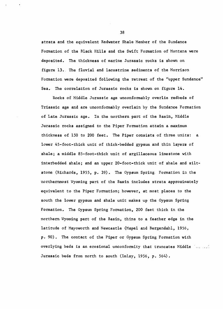
deposited. The thickness of marine Jurassic rocks is shown on
figure 13.. The fluvial and lacustrine sediments of the Morrison
Formation were deposited following the retreat of the "upper Sundance"
Sea. The correlation of Jurassic rocks is shown on figure 14.
Rocks of Middle Jurassic age unconformably overlie redbeds of
Triassic age and are unconformably overlain by the Sundance Formation
of Late Jurassic age. In the northern part of the Basin, Middle
Jurassic rocks assigned to the Piper Formation attain a maximum
thickness of 150 to 200 feet. The Piper consists of three units: a
lower 45-foot-thick unit of thick-bedded gypsum and thin layers of
shale; a middle 85-foot-thick unit of argillaceous limestone with
interbedded shale; and an upper 20-foot-thick unit of shale and silt-
stone (Richards, 1955, p. 39). The Gypsum Spring. Formation in the
northernmost Wyoming part of the Basin includes strata approximately
equivalent to the Piper Formation; however, at most places to the
south the lower gypsum and shale unit makes up the Gypsum Spring
Formation. The Gypsum Spring Formation, 200 feet thick in the
northern Wyoming part of the Basin, thins to a feather edge in the
latitude of Mayoworth and Newcastle (Mapel and Bergendahl, 1956,
p. 90). The contact of the Piper or Gypsum Spring Formation with
overlying beds is an erosional unconformity that truncates Middle
Jurassic beds from north to south (Imlay, 1956, p. 564).
39
108° 107° 106° I05C 104°
Broodus* POWDER RIVER
CAMPBELL !
Gillette
^ _ij -,___ * 5*
fe "~i° J d H N S 0 N*"-t- 1^ 5 i i j^ > 44°
43°
(UP^FT JCD Vo,, T>Lusk H LU " '
108°_
107° 106° 105° l04Compiled from data shown by Peterson, 1958, figs. 2. and 5
25 i i i 25 50i
75 miles _l
Figure 13. Thickness map of marine Jurassic rocks in the Powder River Basin. (Thickness interval is 100 feet; thickness lines are dashed where rocks have been removed by erosion).

NORTHWESTNear Hardin, Montana
40
WEST Near Buffalo, Wyoming
EAST Near Sundance, Wyoming
. X X X X X X \\x\x\x\\ XX X XXX X
Morrison Formation Morrison Formation Morrison Formation
oV)a
O.
Swift Formation "Upper Sundance" strata
fi o H 4-103
Ofa
Rierdon Formation "Lower Sundance" strata
Redwater Shale Member
Lak Member
Hulett Sand stone Member
Stockade Beaver Shale Member
Canyon Springs Sandstone Membe
o
XX
ofa
(I)ex
Red shale
Red shale and gray limestone
Red shale and gypsum
ooc c
H oM -H CX 4J
CO Cfl
3 OCO faex >,O
Red shale
Red shale and gray limestone
Red shale and gypsum
c c H O
co «a6 S 3 O co fa cx >% o
Red shale and\ gray limestone
Red shale and gypsum
(Iralay, 1947, table 1; modified by Mapel and Bergendahl, 1956,table 1.)
Figure 14. Correlation chart of Jurassic rocks in the Powder RiverBasin.
41
The Sundance Formation is generally divided into a lower non-
glauconitic sequence ("lower Sundance" strata) and an upper glaucor.itic
sequence ("upper Sur.dar.ce" strata) . These are separated from each other
by a sharp lithographic break and by an unconformity (Love, 1958, p. 67).
"Lower Sundance" strata in the Black Hills include the Canyon
Springs Sandstone Member at the base (Imlay, 1947, p. 247-251). This
member, 0 to about 45 feet thick, is a slightly calcareous, fine-grained
sandstone that thickens and thins abruptly ir: disco"tinuous channel-fill
deposits. A basal sandstone along the southern margin of the Basin was
described and tentatively correlated with the Canyon Springs Sandstone
Member by Love (1958, p. 64-66). The basal sandstone ranges in thick
ness from 30 to 75 feet within a short distance and consists of a soft,
porous, clean sandstone, a silty fine-grained calcareous sandstone, and
an upper oolitic sandstone. This basal sandstone cannot be recognized
within the deeper part of the Basin, where it and the other "lower
Sundance" members of the Black Hills lose their identity (Peterson,
1957, p. 413). The overlying sequence in the "lower Sundance" consists
of non-glauconitic shale and sandstone, which thins from about 300 feet
in thickness in the northern part of the Basin to 125=150 feet in the
southern part.
"Upper Sundance" strata are glaucor.itic and consist largely of
shale and sandstone. Their thickness ranges from about 250 feet in
Montana to about 50 feet along the southern margin of the Basin. In
places a basal sandstone, ranging in thickness from a wedge edge to as
42
much as 30 feet, is conspicuously developed (Love, 1958, p. 68).
A porous, thin-bedded, yellow-weathering, calcareous quartz
sandstone of undetermined correlation occurs between glauconitic
marine "upper Sundance" rocks and the nonmarine Morrison strata.
Opinions differ as to whether this sandstone should be included in the
Sundance or Morrison Formations, or be considered a separate formation
(Love, 1958, p. 68-70). This sandstone, 2 to 25 feet thick, is present
nearly everywhere in the Basin and may represent a transition zone
between the two formations.
The Morrison Formation is the youngest formation of Jurassic age.
It is present throughout the Basin except where it has been removed by
Cenozoic erosion. The Morrison is remarkably uniform in thickness,
ranging from about 100 feet to about 250 feet and averaging about 150
feet. The formation consists of a variegated sequence of claystone,
siltstone, shale, and fine-grained sandstone deposited as a blanket on
floodplains and in swamps
A hiatus representing uppermost Jurassic and lowermost Cretaceous
time occurs between the Morrison Formation and the overlying Cleverly
Formation (or Lakota Formation of the Black Hills) (Reeside, in Yen,
1952, p. 26). In places in the Black Hills, folding accompanied by
erosion took place during this interval as is shown by an unconformity
at the base of the Lakota Formation, where the Morrison and much of
the Sundance Formation have been removed (Robinson and others,
in prep.) .

43
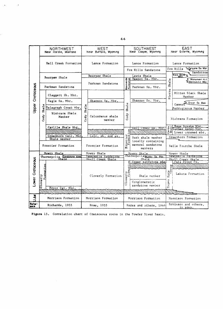
Cretaceous rocks
Cretaceous rocks in the Powder River Basin have a total thickness
greater than the aggregate thickness of all the underlying Paleozoic
and Mesozoic rocks (fig. 4). They consist largely of sandstone and
shale deposited during the last great marine inundation of the area
and of some shale, sandstone, and coal-bearing strata deposited during
the retreat of the sea. Cretaceous rocks or: the west side of the Basin
are coarser grained than those on the east side and contain sandstone
beds that wedge out to the east into siltstone, shale, and calcareous
shale. Major lithologic facies are of different ages in different
parts of the Basin. As a result of facies changes, several sets of
formation names are used around the margins of the Basin. The
correlation of these various names is shown on figure 15.
Lower Cretaceous rocks
Lower Cretaceous rocks are divided into two lithogenetic units
consisting of a lower varied sequence of continental deposits
separated by a regional disconformity from overlying marginal-marine
and marine deposits (Waage', 1959) . This disconformity, which is
transgressive, marks the initial incursion of the epiconti::.er.tal
Cretaceous sea. It occurs between the Lakota Formation below and the
Fall River Formation above in the Black Hills and at the base of the
"rusty beds" in the upper part of the Cloverly Formation in the
Bighorn Mountains. The thickness of Lower Cretaceous rocks in the
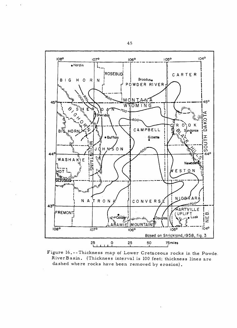
Basin is shown on figure 16.
44
Upper Cretaceous
Lower Cretaceous
4R«f«r- nc*
NORTHWESTNear Hardin, Montana
Hell Creek Formation
Bearpaw Shale
Parkman Sandstone
<Ur-l<s
>̂% o o o
Claggett Sh. Mbr.
Eagle Ss. Mbr.
Telegraph Creek Mbr.
Niobrara Shale Member
Carlile Shale Mbr.
Greenhorn Calc . MbrShale member
Frontier Formation
Mowrv ShaleThe
iGloverly
Formation
rmoi>n1ig iSondstope dikes1 Shale
Prvor Cjcl. Mbr.
^^^^^^^^
Morrison Formation
Richards, 1955
WEST Near Buffalo, Wyoming
Lance Formation
Bearpaw Shale
Parkman Sandstone
Shannon Ss . Mbr.0),-1 n)
%
^ Calcareous shale Q member
^^^^^^^^^^Calc. sh . and ss.
Frontier Formation
Mowry ShaleNewcastle SandstoneSViiH Creek Shale
Cloverly Formation
Morrison Formation
Hose, 1955
SOUTHWEST Near Casper, Wyoming
Lance Formation
Fox Hills Sandstone
Lewis ShaleMesoverde Formation
0)r-<tO
CO
>% ao o
Frontier Formation
Teapot Ss . Mbr.
Parkman Ss . Mbr.
Shannon Ss . Mbr .
wail (JreeR bs. Mbr.
Dark shale member locally containing several sandstone
members
Mowrv ShaleThermopolisiMuddy $s. Mor"
Shale
Cloverly
FormationUpper sandstone mbr
Shale member
Conglomeratic sandstone member
^^^^^^^^^^^^
Morrison Formation
Hares and others, 1946
EAST Near Gillette, Wyoming
Lance Formation
Fox
Pierre Shale
Hills 'z^flgo'e ^ s Mbr
Koto Bent-s *
5~"Manumenf Hill *<_Bentonit!C Mbr
Mitten Black Shale Member
_ ^~GroQf Ss Bed
Ferruginous Member
Niobrara Formation
4> 0)
<5"
Sage Breaks Mbr.Turner Sandv Mbr. _.
Lower unnamed mbr.
Greenhorn Formation
Belle Fourche Shale
Mowrv ShaleNewcastle Sands tortSSkull Crppk Stills
a.0
=3^ij^eg-
W
C. <L £>>
h-i
^
FalJ, River Fm.
Lakota Formation
^^^^TO^_
Morrison Formation
Robinson and others, in oreo.
Figure 15. Correlation chart of Cretaceous rocks in the Powder River Basin.
45
108° 107° 106° 105° I04C
45
Broodus* POWDER RIVER
C?R 0^,0 K I
j/tfARTVILLE | . CD
108° 107° 106°
fi \*» ,,-', Lusk !uj \\ V" ^ ^'«± f I .*£&£_*- i ^ 104°
Based on Stricklond, 1958, fig. 3
25 0 i i i i i i 25 50 75 miles
Figure 16.--Thickness map of Lower Cretaceous rocks in the Powde RiverBasin. (Thickness interval is 100 feet; thickness lines are dashed where rocks have been removed by erosion).
46
The Lakota Formation is a heterogeneous sequence of sandstone
and conglomeratic sandstone, and variegated sandy mudstone and
claystone; the relative amounts of sandstone and finer grained
elastics vary widely (Mapel and Gott, 1959) . The Lakota Fomation
is as much as 550 feet thick at the southern end of the Black Hills
where it contains the Chilson and overlying Fuson Members (Post and
Bell, 1961). The lithology of the Chilson Member is extremely varied.
In the lower part, it includes very fine grained well-sorted sandstone
in lenticular bodies separated by the partings of carbonaceous
siltstone and in the upper part it includes very fine grained and
well-sorted rarely carbonaceous sandstone in lenticular bodies that
are interbedded with and finger laterally into varicolored siltstone
and claystone. The Fuson Member comprises variegated claystone and
mudstone and channel sandstone that is locally conglomeratic. To the
northwest, the Chilson Member pinches out ar.d the Lakota Formation
thins irregularly to less than 10C feet near Sur.dance, and to 100 to
250 feet near the Wyoming-Montana State line.
The Fall River Formation is fairly uniform in thickness, ranging
from 110 to 150 feet and averaging 135 feet. It is predominantly
thin-bedded siltstone, sandstone, and shale interstratified with
thicker, more massive beds of sandstone. The basal few feet consist of
carbonaceous siltstone (Mapel and Gott, 1959) .
The Cleverly Formation in the Bighorn Mountains ranges in thick
ness from 135 to 165 feet. It includes a basal sandstone of almost
47
pure quartz, 15 to 45 feet thick, overlain by a 120-foot-thick sequence
of black shale interbedded with brown-weathering siltstone (Hose, 1955,
p. 56). In the northwest part of the Basin, the Cleverly averages
between 300 and 400 feet in thickness (Richards, 1955, p. 42-45).
There it consists of a lower member, the Pryor Conglomerate Member,
30 to 150 feet thick, composed of resistant sandstone, commonly with
chert-pebble conglomerate in the lower part. The upper part of the
formation is made up of shale, siltstone, and thin-bedded flaggy
sandstone.
The Skull Creek Shale and Newcastle Sandstone (and their equiva
lent, the Thermopolis Shale) occupy the interval between the top of the
Cleverly Formation (and its equivalents, the Lakota and Fall River
Formations) and the base of the widespread Mowry Shale (fig. 15). The
Newcastle Sandstone is correlative with the Muddy Sandstone Member of
the Thermopolis Shale and the Skull Creek Slale is correlative with the
lower part of the Thermopolis underlying the Muddy Sandstone Member.
The Skull Creek Shale ranges in thickness from 125 to 275 feet on
the west side of the Basin and from 180 to 270 feet on the east side.
It consists of shale with a few interceds of sar.dstor.e or siltstone
and in some places beds of bentonite near the base.
The Newcastle Sandstone (and its equivalents) is a widespread
formation in the Powder River Basin. It is a varied unit, consisting
of lenticular beds of fine- to medium-grained sandstone, lesser amounts
of siltstone and shale, and on the east side of the Basin, some coal

48
and bentonite. To the northwest, the Newcastle grades into dark-gray
shale cut by sandstone dikes (Richards, 1955, p. 45-47). It is 20 to
60 feet thick at most places, but attains a thickness of 100 feet near
Newcastle.
The Mowry Shale, the uppermost formation of Early Cretaceous age,
is present throughout the Powder River Basin, It consists of two units
that grade into each other. The lower unit is nor.resistant black shale
that contains thin beds of ber.tonite. This lower unit is from 150 to
200 feet thick on the west side of the Basin and 'about 20 feet thick on
the east side. The upper unit is gray, hard, siliceous shale, about
350 feet thick on the west side of the Basin and about 100 to 150 feet
thick on the east side.
The lithology of the Mowry Shale is unusual because of its hard
ness. Some of the rocks it contains consist of very fine grained
nearly pure silica, which causes the hardness. The origin of the
silica in the Mowry was the subject of a study by Rubey (1929) who
concluded that the silica was dissolved out of volcanic ash which had
decomposed in sea water, and that the dissolved silica was then precipi
tated by decaying organic matter. The volcanic ash in the Mowry, some
of which altered to bentonite and some of which decomposed, "suggests
a long series of volcanic eruptions, perhaps in Idaho, from which air
borne ash was carried, mostly eastward, over ar. inland sea and deposited
in it." (Reeside and Cobban, 1960, p. 11).
49
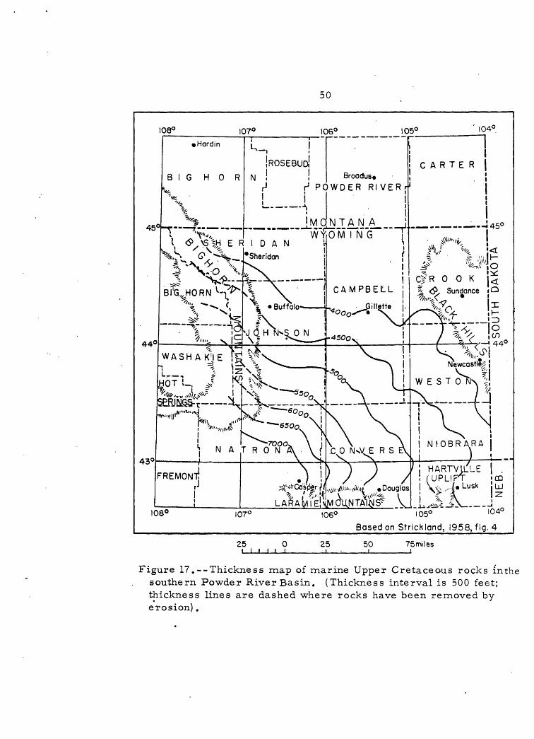
Upper Cretaceous rocks
Upper Cretaceous rocks include a complexly interfingering set of
beds between the top of the tnartine Mowry 'Shale and the base of .the
nonmarine Fort Union Formation of Paleocene age. Except for part of
the Mesaverde Formation and the Lance Formation at the top of the
sequence, the upper Cretaceous rocks are marine in origin; their
thickness in the Basin is shown on figure 17.
The Frontier Formation is the lowermost formation of Late
Cretaceous age on the west side of the Basin. It includes sandstone
and shale, but is characterized chiefly by sandstone. The Frontier is
thickest in the southwest part of the Basin and interfir.gers with and
grades into shale (lower part of the Cody Shale) to the north and into
shale and limestone (Belle Fourche Shale, Greenhorn Formation, and
Carlile Shale) to the east. The base of the Frontier Formation is
placed at the base of a persistent bentonite bed that overlies the Mowry
Shale and the top is placed at the top of the uppermost persistent
sandstone bed. Where the uppermost sandstone bed grades into shale,
the next lower sandstone is designated as the top of the formation.
Because the top of the Frontier Formation is placed at the top of
progressively lower sandstone beds, the age of the top of the formation
becomes increasingly older along the east front of the Bighorn
Mountains (fig. 15). Based on faunal correlations, near Casper, the
top of the Frontier Formation is equivalent to beds near the top of the
Carlile Shale; near Buffalo it is equivalent to beds in the upper half
50
108° 107° 106° 105° ' 104°
43°
CARTER |Broodus.
r1 POWDER RIVER
H E R I D A N "
C R 0 0 K
Newcostle|
W E S T 0 N '"
NfOBRARA
44° 44°
108° 107° 106° 105° I04°
Based on Strickland, 1958, fig. 4
25 0 i i i i i i 25 50 i
75 miles
Figure 17.--Thickness map of marine Upper Cretaceous rocks inthe southern Powder River Basin. (Thickness interval is 500 feet; thickness lines are dashed where rocks have been removed by erosion).

51
of the Greenhorn Formation, and near Hardin, Mont., it is equivalent to
beds in the upper half of the Belle Fourche Shale (Cobbar. and Reeside,
1952, fig. 4).
In the southwestern part of the Basin, near the northeast corner
of Natrona County, the Frontier Formation consists of more than 1,000
feet of shale interbedded with four sandstones, including the 120-foot-
thick Wall Creek Sandstone Member at the top (Thorn and Spieker, 1931,
pi. 2, p. 63). To the north, near Kaycee, the lower part of the
formation thins to 700 feet and the Wall Creek Sandstone Member thins
to about 50 feet (Cobban and Reeside, 1952, p. 1954). In the area
between Kaycee and Buffalo, the Wall Creek Sandstone Member grades into
shale, and near Buffalo, the top of the formation is placed at the top
of the next lower sandstone bed (Hose, 1955, p. 60). Here the total
thickness of the formation is about 480 feet. Farther to the north
near Hardin, Montana, the Frontier Formation consists predominantly of
concretionary sandy shale with interbedded bentonite and a few lenses
of sandstone and is about 260 feet thick (Richards, 1955, p. 49).
The Belle Fourche Shale is the lowermost Upper Cretaceous unit on
the east side of the Basin. The Belle Fourche is 750 to 850 feet thick
in northwestern Crook County, Wyo., and thins to about 450 feet to the
south near Newcastle (Robinson and others, in prep.). This change in
thickness is caused by interfingering and lateral gradation between
noncalcareous shale in the upper part of the formation and calcareous
shale, marl, and limestone in the overlying Greenhorn Formation. The
52
basal 50 feet of the Belle Fourche is nonresistant grayish-black shale,
above which are 400 to 500 feet of shale that contains few laminae of
fine-grained sandstone, scattered ironstone concretions, ar.d several
beds of bentonite. The next higher 20 to 350 feet of strata consists
of noncalcareous shale and a few thin bentonite beds and numerous
limestone concretions. The Belle Fourche is lithologically very
similar to the lower part of the Frontier Formation (Haun, 1958,
p. 86).
The Greanham. Formation overlies the Belle Fourche Shale and
consists of shale, limestone, ;cr marl. The limestone is best developed
along the central part of the Black Hills uplift where it is represented
by a thin concretionary facies, which thickens to a limestone-marl
facies to the north and to the south. The formation ranges from 70
to 370 feet in thickness.
The Carlile Shale overlies the Greerihom Formation. It rar.ges in
thickness from 450 to 650 feet and consists of a dark marine shale that
is sandy in the middle part. On the basis of the sandy part, the
Carlile has been divided into three members: a lower unnamed member,
the Turner Sandy Member, and the Sage Breaks Member.
The lower unnamed member of the Carlile Shale is 40 to 130 feet
thick and consists of shale with a few calcareous concretions. The age
'equivalent of this member is absent on the west side of the Basin. The
Turner Sandy Member is 150 to 170 feet thick and consists of a bed
5 feet thick of fine- to coarse-grained sandstone at the base overlain
53
by shale and sandy shale containing a few thin beds and laminae of
sandstone and silty limestone concretions. The Turner is the eastward
equivalent of the Wall Creek Sandstone Member of the Frontier Formation
(Haun, 1958, p. 87). The Sage Breaks Member is 200 to 300 feet thick
and consists of shale with abundant limestone concretions.
The Niobrara Formation overlies the Carlile Shale. It consists
of calcareous shale and marl with thin beds of bentor.ite in the middle
part. It ranges in thickness from 150 to 225 feet on the east side of
the Basin.
The Pierre Shale of the Black Hills area includes a sequence of
marine shale, sandstone, and bentonite beds between the Niobrara
Formation below and the Fox Hills Sandstone above. Equivalent rocks
on the western side of the Basin include several sandstone beds. On
the basis of these sandstone beds and other lithologic differences,
the rocks of the west side of the Basin are divided into three
formations: the upper part of the Cody Shale, the Mesaverde or Parkman
Formation, and the Lewis or Bearpaw Shale (fig. 15).
The Cody Shale overlies the Frontier Formation on the west side of
the Basin and includes a sequence about 2 S 500 to 3,500 feet thick
consisting predominantly of shale and some sandstone. The Cody Shale
correlates faunally with rocks ranging from the Belle Fourche through
Claggett Formations.

54
The basal part of the Cody Shale is oldest in the northwest part
of the Basin where it consists of about 200 feet of concretionary
shale and several thin sandstone beds equivalent in age to the upper
part of the Belle Fourche (Richards, 1955, p. 51). To the south, in
the vicinity of Buffalo, rocks equivalent in age to the Greenhorn
Formation constitute the lower part of the Cody; along the east front
of the Bighorn Mountains, this unit consists of 200 to 300 feet of
shale interbedded with some fine- to medium-grained sandstone. Equiv
alents of the Carlile Shale are present in the western part of the
Basin and are represented by 160 to 280 feet of shale, silty shale,
and fine-grained sandstone. The Niobrara Formation is represented by
400 to 950 feet of soft calcareous shale and thin bentonite beds. The
next higher series of strata consist of laminated shale and fine
grained sandstone equivalent in age to the Telegraph Creek Member of
the Cody Shale and part of the Eagle Sandstone of Montana. The only
thick sandstone in the Cody Shale is the Shannon Sandstone Member. The
Shannon, a fine-grained glauconitic sandstone, is about 200 feet thick
along the southwest and west-central margins of the Basin. To the
north in Montana, it grades into a silty shale equivalent in age to
the Eagle Sandstone. In the western part of the Powder River Basin,
the uppermost part of the Cody consists of shale, 350 to 900 feet
thick equivalent in age to the Claggett Shale.
The Mesaverde Formation overlies the Cody Shale in the southwest
part of the Basin. It is about 850 feet thick near Salt Creek, Wyo.,
55
about 40 miles north of Casper. It consists of three members: the
Parkman Sandstone Member, 470 feet thick; an intermediate marine shale,
325 feet thick; and the Teapot Sandstone Member, 110 feet thick (Downs,
1949, p. 49). The Parkman Sandstone Member includes a basal 170-foot
marine sandstone, a 190-foot coal-bearing shale, and an upper 110-foot
sandstone (Thorn and Spieker, 1931, p. 11, 12, and table 4).
To the north, near Buffalo, the lower members cannot be differ
entiated and the name Parkman Sandstone is Msed for beds equivalent to
the Mesaverde Formation. In this area the Parkman is about 720 feet
thick and consists mostly of sandstone, with some shale near the top,
and an 8 to 10-foot bed of sandstone at the top. This upper sandstone is
probably equivalent to the Teapot Sandstone Member of the Mesaverde
Formation (Hose, 1955, p. 64). Near Hardin, Mont., the Parkman has
thinned to about 250 feet of sandy shale and sandstone, and is made up
of a lower 110-foot shale and an upper 140-foot massive sandstone
(Richards, 1955, p. 63).
The Parkman Sandstone, from which both marine and fresh-water
invertebrates and dinosaur bones have been collected (Darton, 1906,
p. 59; Thorn and others, 1935, p. 59) grades northward into the nonmarine
Judith River Formation of Montana. It thins eastward and grades into
shale in the marine Pierre Shale. It is approximately equivalent in
age to that part of the Pierre Shale between the top of the Mitten
Black Shale Member and the top of the Monument Hill Bentonite Member
(fig. 15).
56
The Lewis Shale overlies the Mesaverde Formation. It is predomi
nantly marine shale but contains numerous zones of sandy shale and
lenses of very fine to fine grained calcareous sandstone. The Lewis
is about 1,000 feet thick in the Salt Creek area in the southwest part
of the Basin (Downs, 1949, p. 49). It is equivalent to the Bearpaw
Shale in the northwestern part of the Basin. Near Buffalo, the Bearpaw
is 200 feet thick and consists of shale with some laminae of fine-grained
sandstone in the upper part (Hose, 1955, p. 49). Near Hardin, Mont.,
the Bearpaw Shale includes 850 feet of concretionary shale that is
sandy in the upper few feet (Richards, 1955, p. 63). According to
Dunlap (1958, p. 109) the Lewis or Bearpaw Shale was deposited during
the last transgression of the Late Cretaceous sea. Discontinuous
sandstones were deposited in the shale during several minor regressions.
In the eastern part of the Basin rocks equivalent to the Lewis make up
the upper part of the Pierre Shale.
The Pierre Shale is more than 2,700 feet thick along the southwest
part of the Black Hills uplift but thins irregularly northwestward to
2,050 feet in northern Campbell County, Wyo. (Robinson and others, in.
prep.). The Pierre is divided into several members on the basis of
differences in the shale and the presence of sandy and ber.tonitic units.
In ascending order, these members are: the Gammon Ferruginous Member
which includes the Groat Sandstone Bed; the Mitten Black Shale Member;
and an unnamed upper part which includes the Monument Hill Bentonitic
Member and the Kara Bentonitic Member near the top.
57
The Gammon Ferruginous Member of the Pierre Shale consists mostly
of noncalcareous shale containing sideritic concretions. These con
cretions are several feet long in layers 5 to 10 feet apart. The
Gammon Member is as much as 1,000 feet thisk in parts of Campbell
County, Wyoming, and thins rapidly southeastward. It is absent in
parts of Weston County. The Groat Sandstone Bed occurs about 150 feet
below the top of the Gammon Member. It consists of 35 tc 125 feet of
medium- to fine-grained glauconitic and ferruginous sandstone. The
Groat Sandstone Bed is present along the northwest flank of the Black
Hills, but to the south it is represented by silty shale or shale.
The Mitten Black Shale Member of the Pierre Shale consists of
about 75 feet of platy dark shale containing several bentonite beds in
the lower part, and about 75 feet of less resistant shale containing
siderite and septarian limestone concretions in the upper part. The
Mitten Black Shale Member is about 150 fee.-: r.lic/. i::~ central Carter
County, Mont., and thickens southward to nearly 9.'C feet near Newcastle,
Wyo. Where the Gammon Ferruginous Member is a'";sen':, the Mitten Member
rests directly on the Niobrara Forma tier..
The upper part of the Pierre Shale contains " Lack shale that is
locally bentonitic and silty. It is a1:out 8,\" feet thick in Carter
County, Mont., and thickens to 1,500 feet to the south in Weston County,
Wyo. The Monument Hill Bentonitic Member consists of bentonitic shale
and occurs about 450 feet above the base of the v.pper part of the
Pierre; it grades southward into nonber,to::itic shale in northern Crook
53
County, Wyo. The Kara Bentonitic Member is aboit 705 feet above the
base of the upper part of the Pierre and consists of a":cut ICO feet of
shale, bentonitic shale, and bentonite.
The Fox Hills Sandstone overlies the Pierre si.d Lewis Shales and
is overlain by the nonmarine Lance Formation. The Fox Hills is an
erratic nearshore sand facies deposited as the Late Cretaceous sea
withdrew towards the southeast (Dunlap, 1958, p, 1C9) . It becomes
younger to the south. The Fox Hills has beer: recognised along the
west flank of the Black Hills and along the southwest margin of the
Basin; however, along the east flank of the Bighorn Mountains, it
becomes a less distinct lithologic unit. In the Crazy Woman Creek
area Hose (1955, p. 65) did not differentiate the Fox Hills. He
included 100 feet of thin-bedded fine-grained sandstone, which he
thought to be in part equivalent to the Fox Hills, in the basal part
of the Lance Formation. Farther to the :.or!:h near Buffalo, the Fox
Hills could not be distinguished and beds he classified as Lar.ce rest
directly on the Bearpaw Shale (Mapel, 1961, p. 59).
Along the northwest flank of the Black Hills in Montana, the Fox
Hills Sandstone consists of a lower member 50 t:> 1~0 feet thick, of
fine-grained, thin-bedded sandstone interbedded with sandy shale and
siltstone. These rocks are overlain by 50 to 100 faet of fine- to
medium-grained sandstone, equivalent to the Colgate Sandstone Member
as redefined by Thorn and Dobbin (1924, p. 485-436). The Colgate
Member grades laterally southward in Wyoming i:.to sandstone and shale

59
similar to that in the lower member (Ro-insor. and others, in prep.).
Where exposed on the margin of the Basin in Wyoming, the F:/s Hills
Sandstone ranges in thickness from about 130 feet in the north to about
300 feet in the south (Dunlsp, 1958, p. 11J? .
The Lance Formation (Hell Creek Formation of Montana) is a varied
nonmarine sequence of sandstone and shale that was deposited following
the final withdrawal of the Upper Cretaceous se?,. It is the uppermost
formation of Cretaceous age in the Basin.
On the east side of the Basin, the Lance Formation consists of
alternating beds of sandstone, sandy shale, and claystone. The
sandstone beds range in thickness from an inch to more than 25 feet.
The formation is about 500 feet thick in southern Powder River County,
Mont., and thickens to more than 1,600 feet in northern Weston County,
Wyo. (Robinson and others, in prep.).
On the west side of the Basin, the .1-,-v.-,-;e F^ma-LcT- is ah out 600
feet thick in Montana (Thorn and others, 1935, p. 61) a~d i'rout 2,COO
feet thick on the west-central side near r.uff^l:, in Wyoming. Here, a
500-foot-thick sequence of lenticular crosshecd^l sa-_istones, some of
which are as much as 70 feet thick, ir.':e:.r eicai with =" J ?.le ? occurs
about 100 feet above the base of the forrtst: D~. f~ -^«> 1355, p. 65).
These sandstones are domir.ar.tly fine- no meii";::ii-g:r ;~i"..~:i and quartsitic.
The remainder of the formation consists of ii-.^erVteidei n^nresistar.t
sandstone and shale, and in the upper hd.lf, beds of '- = r'*onaceo'.i3 shale.
60
Tertiary rocks
The Fort Unio::, Formation of Paleocene age is interbedded r.onmarine
sandstone, shale, ar.d coal (fig, 4} , Its outcrop encircles the Powder
River Basin except for a stretch of about 25 miles west of Buffalo
(fig, 2), The thickness of the Fort Union ranges from about 1,500 feet
to 2,200 feet in the northern and eastern parts of the Basin. On the
west-central side, Hose (1955, p. 66) reported a thickness of 3,950
feet and on the southwest side near Sussex, Hcrr. (1955) showed a thick
ness of 2,900 feet. According to Brown (1958, p. Ill), "These
differences in thickness are most likely indications of distance from
the source of supply of the sediments and of varied conditions in
transportation and deposition,"
In the northeastern part of the Easin, the Fort Union Formation
has been divided into three members, which from bottom to top are the
Tnllock, Lebo, and Tc~.,gu& Rf.-.rer Members', however, these members cannot
be recognized in the southern ar.d western parts of the Basin, The
lower part of the formation is generally darker ir. color and contains
only a few thin nonpersistent coal beds; the upper part is generally
lighter and contains numerous thick coal Ireds. The top of the Fort
Union Formation is placed at the top of the Rolar.i coal bed or the
equivalent horizon.
The Wasatch Formation of Eocene age, which is 1,050 to 3,500 feet
thick (Berryhill and ethers, 1950, p. 11) 9 forms the surface of most
of the central part of the B.asic_, Its thickness ranges greatly,
61
depending upon the amount of Recent erosion. Like the underlying Fort
Union Formation, the Wasatch consists of continental deposits of sand
stone, shale, arid coal beds. Throughout the Basin there is no marked
change in lithology between the two formations. North of Gillette,
the Wasatch overlies an erosional surface in the Fort Union (Olive,
1957, pi. 4), but at most other places, the contact is conformable.
The Wasatch Formation contains two conglomeratic members in the
area near Buffalo, Wyo. The lower member, the Kingsbury Conglomerate
Member, consists of 100 to 800 feet of poorly indurated conglomerate,
medium- to coarse-grained sandstone, siltstone, and shale. Pebbles
and boulders in the Kingsbury are derived from Paleozoic and Mesozoic
rocks. The Kingsbury unconformably overlaps the Fort Union, Lance,*
Bearpaw, and Parkman Formations. The upper conglomeratic member of
the Wasatch is the Moncrief, which overlies the Kingsbury Conglomerate
Member with an angular discordance of as much as 45 degrees. The
Moncrief consists of about 1,200 feet of siltstone, sandy siltstone,
and beds of conglomerate that become coarser upward and at places
include coarse boulder beds. The boulders are mainly of Precambrian
rock. East from the Bighorn Mountains both members grade almost
imperceptibly into a finer grained facies and no angular discordance
separates them. These relations indicate uplift and deep dissection
of the Bighorn Mountains in the last two stages in Eocene time.
The White River Formation, as much as 300 feet thick, consists of
sandstone, conglomerate, tuff, and bentonitic claystone. The
62
White River unconformabl}/ overlies older rocks in a few high divides in
the Basin and in the adjacent mountains. These deposits are remnants
of deposits that originally covered much, if not all, of the Basin.
The White River Formation has been removed by erosion from most parts
of the Basin (Love, 1952, p. 5).
Rocks of Oligocene and Miocene age surround the Hartville uplift,
where they unconformably overlap and obscure older rocks. These strata,
which attain a thickness of more than 2,000 feet, are separated into a
lower claystone-siltstone unit, the White River Group, and an upper
sandstone unit, Miocene, undivided (Denson and Botinelly, 1949),
Quaternary rocks
Quaternary rocks consist of surficial deposits of colluvium,
alluvium, landslide debris, and terrace gravels. Alluvium includes
clay, silt, sand, and gravel present along most of the stream beds.
Landslide debris covers areas as large as several miles and consists of
rock waste that has slumped downward on steep hillsides. Terrace grav
els are deposits of silt, sand, and gravel that cap locally extensive
terrace levels. The highest terrace gravel may be Tertiary in age.
STRUCTURE
The Powder River Basin is a relatively simple structural feature
consisting of an elongate synclinal depression bounded on three sides
by mountain uplifts (fig. 1). The northern limit is here considered
to be the south flanks of two low arches and is shown by the minus
3,000-foot structure contour on figure 3. The Basin is asymmetrical,
63
with its deepest part on the west side adjacent and parallel to the
Bighorn Mountains. The surface of the Precambrian is about 21,000 feet
lower in the deepest part of the trough than on the nearby flank of the
Bighorn Mountains.
The western margin of the Basin is the most strongly deformed,
especially along the east front of the Bighorn Mountains, where
Paleozoic and Mesozoic strata have been folded into a narrow belt of
steeply dipping rocks. Dips range mostly from 30 degrees eastward to
vertical, but locally beds are overturned. This intense folding was
accompanied by faulting, which is most pronounced in the area between
Sheridan and Buffalo where strata have been thrust eastward as much as
tHree miles. To the north and south of the central Bighorn Mountains,
the dips of the rocks decrease and the width of their outcrops becomes
correspondingly greater (fig. 2).
At the southern margin of the Basin, Paleozoic and Mesozoic rocks
are sharply bent along the north fronts of the Laramie Range and
Hartville uplift and dip steeply to the north.
On the east and north sides, the rocks at most places dip 3 to 5
degrees toward the axis of the Basin. This gentle dip is interrupted
by the Black Hills monocline, a belt of steeply dipping rocks 1% to &
miles wide, which has a structural relief of about 4,000 feet. The
Black Hills monocline is about 90 miles long and extends in a northwest
direction from Newcastle almost to the Wyoming-Montana State line
(Pierce and Girard, 1952; Mapel and others, 1959). Where the fold is
64
narrowest the dip of the rocks is almost vertical; elsewhere the dips
are from 20 to 35 degrees. The rocks to the east of the monoclir.e are
folded into northwest-trending anticlines and synclines and nearly
circular domes and depressions, and locally are cut by normal faults,
most of which have a displacement of less than 100 feet. To the west
of the monocline, the dip of the rocks flattens abruptly, and is
uninterrupted by folds and faults.
Faults
Major faults in the Powder River Basin are restricted to the mar
ginal areas and are associated with movements that produced the sur
rounding mountain uplifts. In the area between Sheridan and Buffalo on
the west side of the Basin, small segments of the mountain front have
been displaced eastward along high-angle reverse faults and accompanying
tear faults; at some places in this area Paleozoic rocks have been
thrust over Tertiary rocks. To the south near Mayoworth, a transverse
fault zone, along which a series of en echelon folds have developed,
cuts across the Basin margin. High-angle reverse faults also are found
along the edges of the Laramie Mountains and the Hartville uplift along
the south margin of the Basin. The Black Hills uplift, however, did
not produce large-scale faulting.
Numerous transverse faults of relatively small displacement are
present in southern Johnson and northern Natrona Counties. These
faults were important in controlling oil accumulation in the Sussex
area (Strickland, 1958, p, 134). A series of normal faults with small
65
vertical displacement occurs in the southern Black Hills near the
Niobrara-Weston County line. Also along the margin of the Easir. are
numerous relatively small folds whose axes roughly parallel the
adjacent mountain uplifts. Most of the oil produced in the southwest
and southeast parts of the Basin is from fields on these structural
features.
Age of deformation
The Powder River Basin was formed during the Laramide orogeny in
Late Cretaceous and early Tertiary time when the surrounding mountain
masses were uplifted. The first evidence of local uplift is shown by
an angular unconformity in the Fort Union Formation, near Buffalo, Wyo,
(Mapel, 1959, p. 81). Conglomerate above this unconformity contains
fragments derived from Paleozoic formations of nearby areas to the
west. The 45-degree discordance between the Kingsbury Conglomerate
Member of the Wasatch Formation and the underlying Fort Union Formation
indicates that uplift followed deposition of the Fort Union. Subse
quent uplift is indicated by local dips of as much as 45 degrees in the
Kingsbury, which is unconformably overlain by the flat-lying beds of
the Moncrief Member of the Wasatch Formation. Thrust faulting in the
area took place after deposition of the Moncrief Member (Sharp, 1948).
ECONOMIC GEOLOGY
The most important mineral deposits found within the Basin are
oil, gas, coal, and uranium. Deposits of lesser importance include
bentonite, gypsum, limestone, and sand and gravel.

66
Oil and gas
Oil has been produced from the Powder River Basin sir.ce the 1880 f s
and as of January 1, 1960, the cumulative production was about 738
million barrels. This constitutes about half of the total that has
been produced from Wyoming, and more than has been produced from any
other basin in the Rocky Mountain region. Gas is generally produced
with the oil, although a few small gas fields have been developed.
Sandstones of Late Cretaceous age have been the major oil pro
ducing reservoirs. In decreasing order of importance, other oil
producing rocks are strata of Early Cretaceous, Pennsylvanian, Jurassic,
and Permian ages. Small quantities of oil have been produced from
rocks of Tertiary and Triassic ages; oil in commercial quantities has
riot been produced from rocks older than Pennsylvanian.
As in most large sedimentary basins, most of the oilfields have
been developed around the margin (fig. 18). The central deeper part of
the Basin has been drilled to a lesser extent because of the greater
depth of the oil-bearing strata. According to Strickland (1958, p. 132-
147), updip loss of relative permeability is the primary factor in
controlling oil accumulation in the Cretaceous strata in the Basin, and
the three main types of traps responsible for the accumulation of oil
are anticlinal, fault, and permeability traps.
Coal
Some coal of bituminous rank occurs in the Lakota Formation of
Early Cretaceous age in Crook and Weston Counties, Wyo., on the east

67
45<
44°
43°-
f
108° 107° 106° 105° I04°
^Hardin
BIG H 0 R
\t % \
> ^fT" ^ 81 lt <s»x S'IH E Ff%,\ ^. \
* ^ ̂ \.=? «v* O \.~: V £--
^ \ A
BIGHORN S^ -*«.. <
_-_.i_ *^ ' ~io^, ig
WASH A KM E !^ -. = i L : «z«6rL J |- ^ffi^f- -1""" ' K r"
,1 >""'//|!\iKw
1
j N A '. \
rREMONlir'
- i
u i i JROSEBUD!
N ! !rJ H PC
L _._4JMO
r w'f! 1 D A N !
Sheridan
'£
1 1 ^ Buffalo
^J dft N S 0 N
^ " i^ f ^
^ -<5s2 U ^\J 1
,i^ V^^ ^^ - tf<^Y i ^ i «* i
^ R 0 N A ° *f __*. __________ JL
^ ^,
., 4- rit»"CosjS.r^
" \ -l"f LARAMIE
1
Broadus* IWDER RIVERr
NTANA i0 M 1 N G i
i
s .-'ICAMPB"ELLO :
Gillet%r |«\ t Hi1i1 i1i
a
CONVERSE
i e
^^\i/*. <jfuQ DouaJas/; vvt'/'*- ^^
MOUNTAINS^
I
CARTER j i
ji__ M______«i d"^0- - 45
^"" fr
>^,f ^ !<
J- " U'jSC/R 0 0 K |<
c?& ^ Sundance iQ ^""^\«-» * !
0̂ X3 « »V^ « H«s>£e ''<",' I ) * r^"- -|o
/iv , :^o.^^X^l^^iss^^iWJ^TO N |{
i . .'. «.NIOoBRARA^V
^ARTVILLE | . (UPLIFT «QD V*. M ,,*Lusk LU
>>'"* f -^"*' > jf"
-*.xv*c -fr _J
108° 107° 106° 105° l0^ Data from M-Grew (1955) and Petroleum Infprmation Corp. Map (I960
25 0 i j < i i i
25i
50 75miles
Figure 18.--Map showing oil and gas fields in the Powder Rivf.-r Basin
68
side of the Basin, and coal of subbi turn incus rank occurs i~ the Lar.ee
Formation of Late Cretaceous age in Converse and Natroria COM:::ties
along the southern margin of the Basin. Most of the coal, however,
occurs in the Fort Union and Wasatch Formations of Tertiary age in the
central part of the Basin.
The coal beds of Tertiary age are generally thin and lenticular
south of a line drawn from Buffalo to the northwest comer of Kiobrara
County. North of this line, the coal beds in both the Fort Union and
Wasatch Formations are thick and persistent and presumably underlie
hundreds of square miles. In general the thicker, more persistent coal
beds are near the top of the Fort Union Formation. Two coal beds in
the Basin are among the thickest known in the United States: a coal
bed at the top of the Fort Union Formation attains a thickness of 90
to 106 feet about 6 miles east of Gillette and another bed, 115 to a
reported 220 feet in thickness, occurs in the upper part of the Wasatch
Formation near the north end of Lake De Smet in Johnson County.
The coal in the Fort Union and Wasatch Formations ranges in rank
from subbituminous B to lignite. Coals in the Wasatch are generally
lower in rank than those in the Fort Union and coals in the north
western part of the Basin are slightly lower in rank than equivalent
beds in other parts of the Basin.
According to the work of several writers, summarized by Ms.pel
(1958, p. 218-224) from whom the information presented here on coal is
taken, the coal reserves of the Powder River Basin are estimated to
69
total about 210 billion short tons, in beds more than 2% feet thick.
Approximately half of the reserves are in the Montana part cf the
Basin and half are in the Wyoming part.
Uranium
Commercial deposits of uranium have been found at several locali
ties within the Basin. In the central part, lenticular sandstones in
the Wasatch Formation of Eocene age are the host rocks for uranium.
The principal areas of mineralization are near the Pumpkin Buttes in
Campbell and Johnson Counties (Love, 1952), near Dry Fork and Box
Creek in Converse County, and near Lance Creek in Niobrara County
(Mrak, 1958, p. 233-240).
In the Black Hills area, uranium deposits are in beds of sandstone
in the Lakota and Fall River Formations of Early Cretaceous age. The
principal areas from which ore has been produced in the northern Black
Hills are the Elkhorn Creek, Hulett Creek, and Carlile areas in western
Crook County (Robinson and others, in prep.),
GROUND WATER
Most of the water supply in the Powder River Basin is obtained
from streams. Only a few studies of ground water have been mads and
detailed data regarding the occurrence of ground water are unavailable.
On the basis of available information, wells drilled for water in the
area are less than 3,000 feet deep; however, depths of about 2,500 feet
are not uncommon. According to a summary by Whitcomb and others (1958)
the Pahasapa Limestone and Minnelusa Formation are the only
70
stratigraphic units on the east side of the Basin that yield large
quantities of water; small quantities are obtained from the Fox Hills
Sandstone and overlying units, and from the underlying Newcastle, Fall
River, Lakota, Morrison, Sundance, and Minnekahta. The groirr.d water
possibilities of the remaining units are considered to be poor.
Thorn and others (1935, p. 124-133) discussed the water-bearing
properties of formations in the northwest part of the Basin. There,
small quantities of water are obtained from the Lance Formation and
overlying units and the underlying Parkman, Cleverly, Sundance,
Tensleep, Amsden, and Madison were assessed as having good water
bearing properties.
WASTE DISPOSAL POSSIBILITIES
Possible reservoirs for disposal of radioactive waste include
(1) permeable sandstone, (2) impermeable shale, and (3) carbonate
and evaporite rocks,
Sandstone reservoirs
Sandstone beds are considered possible reservoirs for the sub
surface disposal of liquid radioactive waste because they are more
permeable than other beds. Many permeable sandstone units, confined
between relatively impermeable units, occur throughout the rock sequence
in the Powder River Basin. In rocks of pre-Cretaceous age, the more
promising potential sandstone reservoirs are in the Flathead and
Deadwood Formations, in the Tensleep and Minnelusa Formations, and
in the Sundance Formation. However, most of the potential sandstone

71
reservoirs are in the upper part of the sequence in rocks of Cretaceous
age. These comprise sandstone beds in the Fall River, Lakota, Newcastle,
Frontier, Cody, and Mesaverde Formations (fig. 4). All of these sand
stone beds are known to be permeable at most places in the Basin;
problems of containment that might arise should be investigated before
any of the sandstone units are selected for disposal.
The Flathead Sandstone and sandstone within the Deadwood Formation
overlie Precambrian basement rocks, which would be a barrier to down
ward seepage of liquid waste and are overlain by shale which may be
sufficiently impermeable to prevent upward seepage. Throughout most of
the Basin these formations are more than 10,000 feet below the surface
and presumably are too deep to be utilized as a ground water source;
thus far they have not been found to contain commercial amounts of oil
or gas. If deep storage of waste is contemplated, these formations
should be considered.
Sandstone beds that might be suitable for waste disposal are present
in the Tensleep Sandstone in the western part of the Basin, in the
Minnelusa and Hartville Formations in the east and southeastern parts,
and in the Sundance Formation throughout the Basin. These strata would
afford possibilities for waste disposal in the deeper, central part of
the Basin. Any disposal that might be considered in areas around the
margins of the Basin should be restricted to isolated sandstone lenses
within the formations in which the waste would be trapped, as these
formations are reservoirs for both water and oil. Isolated lenses
72
might be found in units such as the basal sandstone of the Sundance
Formation, which is a discontinuous channel-fill deposit.
Potential reservoirs in these pre-Cretaceous rocks are at shallow
depth (0 to 5,000 feet) over approximately one-quarter of the total
area of the Basin, at moderate depth (5,000 to 10,000 feet) over
approximately one-quarter, and at great depth (more than 10,000 feet)
over the remaining one-half.
In the upper part of the sequence in rocks of Cretaceous age, the
Lakota and Fall River Formations on the east side of the Basin contain
lenticular bodies of sandstone interbedded with finer grained clastic
rocks. These lenticular sandstone beds, providing they are not a
source of ground water, could be considered as possible isolated reser
voirs for shallow to moderate depth waste disposal if the enclosing rocks
are sufficiently impermeable*
The Newcastle Sandstone deserves particular consideration because
it is present throughout all but the northern part of the Basin, At
many places it grades into shale in an updip direction and is overlain
by the impermeable Mowry Shale. However, the Newcastle is oil-bearing
in many places, and therefore it may not be suitable for waste disposal.
The Frontier, Cody, and Mesaverde Formations all include thick
sandstone beds. The Frontier Formation includes at least four such
sandstone beds in the southwest part of the Basin; the Cody Shale
contains the Shannon Sandstone Member; and the Mesaverde Formation
includes the Parkman and Teapot Sandstone Members. These strata all
73
grade eastward across the Basin into shale. The sandstone beds within
them presumably lens out eastward and the enclosing shale wo-ild form
barriers to fluid movement.
Potential reservoirs in Cretaceous rocks are at shallow depth over
approximately one-quarter of the total area of the Basin, at moderate
depth over approximately one-half the area, and at great depth over
the remaining one-quarter.
Sandstone beds that afford less favorable potentials as waste
disposal reservoirs, but which should not be eliminated from considaral:Ion,
occur in the Chugwater, Morrison, Carlile, Pierre, and Fox Hills
Formations. In some of these formations, the lithology of the strata
enclosing the sandstone beds is varied and therefore unpredictable;
the contained sandstone beds generally are thinner and less persistent
than those in other formations.
Shale reservoirs
Thick sequences of shale in which limited storage space might be
developed by hydraulic fracturing or by excavating cavities are present
only in rocks of Cretaceous age. These include the Skull Creek and Mowry
Shales, the lower part of the Frontier Formation and the Belle Fourc'-.e
Shale, and parts of the Cody, Lewis, and Pierre Shales.
The M'owry Shale appears to be the most promising. The Mowry, like
the underlying Newcastle Sandstone, is present throughout the Basl:-:.
It contains a thick upper unit of uniform lithology, consisting of
siliceous shale which is impermeable except for the possibility of
74
fractures which might be developed in local areas of deformatio::.
The Mowry Shale, and the other shale sequences mentioned--if they
prove to be sufficiently impermeable--offer possibilities for the
storage of calcined or fused waste in excavated cavities if economi
cally feasible. These shales are near the surface in a band several
miles wide at the margin of the Basin so excavations could be made at
shallow depth.
Carbonate and evaporite reservoirs
The only relatively thick sequence of carbonate rocks are the
rocks of Ordovician to Mississippian age. Space for storage of
radioactive wastes is present in porous zones and solution cavities
within this sequence; however, its'suitability as a storage reservoir
is doubtful because of the probable absence of impermeable barriers
to migration. Storage in evaporites, such as salt, anlr/drite, and
gypsum is probably not feasible because the few beds of gypsum ar.d
anhydrite present are too thin or are too deeply buried.
Conclusions
The potential of the Powder River Basin for disposal of radio
active waste in many aspects is believed favorable. Many permeable
sandstone units in the subsurface of the rock sequence of the Basir_
might be considered for use as reservoirs for liquid radioactive
waste disposal, and several shale units might be used either as
reservoirs for liquid waste entrained in cement grout or for storage
of calcined or fused waste. Formations considered favorable for
75
radioactive waste disposal occur at shallow, moderate, a~d great
depths,
A most important factor to be considered in radioactive waste
disposal is the certainty of containment for a length of time of
hazardous radioactivity. Danger of contamination of the water supply-
could be minimized by storing radioactive waste in a strata below the
depth of potable ground water. The waste might either £>e so situated
in relation to the direction of movement of ground water withir: the
strata that such migration as might occur would not be in the direction
of outcrop, or the waste might be stored at a depth and distance
sufficient to allow disintegration before the waste could migrate to
outcrop areas. Waste stored within the depth of current ground
water supply, which at present in this area is 3,000 feet, might be
stored in aquifers which are confined by impermeable beds.
The permeability traps that have controlled oil accumulation i"~-
the Basin could be expected also to serve as natural barriers to the
migration of liquid radioactive waste. Permeability traps caused bv
updip loss of permeability where sandstone bodies grade into s^sle
are common in Cretaceous rocks. Other possible barriers to liquid
migration are faults that bring impermeable units against permeacle
ones. Many faults of this type are known to form a tight seal, as
shown by the retention of oil and gas in fault traps, but i:*_ others
migration of fluids apparently does occur.

76
Local structural and stratigraphic traps are preser.t that might
constitute suitable sites for disposal of radioactive waste. These
traps are carried much deeper in short distances on the west ar.d souch
sides of the Basin than on other sides. The gently dipping east limh
may have local depressions with several hundred feet of closure;
however, reservoir rocks older than the Pierre Shale are carried
underground several thousand feet on the west side of the Black Hills
monocline, which limits areas in which the older rocks are at a
shallow depth and easily accessible.
The surficial rocks and most of the Wasatch and Fort Union
Formations, are not considered suitable for the subsurface storage of
radioactive waste. The Wasatch Formation is a source of potable ground
water. Also, both the Wasatch and underlying Fort Union Formation
contain large reserves of coal, and although only small amounts of
coal are now being mined, its future use should not be impaired.
The sparse population of the area favors the Powder Rivei 3ar ir.
as a waste disposal site, especially because, at least at present:,
slight use is made of ground water for water supply, compared co areas
such as the Michigan basin (deWitt, 1961, p. 92, 93).
77
LITERATURE CITED
Andrichuk, J. M., 1955, Mississippian Madison group stratigraphy and
sedimentation in Wyoming and southern Montana: Am. Assoc.
Petroleum Geologists Bull., v. 39, p. 2170-2210.
Baillie, A. D., 1951, Silurian geology of the Ir.terlake area, Mar.ito'-a:
Manitoba Dept. Mines and Nat. Res., Pub. 50-1, 82 p.
Berryhill, H. L., Jr., Brown, D. M., Brown, Andrew, and Taylor, D. A.,
1950, Coal resources of Wyoming: U.S. Geol. Survey Circ. 81,
78 p.
Brown, R. W., 1958, Fort Union formation of the Powder River Basin,
Wyoming, in Wyoming Geol. Assoc. Guidebook 13th Ann. Field Cor.f.,
Powder River Basin, 1958, p. 111-113.
Burk, C. A., and Thomas, H. D., 1956, The Goose Egg formatior.
(Permo-Triassic) of eastern Wyoming: Wyoming Geol Survey Rept.
of Inv. no. 6, 11 p.
Cobban, W. A., and Reeside, J. B., Jr., 1952, Frontier formatior.,
Wyoming and adjacent areas: Am. Assoc. Petroleum Geologists ?'ill.
v. 36, no. 10, p. 1913-2010.
Cohee, G. V., Chairman, Tectonic map of the United States excl .,£-- <=. of
Alaska and Hawaii: U.S. Geol, Survey, 1961.
Darton, N. H., 1906, Geology of the Bighorn Mountains: U.S. Geol.
Survey Prof. Paper 51, 129 p.
Darton. N. H., and Paige, Sidney, 1925, Description of the central
Black Hills: U.S. Geol. Survey Geol. Atlas, folio 219.
78
Denson, N. M., and Botinelly, Theodore, 1949, Geology of che Hartville
uplift, eastern Wyoming: U.S. Geol. Survey Oil and Gas ~:~: ir. Map
OM 102.
deWitt, Wallace, Jr., 1961, Geology of the Michigan ^asin with
reference to subsurface disposal of radioactive wastes:
U.S. Geol. Survey TEI-771, 100 p.
Dobbin, C. E., and Erdman, C. E., 1955, Strict-re contour map of the
Montana Plains: U.S. Geol. Survey Oil ar.d Gas Ir.v. Map OM 1762.
Dobbin, C. E., Kramer, W. B., and Horn, G. W., 1957, Geologic and
structure contour map of the southeastern part of the Powder
River Basin, Wyoming: U K S» Geol. Survey Oil and Gas ~::.v, M-r.p
OM 185.
Downs, G. R., 1949, Mesozoic rocks of the northern Powder Rl"er ?*si".,
Wyoming, in Wyoming Geol. Assoc. Guidebook, 4th Arm. Field Cor.f.,,
Powder River Basin, 1949, p. 46-51.
Dunlap, C. M., 1958, The Lewis, Fox Kills and Lance f:.rm~~-lc-:.s -:f
Upper Cretaceous age in the Powder River Basin, Wyoming, jLn
Wyoming Geol. Assoc. Guidebook, 13th Ann. Field C: ::£., Powder
River Basin, 1958, p. 109-110.
Foster, D. I., 1958, Summary of the stratigraphy of c'-.e Mi:.--.el-fa
formation, Powder River Basin, Wyoming, in Wyomi/.g Geol. ^\f,.?c.a.
Guidebook, 13th Ann. Field Cor.f., Powder River Easi. . 5 lr»5r.
p. 39-44.
79
Fuller, J. G. C. M., 1961 P Ordovician and contiguous formations i".
North Dakota, South Dakota, and Montana: Am, Assoc Fetr-rleum
Geologists Bull., v. 45, p. 1334-1363.
Furnish, W. M., Barragy, E. J., ar.d Miller, A. K., 1^36, Ordoviciar
fossils from upper part of type section cf Deadwood formation,
South Dakota: Am. Assoc. Petroleum Geologists Bull., v. 20,
p.-1329,1341.
Hares, C. J., and others, 1946, Geologic map of the southeaster:: part
of the Wind River Basin and adjacent areas in central Wyoming:
U.S. Geol. Survey Oil and Gas Inv. Map 51.
Haun, J. D., 1958, Early Upper Cretaceous stratigraphy, Powder River
Basin, Wyoming, in Wyoming Geol. Assoc. Guidebook 13th An:., Field
Conf., Powder River Basin, 1958, p. 84-89.
Horn, G. H., 1955, Geologic and structure map of the Sussex and
Meadow Creek oil fields and vicinity, Johnson and Na~:r v.-.a. C. . ties
Wyoming: U 0 S. Geol. Survey Oil and Gas Tr.v. Map OM 164.
Hose, R. K., 1955, Geology of the Crazy Woman Creek area, Jo<". ;.:?- :.
County, Wyoming: U V S. Geol. Survey Bull. 1C27-B, 118 p.
Imlay, R. W., 1947, Marine Jurassic of El,=ck Hills area, S,o:t~- 'i±'>.:".-,
and Wyoming: Am. Assoc. Petrale'im Geologists Bull. -?. 31. :.?, 2,
p. 227-273.
____1956, Marine Jurassic exposed in Bighorn Basin, Pry:<r v. .d
Bighorn Mountains: Am. Assoc. Petroleum Geologists f .!!., -.-. '-. ,
p. 562-599.
80
Jenkins, M. A., and McCoy, M w R, 5 1958, Cambro-Mississippiar-
correlations in the eastern Powder River Basin, Wyoming a:~-i
Montana; _in Wyoming Geol. Assoc. Guidebook 13th Ar.r-. Field Cor.f. s
Powder River Basin, 1958, p. 31-35,
Love, J. D., 1952, Preliminary report on urar.ium deposits ir. the
Pumpkin Buttes area, Powder River Basin, Wyoming: U.S.. Geol.
Survey Circ. 176, 37 p.
____1958, Stratigraphy and fossils of marine Jurassic rocks along
the southern margin of the Powder River Basin, Wyoming, in
Wyoming Geol. Assoc. Guidebook 13th Ann. Field Conf., Powder
River Basin, 1958, p. 64-70.
Love, J. D., Henbest, L. G., and Denson, N. M,, 1953, Str^tigrapV; ar.d
paleontology of Paleozoic rocks, Hartville area, easter.'. Wyoming:
U.S. Geol. Survey Oil and Gas Inv. Chart OC 44.
Love, J. D., Weitz, J. L., and Hose, R. K 0> 1955, Geologic map of
Wyoming: U.S. Geol. Survey.
McCoy, M. R., 1958, Cambrian of the Powder River Easi:~ s ir. W-otn-l.-.g
Geol. Assoc. Guidebook 13th Ann. Field Conf., Powder Rl.'^r
Basin, 1958, p. 21-24.
____1958a, Ordovician rocks of the northern Powder River riif .
and Black Hills uplift areas, Mor.tar.a, Wyoming, a:.i So.;:'-
In Wyoming Geol. Assoc. Guidebook 13th Ann. Field Cor.f», Pow;"e.r
River Basin, 1958, p. 25-30.
81
Me Grew, L. W., 1955, Map of Wyoming showing test wells for oil and
gas, anticlines s oil and gas fields, and pipelines' U.S. Geol.
Survey Oil and Gas Inv. Map OM 175.
McKee 9 E. D., and others, 1956, Paleotectonic maps of the J.rass'le
system: U 0 S. Geol. Survey Misc. Geol. Inv. Map 1-175.
____1959, Paleotectonic maps of the Triassic system: U.S. Geol.
Survey Misc. Geol. Inv. Map 1-300.
Mapel, W. J., 1958, Coal in the Powder River £asii'. 9 j.~ Wyoming Geol.
Assoc. Guidebook 13th Ann. Field Conf., Powder River Basin,
1958, p. 219-224.
____1959, Geology and coal resources of the lake De Smet area.
Johnson County, Wyoming: U.S., Geol. Survey Hull. IT78,, 1^6 p,
Mapel, W. J., and Bergendahl, M. H., 1956, Gypsum Spring formatrlir.j
Black Hills, Wyoming and South Dakota; Am. Assoc. Petroleurn
Geologists Bull., v. 40, p. 84-93.
Mapel, W. .I.,, and Gott, G. B., 1959, Diagrammatic restored sectiy. of
the Inyan Kara group, Morrisor- formation,, and Unkapa sa-ds-y.'.e J-
the western side of the Black Hills, Wyoming and Sour.': Daota-
U.S. Geol. Survey Mineral Inv, Field Studies Map MF-2Lo.
Mapel, W. J., Robinson, C. S., and Theobald, P. K. 9 1959., GeclDglc =,.
structure contour map of the norrhern and western fl-?.".ks :->£ fe
Black Hills, Wyoming, Monta::.a, and South Dakota" U.S. Ge.~'l.
Survey Oil and Gas Inv. Map OM 191.
82
Mrak, V. A., 1958, Uranium deposits in Tertiary sediments of the Powder
River Basin, Wyoming, in Wyoming Geol. Assoc. Guide!: c-ck 13th Ar.n.
Field Conf., Powder River Basin, 1958, p. 233-240.
Olive, W. W., 1957, The Spotted Horse coalfield, Sheridan and C.=snp"-ell
Counties, Wyoming: U,S» Geol. Survey Bull. 1050, S3 p.
Peterson, J. A,, 1957, Marine Jurassic of northern Rocky Mountains
and Williston basin: Am. Assoc. Petroleum Geologists 3ull.,
v. 41, p. 339-440.
Petroleum Information Corp., Denver, Colo., Powder River Basin, Wyoming
and Montana [Map showing oil and gas test wells and oil and gas
fields]
Pierce, W. G., and Girard, R. M., 1952, Structure contour map of che
Powder River Basin, Wyoming and Montana: U 3 S. Geol, Survey Oil
and Gas Inv. Map OM 133, revision by A. D. Zapp of 1945 edition
(OM 33) .
Post, E. V., and Bell, Henry III, 1961, Chilson member of the !<<: !:£
formation in the Black Hills, South Dakota and Wyomir.g: >; ?. Geol,
Survey Prof. Paper 424-D, p. 173-178.
Reeside, J. B,, Jr., 1952, Summary of the stratigraphy of .:":.e Mcrriso:..
formation, in Yen, Teng-Chien, 1952, Mollusc an fauna of c"'.e M-rn'.s v^
formation: U.S. Geol. Survey Prof. Paper 233-3, p. 21-52.
Reeside, J. B., Jr., and Cobban, W. A., 196C, Studies of f.ie Mcwr r;^:.e
(Cretaceous) and contemporary formations in the Unitei St-':?,? =:ii
Canada: U.S r Geol. Survey Prof. Paper 335, 126 p.
83
Richards, P. W., 1955, Geology of the Bighorn Canyon-Hardin area.
Montana and Wyoming: U.S. Geol. Survey Bull, 1026, 93 p.
Richards, P. W., and Nieschmidt, C. L., 1961, The Bighorn dolomite and
correlative formations in southern Montana and northern Wyoming:
U.S. Geol. Survey Oil and Gas Inv. Map OM 2C2.
Robinson, C. S., Mapel, W. J., and Bergendahl, M. H., in prep.,
Stratigraphy and structure of the northern and western flanks of
the Black Hills uplift, Wyoming, Montana, and South Dakota:
U.S. Geol. Survey Prof Paper
Ross, C. P., Andrews, D. A., and Witkind, I. J., 1955, Geologic map of
Montana: U.S. Geol. Survey.
Ross, R. J., Jr., 1957, Ordovician fossils from wells in the Williston
basin, eastern Montana: U.S. Geol. Survey Bull. 1C21-M.
Rubey, W. W., 1929, Origin of the siliceous Mowry shale of the Black
Hills region: U.S. Geol. Survey Prof. Paper 154-D, p. 153-170.
Sandberg, C. A., 1961, Widespread Beartooth Butte formation of Early
Devonian age in Montana and Wyoming: Am. Assoc. Petroleum
Geologists Bull., v. 45, p. 1301-1309.
____1961a, Distribution and thickness of Devonian rocks in W:!, LI is tor..
basin and in central Montana and north-central Wyoming: U.S. Geol.
Survey Bull. 1112-D.
Sandberg, C. A., and Hammond, C. R., 1958, Devonian system in Willist^:;.
basin and central Montana: Am, Assoc. Petroleum Geologists Bull.,
v. 42, p. 2293-2334.
84
Shaw, A. B., 1954, The Cambrian and Ordovician of the Pryor Mountain-,
Montana, and northern Bighorn Mountains, Wyoming, jLr: E ill ings
Geol. Soc. Guidebook 5th Ann. Field Goaf., p. 32-37.
Smith, H. R., 1956, Map of Montana showing oil and gas fields &~-~- tesc
wells for oil and gas: U.S. Geol. Survey Oil and Gas Inv. Map
OM 170.
Strickland, J. W., 1958, Habitat of oil in the Bowder River Basin, _in
Wyoming Geol, Assoc. Guidebook 13th Ann. Field Conf., Powder River
Basin, 1958, p. 132-147.
The world almanac and book of facts for 1961: New York World-Telegram
and the Sun, 125 Barclay St., New York 15, N. Y., 896 p.
Thorn, W. T., Jr., and Dobbin, C. E., 1924, Stratigraphy of Cretaceous-
Eocene transition beds in eastern Montana and the Dakotas: Geol.
Soc. America Bull., v. 35, no. 3, p. 481-505.
Thorn, W. T., Jr., Hall, G. M., Wegemann, C. H., and Moulton, G. F. 9
1935, Geology of Bighorn County and the Crow Indian Reserve,;:! .c. ?
Montana with special reference to the water, coal, oil, and gas
resources: U.S. Geol. Survey Bull. 856, 200 p.
Thorn, W. T., Jr., and Spieker, E. M., 1931, The significance of
geologic conditions in Naval Petrole^jm Reserve No. 3, Wyoming:
U.S. Geol. Survey Prof. Paper 163, 64 p.
85
Thomas, H. D., 1949, Summary of Paleozoic stratigraphy of the Powder
River Basin, in Wyoming Geol. Assoc. Guidebook 4th Am. Field
Conf., Powder River Basin, 1949, p. 43-45.
____1949a, The geologic history and geological structure of Wyoming:
Wyoming Geol. Survey Bull, 42, 28 p.
Thomas, H. D., Thompson, M. L., and Harrison, J. W., 1953, Fusilinids
of the Casper formation of Wyoming; pt. 1, Stratigraphy of the
Casper formation: Wyoming Geol. Survey Bull. 46, p. 1-13.
Waage, K. M., 1959, Stratigraphy of the Inyan Kara group in the Black
Hills: U.S» Geol. Survey Bull. 1081-B, 90 p.
Whitcomb, H. A.^ Morris, D. A., Gordon, E. D., and Robinove, C. J.,
1958, Occurrence of ground water in the eastern Powder River
Basin and western Black Hills, northeastern Wyoming, in Wyoming
Geol. Assoc. Guidebook 13th Ann. Field Conf., Powder River Basin,
1958, p. 245-260.