Geology of the New Caledonia region and its implications ...
22
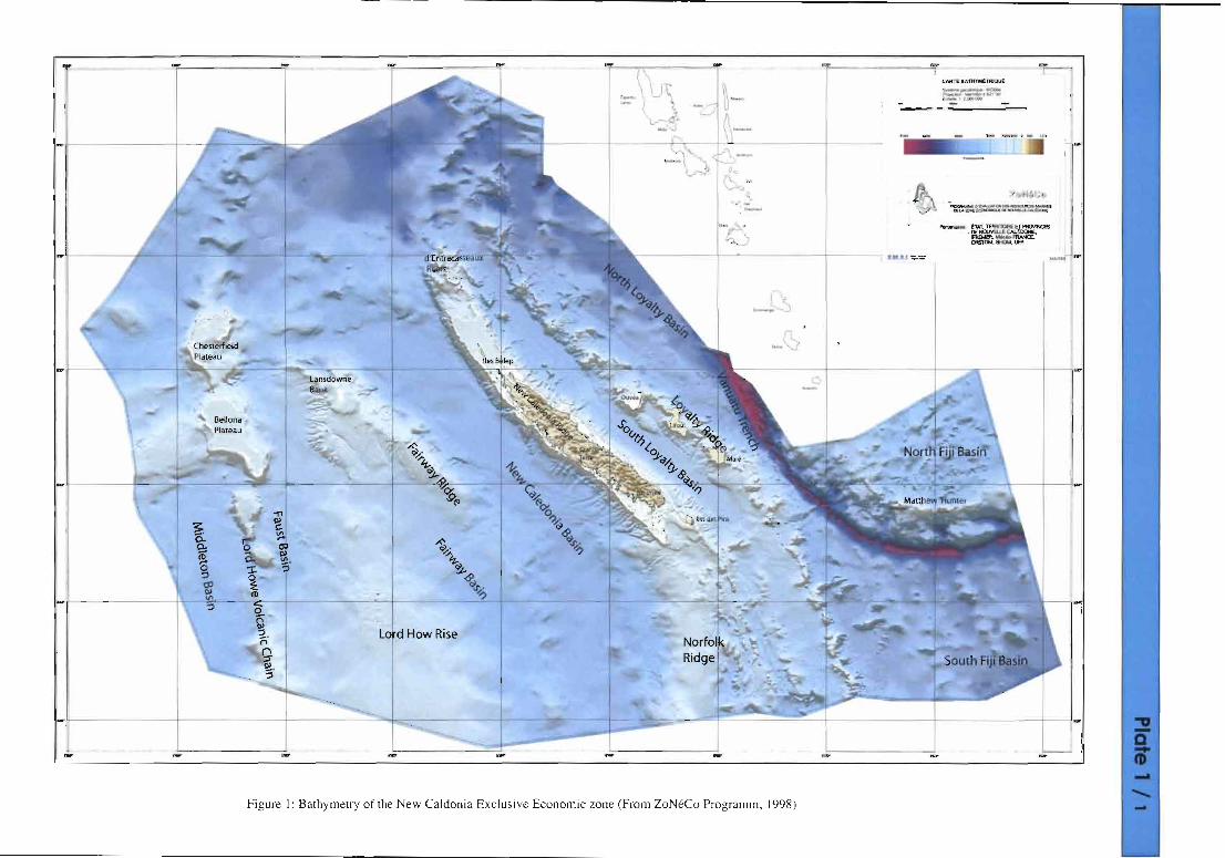
Geology of the New Caledonia region and its implications for the study of the New Caledonian biodiversity Bernard PELLET/ER /nstitut de Recherche pour le Developpement (/RD) Noumea, UMR Geosciences Azur, BP A5 Noumea, Nouvelle-Caledonie [email protected] Introduction The New Caledonian exclusive economic zone is located in the Southwest Pacific between Australia and the Vanuatu archipelago (formerly New Hebrides). It extends over 1200 km from north to south and 1800 km from west to east, from the Chesterfield Islands up to the Matthew and Hunter Islands at the southern tip of the Vanuatu archipelago (Figure 1). The main islands of New Caledonia are located on two parallel NW-SE trending ridges. The largest island (the 400 km-long and 50 km-wide Grande Terre) and subordinate islands including the Belep islands in the north and the Isle of Pines in the south are supported by the New Caledonia Ridge. The Loyalty Islands are supported by the Loyalty Ridge. Geologically, the area is schematically composed of a series of NW-SE trending ridges and basins formed by i) stretching and spreading along the eastern margin of Australia during Late Cretaceous- Paleocene times and ii) Eocene convergence which was responsible for the emplacement of one of the largest ophiolitic complexes in the world: the New Caledonian ophiolitic nappe (a slice of ocean- ic lithospheric mantle) from which weathering formed one of the world's largest reservoirs of nick- el. The ridges and basins are nowadays supported by the Australia plate that subducts beneath the Vanuatu active volcanic arc. The southernmost segment of the arc supports the active volcanic islands of Matthew and Hunter. These latter islands are thus on a plate (a micro-plate) that differs from the one supporting the main islands of New Caledonia territory. After reviewing the different morphostructural units and discussing the geological history of the New Caledonia area, I will point out some facts that may be relevant in the study and understanding of New Caledonia biodiversity. Geological of the morphostructural units of the New Caledonia region From west to east, the main geological units between Australia and Vanuatu include the Tasman Sea Basin, the Lord How Rise with subordinate basins, ridges and chains, the New Caledonia Basin, the New Caledonia Ridge, the South Loyalty Basin, the Loyalty Ridge, the North Loyalty Basin and the Vanuatu Ridge (Missegue et al., 1991; Smith and Sandwell, 1997; ZoNeCo 1998) (Fig. 1 plate 1/1 and Fig. 2 plate 2/1). The Tasman Sea Basin To the southeast of Australia the Tasman Sea Basin is a wide (up to 2000 km) and deep (4000 m) basin floored with oceanic crust formed by spreading from the Cretaceous (85 Ma: Santonian to Early Campanian) to Earliest Eocene (52 Ma) (Hayes et Ringis, 1973; Weissel and Hayes 1977; Gaina et al., 1998). In the central part of the basin, the N-S trending Tasmantid volcanic chain is an Oligocene to Late Miocene hot spot chain showing the northward drift of the Australia plate (Vogt and Conolly, 1971; Mc Dougall and Duncan, 1988). The Lord Howe Rise The Lord Howe Rise is a main bathymetric feature which averages 400 km in width and extends over 1600 km from the Challenger Plateau off New Zealand to the Chesterfied area. Water depths on the crest are 1200 to 750 m. In the north, at the latitude of New Caledonia, the Lord Howe Rise includes several basins, ridges and chains. They are from west to east: the Dampier Ridge, the Middleton basin, the ChesterfieVBellona Plateau, the Faust basin, the Lord Howe Rise crest, the Fairway Basin and the Fairway Ridge. The Lord Howe Rise is interpreted as a thinned fragment of continental crust split from Gondwana by Cretaceous rifting and subsequent spreading in Tasman Sea Basin, and it is o
Transcript of Geology of the New Caledonia region and its implications ...

Geology of the New Caledonia region and its implications for the studyof the New Caledonian biodiversity
Bernard PELLET/ER/nstitut de Recherche pour le Developpement (/RD) Noumea,UMR Geosciences Azur, BP A5 Noumea, Nouvelle-Caledonie
IntroductionThe New Caledonian exclusive economic zone is located in the Southwest Pacific between Australiaand the Vanuatu archipelago (formerly New Hebrides). It extends over 1200 km from north to southand 1800 km from west to east, from the Chesterfield Islands up to the Matthew and Hunter Islandsat the southern tip of the Vanuatu archipelago (Figure 1). The main islands of New Caledonia arelocated on two parallel NW-SE trending ridges. The largest island (the 400 km-long and 50 km-wideGrande Terre) and subordinate islands including the Belep islands in the north and the Isle of Pinesin the south are supported by the New Caledonia Ridge. The Loyalty Islands are supported by theLoyalty Ridge.Geologically, the area is schematically composed of a series of NW-SE trending ridges and basinsformed by i) stretching and spreading along the eastern margin of Australia during Late CretaceousPaleocene times and ii) Eocene convergence which was responsible for the emplacement of one ofthe largest ophiolitic complexes in the world: the New Caledonian ophiolitic nappe (a slice of oceanic lithospheric mantle) from which weathering formed one of the world's largest reservoirs of nickel. The ridges and basins are nowadays supported by the Australia plate that subducts beneath theVanuatu active volcanic arc. The southernmost segment of the arc supports the active volcanic islandsof Matthew and Hunter. These latter islands are thus on a plate (a micro-plate) that differs from theone supporting the main islands of New Caledonia territory.After reviewing the different morphostructural units and discussing the geological history of the NewCaledonia area, I will point out some facts that may be relevant in the study and understanding ofNew Caledonia biodiversity.
Geological of the morphostructural units of the New Caledonia regionFrom west to east, the main geological units between Australia and Vanuatu include the Tasman SeaBasin, the Lord How Rise with subordinate basins, ridges and chains, the New Caledonia Basin, theNew Caledonia Ridge, the South Loyalty Basin, the Loyalty Ridge, the North Loyalty Basin and theVanuatu Ridge (Missegue et al., 1991; Smith and Sandwell, 1997; ZoNeCo 1998) (Fig. 1 plate 1/1and Fig. 2 plate 2/1).
The Tasman Sea BasinTo the southeast of Australia the Tasman Sea Basin is a wide (up to 2000 km) and deep (4000 m)basin floored with oceanic crust formed by spreading from the Cretaceous (85 Ma: Santonian to EarlyCampanian) to Earliest Eocene (52 Ma) (Hayes et Ringis, 1973; Weissel and Hayes 1977; Gaina etal., 1998). In the central part of the basin, the N-S trending Tasmantid volcanic chain is an Oligoceneto Late Miocene hot spot chain showing the northward drift of the Australia plate (Vogt and Conolly,1971; Mc Dougall and Duncan, 1988).
The Lord Howe RiseThe Lord Howe Rise is a main bathymetric feature which averages 400 km in width and extends over1600 km from the Challenger Plateau off New Zealand to the Chesterfied area. Water depths on thecrest are 1200 to 750 m. In the north, at the latitude of New Caledonia, the Lord Howe Rise includesseveral basins, ridges and chains. They are from west to east: the Dampier Ridge, the Middletonbasin, the ChesterfieVBellona Plateau, the Faust basin, the Lord Howe Rise crest, the Fairway Basinand the Fairway Ridge. The Lord Howe Rise is interpreted as a thinned fragment of continental crustsplit from Gondwana by Cretaceous rifting and subsequent spreading in Tasman Sea Basin, and it is
o
probably composed of Paleozoic basement overlain by rift basins with up to 4 km of Mesozoic andCenozoic sediments (Willcox et al., 2001; Van de Beuque et al., 2003; Exon et al., 2004).Stratigraphy also indicates an emergence and major unconformity from the Late Eocene to EarlyOligocene (Burns et al., 1973), which correlates with described compressive structures of that age(Lafoy et al., 1994; Symonds et al., 1999; Auzende et al., 2000).The Lord Howe rise has Cenozoic seamount chains as exemplified by N-S trending volcanic edificeson its crest (Van de Beuque et al., 1998; Exon et al., 2004) and the Oligocene-Miocene Lord Howeseamount chain on its western side. The ChesterfieldlBellona plateau is supported by five guyots thatconstitute the northern and oldest volcanoes (Late Oligocene ?) along the Lord Howe hotpsot chain(Missegue et Collot, 1987).The 800 km long, 130 km wide and NW-SE to NNW-SSE trending and southward deepening (1000to 3000 m) Fairway Basin, firstly interpreted as oceanic in nature (Ravenne et al., 1977; Mignot,1984; Eade, 1988; Uruski and Wood, 1991; Van de Beuque, 1999), is now considered to be flooredby stretched-thinned continental crust based on the presence of salt diapirs derived from Cretaceousseries (Auzende et al., 2000), gravity modeling (Vially et al., 2003) and extensional-type horst andgraben structures of the crust (Lafoy et al., 2005). It is proposed that the formation of the FairwayBasin took place during the Late Cretaceous (95-65 Ma) by continental stretching, at the same timeas the stretching in the Middleton Basin (Lafoy et al., 2005).The 600 km-long and NW-SE trending Fairway Ridge, culminating in its northernmost part at theLansdowne bank, thins and deepens southward. The origin of the ridge is still· controversial.Previously interpreted as a ridge of oceanic nature (Ravenne et al., 1977; Mignot, 1984) and as anoceanic piece of the New Caledonia basin crust overthrust along the Lord How Rise (Lafoy et al.,1994; van de Beuque, 1999; Auzende et al., 2000), it is now considered as thinned continental crust(Vially et al. 2003; Lafoy et ai, 2005).
The New Caledonia BasinThe New Caledonia Basin extends from west of Northern New Zealand to west of New Caledonia,parallel to the Lord Howe Rise. The deepest (3600-3700 m) northern part (north of 22°30'S) strikesNW-SE while the central part (3000 m deep) strikes NNW-SSE. Origin of the basin is controversialfrom oceanic type (Shor et al., 1971; Dubois et al., 1974; Weissel et Hayes, 1977; Willcox et al.,1980; Kroenke, 1984; Mignot, 1984 ; Sutherland, 1999 ; Auzende et al., 2000) to thinned continental type (Etheridge et al., 1989 ; Uruski et Wood, 1991 ; Sdrolias et al., 2003 ; Vially et al., 2003 ;Lafoy et al., 2005). The horst and graben structure of the crust with westward tilted blocks and a sedimentary section up to 8 km thick suggests a thinned continental crust for the northern NW-SE segment. On this segment the crust dips to the east, toward the western margin of the New Caledoniaridge. At the base of this margin, buried deformation features interpreted as the result of compressionhave been recognized (Rigolot and Pelletier, 1988). In contrast to the northern segment, the centralsegment of the basin, with magnetic lineations and an axial ridge buried by a 4 km-thick sedimentary sequence, is interpreted as a segment floored with oceanic crust that formed during the Paleocene(possibly from 62 to 56 Ma) after Late Cretaceous-Earliest Paleocene stretching (Lafoy et al., 2005).
The New Caledonia RidgeThe New Caledonia Ridge is the NW-SE trending northern segment of the 70-100 km-wide NorfolkRidge which extends over 1500 km from the d'Entrecasteaux Reef to the northern tip of NewZealand. As for the Lord How Rise, the Norfolk ridge is interpreted to be a continental ribbondetached from Gondwana. Geology ofthe Grande Terre of New Caledonia (Lillie and Brothers, 1970;Paris, 1981; Picard, 1999) has great similarities with that of New Zealand. Main geologic features ofthe island have been tentatively extended along the submerged northward (Collot et al., 1988) andsouthward (Rigolot, 1988) segments of the ridge.The island is composed of a series of various terranes assembled during two tectonic events : a LateJurassic to Early Cretaceous tectonic collage (paris, 1981 ; Meffre 1995 ; Aitchison et al. 1998) and

a Late Eocene subduction/collision resulting in the emplacement at the Latest Eocene (38-34 Ma) ofa large ophiolitic nappe (Avias 1967; Paris, 1981 ; Collot et al., 1987 ; Aitchison et al., 1995 ; Cluzelet al., 1994,2001).The pre-Cretaceous terranes, mainly located in the central chain, are unconformably overlain byUpper Cenomanian (Late Cretaceous) to Upper Eocene sediments, and include disrupted LateCarboniferous ophiolite (Meffre et al., 1996 ; Aitchison et al., 1998), mid-Triassic to late Jurassic volcano-sedimentary arc terrane (Meffre et al., 1996), Mid Permien to Late Jurassic volcano-sedimentary arc terrane (Campbell et al., 1985), post-Liassic unit composed of oceanic crust and volcano-sedimentary distal deposits (Cluzel, 1996) and affected by a Late Jurassic high pressure metamorphism(150 Ma: Blake et al., 1977).The post-EarlY Cretaceous terranes also involved in the Late Eocene major event include:- an unmetamorphosed Upper Cretaceous to Upper Eocene sedimentary pile well exposed along thewestern side of the Grande Terre. This pile is composed of two sequences separated by an unconformity (paris, 1981; Cluzel et al., 2001). The lower sequence includes an Upper Cretaceous finingupward clastic series of conglomerates, sandstones, coaly siltstones and volcanic rocks, overlain byPaleocene to Middle Eocene pelagic limestones and cherts, indicative of a deepening of the depositenvironment. The upper sequence is a Upper Eocene (Upper Bartonian to Priabonian) flysch formation (Noumea-Bourail and Nepoui flyschs), deposited after a short period of deformation and erosionand showing a coarsening upward sequence with (a) basal neritic limestones, (b) a «lower flysch»member of marls and calcareous sandy marls, (c) an «upper flysch» member composed of finegrained calcareous turbidites interbedded with mafic breccias, and (d) a "wildflysch" member thatincorporates blocks and olistoliths of siliceous shales, limestones, basalts and flysch, topped by anolistostrome recording the Late Eocene tectonic paroxism.- a mafic unit of oceanic basalts interbedded with argillite and cherts (named basalt nappe or Poyaunit) of Late Cretaceous (Campanian) to Late Paleocene-Earliest Eocene age (85-55 Ma), with backarc orfore-arc affinities (Routhier, 1953; Espirat, 1963; Eissen et al., 1998; Cluzel et al., 1997,2001).This unit, severely sheared and folded, is mainly exposed along the northern half part of the westcoast but also outcrops along the east coast; it always underlies the ultramafic nappe and tectonical1y overlies the Upper Eocene sedimentary rocks.- mafic high pressure-low temperature metamorphic units (Pouebo and Diahot units) located in thenortheastern part of the Grande Terre (Brothers, 1974; Paris, 1981; Yokoyama et al., 1986; Maurizotet al., 1989; Black et al., 1993; Clarke et al., 1997; Cluzel et al., 1995; Baldwyn et aI, 1999; Carsonet al., 1999; Rawling and Lister, 2002; Fitzherbert et al., 2004, Spandler et al., 2005). The units andespecially the Pouebo unit are interpreted to be the equivalent of the basalt nappe metamorphosedunder blueschist to eclogitic facies conditions, the latter (20 kbar, 650°C) indicating an underthrusting equivalent to a depth of 60-70 km. Radiometric dating of the metamorphism peak is 44 Ma(Spandler et al., 2005) while those from the cooling ages range from 40 to 34 Ma (Baldwyn et al.,1999), indicating a rapid unroofing and exhumation of the metamorphic units in the north and a synchronism with the final emplacement of the ophiolitic nappe (38-34 Ma) in the west and south of theisland.- the ophiolitic nappe mainly composed of peridotites and well exposed in the southern part of theisland (3 km thick in the southern massif), Belep and Pines islands and as a series of klippes alongthe western northern half of the island (Avias, 1967; Guillon et Routhier 1971; Guillon, 1975;Prinzoffer et al., 1980). If the age of its emplacement is Late Eocene (Paris et al., 1979), the age ofthese mantellic rocks is not accurate and considered to be Late Cretaceous or older from radiometricdatings of associated mafic and felsic dikes yielded Late Cretaceous (100-80 Ma) and Eocene (42-52Ma) ages (paris, 1981; Prinzhoffer, 1981). The peridotites are mainly harburgites and are the motherrocks for the nickel of New Caledonia.The Oligocene is characterised by a lack of marine sediments, and post-obduction granodiorite intrusions (St Louis and Koum) radiometrically dated from 32 to 24 Ma (Guillon, 1975) and interpreted
•

as the result of short-lived convergence episode along the western margin of the New Caledonia ridge(Cluzel et al., 2005). The peridotites have been extensively weathered under aerial conditions sinceOligocene, leading to the development of thick Ni-rich lateritic mantles (Trescases, 1973, 1975;Latham, 1986) and relict lateritic landsurfaces (Chevillotte et al., 2006). Brittle extensional deformation plays an important role in the post-obduction morphotectonic evolution of the island(Leguere, 1976; Lagabrielle et al, 2005; Chardon and Chevillotte, 2006). This extension which mayinitiated in the Oligocene is expressed in the Neogene by the disruption of land surface formed during Oligocene planation and in the outcrop at Nepoui of Lower-Middle Miocene fluvial conglomerates with shallow water marine limestones (Coudray, 1976). Neogene ridge-normal then ridge-parallel to oblique extensional tectonics are also responsible for the shape and subsidence of the NewCaledonia ridge margins (Daniel et al., 1976; Dugas and Debenay, 1978; Bitoun and Recy, 1982;Rigolot, 1989; Chardon and Chevillotte, 2005; Flamand 2006). The Grande Terre displays one of thelargest barrier-reefs in the world, isolating a locally-wide lagoon. The barrier reef settled in the EarlyPleistocene (Coudray, 1976). Vertical motions from the 125 Ka reef indicate different tectonic blocksand a general slow subsidence (0.03 to 0.16 mmlyear) of the coast except in the southeastern part ofthe Grande Terre and Pines island where coasts are uplifted (Launay and Recy, 1972; Launay, 1985;Cabioch, 1988, Cabioch et al., 1996) and where quaternary faults have been observed (Lafoy et al.,2000; Lagabrielle et al., 2005; Flamand, 2006) and seismicity occurs (Regnier et al., 1999; Pillet andPelletier, 2004).
The South Loyalty BasinParallel to the NorfolklNew Caledonia Ridge, the South Loyalty Basin (called also the West LoyaltyBasin) is a 1300 km-long, narrow (45-65 km wide), and northward deepening (from 2000 to 3800 m)basin with oceanic crust dipping northwestward and filled with thick (up to 8 km) sediments whichare considered to be mainly post Eocene in age (Bitoun and Recy, 1982 ; Pontoise et al., 1982 ;Collot, et al., 1987). Geophysical data suggests that the oceanic basement is the continuity of theophiolitic nappe of the Grande Terre. The age of the crust is unknown but considered as pre LateCretaceous (Collot et al., 1987) or Late Cretaceous to Paleocene (Cluzel et al., 2001).
The Loyalty RidgeThe loyalty ridge is a narrow ridge parallel to the South Loyalty Basin and Norfolk Ridge and moreor less continuous from the Cook Fracture zone in the South to the d'Entrecasteaux zone in the north.It is composed of a series of seamounts and guyots and supports the Loyalty islands.The geology of the ridge is poorly known and its origin and nature are unknown. Parallelism withother ridges bordering the Australian margin suggests an old and continental origin (Monzier, 1993).However, taking into account its possible link with the d'Entrecasteaux zone (an Eocene subductionzone) and for convenience in the understanding the geology of New Caledonia, the Loyalty Ridge isconsidered as an Eocene island arc in most of the reconstructions, (Maillet et al., 1983; Kroenke,1984; Eissen et al., 1998 ; Cluzel et al., 1994,2001 ; Crawford et al., 2003 ; Sdrolias et al., 2003 ;Schellart et al., 2006). Middle to Upper Oligocene non orogenic volcanism has been also proposedfor the origin of the ridge (Rigolot, 1989; Monzier, 1993). Only few volcanic rocks have been recovered in two areas. Upper Miocene (9-11 Ma) alkalic basalts (Baubron et al., 1976) outcrop on Mareisland. Submersible dives off Mare along the eastern flank of the ridge (Monzier et al., 1989) recovered volcanic breccias, Middle Oligocene (32 Ma) alkaline rhyolites, Middle Oligocene tuffaceoussandstones, Middle Upper Oligocene chalks, Upper Oligocene (27 Ma) alkalic basalts, LowerMiocene (20 Ma) back-arc basalts, and algae and reefallimestones with reworked Eocene-Oligoceneand Mio-Pliocene fauna (Monzier, 1993). The ridge appears to be composed, at least partly, of nonorogenic alkaline volcanics of Middle to Late Oligocene and Late Miocene age, the youngest beinglikely a part of a N-S trending hot spot track (Rigolot et al., 1988). None of the recovered rocksargues for a volcanic arc origin, although this hypothesis, possible and attractive, is widely acceptedin the literature.

The Loyalty islands are mainly composed of Late Miocene to Pleistocene uplifted reef formationscovering the basement (Chevalier, 1968 ; Marshall et Launay, 1978 ; Bourrouilh, 1996; Carriere,1987; Guyomard et aI., 1996). The varying altitude of the islands shows the bulge of the Australiaplate in front of its subduction eastward beneath the Vanuatu arc (Dubois et al., 1974, 1977, 1988).The islands diachronously emerged during the Pleistocene (possibly in the Latest Pliocene for Mare)and are still emerging and uplifting (as exemplified by Ouvea) except the ones which have passedthe top of the bulge and are thus subsiding.
The North Loyalty BasinThe North Loyalty Basin (named also East Loyalty Basin) is a deep (3000 to 5000 m) basin flooredwith oceanic crust dated of pre Middle Eocene age in its northernmost part (Andrews et al., 1975).Bounded northward by the d'Entrecasteaux zone, it is the remaining part of a larger basin which disappears eastward in the active Vanuatu subduction zone. Initially interpreted to have formed byspreading in Early Eocene and regarded as the old part of the South Fiji Basin (Lapouille, 1982;Weissel et al., 1982), it is now considered to have formed in Late Eocene (44 to 35 Ma: Sdrolias etal., 2003) as a back arc basin of the Loyalty arc (Maillet et al., 1983; Cluzel et al., 2001; Schellart etal., 2006).
The Vanuatu Trench and Ridge, the North Fiji Basin and the Vitiaz Trench LineamentThe Vanuatu Ridge is a 1500 km-long active volcanic arc related to the subduction of the Australiaplate since the Late Miocene (12-10 Ma). Oldest known arc volcanic rocks from the Vanuatu ridgeare however Early Miocene in age (Mitchell and warden, 1971 ; Camey and MacFarlane, 1982) andrelated to the fossil west-dipping Vitiaz subduction zone along which Pacific plate subducted, LateMiocene subduction reversal and initiation of east-dipping Vanuatu subduction being due to collisionof the Ontong Java Plateau and the Melanesian border plateau (Packham, 1973; Kroenke, 1984;Brocher, 1985; Pelletier and Auzende, 1996). The Vanuatu arc rotated clockwise leading to the formation of the active north Fiji back arc complex basin (Chase et aI., 1971 ; Falvey, 1975 ; Auzendeet al., 1988, 1995).The Vanuatu Trench is a segment of the present-day Australia-Pacific converging plate boundaryalong which Australia plate dips eastward and is consumed. Relative motion of convergence at trenchis ENE-WSW and rate of motion varies along the trench and is about 12 cm/year at the latitude ofthe Loyalty islands (Dubois et ai, 1977; Louat et Pelletier 1989 ; Pelletier et ai, 1998 ; Calmant et ai,1995,2003). Near 22°S, the Loyalty Ridge enters the trench and subductslcollides with the Vanuatuarc since 300 ka (Monzier et al., 1989) ,reducing the convergence motion south of the impact pointand forming sinistral E-W strike-slip motion across the arc and isolating a micro plate (Louat andPelletier 1989 ; Calmant et al., 2003) on which Mattew and Hunter islands are active volcanoes(Maillet et al., 1986). This incipient collision is also supposed to have tectonic effects on the LoyaltyRidge (Lafoy et al., 1996).
Tectonic evolution of the New Caledonia domainNumerous Cretaceous to Cenozoic reconstructions of the Southwest Pacific and New Caledoniaregion have been proposed in the past years (Kroenke 1984 ; Yan and Kroenke, 1993; Veevers, 2000 ;Muller et al., 2000 ; Cluzel et al., 2001 ; Sutherland et al., 2001 ; Hall, 2002 ; Crawford et al., 2003 ;Sdrolias et al., 2003 ; Schellart et al., 2006). Tectonic evolution concerning the New Caledoniadomain can be divided into 5 stages (Fig. 3, plate 2/2).
The pre-Late Cretaceous periodThe Paleozoic to Early Cretaceous period is thought to be marked by a subduction zone along theeastern margin of Gondwana. It ended with a Late Jurassic to Early Cretaceous tectonic orogeny (correlated with the Rangitata orogeny in New Zealand) that resulted in a collage of different units. Thevarious Late Carboniferous to Late Jurassic units found in New Caledonia assembled at that time toform the old core of New Caledonia (Paris, 1981 ; Meffre, 1995 ; Cluzel et al., 2001).
•

•
The Early Late Cretaceous (120-100 Ma) to Earliest Eocene (55-50 Ma) period: marginal rifting andspreading along the east Gondwana marginThis extensional tectonics period is marked by dislocation of the east Gondwana margin by LateCretaceous rifting and subsequent Latest Cretaceous to Latest PaleocenelEarliest Eocene spreading.This results in a series of at least two thinned fragments of continental crust (the Lord Howe Rise,the Norfolk Ridge and possibly the Loyalty Ridge 7 and/or a ridge further to the east 7) and at leastthree main basins floored with oceanic crust (the Tasman Sea Basin (100-85 Ma stretching, 85/80-52Ma spreading), the New Caledonia Basin (95-62 7 Ma stretching, 62-56 Ma 7 spreading) and theSouth Loyalty Basin (100/80 7 or 85/80 -55 Ma 7 spreading). Ages of the crust of the two latter basinsstill derive from interpretations.The major problem in the reconstruction for this period is the nature of the plate boundary east of thearea. Reconstructions have suggested this boundary is an east dipping subduction zone, a west-dipping subduction zone, a strike-slip boundary, or no boundary at all. The recent reconstructions(Cluzel et al., 2001 ; Crawford et al., 2003; Shellart et al., 2006) propose a continous west-dippingsubduction of the Pacific plate that rolled back eastward to accomodate the basins opening. However,this attractive model does not fit well with the « classic» formation of successive back-arc basins inwhich the closest basin to the trench is the youngest, because the basins are thought to be more orless similar in age (except if an older age -Early Cretaceous- for the South Loyalty Basin is chosen).Also, the associated volcanic arc accompanying this long term subduction is still largely undocumented, even if one may consider that it disappeared by erosion or it is hidden beneath younger volcanic arcs or sediments.
The Early Eocene (55-50 Ma) to Latest EocenelEarly Oligocene period: lithospheric shortening andthe New Caledonian orogenThis period is marked by convergence inside the previously dismembered east Gondwana margin, bythe partial closure of North Loyalty Basin and finally by the emplacement of the ophiolitic nappe inNew Caledonia. Recent reconstructions (Cluzel et al., 2001 ; Schellart et al., 2006) propose a relatively long-lived intra-oceanic east-dipping subduction zone inside the South Loyalty Basin duringEarly to Middle Eocene. Subduction was locked in the Late Eocene (38-34 Ma) by the underthrusting of the Norfolk ridge, resulting in the thrusting over the New Caledonia block of mafic and ultramafic units with coeval (60-70 km) exhumation of metamorphic rocks by buoyancy-driven uplift. Inthe final stage, the convergence motion jumped westward along the west margin of the NewCaledonia ridge, as suggested by compressive features at the toe of the western margin, the abandoned slab beneath southern New Caledonia (Regnier, 1988) and the post-orogenic Lower Oligoceneintrusives. Compression also affected the Fairway Ridge and Lord How Rise.In the above-mentioned model, a large portion of the oceanic lithosphere of the wide South LoyaltyBasin would have been absorbed in subduction, and the subduction would be responsible for thedevelopment of the Loyalty Ridge arc and the North Loyalty back-arc basin. However, the fore arcof this subduction zone does not resemble classic fore arc domain, and volcanic rocks with arc affinity are still unknown in the Loyalty ridge, and the direction of spreading in the North Loyalty Basin,deduced from E-W trending magnetic anomaly lineations, is parallel -instead of normal- to the arcand the subduction zone. An alternative model proposed here is to consider a narrow original NorthLoyalty basin from which a small panel of lithosphere forming the foot of the New Caledonia Ridge'smargin has been obducted, with no requirement of Eocene subduction to create the Loyalty Ridge.
The Oligocene to Late Miocene period: planation, extensional tectonics and subsidence, volcanismThis poorly-documented post orogenic period is marked by (low to moderate 7) uplift, erosion andplanation of the New Caledonia ridge. Isostatic uplift is likely accompanied by ridge-normal extensional tectonics and subsidence of the margins, and could be due to the buoyancy force of the orogenic root thickened during collision, to loading by the overthrusted oceanic lithosphere and to erosion. Ni-rich lateritic mantles likely mainly developed during this period of extensive alteration of theperidotites .
This period is also marked by alkaline volcanism related to several hot spots that affect the Australiaplate, as exemplified by the Tasmantid chain in the Tasman Sea Basin, the Lord Howe volcanic chainand the volcanic edifices along the Norfolk RidgelLoyalty Ridge.
The Late Miocene (10 Ma) to Present period: extension, initiation of subduction, bulge-related deformations and arc-ridge subduction/collisionThe Latest Miocene is marked, to the east of the New Caledonia domain, by the initiation of the eastdipping Vanuatu subduction zone. This zone of convergence, behind which the active North FijiBasin opened and along which part of the North Loyalty Basin (and other basins and features ?) wasconsumed, appears to play a significant role in the Late Neogene evolution of New Caledonia andLoyalty Ridges, as shown by (1) Late Neogene ridge-parallel to oblique extensional tectonics thataffected the ridges, (2) Quaternary faults, bulge-related Quaternary vertical motions of the Loyaltyislands and southern part of the New Caledonia' Ridge, (3) Loyalty Ridge-Vanuatu arc interactionrelated deformation and (4) shallow seismicity of relatively low intensity in the Grande Terre (intenseseismicity, however, occurs in the easternmost part of the Loyalty Ridge close to the active Vanuatuplate boundary).
Some geological aspects for the understanding of the New Caledonia biodiversity andendemism
The problem of lands for refuge of the Gondwanian flora and faunaThe geology of the Grande Terre of New Caledonia indicates that after the Cretaceous the NorfolkRidge/New Caledonia Ridge was below sea level up to the Late Eocene (or possibly up to the MiddleEocene), thus for a period of about 20 Ma (from 65 to 45 Ma). Indeed, the Paleocene-Lower Eocenepelagic limestones and cherts following the Upper Cretaceous fining-upward clastic sequence indicate relatively deep water deposits. Presence of an island on the New Caledonia Ridge is establishedsince the Late Eocene, the size of which was larger than today since the d'Entrecasteaux Reef area,the wide northern lagoon, the wide southern lagoon, as well as parts of the upper slope of the present-day margins were probably above sea level. Other islands likely existed in the Late Eocene-EarlyOligocene, on the Lord Howe Rise, Fairway Ridge and Loyalty Ridge. Islands also existed in LateOligocene on the ChesterfieldlBellona zone, and in Late Miocene on the Loyalty Ridge. Thus, onemay infer that the Gondwanian fauna and flora were introduced in New Caledonia during or after theMiddle to Late Eocene.If New Caledonia was not a refuge for the Gondwanian biodiversity, did other land -except Australia- exist in the region before the Middle-Late Eocene ? This in turn poses the major question concerning the nature of the plate boundary east of Australia before 45-50 ma. If we consider (as proposedby Veevers et al., 2000; Cluzel et al., 2001; Crawford et al., 2003; Schellart et al., 2006) that a westdipping subduction continuously proceeded since that time during rifting and subsequent basinspreading, therefore a volcanic arc must have been always active. This provides the possibility for thebuilding of an alignment of islands likely restricted in size east of the Norfolk-New Caledonia Ridge,such as the present-day islands of the active Tonga or Vanuatu arcs.
The influence of the New Caledonian ophioliteIt is well known that the nature of the ultra basic ophiolitic nappe of New Caledonia plays an important role in the floral endemism of the island. The peculiar speciation and diversification are drivenby the unusual type of ultra basic rock-derived soils rich in metallic elements and depleted in mineral salts. Most of the flora living on lateritic soils is endemic. Today ultrabasic rocks and associatedsoils only cover about one third of the island. The ophiolitic nappe constituting the top of the tectonic pile of the Late Eocene orogen, it is likely that when it emerged the Grande Terre island was fullycovered by the ophiolite, leading to species selection. However, the present-day ophiolitic nappe

lacks a complete crustal sequence (sheeted dike complex and mafic rocks) and we do not know if themafic crustal sequence existed on the top of the ultramafic rocks or if it has been removed by erosion.An other point about the possible role of the ophiolitic nappe for the biodiversity is alkalinehydrothermalism resulting from reactions between water and upper mantle rocks (serpentinization).Recently (Pelletier et al., 2006) an extensive active alkaline hydrothermal field has been revealed by2004 and 2005 swath mapping and scuba diving in the floor of Prony Bay which developed in thelarge peridotitic massif at the southern tip of the Grande Terre, the "Prony aiguille" chimney was previously known (Launay and Fontes, 1985) . Uncommon characteristics of this alkaline hydrothermalsystem are similar (same high pH, same deposits of CaCo3 and Mg hydroxyde and same peridotiticsubstratum) to those of the Lost City site recently discovered on the Mid-Atlantic Ridge (Kelley etal., 2001) and which produces methane- and hydrogen-rich fluids serving as energy sources forarchaeal and eubacterial communities (Kelley et al., 2005). Such alkaline systems which derive fromhydration of the outcropping ultramafic rocks is interesting because it may share several characteristics with hydrothermal environments at the beginning of life on Earth. The Prony Bay site is accessible by scuba diving and thus may be of wide interest. It is possible that such other active or recenthydrothermal sites exist in the present-day submerged portions of the remaining ophiolitic nappe(parts of southeastern and eastern lagoons of the Garnde Terre). Probably, such hydrothermal fieldsalready existed in the past since the Late Eocene emplacement of the ophiolitic nappe, and may haveplayed a first-order role in the evolution of the New Caledonian biodiversity.
Pleistocene sea level variationThe sea level has 100 Ka cyclic high and low stands since the last 0.9 Ma (Shackelton, 1987,2000).Low stands were 120-130 m below present-day sea level and high stands were sometimes 5 to 10 mabove present-day sea level. Such high amplitude and rapid variations may have significant effectson the distribution of the New Caledonia marine biodiversity. Taking into account the slow subsidence of the margins, the wide lagoon around the Grande Terre with depths much lower than 120 mhas been largely emerged and submerged several times during the last million years. Detailedbathymetry of the lagoon however suggests that lakes with brackish water existed during sea falls inthe deepest parts of the lagoon, the depths of the passes being generally shallower than that the lagoonitself (Dugas et al., 1980; Chevillotte et al., 2005). Lakes were likely in the relatively deep (60 m)and closed northern lagoon (Collot et al., 1988), as well as in the southern lagoon as suggested by25-35 m deep closed basins in front of the Pirogue river and east of the Mato Pass. The productionof maps at different times during the last cycles, especially during the last glaciation/deglaciationperiod (last 125 ka), taking into account subsidence, sedimentation and detailed bathymetry of thelagoon, barrier reef and passes may be useful to locate possible refuges through Late Pleistocene forthe species of the lagoon.
AcknowlegmentsI am thankful to Guy Cabioch and Dominique Chardon, both at IRD Noumea, for fruitful discussions and reviews of thecontent of the paper.
REFERENCESAITCHlSON, J., CLARKE, G., MEFFRE, S. & CLUZEL, D., 1995. Eocene arc-continent collision in New Caledonia and
implications for regional southwest Pacific tectonic evolution. Geology, 23(2): 161 - 164.AITCHlSON, J.C., IRELAND, T.R., CLARKE, G.L., CLUZEL, D., & MEFFRE, S., 1998. UlPb SHRIMP age constraints
on the tectonic evolution of New Caledonia and regional implications. Tectonophysics 299, 333- 343.
ANDREWS J.E., PACKHAM G. et al, 1975. Sites 285 and 286, in Initial Reports of the Deep Sea Drilling Project,Washington, D.e., U.S. Governement Printing Office, 30, 27-131.
AUZENDE, J.M., LAFOY, Y. & MARSSET, B., 1988. Recent geodynamic evolution ofthe North Fiji Basin (SW Pacific),Geology, 16,925-929.

AUZENDE, J.-M., PELLETIER, B. & EISSEN, J.-P., 1995. The North Fiji Basin, geology, structure and geodynamic evolution. In: Brian Taylor (Ed), Backarc Basins: Tectonics and Magmatism, New York, Plenum Press, 139-175.
AUZENDE, J.M., VAN DE BEUQUE, S., REGNIER, M., LAFOY, Y. & SYMONDS, P., 2000. Origin of the NewCaledonian ophiolites based on a French-Australian Seismic Transect. Marine Geology, 162,225-236.
AUZENDE, J. M., VAN DE BEUQUE, S., DICKENS, G., FRAN<;OIS, C., LAFOY, Y., VOUTAY, O. & EXON, N., 2000,Deep sea diapirs and bottom simulating reflector in Fairway Basin (SW Pacific), Mar. Geophys. Res. 21, 579-587.
AVIAS, J., 1967. Overthrust structure of the main ultrabasic New Caledonia massives. Tectonophysics, 4(4-6): 531 - 541.
BALDWIN, S.L., RAWLINGS, T., & FITZGERALD, P.G., 1999. Thermochronology of the northern high Pff terrane ofNew Caledonia: implications for mid-Tertiary plate boundary processes in the SW Pacific. In: Baldwin, L., Lister, G.S.(Eds.), Penrose Conference, Mid-Cretaceous to recent plate boundary processes in the Southwest Pacific, Abstr Vol., p. 13.
BAUDRON, J.C., GUILLON, J.H. & RECY, J., 1976. Geochronologie par la methode K1Ar du substrat volcanique de l'ilede Mare, archipel des Loyaute (Sud-Ouest Pacifique). Bulletin BRGM, 3 serie 2: 165 - 176.
BITOUN, G., RECY, J., 1982. Origine et evolution du bassin des Loyaute et de ses bordures apres la mise en place de laserie ophiolitique de Nouvelle-CaIedonie, In: Equipe de Geologie-Geophysique ORSTOM Noumea (Bd), Contribution.al'etude Geodynarnique du Sud-Ouest Pacifique, Trav. Doe. ORSTOM, 147, 505 - 539.
BLACK, P.M., MAURIZOT, P., GHENT, E.D., & STOUT, M'z., 1993. Mg-Fe carpholites from aluminous schists in theDiahot region and implications for preservation of high-pressure low-temperature schist, northern New Caledonia. J.Metamorph. Geol. 11,455- 460.
BLAKE, M.CJ., BROTHERS, R.N. & LANPHERE, MA., 1977. Radiometric ages of blueschists in New Caledonia. In:Technip (Bd), International Symposium on Geodynamics in the South-West Pacific, Noumea 1976, Paris, 279-282.
BOURROUILH E, 1996. Plates-formes carbonatees et atolls du centre et sud Pacifique : Stratigraphie, sedimentologie,mineralogie et geochimie. Diagenese et emersions : Aragonite, calcite, dolomite, bauxite et phosphate. Document duBRGM,249.
BROCHER, T.M., 1985. On the formation of the Vitiaz Trench lineament and North Fiji Basin, in T.M. Brocher, ed.,«Investigations of the Northern Melanesian Borderland», Circum-Pacific Council for Energy and Mineral Resources,Earth Science Series, 3, Houston, Texas, 13-34.
BROTHERS, R.N., 1974. High-pressure schists in northern New Caledonia. Contrib. Mineral. Petrol. 46 (2),109- 127.
BURNS, R.E., ANDREWS, J.E. et al., 1973. Initial Reports of the Deep Sea Drilling Project, Washington, D.C., U.S.Government Printing Office, 21, 931 p.
CABIOCH G., 1988 - Recifs frangeants de Nouvelle-CaIedonie (Pacifique sud-ouest). Structure interne et influences del'eustatisme et de la neotectonique. - These Doct. Univ. Provence, Publ. Univ. Aix-MarseilleI, 291p.
CABIOCH, G., RECY, J., JOUANNIC, C. & TURPIN, L., 1996. Controle climatique et tectonique de l'edification recifale en Nouvelle CaIedonie au cours du Quaternaire terminal. Bull. Soc. geol. France, 167(6): 729 - 742.
CALMANT S, LEBELLEGARD P., TAYLOR EW., BEVIS M., MAILLARD D., RECY J. & BONNEAU J., 1995.Geodetic measurements of convergence across the New Hebrides subduction zone, Geophys. Res. Left., 22, 2573-2576.
CALMANT S., PELLETIER B., BEVIS M., TAYLOR E, LEBELLEGARD P., & PHILLIPS D., 2003 - New insight on thetectonics of the New Hebrides subduction zone based on GPS results. J. Geophys. Res., 108, B6, 2316.
CAMPBELL,HJ., GRANT-MACKIE,J.A.,& PARIS,J.P., 1985. Geology of the Moindou-Teremba area, New Caledonia.Stratigraphy and structure of the Teremba Group (Permian-Lower Triassic) and Baie de St. Vincent Group (UpperTriassic -Lower Jurassic). Geologie de la France Paris, Bureau des Recherches Geologiques et Minieres 1, 19-36.
CARNEY, J.N. & MACFARLANE, A., 1982. Geological evidence bearing on the Miocene to Recent structural evolutionof the New Hebrides arc, Tectonophysics, 87,147-175.
CARRIERE D., 1987. Sedimentation, diagenese et cadre geodynamique de l'atoll souleve de Mare, Nouvelle-CaIedonie,These Paris sud, Orsay.
CARSON, CJ., CLARKE, G.L., & POWELL, R., 2000. Hydration of eclogite, Parn Peninsula, New Caledonia. J.Metamorph. Geol. 18,79-90.
CHASE, C.G., 1971. Tectonic history of the Fiji plateau, Geol. Soc. Am. Bull., 82, 3087-3110..
CHARDON D., & CHEVILLOTTE, 2006. Morphotectonic evolution of the New Caledonia ridge (pacific Southwest) frompost obduction tectonosedimentary record. Tectonophysics, 420, 473-491.
CHEVALIER, J.P., 1968. Geomorphologie de l'ile de Mare. Les recifs de l'ile de Mare. In: Fond. Singer -Polignac (Ed),Expeditionjranraise sur les recifs carbonates de la Nouvelle-Calidonie, Paris, 3,1-158.
CHEVILLOTTE v., CHARDON D., BEAl}VAIS A., MAURIZOT P. & COLIN E, 2006. Long term tropical morphogenesis of New Caledonia (Southwest Pacific): importance for epeirogeney and climate change. Geomorphology, 0197615 p.
CHEVILLOTTE, v., DOUILLET, P., CABIOCH, G., LAFOY, Y., LAGABRIELLE, Y. & MAURIZOT, P., 2005. Evolutiongeomorphologique de l'avant-pays du Sud-Ouest de la Nouvelle-Caledonie durant les derniers cycles glaciaires.Comptes Rendus Geosciences, 337(7): 695 - 701
•

CLARKE, G., AITCHISON, J.C., & CLUZEL, D., 1997. Eclogites and blueschists of the Pam Peninsula NE NewCaledonia: a reappraisal. J. Metamorph. Petrol. 38 (7),843- 876.
CLUZEL, D.,AITCHISON, J., CLARKE, G., MEFFRE, S. & PICARD, C., 1994. Point de vue sur l'evolution tectoniqueet geodynamique de la Nouvelle CaIedonie (Pacifique, France). C. R. Acad. Sci. Paris, 319: 683 - 690.
CLUZEL, D., CLARKE, G., & AITCHISON, J.C., 1995. Northern New Caledonia high-pressure metamorphic core complex. From continental subduction to extensional exhumation. Pacrim'95 Congress,Auckland 11195, Proceedings Vol., 129134.
CLUZEL, D., 1996. Affinites intra-oceaniques des metavolcanites de l'Unite de la Boghen (ex-"ante-Permien" deNouvelle-CaIedonie, Pacifique SW). Consequences paIeogeographiques. C.R. Acad. Sci. Paris 323,657- 664.
CLUZEL, D., PICARD, C.,AITCHISON, J.C., LAPORTE, C., MEFFRE, S. & PARAT, E, 1997. La Nappe de Poya (exFormation des basaltes) de Nouvelle-Caledonie (pacifique Sud-Ouest), un plateau oceanique Campanien-Paleocenesuperieur obducte al'Eocene superieur. C. R. Acad. Sci. Paris, 324: 443 - 451.
CLUZEL, D.,AITCHISON, J.C. & PICARD, C., 2001. Tectonic accretion and underplating ofmafic terranes in the Late Eoceneintraoceanic fore-arc of New Caledonia (Southwest Pacific): geodynamic implications. Tectonophysics, 340: 23-59.
CLUZEL, D. & MEFFRE, S., 2002. L'unite de la Boghen (Nouvelle CaIedonie, Pacifique sud-ouest): un complexe d'accretion jurassique. Donnees radiochronologiques preliminaires U-Pb sur les zircons detritiques. Comptes RendusGeosciences, 334: 867-874.
CLUZEL, D., BOSCH, D., PAQUETTE, JL, LEMENNICIER, Y., MONTJOIE, P. & MENOT, R.P., 2005. Late Oligocenepost-obduction granitoids of New Caledonia: A case for reactivated subduction and slab breack-off. Island Arc, 14: 254 - 271.
COLLOT, J.Y., MALAHOFF, A., RECY, J., LATHAM, G. & MISSEGUE, E, 1987. Overthrust emplacement of NewCaledonia ophiolite: geophysical evidence. Tectonics, 6(3): 215 - 232.
COLLOT, J .Y., RIGOLOT, P. & MISSEGUE, E, 1988. Geologic structure of the Northern New Caledonia ridges, as inferred from magnetic and gravity anomalies, Tectonics, 7, 5, 991-1013.
COLLOT J.Y., MISSEGUE E EISSEN J.P., & RIGOLOT P., 1988 - Carte bathymetrique de la region du Grand LagonNord de la Nouvelle-CaIedonie et des recifs d'Entrecasteaux. Carte au 11500000, edition ORSTOM 1988.
COUDRAY J., 1976 - Recherches sur le Neogene et le Quaternaire marins de la Nouvelle-CaIedonie. Contribution de l'etude sedimentologique ala connaissance de l'histoire geologique post-eocene de la Nelle-CaIedonie. - These doc. d'Etat,Universite de Montpellier In Exped. franr;aise sur les recifs coralliens de Nelle-Caledonie, Fond. Singer-Polignac,Paris, 8,1-276.
CRAWFORD, AJ., MEFFRE, S. & SYMONDS, P.A., 2003. 120 to 0 Ma tectonic evolution of the southwest Pacific andanalogous geological evolution of the 600 to 220 Ma Tasman Fold Belt System. Geological Society of Australia SpecialPublication, 22: 377 - 397.
DANIEL, J., DUGAS, E, DUPONT, J., JOUANNIC, c., LAUNAY, J., MONZIER, M. & RECY, J., 1976. La zone chaniere Nouvelle CaIedonie - Ride de Norfolk (S.W. Pacifique) - Resultats de dragages et interpretations. Cah. ORSTOM,ser. Geol., VInO): 95-105.
DUBOIS, J., RAVENNE, C., AUBERTIN, A., LOUIS, J., GUILLAUME, R., LAUNAY, J. & MONTADERT, L., 1974.Continental margin near New Caledonia. In: C.A. Burck and CL Drake (Ed), The geology of Continental margins,New York, Springer-Verlag, 521-535.
DUBOIS, J., LAUNAY, J. & RECY, J., 1974. Uplift movements in New Caledonia-Loyalty Islands area and their plate tectonics interpretation. Tectonophysics, 24: 133-150.
DUBOIS, J., LAUNAY, J., RECY, J. & MARSHALL, J.E, 1977. New Hebrides trench: subduction rate from associatedlithospheric bulge. Can. J. Earth. Sci., 14: 250 - 255.
DUBOIS, J., DEPLUS, C., DlAMENT, M., DANIEL, J., & COLLOT, J. Y., 1988 - Subduction of the BougainvilleSeamount (Vanuatu); mechanical and geodynamic implications, Tectonophysics, 149 0-2), p. 111-119.
DUGAS E & DEBENAY, J.-P., 1978, Interferences des failles-flexures littorales et de l'erosion karstique sur les constructions coralliennes : le lagon de Nouvelle-CaIedonie. C.R. Acad. Sci. Paris, serie D. 290 ,963-966.
DUGAS, E, VILLE, P., & COUDRAY, J., 1980. Etude sismique du lagon sud-ouest de la Nouvelle-CaIedonie (Sud-OuestPacifique). Paleomorphologies successives et comportement au Quaternaire superieur du littoral de l'ile. C.R. Acad. Sc.Paris, serie D, 290, 963-966.
EADE, J., 1988. The Norfolk Ridge system and its margins. In: A.E.M. Nairn, F.G. Stehli and S. Uyeda (Ed), The OceanBasins and Margins: The Pacific Ocean, New York, London, Plenum Press, 7B, 303-324.
EISSEN, J.-P., CRAWFORD,AJ., COTTEN, J., MEFFRE, S., BELLON, H. & DELAUNE, M., 1998. Geochemistry andtectonic significance of basalts in the Poya Terrane, New Caledonia. Tectonophysics, 284(3-4): 203 - 219.
ESPIRAT, J.-J., 1963. Etude geologique de regions de la Nouvelle-Caledonie septentrionale (extremite nord et versant est),These doct. Etat, Toulouse, 217 pp.
ETHERIDGE, M. A., SYMONDS, P. A. & LISTER, G. S., 1989, Application of the detachment model to reconstruction ofconjugate passive margins, AAPG Bull, AAPG Bull. (Memoir) 46, 23-40.

EXON, N., HILL, P., LAFOY, Y., FELLOWS, M., PERRY, K., MITTS, P., HOWE, R., CHAPRONIERE, G., DICKENS,G., USSLER, B. & PAULL,C., 2004, Geology of the Fairway and New Caledonia Basins in the Tasman Sea from: sediment, pore water, diapirs and bottom simulating reflectors (Franklin Cruise FR9/ 01 and Geoscience Australia Survey232), Geoscience Australia Record 2004/26, 112.
EXON N., QUlLTY Pl., LAFOY, Y., & AUZENDE J.M., 2004 - Miocene volcanic seamounts on northern Lord HoweRise: lithology, age, ferromanganese crusts and origin. Australian Journal of Erath Sciences, 51,291-300.
FALVEY, DA., 1975. Arc reversals, and a tectonic model for the North Fiji Basin. Austr. Soc. ofExplor. Geophys. Bull., 6,47-49.
FlTZERBERT J.A., CLARKE G.L., BARMO B., & POWELL R., 2004 - The origin and P-T evolution of peridotites andserpentinites of the NE New Caledonia: prograde interaction between continental margin and the mantle wedge.Journal of Metamorphic Geology, 22, 327-344.
FLAMAND B., 2006 - Les pentes externes du recif-barriece de la Grande Terre de Nouvelle-Caledonie : morphologie,lithologie, contrOle de la tectonique et de l'eustatisme. These Universite de Bretagne Occidentale, 240 p + cdrom.
GAINA, C., MULLER, R. D., ROYER, J-Y., STOCK, J., HARDEBECK, J. & SYMONDS, P., 1998, The tectonic evolution of the Tasman Sea: A tectonic puzzle with thirteen pieces, J. Geophys. Res. 103, 12413-12433.
GUILLON, JB., 1975. Les massifs peridotitiques de Nouvelle-Caledonie: type d'appareil ultrabasique stratiforme de chaine recente. Mem. ORSTOM, 76: 1 -120.
GUILLON, J.H. & ROUTHIER, P., 1971. Les stades d'evolution et de mise en place des massifs ultramafiques deNouvelle-Caledonie. Cah. O.R.S.T.OM., ser. Geol., IV(2): 5-38.
GUYOMARD T.S., AISSAOUI D.M., & McNEILL D.E, 1996 - Magnetostratigraphic dating of the uplifted atoll of Mare:geodynamics of the Loyalty Ridge, SW Pacific. Journal Geophys. Res., 101, 601-612.
HALL R., 2002 - Cenozoic geological and palte tectonic evolution of the SE Asia and the SW Pacific; computer-basedreconstructions, model and animation. Jounal of Asian Earth Sciences, 20, 353-431.
HAYES, D.E. & RINGIS, J., 1973. Seafloor spreading in the Tasman Sea, Nature, 243,454-458.
KELLEY D. et al., 2001 - An off-axis hydrothermal vent field near the Mid-Atlantc Ridge at 30oN. Nature 412,145-149.
KELLEY D. et al., 2005 - A serpentinite-hosted ecosystem, the Lost City hydrothermal field. Science, 307, 1428-1434.
KROENKE, L.W, 1984. Cenozoic tectonic development of the Southwest Pacific. Committee for co-ordination of jointprospecting for mineral resources in South Pacific offshore areas (CCOP/SOPAC) Tech. Bull., New Zealand, 122 p.
LAFOY, Y., PELLETIER, B., AUZENDE, J.M., MISSEGUE, E & MOLLARD, L., 1994. Tectonique compressive cenozo'ique sur les rides de Fairway et Lord Howe, entre Nouvelle-Caledonie et Australie, C. R. Acad. Sci. Paris, 319, serieHa, 1063-1069.
LAFOY Y., MISSEGUE E, CLUZEL D., & LE SUAVE R., 1996 - The Loyalty-New Hebrides arc collision: effects onthe Loyalty Ridge and basin system, Southwest Pacific (first results of the ZoNeCo Programme). Marine Geophys. Res.,18,337-356.
LAFOY, Y., AUZENDE, J.-M., SMITH, R. & LABAILS, C., 2000.Evolution geologique post-Pleistocene moyen dudomaine lagonaire Neo-Caledonien meridional. Comptes Rendus de l'Academie des Sciences - Series HA - Earth andPlanetary Science, 330(4): 265-272.
LAFOY, Y., BRODIEN, R.V. & EXON, N.E, 2005. Structure of the basin and ridge system west of New Caledonia(Southwest Pacific): A synthesis. Marine Geophysical Researches, l3p.
LAGABRIELLE, Y., MAURIZOT, P., LAFOY, Y., CABIOCH, G., PELLETIER, B., REGNIER, M., WABETE, I. &CALMANT, S., 2005. Post-Eocene extensional tectonics in Southern New Caledonia (SW Pacific): Insights fromonshore fault analysis and offshore seismic data. Tectonophysics, 403(1-4): 1 - 28.
LAPOUlLLE A., 1982 - Etude des basins marginaux fossils du Sud-Ouest Pacifique: basin Nord-d'Entrecasteaux, BassinNord Loyaute, Bassin Nord-Fidjien. In Contribution a l'etude geodynamique du Sud-Ouest Pacifique; Travaux etDocuments de I'ORSTOM, 147,409-438.
LATHAM, G., 1986. Alteration et pedogenese sur roches ultrabasiques en Nouvelle-Caledonie. Etudes et Theses, ORSTOM: 331 pp.
LAUNAY J., RECY J., 1972 - Variations relatives du niveau de la mer et neotectonique en Nouvelle-Caledonie auPleistocene superieur et al'Holocene. - Rev. Geogr.phys. Geol. dyn., 14 , 1,47-65.
LAUNAY, J., 1985. PaIeoniveaux marins et neotectonique al'ile des Pins (Nouvelle CaIedonie). Bull. Soc. geol. France, 1:77-81.
LAUNAY J. & FONTES J.-C., 1985 - Les sources thermales de Prony (Nouvelle-Caledonie) et leurs precipites chimiques.Exemple de formation de brucite primaire. Geologie de la France, 1, 83-100.
LEGuERE, J., 1976. Des correlations entre la tectonique cassante et I'alteration supergene des peridotites de NouvelleCaledonie. Ph D Thesis, Universit des Sciences et Techniques du Languedoc, Montpellier, 80 p.
LILLIE A.R. & BROTHERS R.N., 1970 - The geology of New Caledonia. N.Z. Journal of Geology and Geophysics, 13,145-184.
•

•
LOUAT R. & PELLETIER B., 1989 - Seismotectonics and present-day relative plate motions in the New Hebrides - NorthFiji basin region. Tectonophysics, v.l67, p. 41-55.
MAILLET, P., MONZIER, M., SELO, M. & STORZER, D., 1983. The d'Entrecasteaux zone (SW Pacific). A petrologicaland geochronological reappraisal. Marine Geology, 53: 179 - 197.
MAILLET P., MONZIER M., & LEFEVRE C., 1986. Petrology of Matthew and Hunter volcanoes, south New Hebridesisland arc (southwest Pacific). J. Volcanol. Geotherm. Res., 30,1-27.
MARSHALL J.E & LAUNAY J., 1978 - Uplift rates of the Loyalty islands as determined by ThIU dating of raised coralterraces. Quaternary Research, 9,186-192.
MAURIZOT, P., EBERLE, J.M., HABAULT, C. & TESSAROLO, C., 1989. Carte geol. Territoires d'Outre-Mer, NouvelleCaIedonie (1150000), feuille Pam-Ouegoa, 2e edition, B.R.G.M., Notice explicative par Maurizot, P., Eberle, J.M.,Habault, C., Tessarolo, C., 81 pp.
McDOUGALL, I. & DUNCAN, RA., 1988. Age progressive volcanism in the Tasmantid Seamounts, Earth Planet. Sci.Left., 89,207-220.
MEFFRE, S., 1995. The development of arc-related ophiolites and sedimentary sequences in New Caledonia, Ph. D. Thesis,University of Sydney, 236 p.
MEFFRE, S.,AITCmSON,J.C. & CRAWFORD,AJ., 1996. Geochemical stratigraphy ofboninites and tholeiites from thePermo-Triassic Koh Ophiolite, New Caledonia. Tectonics, 15: 67 - 83.
MlGNOT, A., 1984. Sismo-stratigraphie de la terrninaison Nord de la ride de Lord Howe, Evolution geodynamique du SudOuest Pacifique entre l'Australie et la Nouvelle-CaIedonie, These, Universite Pierre et Marie Curie, 203 pp.
MlSSEGUE, E & COLLOT, J.-Y., 1987. Etude geophysique du plateau des Chesterfield (pacifique sud-ouest). ResultatspreIiminaires de la campagne ZOE 200 du N/O Coriolis, C. R. Acad. Sci. Paris, 304, serie n, 279-283.
MlSSEGUE, E, et al., 1991 - Carte bathymetrique de la zone economique exclusive de la Nouvelle Caledonie au111100000. In Missegue E, Dupont, J. & Daniel, J., 1992. Carte bathymetrique de synthese de la zone economique deNouvelle-CaIedonie, projet ZOE500. rapport de fin d'execution des travaux, convention ORSTOM / MEDETOMn02487-00C: 44 pp.
MITCHELL, A.H.G. & WARDEN AJ., 1971. Geological evolution of the New Hebrides island arc. J. Geol. Soc. London,127,501-529.
MONZIER, M. et al., 1989. Premiers resultats des plongees Nautile de la campagne SUPSOl sur la zone de collision ridedes Loyaute arc des Nouvelles Hebrides (sud-ouest Pacifique). C.R. Acad. Sci. Paris, 309, n, 2069-2076.
MONZIER, M., DANIEL J. & MAILLET P., 1990. La collision « ride des Loyautelarc des Nouvelles Hebrides» (pacifiqueSud-Ouest). Oceanol. Acta, 10,43-56.
MONZIER, M., 1993. Un modeIe de collision arc insulaire - ride oceanique. Evolution sismo-tectonique et petrologie desvolcanites de la zone d'affrontement arc des Nouvelles-Hebrides - ride des Loyaute. ORSTOM, These Doct., UniversiteFran~aise du Pacifique, 322 pp.
MULLER RD. et al., - 2000 Mesozoic/Cenozoic tectonic events around Australia. In Richards M.A., Gordon R.G., van derHilst RD. (Eds), History and dynamics of global Plate motions. Geoghysical Monograph. Amercican GeophysicalUnion, 161-188.
PACKHAM, G.H., 1973. A speculative Phanerozoic history of the South-west Pacific, in PJ. Coleman, ed., «The Western
Pacific: Island Arcs, Marginal Seas and Geochemistry«, Nedlands, Western Australia Press, 369-388.PARIS, J.P., ANDREIEFF, P. & COUDRAY, J., 1979. Sur l'1ige Eocene superieur de la mise en place de la nappe ophioli
tique de Nouvelle-CaIedonie, une unite de charriage oceanique periaustralien, deduit d'observations nouvelles sur laserie de Nepoui. C. R. Acad. Sci. Paris, 288, serie D: 1659 - 1661.
PARIS, J.P., 1981. Geologie de la Nouvelle-CaIedonie. Mem. BRGM, 133, 1 - 278.
PELLETIER B & AUZENDE J.M., 1996. Geometry and strucure of the Vitiaz trench lineament (SW Pacific). MarineGeophys. Res., 18: 305-335.
PELLETIER B., CALMANT S. & PILLET R., 1998 - Current tectonics of the Tonga-New Hebrides region, Earth Planet.Sci. Lett. 164,263-276.
PELLETIER B., C. CHEVILLON, J.-L. MENOU, J. BUTSCHER, E. FOLCHER, C. GEOFFRAY, J.-M. BORE, J.-Y.PANCHE & J. PERRIER, 2006 - Plongees, forage et cartographie Baie du Prony et Banc Gail, lagon Sud de NouvelleCaIedonie, N.O. ALIS, 13-17 juin 200 et cartographie baie du Prony N.O. ALIS, 25-26 septembre 2005. Rapports demissions, Sci. Terre, Geol-Geophys, 70, Noumea IRD septembre 2006, 44 p.
PICARD M., 1999 - L'archipel neo-caIedonien. 300 millions d'annees pour assembler les pieces d'un puzzle geologique.CTRDP,93p.
PILLET, R. & PELLETIER, B., 2004. Tectonique active, tsunamis et sismicite en Nouvelle-CaIedonie. Notes Techniques,Sciences de la Terre, Geologie-Geophysique, Centre IRD de Noumea, 28: 24 pp.
PONTOISE, B., COLLOT, J.-Y., MlSSEGUE, E & LATHAM, G. V., 1982. Sismique refraction dans le bassin desLoyautes; resultats et discussion. In Contribution a I'etude geodynamique du Sud-Ouest Pacifique; Travaux etDocuments de l'ORSTOM, 147, p. 541-548.

PRINZHOFER, A., NICOLAS, A., CASSARD, D., MOUTTE, I., LEBLANC, M., PARIS, I.P. & RABINOVITCH, M.,1980. Structures in the New Caledonia peridotites-gabbros: implications for oceanic mantle and crust, Tectonophysics,69,85-112.
PRINZHOFER, A., 1981. Structure et petrologie d'un cortege ophiolitique: le massif du Sud (Nouvelle-CaIedonie), Thesed'Ing. Doct., ENSM, Paris, 185 p.
RAVENNE, C., DE BROIN, C.E., DUPONT, I., LAPOUILLE, I. & LAUNAY, I., 1977. New Caledonia Basin - FairwayRidge: structural and sedimentary study. International Synopsium on geodynamics in South West Pacific, Noumea(New Caledonia), Editions TECHNIP, Paris: 145-154.
RAWLING, T. I. & LISTER, G .S., 2002. Large-scale structure of the eclogite-blueschist belt of New Caledonia. Iournal ofStructural Geology, 24(8): 1239-1258.
REGNIER, M., 1988. Lateral variation of upper mantle structure beneath New Caledonia determined from P-wave receiver function; evidence for a fossile subduction zone. Geophysical Iournal of the Royal Astronomical Society, 95: 561 - 577.
REGNIER, M., VAN DE BEUQUE, S., BALDASSARI, C. & TRIBOT LASPIERE, G., 1999. La sismicite du Sud de laNouvelle Caledonie: implications structurales. C. R. Acad. Sci. Paris, 329: 143-148.
RIGOLOT, P., 1988. Prolongement meridional des grandes structures de Nouvelle-Caledonie et decouvertes de monts sousmarins interpretes comme un jalon dans un alignement de hot spot, C.R. Acad Sci. Paris, 307, serie 11, 965-972.
RIGOLOT, P. & PELLETIER, B., 1988. Tectonique compressive recente le long de la marge Ouest de la NouvelleCaledonie: Resultats de la campagne ZOE 400 du N/O Vauban (mars 1987). C. R. Acad. Sci. Paris, 307: 179 - 184.
RIGOLOT, P., 1989. Origine et evolution du «systeme» ride de Nouvelle-Caledonie / Norfolk (Sud-Ouest Pacifique):Synthese des donnees de geologie et de geophysique marine, Etude des marges et bassins associes., These Doct.,Universite de Bretagne Occidentale, 319 pp.
ROUTHIER, P., 1953. Versant occidental de la Nouvelle-Caledonie entre le col de Boghen et la pointe d'Arama, Mem. Soc.Geol. Fr., 67,271 p.
SCHELLART W.P., LISTER G.S. & TOY V.G., 2006 - A Late Cretaceous and Cenozoic reconstruction of the southwestPacific region: tectonic controlled by subdcution and slab rollback process. Earth Science Reviews,
SDRIOLAS, M., MULLER, R.D. & GAINA, C., 2002. Tectonic evolution of the southwest Pacific using constraints frombackarc basins. Geological Society of Australia Special Publication, 22: 343 - 359.
SHACKELTON N.J., 1987 - Oxygen isotopes, ice volumes and sea level. Quaternary Science Reviews, 6,183-190.
SHACKELTON N.J, 2000 - The 100,000-year ice-age cycle identified and found from lag temperature, carbon dioxide andorbital excentricity. Science, 289,1897-1902.
SMITH W.H.E, SANDWELL D.T., 1997 - Global sea florr topography from satellite altimetry and ship depth soundings.Science, 277,1956-1962.
SPANDLER c., RUBATTO D., HERMANN I, 2005 - Late Cretaceous-Tertiary tectonics of the Southwest Pacific:insights from U-Pb sensitive, high-resolution ion microprobe (SHRIMP) dating of eclogite facies rocks from NewCaledonia. Tectonics, 24.
SUTHERLAND, R., 1999, Basement geology and tectonic development of the greater New Zealand region: an interpretation rom regional magnetic data, Tectonophysics 308,341-362.
SUTHERLAND R., KING P, WOOD R., 2001 - tectonic evolution of the Cretaceous rift basins in south-eastern Australiaand New Zealand: implications for exploration risk assesment. In Hill K .C., Bernecker T. (Eds.), Eastern AustralasianBasins Symposium 2001. Petroleum Exploration Society of Australai Special Publication. The Australian Institute ofMining and Metallurgy, Carlton, 3-14.
SHOR, G.G.J., KIRK, H.K. & MENARD,H.W., 1971. Crustal structure of the Melanesian aera,J. Geophys.Res., 76,25622586.
SYMONDS, P., STAGG, H., BORISSOVA, 1.,1999. The transition from rifting and break-up to convergence in the LordHowe Rise-Norfolk Ridge region. In: Baldwin, L., Lister, G.S. (Eds.), Penrose Conference, Mid-Cretaceous to recentplate boundary processes in the Southwest Pacific, Abstr. Vol., 94- 96.
TRESCASES, I. I., 1973. Weathering and geochemical behaviour of the elements of ultramafic rocks in New Caledonia.Metallogenic provinces and mineral deposits in the southwestern Pacific, Bulletin - Australia, Bureau of MineralResources, Geology and Geophysics, 141, p. 149-161.
TRESCASES 1.1,1975 - L'evolution geologique supergene des roches ultrabasiques en zone tropicale. Formation des gisements nickelireres de Nouvelle-CaIedonie. Mem. ORSTOM, 78: 1-259.
URUSKI, C. ET WOOD, R., 1991. A new look at the New Caledonia Basin, an extension of the Taranaki Basin, offshoreNorth Island, New Zealand, Mar. Pet. Geol., 8,379-391.
VAN DE BEUQUE, S., AUZENDE, I.-M., LAFOY, Y. & MISSEGUE, E, 1998. Tectonique et volcanisme tertiaire sur laride de Lord Howe (Sud-Ouest Pacifique), C. R. Acad. Sci. Paris, 326, serie 11, 663-669.
VAN DE BEUQUE, S., 1999. Evolution geologique du domaine peri-caledonien (Sud Ouest Pacifique), These Doct.,Universite de Bretagne Occidentale, Brest, 270 pp.

VAN DE BEUQUE S., STAGG H.MJ. SAYERS J., WILLCOX J.B. & SYMONDS P.A., 2003 - Geological framework ofthe northern Lord Howe Rise and adjacent areas. Geoscience Australia Record 2003/01, 108 p.
VEEVERS U., 2000 - Change of tectono-stratigraphic regimes in the Australian plate during the 99 Ma (mid-Cretaceous)and the 43 Ma (mid-Eocene) swerves of the pacific. Geology, 28,47-50.
VlALLY, R., LAFOY, Y.,AUZENDE, J.M. & FRANCE, R., 2003. Petroleum potential of New Caledonia and its OffshoreBasins, American Association of Petroleum Geologists International Conference, Barcelona, Spain, pp. 1 - 6.
VOGT, P.R. & CONNOLLY, J.R., 1971. Tasmantid guyots, the age of the Tasman basin and motion between the Australiaplate and the mantle, Geol. Soc. Am. Bull., 82,9,2577-2583.
WEISSEL, J.K. & HAYES, D.E., 1977. Evolution of the Tasman sea reappraised, Earth Planet. Sci. Lett., 36,77-84.WEISSEL, J.K., WATTS, A.B. & LAPOUILLE, A., 1982. Evidence for late paleocene to late eocene seafloor in the
Southern New Hebrides basin, Tectonophysics, 87,243-251.
WILLCOX J.B., SAYERS J., STAGG H.MJ. & VAN DE BEUQUE S, 2001 - Geoogical framework of the Lord HoweRise and adjacent ocean basins. In Hill K.C., Bernecker T. (Eds.) Eastern Australasian Basins Symposium. A refocusedenergy perspective for the future. Petroleum Esploration Society of Australia, Special Publication, 211-225.
YAN A. & KROENKE L.W., 1993. A plate tectonic reconstruction of the Southwest Pacific 0-100 Ma, In Berger T., L.W.Kroenke, L. Mayer et al., Proc. ODP, Sci. Results, 130, College Station, TX, 697-709.
YOKOYAMA, K., BROTHERS, R.N. & BLACK, P.M., 1986. Regional facies in the high-pressure metamorphic belt ofNew Caledonia. Geol. Soc. Am. Mem. 184,407- 423.
1-
W~Et~~,M6l*FRN«:f..CRSTOM, 5HDtIl. LEi"
r--
~s{..
-_.~OII""__~ŒlJl:DlllfdliiOlllU.~
CA.A:Tt: BA'fHYMETRlQVe
-..-~.=~t'OOOgœ _
--Ç/.
.:..-=
"1-- ~,
1
,-'
J ç.'
" t,
-,."-
do
""'. q..ir-.~.~.--
'-) \.
-1 *:]l
\ \ 1" 1~,-\ -) -
V~: ._.' (\..... ..$ --.. .
,-
~~Cq~
<>0"'Ql
~.r..:-.,,('
~~~
~~.'?
,('
~;.
~:-43.:~(0
Lord How Rise
Figure J: Bathymetry of the New Caldonia Exclusi ve Economie zone (From ZoNéCo Programm, 1998)
:r.~li)
.cQ..t"'
~.t"'
~.:;)
t9:5:;)
r:PIII~_.
~

Arthropoda
Worms
Molluscs
LophophoratesCnidaria
Echinodermata
Thnicata
Vertebrata
Flora & Seagrasses
AlgaePorifera
Figure 2 . Division s of the marine biodi versi ty of New Caledonia between the different groups as es tablished from the species lits in this
vo lume (tota l of 8783 spec ies) .

\ --, , - ,
Cl::Cl : 10 ....... · "I ·"J.r. ",_0",« ~ t ) f/ ->~ " .z ..... . ........ 4~l \ ·O<A!lIn 30'E X () " It ~~l/Hl)l ~ I ~ ,'.,' . '.. ~ .. ....8 t,, '" J ' Y l-0 ] 1. ~ T .. 4 !: .: -, :I,» -'. •
z \ ... ~~ . - ~~. . ,:. / - ; , . "• __ a..::. b . , .~ -,"--,
....... J'lfJJ . ITasmen
SeBasin
"set
G)m 'or-oG)-(
1500 160 ' 1700 1800
j , , I I I , I I I I I I ! 11 i I I I I190" 1~On 1600
170n 180' 190"
·6000 -4000 ·2000 Om 2000
Fig. 2 . (a) Topograph y and bathyrnet ry of the Southwest Pac if ic region (frorrrSmith and S and we ll ( 1997)) and (b) re g ional tect on ic se tt ing o f (a) . Cfz,Cook fr act ur e zo ne ; ChRfsz, Chatham Rise fossil subd uc tio n zone ; d'ER, d'Entrecasteaux R idge; EP, Eas t Papua; ER , Efate Re-entrant ; LPl, Lou is iadePl ateau ; LoR , Loyalty Rid ge ; LTr, Louis iade Trough ; M aB , M a nus Basin ; M eR, Melish Ri se ; NB, N e w Britain; NBT, New Brita in Trench; NCfsz,New Caledon ia fo ss il sub d uc tio n zo ne ; Nd'EB, N orth d'Enrrec asre au x Basin ; N HT, N ew H ebrides Tren ch ; N LoB , N orth Lo yalty Basin ; N ST , Nort hSolomon Trough; QT, Queensland T rough; ReB , Reinga Basin , ReR, Reing a R idge ; SCB , S anta C ruz B asin ; SCT, San C risto ba l Trench ; S ER, SouthEfate Re- entrant; SLoB , South Loyalt y Basin ; SoS , Solomon Sea; SReT, S outh Rennell Trou gh ; TaB , Taranaki Bas in ; TKR, Three Kings Ridge ; ToT,Townsv ill e Trough; T rT, Trobriand T rough ; VMfz , Ve ning M e in e sz fractu re zone ; WoB , Woodlark Ba sin ; WTP, West Torres Pl at e au . I, norm al fa u lt ;2, s trike-s l ip fault ; 3, subd uct io n zone ; 4, spreading ridge (d o ub le line) and tran sform fault s (s ing le lin e s) ; 5, land ; 6 -8, se a , with 6 , contine nta l o r arcc rus t; 7 , oceanic pl at e au ; a nd 8, ba s in/ocean floo r. Structures in light g rey ind ic at e that th ey are inacti ve . Thick co ntin uo us eas t-wes t line a t lat itude 20 0
S in panel (a) shows location of cross-sec tio n pl otted in Fi g . 3 h .
""Der-'CDf')
........

GEOLOGY Plate 2/2
(a) WAu&tra lia 7
E
Paci fic Plate
?
fu r hlflgw_ r
7
Ncw'oll(Ridge
Nort h d'EnttKu~ ux·H~w C",Jea onU
Bl!Itl n
Lor11 MOlAl !! R.i!H!
COI..f-C"toT. _man BaJln
Milrlo n Plateau
Paleocene (-65 Ma)
Late Cretaceous (-85 Ma)
(5)
(c)
subducttont,lI".r(un
Middle Eocene (-45 Ma)
(d) 7 " ""h l ",. It,a..1n
Late Eocene (-40 Ma)
(e)
l..fhJll1I.roUN'
7Oph.~QlI" Loy. 'I,
obduehtm R1dliJ .
Early Oligocene (-35 - 30 Ma)
(I)South Fiji BQ ln
Late Oligocene (-30 - 25 Ma)
(g)
I f b dnlp"'fJ . rtd lo ldifl(J
f~ 5t h j'n~
n~f'.~'
f.u I slabroUbotck
Lau Ridg e
Late Miocene (-10 Ma)
(h)
Present
Now~rid'" No rth Fiji Ba-sin
NewHebrides
.Iob
~
150° 1600 170° 1800 190°
Fi g u r e 3 : Eas t- wes t c ross - sec t ion s illu s tratin g t h e e vo lutio n of t he S o u thwe stP a c i f i c r e g ion si nce the Late C re taceo us. L ine of s e c t io n is s how n o n Fig 2a.(modified f'ro m Schel lart et a l. 2006)
fnstitut de recherchepour le developpement
CENTRE DE NOUMEA
DOCUMENTSSCIENTIFIQUESet TECHNIQUES
Publication editee par:
Centre IRD de NoumeaInstltut de recherche BP A5, 98848 Noumea CEDEXpour le d'veloppement Nouvelle-Caledonie
Telephone: (687) 26 10 00Fax: (687) 26 43 26
L'IRD propose des programmes regroupes en 5 departements pluridisciplinaires:I DME Departement milieux et environnement11 DRV Departement ressources vivantesIII DSS Departement societes et santeIV DEV Departement expertise et valorisationV DSF Departement du soutien et de la formation des communautes scientifiques du Sud
Modele de reference bibliographique it cette revue:Adjeroud M. et al., 2000. Premiers resultats concernant le benthos et les poissons au cours des missions TYPATOLL.Doe. Sei. Teeh.1I 3,125 p.
ISSN 1297-9635Numero 117 - Octobre 2006©IRD2006Distribue pour le Pacifique par le Centre de Noumea.

Premiere de couverture : Recifcorallien (Cote Quest, NC) © IRD/C.OeoffrayVignettes: voir les planches photographiques
Quatrieme de couverture . Platygyra sinensis © IRD/C GeoITray
Matt~riel de plongee L'Aldric, moyensous-marine naviguant de I'IRD
© IRD/C.Geoffray © IRD/l.-M. Bore
Recoltes et photographiesTrailement des reeoHes
sous-marines enen laboratoireseaphandre autonome
© IRD/l.-L. Menou © IRDIL. Mallio
CONCEPTIONIMAQUETIElMISE EN PAGE JEAN PIERRE MERMOUDMAQUETIE DE COUVERTURE CATHY GEOFFRAY/ MINA VILAYLECK
I'LANCHES PHOTOGRAPHIQUES CATHY GEOFFRAY/JEAN-LoUIS MENOU/GEORGES BARGIBANTTRAlTEMENT DES PHOTOGRAPHIES NOEL GALAUD
La traduction en anglais des textes d'introduction, des Ascidies et des Echinoderrnes a ete assuree par EMMA ROCHELLE-NEwALL,la preface par MINA VILAYLECK.
Ce document a ete produit par le Service ISC, imprime par le Service de Reprographie du Centre IRD de Noumea et relie avec l'aimable
autorisation de la CPS, finance par le Ministere de la Recherche et de la Technologie.
ISSN 1297-9635Numero 117 - Octobre 2006© IRD 2006
CO:MPENDIUM OF MARINE SPEClES FROMNEW CALEDONIA
Edited byCLAUDE E. PAYRI, BERTRAND RICHER DE FORGES