Geology of the Magadi Area, Kenya - Geological … Magadi Beds (9-23.7 ka): yellow-brown silts over...
1
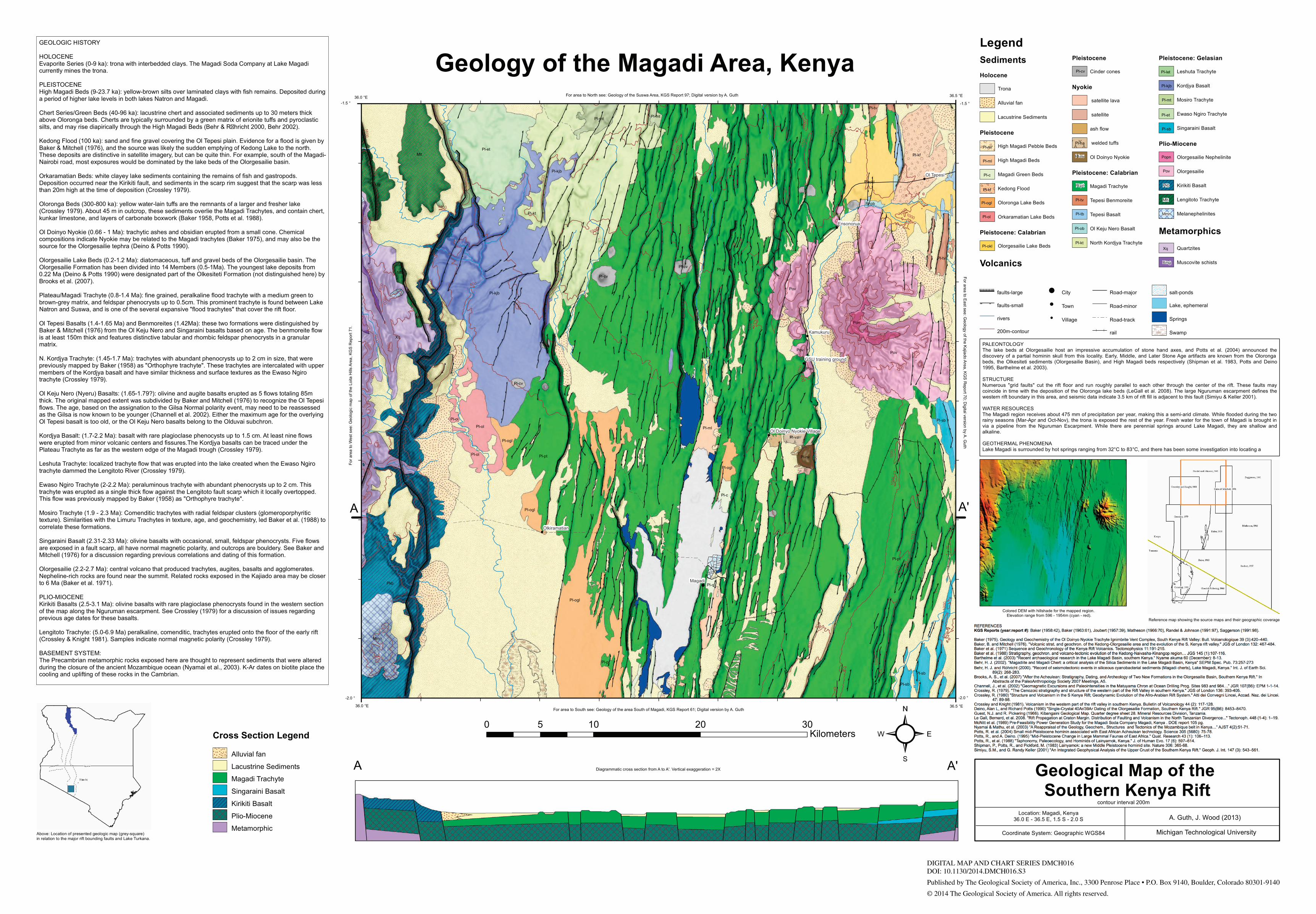
Legend Sediments Holocene Trona Alluvial fan Lacustrine Sediments Pleistocene High Magadi Pebble Beds High Magadi Beds Magadi Green Beds Kedong Flood Oloronga Lake Beds Orkaramatian Lake Beds Pleistocene: Calabrian Olorgesailie Lake Beds Volcanics Pleistocene Cinder cones Nyokie satellite lava satellite ash flow welded tuffs Ol Doinyo Nyokie Pleistocene: Calabrian Magadi Trachyte Tepesi Benmoreite Tepesi Basalt Ol Keju Nero Basalt North Kordjya Trachyte Pleistocene: Gelasian Leshuta Trachyte Kordjya Basalt Mosiro Trachyte Ewaso Ngiro Trachyte Singaraini Basalt Plio-Miocene Olorgesailie Nephelinite Olorgesailie Kirikiti Basalt Lengitoto Trachyte DDDD DDDD DDDD Melanephelinites Metamorphics Quartzites Muscovite schists %%%%%%%%%%%%%%% faults-large faults-small rivers 200m-contour ! City ! Town ! Village Road-major Road-minor Road-track rail salt-ponds Lake, ephemeral Springs Swamp Above: Location of presented geologic map (grey-square) in relation to the major rift bounding faults and Lake Turkana. Geology of the Magadi Area, Kenya ² 0 10 20 30 5 Kilometers GEOLOGIC HISTORY HOLOCENE Evaporite Series (0-9 ka): trona with interbedded clays. The Magadi Soda Company at Lake Magadi currently mines the trona. PLEISTOCENE High Magadi Beds (9-23.7 ka): yellow-brown silts over laminated clays with fish remains. Deposited during a period of higher lake levels in both lakes Natron and Magadi. Chert Series/Green Beds (40-96 ka): lacustrine chert and associated sediments up to 30 meters thick above Oloronga beds. Cherts are typically surrounded by a green matrix of erionite tuffs and pyroclastic silts, and may rise diapirically through the High Magadi Beds (Behr & Rhricht 2000, Behr 2002). Kedong Flood (100 ka): sand and fine gravel covering the Ol Tepesi plain. Evidence for a flood is given by Baker & Mitchell (1976), and the source was likely the sudden emptying of Kedong Lake to the north. These deposits are distinctive in satellite imagery, but can be quite thin. For example, south of the Magadi- Nairobi road, most exposures would be dominated by the lake beds of the Olorgesailie basin. Orkaramatian Beds: white clayey lake sediments containing the remains of fish and gastropods. Deposition occurred near the Kirikiti fault, and sediments in the scarp rim suggest that the scarp was less than 20m high at the time of deposition (Crossley 1979). Oloronga Beds (300-800 ka): yellow water-lain tuffs are the remnants of a larger and fresher lake (Crossley 1979). About 45 m in outcrop, these sediments overlie the Magadi Trachytes, and contain chert, kunkar limestone, and layers of carbonate boxwork (Baker 1958, Potts et al. 1988). Ol Doinyo Nyokie (0.66 - 1 Ma): trachytic ashes and obsidian erupted from a small cone. Chemical compositions indicate Nyokie may be related to the Magadi trachytes (Baker 1975), and may also be the source for the Olorgesailie tephra (Deino & Potts 1990). Olorgesailie Lake Beds (0.2-1.2 Ma): diatomaceous, tuff and gravel beds of the Olorgesailie basin. The Olorgesailie Formation has been divided into 14 Members (0.5-1Ma). The youngest lake deposits from 0.22 Ma (Deino & Potts 1990) were designated part of the Olkesiteti Formation (not distinguished here) by Brooks et al. (2007). Plateau/Magadi Trachyte (0.8-1.4 Ma): fine grained, peralkaline flood trachyte with a medium green to brown-grey matrix, and feldspar phenocrysts up to 0.5cm. This prominent trachyte is found between Lake Natron and Suswa, and is one of the several expansive "flood trachytes" that cover the rift floor. Ol Tepesi Basalts (1.4-1.65 Ma) and Benmoreites (1.42Ma): these two formations were distinguished by Baker & Mitchell (1976) from the Ol Keju Nero and Singaraini basalts based on age. The benmoreite flow is at least 150m thick and features distinctive tabular and rhombic feldspar phenocrysts in a granular matrix. N. Kordjya Trachyte: (1.45-1.7 Ma): trachytes with abundant phenocrysts up to 2 cm in size, that were previously mapped by Baker (1958) as "Orthophyre trachyte". These trachytes are intercalated with upper members of the Kordjya basalt and have similar thickness and surface textures as the Ewaso Ngiro trachyte (Crossley 1979). Ol Keju Nero (Nyeru) Basalts: (1.65-1.79?): olivine and augite basalts erupted as 5 flows totaling 85m thick. The original mapped extent was subdivided by Baker and Mitchell (1976) to recognize the Ol Tepesi flows. The age, based on the assignation to the Gilsa Normal polarity event, may need to be reassessed as the Gilsa is now known to be younger (Channell et al. 2002). Either the maximum age for the overlying Ol Tepesi basalt is too old, or the Ol Keju Nero basalts belong to the Olduvai subchron. Kordjya Basalt: (1.7-2.2 Ma): basalt with rare plagioclase phenocysts up to 1.5 cm. At least nine flows were erupted from minor volcanic centers and fissures.The Kordjya basalts can be traced under the Plateau Trachyte as far as the western edge of the Magadi trough (Crossley 1979). Leshuta Trachyte: localized trachyte flow that was erupted into the lake created when the Ewaso Ngiro trachyte dammed the Lengitoto River (Crossley 1979). Ewaso Ngiro Trachyte (2-2.2 Ma): peraluminous trachyte with abundant phenocrysts up to 2 cm. This trachyte was erupted as a single thick flow against the Lengitoto fault scarp which it locally overtopped. This flow was previously mapped by Baker (1958) as "Orthophyre trachyte". Mosiro Trachyte (1.9 - 2.3 Ma): Comenditic trachytes with radial feldspar clusters (glomeroporphyritic texture). Similarities with the Limuru Trachytes in texture, age, and geochemistry, led Baker et al. (1988) to correlate these formations. Singaraini Basalt (2.31-2.33 Ma): olivine basalts with occasional, small, feldspar phenocrysts. Five flows are exposed in a fault scarp, all have normal magnetic polarity, and outcrops are bouldery. See Baker and Mitchell (1976) for a discussion regarding previous correlations and dating of this formation. Olorgesailie (2.2-2.7 Ma): central volcano that produced trachytes, augites, basalts and agglomerates. Nepheline-rich rocks are found near the summit. Related rocks exposed in the Kajiado area may be closer to 6 Ma (Baker et al. 1971). PLIO-MIOCENE Kirikiti Basalts (2.5-3.1 Ma): olivine basalts with rare plagioclase phenocrysts found in the western section of the map along the Nguruman escarpment. See Crossley (1979) for a discussion of issues regarding previous age dates for these basalts. Lengitoto Trachyte: (5.0-6.9 Ma) peralkaline, comenditic, trachytes erupted onto the floor of the early rift (Crossley & Knight 1981). Samples indicate normal magnetic polarity (Crossley 1979). BASEMENT SYSTEM: The Precambrian metamorphic rocks exposed here are thought to represent sediments that were altered during the closure of the ancient Mozambique ocean (Nyamai et al., 2003). K-Ar dates on biotite place the cooling and uplifting of these rocks in the Cambrian. For area to North see: Geology of the Suswa Area, KGS Report 97; Digital version by A. Guth Geological Map of the Southern Kenya Rift A. Guth, J. Wood (2013) Location: Magadi, Kenya 36.0 E - 36.5 E, 1.5 S - 2.0 S Coordinate System: Geographic WGS84 Michigan Technological University contour interval 200m ! ! ! ! ! ! ! % % % % % % % % % % % % % % % % % % % % % % %% % % % % % % % % % % % % % % % % % % % % % % % % % % % % % % %%%% %%%%% %%%% %% %%% % % % % % % % % % % % %% %%% %%%% %%%% % % %%% %%% %% % % % % % % % % % % % % %%%% % % %%% % %%% %%%% % % % %% %% % % % % %%% %%% %%% % %% %%% % %% %%% %%% % % % % % % %% % % % % % % % % % % % % % % % % % % % % % % % %%%%%% %%% % % % % % % % % % % % % % % % % %%%%%%%%%%%%% % % % % % % % % %% % % % % % % % % % % % % % % % % % % % % % % % % % % % % % % % % % %%% %%%% % % %%%%% % % % % % % % % % % % % % % % % % % % % % % % % % % % % % % % % % % % % % % % % % % %% %%%%%% %%%%% % %%% %%%%% %%%%% %%%%% %% % % % % % % % % % % % % % % % % % % % % % % % % % % % % % % % % % % % % % % % % % % % % % % % % % % % % %% %%% %%%% %%% %%% %%% % % % % % % % % % % % % % % % % % % % % % % % % % % % % % % % % % % % % % % % % % % % % % % % % % % % % % % % % % % % % % % % % % % % % %% %%% %%% %% %%% % %% % % % % % % % % % % % % %%%% %%%%% %%%%% % %%% % % % %% % % % %% % %% % % % % % % % % % % % % % % % %% % % %% % %% % % % % % % % % % % % % % % % % % % % % % % % % % % % % % % % % % % % % % % % % % % % % % % % % % % % % % % % % % % % % % % % %% %% %% %%% % % % % % % % % % % % % % % % % % % % % % % % % % %% %% %% %%% % % %%%% %%% %%% %%%%%% % % % %% % % % % %%%% % %%% % % % % % % % %%% % % %%%%%%%%%%% % % % % % % % % % % % % % % % % % % % % % % % % % % % % % % %% % % %%% % %%% %%% % % % % % % % % % % % % % % %%%%%%%%%%%% % % % % % % % % % % % % % % % % % % % % % % % % %%% % % %% % %% %%%%%%%% % % % % % % % % % % % % % % % % % % % % % % % % % %% % % % % %% % % % % % % % % % % % % % % % % % % % % % % % % % % % % % % % % % % % %% % % %% % % % % % % % % % % % % % % % % % % % % % % %%% %%%%%%%%%% % % %% % %% % % % % % % % % % %%%%% % % % % % % % % % % % % % % % % % %%%%%%%%%%%%%%%%%% % % % % % % % % % % % % % % % % % % % % % % % % % % % % % % % % % % % % % % % % % % % % % % % % % % % % % % % % % % % % % % % % % % % % % % % % % % % % % % % % % % % % % % % % % % % % % % % % % % % %%%%%%% %%%%%%%% % % % % % % % % % % % % % % % % % %%%% %% % % % % % % % % % % % % % % % % % % %% %%%%%%%%%% %% % % % % % % % % % % % % % % % %% % % % % % % % % % % % % %%%%%%% %% %% %% %% % %% %% % % % % % % % % % % % % %%%%%%%%%% %% % % % % % % % % % % %% % % % % % % % % % % % % % % % % % % % % % % % % % % % % % % % % % % % %%%%%% % % % % %%% %%%%%% % %% % % %%%% %% % % % % % % % % % % % % % % % % % % % %%% %% % %% % % % % % % % % % % % % % % % % % % % % % % % % % % % % % % % %% % % %%%%%%% %% %%%% % % % % % % %%%%%%%%%%%%%% % % % % % % % % % % % % % % % % % % % % %%%%% % %% %%% % %%%%%% % %% %%%%%%%% % %% % %% % % % %% % % % % %%%% % % % % % % % % % % % % % % %% % % % %% % %%%%%% %% %% %% %%%% % % % % % % %%%% % % % % %%%%%% %% % % % % % % % % % % % % % % % %%%%% % % %%%%%%%%% % % % % % % % % % % % % % %%%%%%%%% % % % % % %%%%%%% % % % % % % % % % %%%% % %% %% %% %% % %%%% %% % %% % % % %% %% % %% % %% % % % % % % % % % % % % % % % % % % % % % % % % % % % %%%% %% %%%%% % %%% %%%%%%% %%%%%%%%% % % % % % % % % % % % % % % % % % % % % % % % % % % % % % % % % % % % %%%%%%%% % % % % % % % % % % % % % % % %%%%%%%%%% % % % % % % % % % % % % % % % %% % %% %% % % % % % % % % % % % % % % % % % % % % % % % % % % % % % % % % % % % % % % % % % % % % % % % % % % Xq Pl-pt Pl-pt Pov Pl-kt Pl-kjb Pl-pt Pkb Pl-et Pkb Mlt Pov Mmn Mlt Pl-sb Pon Pl-mt Pl-tv Pl-sb Pl-kjb Pl-cv Mlt Mlt Pl-nv Pl-sb Pl-va Pov Pl-pt Pl-cv Pl-mt Pov Pl-tv Pl-cv Pl-ob Pl-ogl Pl-okl Pl-kf Pl-ol Pl-ml Pl-ogl Pl-ogl Pl-ol Pl-c Pl-ogl Pl-c Pl-ol 800 1000 1200 1400 1600 1800 1000 1600 1800 800 1200 1200 1600 1200 1000 1000 1000 1800 1200 1200 1200 1000 1000 1000 1600 1600 1200 1000 1600 1200 800 800 1200 1800 1400 800 1000 800 1000 1000 1000 1000 1800 1400 1200 1600 1000 1800 1600 1600 1200 1600 1000 1200 1200 1000 1400 1800 Magadi Kamukuru Ensonorua Ol Tepesi Olkiramatian GSU training ground Ol Doinyo Nyokie Village A For area to East see: Geology of the Kajiado Area, KGS Report 70; Digital version by A. Guth For area to West see: Geologic map of the Loita Hills Area, KGS Report 71. Diagrammatic cross section from A to A'. Vertical exaggeration = 2X Colored DEM with hillshade for the mapped region. Elevation range from 596 - 1954m (cyan - red). Reference map showing the source maps and their geographic coverage 36.0 °E 36.5 °E 36.5 °E 36.0 °E -2.0 ° -2.0 ° -1.5 ° -1.5 ° Cross Section Legend Alluvial fan Lacustrine Sediments Magadi Trachyte Singaraini Basalt Kirikiti Basalt DDD DDD DDD Plio-Miocene Metamorphic Xmg Xq Pl-kf Pl-sb Pl-kjb Pl-ol Pl-ml Pl-let Pov Popn Mlt A' A Pl-na Pl-nv Pkb Pl-okl Pl-et Pl-cv Pl-ogl Pl-c Pl-tv Pl-tb Pl-ob Pl-pt Pl-mt For area to South see: Geology of the area South of Magadi, KGS Report 61; Digital version by A. Guth Pl-ml' A' PALEONTOLOGY The lake beds at Olorgesailie host an impressive accumulation of stone hand axes, and Potts et al. (2004) announced the discovery of a partial hominin skull from this locality. Early, Middle, and Later Stone Age artifacts are known from the Oloronga beds, the Olkesiteti sediments (Olorgesailie Basin), and High Magadi beds respectively (Shipman et al. 1983, Potts and Deino 1995, Barthelme et al. 2003). STRUCTURE Numerous "grid faults" cut the rift floor and run roughly parallel to each other through the center of the rift. These faults may coincide in time with the deposition of the Oloronga lake beds (LeGall et al. 2008). The large Nguruman escarpment defines the western rift boundary in this area, and seismic data indicate 3.5 km of rift fill is adjacent to this fault (Simiyu & Keller 2001). WATER RESOURCES The Magadi region receives about 475 mm of precipitation per year, making this a semi-arid climate. While flooded during the two rainy seasons (Mar-Apr and Oct-Nov), the trona is exposed the rest of the year. Fresh water for the town of Magadi is brought in via a pipeline from the Nguruman Escarpment. While there are perennial springs around Lake Magadi, they are shallow and alkaline. GEOTHERMAL PHENOMENA Lake Magadi is surrounded by hot springs ranging from 32°C to 83°C, and there has been some investigation into locating a Mmn Pl-kt DIGITAL MAP AND CHART SERIES DMCH016 DOI: 10.1130/2014.DMCH016.S3 Published by The Geological Society of America, Inc., 3300 Penrose Place • P.O. Box 9140, Boulder, Colorado 80301-9140 © 2014 The Geological Society of America. All rights reserved.
Transcript of Geology of the Magadi Area, Kenya - Geological … Magadi Beds (9-23.7 ka): yellow-brown silts over...
LegendSedimentsHolocene
Trona
Alluvial fan
Lacustrine Sediments
Pleistocene
High Magadi Pebble Beds
High Magadi Beds
Magadi Green Beds
Kedong Flood
Oloronga Lake Beds
Orkaramatian Lake Beds
Pleistocene: Calabrian
Olorgesailie Lake Beds
Volcanics
Pleistocene
Cinder cones
Nyokie
satellite lava
satellite
ash flow
welded tuffs
Ol Doinyo Nyokie
Pleistocene: Calabrian
Magadi Trachyte
Tepesi Benmoreite
Tepesi Basalt
Ol Keju Nero Basalt
North Kordjya Trachyte
Pleistocene: Gelasian
Leshuta Trachyte
Kordjya Basalt
Mosiro Trachyte
Ewaso Ngiro Trachyte
Singaraini Basalt
Plio-Miocene
Olorgesailie Nephelinite
Olorgesailie
Kirikiti Basalt
Lengitoto Trachyte
DDDDDDDDDDDD
Melanephelinites
Metamorphics
Quartzites
Muscovite schists
%% %% %% %% %% %% %% %% %% %% %% %% %% %% %% faults-large
faults-small
rivers
200m-contour
! City
! Town
! Village
Road-major
Road-minor
Road-track
rail
salt-ponds
Lake, ephemeral
Springs
Swamp
Above: Location of presented geologic map (grey-square) in relation to the major rift bounding faults and Lake Turkana.
Geology of the Magadi Area, Kenya
²0 10 20 305Kilometers
GEOLOGIC HISTORY
HOLOCENEEvaporite Series (0-9 ka): trona with interbedded clays. The Magadi Soda Company at Lake Magadicurrently mines the trona.
PLEISTOCENEHigh Magadi Beds (9-23.7 ka): yellow-brown silts over laminated clays with fish remains. Deposited duringa period of higher lake levels in both lakes Natron and Magadi.
Chert Series/Green Beds (40-96 ka): lacustrine chert and associated sediments up to 30 meters thickabove Oloronga beds. Cherts are typically surrounded by a green matrix of erionite tuffs and pyroclasticsilts, and may rise diapirically through the High Magadi Beds (Behr & R�hricht 2000, Behr 2002).
Kedong Flood (100 ka): sand and fine gravel covering the Ol Tepesi plain. Evidence for a flood is given byBaker & Mitchell (1976), and the source was likely the sudden emptying of Kedong Lake to the north.These deposits are distinctive in satellite imagery, but can be quite thin. For example, south of the Magadi-Nairobi road, most exposures would be dominated by the lake beds of the Olorgesailie basin.
Orkaramatian Beds: white clayey lake sediments containing the remains of fish and gastropods.Deposition occurred near the Kirikiti fault, and sediments in the scarp rim suggest that the scarp was lessthan 20m high at the time of deposition (Crossley 1979).
Oloronga Beds (300-800 ka): yellow water-lain tuffs are the remnants of a larger and fresher lake(Crossley 1979). About 45 m in outcrop, these sediments overlie the Magadi Trachytes, and contain chert,kunkar limestone, and layers of carbonate boxwork (Baker 1958, Potts et al. 1988).
Ol Doinyo Nyokie (0.66 - 1 Ma): trachytic ashes and obsidian erupted from a small cone. Chemicalcompositions indicate Nyokie may be related to the Magadi trachytes (Baker 1975), and may also be thesource for the Olorgesailie tephra (Deino & Potts 1990).
Olorgesailie Lake Beds (0.2-1.2 Ma): diatomaceous, tuff and gravel beds of the Olorgesailie basin. TheOlorgesailie Formation has been divided into 14 Members (0.5-1Ma). The youngest lake deposits from0.22 Ma (Deino & Potts 1990) were designated part of the Olkesiteti Formation (not distinguished here) byBrooks et al. (2007).
Plateau/Magadi Trachyte (0.8-1.4 Ma): fine grained, peralkaline flood trachyte with a medium green tobrown-grey matrix, and feldspar phenocrysts up to 0.5cm. This prominent trachyte is found between LakeNatron and Suswa, and is one of the several expansive "flood trachytes" that cover the rift floor.
Ol Tepesi Basalts (1.4-1.65 Ma) and Benmoreites (1.42Ma): these two formations were distinguished byBaker & Mitchell (1976) from the Ol Keju Nero and Singaraini basalts based on age. The benmoreite flowis at least 150m thick and features distinctive tabular and rhombic feldspar phenocrysts in a granularmatrix.
N. Kordjya Trachyte: (1.45-1.7 Ma): trachytes with abundant phenocrysts up to 2 cm in size, that werepreviously mapped by Baker (1958) as "Orthophyre trachyte". These trachytes are intercalated with uppermembers of the Kordjya basalt and have similar thickness and surface textures as the Ewaso Ngirotrachyte (Crossley 1979).
Ol Keju Nero (Nyeru) Basalts: (1.65-1.79?): olivine and augite basalts erupted as 5 flows totaling 85mthick. The original mapped extent was subdivided by Baker and Mitchell (1976) to recognize the Ol Tepesiflows. The age, based on the assignation to the Gilsa Normal polarity event, may need to be reassessedas the Gilsa is now known to be younger (Channell et al. 2002). Either the maximum age for the overlyingOl Tepesi basalt is too old, or the Ol Keju Nero basalts belong to the Olduvai subchron.
Kordjya Basalt: (1.7-2.2 Ma): basalt with rare plagioclase phenocysts up to 1.5 cm. At least nine flowswere erupted from minor volcanic centers and fissures.The Kordjya basalts can be traced under thePlateau Trachyte as far as the western edge of the Magadi trough (Crossley 1979).
Leshuta Trachyte: localized trachyte flow that was erupted into the lake created when the Ewaso Ngirotrachyte dammed the Lengitoto River (Crossley 1979).
Ewaso Ngiro Trachyte (2-2.2 Ma): peraluminous trachyte with abundant phenocrysts up to 2 cm. Thistrachyte was erupted as a single thick flow against the Lengitoto fault scarp which it locally overtopped.This flow was previously mapped by Baker (1958) as "Orthophyre trachyte".
Mosiro Trachyte (1.9 - 2.3 Ma): Comenditic trachytes with radial feldspar clusters (glomeroporphyritictexture). Similarities with the Limuru Trachytes in texture, age, and geochemistry, led Baker et al. (1988) tocorrelate these formations.
Singaraini Basalt (2.31-2.33 Ma): olivine basalts with occasional, small, feldspar phenocrysts. Five flowsare exposed in a fault scarp, all have normal magnetic polarity, and outcrops are bouldery. See Baker andMitchell (1976) for a discussion regarding previous correlations and dating of this formation.
Olorgesailie (2.2-2.7 Ma): central volcano that produced trachytes, augites, basalts and agglomerates.Nepheline-rich rocks are found near the summit. Related rocks exposed in the Kajiado area may be closerto 6 Ma (Baker et al. 1971).
PLIO-MIOCENEKirikiti Basalts (2.5-3.1 Ma): olivine basalts with rare plagioclase phenocrysts found in the western sectionof the map along the Nguruman escarpment. See Crossley (1979) for a discussion of issues regardingprevious age dates for these basalts.
Lengitoto Trachyte: (5.0-6.9 Ma) peralkaline, comenditic, trachytes erupted onto the floor of the early rift(Crossley & Knight 1981). Samples indicate normal magnetic polarity (Crossley 1979).
BASEMENT SYSTEM:The Precambrian metamorphic rocks exposed here are thought to represent sediments that were alteredduring the closure of the ancient Mozambique ocean (Nyamai et al., 2003). K-Ar dates on biotite place thecooling and uplifting of these rocks in the Cambrian.
For area to North see: Geology of the Suswa Area, KGS Report 97; Digital version by A. Guth
Geological Map of the Southern Kenya Rift
A. Guth, J. Wood (2013)Location: Magadi, Kenya
36.0 E - 36.5 E, 1.5 S - 2.0 S
Coordinate System: Geographic WGS84 Michigan Technological University
contour interval 200m
!
!
!
!
!
!
!
%% %% %% %% %% %% %% %% %% %% %% %% %% %% %% %% %% %% %% %% %% %% %% %% %% %%%% %% %% %% %% %% %% %% %% %% %% %% %% %% %% %% %% %% %% %% %% %% %% %% %% %% %% %% %% %% %% %% %% %% %% %% %% %% %% %% %% %% %% %% %% %% %% %% %% %% %% %% %% %% %% %% %% %% %% %% %% %% %% %% %% %% %% %% %% %% %%%%%%%%%%%%%%%%%%%%%%%%%%%%%%%%%%%%%%%%%% %%%%%%%%%%%% %%%%%%%%%%%%%%%%%%%%%%%%%%%%%%%%%%%%%%%%%%%%%%%%%%%%%%%%%%%%%%%%%%%%%%%%%%%%%%%%%%%%%%%%%%%%%%%%%%%%%%%%%%%%%%%%%%%%%%%%%%%%%%%%%%%%%%%%%%%%%%%%%%%%%%%%%%%%%% %% %% %% %% %% %% %% %% %% %% %% %% %% %% %% %% %% %% %% %% %% %% %% %% %%%%%%%%%%%%%%%%%%%%%%%%%% %% %% %% %% %% %% %% %% %% %% %% %% %%%%%%%%%%%%%%%%%%%%%%%%%%%%%%%% %%%%%%%%%%%%%%%%%%%%%%%%%%%%%% %%%%%%%%%%%%%%%%%%%%%%%%%%%%%% %% %% %% %% %% %% %% %% %% %% %%%%%%%%%%%%%%%%%%%%%%%%%%%% %%%%%%%%%%%%%%%%%%%%%%%%%%%%%%%%%%%%%%%%%%%%%%%%%%%%%%%%%%%%%%%%%%%%%%%%%%%%%%%%%%%%%%%%%%%%%%%%%%%%%%%%%%%%%%%%%%%%%%%%%%%%%%%%%%%%%%%%%%%%%%%%%%%%%%%%%%%%%%%% %% %% %% %% %% %% %% %% %% %% %% %% %% %% %% %% %% %% %% %% %% %% %% %% %% %% %% %% %% %% %% %% %% %% %% %% %% %% %% %% %% %% %% %% %% %% %% %% %% %% %% %% %% %% %%%% %% %% %%%% %% %% %% %%%% %% %% %% %%%% %% %% %%%% %%%%%%%% %%%%%%%%%% %%%%%%%%%% %%%%%%%% %%%%%%%%%% %%%%%%%%%% %%%%%%%%%% %%%%%%%%%%%%%%%%%%%%%%%%%%%%%%%%%%%%%%%%%%%%%%%%%%%%%%%%%%%%%%%%%%%%%%%%%%%%%%%%%%%%%%%%%%%%%%%%%% %% %% %% %% %% %% %% %% %% %% %% %% %% %% %% %% %% %% %% %% %% %% %% %% %% %% %%%%%%%%%%%%%%%%%%%%%%%% %% %% %% %% %% %% %% %% %% %% %% %% %% %%%%%%%%%%%%%%%%%%%%%%%%%%%%%%%%%%%%%%%%%%%%%%%%%%%%%%%%%%%%%%%%%%%%%%%%%%%%%%%%%%%%%%
%%%%%%%%%%%%%%%%%%%%%%%%%%%%%% %% %%%% %% %% %% %% %% %%%%%%%%%%%%%%%%%%%%%%%%%%%%%%%%%%%% %% %%%%%%%%%%%%%%%%%%%%%%%%%%%%%%%%%%%%%%%%%%%%%%%%%%%%%%%%%%%%%%%%%%%%%%%%%%
%%%%%%%%%% %%%% %%%%%%%%%%%%%%%%%%
%%%%%%%%%%%%%%%%%%%%%%%%%%%%%%%%%%%%%%%%%%%%%%%% %%%%%% %%%%%% %%%% %%%%%% %%%%%%%%%%%%%%%%%%%%%%%%%%%%%%%%%%%%%%%%%%%%%%%%%%%%%%%%%%%%%%%%%%%%%%%%%%%%%%%%%%%%%%%%%%%% %% %% %% %%%%%%%%%%%%%%%%%% %% %% %%%% %% %% %%%% %% %% %% %% %% %% %% %% %% %% %% %% %% %%%%%%%%%%%%%%%%%% %%%%%%%%%%%%%%%%%%%% %% %% %% %% %% %% %% %% %% %% %% %% %% %% %% %% %% %% %% %% %% %% %%%%%%%%%%%%%%%%%%%%%%%%%%%%%%%%%% %% %% %% %% %% %% %% %% %% %% %% %% %% %% %% %% %% %% %% %% %% %% %% %% %% %% %% %% %% %% %% %% %%%% %%%%%%%% %%%%%% %%%%%%%%%%%%%%%%%%%%%%%%%%%%%%%%%%%%%%%%%%%%%%%%%%%%%%%%%%%%%%%%%%%%%%%%%%%%%%%%%%%%%%%%%%
%% %% %% %% %%%%%%%%%%%%%%%%%%%%%%%%%%%%%%%%%%%%%%%%%%%%%%%%%%%%%% %%%%%%%%%% %%%%%%%%%%%%%%%%%%%%%%%%%%%%%%%%%%%%%%%%%%%%%%%%%%%%%%%% %% %% %% %% %% %% %% %%%%%%%%%%%%%%%%%%%% %%%%%% %% %% %% %% %% %%%%%%%%%%%%%%%%%%%%%%%%%%%%%%%%%%%%%%%%%%%%%%%% %%%%%%%% %%%%%% %%%%%%%%%%%%%%%%%%
%%%%%%%%%%%%%%%%%%%%%%%%%%%%%%%%%%%%%%%%%%%%%%%%%%%%%%%%%%%%%%%% %% %% %% %% %% %%%%%%%%%%%%%%%%%%%%%% %% %% %% %% %% %% %% %% %%%%%%%%%%%%%%%%%%%%%%%%%%%%%% %% %% %% %% %% %% %% %% %% %% %% %% %% %% %% %%%%%% %%%% %%%% %% %%%% %%%% %% %%%%%%%%%%%%%% %% %% %% %% %%%%%%%%%%%%%%%%%%%%%%%%%%%%%%%%%%%%%%%% %% %% %% %% %% %% %% %% %% %% %% %% %% %%%%%% %%%%%% %%%%%% %%%% %% %% %%%%%%%%%%%%%%%%%%%%%%%%%%%%%%%%%%%%%%%%%%%%%%%%%%%%%%%%%%%%%%%%%%%%
%%%%%%%%%%%% %%%%%% %%%%%%%%%%%%%%%%%%%%%%%%%%%%%%%%%%%%%%%%%% %% %% %% %% %% %% %% %% %% %% %% %%%%%%%%%%%%%%%%%%%%%% %% %% %% %% %%%% %% %% %% %% %% %%%%%%%%%%%%%%%%%%%%%%%%%%%%%%%%%%%%%%%% %%%% %% %% %% %% %% %% %%%%%%%%%%%%%%%% %%%%%%%%%%%%%% %% %% %% %% %%%%%%%%%%%%%%%%%%%%%%%%%%%%%% %%%%%%%%%%%%%%%% %%%% %%%% %%%% %%%%%%%%%%
%% %% %% %% %% %% %% %% %% %% %% %% %% %%%%%%%%%%%% %% %% %% %%%%%%%%%%%%%%%% %% %% %% %% %% %% %% %% %% %% %% %% %% %% %% %% %% %% %% %%%%%%%%%%%%%%%%%% %% %% %% %% %% %% %% %% %% %% %% %% %% %%%%%%%%%%%% %%%%%%%%%%%%%%%%%%%%%% %%%% %%%% %%%%%%%%%% %%%%%%%%%%%%%%%%%%%%%%%%%%%% %%%% %%%% %%%%%%%%%%%%%%%%%%%%%%%%%%%%%%%%%%%%%%%%%%%%%%%%%% %% %%%% %% %%%% %% %%%% %%
%% %% %% %% %% %% %% %% %% %% %% %%%% %% %% %% %%%%%% %%%%%% %%%%%% %%%%%% %%%%%% %% %% %% %% %% %% %% %% %% %% %% %% %% %% %% %% %% %% %% %% %% %% %% %% %% %% %% %% %% %% %% %% %% %% %% %% %% %%%%%%%%%%%%%%%%%% %% %% %% %% %% %% %% %% %% %% %% %% %% %% %% %% %% %% %% %% %% %% %% %% %% %% %% %% %% %% %% %% %% %% %% %% %% %% %% %% %% %% %% %% %%
%% %% %% %% %% %% %% %% %% %% %% %% %% %%%%%%%%%%%%%%%% %% %% %% %% %% %% %% %% %% %% %% %% %% %% %% %% %% %% %% %% %% %% %% %% %% %% %% %% %% %% %% %% %% %% %% %% %% %% %% %% %% %% %% %% %% %% %% %% %% %% %% %% %% %% %% %% %% %% %% %% %% %% %% %%
%%%%%%%%%%%%%%%%%%%%%%%%%%%%%%%% %% %% %% %% %% %% %% %% %% %% %% %% %% %% %% %% %% %% %% %% %% %% %% %% %% %% %% %% %% %% %% %% %% %%%%%%%%%%%%%%%%%%%%%% %% %% %% %% %% %% %% %% %% %% %% %% %% %% %% %% %% %% %% %% %% %% %% %% %% %% %% %% %% %% %% %% %% %% %% %% %% %% %% %% %% %% %% %% %% %% %% %% %% %% %% %% %% %% %% %% %% %% %% %% %% %% %% %% %% %% %% %% %% %% %% %% %% %% %% %% %% %% %% %% %% %% %% %% %% %% %% %% %% %% %% %% %% %% %% %% %% %% %% %% %% %% %% %% %% %% %% %% %% %% %% %% %% %% %% %% %% %% %% %% %% %% %% %% %% %% %%%%%%%%%%%%%%%%%% %% %% %% %% %% %% %% %% %% %% %% %% %% %%%%%%%%%%%%%%%%%%%%%% %%%%%%%%%%%%%%%%%%%%%%%%
%%%%%%%%%%%%%%%%%%%%%%%%%%%%%%%%%%%%%%%%%%%%%%%%%%%%%%%%%%%%%%%%%%%%%%%%%%%%%%%%%%%%%%%%%%%%%%%%%%%%%%%%%%%%%%%%%%%%%%%%%%%%%%%%%%%%%%%%%%%%%%%%%%%%%%%%%%%%%%%%%%%%%%%%%%%%%%%%%%%%%%%%%%%%%%%%%%%%%%%%%%%%%%%%%%%%%%%%%%%%%%%%%%%%%%%%%%%%%%%%%%%%%%%%%%%%%%%%
%%%%%%%%%%%%%%%%%%%%%%%%%%%%%%%%%%%%%%%%%%%%%%%%%%%%%%%%%%%%%%%%%%%%%%%%%%%%%%%%%%%%%%%%%%%%%%%%%%%%%%%%%%%%%%%%%%%%%%%%%%%%%%%%%%%%%%%%%%%%%%%%%%%%%%%%%%%%%%%%%%%%%%%%%%%%%%%%%%%%%%%%%%%%%%%%%%%%%%%%%%%%%%%%%%%%%%%%%%%%%%%%%%%%%%%%%%%%%%%%%%%%%%%%%%%%%%%%%%%%%%%%%%%%%%%%%%%%%%%%%%%%%%%%%%%%%%%%%%%%%%%%%%%%%%%%%%%%%%%%%%%%%%%%%%%%%%%%%%%%%%%%%%%%%%%%%%%%%%%%%% %%%%%%%%%%%%%%%%%%%%%%%%%%%%%%%%%%%%%%%%%%%%%%%%%%%%%%%%%%%%%%%%%%%%%%%%%%%%%%%%%%%%%%%%%%%%%%%%%%%%%%%%%%%%%%%%%%%%%%%%%%%%%%%%%%%%%%%%%%%%%%%%%%%%%%%%%%%%%%%%%%%%%%%%%%%%%%%%%%%%%%%%%%%% %%%%%%%%%% %%%%%%%%%% %%%%%%%%%% %%%%%%%%%%%%%%%%%%%%%%%%%%%%%%%%%%%%%%%%%%%%%%%%%%%%%%%%%%%%%%%%%%%% %% %% %% %% %% %% %% %% %% %% %% %% %% %% %% %% %% %% %% %%%%%%%%%%%%%%%%%%%%%%%%%%%%%%%%%%%%%%%%%%%%%%%%%%%%%%%%%%%%%%%%%%%%%%%%%%%%%%%%%%%%%%%%%% %% %% %% %% %% %% %% %% %% %% %% %% %%%%%%%%%%%%%%%%%%%%%%%%%%%%%%%%%%%%%%%%%%%%%%%%%%%%%%%%%%%%%%%%%%%%%% %% %% %% %% %% %% %% %% %% %% %% %% %% %%
Xq
Pl-pt
Pl-pt
Pov
Pl-kt
Pl-kjb
Pl-pt
Pkb
Pl-et
Pkb
Mlt
Pov
Mmn
Mlt
Pl-sb
Pon
Pl-mt
Pl-tv
Pl-sb
Pl-kjb
Pl-cv
Mlt
Mlt
Pl-nv
Pl-sb
Pl-va
Pov
Pl-pt
Pl-cv
Pl-mt
Pov
Pl-tv
Pl-cv
Pl-ob
Pl-ogl
Pl-okl
Pl-kf
Pl-ol Pl-ml
Pl-ogl
Pl-ogl
Pl-ol
Pl-c
Pl-ogl
Pl-c
Pl-ol
800
1000
1200
1400
1600
1800
1000
1600
1800
800
1200
1200
1600 1200
1000
1000
1000
180012
00
1200
1200
1000
1000
1000
1600
1600
1200
1000
1600
1200
800
800
1200
1800
1400
800
1000
800
1000
1000
1000
1000
1800
1400
1200
1600
1000
18001600
1600
1200
1600
1000
1200
1200
1000
14001800
Magadi
Kamukuru
Ensonorua
Ol Tepesi
Olkiramatian
GSU training ground
Ol Doinyo Nyokie Village
A
For area to East see: G
eology of the Kajiado A
rea, KG
S R
eport 70; Digital version by A
. Guth
For a
rea
to W
est s
ee: G
eolo
gic
map
of t
he L
oita
Hill
s A
rea,
KG
S R
epor
t 71.
Diagrammatic cross section from A to A'. Vertical exaggeration = 2X
Colored DEM with hillshade for the mapped region. Elevation range from 596 - 1954m (cyan - red).
Reference map showing the source maps and their geographic coverage
36.0 °E 36.5 °E
36.5 °E36.0 °E
-2.0 ° -2.0 °
-1.5 °-1.5 °
Cross Section Legend
Alluvial fan
Lacustrine Sediments
Magadi Trachyte
Singaraini Basalt
Kirikiti Basalt
DDDDDDDDDDDDDDDPlio-Miocene
Metamorphic
Xmg
Xq
Pl-kf
Pl-sb
Pl-kjb
Pl-ol
Pl-ml
Pl-let
Pov
Popn
Mlt
A'A
Pl-na
Pl-nv
Pkb
Pl-okl
Pl-et
Pl-cv
Pl-ogl
Pl-c
Pl-tv
Pl-tb
Pl-ob
Pl-pt
Pl-mt
For area to South see: Geology of the area South of Magadi, KGS Report 61; Digital version by A. Guth
Pl-ml'
A'
PALEONTOLOGYThe lake beds at Olorgesailie host an impressive accumulation of stone hand axes, and Potts et al. (2004) announced thediscovery of a partial hominin skull from this locality. Early, Middle, and Later Stone Age artifacts are known from the Olorongabeds, the Olkesiteti sediments (Olorgesailie Basin), and High Magadi beds respectively (Shipman et al. 1983, Potts and Deino1995, Barthelme et al. 2003).
STRUCTURENumerous "grid faults" cut the rift floor and run roughly parallel to each other through the center of the rift. These faults maycoincide in time with the deposition of the Oloronga lake beds (LeGall et al. 2008). The large Nguruman escarpment defines thewestern rift boundary in this area, and seismic data indicate 3.5 km of rift fill is adjacent to this fault (Simiyu & Keller 2001).
WATER RESOURCESThe Magadi region receives about 475 mm of precipitation per year, making this a semi-arid climate. While flooded during the tworainy seasons (Mar-Apr and Oct-Nov), the trona is exposed the rest of the year. Fresh water for the town of Magadi is brought invia a pipeline from the Nguruman Escarpment. While there are perennial springs around Lake Magadi, they are shallow andalkaline.
GEOTHERMAL PHENOMENALake Magadi is surrounded by hot springs ranging from 32°C to 83°C, and there has been some investigation into locating a
Mmn
Pl-kt
DIGITAL MAP AND CHART SERIES DMCH016DOI: 10.1130/2014.DMCH016.S3
Published by The Geological Society of America, Inc., 3300 Penrose Place • P.O. Box 9140, Boulder, Colorado 80301-9140
© 2014 The Geological Society of America. All rights reserved.