Geology and Ground -Water Resources of Comal County,Texas · The purpose of this report on the...
140
Geology and Ground -Water Resources of Comal County,Texas GEOLOGICAL SURVEY WATER-SUPPLY PAPER 1138
Transcript of Geology and Ground -Water Resources of Comal County,Texas · The purpose of this report on the...

Geology and Ground -Water Resources of Comal County,Texas
GEOLOGICAL SURVEY WATER-SUPPLY PAPER 1138


Geology and Ground -Water Resources of Comal County,TexasBy WILLIAM O. GEORGE
With sections on
SURFACE-WATER RUNOFFBy SETH D. BREEDING
CHEMICAL CHARACTER OF THE WATERBy WARREN W. HASTINGS
GEOLOGICAL SURVEY WATER-SUPPLY PAPER 1138
Prepared in cooperation with the Texas Board of Water Engineers
Sanfrancisco
UNITED STATES GOVERNMENT PRINTING OFFICE, WASHINGTON : 1952
UNITED STATES DEPARTMENT OF THE INTERIOR
Oscar L. Chapman, Secretary
GEOLOGICAL SURVEY
W. E. Wrather, Director
*H'j&v-.'' l"*J*
For sale by the Superintendent of Documents, U. S. Government Printing Office Washington 25, D. C.
CONTENTS
Page
Abstract.._______._,__________________ = ;siiii. i ___ ii ________________ 1Introduction, _____________________________________________________ 2
Purpose and scope_____________________________________________ 2History of settlement-___-____--_-_-_______---__-_-____________ 2Location-.___________________________________________________ 3Agriculture and% industrial development________--_______-_-_______ 3Methods of investigation,______________________________________ 5Previous investigation._________________________________________ 6Acknowledgments. ______________________________________________ 6
Climate-_____-____-__---___-_-_-_-___-_-___-____-___-_-__________ 6Topographjr ______________________________________________________ 11
General features_______________________________________________ 11Drainage._ ___________________________________________________ 11
Stratigraphy. _______________________________'______________________ 12Rock formations and their water-bearing properties._______________ 13
Pre-Cretaeeous rocks__ ______________________________________ 13Cretaceous system.________________________________________ 13
Pre-Comanche rocks..__________________________________ 13Comanche series_________________-____-_-__-____-______ 15
Trinity group.____________________________________ 15Travis Peak formation. ________________J_______ 15Glen Rose limestone. ________________________ -_ 17
Fredericksburg group. _____________________________ 21Walnut clay______________________--___-_____. 21Comanche Peak limestone.______-____--__-__-__ 22~Edwards limestone___________________________ 22
Washita group.___________________________________ 23Georgetown limestone_________________________ 24Graysoii (Del Rio) shale__________-____----.-- 25Buda limestone______________________________ 25
Gulf series__-.__.-_____._.___________-___---___-___-._ 26Eagle Ford shale. _________________________ 26Austin chalk____________________.___________ 26Anacacho limestone and Taylor marl_____________ 27
Tertiary (?) system..._______________________________ 27Pliocene (?) series-_____-___-_-___-__--_--__------_--__ 27
Uvalde gravel_______-______-__-_-__-_-_-_-____ 27Quaternary system, _ ______________________________________ 28
Pleistocene series___________________.._______-__-_______ 28Leona formation_____________________________ 28
ni

IV CONTENTS
Page Structural geology_-______-____-___________-__-_-_-__-____________.. 28
Faults______________________________________________________ 28Comal Springs fault____-______ ___________ _ ______________ 29Hueco Springs fault.___ ___________________ _________________ 29Bat Cave fault-_-__-__-_-_-._ ._-___-__-__________________ 30Bear Creek fault___J_______________.______________________ 30Hidden Valley fault_______________________________________ 31Tom Creek fault____________________________________________ 31Spring Branch fault______-___--_-____-_____________________ ' 31Minor faults and folds_ _______ ._____....________________..__.._ 32Cause of faulting, ____ _______________________________________ 32Age of faulting._____________________________________________ 32
Other structural features--__--____-__-._-_--__-_-_-.-..____-_____ 33San Marcos arch, ___________________________________________ 33Regional dips ._._..____.______....____ _______________________ 33Sinkholes- _ ________________________________________________ 34
Methods of water-well construction-__________________________________ 34Occurrence of ground water, with special reference to discharge and source
of Comal Springs__ _____________________ .____-___-______-..___-___ 35The development of the reservoir in the Edwards lirnestone_--______ 36The development of the reservoirs in the Glen Rose limestone______ 38Ground-water discharge________-..__________-_-____---_-_-__-_-. 38
Comal Springs_____________...--_-_____-_-___---_--_-_-____ 38Hueco Springs__________---_-----_--_--_-_-_-.-_-_-_----,_-_ 40Other springs_____________________________________________ 41Discharge from \vells______________-_-______-_-..--_____---__ 42
Ground-water recharge____________________-__-_-_-_----____-_-_ 42Water levels in wells in relation to rainfall and discharge of
springs- _ _____-__--- __-_--___---------_-_-_--__-----_-_ 43Movement of ground water. __-____.--_-_------__---_-----_----- 48
Rate of movement---__-_-__-____------_---- ____-______-_-_ 50Direction of movement-__________________-_-_-__-_-___-__-._ 52Stream losses and gains-___________--_-___-__-_-_-__-_-_.--- 53
Summary of conclusions._____________---_--_-----------__-_-_-- 60Surface-water supplies, by Seth D. Breeding-_________________________ 61
Guadalupe River___.________________-------------------------- 61Comal Springs____________________ _---_---- - ------ 65Blanco River______________________-__-----_----------------- 67Comal Creek____.___________ __._ 67Cibolo Creek__ - - 67Simultaneous records.___________________---__-_-_____--_-_--- 67Conclusions. __ __________________ _ - - - 69
Chemical character of the water, by Warren W. Hastings..- _-_-_-_- 69References cited-_________________________- __-_--_--_ _.-- --- 72Logs of wells___ _ _ ______ -_ _______ 115Index. _____________ _ _ _ - _ - - 125
CONTENTS
ILLUSTRATIONS
Page PLATE 1. A, Guadalupe River at Hueco Springs fault. B, Cavern in
flood plain on Cibolo Creek________________._______ Facing 102. Geologic map and section of Comal County, Tex., showing lo
cations of recorded wells and springs.________.:____ In pocket3. A, Rudistid limestone in Guadalupe River canyon. B, Ed
wards and Comanche Peak limestone in Guadalupe River canyon______________________-___-___________---- Facing 24
4. A, Comal Springs. B, Private power plant below HuecoSprings______________________________________---- Facing 40
5. Map showing altitudes of water levels and lines of equal pres sure in Edwards limestone reservoir, 1951______--_-__ In pocket
6. Map of Cibolo Creek basin showing geology and stream gagingstations._________________________________________ In pocket
FIGURE 1. Index map showing location of Comal County, Tex_________ 42. Altitudes of water levels in wells compared with rainfall,
1936-50_____________________________________________ 453. Monthly discharge-of Comal Springs compared with water
levels and rainfall, 1932-50___________________________ 464. Daily discharge of Comal Springs, water level fluctuations, and
rainfall, 1942_____________________.________.__________ 495. Average monthly discharge of the Guadalupe River at Com
fort, Spring Branch, and New Braunfels stations, 1939-50- 556. Simultaneous runoff water levels, and precipitation records,
1946-50_____________________________________________ 577. Chemical character of ground water in Comal County, Tex__ 71
TABLES
TABLE 1. Mean monthly temperature at New Braunfels, Tex_________ 72. Frost data for New Braunfels for the years 1930-49, inclusive_ 73. Monthly precipitation, in inches, at New Braunfels, Comal
County, Tex., 1889-1950.____________________________ 84. Monthly precipitation, in inches, at Fischer Store, Comal
County, Tex., 1890-1950_______________---____-_-_---_ 95. Monthly precipitation, in inches, at Boerne, Kendall County,
Tex., 1892-1950_________ _ - -- ---- -_ 106. Monthly precipitation, in inches, at Bulverde, Comal County,
Tex./1940-50_____________-_-__-_-_--------_--_-_---_ 117. Geologic formations in Comal County, Tex________________ 148. Comparison of minimum, maximum, and average discharge of
Comal Springs and other important springs of the Balcones fault zone, Texas_____________________________________ 39
9. Temperatures, hardness, and discharge of Hueco. Springs,Texas. ________________-_-_-_-_______________ 52

VI CONTENTS
Pagfr TABLE 10. Gaging stations in the Comal County area, Texas_________ 61
11. Runoff of the Guadalupe River.________-______'___________ 6212. Discharge of the Guadalupe River near Spring Branch and at
New Braunfels and pickup between stations; rainfall at Fischer Store and New Braunfels, Tex., 1928-50-.-_.___ 63
13. Discharge measurements, Hueco Springs, 3 miles north of NewBraunfels, Tex_.._____________________________ 63
14. Discharge measurements to determine seepage on the Guad alupe River from Comfort, Tex., to New Braunfels, Tex., in January 1928____________-________-_---__---_--____ 64
15. Discharge measurements to determine seepage on the Guad alupe River from Comfort, Tex., to New Braunfels, Tex., in February 1929____________-___-___-__----_--__---_-_ 65
16. Discharge measurements to determine seepage on the Guad alupe River from Spring Branch, Tex., to New Braunfels, Tex., in August 1944__________________________________ 66
17. Average monthly and annual discharge, in second-feet, ofComal Springs at New Braunfels, Tex___________________ 66
18. Rainfall and runoff, Comal County, Tex., 1946-50__________ 6819. Partial analyses of water from wells and springs in Comal
County, Tex_____________________________ 74Travis Peak formation._____________________________ 74Glen Rose limestone (lower member)__________________ 75Glen Rose limestone (upper member)-_______________ 77Edwards limestone__--__----__----------_----------- 78Austin chalk_______________-_____-_______-_____-___ 82Taylor marl________________________________ 82Leona formation__________________________________ 82
20. Records of water levels in observation wells________________ 8321. Records of wells and springs in Comal County___.--____-___ 92

GEOLOGY AND GROUND-WATER RESOURCES OF COMALCOUNTY, TEX.
By WILLIAM O. GEORGEABSTRACT
The purpose of this report on the geology and ground-water resources of Comal County in central Texas is to determine the sources of the waters that supply Comal Springs, the largest springs in the Southwest, and other springs and wells. Comal County has an area of about 559 square miles and in 1950 had a popula tion of 16,325. Comal Springs discharge within the city limits of New Braunfels, the county seat of Comal County.
With the exception of a small outcrop of basaltic rock near the western bound ary of the county, all the rocks in the county are sedimentary in origin and range in age from Cretaceous to Recent. The main water-bearing formations, the Edwards and Glen Rose limestones, are a part of the Comanche series which has a maximum thickness of about 1,900 feet in Comal County. The Gulf series which is about 500 feet thick yields very little water. The Uvalde gravel of Pliocene (?) age is found only on hilltops and is too thin to retain water. Small yields for domestic and stock use are obtained from the Leona formation of Pleistocene age, which occurs as terraces along the main streams and has a maxi mum thickness of about 50 feet. Extensive faulting has exposed almost all the Cretaceous rocks. Seven main faults which are a part of the Balcones fault zone in central Texas cross the county in a northeasterly direction. They are normal faults with the downthrow to the south or southeast, are roughly parallel, and have a combined displacement of about 1,500 feet. The direction of movement of ground water is largely controlled by these faults.
Studies of hydraulic gradients; chemical analyses; correlation among water levels, rainfall, and discharge measurements of Comal Springs; and relative run off of streams within the county prove rather conclusively that more than half of the water discharged by Comal Springs is supplied by a large underground reservoir which also supplies many artesian wells in the San Antonio area. The data show that a relatively large proportion of the water comes from recharge areas west of Comal County. Although the volume of water in storage varies considerably in response to droughts or heavy rainfall, it is believed that over a long period recharge and discharge are in approximate balance.
The report contains 385 records of wells and springs, logs of 18 wells, chemical analyses of 350 water samples, and periodic measurements of water levels in 52 wells.
Measurements of stream flow in Comal County are presented; and it is con cluded that abundant supplies of water are available from Comal Springs and the Guadalupe River below Comal Springs, but that storage will have to be provided, if a large and continuous supply of water is to be obtained from sources other than Comal Springs.
In general the chemical character of the water from the wells in the county is acceptable for most purposes but because the water-bearing formations are
1
2 GEOLOGY AND GROUND-WATER RESOURCES, COMAL COUNTY, TEX.
largely limestones, the waters are moderately hard, generally above 200 parts per million. Calcium bicarbonate is normally the predominant mineral con stituent in ground water in Comal County. Most of the deep wells south of the Ccmal Springs fault yield water with an odor of sulfur.
INTRODUCTION
PURPOSE AND SCOPE
This investigation in Comal County was made possible through cooperation between the Texas State Board of Water Engineers and the United States Geological Survey, and is a part of a State-wide program of underground-water investigations in Texas. In general the purpose of these investigations is to obtain facts regarding the thickness, depth beneath the land surface, and areal extent of the water-bearing formations; to estimate the capacity of the formations to absorb, transmit, and discharge water; and to determine the chem ical character of the ground water. In Comal County the principal purpose of this investigation was to determine the source of the water that issues from Comal Springs which have the largest average flow of any known springs in the southwestern part of the United States. The investigation was begun in 1941 by Robert R. Bennett of the Geological Survey, and was taken over by the writer in September 1943, when Mr. Bennett was transferred to another State. The study was interrupted repeatedly by work relating to defense and war projects. In 1947 the report was published by the Texas Board of Water Engineers. The present report contains some additional data and some revisions.
HISTORY OF SETTLEMENT
New Braunfels, the county seat and only large town in the county, had a population of 12,193 in 1950. The settlement was founded by German immigrants in 1845, and the majority of the inhabitants of the county are descendants of those founders. The leader of the group was Carl, Prince of Solms-Braunfels, (1846) a cousin of Queen Victoria. In 1842 he and 20 others founded the Society for the Pro tection of German Immigrants in Texas. A document bearing the following inscription was placed in the Sophienburg, a fortress built at New Braunfels for the protection of the immigrants:
In the year of our Lord, One Thousand Eight Hundred and Forty-two, an association of Princes, Counts, and Gentlemen, was formed in Germany, who mindful of the increasing excess of population and the poverty growing there from, particularly among the lower classes of people, made it their object to redress this evil by regulating the already considerable immigration.
The first settlers landed at Galveston in 1844 and more arrived at Indian Point in Lavaca Bay on March 1, 1845. On Good Friday, March 21, the immigrants crossed the Gaudalupe and established

INTRODUCTION 3
camp on Comal Creek and from there the town was laid out to which was given the name New Braunfels (Biesele, 1930). The camp was probably near Comal Springs which was then known as Las Fontanas.
This investigation is a part of the study of the discharge, recharge, and movement of ground water along the entire Balcones fault zone, particularly in the Edwards limestone. This fault zone which passes through Comal County is about 250 miles long. The ground-water reservoirs in the Edwards Plateau yield an average of about 400 million gallons of water a day to large springs along the Balcones fault zone at Austin, San Marcos, New Braunfels, San Antonio, and Uvalde.
The investigation was made under the administrative direction of O. E. Meinzer, geologist in charge of the Ground Water Branch of the United States Geological Survey. Mr. Meinzer retired on December 1, 1946, and was succeeded by A. N. Sayre. The field work was done and the report was prepared under the direct supervision of Walter N. White, district engineer in charge of ground-water investigations in Texas, who was succeeded in 1947 by William L. Broadhurst, district geologist.
LOCATION
Comal County is in south-central Texas. The county contains about 559 square miles,and its greatest length is about 39 miles, measured east and west, and greatest width about 30 miles, measured north and south. The intersection of latitude 29°50' north and longitude 98°15' east falls in the central part of the county. According to the United States Census Bureau, the population of Comal County was 16,357 in 1950.
Transportation facilities include several paved Federal and State highways and an extensive network of farm-to-market roads, many of which are paved. The Missouri Pacific and the Missouri, Kansas, and Texas railway systems serve New Braunfels and other smaller stations in the county.
AGRICULTURE AND INDUSTRIAL DEVELOPMENT
Agriculture in the more rugged upland areas northwest of the Bal cones escarpment is limited to the raising of cattle, sheep, and goats, except along stream terraces where supplementary feed and grain crops can be raised. The upland area is well known for the abundance of white-tailed deer which attract many hunters during the deer season, thus adding materially to the income of the ranchers.
The relatively level country southeast of the escarpment is used mostly for farming; cotton, corn, oats, maize, and wheat are the principal crops. No large fields in the county are irrigated.

101°
100°
99^
98°
10
0 i i
i i 1
150
M
ILE
S
30°
|__
G
JJ
_L
ES
PI_
E_
-B
LA
NC
O;
30*
29°
MA
VE
RIC
K
ZA
(VA
LA
,
V
F R
I 0
29°
ME
XIC
O
O O
O
101°
100°
99
°
I. I
ncle
x m
ap o
f cen
tral
Tex
as s
how
ing
loca
tion
of C
omal
Cou
nty.
98c
INTRODUCTION 5
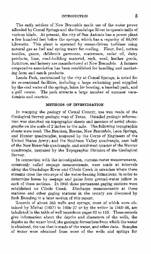
The early settlers of New Braunfels made use of the water power afforded by Comal Springs and the Guadalupe River to operate mills of various kinds. At present, the city of San Antonio has a power plant a few hundred feet below the springs, which has a capacity of 60,000 kilowatts. This plant is operated by steam-driven turbines using natural gas as fuel and spring water for cooling. Flour, feed, cotton textiles, gauze, children's garments, mattresses, cedar oil, dairy products, lime, road-building material, rock, wool, leather goods, furniture, and hoisery are manufactured at New Braunfels. A farmers cooperative association has been established for handling and market ing farm and ranch products.
Landa Park, maintained by the city at Comal Springs, is noted for its recreational facilities, including a large swimming pool supplied by the cool water of the springs, lakes for boating, a baseball park, and a golf course. The park attracts a large number of summer vaca tionists and tourists.
METHODS OF INVESTIGATION
In mapping the geology of Comal County, use was made of the Geological Survey geologic map of Texas. Detailed geologic informa tion was sketched on topographic sheets and mosaics of aerial photo graphs on the scale of 2 inches to the mile. The following topographic sheets were used: The Bracken, Boerne, New Braunfels, Leon Springs, and Hunter quadrangles, prepared by the Corps of Engineers of the United States Army; and the Smithson Valley quadrangle, east half of the New Braunfels quadrangle, and southwest quarter of the Hunter quadrangle, prepared by the Topographic Division of the Geological Survey.
In connection with the investigation, current-meter measurements, commonly called seepage measurements, were made at intervals along the Guadalupe River and Cibolo Creek in stretches where these streams cross the outcrops of the water-bearing formations, in order to determine losses by seepage and gains from ground-water inflow in each of these sections. In 1946 three permanent gaging stations were established on Cibolo Creek. Discharge measurements at these stations and other gaging stations in the county are discussed by Seth Breeding in a later section of this report.
Records of about 365 wells and springs, most of which were ob tained by Michal (1937) in 1936-37 or by the writer in 1945-46, are tabulated in the table of well records on pages 92 to 115. These records give information about the depths and diameters of the wells, the depths to the water level, the geologic formations from which the water is obtained, the use that is made of the water, and other data. Samples of water were obtained from most of the wells and springs for
6 GEOLOGY AND GROUND-WATER RESOURCES, COMAL COUNTY, TEX.
chemical analyses. The results of the analyses are shown in table 19. Serial numbers of wells are preceded by a capital letter and are shown on plates 2 and 5.
PREVIOUS INVESTIGATION
Records of a few of the wells in the western part of the county, including the altitude of the water levels, were obtained by Livingston (1936) in 1934 as a part of the study of the water resources of the Ed wards limestone in the vicinity of San Antonio.
A number of wells have been selected as observation wells, and periodic measurements have been made of the depth to water in these wells. The results of these measurements have been published in a series of water-supply papers of the Geological Survey entitled, "Water levels and artesian pressures in the United States." The water-level measurements for Comal County are given in the tables of this report.
ACKNOWLEDGMENTS
In the compilation of this report, the notes and geologic maps made by Bennett, which covered about half of the county, have been used freely. Although all parts of the county were visited by the writer, only minor changes were made in Bennett's tentative delineation of geologic features. A small area in the vicinity of Bracken was mapped by A. N. Sayre in connection with a ground- water investigation of the San Antonio area (Livingston, Sayre, and White, 1936, pi. 5). These data were also used in a similar manner. Complete cooperation of the Surface Water Branch of the Geological Survey resulted in prompt response to specific requests for stream measurements.
The writer thanks the farmers and ranchers in the county for their cordial cooperation in supplying information about their wells and permitting access to their properties. Well logs furnished by water-well drillers, particularly E. B. Kutscher of San Marcos and J. R. Johnson of San Antonio, have been helpful in the interpreta tion of the geology of the area.
CLIMATE
The highest and lowest temperatures recorded by the United States Weather Bureau at New Braunfels over a period of 60 years were 107 F and 2 F. The mean monthly temperatures are given in the following table.

CLIMATE- 7
1. Mean monthly temperatures at New Braunfels, Tex.
March _
May
Mean temperature (°P.)
53. 457.068.768. 476. 484.0
July- AugustSeptember _October _November __December. _
Mean temperature (°F.)
85.085. 681. 269. 165. 452.8
The following table gives the dates of the last killing frost in spring and the earliest killing frost in autumn at New Braunfels for a period of 20 years. On the basis of these figures the average length of the growing season was 265 days.
The altitude of New Braunfels is about 640 feet, which is consider ably lower than the average altitude of the hill country of the Edwards Plateau comprising the greater part of the county. For this reason, the average length of the growing season in the county as a whole may be somewhat shorter than the average at New Braunfels.
TABLE 2. Frost data for New Braunfels for the years 1930-49, inclusive
[Prom publications of U. S. Weather Bureau]
Year
1930-_-__-___1931-. -____1932-. _______1933___-.-___1934-________1935____-___-1936-_--_-___1937-_ _____1938 _1939_-___-___
Pate of last kill ing frost in
spring
Jan. 31 '___Mar. 9_____Mar. 14- Feb. 12 1 ___
Feb. 28_--_Feb. 18.-.-Feb. 3 (?)___Feb. !_____Feb. 26____
Date of first killing frost ih autumn
Nov. 25Dec. 4Nov. 12
i DPP 19Dec. 1Dec. 26Nov. 4Nov. 20Nov. 8Dec. 27
Year
1Q401941- --1942_-_______1943 --1944. _-._____1 04^1Q4fi1947- ________1948-- -1Q4Q
Date of last kill ing frost in
spring
Apr. 13-- _ Feb. 28____Mar. 3__-__Mar. 3_.___
- Mar. 30_-__Feb. 23___-Feb. 10_--_Mar. 16_--_Mar. 13 _Feb 1
Date of first killing frost in autumn
Nov. 131 Dec. 7Nov. 12
'Nov. 30Nov. 27Nov. 22Dec. 30Nov. 7
1 Nov. 10'Dec. 15
1 No killing frost reported; date of earliest or latest freezing temperatures given.
The average annual precipitation at New Braunfels during a period of 61 years was 31.29 inches. The records show a wide variation from year to year; the lowest precipitation of record was 13.29 inches in 1917 and the highest was 60.21 inches in 1919. During the 61 years of record, periods in which there was no rainfall during the month have been observed 16 times. April, May, and June have had some rainfall during each of the 61 years.
The following table gives the monthly precipitation for New Braunfels and the average rainfall for each month of the period of record.
8 GEOLOGY AND GROUND-WATER RESOURCES, COMAL COUNTY, TEX.
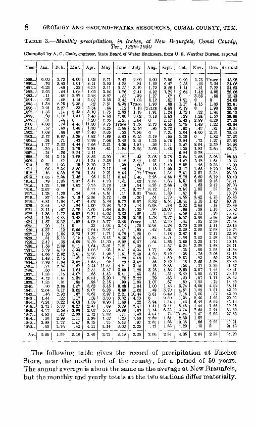
TABLE 3, Monthly precipitation, in inches, at New Braunfels, Comal County,Tex., 1889-1960
[Compiled by A. C. Cook, engineer, State Board of Water Engineers, from U. S. Weather Bureau reports]
Year
1889..1890..1891..1892-1893-1894-1895 1896-1897-1898 1899-1900-1901 1902-1903-1904-1905 1906-19071908-1909-1910-1911 1912-1913-1914-1915-1916-1917-1918-1919-1920-1921-1922-1923-1924-1925-1926-1927-1928-1929-1930-1931-1932-1933-1934-1935-1936-1937-1938-1939-1940-1941-1942-1943-1944-1945-1946-1947 1948-1949..1950-
Av.
Jan.
6.00.70
6.332.03.11.93
1.383.011.56.90.31
4.00.57
1.082.73.24
1.77.39.24.91
0.27.04.46
1.05.19
1.232.671.23.87
4.813.643.111.361.161.57.20
4.371.29.81
2.471.585.794.661.487.98.71.80
1.334.121.35.90
2.04.46
1.446.243.714.774.83.56
3.88.55
2.05
Feb.
3.732.40.49.54.69.58
2.752.27.14
1.16.46.74.69.66
9.87.71
2.331.31.26
3.19.47
1.032.345.382.361.851.9801.291.041.94.42.67
1.724.443.32
.14
.121.645.13.35
2.094.102.922.151.942.84.63.15
1.61.81
2.953.172.92.22
3.225.332.58.42
2.993.723.76
1.99
Mar.
4.001.01.32
1.082.271.142.38.33
2.431.3104.451.40.63
1.38.43
4.441.702.241.88.51.19
5.502.761.482.371.620.24
1.191.47.84
5.705.082.481.9806.553.731.184.692.115.341.611.373.021.871.644.072.39.95
1.573.65.67
1.174.036.273.962.001.111.47.42
2.18
Apr.
1.938.416.351.033.283.07.32
3.343.102.402.20
11.801.-302.401.822.997.662.842.113.521.313.704.641.51.95
5.419.753.11.64
2.364.021.005.606.813.774.08.33
9.641.371.582.591.641.662.762.36
. 1.852.442.51.85
8.81.98
3.628.073.63.58
1.582.412.021.721.989.154.11
3.40
May
0.713.822.113.862.873.597.51.64
1.754.602.353.755.253.351.897.062.31.61
3.902.362.712.172.213.114.792.784.994.513.725.883.981.684.023.325.771.943.971.713.13
11.393.01.93
1.924.98.92
11.815.474.435.202.153.456.282.873.308.93.89
5.757.321.52.75
3.14
3.73
June
7.424.382.551.76.55
3.459.39.12
2.937.605.21
Trace1.99.22
5.632.424.391.84
.211.12.39.29
2.545.641.41.18.71.11
1.396.723.125.043.322.252.363.131.414.788.362.027.212.411.611.29.29
4.213. RO5.41.75.90
9.896.692.213.321.683.29
10.88.71
1.235.433.02
3.19
July
2.60.84
3.192.41.39
1.03Trace
1.101.193.025.943.583.167.896.152.131.813.25
.433.77.80.79.77
1.40.62.94
3.773.31.20
6.97.14.23.58
2.15Trace
.30
.901.202.445.37.30
4.342.505.693.023.101.29.53
2.221.931.041.60
10.444.73.22
2.411.891.491.59.97
2.25
2.30
Aug.
6.001.581.724.921.278.121.93
Trace1.913.1802.73.86
03.191.35.26
3.66
3. OS1.27.18
1.18Trace
2.257.353.233.12
Trace.54
3.826.98.90.53
1.58.15
2.94.42
0.84.64
01.774.901.38.58.18
3.28.54.29
1.071.00.49
3.6103.941.417.144.542.822.55.72
2.06
Sept.
7.966.472.581.29.07.81.60
4.591.241.831.174.552.727.31.55
5.761.111.45
3.78.19
1.401.001.344.661.662.661.411.391.795.54.88
10.071.333.772.304.281.611.184.711.851.57.08
5.191.802.499.884.53.51.65.67
1.433.706.499.501.342.118.33.74
1.811.881.83
2.91
Oct.
0.902.581.142.6801.911.176.191.72.29
2.433.78.02
2.042.202.842.571.306.243.044.572.523.172.51
12.785.51.49
2.54.57
4.5516.442.02.98
4.595.57.61
3.702.293.871.583.695.24.35.28
2.53.18.93
2.553.30.20.50
3.744.517.151.25.46
8.453.74
Trace2.69
10.361.20
3.05
Nov.
4.73.63.81
1.483.3504.150.32
1.242.891.48.47
4.600.73
3.941.819.281.582.48.45
1.653.076.604.09.63
1.9303.421.182.68.38
1.313.06.05
2.092.0003.033.352.28.86.75.83
2.55.31
2.671.90.97
1.324.501.281.062.466.481.442.601.671.58.06.13
2.04
Dec.
Trace1.247.224.98.58
01.031.901.841.534.291.22.81
2.311.821.272.393.60
3.981.612.362.793.358.122.462.47.33
04.791.42.18
1.16.20
5.982.391.112.982.173.281.741.683.952.05.89
5.983.391.446.171.11.72
4.021.51.57
1.965.021.663.212.08
2.990
2.39
Annual
45.9834.0634.8328.0615.4324.6332.6123.4920.1329.0627.2542.0819.2432.4937.2327.9334.9823.76
29.5019.6616.0025.5625.9050.4037.7127.9624.5813.2925.8660.2125.8835.5230.8539.4924.5820.1636.2622. 9436.0740.1528.7131.5831.1526. 7530.8041.6730.4129.1928.3213.3538.1142.9942.0929.9343.1439.3856.6027.52
.43.2121.13
31.29
The following table gives the record of precipitation at Fischer Store, near the north end of the county, for a period of 59 years. The annual average is about the same as the average at New Braunfels, but the monthly and yearly totals at the two stations differ materially.
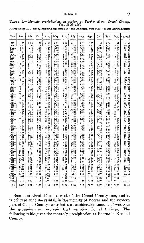
CLIMATE 9TABLE 4. Monthly precipitation, in inches, at Fischer Store, Comal County,
Tex., 1890-1950 {Compiled by A. C. Cook, engineer, State Board of Water Engineers, from U. S. Weather Bureau reports]
Year
1890- 1891- 1892- 1893- 1894- 1895- 1896- 1897- 1898- 1899- 1900- 1901- 1902- 1903- - 1904..1905-1906- 1907- 1908- 1909- 1910-1911- 1912- 1913- 1914- 1915- 1916- 1917- 1918- 1919-1920- 1921- 1922- 1923- 1924- 1925- 1926- 1927- 1928-1929- 1930. - 1931. . 1932. .1933- 1934- 1935-1936- 1937- 1938-1939.. 1940- 1941- 1942.. 1943- 1944- 1945- 1946- 1947.. 1948-1949-1950-
Av.
Jan.
1.70 5.50 2.00 0 1.25 1.25 4.50 1.90 .75
0 4.50 0 .75
2.00 01.750 .20
1.50 0 00 0 .75
0 1.25 3.90 .50 .60
3.554.25 1.65 1.50 0 1.38 .60
4.02 1.28 .53
2.87 .95
4.35 5.213.50 6.77 1.51.43
3.00 3.80
10.08 3.95 2.20 0 .69
5.67 3.33 4.42 4.70 .58
7ft
2.07
Feb.
1.55 .76 .16 .10 .50
2.45 3.60 0 .75
0 0 0 .75
7.25
1.751.00 .25
L50 0
.501.75 3.00 1.25 .75
2.00 0 .87
2.00 2.75.35
1.00 1.05 5.25 3.30 0 0 3.02 3.570 1.15 4.53 2.122.03 2.13 3.68.85
0 1.431.23 3.65 2.46 1.50 .18
3.45 4.22 2.70 .44
3 fin
1.66
Mar .
.20
.76
.65 2.40 .50
1.35 1.10 3.20 1.25 0 2.40 .85
1.85 1.00 .75
3.25.50
1.00 1.38 .50 .56
2.40 1.65 1.20 5.65 1.25 4.15 0 1.10 1.951.22 3.50 2.80 2.85 2.65 0 4.52 2.45 1.383.00 1.77 3.20 2.47.60
2.90 .50
1.18 2.87 1.35.41
1.51 4.23 .96
2.55 3.17 4.55 4.95 2.33
2.181 1\
1.88
Apr.
4.95 4.40 .25 .75
4.55 1.25 4.85 2.65 1.90 1.90 9.35 .50
2.25 2.10 4.136.751.50 2.53 .50
1.55 4.006.75 3.00 .75
5.94 10.75 1.15 1.15 6.73 2.000 4.60 6.60 3.75 3.20 2.27 6.90 2.36 1.754.70 1.60 5.50 1.001.38 4.70 .50
2.25 .85
5.212.98 2.50 5.71 4.64 1.60 1.15 1.38 2.78 1.08 1.702.643 Aft
3.15
May
4.32 2.60 3.90 2.40 3.20 5.20 0 .85
1.50 2.15 5.18 4.52 4.63 .50
6.802.001.10 7.25 5.00 5.65 4.753.00 .95
2.75 6.75 1.40 7.35 5.98 1.75 4.037.25 1.75 3.25 1.85 6.20 1.35 4.55 1.40 5.15
15.15 8.90 .90
1 ff>2.70 1.10
11.438.03 3.44 3^051.84 1.08 3.73 2.38 5.39 6.50 .73
3.90 2.84
3.87
June
3.91 1.71 1.60 1.55 1.30 4.90 1.00 2.10 5.75 6.45 0
.75 1.15 4.00 4.652.401.50 1.25 .25 .80
1.500 3.75 5.25 .75 .30 .50
0 1.15
2.55 5.60 3.10 1.75 1.75 .67
3.05 5.15 3.281.40 2.00 3.27 0.901.70 .20
7.485.85 1.91 2.33.83
2.82 8.75 2.20 1.78 1.84 3.68 3.18 1.83 4.651.842.06
2.54
July
0 .80
1.70 .25 .45
0 4.20 .50
3.35 3.20 5.35 2.25 6.00 7.00 2.752.504.38 1.00 0 4.25 1.50.50 .35
0 0 2.63 7.00 1.00 1.25
10.00.25
1.25 .25
1.35 1.34 2.37 6.95 2.06 3.195.70 1.05 4.25 1.904.20 2.65 3.803.83 1.63 2.204.89 4.00 0 3.14 3.15 .38
4.10 2.91 .85
3.25
2.53
Aug.
1.77 1.65 5.46 .05
7.35 1.25 0 3.10 1.50 0 4.15 1.00 0 2.65 3.501.25.75
0 4.65 .75 .87.25
1.00 3.35
16.85 3.00 3.25 .75
3.30 5.004.85 0 3.15 1.20 .15
3.14 .90 .40 .28
0 .32
1.35
5.05 .45
1.281.95 1.22 .43
2.64 3.12 0 4.62 1.00 4.02 2.60 3.82 2.90
84
2.31
Sept.
7.00 4.30 .28 .01
1.00 2.65
12.25 .85 .50 .50
2.25 3.50 3.95 .25
3.502.753.50 1.50 .50
1.25 .90.65 .25
11.25 1.00 2.25 2.00 .50 .90
7.401.13
12.00 2.00 7.30 3.50 1.76 .90 .70
3.801.00 2.27 0
1.97 .70
5.846.65 .51 .70.32
1.40 2.18 6.40 2.68 2.88 3.41 6.55 0 1.91
4.05
2.79
Oct.
1.26 .01
2.05 0 1.75 1.76 4.80 2.00 .15
4.48 1.55 0 2.00 3.75 2.502.500 5.50 1.50 2.50 2.881.27 3.75
11.75 2.75 0 1.70 .25
2.75 8.502.25 .75
2.50 3.90 0 7.73 3.19 8.15 .80
1.53 6.71 .75 .15
1.97 0 2.752.60 5.41 .41
1.10 3.30 4.98 3.48 .45
1.35 3.40 1.50 .80
4.93
2.57
Nov.
1.56 1.75 1.16 4.85 0 3.30
.15 0 .75
1.50 .50 .50
5.05 0 .25
2.501.00 5.25 .75
3.85 1.252.75 2.25 0 2.40 .75
2.25 1.25 3.25
.252.75 .75
1.40 3.60 0 2.65 2.35 0 2.853.85 2.05 1.00 .78.60
3.45 .20
1.95 1.55 .52
1.82 4.20 .60
1.23 1.05 5.59 .80
6.48 2.03 .70
0.72
1.78
Dec.
.81 8.40 5.05 1.25 .25 .60
2.10 1.10 .25
4.00 .75
0 3.50 2.00 .75
1.003.50 0 1.50 1.50 3.332.00 1.50 8.40 2.00
' 3.00 .25
0 6.00
7K
0 0 0 4.55 1.35 1.00 3.36 2.95 2.251.40 2.03 3.47 1 981.20 3.57 3.102.29 6.55 1.701.39 5.75 1.17 .60
2.31 5.55 3.10 3.60 1.34
2.330
2.26
Annual
29.03 32.64 24.26 13.61 22.00 25.96 38.55 18.25 18.40 24.18 35.98 13.87 31.88 32.50
30.4018.73
25.73 19.03 22.60 22.0421.32 21.45 46.70 44.84 28.58 33.50 12.25 30.78
26.85 32.85 27.60 37.35 24.82 23.54 40.69 29.92 28.8340.60 30.80 32.57 27.5826.90 28.62 42.0737.86 28.94 23.1329.53 37.28 36.02 31.15 22.83 41.55 29.28 46.79 21.14
29.41
Boerne is about 10 miles west of the Comal County line, and it is believed that the rainfall in the vicinity of Boerne and the western part of Comal County contributes a considerable amount of water to the ground-water reservoir that supplies Comal Springs. The following table gives the monthly precipitation at Boerne in Kendall County.
10 GEOLOGY AND GROUND-WATER RESOURCES, COMAL COUNTY, TEX.
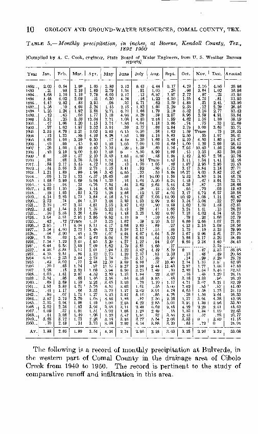
TABLE 5. Monthly precipitation, in inches, at Boerne, Kendall County, Tex.,1892-1950
]Compiled by A. C. Cook, engineer, State Board of Water Engineers, from U. S. Weather Bureaureports]
Year
1892-
1894..1895-
1897-1898- 1899- 1900- 1901-19021903-
1905-1906-1907- 1908- 1909-1910- 1911-1912- 1913- 1914- 1915-1916-1917- 1918-1919- 1920- 1921- 1922- 1923- 1924_ . 1925- 1926- 1927-1928-1929- 1930. . 1931-1932, . 1933-1934- 1935- 1936- 1937^ 1938- 1939- 1940- 1941- 1942- 1943- 1944- 1945- 1946- 1947- 1948- 1949- 1950-
Av_
Jan.
2.03 .21
1.681.48 4.411.561.25 .42
5.31 .47.97
3.35 .12
1.00.40.20 .40
0.05.58.34
1.21 .05
1.684.351.05.28
4.14 2.72 2.16 1.42 .56
1.64 .42
2.85 1.54.64
1.58 1.54 6.444.38 4.136.01 .42 .70
1.98 4.03 3.54
.68 1.81 .41 .86
3.67 3.55 3.02 4.09
.44 3.68 .70
1.88
Feb.
0.54 .98
1.164.022.82.10
1.24 .45 .25
1.081.028.70 1.331.50.90
1.00 2.10 .30.68
2.173.55 1.80 1.73 2.90.04
1.30 1.652.85 .74 .87
1.54 5.35 3.61 .12 .11
4.603.90.62
1.22 5.533.84 2.512.33 3.02
.65
.15 1.61 .86
3.69 5.88 1.17 .07
3.75 2.94 2.35 .37
3.08 3.72 2.49
2.05
Mar.
1.08 2.101.102.09 .83
4.061.92 .03
3.36 1.201.972.21.88
3.30.45
1.40 2.00 1.573.70 5.453.53 .90
1.32 1.69.23.28 .93
1.73 .94
3.35 3.18 3.28 2.91
Trace 6.04 2.72.68
1.34 2.51 2.693.14
.852.54 .77
1.74 2.92 2.07 .65
1.59 4.71 .66
1.71 3.70 1.98 1.93 1.91 1.49 1.73 .34
1.99
Apr.
1.03 1.897.78.51
2.953.263.88 1.77
12. 36 1.152.322.03 4.269.302.402.40 2.40 2.103.38 4.722.73 1.94 6.57 9.946.761.14 3.723.84 1.31 4.81 7.59 4.89 3.86 1.51 8.11 3.481.702.42 1.95 7.093.01 1.322.73 2.45 .97
1.60 4.52 1.46 2.24 5.76 3.53 1.27 1.03 1.10 3.94 1.51 1.98 7.28 3.73
3.54
May
3.86 2.796.056.30 .98
1.452.71 3.10 7.71 3.74
2.058.28.17
1.207.75 7.60 3.891.91 1.361.15 3.85
15.65 1.307.546.85 1.284.16 2.44 2.35 3.22 1.61 9.82 2.35 4.17 2.721.018.04 5.20 1.621.94 3.751.74
12.59 11.17 5.94 2.59 2.58 3.45 4.51 3.79 4.26 8.56 1.00 3.65 5.92 1.29 3.18 3.08
4.24
June
2.13 1.342.174.76 .37
2.156.71 4.96 1.08 1.86
so6.151.844.101.05.20
0 1.05.61 .13
3.41 6.05 .50 .16.54
3.65 2.565.74 3.89 3.87 3.15 1.48 4.10 1.02 2.96 5.582.641.28 4.27 1.791.22 1.20.55
8.59 9 27 5^50 1.33 .58
3.90 3.03 1.27 3.57 1.88 2.65 3.14 1.05 5.47 3.95 2.02
2.74
July
0.43 .91.13.16
6.711.821.66 3.29 8.40 6.04
9.50 1.991.307.001.50 5.50 6.90.84
1.70.92 .33 .84
1.613.62.58 .12
6.27 1.53 1.02 .28
3.23 0 .59
2.85 3.174.076.83 1.22 3.815.62 2.375.17 6.80 2.80 3.24 1.84 6.55 .79
1.61 2.62 5.16 .87
4.22 2.40 1.28 1.81 3.77 4.14
2.96
Aug.
4.44 1.056.871.22 .62
4.031.70 .39
2.46 1.18.06.58
4.161.601.95.60
5.90.88
Trace 1.05.86 .53
10.00 5.202.63.13
1.277.06 2.99 .90 .41
1.92 .10
2.10 .89 .15
1.64.64 .94
1.604.49 .83.38 .57
2.44 1.49 .22
3.05 1.19 .55
3.91 .05
7.56 2.85 6.62 2.49 .87
5.54 3.88
2.24
Sept.
0.17 .23
1.974.30 5. 593.292.10 2.97 1.99 3.062.841.628.833.805.601.70 1.00 1.941.43 .40
1.73 5.64 1.56 5.345.443.05 4.01
13.90 2.63 9.69 1.66 9.97 4.06 3.17 .27 .86
5.732.02 2.01 .17
5.19 2.52.91
10.40 11.43
.10 3.97 .48
1.17 5.00 4.78 4.76 2.25 5.01 9.45 .15
3.66 2.08 3.29
3.63
Oct.
4.23 .60
2.721.55 4.862.3S3.32 8.96 4.62 .74
2.781.59 2.502.101.007.95 ,45
1.423.11 1.973.47
16.37 2.52 1.184.39.95
3.4710.49 3.54 1.02 2.24 7.18 .79
6.00 4.13 1.751.072.86 9.85
0 .13.14
2.14 2.97 2.89
, .16 3.16 4.71 7.02 5.65 .39
1.37 3.94 4.22 1.33 2.43 3.33
.55
3.25
Nov.
2.16 3.84.07
4.75 .31.12
2.16 2.59 1.35 .75
9.00Trace
.554.501.20
10.40 2.35 2.951.34 2.953.84 8.03 3.80 .67.87.79
4.721.08 5.04 1.39 1.41 4.02 .24
2.66 3.10
.102.063.17 2.34
.47
.48
.99 1.35 1.77 1.54 .48
2.33 3.67 .85
1.58 1.59 3.91 1.30 2.29 1.34 .57
0 .72
2.24
Dec.
4.86 1.02.23.81
2.412.292.77 4.91 1.30 .33
3.65.75
1.671.803.001.50 .83
2.764.41 2.952.18 5.82 2.24 2.04.25.05
6.571.21 .22
1.38 .13
4.74 1.66 1.07 3.08 3.232.613.26 1.403.783.35 .49
3.29 3.81 1.68 5.46 1.29 .96
5.21 .87
1.75 2.64 4.38 2.96 2.61 1.19 .78
2.89 0
2.32
Annual
26.96 16.9631.9331.95 32.8626.4631.42 33.84 50.19 21.6033.7138.53 36.4134.4726.1536.60 30.53 25.7621.46 25. 4327.71 52.47 46.78 33.7136.6619.82 30.5862.47 27.99 32.81 26.23 48.23 32.79 21.01 38.56 29; 9027.7534.06 34.45
36.65 20.5826.78 52.93 47.59 32.81 24.14 26.20 32.29 41.60 31.12 26.33 42.98 33.50 45.62 22.63 23.77 41.15 24.94
33.08
The following is a record of monthly precipitation at Bulverde, in the western part of Comal County in the drainage area of Cibolo Creek from 1940 to 1950. The record is pertinent to the study of comparative runoff and infiltration in this area.
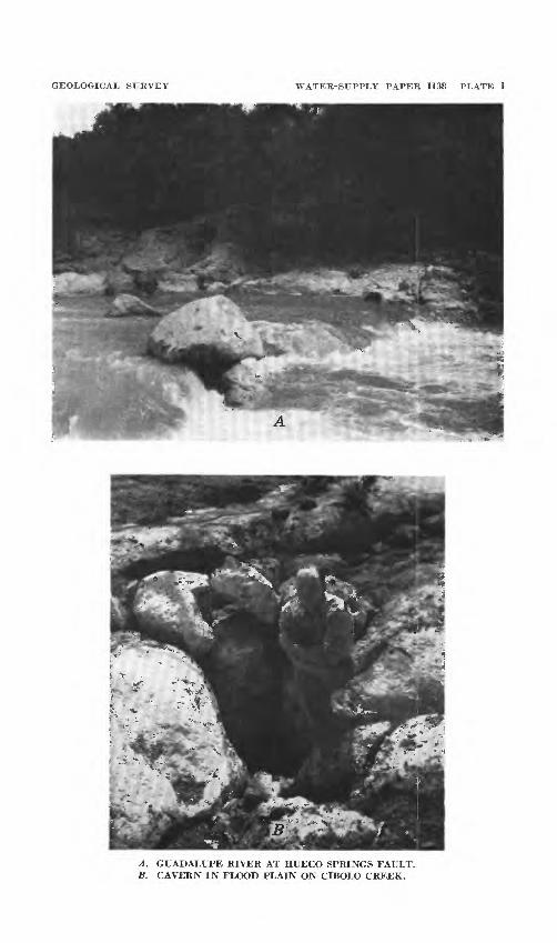
GEOLOGICAL SURVEY WATER-SUPPLY PAPER 1138 PLATE 1
A. GUADALUPE RIVER AT HUECO SPRINGS FAULT. B. CAVERN IN FLOOD PLAIN ON CIBOLO CREEK.

TOPOGRAPHY 11
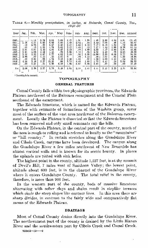
TABLE 6. Monthly precipitation, in inches, at Bulverde, Comal County,1940-50
Tex. f
Year
1940-1941- 1942-1943 __1944- i945._1946-1947- 1948-1949-1950-
Av-
Jan.
1.18 .12.55
3.91 3.213.552.86 .53
4.24.65
2.08
Feb.
1 1.144.31 2.76.15
3.81 4.082.53.37
2.913.163.21
2.58
Mar.
0.793.85
.201.534.42 5.195.071.55 .88
2.27.31
2.37
Apr.
2.846.00 3.971.784.83 1.453.77.55
1.9410. 233.96
3.76
May
3.693.00 2.403.625.87 .78
4.052.87 2.45.98
6.39
3.28
June
4.475.48 2.172.172.53 3.003.59.0 2.253.751.92
2.85
July
1.912.02 4.867 A.",
.75 1.14.54.79
1.444.033.07
2.55
Aug.
1.50.54
2.15.12
4.89 .35
5.334.22 .97
1.503.96
2.41
Sept.
1.483.52 7.177.572.33 2.92
12.96.58
1.901.723.04
4.11
Oct.
2.887.05 8.151.421.13 4.432.531.01 2.004.41.30
3.21
Nov.
4.94.48
1.321.985.80.78
6.69.85
1.15.24.30
2.23
Dec.
1.54 .72
2.785.61 2.063.771.33 .92
3.02.09
2.51
Annual
131.4538.97 36.9931.1245.88 29.3954.3816.98 19.3439.5527.20
33.94
Incomplete record.TOPOGRAPHY
GENERAL FEATURES
Comal County falls within two physiographic provinces, the Edwards Plateau northwest of the Balcones escarpment and the Coastal Plain southeast of the escarpment.
The Edwards limestone, which is named for the Edwards Plateau, together with remnants of formations of the Washita group, cover most of the surface of the vast area northwest of the Balcones escarp ment. Locally the Plateau is dissected so that the Edwards limestone has been removed and only small remnants cap the hills.
On the Edwards Plateau, in the central part of the county, much of the area is rough or rolling and is referred to locally as the "mountains" or "hill country." In certain stretches along the Guadalupe River and Cibolo Creek, canyons have been developed. The canyon along the Guadalupe River a few miles northwest of New Braunfels has almost vertical walls and is known for its scenic beauty. In places the uplands are pitted with sink holes.
The highest point in the county, altitude 1,527 feet, is at the summit of Devil's Hill, 7 miles west of Smithson Valley; the lowest point, altitude about 600 feet, is in the channel of the Guadalupe River where it enters Guadalupe County. The total relief in the county, therefore, is more than 900 feet.
In the western part of the county, beds of massive limestone alternating with softer clays and shales result in steplike terraces which circle the steep slopes like contour lines. In this area there are sharp divides, in contrast to the fairly wide and comparatively flat mesas of the Edwards Plateau.
DRAINAGE
Most of Comal County drains directly into the Guadalupe River. The northernmost part of the county is drained by the Little Blanco River and the southwestern part by Cibolo Creek and Comal Creek.
993963 52 2

12 GEOLOGY AND GROUND-WATER RESOURCES, COMAL COUNTY, TEX.
These streams have wide meanders characteristic of old streams and have apparently held their general courses through the events of recent geologic history. There is much evidence, however, of com paratively recent rejuvenation. The streams are actively degrading their channels within their meander belts. The channels are barren of sediments except for large boulders. Rapids are found where major faults cross the streams (pi. I A), indicating comparatively recent movement along the fault planes.
STRATIGRAPHY
Sedimentary rocks may be seen at the surface in all parts of Comal County, but only small outcrops of igneous rock have been found. Basalt porphyry intrudes the Glen Rose limestone near the Kendall County line. No igneous rock has been reported in the log of any well in the county. Metamorphic rock in the form of schist is reported in the log of the oil test (well F32, see driller's log) on the E. J. Heidrick ranch 6K miles west of New Braunfels.
The sedimentary rocks are composed of layers of limestone, shale, clay, sandstone, and sand, which for convenience of study and refer ence have been grouped by geologists into formations and larger units, usually named for the areas in which they were first observed and described. The limestones, sandstones, and sands contain the under ground-water reservoirs in Comal County. Openings in rocks such as cavities in limestone caused by solution or fracturing or spaces between grains of sand, permit the movement of water from the surface downward to the ground-water reservoirs and also laterally within the reservoirs. Clays and shales generally transmit little or no water and are regarded as barriers which retard or prevent the move ment of water. For a complete classification and discussion of openings in rocks, reference should be made to the work of O. E. Mein- zer (1923a, pp. 109-148).
The occurrence of ground water is closely related to the geologic history of Comal County. Gradual elevation or subsidence of the land relative to the level of the sea is clearly shown by the upward succession of strata, marked by the fossil remains of animals contained in them. Breaks in the continuity of sediments that were deposited in the sea are indicated by the absence of strata that are known to occur elsewhere in Texas. This means that Comal County was above the level of the sea while other parts of Texas were still below sea level. In such areas sediments were still being deposited to form strata not found in Comal County. These breaks in sedimentation are called disconformities and are mentioned later in the description of the formations.
STRATIGRAPHY 13
More abrupt movements within the earth underlying Comal County have resulted in the dislocation of the rock, so that in some places formations that were deposited early in the geologic history are now found to be in contact with and at the same level as formation that were deposited much later and normally belong at much higher levels. The planes of contact between these formations are called faults and can be traced at the surface in linear patterns. The major faults are shown on the geologic map, plate 2. Deformation along fault lines has caused some strata to dip or to be inclined from their original nearly horizontal position.
Except for a few isolated alluvial deposits of Pleistocene age the water-bearing rocks in Comal County are of Cretaceous age. The following table shows the thicknesses of the various geologic forma tions and gives brief descriptions of the character of the formations, their water-bearing properties, and the characteristic appearance of the land where the formations are at the surface.
BOCK FORMATIONS AND THEIR WATER-BEARING PROPERTIES
PRE-CRETACEOUS ROCKS
No rocks older than those of Cretaceous age crop out in Comal County and it is believed that no wells in Comal County yield water from such formations.
After the long and complex history of the Paleozoic era, as shown by the rocks which crop out in Llano County and adjacent counties, the sea retreated from central Texas and a large part of Texas became a mountainous land and remained above sea level during the Triassic and Jurassic periods which followed. It is believed that Paleozoic rocks underlie Comal County at considerable depth but Triassic and Jurassic formations are probably absent. The schist reported in the drillers' log of well F32 is probably Paleozoic in age. Sellards (1920, pp, 19-21) and Udden have identified Paleozoic schists in two deep wells in the Leon Springs area, a few miles south of the western part of Comal County, and at other places along the Balcones fault zone (Sellards, 1931, pp. 819-827), indicating a large subsurface area of of these schists.
CRETACEOUS SYSTEM
PRE-COMANCHE ROCKS
As yet not enough deep wells have been drilled to clarify the geo logic history of the Early Cretaceous formations in Comal County. From 15 to 20 miles north of the north tip of Comal County, in Blanco
1 County along the Pedernales River, the Travis Peak formation (Cuyler 1939, pp. 625-642) lies directly upon Paleozoic rocks ranging in age
:from Ordovician to Carboniferous. The Travis Peak formation has
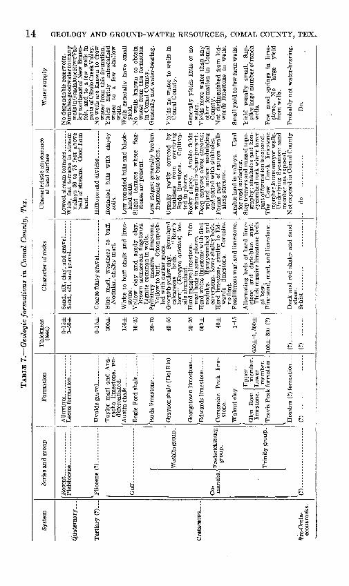
TAB
LE 7
. G
eolo
gic
form
atio
ns i
n C
omal
Cou
nty,
Tex
.
Syst
em
Qua
tern
ary.
. .
Ter
tiar
y (?
) ...
Cre
tace
ous .
...
fre-
Cre
ta-
ceou
s roc
ks.
Seri
es a
nd g
roup
Re c
ent .
.Pl
eist
ocei
Plio
cene
Gulf
-...
.
Co- man
che.
1
(?)
(?)_
_
_.
Was
hita
gro
up -
Fred
eric
ksbu
rg
grou
p.
Tri
nity
gro
up -
For
mat
ion
Tay
lor
mar
l an
d A
na-
cach
o lim
esto
ne,
un-
diS
eren
tiat
ed.
Qra
yson
sha
le (
Del
Rio
) _
Geo
rget
own
limes
tone
_
Com
anch
e P
eak
lime
st
one.
(Upp
er
] G
len
Ros
e 1
mem
ber.
1 lim
esto
ne. I
Low
er
f I
mem
ber.
J
Tra
vis
Peak
for
mat
ion.
.
(?) _
Thi
ckne
ss
(fee
t) 0-1 5
±
0-50
±
0-1
5±
300±
150±
10-2
5
35-7
0
40-5
5
20-2
5
500±
40
±
1-15
650±
-1,
500±
100±
-300
(?
)
(?).
. .-
(?).
.. .-.
.
Cha
ract
er o
f roc
ks
Blu
e m
arl,
wea
ther
s to
bu
ff.
Nod
ular
, ch
alky
mar
l.
Whi
te t
o bu
ff c
halk
and
lim
e
ston
e.
Yel
low
cl
ay
and
sand
y cl
ay.
Bro
wn
aren
aceo
us f
lags
tone
s.
Lig
nite
com
mon
in
wel
ls.
Spl
inte
ry
mas
sive
lim
esto
ne.
Yel
low
to b
uff.
Oft
en s
peck
le
d w
ith
dark
er s
pots
. G
reen
ish-
yello
w c
lay.
So
me
hard
ca
lcar
eous
be
ds.
"Rai
n's
horn
" (E
xogy
ra a
riet
ina)
fo
s
sils
abu
ndan
t. H
ard
mas
sive
lim
esto
ne .
Thi
n m
arl b
eds
in s
ome
plac
es.
Har
d w
hite
lim
esto
ne w
ith
flin
t no
dule
s.
Hon
eyco
mbe
d an
d ca
vern
ous.
Som
e ch
alky
bed
s.
Har
d lim
esto
ne,
sim
ilar
to E
d
war
ds
limes
tone
. C
onta
ins
no f
lint.
Foss
ilife
rous
mar
l and
lim
esto
ne.
Alt
erna
ting
bed
s of
har
d lim
e
ston
e an
d da
rk-b
lue
mar
l. T
hick
mas
sive
lim
esto
ne b
eds
at b
ase
. Fi
ne s
and,
mar
l, an
d li
mes
tone
-.
Dar
k an
d re
d sh
ales
and
san
d
ston
e.
Cha
ract
eris
tic a
ppea
ranc
e at
lan
d su
rfac
e
Wid
e, f
lat
terr
aces
in
stre
am
valle
ys 3
0 to
75
feet
abo
ve
beds
of
stre
ams.
G
ood
farm
la
nd.
Rou
nded
hi
lls
wit
h cl
ayey
so
ils.
Low
rou
nded
hill
s an
d bl
ack-
la
nd s
oils
. Sl
ight
te
rrac
es
whe
re
flag
st
ones
are
pre
sent
.
Low
rid
ges;
gen
eral
ly b
roke
n fr
agm
ents
or
boul
ders
.
Usu
ally
pa
rtly
co
vere
d by
bo
ulde
rs
from
ov
erly
ing
Bud
a lim
esto
ne.
Cul
tiva
te
d in
pla
ces.
R
ocky
slo
pes.
A
rabl
e fi
elds
w
here
mar
l bed
s ar
e pr
esen
t. D
eep
cany
ons
alon
g st
ream
s;
upla
nd
surf
ace
undu
lati
ng
and
pitt
ed w
ith
sink
hole
s.
Form
s pa
rt o
f ca
nyon
wal
ls
alon
g st
ream
s.
Ara
ble
land
in v
alle
ys.
Use
d fo
r ro
ad s
urfa
cing
. St
ep te
rrac
es a
nd ru
gged
topo
gr
aphy
; si
nkho
les
and
hon
ey
com
bed
rock
whe
re l
ower
pa
rt o
f for
mat
ion
is e
xpos
ed.
The
C
ow
Cre
ek
limes
tone
m
embe
r for
ms
cany
on w
alls
. U
nder
lyin
g Sy
cam
ore
sand
m
embe
r ro
t ex
pose
d.
Not
exp
osed
in C
omal
Cou
nty.
- .do.. .-
Wat
er s
uppl
y
No
depe
ndab
le r
eser
voir
s.
Fur
nish
es g
oodw
ater
to m
any
wel
ls in
Gua
dalu
peR
iver
Val
le
y so
uthe
ast o
f N
ew B
raun
- fe
ls,
and
to a
few
wel
ls i
n pa
rts
of C
ibol
o C
reek
Val
ley.
N
o w
ells
are
kno
wn
to d
raw
w
ater
fro
m t
his
form
atio
n.
Yie
lds
high
ly
min
eral
ized
w
ater
to
a
few
sh
allo
w
wel
ls.
Wel
ls
gene
rally
hav
e sm
all
yiel
d.
No
wel
ls
know
n to
ob
tain
w
ater
fro
m t
his
form
atio
n in
Com
al C
ount
y.
Gen
eral
ly n
ot w
ater
-bea
ring
.
Yie
lds
no w
ater
to
wel
ls i
n C
omal
Cou
nty.
Gen
eral
ly y
ield
s li
ttle
or
no
wat
er.
Yie
lds
mor
e w
ater
tha
n an
y ot
her
form
atio
n in
Com
al
Cou
nty.
N
ot d
istin
guis
hed
from
Ed
w
ards
lim
esto
ne
in
wel
ls.
Smal
l yie
ld to
few
farm
wel
ls.
Yie
ld
usua
lly
smal
l. Su
p
plie
s la
rge
num
ber
of ra
nch
wel
ls.
Few
go
od
spri
ngs
in
lime
st
one.
N
o la
rge
yiel
d fr
om w
ells
.
Pro
babl
y no
t w
ater
-bea
ring
.
Do.
STRATIGRAPHY 15
long been regarded as the oldest Cretaceous strata in central Texas (Hill, 1901, p. 140).
However, Ralph W. Imlay (1945) of the Geologic Division of the United States Geological Survey, in cooperation with a number of other geologists associated with the oil industry, has presented evi dence to indicate that the older basinward strata of Cretaceous age extending from Arkansas to Mexico should be classified as the Hosston, Sligo, and Pearsall formations in ascending order; the Pearsall being the subsurface equivalent of the Travis Peak formation. The Hosston and Sligo have not been positively identified in Comal County wells. There is a possibility, however, that the 177 feet of "red beds" and blue lime shown from 1,518 to 1,795 feet in the drillers' log of well F32 may belong to the Hosston formation.
No potable water has been reported from pre-Trinity rocks in ;Comal County.
COMANCHE SERIES
TRINITY GROUP Travis Peak formation
The Travis Peak formation was divided by Hill (1901, pp 141-144) into three members, which in ascending order are: the Sycamore sand member, the Cow Creek limestone member, and the Hensell sand member. These members were described from outcrops near the Travis Peak post office in the northern part of Travis County, Tex.
Rocks that are believed to be the equivalents of the Cow Creek limestone and Hensell sand members of the Travis Peak are exposed near the Guadalupe River in the northwestern part of Comal County. These are the oldest rocks that are exposed in the county. They were observed by Cuyler (1939), who pointed out that these two mem bers are uniform in thickness as compared with Hill's Sycamore sand member. The Sycamore contains materials characteristic of the first deposits of a transgressing sea and differs in thickness according to the topography of the land surface on which it was deposited. In the outcrop areas of the Sycamore sand member in north-central Texas the sands are coarse and some parts of the member are conglomeratic, and east of the outcrop area this member is an important source of ground water for municipalities and industries. The Sycamore does not crop out in Comal County and it is doubtful that such sands are present beneath the sufrace. A number of wells in the Guadalupe River Valley in the vicinity of Spring Branch (wells A13, A15, A17, A20, and others) are deep enough to have entered these sands if they were present but no such sands have been reported. No well logs for these wells are available, however, and no tests have been made to determine the probable maximum yield.

16 GEOLOGY AND GKOUND-WATER RESOURCES, COMAL COUNTY, TEX,
The Cow Creek limestone member consists of massive gray-whiteN fossiliferous limestone and has a total thickness of about 75 feet. The limestone is honeycombed in some places along the outcrop but little is known regarding the permeability of the Cow Creek where it is deeply buried and protected from surface weathering. It is believed that large yield cannot be expected in such places. In well A32, on the south bank of the Guadalupe River near Highway 281, however, honeycombed rock which yields an ample supply of water for domestic and stock use was encountered at a depth of 330-380 feet. It is believed that the honeycombed rock is a part of the Cow Creek member.
Rebecca Creek Spring, A5, 9 miles northwest of Hancock, which at times flows as much as 2,000 gallons a minute, issues from the lower part of the Cow Creek. Here the reservoir that supplies the spring is at or near the surface and is weathered.
The Hensell sand member is composed of buff-colored argillaceous and calcareous fine-grained sand containing siliceous and calcareous geodes locally known as Katzenkopfe (cat heads). There are also sandy limestone beds containing glauconite which adds a greenish tint to the buff color. Within the limited area of exposure in Comal County the contact between the Glen Rose and the Travis Peak formations appears to be comformable and is shown on plate 2. It is arbitrarily placed at the top of the greenish-colored glauconitic limestone of the Travis Peak that is in contact with the overlying gray- white honeycombed rudistid-bearing beds of the Glen Rose limestone. The following section was observed 2.3 miles northeast of the Spring Branch post office, above United States Geological Survey bench mark R26 Texas, 1924; altitude 1,036 feet.
Thick- Altitudeness top of bed(feet) (feet)
Glen Rose limestone: Limestone, massive, honeycombed,gray-white; containsrudistids___ _____________________ 3 1,08ft
Travis Peak formation Hensell sand member:Limestone, greenish buff, sandy, nodular, with honey
comb texture; glauconite abundant._______________ 22 1, 08SSandstone, fine-grained, greenish buff, calcareous; con
tains white hard siliceous geodes ranging in diameterfrom 1 to 8 inches, locally known as Katzenkopfe (catheads)-____.__________________________________ 6 1,064
Sandstone, yellow to buff, calcareous, containing largefossil oysters near top. The fossils (Exogyrd) haveconcentric surface markings of secondary siliceousmaterial (beekite)_______________________________ 11 1,058
Sandstone, fine-grained, buff, argillaceous; contains"cat heads." Stratified; some poorly preservedfossils________._._____..____._.___._-_- \% 1,047
Limestone, hard, buff; contains large fossil oysters alsocovered with beekite like those above. ____-_-_____- 2 1, 045H
STRATIGRAPHY 17
Thick- Altitudeness top of bed
(feet) (feet)
Covered_________________ _____-___-______.___-_____ 1% 1, 043}'2Fault-_-_-___-_-_________-____._____________________ ___- 1,036Glen Rose limestone_________________________________ ____ 1,036Benchmark________________________________________ ____ 1,036
The rocks of the Hensell sand member, buff-colored where weathered, are probably blue where protected from weathering. In wells the member is known as "the blue rock." The member generally yields sufficient water for domestic and stock use, but, because of its relatively low permeability, large yields probably cannot be obtained from wells obtaining water from this source.
Evidence of the lack of permeability in the Hensell sand member of the Travis Peak formation is shown by the fact that at least two fairly large springs (A28, A12) issue near the contact between it and the overlying Glen Rose limestone. The water accumulates in sinkholes and in the honeycombed rudistid bearing limestone bed in the base of the Glen Rose limestone, which covers a fairly large area in the western part of Comal County and the adjacent part of Kendall County. It flows underground on top of the Hensell sand to points where the streams have cut through the contact whence it issues as springs.Glen Rose limestone
The Glen Rose limestone is exposed at the surface in the north western part of the county in an area equal to about one-half of the area of the county. The thickness of the formation ranges from about 650 feet in the northern part of Comal County to about 1,200 (?) feet in the southern part of the county, where the formation has been penetrated by oil test drilling. Where thick sections are exposed at the surface the Glen Rose is easily recognized at a distance because 6f the characteristic terraces or stair-step topography due to the alter nation of limestone and more easily eroded marl beds.
For convenience of reference, the Glen Rose limestone is arbitrarily divided into two parts which are referred to in this report as the upper and lower members of the Glen Rose limestone. The division is made at the top of a well-known fossiliferous zone called the Salenia texana zone which occurs somewhat below the middle of the formation. This zone has been studied in detail and been traced in an area covering several counties in central Texas by Prof. F. L. Whitney and associates of the University of Texas. It is an excellent marker because it is easily recognized and several of the contained fossils are not found elsewhere in the Glen Rose.
The locations of the outcrops of the Salenia texana zone coincide with the contact between the upper and lower members of the Glen
18 GEOLOGY AND GROUND-WATER RESOURCES, COMAL COUNTY, TEX.
Rose limestone as shown on plate 2. The following species were collected from the Salenia texana zone at a location 2.9 miles south of the Guadalupe River on Highway 281, and have been identified by the members of the United States Geological Survey.
1. Orbitolina texana (Roemer).2. Salenia texana Credner.3. Tetragramma sp.4. Hemiaster comanchei Cl^rk.5. Enallaster texanus (Roemer).6. Prohinnitesl sp.7. Nuculanat8. Panope cf. P. henselli (Hill).9. Homomya jurafacies Cragin.
10. Arctica medialis (Conrad). _ T ,. « ,. /T) ^,, . . ,J; . . 22. Lunatia! praegrandis (Roemer).11. Arctica roemen ( Cragin).12. Idonearca cf. /. terminalis (Conrad).13. Idonearca sp.
14. Volsella sp.15. Protocardiaf sp.16. Neithea occidentaUs (Conrad).17. Pteria sp.18. Trigonia crenulata Roemer (not
Lamarck).19. Aporrhais! sp.20. Nerinea sp.
21. Nerinea n. sp.
23. Tylostoma sp.
24. Porocystis globularis (Giebel).
The echinoids listed above were identified by C. Wythe Cooke; the Orbitolina by Lloyd Henbest; all others by R. W. Imlay.
Lower member. Although alternating limestones and marls are- characteristic of the whole formation, the lower member of the Glen Rose contains thicker and more massive limestone beds and is more fossiliferous than the upper member. With the exception of a few small areas, the lower member of the Glen Rose is exposed in Comal County only in the area west of Tom Creek fault. (See geologic map, pi. 2.) The basal limestones in this area are composed almost entirely of poorly preserved fossils and have a total thickness of about 100 feet. In the outcrop area the rock is honey combed and sinkholes are common; in the northwestern part of the county and the adjacent part of Kendall County these limestones yield a considerable volume of water to springs. Spring Branch Spring, Honey Creek Spring, and Crane's Mill Spring (see nos. A12, A28, and B27, respectively, on geologic map, and in table of well records), and other smaller spring's issue from these basal limestones. At Spring Branch Spring, however, the water issues at the contact between the basal limestone and the underlying Travis Peak formation. Above the spring massive fossiliferous limestone forms a cliff about 25 feet in height. Here the fossils have been partly dissolved from the matrix, leaving a honeycomb mass of moulds of rudistids, gastropods, and mollusks. Moulds of the genus Trigonia are especially abundant. It is believed that the springs are fed through solutional channels developed along fractures connecting sinkholes. In the areas where these limestones are deeply buried beneath younger rocks, no large yields are reported from wells that penetrate them, and the solutional channels are probably limited to the outcrop area.
Between the basal limestone and the Salenia texana zone, the alternating beds of limestone and marl are characterized by casts

STRATIGRAPHY 19
of large gastropods and mollusks. Fossils with original shell material are seldom found. The casts of the large mollusks are known locally as "ox hearts." This part of the section yields very little water to wells. About 80 feet below the Salenia texana zone is a bed containing the large species of Foraminifera Orbitolina whitneyi Carsey, believed by some paleontologists to be the same species as 0. texana (Roemer). In some places this fossil occurs in such numbers as to form a "sand" which yields small amounts of water. Oolitic sands in the lower member of the Glen Rose limestone yield as much as 100 gallons a minute to wells in the vinicity of Wimberly in Hays County, but no such sands have been found in Comal County.
In the western and southwestern parts of the county, particularly in the valley of Cibolo Creek, the lower member of the Glen Rose limestone is cavernous (pi. 1), and much surface water enters these rocks, but it does not return to the surface as springs in the outcrop area of the Glen Rose limestone. Just south of the creek, in Bexar County, and in the Leon Springs military reservation, honeycombed limestone was reported by a well driller at a depth of 199 feet. North of Cibolo Creek in Kendall County, in the same general area, a cave which caused the drill to drop a foot was found at a depth of 269 feet. At this depth the water rose 60 or 70 feet in the drill hole.
The Salenia texana zone is associated with some fine-grained sandy beds both above and below and is the source of water in some wells and springs. Seep springs occur in nearly all the valleys where this zone is exposed at the surface, although most of them disappear after long dry seasons. In the western part of the county, however, rocks in this zone are more permeable and the yield to wells is somewhat greater. On the Hohman ranch, a spring (E36) yields about 50 gallons a minute during wet seasons and some water is always available in any season.
Upper member. No unconformity was observed between the upper and lower members of the Glen Rose limestone. Outcrops of the upper member of the Glen Rose appear in valleys in the central part of the county, cover most of the north-central part of the county, and are found at relatively high altitudes in the extreme northern part of the county. The upper member is comparatively barren of fossils. Orbitolina texana occurs irregularly in five or six beds and a few other beds are fossiliferous, but in the upper part of the member no fossils are found. Ripple marks, cross-bedding, and other manifestations of shallow-water deposition are common. Water is found in small

20 GEOLOGY AND GROUND-WATER RESOURCES, COMAL COUNTY, TEX.
quantities in fine-grained sandy marl and sandy limestone and in beds of fine-grained loose sand from 1 to 2 feet thick.
The maximum yield for most water wells in the upper member of the Glen Rose limestone is probably less than 3 gallons a minute. How ever, in some places where the main channels of the reservoirs in the Edwards and Comanche Peak limestone overlie thin beds of Walnut clay, it is believed that sohitional cavities extend down into the upper member of the Glen Rose limestone. (See log of well G49.)
The following section includes parts of both the upper and lower members of the Glen Rose limestone.
Section measured from foot of windmill near ranch house at Byler ranch northward to United States Geological Survey bench mark on ilat-topped hill. (United States Geological Survey bench mark 12-T; altitude 1,450± feet.)
Glen Rose limestone, upper member: FeetLimestone, massive, gray, honeycombed._________________________ 3Marl, blue-gray________________________-_____..__-_-------_---- 2Limestone, massive, honeycombed, forms prominent terrace-______-_ 8Limestone, chalky _____________________________________________ 6Covered; soil moist from seepage._______________________________ 13Limestone, hard, gray-brown, brittle, roughly stratified; forms terrace. 3 Limestone, soft, yellow to gray, nodular, a few fossil casts in lower
part --._-_-____________________-______-_-__------__----.----- 24Marl, blue, weathers buff; fossils rare. ___________________________ 12Limestone, hard, buff_________________________________________ 2Limestone, earthy, honeycombed, grading upward into marl contain
ing an abundance of casts of large and small mollusks____________ 16Limestone, cross-bedded, sandy; forms terrace.____________________ 2Marl_-______-___--______________--___--____--_-_--_-__---___- 5Limestone, hard, brittle; forms terrace_____-________----_-_-____- 1Marl ___________________ __-__-_--------------------------_- 5Limestone, hard, brittle; forms terrace___________________________ 1Limestone, irregularly bedded, honeycombed__________________.__- 4Limestone, earthy, in 6-inch beds-__--_-__-------------------___- 2Marl, blue; weathers buff_________________________--__--__-.__-_ 4Limestone, hard, 2-inch to 4-inch flags_______:______--____-______ 2Marl, platy___________________________________________________ 5Limestone, gray-brown, crystalline, composed of fossil fragments____ JiMarl, platy_--______________________________--__----_---_-__-_ 5Limestone, gray-brown, crystalline, fossil fragments._______________ YzMarl_-_.________-________________________-___--_---_---.__-- 5Limestone, light gray, 2-inch flagstones_________________________ 2Marl_______-_____________________________----_---_----____--- 5ftLimestone, gray, 2-inch flagstones. ______-___-_--___-__--__-_____ 1Marl, platy___________________________________________________ 11Limestone, blocky with rectangular fracture, some thin flagstones__ 2Marl, with thin beds of limestone____-__---_-___-_-__-___-------- 18

STRATIGRAPHY 21
<Glen Rose limestone, lower member:Limestone with an abundance of small fossils (Nuculanal sp.) that Feet
look like wheat seeds. Generally forms prominent terrace________ %Limestone, fossiliferou.s, honey combed____________________________ 2Marl, fossiliferous, fine sandy, containing Salenia texana Credner,
Hemiaster sp., Nerinea sp., Orbitolina texana (Roemer), and casts oflarge mollusks. Source of seep springs in valleys ________________ 5
Limestone, irregularly bedded, with an abundance of poorly preservedfossils.___________________________________________________ 2
Marl, fine sandy, source of seep springs in valleys._______________ 5Limestone, poorly stratified, porous; nodular structure _____________ 3MarL_________________________________________________ 13Limestone, massive, sandy______________________________________ 1MarL___ _________________________________________ 6^Limestone, hard, buff; forms terrace_.____________________________ J_-Marl________.________________________________________________ 5Alternating marl and limestone with casts of large mollusks_________ 11Limestone, hard, flaggy______i__________________________________ 2J>_Marl_______________________________________________ 3Limestone, hard, buff; porcelaneous texture; forms terrace,_________ 2Marl with casts of large mollusks ("ox hearts")___________________ 10Limestone, hard, porous, fossiliferous, massive, containing Orbitolina
whitneyi Carsey_____________________________________________ 2J£Marl, fine sandy, buff and blue; contains abundance of Orbitolina
texana (Roemer)_____________________________________________ 9Covered. Broad grassy valley__________________________________ 27Foot of windmill.
FEEDEBICKSBURG GROUP
The Fredericksburg group includes the Walnut clay, the Comanche Peak limestone, and the Edwards limestone. The three formations are shown as a single unit on the geologic map. The Kiamichi for mation, the uppermost member of the group, is absent in Comal County.
Adkins (in Sellards, Adkins, and Plummer, 1932, p. 323) has offered the following opinion regarding the classification of the formations in the Fredericksburg group.
Although in this discussion the Fredericksburg is divided into the usual con ventional formations, it is the writer's opinion that all formations in this group should be suppressed and only the facies used. However, a decision on this pro cedure can be reached only after the zonation is better known and the meaning of the term "formation" better clarified.
Hydrologically, in Comal County the Comanche Peak and Edwards limestones may be regarded as a single unit.Walnut clay
The Walnut clay, the lowest formation of the group, lies con formably on the Glen Rose limestone and marks the change from the alternating marl and limestone of the Glen Rose to the thick, massive beds of the Comanche Peak limestone and the Edwards limestone.

22 GEOLOGY AND GROUND-WATER RESOURCES, COMAL COUNTY, TEX-
The typical Walnut clay of central Texas includes a buff-colored sandy clay or marl containing a comparatively large fauna charac terized by an abundance of Exogyra texana Roemer. In Comal County such beds occur only in the northeastern part of the county near the Hays County line. Westward the formation becomes thinner and less fossiliferous. In most places in Comal County it is represented by a bed of sandy marl from 3 to 5 feet in thickness, which contains small white nodules of calcareous material and a few scattered speci mens of Exogyra texana. In some places the formation is only a few inches thick and fragments of E. texana can be found only by diligent searching. The presence of E. texana in the marly beds of the over lying Comanche Peak limestone makes the exact position of the Wal nut clay uncertain, particularly in faulted areas. The Walnut clay may yield small amounts of water to some wells in Comal County where the marl is sandy, but such occurrences are probably rare. In some parts of the county it is believed to be an effective barrier in the downward percolation of water; in other parts particularly in the southwestern part, solutional activity has probably progressed through the Walnut into the upper member of the Glen Rose formation.Comanclie Peak limestone
The Comanche Peak limestone appears to lie conformably upon the Walnut clay. The range in thickness in Comal County is from 20 to 55 feet but the thickness in most places is about 40 feet. It is com posed chiefly of hard gray-white massive limestone, but in some places beds of marl containing Exogyra texana Roemer occur in the lower part of the formation. The similarity of these beds to the Walnut clay makes it difficult to define the lower limits of the Comanche Peak limestone. Along the Guadalupe River upstream from Hueco Springs (pi. 3), the basal part of the Comanche Peak is composed of massive, honeycombed caprinid limestone and dolomite. The most distin guishing characteristic of the formation in Comal County is the presence of secondary crystalline calcite in the form of nodules and veins. Honeycomb structure is generally associated with biostroms containing caprinid and other fossils. Well drillers do not distinguish the Comanche Peak from the Edwards limestone.Edwards limestone
The Edwards limestone lies conformably upon the Comanche Peak limestone. The thickness of the Edwards in Comal County has not been accurately determined but it probably ranges from 350 to 500 feet. The outcrop area is mostly in the southeastern part of the county. The areal distribution is discussed in more detail and in relation to faults under the heading of structural geology. The Ed wards is composed almost entirely of hard, massive limestones that are extensively honeycombed. The most distinguishing character-

STRATIGRAPHY 23
istic of the formation is the occurrence of flint nodules ranging in size from small pebbles to irregularly lenticular-shaped masses as much as a foot in diameter. Flint is not found in any other Cretaceous strata in Comal County. The flint is not uniformly distributed in the Edwards but occurs at a number of horizons. No flint is found at the base of the formation.
Shale or clay lenses as much as 40 feet thick (see log of well G53) occur irregularly in the Edwards but are extensive enough to retard the downward movement of water in some areas, so that a perched water table is found in some areas during wet seasons. Well F59, dug to a depth of 90 feet in the Edwards limestone on the R. J. Haug ranch, 5 miles west of New Braunfels, overflows during wet seasons, whereas water levels in deeper drilled wells in the same area and at approximately the same altitude are from 300 feet to 400 feet below the land surface. Well F59 is not in use, probably because of failure in dry seasons. The Servtex Co. reports a bed of clay 10 feet thick at the bottom of its quarry in the Edwards limestone, about 9 miles south west of New Braunfels. Some of the clay beds reported by drillers may be old caves that have been filled with mud.
In contrast to the brittle crystalline material of most of the Edwards limestone, a white chalky limestone 15 to 20 feet thick, very similar in appearance to the Austin chalk, occurs in the upper part of the Edwards. Samples from an outcrop 6 miles northeast of New Braun fels were examined under the microscope by Dr. Frank E. Lozo, Jr. (personal communication). They contained an abundance of ostracods and reef-forming organisms but very few Foraminifera. Chara seeds were also reported.
A nearly complete section of the Edwards limestone is given in the field description of a core test drilled by the Corps of Engineers, United States Army, 5 miles north of New Braunfels. No clay or shale beds are reported in this section. Most of the limestones are porous and contain many cavities from 1 to 3 feet in depth.
The land surface in the outcrop area of the Edwards limestone is characterized by gentle slopes pitted by sinkholes that range in size from small openings to depressions 15 to 20 acres in extent. In the vicinity of the main streams the slopes are precipitous. The Edwards, together with the Comanche Peak limestone, forms the walls of the Guadalupe River canyon above Hueco Springs.
WASHITA GROUP
The Washita group in Comal County includes the Georgetown lime- .stone of Early Cretaceous age and the Grayson (Del Rio) shale and Buda limestone of Late Cretaceous age.

24 GEOLOGY AND GROUND-WATER RESOURCES, COMAL COUNTY, TEX..
Georgetown limestone
Present outcrops of Georgetown limestone occur only in a belt from 3 to 6 miles wide lying between the Comal Springs fault and the Bat Cave fault where the formation is exposed in an irregular pattern.
After the Edwards limestone was deposited, a part of the surface of the Edwards was elevated above the level of the sea and was subjected to erosion. During this period some of the upper part of the Edwards was removed and a part of it became honeycombed and probably cavernous as a result of solution by fresh water. When the Edwards was submerged again, the encroaching Georgetown sea first filled the valleys in the partially dissected surface of the Edwards and later covered all of the present outcrop area of the Edwards limestone in Comal County. At present all of the Georgetown limestone south of the escarpment is covered by younger formations. The extent of the disconformity between the Georgetown and the Edwards has not been fully determined, but it is generally recognized that on the broad uplift known as the San Marcos arch the equivalents of the Kiamichi of the Fredericksburg group and the Duck Creek, Fort Worth, Denton, Weno, and Pawpaw formations of the Washita group are either absent or are represented by comparatively thin beds. The formations men tioned above have been described in other parts of Texas by Adkins (in Sellards, Adkins, and Plummer, 1932, pp. 359-386). The descrip tion includes a provisional zonation of the fossils found in them.
The importance of the disconformity in relation to ground water lies in the probability that the high permeability of the upper part of the Edwards limestone, now buried beneath succeeding formations in the area south and southeast of the Balcones escarpment, may have been caused by solution during the interval indicated by the discon formity. Some drillers, particularly in the San Antonio area, are careful to cement casing in the Georgetown limestone before drilling into the Edwards. Experience in that area has shown that, if the well is drilled into the Edwards before attempting to cement the casing, it is sometimes necessary to mix rags, cotton hulls, and other materials, with the mud to shut off the water long enough to allow the cement to set. As a result of this procedure a considerable part of the potential yield of the well may be permanently lost.
In the report on the San Antonio area Livingston, Sayre, and White (1936) show between waters of good and poor quality a line of demar cation which is believed to be the gulfward limit of free circulation of ground water in the Edwards limestone.
The Georgetown limestone is not water-bearing in Comal County. It serves as one of the upper confining beds in the artesian area of the Edwards limestone.
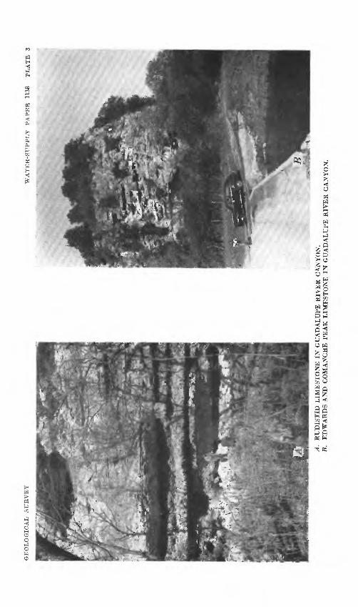
GE
OL
OG
ICA
L
SU
RV
EY
WA
TE
R-S
UP
PL
Y
PA
PE
R
1138
P
LA
TE
3
A.
RU
D1S
TID
LIM
ES
TO
NE
IN
GU
AD
AL
UP
E R
IVE
R C
AN
YO
N.
B.
ED
WA
RD
S A
ND
CO
MA
NC
HE
PE
AK
LIM
ES
TO
NE
IN
GU
AD
AL
UP
E R
IVE
R C
AN
YO
N.

STRATIGRAPHY 25
Orayson (Del Rio) shale
Like the Georgetown limestone, the outcrops of the Grayson shale are confined to the belt between the Comal Springs fault and the Bat Cave fault, in many places occurring in isolated patches in depressions in the Edwards limestone. The Grayson appears to lie conformably on the Georgetown limestone.
In the outcrop area the thickness of the Grayson shale is about 30 feet; in wells it is generally reported as 40 feet thick.
In Comal County the Grayson is predominantly a marl. It weathers to a buff color at the surface but drill cuttings are usually blue. Geologists and drillers alike look for the characteristic fossil Exogyra arietina Roemer, an oyster having a shell shaped like a rani's horn. This fossil is particularly abundant in the lower part of the formation and in some parts of the formation are cemented together to form beds of limestone 12 to 18 inches thick. The Grayson is probably the most impermeable formation in Comal County and many surface reservoirs or tanks for stock use are constructed in the outcrop area of this formation.
Solutional cavities at unconformable contacts and their relation ship to the circulation of ground water in limestones have been recog nized by Piper (1932, p. 74) in Tennessee and by Nye (Fiedler and Nye, 1933, p. 88) in New Mexico.
The observed thickness of the Georgetown limestone in the outcrop area in Comal County is about 15 feet, but in wells the thickness reported by drillers is from 40 to 50 feet. This is measured as the thickness between the last clay bed in the Grayson (Del Rio) shale and the appearance of water, presumably in the top of the Edwards limestone. The Georgetown appears to be conformable with the Grayson (Del Rio) shale above it. In many places there is an abun dance of well-preserved brachiopods of the species Kingena wacoensis (Roemer) in the thin marly beds at the top of the formation. These beds are about 2 feet thick and grade downward into massive lime stones that weather to a buff color. In some places the limestone has a brittle porcelaneous texture similar to some beds in the Buda limestone. In the lower beds the fossil oyster of the genus Alectry- onia, an oyster recognized by the zigzag pattern on the margin of the shell, is fairly abundant. In many places however, it is difficult to distinguish the Georgetown from the Edwards.Buda limestone
The Buda limestone is believed to lie conformably upon the Gray- son shale but there are few good exposures of the contact between the two formations. The thickness of sections lying north and north west of the Comal Springs fault does not exceed 30 feet. In wells south and southeast of the Comal Springs fault (see logs of H39 and
26 GEOLOGY AND GROUND-WATER RESOURCES, COMAL COUNTY, TEX.
G75), thickness of 52 feet and 70 feet, respectively, have been reported. In many places in the outcrop area low brushy or wooded ridges are covered by boulders of Buda limestone which extend onto the slopes of the underlying Grayson. The Grayson becomes more or less plastic when wet, and small landslides cause the overlying beds of the Buda to give way and to break up into boulders.
The greater part of the Buda limestone as observed in Comal County is hard and brittle and has a porcelaneous texture. Its color is gray, yellow, and red and in most places it is speckled with small spots of darker-colored rock reported to be oxidized glauconite. Some of the outcrops of the Buda are honeycombed but the formation is not known to yield water to wells in Comal County.
GUIF SERIES
The Gulf series is represented in Comal County in ascending order by the Eagle Ford shale, the Austin chalk, and the Taylor marl and its probable age equivalent, the Anacacho limestone.Eagle Ford sliale
The Eagle Ford shale, lowest formation of the Gulf Series, lies unconformably on the Buda limestone of the Comanche series. It is found at the surface only between the Comal Springs fault and the Bat Cave fault.
According to Stephenson (1929) "The * * * Gulf series of Texas is separated from the Comanche series below by an unconformity which certainly represents a considerable interval of geologic time."
In Comal County there appears to be no discordance in dip between the Eagle Ford shale and the Buda limestone but in some places the Buda is very thin. West of the road between Highway 46 and the Hueco Springs road the Eagle Ford appears to rest directly upon the Grayson shale but the Buda may be obscured by land slides in the Grayson and by complex faulting.
In most places in Comal County the Eagle Ford shale is about 30 feet thick and is composed of sandy yellow clay. The black clay or lignitic facies is not conspicious at the surface but is nearly always reported in well logs. Good exposures of the Eagle Ford are found along the old Austin Post Road east of New Braunfels, near the Hays County line.
The Eagle Ford is not a water-bearing formation in Comal County.Austin chalk
In Comal County the Austin chalk lies unconformably on the Eagle Ford shale. This wide-spread unconformity has been described by Stephenson.
According to drillers' logs, the Austin chalk is 135 to 150 feet thick in the area south of the Comal Springs fault. In the outcrop area
STRATIGRAPHY 27
between the Comal Springs fault and the Bat Cave fault only thin remnants are found. Here it is a nearly white chalky and fossiliferous limestone and its characteristic appearance is fairly uniform from top to bottom. Remnants of the formation crop out north of the Comal Springs fault in the vicinity of Bracken; along Highway 36, 6 miles northwest of New Braunfels; and also east of New Braunfels. South of the fault the Austin is exposed in the beds of Cibolo Creek and the Guadalupe River.
The formation is not generally prolific as an aquifier. Eight wells recorded in Comal County are known to draw water from the Austin chalk. One of these (Gil) at Hunter, flows a small stream during wet seasons. Some of these wells yield water with a hydrogen sulfide odor. In most of the area where the Austin chalk has been uncovered, surface and ground water have begun to dissolve the rock. Fairly large solutional cavities were observed along Cibolo Creek, just above the bridge on U. S. Highway 81.Anacacho limestone and Taylor marl
According to Stephenson (1937, pp. 135-136) the Anacacho lime stone and the Taylor marl are of the same age, and the limestone facies of the Anacacho west of San Antonio merges with the marl of the Taylor in Comal County. Typical exposures of Taylor marl are found in the eastern part of the county. In the western part of the county the Anacacho limestone also contains marly beds but limestone beds are absent. Only small nodules of lime remain.
Stephenson (1937, p. 136) also states that both formations lie unconformably upon the Austin chalk and describes two sections that were observed at the contact.
According to the drillers' logs of well G75 and G41 the Taylor marl and Anacacho limestone, considered as a unit, has a thickness of about 300 feet. Neither the Taylor nor the Anacacho is found in any part of the area north and northwest of the Comal Springs fault. Southwest of New Braunfels, below the escarpment, a few wells are believed to draw water from the base of the Taylor and Anacacho, where from 0.5 to 2 feet of sandy lime or gravel has been reported. This sand or gravel may be fed through the cavernous limestone in the upper part of the Austin chalk. The spring (G64) on the Altgelt farm 2% miles southwest of New Braunfels may be from this source.
TERTIARY (?) SYSTEM
PLIOCENE (?) SERIES Uyalde gravel
The Uvalde gravel occurs only in small remnants on hilltops. These remnants are effective in retarding erosion in the same manner that ballast protects a railroad track. Because of the small size and
993963 52 3
28 GEOLOGY AND GROUND-WATER RESOURCES, COMAL COUNTY, TEX.
thickness of the outcrops and the topographic'position which permits the water to seep out rapidly, no water is obtained from wells in the Uvalde gravel.
QUATERNARY SYSTEM
PLEISTOCENE SERIES Ijeona formation
The Leona formation is composed of limestone gravels, sand, and clay arranged in terraces by the present streams in their valleys. The terraces overlie all formations crossed by the streams and the forma- ation ranges in thickness from a knife edge to a probable maximum of 65 feet. (See driller's log of G40.) The formation is found mainly in the valleys of the Guadahipe River and Cibolo Creek. In the valleys above the escarpment formed by Comal Springs fault, the Leona fills old abandoned meander channels and is rarely used as a source of water, probably because of leakage into underlying rocks and drainage into the streams. However, one dug well 50 feet deep (G40), 13 % miles southwest of New Braunfels and in the valley of the Cibolo, has served more than 50 years without failure.
Below the escarpment and between the Guadalupe River and Alli gator Creek, the Leona formation overlies the relatively impervious Taylor marl and provides a dependable ground-water supply for a considerable number of families. Failures in this area are unknown. The log of well G40, 3 miles northeast of New Braunfels, indicates the kind of material encountered in the Leona. Depth-to-water meas urements indicate that normally not more than 10 feet of this mate rial is saturated with water. Because of this fact, the Leona would probably not supply enough water for large-scale irrigation.
STRUCTURAL GEOLOGY
FAULTS
In Comal County the development of ground-water reservoirs, par ticularly reservoirs in the Edwards, Comanche Peak, and Glen Rose limestone, and the position of the main channels of movement of ground water are closely related to a system of faults in the Balcones fault zone. This zone is 20 miles wide in places and extends from near Waco southwest through Comal, Bexar, and Medina Counties into Uvalde County. The faults are roughly parallel, and in Comal County the zone includes seven major faults that trend in directions ranging from S. 45° to S. 60° W. In general, the hades of the faults, are steep. In many places the traces of the faults form nearly straight, lines in fairly rough topography indicating that the hade may be nearly vertical. Clinometer measurements at a few places along the Comal Springs fault show that the hade ranges from 20° to 30° from the vertical.
STRUCTURAL GEOLOGY 29
In the following paragraphs the major faults are discussed in the order of their occurrence from southeast to northwest. (See geologic map and cross section, pi. 2.)
COMAL SPRINGS FAULT
The most conspicuous fault in the zone forms the escarpment sep arating the Coastal Plain from the Edwards Plateau, and is here designated the Comal Springs fault. The fault enters the eastern part of the county near Hunter, passes through Landa Park at New Brauiifels, and continues westward through Bracken near the south western extremity of the county. Comal Springs issue from fissures along this fault. At some places along-the fault the Taylor marl is brought in contact with the Edwards limestone, indicating the possi bility of a stratigraphic displacement of 400 to 600 feet. North of this fault, water in the Edwards limestone occurs under water-table (unconfined) conditions and is of good chemical quality. South of the fault the Edwards is buried to a depth of several hundred feet; the water in it is under artesian pressure and is highly mineralized.
HUECO SPRINGS FAULT
The second major fault, called the Hueco Springs fault in this report, enters the eastern boundary of the county about a mile nortk of the Comal Springs fault, crosses the Guadalupe River at Hueco Springs, about 2% miles north of Comal Springs, and continues west ward across the westward boundary of the county about 4 miles north of Bracken. Structural relations along this fault are complex. Where the fault crosses Highway 46, between wells 227 and 390, the rocks at the contact are crushed into a fault breccia and secondary cal careous material fills the spaces between the boulders. From this point to the river the rocks dip northeastward toward the river at the rate of about 200 feet to the mile. Oil the east side of the river, oppo site Hueco Springs, the fault has brought rocks of the Georgetown limestone, containing an abundance of specimens of the fossil Kingena, wacoensis (Roemer) in contact with beds containing Exogyra texana (Roemer) probably of Walnut age. It is difficult, however, to deter mine the amount of displacement along the fault because of the thin ning of the displaced formations and the unconformities between them. Moreover, there is possibility that a part of the apparent displacement is due to the collapse of roofs of former caverns in the Edwards limestone. In most of the area between the Comal Springs fault and the Hueco Springs fault, the Edwards limestone crops out, and an adequate supply of good water for farm and ranch use may be obtained from wells.

30 GEOLOGY AND GROUND-WATER RESOURCES,, COMAL COUNTY, TEX.
BAT CAVE FAULT
The third fault, called Bat Cave fault, enters the eastern boundary of the county about 2 miles north of the Comal Springs fault, crosses the Guadalupe River about 2 miles north of Hueco Springs, and crosses the western boundary of the county 5}£ miles northwest of Bracken in the vicinity of Bat Cave. East of the Guadalupe River this fault forms the south side of a downfaulted block or graben in which a narrow wedge of younger rocks appears between outcrops of Edwards limestone. Actually the graben may be a slump or valley sink produced by the collapse of a former cavern in the Edwards limestone, which lowered the younger rocks below the level of the Edwards limestone, thus protecting the fallen block from erosion. In the western part of the country where the faulting has brought the upper member of the Glen Rose limestone in contact with the Edwards limestone, the displacement is estimated to be about 300 feet. A hole drilled to a depth of 500 feet on the Dietz Ranch about 300 feet northwest of well F33 is believed to have passed through the fault plane. Normally plenty of water is available in the Edwards at this locality, but this well did not strike any water. The dry hole may be due to the presence of relatively impervious pulverized rock which was ground between the two walls of the fault in the process of move ment. Another possible explanation is that the underground channels at this point have been filled with mud carried in by infiltrating sur face waters. The Edwards limestone is exposed at the surface over most of the area between the Hueco Springs and Bat Cave faults and together with the underlying Comanche Peak limestone is thick enough to transmit large volumes of water. Farm and ranch wells in the area obtain adequate supplies from the limestone.
BEAR CKEEK FAULT
The fourth or Bear Creek fault crosses the Guadalupe River about a mile southwest of Sattler. From this point it can be traced more or less continuously southwestward to Bear Creek and thence to Cibolo Creek at the west boundary of the country, where it was observed about 6 miles south of Smithsons Valley. The fault has less displacement than the three already mentioned. Between the Bat Cave and Bear Creek faults the thickness of the Edwards lime stone has been considerably reduced by erosion; and in the deeper valleys, the streams have cut through both the Edwards, and Co manche Peak limestones into the upper part of the upper member of the Glen Rose limestone. The Glen Rose within this block is believed to dip southeastward and generally is at a higher level than the water level in the Edwards and Comanche Peak limestones southeast of the Bat Cave fault. Thus the ground water in the Edwards limestone
STRUCTURAL GEOLOGY 31
between the Bat Cave and Bear Creek faults tends to drain toward the block southeast of the Bat Cave fault. This is indicated by the failure of some wells, such as wells F20 and F16, to obtain an adequate supply of water for ranch use from the Edwards and Comanche Peak limestones.
HIDDEN VALLEY FAULT
The fifth major fault or Hidden Valley fault crosses the Guadalupe River near the lower end of Hidden Valley and thence continues southwestward across the county to a point on Cibolo Creek about 5 miles east of Bulverde. The average displacement of the strata along this fault is estimated to be about 200 feet. Between the Bear Creek and Hidden Valley faults, the Edwards limestone is thin and the areas of the upper member of the Glen Rose limestone exposed at the surface are larger than they are between the Bat Cave and Bear Creek faults. It is believed that most wells in this area must pen etrate strata below the Edwards and Comanche Peak limestones to obtain sufficient water for ranch use.
TOM CREEK FAULT
The trace of the sixth major fault or Tom Creek fault passes about half a mile south of Hancock, in the eastern part of the county, and thence crosses the county in a fairly straight line which passes about a quarter of a mile south of Smithsons Valley post office. Tom Creek follows the trace of the fault for about 5 miles between Hancock and Smithsons Valley. In the area between the Hidden Valley and Tom Creek faults, the upper member of the Glen Rose limestone covers most of the surface, and the Edwards and Comanche Peak limestones are found only as caps on the higher hills. Along the river, small areas of the lower member of the Glen Rose lime stone are exposed. In this area only small yields are reported from the upper and lower members of the Glen Rose limestone, but sat isfactory yields have been obtained from deep wells (as in well F3) in the Travis Peak formation.
SPRING BRANCH FAULT
The seventh fault, called the Spring Branch fault in this paper, is really twin faults that are probably contemporaneous and are closely related to each other. The trace of the first one was observed about a mile north of Fischer Store, and from this point it extends southwestward to the Guadalupe River. The second part of the fault is about 1% miles north of the first and extends in the same general direction about 2% miles each way from Spring Branch post office. The maximum displacement along these faults is probably about 200 feet. In most of the area between the Tom Creek and
32 GEOLOGY AND GROUND-WATER RESOURCES, COMAL COUNTY, TEX.
Spring Branch faults the lower member of the Glen Rose limestone is exposed over the greater part of the area, the upper member oc cupying only the areas of higher altitude. The Spring Branch faults mark the southeastern limit of the outcrop of the Travis Peak for mation in Comal County. North of the Travis Peak area the lower member of the Glen Rose occupies the valleys and the upper member the more elevated areas. Water for domestic and ranch use is obtained from wells and springs in the lower member of the Glen Rose limestone and from the Travis Peak formation.
MINOR FAULTS AND FOLDS
There are many minor faults parallel to the trend of the major faults, some of which have not been positively identified because of the lack of horizon markers in the area in which they occur. Other small faults diverge from the major faults, notably east and northeast of New Braunfels and in the vicinity of Braken and Selma. Near Bracken there is evidence of folding and faulting in a direction more or less transverse to the trend of the major faults. These structural features appear to have had some effect upon the direction of the movement of water in that area.
CAUSE OF FAULTING
Individual faults in the Balcones fault zone seem to be definitely related to each other in origin because of their roughly parallel pattern. Most of them are normal faults with downthrow to their southeast, and they are generally regarded as having been caused by the gradual sinking of the Coastal Plain with reference to the Llano uplift. Stephenson (1928, p. 899) has pointed out, however, that uplift may have occurred as well as sinking. Foley (1926) produced a group of faults similar to the Balcones faults in laboratory materials by apply ing tensional forces.
AGE OF FAULTING
The age of the faulting along the Balcones fault zone has not been accurately determined, but it is believed that faulting may have occurred from Early Cretaceous to Recent geologic time. Sayre (1936, p. 29) states that in Medina County the faults are believed to be late Pliocene or early Pleistocene, though possibly early Pliocene or Miocene in age. Bryan (1933, pp. 439-442; 1936, p. 1357) has presented evidence to show that there have been three movements along the Balcones fault zone at Waco, Tex., the first during Early Cretaceous time, the second during Georgetown time, and the third during very recent time. The Comal Springs fault extends the length of the county, through New Braunfels, causing a bold escarpment with an extremely youthful appearance. The escarpment seems to have been only slightly eroded as though it might have been formed

STRUCTURAL GEOLOGY 33
very recently. This appearance may be deceptive, however, as much of the Edwards limestone has been removed internally by solution of infiltrating waters instead of by external erosion. None of the other faults in Comal County retains this youthful appearance because the escarpments have been removed by erosion. However, as previously stated, rapids are found in the Guadalupe River at nearly every place that a fault crosses the river (pi. I A).
OTHER STRUCTURAL FEATURES
SAN MARCOS ARCH
One of the older structural features of the area is the broad San Marcos arch, which was pointed out by Stephenson (1928, pp. 887- 889) in 1928 and was later named by Adkins (in Sellards, Adkins, and Plummer, 1932, p. 266). The axis of this arch extends southeast ward from the Llano uplift through San Marcos in Hays County and thence follows the course of the San Marcos River toward Gonzales in Gonzales County. In Comal County the results of this uplift are seen in the thinning or absence of sediments that normally occur be tween the Edwards limestone and the Taylor marl. Topographic expression of the arch is lacking or is obscured by the more abrupt movements of the Balcones fault zone.
In addition to the deformation related to faults of the Balcones fault zone, a large number of small faults and steep dips are definitely related to sinks and probably bear no relation to deep-seated crustal movements.
REGIONAL DIPS
The regional dip of the Cretaceous rocks on the Edwards Plateau is generally accepted to be about 15 feet to the mile in a southeasterly direction. In the Coastal Plain the dip steepens considerably, par ticularly at depths where the seaward thickening of the younger for mations has taken place. In Comal County, however, as a result of crustal deformation, there are many departures from the regional dip. In the vicinity of faults, the dips are likely to be abnormally steep. Stephenson (1937, p. 136) observed a perceptible northwest dip in the Austin chalk and Taylor marl on the Guadalupe River about 2 miles south of the Comal Springs fault.
In addition to these local irregularities, in the eastern part of the county there is a rather general steepening of the dip of the rocks east ward. For example, the top of the Glen Rose limestone crops out in the small valleys on the east side of the Guadalupe River at an alti tude of about 900 feet. In a number of wells east of these valleys, the Edwards limestone is found in wells at considerable depth. In well Cl2 a limestone reported as Edwards limestone (but probably Comanche Peak) was found at a depth of 482 feet, or at an altitude
34 GEOLOGY AND GROUND-WATER RESOURCES, COMAL COUNTY, TEX.
of 374 feet. This indicates an eastward dip of at least 526 feet in about 5 miles, or more than 100 feet to the mile.
SINKHOLES
The solution of limestone by ground water may result in the devel opment of large caverns. If such a cavern becomes so large that the roof is not able to support its own weight, the roof will collapse, leav ing a large hole or pit in the surface of the ground. These holes may be more or less round or elongated or irregular in shape, depending on the shape of the cavern. Large sinkholes with vertical walls were not found in Comal County. A very few, ranging from 5 to 15 acres, in area, are circular and have gently sloping sides, suggesting that collapse kept pace with undermining. After heavy rains they are likely to hold water for several weeks. Smaller and less conspicuous sinkholes are more numerous and do not hold water.
Many of the sinkholes in the Edwards limestone in Comal County are filled with Georgetown limestone and Grayson shale. In some places, the Georgetown is completely covered by the Grayson so that only the Grayson appears to be in contact with the Edwards. Because of the lack of observable bedding planes, the dip of the Grayson shale in the sinks could not be determined. The Georgetown limestone generally dips steeply toward the center of the sink. The Edwards limestone on the perimeter of the sink may also dip toward the sink or may be faulted. These fault lines are generally curvilinear and often transverse to the trend of major faults. On the basis of these observations it is assumed that some of the caverns collapsed after the Georgetown was deposited.
Apparently such sinks or slumps are not unusual in Texas. Dumble, (1918, pp. 19-20) observed in the Edwards limestone deep ravines filled with Eagle Ford shale in areas west of the Pecos River, which he ascribed to disconformity. Adkins (in Sellards, Adkiiis, and Plum- mer, 1932, pp. 361 and 401) believes that these valleys were caused by underground solution and subsequent slumping.
METHODS OF WATER-WELL CONSTRUCTION
Most of'the water wells in Comal County have been drilled by the cable-tool percussion method. Ordinary farm and ranch wells are mostly from 5 inches to 6 inches in diameter. Most wells that started in the Georgetown limestone or older formations, including in descend ing order the Edwards limestone, the Glen Rose limestone, and the Travis Peak formation, do not require casing to prevent the caving of the softer beds. These are usually equipped with a short piece of galvanized iron casing to prevent soil from entering the well at the surface. Many uncased wells that have been drilled in to these

OCCURRENCE OF GROUND WATER 35
older formations are more than 50 years old and are still giving service. Some wells are equipped with one or two joints of wrought steel casing cemented around the outside of the casing from the surface of the ground to the bottom; from 1 to 2 feet of the casing protrudes above the ground. This not only provides a seat for a water-pipe clamp but it affords better protection from pollution or surface contamination.
Wells that penetrate the Grayson (Del Rio) shale, however, must be cased to solid limestone at the time the well is drilled because the clay in this formation will invariably cave as soon as it becomes wet.
Wells that are drilled in the Taylor marl or Anacacho limestone require casing. No caving beds are found in the underlying Austin chalk, but some clay beds in the Eagle Ford shale may cave if no casing is used.
In the Pleistocene alluvial deposits, the wells have an average depth of less than 60 feet. A few of the older wells have been dug by hand and are lined with rock. Drilled wells obtaining water from the alluvium require casing to prevent caving.
Most farm or ranch wells are equipped with a 2-inch drop pipe and cylinder pump. The cylinder is usually \% inches in diameter and is placed near the bottom of the 2-inch drop pipe, with a short piece of suction pipe below the cylinder. The bottom of the suction pipe extends almost the full depth of the well except in wells in which the yield and specific capacity (yield per unit of drawdown) are high.
Windmills are extensively used for power, but some pumps are powered by 1 %- to 5-horsepower gasoline engines. The wind is fairly dependable in Comal County, but emergency power or storage tanks holding 3 or 5 days' supply are needed in case the wind does not blow. Some ranchers equip their wells with a j ack and pulley so that a trac tor or automotive equipment can be used when the wind does not provide adequate power. Recently, as a result of the growth of the rural electrification system, electric power is being used for pumping on several farms and ranches. Where large amounts of water are needed, such as for the public supply for the city of New Braunfels, wells of larger diameter are drilled and turbine-type pumps powered by electric motors are used.
OCCURRENCE OF GROUND WATER, WITH SPECIAL REF ERENCE TO DISCHARGE AND SOURCE OF
COMAL SPRINGS
The occurrence of ground water in all classes of rocks and the conditions that control the movement of water from areas of intake toward areas of discharge have been described by Meinzer (1923a, pp. 2-192; 1923b, 68 pp.; 1942, pp. 385-497) and Wenzel. (1942,192 pp.). The section that follows is limited to a brief discussion of the occur-
36 GEOLOGY AND GROUND-WATER RESOURCES, COMAL COUNTY, TEX.
rence of ground water in Comal County. The springs and most of the wells in the county are supplied with water from ground-water reservoirs in limestones, of which the reservoir in the Edwards lime stone is by far the most important.
DEVELOPMENT OF THE RESERVOIR IN THE EDWARDS LIMESTONE
The permeability of most limestones as deposited is low. Small openings called primary openings are those that remain after consoli dation. Limestones that are composed largely of fossil shells or skeletons of sea animals, particularly corals, are likely to contain primary openings. The larger openings, however, are developed after deposition by fracturing and solution along the fractures. Slight earth movements or shrinkage during consolidation can cause frac tures in limestone. These fractures or joints generally are developed in two planes at a considerable angle from one another, and, if they intersect, continuous openings in a zigzag pattern may develop. The openings may be only as thick as a knife blade at the surface and still narrower at depth. These are the original passages from which larger channels are later developed by solution. Solutional cavities are generally classified as secondary openings.
Solution may take place during the over-all period of deposition in sea water by reason of slight physical or chemical changes. Sea water at 30° C. is generally saturated with carbon dioxide. Eevelle (1934) states:
Except for water in equilibrium with the atmosphere, the most important factor controlling the solubility in sea water is the CO2 content of the water which in turn is chiefly dependent on the nature and extent of biological activity. The order of importance of the other factors is temperature, salinity, and hydrostatic pressure.
In the process of the formation of limestone reefs which are generally permeable, it seems possible that solution may begin with the release of carbon dioxide when the animals that secrete the shells begin to decay. The molecular structure of calcium carbonate may also be a factor in the relative solubility of limestones. Many species of sea animals secrete shells composed of aragonite instead of calcite. Accord ing to Foote (1900, pp. 740-759), aragonite is more soluble than calcite under similar conditions. In Comal County there are many exposures of limestones in which the original shell material of the fossils has been dissolved, leaving only moulds of the shells.
After the limestone has been elevated and removed from its original environment it becomes subject to solution by meteoric waters. It is generally recognized that an increase in the carbon dioxide in meteoric waters increases the solvent action on limestones manyfold. Water acquires carbon dioxide while passing through the air and through soils containing decaying vegetable matter. As pointed out

OCCURRENCE OF GROUND WATER 37
by Swinnerton (1932, pp. 658-660), the chemical process is complex, depending on a number of physical factors.
Solution and deposition are in delicate balance, depending on such factors as small changes in temperature and pressure, so that under ground streams may dissolve calcium carbonate at one place and at the same time deposit calcium carbonate at another. In the cores obtained from well G39 (see log) large vugs lined with crystals of secondary calcite were found at a depth of about 300 feet below the present water table.
Originally the Edwards limestone in Comal County may have contained beds of gypsum which have been removed by solution, gypsum being much more soluble than calcium carbonate. Barnes (1943, pp. 35-46) reports beds of gypsum in the Edwards limestone in Gillespie County as much as 35 feet in thickness; he named these the Kirschberg evaporite. These deposits are about 60 miles north west of New Braunfels.
Some idea of the solvent action of ground water on the limestones in Comal County may be obtained from the chemical character of the water that issues at Comal Springs. The dissolved solids in the water at the spring average about 285 parts per million. The average flow of the springs over a period of about 20 years has been 320 cubic feet per second. On this basis an average of more than 200 tons of rock material is carried away daily in solution by the water that issues from these springs.
Ordinarily the development of underground limestone reservoirs is related to surface drainage. When a thick, dense, soluble limestone, such as the Edwards limestone, has been elevated above the lines of regional drainage, the development of underground drainage channels progresses much in the same manner that surface drainage is developed from an initial stage to maturity. This analogy has been described by Davis (1930, pp. 475-628), Swinnerton (1932, pp. 663-627), and Piper {1932, pp. 79-86). Just as the surface streams are first developed more rapidly along main drainage channels and grow by head ward erosion, the underground streams in limestone are first larger and develop most rapidly in the vicinity of the main streams, and gradually work back to underground divides. In Comal County the normal development has been modified by faulting. It is believed that the main underground channels in the Edwards and Comanche Peak limestones that lead water toward Comal Springs are more or less parallel to the lines of major faulting, which are more or less trans verse to the direction of flow of the main surface streams.
It is difficult to determine the area of Edwards limestone exposed to surface drainage during the encroachment of the Georgetown sea. However, the outcrop area of the Edwards limestone was probably

38 GEOLOGY AND GROUND-WATER RESOURCES, COMAL COUNTY, TEX.
much larger during that time than it is now. The permeability of the upper part of the Edwards limestone in the San Antonio area (Living- ston, Sayre, and White, 1936, pps. 58-113), now faulted down and covered by younger formations, may have been caused in part by solution in marine waters, but such extensive cavities are more likely to have been caused by the solutional action of meteoric waters.
At the outcrop in Comal County, the Edwards limestone and the Comanche Peak limestone beneath it are thoroughly honeycombed from top to bottom. In the log of test hole Gl7 (see logs of wells) drilled by the Corps of Engineers, United States Army, to the bottom of the Comanche Peak limestone, nearly all of the 237 feet of material was described as porous; the total footage of caves was 24 feet, the largest cave being 3 feet deep, between 179 and 182 feet.
DEVELOPMENT OF RESERVOIRS IN THE GLEN ROSE LIMESTONE
In the lower member of the Glen Rose limestone, the earlier stages of the development of a limestone reservoir in relation to surface drainage lines are more celarly shown. This development could not progress rapidly until much of the cover of Edwards limestone and upper member of the Glen Rose limestone had been removed. This condition exists in western Comal County.
Although the Guadalupe River and Cibolo Creek have youthful characteristics at present, the wide meanders and broad terraces on the Guadalupe above Sattler and on the Cibolo above Bracken sug gest that these streams have passed through mature stages and that the limestones in these areas have been exposed to erosion and under ground solution since early Pleistocene time or possibly for a longer period. Along the main stream the lower member of the Glen Rose is honeycombed at the surface and caverns have developed, particu larly along Cibolo Creek, where the surface runoff is negligible except after very heavy rains. However, in the interstream areas where the massive limestones are protected by overlying shale beds solutional cavities are small and the lower member of the Glen Rose limestone yields only small amounts of water.
GROUND-WATER DISCHARGE
COMAJL SPRINGS (F63)
Comal Springs have the largest average discharge of any known springs in the southwestern part of the United States. The average flow during the 19-year period 1928-46 was 324 second-feet (cubic feet a second) or about 210,000,000 gallons a day. This is equivalent to 640 acre-feet a day or 235,000 acre-feet a year. It is greater than the average surface runoff from the 1,423 square miles drained by the Guadalupe River above the Spring Branch gaging station during the same period. The lowest recorded discharge of the springs was 245
OCCURRENCE OF GROUND WATER
second-feet, which was greater than the discharge of the Colorado River at Austin (drainage area 38,200 square miles) during dry periods, before the Buchanan and Lake Travis reservoirs were put into opera tion. For example, the average daily flow of the river at Austin was less than 245 second-feet for periods of varying length aggregating 9& days during the water year from October 1929 to September 1930.
The discharge of the springs is better sustained than that of any other of the large springs of the Balcones fault zone; the minimum flow is about 58 percent of the maximum flow and about 76 percent of the average. The minimum, maximum, and average recorded dis charge of the most inportant springs of the fault zone, including Coma! Springs, together with the ratio of the minimum discharge to the max imum and average discharge are given in the table which follows. (See also table 17.)
TABLE 8. Comparison of minimum, maximum, and average discharge of Comal Springs and other important springs of the Balcones fault zone, Texas
Springs
Comal at New Braunfels. _ _ .San Marcos at San Marcos_______ Barton at AustinLas Moras near BrackettvilleSan Felipe l at Del Rio _________Goodenough 1 near Comstock_____
Discharge in second-feet
Mini mum
245 51 12
5. 8 41 96
Maxi mum
420 286 139 60
150 700 ±
Average
324 153 41 2276
179
Ratio of minimum to maximum discharge
(percentage)
58 18
8. 7 9. 6
27 14
Ratio of minimum to
average discharge
percentage)
76 33 30 27 54 54.
1 In westward monoclinal extension of Balcones fault zone.
The water from Comal Springs issues crystal clear at a temperature of about 74° F. from the foot of the escarpment formed by the Comal Springs fault. The water has been observed after relatively long dry periods and after heavy rains, in winter and in summer, and no trace of turbidity has been detected. The maximum observed variation in temperature is not more than a degree.
Roemer (1849, p. 139) observed the temperature of Comal Springs at different times of the year between December 1845 and April 1847, and was impressed by their constant temperature which he reports as 19K0 R. (19K0 Reumur=75.83° F.).
The water rises from a large number of openings in the Edwards limestone along a distance of 500 yards at the base of the Comal Springs fault escarpment. There is no spectacular rush of water, no discharge of gas with the water, and no travertine deposits in the vicin ity of the springs. The springs supply nearly all of the water that flows in Comal River which joins the Guadalupe River at a point about 1
40 GEOLOGY AND GROUND-WATER RESOURCES, COMAL COUNTY, TEX.
mile east of the Springs and at a level about 40 feet below the level of the springs (pi. 4A}.
The facts observed at Comal Springs reveal much of the story of ground water in Comal County. In order to account for such a large and constant volume of discharge, the conclusion is inescapable that the area of intake must be of the magnitude of many hundreds of square miles. In view of the limited area within the county that is favorable for rapid infiltration of rainfall or stream water to the ground- water reservoir supplying the spring, the source of some of the water must be beyond the corporate limits of the county.
The lack of turbidity suggests that t^e water moves slowly under ground and that a part of its course is through an intricate network of small openings rather than through large tubular caverns, so that the rate of flow is retarded and sediment has an opportunity to settle out. The temperature of the water at the springs, which is 6 degrees higher than the average air temperature observed by the United States Weather Bureau at New Braunfels, suggests that the paths of circula tion within the reservoir may reach depths of 300 to 500 feet below the surface because the temperature of ground water generally in creases with depth. Cores from well G49, near Comal Springs, contained solutional cavities at the bottom of the hole, 320 feet below the surface.
HTJECO SPRINGS (G18)
Hueco Springs appear on the west side of the Guadalupe River about 3 miles north of Comal Springs. The water issues from stream gravels in two places, one about 400 and the other about 200 feet west of the river.
The westernmost spring comes to the surface at an altitude of about 645 feet and is about 4 feet above the bed of the river; the other spring is nearer the river and is about 10 feet higher than the stream bed. The springs appear to rise a few feet north of a fault having several hundred feet of displacement, the trace of which can be seen in the bed of the river (pi. 1A). In dry years the springs are dry for months at a time. From August 1944 to February 1947 a period in which the average rainfall was exceptionally high, 25 discharge measurements showed a range in the flow of the springs from 13.2 to 96.0 second-feet or about 7 to 62 million gallons a day. (See table 13 and discussion by S. D. Breeding on p. 139.)
In contrast to that of Comal Springs, the temperature of Hueco Springs fluctuates as much as 3°. In 23 observations made between January 22,1944, and December 30, 1945, the temperature ranged from 68° in winter to 71° in summer (table). The water is ordinarily clear but becomes slightly turbid during the first flow after heavy rains, particularly after a dry period. No gas issues from the water and no
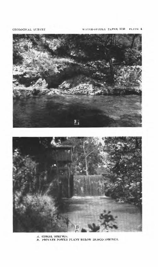
GEOLOGICAL SURVEY WATER-SUPPLY PAPER 1138 PLATE 4
A. COMAL SPRINGS.B. PRIVATE POWER PLANT BELOW HUECO SPRINGS.

OCCURRENCE OF GROUND WATER 41
travertine deposits are found in the vicinity of the springs. The water is used by the owner, R. W. Gode, to operate a small power plant (pi. 4). Observations of Hueco Springs indicate that the area of recharge is relatively small.
OTHER SPRINGS
A number of other springs were observed in the county, but it is believed that their occurrence is not related to the underground reservoir that supplies Comal Springs.
Two springs (B35 and B36) issue, from fault crevices in the lower member of the Glen Rose limestone in the bed of the GuadalupeRiver about 2 miles southwest of Hancock. The springs make only a slight bulge in the surface of the stream and are most conspicuous when the river is muddy because the spring water is clear. The combined discharge of these two springs, computed from the difference in the discharge of the river above and below the springs, was 14 second- feet or about 6,500 gallons a minute on Sept. 18, 1944 (U. S. Geol. Survey, 1946, p. 301). The spring water at that time was reported to be much colder than the river water.
Farther upstream, on the Guaclalupe River, 3/£ miles west of Hancock, on the J. D. Nixon ranch, a spring (B29), called Big Spring, issues from solution cavities in the lower member of the Glen Rose limestone about 10 feet above the level of the river. Two discharge measurements (U. S. Geol. Survey 1931 p. 76; 1932, p. 75) made at periods of low flow of the river, indicate a flow of 3.9 second-feet (1,750 gallons a minute) on January 18, 1928, and 2.9 second-feet (1,290 gallons a minute) on February 21, 1929. The average dis charge of the spring may be somewhat greater than is indicated by these measurements, which were made during periods of low rainfall.
Rebecca Creek Spring (A5), 9 miles northwest of Hancock, had an estimated discharge of 1,500 to 2,000 gallons a minute on October 7, 1943. The temperature of the water on that date was 70° F. The spring issues from fissures and solution cavities in the Cow Creek limestone member of the Travis Peak formation.
The discharge of Spring Branch, which enters the Guadalupe River near Spring Branch post office in the northwestern part of the county, is maintained by two springs, one at the head of the branch (A12), and the other a smaller spring (A16), about a mile downstream. Spring A20, on the H. C. Plumly ranch, issues from a cavern at the base of the lower member of the Glen Rose limestone. Records of additional discharge measurements show a flow of 1.5 second-feet on January 18, 1928, and 0.9 second-foot February 20, 1929. When visited by the writer on March 28, 1945, the discharge was estimated to be about 11 second-feet or 5,000 gallons a minute. The lower spring (A16), visited on the same day, issues from a crevice in the Cow
42 GEOLOGY AND GROUND-WATER RESOURCES, COMAL COUNTY, TEX..
Creek limestone member of the Travis Peak formation at an estimated rate of 50 gallons a minute. It supplies a school house and a small community by means of a hydraulic ram.
Honey Creek Spring (A28), on the Weidner ranch, 7 miles north west of Bulverde, flows from a cavern at the base of the Glen Rose limestone, near the contact with the underlying Travis Peak formation. On July 20, 1944, the discharge of the spring was estimated to be 1,000 to 1,500 gallons a minute, and the temperature of the water was 69° F.
One spring (F66) is believed to have its source in the Austin chalk,, although the water rises through an opening in the Taylor marL This spring, the property of the Altgelt Farm Association, is 2% miles: southwest of New Braunfels. The average discharge of the spring is estimated to be 50 gallons a minute.
A fault spring (F5), on the south side of Bear Creek near the Bear Creek road, issues from the upper members of the Glen Rose limestone, not far below its contact with the Edwards limestone. The water probably seeps from, the Edwards limestone into the Glen Rose limestone along the fault plane. The flow was estimated to be 2,0001 to 2,500 gallons a minute on March 28, 1945, but only 200 gallons a. minute on September 29, 1945.
Eleven other springs (nos. B12, B17, B32, A2, B53, B52, E22, E36, E54, E58, and F4) which have maximum yields of less than 50* gallons a minute, are listed in the table of well and spring records.. All of them issue from the Glen Rose limestone, generally from thin beds of fine-grained sandy marl. Some of the larger springs are- associated with joint planes or faults with small displacements.
DISCHARGE FROM WELLS
Comparatively little water is withdrawn through wells from ground- water reservoirs in Comal County. The city of New Braunfels pumps from 1,000,000 to 2,000,000 gallons of water daily from three- wells (G46, G47, and G81) in the Edwards limestone along the escarp ment: and the Servtex Materials Company pumps an average of 1,250,000 gallons a day from a well (H29), also in Edwards limestone,, in the western part of the county. Total withdrawals by pumpage from wells probably does not exceed 4,000,000 gallons a dav.
GROUND-WATER RECHARGE
Ground water is derived chiefly from water that falls as rain or snow. A part of the precipitation runs off in streams; a part is returned to the atmosphere by evaporation and by transpiration of trees and other plants; and a part sinks into the zone of saturation,, in which the openings in the rocks are filled with water. In a given»
OCCURRENCE OF GROUND WATER 43
drainage basin the proportion of the rainfall that is carried away directly by the streams can be determined accurately by stream gag ing, but for a large area the proportions that are dissipated by evap oration and transpiration relative to the proportion that sinks to the water table as recharge can be only roughly estimated.
Perhaps the most important objective in the study of ground- water in the Balcones fault zone is the delineation of the intake areas of Comal Springs. On the basis of water-level measurements corre lated with the discharge of the springs, hydraulic gradients, and surface-water runoff it is believed that the greater part of Comal County can be eliminated as recharge area for Comal Springs.
WATER LEVELS IN WELLS IN RELATION TO RAINFALL AND DISCHARGEOF SPRINGS
Upward or downward movements of the surface of the water under ground are positive indications of increase or decrease of the volume of water in storage in the underground reservoir. Such movements are revealed by water-level measurements in wells. Estimates of recharge to sand or sandstones under water-table conditions can be made by measuring the rise in the level of the water in wells following each rain if the sand is fairly uniform in texture and if the water-table lies below the reach of the plant roots. In limestones, however, there is no uniformity in the size or the distribution of the openings, and the volume of voids, or space, available to receive the recharging- rainfall can not be estimated. For example, the wide variations in water-levels recorded in well E24 (fig. 2), in Glen Rose limestone in Comal County were probably owing to the fact that the openings in the limestone are small and consequently a relatively small amount of local recharge produces a large rise in water levels. In such wells a large decline in water-levels results from a small amount of pumping. Conversely, the graph of well A34, shown in the same figure, shows little variation in water levels, indicating large underground storage space in the vicinity of the well. The discharge of Comal Springs is the overflow from a ground-water reservoir, and the flow of the springs increases as the levels of the water in the wells tapping the reservoir rise.
A number of wells in Comal County have been selected as perma nent observation wells in which the depths to water have been meas ured periodically since 1934 at intervals ranging from 1 month to 1 year. The records for 54 wells, which have been measured 5 times or more, are given in table 20. Of the 54 wells, 3 draw water from the Travis Peak formation, 8 from the lower member of the Glen Rose limestone, and 39 from the Edwards limestone.

44 GEOLOGY AND GROUND-WATER RESOURCES, COMAL COUNTY, TEX.
The maximum difference between highest and lowest levels recorded in any of the wells in the Travis Peak is 52.64 feet, the minimum is 20.87 feet, and the average is 36.41 feet; in wells in the lower member of the Glen Rose the maximum is 264.53 feet, the minimum 5.66 feet, and the average 87.55 feet; and in wells in the Edwards limestone the maximum is 149.28 feet, the minimum 2.22 feet, and the average 14.08 feet.
Hydrographs for five of these wells are shown in figure 2. The graph for well E24 shows a range in water levels of 49.19 feet. The well is in the lower member of the Glen Rose limestone, is 248 feet deep, and is in an interstream area about 3/£ miles northeast of Bulverde. The water level can be lowered several feet by hand with a bucket and rope even though the lift is, at times, as much as 200 feet. The graph for well A34 gives the range between the maximum and minimum water levels of record as only 5.66 feet. This well is 9K miles northeast of Bulverde and only about a quarter of a mile from the Guadalupe River. It also draws water from the lower member of the Glen Rose limestone, at a depth of 108 feet. The well is equipped with a cylinder pump and windmill and there is no measurable draw down in the water level when the windmill is turning rapidly. These two wells illustrate the difference in yield and water-level fluctuations between wells that are near the main lines of drainage and wells in the interstream areas where solution channels have been poorly developed.
The water-level fluctuations in wells F44, G33, and G34 are more or less typical of those recorded from wells in the outcrop area of the Edwards limestone. The wells range in depth from 140 to 242 feet, and the fluctuations of water levels in them are of moderate range. None of the three wells in the Edwards has been tested for yield, but no shortage of water has been reported from any of them.
Heavy rainfall causes the water levels in wells in the limestone reservoir to rise, indicating an increase in the volume of water in stor age. As the water in storage increases, the discharge from Comal Springs also increases. Figure 3 shows the monthly precipitation near the spring at New Braunfels and at Boerne in the upper part of the drainage area of Cibolo Creek, about 35 miles west of the springs. Hydrographs of the fluctuations in the average monthly discharge of Comal Springs from 1932 to 1945, inclusive, and the monthly average water level in the Beverly Lodges well at San Antonio, about 28 miles southwest of the springs, are also shown. The Beverly Lodges well is an artesian well in the Edwards limestone, 756 feet deep. The hydrograph of the water level in this well is the only long continuous record available in the area and seems to correlate with the variations

45
E
=
E
|
=
|
1*
E
E
1
i
|
i
1
1
1
r"^
o
<f'
\
<
_--(
(M
1
i
1
1
1
1
*.
s>
"- o
f
1
1
1
1
1
}j~
0
\
o
0 r
I
°\
I io11o
-f
IO
a>
\
I a J.33J Ni"3aniaiv
/\
\
ft,O (
\o / o
/o </ /
o of ifoi
< ' s,
* tu.'
ID?
// 1?
R/X
//
/ /
"bJ1
i
\h\^\
1 1-
1 1 11
10 1 10 '
_lr°«-"a
i
,1'°i
Li0 t-
4t4«?0
ofo(^
i{-!0 j
aS
}
1
r~
r
s
S3HONI Nl 'NOIlVlldlOBdd

PRECIPITATION. IN INCHESALTITUDE, IN FEET DISCHARGE, IN SECOND-FEET'
L/
% XJ*
/
V
/?
Sf
If
^
SSPry
^3-
^
^
/
f >
/
fi>us[noo ^v]^[oa 'saaanosaa aaxvAi-aMioaD QMV Aooioao
OCCURRENCE OF GROUND WATER 47
in the discharge of Comal Springs. The water level in the well during the period of record has ranged from 38 to 69 feet below the land surface.
At the time of heavy general rains such as those of the periods May-July 1935, May-September 1936, and July-September 1942, the water level in the Beverly Lodges well rises quickly after each rain and finally reaches a high level which may be maintained from 1 month to 2 months after the period of heavy precipitation. The reservoir seems easily repleted and the changes in the volume of water in stor age respond more readily to rainfall than to withdrawals. As indi cated by the water levels in the Beverly Lodges well there was a steady decline in the amount of water in storage during the dry years from 1936 to 1940. Withdrawals for consumption also increased and the rate of withdrawals is still increasing in the San Antonio area but the heavy rains of 1941 and 1942 caused the water level to rise to the highest recorded level.
The increase in the discharge of the Comal Springs after rains follows a pattern that is similar in most respects to that of the rise in the Beverly Lodges well, except that the rise in the water level in the well occurs much sooner than the increase in discharge of the springs. The lag is especially pronounced after a long period of drought, but is much less during wet periods. For example, the water level in the Beverly Lodges well rose nearly 9 feet in three stages immediately after each heavy rain between October 23 and December 13, 1940, preceded by a relatively dry period of 30 months. In contrast to this the discharge of Comal Springs, which was at an exceptionally low stage, remained practically unchanged aside from slight temporary increases throughout October, November, and the first half of Decem ber, and finally had a sustained increase of about 10 percent on De cember 18. Once a rise takes place, however, it is likely to be sus tained for weeks or months, even through periods of unusually low rainfall.
It will be observed that the rise in water level and increase in the discharge of the springs is not always proportional to the amount of precipitation. In 1935 the average precipitation at Boerne and New Braunfels was 47.30 inches. Heavy rains in May started an upward movement in the water level in the Beverly Lodges well, culminating at 682 feet above sea level in July, whereas the peak in the discharge curve for Comal Springs did not come until January 1937, when it reached 375 second-feet. In 1942, after the relatively heavier rainfall of 1941, the average precipitation at Boerne and New Braunfels was 36.60 inches or 10.70 inches less than in 1935, yet the water level in the well rose to an altitude of nearly 681 feet and the discharge of Comal Springs at the end of the year was 418 second-feet or 43 second-

48 GEOLOGY AND GROUND-WATER RESOURCES, COMAL COUNTY, TEX-
feet greater than maximum discharge after the heavier rains of 1935. This is not surprising, however, as the surface runoff and the ground- water recharge are greatly affected by the distribution and the in tensity of rainfall.
The relationship among precipitation, water levels, and the dis charge of Comal Springs is shown in greater detail in figure 4, which gives the daily precipitation at New Braunfels, the daily fluctuations in discharge of the springs, and a hydrograph of the daily water levels in well F44 for 1942. Well F44 is about 2% miles west of Coma! Springs, is 242 feet deep, and draws from the Edwards limestone. The hydrograph, obtained by means of a continuous recorder, show the fluctuations in water level under water-table conditions.
During the first half of 1942 there was a steady decline in water level in the well in response to relatively low rainfall. The decline- was interrupted by several slight rises, notably in the second week of April, the last week of May, and the first week of July. The rise in both the water levels and the discharge of the springs began within a, day or two after the rains but the general trend seemed to depend upon the backlog of storage in the reservoir. In spite of the low rainfall in November and December, the rises that occurred after heavy rains in September and October were maintained until the end of the year.
MOVEMENT OF GROUND WATER
Ground water may be classified in regard to its origin as connate water or meteoric water. The water that is trapped in sediments at the time of their deposition is called connate water. This water may be a brine similar to present sea water, or even more concentrated. After the formation has been exposed to the surface, or lifted above sea level, the sea water may be gradually flushed out and replaced by water from rain or snow and only such minerals as may be dissolved from the rock in the process of circulation will be found in the water. For example, the Edwards limestone yields potable water to Comal Springs but contains salt water, petroleum, and gas in the oil fields of Caldwell County. Intermediate between these two kinds of water is that of poor quality found in areas where the circulation of meteoric water is comparatively slow as a result of structural features or because of clay or shale beds between beds of limestone. South of the Comal Springs fault a number of wells (for example, nosj G75 and G38) have been drilled to the Edwards limestone but have been abandoned because the water is too highly mineralized or has a hydrogen sulfide odor. This is strong evidence that there is very little circulation of water in the Edwards south of the Comal Springs fault in Comal County. In Bexar County (Livingston, Sayre, and White, 1936, p.
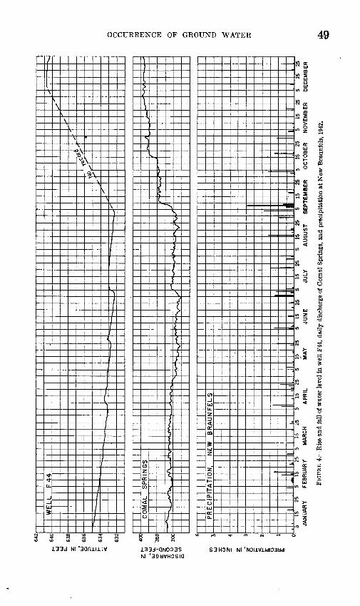
OCCURRENCE OF GROUND WATER
f m m m m
133d NI 'sonnnv
S 8
133J-QN003S NI '39HVH3SIQ
So: ,2
S £ 3
S3HONI NI '

50 GEOLOGY AND GROUND-WATER RESOURCES, COMAL COUNTY, TEX.
104), however, there is a large area, not defined by any one fault, which yields potable water.
In the upper member of the Glen Rose limestone many wells yield water of comparatively poor quality owing to the alternating beds of clay and shale that prevent the free circulation of meteoric water. In general, circulation decreases with depth and water obtained at great depths is likely to be of poor quality although there are many exceptions to this rule. Circulation of water in limestones may be retarded by natural puddling when solution channels become filled with clay or other detrital material carried into the formation by infiltrating meteoric waters after heavy rains. Weathering within the limestone usually produces a residue of red clay, which may also be washed into previously formed caverns. Beds of red clay are found in a number of places in the Edwards limestone. Natural puddling occurs, however, after connate waters have been flushed out of the limestone.
RATE OF MOVEMENT
The lack of turbidity in the water that issues from Comal Springs suggests that the water moves slowly underground and that a part of its course is through an intricate network of small openings that retard the velocity of the water to the extent that sediments are not carried along as in open streams. Locally, however, at some distance from the springs constricted openings may cause turbulent flow. The temperature of the water from Comal Springs is constant at about 74° F., whereas the mean annual temperature of the air recorded by the United States Weather Bureau at New Braunfels is 68° F. This suggests that the paths of circulation within the reservoir may reach depths of 300 to 500 feet below the surface at no great distance from the spring.
Cores obtained from G49, near Comal Springs and on the upthrow side of the fault, show that the Glen Rose limestone is vuggy at a depth of 320 feet. The presence of solutional cavities at 320 feet is not proof that water is circulating at this depth at the present time, but geologic evidence does not indicate that the water table has ever been lower, relative to the land surafce, than it is now at least not since the faulting took place.
The water from Hueco Springs, conversely, becomes slightly turbid after heavy rains and the temperature of the water fluctuates within a range from 3° to 6° lower than that of Comal Springs. These conditions, together with the fact that the springs have a wide range in discharge, suggest that the springs are supplied by a ground-water reservoir that is quite separate from that supplying Comal Springs, and that the intake area for this reservoir is smaller and closer to the point of discharge than the intake area of the Comal Springs reservoir.

OCCURRENCE OF GROUND WATER 51
The Hueco Springs fault is believed to divide the two reservoirs. This is indicated by a comparison between the altitudes of the water levels in wells in the Edwards iimestone on either side of the fault and the altitude of Hueco Springs. On the southeast side of the fault in the vicinity of the spring the maximum altitudes of water levels on record in wells G33, G32, F27, and G29 are approximately 636, 637, 641, and 636 feet, respectively (see table of water levels), whereas the alti tude of the lowest point of discharge for Hueco Springs is 645 feet. Just northwest of the fault the water level in well F26 has been re corded as high as 665 feet. Hueco Springs obviously could, not be fed by a reservoir having a water level lower than the point of dis charge, so that the reservoir must be northwest of the fault. It is not proved, however, that the fault acts as a barrier to the movement of ground water for the entire width of the county.
Springs in the Balmorhea area of Texas are believed to be close to the intake area and it was observed by White, Gale, and Nye (1941, p. 100), that an increase in discharge was accompanied by a decrease in the temperature and in the mineralization of the water. In table 9 the records of temperatures, hardness, and discharge measurements for Hueco Springs show no direct relationship among these factors.
The apparent lag in the increase in discharge of Comal Springs (figs. 3 and 4) following heavy rains and rises in water levels does not mean that the water actually moves from the vicinity of San Antonio to Comal Springs within the 1- or 2-month period indicated by the lag. Only the change in head due to added water in the intake area and Tn the reservoir itself is transmitted at this rate. The time required for the water that falls as rain on the intake area west of Comal County to reach Comal Springs would probably be expressed in years rather than in days or months. Much research has been directed toward the rate of movement of ground water, and with considerable success where the character and permeability of the materials that form the ground-water reservoirs are fairly uniform. As a result of this, research methods have been developed by Thiem (1906) and Theis (1935, pp. 519-524) by which it is possible to make quantitative estimates as to the possible yield of ground-water reservoirs. The methods are more generally applicable to sand and sandstone reser voirs because of the more nearly uniform character of such aquifers. The application of formulas for the determination of the permeability of the limestones in Comal County would be difficult not only because of the irregularities in the character of the openings in the limestones but because it is believed that the movement of the water may be under artesian conditions in a part of its course and under water-table conditions in other parts.

52 GEOLOGY AND GROUND-WATER RESOURCES, COMAL COUNTY, TEX.
TABLE 9. Temperatures, hardness, and discharge of Hueco Springs, Tex.
Date
1944 Jan. 22. _ ___________Sept. 14_. _________ _Oct. 9__ ______________Nov. 22_. _ ______Dec. 5 3 _____ _______Dec. 7-_-_-_-____.____Dec. 11______ ____ _ _Dec. 12 _ __ ________Dec. 13-__-.__________Dec. 20________.__-__.
1945 Jan. 8--_____- ____ __Jan. 22_______ _______Jan. 27______._.______Feb. 14___________.___Mar. 5___ ___________Mar. 23--_--_-___-___Apr. !-______________Apr. 27_______________May 31 _--___--____July 5_-_.____________Aug. 9 __ ___________Sept. 13---_-___---.__Oct. 19. ______________Nov. 23___. ._____.__.Dec. 20._--_..___-___
Temperature of spring water
(°F.)
7071.571
71716Q6Q696Q
6Q6Q686868.5fiQ
fiQ69. 570707069.57070
Air temperature (°F.)
454545495235
4434
Hardness as CaCOs (parts per
million)'
326260333294264316
279
322288308286337254272221336282326
Discharge in second-feet 8
90.3
92.4
80.4
84.577.759.032. 123.346.817. 616.5
1 For more complete analyses see table 19.2 More complete discharge data given in table 13. ' About 8 hours after heavy rain.
DIRECTION OF MOVEMENT
Plate 5 (in pocket) is a map of Comal County showing the altitude of the water surface in a number of observation wells in the Edwards limestone for the period January 5-16, 1951. This was obtained by determining the altitude of the land surface at each well and sub tracting therefrom the depth to water in the well. The slope of the hydraulic gradient is indicated by contours.
These records show that the general slope of the water table in the wells in the Edwards limestone in Comal County is from the south west boundary of the county toward the northeast boundary of the county, although locally the gradients may not conform to this general direction. Relatively high water levels recorded for a few wells (not shown on pi. 5) along the northwest side of the Hueco Springs fault show the impounding effect of the fault. From the general direction of the gradient it may be assumed that some water enters Comal County from the Edwards limestone in Bexar County. Livingston, Sayre, and White (1936, pi. 5) show the slope of the artesian head for
OCCURRENCE OF GROUND WATER 53
wells in the Edwards limestone in the San Antonio area in 1934. The general direction of the movement of water probably varies but little from time to time. As indicated by the contours on their map, the general slope of the pressure surface is southeastward but at the Comal County line the contours swing rather abruptly northward, indicating an eastward slope of the pressure surface. In this area the water appears to move out from under its confining bed and continues northeastward under water-table conditions, as indicated by the rela tive elevations of the water surface shown on the map of the San Antonio area and in plate 5 of the present report.
The fact that the chemical character of the water southeast of the Comal Springs fault is poor compared with the quality of the water that issues from Comal Springs is further proof that the main body of water flows along the north side of the fault under water-table condi tions rather than on the downthrow side of the fault. This change in the direction of flow of the water in the Edwards was probably caused by structural uplift and transverse faulting in the vinicity of Bracken, modifications which may have formed a barrier diverting the water from its normal course in the artesian area. Following the general direction of the slope in Comal County, the water appears to move from the vicinity of Bracken toward and beyond Comal Springs. In the vicinity of the springs the slope is toward the springs from north, west, and south, indicating a cone of depression caused by the discharge of the spring (pi. 5).
In wells drawing from the Glen Rose limestone the altitude of the water levels indicate that the water table slopes eastward and south eastward toward the outcrop of the Edwards. On the divide between Cibolo Creek and the Guadalupe River, however, wells in the Glen Rose show a pronounced irregularity in the altitude and slope of the water table. This is characteristic of the water table in limestones in which the solution channeling is poorly developed.
STREAM LOSSES AND GAINS
In some localities recharge from larger streams to ground-water reservoirs can be measured directly with fair accuracy by stream gaging. For example, it has been estimated from stream-flow records that the combined losses into the Edwards artesian reservoir in Uvalde and Medina Counties from the Nueces, Frio, Dry Frio, Sabinal, and Medina Rivers and Hondo Creek may average as much as 150,000 acre-feet annually (Sayre, 1936, p. 83; Livingston, Sayre, and White, 1936, p. 77), the equivalent of a continuous flow of 207 second-feet or 134 million gallons a day. These estimates, of course, did not take into account the recharge in the interstream areas.
Records showing losses from streams and gains to streams from ground-water reservoirs are useful, but in the Comal County area
54 GEOLOGY AND GROUND-WATER RESOURCES, COMAL COUNTY, TEX.
comparison of the records of the total runoff from the different drain age subdivisions provides a more adequate basis for estimating the total ground-water recharge, especially if the data are correlated with the facts regarding the geology and opportunities for infiltration to the underground reservoir in the different sections.
Most of Comal County is drained by the Guadalupe River and Cibolo and Dry Comal Creeks. Gaging stations have been in opera tion on the Guadalupe River at Comfort, Spring Branch, and New Braunfels for many years. Figure 5 shows graphically the discharge at the three stations from January 1939 to December 1950. The discharge varied over a wide range during the period, and at all stages except the very low stage of September and October 1940, it showed a fairly uniform increase at successive downstream stations. The loss during the period of low flow could be readily accounted for by losses from evaporation.
Above Comfort the Edwards limestone crops out in the higher parts of the drainage area, comprising about two-thirds of it, and the Glen Rose limestone is exposed in the lower parts. A perennial flow of considerable size is maintained by springs that issue from the Edwards limestone. The average runoff from this area of nearly 1,000 square miles for the period from 1923 to 1932 was 110 acre-feet per year per square mile, and 138 acre-feet per year per square mile for the period from 1939 to 1946.
Between the stations at Comfort and Spring Branch, the river cuts deeper into the section, exposing the lower member of the Glen Rose limestone and leaving remnants of the Edwards limestone on the hilltops. Near Spring Branch the upper and middle members of the Travis Peak formation are exposed in the bed of the stream, but the outcrop is terminated by a fault about 1% miles upstream from the Spring Branch station. The average runoff from the drainage area of 1,432 square miles above Spring Branch for the period from 1923 to 1946 was 150 acre-feet per year per square mile.
Between Spring Branch and New Braunfels the Guadalupe River crosses successively younger formations, because of the series of down- faulted blocks, beginning with the lower member of the Glen Rose limestone at Spring Branch gaging station and crossing the Edwards limestone at New Braunfels. (See cross section, pi. 2.) At New Braunfels the average runoff for the years 1928-50 from the drainage area of 1,666 square miles was 165 acre-feet per year per square mile, and the average pickup between the two stations including the dis charge of Hueco Springs, but not that of Comal Springs, amounted to 63,370 acre-feet a year, representing an average runoff of 271 acre-feet per square mile per year.

DISCHARGE, IN SECOND-FEET
ro w ^ *b ToS
O Ui O Wo o o o8 3 8 o
o 3
56 GEOLOGY AND GROUND-WATER RESOURCES, COMAL COUNTY, TEX.
In addition to the discharge measurements at the regular stations, several series of measurements have been made at intermediate points during periods of low flow to determine the pickup or losses between stations. These are shown in tables 13 to 16. The series of seepage measurements made on January 18-19, 1928, showed a net gain of 12.9 second-feet between the Comfort and Spring Branch stations and a net gain of 0.3 second-foot between the Spring Branch station and New Braunfels. The total net gain, therefore, was 13.2 second-feet. The series of February 20-22, 1929, showed a net gain of 3.0 second- feet between Comfort and Spring Branch and a net loss of 1.4 second- feet between Spring Branch and New Braunfels. The overall net gain for the two sections, therefore, was 1.6 second-feet. The dis charge of the Guadalupe River at New Braunfels above Comal River for February 22, 1929, was 49 second-feet, and the discharge of Comal Springs for the same date was 270 second-feet.
Water levels in most of the wells dflong the Guadalupe River are above the level of the river except in the section of the river between the Hueco Springs fault and the Comal Springs fault, where the bed of the river is in the Edwards limestone. Here, however, the water- table gradient is eastward, away from Comal Springs (pi. 5). On the basis of the foregoing data it is concluded that very little, if any, water is lost from the surface flow of the Guadalupe River to the ground-water reservoir that supplies Comal Springs or Hueco Springs.
In contrast to the Guadalupe River, Cibolo Creek shows much evidence of large losses to the underground reservoirs along most of its course from Boerne to Selma, of which about 30 miles is in the Glen Rose limestone and about 5 miles at the lower end of the section is in the Edwards limestone (fig. 6).
Losses from Cibolo Creek have been observed as far upstream as the mouth of Balcones Creek. About a hundred yards above the junction of the two creeks a crevice 18 inches wide crosses Balcones Creek. During periods of high stage, a part of the water from Cibolo Creek backs upstream in the bed of Balcones Creek and disappears in the crevice. Downstream along the Cibolo, losses have been reported in the vicinity of the crossing of Highway 281 and have been observed by the writer in a pool about 5 miles east of Bulverde. Evidence of losses in the flood plain of the Cibolo may be seen on the O. Weidner farm, half a mile east of Highway 281, and on the Rompel farm, 4}£ miles east of Highway 281, in the form of small caves opening at the surface (pi. IB). In one cave the hard limestone at the mouth of the cave has been rounded and smoothed by the abrasive action of sand washed into the hole (pi. IB).
Three gaging stations were established on the Cibolo in March 1946, and the brief records of discharge for two of these stations are=
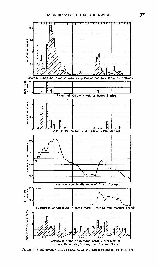
OCCURRENCE OF GROUND WATER 57
Runoff of Guodolupe River between Spring Bronch and New Braunfels stations2 0.5
Runoff of Cibolo Creek at Selma Station
Runoff of Dry Com a I Creek above ComaT Springs
Average monthly discharge of Camol Springs
Hydrograph of well H 39, (highest monthly reading from recorder charts)
Composite graph of average monthly precipitation at New Braunfels, Boerne, ond Fischer Stare
FIGURE 6. Simultaneous runoff, discharge, water level, and precipitation records, 194(5-50.
58 GEOLOGY AND GROUND-WATER RESOURCES, COMAL COUNTY, TEX.
given in table 18, and are shown in plate 6 (in pocket). Between the mouth of Balcones Creek, at the west corner of the county, and the Bulverde station the bed of the creek is in the lower member of the Glen Kose limestone and the losses in this part of the stream appear to be large. Between the Bulverde station and the Bracken station about 5 miles northwest of Bracken, the bed o± Cibolo Creek is in the upper member of the Glen Kose limestone and the losses in this area are relatively small, although some loss was observed by the writer at the edge of a pool about 8 miles northwest of Bracken. Between the Bracken station and the bridge at Bracken the bed of the creek is in the Edwards limestone which is honeycombed and broken by many small faults. Here the losses are believed to be large in pro portion to the amount of water that reaches this stretch of the stream. Most of the rainfall in the upper reaches of the Cibolo, however, is intercepted by infiltration into the Glen Rose limestone before it reaches the Edwards limestone at Bracken station. Between the bridge at Bracken and the Selma station about 1 mile below the crossing, the bed is in the Austin chalk and the losses in this stretch are probably small.
A striking example of infiltration into the lower member of the Glen Rose limestone above Bulverde station is shown in the records for the last 4 days of August 1946. Official rainfall records of the United States Weather Bureau are as follows:
[Precipitation in inches]
1946
August 282930-_______.___31_____ -
Bulverde
1. 053. 80.67.06
5. 58
Kandolph Field
0. 172.57
. 26
.04
3. 04
Boerne
1. 304. 79
. 19
.01
6. 29
New Braunfels
1. 563. 06.77. 10
5. 49
The heaviest precipitation occurred in the vicinity of Boerne in the headwaters of Cibolo Creek. The rains occurred after a relatively long dry period and it is probable that much of this water was inter cepted by vegetation, by the wetting of soils and rock surfaces, by depressions that form pools in the bed of the stream, and by the sands and gravels in the Leona formation that occur as broad terraces on either side of the Cibolo, but an estimated discharge of 300 second- feet was observed in the stream near the junction of Bexar, Kendall, and Comal Counties on August 29. As shown by the discharge records (table 18), none of this water reached the station at Bulverde.
OCCURRENCE OF GROUND' WATER 59
It is believed that most of the water entered caverrs in the lower member of the Glen Rose limestone and thence passed laterally through underground channels into the Edwards limestone.
Water seldom flows in the channel of Dry Comal Creek which drains the greater part of the outcrop area of the Edwards limestone north and west of New Braunfels and flows into the Comal River near Comal Springs.
Records of runoff and rainfall are given in table 18. For the 58 months beginning March 1, 1946, and ending December 31, 1950, the runoff for the three drainage areas was as follows: 1,200 acre-feet per square mile from the area drained by Guadalupe River between the Spring Branch and New Braunfels gaging stations; 48.9 acre-feet per square mile from the basin of Cibolo Creek above Selma; and 267.2 acre-feet per square mile from the drainage basin of Dry Comal Creek (excluding spring discharge). These figures, expressed as depth of runoff in inches, are 22.5, 0.92, and 4.8 inches, respectively. Assuming a fairly uniform distribution of rainfall for the period, the large difference in runoff indicates that the rate of infiltration into the underlying reservoir from the basin of Comal River and Cibolo Creek above Selma is markedly high as compared with infiltration from the area drained by the Guadalupe River between the Spring Branch gaging station and New Braunfels gaging station (fig. 6).
From the rainfall records it is reasonable to assume that the dis tribution and intensity o± rainfall for the 58-month period was similar for all three drainage areas. The striking differences in runoff must then be attributed to evaporation, transpiration, and infiltration. In the drainage area of the Guadalupe River between Spring Branch station and the New Braunfels station there are sharp divides and steep, almost barren slopes; in the other two areas there is probably more vegetation and, consequently greater transpiration. If there are any differences in evaporation and transpiration among the three areas, these must be slight in comparison to the differences in infiltra tion. If most of the differences in runoff are attributed to infiltration, as seems reasonable, it is possible to estimate by differences the relative recharge among the three reservoirs to the reservoir that supplies Comal Springs. The difference in runoff for the 58-month period of the Guadalupe River drainage area (1.200 acre-feet per square mile), and the Cibolo Creek area (49 acre-feet per square mile) times the drainage area of the Cibolo basin (280 square miles) is 322,280 acre-feet. The difference for Dry Comal basin is (1,200 254) 946 acre-feet per square mile times the 45 square miles of drainage area or 42,570 acre-feet. The total infiltration would then be: Guadalupe 0 + Cibolo 322,280 + Dry Comal 42,570=364,850 acre-feet.
993963 52 5
60 GEOLOGY A MAL COUNTY, TEX.
The total infiltration is about 34 percent of the 1,073,910-acre-foot discharge of Comal Springs for the 58-month period. The average discharge of Comal Springs for this period was 308 cubic feet per second or slightly less than the average for a 23-year period of record which is 320 cubic feet per second. This suggests that the recharge may have been slightly under average.
Making some allowance for the fact that transpiration and evapora tion in the Cibolo and Dry Comal basins may have been somewhat greater than in the Guadalupe drainage area it appears that about one-fourth to one-third of the water that flows from Comal Springs comes from the rainfall and recharge in the Cibolo and Dry Comal basins.
SUMMARY OF CONCLUSIONS
The facts presented in this report suggest that Comal Springs are a point of discharge for an immense ground-water reservoir which also supplies wells and springs in the San Antonio area, and that the discharge of the springs varies with the volume of water in the reservoir. The large size of the reservoir is indicated by the remark ably constant rate of discharge of the springs, by the uniform temper ature and lack of turbidity of the water, and by the relation among fluctuation in discharge, rainfall, and rise and fall in water levels in wells. The geological information, together with the runoff and seepage data available, seems to justify the conclusion that a rela tively large part of the discharge of Comal Springs comes from sources outside of Comal County and beyond the adjacent parts of Bexar and Kendall Counties drained by Cibolo Creek.
The water is not coming from the north, because the intake and transmission facilities are unfavorable in that direction; it is not coming from the east, because the hydraulic gradient shown by the altitude of the water level in wells is eastward from the springs; it is not coming from the south because it is shut off by the Comal Springs fault as indicated by the difference in the chemical character of the water on the two sides of the fault. Therefore, it must be coming from the west and southwest and a major part of it must be coming from areas beyond the drainage basin of Cibolo Creek.
It has been shown that recharge to the reservoir within Coma) County is limited to parts of the drainage area of Cibolo and Comal Creeks, and that even under the most favorable conditions this recharge is too small to supply the springs. It is estimated that the entire drainage area of Comal and Cibolo Creek contributes about one-third of the water that reaches Comal Springs; the rest, therefore, must come from areas to the west, beyond these drainage basins.

SURFACE-WATER SUPPLIES 61
SURFACE-WATER SUPPLIES
By SETH D. BREEDING
About 420 square miles of the 567 square miles in Comal County drains directly into Guadalupe River. About 60 square miles in the northeastern part of the county is drained by Blanco River, a tribu tary of San Marcos River which enters the Guadalupe at Gonzales. about 60 miles below New Braunfels, and a strip of about 90 square miles along the southwestern border of the county is drained by Cibolo Creek, a tributary of the San Antonio River.
Continuous records of the discharge of these streams were being obtained in January 1951 at the gaging stations listed in table 10 except the one on Guadalupe River at New Braunfels, below Comal River, which was discontinued in 1927. All the stations except the one at Wimberley are in Comal County.
TABLE 10. Gaging stations in the Comal County area, Tex.
Station
Guadalupe River near SpringBranch.
Guadalupe River above ComalRiver at New Braunfels.
Guadalupe River at NewBraunfels (below ComalRiver).
Comal River at New Braunfels_. Blanco River at Wimberley_ _ _.
Cibolo Creek near Bulverde___. Cibolo Creek at Selma_ _______
Drainagearea (square
miles)
1,432
1,666
1,770
i 94 378
198280
Period of record
June 1922 to December 1950.
December 1927 to December 1950.
January 1915 to December 1927.
December 1927 to December 1950. August 1924 to September 1926 and
June 1928 to December 1950. April 1946 to December 1950. March 1946 to December 1950.
i Measurements include flow from Comal Springs which receive water from beyond this drainage area.
These records were collected by the Surface Water Branch of the United States Geological Survey in cooperation with the Texas State Board of Water Engineers, and have been published in Geological Survey Water-Supply Papers.
GUADALUPE RIVER
A few pertinent facts about the flow of Guadalupe River as measured at gaging stations in Comal County are given in table 11.
Peak rates of flow recorded for the Guadalupe River near Spring Branch during the period 1923-50 were 121,000 second-feet on July 3, 1932, and 114,000 second-feet on June 15, 1935. The minimum flow recorded was 2.2 second-feet on July 11, 1939. Peak rates of flow recorded for the Guadalupe River at New Braunfels during the period 1916-50 were 95,200 second-feet on July 3, 1932, and 101,000
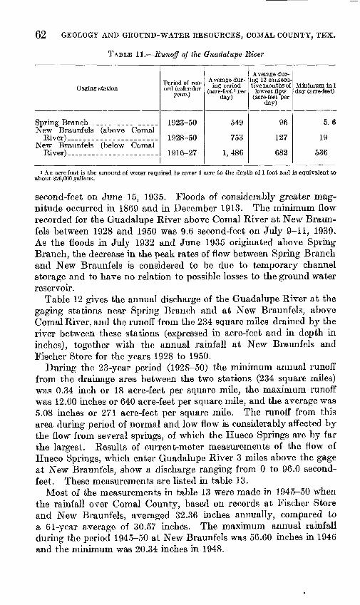
62 GEOLOGY AND GROUND-WATER RESOURCES, COMAL COUNTY, TEX,
TABLE 11. Runoff of the Guadalupe River
Gaging station
Spring Branch _ ___ __ _New Braunfels (above Comal
New Braunfels (below ComalRiver) _ ___
Period of rec ord (calendar
years)
1923-50
1928-50
1916-27
Average dur ing period
(acre-feet ' per day)
549
753
1,486
Average during 12 consecu tive months of
lowest flgw (acre-feet per
day)
96
127
682
Minimum in 1 day (acre-feet)
5.6
19
536
i An acre-foot is the amount of water required to cover 1 acre to the depth of 1 foot and is equivalent to about 326,000 gallons.
second-feet on June 15, 1935. Floods of considerably greater mag nitude occurred in 1869 and in December 1913. The minimum flow recorded for the Guadalupe River above Comal River at New Braun fels between 1928 and 1950 was 9.6 second-feet on July 9-11, 1939. As the floods in July 1932 and June 1935 originated above Spring Branch, the decrease in the peak rates of flow between Spring Branch and New Braunfels is considered to be due to temporary channel storage and to have no relation to possible losses to the ground water reservoir.
Table 12 gives the annual discharge of the Guadalupe River at the gaging stations near Spring Branch and at New Braunfels, above Comal River, and the runoff from the 234 square miles drained by the river between these stations (expressed in acre-feet and in depth in inches), together with the annual rainfall at New Braunfels and Fischer Store for the years 1928 to 1950.
During the 23-year period (1928-50) the minimum annual runoff from the drainage area between the two stations (234 square miles) was 0.34 inch or 18 acre-feet per square mile, the maximum runoff was 12.00 inches or 640 acre-feet per square mile, and the average was 5.08 inches or 271 acre-feet per square mile. The runoff from this area during period of normal and low flow is considerably affected by the flow from several springs, of which the Hueco Springs are by far the largest. Results of current-meter measurements of the flow of Hueco Springs, which enter Guadalupe River 3 miles above the gage at New Braunfels, show a discharge ranging from 0 to 96.0 second- feet. These measurements are listed in table 13.
Most of the measurements in table 13 were made in 1945-50 when the rainfall over Comal County, based on records at Fischer Store and New Braunfels, averaged 32.36 niches annually, compared to a 61-year average of 30.57 inches. The maximum annual rainfall during the period 1945-50 at New Braunfels was 56.60 inches in 1946 and the minimum was 20.34 inches in 1948.

SURFACE-WATER SUPPLIES 63
TABLE 12. Discharge of the Guadalupe River near Spring Branch and at New Braunfels and pickup between stations; rainfall at Fischer Store and New Braunfels, Tex., 1928-50
Calendar year
1928 1929_ .......................1930 1931 1932 1933 1934 1935 1936 1937 1938 1939 - 1940 1941 1942 1943 1944 1945 ..1946. - . ... 1947 1948 1949 1950
Average,.. _______
Flow of Guadalupe River in acre-feet
Spring Branch
45, 400 143, 000 142, 000 235, 000 395, 000 102, 000 54,490
459, 800 619, 300 181, 200 140, 800 60,310
152, 400 485, 100 227, 800
98, 570 315, 100 302, 200 228, 500 225, 000
55, 280 124, 100
57, 130
210. 800
New Braunfels
64, 800 208, 000 170, 000 336,000 425, 000 114, 000
87, 680 573, 700 691, 900 233, 400 232, 400
64, 580 174, 300 620, 600 318, 000 136, 300 450, 100 420, 700 378, 200 299, 700
65, 310 170, 600 72, 770
274. 300
Runoff between Spring Branch and New
Braunfels
Acre-feet
19, 400 65, 000 28,000
101, 000 30, 000 12, 000 33, 190
113, 900 72,600 52,200 91, 600 4,270
21,900 135, 500 90,200 37, 730
135, 000 118, 500 149, 700 74, 700 10, 030 46,500 15, 640
63. 420
Depth in inches
1.55 5.21 2.24 8.09 2.40 .96
2.66 9.13 5.82 4.18 7.34 .34
1.75 10.86 7.23 3.02
10.82 9.49
12.00 5.99 .80
3.73 1.25
5.08
Rainfall in inches
Fischer store
28. 83 40.60 30.80 32.57 27.58
' 26. 90 28.62 42.07 37.86 28.94 23. 13 29.53 37.28 36.02 31.15 22.83 37.53 35.30 46.79 19.77 23.24 30. 69 24.34
31.41
New Braunfels
36.07 40.15 28.71 31.58 31.15 26.75 30.80 41.67 30.41 29.19 28.32 13.35 38.11 42.99 42.08 29.93 43.14 39.38 56.60 27.52 20.34 43.21 21.13
33.59
TABLE 13. Discharge measurements, Hueco Springs, 8 miles north of New Braunfels, Tex.
Date
Jan. 19, 19J8-.Feb. 22, 1929-Oct. 8, 1937 Aug. 4, 1944 _Sept. 18, 1944.Jan. 22, 1945-Feb. 16,1945--Mar. 23, 1945-Apr.27, 1945 _.May 31, 1945-July5, 1945__-Aug.9, 1945.-Sept. 13, 1945.Oct. 19, 1945- -Nov. 22, 1945. _Dec. 20, 1945- .Jan. 24, 1946
Dis charge
(second- feet)
00
i 1.561.056.890.392.480.484.577.759.032.1
1 23.346.8
1 17.6116.538.0
Date
Mar. 1, 1916 Apr. 4, 1946- -May9, 1946.-June 14, 1946-JulylS, 1946- .Aug. 21,1946--Sept. 26, 1946_Oct. 31, 1946- .Dec. 7, 1946 _-Jan. 12, 1947 Feb. 13, '947- -Mar. 20. '947-Apr. 24, 1947- -May 29, 947--July2, 1947---Aug. 7, 1947..-Sept. 11, 1947-
Dis- charge
(second- feet)
71.471.355.954.4
122.3i 13.2
93.688.885.596.088.777.464.645.625.0
119.3i 16.9
Date
Oct. 16, 1947_ _Nov. 22, 1947-Dec. 18, 1947. .Jan. 22, 1948 Feb. 26, 1948. _Apr. 1,1948- ._May 6, 1948 _-June 10, 1948 July 22, 1948 - .Aug. 26, 1948. _Sept. 30, ]948_Nov. 5,1948 Dec. 9, 1948 Jan. 22, 1949- Feb. 22, 1949_.Anr. 1, 1949._.May 16, 1949._
Dis charge
(second- feet)
1 13.31 10.118.72i 6.6215.8314.2313.9315.09'2.8411.22
00000
126.891.5
Date
June 16, 1949 July 23, 1949,.Aug.26, 1949- _Sept. 28, 1949.Nov. 4,1949 Dec. 8, 1949...Jan. 12, 1950 Feb. 16, 1950- _Mar. 22, 1950-Apr. 21, 1950. .May 24,1950-.June28, 1950 Aug. 2, 1950..-Sept. 9, 1950 Oct. 11, 1950. -Nov. 15, 1950- .Dec. 21, 1950.-
Dis- charge (second-
feet)
50.9i 19.2i 13.417.88
i 14.616.4714.3853.319.6215.38
i 11.415.3313.2010.16
010.48
0
i Flow of West Springs only; no flow in East Springs.
Tables 14 and 15 show discharge measurements made to determine seepage losses and returns on the Guadalupe River between the Comfort and New Braunfels gaging stations during period of low flow in 1928 and 1929. The records show a net seepage gain of 0.3 second-feet in 1928 and a net seepage loss of 1.4 second-feet in 1929 between the Spring Branch and New Braunfels stations.

64 GEOLOGY AND GROUND-WATER RESOURCES, COMAL COUNTY, TEX.
The seepage investigations in 1928 and 1929, as recorded in tables 14 and 15, show that the flow at New Braunfels was 2 to 4 second- feet greater than it was at Spring Branch. In these tables the dis charge of Hueco Springs is shown in the Elm Creek measurements, for which the discharge was zero, indicating that the springs were dry during both investigations.
In 1944 a seepage investigation was made between the Spring Branch and New Braunfels stations which showed a net gain of 98 second-feet between Spring Branch and New Braunfels, of which 61 second-feet came from Hueco Springs. Table 16 is a record of this investigation.
TABLE 14. Discharge measurements to determine seepage on Guadalupe River from Comfort to New Braunfels, Tex., in January 1928
[During the investigation the river was at a constant stage and the measurements represent the naturalconditions]
Date
Jan. 16
Do.. .
Do-... Do.... Do_...
Jan. 17 Do....
Do..__
Do....
Do...-
Do-...
Do....
Jan. 18
Do....
Do....
Do....
Do.... Do
Do _Jan. 19
Do Do-...
Do....
Do- Do
Stream
Guadalupe River-
Cypress Creek...
Holiday Creek___ Guadalupe River
.. -.do __Joshua Creek.... Sister Creek _ ..
Gaudalupe River-
Wasp Creek ......
Sabino Creek....
Gaudalupe River.
.....do .........
Currys Creek. ...
Guadalupe River-
Spring Branch...
Guadalupe River.
Guadalupe River -
__ do... __
Guadalupe River- Isaacs Creek.. ...
Guadalupe River.
Guadalupe River.
Location
At gaging station 2 miles above Comfort.
0.25 mile above mouth at Com fort.
At railroad bridge near Comfort.
2 miles above mouth near Waring. 0.5 mile above mouth near Sis-
terdale. Just below mouth at Sister
Creek near Sisterdale. At mouth 6 miles below Sister-
dale. At mouth 8 miles northeast of
Boerne. Just below mouth of Sabine
Creek at Ammans Crossing. At Schillers Crossing, 4 miles
north of Bergheim. 0.5 mile above mouth, 4 miles
above Spring Branch. At Specks Crossing, 2.5 miles
southwest of Spring Branch. 1.5 miles above mouth near
Spring Branch. At gaging station near Spring
Branch.
Just below Big Spring, at Cranes Mill.
2 miles noitheast of Sattler. _ .. At mouth 2 miles below Sattler
At mouth 5.5 miles above New Braunfels.
0.4 mile above Elm Creek near New Braunfels.
At mouth near New Braunfels. . At gage 1 mile above mouth of
Comal River.
Ap- prox.
distance (miles) from initial point
0
3.0
4.86.4
12.2 16.0 19.7
19.7
29.5
31.2
31.2
45.6
55.8
57.5
59.0
61.7
78.578.5
92.7 95.9 97.4
103. 5
103.9
104.3 108.7
Discharge in second-feet
Mam stream
52.0
58.6 58.7
65.4
70.9
68.3
71.9
73.5
72.3
88.9
83.2
81.6
77.7
Trib utary
1.5
.3
1.6.4
.2
.5
2.6
1.5
3.9
0
0
0
Gain or loss in
section *
+4.8 +.1
+4.7
+4.8
-2.6
+1.0
+.1
-5.1
+16.6
-5.7
-1.6
-3.9
Total gain or loss 1
+4.8 +4.9
+9.6
+14.4
+11.8
+12.8
+12.9
+7.8
+24.4
+18.7
+17.1
+13.2
Computed from discharge of main stieam and tributaries.
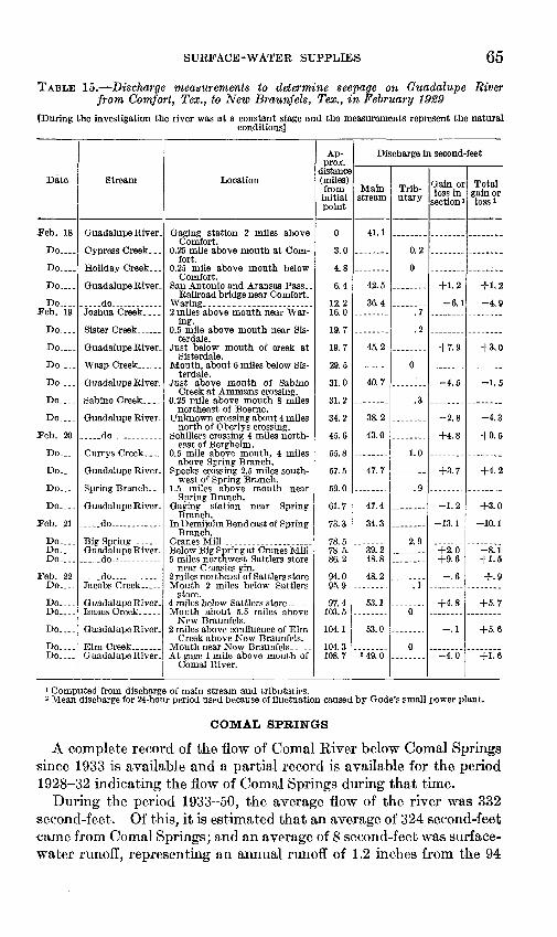
SURFACE-WATER SUPPLIES 65
TABLE 15. Discharge measurements to determine seepage on Guadalupe River from Comfort, Tex., to New Braunfels, Tex., in February 1929
fDuring the investigation the river was at a constant stage and the measurements represent the naturalconditions]
Date
.Feb. 18
Do....
Do....
Do....
Do....Feb. 19
Do....
Do-
Do... .
Do_...
Do... .
Do
Teb. 20
Do....
Do....
Do
Do....
Teb. 21
Do.... Do.... Do....
Feb. 22 Do
Do.... Do....
Do....
Do- Do
Stream
Guadalupe River-
Cypress Creek...
Holiday Creek. ..
Guadalupe River.
... -do .. .......Joshua Creek.
Guadalupe River.
Guadalupe River.
Sabino Creek. ...
Guadalupe River.
__.__dO ...
Currys Creek... _
Guadalupe River-
Spring Branch...
-. do. .......
do Jacobs Creek _ .
Guadalupe River- Isaacs Creek.....
Guadalupe River.
Guadalupe River-
Location
Gaging station 2 miles above Comfort.
0.25 mile above mouth at Com fort.
0.25 mile above mouth below Comfort.
Railroad bridge near Comfort.
2 miles above mouth near War ing.
0.5 mile above mouth near Sis- terdale.
Just below mouth of creek at Sisterdale.
Mouth, about 6 miles below Sis terdale.
Just above mouth of Sabino Creek at Ammans crossing.
0.25 mile above mouth 8 miles northeast of Boerne.
Unknown crossing about 4 miles north of Oberlys crossing.
Schillers crossing 4 miles north east of Bergheim.
0.5 mile above mouth, 4 miles above Spring Branch.
Specks crossing 2.5 miles south west of Spring Branch.
1.5 miles above mouth near Spring Branch.
Gaging station near Spring Branch.
In Demijohn Bend east of Spring Branch.
Cranes Mill-. ..................Below Big Spring at Cranes Mill. 5 miles northwest Sattlers store
near Craasies gin. 2 miles northeast of Sattlers store- Mouth 2 miles below Sattlers
store. 4 miles below Sattlers store _ .. Mouth about 5.5 miles above
New Braunfels. 2 miles above confluence of Elm
Creek above New Braunfels.
At gage 1 mile above mouth of Comal River.
Ap- prox.
distance (miles) from initial point
0
3.0
4.8
6.4
12.2 16.0
19.7
19.7
29.5
31.0
31.2
34.2
45.6
55.8
57.5
59.0
61.7
73.3
78.5 78.5. 86.2
94.0 95.9
97.4 103.5
104.1
104.3108.7
Discharge in second-feet
Main stream
41.1
42.5
36.4
45.2
40.7
38.2
43.0
47.7
47.4
34.3
39.2 48.8
48.2
53.1
53.0
M9.0
Trib utary
0.2
0
.7
.2
0
.3
1.0
.9
2.9
.1
0
0
Gain or loss in
section 1
+1.2 -6.1
+7.9
-4.5
-2.8
+4.8
+3.7
-1.2
-13.1
+2.0 +9.6-.6
+4.8
-.1
-4.0
Total gain or loss*
+1.2 -4.9
+3.0
-1.5
-4.3
+0.5
+4.2
+3.0
-10.1
-8.1+1.5
+.9
+5.7
+5.6
+1.6
1 Computed from discharge of main stream and tributaiies.2 Mean discharge for 24-hour period used because of fluctuation caused by Gode's small power plant.
COMAL SPRINGS
A complete record of the flow of Comal River below Comal Springs since 1933 is available and a partial record is available for the period 1928-32 indicating the flow of Comal Springs during that tune.
During the period 1933-50, the average flow of the river was 332 second-feet. Of this, it is estimated that an average of 324 second-feet came from Comal Springs; and an average of 8 second-feet was surface- water runoff, representing an annual runoff of 1.2 inches from the 94

66 GEOLOGY AND GROUND-WATER RESOURCES, COMAL COUNTY, TEX.
TABLE 16. Discharge measurements to determine seepage on Guadalupe River from Spring Branch to New Braunfels, Tex., in August 1944
[During the investigation the river was at a constant stage and the measurements represent the naturalconditions]
Date
Aug. 3-.
Do ..
Do....
Do .
Do .
Do-
Stream
Guadalupe River..
.....do.
. do ..... ......
.....do...... ....
.--.do. ..... ....
Guadalupe River. .
Location
Lat. 29°51'40", long. 98°23'00", at gaging station near Spring Branch, Tex.
Lat. 29°53'35", long. 98°14'40", 100 feet below Sorrel Creek and \\<i miles southwest of Hancock. Tex.
Lat. 29°52'10", long. 98^11'25", 500 feet below Hidden Valley crossing and 1.8 miles northwest of Sattler, Tex.
Lat. 29°48'35", long. 98°10'40", \<i mile below Bear Creek and 2.7 miles south- southwest of Sattler, Tex.
Lat. 29°45'50", long. 98°09'10", 0.7 mile above Isaac Creek, 0.8 mile above first crossing on New Braunfels-Sattler Road, and 4.6 miles northwest of New Braunfels, Tex.
Lat. 29°43'35", long. 98°08'25", 3.8 miles north of New Braunfels, Tex.
Lat. 29°42'55", long. 98°06'40", at gag ing station above Comal River at New Braunfels, Tex.
Discharge in second-feet
Main stream
92
102
113
119
124
190
Tribu tary
Gain or loss in sec tion'
+10
+11
+6
+5
+5
Total gain
or loss r
+10
+21
+27
+32
+37
1 Computed from discharge of main stream and tributaries.
square miles of drainage area above the station. The average rainfall at New Braunfels for the period 1933-50 was 33.60 inches, which is 3 inches above normal for that place. Monthly and annual discharges for Comal Springs for the years 1928-50 are given in table 17.
TABLE 17. monthly and annual discharge, in second-feet, 1 of Comal Springs at New Braunfels, Tex.
Year
1928. -1929-.1930. _1931 _-1932. _1933- -1934. .1935. .1936-.1937- _1938. .1939- .1940- -1941 _ _1942-.1943. _1944-.1945-.1946-.1947.-1948-.1949-.1950- -
Av-
Jan.
299282287280315311320296375348326324285297338408333344327408305259284
319
Feb.
295274270316315299307297369351330329288313333390334378312407308244286
319
Mar.
300273257337327311330294358362330320286322335374359382338406297271279
324
Apr.
2982772623303053403323003353753403162773403423563834C6331394296278275
326
May
295275295341303325328310325365367304264377313333383414347368285313270
326
June
295300295345311305325330385375366305278377318328377376364345278315267
328
July
289320299336334320330343365359354270287358328328355346374329267312255
324
Aug.
275310269322347306325342359341342289276361319317328341356323257306246
315
Sept.
2743002653293353112993353603373523C8276342357322333335365320258288247
315
Oct.
283290260315324292309342366319340287271354388307325334392312258281247
313
Nov.
277293260296316299287355361315338276271342405317314331401309261282239
311
Dec.
280285269296321309287370354322331286287335416314333336398309256284235
314
Annual
288290273320321311315326359347343301279343349341346360359352277286261
320
1 1 second-foot=448.8 gallons a minute.

SURFACE-WATER SUPPLIEiS 67
BLANCO RIVER
The gaging station on Blanco River at Wimberley in Hays County records the runoff from a drainage area of 378 square miles, including 60 square miles in Comal County. Simultaneous records of the dis charge of Blanco River at Wimberley and the Guadalupe River at Spring Branch and New Braunfels (above Comal-River) are available for the calendar years 1929-50. The average annual runoff from the Blanco River basin during this period was 209 acre-feet per square mile, as compared with 280 acre-feet per square mile for the part of the Guadalupe River basin between the Spring Branch and New Braunfels stations (computed from the difference in the discharge recorded at thetwo stations.)
COMAL CHEEK
Comal Creek drains 94 square miles above Comal Springs, all of which is in Comal County. Below Comal Springs the stream is called Comal River; above the springs it is called Dry Comal Creek. Figures for the runoff of Dry Comal Creek are obtained by subtracting the flow of Comal Springs from the discharge of Comal River.
CIBOLO CHEEK
Cibolo Creek drains as area of 280 square miles above the Selma gaging station. The Bulverde, Bracken, and Selma gaging stations were established on the Cibolo in March and April 1946 (fig. 2). Records for the Bracken station are not included in this report as only records of low flows are available at that station. The unusually heavy rainfall during 1946 emphasized the rather remarkable differ ences in runoff for the various drainage basins in Comal County.
SIMULTANEOUS RECORDS
Simultaneous records of the discharge of Dry Comal Creek and Cibolo Creek, as well as the discharge of Guadalupe River, are avail able for the period March 1946 to December 1950 at the Selma, Spring Branch, and New Braunfels stations, and Cibolo Creels at the Bulverde station from May 1946 to December 1950. During this 58-month period the. total runoff of Cibolo Creek amounted to 13,710 acre-feet at Selma, representing a depth of 0.92 inch over the drainage area. The runoff of Comal Creek for the period was 24,230 acre-feet, repre senting a depth of 4.8 inches. In contrast to these low figures, the runoff of the Guadalupe River from the drainage area between Spring Branch and New Braunfels amounted to 280,900 acre-feet, or a depth of 22.5 inches.
The total rainfall during the 58-month period was 152 inches at Boerne, 154.41 inches at Bulverde, 138.71 inches at Fischer store, and
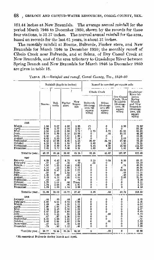
68 , GEOLOGY AND GROUND-WATER RESOURCES, COMAL COUNTY, TEX,
161.44 inches at New Braunfels. The average annual rainfall for the period March 1946 to December 1950, shown by the records for these- four stations, is 31.37 inches. The normal annual rainfall for the areaf based on records for the last 61 years, is about 31 inches.
The monthly rainfall at Boerne, Bulverde, Fischer store, and New Braunfels for March 1946 to December 1950; the monthly runoff of Cibolo Creek near Bulverde, and at Selma, of Dry Comal Creek at New Braunfels, and of the area tributary to Guadalupe Kiver between Spring Branch and New Braunfels for March 1946 to December are given in table 18.
TABLE 18. Rainfall and runoff, Comal County, Tex., 1946-50
1946
April ___ .........May... _______
July.................August ________September ...........
Total for year..
1947 January. ___ ....February.. _____MarchApril ................May.. __ . ...June _____ ......July.................August ...........September _ ......October... ..........November _ .....December ...........
Total for year..
1948 January .............February ............March . _ .April ................May... .............
July.................
Total for year..
Rainfall (depth in inches)
Boerne
1.93 3.94 3.65 3.14 2.40 6.62 9.45 4.22 2.29 2.61
40.25
4.09 .37
1.91 1.51 5.92 .31
1.28 2.49 .15
1.33 1.34 1.19
21.89
.44 3.08 1.49 1.98 1.29 5.47 1.81 .87
3.56 2.43 .57 .78
23.77
Bul verde
5.07 3.77 4.05 3.59 .54
5.33 12.96 2.53 6.69 3.77
48.30
4.42 .37
1.55 .55
2.87 0 1.09 4.22 .58
1.01 2.03 1.33
20.02
.53 2.91 .88
1.94 2.45 2.25 1.44 .97
1.90 2.00 1.15 .92
19.34
Fischer store
4.95 2.78 3.90 3.18 2.91 3.82 6.55 1.50 6.48 3.60
39.67
4.70 .25
2.33 1.08 2.84 1.83 .85
2.90 0 .80 .85
1.34
19.77
.58 2.92 1.29 1.70 2.55 4.65 .94
1.26 1.91 3.62 .70
1.12
23.24
New Braun
fels
3.96 2.02 5.75
10.88 1.89 7.14 8.33 3.47 2.60 3.21
49.25
4.83 .42
2.00 1.72 7.32 .71
1.49 4.54 .74
Trace 1.67 2.08
27.52
.56 2.99 1.11 1.98 1.52 1.23 1.59 2.82 1.81 2.69 1.58 .46
20.34
Runoff in acre-feet per square mile
Cibolo Creek
Bulverde (drainage area 198 square miles)
(') (')
1.73 0 0 0
36.87 3.63 9.14 1.83
53.20
5.15 .01
0 0 0 0 0 0 0 0 0 0
5.16
0 0 0 0 0 0 0 0 0 0 060
Selma (drainage area 280 square miles)
0 0 5.71 .44
0 0
24.79 .28
9.50 .95
41.67
0.03 0 0 0 0 0 0 0 0 0 0 0
.03
0 0 0 0 0 0 .02
0 0 .01
0 0
.03
Dry Comal Creek, New
Braunfels (drainage area, 94 square miles)
3.30 0
31.91 50.11 0 2.02
57.98 1.91
18.93 1.81
167. 97
9.50 0 .73
0 18.94
.45
.26 2.85 0 0 0 0
32.73
0 0 0 0 0 0 0 0 0 0 0 0
0
Guadalupe- River be
tween Spring Branch
and New Braunfels- (drainage area, 234 square miles)
72.99' 33. 29' 33.63 46.28'
15.98 13. 12' 70.26- 75.21
113. 50' 98. 59'
572. 85-
83.21 63. 29'
49.36 28.38 29. 15 11.11 11.28 21. 54' 8. le ft 11 3.72'
4. 1»
319. 50'
3.25 3.21 4.02 1.03 9.87" 6.45' 8.16 .04 .51
2.52 1.58 2.22
42.86
1 No records at Bulverde during March and April.
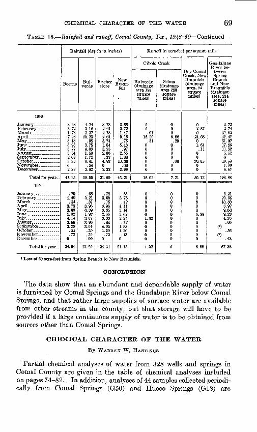
CHEMICAL CHARACTER OF THE WATER 69
TABLE 18. Rainfall and runoff, Comal County, Tex., 1946-50 Continued
1949
March ________April................
June _________July ..............
October... __ ....
Total for year..
1950
February ______March _______ ..April................May ................June _________July . .............
October.. _____ .
Total for year..
Rainfall (depth in inches)
Boerne
3.68 3.72 1.73 7.28 3.18 3.95 3.77 5.54 2.08 3.33 0 2.89
41.15
.70 2.49 .34
3.73 3.08 2.02 4.14 3.88 3.29 .55 .72
0
24.94
Bul-verde
4.24 3.16 2.27
10.23 .98
3.75 4.03 1.50 1.72 4.41 .24
3.02
39.55
.65 3.21 .31
3.96 6.39 1.92 3.07 3.96 3.04 .30 .30 .09
27.20
Fischer store
3.78 2.61 2.18 2.64 5.74 1.84 3.25 2.06 .33
4.93 0 2.33
31.69
.78 3.60 .15
3.96 3.35 2.06 3.33 .84
4.05 1.50 .72
0
24.34
New Braun-
fels
3.88 3.72 1.47 9.15 .75
5.43 .97
2.55 1.88
10.36 .06
2.99
43.21
.55 3.76 .42
4.11 3.14 3.02 2.25 .72
1.83 1.20 .13
0
21.13
Runoff in acre-feet per square mile
Cibolo Creek
Bulverde (drainage area 198 square miles)
0 0 .01
15.20 .81
0 0 0 0 0 0 0
16.02
0 0 0 0 0 0 1.32 0 0 0 0 0
1.32
Selma (drainage area 280 square miles)
0 00 6.86 .29
0 0 0 0 .06
0 0
7.21
0 0 0 0 0 0 0 0 0 0 0 0
0
Dry Comal Creek, New Braunfels (drainage area, 94 square miles)
02.87 0
24.68 0 1.61 .11
0 0
20.85 0 0
50.12
0 0 0 0 0 6.88 0 0 0 0 0 0
6.88
Guadalupe River be
tween Spring Branch
and New Braunfels (drainage area, 234 square miles)
3.72 2.74
31.62 41.41 51.07 17.86 11.32 5.51 0
19.53 7.39 6.67
198.84
5.21 20.64 10.30 6.97 9.06 9.23 4.36 .60
«.56
(2) .43
67.36
* Loss of 60 acre-feet from Spring Branch to New Braunfels.
CONCLUSION
The data show that an abundant and dependable supply of water is furnished by Comal Springs and the Guadalupe River below Comal Springs, and that rather large supplies of surface water are available from other streams in the county, but that storage will have to be provided if a large continuous supply of water is to be obtained from sources other than Comal Springs.
CHEMICAL CHARACTER OF THE WATER
By WAEREN W. HASTINGS
Partial chemical analyses of water from 328 wells and springs in Comal County are given in the table of chemical analyses included on pages 74-82.. In addition, analyses of 44 samples collected periodi cally from Comal Springs (G50) and Hueco Springs (G18) are

70 GEOLOGY AND GROUND-WATER RESOURCES, COMAL COUNTY, TEX.
listed to show the possible relationship of the chemical character, the rate of discharge, and the temperature of the water. The data in dicate no apparent pronounced differences in chemical composition or temperature of the water with changes in the rate of flow.
Most of the water obtained from wells in Comal County is ac ceptable for stock and domestic purposes but, because the water bearing formations are largely limestones, the waters are moderately hard, generally above 200 parts per. million. Calcium bicarbonate is normally the predominant mineral constituent of ground water of Comal County.
The Travis Peak formation yields water that ranges in quality from exceptionally good, as shown by the analysis of the water from well A13, to water that is too highly mineralized for most purposes, such as the water from well A20. However, most wells in the Travis Peak formation yield water containing less than 500 parts per million of dissolved solids.
Wells in the Glen Kose limestone generally yield water acceptable for domestic purposes. The more highly mineralized waters from the lower member of the Glen Kose are high in sulfates and are very hard, as shown by the analyses of water from wells C3 and E8. Water in the upper member of the Glen Rose in many wells is rather high in sulfates and hard, but most of the water had dissolved solids below 1,000 parts per million. An exception is found in the analysis of water from well G55, which is 1,200 feet deep and yields water having 4,170 parts per million of dissolved solids.
All the analyses of water from wells in the Edwards limestone northwest of the Comal Springs fault show that the water is of good quality; although the water is hard, dissolved solids are generally less than 500 parts per million. The wells (G46 and G47) that supply the city of New Braunfels yield water that has an average hardness of 252 parts per million and dissolved solids of 282 parts per million (pi. 6). The water supply has been approved by the State Board of Health for public consumption.
As previously stated, it is believed that the water southeast of the Comal Springs fault is of poor quality because the fault has prevented the free circulation of meteoric water in the Edwards limestone. In the Glen Rose limestones and in the Austin chalk, circulation is also the controlling factor in the quality of water. Where solution has developed a reservoir with a system of connecting passages per mitting the free movement of water, characteristic limestone waters prevail, as illustrated by wells E50 and G46 in plate 6.
Water from the Leona formation of Pleistocene age is high in nitrate, as in well G60, but the nitrate content of the water differs widely from one well to another. It is frequently stated that well
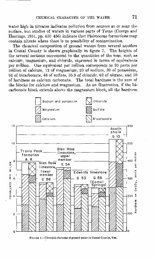
CHEMICAL CHARACTER OF THE WATER 71
water high in nitrates indicates pollution from sources at or near the surface, but studies of waters in various parts of Texas (George and Hastings, 1951, pp. 450-456) indicate that Pleistocene formations may contain nitrate where there is no possibility of contamination.
The chemical composition of ground waters from several aquifers in Comal County is shown graphically in figure 7. The heights of the several sections correspond to the quantities of the ions, such as calcium, magnesium, and chloride, expressed in terms of equivalents per million. One equivalent per million corresponds to 20 parts per million of calcium, 12 of magnesium, 23 of sodium, 39 of potassium, 61 of bicarbonate, 48 of sulfate, 35.5 of chloride, 62 of nitrate, and 50 of hardness as calcium carbonate. The total hardness is the sum of the blocks for calcium and magnesium. As an illustration, if the bi carbonate block extends above the magnesium block, all the hardness
Sodium and potassium
Magnesium
Cole ium
Austinchalk
G 10
Glen Rose limestone,
upper member
__Travis Peak formation
A 8Glen Rose limestone,
I ower member
Edwards limestone
_ G 53 G 55 _ (Coma
600
500
400 E
300
200 o
100
FIGURE 7. Chemical character of ground water in Comal County, Tex.
72 GEOLOGY AND GROUND-WATER RESOURCES, COMAL COUNTY, TEX.
is carbonate hardness; but if the top of the bicarbonate is lower than the top of the magnesium, part of the hardness is due to sulfate, or even chloride if the chloride extends below the top of the magnesium.
REFERENCES CITED
Barnes, V. E., 1943, Gypsum in the Edwards limestone of central Texas: TexasUniv. Bull. 4301, pp. 35-46.
Biesele, B. F., 1930, The history of German settlements in Texas: Austin, Tex.,Press of Von Boeckman-Jones Co.
Bryan, Frank, 1933, Recent movement along the fault of the Balcones system,McLennan County, Texas: Am. Assoc. Petroleum Geologists Bull., vol.17, pp. 439-442.
1936, Evidence of recent movements along faults of the Balcones system , in central Texas: Am. Assoc. Petroleum Geologists, Bull., vol. 20, no. 10,
pp. 1537-1371, 7 figs.Cuyler, R. H., 1939, Travis Peak, formation of central Texas: Am. Assoc. Petro
leum Geologists Bull., vol. 23, pp. 625-642. Davis, W. M., 1930, Origin of limestone caverns: Geol. Soc. America-Bull.,
vol. 41, pp. 475-628. Bumble, E. T., 1918, The geology of east Texas: Texas Univ. Bull. 1869, 388
pp., 12 pis. Fiedler, A. G., and Nye, S. S., 1933, Geology and ground-water resources of
the Roswell artesian basin, New Mexico: U. S. Geol. Survey Water-SupplyPaper 639.
Foley, L. L., 1926, Mechanics of Balcones and Mexia faulting: Am Assoc. Petro leum Geologists Bull., vol. 10, pp. 1261-1269.
Foote, H. W., 1900, Uber die physikalisch-chemischen Biziehungen zwischenAragonit und Calcit: Zeitschr, physikal. Chemie, vol. 33, pp. 740-759.
George, W. O., and Hastings, W. W., 1951, Nitrate in ground water in Texas:Am. Geophys. Union Trans., pp. 450-456.
Hill, R. T., 1901, Geography and geology of the Black and Grand Prairies,Texas: U. S. Geol. Survey 21st Ann. Rept., part 7.
Imlay, R. W., 1945, Subsurface Lower Cretaceous formations of south Texas:Am. Assoc. Petroleum Geologists Bull., vol. 29, pp. 1416-1469.
Livingston, Penn, Sayre, A. N., and White, W. N., 1936, Water resources ofthe Edwards limestone in the San Antonio area, Texas: U. S. Geol. SurveyWater-Supply Paper 773.
Meinzer, O. E., 1923a, The occurrence of ground water in the United States:U. S. Geol Survey Water-Supply Paper 489.
1923b, Outline of ground water hydrology: U. S. Geol. Survey Water- Supply Paper 494.
Editor, 1942, Physics of the earth, part 9, Hydrology, New York, McGraw-Hill Book Co., Inc., 712 pp.
Michal, E. J., 1937, Records of wells and springs in Comal County, Texas: TexasState Board of Water Engineers, 44 pp., 1 fig.
Piper,-A. M. ( 1932, Ground water in north-central Tennessee: U. S. Geol. SurveyWater-Supply Paper 640.
Revelle, Roger, 1934, Physio-chemical factors affecting the solubility of calciumcarbonate in sea water: Jour. Sedimentary Petrology, vol. 4, pp. 103-110.
Roemer, Ferdinand, 1849, Texas: Bonn, Adolph Marcus, 464 pp., map.

REFERENCES CITED 73
Sayre, A. N., 1936, Geology and ground-water resources of Uvalde and Medina Counties, Texas: U. S. Geol. Survey Water-Supply Paper 678.
Sellards, E. H., 1920, Geology and Mineral resources of Bexar County: Texas Univ. Bull. 1932, (June 5, 1919), 202 pp. 1 pi.
1931, Rocks underlying Cretaceous in Balcones fault zone of centralTexas: Am. Assoc. Petroleum Geologists Bull., vol. 15, pp. 819-827.
iSellards, E. H., Adkins, W. S., and Plummer, F. B., 1932, The geology of Texas:Texas Univ. Bull. 3232, 1007 pp.
Solms-Braunfels, Prince Carl, 1846, Texas: Frankfurt-Am-Mein. Translation,1936, Houston, Tex., Anson Jones Press.
Stephenson, L, W., 1928, Structural features of the Atlantic and Gulf CoastalPlain: Geol. Soc. America Bull., vol. 39.
1929, Unconformities in the Upper Cretaceous series of Texas: Am. Assoc. Petroleum Geologists Bull., vol. 13, pp. 1323-1334.
1937, Stratigraphic relations of the Austin, Taylor, and equivalent formations in Texas: U. S. Geol. Survey Prof. Paper 186.
Swinnerton. A. C., 1932, Origin of limestone caverns: Geol. Soc. America Bull., vol. 43, pp. 663-693.
1942, Physics of the earth, part 9, Hydrology: New York, McGraw-Hill Book Co., Inc., 712 pp.
Theis, C. V., 1935, The relation between the lowering of the piezometric surfaceand the rate and duration of discharge of a well using ground-water storage:Am. Geophys. Union Trans., pp. 519-524.
Thiem, Gunther, 1906, Hydrologische Methoden, Leipzig, J. M. Gebhardt, 56 pp. U, S. Geol. Survey, 1932, Surface water supply of the United States, 1929,
part 8, Western Gulf of Mexico basins: Water- Supply Paper 688. 1946, Surface water supplies of the United States, 1944, part 8, Western
Gulf of Mexico basins: Water-Supply Paper 1008. Wenzel, L. K., 1942, Methods for determining the permeability of water-bearing
materials, with special reference to discharging-well methods: U. S. Geol.Survey Water-Supply Paper 887.
White, W. N., Gale, H. S., and Nye, S. S., 1941, Geology and ground-waterresources of the Balmorhea area of western Texas: U. S. Geol. SurveyWater-Supply Paper 849.

TAB
LE 1
9. P
arti
al a
naly
ses
of
wat
er f
rom
wel
ls a
nd s
prin
gs i
n C
omal
Cou
nty,
T
ex.
[Res
ults
are
in
part
s pe
r m
illio
n]H
^
Wel
lO
wne
rD
epth
of
wel
l (f
eet)
Dat
e of
col
le
ctio
nso
lved
so
lids
Cal
cium
(Ca)
Mag
nesi
um
(Mg)
Sodi
um a
ndpo
tass
ium
(N
a+K
) (c
alcu
late
d)
Bic
arbo
n
ate
(HC
O3)
Sulf
ate
(S0
4)C
hlor
ide
(01)
Nit
rate
(N
0>)
OT
otal
har
d-
fe|
ness
as
o
CaC
Os
F
(cal
cula
ted)
O O
i~*T
ravi
s P
eak
form
atio
n
Al
A5
A7 A8
A9
A10
A15
A17
A19
A20
A22
A 26
A 00
A35
B12
B14
B27
B28
B46
B47
D4D4
El
<E3
E40
T J
Byler
-_^-do_ ------------
-----------
_do_ -_ -
-_-do
- _ ----- -_
-__.do __
- -- _- __
_
Wm. Specht.... ___ __
_ .____
Willard Hill__. ....
.............
W. D.Hill.....- . .......... .
do-- -
Alfred Wehe --____
____--..-__.
930
300
120
142
100
184
140
412
225
124
120
280
' 28
017
525
0 80 380
157
200
410
112
300
428
750
350
450
816
Oct. 10
,194
4Oc
t. ,7
,194
3...-do.. . ..
Mar.
28, 194
5Oc
t.
6,19
43May
3,19
43Oc
t.
6, 194
3De
c.
9, 193
6 .do
--
-do--.
Nov. 2
0, 193
6- do-.- .
do-.
Dec.
10
,193
6 do. .
-do-.
do--
Dec.
9,
193
6Nov. 2
0, 193
6 .-do-.--. .
Nov. 2
7,19
36Dec. 10,1936
Nov.
20, 193
6No
v. 1
9,19
36
___-do---
...
Nov.
4, 1936
Nov.
3,19
36
May 1
1,19
45Nov. 2
1, 193
6Nov.
2,19
36Ja
n.
22,1
945
504
329
589
457
394
360
329
174
105
445
136
512
437
340
1,348
168
598
136
394
336
339
148
230
178
196
193
1,55
750
4486
724
237
203
110 84 115 63 118 21 20 23 85 168 71 23 43 52 27 115 11 51 27 72 39 116 70
32 24 25 40 16 38 12 17 26 19 71 24 47 42 44 9 1 25 24 57 71 49 20
37 11 55 32 1 55 5 8 66 325 6
108 60 8 50 6 14 32 26 26
129
418
352
271
355
292
322
470
311
116 92 445
140
214
317
183
171
122
171
159
262
323
403
134
268
146
324
153
183
317
378
226
388 98 220
328
160
i 60
117 19 128 16 136 16 42 26 0 35 0 93 47 103
237 28 138 35 71 28 0 0 0 20 146 28 20 870
138
209
121 35 0
1210
39 57 16 13 59 38 64 11 20 27 23 19 19 137 47 28 560 27 178 41 63 20 9 20 16 19 20 20 18 41 19 30 47 64 15 17
1.8
3.8
1.8
132
112 .2 0 0 0 0
(3)
0(3
) 0)
0 1.0
47(3
)
2246 406
308
2201 390
394
322
360
208 97 125
321
497
469
155
299
301
247
326 30 230
165
412
389
491
257
2258
Low
er m
embe
r of
th
e G
len
Ros
e li
mes
ton
e
A2
o 5
A12
r> A
12
A 9
T
*> A
28A
on
A 34
35 A
36 Bl
B2
B3
B4
B4
B6
B7
B8
Bll
B13
B15
B17
"RlQ
B21
B23
B24
B26
B29
B30
B31
B36
Tiq
n
B41
B42
B43
B44
B48
B50
Fre
d an
d R
icha
rd
Scha
efer
-
do
J. W
. H
eard- --
-
Wm
. G
ast-
___ ..
do
-.
d
o--
W
O
Fis
cher
E.
Kad
erli
-
do do
W.
H. S
tan
ley
-
do
.-.-
do--
- -------------
Carr
oll
Hall
-
-
_-. _
.do_
D.
C.
Mcl
ver _
__ _
- _
__J.
D.
Nix
on..
Mrs
. T
. P
. S
hell
y -
----
-
d
o
d
o
----
do. .. --
----
----
----
--
J.M
. B
lock
O.
C. T
rout
--- -
-
75 244
108
185 5
91 7
217 89 218
275
300
265
300
325
350
Spr
ing
220
385
320
325
374
240
350
228
297
240 20 50 260
102
221
108
Dec
. 10
,193
6N
ov.
20, 1
936
Mar
. 28
,194
5
Dec
. 9,
193
6D
ec.
21,1
944
July
19
,194
4N
ov.
27,1
936
Jan.
26
,193
7N
ov.
25,1
936
Oct
. 4,
194
4N
ov.
13,1
936
-d
o-.
.
---d
o-
Dec
. 14
, 194
4O
ct.
10,1
944
Dec
. 31
,193
6N
ov.
4,19
36D
ec.
31,1
936
_
do--
..
Oct
. ,1943
Nov
. 13
, 193
6O
ct.
.1943
Dec
. 4,
193
6D
ec.
31,1
936
Dec
. 8,
193
6D
ec.
31,1
936
Dec
. 8,
193
6 -do
Oct
. 30
,194
4N
ov.
4, 1
936
d
o.-
. .
Nov
. 10
, 194
4N
ov.
13, 1
936
Nov
. 9,
1944
Nov
. 3,
193
6A
ug.
__,1
944
Dec
. 15
,193
6 d
o -
-d
o-.
N
ov.
13,1
936
Jan.
31
,194
5Se
pt.
29,1
944
Feb
. 1.
194
5
141
121
110
190
322
102
323
302
937
251
250
293
276
166
612
176
287
389
177
290
295
431
455
820
228
258
274
323
483
446
33S
335
154
289
338
322
333
36 26 107 54 76 56 102 66 60 41 32 63 42 77 74 65 72 94 88 68 98
10 12 7.8
49 17 24 9 37 10 32 57 9 42 55 73 106 13 14 11 19 23 41 49 16
6 6 9.0
0 11 67 10 4.1
15 22 21 18 26 0 17 2.8
9 7 9.0
27 9.0
146
122
308 98 165
284
352 92 250
372
148
250
290
293
338
169
323
244
342
134
381
183
349
230
159
195
275
378
329
420
256
256
239
372
165
390
329
340
324
329
146
311
372 92 314
245
313
0 0i
9 0 16 i 11 14 0 24 0
17 0 0 0 53 1 11 0 39 0 12 181 0 11 114 16 71 42 83 138
305 0 16 11 0 16 66 103
114
114 26 0 0 0 20 110
1 2,
200
±12
0
17 17 14 19 21 18 16 17 54 16 12 14 15 15 10 11 18 13 17 25 37 20 12 35 18 19 22 23 22 16 15 20 14 18 14 14 37 16 12 18 22 22 21 26 10 10 9.0
0 8.2
4.5
0 0 0 0 0.2
0.2
0 0 0 0 0 0 4.6
0 0 18 0 0.2
1.2
132
122
221
2
2246 29
9
335
2249
2260 23
722
9422
73 291
406
157
296
385
140
251
384
406
628
238
218
224
312
155
388
370
310
2246 30
4
314
See
foot
note
s at
end
of t
able
.O
r

TA
BL
E 1
9.
Par
tial
ana
lyse
s of
wat
er f
rom
wel
ls a
nd s
prin
gs i
n
Com
al C
ount
y, T
ex.
Conti
nued
[Res
ults
are
in
part
s pe
r m
illio
n]O
S
Wel
lO
wne
rD
epth
of
wel
l (fe
et)
Dat
e of
col
le
ctio
nT
otal
dis
so
lved
so
lids
Cal
cium
(C
a)M
agne
sium
(M
g)
Sodi
um a
nd
pota
ssiu
m
(Na+
K)
(cal
cula
ted)
Bic
arbo
n
ate
(HC
Os)
Sulf
ate
(S0
4)C
hlor
ide
(01)
Nit
rate
(N
Oj)
Tot
al h
ard-
/-,
ne
ss a
s M
C
aCO
s £>
(c
alcu
late
d)
f1
O CJL
ower
mem
ber
of t
he G
len
Ros
e li
mes
tone
C
onti
nued
KJ
B51
RK
O
B53
i C
3C
8D
lD
2D
5D
6D
7D
8D
9D
10D
llD
13D
14D
15D
16D
18 E2
E4
E6
<E
8E
9E
10E
llE
12E
13E
14E
15E
18E
19E
21E
22E
24E
26E
27E
29E
30E
31
H.
W.
Kra
ft E
stat
e.
d
o . .
H.
E.
Nes
sly.
.. ..
-.--
_. _
......
do
G.
S. M
cF
arl
and _ ..........
Mrs
. C
. L
. E
llsw
orth
. ...
... .
...
....
.do
-. .
....
....
....
....
....
Ed.
Kue
bel. ..
....
. ...
....
_ ..
.
A.
J. W
alse
r.. ..
....
... .
.....
R.
P.
Holt
.... ..
....
....
....
....
do __
_
0. W
ehe.
............
....
..._
.._
L.
A.
Alle
n___
..
.............
Ale
x P
. Sc
heel
__
____ . .
....
0. W
eh
e
........
....
....
...
- V.
F. M
oo
s...
....
_ ..
....
....
.M
rs.
Mat
tie
Shel
burn
e __
....
W.
E. G
reen
..
....
. .....
Mil
ton
Y. J
ones
___
_ _
_ ..
.
69 154
100 96 280
350 25 235
216
300
200
218
300 25 217
265
236
210
344 85 620
300
185 25 60 350
480
350 15 318
110
. 32
024
836
044
660
063
543
7
Nov.
13,1
936
No
v.
16, 1
936
No
v.
5,19
36D
ec.
8, 1
944
....
. d
o..
. .....
Dec
. 7,
193
6do
.....d
o.......
d
o... .....
do .
Dec
. 23
,193
6D
ec.
7, 1
936
Dec
. 23
,193
6 ..d
o .
...
. .d
o... .
....
....
. do...
d
o
....
Nov
. 30
, 193
6 d
o
Nov
. 16
, 193
6Se
pt.
23, 1
943
Nov
. 2,
1936
Dec
. 11
,193
6N
ov.
16, 1
936
Dec
. 10
,193
6N
ov.
27, 1
936
. d
o
.do ...
Nov
. 21
, 193
6D
ec.
7, 19
36.... .d
o _
____
. .d
o___
__._
_N
ov.
27, 1
936
- d
o .
No
v.
16, 1
936
Dec
. 11
,193
6Ja
n.
26,1
937
Dec
. 11
.193
6 d
o
May
30
.194
5
218
265
174
2,14
0
391
131
164
139
200
328
158
357
222
261
313
151
226
165
194
355
224
2,60
821
426
321
729
814
217
329
338
536
011
228
130
220
036
848
131
4
70 326 24 19 85 51 32 72 346 66 12 45 83 78 62 52 97 77
19 220 26 23 26 24 31 39 201 7 Is 18 23 13 18 57 45 24
7 17
3
10 17 18 12 8.5
179 10 21 1 14 0 8 10 12
232
275
165
360
277
415
122
171 92 171
354
159
366
226
275
354
134
238
177
195
353
183
232
244
220
238
232
153 85 342
390
110
293
342
220
378
'32
9
336
335
0 16 101,
380
1350
±12 0 12 24 26 8 12 32 12 20 0 16 20 0 0
136 24
1,64
2 0 32 0 28 0 24 0 24 28 0 20 0 0 53 150 24 18
18 18 16 17 13 22 20 15 19 15 17 16 17 13 13 15 12 14 13 22 17 26 126 11 24 14 44 16 44 18 20 26 14 12 14 12 12 17 12 10
0 0 0 0 0 0 0 0 0 0 0 Q
ft
0
(3)0
(3)
0 0 0 0
%25
2 W
.. _
O1,
720
f-J2 1
, 130
O S
4 -
js
144
Lj
321
ta_. _
.
w22
5 w SI
---209
g * «
340
0_.
.
H1,
689
*19
4 "
..
....
....
O O g
161
> 18
6 F
304
0..
. .-
o 324
8 J3
232
^36
5 1-3
428
fej
OQ
ft
VL
J
2 19
5
E32
E33
E34
E35
E36
E37
E38
E39
E41
E42
E43
E44
E49
ES3 F9
F22 F37
<G55
G.
W. K
ufz
...
....
....
....
..
do
Cle
men
s S
cholz
. ...
....
....
....
.E
lmer
Kle
ek _
___
__
__
__
Ric
har
d H
itzf
elder
__
_ . ..
....
.
T
ian... .
....... ..
....
. ..
....
348
100
300 30 414
348
245
450
320
375
336
630
615
630
507
1,20
0
Dee
. 11
,193
6N
ov.
21,1
936
No
v.
30, 1
936
.....d
o.......
do
....
.do
... .
.. -.
Dee
. 15
,193
6D
ee.
11,1
936
..... d
o... .....
Dee
. 15
,193
6. .do
...
No
v.
27, 1
936
Jan
. 22
,194
5N
ov
. 2,
1936
Feb
. 28
,194
5S
ept.
19,
1944
Aug
. 20
,194
1
138
111
334
265
113
312
235
219
574
169
357
278
742
4,17
0
30 36 86 69 18 117 74 151
390
13 30 10 17 36 46 21 62 220
7 13 6 1 16 19 3 11 737
146 98 226
336
305
110
281
268
- 22
034
814
030
524
433
433
631
428
231
9
0 0 36 24 0 0 36 0 28 195 24 39 19 13 323
128
»1,4
00±
1,46
7*
16 20 14 16 13 15 20 16 13 26 13 33 41 10 15 97 121,
200
6 0 0 0 0 0 0 0 0 0 0
128
213
256
240
192
272
J264 63
324
35
1,87
8
Upp
er m
embe
r of
th
e G
len
Ros
e lim
esto
ne
B32
B33
B54 61 0?
404 05 07
09
010
014
E41
K-i
2E
54E
55E
56E
57E
58 F7
F8
Fll
F17 F18
F20
F20
F23
F35
F36
F43
<G
5
-. d
o..
... .
.....................
H.
E.
Nes
sl.. ..
....
.... ..
. ......
. d
o
_
_ _
_
_
V.
and
O.
D.
Pras
seL
. _____
Ada
m M
yer
Est
. __
__
__
__
Otto
Hit
zfel
der
,-...-
-...... .
...
....
.do
....
....
....
...............
d
o _ __
T
ian.-
. ___ ..
.... _
... .
.... d
o........... .
...... ..
....
...
E. H
erb
st
....-d
o ..
....
....
... .
....
....
E.
J. H
eidri
ck ..
.
Wm
. Z
eueh
er. .
....
....
....
....
.
110 60 250
101
101
455
256
170
200
640
245 90 15 381
+20
018
0
480
425
178
208
208
350
475
535
265
440
Dee
. 31
,193
6..
.. .do
No
v.
22, 1
944
Dec
. 8,
193
6D
ee.
8, 1
944
No
v.
9, 1
944
No
v.
26, 1
944
Dee
. 14
,194
4N
ov
. 3,
1936
Dee
. 14
,194
4D
ee.
14,1
944
Dec
. 11
,193
6N
ov
. 15
, 193
6N
ov.
11,1
936
..d
o .
Nov.
12,1
936
..... d
o..
..
.. .do
Jan.
26,1
937
No
v.
2, 1
936
. do
Jan
. 25
,193
7N
ov.
2,19
36Ja
n.
26,1
937
Apr.
6,
194
5A
pr.
28
,194
5N
ov
. 9,
1936
No
v.
12,1
936
Jan
. 18
,193
7
187
223
227
372
777
219
348
297
180
911
143
1,27
741
439
463
426
423
040
029
846
322
259
318
0
30 55 34 61 18 144 95 51 98 56 58 72 59 122 35
21 24 36 50 36 4 10 10 75 30 23 49 33 48 15
13 0 3.4
16 9 7 5 2 12 6.2
10 13
189
256
380
207
370
338
336
242
293
264
220
268
342
171 67 159
299
384
390
287
287
281
390
330
233
189
293
171
280
16 0
28 40 4313
20 124
112
366
155 12 28 0 10 12 590 0
716 28 28 299 18 0 55 17 66 35 260 20 12
14 18 16 15 12 14 10 15 12 10 8.0
13 68 15 15 13 4 11 38 22 14 14 9 20 12 23 11 9 13 19
0 0 0.2
0(3
)0
(3)
o
«1.
577 0
163
235
2246 23
235
8"6
06U
72
"312
2294
!23
419
237
828
1
171
551
263
239
380
282
354
501
150
2 30
0
See
foot
note
s at
end
of t
able
.

TA
BL
E 1
9. P
arti
al a
naly
ses
of
wat
er f
rom
wel
ls a
nd s
prin
gs i
n C
omal
Cou
nty,
T
ex. C
onti
nued
[Res
ults
are
in
part
s pe
r m
illi
on]
Wel
lO
wne
rD
epth
of
wel
l (f
eet)
Dat
e of
col
le
ctio
nT
otal
dis
so
lved
so
lids
Cal
cium
(Ca)
Mag
nesi
um
(Mg)
Sod
ium
and
po
tass
ium
(N
a+K
) (c
alcu
late
d)
Bic
arbo
n
ate
(HC
Os)
Sul
fate
(S
04)
Chl
orid
e (0
1)N
itra
te
(NO
.)
O
Tot
al h
ard-
t=c
j ne
ss a
s o
CaC
Oa
t*
(cal
cula
ted)
O
Q '"S
Edw
ards
lim
esto
ne (
may
inc
lude
Com
anch
e P
eak i
n so
me
wel
ls)
s. t-j
06
E59
F
4 F5
F14
F15
F24
F'25
F2
6 F2
7 F2
8 F3
0
Bea
r C
reek
Ran
ch A
ssoc
iati
on .-
B.
Bor
cher
s_ ---
--- --.
----
.__
290
325
Spr
ing
Spr
ing
Spri
ns;
300
300
365
251
290
300
402
Nov
. 3,
1936
D
ec.
1, 1
936
Nov
. 5,
193
6 S
ept.
29,1
943
Nov
. 5,
193
6 Ja
n.
18, 1
937
Nov
. 5,
1936
Ja
n.
18, 1
937
Dec
. 21
,193
6 - d
o ....
Oct
. 28
,193
6 N
ov.
2, 1
936
303 49
17
2 29
4 23
2 19
5 23
7 26
1 29
1 30
4 22
8 18
3
27
80
45
48
52
64 91
69
26
21
25
21
31
28 16
18
5 5.8
13 2 6
305 12
20
1 32
5 27
5 23
2 29
3 31
7 31
1 33
6 25
6 18
3
24 0 0 18 0 0 0 0 12
12 0 0
12
25
15
'
14
14
12
10
11
12
14
15
21
(3)
5.2
0 0 0 0
0 ...
O
286
O
216
d
208
%
259
O
272
' a29
5 !>
24
6 £
_
_.- _
_
H

F67
F68
F70
Ql
Q2
Q7
Q8
Q12
O
13
G14
Q
15
Q16
Q
18
Q18
'Q
18
Q18
Q
18
O18
Q
18
O18
Q
18
O18
Q
18
O18
Q
18
Q18
O
18
Q18
Q
18
G18
Q
18
Q18
G
18
Q18
Q
20
Q21
G
22
G23
G
2S
026
G27
G
28
G30
G
31
G32
G
33
G34
G
44
'G46
'G
47
G50
Udo
Haa
rman
an
d R
. W
right
Wm
. P
ose
y..
. __________
Eri
ch R
ose
nth
al.
..... _
_ ..
__
doE
dwar
d L
acke
y __ _
__
__
_R
. W
. G
od
e ..
...........
d
o ...
....
...............
.. .
.do __
....
..d
o
..
.... ...........
. do
d
o .
d
o . .
. do
.
. __
do... _ -.
- _....
. _
_
... d
o ..
.......... .......
. do
__
do.... _
__
_ _
___ .... ..
. do
. do
..... d
o....... . ......
. do
.
.- _
.do
. _
_
___ ----
d
o .
..........
.............
. do
do
d
o
. do
0.
E.
Gru
ene.
_ _____ .......
L.
S. D
avis
... _
_________
Wm
. K
raft
do
....
.
do .
....
.
----
---
89 255
288
280
500
333
250
160
212
230
440
Spr
ing
168
138
145
210
210
330
175
320
265
190
186
140 80 116
102
Spr
ing
Dec
. 5,
193
6D
ec.
18,1
936
Oct
. 26
,193
6D
ec.
15,1
944
Nov
. 3,
1936
Dec
. 15
,194
4 N
ov.
3,19
36Ja
n.
5, 1
937
Oct
. 21
, 19
36Ja
n.
5, 1
937
d
o. .
Dec
. 15
, 19
44Ju
ne 2
4, 1
941
Aug
. 13
, 19
41
Jan.
22
, 19
44S
ept.
14,
1944
Oct
. 9,
194
4N
ov.
22,
1944
Dec
. 5,
194
4D
ec.
7, 1
944
Jan.
22
, 19
45F
eb.
14,
1945
Mar
. 5,
194
5M
ar.
23,
1945
Apr
. 27
, 19
45M
ay 3
1, 1
945
July
5,
194
5Ju
ly
9, 1
945
Sep
t. 13
, 19
45O
ct.
19,
1945
- d
o
...
Nov
. 23
, 19
45O
ct.
22,
1936
Oct
. 21
, 19
36O
ct.
20,
1936
Jan.
5,
193
7O
ct.
20,
1936
.. d
o.. .
Dec
. 3Q
, 19
36O
ct.
22, 1
936
Dec
. 21
, 19
36O
ct.
28,
1936
doD
ec.
21, 1
936
Dec
. 30
, 19
36 .d
o -
Dec
. 4,
194
3.... _
do_
.
Nov
. 22
, 19
44
130
OQ4.
97Q
564
cn 7
380
322
320
335
291
317
253
714
981
303
206
266
286
309
287
281
283
34 64 oo
7Q 76 97 102
109 88
107
QS 76 100
Qfi
109
QO 79 86 64 102 93 89
1O4. 82 60 73 112 24 33 86 83 68 73
73
102
7 6 19 18 55 21 11 14
13 9.8
16 12 18 16 9.6
12 10 10 10 14 14 14 15 20 12 11
16 19 19 25 KQ 29 17 20 15 17
17
13
5 3 3 94 38 13 1.6
2.5"'
.7.
2.8
10 12 15 Q»
289 6
QK 6.
7 5.
5
183
372 79 172
281
248
329
268
311
287
305
242
334
334
334
358
282
294
317
256
311
354
159
201
293
153
207
207
268
305
293
268
263
261
0 0 31165 0
i 4 0
162
197 32 65
13 11
ill 13
19 6.7
12 ill 18
13.0
20 20 35 213
307
326 26 16 32 130 12 12 30 32 24
24
12 10 15 11 10 10 13 73 119 19 30
12 16
12 13
13 12 11 10 16 16 18 78 202
214 17 15 12 48 24 12 17 19 14
13
0 0 0 0 9.8
12
12 8.0
1.5
12 0 0
(3)
0
5.8
5.5
324
108
*228 237
M22
82 S
281
£-
424
M >27
8 ^
2294
^
287 £
312
H
326
k
260
CO
333
H29
4 56
264
_316
2279
^322
<J28
8 <!
308
228
6 3
337
g25
4 ^
272
*rj221
&33
6 o
282
&26
7 ^
326
<j282
322
7 S
285
^..
....
... -
o,
178
>
150
O
298
CO27
0 2
....
....
....
g
234
g25
2 o5
25
2 30
8
See
foot
note
s at
end
of
tabl
e.C
O
TAB
LE 1
9.
Par
tial
ana
lyse
s of
wat
er f
rom
wel
ls a
nd s
prin
gs i
n C
omal
Cou
nty,
T
ex.
Con
tinu
ed
[Res
ults
are
in
part
s pe
r m
illio
n]
Well
Ow
ner
Dep
th o
f w
ell (
feet
)D
ate
of c
ol
lect
ion
To
tal
dis
so
lved
so
lids
Cal
cium
(C
a)
Sodi
um a
nd
Mag
nesi
um
pota
ssiu
m
(Mg)
(N
a+K
) (c
alcu
late
d)
Bic
arb
on
at
e (H
CO
3)S
ulfa
te
(80
0C
hlo
rid
e (0
1)N
itra
te
(NO
j)
Tot
al h
ard-
£J
ne
ss a
s Q
O
aOO
3 f
(cal
cula
ted)
o O «i
E
dwar
ds li
mes
tone
(m
ay in
clud
e C
oman
che
Pea
k in
som
e w
ells
) C
onti
nued
^ fj
G50
G
50
G50
G
50
G50
G
50
G50
G
50
G50
G
50
G50
G
50
G50
G
50
G50
G
50
8Q50
8Q
50
G50
8Q
50
G50
G
50
G52
G
54
G56
G
57
G61
G
63
G65
G
67
G68
G
69
G75
G
77
G78
H
I H
2 H
3
Cit
y of
New
Bra
unfe
ls ..
....
....
..... d
o_
...
....
....
....
....
....
- d
o
....
.do
_.
...................
...-
do.. ..
....
....
....
....
....
. d
o .
...-
do
. .-
....
....
....
....
....
.. d
o-.
... .
......... .
....
....
...
d
o
....
. do
.
.... .d
o, ..
......... .
....
....
... do
..... d
o-
..........
. . .....-
..... d
o
_ . .-.--
.. d
o... ..
....
..d
o..
....
....
...
..
....
...
d
o
.. d
o...... ..
. - - -
. _
do--
... ..
.. . ..
.. ..
. ...
.. d
o _ ._
___.
..
do
...
....
....
.............
....
. do
Alb
ert S
oefj
e
..
.... ..
....
Max
Alt
gel
t _
__
.. _
_ ..
....
Han
no W
elsc
h _
....... _
...
Spri
ng
Spri
ng
Spri
ng
Spri
ng
Spri
ng
Spri
ng
Spri
ng
Spri
ng
Spri
ng
Spri
ng
Spri
ng
Spri
ng
Spri
ng
Spri
ng
Spri
ng
Spri
ng
Spri
ng
Spri
ng
Spri
ng
Spri
ng
Spri
ng
Spri
ng
290 25 57
24
33
5 34
5 50
2
427
503
485
510
500
450
542
Jan
. 22
, 19
45
Feb
. 14
, 19
45
Mar
. 5,
194
5 M
ar.
23,
1945
A
pr.
28
, 19
45
May
31,
194
5 Ju
ly
6, 1
945
Sep
t. 1
3, 1
945
Oct
. 9,
194
5 O
ct.
18,
1945
N
ov
. 23
, 19
45
Sep
t. 1
3, 1
945
Get
. 27
, 19
36
Apr.
10,
193
8 Ju
ne
24,
1941
A
ug.
13,
1941
S
ept.
16,
194
1 A
pr.
2,
194
2 Ja
n.
10,
1944
Ja
n.
22,
1944
b
ept.
14,
194
4 O
ct.
11,
1944
D
ec.
16,
1936
D
ec.
22,
1936
Ja
n.
6, 1
937
Oct
. 20
, 19
36
No
v.
18,
1936
D
ec.
20,
1943
D
ec.
4, 1
936
Jan
. 22
, 19
44
Dec
. 3,
194
3 Ja
n.
6, 1
937
Dec
. 4,
19
36
- d
oO
ct.
26,1
936
Dec
. 4,
193
6 O
ct.
26,1
936
Jan.
6. 1
937
292
253
267
271
280
288
280
287
304
285
281
386
234
265
203
360
370
3,85
2 36
8 1,
647
1,14
8 1,
983
1,95
7 1.
019
74
82
72
78
43
75
75
77
76
76
50
80
56
75
63 73 70
78
74
86
81 74 56
66
334 27
11
4 11
9 15
6 16
6 13
2
17
18
17
18
18
18
16
17
18
19
16
19
19
17
17 17
17
17
16
23
22 17 33
32
209 38
10
7 72
117
110 33
2.8
15 3.3
18 28
11 5.5
9.2
3.9
33 27
701 57
32
2 19
4 38
7 38
0 19
3
274
244
266
272
272
264
274
280
270
311
268
262
403
268
260
128
256
262
207
220
207
354
281
348
348
20
1423
1.5
26
23
23
123 24
22
23
23 20
28
32
0 0 12
2 47
58
59
1,30
6 75
422
287
505
500
245
17
13
12
11
12
12
13
12 13 16
13
36 9 14
20
54
56
1,20
0 63
580
302
680
630
245
5.6
5.0
3.7
4.4
4.0
5.5
5.5
0 3.2
0 .2
.5
O
0
^
254
°
278
O
250
W
268
O
182
Cj
261
%
253
O
262
i 26
4 S
26
8 >
19
1 1-3
27
8 H
21
9 W
25
7 w
22
7 g
202
o
244
ej
264
W
250
0
309
H
292
^Cft O
o - "
g
::::::
::::::
£
254
t-<
276
O
296
Cj
1,69
4 5
224
J
726
3
594
- 87
2 1-3
86
8 H
46
6 M

H4
TT
C
H6
H7
H8
H9
HI?
H14
H17
H1S
H20
H21
TIW
.
H?4
H28
H30
H31
H32
H35
TT
O>
7
H38
H40
H41
H43
H46
H47
H48
AW
P
Vin
lr
Ben
Jah
n
498
463
700
372
q ct
\
160
390
326
1 9^
117
300
360
395
160
240
215
246
250
180
109
225
476
306
310
. d
o
Dec
. 4,
193
6
d
o-
Dec
. 1,
1936
Dec
. 19
,193
6-.
do
Dec
. 18
,193
6D
ec.
3, 1
936
Dec
. 16
, 193
6D
ec.
18,1
936
Dec
. 3,
193
6
Dec
. 3,
193
6S
ept.
19,1
944
Dec
. 19
,193
6
do ...
d
o
Oct
. 26
,193
6
Oct
. 26
,193
6.
do
-
Nov
. 24
, 193
6D
ec.
17,1
936
Dec
. 17
,193
6D
ec.
12, 1
936
2, 3
00 101
425
314
OQ
ft
181
142
241
256
412
233
758
1,02
02,
081
1,57
661
728
244
80
40
266
278
265
278
305
336
194
321
298
246 29 58 49 88 33 58 82 339 72 82 83 60 102 30 85
136 2 36 25 14 13 28 66 75 84 57 12 17 12 19 15
390 9 54 37 4 64 16 136
190
223 85 5.
8
0 33 3 14 10
293
110
293
281
281
140
153
159
275
299
311
200
195
360
378 79 226
439
290
323
281
146
293
299
293
250
293
232
232
122
281
232
574 0 47 43 26 26 0 0 0 0 12 103 32 99 197
971
375 63 '7.7 0 0 8 12 0 20 0 31 49 51 40 42
820 7 86 22 19 19 11 8 10 12 14 55 28 222
290
425
550
124 11 49 8 10 H 10 16 30 13 48 49 20 27 31
(3) 0 0 0 0 0 0 6.
8
0 0 a
(")
0 '0
1,14
8 81 292
226
M 1-3
t 1
254
>.
273
~
198
J541
6 £
512
M1,
192
KJ
_-G
O41
6 M
254
CO
275
<j << >**19
7 [J
284
W
152
bj27
5 O g
Aus
tin
chal
k
Q9
QIO
Gil
flfM Q64
«Q66
H19
H25
<H
40
Tra
vis
Tat
e__-
_-.-
__ ..
...
....
.. d
o -
-------
145
152
ian
14S
150
131
130
200
Oct
. 21
,193
6Ja
n.
6, 1
937
Aug
. 20
, 19
41D
ec.
20,1
943
Dec
. 4,
193
6
Dec
. 4,
193
6
Dec
. 12
,193
6
573
394
298
260
553
368
2,22
054
722
5
111 99 109 72 72
32 37 11 19 18
77 58 30 3.2
275
305
319
171
269
268
329
287
128 85 165
169
130 35 71 27 i
17 130 40 908
170 39
124 99 20 19 15 16 63 49 530
151 22
0 17 3.0
2.8
0
410
398
317
208
254
See
foot
note
s at
end
of t
able
.0
0

TAB
LE 1
9. P
arti
al a
naly
ses
of w
ater
fro
m w
ells
and
spr
ings
in
Com
al C
ount
y, T
ex. C
onti
nued
[Ees
ults
are
in
part
s pe
r m
illio
n]
Tay
lor
mar
l
Leo
na f
orm
atio
n
Q35
Q36
Q40
G42
G55
G57
G57
Q58
G60
G60
Q61
G70
G71
G72
G73
G74
H33
Alb
ert
Soef
jL _
_-._
-_...
____
____
___
___d
o___
. _--
____
____
____
____
....
E.
W.
Mue
ller
. ___
___ ........_._
W.
C.
Sta
rtz.
.. .....
....
....
....
65 32 65 57 57 32 50 50 24 40 35 40 30 27 50
Oct
. 22
,.193
6
Dec
. 3,
194
3D
ec.
30,1
936
,Tan
. 6,
193
7O
ct.
20,1
943
Dec
. 3,
194
3N
ov.
18, 1
936
Dec
. 3,
194
3N
ov.
18, 1
936
Oct
. 10
,193
6
doD
ec.
3, 1
943
Dec
. 17
,193
6
352
228
467
260
281
386
519
238
234
239
163
257
291
2:i7
78 112 94 106 93
6 10 7 6 2
5 40
256
250
302
232
262
403
270
268
256
240
268
250
134
250
244
272
146
0 0 1 8 24 32 0 '4 59 0
110 0 0 0 0 35 i
20 8
91 13 52 21 13 36 72 138 0 21 9 0 34 34 '24 15 32
96 0
165 90
(') 82
213
320
264
288
24i
00 to
Wel
lO
wne
rD
epth
of
wel
l (fe
et)
Dat
e of
col
le
ctio
nT
otal
dis
so
lved
so
lids
Cal
cium
(C
a)M
agne
sium
(M
g)
Sodi
um a
ndpo
tass
ium
(N
a+K
) (c
alcu
late
d)
Bic
arbo
n
ate
(HC
Oa)
Sulf
ate
(80«
)C
hlor
ide
(Cl)
Nit
rate
(N
Oa)
Tot
al h
ard-
£j
ness
as
g
CaC
Oa
2
(cal
cula
ted)
Q O
4G
374
Q39
4H26
50 30 38
Oct
. 21
,193
6N
ov.
18,
1930
Dec
. 16
,193
6
680
792
604
132 91
33 22
104
106
458
3.34
323
390
98 248 2. 118
106
101 19 75
fe|
....
....
....
U
460
0 52 "
"
" "
5,Q
W n
1 T
urb
idit
y.
2 H
ardn
ess
dete
rmin
ed b
y s
oap
met
hod.
3 N
itra
te l
ess
than
20
part
s pe
r m
illi
on.
4 D
oubt
ful
geol
ogic
cla
ssif
icat
ion.
8 S
ulfa
te l
ess
than
10
part
s pe
r m
illi
on.
6 F
luor
ide
0.5
ppm
. '
Flu
orid
e 0.
2 pp
m.
8 Flu
orid
e 0.
1 pp
m.
F
luor
ide
0.4
ppm
.

83
TABLE 20. Records of water levels in observation wells[All altitudes are for land-surface datum in feet above mean sea level. Measurements are in feet below
land-surface datum.]
Date Water level Date Water
level Date Water level Date Water
level
A32. Albert Marek, 19% miles northwest of New Braunfels; altitude, 1,029.34
Nov. 16, 1936.Oct. 29, 1939-Dec. 19, 1939 .Jan. 29, 1940. -Feb. 28, 1940-Mar. 26, 1940-Apr. 30 1940-
74.1077.7778.1377.8079.5180,1580.08
May 23,1940.June 27, 1940-July 25, 1940. _Aug. 27, 1940-Aug.28,1940 -Sept. 26, 1940.Oct. 29, 1940. _
80.2085.3382-0587.9083.2681.8783.40
Dec. 5, 1940 May 22, 1941..Nov. 18, 1941-Apr. 3, 1942 ..Dec. 8, 1942 ..Apr. 19, 1943-Sept. 10, 1943.
75.0667.0375.1579.8873.3376.1975.83
Dec. 20, 1943- .Dec. 18, 1944-May 17, 1945-July 12, 1945 .Mar. 20, 1946-Aug. 11,1948-.Jan. 23, 1950-
76.3172.9672.9076.4072.6483.6477.09
A33. Alfred Beierle, 18% miles northwest of New Braunfels; altitude, 1,006.57
Nov. 20, 1936. Oct. 11, 1939.. Dec. 19, 1939_. Jan. 29, 1940. . Feb. 27, 1940- Mar. 26, 1940.
119.10 124. 98 132. 68 134. 07 135. 06 130. 86
Apr. 30, 1940- May23,1940- July 1, 1940 - July 26, 1940- Aug.28, 1940- Sept. 27, 1940.
131. 39 130. 80 133. 26 147. 94 128. 96 126. 72
Oct. 29, 1940- Dee. 5, 1940 - Jan. 24, 1941- Apr. 3, 1942 _. Sept. 10, 1943- Dee. 20, 1943..
125. 77 131.25 131. 77 129. 33 123. 24 122. 87
May 17,1945-. July 12, 1945. . Mar. 20, 1946. Aug. 11,1948._ Jan. 10, 1949- Jan. 25, I960..
95.30 102. 00± 120. 46 124. 30 122.20 123. 63
A34. A. B. Cavender 18% miles northwest of New Braunfels; altitude, 1,015.85
Jan. 26, 1937.. Oct. 11, 1939 _ Dec. 19, 1939. . Jan. 29, 1940. _ Feb. 27, 1940- Mar. 26, 1940 Apr. 30, 1940. - May 29, 1940- Julyl, 1940. ..
92.70 92.70 92.72 92.69 92.72 92.69 92.69 92.69 92.71
July 26, 1940- Aug.28, 1940- Sept. 27, 1940_ Oct. 29, 1940- Dec. 5, 1940 _- Jan. 24, 1941- Mar. 25, 1941. May 22, 1941-
92.74 92.67 92.68 92.68 92.69 92.66 92.61 92.08
Nov. 18, 1941. Apr. 3, 1942 ._ Aug. 7, 1942- Dec. 8, 1942 Apr. 19, 1943, . Sept. 10, 1943. Dec. 20, 1943- May 2, 1944-
92.66 92.73 92.68 92.64 92.65 92.66 92.67 91.16
Aug. 24, 1944._ Dec. 18, 1944. - May 17, 1945 _ July 12, 1945- Mar. 20, 1946- Aug. 11,1948- Jan. 10, 1949- Jan. 23, 1950. -
92.63 92.63 93.00 92.63 92.61 92.66 96.82 92.66
A35. Mrs. John Striker, 18 miles northwest of New Braunfels; altitude, 1,031.68
Nov. 19, 1936. Oct. 11, 1939- Dec. 19, 1939 Jan. 29, 1940- Feb. 27, 1940- Mar. 26, 1940. Apr. 30, 1940 May 23, 1940- June27, 1940__
166. 70 172.47 173. 13 173.35 173. 33 173. 66 173. 67 173. 74 173. 86
July 25, 1940- Aug.27,1940- Sept. 261940- Oct. 28, 1940- - Dec. 5,1940_- Jan, 24, 1941- Mar. 25, 1941- May22, 1941-
173. 92 173. 93 174. 04 173. 79 174. 13 173. 94 172. 27 167. 18
Nov. 18, 1941. Apr. 3,1942 Aug. 7, 1942. . Dec. 8, 1942 Apr. 19, 1943. _ Sept. 10, 1943. Dec. 20, 1943. . May 2, 1944
162. 92 168. 48 171. 46 165. 72 167. 85 170. 89 171.37 166. 82
Aug. 24, 1944. _ Dec. 18, 1944._ Mayl7, 1945_. July 12, 1945- Mar. 20, 1946. Aug. 11, 1948. Jan. 10, 1949. _ Jan. 23, 1950..
155. 55 161.29 138. 40 138. 80 162. 75 169. 18 171. 49 170. 72
D17. Vincent Laubach, 23 miles west of New Braunfels; altitude, 1,264.3
May 11, 1945. May 19, 1945-
188.7 188.7
May 24, 1945- 208.0 July 5, 1945. _- 253.8 Jan. 25,1950- 281.2
E9. J. H. Fyke, 19 miles northwest of New Braunfels; altitude, 1,204.47
Nov. 16, 1936- Oct. 12, 1939 Jan. 29, 1940- Feb. 27, 1940- - Mar. 26, 1940 Apr. 30, 1940- . May 29, 1940-
116. 30 117. 76 118. 41 118. 61 118.84 119.08 119. 26
June 27, 1940. . July 25, 1940- - Aug. 27, 1940- . Sept. 27, 1940- Oct. 29, 1940 Dec. 5. 1940--. Jan.24,1941
119. 32 119. 33 119.48 119. 71 119. 87 120. 02 119. 23
Mar. 25, 1941- Nov. 18, 1941.. Apr.3, 1942-.. Aug. 7, 1942. - - Dee.8, 1942-,- Apr. 19,1943.. Sept. 10, 1943- -
116. 00 109. 80 112. 53 114. 39 109. 56 111. 98 115. 58
Dec. 20, 1943-. Aug. 24, 1943. - Dee. 18,1943- July 12, 1945- Mar. 20, 1946- Aug. 11, 1948- . Jan. 23. I960
116. 19 106. 82 109. 88 101. 88 108. 68 116. 61 117.56
E10. Roy Akers, 19 miles northwest of New Braunfels; altitude, 1,241.44
Dee. 10,1936-.Jan. 29, 1939 Oct. 12, 1939 Dec. 19,1939-.Feb. 28, 1940- -Mar. 26, 1940-
83.00120. 30114.85115. 89115.61115. 90
May 23, 1940-July 1,1940 Jnly 25/1940-.Aug. 27. 1940- -Sept. 26, 1940-Oct. 28, 1940
115. 95116. 03115.92116, 00116.12115. 96
Jan. 29, 1941 Mar. 25, 1941-May22, 1941..Apr.3, 1942...Sept. 11, 1943-Dec. 20, 1943-
115. 8341.4042.4785.30
116.04115.48
Aug. 24, 1944. -May 17, 1945-July 12,1945-Mar. 20, 1946-Aug. 11, 1948-Jan. 23, 1950
119. 52114. 70116.60113.1115. 41115. 65
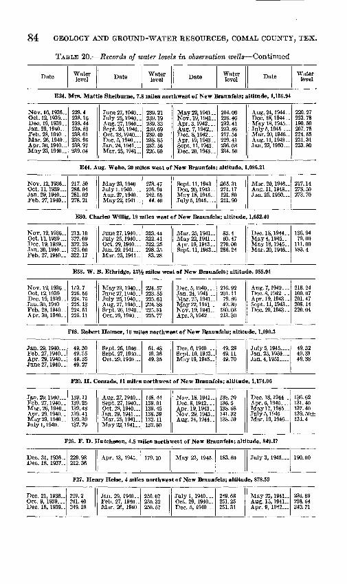
84 GEOLOGY AND GROUND-WATER RESOURCES, COMAL COUNTY, TEX.
TABLE 20. Records of water levels in observation wells Continued
Date Water level Date Water
level Date Water level Date Water
level
E24. Mrs. Mattie Shelburne, 7.8 miles northwest of New Braunfels; altitude, 1,156.94
Nov. 16,1936.. Oct. 12, 1939... Dec. 19,1939.. Jan. 29, 1940... Feb. 28, 1940.. Mar. 26, 1940.. Apr. 30, 1940.. May 23, 1940..
228.4 238. 16 238. 44 238. 53 238.61 238. 95 238.97 239.04
June 27, 1940. . July 25, 1940. . Aug. 27, 1940- Sept. 26, 1940- Oct. 28, 1940 Dec. 5, 1940... Jan. 24, 1941 Mar. 25, 1941-
239. 21 239.19 239.33 239.69 239.40 238.85 237.56 226.60
May 22, 1941- Nov. 19, 1941.. Apr.3, 1942... Aug. 7,1942-. Dec. 8, 1942... Apr. 19, 1943- Sept. 11, 1943- Dec. 20,1943..
204.00 226.46 232.41 233.86 217. 54 229. 41 236. 03 234.50
Aug. 24, 1944.. Dec.18,1944.. Mayl8,1945.. July5, 1945 Mar. 20, 1946- Aug. 11,1948- Jan. 23, 1950...
220.27 223.78 190.50 207.75 224.55 231. 31 233.80
E44. Aug. Wehe, 20 miles west of New Braunfels; altitude, 1,096.21
Nov. 12, 1936_. Oct. 11, 1939... Jan. 29, 1940... Feb. 27, 1940..
217.50 286. 04 281. 02 278. 21
May23,1940- July 1, 1940 Aug. 27, 1940- May22, 1941..
278. 47 276. 94 282.55 44.40
Sept. 11, 1943- Dec. 20, 1943.. May 18, 1945.. July 5, 1945
£65. 31 271.17 121.80 211.90
Mar. 20, 1946- Aug.ll, 1948.. Jan. 25, I960
217. 14 278. 50 273. 70
E50. Charles Willig, 18 miles west of New Braunfels; altitude, 1,052.40
Nov. 12,1936.. Oct. 11, 1939 Dec. 19,1939.. Jan. 30, 1940... Feb. 27, 1940..
213. 10 322. 09 322. 35 325. 00 322.17
June 27, 1940. . July 25,1940-. Oct. 29, 1940 Jan. 29, 1941... Mar. 25, 1941..
323. 44 322. 41 322. 25 298. 35 83.28
Mar. 25, 1941.. May22,1941.. Apr. 19,1943.. Sept. 11, 1943-
83.4 60.47
270. 00 286. 24
Dec. 18,1944-. May 4, 1945.- Mayl8,1945.. Mar. 20, 1946..
136. 94 79.00
111.00 183.4
ESS. W. B. Ethridge, 13V2 miles west of New Braunfels; altitude, 955.94
Nov. 12, 1936- Oct. 12, 1939... Dec. 19, 1939. . Jan. 30, 1940,.. Feb. 28, 1940. . Apr. 30, 1940..
153. 7 226. 55 224. 75 225. 13 224. 51 225. 11
May23, 1940- June 27,1940.. July 25,1940.. Aug. 27, 1940- Sept. 26, 1940- Oct. 29, 1940
224. 57 223. 55 225. 61 224. 88 225. 81 225. 77
Dec. 5, 1940--. Jan. 24, 1941 Mar. 25, 1941- May22, 1941-. Nov. 19, 1941- Apr.3,1942.-.
216. 92 201. 11 79.86 49.30
180. 03 213. 30
Aug.7,1942 Dec. 8, 1942. _- Apr. 19, 1943. - Sept. 11, 1943- Dec. 20, 1943. .
216. 24 100. 07 201. 47 208.14 220. 04
F18. Robert Heimer, 10 miles northwest of New Braunfels; altitude, 1,090.3
Jan. 29, 1940... Feb. 27, 1940.. Apr. 29, 1940.. June 27, 1940. .
49.30 49.35 49.35 49.27
Sept. 26, 1940- Sept. 27, 1940- Oct. 29, 1940
61.48 49.36 49.35
Dec. 6, 1940... Sept. 10, 1943- Mayl9, 1945-
49.28 49.11 49.70
July5, 1945 Jan. 23, 1950 Jan. 4, 1951 .
49.32 49.31 49.38
F20. H. Conrads, 11 miles northwest of New Braunfels; altitude, 1,174.06
Jan. 29. 1940... Feb. 27, 1940.. Mar. 26, 1940- Apr. 29. 1940.. May 23, 1940 .. Julyl, 1940 .
139. 11 139. 25 139. 48 139. 41 139. 39 137. 79
Aug. 27, 1940. Sept. 27, 1940- Oct. 28, 1940... Jan. 29, 1941 Mar. 25, 1941.. May 22,1941..
148. 44 139. 91 139. 45 138. 39 132. 11 132. SO
Nov. 18,1941- Dec. 8, 1942 ... Apr. 19, 1943.. Nov. 29, 1943- Aug. 24, 1944. .
138. 20 136.5 138. 68 341.32 138. 59
Dec. 18, 1944. . Apr. 6, 1945.. . May 1 7, 1945.. July5, 1945 Mar. 19, 1946-
136. 62 131. 40 137. 40 139. 50± 134.4
F26. F. D. Hutcheson, 4.5 miles northwest of New Braunfels; altitude, 849.17
Dec. 31, 1936- Dec. 18, 1937-
229. 98 212. 36
Apr. 13, 1945.. 179.10 May 23, 1945. 183.50 July 3, 1945 190.00
F27. Henry Heise, 4 miles northwest of New Braunfels; altitude, 878.59
Dec. 21, 1936- Oct. 9, 1939... Dec. 18, 1939-
259.2 261.40 249. 58
Jan. 29, 1940 .. Feb. 27, 1940- Mar. 26, 1940.
250.07 250. 32 250. 57
Julyl, 1940 .- Oct. 29, 1940- Dec. 5, 1940
249. 68 251. 25 251. 31
May 23, 1941- Aug. 15, 1941- Apr. 9, 1942
236.89 236. 64 242. 21

RECORDS OF WATER LEVELS IN OBSERVATION WELLS 85
TABLE 20. Records of water levels in observation wells Continued
Date Water level Date Water
level Date Water level Date Water
level
F29. Henry Rahe, 6 miles northwest of New Braunfels; altitude, 966.94
Apr. 13, 1945- May 16, 1945..
274.6 289.8
July 4, 1945 297.9 Jan. 24, 1950... 304.0 Jan. 5, 1951... 304.77
F34. H. W. Dietz, 7% miles northwest of New Braunfels; altitude, 968.07
Apr. 27, 1945.. May 19, 1945-
268.1 269.3
July 4, 1945 269.45 Jan. 24, 1950. . 267.3 Jan. 4,1951-- 267.23
F38. Paul Tonne, 9 miles west of New Braunfels; altitude, 954.06
Nov. 9, 1936- . -Jan. 10, 1937. _
255.64 254. 87
May 4, 1945 May 18, 1945-
246. 00 254. 10
July 11, 1945- Jan. 22, 1950. .
266.90 271.00
Jan. 4, 1951 276.9
F41. Krueger Brothers, 6 miles northwest of New Braunfels; altitude, 941.79
Jan. 25, 1937- .Oct. 10. 1939..Jan. 29, 1940..Feb. 27, 1940-Apr. 29, 1940-May 23, 1940-June 27, 1940..July 26, 1940-Aug. 27, 1940-
188. 75171.89179.90175. 49177. 54180.37180.93182. 46178. 43
Sept. 26, 1940.Oct. 28, 1940- .Dec. 5, 1940 Jan. 24, 1941 _.Mar. 25, 1941.May22, 1941-Nov. 18, 1941.Mar. 6, 1942.-Apr. 3, 1942
176. 87184. 91187. 22175. 16170. 54168. 19177. 36172. 81180.42
Aug. 7, 1942 Dec. 8, 1942.-Apr. 19, 1943-Sept. 10, 1943-Dec. 20, 1943-Mayl, 1944 Aug. 24, 1944-Dec. 18, 1944_.May 18, 1945-
176. 62177. 21167. 92167. 70174. 36177. 03175. 19176. 28182. 40
July 4, 1945 Mar. 19, 1946.July6, 1947 Nov. 23, 1947-May 2, 1948 Aug. 11, 1948-.Tan. ?3, 1950..Jan. 3, 1951
181. 48168.00188.86192. 74197. 12196. 14195. 67197. 77
F44. Walter Kappelmacher, 3.5 miles west of New Braunfels; altitude, 861.68
Oct. 10, 1939. .Dec. 18, 1939-Jan. 29, 1940- .Feb. 28, 1940-Mar. 26, 1940-Apr. 29, 1940..May 23, 1940-June 27, 1940-July26, 1940..
233. 09233.80234. 05234.19234.42234.42234.28233.48233.84
Aug. 27, 1940-Sept. 23, 1940 _Oct. 29, 1940-Dec. 5, 1940 Jan. 24, 1941 ..Mar. 28, 1941.Aug. 14, 1941-Nov. 19, 1941.Jan. 14, i942__
234. 41234. 85235. 27235. 30233. 64229. 87223. 22225.58226.90
Mar. 6, 1942-Apr. 3, 1942 Aug. 7, 1942 Dec. 7, 1942 Dec. 8, 1942 Apr. 19, 1943-Apr. 29, 1943-Sept. 10, 1943.May 1, 1944
227. 92228.50228. 82220. 85220. 86224. 61224. 91227. 85223. 98
May 24, 1945-Julv3, 1945 May 19, 1946-July6, 1947 Nov. 23, 1947-May2, 1948 Jan. 11,1949.-Jan. 23, 1950..Jan. 4, 1951
217.80219. 10225.1220.58225. 16229. 69233.90233. 05235.65
F49. Richard Gesche, 7.5 miles west of New Braunfels; altitude, 916.65
Oct. 11, 1933..Dec. 16, 1936-May 24, 1945-
267. 35259. 82233.00
July 3, 1945...July 5, 1947
240. 48239. 34
Nov. 23, 1947.Apr. 23, 1947-
241.61254. 80
Jan. 23, 1950- -Jan. 3, 1951..-
267.02266. 39
F50. Henry Ludwig, 7% miles west of New Braunfels; altitude, 920.9
Apr. 13, 1945.. May 18, 1945..
221.5 231.9
July 11, 1945.. JulyS, 1947
244.5 244. 53
Nov. 27, 1947. Apr. 23, 1948-
246.3 261. 18
Jan. 25, I960-. Jan. 3, 1951. ..
266.22 269.38
F52. Charles Wuest, 11% miles west of New Braunfels; altitude, 976.9
Apr. 27, 1945- May 18, 1945-
266.8 276.3
July 4, 1945 276.1 Jan. 25, 1950 .. 280.95 Jan. 8, 1951... 285.81
F61. O. C. Brehmer, 5 miles west of New Braunfels; altitude, 916.87
May 25, 1934- Dec. 1, 1936
283.63 278. 53
Jan. 10, 1937. . May 23, 1945..
278. 37 262. 14
July 13, 1945. - 265. 04 Jan. 4, 1951... 284.50
F68. Schaeffer Brothers, 7 miles southwest of New Braunfels; altitude, 886.1
May 28, 1934- Dec. 18, 1936..
241. 69 243. 50
May 25, 1945- 231. 84 July 13, 1945- 234. 74 Jan. 23, 1950- . 233.22
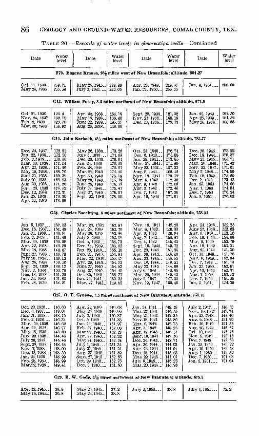
86 GEOLOGY AND GROUND-WATER RESOURCES, COMAL COUNTY, TEX.
TABLE 20. Records of water levels in observation wells Continued
Date Water level Date Water
level Date Water level Date Water
level
F70. Eugene Krause, 9% miles west of New Braunfeis; altitude, 904.27
Oct. 11, 1933..May 25, 1936-
259. 71255. 54
May 25, 1945-JulyS, 1945...
229. 80232.05
Apr. 23, 1948-Jan. 23, 1950. .
249. 37266. 35
Jan. 4, 1951... 266.60
G13. William Posey, 8.5 miles northeast of New Braunfeis; altitude, 671.5
Oct. 21, 1936. -Nov. 24, 1937-Feb. 2, 1938 ..Mar. 30, 1938-
123.4130. 19123. 70158.92
Apr. 22, 1938..May 18, 1938- -June 22, 1938- _Aug. 26, 1938-
154.18138. 40185. 37149. 60
Sept. 28, 1938.Nov.21,1938-Dec. 13, 1938..
181. 38168. 19179. 73
Jan. 25, 1939..Apr. 23, 1939. .May 26, 1939-
161.50181. 52166. 33
G19. John Karbach, 4Vt miles northeast of New Braunfeis; altitude, 783.77
Dec. 20, 1937- .Jan. 22, 1938. .Feb. 2,1938,..Mar. 30, 1938.Apr. 22, 1938-May 19, 1938. -June 23, 1938-July 20, 1938. .Aug. 30, 1938-Sept. 28, 1938.Dec. 12, 1938-Jan. 25, 1939- .Apr. 22, 1939_
173.32172. 50170. 90171. 14171. 46168. 76169. 39169. 93171. 20176. 52172. 21173.29173. 98
May26, 1939- .JulyS, 1939-.-Dec. 20, 1939-Jan. 24, 1940..Feb. 28,1940Mar. 22, 1940-Apr. 30, 1940-May28, 1940-June 25, 1940-July29, 1940..Aug. 27, 1940 .Sept. 23, 1940_
173. 26174. 68176. 04176. 19176. 97176. 35176. 19176. 18175.78175. 47176. 01176. 50
Oct. 28, 1940..Dec. 6, 1940 Jan. 29,1941..Mar. 27, 1941.May 23, 1941-Aug. 8, 1941-Nov. 19, 1941-Mar. 6, 1942 _.Apr. 9, 1942 Aue. 3, 1942 Dec. 7, 1942 Apr. 19, 1943-
176. 74175. 88173. 85171.80167. 33168. 18170. 12172. 30172. 68172. 45167. 36171. 01
Dec, 20, 1943-Dec. 19, 1944_ .Mav23, 1945-Mar. 20, 1946-Nov. 22, 1947-May 2, 1948 Feb. 10, 1949- .Dec. 7, 1949 Jan. 23, 1950. -Aug. 1, 1950 Dec. 7, 1950... _Jan. 5, 1951...
173.22170.37165. 71171. 42171. 01174. 59175. 69173. 43174.00174.84176. 24176. 03
G23. Charles Soechting, 6 miles northeast of New Braunfeis; altitude, 758.31
Jan. 5, 1937-..Dec. 15, 1937-Jan. 21, 1938- .Feb. 2, 1038 . .Mar. 30, 1938.Apr. 22, 1938..Mav 18, 1938-June 22, 1938-.Julv20, 1938..Aug. 26, 1938.Sept. 28, 1938-Nov. 2, 1938.Dec. 13, 1938_.Jan. 24, 1939. -Feb. 28, 1939 .
157. 53151. 49149.81151.49149. 06149. 29146. 67146. 78148. 13150. 50149.12150. 79151. 20151.83154. 21
Mar. 28, 1939_Apr. 23, 1939-May 26, 1939-July 3, 1939 _Oct. 4, 1939--.Dec. 18, 1939- .Jan. 23, 1940..Feb. 27, 1940.Mar. 22, 1940-Apr. 29, 1940-June27, 1940__Aug. 27, 1940. .Oct. 30, 1940Jan. 24, 1941Mar. 27, 1941.
152. 91152. 75152. 86152. 50153. 73156. 02155. 10154. 91155. 17154.52154. 82154. 45155. 71152. 22149. 85
Nov. 18, 1941-Mar. 6, 1942..Apr. 9, 1942 Aug. 7, 1942 Dec. 4, 1942 . _Sept. 10, 1943-DPC. 20, 1943- _Apr. 30, 1944_ .Aug. 23, 1944-Dec. 18, 1944- _May 23, 1945 .July 6, 1945..-Mar. 20, 1946-Julv5, 1947-..Nov. 19, 1947.
148. 23150. 33150. 94150. 81145. 32149. 72151.36146. 40146. 65148. 51144. 08145. 60149. 42147. 22150. 45
Apr. 24, 1948-June 25, 1948-Au?. 6,1948-.Feb. 10, 1949- _Mnr. 9, 1949. .Apr. 18, 1949-Aug. 25, 1949 .Oct. 10, 1949-Nor. 8, 1949. .De. . 7, 1949 Jun. 23, 1950..Apr-. 10, 1950-Aur. 1, 1950.-.DPC. 7, 1950 ._Jan. 5, 1951...
152. 25153. 03153. 10154. 66153. 79153. 31151. 30151.75152. 84151.13152. 61152. 31153. 12154. 05154. 30
G25. O. E. Gruene, 7.5 miles northeast of New Braunfeis; altitude, 752.70
Oct. 20,1936..Deo. 6, 1937. -Jan. 21. 1938- -Feb. 2, 1938...Mar. 30,1938Apr. 22, 1938-May 18, 1938..June 22, 1938. .July 20, 1938 - -Sept. 28, 1938.-Nov. 2, 1938 Dec. 13, 1938-.Jan. 24,1939_-Feb. 28, 1939..Mar.22, 1939..
146. 63149. 04148. 15146. 34146. 62146. 77143. 89144. 46145. 46148. 43148. 00148. 50148. 99148. 99149. 41
Apr. 22,1939-May 2fi, 1939July 3, 1939 ..Oct. 5,1939-..Jan. 23, 1940. .Feb. 27,1940..Mar.22, 1940-Apr. 29, 1940-May24, 1940.July 1,1940-..July 27, 1940. -Aug. 27, 1940. .Sept. 27, 1940__Oct. 29, 1940. _Dec. 5,1940-..
149. 68149. 99150. 37151.33151. 97152. 08152. 23152. 32152. 24151. 34151.21151. 89152. 56152. 76151. 50
Jan. 24, 1941- .Mar. 27,1941-.May 23, 1941-Nov.18, 1941.Mar. 6, 1942 Apr. 3, 1942 Apr. 19,1943-Sept. 10, 1943-Dec. 20, 1943 ..Apr. 30,1944-Aug. 23, 1944..Dec. 18,1944..May 22, 1945 _July 6. 1945...Mar. 20, 1946-
149. 19146. 55142. 35145. 86147. 75148. 25146. 51147. 16148. 71144. 03144. 01145. 63141. 01143. 25146. 93
July 2, 1947...Nov. 19,1947.Apr. 23,1948..Aug. 6, 1948_._Feb. 10,1949.-Aug. 25, 1949-Oct. 10,1949^-Nov. 8,1949 Dec. 7,1949-..Jan. 23, 1950 . -Apr. 10,1950-.Aug. 1, 1950 .-Dec. 7,1950...Jan. 5,1951.-.
146. 73147. 74148.40151. 90151. 55148. 67148. 75149. 16148. 50149. 22149. 43149. 32151. 03151.64
G29. R. W. Code, 3% mites northwest of* New Braunfeis; altitude, 675.5
Apr. 13, 1945..May 16, 1945..
38.836.8
May 23, 1945..May 24, 1945..
37.238.8
July 2, 1950... 38.8 July4,1951... 52.2
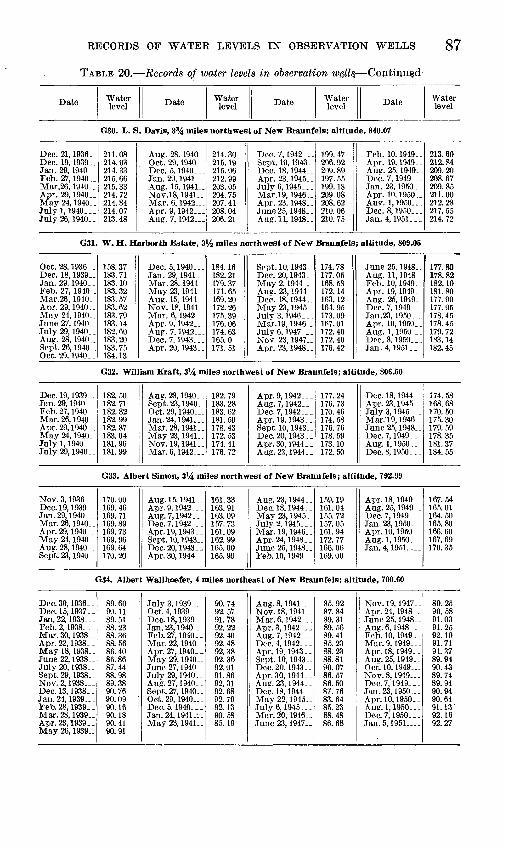
RECORDS OF WATER LEVELS IN OBSERVATION WELLS 87
TABLE 20. Records of water levels in observation wgll§ Coiitimifcl
Date Water level Date Water
level Date Water level Date Water
level
G30. L. S. Davis, 3% miles northwest of New Braunfels; altitude, 840.07
Dec. 21, 1936. .Dec. 19, 1939.Jan. 29, 1940 __Feb. 27, 1940..Mar.26, 1940_.Apr. 29,1940..May 24, 1940. .July 1,1940...July 26, 1940. .
211. 08214. 03214. 33215. 66215. 33214. 72214. 84214. 07213. 48
Aug. 28, 1940_ .Oct. 29, 1940__Dec. 5,1940 Jan. 29, 1941 __Aug. 15, 1941__Nov.18, 1941 ..Mar. 6, 1942- _.Apr. 9,1942 Aug. 7,1942...
214. 30215. 19215. 06212. 99203. 05204. 75207. 41208. 04206. 21
Dec. 7, 1942 Sept. 10, 1943.Dec. 18, 1944. _Apr. 23, 1945. _July 6, 1945...Mar.19, 1946-.Apr. 23, 1948. .June 25, 1948 Aug. 11, 1948-
199. 47206. 92209. 89197. 55199. 18209. 08208. 62210. 06210. 75
Feb. 10, 1949 _.Apr. 19,1949-.Aug. 25, 1949_Dec. 7, 1949 Jan. 23,1950.-Apr. 10,1950..Aup. 1, 1950 Dec. 8, 1950...Jan. 4, 1951.--
213. 60212. 84209. 20208.67209.85211.00212.28217. 55214. 72
G31. W. H. Harborth Estate, 3V2 miles northwest of New Braunfels; altitude, 809.05
Oct. 28, 1936 .Dec. 18, 1939..Jan. 29, 1940Feb. 27, 1940 _Mar.26, 1940_Apr. 29, 1940. .May 24, 1940..June 27, 1940. .July 29, 1940..Aug. 28, 1940.Sept. 26, 1940-Oct. 29, 1940__
158. 37183. 71183. 10183. 32183. 57183. 62183. 79183. 14182. 60183.20183. 75184. 13
Dec. 5,1940...Jan. 29, 1941 .Mar. 28, 1941May 23, 1941 .Aug. 15, 1941_ _Nov. 18, 1941_Mar. 6, 1942-Apr. 9,1942 Aug. 7,1942 Dec. 7,1943...Apr. 20, 1943-
184. 16182. 21179. 37171.65169. 20172. 26175. 39176. 06174.63165.0171. 51
Sept. 10, 1943Dec. 20, 1943-May2, 1944 ..Aug. 23, 1944Dec. 18,1944-.May 23, 1945.JulyS, 1946_ _.Mar.19, 1946-July 6, 1947 ..Nov. 23, 1947..Apr. 23, 1948-
174. 78177. 05168. 58172. 14163. 12164. 95173. 091R7. 01172. 40172. 40176. 42
June 25, 1948..Aug. 11, 1948Feb. 10, 1949-Apr. 19, 1949_Aug. 25, 1949.Dec. 7,1949 Jan. 23, 1950 _Apr. 10,1950..Aug. 1, 1950 Dec. 8, 1950...Jan. 4, 1951.,-
177.80178. 82182. 10181.80177. 90177. 95178. 45178. 45179. 72183.14182. 45
G32. William Kraft, 3Vi miles northwest of New Braunfels; altitude, 806.50
Dec. 19, 1939_ -Jan. 29, 1940 Feb. 27, 1940_ _Mar. 26, 1940-Apr. 29,1940_.May 24, 1940-July 1, 1940- _ _July 29, 1940_ _
182.50182. 71182. 82182. 99182. 87183. 04181. 96181. 99
Aug. 28,1940_.Sept. 23, 1940-Oct. 29, 1940 Jan. 24, 1841 Mar. 28, 1941. .May 23, 1941-Nov. 19,1941..Mar. 6, 1942
182. 79183. 28183. 62181.50178. 43172. 53174. 41176. 72
Apr. 9, 1942_ _ _Aug. 7, 1942 Dec. 7, 1942- _ _Apr. 19, 1943 . .Sept. 10, 1943_ _Dec. 20, 1943..Apr.30, 1944--Aug. 23, 1944 . .
177. 24176. 73170. 46174.58176. 76178. 59173. 10172. 50
Dec. 18, 1944. _Apr. 23, 1945__July 3, 1945- - _Mar. 19, 1946. _June 25, 1948__Dec. 7, 1949- - -Aug. 1,1950.. _Dec. 8, 1950 _._
174. 58168.68170.50175. 30179. 59178. 35181.37184. 55
G33. Albert Simon, 3Vi miles northwest of New Braunfels; altitude, 792.99
Nov. 3, 1936 Dec. 19, 1939_ _Jan. 29, 1940 Mar. 26, 1940-Apr. 29, 1940_ _May 24, 1940-Aug. 28, 1940-.Sept. 23, 1940-
170. 00169. 46169. 71169. 89169. 73169. 96169.64170.20
Aug. 15, 1941. .Apr. 9, 1942. _ _Aug. 7, 1942 Dec. 7, 1942...Apr. 19, 1943. _Sept. 10, 1943-Dec.20, 1943--Apr. 30, 1944_ _
161. 33163.91163.09157. 73161. 09162. 99165. 00165.90
Aug. 23, 1944. _Dec. 18, 1944 . _May 23, 1945-July 2, 1945_ _ _Mar. 19, 1946- .Apr. 24,1948-.June 25, 1948..Feb. 10, 1949_ _
159. 19161.01155. 72157.05161. 94172. 77166. 06169. 00
Apr. 18, 1949- _Aug. 25, 1949 _ .Dec. 7, 1949- _ -Jan. 23, 1950. __Apr. 10, 1950_ _Aug. 1,1950- . .Jan. 4, 1951
167.54165. 01164. 50165.80166. 60167. 69170.35
G34. Albert Wallhoefer, 4 miles northeast of New Braunfels; altitude, 700.60
Dec. 30, 1936_ _Dec. 15,1937-.Jan. 22, 1938 Feb. 2, 1938- - _Mar. 30, 1938- _Apr. 22, 1938_ _May 18, 1938-June 22,1938..July 20, 1938. _Sept. 29, 1938.Nov.2, 1938 Dec. 13, 1938. _Jan. 24, 1939-Feb. 28, 1939. -Mar. 28, 1939..Apr. 23, 1939- _May 26, 1939-
89.6090.1189.5188.2388.3688.5686.4086.8687.4488.9889.3890.7690.0990.1690.1890.4190.91
July 3, 1939_ _ _Oct. 4, 1939 -Dec. 18, 1939_ _Jan. 23, 1940- _Feb. 27, 1940. _Mar. 22, 1940. _Apr. 27, 1940. .May 29, 1940-June 27,1940-July 29, 1940- .Aug. 27, 1940. _Sept. 27, 1940-Oct. 29, 1940 Dec. 5, 1940...Jan. 24, 1941_i.May 23, 1941-
90.7492.5791.7892.2292.4092.4892.3892.3692.0191.8692.3192.6892.7992.1390.5885.19
Aug. 8, 1941_ _ _Nov. 18, 1941 _ _Mar. 6, 1942 Apr. 3, 1942- . .Aug. 7,1942_. _Dec. 4, 1942_ _ _Apr. 19, 1943- .Sept. 10, 1943-Dec. 20, 1943- .Apr. 30, 1944. _Aug. 23, 1944_ _Dec. 18, 1944- _May 22, 1945-July 6, 1945. __Mar. 20, 1946- .June 23, 1947. .
85.9287.8489.3189.5689.4185.2388.2388.8190. 0786.5786.5087.7683.6485.2388.4886.68
Nov. 19, 1947-Apr. 24, 1948 -June 25, 1948-Aug.6,1948 Feb. 10, 1949_ _Mar. 9, 1949. _ _Apr. 18, 1949_ _Aug. 25, 1949. -Oct. 10, 1949 No v. 8, 1949 Dec. 7, 1949-.-Jan. 23, 1950 Apr. 10, 1950- -Aug.l, 1950 Dec. 7, 1950. _ -Jan. 5, 1951 .
89.2590.5891.0391.2592.1091.7191.3789.9490.4389.7489.9490.9490.6491.13'92.1692.27

88 GEOLOGY AND GROUND-WATER RESOURCES, COMAL COUNTY, TEX>
TABLE 20. Records of water levels in observation wells Continued
Date Water level Date Water
level Date Water level Date Water
level
G43. Bruno Preiss, 2'/2 miles northeast of New Braunfels; altitude, 672.17
Oct. 21, 1936...Dec. 6, 1937. __Jan. 21, 1938..Feb. 2, 1938 __Mar. 30, 1938. _May 18, 1938._July 19,1938,.Aug. 26, 1938..Sept.28, 1938..Nov. 2.1938. -.Dec. 12, 1938..Jan. 24, 1939..-Feb. 28, 1939, .Mar. 28, 1939-Apr. 23, 1939, _May 26, 1939..
51.2352.9352.3951.4351.5349.7651.2351.8052.2252.5752.7753.0253.2653.3753.6453.89
July 3,1939.. _Oct. 5, 1939.--Dec. 18, 1939-Jan. 24, 1940...Feb. 27, 1940 . -Mar. 22, 1940..Apr. 27, 1940 .June 27, 1940.July 29, 1940- _Aug. 27, 1940. .Sept. 23, 1940-Oct.28, 1940,--Dec. 5, 1940-..Jan. 24, 1941...Mar. 28, 1941-May 23, 1941..
55.0154.6554.7854.8554.9555.0454.9954.5354.7255.1855.4255.4354.8053.7652.1849.47
Aug. 8, 1941...Nov. 14, 1941 -Mar. 6, 1942..-Apr. 3, 1942.--Aug. 7, 1942...Dec. 4, 1942. . _Apr. 19,1943--Sept. 10, 1943.Dec. 20, 1943 . -Apr. 30, 1944 .Aug. 23, 1944..Dec. 19, 1944 -May 23, 1945-July6, 1945.,-Mar. 20, 1946-.
50.4451.4152.4652.7352.7149.5751.7752.4955.8250.9351.2651.5149.9750.0951.96
July 6, 1947. - .Nov. 22, 1947-Aug.6, 1948...Feb. 10, 1949 - _Mar. 9, 1949...Apr. 18, 1949 _Aug. 25, 1949. .Oct. 10, 1949...Nov. 8, 1949- _Dec. 7, 1949.- -Jan. 23, 1950 __Apr. 10, 1950 . -Aug. 1, 1950. . .Dec. 7, 1950. - _Jan. 4, 1951-.-
52. 25.52.93.54.9155.4755. 0354.90-53.8653.8453. 3853.6854.0154.3254. 92'45.6555.77
G48. Dean Word, IVi miles northwest of New Braunfels; altitude, 747.83
Jan. 6,1937_. _Apr. 13, 1945- .
119. 55121.90
May 19, 1945. _May 24, 1945..
122. 10122. 30
July 2, 1945...July5, 1947- -
122. 75122. 97
June25, 1948_-Jan. 4, 1951_ __
124.81125. 13
G53. A. Swanson, in New Braunfels; altitude, 736.05
Jan. 6,1937-..Apr. 13, 1945..May 19,1945..
100. 80110. 09110. 06
May 24,1945_.July 2, 1945...July 5, 1947...
110. 34110. 85111. 58
Nov. 23, 1947..Apr. 24, 1948. .
112. 65113. 30
Jan. 23, 1950- .Jan. 4, 1951.--
113. 20114. 20
G67. Walter Sippel, 1V2 miles southwest of New Braunfels; altitude, 649.7
Dec. 20, 1943-May30,1945__July 4, 1945...
16.06.67.9
July 13, 1945.-July 5, 1947--
9.010.0
Nov. 22, 1947-May2, 1948...
12.216.1
Jan. 23,1950...Jan. 4, 1951.
11.317.33
G77. L. Jentsch, 3.0 miles southwest of New Braunfels; altitude, 661.45
Dec. 4, 1936...Dec. 15,1937..Jan. 21, 1938...Feb. 2, 1938...Mar. 30, 1938..Apr. 22,1938-.May 19,1938..Jan. 25, 1938...Apr. 23,1939..May 26, 1939..July 3, 1939...Oct. 5, 1939...Mar. 22, 1940-
16.4419.9919.4618.2718.3318.9517.2521.8723.4123.9024.6525.1325.41
Apr.26,1940__May 23,1940-.Sept. 25, 1940.Oct. 29, 1940- .Jan. 29, 1941-Mar. 25, 1941May 23, 1941..Aug. 11,1941..No\.14, 1941..Mar. 6, 1942..Apr. 9, 1942...Aug. 7, 1942...Dec. 3, 1942...
24.9426.0027.0227.0624.4521.3917.3319.7619.8121.1020.3422.1916.82
Apr. 20, 1943. .Dec. 21, 1943-Aug.24,1944-Dec. 19, 1944-May23,1945..July 13, 1945..Mar. 19, 1946-July 5, 1947. ..Nov. 22,1947..Apr. 24, 1948. .June 25, 1948..Aug.6,1948...
20.3623.1122.9821.6118.8320.1422.2421.7524.4526.6728.9729.03
Feb. 11,1949..Mar, 9,1949.-Apr. 20, 1949..Aug. 25,1949-.Oct. 10, 1949. .Nov. 8, 1949...Dec. 7, 1949-..Jan. 23, 1950..Apr. 10, 1950-.Aug. 1,1950--.Dec. 8, 1950 _Jan. 3, 1951.-.
29.4628.7228.4026.1627.3125. 73.25.9626.0226. 40'27.9129.05.29.03
H5. Otto Eeinartz, 4 miles southwest of New Braunfels; altitude, 666.77
May 24, 1934.. Oct. 8, 1934....
15.90 19.07
Aug. 5, 1935... 15.90 Aug. 10, 1935.. 15.00 Dec. 3, 1936... 9.41
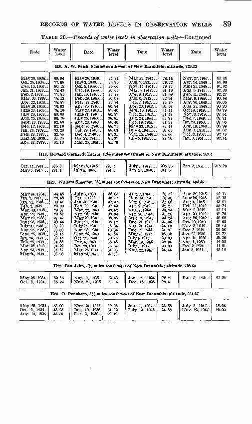
EECOEDS OF WATEE LEVELS IN OBSEEVATION WELLS 89
TABLE 20. Records of water levels in observation wells-^Continued
Dote Water level Date Water
level Date Water level Date Water
level
H6. A. W. Feick, 5 miles southwest of New Braunfels; altitude, 728.13
May 28, 1934-Oct. 26, 1936...Dec. 15,1937..Jan. 21, 1938...Feb. 2, 1938...Mar. 30, 1938..Apr. 22, 1938. _May 19, 1938..June 23, 1938.July 20, 1938 __Aug. 25, 1938..Sept. 28, 1938..Dec. 12, 1938..Jan. 24, 1939...Feb. 28, 1939. .Mar. 28, 1939__Apr. 22,1939.-
69.9477.0880.5279.4377.8578.1378.8776.8378-. 1680.0080.7682.6882.1883.2082.6683.2684.18
May 26, 1939..July 3, 1939 Oct. 5,1939 .Dec. 19, 1939. _Jan, 30, 1940 Feb. 20, 1940 . .Mar. 22, 1940..Apr. 20,1940..May 23, 1940-June 21, 1940- .July 25, 1940 Aug. 28, 1940-Sept. 26, 1940-Oct.29,1940 Dec. 4, 1940-..Jan. 29, 1941 Mar. 25, 1941-
84.9486.9686.6086.0585.7286.0786.7486.9487.4686.9786.8188.4088.7588.6387.3185.3781.78
May 23, 1941 ._Aug. 7, 1931 Nov. 14, 1941- _Mar. 6, 1942 Apr. 9, 1942.. _Aug. 6,1942_ Dec. 3, 1942 _. _Apr. 20,1943-.Sept. 10, 1943-Dec. 21, 1943--Aug. 24, 1944.-Dec. 19, 1944..May 23, 1945-July 4, 1945 -Mar, 19, 1946-JulyS, 1947
78.1479.7279.7781.1981.6982.6176.7080.6784.1184.1983.9781.8778.4480.0583.6682.76
Nov. 27, 1947-Apr. 24, 1948 ._June 25, 1948-Aug.6, 1948...Feb. 11, 1949-Mar. 9, 1949 Apr. 20, 1949- _Aug. 25, 1949- _Oct 10, 1949- . .Nov. 8, 1949 Dec. 7, 1949. ..Jan 23, 1950.. .Apr. 10, 1950_ _Aug. 1,1950. - -Dec. 8, I960.--Jan. 3, 1951 .
85.5889.0091.3292.3092.2790.5486.0590.2089.7987.3487.7187.9588.9991.6292.1392.14
H14. Edward Gerhardt Estate, 12V2 miles southwest of New Braunfels; altitude, 967.4
Oct. 11, 1933 May 5, 1945-..
306.8 291.1
May 18, 1945- July 4, 1945
290.5 294.5
July 3, 1947 . Jan. 25, 1950
295. 36 311.6
Jan. 3,1951 319. 79
H20. William Shaeffer, 6% miles southwest of New Braunfels; altitude, 684.45
May 24,1934-.Jan. 7, 1937 Jan. 21, 1938 Feb. 2, 1938- -Mar. 30, 1938-Apr. 22,1938-Mayl9,1938._June 23, 1938July 20, 1938 Aug. 25, 1938- . Sept. 28, 1938.-Jan. 24, 1939...Feb. 28,1939-.Mar. 28, 1939__Apr. 23,1939--May26, 1939_-
34.4828.4830.4129.0029.3729.6127.4729.4430.9333.00 32.4533.4534.8834.2935.6736.78
July 3, 1939 Oct. 5, 1939 _Jan. 30, 1940 Feb. 20, 1940. _Mar. 22, 1940-Apr. 26,1940-May 23,1940..June 21, 1940 ..July 25, 1940 Aug. 28, 1940- Sept. 24, 1940-Oct. 29, 1940...Dec. 4, 1940..-Jan.29,1941...Mar. 25, 1941-May23, 1941-.
38.6538.5737.3737.5338.4238 8438.9538.1238.3440.34 40.5439.7638.4836.6431.9327.38
Aug. 7, 1941.. .Nov. 14, 1941. _Mar. 6, 1942...Apr. 9, 1942.. _Aug. 7, 1942 Apr. 20, 1943 __Sept. 10, 1943-Dec. 21,1943-Aug.24, 1944--Dec. 19,1944.. May23,1945_.July 4,1945 Mar. 19, 1945-July5,1947... _Nov. 22, 1947-
30.5230.4031.6632.2733.9431.2634.2435.0635.1931.97 28.3230 9032 9433.9036.66
Apr. 24, 1948- -June 25,1948..Aug. 6, 1948- ._Feb. 11, 1949. -Mar. 9, 1949. __Apr. 20, 1949. .Aug. 25, 1949 __Oct. 10, 1949 Nov. 8,1949,. .Dec. 7, 1949.. . Jan. 23, 1950...Apr. 10,1950..Aug. 1,1950.. _Dec. 8, 1950...Jan. 3, 1951....
40.1742.1843.9143.7442.1441.7040.6041.6538.4439.06 39.7740.3544.0544.9145.12
H22. Ben Jahn, 5% miles southwest of New Braunfels; altitude, 728.63
May 28, 1934 _ Oct. 8, 1934..
82.86 85.24
Aug. 9. 1935.. Nov. 21, 1935.
73.63 77.14-
Jan. 19, 1936. Dec. 18, 1936.
78.21 79.61
Jan. 8, 1951.. 92.22
H23. O. Penshorn, 5% miles southwest of New Braunfels; altitude, 694.67
May 28, 1934. Oct. 9, 1934.. Aug. 10, 1935.
53.00 43.25 35.50
Nov. 21, 1935. Jan. 19, 1936 Dec. 3, 1936- .
30.96 31.92 29.49
Jan. 7, 1937. . July 13, 1945_
36.58 34.58
July 5, 1947- Nov. 23, 1947.
18.06 29.00

90 GEOLOGY AND GROUND-WATER RESOURCES, COMAL COUNTY, TEX.
TABLE 20. Records of water levels in observation wells Continued
Date Water level Date Water
level Date Water level Date Water
level
H28. Percy Hansman, 8 miles southwest of New Braunfels; altitude, 786.53
May 24, 1934. 133. 93 Dee. 3, 1936- 127. 36 Jan. 7, 1937- 128. 88 Jan. 9, 1951.. 145. 12
H31. Lena Binzeil Estate, 13 miles southwest of New Braunfels; altitude, 844.2
Dee. 17, 1936.May 5, 1945-May 18, 1945.
174.3174.6165.8
July 4, 1945. .July 3, 1947. -
170.7170.8
Nov. 23, 1947.Apr. 23, 1947.
182.0185.8
Jan. 25, 1950.Jan. 5, 1951..
v
191.0194. 15
H34. Paul J. Marbach, 13 miles southwest of New Braunfels; altitude, 804.6
May 5, 1945- May 18, 1945.
130.6 132.0
July 4, 1945- July 3, 1947-
135.3 135. 12
Nov. 23, 1947. Apr. 23, 1948.
145.1 148. 99
Jan. Si 1951- . 156. 70
H39. Davenport School, 12 miles southwest of New Braunfels; altitude, 851.7.from record chart
Highest monthly reading
Dec. 10, 1948.Jan. 3, 1949 ..Feb. 28, 2949Mar. 26, 1949Apr. 30, 1949May 16, 1949_June 1, 1949
203.5203.7202.6201.9194.5192.9194.1
July 4, 1949. .Aug. 5, 1949-Sept. 1, 1949-Oct. 31, 1949Nov. 1, 1949-Dec. 20, 1949.
195.2197.6200.3197.0197.0198.0
Jan. 3. 1950 Feb. 24, 1950 .Mar. 5, 1950-Apr. 12, 1950.May 1, 1950-June 7, 1950- -
198.0197.4197.5199.1199.2198.7
July 3, 1950-Aug. 19, 1950Sept. 28, 1950.Oct. 1, 1950-Nov. 19, 1950.Dee. 4, 1950-
201.5203.6204.5204.6204.9205.0
H44. D. N. Barnett, 9 miles southwest of New Braunfels; altitude, 836.5
Dee. 9, 1937-Jan. 2, 1938-Feb. 2, 1938-Mar. 30, 1938Apr. 22, 1938.May 19, 1938June 23, 1938_July 19, 1938.Aug. 25, 1938.
178. 95179. 05175. 50175. 56176.24175. 10176. 15177. 18177. 20
Dec. 12, 1938Jan. 24, 1939Feb. 28, 1939-Mar. 28, 1939.Apr. 22, 1939.May 25, 1939.July 4, 1939..Oet. 5, 1939-
177. 10180. 87181. 28181.501S2. 76183. 75184. 15188. 18
Dee. 19, 1939.Jan. 30, 1940.May 25, 1940_June 21, 1940.Aug. 24, 1944.May 2, 1945-June 25, 1948.July 2, 1948-
185. 90185. 59187. 41187. 35182. 08175. 61191. 71191. 79
Aug. 6, 1948. .Feb. 11, 1949.Mar. 9, 1949- .Jan. 23, 1950.Apr. 10, 1950.Aug. 1, 1950..Dec. 8, 1950..Jan. 3, 1951..
192. 18193. 44192. 78191. 50192.60197. 80193.60193. 80

993963 52 7

92 GEOLOGY AND GROUND-WATER RESOURCES, COMAL COUNTY, TEX.
TABLE 21. Records of wells and springs
[Method of lift: B, bucket; C, cylinder; E, electric; G, gasoline engine; H, hand; T, turbine; W, windmill. Number following letter indicates horsepower. Use of water: D, domestic; Ind., industrial; N, not used; P, public supply, t Water level reported]
Well
A1
A?
A3
A4
A5
A6
A7AR
A9A 10
AllA1?
A 13
A 14
A 15
A 16
A17A18A 19A20
A?1
A??
A23
A24
A 25A?6
A27
Distance (miles) and
direction from New Braunfels
22NW
22HNW -
22NW-. ___ .
.do.-
20J4NW -
19 NW. -do.... .
18J4NW 19 NW
22J4 NW. ___23HNW ...
do....
do..... _ .
22J4 NW
do.
22 NW. __ do
21J4 NW .do.-
19 NW .
18 NW.
17J4NW -
20J4 NW
_ -do.... .23 NW.
22J4 NW .
Owner
Schaeferkoeter.
-do....
H. B. Thompson...
_ _ .do.... ... ...
J. W. Heard. ... .
estate. Ed Gass - -- _H. C. Plumlv
Erich Specht . .
do .. _ - __
William Neuge-bauer.
.do..... D.L. Knibbe _
Edwin Elbel .
J. W. Heard . _.
H. A. Knippe __ ..
Erich Specht- - .
Driller
W. Neugebauer
T. E. Owens -
E. B. Kutscher _...
Date com pleted
1906
1890
19001910
OldIftftfi
Old
1932
1926
1886
19001885OldOld
Old
Old
1937
1918
Old
Depth of well
(ft)
GO A
125
Ofift
226
120142
86184
140Spring
412
75
163
Spring
225124120280
100
280
244
200
175250
200
Di am eter of
well (in)
6
6
6
66
6
6
6
6
6666
6
6
6
6
6
6
Water-bearing formation
stone, lower member.
Travis Peak _____
..do ..
.do....... _
.do..... -
do... - .do..
Travis Peak (?).
_ .do.-... Glen Rose lime
stone, lower member.
Travis Peak. ...
(Glen Rose lime-
( member. _ ...do........ -
Travis Peak. ....
_ - do...... -__ do ... .do. _- ..do,.-. (Glen Rose lime-
! stone, lowerI member. Travis Peak.. _
Glen Rose limestone, lower member.
Travis Peak .....
.do-.. ___ .do....
..... do.......

RECORDS OF WEiLLS AND SPRINGS 93
in Comal County, Tex.
[ Measuring point was usually top of casing, top of pipe clamp, or top of pump base or foundation. All wells are drilled unless noted in remarks column. Numbers in parentheses refer to numbers previously published in waters-supply papers]
Well
Al
A2
A3
A4
AS
A6
A7A8
A9 A10
All A12
A13
A14
A15
A16
A17 A18 A19 A20
A21
A22
A23
A24
A26 A26
A27
Altitude of land surface
(ft)
Height of meas
uring point above
ground (ft)
0.5
.5
1.1
2.0 0
.5
.6
1.2
.4
1.1
2.2 .3
1.2
.7
0 2.6
.5
Water level
Below land
surface (ft)
154.4
113.4
f!70
150.8
72.8 94.2
/ 50.3 I 84.0
177.3
/ 63.5 \ 61.5
45.4
111.5 43 46.2
113.5/ 60.1 \ 66.3
197.5
tioo
58.1 58.0
157.3
Date of measurement
Oct. 3, 1944
Dec. 10,1936
Dec. 9, 1936
Sept. 23, 1943 Oct. 8, 1943
Dec. 9, 1936 Sept. 25, 1943
Nov. 20, 1936
Nov. 20, 1936 Jan. 18, 1943Nov. 20, 1936
Dec. 10,1936
Dec. 10,1936 ...-do.--....Dec. 9, 1936 Oct. 8, 1943Dec. 9, 1936
Nov. 20, 1936 do.. .
___-do__.___.
Method of lift
.... .do......
C, W____._.
C,G_. ______
N"onG
c, w__ ...C, W, G..__
C, W. .._...C,W ......
\C, W- _._
C, W- ..
}c, w. ......C, W. ......
c, w.......c, w.......C, W-___.._C, W_ ....
}c, w.-_--_C, W2, Q...
C, W..
C, W. ...
C, W-__.__.C, W-_ _.
C. W-......
Use of water
N
D, S
D, S
D, C
N
D, S D, S
D, S D,S
D.S D, S
D, S
D, S
D, S
D, S D, S
S
D, S
D, S
S
D, S
D, S D, S
D.S
Remarks
Oil test: upper 300 ft of casing removed. Water from sand at 240-260 ft. Black rock re ported at 550-600 ft.
Estimated yield 50 gpm, Sept. 25, 1943.
Cased to 20 ft. Yield approxi mately 1 gpm per foot of draw-down.
Cylinder set at 280 ft; pump breaks suction in 2 hours when pumped at 5 gpm.
Rebecca Creek Spring. Esti mated yield 1,500 to 2,000 gpm. Temp., 70 F, Oct. 7, 1943.
Water reported from blue clay at 220-226 ft.
Cylinder set at 115 ft.Cylinder set at 120 ft; has
pumped all day'at 5 gpm.Original depth reported 100 ft.Estimated yield 5 gpin, cased
to 10 ft.Breaks suction easily.Spring Branch Spring. Flows
from cavernous limestone. Temp 70 F, Jan. 18, 1943. Volume varies with rainfall. Estimated flow 5,000 gpm Mar. 28, 1945.
Cased to about 325 ft. Cyl inder set at 250 ft, 20 ft east of well 185.
Some water reported from blueclay at 69 ft.
Hydraulic ram pumps waterto school and nearby houses;water flows from crevice inlimestone.
Water has slight sulfur odor.
On river terrace; some of the water may come from al luvium.
Estimated yield, 10 gpm. 2 ft of casing.
Casing: 6-in. from 140 to 180 ft.
Tested 24 hr at 10 gpm. Water from sand at 196-220 ft; struck dark blue rock at 220 ft.
Cased to bottom. Water from sandstone at 240-245 ft. Originally 70 ft; failed in 1891. Deepened to 250 ft in 1933.
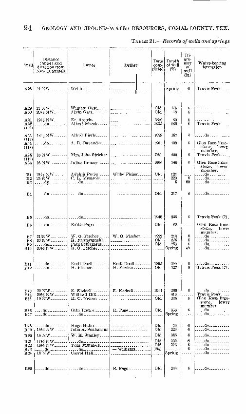
94 GEOLOGY AND GROUND-WATER RESOURCES, COMAL COUNTY, TEX.
TABLE 21. Records of wells and springs
Well
A 28
A9QA30
AS1A oo
moA QQ
(U7) A 34(118)
A35(119)A Q«
BlB2Tf?
B4
B5
B6
B7T>0
B9
TJ-l -t
B12
m 3BHB15
B17
B18Din
B21
B?3B?4
"Doc
Distance (miles) and
direction from NPW Braunfels
24 XW - _ _-_
20^NW -
19^NW -. _ .do..-.- -
181-; NW
.... -do...., _
18NW
16 NW - -
24J.2NW 23NW _rto
.....do -
-...-do -----
..-.do .. -.
21/NW 20NW . - do 20JiNW __-
..do. - .....do.. ...
20NW.-_.. _20J^NW ...-19NW- -
... .do . -
.... do -
.... _do ... ....181/6 NW--
18NW- 17MNW._ __16HNW.. _
18NW -___
..... do ... -
Owner
-_.__ do ....-
....-do.. _
.... -do .
AV O Fischer
WilliardHill ....
... .-do .....
W. H. Stanley- __. _.... -do ....
. .do ... .....
.....do...... .... ....
Driller
W. 0. Fischer ...
Date com
pleted
OldOld
1935
1928
1901
Old
1906
Old
Old
1940
Old
OldOld
Old
bid
Old
OldOldOldOldOld1941
Old
Depth of well
(ft)
115
80
157
108
200
185
121220
5
217
226
89
275253
300327
265410325
350Spring
49220385320325
240
Di am eter of
well (in)
6
6
6
6
6
6
660
6
6
666
48
66
6
6
6
666666
6
Water-bearing formation
_ ..do......
Glen Rose limestone, lower member.
stone, lower member.
do-....,- . ..do .... . do ..
do .....
Travis Peak (?) .
Glen Rose limestone, lower member.
-do do -----.... .do --- -do ---
- do . .
.. do . ..Travis Peak ...Glen Rose lime
stone, lower member.
-- do .. .-do ... _
.--.do- ._ .do ..... ... ..do - ... ..do .-- - -do -- ----do ------...do .... . .
.do -
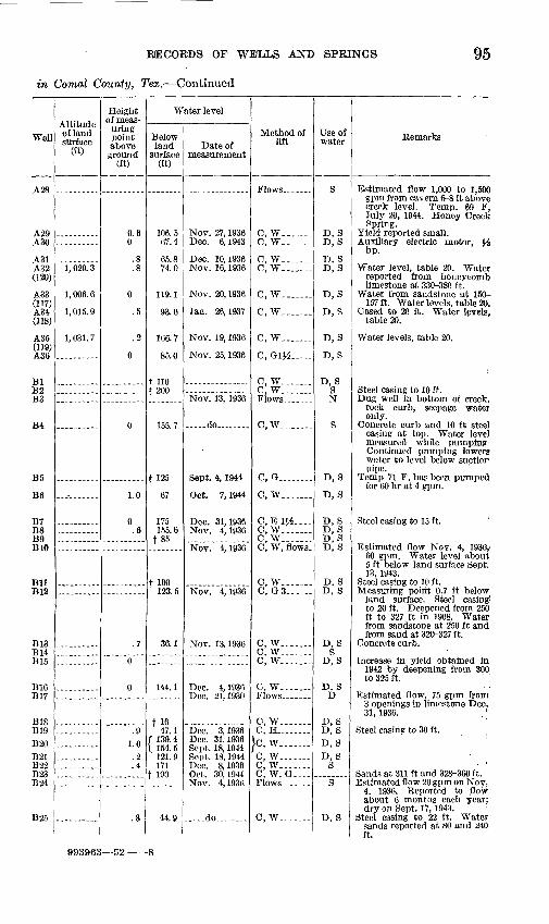
RECORDS OF WELLS ANI> SPRINGS 95
in Comal County, Tex. Continued
Well
A28
A29 A30
A31A32 (120)
A33(117) A34 <1M)
A35 (119) A36
Bl B2 B3
B4
B5
B6
B7 B8 B9 BIO
Bll B12
B13 B14 BIS
B16 B17
B18 B19B20B21 B22 B23 B24
B25
Altitude of land surface
(ft)
1, 029. 3
1, 006. 6
1, 015. 9
1,031.7
Height of meas
uring point above ground
(ft)
0.6 0
.8
.8
0
.5
.2
0
0
1.0
0 .6
.7
0
0
.9 1.0.2 .4
.8
Water level
Below land
surface (ft)
106.5 67.4
65.8 74.0
119.1
93.0
166.7
85.0
t not 200
155.7
f 125
67
175 155.6
f85
t 160 123.5
36.1
144.1
t 16 47.1
( 139.4 \ 154.5
121.9 171
f 190
44.9
Date of measurement
Nov. 27, 1936 Dec. 6, 1943
Dec. 10, 1936 Nov. 16, 1936
Nov. 20, 1936
Jan. 26,1937
Nov. 19, 1936
Nov. 25, 1936
Nov. 13, 1936
-. do--.....
Sept. 4, 1944
Oct. 7, 1944
Dec. 31,1936 Nov. 4,1936
Nov. 4, 1936
Nov. 4,1936
Nov. 13,1936
Dec. 4, 1936 Dec. 21,1930
Dec. 3, 1936 Dec. 31,1936 Sept. 18, 1944 Sept. 18, 1944 Dec. 8, 1936 Oct. 30,1944 Nov. 4, 1936
.- do . - -
Method of lift
C, W_ C, W- ...
O, W-_...._O, W_ ....
O, W---_.
O, W-.._
O, W.......
0, 01^.....
C, W---...O, W. --....
C,W .. ._
C, G_. ___.._
O, W... -
0, E !#-.--O, W...--.0, W.......0, W, flows.
O, W.... .O, Q3-_- -
0, W. ......C, W . ..O, W.... -
C, W.---
C, W.......0, H .-.-.
}c, w.-.. C, W..--...C, W------0, W, G_...Flows. ......
C, W.-_- ..
Use of water
S
D, S D, S
D, S D,S
D, S
D, S
D, S
D, S
D, SSN
S
D, S
D, S
D, S D, S D, S D, S
D, S D, S
D, S S
D, S
D, S D
D, S D, SD, SD, S
S
S
D, S
Remarks
Estimated flow 1,000 to 1,500 gpm from cavern 6-8 ft above creek level. Temp. 69 F, July 20, 1944. Honey Creek Spring.
Yield reported small. Auxiliary electric motor, $$
hp.
Water level, table 20. Water reported from honeycomb limestone at 330-380 ft.
Water from sandstone at ISO- 157 ft. Water levels, table 20.
Cased to 20 ft. Water levels, table 20.
Water levels, table 20.
Steel casing to 10 ft. Dug well in bottom of creek,
rock curb, seepage water only.
Concrete curb and 10 ft steel casing at top. Water level measured while pumping. Continued pumping lowers water to level below suction pipe.
Temp 71 F, has been pumped for 60 hr at 4 gpm.
Steel casing to 15 ft.
Estimated flow Nov. 4, 1936,' 60 gpm. Water level about 5 ft below land surface Sept. 13, 1943.
Steel casing to 10 ft. Measuring poirit 0.7 ft below
land surface. Steel casing to 20 ft. Deepened from 250 ft to 327 ft in 1908. Water from sandstone at 250 ft and from sand at 320-327 ft.
Concrete curb.
Increase in yield obtained in 1942 by deepening from 300 to 325 ft. ; ;
Estimated flow, 75 gpm from 3 openings in limestone Dec. 31, 1936. '
Steel casing to 30 ft.
Sands at 311 ft and 328-360 ft. Estimated flow 20 gpm on Nov.
4, 1936. Reported to flow about 6 months each year; dry on Sept. 17, 1943. '
Steel casing to 22 ft. Water sands reported at 80 and 240 ft.
993963 52-

96 GEOLOGY AND GROUND-WATER RESOURCES, COMAL COUNTY, TEX.
TABLE 21. Records of wells and springs
Well
B26
B27
B28 B29
B30 B31 B32
B33 B34
B35 B36
B37 B38
B39
B40 B41 B42 B43 B44 B45
B46
B47
B48
B49
B50 B51B52
B63B54
Cl C2
C3
C4
C5
C6
Distance (miles) and
direction from ^ew Braunfels
17J4NW . ...
19NW
18^ NW17NW
15^NW16 NW. .... .15 NW.... -.
_.__ do -14^ NW
15 NW. -----....do
16MNW17^NW
16^ NW
do. ..-.do .16 NW .... -.l&A NW -14 NW..
12^ NW ....
IIJ^NW
..... do .
.....do ....
do 14 NW ... do
11 NW do
14NW .....do
13M NW
10 tJ\fI
do
12 N. .. ---
Owner
W. D. Hill
Ed Kaderli .J. D. NixoD... ... ..
Mrs. T. P. Shelly-D. R. Sernmes.- _
... -do. -
do
BenF. Welle...
.... do ......
.... do.... .... ...
....do-. .Mrs. D. N. Riegler J. M. Block Miss Elsie Leuhl-
fing. Henry Panter-
muehl.
Otto Krause... ....
H. W. Kraft Estate do ....
M. Leaghling ... E. S. Schroeder...
do. .....
..... do.
George Faber .-..--
C. B. Crawford. ...
DrUler
Tom Adare
Jesse Page
E. B. Kutscher..
W^illis Fischer
Frank Guntner....
Corps of Engineers, U. S. Army.
Frank Gunther....
E. B. Kutscher...
Schmidt. _
E. B. Kutscher...
Date com
pleted
1903
1915
Old 1902
Old Old
1943
Old Old Old 1906 1902 1898
Old
1896
1929
1949
1923 Old Old
1900
Old Old
1944
1944
1941
Old
Depth of well
(ft)
Spring
140
112 Spring
169 350
Spring
110 228
SpringSpring
96 120
297
240 20 50
260 175 102
300
428
221
109 69
Spring
Spring 60
250 101
154
101
455
290
Di am eter of
well (in)
6
6
6
6 6
6 36 24
6 6
6
6
6
.....
6
5
6
Water-bearing formation
Glen Rose lime stone, lower member.
Travis Peak .....
.... .do .... .Glen Rose lime
stone, lower member.
do..... ..... .... .do Glen Rose lime
stone, upper member.
....do -----Glen Rose lime
stone, lower member.
... .do .... .
..-do -
....do ... - do.. ......
do..
.do .... .do ---..... do ... ...... -do ....... -.do-,. -....... do. .
Travis Peak ..
do
Glen Rose lime stone lower member.
do .
..... do ...
.... .do
.... .do ..... .
Walnut clay.. Glen Rose lime
stone, upper member.
.... .do . ...
.... .do
Glen Rose lime stone, lower member(7).
Glen Rose lime stone, upper member.
..... do. -
Edwards lime stone.
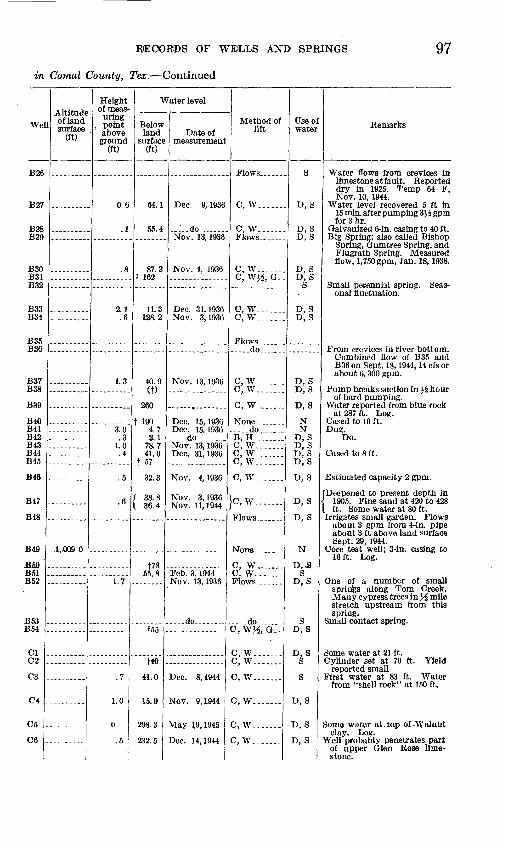
RECORDS OF WEOLLS AND SPRINGS 97
in Comal County, Tex. Continued
We
B26
B27
B28 B29
B30 B31 B32
B33 B34
B35 B36
B37 B38
B39
B40 B41 B42 B43 B44 B45
B48
B47
B48
B4S
BfiO B51 B52
B53 B54
01 02
C3
C4
05
6
Altitude of land surface
(ft)
.1..009.D
Height of meas
uring , point
above ground
(ft)
0.6
.1
.8
2.1.6
1.3
3.0 .3
1.0 .4
.5
.6
1.7
.7
1.0
C
.5 |
Water level
Below land
surface (ft)
64.1
55.4
87.2 t 162
11.3 128.2
40.9 (t)
260
t 190 4.7 2.1
78.7 41.0
t 57
32.3
38.8 36.4
t78 55.8
t55
f40
41.0
15.9
298.3
232.5
Date of measurement
Dec. 9, 1936
..do ......Nov. 13, 1936
Nov. 4, 1936
Dec. 31,1936 Nov. 3, 1936
Nov. 13, 1936
Dec. 15,1936 Dec. 15.1936 ....do........Nov. 13, 1936 Dec. 31,1936
Nov. 4,1936
Nov. 3,1936 Nov. 11,1944
Feb. 3, 1944 Nov. 13,1936
.do........
Dec. 8, 1944
Nov. 9, 1944
May 19,1945
Dec. 14,1944
Method of lift
C, W ...
C, W..
C, W...C, W}.£, G.
c,w... .C, W.... .
..... do......
C, W......C, W.......
C, W.......
..do.......B, H. .C, W.... ..C, W..C, W. . . . .
C, W. ......
C, W.----.
C, W ....C, W.-- .
.do.......C, W^, G.-
C, W... C, W. ......
C, W----_..
c,w.......
C, W---
0, W----
Use o water
S
D, S
D, SD, S
D, S D, S
S
D, S D, S
D,S D, S
D, S
N N
D, S D, S D.S D,S
D, S
D, S
D, S
N
D,JS S
D, S
3 D, S
VS
D, S
D, S
D, S
Remarks
Water flows from crevices in limestone at fault. Eeported dry in 1925. Temp 64 F, Nov. 10, 1844.
Water level recovered 5 ft in 15 min. after pumping 3J.6 gpm for 3 hr.
Galvanized 6-in. casing to 40 ft. Big Spring; also called Bishop
Spring, Gumtree Spring, and Flugrath Spring. Measured flow, 1,750 gpm, Jan. 18, 1938.
Small perennial spring. Seas onal fluctuation.
From crevices in river bottom. Combined flow of B35 and B36 on Sept. 18, 1944, 14 cfs or about 6, 300 gpm.
Pump breaks suction in }.i hour of hard pumping.
Water reported from blue rock at 287 ft. Log.
Cased to 10 ft. Du?.
Do.
Cased to 8 ft.
Estimated capacity 2 gpm.
Deepened to present depth in 1905. Fine sand at 420 to 428 ft. Some water at 80 ft.
Irrigates small garden. Flows about 3 gpm from 4-in. pipe about 3 ft above land surface Sept. 29, 1944.
Core test well; 3-in. casing to 16 ft. Log.
One of a number of small springs along Tom Creek. Many cypress trees in J^ mile stretch upstream from this spring.
Small contact spring.
Some water at 21 ft. Cylinder set at 70 ft. Yield
reported small First water at 83 ft. Water
from "shell rock" at 150 ft.
Some water at. tap of -Walnut clay. Log.
Well probably penetrates part of upper Glen Rose lime stone.

98 GEOLOGY AND GROUND-WATER RESOURCES, COMAL COUNTY, TEX.
TABLE 21. Records of wells and springs
Well
C7
08
O9
CIO Oil
C12
C13
014
Dl
D2
D3
D4
D5
D6 D7 D8
D9 DID Dll D12
D13 D14 D15 D16 D17 (98)
D18 El E2
E3
E4
E5
E6
F,7
Distance (miles) and
direction from New Braunfels
ll^N... ......
_ ..do _____
UN......
do 10KNE
11HNE
11 NE. .
ni / ATT?
25 NW __
24 NW
22^ NW ....
... ..do.... ..
..do .24 WOE \xr
25^6 NW. ...26 WQQl / TXT
o-i \KJ
29}^ W ... ...28}^ W ...25}<£W ... ...23^ W... ......23 W...........
23^W .21% NW 19 NW
16^ NW ....
do
14% NW.......
do
15NW
Owner
O. B. Crawford .
Miss Carrie Qeorge.
V.andC.D.Prassel.
.do . Udo Haarman and
R. Wright.
R. R. Williams....
Udo Haarman and R. Wright.
E. A. Moos. ___
Eugene Scheel.....
Herman^Laubach
.....do ..........
Mrs. Emma Sauer.
Aug. Scholz Estate-
Aug. Scholz Estate. Alfred Wehe....... Ed Kuebel... .... ..
Joe S. Sheldon. __
A. J. Walser. ......
.do.... , ..
Joe E. Sheldon.. .
Driller
- -
E. B. Kutscher....
E. B. Kutscher. _
Schwartz and Nick- ols.
Oscar Dietz.... .
A. Brown _ .......
E. B. Kutscher....
Date com
pleted
Old
'1890
Old
Old
1890
1943
Old
1922
1898
1914
1930
Old
Old 1895 1885
1885
Old
Old 1860 Old 1906
1906 1901 1916
Old
1943
Old
Depth of well
(ft)
256
100
170
200 440
380
422
640
96
280
650
750
350
25 235 216
300 200 218 240
300 25
217 265 300
236 350 210
450
344
475
85
350
Di am eter of
well (in)
6
6
6
4
6
6
6
6
6
6
36 6 6
6
6
6 36
6
6 ......
6
5
6
6
6
Water-bearing formation
Glen Rose lime- Stone, upper member.
Glen Rose lime stone lower member.
Glen Rose lime stone, upper member,
. .do...... .Edwards lime
stone (?).
Edwards lime stone.
..do. _.
..do . ..
[Glen Rose lime- i stone, lower I member, .do . ..
Travis Peak .....
do... ........
Glen Rose lime stone, lower member.
do.... . .do ............do... ........
do .... ...... ..do do... ... do.... .... ...
... ..do...- ... do do do do...
.do. ... Travis Peak ..... Glen Rose lime
stone, lower member.
Travis Peak... ...
Glen Rose lime stone, lower member.
do ....
Glen Rose lime stone, upper member.
-do.... .

RE COEDS OF WECLLS AND SPRINGS
in Comal County, Tex. Continued
99
We
C7
C8
C9
CIOOil
C12
CIS
C14
Dl
D2r
D3
D4
D5
D6 D7 D8
D9D10 Dll 012
313 314 315 316 317 (98) 318 El E2
E3
E4
E5
E6
E7
Altitud of lane surface
(ft)
942.5
1,403.2
1,411.6
1,413.4
1,264.3
1, 303. 1
Height of meas
uring point above ground
(ft)
0.
1.
2.0
13.3
.7
.6
1.0
.6
2.9
1.0 0 .3
0 1.0
---
1.0
.2
.9
.3
1.0
.5
.3
3.0
Water level
Below land
surfac (ft)
119,
67.5
192.0
337.8
53.4 52.0 54.0
133.9
/ 320. 2 I 374. 4
243.6 95.2 95.2 89.5f250
6.4 f220 t!80
135. 5 125. 6 210.1
flOO
124.6 13.7
187.3 209.3 188.7
216.0 t315
168.0
278.1
317.1
236.3 234.3 239.7 14.3
258.6
Date of measuremen
Dec. 4, 194
Nov. 3,1936
-do ....
Mar. 11, 1943
Dec. 7, 1936 May 16,1945 July 12,1945 Dec. 7, 1936
Dec. 7, 1936 Jan. 25,1950
Nov. 30, 1936 May 19,1945 May 24,1945 Jan. 25,1950
Dec. 7, 1936 Dec. 23,1936 ...-do .....
Dec. 23,1936 do... .. do .
Nov. 30, 1936 May 11,1945
Nov. 30, 1936
Nov. 16, 1936
Nov. 2,1936
Sept. 23, 1943
Nov. 2,1936 May 17,1945 uly 12,1945
Nov. 2,1945
Nov. 25, 1936
Method o: lift
C, W.....
C TJ
C, W5, G.
C, W.....C, W......
c,w......
C,W......
C, W.....
C, W2, G_.
}c, w....
C, W.......
C, W.......
C WC, W-...3, G ....
C, W.......C, W.......C, W. ...C, W. ......
C, W.......C, W. ......C, G3....... C.W.......C,W..._
C, W.......C, W.......C, W.......
C, W2, G...
C, W.......
C, W.......
C, W. ......
C. W.......
Useo wate
8
D, S
D, 8
S S
N
S
D, S
D, S
D, S
D, S
D, S
D, S
S D, S D,S
D,S D, S D, S D, S
D, S D, S
VD, S
D, S D, S D, S
D, S
D, S
D, S
D, S
S
Remarks
Water level one-half foot above land surface Dec. 8, 1944.
Estimated capacity 3 gpm.
Circle Dot Ranch No. 2; prob ably drilled into Glen Rose limestone. Bottom of suc tion pipe set at 400 ft.
Well penetrates upper part of Glen Rose limestone, water level approximately 370 ft below surface Dec. 1, 1943. Estimated yield 3 gpm. Log.
Circle Dot Ranch No.l head quarters well. Probably be drilled into Glen Rose lime stone.
Cased to 60 ft. Not enough wa ter at 400 ft; deepened to 650 ft in 1930.
Water level reported 150 ft be low land surface when drilled. Cylinder lowered several times. Water reported from blue clay at 680-700 ft.
Dug.
Well has been pumped 10 hrs at 7 gpm with tractor.
Cased to 6 ft. STo indication of exhaustion af
ter being pumped 18 hrs with power pump having 2Ji-in. cylinder and 12-in. stroke.
Cased to 10 ft. Well flows in wet seasons.
Water levels, table 20.
Cased to 6 ft.
Drawdown 8 ft when pumped at 2 gpm.
Seep at 60 ft; main water-bear ing sand at 338-344 ft. Cased to 60 ft.
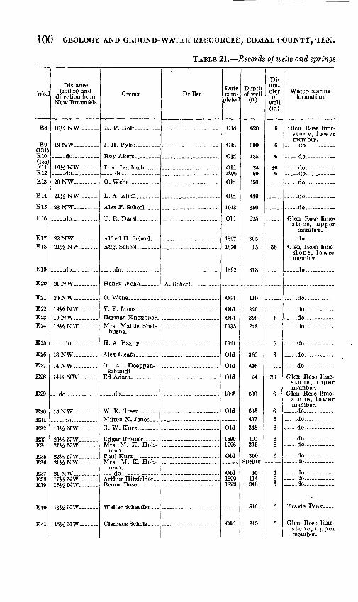
100 GEOLOGY AND GROUND-WATER RESOURCES, COMAL COUNTY, TEX.
TABLE 21. Records of wells and springs
Well
E8
Efl(131)E10(155) EllE12
E13
E14
E15
E16
E17E18
E19
E20
E21
K9BE23E?4
E25
E26
E37
E?,8
E29
E30TPQl
E32
E34
ntOT
TPift
T7I.I1
Distance (miles) and
direction from New Braunfels
16J4 NW. _ ...
19 NW. __ ...
-do-.. ...
19J4NW .... -do... ... .
20NW.. .
1\% NW
23 NW- _ .....
__ -do
22 NW- -
2154 NW
do
21 NW .
20 NW -
19J4 NW 19 NW - 18J4 NW_ _
_ ..do... ....
18 NW .... .
14 NW .... -
1454 NW .
do .
15 NW do. .
1654 NW.
2054 NW 2154 NW -
2254 NW _ -21J4NW. _
21 NW. ____ .1754 NW .16^ NW
13}4 NW. __ -
1554 NW. ___
Owner
R. P. Holt
J. H. Pyke ....
-_do ..... ......
L. A. Alien...
AlexP. Scheel.
T. R. Darst- ...
Alfred H. ScheeL--Aug. Scheel. .......
..do.
O. Wehe- _ .......
V. F. Moos , _
burne.
H. A. Bagby
schmidt
.....do.. .........
W. E. Green. ......
G. W. Kurz- __ -
Mrs. M. K. Hoh- man.
Mrs. M. K. Hoh-man.
. -do ...
Driller
A QftT-irtrtl
.....
Date com-
pletec
Old
Old
Old
Old1896
Old
Old
1913
Old
1897
1870
1892
Old
OldOld1QQK
1941
Old
Old
Old
1885
Old
Old
18901996
Old
Old18901892
Old
Depth of well
(ft)
620
3nn
185
60350
480
225
30515
318
110 >on
320248
360
446
24
600
635 437348
100315
300
30414348
816
245
Di am eter of
well (in)
6
6
6
366
36
6
6
6
36
6
6 66
66
6
666
6
6
Water-bearing formation.
stone, lower member. .do -
do
.do -- do ___ do
.do
.do -
stone, upper member.
do Glen, Rose lime
stone, lower member.
do-
do
do . do ....-do
_do _ -
..do ____
do
Glen Rose limestone, upper member.
Glen Rose limestone, lower member.
-do __ .do _ - __ .do -
do -do. -
do do -
..... do do ~ do
Travis Peak
Glen Rose limestone, upper member.
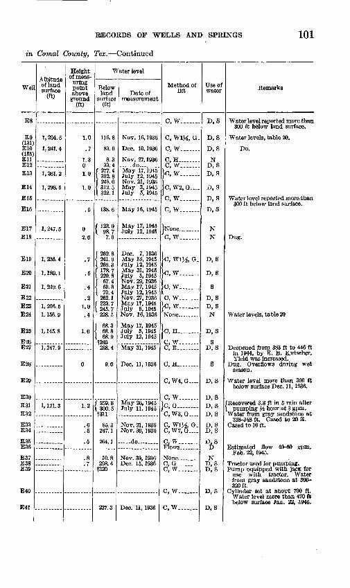
RIECOKDS OP WEtLLS AND SPRINGS 101
in Comal County, Tex. Continued
Wel
E8
£9 (131) E10 (155) Ell E12E13
E14
E15
E16
E17E18
E19
E20
E21
E22 E23 E24
E25
E26 E27
E28
E29
E30 E31 E32
E33 E34
E35 E36
E37 E38 E39
E40
E41
Altitude of land surface
(ft)
1,204.5
1, 241. 4
1, 261. 2
1, 298. 5
1, 247. 5
1,256.4
1, 189. 1
1, 249. 6
1, 206. 5 1, 156. 9
1, 145. 8
1, 247. 9
1, 121. 3
Height of meas uring point above
ground (ft)
1.0
.7
1.3 01.0
1.0
.5
0 2.0
.7
.5
.4
.2 1.0.4
1.0
0
1.2
.6
.5
.5
.8
.7
Water level
Below land
surface (ft)
116.8
83.0
8.3 33.4
277.4 302.8 248.0 312.5 322.1
138.6
f 123.0 I 98.7
7.0
[ 262.8 { 241.9 I 269.3 f 178. 7 L 220.8 f 67.4 { 69.8 I 70.4
262.1 f 223.7 L 245.7
228.5
' 68.3 68.8
. 68.9 f240 288.4
9.0
f 259.8 \ 300.5 t311
85.3 247.1
264.1
10.8 298.4
f320
227.3
Date of measurement
Nov. 16, 1936
Dec. 10,1936
Nov. 27, 1936 -do .....May 17,1945 July 12, 1945 Nov. 21, 1936 May 3,1945 July 5, 1945
May 16, 1945
May 17, 1945 July 12, 1945
Dec. 7, 1936 May 18, 1945 July 12, 1945 May 31, 1945 July 5, 1945 Nov. 29, 1936 May 17, 1945 July 12, 1945 Nov. 27, 1936 May 17, 1945 July 5, 1945 Nov. 16,1936
May 17, 1945 July 5, 1945 July 12, 1945
May 31, 1945
Dec. 11, 1936
May 26, 1945 July 11, 1945
Nov. 21, 1936 Nov. 30, 1936
do .....
Nov. 30, 1936 Dec. 15, 1936
Dec. 11, 1936
Method of lift
C, W...._._
C, W1M, 0.
C, W____ ..
C, H.. ...C, W.___ ..
}c, w____ ..
C, W2, G_...
C, W..._.-
C, W.......
JNone ........C, W.......
C, WIJi G.
}c, w.......
C, W...
C, W_....__}c, w.......
C, H........
C, W....C, E_
C, H.
C, W4, G...
C, W.......}c, G......._C, W3, G .
C, W% G. C, W7, G .
C, W. ......Flows.. .....
C, G .....C, W. ......
C, W. __ .
C, W.......
Use ofwater
D, S
D, S
D, S
N D, SD, S
D, S
D, S
D, S
N N
D, S
D, S
S
D, S D, SN
D, S
S D, S
S
D, S
D, S D, S D, S
D, S D, S
D, S D
N D, S D, S
D, S
D, S
Remarks
Water level reported more than 300 ft below land surface.
Water levels, table 20.
Do.
Water level reported more than 300 ft below land surface.
Dug.
Water levels, table 20
Deepened from 383 ft to 446 ft in 1944, by E. B. Kutscher. Yield was increased.
Dug. Overflows during wet season.
Water level more than 300 ft below surface Dec. 11, 1936.
'Recovered 3.8 ft in 5 min after pumping H hour at 3 gpm.
Water from gray sandstone at 338-348 ft. Cased to 20 ft.
Cased to 10 ft.
Estimated flow 40-50 gpm. Feb. 22, 1945.
Tractor used for pumping. Pump equipped with jacfc for
use with tractor. Water from gray sandstone at 300- 320ft.
Cylinder set at about 700 ft. Water level more than 470 ft below surface Jan. 22, ,1945.
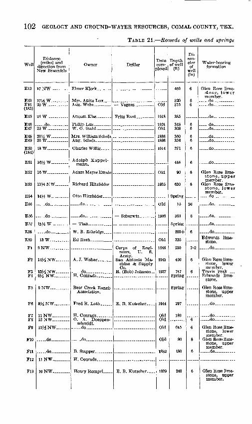
102 GEOLOGY AND GROUND-WATER RESOURCES, COMAL COUNTY, TEX.
TABLE 21. Records of wells and springs
Well
E42
E43E44(183)
E45
E46E47
E48E49
E50(184)
E51
E52
E53
E54
E55
E56
E57
ESS
E59
Fl
F2
F3F4
F5
F6
F8
F9
F10
Fll
F1?
F13
Distance (miles) and
direction from New Braunfels
17 NW. __
17^ W. _20 W. _ - _ ...
21 W. ____
.-.do- ... 22 W .. -
20^ W ......20 W- ...
18 W. _____ -
\m w .... -16 W- _ - _
13^ NW
14VS W
.do.. .....
, .do .....
13H W
....do- .
13 W.. .-.
9 NW.. ........
14J4NW _
l&A NW.... ...9}^ NW........
9 NW... .......
8J4NW .
11 NW.........12 NW... ......
13J4NW .
..... do .....
do
11 NW........
10 NW
Owner
Philip Lux- W. O. StahL. _
Mrs. William Scholz
Charles Willig....
Adolph Kappel-
Otto Hitzfelder
..do-. ... __ .
..do.... .......
Tian ...... ..
W. B. Ethridge....
Ed Reeh... _ ...
A. J. Walser.. _
.....do.........H. Conrads .
Association.
schmidt. do . ........
do..... .........
Driller
neers, U. S. Army.
San Antonio Machine & Supply Co.
E. B. Kutscher __
Date com
pleted
Old
1918
1924Old
18961896
1914
Old
1935
Old
ionn
Old
1948
1941
1937
1944
OldOld
Old
Old
1882
1939
Depth of well
(ft)
450
320375
385
348308
360336
371
444
90
630
15
381
200+
325
230
450
747Spring
297
180
615
80
480
240
Di am eter of
well (in)
6
66
66
66
6
6
6
6
36
6
6
7-2
6
6
6
6
8
6
6
Water-bearing formation
stone, lower member.
-do... do.
do .
do __ .do...
do - do.
do.
do
Glen Rose limestone, upper member.
stone, lower member,
. .do... ..
do- .
. _ .do... _.......
. _ .do... ........
... ..do ...Edwards lime-
... ..do ,.
Glen Rose limestone, lower member.
Travis Peak ....Edwards lime
stone.
Glen Rose limestone, upper member.
-do. .
..... do ...
.... .do... .... . ...
Glen Rose limestone, lower member.
Glen Rose limestone, upper member.
..do... ........
Glen Rose limestone, upper member.

RECORDS OF WEiLLS AND SPRINGS 103
in Comal County, Tex. Continued
Well
E42
E43E44 (183)
E45
E46 E47
E48 E49
E50 (184)
E51
E52
E53
E54
E55
E56
E57
ESS
E59
Fl
F2
F3 F4
F5
F6
F7F8
F9
F10
Fll
FI2
F13
Altitude of land surface
(ft)
1, 096. 2
1, 143. 4
1, 052. 4
1, 015. 3
955.9
962.1
864.7
1, 231. 0
Height of meas
uring point above
ground (ft)
0.2
1.0
.4
1.0
.8
.3
.7
.2
.0
1.0
.1
.1
1.0
Water level
Below land
surface (ft)
t250+
f280 217.8
f 107. 7 \ 112.8 I 128.1
141.4 88.1
t250 t300
213.1
1 61.4 94.1
147.9 250.9 48.9
t530
10.2
fl60
153.7 fl56.6 te50. 3 1266. 9
18.3
289.9
401.0
teo
tioo24.4
46.4
227.0
t210
Date of measurement
Nov. 12, 1936
May 4, 1945 May 18, 1945 July 5, 1945 Nov. 27, 1936
-. do........
Nov. 12, 1936
May 4,1845 May 18, 1945 July 11, 1945 Jan. 25, 1950 Nov. 12, 1936
Nov. 12, 1936
Nov. 12,1936 Dec. 1, 1936 May 18, 1945 Jan. 16, 1951 Nov. 4,1948
May 25, 1945
-. do .....
Nov. 2,1936
Nov. 2,1936
May 31,1945
Method of lift
C, W ... .
C, W_... ..0, W..._ ..
Ic, w._____.C, W4, G__._ C, W, G.__.
C, W. ......C, WIJi G-
0, W..... .
lo, w.......
C, W. ......
C, W.......
C, W.... ..
C, W. ......
C, G.. ......
..do.......
0, W.......
C, W.......
.....do.......
C, W.......
C, W... .C, W. __ ..
C, W... .
B. ..........
C, W. ......
0, W.......
C, W...... .
Use of water
D, S
D, 8 D, S
D,S
D,SD, 8
D, 8 D, S
D, S
D, 8
D, S
S
S
D, 8
D, 8
S
D, S
N
N
S
S D, S
8
D, S
S D, S
D, S
D, S
S
8
Remarks
Cased to 50 ft.
Cased to 40 ft. Water levels, table 20.
Heavy pum ping breaks su ction .
Cased to 10 ft. Draw-down more than 200 ft
at 8 gpm.
Yellow sand reported at 334- 336 ft. Cased to 16 ft.
Cased to 60 ft. Water levels, table 20.
Seep spring. Maximum flow reported 60 gpm.
Dug; 12 ft of caliche reported at surface underlain by lime stone.
Cased to 10 ft. Water reported from sand at 373-375 ft.
Small fault spring in bottom of Cibolo Creek.
Water levels, table 20.
Core test for dam site. Log.
Casing: 7-in. to 25 ft.
Log. Measured flow IJi gpm, Nov.
5, 1936; 20 ft above bed of Bear Creek.
Estimated flow 200 gpm, Sept. 29, 1943; 2,000-2,500 gpm, Mar. 28, 1945. Fault spring.
Estimated yield 500 gal. a day; bottom of suction pipe set 285 ft.
Water level reported more than 300 ft below land surface.
Water level more than 300 ft below surface, Nov. 2, 1936.
Water level rose 6.35 ft in 15 min after windmill was turned off.
Driller reports Edwards lime stone to 103 ft. Only enough water in Edwards for drill ing. Yield reported 2 gpm from sand at 228-240 ft. Log.
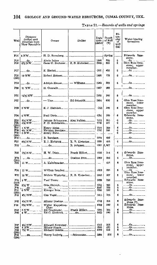
104 GEOLOGY AND GROUND-WATER RESOURCE'S, COMAL COUNTY, TEX.
TABLE 21. Records of wells and springs
Well
F14
F15 F16
F17
F18 (195)
F19
F20
F21
F22
F23
F24
F25 F26 (283) F27 F28 F29 (390) F30F31 F32
F33
F34 (385) F35
F36
F37
F38 (210) F39 F40 F41 (232) F42
F43 F44
F45 F46
F47 F48 F49 (233) F50I*>KA\
Distance (miles) and
direction from New Braunfels
6NW_.._ ...
.....do 8HNW ....
do
10NW ...
do .
11 NW ...
12J^ NW
do
8 NW ...... .
6NW
5HNW 4J4NW _
4NW ___4&NW 6NW... .......
do 6J^ NW . do... ... -
7J-6NW
.....do ......
11 W..-. ......
12 W
10 W ....
9 W
8HW.......... ..do 6NW ......
4^NW ....
4J^NW .viz >jTir
q XTW4W............
4J^ NW .....5 NW... .......7J^ W. ......
.....do ..
Owner
Oscar C. Brehmer
Adolph Henne __
.....do ..... .
E. J. Heiridck ...
Jerome Schumann.
.do - _
H. W. Dietz...... .
. ..do. ....
Melvin Westerfer..
Otto Ohlrich _ .... ..do ....
Walter Kappelma- Chev
Ed Dischinger.. ... Ed C. Heidrich. ...
Edward Nowotny.
Henry Ludwig. ....
Driller
E. B. Kutscher ...
Williams.. _ ...
E. B. Kutscher....
E. B. Kutscher....
Frank Hfflert do .
Date com
pleted
1906 1946
Old
1926
1943
1937
1933
1934
Old
Old
1915 Old
1923 Old
1902 1938 1937
1926
1900
1922
1945
1929
Old 1897 Old
1915
Old 1932
1925 1922
Old 1895 1902
1034
Depth of well
(ft)
Spring
300 601
425
178
302
208
240
630
350
300
365 251
290 300
402 405
1,867
314
306
475
535
507
320
265 350 250
325
265 242
305 340
325 450 313
375
Di am eter of
well (in)
6 6
6
6
6
6
6
6
6
6 6
6 6 6
6
6
6
6
6
5
6 6 6
6
68
6 8
6 6 6
6
Water-bearing formation
Edwards lime stone.
.....do ........Glen Rose lime
stone, upper member.
....-do
.... .do. .... ...
.....do .....
. __ do ..... ...
..do..... .... -
Glen Rose lime stone, lower member.
Glen Rose lime stone, upper member.
Edwards lime stone.
... ..do- do
... ..do
.....do ........ do .
... ..do ...... do
Edwards lime stone,
do
Glen Rose lime stone, upper member.
do ... .....Glen Rose lime
stone, lower member.
Edwards lime stone.
do ..... do ..... do ...
do
Edwards lime stone (?).
Edwards lime stone.
.....do ... ...
.....do ...
..... do ..... ...
.....do... ... ... ..
..... do.
do...........
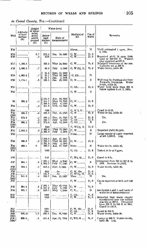
RECORDS OF WELLS AND SPRINGS 105
in Comal County, Tex. Continued
Well
FM
F15 F16
F17
F18
F19
F20
F21
F22
23
F24
F25 F26 (283) F27 F28 F29 (390) F30F31 F32
F33
F34 (385) F35
F36
F37
F38 (210) F39 F40 F41 (232) F42
F43F44
F45 F46
F47 F48 F49 (233) F50 (254)
Altitude of land surface
(ft)
1, 166. 4
1,090.3
1, 085. 8
1, 174. 1
998.2
849.2
878.6
966.4
1,005.2
998.8
968.1
964.1
954.1
941.8
894.2 861.7
916. 55
920.9
Height of meas
uring point above
ground (ft)
0.7.5
.7
.7
.6
.5
.2
.8
.5
.5
.5
.5
.5
0
.5
.5
.7
.4
.5
.8
1.0
.5
Water level
Below land
surface (ft)
272.3t275
256.3
49.3
f 51.3 \ 55.7 I 54.7
139.1
f 244. 0 { 254.1 [ 255. 9
251.5
f285 229.9
295.2 248.8 274.6
t332 f 302. 4 \ 303. 0
f 289. 0 { 289.0 [ 291, 6
268.0
t400
t!21( 239. 5 \ 282.9
255.6
f250 195.7 188.7
f 214. 1 \ 241. 2
223.9
t293 f328
tsoo tsoo
259.9
221.5
Date of measurement
Jan. 18,1936
May 24,1945
July 5, 1945
Sept. 21, 1943 May 19, 1945 Jan. 4, 1951 Jan. 29,1940
Apr. 28,1945 May 19, 1945 July 4, 1945 Nov. 15, 1936
Dec. 21,1945
Dec. 21,1936 July 6, 1945 Apr. 13,1945
May 19,1945 July 4, 1945
Apr. 27,1945 May 19,1945 July 4, 1945 Apr. 27,1945
May 4, 1945 July 11,1945Nov. 9, 1936
..do.........--.do ..Jan. 25,1937
May 23,1945 July 3, 1945 May 1, 1944
Dec. 16,1936
Apr. 13, 1945
Method of lift
Flows .......
C, W.......C, W.......
C, W.......
C, W% G.
1 C, E2......
C, W... ....
C, G6.......
C, W.......
[c, w.......C, W.......
C, W 3, G C, W.......
C, W.......C, G3.......C, G2 .
C, WIJi G.}c, w.......None... ...
ic.w.......
C, G2.......
C, W4, G...
}c, w.......c, w.......
C, WlJi, G.
C, W.......
}c, w.......C, E.. ......
C, G2...._-C, W.......
C, W, G6...C, G3-.- .C, W. ......
C,W2, G..-
TJse of water
N
D, S D, S
D, S
D, S
D
S
D, 8
S
D, S
D, S
D, S
D, S
VD, S
SN
D, S
N
D, 8
D, S
S
D, S
D, SD, S
N
D, S
D, S D
D, S D, S
D, S D, 8 D, S
D, S
Remarks
Yield estimated 1 gpm, Nov. 5, 1936.
Reported yield 15 gpm from sand at 585-601 ft. Walnut clay reported at 365 ft.
Edwards limestone at sur ace. Cylinder set at 350 ft.
Water levels, table 20.
Well may be drawing also from Edwards limestone. Water levels, table 20.
Water level more than 300 ft below surface Nov. 2, 1936.
Cased to 10 ft. Water levels, table 20.
Do.
Do.
Reported yield 20 gpm.Large supply of water reported
at 800-1,000 ft. Log.
Water levels, table 20.
Tested 24 hr at 6 gpm.
Cased to 6 ft.[Deepened from 360 to 507 ft in \ 1945. Increase in yield.Water levels, table 20.
Do.
Caves reported at 80 ft and 120 ft.
See figures 4 and 5, and table of water-level measurements.
Reported that water supply encountered near the surface was lost at 200 ft. Deepened from 335 ft to 340 ft in 1941. Cased to 150 ft.
Cased to 130 ft. Water levels, table 20.
Casing to 220 ft. Waters levels, table 20. Log.
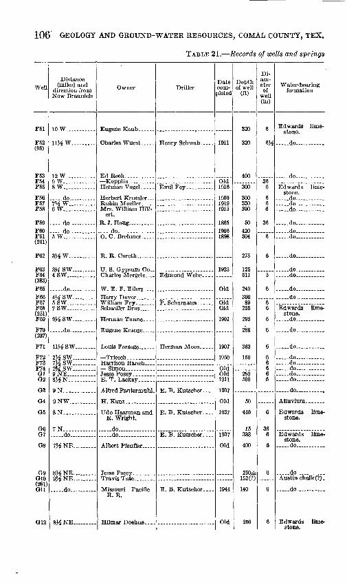
106 GEOLOGY AND GROUND-WATER RESOURCES, COMAL COUNTY, TEX.
TABLE 21. Records of wells and springs
Well
F51
F.W(95)
F53F54F55
F56F57F58
F59FfiOF61(261)
F62
F63F64(383) F65F66F67F68(251) F69
F70(237)
F71
F72F73F7401O2
03
04
O5
Ofi07
08
rjoO10(281)on
O12
Distance (miles) and
direction from New Braunfels
10W...........
11J4 W
12 W._. ...9 W.... ........8 W. ..........
do 7^W._. . 6W ....
..... do . .
. -do .......5 W..... .......
3XW..........
3JiSW. .....4SW....... ....
. .do... .......4JiSW ....5SW 7SW .....
9J4SW. .....
.. do .....
11HSW ...
2J^SW.........7J4SW 2MSW _. .9NE...........8XN .......
9N. ...........
9NW.. _ .
8N.. ..........
7N-... ....... do... ...... .
7^NE ...
8^NE 9J4NE ......
... -do.. ...
sys NE.........
Owner
Ed Reeh. .........
Mrs. William Hill-ert.
.. do .. ....
W. E. F. Eilers-.-
E.T. Lackey. .....
R. Wright.
.. do.............. ..do ... ......
TravisTate.. ...
Missouri Pacific R. R.
Driller
Emil Fey
E. B. Kutscher.-..
E. B. Kutscher....
E. B. Kutscher....
Date com pleted
1911
Old1916
190019191915
186519061898
1925
Old
OldOld
1901
1907
1950
OldOld1911
1937
Old
1937
1937
Old
1944
Old
Depth of well
(ft)
320
320
400
300
300330390
50420304
275
125611
240300
89255
295
288
363
150
280500
50
440
15333
400
250±152(?)
140
250
Di am eter of
well (in)
6
^
366
666
36
6
6
5
6
66
6
6
6
66666
6
366
6
6
6
6
Water-bearing formation
Edwards limestone.
... ..do -
.. do .. ..
stone, ..do.. ..........do ........ .do ....
.do. . ..do ....... -do
... ..do ........
do ..... ......do ..
. _ .do
...-do. . .
Edwards limestone.
do ....
do ...... .
.....do . .
do ...... do. .... .do ..... ..do... ........ do ..... ...
.....do ......
Alluvium.... ...
Edwards limestone.
Edwards limestone.
do . ...
.do .Austin chalk (?).
do ....
Edwards limestone.

RECORDS OF WELLS AND SPRINGS 107
in Comal County, Tex. Continued
Wel
F51
F52 (95)
F53 F54F55
F56 F57 F58
F59F60 F61 (261)
F62
F63F64 (383)F65F66 F67 F68 (251) F69
F70 (237)
F71
F72 F73 F74 Gl G2
G3
G4
05
G6 07
08
09 G10 (281) Gil
G12
Altitude of land surface
(ft)
930.6
976.9
916.9
869.6
675.5
714.6 886.1
903.7
993.4
691.6 889.7 674.4 825.7
910.7
977.0
823.3
Height of meas
uring point above
ground (ft)
0.5
.5
.9 1.0 ,9
.6
3.5
.5
2.5
0 0
1.0
.1
.7
1.4
.5
.5 1.0 .7 .5
1.2
.5
2.0 .4
.3
.9
.6
.9
Water level
Below land
surface (ft)
225.5 247.1 260.9 271.6 266.8
242.0 23.3
252.7
273.5 f300 t330
f 7.4 I tl2. 5 f400 283.5
f 228.2 1 235.0 1 244.0 1 242.8
51.5 63.9
f 24.9 \ 41.1
f51 66.3
241.6
250.1
[ 305. 1 { 303.9 1 307. 0
58.8 254.3 41.5
232.8
42.7
350
6.9 300.9
382.2
233.0 27.5
97.2
Date of measurement
Apr. 18, 1945 May 18, 1945 July 3, 1945 Jan. 8, 1951 Apr. 27, 1945
Dec. 1, 1936 Jan. 27,1937 Jan. 21,1937
Nov. 24, 1936
Oct. 26,1936 Dec. 13,1943
May 25, 1934
May 25, 1934 July 2, 1945 Jan. 23, 1950 Jan. 8, 1951 Dec. 4, 1936 Aug. 20, 1940
Oct. 27,1936 Jan. 9, 1951
Dec, 4,1936 May 28, 1934
Oct. 11,1933
May 5, 1945 May 18,1945 July 14,1945 Jan. 9, 1951 Jan. 3. 1951 Jan. 9, 1951 Jan. 16,1951
Nov. 4, 1936
Dec. 15,1945
Oct. 22,1936 Jan. 16, 1951
..do__..._._
-...do........Jan. 5, 1937
Dec. 25,1944
Jan. 5, 1937
Method of lift
Ic, w....___
C, W.......
C, W......C, W......C, W._.___.
G, W6, G.. C, 0........C, G2_-..._
}H, B........C, G.. ......C, W......
Ic, w.......
C, EM
Jo, w......C, W.......C, W.......C, W3, G...
C, W.-...__
O, G7 .
C, W.......
C, W.......C, G........O, W.... .C, W.......o, we, o...C, W.......
C, H........
C, W.......
B, H _- ...C, E. .......
C, G6.......
C, W.......C, W.......
Flows. ___
C, W.-..
Use of water
0,8
D, S
N D, S D, S
D, 8 D, 8 D, 8
ND, 8 D, S
8
N D, S
D, SD.S
S D, S
D, S
D, S
D, S
S D, S D, S D, S D, S
S
S
S
D, SS
D, S
S S
D
D, S
Remarks
Originally drilled to 1,240 ft. and cased to 1,100 ft, 6K-in. casing perforated from 260 to 320 ft, 2M-in. cylinder set at about 295 ft. Water levete, table 20.
Dug; rock curb.
Cased to 70 ft.
/Well was overflowing Apr. 13, X 1935.
Water levels, table 20.
Yellow clay reported at 58-62 ft. Irrigates small garden.
/Sulfur odor. Water levels, \ table 20.
Water levels, table 20.
Water level reported more than 200 ft below land surface.
Water levels, table 20.
Water level reported more than 300 ft below land surface.
Water level more than 340 ft. below surface Dec. 14, 1944.
Dug well in Guadalupe River bottoms.
Circle Dot Ranch well 3. Probably drilled into Glen Rose limestone.
Dug. Circle Dot Ranch. Circle Dot Ranch well 4.
Water level reported more than 300 ft below land surface. Reported yield 16 gpm with pump having 3-in. cylinder and 21-in. stroke.
Casing: 18 ft of 6-in. cemented in Austin chalk. Supplies railroad community. Esti mated flow Dec. 25, 1944, 3 gpm Does not flow in dry seasons.
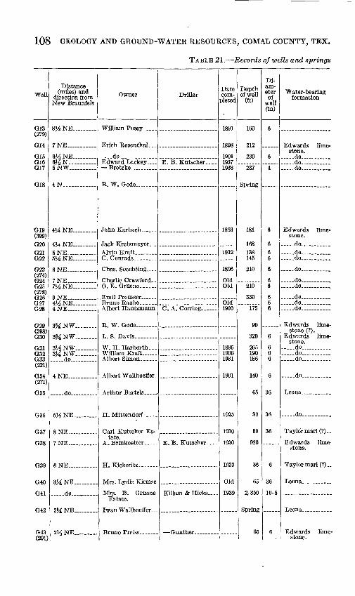
108 GEOLOGY AND GROUND-WATER RESOURCES, COMAL COUNTY, TEX.
TABLE 21. Records of wells and springs
Well
G13(279)
G14
O1 5O16017
O18
G19(399) G20G21f^99
rioo(274) G24GW(278)f~*n(t
G27fioa
fJ9O
(398) G30
railG32nvt(221)
fiQJ.
(271) fj3n
G36
CIV7
G38
ra^Q
G40
G41
G42
n&i(291)
Distance (miles) and
direction from New Braunfels
8Ji NE.........
7NE .......
6J-£NE 6^N._ .....5NW ....
4N-. . .........
4H NE .....
4$4 NE.........f, WI7
5^NE. _ ....
6NE ..... ..
7 NE .......7HNE...
9 NE-. ......4J-SNE ....4 NE .......
3?£NW._-.
3^NW........
3HNW.......3MNW. .... ..do... .......
4 NE ........
. _ .do.
5H NE.........
8 NE
7 NE... ........
6 NE... ........
3MNE... ..
... ..do...
2?iNE... ......
VA NE.........
Owner
Erich Eosenthal. . .
..do... ........Edward Lackey _ Bretzke. ......
B. W. Gode. . ...
John Karbach ......
Albert Hantzmann
R. W. Gode. __ .
L. S. Davis. ____
W. H. Harborth...William Kraft ...
Albert Wallhoeffer-
H. Mittendorf.....
tate.
H. Kickeritz.......
Estate.
T^rvino T'r^i****
Driller
E. B. Kutscher.--.
E. B. Kutseher. - - -
Killam& Hicks.. -
Date com
pleted
1891
1898
190119371938
1893
1932
1896
OldOld
Old1900
189519001931
1901
1925
1930
1930
1933
Old
1939
Depth of well
(ft)
160
212
230
237
181
168138145
210
210
330
175
90
320
265190186
140
65
32
50
920
36
65
2,350
65
Di am eter of
well (in)
6
6
4
6
666
6
66
666
6
666
6
36
36
36
6
36
10-5
6
Water-bearing formation
stone. ..do................do-.-......... do...........
Edwards limestone.
..do........... ..do,... ............do .......
do... __
.....do........ _
.. do.... .......
do_... ............do... .......... do ........
Edwards limestone (?).
Edwards limestone,
do .............do... ........ do .......
.....do ........
Leona __ ......
.....do ......
TaylormarK?)..
Edwards limestone.
Taylormarl(?)..
Leona. ..........
Leona _ . _ ....
stone.
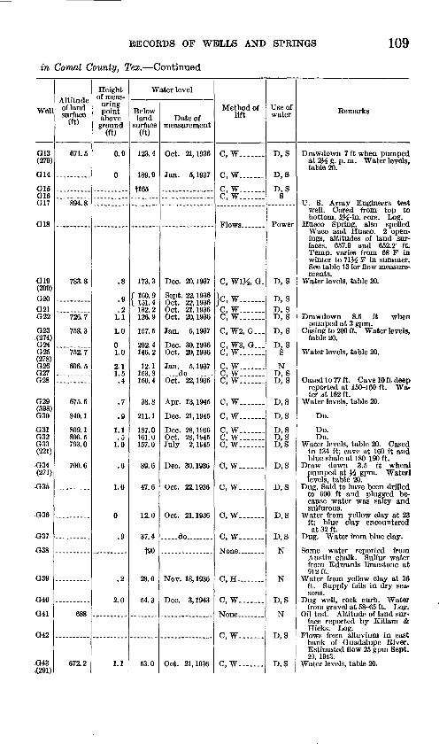
RECORDS OF WELLS AND SPRINGS 109
in Comal County, Tex. Continued
Well
G13(279)
G14
G15 G16 G17
G18
G19 (399)G20G21 G22
G23(274) G24 G25 (278) G26 G27 G28
G29 (398) G30
G31 G32 G33(221)
-G34 (271)
G36
G37
G38
G40
G41
G42
-G43-mn
Altitude of land surface
(ft)
671.5
894.8
783.8
726.7
758.3
752.7
606.5
675.5
840.1
809.1 806.5 793.0
700.6
688
672.2
Height of meas
uring point above ground
(ft)
0.9
0
.8
.9
.2 1.1
1.0
0 1.0
2.1 1.5 .4
.7
.9
1.1 .5
1.0
.6
1.0
0
.9
.2
2.0
1.1
Water level
Below land
surface (ft)
123.4
189.9
f!65
173.3
/ 160.9 \ 151.4
132.2 126.9
157.5
202.4 146.2
12.1 153.8 150.4
38.8
211.1
187.0 161.0 157.0
89.6
47.6
12.0
37.4
f90
28.0
54.3
53.0
Date of measurement
Oct. 21,1936
Jan. 5, 1937
Dec. 20,1937
Sept. 22, 1936 Oct. 22,1936 Oct. 21,1936 Oct. 20,1936
Jan. 5, 1937
Dec. 30,1936 Oct. 20,1936
Jan. 5, 1937 .. do .....Oct. 22,1936
Apr. 13,1945
Dec. 21,1945
Dec. 28,1936 Oct. 28,1945 July 2, 1945
Dec. 30,1936
Oct. 22,1936
Oct. 21,1936
.....do........
Nov. 18, 1936
Dec. 3, 1943
Oct. 21,1936
Method of lift
C, W.... ..
C, W_..-._-
C, W.C, W.......
C, WVA, O-
}c, w.......C, W.......C, W. ...
C, W2, G...
C, W3, G... C, W.......
C, W_....-_C, W-.-- C, W....._.
C, W....-.-
C, W.......
C, W.......C, W.......c, w.......
C, W----
C, W.......
C, W.......
C, W--. .
None .....
C, H ... ..
C, W.......
C, W-......
C, W. ......
Use of water
D, S
D, S
D, SS
Power
D, S
D, SD. S D, S
D, S
D, SS
N D, S D, S
D,S
D,S
D, S D,S D,S
D,S
D,S
D,S
D,S
N
N
D, S
N
D,S
D,S
Remarks
Drawdown 7 ft when pumped at 2J3 g. p. m. Water levels, table 20.
U. S. Army Engineers test well. Cored from top to bottom, 2^,-in. core. Log.
Hueco Spring, also spelled Waco and Huaco. 2 open ings, altitudes of land sur faces, 657.9 and 652.2' ft. Temp, varies from 68 F in winter to 71J^ F in summer. See table 13 for flow measure ments.
Water levels, table 20.
Drawdown 8.5 ft when pumped at 3 gpm.
C asing to 200 ft. Water levels, table 20.
Water levels, table 20.
Cased to 77 ft. Cave 10 ft deep reported at 150-160 ft. Wa ter at 162 ft.
Water levels, table 20.
Do.
Do. Do.
Water levels, table 20. Cased to 134 ft; cave at 160 ft and blue shale at 180-190 ft.
Draw down 3.5 ft whenl pumped at W gpm. Waterl levels, table 20.
Dug. Said to have been drilled to 600 ft and plugged be cause water was salty and sulfur ous.
Water from yellow clay at 23 ft; blue clay encountered at 32 ft.
Dug. Water from blue clay.
Some water reported from Austin chalk. Sulfur water from Edwards limestone at 912 ft.
Water from yellow clay at 36 ft. Supply fails in dry sea sons.
Dug well, rock curb. Water from gravel at 58-65 ft. Log.
Oil test. Altitude of land sur face reported by Killam & Hicks. Log.
Flows from alluvium in east bank of Guadalupe River. Estimated flow 25 gpm Sept. 29, 1943.
Water levels, table 20.
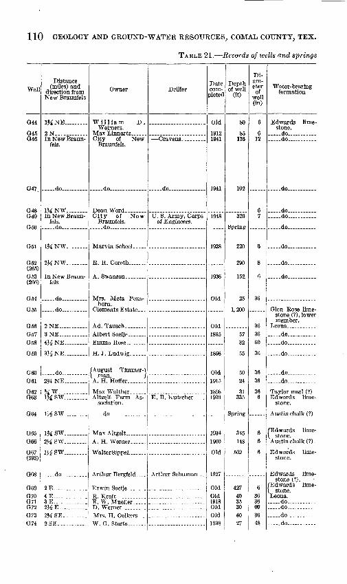
110 GEOLOGY AND GROUND-WATER RESOURCES, COMAL COUNTY, TEX.
TABLE 21. Records of wells and springs
Well
G44
G45G46
Q47
G48O4Q
ficn
(265) G53(266)
G54
G55
G56
G58
G59
GfiOG61
G6?G63
G64
G65G66
067(393)
G68
G69O7007107?O73O 74
Distance (miles) and
direction from New Braunfels
l^NE
2N-. .
fels.
do
1MNW
fels. -do... ....
IJiNW..
2MNW_._
fels
- do .. ..
.do-...
2NE ...3NE ....4^NE
3VSNE
.... -do 2%NE
«W __ ......IJiSW
l^SW ....
l^SW .._2JiSW
l^SW .
do .......
2E ....4E3 E2HE... . .......2?iSE._ . ...2SE__. _-._....
Owner
William D.Weimers.
City of NewBraunfels.
. .do. ........
City of NewBraunfels.
do ... ... .
R. R. Coreth .......
horn.
H.J. Ludwig......
(August Timmer-\\ man. / A. H. Hoffer ..
Altgelt Farm Association.
..... do ..
Max Altgelt .
WalterSippel. .....
E. W. Mueller.....
W. G. Startz .
Driller
..... do ... ... -
of Engineers.
E. B. Kutscher.-..
Date com
pleted
Old
19121941
1941
1948
1938
1936
Old
Old1895
1898
Old1915
18981939
19341900
Old
1927
OldOld1918OldOld1938
Depth of well
(ft)
80
85116
102
320
220
290
152
25
1,200
5732
55
5024
31335
Spring
345148
502
42740353040
Di am eter
of well (in)
6
612
67
6
8
6
36
363660
36
3636
366
36
6
63636 03648
Water-bearing formation
Edwards limestone.
..... do .... . do. .... ...
... ..do .......
.....do... ... ..do... .
..... do .
do ... .
..... do.... .... ...
do ...
stone (?) , lower member.
-do .. -do --.
-do
..do ... ... do
Taylor marl (?)Edwards lime
stone.
Austin chalk (?).
/Edwards lime-
Austin chalk (?).
Edwards limestone.
Edwards limestone (?).
(Edwards lime-
Leona. do - do do do ..
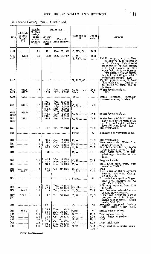
RECORDS OF WEiLLS AND SPRINGS 111
in Comal County, Tex. Continued
Well
G44
G45 G46
G47
G48 G49
G50
G51
G52(265)G53 (266)
G54
G55
G56 G57 G58
G59
G60 G61
G62 G63
G64
G65 G66
G67 (393)
G68
G69G70 G71 G72G73 G74
Altitude of land surface
(ft)
670.0
647.8 642.7
623.1
843.5
909.9
736.1
648.5
641.2
649.2
653.2
Height of meas
uring point above
ground (ft)
1.4
1.3
1.11.0
1.0
1.0
1.0
.2
1.4 .4 .2
3.1 .7
.5
.8 2.1
.5
03.2 1.4 .5
2.2 1.0
Water level
Below land
surface (ft)
47.1
54.0
119.5 18.36
1 204.7 200.9 202.2 211.8 272 273.0 291.4 100.8
8.1
21.2 / 52.4 \ 52.3
33.7
f49
/ 41.1 1 41.5
24.4
28.4 f!5
/ 52.5 I 57.7
.1
16.0
t20
/ 30.8 \ 33.7
24.7 34.5 25.6
( 34.1 \ 30.2
20.4
Date of measurement
Dec. 30,1936
Oct. 28,1936
Jan. 6, 1937 Nov. 4, 1948
Dec. 20,1943 May 17,1945 July 2, 1945 Jan. 4, 1951 May 23,1945 July 2, 1945 Jan. 24, 1950 Jan. 6, 1937
Dec. 22,1936
Jan. 7, 1936 Oct. 20,1936 Dec. 3, 1943 Nov. 18, 1936
Nov. 18,1936 Nov. 30, 1943 Nov. 18,1936
Oct. 27,1936
Dec. 4, 1936 Dec. 20, 1943 Dec. 4, 1936
Dec. 20, 1943
Dec. 1, 1943 Jan. 10, 1951 Nov. 18, 1936 Oct. 10, 1936 ..do .....Oct. 10,1936 Nov. 30, 1943 Nov. 30, 1943
Method of lift
C, W3, G_-_
C, W------T, E100, 75..
T,E100,40_.
C, W....
Ic, w... _
Ic, w. ......C, W. --.-..
C, W.......
C, W.......}c, W-._.___
C, W. ......
C, W. ......
}c, w. ......C, W....
C, W. ......T,E^_
}C, G4 C, G_.__..-_
C, W. ......
C, G .....
B, H .---..C, WC, W .
}c, w.......C, W._..._.
Use of water
D,S
D,S
D, SN
D,S
D,S
D, S
D, S
N
D, S D, S D, S
D,S
D,S D,S
D,S D,S
S
D, S D, S
D, S
Ind
ND, S D, S D, SD, SD, S, Ind
Remarks
Public supply, eity of New Braunfels no. 1, 30 ft south of no. 2. Casing: 12-inch to 5& ft; cemented by Halliburton Oil Well Cementing Co.; open hole, 58 ft to bottom. Draw down 7 ft after pump ing 12 hr at 2,300 gpm with 2 centrifugal pumps. Log.
Public supply, city of New Braunfels no. 2. Casing: 8- in. to 58 ft, open hole to bottom.
Water levels, table 20. Do.
Comal Springs. Discharge measurements, in table 17.
Water levels, table 20.
Water levels, table 20. Said to have been tested with boiler at 60 gpm for 6 hr without lowering water-level. Log.
Dug; rock curb.
Estimated flow 100 gpm in 1941.
Dug; rock curb. /Dug; rock curb. Water from \ gravel at 55-57 ft. Dug; brick curb to 8 ft. Water
from gravel at 30-32 ft. Log. Dug; brick curb. Has sup
plied eight families at one time.
Dug; rock curb.Dug; brick curb, water from
gravel at 23-24 ft. Dug. First water at 282 ft; stronger
flow at 326-330 ft. Casing: 287 ft of 5-in.
Estimated average flow 50 gpm Has been pumped at 700 gpm for irrigation.
/Blue clay reported from 50 ft X to 345 ft. Well flows as much as 3 ft above
ground in wet seasons. Draw-down about 20 ft when
pumped at 2 to 3 gpm. Slight odor of sulfur. Water levels, table 20.
Formerly supplied hosiery mill. Slight sulfur odor.
Strong odor of sulfur.Dug; concrete curb. Dug. Irrigates garden. Dug.Dug; brick curb. Dug; used at slaughter house
993963 52-

112 GEOLOGY AND GROUND-WATER RESOURCES, COMAL COUNTY, TEX.
TABLE 21. Records of wells and springs
Well
G75
G76G77(373) n7«
G79G80G81
G82HIH2H3H4H5
(339) H6H7H8
H9H10
Hll
H12
H13
H14<243) H15H16
HIS
H19H20<326) H21H22<332) H23(333) H24
H25H2fi
Distance (miles and
direction from New Braunfels
1% SW
2M SW_._. 3SW
VA SW ...7NE -4 NE_. .........1H NW._ .
1^W._ ___3}/2 SW......... do ..-.do... ... .4SW - do
5 SW ...5Ji SW.........7l/2 SW.........
8 SW... ........11 SW..........
HJiSW... .....
iq aw
12M SW
11 SW...... 8Ji SW.... ..... do. 7SW ..... ...
.do .......&A sw... ......6 SW.... .......5Ji SW.........
.. do ... ...
5SW...... .....
6 SW... ........7SW .... ... .
Owner
W. S. Buttle.-..
Braunfels.
A. W. Feick...
Estate. H. Blank.... .......
FServtex Materials
hahn.
man.
Fred Schwab- ...
Driller
E. B. Kutscher-...
Inc.
. .do .... -
Frank Hillert..
}.. .. .
Date com
pleted
1935
OldOld
1898Old
1950
1932
OldOld1924Old
Old19341890
19111932
1925
1916
Old
1926
Old1895
1916
1900Old
Old
Old
1914
Depth of well
(ft)
610
503485
510307190160
148500450542498463
700372360
16045
322
390
326
240125117360
150300
360395
428
13138
Di am eter of
well (in)
6
66
666
24,20
66666
666
66
6
6
6
6665
64
66
6
636
Water-bearing formation
Edwards lime stone.
do .... .do .
- do .. ..do. . . .do.. .... . do ....
do ... ..do.. .. do. ... do .. -do ... .. . do ...
do ....../Edwards lime-\ stone (?). Edwards lime
stone...... do... ...
Edwards limestone.
do .
do.. ...
do. .
... -do ...... do.. .... do. ... do... ..
Austin chalk. Edwards lime
stone. do . do..
.....do ....
Austin chalk....TaylormarH?)..

RECORDS OF WE(LLS AND SPRINGS 113
in Comal County, Tex. Continued
Wefl
G75
G76 077 (373) G78G79 G80 G81
G82 HIH2H3 H4 H5
(339) H6H7 H8
H9 H10
Hll
H12
H13
H14(243) HISH16H17 HIS
H19 H20 (326) H21 H22 (332) H23 (333) H24
H25 H26
Altitude of land surface
(ft)
661.5
715.9841. S 784.8
763.2
733. S
666.8
728.1
724.7
967.4
684.5
728.6
694.7
Height of meas
uring point above ground
(ft)
0.7 1.5
2.2.9
1.2
.4
.9
.61.4 0 0
.7 1.6 1.2
.9
.6
.3
.3
.8 0.7
0
1.0 1.1
.4 1.1
.8
.5
1.1 2.1
Water level
Below land
surface (ft)
f90
7.1 16.4
f 73.8 \ 86.5
239.0 178.8 t50
132.3 29.8
f 92.7 \ 102. 6
113.7 52.3 15.9
69.7 f 38.2 \ 32.1
67.2
f 86.8 \ 94.3
20.0
t300
f360
231.0
306.8
296.7 f 79.4 \ 87.7
80.9 56.1
16.0 35.1
31.9 79.6
53.0
68.3
46.7 23.0
Date of measurement
Dec. 4, 1936 .. do.
Oct. 26,1936 Jan. 10, 1951 Jan. 16,1951 Jan. 5, 1951 Feb. 2, 1950
Jan. 10,1951 Dec. 4, 1936 Oct. 26,1936 Jan. 9, 1951 Jan. 6, 1938 ... _.do - ...May 24,1934
..do.... May 25, 1934 Dec. 4, 1936 Dec. 4, 1936
Dec. 18, 1936 Dec. 21,1943 Nov. 24, 1936
Dec. 17, 1936
Oct. 11,1933
Nov. 24, 1936 Dec. 19,1936 Dec. 21, 1943 Dec. 19,1936 Dec. 18,1936
Dec. 1, 1936 May 24, 1934
Dec. 16,1936 Dec. 18,1936
May 28,1934
Jan. 6, 1937
Dec. 4, 1936 do...
Method of lift
C, W._.__-
}c, w.__ C. W. ......C, W.-.-._.T, E
C.W. .'.....C, W.......
}c, w.......C, G._ _ .
C, W.... }c, w.......C, W-.._
}c, w.......C, W__ .
C, G ..
C, W._-.
C, W_.._
C, W--. .
C, W. ......
C, W-... .C, W2, H...
C, W4, G... C, W. ......
C, W.......C, W.-...-
C, W_._.
C, W-..
C, W_._ C. W.-.-.-
Useof water
N
D, SN
SD, S D, S D, S
D, SSSN SN
D, S D, S
D
D, S
D, S
D, S
S
D, S
D, SN
D,S D, S
D, SS
D, SS
D, S
S
S D. S
Remarks
Formerly supplied suburban community. Strong sulfur odor. Log.
Slight sulfur odor. Sulfur odor. Estimated yield 1
gpm. Water levels, table 20.Sulfur odor.
Draw-down 1 ft after pumping 48 hr at 4,000 gpm.
Sulfur odor. Cased to 450 ft. Sulfur odor.Sulfur odor.
Do. Sulfur odor. Water levels,
table 20. Do.
(Blue clay reported from top to \ bottom. Cylinder set at 130 ft. Pump
breaks suction at high speed.No sulfur taste or odor.Cased to 35 ft. Water en
countered in red sand at 30 ft. Irrigates small garden.
Cased to 315 ft. Large cave reported at 300 ft.
Cave in limestone reported at 360ft.
Depth reported more than 320 ft.
Water levels, table 20.
Cased to 40 ft. Cased to 40 ft, cylinder set at
125 ft. Casing to 20 ft. Water levels, table 20. Slight
sulfur odor. Sulfur odor. Sulfur odor. Water levels,
table 20. Slight sulfur odor. Water
levels, table 20. Sulfur odor.
Do.

114 GEOLOGY AND GROUND-WATER RESOURCES, COMAL COUNTY, TEX.
TABLE 21. Records of wells and springs
Well
HWms(319) H29
moH31(244) H32H33
H34(380)
H35
H36
H37
H38H39H4nH41H43H44H45
TT46
H47H48
Distance (miles and.
direction from New Braunfels
8SW do
9J£SW .
IWA SW
13 SW_
13J£SW 13 SW..........
do... ..... ..
.... . do
..do .
12J/2 SW...
12 SW .......-_- do.... ......11 SW..........10^ SW.... .9SW ... ..do.. 10^ SW........
llj^ SW........
12 SW..........11 SW.... ...
Owner
Co.
tate.
R. R.
R. P. Schneider..
D. N. Barnett....
Driller
enhahn.
Pomeroy.
bauer.
Date com
pleted
1911
1CU1
Old
Old1880
1920
f QnK
1900
1910
Old19481928OldOld19341925
1910
OldOld
Depth of well
(ft)
130360
160
240
21560
185
94.fi
292
180225192109400378225
476
306300+
Di-am- eter of
well (in)
66
30,15
6
8
636
6
6
6
66?i66666
fl,4V*
5
Water-bearing formation
Edwards limestone,
do ........
do...........
do. .. ..
.-..do...........Leona _____
stone,
do...........
do..... .
do. ... .
- do ........ .do. . ...... do ..... ......do .. do . .... do ..... do.. ......
do..... .
.. do... ........ do . _ ....
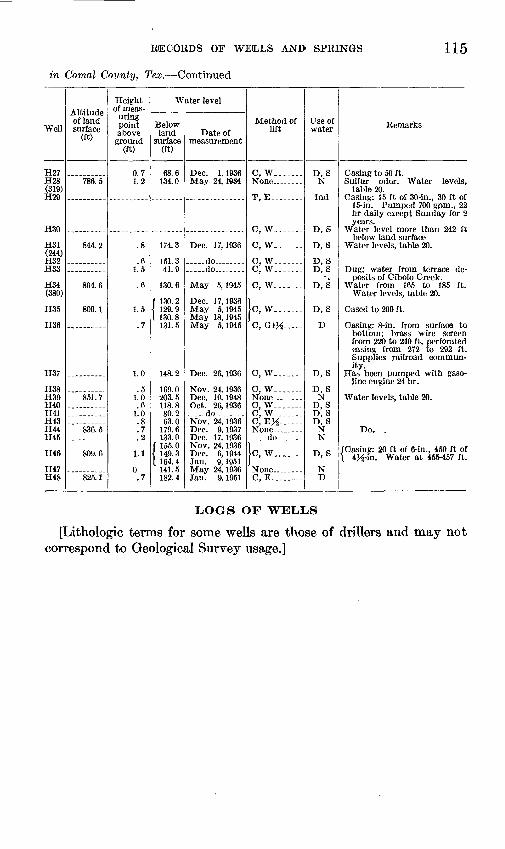
RECORDS OF WELLS AND SPRINGS
in Comal County, Tex. Continued
115
Well
H27 H28 (319) H29
H30
H31 <244) H32 H33
H34(380)
H35
H36
H37
H38 H39 H40 H41 H43 H44 H45
H46
H47 H48
Altitude of land surface
(ft)
786.5
844.2
804.6
800.1
851.7
836.5
809.6
825.1
Height of meas
uring point above ground
(ft)
0.7 1.2
.8
.6 1.5
.6
1.5
.7
1.0
.5 1.0 .6
1.0 .8 .7 .2
1.1
0.7
Water level
Below land
surface (ft)
68.6 134.0
174.3
151.3 41.9
130.6
f 130. 2 < 129.9 [ 130. 8
131.5
148.2
169.0 203.5 118.8 80.2 63.0
179.6 133.0
f 155.0 i 149.3 [ 164. 4
141.5 182.4
Date of measurement
Dec. 1, 1936 May 24, 1S84
Dec. 17, 1936
.....do. .-- do... ..
May 5,1945
Dec. 17, 1936 May 5, 1945 May 18, 1945 May 5, 1945
Dec. 26, 1936
Nov. 24, 1936 Dee. 10,1948 Oct. 26,1936
..... do .. ...Nov. 24, 1936 Dec. 9, 1937 Dec. 17,1936 Nov. 24, 1936 Dec. 6, 1944 Jan. 9, 1951 May 24, 1936 Jan. 9, 1951
Method of lift
C, W_.__.__
T, E. .......
C, W.......
C, W....--_
C, W.......C, W.......
C, W.......
Ic, w.......C, GlJi.--- -
C, W.......
C, W-....-
C, W.......C, W.......O.EJi
__._-do.-.-_-.
|c, w.......
C, E. .......
Use of water
D, SN
Ind
D, S
D, S
D, S D, S
D, S
D, S
D
D, S
D, SN
D, S D, S D, S
N N
D, S
N D
Remarks
Casing to 50 ft. Sulfur odor. Water levels,
table 20. Casing: 15 ft of 30-in., 30 ft of
15-in. Pumped 700 gpm., 22 hr daily except Sunday for 2 years.
Water level more than 242 ft below land surface
Water levels, table 20.
Dug; water from terrace de posits of Cibolo Creek.
Water from 165 to 185 ft. Water levels, table 20.
Cased to 200 ft.
Casing: 8-in. from surface to bottom; brass wire screen from 220 to 240 ft, perforated casing from 272 to 292 ft. Supplies railroad commun ity.
Has been pumped with gaso line engine 24 hr.
Water levels, table 20.
Do. .
/Casing: 20 ft of 6-in., 450 ft of \ 4K- in. Water at 45S--457 ft.
LOGS OF WELLS
[Lithologic terms for some wells are those of drillers and may not correspond to Geological Survey usage.]

116 GEOLOGY AND GROUND-WATER RESOURCES, COMAL COUNTY, TEX.
Well B39
[Owner, A. J. Monier 16J.i miles northwest of New Braunfels]
Thick ness (feet)
Depth (feet)
Thick ness (feet)
Depth(feet)
Hard yellow limestone- -. Blue marl,._______ Clay and marl, light blue. Light-gray soft limestone. Light-blue clay_____ Hard white limestone. -
Slightly pink limestone__.__. Light-gray marl.._. .. . . Dark-blue marl __.__ __. Alternating beds of limestone and
marl; water at 287 feet.. ...... 196
6595
101
297
Well B49
[lltf miles northwest of New Braunfels. Core test. Driller, U. S. Army, Corps of Engineers]
Thick ness (feet)
Depth (feet)
Soft lime boulders (taken from driller's log)..__________--_ -- 4.0 4.0- Glen Rose formation:
Limestone, hard argillaceous, weathered, variably light yellow and tan, with occasional very hard, slightly crystalline, very vuggy tan limestone phases 10.6 14.6-
No core recovery; used rock bit_______________________-_ -. 1.4 16.01Limestone, very hard, slightly argillaceous, weathered, light yellow with many
solution cavities partly to filled with yellow marl, with a highly inclined slickensided fracture from 23.5 ft to 23.8 ft and with verv argillaceous, yellow limestone phases from 24.2 ft to 25.9 ft and 26.8 ft to 27.2 ft.__._ 17. 7 33. T
Limestone, hard, argillaceous, weathered, light yellow, with occasional solution cavities partly filled with yellow marl; occasional, very argillaceous, yellowish- tan limestone phases; medium hard, calcareous, weathered, yellowish-brown shale seams from 42.3 ft to 42.7 ft, 44.1 ft to 44.6 ft, 45.7 ft to 46.2 ft and 47.6 ft to 47.8ft _ 5.9
Limestone, hard, argillaceous, light gray (almost gray), with a very argillaceous phase in the middle and extreme lower parts; occasional very irregular, tight, thin partings of medium hard, very calcareous, gray shale having many grains of dark-gray limestone from 53.8 ft to 55.1 ft and with vertical fractures from 52.6 ft to 53.6 ft. 6.6 56.2:
Limestone, hard, argillaceous, weathered, light yellow, with many irregular, tight, thick, and thin partings of medium-hard, calcareous, yellowish-brown shale from 56.4 ft to 57.0 ft; verv argillaceous phases having highlv numerous Orbitolina texana from 59.8 ft to 60.7 ft, 61.8 ft to 63.6ft and 69.5ft to 72.5ft; highly incliied fractures from 70.9 ft to 71.1 ft arid 73.6 ft to 74.0 ft; a few scattered solution cavities from 67.0 ft to 67.7 ft.____________-__-_ __ . 18.6 75. 2
Limestone, hard, argillaceous, light gray, with numerous Orbitolina texana in the extreme lower part, and with an inclined, slickensided fracture at 78.1 ft 3.0 78.2
Shale, hard, very calcareous, gray___________________._ - _ 1.3 79.5Limestone, hard, very argillaceous, light gray (almost gray), with many small
grains of dark-gray lime; numerous Orbitolina texana fossils; inclined fractures at 80.0 ft and 80.5 ft, and with medium-hard, calcareous, gray shale seams from 80.3 ft to 80.5 ft and 80.6ft to 81.4 ft _______-__-_.___________ 5.8 85.3
Limestone, hard, argillaceous, light gray with many small grains of gray lime_.. 2.7 88.0Shale, medium hard, calcareous, gray________________-_ _..... .4Limestone, hard, very argillaceous, massive, light gray, with many small grains
of dark-gray lime on the extreme upper part; many vertical and inclined frac tures from 89.0 ft to 90.6 ft and 93.8 ft to 96.7 ft__._-_______-----__ - 9.8 98. 2
Limestone, hard, very argillaceous, weathered, light yellow, transitional to a medium-hard, very calcareous, weathered, yellow shale in the lower part-- - 3.5 101.7
Limestone, hard, slightlv argillaceous (becoming argillaceous below 104.3 ft), weathered, highly fossiliferous (bordering on shell agglomerate in the upper- part), light yellow, with numerous solution cavities partly to tightly filled with yellow lime from 101.6 ft to 104.8 ft, with a very hard, crystalline, fossiliferous, weathered, reddish-brown limestone seam from 101.7 ft to 102.6 ft, with numer ous Orbitolina texana fossils in the lower part, and with a highly inclined, iron- stained, slickensided fracture from 117.9 ft to 118.4 ft___________-___ 17.8 119.5
Limestone, medium hard, very argillaceous, weathered, yellow, with highly numerous Orbitolina texana fossils. (Bordering on shell agglomerate).--.__ 2.3 121.8
Limestone, hard argillaceous, weathered, light yellow, with numerous Orbitolina texana fossils, with numerous solution cavities tightlv filled with yellow argil laceous lime having numerous Orbitolina texana fossils _ ___ -- - - . 9 122.7
Limestone, hard, argillaceous, light gray, with many Orbitolina texana fossils, and with many irregular masses of medium-hard, calcareous, gray shale having many Orbitolina texana fossils_________...___...________ 1.5 124.2
Limestone, hard, argillaceous, weathered, yellow, with abundant Orbitolina tex ana fossils; highly inclined, parallel, iron-stained fractures from 124.8 ft to 125.2 ft. 2.0 126.2

LOGS OF WELLS 117
Well B49 Continued
Thick ness (feet)
Depth(feet)
Glen Rose formation -ContinuedLimestone, hard, argillaceous, light gray, with abundant Orbitolina texana fossils- 6.3 132.5 Limestone, hard slightly argillaceous, fossiliferous, light gray, with occasional solu
tion cavities partly to tightly filled with argillaceous, gray lime; occasional irreg ular, tight, thin, and hairline partings of gray shale; many small grains of dark- gray limestone from 137.2 ft to 139.3 ft; a highly inclined fracture from 134.0 ft to 134.3 ft; irregular, light-yellow, weathered zones from 133.8 ft to 135.9 ft 6.7 139.2
Limestone, hard, very argillaceous, gray, with many tight, thin partings of gray shalefrom 139.2ft to 139.6ft-- .. 4.1 143.»
Limestone, hard, argillaceous, variably light gray and gray, with a few scattered solution cavities; many small grains of gray limestone from 143.3 ft to 144.1 ft, 1946.2 ft to 150.8 ft, and 152.3 ft to 154.7 ft, with occasional fossils; inclined slick- ensided fractures at 143.5ft, 143.8 ft and 145.6 ft._, .._ 11.4 154.7
Limestone, hard, argillaceous, gray, with abundant minute grains of dark-gray lime; a highly inclined, slickensided fracture from 154.7 ft to 155.1 ft; medium- hard, very calcareous, gray shale seams from 155.9 ft to 156.2 ft and 156.5 ft to 156.5ft---- .- 1.8 156.5
Limestone, hard, argillaceous, gray, with abundant small grains and small con cretionary masses of hard, argillaceous, gray limestone; many irregular, tight, thick and thin partings of medium-hard, very calcareous gray shale in the lower part-------.-.-.--------- . - 2.5 159.
Limestone, hard, very argillaceous, gray; occasional irregular seams of hard, argil laceous, light-gray limestone, and occasional irregular, tight, thick and thin partings of medium-hard, very calcareous gray shale.---____.'...___-_ 1.2 160.2
Limestone, hard, very argillaceous, gray; occasional fractures in the extreme up per part--.---.----------.-- 4.1 164.3
Limestone, hard argillaceous, light gray, with many small grains of gray limestone. 1.7 166.0 Shale, medium hard, calcareous, weathered, yellowish brown. ___ __ _____ 0.5 166.5 Limestone, hard, argillaceous, weathered, light yellow; occasional fracture zones;
occasional very argillaceous phases in the lower part; a medium-hard, very cal careous, weathered yellow shale phase from 193.0 ft to 194.1 ft; a very hard, slightly argillaceous, weathered, somewhat brittle and fractured, light-tan lime stone phase from 191.8 ft to 192.8 ft: and a very hard crystalline, weathered, brown limestone seam from 192.3ft to 192.6 ft ___________._____ 30.0 196. f>
Limestone, hard, very argillaceous, gray, with a vertical fracture from 197.8 ft to 198.3ft __-------- 2.3 198. *
Shale, medium hard, very calcareous, dark gray.._._...__.._____.__ 1.0 199.3 Limestone, medium hard, very argillaceous, fossiliferous, gray, with occasional
concretionary masses of hard, argillaceous, light-gray limestone. ___--_ 1.0 200.2 Limestone, hard, argillaceous, partly fossiliferous light gray; a hard, very argil
laceous, light gray (almost gray) limestone phase having highly numerous Orbitolina texana fossils from 203.3 ft to 212.8 ft; numerous small solution cavities from 201.0 ft to 201.8 ft; a few small solution cavities in the extreme lower part which is hard, very argillaceous, limestone.______._.__.__-_.___.._ 14.2 214.4
Limestone, hard, argillaceous, light gray (almost gray); with a light-gray lime stone phase in the middle part having scattered pin-hole vugs and a few small solution cavities; a very argillaceous gray limestone phase in the extreme lower part--------.-.-------.-...-----... 4.4 218.8
Limestone, hard, argillaceous, light gray, with a medium-hard very argillaceous gray limestone phase from 200.0ft to 220.7 ft. 2.9 222.7
Limestone, hard, argillaceous, light gray (almost gray), with many small concre tionary masses of hard, argillaceous, light-gray limestone in the extreme lower part, and with a light-gray and gray banded appearance in the middle part 7.4 230.1
Shale, medium hard, calcareous, gray_-___ _ _ _____.___-__... 0.1 233.0 Limestone, hard, argillaceous, light gray, with many irregular masses of hard,
argillaceous gray limestone.---________________.__ ______ 3.6 236.6 Limestone, hard, argillaceous, light gray_ __________-________ 0.8 237.4 Limestone, hard, very argillaceous, gray.___.____._____________ 1.3 238.8 Shale, medium hard, very calcareous, gray.-.._.________ .__..._ 1.7 240.4 Limestone, hard, argillaceous, light gray, with occasional fossils with a few scat
tered solution cavities and open shell casts becoming numerous from 241.6 ft to 242.6 ft, and with scattered small grains of gray limestone in the lower part- - -. 9.0 250.1
NOTE: After the classification by James K. Mortlock, Corps of Engineers, U. S. Army. Published by the permission of the District Engineer.
Well C5
[Owner, George Faber. 13 miles northwest of New Braunfels. Driller, E. B. Kutcher.]
Thick ness (feet)
Depth (feet)
Thick ness (feet)
Depth (feet)
Dobie .........Boulders.. ___......Red boulders- ..... Yellow clay (water at 87 ft).
103053
130
Blue clay and limestone ... Yellow clay and limestone. Blue-gray limestone - __ Gray and blue limestone...
205545
205
150205250455

118 GEOLOGY AND GROUND-WATER RESOURCES, COMAL COUNTY, TEX.
Well CIS
[Owner, E. R. Williams. 11 miles northeast of New Braunfels. Driller, E. B. Kuteher]
Thick ness (feet)
220401025
Depth (feet)
220260270295
Thick ness (feet)
154070
Depth (feet)
310350420
19 miles northwest of New Braunfels.
Well FlCore test. ' Driller, U. 8 Army, Corps of Engineers. Altitude of
land surface 864.7]
Thick ness (feet)
Depth (feet)
Glen Rose formation:Limestone, hard, broken and weathered, yellowish white, fishtailed-- _---.Limestone, hard, broken and weathered, yellowish white with occasional iron
stains, and with many pinhole vugs and minute calcite crystals, especially in basal part----.--..-----_.____.-.____---_.--_----__---_------.. -.
Limestone, hard, partly broken, weathered yellowish white, with occasional open iron-stained partings and open ealcite-lined vugs throughout
Limestone, hard, partly broken and weathered yellowish white, with many solu tion cavities tightly filled with very calcareous yellow shaly clay or marL._.._.
Shale, medium hard, very calcareous, yellow-...------------------------ -----Limestone, variably hard and medium hard, massive, argillaceous throughout;
some transitional phases bordering on very calcareous shale or marl, yellow and yellowish white, with occasional small solution cavities filled with very calcar eous yellow shaly clay or marl...........____.-._----__-. . ...
Shale, medium hard, calcareous, yellow_____------__-.____---.-___....Limestone, hard (almost medium hard), massive, slightly argillaceous through
out, light yellowish white, with 1-in. calcite-lined vug at 41.7 ft ..._____-.Shale, medium hard, calcareous, yellow_____-.---..___.-__-_-_.._.....Limestone, hard, massive, slightly argillaceous throughout, light yellowish-white,
with occasional thin, tight horizontal partings of calcareous yellow shaly clay or marl___.__-____-_-______.___......_....______..-._.__...
Limestone, hard (almost medium hard), argillaceous, containing numerous pin- hole vugs, yellowish white, with occasional thin horizontal bands or partings of medium hard, calcareous yellow shaly clay or marl_.._...._ ..........
Shale, medium hard, calcareous, yellow......._...._ .. ... ...Limestone, hard, argillaceous, light yellowish white.....___._......___Limestone, medium hard, argillaceous, light yellow with numerous vugs K in. in
diameter and smaller, through out...-.__.._.---.--__-_-----..-_.--.-_-----Limestone, hard, massive, slightly argillaceous throughout, light yellowish white,
mottled with occasional solution cavities tightly filled with hard, yellow argil laceous limsetone; occasional very small calcite-lined vugs, especially in upper part, and with J4 in. horizontal parting of calcareous, yellow shale at 55.1 ft--
Limestone, medium hard, very argillaceous, yellowish white, with numerous pin- hole vugs throughout..-_.__-_-__--_-__-_...__.________......
Limestone, medium hard, (almost hard), argillaceous, yellowish white, with some pinhole vugs scattered throughout; \i in. bands of calcareous yellow shale at 64.3ft. and65.9ft - ..- -
Limestone, hard, massive, white with very occasional fossils scattered through out and withj.j in. band of calcareous yellow shale at 69.6ft .... . .
Limestone, hard (almost medium hard) slightly argillaceous, yellowish white with pinhole vugs scattered throughout. Note: The "contact" shown at 70.7ft. is transitional_____.._....____......________.-..__
Limestone, hard, massive, slightly argillaceous, yellowish white to yellowish gray. Note: The "contact" shown at 71.3 ft. is transitional---------.--.-----
Limestone, hard, variably argillaceous and very argillaceous, partly broken, yel lowish white, with some pinhole vugs; occasional medium sized calcite crystals, many minute calcite crystals throughout, and with a J^ in. stained vug at 75.2 ft. Note: The "contact" shown at 72.7 ft is transitional and solution action is becoming increasingly apparent with depth____._.__... _ ..
2.4
3.5
15.6
3.3 1.4
10.1 .3
5.3 .2
1.2 .1 .5
11.4
2.0
1.4
3.5
2.4
5.9
21.5
24.826.2
36.336.6
41.942.1
8.3
49.549.650.1
50.9
62.3
64.3
65.9
70.7
71.3
72.7
76.2
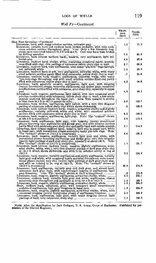
LOGS OF WELLS 119
Well Fl Continued
Thick ness (feet)
Depth (feet)
Glen Rose formation ContinuedLimestone, hard, with many solution cavities, yellowish gray____.._ __.. 1.0 77.2Limestone, variably hard and medium hard, broken probably, with very num
erous solution cavities throughout, gray. Note: Only a few limestone frag ments were recovered between 77.2 ft and 80.8 ft. Core may have been broken by drilling operation.____.____________________.______.. 3.6 80.8
Limestone, hard (almost medium hard), massive, very argillaceous, light yel lowish gray __.____-____________._____________.. 4.8 85.6
Limestone, medium hard, chalky, white, containing occasional calcite crystals; vugs filled with clay; thin partings of calcareous yellow shaly clay or marl. -. 2.7 88.3
Limestone, medium hard, very argillaceous, with many "pin-hole" vugs through out, yellowish white_________________________________ 1.6 89.9
Limestone, medium hard or soft, very argillaceous, yellowish white, with many small solution cavities partly filled with calcareous, yellow shaly clay or marl.- .7 90. ft
Limestone, medium hard, massive, argillaceous, yellowish white, with many "pin-hole-vugs throughout and with small solution cavities filled and partly filled with calcareous, yellow shaly clay or marl_. -____.._ 4.2 94.8-
Limestone, hard, generally massive, argillaceous, light gray, with irregular (wavy) transitional phases, becoming argillaceous and darker gray; occasional small solution cavities filled with calcareous, gray shaly clay, especially in upper part _---- 4.3 99.1
Limestone, hard, massive, argillaceous, light yellow, with very occasional small solution cavities filled with calcareous, yellow shaly clay or marl; a few calcite crystals scattered throughout the basal part. Note: This material is similar to that from 94.8 ft to 99.1 ft except for color,______________-- ___ 3.6 102.7
Limestone, hard, broken, argillaceous, light yellow, with a very thin diagonal parting of calcareous yellow shaly clay which shows slickenside.- -. . 3 103. Q
Limestone, hard, (almost medium hard), massive, somewhat chalky and slightly argillaceous, variably yellowish white and white, with occasional solution cavities filled with calcareous yellow shaly clay or marl -_ - 6.3 109.3
Limestone, hard, massive, argillaceous, light gray. Note: The "contact" shown at 109.3 ft is transitional_____.________________________. 2.9 112.2
Limestone, hard, argillaceous, light gray, with irregular (wavy) transitional phases becoming very argillaceous and darker gray, and with solution cavities partly filled with calcareous gray shaly clay and partly lined with calcite crystals, 2.1 114.3
Limestone, hard (almost medium hard), massive, light gray in upper part; white in basal part, with transitional phases containing many pin-hole vugs. Note: The "contact" shown at 114.3 ft is transitional 6.0 120.3
Limestone, hard, massive, argillaceous, variably light gray and white, with transitional phases becoming argillaceous and darker gray; very thin irregular (wavy) tight partings of dark gray shaly clay, especially at about 128 ft. Note: The "contact" shown at 114.3ft is transitional-...- 1.4 121.7
Limestone, hard (almost medium hard), massive, slightly argillaceous, some what chalky, white, with a very thin diagonal parting of dark gray shaly clay at 125.2 ft which shows slickenside and with W in. solution cavity or vug at 132.3 ft.- 2.5 134.2
Limestone, hard, massive, variably argillaceous and partly argillaceous, variably light gray and white, with occasional fossils scattered throughout; some transi tional phases contain very thin (wavy) tight partings of dark gray shaly clay, and with an isolated W in. vug at 142.2 ft. Note: The "contact" shown at 134.2ft is transitional __ . 40.6 174.8
Limestone, hard argillaceous, variably gray and dark gray, and almost hard, calcareous dark gray shale, with concretionary nodules of argillaceous, light gray limestone. Note: The "contact" shown at 174 ft is transitional. . 8 175. ft
Limestone, hard, massive, slightly argillaceous, somewhat chalky, white.. 5.5 181.1Limestone, medium hard, variably light gray and white, argillaceous, almost
calcareous shale throughout and especially so from 181.8 ft to 182.1 ft.. 1.0 182.1Limestone, hard, massive, slightly argillaceous, somewhat chalky, white - - - 1.8 184.0Shale, medium hard, calcareous, gray, with occasional small concretionary
nodules of argillaceous, light gray limestone in basal part. ---------------- . 1.9 185. 9Limestone, hard, massive, slightly argillaceous, somewhat chalky, white, with
occasional irregular (wavy) transitional phases of argillaceous limestone.. 3.3 189.2Limestone, hard, argillaceous, light gray, with many irregular (wavy) tight
partings of hard, very calcareous, shaly clay.____ __...__ 1.3 190.5
NOTE: After the classification by Jack Colligan, U. 8. Army, Corps of Engineers. Published by per mission of the District Engineer.
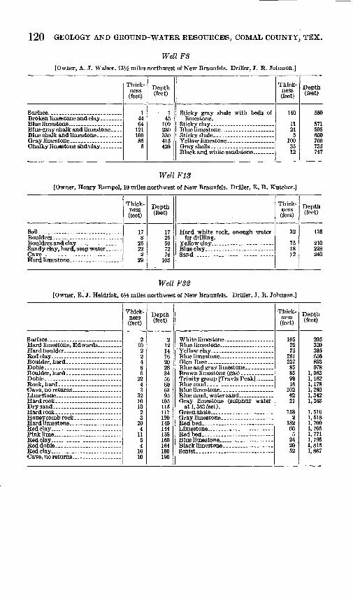
120 GEOLOGY AND GROUND-WATER RESOURCES, COMAL COUNTY, TEX.
Well FS
[Owner, A. J. Walser. 13H miles northwest of New Braunfels. Driller, J. R. Johnson.]
Thick ness (feet)
14464
121100855
Depth (feet)
145109oqn
330415420
Thick ness (feet)
140
11245
1003512
Depth (feet)
560
571595600700735747
Well ¥13
[Owner, Henry Rom pel, 10 miles northwest of New Braunfels. Driller, E. B. Kutcher.]
Sofl -. - . -
Thick ness (feet)
17
25222
29
Depth (feet)
17OK
KA
7274
103
Thick ness (feet)
32
751812
Depth (feet)
135
210228240
Well FS2
[Owner, E. J. Heidrick, 6J.S miles northwest of New Braunfels. Driller, J. R. Johnson.]
Thick ness (feet)
210
4
62243
321010
3204
1154
1610
Depth (feet)
219
141620OQ
*U.
W
606395
105115117120140144155160164180190
Glen Rose
at 1,363 feet).
Thick ness (feet)
1052575
26123785859916
1026221
1532
18266
5242052
Depth (feet)
295320395656893978
1,0631,1621,1781,2801,3421,363
1,5161,5181,7001,7661,7711,7951,8151,867

LOGS OF WELLS 121
Well Gil
I Owner, Bretzke. 5 miles northwest of New Braunfels.of Engineers]
Core test. Driller, U. S. Army, Corps
Limestone with chert inclusions ...
chert inclusions at 12.2ft.. ___
ityatie.Oft -
37.0ft---- ..................
Cavity partly filled with red day-
Cavity...... .... - .-_._-
Cavity...------ ....... .... ..
Cavity. .....................
chert at 131.3 ft --------------
pores stained with iron oxide . . - - Chert- _ -.- __ -...-.- __ -. Cavity
Thick ness (feet)
6.0.5.7
3.6
2.2.5
.51.0
3.62.41.42.1
1.51.4.6
2.07.01.0
12.0
21.09.02.7.3
3.0.8
2.21.01.01.08.0.8
2.21.81.0
6.81.6.8
3.04.1.4.5
3.4 .1
40
Depth (feet)
6.06.57.2
10.8
13.013.5
16.022.0
25.628.029.431.5
33.034.435.0
37.0a n45.0
57.0
78.087.0
1 89.7
93.093.896.097 098.099.0
107.0107.8110.0111.8112.8
119.6121.2122.0125.0129.1129.5131.0
133.6
137.0 137.1140.1
Gray crystalline limestone, slight-
Cavity
Cavity-- - -
Brown, very porous limestone _ -
Cavity- ----------------------- --.
Cavity
Cavity Gray, porous, broken, cherty
Thick ness (feet)
0.9
6.82.2.8
1.21.02.01.02.01.01.0.8
421.03.01.02.0.7
1.3.9
1.13.01.0.7
1.3
3.3.8
7.5.4
3.02.04.0.7
.32.11.42.51.41.63.02.0.9
5.2.5
7.4.9
1.11.0
2.0
Depth (feet)
141.0
147.6150.0
152.0153.0155.0156.0158.0159.0160.0160.8165.0
169.0170.0172.0172.7174.0174.9176.0179.0180.0 180.7
182.0
185.3186.1
193.6194.0197.0199.0203.0203.7
2040206.1207.5210.0211.4213.0216.0218.0218.9224.1224.6232.0232.9234.0235.0
237.0
NOTE. Published by permission of District Engineer.
Well G40
[Owner, Mrs. Lydia Kirmse. 314 miles northeast of New Braunfels.]
Thick ness (feet)
52
Depth (feet)
57
Thick ness (feet)
58
Depth (feet)
65

122 GEOLOGY AND GROUND-WATER RESOURCES, COMAL COUNTY, TEX.
[Owner, Mrs. B. Gruene Estate.
Well G41, partial logmiles northeast of New Braunfels. Drillers, Killern and Hicks.}
Thick ness (feet)
Depth (feet)
Thick ness (feet)
Depth (feet)
Taylormarl..._____. Austin chalk...____. Eagle Ford shale..___. Buda limestone_.___. Grayson (Del Rio) shale- Georgetown limestone_.
292193
20354020
292485505540580600
Edwards and Comanche Peaklimestone-..____-... .
Glen Rose limestone.-.. .459 1,050
Total depth. 2,350
Well G46
[Owner, City of New Braunfels. In New Braunfels. Driller,__ Cravens.]
Thick ness (feet)
Depth (feet)
Thick ness (feet)
Depth (feet)
Surface rock_. Red clay..._. Gravel (water).
Georgetown limestone. Edwards limestone.
58116
Well G49
[In New Braunfels. Core test and observation well. Driller, U. S. Army, Corps of Engineers.]
Thick ness (feet)
Depth (feet)
No samples____________________________ __ 6.4 6.4 Limestone, gray white, crystalline_____________-.-__ 1.6 8.0Limestone, gray white, lithographic, solution cavities filled with red clay or pink lime. 4.0 12.0 Limestone, lithographic texture, brownish gray; some chert- _ -------- 1.2 13.2Limestone, gray white vugs contain secondary calcite crystals; lower part, white with
milioline fossils_________________________________ 7.1 20.3 Limestone, dense brownish gray___________.-___--_____ - 4.0 24.3 Limestone, white, milioline fossils...._-...____._.________...-. 4.7 29.0 Limestone,- brownish gray, fine texture; vugs (core less 1.8 ft) chert at 36 ft .- 7.0 36.0 Limestone, gray white, fine texture, cavities filled with red clay and calcite crystals . 6.0 42.0 Limestone, brownish gray, coarsely crystalline; cavities contain red clay and calcite
crystals. --- . --~- - ~- - - - ~--_- - -------- 9.0 51.0Limestone, dark gray, coarsely crystalline, some red clay. . - 9.0 60.0 Limestone, gray white to pink, lithographic texture. Part of core replaced by dense
calcareous pink clay. Contact between clay and limestone irregular. Logged as"broken limestone"---..____________________-_____--- - 10.0 70.0
Limestone, gray, coarsely crystalline; vugs and fractures filled with dogtooth spar 8.0 78.0and some real clay; about one half of core is secondary material-.- . - .-
Limestone, gray, fine grained; vugs small, contain small crystal of calcite core less 1.3 ft- 6.3 84.3 Limestone, fine-grained, and red clay; core lesslft----. ----- 1.0 85.3 Limestone, mostly coarsely crystalline; large vugs lined with small calcite crystals;
large crystals and red clay in lower part of core.-----__----_ 3.8 89.1 Limestone, upper part badly broken, with much replacement by red clay; lower part
finein texture_______________________--_ 1.4 90.5 Limestone, with red clay; 2-in. dark-gray bank containing fossils- 2.0 92.5 Limestone, dense gray; no vugs or fossils; some fractures filled with red clay. -. 10.0 102.5 Limestone, light gray, finely crystalline, Poraminifera and small megascopic fossils.. 4.0 106.5 Limestone, light gray, fine texture, small open vugs, red clay in fractures. (4 cores
loss 6 ft) . - - - - - .-- - - - 16.9 123.4Limestone, gray, medium texture, small vugs, no red clay 3.6 127.0Limestone, gray, lithographic texture, breaks and large vugs filled with red clay 8.5 135.5 Limestone, gray, medium texture, fractures filled with red clay, some open vugs lined
with small calcite crystals.-- ___________ 2.0 137.5 Limestone, hard, dense, vuggy, gray to brownish gray; much pink argillaceous secon
dary material; some fossils___._________ . . 4.1 141.C Limestone, gray, lithographic texture, not vuggy, rudistied(?) fossils- 4.4 146.0 Limestone, light gray, fine texture, contains small white elongate pellets about }$
in. in diameter. 2 cores, loss 1.1 ft____ 5.C 151.6 Limestone, fine texture, vuggy, partly replaced by pink calcareous material-. 8.7 160.3 Limestone, vuggy, without crystals, fine texture, much pink calcareous clay 2.6 162.9 Clay or marl, red (loss 4.7 ft)....... _ _ . - 7.1 170.0

LOGS OF WELLS
Well G49 Continued
123
Limestone, brownish gray to gray, vuggy, almost spongy, fine texture, elastic(?)._ ...
Limestone, dense, brownish gray, vugs lined with calcite crystals and clay, (4 cores),
Limestone, gray, lithographic texture, vuggy with calcite and clay fossiliferous
Limestone, gray to brownish gray, fine texture, vugs filled with earthy lime. (4 cores) --
Limestone, mottled light and dark gray; fossils abundant; Probably equivalent of
Limestone, gray to white, mottled with nearly black limestone, few fossils, no vugs __ Limestone, medium-dark gray, finely porous to vuggy, largely dolomitized; few
fossils (2 cores),.. _____ _- _ .. ___________________ __ _____
Limestone, light gray, fine texture, somewhat dolomitized, large vugs nearly filled
Total depth.... _ ... ___ .. _____ . ________ . __ ... ____ . _ . ....
Thick ness (feet)
4.5 3.02.5
11.4
19.0
7.14.9
18.6 1.0
1.07.0
10.0
18.94 17.2
5.85.0
19.0
Depth (feet)
174.5 177.5180.0191.4
220.4
227.5232.4251.0 252.0
253.0260.0270.0
288.9293.0300.2
306.0311.0320.0
320.0
Well G5S
[Owner, A. Swanson. In New Brannfels]
Thick ness (feet)
2852408
Depth (feet)
2880
120128
Thick ness
.(feet)
416
4
Depth (feet)
132148
152
Well G58
[Owner, Emma Rose. 4J.6 miles northeast of New Braunfels]
Thick ness (feet)
325
Depth (feet)
328
Thick ness (feet)
22
Depth (feet)
3032
Well G75
[Owner, W. S. Buttle. \% miles southwest of New Braunfels. Driller, E. B. Kutcher]
Thick ness (feet)
60255150
15
Depth (feet)
60305455470
Thick ness (feet)
704020
5
Depth (feet)
^dit580600610
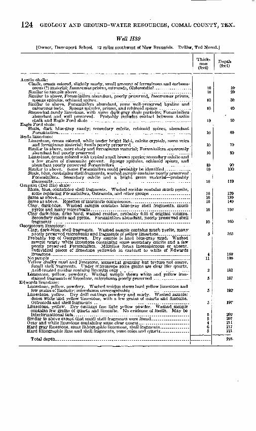
124 GEOLOGY AND GROUND-WATER RESOURCES, COMAL COUNTY, TEX.
Well HS9
[Owner, Davenport School. 12 miles southwest of New Braunfels. Driller, Ted Nored.]
Thick ness (feet)
Depth (feet)
Austin chalk:Chalk, cream colored, slightly sandy, small amount of ferruginous and carbona
ceous (?) material; Inoceramus prisms, ostrocods, Oloborotalial...__-____., 10 IfrSimilar to sample above.-.__....__-________________________ 10 20Similar to above, Foraminifera abundant, poorly preserved, Inoceramus prisms,
sponge spicules, echinoid spines..___.-_..._._____.___.-_---.__ _.__ 10 30Similar to above, Poraminifera abundant, some well-preserved hyaline and
calcareous tests. Sponge spicules, prisms, and echinoid spines._..._-..__ 10 40Somewhat sandy limestone, with some dark-gray shale particles; Poraminifera
abundant and well preserved. Probably includes contact between Austin chalk and Eagle Ford shale..------_____-_--_._______________. 10 50
Eagle Ford shale:Shale, dark blue-gray sandy; secondary calcite, echinoid spines, abundant
Poraminifera-_______..._________.__________________ 10 60 Buda limestone:
Limestone, cream colored, white under bright light, calcite crystals, some mica and ferruginous material; fossils poorly preserved.. __._._--_____ 10 70
Similar to above, more shaly and ferruginous material; Foraminifera apparently abundant but poorly preserved.. ---------_..._--_---_-___---_-----___.. 10 SO
Limestone, cream colored with typical small brown specks; secondary calcite and a few grains of glauconite present. Sponge spicules, echinoid spines, and abundant poorly preserved Poraminifera.___-_-______-._--____-_--_-..___ 10 90
Similar to above. Some Foraminifera could probably be identified-------__-. 10 100Shale, blue, containing shell fragments, washed sample contains poorly preserved
Foraminifera. Secondary calcite and a bright green material probably glauconite,-.--._._.___.___._____._._____.____.. 10 110
Gray son (Del Rio) shata:Shale, blue, containing shell fragments. Washed residue contains much pyrite,
some replacing Foraminifera, Ostracoda, and other groups-.___-------__ 10 120Same as above..._._.._-.-._-______-.....-.._..--_______-______ 10 130Same as above. Rosettes of marcasite conspicuous.---___-______--__---_. 10 140Clay, dark-blue. Washed sample contains blue-gray shell fragments, much
pyrite and many microfossils-_______________________..._-_.._.----_.__.. 10 150Clay dark-blue; dries hard; washed residue, probably 0.05 of original volume.
Secondary calcite and pyrite. Foraminifera abundant, poorly preserved shell fragments-..--__.__._____._________._______-.._____ 10 160
Georgetown limestone:Clay, dark-blue; shell fragments. Washed sample contains much pyrite, many
poorly preserved microfossils and fragments of yellow limestone,.-.-.___.-_ 5 165Probably top of Georgetown. Dry sample is hard blue:gray mud.- Washed
sample nearly white limestone containing some secondary calcite and a few poorly preserved Foraminifera. Milioline forms inconspicuous or absent. Individual pieces of limestone yellowish in contrast to white of Edwards limestone...-_-_.-----__..._________...________.....______ 4 16&
No sample ....____________._______________...__________ 11 180Yellow chalky marl and limestone, somewhat granular but texture not coarse.
Small shell fragments. Under microscope some grains are clear like quartz. Acid-treated residue contains limonite only..-____-.______________ 2 182-
L«ae_stone, yellow, powdery. Washed sample shows white and yellow iron- stained fragments of limestone, microfauna poorly preserved__ - ______ - 5 187
Edwards limestone:Limestone, yellow, powdery. Washed residue shows hard yellow limestone and
few grains of limonite; microfauna unrecognizable. ------------ _. _ ---------- 5 1921Limestone, yellow. Dry drill cuttings powdery and mar]y. Washed sample:
dense white 'and yellow limestone, with a few grains of quartz and limonite. Ostrocodaand shelf fragments______________________.._____.______.. 5 19T
Limestone, yellow. Dry cuttings fine light yellow powder. Washed sample contains few grains of quartz and limonite. No evidence of fossils. May be interformational tufa. -_--____---_-____________-.___--__-----_____-.._.. 5 202
Similar to above except that small shell fragments were found.-.______.-__ 5 207Gray and white limestone containing some clear quartz._.__.._--_-___..- 4 211Hard gray limestone, some lithographic limestone, shell fragments.._--__ _ 6 217Hard lithographic lime and shell fragments, some mica and quartz. -- 5 221
Total depth...............___..._____..._______.__..._. ._.. _...-.-. . .......... 225
INDEX
Page Adkins, W. S., cited ---------------_ 21Alluvium. ._.- - -.-...-... 14 Anacacho limestone.---------------------- 14,27arietina, Eiogyra_.----.-...-.-..-.-.-.__ 25
Austin chalk, character and distribution_ 14,26-27 chemical character of water. 71ground water -- 14
BBalcones escarpment------------------------- 11Blanco River, drainage area and runoff------- 67Buda limestone..-.---------------------- 14,25-26
Chara seeds, in Edwards limestone. _._ _ 23 Carl, Prince of Solms-Braunfels-_._ --_.__ 2 Cibolo Creek, drainage area---.----..----.--- 67
loss to ground-water reservoir_ _ -_..__-.- 56-60 runoff at Bulverde.-----------------------runoff at Selma ..~-_----- 57,67,
Comal County, location.----....------------ 3population _.. - - _ 3,4See Dry Comal Creek, Comal River.
Comal River.. -_- -------- 56,59,62,67Comanche Peak limestone-------------------- 14,22Comanche series_.-...._.-.----..-------.-. 14Cooke, C. W., fossils identified---------.----- 18Cow Creek limestone.---------------------.-- 15,16
D
Del Rio shale. See Grayson shale.Dips, regional----------------------------...- 33-34Dry Comal Creek, drainage area and runoff-- 67
loss to ground-water reservoir___-------. 60runoff above Comal Springs.---------_-__ 57runoff, NewBraunfels --- - 68-69
E Eagle Ford shale...-------------_------__ 14,26Edwards limestone, character and distribu
tion. ____ . - -- ---. 14,22-23chemical character of water.....--.--- . 70,71development of reservoir in. ._- -...__ 36-37water-bearing properties._ . 14,36
Edwards Plateau ___ _- -_ 11Exogyra arietina -____ .. _.-. _ 25Exogyratexana......_.__-_..- .----_---...---- 22,29
Faults, age of-..------------------------------ 32-33Bat Cave, confines Grayson shale__-_. 25 Bat Cave, position and features _.__---___ 30 Bat Creek, relation to Austin chalk..----- 27Bear Creek, position and features_------ 30-31cause of ------------------------------ 32Comal Springs, confines Grayson shale-.. 25 Comal Springs, effect on water movement 60
Fruits, age of Continued Page Comal Springs, position and features. __ 29 Comal Springs, relation to Austin chalk.. 27 character and features.----------_..-__. 28-29defined.-----------------------------...-. 13Hidden Valley, position and features.... - 31Hueco Springs, divides reservoirs.____ 51 Hueco Springs, position and features-. 29, pi .8 Spring Branch, position and features..... 31Tom Creek, pesition.and features__.-._. 31
Fossils, in Glen Rose limestone. .-- -- .-_ 19 Fredericksburg group.-.. .. ...... 14,21-23
G
Gaging stations, Comal County.--. -..-. _ 61 Georgetown limestone-.--------.. _ .-- 14,24,25Glen Rose limestone,' chemical character of
water -------------_- --.__ 70,71development of reservoirs hi _. _. - 38 distribution and character..__-- ..- 14,17-21 division intomembers-.. -... -- . 17 measured section..------------ -------- 20-21yield of wells, -------__-_------- 20
Grayson shale----------.-------- -- ----.-- 14,25Ground water, direction of movement _-_- 52-53
kinds and occurrence.------------.- __- 50rate of movement__ _ ___- 50-51recharge_-_--_---------------------------- 42-43
Guadalupe River, flow at New Braunfek_ 63 flow at Spring Branch ------------------- 63hydrograph- -------- _- . 55loss to ground-water reservoir. -,...-.__ 56,63-66 runoff above Comfort__ _ -_ 54 runoff above New Braunfels- -_ 54,57,52 runoff above Spring Branch--.--...------ 54,62runoff between Spring Branch and New
Braunfels----.-.--.------ <33,67,68-39Gulfseries-.- . . -. 14,26-27
H
Henbest, Lloyd, fossils Identified.___.__ 18 Hensell sand-__._-____________.. 15,16,17 Hosston formation_.___ _...__ ..... 14
Imlay, R. W., fossils identified..- .. .... 18
J
Johnson, J. R-..._______.....__.. _. 6
K
Katzenkopfe (cat heads).____________ 16 Kingena wacoensis.---- .... . ... 25,29 Kutscher, E. B...__._____.._ __..... t>
tas Fontanas.,.. See Comal Springs tebna formation, chemical character of water. 70
distribul ion and character____. ___. 14,2
125
126 INDEX
Orbholina lexana. whitneyi.. ...
Page19
Precipitation, at Boerne. ...... 10,67,68-69at Bulverde - . 11,67,68-69 at Fischer Store-----------. 9,63,67,68-69at New Braunfels.. ............... 8,63,68-69
Pleistocene series._______.___.... 14,28Pliocene series.___________...____ 14,27-28 Purpose of investigation.______________...
R
Relief--.. 11Revelle, Roger, cited.._____________ 36Rocks, age. __... ---------_____. 13
formations......__..._____..... 14 (table)igDeous-.---_---_-__--__-___---_--_.___._. 12Paleozoic.________..._______.. 13sedimentary..-._--------____....... 12
Salenia teiana zone, fossils._._--.. outcrops..._.._..___......rocks._________...
San Marcos arch__......... ...Sinkholes, formation and features.Springs, A12......................
A16_______..______ A20 - ._.B35 _. B36- Big Springs...- .-.--_---.
18- .. 17-_-..- 19 ______ 33--..-- 34----- ' 41..__ 41 ...... 41
41-..- 41 ...... 41
Comal and Hueco, reservoirs compared_ 50-51Comal, features of discharge...___.__ 39-40
hydrograph.......___...______ 4t>inflow to...-._____.______ 40 mean discharge.--------......__...... 57,66rate of discharge____________ 38-39 rate of discharge, compared with other
Balcones fault springs_______ 39recharge from Cibolo and Dry Comal
basins.. _____________. 60relation of precipitation to discharge_ 47 relation of precipitation, water levels,
and discharge__.._______ 48,49 rock material in solution_______ 37 temperature of water_________ 39view of________________ pi. 4A
Crane's Mm . ...--............ 18F5........................................ 42
Springs Continued Page F66 . . -- -_-----_ -.--... 43 Honey Creek --------- 18,42Hueco, discharge rates - .___ 63
features of discharge.-....__--___ 40temperature, hardness, and discharge. 52temperature of water. __ ___ 40rate of discharge. . 40
partial chemical analyses _. _. _.. ____ 74-82Rebecca Creek..._____.____.__ 16,41source of supply.... 36Spring Branch. ... .... ....... 18
Stephenson, L. W., cited. 26Stratigraphy, general features____.___.. 12-13 Streams, losses and gains. ________ .. 54-60Sycamore sand..----.--------.--------------- 15
Taylor marl - - -- 14,27Temperature, New Braunfels, frost data_... 7
mean monthly __ -------------- 7maximum and minimum.------------ 7
texana, Exogyra.------------------------------ 22Orbitottna ----------------------- 19
Topography, drainage..- ... . 11-12 general features_.. . -------- 11
Travis Peak formation, chemical character ofwater. 70,71
distribution and character.------------ 14,15-17Trinity group-------------------------- 14,15-21
U
Uvalde gravel... 14,27-28
W
wacoensis, Kingena.-.. --------------------- 25Walnut clay 14,21-22Washita group-... 14,23-26Wells, Beverly Lodges, hydrograph..... 46
position and features . .. 44-45relation of precipitation to water level. 47
construction and features_ 34-35discharge from__- .... . 42H39, hydrograph..____ 57 logs. ------------------------------ 116-124observation, hydrographs of. ----- _. 45
maximum and minimum levels 44 records..--------------.-- . 83-90
. partial chemical analyses. 74-82source of supply.-- _ - - 36water level, in relation to precipitation.-- 43^8
in relation to spring flow 43-48whitneyi, Orbitolina.---------------- ....... 19
o