Geology and Ground-Water Characteristics of the … · Geology and Ground-Water Characteristics ......
86
Geology and Ground-Water Characteristics of the Hanford Reservation of the U.S. Atomic Energy Commission, Washington GEOLOGICAL SURVEY PROFESSIONAL PAPER 717 Prepared in cooperation with the U.S. Atomic Energy Commission
Transcript of Geology and Ground-Water Characteristics of the … · Geology and Ground-Water Characteristics ......

Geology and Ground-Water Characteristicsof the Hanford Reservation of theU.S. Atomic Energy Commission, Washington
GEOLOGICAL SURVEY PROFESSIONAL PAPER 717
Prepared in cooperation with the U.S. Atomic Energy Commission

Geology and Ground-Water Characteristicsof the Hanford Reservation of theU.S. Atomic Energy Commission,WashingtonBy R. C. NEWCOMB, J. R. STRAND, and F. J. FRANK
GEOLOGICAL SURVEY PROFESSIONAL PAPER 717
Prepared in cooperation with the U.S. Atomic Energy Commission
UNITED STATES GOVERNMENT PRINTING OFFICE, WASHINGTON : 1972

UNITED STATES DEPARTMENT OF THE INTERIOR
ROGERS C. B. MORTON, Secretary
GEOLOGICAL SURVEY
V. E. McKelvey, Director
Library of Congress catalog-card No. 72-600205
For sale by the Superintendent of Documents, U.S. Government Printing Office Washington, D.C. 20402 Stock Number 2401-00241
CONTENTS
Page Abstract...................................................................................... 1Introduction............................................................................... 2
Purpose............................................................................... 2Previous investigations..................................... ........... 2Scope and methods of investigation............................. 2
Drilling of observation wells................................. 2Geologic work............................................................ 2
Mapping.............................................................. 2Petrographic studies........................................ 2Stratigraphic investigations............ ............ 2Ground-water information ....................... 4
Well data.................................................................................... 4Personnel . .... . .. ............................................ 4Geographic features of the reservation............................. 4Geology....................................................................................... 5
General description of the geologic units........... .. 5Bedrock . ... . 5Sedimentary deposits............................................... 6
Ringold Formation........................................... 6Glaciofluviatile and fluviatile deposits......... 6Alluvium............................................................. 7Colluvium. .................................................... 7
Stratigraphic characteristics of the geologic units... 8Basalt of the Columbia River Group... 8
Layered structure............................................. 8Vertical subdivision of the basalt. ....... 8
Ringold Formation................................................... 10Character and extent of the strata in the
type locality .. . .. 10 Character and extent of the strata beyond
the type locality............................ ...^............ 13Distinctive lithologic zones... 13Extensions of the Ringold Formation near
the reservation.............................................. 15Relations of the Ringold Formation to the
deformation of the basalt bedrock........... 15End of Ringold deposition.............................. 15
Glaciofluviatile and fluviatile deposits.. .... 16History................................................................ 16Lithologic features... ................................. 18Differences between the Ringold Forma
tion and the glaciofluviatile and fluvia tile deposits.................................................... 19
Holocene deposits..-........ ........................................ 19Tectonic structure of the rocks. ............................. 20
General regional setting......................................... 20Altitude of the bedrock beneath the reserva
tion.......................................................................... 20Deformation in the basalt...................................... 21
Shape of the deformed units......................... 21Folding and faulting ................................ 21Synclinal structures......................................... 22
Pattern of structural displacements .. 22 Effect of tectonic structures on the occurrence
of ground water.......... ............................... 22Basalt of the Columbia River Group 22 Ringold Formation........................................... 23
Page Geology Continued
Physiography..................................................................... 23Mountain slopes................................................ . 23Plateaus................................... .............................. 23Terraces...................................................................... 24Alluvial plains............... ......................................... 24Declivities and landslides........................................ 24
Hydrology general ground-water conditions.................. 25Unconfined ground water............................................... 25
Shape of the water table......................................... 25Water-bearing materials......................................... 26Changes in the level of the water table............... 26Recharge and discharge.......................................... 28
Local bodies of confined ground water......................... 31Artesian water associated with the unconfined
ground water........................................................ 31Artesian aquifers isolated from the regional
unconfined ground water.................................... 32Local perching of ground water artificially re
charged.... ....................................................................... 32Changes in ground-water regimen.............. .............. 32
Artificially recharged mounds............................... 32Growth of the large mounds beneath the high
terraces.................................................................. 32Direction of movement .................................................. 35Rate of ground-water movement................................... 35
Porosity. ............................................................ 35Gradients. ........................................................ 35Hydraulic coefficients of the water-bearingmaterials. . . . 36
Ground disposal of radioactive wastes. .. 39History of disposal 39
Early procedures.. ........................................... 39Later developments.................................................. 40
Types of wastes disposed. ........................................ 41Reactor areas............................................................ 41Chemical-separation plants... . . 42
Means of waste disposal and management................. 42Retention basins............... ..................................... 42Pits and trenches...................................................... 42Cribs and tile fields.... ..................................... 42Burial grounds and vaults .. .. 42Tank farms ................................................... 42Injection wells........................................................... 43Swamp areas............................................................. 43Unplanned disposal.. . 43
Location of disposed wastes........................................... 43Special geologic situations that affect operations of an
industrial plant ............................ ..................... 46Terrain, foundations, and building material. .. .. 46Storage space for fluids and gases. .. 46Disposal of radioactive wastes....................................... 46
Disposal beneath the high terraces. . . 47Disposal beneath the low terraces. . 47The possibility of disposal in the basalt 48
Water supply... .... - 48Geologic hazards of the reservation... 48
References cited............. . - 49ill

IV CONTENTS
ILLUSTRATIONSPage
PLATE 1. Geohydrologic map of the Hanford Reservation of the U.S. Atomic Energy Commission, Washington......In pocket2. Map showing configuration of the water table beneath a main part of the Hanford Reservation, November
1948 and May 16-20, 1953..................................--..............................................................-.......-.. ............In pocket3. Map showing configuration of the water table beneath a main part of the Hanford Reservation, June 26-
30, 1961.. -. ..... .. -. . .......... ......-. -. ..... .. ^ pocket
FIGURE 1. Map showing location of the Hanford Reservation and the area covered by plate 1................ ..................... 32. Diagram showing well-numbering system................. .......... ......................................................................... 5
3-9. Hydrographs showing:3. Water levels in four wells in the northern part of the reservation compared with the water level of
the Columbia River......................................................................................................................................... 264. Water levels in three wells in the southeastern part of the reservation compared with the water
level of the Columbia River....................... .......................................................................................... 275. Water levels in wells where there is little or no natural recharge............................................................ 296. Water levels in two wells that tap unconfined ground water in the basalt and in the overlying
Ringold Formation.......................................... .............................................................................................. 307. Rise of water levels in wells at and near the western large recharge mound........................................ 338. Changes in ground-water levels at and distant from the eastern large recharge mound.................... 349. Rise of water levels in wells several miles from the eastern large recharge mound....... .................... 34
10. Map of typical nuclear reactor plant, showing points of disposal of several types of radioactive waste........ 4111. Map of typical chemical-separation plant, showing points of storage or disposal of several types of radio
active waste.................................................................................................................................................................. 44, 45
TABLES
PageTABLE 1. Data on wells of the Hanford Reservation....................................................................................... . 52
2. Logs of type wells on the Hanford Reservation.............-.. ... ........................................................ .......... ........... 573. Analyses of waters from the Hanford Reservation....................................................................................................... 78

GEOLOGY AND GROUND-WATER CHARACTERISTICS OF THE HANFORD RESERVATION OF THE U.S. ATOMIC ENERGY COMMISSION,
WASHINGTON
By R. C. NEWCOMB, J. R. STRAND, and F. J. FRANK
ABSTRACT
The Hanford Reservation is located on the broad sandy terraces along the Columbia River in the semiarid Pasco Basin of south-central Washington. Altitudes range from 340 to about 800 feet on the terraces, reach 3,524 feet in the mountains adjacent on the west, and extend above 1,000 feet on a few bedrock knobs which rise prominently above the surrounding terraces.
The thick basalt of the Columbia River Group is the bed rock of the region. Its top lies within about 200 feet of sea level below broad areas of terrace lands built on sedimentary deposits. The basalt is warped and locally is severely de formed. The Ringold Formation, of middle or late Pleistocene age, overlies the basalt; it consists of up to 1,200 feet of bedded silts and fine sands containing some gravel and one prominent gravel train. This extensive formation has been partly eroded from the southwestern part of the Pasco Basin. Over its erosional surface have been laid glaciofluviatile and fluviatile deposits which underlie the wind-scarred terraces. The glaciofluviatile and fluviatile deposits consist of gravel and sand containing some lenses of silt, except for the Touchet Beds of Flint (1938), which is largely silt and fine sand. The thickness of the glaciofluviatile and fluviatile deposits is as great as 200 feet locally and as much as 100 feet over large areas.
Under natural conditions, which are now altered by arti ficial recharge, the water table sloped eastward and north ward at an average of 5 to 10 feet per mile from where Cold Creek and Dry Creek flowed onto the terrace lands and where the Yakima River flowed along the higher side of the south ern part of the terrace lands. This water-table slope continued to within about 2 miles of the Columbia River, where it flattened. The flatter gradient of the water table near the river continues to be present, but the water table there fluctu ates most widely with the annual flood stages of the river. Some bank-stored ground water in the northern part of the reservation is diverted across the large river bend and returns to the river farther south and east. Natural recharge to the ground water was limited to infiltration from the two creek valleys, infiltration from the Yakima River at the southern extremity of the reservation area, and infiltration from the zone of bank storage along the Columbia River.
Artificial recharge from ordinary industrial-plant opera tions and from radioactive waste disposal has built two rudely conical ground-water "mounds" beneath the high terraces. The western ground-water mound in 1961 was nearly 60 feet high at the apex, had a base area of about 15 square miles, and was entirely in the Ringold Formation. The eastern one was less than half as high and had been elongated by growth to the southeast, in the more permeable glaciofluviatile and fluviatile deposits. Lesser mounds and minor changes in the water-table configuration have been produced elsewhere. Even
the two large mounds, constructed by recharge of about 8,000 acre-feet of waste water per year during 1944-66, occupy only a small part of the water-storage space available above the water table in materials of relatively low permeability be neath the terrace lands.
The principal water-bearing units are the basalt of the Columbia River Group, the conglomerate of the Ringold For mation, and the glaciofluviatile and fluviatile deposits. The water table lies mainly in the Ringold Formation, -and only locally does the saturated zone extend into the post-Ringold deposits. Permeability and transmissivity of the Ringold con glomerate are about 450 gallons per day per square foot and 50,000 gallons per day per foot, respectively, and those of the glaciofluviatile and fluviatile deposits are about 46,000 and 1 to 3 million, respectively. The effective porosity of the Ringold conglomerate is about 11 percent, and that of the younger deposits is about twice as much. The artificially accelerated rate of lateral movement of ground water within the Ringold Formation in the larger recharge mound, as derived for one condition in 1953, ranged from 0 to about 1,400 feet per year and averaged 240 feet per year. Permea bility of the glaciofluviatile and fluviatile deposits is about 100 times that of the Ringold conglomerate, and proportion ally greater ground-water velocities can be expected in these deposits for equivalent hydraulic gradients.
The Hanford Reservation contains the major emplacement of radioactive industrial wastes that the Atomic Energy Commission has made to the geologic environment. Wastes containing a large variety of radionuclides are disposed to the subsurface. The most highly radioactive wastes are held beneath the high terraces, where metallic wastes are stored underground in tanks and where fluids have been disposed to the geologic materials by means of infiltration cribs. Most of the disposed radioactive materials are located above the water table. Much of the ground water beneath the disposal areas contains only slight amounts of radioactivity, distrib uted spottily. A great concentration of radioactivity occurs in the geologic materials which underlie crib-disposal sites. Ruthenium-106 and tritium have moved from one large re charge mound for a distance of 14 miles to the bank of the Columbia River through the basal part of the glaciofluviatile and fluviatile deposits. The rapid (about 10,000 feet per year) movement of these radionuclides to the riverbank resulted from the rise of saturation of a disposal mound above the top of the Ringold Formation and into the overlying more permeable glaciofluviatile and fluviatile deposits.
Disposal of radioactive materials beneath the low terraces along the Columbia River has created some potential hazards, should the river become diverted and cut new channels through such disposal sites.
1

HANFORD RESERVATION, U.S. ATOMIC ENERGY COMMISSION, WASHINGTON
INTRODUCTION PURPOSE
The investigation was made to obtain general information on the geologic and hydrologic situations that control many of the operations on the Hanford Reservation of the U.S. Atomic Energy Commission. (See fig. 1.) Important aspects of the investigations were the conditions that govern disposal of radio active waste to the geologic environment, the general geologic conditions at the plant site, and the avail ability of ground water for various industrial and domestic water supplies.
The period of this work spanned the formation of the prime contractor's staff section of about 12 earth scientists. That staff section has continued investigations on the geophysical aspects of the dis posal of chemical effluents at the Hanford plant and carries on the responsibility of the prime contractor for knowing why, how, and where the plant's radio active wastes are disposed or stored. Such factors as selective adsorption of radioactive isotopes by different components of the earth materials, natural and induced shape of the water table, ground-water flow characteristics (Raymond and Bierschenk, 1957), and other factors of direct application to waste disposal and plant management are part of the continuing studies of the prime contractor's staff section.
Some of the hydrologic measurements, explora tory testing, and geologic investigation conducted by the U.S. Geological Survey were taken over, con tinued, and enlarged by the prime contractor's staff after 1953. Some of the Survey's general geologic and hydrologic information has been enlarged or added to by publications of the personnel of the Atomic Energy Commission and the successive prime contractors. For example, the Survey's information on the top of the bedrock beneath the sedimentary deposits was from sites too widely scattered to warrant drawing a bedrock contour map, so the bedrock altitudes were lettered on plate 1. A tenta tive map has since been compiled and the data kept current by the staff of Battelle-Northwest Lab oratories.
PREVIOUS INVESTIGATIONS
The general background knowledge of geology and ground-water characteristics prior to this investi gation included the bulletin on the agricultural water supplies of The White Bluffs-Hanford district (Jenkins, 1922), the reports and correspondence prior to and during the existence of the Hanford Engineering Works on the Manhattan Project (A. S. Gary, written commun., 1943, and letter reports of A. M. Piper, 1944), and later investigations after
the plant became the responsibility of the Atomic Energy Commission (Brown and Rupert, 1948, 1950; Parker and Piper, 1949).
SCOPE AND METHODS OF INVESTIGATION
The work reported herein consisted of geologic mapping of the reservation, determining the compo sition and interrelations of the stratigraphic units, and deriving the characteristics of the ground water. After the start of the work in 1950, a second project, involving mostly drilling and sampling work around disposal sites, was undertaken and carried on after the completion of the original project in 1953. The drilling was continued until 1958; some of the data obtained in that work are included in this paper.
DRILLING OF OBSERVATION WELLS
Thirteen new wells previously planned as neces sary to complete the 2- to 3-mile observation net on the reservation were constructed in 1950 and 1951 by drilling contractors. During all the drilling, the system of clean-hole drilling and sampling was fol lowed.
GEOLOGIC WORK
MAPPING
The units underlying the surface of the reservation and adjacent areas are shown on plate 1.
The basaltic ridges on and adjacent to the reserva tion were mapped in some detail not only to record the stratigraphic features that continue beneath the reservation but also to determine the dominant types of tectonic structures that resulted from the defor mation of the basalt. This information gave clues to the stratigraphy and tectonic structure of the basalt where it is covered by the unconsolidated materials.
PETROGRAPHIC STUDIES
Drill cuttings from the 13 observation wells and samples taken from outcroppings of the Ringold Formation and the glaciofluviatile deposits were examined in detail in the laboratory. Also examined were most of the samples from critical depths in wells drilled elsewhere on the reservation after use of the clean-hole well-sampling technique was begun in 1948. The mineral composition and the individual grain characteristics (such as roundness and weath ering) of the sample materials were studied. One of the main efforts was centered on the recognition of criteria by which the geologic units, and in particular the Ringold Formation, could be distinguished posi tively in samples of drill cuttings.
STRATIGRAPHIC INVESTIGATIONS
The character and continuity of the strata that make up the basalt, the Ringold Formation, and the glaciofluviatile and fluviatile deposits were deter-

120°00'
INTRODUCTION
30' 119°00'
Beverly Crab
S A |D/D LE MOUNTAINS
.Is '
PRIEST RAPIDS r O/IA*
FIGURE 1. Location of the Hanford Reservation and the area covered by plate 1.
HANFORD RESERVATION, U.S. ATOMIC ENERGY COMMISSION, WASHINGTON
mined by study of systematic sections cut across the outcrops and by study of information derived from samples of drill cuttings. The summary determina tions are described in the text and incorporated in the geologic sections. The geologic sections on plate 1 and the logs of representative wells in table 2 give examples of the stratigraphic distinctions. The lat eral extent of some geologic units, such as the con glomerate member of the Ringold Formation, is particularly vital to ground-water and waste-disposal situations on the reservation.
Vertebrate fossils were collected from, and age determinations obtained on, the Ringold Formation of The White Bluffs (Strand and Hough, 1952) in order to get better information on the relative ages of the geologic events.
GROUND-WATER INFORMATION
Many of the ground-water facts are in the section on hydrology, and many of the basic data on the ground water of the reservation and of the pertinent adjacent lands are condensed in the tables for repre sentative wells shown on plate 1. The information on wells was obtained from data in the files of the U.S. Geological Survey; from the files of the Hanford Engineering Works and its successor, the Hanford Operations Offices of the Atomic Energy Commis sion; from the prime contractors, E. I. du Pont de Nemours & Co., General Electric Co., and Battelle- Northwest Laboratories; and from field observations made during this investigation. Configurations of the water table for 1944, May 16-20, 1953, and June 26-30, 1961, are shown on plates 1, 2, and 3, respec tively. Other fluctuations of the water table are shown in figures 3 to 9, and the generalized position of the water table is given on the geologic sections. (See pi. 1.) Most of the water-level observations were obtained from the General Electric Co.
Some data on the chemical quality of ground water still in near-native condition are included as back ground information to help indicate any later quality changes.
WELL DATA
Pertinent information on a condensed list of repre sentative wells is given in table 1. About 1,000 wells have been drilled or dug in the area of the reserva tion. These include old farm wells, foundation and water-supply explorations of the atomic facilities, ground-water observation wells, and waste-disposal monitoring wells. The monitoring wells represent about half of the total. The 175 wells described in table 1 condense most of the representative data obtained from the entire number of wells.
Details of the materials penetrated by some of the
representative wells are given by the logs in table 2, and comprehensive chemical analyses of water from 27 wells and one spring sampled during this investi gation are given in table 3.
The Geological Survey well numbers used in this report were derived by the following system: Wells are designated by symbols that indicate their loca tions according to the official rectangular survey of public lands. For example, in the symbol for well 9/27-4N1, the part written as a fraction and preced ing the hyphen indicates township and range; because all parts of the county are in the northeast quadrant of the Willamette base line and meridian, this part of the symbol is specific and indicates T. 9 N., R. 27 E. The number following the hyphen indi cates the section (sec. 4) ; the letter denotes the 40- acre subdivision of the section, according to figure 2; and the final digit is a serial number among wells and springs in that particular 40-acre tract. Thus, well 9/27-4N1 is in the SW^SW^ sec. 4, T. 9 N., R. 27 E., and is the first well in that tract to be listed.
PERSONNELThe senior author supervised the work, and Jesse
R. Strand was resident geologist until 1954. Fred erick D. Trauger helped with the geologic work and compiled many of the ground-water data from which those in the tables were taken. Paul B. Carter and Victor T. McCauley served as drilling inspectors and ran level lines to the wells drilled under this pro gram. George W. Mason assisted in some of the geologic mapping. Donald H. Hart made some of the quantitative determinations on the ground water. Florian J. Frank aided in the collection and prepara tion of the data for tables and charts and was in charge of the drilling and sampling work from 1954 to 1958.
GEOGRAPHIC FEATURES OF THE RESERVATION
The reservation contains and is centered on about 350 square miles of terrace lands along the Columbia River within the semiarid Pasco Basin of south-cen tral Washington (fig. 1). The wind-scarred terrace plains rise gradually north and west from an altitude of about 340 feet at Richland to 700 and 800 feet in the northwestern part of the reservation. From these high terraces the surface descends more abruptly to the 450-foot terraces along the river in the north ern part of the reservation.
In much of its course through and around the reservation, the Columbia River flows between the lowest terrace and the 600-foot escarpment, known as The White Bluffs. The Yakima River enters the Columbia River just south of Richland. Downstream

GENERAL DESCRIPTION OF GEOLOGIC UNITS
ONl
FIGURE 2. Well-jpumbering system. from Richland the Columbia River is impounded in the 55-mile-long reservoir behind McNary Dam.
The terrace lands of the reservation terminate on the west against the slopes and interridge valleys of low linear mountains known collectively as the Yak- ima Ridges. Rattlesnake Mountain, at the southwest edge of the reservation, rises to an altitude of 3,500 feet. A few bedrock outliers, such as Gable Mountain, protrude above the terraces of the reservation.
Richland and the cities of Pasco and Kennewick, which lie on opposite sides of the river 8 miles down stream from Richland, form the commercially im portant Tri-Cities area, which had a population of about 80,000 in 1960.
GEOLOGYGENERAL DESCRIPTION OF THE GEOLOGIC UNITS
BEDROCK
The main body of the basalt of the Columbia River Group extends from the Cascade Range eastward to the Rocky Mountains and from the Okanogan High lands southward into the mountains of central Ore gon. The Pasco Basin, a main structural and physiographic unit, lies near the center of that vast area.
Beneath the terrace lands the basalt has a general saucer-shaped structure; this broad syncline forms the bedrock frame of the Pasco Basin, of which the terrace lands form the southwestern part.
From test drilling for oil at Union Gap and at the Frenchman Hills, respectively 35 miles west and 20 miles north of the reservation, the basalt is known
to be more than 4,500 feet thick. Basaltic lavas and pyroclastic rocks were drilled to a depth of more than 10,000 feet in a recent oil test on Rattlesnake Mountain just west of the reservation; however, the electrical log of this Rattlesnake Mountain well indi cates that strata penetrated by the well change at a depth of about 5,000 feet from what seems to be basalt of the Columbia River Group above to what may be volcanic sedimentary rocks and lava below. However, so many unknowns are involved that all that can be concluded now is that the basalt of the Columbia River Group forms the top 5,000 feet.
The basalt was drilled to a depth of 3,660 feet in the old Rattlesnake gas field near the southwestern edge of the reservation. (See log of well 11/26-29B1 in table 2.)
The basalt is an accordantly layered sequence of flows which were extruded as highly fluid lava in Miocene and early Pliocene time. It crops out around the sides of the Pasco Basin. In a few places on the reservation, the basalt protrudes through the sedi mentary materials that underlie the terraces.
At depth beneath the terraced plains of the reser vation the top of the basalt lies within 100-200 feet of sea level except near the lines of deformation that bound the adjacent upland areas. The basalt forms Gable Mountain and Gable Butte as well as several smaller knobs within the reservation. The outcrop extent is shown on plate 1, and the general geologic relations beneath the reservation are shown on cross sections on plate 1.
The basalt is a gray-black coarsely fractured rock that differs a little in color, texture, and jointing from flow to flow but has a rather uniform appear ance within any single flow layer. In general, the rock is dense and hard, and it may even be brittle and flintlike in places. The most flinty basalt contains up to 50 percent glass but enough microscopic crystals to give it a stony, rather than a glassy, luster. At the other textural extreme, some rock is largely crystal line and approaches diabase in texture. Some basalt is porphyritic and contains scattered labradorite plagioclase phenocrysts. Most of the phenocrysts are less than a quarter of an inch in length, but in a very few places they are as much as 1 inch long. A few gas vesicles occur throughout much of the rock; most flows are markedly vesicular near the top, and the tops of some flows locally consist of scoria as a result of the concentration of the gas bubbles.
Little secondary alteration has affected the basalt as a whole. Locally, vesicles and shear zones show some zeolitization and silicification. The tops of some flows were moderately oxidized and stained red before being covered by the succeeding flow. Other
478-522 O - 73 - 2

HANFORD RESERVATION, U.S. ATOMIC ENERGY COMMISSION, WASHINGTON
flows have a black, glossy, slightly ropy surface that is remarkably fresh and unoxidized.
Horizontal and vertical systems of joints were formed during solidification and shrinkage of the basalt. Joints belonging to either directional system may predominate within a single flow or within different parts of the same flow. The horizontal sys tem lends a platy character in places but may be so subordinate that it only separates the vertical units by inconspicuous horizontal cracks 5 to 10 feet apart. The main vertical system contains the only plane surfaces within the basalt; it creates a columnar structure that comprises blocks 4 inches to 5 feet in width. The columnar structure is formed in all de grees of perfection and intensity in certain flows and in separate parts of the same large flow. Where the wide columns are sparsely cut by horizontal joints, as they are in the center of many flows and through out some flows, the most massive blocks of the basalt occur. Where the narrow columns are intricately associated with concentrated platy jointing, the whole rock may be divided by the cooling cracks into fist-sized or football-sized blocks; such a rock is commonly called brickbat basalt. The shrinkage joints are open cracks at the surface but are closed hairline partings at depth within the rock.
Autobrecciated rock, sometimes called flow breccia, that results from the solidification and extensive breaking at the top of some lava during its flowage on the land surface, is rare in this basalt. However, local, thin zones of a rubbly scoria somewhat similar to flow breccia occur at the top of a few flows and create particularly permeable parts of the basalt. Caverns in the lava are rare.
Pillow basalt, ball-like oblates of chilled lava with interstitial fillings composed of chilled and partly hydrated and oxidized glass shards (palagonite) and their decomposition products, occurs at the base of some flows and is generally ascribed to flowage of lava into water. Pillow lavas form a very small part of the mass but are not so rare as natural outcrop- pings would indicate. Most exposures of the easily eroded pillow lavas are seen in artificial cuts.
Deposits of sedimentary materials and former soils between successive lava flows form a small part of the basalt mass. A few such interflow soils and thin sedimentary deposits are sufficiently extensive to serve as local stratigraphic markers.
SEDIMENTARY DEPOSITS
RINGOLD FORMATION
Overlying the basalt bedrock of the Pasco Basin are sedimentary strata consisting largely of silt,
sand, gravel, and volcanic ash. One prominently stratified part of that sedimentary cover is known as the Ringold Formation (Merriam and Buwalda, 1917).
The type locality of the Ringold Formation is in The White Bluffs, against which the Columbia River impinges in the northeastern part of the reservation and along the east side of the reservation. The strata at this locality are the only ones to which the name Ringold Formation was originally applied. The sub surface continuation of these strata, in places com pletely down to the underlying basalt, was also considered to be Ringold Formation (Newcomb, 1958, p. 328).
With the exception of a conglomerate train, the Ringold Formation consists mainly of silt and fine sand strata that are characteristic od deposition in a current-carrying lake and its environs. The deposi tion apparently started when the Columbia River drainage was impounded in middle Pleistocene time by the first uplift of the Horse Heaven Ridge (and downwarp of the Pasco syncline) (Newcomb, 1958).
Eastward and northward from The White Bluffs, the Ringold Formation lies at or near the plateau surface for many miles to where the basalt bedrock emerges at the surface. In the lowland swath between the east end of the Yakima Ridges and The White Bluffs, the ancestral Columbia River removed the Ringold strata down to a level below that of the present surface of the terraces. This eroded surface of the Ringold Formation has been covered by vari ous thicknesses, up to about 200 feet, of glaciofluvia- tile and fluviatile deposits which underlie the land surface in most of the reservation area.
The stratigraphic subunits and the continuity of the Ringold Formation, as well as its relations to the bedrock and to the overlying deposits, are shown by the drillers' logs in table 2 and by the cross sections on plate 1.
GLACIOFLUVIATILE AND FLUVIATILE DEPOSITS
The coarse clastic deposits that lie above the eroded top of the Ringold Formation and beneath the reser vation terraces are somewhat similar to the coarsest materials of the Ringold Formation but in detail dif fer greatly. They are referred to in this report as glaciofluviatile and fluviatile deposits because they were water laid by the ancestral Columbia River, in part while it was swollen by glacial melt water. It is known that during the time of their deposition the ice of a continental glacier occupied parts of the Columbia River basin. Except for some material in the Touchet Beds, the glaciofluviatile and fluviatile

GENERAL DESCRIPTION OF GEOLOGIC UNITS
deposits are largely current-laid materials.The glaciofluviatile and fluviatile deposits consist
of granule gravel, sand, and pebble gravel with some intermixed and interlayered silt as well as inter- bedded and included cobbles and boulders. These deposits mantle the eroded top of the Ringold For mation and some slopes of the basalt bedrock. They overlie the Ringold beneath the reservation, form the upper part of the northwestern end of The White Bluffs, and also underlie the terraces southward and eastward from the south end of The White Bluffs to and beyond Pasco. The continuity of these deposits is shown on the cross sections on plate 1. The great est part of the deposits lie below an altitude of 800 feet, but the special facies, called the Touchet Beds,1 with its contemporaneous erratics, reaches to a com mon altitude of about 1,150 feet.
Late in the glacial epoch, the facies of the glacio fluviatile and fluviatile deposits known as the Tou chet Beds was laid down in a temporary lake (proglacial Lake Lewis) created by the ponding of the Columbia River by a mountain glacier, ice jams, lava flows, or landslides (Russell, 1893; Allison, 1933) in the Columbia Gorge below The Dalles, Oreg. The Touchet Beds in its type occurrence consists of horizontally layered silt and sand. It includes scat tered and clustered erratics that range from granules up to large blocks 6 to 8 feet in diameter. In the reservation area, the lake in which the Touchet Beds was laid down probably submerged a topography somewhat similar to that of the present time. The Touchet accumulated as a lake-bottom deposit no more than 200 feet thick. The unit is best preserved in places that were the backwater or cove parts of the lake. On the reservation the greatest amount of material occurs on the lowest slopes of the Yakima Ridges and in the lower part of the Cold Creek valley (pi. 1).
The youngest of the glaciofluviatile and fluviatile deposits may be those deposits that now underlie the lowest terraces, such as the 400-foot terraces at old White Bluffs and Hanford and the 360-foot terrace at Richland. The demarcation between the last of the glaciofluviatile and fluviatile deposits and the first of the Holocene alluvium is obscure and is arbitrarily assigned in this report. The exact time at which the river ceased to carry outwash of the last continental glacier is difficult to determine. The fact that glacial outwash, icefloes, and icebergs were transported until comparatively recent times in the Columbia
1For the sake of brevity, the unmodified term Touchet Beds is employed throughout the text. It is applied to the same deposits called Touchet Beds by Flint (1938, p. 494).
River's history and in the evolution of the present topography is shown by the pits left by the melt ing of icebergs in the knob-and-kettle topography on the low (460-ft.) terrace south of the Columbia River in sees. 21, 22, 27, 28, and 33, T. 14 N., R. 26 E., as well as by the low altitude of the Touchet Beds in the lower Cold Creek and Dry Creek valleys and along the Yakima River.
ALLUVIUMThe water-laid materials that are within the ver
tical range of the natural river stages of the present time are referred to herein as alluvium. Most of the wind deposits, which are a reworked surficial aspect of previous deposits, are not shown as alluvium on plate 1 but are marked as parts of their parent material. The Touchet Beds has been more exten sively reworked by the wind than the other deposits and is indicated on plate 1, in places, as wind worked.
The Holocene deposits consist of current-laid gravel, mostly pebble and cobble sizes, containing sand and silt mainly as a matrix, and of slack-water deposits of fine sand and silt. The flood-plain deposits underlying the lower Cold Creek, Dry Creek, Yakima River, and Columbia River flood plains are largely silt and fine sand containing some layers of gravel and rock rubble and various amounts of organic matter. The alluvium is thin; in the river valleys it lies mainly in the vertical interval between the maxi mum flood stage and the bottom of the stream's bedload. The alluvium in Cold Creek and Dry Creek valleys in places is thin enough that the underlying glaciofluviatile and fluviatile deposits can be identi fied near the surface.
COLLUVIUM
Some deposits of mixed rock rubble, silt, sand, and land-slumped material have been slightly reworked and deposited on, and at the foot of, the mountain slopes adjacent to the terraced plains of the reserva tion. The designation of some of that material as colluvium rather than alluvium on plate 1 is rather arbitrary. Moreover, in part the colluvium may con tain some material that is probably contemporaneous with the latest glaciofluviatile and fluviatile deposits, but since the surficial part is youthful in those places, it is referred to and mapped as colluvium. On several of the lower slopes of the mountains the colluvium appears to be at least 25 feet thick in places, though this must be estimated from exposures that are lim ited to the shallow banks of the ravines. Land- slumped areas that retain the identity of the parent ledge material are mapped on plate 1 as landslide deposits.

HANFORD RESERVATION, U.S. ATOMIC ENERGY COMMISSION, WASHINGTON
STRATIGRAPHIC CHARACTERISTICS OF THE GEOLOGIC UNITS
BASALT OF THE COLUMBIA RIVER GROUP
LAYERED STRUCTURE
The basalt is a thick succession of layers that originally were in a near-horizontal position. The individual layers are usually referred to as flows denoting single outpourings of lava. The thicker individual flows consist of both single and multiple flow units not separated by significant time breaks or lithologic changes. The visible breaks between flow layers result from differences in the joint pattern of the overlying or underlying lava, from lithologic differences, such as the vesicular or rubbly top of the underlying flow, and from foreign matter, such as soil or volcanic ash partings or layers.
The flows range in thickness generally from 10 to 150 feet. The length of many of the thinner flows can be distinguished for only a mile or so at the most, but some of the thicker flows can be followed for several miles in places where the continuous exposures afford that opportunity, and for many tens of miles by the correlation of exposures.
VERTICAL SUBDIVISION OF THE BASALT
Upon superficial examination, the basalt may ap pear to be a continuous succession of layered lava, but some variations are known in the top 1,000 feet of the basalt and are of particular importance to the ground-water aspects of the bedrock.
From the Yakima River valley, near the west edge of the vast basalt area, eastward and northeastward to and beyond the reservation, a number of relatively thin sedimentary deposits are bedded between lava flows. The sedimentary beds are mostly conformable to the layered structure of the basalt and lie at depths ranging generally from 100 to 700 feet below the top of the basalt. These widespread intrabasalt sedimentary strata in the Yakima area consist largely of andesitic, clastic, and tuffaceous materials, and farther east they are composed of tuff, pumicite tuff, gravel (both quartzitic and basaltic), diatomite, and other sedimentary materials. The continuation of these sedimentary layers eastward to the reserva tion has been described by Mason (1953) and Schmincke (1967).
In the middle part of the Yakima Valley, 50 miles west of the reservation, one sedimentary layer near the top of the basalt includes tuff and water-laid clastic sediments of andesitic composition. The sedi mentary layer separates the top 200 feet of the basalt, formerly called the Wenas Basalt, from the great mass of the basalt below (Smith, 1903). The
sedimentary deposits within the top part of the basalt in the Yakima Valley were not traced by the writers to the reservation area, but the continuity of the deposits and the lithologic types and distribu tion described by Mason (1953) seemed apparent during reconnaissance studies in this region. Near Sentinel Gap in the Saddle Mountains north of the reservation, the topmost basalt, the Saddle Moun tains Member of the Yakima Basalt, is underlain by a 400-foot-thick tuffaceous layer which was consid ered to be a part of the Ellensburg Formation by Twiss (1933) and was called the Beverly Member of the Ellensburg Formation by Mackin (1961, p. 26) and Bingham and Grolier (1966).
Sedimentary layers are persistent within the top part of the basalt beneath the reservation and the mountain ridges to the west. The uppermost sedi mentary bed originally was covered by 10 to 450 feet of basalt. The top of the uppermost sedimentary zone in some places has not been exposed by erosion. Despite a small amount of general erosion from the top of the basalt and some deep local erosion, the remaining thickness of the basalt above the upper most sedimentary bed is similar throughout the region.
The various interbedded sedimentary zones in the top part of the basalt were referred to as the lower part of the Ellensburg Formation by Mason (1953), and the top two zones were so designated by Schmincke (1967). Schmincke (1964) identified five sedimentary zones which he called members of the lower part of the Ellensburg Formation, the lowest member being equivalent to Mackin's (1961) Van tage Sandstone Member of the Yakima Basalt. The basalt flows separating and overlying the sedimen tary members were considered to be part of the Yakima Basalt by Schmincke (1964) ; part of this basalt is equivalent to that called the Saddle Moun tains Basalt Member of the Ellensburg Formation by Mackin (1961, p. 26) and the Saddle Mountains Member of the Yakima Basalt by Bingham and Grolier (1966).
On Red Mountain, west of Richland, two layers of tuff are exposed within the basalt sequence. The upper is 14 feet thick, and the lower is 20 feet thick. The upper is overlain by only 20 to 30 feet of basalt, and about 450 feet of basalt separates the two tuff beds. The material of the upper bed is semiconsoli- dated and consists of gray tuff with a medium-sand grain size. Farther north and on the upper slopes of Rattlesnake Mountain, upslope from the old gas-field wells, two tuff layers are likewise exposed. The upper one is a white "sandy" tuff 30 feet thick. This tuff

STRATIGRAPHIC CHARACTERISTICS
is overlain by 150 feet of basalt and immediately underlain by about 500 feet of basalt. Another 30- foot layer of gray "sandy" tuff underlies the 500-foot thickness of basalt. A mile to the northeast of those outcrops a similar stratigraphic succession was re corded in the logs of the old gas wells, but the lower tuff layer, just below which the main gas accumula tion occurred, was recorded as "sandstone and shale" 78 feet thick. (See log of well 11/26-29B1 in table 2.) Six miles farther east, one tuff-and-sand layer 92 feet thick beneath 25 feet of basalt was penetrated by the drill during construction of well 11/27-20M1.
Farther northwest, a layer of tuff crops out exten sively along the north side of Dry Creek valley, where its top is less than 100 feet below the top of the basalt. West of the reservation, in the NE 1^ sec. 17, T. 12 N., R. 24 E., an exposed sedimentary layer consists of 10 feet of gray tuff with particles of sand and silt size overlying 10 feet of white and light-gray fine-grained "volcanic ash" tuff, which in turn lies upon 15 feet of cream to buff sandy and massive tuff. Along the north side of Dry Creek valley, pebble gravel and sandy tuffaceous conglomerate are present in a layer in which the larger particles are predomi nantly well-rounded quartzite cobbles. The outcrop shown in NEVi sec. 25, T. 12 N., R. 24 E., on plate 1 affords a particularly well-exposed section of a pebble conglomerate about 40 feet thick.
A tuffaceous zone crops out beneath about 100 feet of basalt on the flanks of the anticlinal folds between Dry Creek valley and the upper Cold Creek valley. In the Cold Creek valley this zone has been noted in the logs of the six artesian wells drilled prior to 1960. Three sedimentary layers, the upper two of which are divided by 144 feet of basalt, are found in well 13/25-30G1, but apparently only one sedimentary layer was found in wells 13/24-25E1 and -26M1 that lie outside the area covered by plate 1. In the first of these two wells 322 feet of basalt overlies 130 feet of sedimentary material, and in the second, 298 feet of basalt overlies 220 feet of sedimentary material. Artesian wells drilled in Cold Creek valley obtain water from the basalt below the interlayered sedi mentary deposits. These wells flowed at the land surface when they were drilled.
At least one sedimentary layer in the basalt crops out extensively around the flanks of the local struc tural highs on the east end of Umtanum Ridge, north of Cold Creek. Elsewhere, in many of the knobs of the high Umtanum Ridge just west of the area mapped (pi. 1), a tuffaceous pebble gravel layer crops out less than 100 feet below the top of the basalt.
On Gable Mountain two tuffaceous layers occur. The geologic section contains (downward from top) :
Thickness (feet)
Basalt; two flows one 10-ft flow, top eroded, over one 154-ft flow..................-.-.-.--........-..-...----....-..--.-.--.-.--.... 164
Tuff, fine-grained, gritty and sandy, gray and tan; local beds of pebble gravel and sand....-----.---.---.-----..-.-- 55
Basalt; three flows 122, 35, and 117 ft thick, succes sively downward (pillow structure at places in lower part of lowest flow)............---------....---.-----..-.-.----...-.----... 274
Tuff, gray, gritty, opalized and baked at top.................... 8Sand, buff and white, loose, water-laid; with local
pebble layers in lower part...-..-------..------.-..--.-----.----.......- 16Basalt, ropy, with breccia...-----.---.------------.---.-...-.----..-....---. 300±
Total exposed section................................................ 817
The similarity of the sedimentary strata between flows in the upper part of the basalt is shown by exposures and by well logs north of the reservation. At the northwest extremity of the Wahluke Slope, in sec. 23, T. 15 N., R. 23 E., the following section is exposed southeast of Beverly (downward from top) :
Thickness (feet)
Basalt.-.--.............................................................................. 60Tuff, fine-grained, white and platy at base, brown and
massive toward top.............---.---.....--------.--....--.--.......---.... 30Conglomerate, gravel and sand, loose, gray..--.................. 25Tuff, massive, whitish, with 10 ft of tuffaceous sand
stone in center.......................................................... ....... 59Sandstone, poorly consolidated, well-sorted, medium-
grained, quartzose................................ .................... . 5Conglomerate, pebble and cobble gravel with medium
quartzose sand matrix........ ........................ .................. 56Tuff; lower half fine grained and finely laminated;
upper half sandy, loose, more massive.............. .......... 32Conglomerate, largely pebble gravel with tuffaceous
sand matrix, loose, gray . . .. .. 61Tuff, sandy, light gray and white in beds separated by
thin layers of fine-grained fissile tuff........---. . . 17Conglomerate, consolidated, largely pebble gravel with
loose quartzose sand matrix and with 5-ft interbed of tuffaceous sand . ......... ......... ... ...... 20
Total tuff, conglomerate, and sandstone.......... .. 305
Basalt....... ... . ....... . . .. ....... ...... 3Total exposed section... ........................................ 368
Tuffaceous sedimentary layers in the basalt have been logged during the drilling of deep wells outside the reservation and in the area where the basalt is deeply covered by postbasalt sedimentary deposits. On the Wahluke Slope at the northwest edge of the reservation, well 14/25-1D1 penetrated 102 feet of "clay" and "sand" beneath 443 feet of basalt (Wal ters and Grolier, 1960, p. 394). The driller's log of deep well 12/28-24N1 (table 2) at old Ringold, east of the Columbia River, includes several sedimentary

10 HANFORD RESERVATION, U.S. ATOMIC ENERGY COMMISSION, WASHINGTON
beds in a zone from 35 to 515 feet below the top of the basalt.
In the main reservation area, the tuffaceous sedi mentary layers within the basalt have been logged as 101 feet thick beneath 109 feet of basalt in well 13/27-30H1 (just south of Gable Mountain) and have been found to occur beneath 113 feet of basalt in well 13/25-1N2. Apparently, the same tuffaceous layer was penetrated without basalt cover in well 13/25-23A2, and data available from well 11/28- 21L3 suggests tuff of this type may occur without appreciable cover of basalt.
The continuity of these sedimentary layers in out crops and in the subsurface, as indicated in drilling explorations, suggests that the layers will ultimately be used as stratigraphic markers in the bedrock beneath the reservation area.
A general lack of widespread permeable material is evident from observations of outcrops and from drill cuttings, as well as from data obtained in bailer tests of wells in which drills penetrated these sedi mentary layers within the top part of the basalt. The pebble gravel and coarse sand parts have limited lateral continuity, and most of each sedimentary layer is tuffaceous non-water-bearing material. Over all, these sedimentary layers within the top part of the basalt have yielded less water to wells than the more permeable stratigraphic zones of the basalt.
Studies of diatomite beds and of the foundations of the Priest Rapids and Wanapum Dams, 15 to 30 miles upstream from Coyote Rapids (Mackin, 1961), and data obtained from drilling of wells on the Columbia River Basin Irrigation Project, north and east of the Hanford Reservation (Bingham and Grolier, 1966; Grolier and Bingham, 1969), provide some detailed knowledge on the stratigraphy of the uppermost part of the Yakima Basalt. The reports just cited indicate that feldspar phenocrysts and other lithologic criteria used by Bureau of Reclama tion geologists in the Columbia Basin Irrigation Project area (Jones, 1945, 1950) provide a means for identifying some of the basalt flows in outcrop- pings of the Yakima Basalt over many tens of square miles.
RINGOLD FORMATION
CHARACTER AND EXTENT OF THE STRATA IN THE TYPE LOCALITY
The Ringold Formation in its type locality, The White Bluffs, consists of essentially horizontal beds of coherent silt, sand, clay, gravel, and a little vol canic ash. The most prevalent type of material is a weak siltstone with some interbedded fine sand layers. Zones of semicompact fine sand make up large
sections of the bluffs. The thickness of the individual beds of sand and silt ranges commonly from less than an inch to 10 or more feet. The layers containing largely pure volcanic ash occur in distinct beds that in places are as much as 10 feet thick.
Few of the individual laminae of the material extend laterally more than a few hundred feet, though some beds are continuous for several miles. However, zones in which certain types of material prevail can be followed horizontally for miles along the bluffs. The extensive character is apparent in the more coherent materials, such as the main gravel layer and some of the compact silt zones. The main gravel layer occurs in the general altitude range of 285 to 450 feet along the southern part of The White Bluffs. Commonly, it is called "conglom erate" to distinguish it from glaciofluviatile gravel, though it is mostly a rather weak conglomerate or a semicoherent gravel.
The top of the Ringold Formation in the southern part of The White Bluffs is heavily calcified and silic- ified to a depth of at least 15 feet. This surficial indurated material (commonly called "caliche") underlies the 900- to 1,000-foot plateau that extends eastward from The White Bluffs. The caliche forms a resistant capping to the section exposed in The White Bluffs.
The Ringold Formation contains the fossilized bones of many types of vertebrate animals and some scattered petrified and carbonized wood and plant matter.
The geologic sections that were examined verti cally across the strata exposed in The White Bluffs are given below; each was measured with a hand level from an altitude datum established by barom eter and river-level control. Key points on the section were controlled by telescopic level and vertical angle transit surveys.
Geologic section westward down the bluffs near the west quarter-corner of sec. 1, T. 10 N., R. 28 E.
[Section downward from leveled mark at the top of escarpment at altitude 882 feet]
Altitude (feet)
Covered; soil, and reworked rubble as in 694- to 629- ft zone-...-- - -.- .............................. - 882-714
Covered; tan silty soil.. . . 714-694Covered; reworked rubble eroded from caliche cap-
rock..................................................... 694-629Siltstone, sandy and clayey, tan, massive at base and
progressively more finely laminated toward top; thin sandy layers contain a few pebbles and cobbles 629-623
Sand, medium and fine, progressively more silty up ward and indurated to sandstone at top; some reworked fragments of siltstone of the Ringold included........................................ 623-615

STRATIGRAPHIC CHARACTERISTICS 11
Clay, sandy and silty, massive, buff-green at base and darkening to brown-green at top... ................
Sandstone, indurated, fine- and medium-grained; composed mainly of sand-size ash; has minute crossbedding laminae; a strong bed extending hori zontally for several miles..............................................
Volcanic ash, clayey, white, dense, massive; conchoi- dal fracture and fine laminations near base; top part is made up of loose silt-size shards....................
Clay, silty, brown, massive at base but more laminar toward top; in places contains a 2-ft bed of fine sand that is weakly coherent in the center................
Claystone, dark-brown, crumbly, massive......................Silt, clayey grading to silty clay in upper part, tan,
massive; top foot is calcareous clay..........................Sandstone; similar to 550- to 542-ft zone but whitish
tan......................................................................................Sandstone, fine-grained, gray, weakly indurated, silty
and clayey, massive but with highly uniform size of sand grains; top 5 in. is hard cemented layer....
Clay and silt, brown, compact, semiplastic when wet; sandy beds irregularly distributed..............................
Siltstone, massive, gray, partly indurated..--....... .....Siltstone, clayey, massive, yellowish at base and gray
above; upper 6 ft has many round concretions up to 10 in. in diameter; has calcified zone of 1- to 2-ft thickness at top................................................................
Sand, fine, and silty sand, fine, laminar bedding; ma terial is gray and contains much mica on bedding planes.................................................................................
Covered; soft material......................................................Conglomerate; cobble and pebble gravel with some
boulders up to 8 in. in diameter and with a matrix of quartzose and arkosic medium well-sorted sand that comprises about one-half of the material; exotic pebbles and cobbles are mostly quartzite and dense porphyry (granitic types are rare) ; ex otic rock types and Columbia River Basalt about equal; locally, beds up to 6 in. thick are entirely sand, are firmly cemented, and stand out as resis tant ledges; in 434- to 415-ft zone many pieces of water-rounded and reworked siltstone of the Ring- old are present; pebbles are mostly fresh and clean, but those of Columbia River Basalt have }ie-in. whitish-brown weathering rind, and some granitic pebbles are crumbly........................................
Covered..................................................................................
Altitude (feet)
615-601
601-596
596-589
589-580 580-575
575-557
557-550
550-542
542-504 504-494
494-480
480-475 475-470
470-415 415-349
Geologic section westward down the bluffs near east quarter- corner of sec. 35, T. 11 N., R. 28 E.
Covered; soil........................................................................Silt and siltstone, irregularly permeated with caliche
cementation, brown to red; forms cliff at top of bluff....................................................................................
Siltstone, clayey, partly calcified, cream and yellow....Sand, silty, laminated with silty partings, micaceous,
yellow; contains calcareous concretions; forms gentle slope above spired cliffs....................................
Siltstone, clayey, laminated; contains a few irregular thin beds of gray loose sand; forms badland-type cliffs...................................................................................
Altitude (feet)
920-896
896-884 884-876
876-839
839-804
Altitude (feet)
Claystone, silty, compact, laminated with micaceouspartings, yellow to white; forms badland-type cliffs 804-749
Volcanic ash, laminated, glass shards of silt and fine- sand size, cream to white; continues as prominent band northward-.................... .................................... 749-713
Sand, medium to fine, well-sorted, loose, micaceous,light-yellow-brown........................................................... 713-691
Siltstone, much like that of 674- to 652-ft zone butmuch firmer, gray to tan; forms prominent cliffs.... 691-674
Siltstone, sandy and clayey in bands, poorly consoli dated; makes uniform gentle slope below cliff- forming zone.................................................................... 674-652
Silt, sandy with sand layers, well-bedded, buff............ 652-604Sand, fine and medium, loose, micaceous in places,
yellow and gray.............................................................. 604-568Siltstone, clayey, massive, white-tan; contains a few
sandy layers; forms prominent cliffs and underlies bench.................................................................................. 568-548
Siltstone, sandy and clayey, indurated, well-bedded and with banded coloration, gray to tan; contains a 6-in. sand lens that thickens to 6 ft at 200 ft farther northwest....... ............. ............. .... .. . .. 548-527
Sand, loose, crossbedded in 4- to 8-in.-thick beds,gray; 2-in. layer of pebbles at base............................ 527-514
Siltstone, spotted with calcareous concretions, green ish-gray; a massive zone at 511- to 507-ft altitude makes a prominent escarpment.................................... 514-476
Silt, sandy with silty sand at base grading upward to clayey silt at the top, yellow-buff................................ 476-468
Sand, medium, buff; lower part is micaceous and poorly consolidated, and upper part is silty and compact; characterized by 2- to 5-in.-thick cross- bedding foreset mostly to west and southwest; a 6-in. calcareous hard sandstone layer lies 1 ft below top..... ........................................................................... 468-444
Conglomerate; same as material from the 470- to 415-ft zone in the first geologic section; river gravels with spherical pebbles and cobbles, rude bedding, shingled structure, and sand-filled inter stices; pebbles and cobbles are about 45 percent basalt and 55 percent upriver exotic rock types; in upper 50 ft the sand beds and lenses are more nu merous, and the cobbles are more nearly 65 percent exotics and 35 percent Columbia River Basalt; 6-in. layers of strong cementation present at top and at 427-ft altitude........ ..................................... 444-371
Covered; roadway and banks.......................................... 371-351
Geologic section westward down the bluffs at power line crossing sec. 12, T. 11 N., R. 28 E.
Altitude (feet)
Covered; soil........................................................................ 716-650Clay, more silty progressively upward, massive; con
tains vertical sand dikes from above.......................... 650-639Covered.............................................. ............................... 639-609Sand, fine, angular, micaceous, horizontally bedded
and crossbedded, loosely compacted in upper 5 ft; contains silty layers; basal 3 in. is strongly ce mented and contains scattered pebbles..... ............ 609-606
Clay, silty, tan.... ......................................................... 606-604Clay, greenish-brown........................................................ 604-600Clay, tan.............................................................................. 600-597
12 HANFORD RESERVATION, U.S. ATOMIC ENERGY COMMISSION, WASHINGTON
Altitude(feet)
Clay, plastic, greenish-brown.. ...................................... 597-591Clay, plastic, tan, iron-streaked 591-588Silt, massive, tan and yellow banded; becomes more
clayey toward top.. ...................................................... 588-567Sand, silty, fine to medium, compact, angular, cross-
bedded; has concretionary lumps and nodules; up permost 10 ft is finer, silty, and nonconcretionary.... 567-532
Clay, plastic, jointed, greenish-brown 532-529Sand, silty, angular, medium; becomes more silty up
ward; a 6-in. bed at base is iron-stained flaggy sandstone containing a few pebbles and cobbles up to 4 in. in diameter.--.- 529-503
Sand, silty, generally loose but compact in places, crossbedded, micaceous, light-gray; becomes more silty and clayey toward top 503-490
Clay, silty, tan in lower part grading upward intolight-brown, plastic, relatively pure clay.-..--... .. 490-478
Clay, silty, massive; grades upward into clayey whitevolcanic ash.................................................................... 478-475
Clay, massive, light-tan but brown in lower 4 ft. 475-467 Clay, plastic, dark-brown.................................................. 467-465Clay, silty, massive, tan .. 465-462Sand, clayey, well-compacted, rudely stratified and
progressively more massive toward top, tan; has thin laminae of gray clay and iron-stained planes.. 462-454
Sand, medium, angular, micaceous, tan, loose in lower part but compact and well-bedded in upper part; upper surface shows erosional channels 2 to 4 ft deep .... ..................................................... 454-433
Conglomerate; well-rounded pebbles and cobbles with a few boulders in a matrix of medium indurated clean angular quartzose sand; rude foreset bedding stratifications are present, and uppermost 20 ft contains several 6-in. beds of sand that are cemented to hard resistant rock; pebbles and cob bles consist of 70 percent exotic rock types (45 percent quartzite, 25 percent porphyries and gra- nitics) and 30 percent basalt; basalt particles have a whitish-brown weathering rind up to Vs-in. thick 433-346
Geologic section northwest and southwest down the bluff to apoint near the southeast corner of the NEy^NW 1/^ sec. 14,T. 12 N., R. 28 E.
Altitude(feet)
Covered; whitish-gray silty-sand soil . 886-854 Sandstone, medium- and fine-grained, silty; calcified
in irregular plates, streaks, and nodules; composedof 75 percent siliceous and 25 percent basaltic andother dark grains----.---.-.-- 854-839
Diatomite, silty, whitish-pink; a distinct marker bedof considerable lateral extent.. . 839-837
Sand, medium, silty, loose but with top 6 in. stronglycemented to hard sandstone, brown............................ 837-834
Claystone, silty, dun; contains many concretionarynodules; strongly calcified in lowest 2 ft ........ 834-827
Silt, clayey, and silty claystone, massive, buff; lower18 in. is a mauve clay in places; cliff-forming unit 827-819
Sand, fine, silty, micaceous, laminated, whitish-gray.. 819-804 Silt and fine sand, interlayered, whitish-buff; top
sand laminae cemented to firm sandstone.---...-..- 804-789 Siltstone, sandy and clayey, massive, yellow-buff; a
Altitv.de(feet)
prominent cliff-forming unit of considerable lateral extent-.-...----.---..-...-----.-.-.-- 789-717
Claystone, finely laminated, progressively more siltyand less laminated toward top, white . - 717-699
Sand, fine, loose, micaceous; slightly silty and in places contains hard layers.--- - .--. - 699-694
Siltstone; like that below but more laminar, whiter;becomes sandier and has sand laminae toward top 694-660
Siltstone, banded yellow and white but with rather massive structure, buff and gray in general ap pearance; a prominent cliff-forming zone that can be seen to continue many miles along the bluffs--..- 660-635
Clay, silty, greenish-brown, progressively more siltytoward top---..---..-.----------. . 635-624
Sand, medium and fine, clean, well-sorted, loose, tan and gray; carries hard cemented layers and nod ules in lower part ... ........................................ ..... 624-602
Siltstone, clayey, greenish-brown; has blocky jointing 602-575Siltstone, sandy containing thin beds of fine sand,
coarsely bedded, tan- . 575-571Siltstone, massive, white, and zones of greenish-
brown clayey silt.. ................................................ . 571-539Claystone and siltstone; fissile at base grading into
more massive white siltstone above............................ 539-534Siltstone, sandy in lower 5 ft, clayey above, tan with
some fine gray sand layers in uppermost 30 ft........ 534-483Sand, fine, silty, micaceous, compact, massive, yellow-
tan------------.-----..----.---- 483-456Covered------------..--------.. 456-390±
Geologic section southward down bluffs to junction of a farm lane with "River Road" in NEV±SEV± sec. 33, T. 13 N., R. 28 E.
Altitude (feet)
Covered; soil with erratic cobbles and pebbles nearbase.....-.-..-......-.....-. 908-891
Caliche; a calcareous and siliceous lumpy horizontalcapping---.-.-..----- 891-884
Claystone, silty, and clayey siltstone; well-laminated in ^-in. to 2-in. bands; lower half clayey siltstone and upper half silty claystone; whitish-buff 884-802
Siltstone, sandy, clayey, irregular in firmness and size of grains; a central reddish concretionary zone is a prominent cliff former. ............................ 802-786
Claystone, silty, and clayey siltstone; massive, bluish- gray-.-..--.---...----..--.-.-.-....--.-.- 786-761
Sand, fine and medium, loose, micaceous in the part ings, intricately crossbedded; top is an erosional surface with 5 ft of relief in 50-ft distance but of a general even altitude. ........................................... 76-1-741
Siltstone, sandy with many sand partings (cemented) and many concretions; upper and weaker part of a strong siltstone cliff-forming zone whose material is part of a gradation between claystone below and sand above-.-----..-. 741-702
Siltstone, bedded in laminae V2 in. to 2 in. thick; has some clayey silt and very fine sand laminae; lowest 4 ft and top part are gradational to material below and above---.--..--..- 702-673
Claystone, laminated very finely at base and pro gressively coarser above; smooth novaculitelike ma terial; whitish buff--....-. 673-662
STRATIGRAPHIC CHARACTERISTICS 13
Altitude (feet)
Sand, fine, firm, gray and brown......-............-.........-----. 662-649Silt and sand interlaminated-... ...... ....... .......................... 649-640Sand, silty, medium to fine, rather loose except for
2- to 6-in. cemented layer at base; finely cross- bedded gray sand with silty laminae--....----.........------- 640-616
Siltstone, laminated in bands 1A to % in. thick, whitish buff; similar to underlying claystone.---........-. .. 616-602
Claystone, banded in yellow and gray-buff laminae */£ to l/2 in. thick ; a strong cliff former and distinct marker zone of considerable lateral extent................ 602-589
Siltstone, clayey, massive, buff toward base and bluish above; has much nodular concretionary mat ter.......................................................................... 589-582
Sand, medium; has silt interlayered in 3- to 12-in. beds at base but is progressively more silty toward top; sand is finely crossbedded in water-laid (lake- current) type of deposition.................... .................. 582-570
Sand, medium, loose, clean, crossbedded, micaceous.... 570-543Claystone, silty, dark, damp; has much nodular con
cretionary matter.--.-- ...... .................... ........ ................ 543-526Clay, silty, and clayey silt; blocky and massive, whit
ish-buff in lower 30 ft and dark-brown-green toward top; fossil bones of peccary Platagonus at 525-ft level ..... ............................................................. 526-471
Clay, silty, dark-green and brown but whiter toward top ; contains much secondary gypsum, iron oxide, amber, and carbonized wood..---..----....-..---.. - 471-461
Sand, medium to fine, whitish-gray, secondary gypsum crystals common at base...................-... .......... 461-458
Silt, partly indurated, whitish-gray.... 458-454Silt, sandy toward base but more clayey and more
compact upward; top 10 ft is a green-drab clay- stone that is hard and "flinty".................................... 454-428
Sand, medium and fine, fairly loose, brown ; base not exposed....- .. . . .. 428-426
Covered..-.-... ................................. 426-410
Geologic section westward down the bluffs to river's edge in NEiASWy* sec. 21, T. 14 N., R. 27 E.
Altitude (feet)
Siltstone, sandy, layered in %- to 1-in. bands with interlayered laminae of fine sand; top is an even erosional surface overlain by Touchet Beds of the glaciofluviatile deposits upward to the 629-ft alti tude, above which active sand dunes form the ter rain.....................................................................................
Siltstone, clayey, crumbly, massive; contains some calcareous concretions Vz in. in diameter..................
Clay, silty, massive; more firm in upper 3 ft, which form resistant ledge .
Silt, clayey, crumbly, bluish-violet.... . Siltstone, massive, crumbly, bluish-gray in lowest 8 ft
and darker above...... ......................... ................Siltstone, clayey, massive ; upper 6 ft marked by iron-
stained bands; buff-color....-- . Claystone, massive, slightly silty upward, dark-brown
when damp and grayish-white when dry; top is slightly undulating iron-stained surface, near which fossil wood and bones are located ........ ........
Clay, silty at base; beds of brown-green and gray clay; base not exposed..................................................
Clay, massive, brownish-green........................................
596-584
584-567
567-558 558-553
553-509
509-462
462-433
433-389 389-375
CHARACTER AND EXTENT OF THE STRATA BEYOND THE TYPE LOCALITY
The Ringold Formation, or material of similar lithology, extends downward to the basalt bedrock, or to a thin transitional deposit that may be a prod uct of pre-Ringold weathering or a soil zone at the top of the basalt. While it might be contended (1) that no paleontologic evidence has been obtained to establish the material below river level as a definite extension of the Ringold Formation and (2) that the material might in part be equivalent in age to other deposits, such as the upper part of the andesitic Ellensburg Formation of the Yakima Valley, the siliceous lithology and the stratigraphic continuity of those "below-river-level beds" establish them defi nitely as a downward extension of the Ringold For mation of the type locality (Newcomb, 1958, p. 330).
The logs of wells 13/27-13N1, 12/28-24N1, and 10/28-10G1 in table 2 show the extension of the Ringold Formation below river level in wells along the east side of the reservation near the type locality. The logs of other wells in table 2 record the lateral continuation of the Ringold Formation at depth beneath other parts of the reservation.
Siltstone, distinctive of the Ringold Formation, crops out in sec. 12, T. 10 N., R. 28 E., east of the river in the road bank south of the Pasco Farms pumping plant. Similar material was dredged up in the abandoned excavation for a public water supply pumping plant at the foot of Lee Boulevard in the east-central part of Richland. Apparently, it is pres ent at very shallow depth at places in the river bank between Richland and North Richland.
DISTINCTIVE LITHOLOGIC ZONES
The lowest part of the Ringold Formation com monly has been logged by well drillers as "blue clays," and that name has come into use locally for the blue and green silts and clayey silts that form the lowest 100 or so feet of the Ringold Formation and extend upward from the basalt bedrock to an altitude of about 290 feet in the Richland area. Close examination of drill samples reveals the material to be more silt than clay and to contain considerable sand, presumably as thin interbeds. Gravel and sand beds are interbedded within the "blue clays" and in some places even predominate over the "clays." Apparently the most distinctive feature is the blue or green color that suggests the material has not undergone oxidation as have the other Ringold "clays" and silts that mostly lie above the regional water table. The "blue clays" zone is well known in the Richland area and southeastward to Kennewick and Pasco where it occupies most of the saturated
478-522 O - 73 - 3

14 HANFORD RESERVATION, U.S. ATOMIC ENERGY COMMISSION, WASHINGTON
part of the Ringold and forms a major obstacle to the development of ground water from the Ringold strata.
Above the "blue clays" in the southern part of the reservation, the conglomerate zone extends from an altitude of about 290 feet upward to an altitude of about 450 feet. It is the most distinctive and most permeable subunit of the Ringold Formation and is of paramount significance to the ground-water and waste-disposal situation of the reservation area.
The conglomerate zone extends across the reserva tion from the Rattlesnake and Yakima Ridges on the west to a transitional margin that runs southeast about through Wahluke and old Ringold, hence southeast toward Pasco. Longitudinally, it extends northwest and southeast beyond the reservation. The base is little, if any, higher beneath the north side of the reservation, and it may be as much as 100 feet lower at the northwest side. The top may be consid erably higher in the northern part of the reservation, as it was believed identified at 500 or 560 feet alti tude beneath the high terrace lands west of Gable Mountain. Toward its eastern margin the conglom erate becomes progressively more sandy until, near its edge in The White Bluffs, it is made up almost entirely of sand in the bluff exposures in sec. 36, T. 12 N., R. 28 E.
A river-laid train of this type across a broad basin of newly deposited fine-grained materials must have been flanked by active areas of wind erosion. Such wind reworking and removal may have contributed greatly to the eolian loess of the Palouse Formation to the east (Newcomb, 1961b).
The conglomerate is a rather uniform aggregation of well-rounded pebbles and cobbles with the inter stitial space almost completely filled by medium to fine subrounded and angular siliceous sand. The pebbles and cobbles consist of about 65 percent quartzite and other metamorphic, granitic, and vol canic porphyry rocks of upriver or exotic types and 35 percent basalt of the type in the Columbia River Group. The sand is largely upriver quartzose mate rial. Sand lenses and beds are common, and lenses of sandy silt are rare in the conglomerate.
The conglomerate zone, lying in the general 290- to 450-foot altitude range but locally extending down to 190 feet and up to 560 feet at the southwestern side of the Pasco Basin, was subjected to late Pleisto cene dissection that preceded and accompanied the basin-fill deposition. Thus, beneath much of the reservation area, the gravelly glaciofluviatile and fluviatile deposits lie directly upon an erosional sur face cut on the conglomerate. In many wells this circumstance makes difficult the distinction of the
exact contact between the two gravelly geologic units. The moderately permeable conglomerate be neath the reservation provides many important functions. The permeability of the conglomerate is sufficiently large to allow moderate quantities of ground water to be transmitted to wells and is still small enough to allow large quantities of waste water to be artificially stored without rapid percolation to the ground-water outlets.
The position, shape, thickness, and lithology of the conglomerate zone indicate that it represents a river-laid train of gravel deposited across the slowly sinking floor of a basin. In this basin, quiet-water sediments had been deposited previously and subse quently were to be deposited again. Thus, the con glomerate testifies to a time in which the impounding rim was still low enough to allow the river to flow as a gravel-carrying stream across the subsiding basin of deposition.
Beneath the west side of the reservation and adja cent to the mountains, the lower part of the Ringold Formation, and particularly the zone occupied by the conglomerate member, contains much angular and subangular basaltic debris in part imbedded in silt. Wells 12/25-3D2 and 12/25-23K1 penetrated materials of that particular character. These mate rials represent a fanglomerate facies derived by alluvial wash from the adjacent mountain valleys and slopes. It is a local variation of the conglomerate zone but is one which extended over considerable vertical range along this mountain front during the accumulation of the Ringold deposits.
Some of the stratigraphic features of the conglom erate are shown on the cross sections (pi. 1) and in the well logs (table 2).
In large part, the sand, silt, and clay exposed at the type locality are in strata which contain granular gradation toward the type of materials next over lying and underlying. Thus, many of the laminated beds and layers of silt, fine sand, clay, and volcanic ash seem to have rhythmical changes in a vertical direction as though their deposition occurred amid the shifting currents in a large lake. Singularly thick zones of one grain size are the exception rather than a common feature of the formation; however, there are some distinct sequences of strata within which any one general grain size predominates. Thus, thick sand beds are more common to the southern half of The White Bluffs, massive silt predominates farther north, and thick clay is most common at the extreme northern end of the bluffs. There is general evidence that gravel and sand characterized Ringold deposi tion in the current-carrying part of the lake and that silt and clay characterized deposition in the quieter,

STRATIGRAPHIC CHARACTERISTICS 15
shallower, and marginal parts. The thick clay and silt present in the northern part of The White Bluffs do not occur in the part of the formation that erosion left beneath the terrace lands of the reservation.
EXTENSIONS OF THE RINGOLD FORMATION
NEAR THE RESERVATION
Ringoldlike strata, which apparently belong to the Ringold Formation, were observed beyond the mapped area (pi. 1) in the SW% sec. 25, T. 9 N., R. 28 E., in the ravine southwest of the Richland "Wye," and near the north quarter-section corner of sec. 22, T. 12 N., R. 24 E., in the north side of Dry Creek valley floor. Also, these deposits occur at many places northeast of The White Bluffs as far as El- topia, Connell, and Othello and at the top of the east bluff of the Columbia River 5 miles south of Beverly (in sees. 26 and 35, T. 15 N., R. 23 E.).
RELATIONS OF THE RINGOLD FORMATION TO THE
DEFORMATION OF THE BASALT BEDROCK
The Ringold Formation exposed in The White Bluffs is not deformed technically. Many of its marker beds are discernible for miles with negligible variations from the same altitude. Inclinations of strata by fractions of a degree downstream and centripetal to the basin of deposition, as cited by Brown and McGoniga (1960) for the deposits ex posed in The White Bluffs, are normal sedimentary and compaction features of this type of lacustrine deposits.
Northeast of the reservation, the Ringold exposed at McChesney Springs, Connell, and Paradise Flats south of Othello show that part of it, presumably the lower part, was elevated along with that part of the region. The observations of Jones (1945) at the Potholes Dam site north of Othello showed that the Ringold, presumably the lowest part, at that place had been tectonically deformed in the Lind Coulee flexure.
In the few places where Ringold strata are pre served near the reservation at the edges of the deformed basalt ridges, the strata show dips that represent tectonic folding. In the ravine southwest of the Richland "Wye," the strata dip to the north. In the Dry Creek locality (sec. 22, T. 12 N., R. 24 E.), they dip to the south. Apparently, near the edges of the basin the lower parts of the Ringold Formation were involved in at least part of the tectonic deformation that produced the present Yakima Ridges and Horse Heaven Upland (New- comb, 1958, p. 339).
Thus, the lithology and the structure observable in the Ringold Formation corroborate two stages of the deformation of the bedrock basin. The fine
grained deposits below the conglomerate zone or its lateral equivalents, were elevated or deformed in places around the edges of the basin. The part of the conglomerate exposed in The White Bluffs has under gone only the relative downward position change associated with the Pasco syncline. The postconglom- erate strata in The White Bluffs and elsewhere do not show evidences of the deformation.
Observations from the structural relations of the Ringold Formation in and near the reservation and those cited at the Potholes Dam agree with Warren's (1941) conclusion that the Ringold Formation was deposited contemporaneously with the uplift and deformation that produced the mountainous ridges of the region. In view of the middle or late Pleistocene age of the Ringold Formation derived by Strand and Hough (1952), the evidence cited above now indi cates that the tectonic deformation of the region, with which the deposition of the Ringold coincided and closely followed, is considerably younger (by one million or half a million years) than had been previously supposed.
The middle or late Pleistocene age determination published by Strand and Hough (1952) is reported to have caused thorough reexaminations of several large collections of Ringold fossils, but no evidence for a change or refinement in that age has been published. The formation has been referred to as Pleistocene (?) (Mackin, 1961, p. 39) and has been suggested as "early Pleistocene or even Pliocene" (Brown and Brown, 1961, p. 16 and 17), but no facts have been presented to support such age assign ments.
The relatively large group of vertebrates collected by various paleontologists from the Ringold Forma tion have been Pleistocene forms. One of these forms, the mastodon Mammut americanum, was character istic of the latter part of the Pleistocene; at its type locality at Big Bone Lick, Ky., this form was found in deposits identified as dating from the Wisconsin Glaciation or the Sangamon Interglaciation (Strand and Hough, 1952, p. 154). However, as Jean Hough stated at the time of determination, "* * * the species may well have existed earlier in other parts of North America."
END OF RINGOLD DEPOSITION
The deposition of the fine-grained materials that make up the upper part of the Ringold Formation ceased rather abruptly. That conclusion is derived from the fact that the erosive current of the river, when reestablished through the basin of deposition, did not flow widely over the bed of the Ringold lake. The lack of any river transgression over the lakebed is witnessed by the absence of coarse current-trans-

16 HANFORD RESERVATION, U.S. ATOMIC ENERGY COMMISSION, WASHINGTON
ported deposits of a later Ringold age beneath the broad plateau areas that now represent a close approximation of the top to which Ringold material accumulated. Possibly a rather abrupt erosional lowering occurred in the bedrock lip that controlled the level of the Ringold lake and the upper limit to which Ringold materials could be deposited. The river entrenched itself backward rapidly through the soft materials and became fixed in a broad trough in which it has since remained except for the aber rant flood outwashes, impoundments, and diversions of the later glacial waters. The river's erosion of the Ringold Formation prior to the deposition of glacial outwash was confined to the rather narrow swath which the river is now enlarging in the Pasco Basin.
Also, the top and outer edges of the Ringold de posits must have been extensively altered by wind erosion of the soft light materials. The widespread Palouse Formation to the leeward side of the Ringold deposits is a loess that was, in large part, accumu lated between the start of the Ringold deposition and the later arrival of glacial melt waters (Newcomb, 1961a).
That the post-Ringold climate was dry, at least in part, is indicated by the strong calcium and silica ("caliche") impregnation that developed on the interstream plateaus during the interval between the drainage of the Ringold lake and the carving of the transplateau channels of the glacial melt waters. The caliche forms a capping to the Ringold deposits in the type area and some other areas into which the Ringold Formation extends.
The youngest beds of the Ringold Formation are now recognized as those that underlie the surface of the plateau at the top of The White Bluffs. Consider ing the age of deposition of the Ringold as middle or late Pleistocene, a period of about 300,000 years remained for the subsequent events that shaped the present reservation topography and formed much of the near-surface geology that controls many aspects of the present engineering operations on the reser vation.
GLACIOFLUVIATILE AND FLUVIATILE DEPOSITS
HISTORY
The deposition of the Ringold Formation was fol lowed by an erosional period in which the ancestral Columbia River (and Yakima River) stripped the soft Ringold materials and some of the basalt bed rock from the swath in which the reservation is located. With interruptions, and at various rates, that erosion has continued to the present time, but the first onset must have largely accomplished the removal of the Ringold materials to a depth of
several hundred feet over all but the eastern side of the swath. The current-laid gravels and sands that were deposited by the river during this erosional stage in large part may have been removed later, but the deposits stemming from that first onset of erosion crop out in few places and probably overlie the eroded Ringold surface beneath some of the higher terraces of the reservation.
The principal, and probably only, southward in vasion of the Pleistocene glaciers in eastern Wash ington is correlated with the Wisconsin, the last of the Pleistocene continental glaciations (Flint, 1937, p. 222). The last advance of this continental glacier may have started but 60,000 years ago. The main advance of the ice lobe down the Okanogan River valley and across the Columbia River Gorge, where the ice lobe diverted the river and melt waters to the scabland channels of the Columbia Plateaus, prob ably occurred less than 32,000 years ago. A radio carbon date of 32,700±900 years B. P. (before present) has been determined for woody material dug from outwash gravels, called prescabland in age, along the Columbia River near Beverly, 15 miles northwest of the reservation (Fryxell, 1962).
A sample of wood, U.S. Geological Survey W2310, collected from the next to the oldest of four gravel units exposed in excavations in the SE^ sec. 19, T. 13 N., R. 27 E., at the southern end of the fault crossing Gable Mountain, was dated as older than 40,000 years (J. W. Bingham, oral commun., 1969). It is not known if this gravel unit is of glaciofluvia- tile age, though the top unit at that place can be so classified.
At its southern limits the Wisconsin glacial ice reached a generally east-west line 60 miles north of the Hanford Reservation. Thus, the geologic effects in the reservation area were limited to melt water and its debris, icebergs, and climatic changes.
The first significant interruption of the progressive and continuous late Pleistocene erosion of the swath in the Ringold Formation was a filling episode. It is assumed that these glaciofluviatile deposits may have been caused by the overloading of the Columbia River with the debris contributed at the melting front of the glacial ice.
The aggraded glaciofluviatile deposits filled the river valley with gravel and sand to an even surface which sloped about 10 feet per mile downstream; the top of that fill was at an altitude of about 900 feet at the northwest edge of the Wahluke Slope and at an altitude of about 500 feet in the Pasco-Kennewick area. The high terraces on the western part of the Wahluke Slope, the 800-foot terrace in the north western part of the reservation, the 500- to 600-foot

STRATIGRAPHIC CHARACTERISTICS 17
terraces south of Enterprise (West Richland) and The Horn, and the 500-foot terrace northwest of Pasco and southwest of Kehnewick (Highland Ter race) are altered remnants of this level of alluvial fill. The aggradation may have coincided with the maximum advance of the glacial ice an encroach ment which diverted much of the Columbia River drainage southward across the plateaus in the stream-valley scars known as the Scabland Channels. The glaciofluviatile and fluviatile deposits which accumulated in this aggradational fill, as well as minor overlying materials that were deposited locally during the subsequent erosion, are referred to as the "deposits of the high terraces."
Of the numerous scabland channels by which the glacier-diverted river flowed across the Columbia Plateaus to the Pasco Basin, only one, the Scooteney Channel, crossed directly into the area of the reser vation. The preserved bed of the earlier branch of the Scooteney Channel lies at an altitude of about 600 feet where it is now truncated by The White Bluffs in sees. 11, 13, and 14, T. 12 N., R. 28 E. The bed of the later channel, a mile farther south, is at an altitude of about 500 feet. The gravel bedload of the Scabland Channels is distinctive being almost entirely basalt a type of deposit known commonly as the scabland gravel deposits. The altitude of the channel beds on which the Scooteney Channel depos its were laid down, 100 to 200 feet below the top of the deposits of the high terraces, indicates that these scabland gravels were deposited at this place after the period of maximum aggradation of the glacio fluviatile deposits.
Part of the initial glaciofluviatile fill was removed during an erosional epoch which followed the maxi mum alluviation, and the resultant terrace "benches" were left along the Columbia River. The degradation may have coincided with an early reintegration of the Columbia River drainage as the ice melted back from where it blocked the river's gorge at the north edge of the Columbia Plateaus. The deposits of the early glaciofluviatile fill were partly eroded away by successively lower sweeps of the river. During these erosional sweeps, the river backlaid the gravel and sand which underlies the terraces of the reservation. The 740-foot terrace south of Gable Butte, the 650- to 600-foot dune-covered terrace that extends east ward from lower Cold Creek valley, the 530-foot terrace northwest of Gable Mountain, the 520-foot terrace and the 460-foot channel south of Gable Mountain, and the prominent 520-foot terrace that extends south and west from T. 12 N., R. 27 E., all received their general form during this degrada- tional epoch. During this degradation, several trains
of very large angular basalt blocks and boulders were deposited in the glaciofluviatile and fluviatile materials. A stratum of this type forms the erosion- resistant reef over which the Columbia River cas cades in Coyote Rapids. Other boulder trains occur within the fluviatile deposits beneath the 530-foot terrace in sec. 13, T. 12 N., R. 26 E., and sees. 7, 8, 17, and 18, T. 12 N., R. 27 E., south and southeast of Gable Mountain. Because the blocks are angular, or only subrounded by stream transport, it is assumed that they come from a nearby source, mainly from the badly eroded north escarpment of Umtanum Ridge, just west of the reservation.
The degradation had probably proceeded until the river flowed at an altitude of about 400 feet in the Hanford area when it was temporarily interrupted by an impounding of the Columbia River in glacial Lake Lewis, during very late Pleistocene time.
The Touchet Beds and its associated erratics was laid down as a blanket 10-150 feet thick that ex tended up the inclined sides of the lakebed to a maximum altitude of about 1,150 feet. The lakebed upon which these deposits accumulated was some what similar to the present surface. The lake of deposition (proglacial Lake Lewis) remained only a brief time at its maximum level, as discernible shore lines were not produced generally at that level. However, a remarkably large amount of sand- to boulder-size erratic material was deposited in a widespread manner (presumably by iceberg rafting) at all levels up to an altitude of about 1,150 feet.
In the slack-water parts of the lake, rhythmically bedded silt and fine sand accumulated. In some places near the center of the lake, the beds consisted largely of fine sand, as much as 150 feet thick in places. These deposits have been severely eroded and re worked by the wind. Some of the badly wind-worked glaciofluviatile and fluviatile deposits mapped in the central part of the reservation (between Gable Mountain and the Richland area) may belong to the Touchet Beds.
The glacial lake was drained as the river reduced the impounding dam, and the erosional epoch of the river was resumed in the Pasco Basin. The drainage of proglacial Lake Lewis apparently occurred more than 8,700 years ago, as Daugherty (1956, p. 234) reported a carbon-14 age of 8,700±400 years for bones found in a sand layer overlying Touchet Beds at Lind Coulee, 20 miles northeast of the Hanford Reservation.
The glaciofluviatile and fluviatile deposits that are younger than the Touchet Beds underlie the lowest terraces, close to the river, and were deposited as the river cut down progressively nearer its present
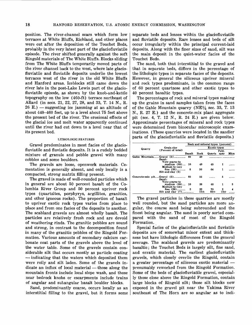
18 HANFORD RESERVATION, U.S. ATOMIC ENERGY COMMISSION, WASHINGTON
position. The river-channel scars which form low terraces at White Bluffs, Richland, and other places were cut after the deposition of the Touchet Beds, probably in the very latest part of the glaciofluviatile episode. The river shifted generally against the soft Ringold materials of The White Bluffs. Blocks sliding from The White Bluffs temporarily moved parts of the river channel back to the west, where late glacio- fluviatile and fluviatile deposits underlie the lowest terraces west of the river in the old White Bluffs and Hanford areas. Iceblocks still came down the river late in the post-Lake Lewis part of the glacio- fluviatile episode, as shown by the knob-and-kettle topography on the low (460-ft) terrace northeast of Allard (in sees. 21, 22, 27, 28, and 33, T. 14 N., R. 26 E.) suggesting ice jamming at an altitude of about 440-460 feet, up to a level about 75 feet above the present bed of the river. The erosional effects of the glacial ice and melt water apparently continued until the river had cut down to a level near that of its present bed.
LITHOLOGIC FEATURES
Gravel predominates in most facies of the glacio- fluviatile and fluviatle deposits. It is a rudely bedded mixture of granule and pebble gravel with many cobbles and some boulders.
The gravels are loose, openwork materials. Ce mentation is generally absent, and only locally is a compacted, strong matrix filling present.
The gravel is made of well-rounded particles which in general are about 50 percent basalt of the Co lumbia River Group and 50 percent upriver rock types (quartzites, porphyrys, argillites, granitics, and other igneous rocks). The proportion of basalt to upriver exotic rock types varies from place to place and from one facies of the deposits to another. The scabland gravels are almost wholly basalt. The particles are relatively fresh rock and are devoid of weathering rinds. The granitic pebbles are sound and strong, in contrast to the decomposition found in many of the granitic pebbles of the Ringold For mation. Various amounts of secondary calcium car bonate coat parts of the gravels above the level of the water table. Some of the gravels contain con siderable silt that occurs mostly as particle coating indicating that the waters which deposited them were roily and silt laden. Some of the gravels in dicate an influx of local material those along the mountain fronts include local slope wash, and those near bedrock knobs or escarpments include trains of angular and subangular basalt boulder blocks.
Sand, predominantly coarse, occurs locally as an interstitial filling to the gravel, but it forms some
separate beds and lenses within the glaciofluviatile and fluviatile deposits. Rare lenses and beds of silt occur irregularly within the principal current-laid deposits. Along with the finer sizes of sand, silt was the main deposit in the quiet-water facies of the Touchet Beds.
The sand, both that interstitial to the gravel and that in separate beds, differs in the percentage of the lithologic types in separate facies of the deposits. However, in general the siliceous upriver mineral and rock types predominate, in the common range of 60 percent quartzose and other exotic types to 40 percent basaltic types.
The percentages of rock and mineral types making up the grains in sand samples taken from the faces of the Gable Mountain quarry (NE}4 sec. 33, T. 13 N., R. 27 E.) and the concrete-mix plant aggregate pit (sec. 4, T. 12 N., R. 24 E.) are given below. Approximate percentages of mineral and rock types were determined from binocular microscopic exam inations. (These quarries were located in the sandier parts of the glaciofluviatile and fluviatile deposits.)
Rock and mineral types (percent)
Quarry Grain size (Percent of total)
Exotic types
Basalt RockFeld-
Quartz spar MicaGable Mountain........Gravel (5)................ 60 40
Sand:Very coarse to
medium (60).... 10 40Medium to very
fine (35)............ 5 30Silt and clay (0)
Concrete-mix pit......Gravel (5)................ 60 35Sand:
Very-coarse to medium (59).... 10 38
Medium to veryfine (29)............ 2 22
Silt and clay (7)................ lOd
49
64
48
70 80+
2 lOd
The gravel particles in these quarries are mostly well rounded, but the sand particles are more an gular, the coarse sand being subrounded and the finest being angular. The sand is poorly sorted com pared with the sand of most of the Ringold Formation.
Special facies of the glaciofluviatile and fluviatile deposits are of somewhat minor extent and thick ness but have lithologic differences from the general average. The scabland gravels are predominantly basaltic; the Touchet Beds is largely silt, fine sand, and erratic material. The earliest glaciofluviatile gravels, which closely overlie the Ringold, contain a greater percentage of siliceous exotic material presumably reworked from the Ringold Formation. Some of the beds of glaciofluviatile gravel, especial ly those close above the Ringold Formation, contain large blocks of Ringold silt; those silt blocks now exposed in the gravel pit near the Yakima River southeast of The Horn are so angular as to indi-

STRATIGRAPHIC CHARACTERISTICS 19
cate either very limited transport or deposition while frozen.
The glaciofluviatile and fluviatile deposits, in general, are rudely bedded. The main bedding dips gently in a predominantly southeast direction, but the direction of the dip of the crossbedding is ir regular from place to place with only a slightly prevalent southeast direction. In a large excavation north of Gable Mountain, in sec. 1, T. 13 N., R. 26 E., a 40-foot thickness of stratified openwork pebble gravel and sand has near its center a 4i/£-foot bed showing foreset bedding that dips 20° in a north- northeast direction and near the bottom a 4-foot bed showing foreset bedding that dips 10° to the east. In a gravel pit southwest of Gable Mountain, in the northeast corner of sec. 34, T. 13 N., R. 25 E., about 15 feet of openwork pebble and cobble gravel is exposed and shows heavy particle coating of silt. The well-bedded foresets dip 30° to the south. East across the river from North Richland, upward from an altitude of about 345 feet, a 90-foot thickness of cobble and pebble gravel lacks distinct bedding stratifications. East of Richland and downvalley from the reservation, the top part of the glacio fluviatile and fluviatile deposits is exposed on the north side of the river in a 40-foot bank at the Old Timmerman Ferry and in railroad cuts west of Kennewick. In a 600-foot-long exposure in the rail road cuts, 10 feet of pebble and cobble gravel has crossbedding that consistently dips 40° in a south east direction.
The silty, quieter water deposits that make up most of the Touchet Beds contain generally hori zontal beds and locally include a laminar and varve- like bedding. At the type area near the town of Touchet, 32 miles east of Richland, the Touchet Beds consists of 2- to 36-inch-thick layers of silt alternated with 1/10- to 2-in-thick beds of fine sand. Most of the individual silt layers include a grada tion upward from sand at the base to silt at the top (Lupher, 1944). In the lower part of the deposits the layers are progressively thicker down ward. In different places the Touchet Beds overlies the bedrock basalt, the Ringold, or sand and coarsely bedded gravel, which is of both glaciofluviatile and local origin.
The lithology and bedding common to the type locality also characterize the silts of the Touchet Beds along Cold Creek valley in the western part of the reservation. The remains of these beds where they were laid down in the more open water areas nearer the center of Lake Lewis consist of more sandy material. This sandy material is believed to be the lake-current equivalent of the more quiet-
water silt of the Touchet Beds. The less wind-worked sands near the surface in much of the central part of the reservation are fine to coarse, light brown, rudely sorted, and coarsely bedded in a generally horizontal manner, and they contain many silt lenses. Where the sands lack gravel, they have been extensively reworked by the wind. Such areas are the principal wind-worked parts of the reservation.
DIFFERENCES BETWEEN THE RINGOLD FORMATION AND THE GLACIOFLUVIATILE AND FLUVIATILE DEPOSITS
Because the distinction (especially in drill cut tings) between the Ringold Formation and the glaciofluviatile and fluviatile deposits is vital to the success of many ground-water developments and waste-disposal works, the distinguishing criteria of the two deposits are summarized in the table that follows.
Characteristic Ringold Formation Glaciofluviatile and fluviatile deposits
Lithology:Rock types.........
Grain sizes.........
Induration..
Sorting..
Grain shapes.....
Alterations: Rinds........
.Upper Columbia River ma terials predominate, al most exclusively below medium-sand sizes.
.Silt and fine sand predomi nate; many thick and continuous silt and clay strata present.
..Silt and clay compact; gravel and sand compact and contain strongly ce mented beds; only newly exposed silt and sand vul nerable to wind erosion.
..Well sorted but uniform sand fills interstices of gravel; gravel and sand are clean washed.
.Gravel well rounded; silt and finer sand is angular.
Cementation.....
Secondary..
..Alteration rinds J& to Yt in. thick on basalt peb bles.
.Caliche impregnations; con cretions in clays; some sand beds contain well cemented layers.
..Secondary gypsum; fossil bone is petrified.
Nearby basaltic materials predominate in gravel sizes and are relatively high in sand sizes.
Except for Touchet Beds, gravels and coarse to me dium sand predominate; little clay present only discontinuous silt beds and lenses.
Material mostly loose; finer grained material blows badly in desert situations.
Mostly poorly sorted except in parts of the Touchet Beds. Gravel particles mostly silt dusted:
Gravel well rounded; boul der blocks, silt, and sand are angular.
No appreciable alterations.
No known concretions; no appreciable cementation ; only slight caliche accu mulations.
No known secondary gyp sum ; no known petrified bone.
HOLOCENE DEPOSITS
The materials that have accumulated since the Pleistocene Epoch, which ended with the melting of the glacial ice of continental type from the Columbia River basin, consist mainly of alluvial deposits closely above and at the present positions of the streams. The flood plain of the Yakima River lies upon the only extensive alluvial deposit in the reservation area. It and the playalike flats of Cold Creek were constructed and widened during post glacial times.
The river-laid bars of gravel differ somewhat

20 HANFORD RESERVATION, U.S. ATOMIC ENERGY COMMISSION, WASHINGTON
from place to place. Downstream from The White Bluffs the river bar gravels are largely exotic and basaltic gravels with a medium-sand matrix some what similar to the composition of the Ringold conglomerates. At the northern side of the reserva tion the postglacial gravels contain a larger per centage of the coarse basaltic material such as that on which the river is cutting in the Priest Rapids area to the northwest of the reservation.
The playas of Cold Creek and Dry Creek valleys are underlain by laminated silt and clay (pi. 1) to a thickness that locally exceeds 25 feet, as at Rattle snake Spring.
White siltlike volcanic ash occurs locally on the lee sides of ridges trending transverse to windswept slopes. The index of refraction indicates that this ash belongs to the widespread fall identified as the Mazama Ash (Powers and Wilcox, 1964), from the ancestral Mount Mazama in which Crater Lake is situated. A distinct fall of such ash occurred about 6,600 years ago.
TECTONIC STRUCTURE OF THE ROCKS
GENERAL REGIONAL SETTING
The broad synclinal sag of the basalt bedrock beneath the Pasco Basin is flanked on the south by the 1,000-foot rise of the basalt to form the elongate Horse Heaven Ridge and on the southwest by the 500- to 2,500-foot rise of the basalt to form the slopes of the Yakima Ridges, of which Rattle snake Hills are the largest and highest in and near the reservation.
The basalt is mildly folded and faulted into the structures that form the principal eminences and the bedrock downwarps of the region. The lower part of the overlying Ringold Formation is also de formed locally, though that structure is poorly ex posed. The glaciofluviatile and fluviatile deposits have not been deformed tectonically.
The deformation in the basalt, aside from its part in forming the large units of the terrain, imposes limitations on the thickness and extent of the overlying sedimentary materials and exercises functional control over the deep circulation of ground water.
The magnitude of the regional deformation that has produced the present uplands and basins is suggested by citing some altitudes of the top of the basalt beneath and adjacent to the reservation. From the common base altitude of 200 feet beneath the Pasco and Richland districts, the top of the basalt rises southward to an upland altitude of 1,500 feet in the broad Horse Heaven Ridge to the south. Northward from Richland the top of the basalt is an irregular surface which extends down
below sea level and rises over ridges that reach their greatest height in Gable Mountain. (See geo logic sections and altitudes of bedrock given by spot figures on pi. 1.) At the southwest edge of the reservation, the Rattlesnake Hills attain an altitude of 3,500 feet, and the various secondary heights of the Yakima Ridges in upper Cold Creek and Dry Creek basins have altitudes of 2,500 feet within 10 miles of the reservation terraces. North ward from the reservation the basalt rises evenly to emerge from beneath its sedimentary cover and to reach an altitude of 2,000 feet in the linear Saddle Mountain anticlinal ridge 10 miles north of the Columbia River. Eastward the basalt rises evenly, and 12 miles east of the reservation, near Eltopia, it emerges from beneath the Ringold Formation at an altitude of 700 feet.
The master structural units of the region to the west of the reservation include long mountainous anticlinal ridges between which intervening synclines lie beneath valley lowlands. The main anticlinal ridges extend generally eastward from the Cascade Range and are collectively known as the Yakima Ridges (Newcomb, 1970). The principal ridges on or near the Hanford Reservation include (1) the Saddle Mountains, from which the Wahluke Slope descends southward to the Columbia River; (2) Umtanum Ridge, which terminates as the ridge north of upper Cold Creek but has the outliers Gable Butte and Gable Mountain; (3) Yakima Ridge, which terminates in the small mountains to the south of upper Cold Creek valley; (4) Rattlesnake Hills, from whose eastern end a strong cross structure continues diagonally southeast to connect with the northern part of the Horse Heaven Ridge; and (5) Horse Heaven Ridge, which lies south of the Yakima River valley and extends eastward to the Blue Mountains. The reservation area lies at the eastern end of Umtanum and Yakima Ridges and Rattle snake Hills and is underlain in part by structures that belong to the Saddle Mountains and the Horse Heaven Ridge.
ALTITUDE OF THE BEDROCK BENEATH THE RESERVATION
The top of the basalt lies at a generally uniform level beneath the terrace lands in the southern and northern parts of the reservation. It rises toward the mountain ridges and toward the outliers of those uplifts. It also approaches, and even reaches, the surface in a few isolated highs. The altitudes of the basalt surface at depth beneath the reservation are given for a number of points on plate 1.
The northeastward dip of the basalt beneath the Richland area and the opposing westward dip

TECTONIC STRUCTURE 21
beneath the plateaus farther northeast meet in the axial part of the Pasco syncline, which lies approxi mately beneath the Columbia River north from Richland to the old White Bluffs townsite and from there curves to an east-west trend along the north foot of Umtanum Ridge anticline (pi. 1). A secon dary syncline that branches west from the Pasco syncline lies between Gable Mountain and Rattle snake Hills and continues into upper Cold Creek valley. This secondary syncline, the Cold Creek syncline, contains some of the most deeply folded basalt and is of major importance to the geology of the reservation.
From an altitude of about 200 feet beneath Rich- land, the top of the basalt slopes to the east and north. It lies below sea level in a broad sag under the terrace plains in the south-central part of the reservation, in T. 12 N., R. 27 E. At well 12/27- 16M1 the bedrock surface is more than 100 feet below sea level. North from this low sag the basalt rises to emerge steeply in the sharp and narrow structures of Gable Butte and Gable Mountain; its rather even rise to Gable Mountain is interrupted by a shallow trough, which may be partly erosional. This shallow trough continues northwest as the bed rock low between Gable Mountain and Gable Butte.
North from Gable Mountain and Gable Butte, the bedrock surface dips into the east-west part of the Pasco syncline. In well 13/25-1N2 the top of the basalt lies more than 200 feet below sea level. From about the south line of T. 14 N., it rises evenly toward the Saddle Mountains to the north. This even subsurface rise to the north is comparable to the rise of the bedrock eastward toward the Eltopia area east of the reservation.
At several places on the reservation at least one tuffaceous sedimentary zone occurs in the upper part of the basalt. This stratigraphic zone has been reported in logs of wells 11/27-20M1, 11/28-21L3, 13/26-34J14, 13/25-1N2, 12/25-23K1, and 13/25- 30G1. The sedimentary zone occurs in much the same position and with the same relationships in these wells as it does in outcrops on the mountain slopes as described above under "Vertical Subdivision of the Basalt." The stratigraphic continuity of this tuffaceous zone further establishes the belief that the top of the basalt, beneath the postbasalt sedi mentary deposits that underlie much of the reser vation, is largely an original stratigraphic surface and, in general, has not been changed greatly by deep erosion.
The results of subsurface explorations indicate that the bedrock surface is essentially free of pre- Ringold river canyons. The data for the reservation
area, combined with the bedrock information of Walters and Grolier (1960) for the area to the north and east, indicate that the freedom from pre- Ringold river canyons extends to much of the Pasco Basin.
DEFORMATION IN THE BASALT
SHAPE OF THE DEFORMED UNITS
The dominant structural shape of the uplifted mass (and of the downfolded mass so far as it can be determined) is the fold with asymmetrical cross section. Rattlesnake Hills are a type example. Of secondary importance is the symmetrical and elon gate fold, of which Red Mountain is a type example. (See pi. 1.)
The broad downwarping of the basalt beneath the reservation is characterized by a gentle tilt of wide areas that separate the abrupt lines of greater deformation. Both gently tilted and sharply folded and faulted structures are present in the exposed basalt and, by inference, are judged to be present in the deformed basalt under the sedimentary cover. Along the western edge of the reservation the basalt emerges from its, sedimentary cover and continues the same structural tilt upslope to near the anti clinal axes of Rattlesnake Hills and Yakima Ridge. In the lesser tilted blocks, the dips over wide areas are as low as 2°; two of the large areas of uniform dip comprise the dip slopes at the east and southwest sides of Rattlesnake Hills. Locally, dips as great as 85° are present along the lines of more severe deformation. Possibly still steeper dips, or local areas of overturned basalt, are covered by the slumped debris in some of the steepest parts of the severely deformed folds.
The top of the basalt before tectonic deformation is partly preserved in some of the uplifted units and is believed to be largely preserved beneath sedi mentary cover in some areas of downfolding. In some sharply deformed structures such as the north face of Umtanum Ridge, Gable Mountain, Gable Butte with its associated knobs, and the covered escarpment beneath sees. 1, 2, and 12, T. 12 N., R. 26 E. the original top of the basalt after deformation has been destroyed by slump and erosion. In some severely uplifted parts, such as the north face of Rattlesnake Hills, the original surfaces on the basalt have been destroyed by land slides.
FOLDING AND FAULTING
The exposed structures indicate folding or bending of the basalt was by far the dominant type of de formation. Shearing and faulting appears to be confined largely to the steeply dipping parts of the asymmetrical folds. Within the zones of great
478-522 O - 73 - 4

22 HANFORD RESERVATION, U.S. ATOMIC ENERGY COMMISSION, WASHINGTON
deformation, the basalt rock yielded by bending as far as possible and sheared only where still further stress occurred. The steeply dipping northeastern limb of Rattlesnake Hills anticline contains shear planes parallel to the layering of the basalt. Some of this interlayer shearing has produced gouged and granulated zones each a foot or two wide in the planar contact zone between successive lava flows. This shearing between flows is evident in exposures of basalt dipping 70° to 80° to the northeast in ravines northeast of the highest part of Rattlesnake Hills.
Minor asymmetrical and symmetrical folds occur in some deformed units, and effects of minor slippages and bendings indicate that the basalt ac commodated to the greatest stresses with combina tions of bending and breaking. Gable Mountain exhibits this type of complex strain relief along the axial part of a steeply folded anticline. The flexures exposed in Gable Mountain have different directions of asymmetrical folding at each end of the mountain. The rocks of nearby Gable Butte are not exposed so well, but the intricate folds of the general anti clinal structure of the butte indicate complex stresses produced the typical linear zones which occur in greatly strained basalt.
The faulting observed was all of the normal type, in which the plane of shearing dips toward the downthrown side. Some reverse, or thrust, faulting may be present in the deeper parts of the steepest asymmetrical anticlines, such as the Horse Heaven Ridge southwest of Benton City, Umtanum Ridge north of Cold Creek valley, and Rattlesnake Hills.
SYNCLINAL STRUCTURES
Local downfolds and uplifts occur within the gen eral synclinal structure of the Pasco Basin. Though geographically less conspicuous than the upfolded units, the synclines are of great importance in such phenomena as the accumulation and movement of ground water.
In addition to the deep sag beneath the southeast- central part of the reservation and the two east- west trending branches of the Pasco syncline north and south of the Gable Mountain uplift, two rather steep downwarps, which may have some inter connection, follow the foot of the mountain slopes in the western part of the reservation. One trends southeast beneath lower Cold Creek, at the lower end of the subsurface extension of the northeastward dip from Rattlesnake Hills (well 11/26-5B1). Farther north, another local downwarp trends north-south just east of the mountain front and across the emergence of upper Cold Creek valley
(well 12/25-10N1). This sharp descent of the basalt across the east end of the mountain valley of upper Cold Creek alines with the abrupt end of Yakima Ridge to the south and may be a monoclinal flexure which includes some fault shear.
PATTERN OF STRUCTURAL DISPLACEMENTS
The traces of the axes of deformation shown on plate 1 form a parallelogrammatic pattern. The two main directions of trend have the general bearings N. 50° to 55° W. and N. 70° E. The trends change a few degrees progressively toward an east-west trend at the northwest edge of the map. Beneath the terrace lands of the reservation the northwest erly trend includes the structures of greater dis placement; but the northwesterly structures are arranged sufficiently en echelon that they belong to a general east-west direction.
Major deformations with the conspicuous N. 50° to 55° W. and N. 70° E. trends are paralleled by subordinate folds. Also, there are distant continua tions beyond the apparent ending of the major dis placements. The Gable Mountain-Gable Butte uplift is this type of distant continuation of the trend of the main Umtanum Ridge anticline. The bedrock knobs in the south-central part of the reservation (sec. 34, T. 11 N., R. 27 E.) are apparently a continuation of trends from the west and the south. The knobs east of the mouth of Dry Creek are continuations of the asymmetrical fold along the north side of Dry Creek valley; they are a part of the Yakima Ridge.
EFFECT OF TECTONIC STRUCTURES ON THE OCCURRENCE OF GROUND WATER
BASALT OF THE COLUMBIA RIVER GROUP
A tilt of the basalt at the surface is advantageous to ground-water recharge either for direct infiltra tion or for the movement of water from streambed gravels and from deep sand and gravel aquifers, because it places permeable interflow zones in posi tion to accept the water directly. In areas where the basalt layers are generally horizontal, the im pervious nature of the dense central parts of many of the flows limits the opportunity for water to move downward and to recharge the ground water. This exclusion of water from horizontal basalt re sults in a general lack of water for wells and springs in this environment as compared with areas of tilted basalt. In horizontal basalt, ground water may be recharged predominantly by movement of water laterally for great distances.
Water in the unsaturated basalt moves laterally through porous interflow zones and any associated

PHYSIOGRAPHY 23
open joints and crossflow openings. Below the water table, movement of water through the interflow zones of the basalt is in response to a pressure gradient and, under similar conditions, can take place as readily in horizontal as in tilted aquifers.
The forces of deformation produced excessive strain on some of the basalt and developed planes of shear. Whether the deformation is in the form of tight folding with interflow slippage or solely in the form of shear rupture and fault displace ment, gouging and grinding of the rock generally reduces its permeability at the shear planes. These zones of crushed rock can be barriers to ground- water movement. Such barriers cause the damming of ground water and, in some areas, may confine ground water so that it has pressure levels relative ly close to the surface (Newcomb, 1961a).
The potentiometric surface of the ground water in the basalt, as known from relatively few wells beneath the reservation, is generally at about the level of the water table in the overlying Ringold Formation. Along the axial area of the Pasco syn- cline, the water level in the basalt is near that of the Columbia River. In the area between The Horn, on the Yakima River, and the Columbia River, the water level in the basalt stands near the level of the Yakima River. At well 10/28-1OG1, north of Rich- land, the potentiometric surface is about 35 feet above the water table, which is at about the level of the nearby Columbia River. The basalt in the eastward-plunging synclines of upper Cold Creek and Dry Creek valleys, in and west of the reserva tion, contains confined ground water, apparently confined behind structural barriers that cross the lower ends of the valleys.
Wells drilled to a general depth of 600 to 1,000 feet in upper Cold Creek valley (well 13/25-30G1 in table 1), at West Richland (9/28-5C1), and at old Ringold (12/28-24N1) obtain confined water with yields of about 1,000 gpm (gallons per minute). The potential water yields of the basalt have not been tested in large areas of the synclinal structure beneath the reservation.
RINGOLD FORMATION
A slight warping type of deformation character izes the conglomerate zone and the subconglomerate part of the Ringold Formation in the basinal area beneath the reservation. This warping elevated the conglomerate about 100 feet higher beneath the high terraces than along the axis of the Pasco syncline. This uplift, along with the subsequent erosion and the deposition of the glaciofluviatile and fluviatile deposits, gave the reservation its gravelly terrain
and created the excellet drainage conditions of the high terraces.
PHYSIOGRAPHY
A resume of the geologic features at the surface clarifies their origin and method of formation and should help in the proper and efficient use of the topography as well as the subsurface materials. The constructional features, such as .mountain slopes, plateau surfaces, terraces, and valley plains, along with the destructive or erosional features, such as river bluffs, canyons, landslides, declivities, and blowouts, are the result of geological events that have formed this industrial site.
MOUNTAIN SLOPES
Despite minor subsequent erosion, many of the mountain slopes in and to the west and south of the reservation represent the basalt surfaces much like they were when they were more nearly horizontal. The southwest slopes of Rattlesnake Mountain, the apronlike slope descending from an altitude of 1,200 feet on that mountain to the Cold Creek valley, the broad ridge southwest of The Horn (on the Yakima River), and many lesser surfaces are large ly dip slopes on the top of a resistant basalt flow. In many such places the top layer may be one that formed at the original top of the basalt accumula tion. Other mountain surfaces, such as the top of Red Mountain and the crests of the dome-shaped mountains north of Dry Creek valley, are now sub- aerial erosion surfaces beveled across many basalt flows and interflow layers.
The whole north slope of Rattlesnake Mountain and smaller areas on other mountain slopes, such as those on the north side of Gable Mountain and on Umtanum Ridge west of the area shown on plate 1, consist of rock debris that has slumped and slid to its present position. Many of the lower slopes of the mountains have been mantled by alluvial wash from the higher parts and by materials trans ported from elsewhere. The north and east slopes of most of the ravines, hills, and mountains have a heavier cover of windblown soil than do the south and west, the wind-struck, slopes.
PLATEAUS
The principal plateau feature of the area is the upland surface at an altitude of about 1,000 feet that extends east and north (beyond the area of pi. 1) from the top of The White Bluffs. This surface is underlain by a thin layer of windblown soil and by erratic glaciofluviatile materials, but it is largely founded on the strong caliche zone at the top of the Ringold strata. To the north and east of The White Bluffs, this plateau extends for many tens of

24 HANFORD RESERVATION, U.S. ATOMIC ENERGY COMMISSION, WASHINGTON
miles with only minor dissection by fluvial channels. Far beyond The White Bluffs, the plateau merges with regional slopes that are underlain by the basalt beneath a common cover of unconsolidated materials, such as the loess broadly referred to as the Palouse Formation. In the northern part of the reservation the plateau's escarpment has been sapped by the side sweeps of the Columbia River and entrenched by glacial melt water drainage; the plateau's surface is interrupted by low escarpments which descend to terraces underlain by glaciofluviatile and fluviatile deposits.
Adjacent to the reservation, the basalt underlies some uplands that are sufficiently level to be classed as plateaus; also, low-angle dip slopes, such as the southwest side of Rattlesnake Hills and the broad ridge southwest of The Horn, can be so classified.
TERRACES
By far the largest part of the reservation is ter race land. Some of these terraces have matched equivalents on each side of the Columbia River. Some of the highest terraces are essentially fill terraces and are underlain by deep sections, up to about 200 feet thick, of glaciofluviatile and fluviatile deposits, but most of the terraces below an altitude of 500 feet are essentially cut-and-filled surfaces formed by single sweeps of the Columbia River during the erosive part of late glacial-outwash time.
At present the vertical range of the river (from the bottom of its bedload to the maximum reach of its flood stages) is about 70 feet. Such a range commonly determines the maximum depth to which a river can deposit sediments during a single lateral sweep.
Most of the terraces are underlain by 50 to 100 feet of glaciofluviatile and fluviatile deposits, as shown in the well logs of table 2 and the geologic cross sections on plate 1. In places, the surficial part of the deposits underlying the terraces consists of wind-worked material, much of which originally belonged to the Touchet Beds facies of the glacio fluviatile and fluviatile deposits. The lowest ter races, such as those at old Hanford and at Richland, contain part of the form of the last channels vacated by the river. One of these youngest channel scars trends south from North Richland and passes through Richland. It contains the main fields of water wells used for many years for the Richland water supply.
ALLUVIAL PLAINS
The flood plain of the Yakima River west of Rich- land is a wide alluvial bottom land built up in the reach where the river apparently is base leveled on basalt bedrock ledges south of Richland. In this
alluviated reach, downstream from the basalt ledges near The Horn, the Yakima River has a gradient of but 3 or 4 feet per mile southeastward to the rock ledges south of Richland. The flood plain deposits of that reach have little equivalent along the Co lumbia River above the mouth of the Yakima River. The low terrace plains farther up the Yakima River between Kiona and The Horn stand a little higher above the river and are underlain by slightly older material.
The alluvial plains along Cold Creek are under lain largely by playa-type silt and clay deposits built up as the velocity of the stream diminishes and the flood rushes of Cold Creek and Dry Creek deposit their loads of fine-grained sediment. These deposits also contain rock rubble delivered by flood runs from the arroyos of the adjacent mountain slopes.
DECLIVITIES AND LANDSLIDES
The northeastern extremity of the Umtanum Ridge, which forms the high escarpment along the Columbia River just west of the area shown on plate 1, the Gable Butte-Gable Mountain ridge, and various rock slopes and. knobs along the Yakima River have been strongly eroded by the Columbia and Yakima Rivers. These slopes are erosional as contrasted to the constructional surfaces and the surfaces of minor subaerial erosion common to the basalt elsewhere on the reservation. The impinge ment of the Columbia River against the Umtanum Ridge has removed the northern and steeper limb of a large anticline and established a bold escarp ment. The steep face exposes edges of the horizontal and southeastward dipping basalt near the anti clinal axis. The Gable Butte-Gable Mountain ridge in places has been stripped of several hundred feet of rock by the Columbia River during post-Ringold time.
The swing of the Columbia River outward against Ringold Formation has established and pushed east ward the escarpment known as The White Bluffs. Large blocks of the bluffs have broken loose and slid with rotational motion toward the river those now remaining are labeled landslide deposits on plate 1. Some of those blocks are now unstable, and large open crevices along their slide planes testify to recent motion. The block in sees. 11 and 14, T. 13 N., R. 27 E., is in a position to cause some impoundment and diversion of the river, should it move rapidly across the river's present channel. The samples of drill cuttings of the Foster Ranch well, 13/27-13N1, indicate that disturbed material extends to a depth of 48 feet, a level that is probably the slide plane of the land-slumped block. Such a

HYDROLOGY 25
position in the well would indicate that the slide plane probably crops out near the lowest part of the riverbed. The toe of the slide block is now near the altitude to which the river stage could be artificially raised in floodtime by McNary Dam. The stability of the block could be adversely affected by greater immersion. The stability of other parts of The White Bluffs may become progressively threatened by the wetting of the formation farther east, in the newly irrigated parts of the plateau.
The north face of Rattlesnake Hills has slumped in large blocks, which moved toward Dry Creek valley. Other land slumps and slides are shown on plate 1. Some of the older slides of the basalt were contemporaneous with the mountain uplifts, but others occurred in late Pleistocene or Holocene time. The slumping that took place during the tectonic deformation resulted from the fracturing off of the top part of the oversteepened limbs of asymmetrical folds. In those slides, weak interbedded zones of tuff served as planes of failure; this can be ob served in well-preserved landslides that occur along the northeast side of Rattlesnake Hills. The con version of the tuff zones to slide planes has occurred commonly in many large slides in the steeply dipping parts of the basalt elsewhere in the region.
HYDROLOGY-GENERAL GROUND-WATERCONDITIONS
UNCONFINED GROUND WATER
The Columbia and Yakima Rivers are the base- level drainage below which the pore spaces of the earth are saturated. The top of the saturated zone of unconfined ground water is the main (or regional) water table. In general, it slopes toward the rivers. The slope of the water table depends directly on the resistance to the percolation of water through the rock materials and on the quantity of water that is present for transmission.
SHAPE OF THE WATER TABLE
The natural shape of the regional water table was mainly a subdued replica of the larger elements of the land surface. Because the unconfined ground water moves in the general direction of the slope of its top, the shape of the water table gives an indication of the input of water, the ease of perco lation, and the velocity of travel of the ground water. The natural form of the water table in 1944 is approximated by reconstituted contour lines on plate 1, and artificially changed forms for 1948 and 1953 are shown on plate 2. The altitude and shape of the regional water table in 1961 are shown for the main reservation area by equal-altitude lines on plate 3.
The natural shape of the water table beneath the northwestern part of the reservation was dominated by a general high along the mountain front and by a slight high which underlay an area of recharge in the upper part of Cold Creek valley.
From the high level (altitude about 440 ft) near upper Cold Creek, the water table descended away from the mountains for about 3 miles at a gradient of about 10 feet per mile. Elsewhere, the natural ground-water gradient beneath most of the terraced plains of the reservation was a more gentle gradient of about 5 feet to the mile outward to where it approached the high levels of the Columbia River. In its natural state, the water table lay in the Ringold Formation eastward to the zone of bank storage and to a few channel scars along the east side of the terrace lands, where in places during high levels of the river the water table occurred just above the base of the glaciofluviatile and fluvi- atile deposits.
Within a belt along the Columbia River and ex tending irregularly for an average of about 2 miles from the river, the level of the ground water rises and falls in response to the river levels (figs. 3 and 4). During rising stages of the river, the adjacent water table rises by virtue of the physical transfer of river water to bank storage as ground water (Newcomb and Brown, 1961). Beneath the low ter races north of Gable Mountain, the ground water is annually recharged at floodtime by infiltration at the riverbed along the western side of this pen- insulalike area. Part of the bank-stored ground water along the Columbia River just downstream from Allard progresses east and southeast to dis charge in the river north and south of old Hanford townsite. The shape of the water table there differs from that in other parts of the bank-storage zone.
South and east of The Horn the water table slopes away from the Yakima River and toward the Co lumbia River, near which the water table rises and falls with variations in bank storage. Part of the ground water drains to the surface along the river- channel scar that traverses north-south through Richland.
Outside the reservation and across the Columbia River, the water table in the Ringold Formation and the basalt has a general slope of about 35 feet per mile southwest to the river (Walters and Grolier, 1960, pi. 2).
In general, the regional water table is the surface of a free, or unconfined, body of ground water which is under only the pressure of the atmosphere. How ever, at places this ground water is slightly confined by passage beneath less permeable materials, and

26 HANFORD RESERVATION, U.S. ATOMIC ENERGY COMMISSION, WASHINGTON
the water table may represent, or coincide with, some potentiometric surfaces that are included with in the general irregularities of the regional water table.
WATER-BEARING MATERIALS
Within the reservation the regional water table lies mostly in the Ringold Formation. The ground water moves in the Ringold Formation and in the underlying basalt downgradient toward points of discharge. In only a few places are the glaciofluvi- atile and fluviatile deposits known to extend down ward to slightly below the natural position of the water table. (See sections on pi. 1 and tables 1 and 2.) However, the closeness of the base of the highly permeable glaciofluviatile deposits to the water table at the east side of the reservation (fig. 2) indicates that these permeable deposits served as overflow outlets for rapid drainage of ground water that has reached high levels. During or following high stages of the river the water table rises to the level of these more permeable glaciofluviatile materials at North Richland (well 10/28-14K2), at the old Han- ford townsite (well 13/27-36G7), and at a few places along the river farther upstream (such as near well 14/27-32R1).
Most of the Ringold Formation, where it occurs beneath the terraced plains of the reservation, is sufficiently sandy to transmit water vertically to the water table. Consequently, few bodies of perched ground water occur naturally. In a horizontal direc tion the Ringold beds transmit water more readily than they do in a vertical direction, especially so in the sand and gravel (conglomerate) strata. The conglomerate seems to provide a path of relatively uniform permeability for the general lateral move ment of the ground water beneath the reservation.
The basalt has an overall low to moderate perme ability largely owing to the high permeability of relatively thin individual porous interflow zones. The hydraulic continuity of the permeable zones in the basalt is sufficiently integrated that over broad areas there is general agreement between the level of the unconfined and confined water in the basalt and the level of the water table in the overlying sedimentary materials. Locally, variations in the overall average permeability and in the structural conditions govern interchange of water between the basalt and adjacent materials. These variations result in the occurrence of minor bodies of confined water at places in the basalt beneath both the reservation and the adjacent areas.
The glaciofluviatile and fluviatile deposits, much of the alluvium, and the colluvium are sufficiently
405
395-
Columbia River at gage in sec. 14, T. 14 N., R. 26 E
O 395
QD
jE 390
< 394
9600 feet from river and in area of out ward percolation from tank storage
13/26-21B1 393""
392
365
19,500 feet from river and in area of outward percolation from bank storage
360^
355
13/27-17J1 11,200 feet from river and in area transmitting water that has per colated outward from bank stor-
age farther westUJl
1949 1950 1951 1952 1953
FIGURE 3. Water levels in four wells in the northern part of the reservation compared with the water level of the Columbia River.
permeable to permit water to infiltrate readily and to transfer downward to the water table or to the underlying earth materials. The high vertical perme ability of these porous materials is of great signifi cance both to the transmission downward of the meager natural recharge and to the infiltration of liquids disposed from industrial plant operations.
CHANGES IN THE LEVEL OF THE WATER TABLE
Records of the level of the water table beneath the reservation show three general conditions two natural and one artificial. The two natural condi tions are: (1) A lack of any appreciable recharge in conformity with the annual precipitation cycle

HYDROLOGY 27
355 r
350
325
320
1950 1951 1952
FIGURE 4. Water levels in three wells in the southeastern part of the reservation compared with the water level of theColumbia River.
(figs. 6 and 7) over wide areas away from the river and (2) an annual rise and fall of the water table along the Columbia River in response to the river's flood stages. (See figs. 3 and 4.) The third general condition is the artificial rise and fall, largely a
progressive rise, of the water table beneath and adjacent to areas where plant liquids are being discharged to the ground. Superimposed upon the short-period fluctuations may be a small but pro gressive rise that conforms with the greater amount

28 HANFORD RESERVATION, U.S. ATOMIC ENERGY COMMISSION, WASHINGTON
of precipitation recorded in general over the Pacific Northwest since about 1941. The small, long-term weather effect is difficult to distinguish in most of the water-level records on the reservation. It may be distinguishable in records of the wells at the southwestern end of the reservation but seems to be masked by the progressive rise resulting from distant artificial recharge.
RECHARGE AND DISCHARGE
Beneath broad areas of the desert terrain the levels of the ground water show that little, if any, water transfers downward through the desert soils to the water table. During the period of observation for many of the wells in the southern part of the reservation (see fig. 5), no annual recharge addi tions have shown on the water-level records. If any transfer of water downward to the water table occurred in that area, it must have been in amounts that would produce less than a few hundredths of a foot seasonal rise in the water table each year. Evidently, over the broad desert plains of the reser vation, the zone of aeration effectively separates the precipitation on the surface from the water table. Only in rare years of greatest precipitation could these soil zones be wetted sufficiently to cause any appreciable recharge to move to the water table.
The contour lines on the water table (see pis. 1, 2, and 3) indicate that the principal natural recharge to the unconfined ground water occurs in the upper and middle parts of the Cold Creek valley, at places where the discharge of upper Cold Creek and Dry Creek valleys spreads out on the valley plains, along the Yakima River downstream from The Horn, and along the Columbia River during its annual high stages.
The surface runoff from the uplands in and west of the reservation is small; in most years it is a measurable flow only during brief periods and in only two places upper Cold Creek valley and Dry Creek valley. This surface runoff either sinks beneath the valley floor or evaporates. About the time the atomic plant was started (1944), a loose fill was placed in Cold Creek at its mouth, and until 1972 that fill had not been reached by runoff, not even by the unusually heavy but brief flood from Dry Creek during March 1952.
The runoff from the higher reaches of upper Cold Creek valley sinks into the unconsolidated deposits beneath the upper valley plains, mostly in sees. 34, 35, and 36, T. 13 N., R. 24 E. In some years no runoff reaches eastward into R. 25 E. and the reservation proper. The average annual flow of Cold Creek to the reservation is estimated as about 200
acre-feet of water. At least twice that much water is estimated to infiltrate in R. 24 E. Of the estimated 600 acre-feet of infiltrated surface water, at least half must have evaporated before it could move down to the ground water.
Approximately 500 acre-feet of ground water was used annually for irrigation in upper Cold Creek valley until about 1954, when this use was discon tinued. It is estimated that at least 25 percent of the water applied during the irrigation season went to deep percolation. For many years prior to October 1952, about 500 acre-feet per year had leaked from well 13/24-25E1 and descended to the ground water, and 15 acre-feet had likewise escaped from well 13/24-26G1. The leakage from two wells farther west was unknown but may have been considerable.
During periods of unusually rapid snowmelt or heavy rainfall, the runoff of the upper part of Dry Creek valley extends beyond Rattlesnake Spring in sec. 29, T. 12 N., R. 25 E. On the basis of occasional miscellaneous observations of the authors, the runoff is estimated to average about 200 acre-feet per year, though during an extreme flood stage the discharge may be as much as 200 cubic feet per second for short times (March 1952 flash flood near Rattlesnake Spring, estimated unmeasured flow). The flow of Rattlesnake Spring ranges from as little as 50 gpm to as much as 450 gpm. Its average flow in recent years is estimated as about 100 gpm, or about 100 acre-feet per year. The direct source of the spring is probably the unconfined ground water in the alluvial deposits of Dry Creek valley rather than the artesian water rising from the basalt, though part or all of the basalt source cannot be ruled out. The spring discharge emerges from alluvial fill and in filtrates a short distance downstream from the spring. It is estimated that evapotranspiration de pletes, by about 50 percent, the water infiltrated from both Dry Creek and Rattlesnake Spring.
Estimated annual recharge to ground water in the western part of the reservation
Prior to 1952 (acre-feet)
Irrigation infiltration............ 125Leakage from wells.............. 515Streams:
Cold Creek.......................... 300 300Rattlesnake Spring and
Dry Creek........................ 150 150
1952-54 (acre-feet)
12515
590
After 1954 (acre-feet)
015
300
150
465
The estimated total of about 1,100 acre-feet of water prior to December 1952 and about 500 acre- feet of water after 1954 was the annual recharge to the unconfined ground water that moved east

HYDROLOGY 29
426
425
424
423
422
392
391
390
389
388
Hi 387UJ
- 386
11/26-5B1
X
X
X
X
u. 373OUJO=! 372 -
< 37lU
370
378
377
376
375
374
373
372
^ 11/28-17D^ '
ii
1 ____ - "-~_^-
~-~~~~'
^^'
- '"^"^
^***"L^'^"
^^"-"
-
-
-
12/28-18D
_ -
1 1 ! ' 1
i _ _-4^^
!1 i i i
//
X
^^/
^
XX
XX
XX
Measurements during 1953-60 provided by General Electric Co. Measurements are average annuallevels obtained by averaging monthly and quarterly levels and are shown by dashed lines.
. ! 1 ! 1 li !ii
X 'gl! Is Ills I II sill sill sill sills! lllllls Ills! Ill1951 1952 1953 1954 1955 1956 1957 1958 1959 1960 1961
FIGURE 5. Water levels in wells where there is little or no natural recharge and where a steady rise occurs because of pressure transfer from distant artificial recharge.
478-522 O - 73 - 5

30 HANFORD RESERVATION, U.S. ATOMIC ENERGY COMMISSION, WASHINGTON
376
375
398
10/28-17B1
Measurements during 1953-60 provided by General Electric Co. Measurements are average annual levels obtained by averaging monthly and quarterly levels and are shown by long-dashed lines. |
t uUl UJ
0. OUJ UJto Q
1955 1956 1957 1958
g t
1959 1960
FIGURE 6. Water levels in two wells that tap unconfined water in the basalt (solid lines) and in the overlying Ringold Formation (short-dashed lines) in the southern part of the reservation.
and north beneath the higher parts of the reserva tion plains.
There is an unknown amount of recharge to the unconfined ground water in Cold Creek valley by the natural leakage of artesian water at the terminal barrier in the lower end of the mountain part of the valley. Such leakage could contribute as much as a few hundred acre-feet of water to the maintenance of the high level of the unconfined water in that area.
Graphs of water-level records for wells that are located far from areas influenced by artificial re charge show some small fluctuations which coincide with fluctuations in precipitation. (See fig. 6, wells 11/27-20M1 and 10/28-17B1.) These wells are con structed so that the levels of ground water in both the basalt and the overlying unconsolidated mate
rials can be measured. The annual recharge response is shown especially by the water in the basalt. On the mountain slopes at the western side of the reservation, some recharge from precipitation in filtrates where the occasional storm runoff is con centrated in arroyos and rills. In this manner small quantities of water are recharged and apparently are reflected in the annual fluctuations of a few inches that occur in wells 11/27-20M1 and 10/28- 17B1 (fig. 6).
All the water-level records on basalt wells, except the record on well 10/28-17B1, shows a slow and steady rise since 1951. This rise may be due to a progressive effect of the artificial-recharge mounds in the unconfined ground water 10 miles to the north, or it may be part of a region-wide rise in

HYDROLOGY 31
response to the greater annual average precipitation that has prevailed since about 1941.
Along the Columbia River within the 2-mile-wide belt in which the ground water rises with the 20- to 30-foot annual rise during flood stage in the river, a great deal of water is recharged to bank storage and then discharged back to the river during its declining stages (Newcomb and Brown, 1961). For example, if the belt is taken as extending 10,000 feet from the river, the average maximum fluctua tion as 10 feet, and the effective porosity as 14 per cent, then a maximum of about 1,700 acre-feet of storage space is used per mile of riverbank. Such a situation exists along the south and west sides of the Columbia River from China Bar, at the north western corner of the reservation, to the Richland area. The north and east banks may have less space available for bank storage because the conglomerate zone is absent from the Ringold Formation for a greater distance along that side.
The main discharge of the bank-stored water occurs during the falling stages of the river; pre sumably this effluent from the ground is largely through the bed of the river, where entry takes place during periods of infiltration. Bank discharge is visible as little seeps just above river level during the river's falling stages. Large springs have been observed only in sec. 23, T. 13 N., R. 27 E., near Hanford, where the water drains from the highly permeable zone of gravel that occurs along the north east side of Gable Mountain. One spring, known as Kashier Spring, in the SE^SE^ of sec. 23, formerly flowed as much as 800 gpm from 200 yards of the riverbank in summer. During periods of ris ing river level, such as occur in April, May, or June, the whole bank line of the reservation was observed by the authors to be devoid of ground-water outflow.
Along the Columbia River in the Allard-to-Wah- luke area, the level of water in bank storage rises sufficiently high that some of the water does not return directly to the river nearby. The high level of bank-stored water imparts a ground-water gradient eastward toward the area between the Hanford and White Bluffs townsites. In most years the levels of the bank-stored ground water south of Coyote Rapids become sufficiently high to cause a natural ground-water gradient through the gravel-filled gap between Gable Mountain and Gable Butte and to increase the gradient southeastward in the glacio- fluviatile and fluviatile deposits south of Gable Mountain. Prior to the time when artificial recharge greatly altered the levels of the ground water in places near Gable Mountain, the southeastward gradient from the bank storage farther north caused
the ground water to rise above the 396-foot altitude of the land surface at the spring in the stream- channel scar in the SE^NW^ sec. 22, T. 13 N., R. 26 E. Though records of its level were not main tained, the high level of the spring pond was ob served each summer by the authors, 1 or 2 months after the annual flood rise of the Columbia River.
The evaluation of Newcomb and Brown (1961) gave 84,000 acre-feet of water as the probable volume of the annual bank storage along the right bank of the Columbia River beneath the Hanford Reservation. They concluded that about 99 percent is infiltrated from the river and 1 percent is ground water whose discharge to the river is delayed.
Within the terrace lands of the reservation, the discharge of ground water to the air by evaporation or by the transpiration of plants is negligible. Only in the channel scar southwest of Gable Mountain, in the old channel swale at Richland, and locally on some of the low terraces and riverbanks is the water table close enough to the surface that plants can transfer ground water to the atmosphere.
LOCAL BODIES OF CONFINED GROUND WATER
ARTESIAN WATER ASSOCIATED WITH THE UNCONFINED GROUND WATER
In the basalt, the relatively high permeability of some of the interflow zones (mostly the rubbly tops of flows) and the watertight character of the centers of some of the flows cause water to move laterally under pressure (Newcomb, 1959, p. 6). Where perco lation in an aquifer is impeded farther downslope, the water in the permeable zones may be under considerable pressure. Such aquifer and water- pressure conditions produce confined ground water that rises in a well that pierces the upper, confining layer. Water that is locally confined is tapped by wells 10/28-10G1,11/28-21L3, and 14/27-18J1 near the axial area of the Pasco syncline. In these wells, clays at the base of the Ringold Formation seem to be the principal confining stratum. It is logical to expect that some of these aquifers may be leaking water to the unconfined ground water above. There is little likelihood that the confined aquifers exert any significant influence on the recharge or dis charge of the unconfined ground water beneath the main part of the reservation, for the following reasons: (1) The total extent of the areas having distinctive levels of confined water is a small part of that underlain by unconfined water, (2) the strata of hard clays near the base of the Ringold Forma tion are poorly permeable in a vertical direction, and (3) the head differential between the unconfined water and the confined water is small.
Locally, ground water confined in some parts of
478-522 O - 73 - 6
32 HANFORD RESERVATION, U.S. ATOMIC ENERGY COMMISSION, WASHINGTON
the gravels of the Ringold Formation has a few feet of hydrostatic head above the level of nearby un- confined ground water, but this occurs in an insig nificant part of the formation.
ARTESIAN AQUIFERS ISOLATED FROM THE REGIONAL UNCONFINED GROUND WATER
In the mountain valleys in and west of the reserva tion local bodies of confined ground water occur in the synclinal areas of the basalt. They are present in both Dry Creek valley and upper Cold Creek valley; the wells in this latter valley are the best known of several such artesian occurrences within the region.
The east-sloping basin of the upper part of Cold Creek is part of an eastward-plunging syncline in which the confined ground water occurs in the basalt beneath beds of tuff and associated sedimen tary deposits. The confining strata may be either the sedimentary deposits or the massive centers of basalt flows within the lava succession. The nature of the barrier that closes the lower end of the artesian basin is incompletely known. The east end of the area of artesian flow alines with a rather tight downfold in the basalt, the monoclinal flexure previously men tioned, and there may be some fault displacements or tight folds forming the barrier across the covered lower end of this part of the Cold Creek syncline. The altitude of the original pressure level of the ground water in the Cold Creek artesian basin may have been as high as 1,138 feet (altitude of the water level reported in 1925 by the driller of the Ford well, 13/24-25E1). In 1960 the potentiometric surface stood at about 1,000 feet at the McGee well (13/25-30G1) ; from there it rose upvalley at about 7 feet per mile (Hart, 1958). Both the artesian aquifer of the upper Cold Creek syncline and, by inference, that of the Dry Creek syncline are be lieved to be terminated by structural barriers that aline with the mountain front north and south of Dry Creek.
LOCAL PERCHING OF GROUND WATER ARTIFICIALLY RECHARGED
The water-level observations and drilling records show that natural perched ground water has not been encountered on the reservation, but artificially recharged water in a perched condition has been found. It occurs at depths of 80 to 90 feet beneath the high terrace lands in part of sec. 1, T. 12 N., R. 25 E. One thin zone of perched water, resting upon a silt bed, has been penetrated by the drill in several wells just west of a disposal swamp. Wells 12/25- 1G1 and -1F1 and a well drilled later 2,000 feet farther west passed through the base of that perched water (Brown and Rupert, 1950) and into the
perching silt layers at an altitude of 580-585 feet.The various' silt beds that occur in the glacio-
fluviatile and fluviatile deposits in places perch arti ficially recharged ground water and cause it to move laterally to the edge of the silt bed before continuing its vertical descent toward the water table. However, except for silt beds beneath one disposal swamp, none of them of either glacial or Ringold age has been found to perch significant amounts of ground water.
The normal path of artificially recharged water as it sinks toward the water table is apparently a direct, almost vertical, movement until it reaches a layer of lesser vertical permeability. Upon reaching such a layer, the recharging water spreads out and builds up a local saturated zone until it covers an area sufficiently large that it will transmit a given quantity of water vertically downward through the perching layer or until the water moves over an edge of the perching bed.
CHANGES IN GROUND-WATER REGIMEN
ARTIFICIALLY RECHARGED MOUNDS
Most important of the changes in the ground- water body beneath the reservation is the raising of the water table at each of the two chemical- separation plants. These elevated parts of the water table, generally called mounds, have been constructed by artificial recharge from water disposal, mostly at the sites of artificial swamps. One large mound (western mound) lies mainly in sees. 1, 2, 11, 12, 13, and 14, T. 12 N., R. 25 E.; another large one (east ern mound) lies beneath the mutual corner of Tps. 12 and 13 N., Rs. 26 and 27 E.
The two mounds have grown progressively at various rates. (See pis. 2 and 3.) The western mound in 1961 reached a peak height of 60 feet above the natural water table and had a basal area of about 15 square miles. The eastern mound was only half as high, had less basal area, and was more elongate than the conical western mound.
The small ground-water mounds beneath the re actor sites and other plant facilities along the Co lumbia River differ from each other, and each of these small mounds varies in height from time to time with the amount of liquid being recharged and the level of the river during those disposal operations. These mounds rise at times less than 5 to 10 feet above the normal water-table positions and extend less than a square mile in area.
GROWTH OF THE LARGE MOUNDS BENEATH THE HIGH TERRACES
Between 1948 and 1953 the western mound in creased in height, width, and length and became

HYDROLOGY 33
480
470
460
Well near center of western large ground-water mound
Measurements during 1953-60 provided by General Electric Co. Measurements are average annual levels obtained by averaging monthly and quarterly levels and are shown by long-dashed lines
Well on the southeast side of the western large moundj
410
400
1
13/26-19R1__ - __
1
- "
1 1
_ ~ -
! 1
Well on of the we
i 1
the northeas 'stern large n
1 !
t side nound
1 1 !
- -
UJ _ Ul i_ UJi_ «, UJ I- «, UJ I-o 2 z £ o 9= z cLo^zaioajzEoSJzEoUJ ^ ) UJ UJ ^ i UJUJ^~5UJUJ^ )ujUJ< )UJUJO5=i</>o5=;</>o5=i</>O5-,</>O5-)</>O
UJ i_ UJ _cczEo^zE oo:<-)UjUJ<-)UJ UJ<5-,wD5-,w Q5
UJ |_ UJ |_ UJ I-zEotcz oio^zE <J
UJ < i UJUJ^^UJ UJW Q 5 W D 5
1949 1950 1951 1952 1953 1954 1955 1956 1957 1958 1959
FIGURE 7. Rise of water levels in wells at and near the western large recharge mound.
more complex in shape (fig. 7). The 1948 apex altitude of 440 feet (Parker and Piper, 1949) on the western mound increased to 450+ feet by 1953, and a new apex farther south had resulted from in filtration at new disposal swamps. At this more recently formed apex, the rise of water level from 1948 to 1953 was about 45 feet. At a distance of about 2 miles from the recharge swamps, the rise between 1948 and 1953 was about 7 feet (in well 12/25-3D2 to the west, in well 13/26-19R1 to the northeast, and in well 12/26-19K1 to the southeast). During that period the upper part of the whole mound spread, but relatively small rises of water levels in wells at the sides indicated that the spread ing had not greatly enlarged the mound below an
altitude of 400 feet. By 1961, the apex of the western mound had risen to an altitude above 470 feet. The mound had shifted southward and had enlarged throughout its somewhat conical form (pi. 3).
The eastern large mound, beneath the common corner of Tps. 12 and 13 N., Rs. 26 and 27 E., decreased in height because of lesser recharge dur ing the period 1948-53, but its base spread and lengthened in a southeasterly direction (pi. 2 and figs. 8 and 9). Later, after recharge from swamps increased, the top of the mound again rose, and the whole mound enlarged greatly (pi. 3). The southeastward extension of the mound is caused by preferential movement of the ground water due to the greater permeability of the glaciofluviatile and

34 HANFORD RESERVATION, U.S. ATOMIC ENERGY COMMISSION, WASHINGTON
416
Well located at the eastern / large recharge mound /
/
Long-dashed line indicates periodic measurements
Well is 3 miles northeast of eastern large recharge mound
1"
z o- o. =J to Q
Z Q. O
-I CO Q
Z Q. O
? w Q
1949 I 1950 i 1951 I 1952 I 1953 I 1954 | 1955 1956 1957 1958 1959
FIGURE 8. Changes in ground-water levels at and distant from the eastern large recharge mound.
396
392
388
2 384 -
380
298
LjJ
§296H I-
294
292
290
12/27-27J1_- J
No IPS? - "
'12/27-3P1
Well southeast of eastern large recharge mound
Well east of eastern large recharge mound
Long-dashed line indicates periodic measurements
12/26-25Q1
Well south of the eastern large recharge mound"T
u < z fcu< z iu< Z uu < Z °-u< z 5-°< z ^° < z ^" < z ^°< zolo ^zolo^zoloQ5-, WQ5-,WQ S -> OT Q 5^WQ5^ tOQS^WQ 5^WQ 5^WQ5 ^U5Q 5^tOQ5^WQ
1949 1950 1951 1952 1953 1954 I 1955 I 1956 , 1957 , 1958 1959
FIGURE 9. Rise of water levels in wells several miles from the eastern large recharge mound.

HYDROLOGY 35
fluviatile deposits which extend below the water table in this locality (sec. A-A' on pi. 1). The ex tension of this mound southward together with the general eastward encroachment of the western mound closed a shallow basin-shaped area in the water table by 1953 (pi. 2).
By 1961 the crest of the eastern mound was above an altitude of 415 feet (pi. 3), and ground water was accelerated downgradient south and southeast ward in the basal part of the glaciofluviatile and fluviatile deposits, as described beyond.
DIRECTION OF MOVEMENT
The natural (1944) shape of the water table is shown on plate 1 as it was reconstructed empirically from a few known levels. The general direction of the natural movement of ground water is shown by arrows and by the contour lines of the water table deduced for 1944.
The artificially recharged mounds, which show on the water-table maps for 1948, 1953, and 1961, have locally altered the direction of ground-water move ment. The newly imposed directions and rates of movement are of prime importance to the waste disposal and other problems in the operating areas.
The exact direction, rate, and manner of move ment of the ground water outward from the re charge mounds are still only partly known. Some of the lateral spreading of the mounds may occur by hydrodynamic adjustment in the ground-water body the movement of water downward below the water table at the point of recharge, outward hori zontally, and upward beneath the fringes of the mound rather than by direct lateral percolation in simple, generally horizontal, radial directions from the centers of the mounds. However, idealized uni form percolation in a horizontal direction is post ulated in most of the equations used below to calculate the average hydraulic coefficients of the saturated zone beneath the top of the western large mound as the mound occurred in 1953.
RATE OF GROUND-WATER MOVEMENT
By eliminating the irregularities of the mounds, one can approximate a reasonably smooth cone- shaped figure for the western mound and a smooth ellipsoidal cone for the eastern mound as they oc curred in 1953 (pi. 2). Such smoothed and integrated conical figures were used for computing the ap proximate values of (1) effective porosity (specific yield), (2) transmissivity and permeability of the Ringold conglomerate, and (3) velocity of move ment of the water outward in the western mound (Newcomb and Strand, 1953).
POROSITYThe effective porosity (the percentage of the
rock's volume occupied by the saturating fluid less the specific retention) of the saturated part of the Ringold Formation can be approximated by dividing the volume of the mound's growth between 1948 (as given by Parker and Piper, 1949) and 1953 (pi. 2) into the total amount of water recharged from the respective plants during the period November 1948 to May 16-20, 1953. These quantities give :
For the western mound
Volume 1953......................165 X 108 ft3 (adjusted to conicalshape)
Volume 1948..................... 62.2 x 108 ft3
Volume increaseNov. '48-May '53..........102.8 X 108 ft3
Average water deliveryrate to plant. . ..........3,757 gpm
Average discharge rateto ground ...... ............. ..3,657 gpm (100 gpm evaporation
assumed) Water recharged to
ground each year..... .....257.5 X 10° ft3Total water recharged
Nov. '48-May '53..........11.6 X 108 ft3
Pore space used........ 11 ' 6 X 1 = 0.11, or 11 percent..Lu£*o X
For the eastern mound
Volume 1953......................102.5 X 10 8 ft3 (adjusted to ellipsoidal conical shape)
Volume 1948...................... 49.2 X 10 8 ft3
Volume increaseNov. '48-May '5S..........53.3 X 10 8 ft3
Average water deliveryrate to plant ............ ... 1,867 gpm
Average discharge rateto ground...... ....... ........ ...1,832 gpm (35 gpm evaporation
assumed) Total water recharged
Nov. '48-May '53..........5.76 X 108 ft3
Pore space used................^'76 X ^= 0.11, or 11 percent
GRADIENTS
Natural slopes of the water table prior to 1944, as they can be reconstructed beneath and outside of the artificial mounds, show that the gradients under which the naturally recharged ground water moved through the Ringold Formation eastward from the mountain front to the river ranged from about 3 to 15 feet per mile. One part of the water moved northward from Cold Creek valley in the Ringold Formation at a gradient of about 10 feet per mile as far as the low terraces along the river west of Gable Butte, where the water table in the more permeable glaciofluviatile and fluviatile deposits was nearly horizontal and in balance with the river level.

36 HANFORD RESERVATION, U.S. ATOMIC ENERGY COMMISSION, WASHINGTON
Across the southern part of the reservation, in T. 11 S., the water table in 1953 was still largely in a natural condition and sloped eastward 4 to 5 feet per mile in the Ringold Formation from the lower valley of Cold Creek to the Columbia River.
Southeast of The Horn, ground-water movement is eastward from the Yakima River to the level of the Columbia River at a gradient of about 10 feet to the mile in the Ringold Formation. This steeper gradient results from the relatively large amount of recharge in this area and the short distance from the places of infiltration to the outlets along the riverbank and in the low swales near Richland.
Gradients on the small ground-water mounds near the industrial plants along the Columbia River are indefinite because of the coarseness of the observa tion-well net, the variations in the amounts of water recharged, and the changes in the natural levels of the ground water in the zone of bank storage.
In 1953 the conical shapes of the two large mounds beneath the high terraces were modified by the sev eral points of recharge to each mound and the variations in the permeability of the saturated materials; but from the general shapes of the mounds it was possible to measure some approximate values for the gradients of the artificially recharged ground water. The western mound had a slope of about 8 feet per mile on the lower part of its west side and 12 feet per mile on the lower part of its east side. The sides of the two pinnacles had various slopes that approached 40 feet per mile on the south side of the southern pinnacle. However, the pin nacles built in 1951-53 comprised but a small part of the total volume of the mounds in 1953.
By 1953 the eastern mound, with its upper surface in the glaciofluviatile and fluviatile deposits, had spread south and southeast toward a bulge in the water table. The higher part of the eastern mound had gradients of only 1 or 2 feet per mile, and the surface on the bulge extending eastward through the southern part of T. 12 N. had gradients of 5 feet per mile (pi. 2).
Between 1953 and 1961 the height of the eastern mound increased about 15 feet, and the mound lengthened 3 miles to the southeast. Gradients of about 10 feet per mile developed eastward to the old Hanford townsite, with a marked encroachment of the mound on the zone of bank storage along the Columbia River (section A-A' on pi. 1). The map of the water table in 1961 (pi. 3) shows the flat gradients of 1 to 2 feet per mile at the south end of the mound connected to an eastward-protruding zone of highest permeability across the southern part of T. 12 N. Also, a major movement of ground
water was obviously underway along that zone in the base of the glaciofluviatile deposits.
HYDRAULIC COEFFICIENTS OF THE WATER-BEARING MATERIALS
The inherent characteristics of an earth material determine the rate of movement of ground water under a given slope of the water table. The capacity of a formation to transmit water may be stated as its transmissivity or its permeability. The capacity to store water is indicated by the storage coefficient.2
In the estimations of the transmissivity and permeability of the portion of the Ringold Forma tion containing the western large mound, an unsolved question involves a decision on how much of the thickness of the aquifer should be used for the pre liminary computations. This difficulty has been re ferred to previously under "Direction of Movement." Under the conditions that determined the position of the water table, the movement of water was largely in the saturated part of the conglomerate zone of the Ringold Formation. It is probable that the entire saturated part of the conglomerate is in volved to some extent in the outward transfer of the water from the recharge mound, but the conglom erate is anisotropic, and the layered character of the material must preclude an ideal pattern of flow vertically downward across the stratification and laterally outward from beneath the mound. The actual shape of the flow net may be something between the two idealized concepts of: (1) Down ward and laterally outward movement in the sym metrical flow net by which water percolates in isotropic materials, and (2) the essentially lateral movement radially off the mound without deep cir culation, by which water moves in fully anisotropic materials.
The recharge to the western mound was carried on at a rather uniform rate in four general periods of operation; the average rates of recharge for those periods and the average total height and alti tude of the ground-water mound are given below (as derived from data in the files of the General Electric Co. and the Atomic Energy Comm.) :
2As used in most field studies of ground water and as defined by O. E. Meinzer (Wenzel, 1942), the permeability is the rate of flow of water, in gallons per day, through a cross-sectional area of 1 square foot under a hydraulic gradient of 100 percent at the prevailing water temperature.
Transmissivity (formerly called coefficient of transmissibility) is equal to the permeability multiplied by the thickness of the aquifer. It was defined by Theis (1935) as the number of gallons of water per day, at the prevailing water temperature, that will pass through a section of the aquifer 1 foot wide extending the full saturated thickness of the aquifer under a hydraulic gradient of unity.
The storage coefficient of an aquifer is the volume of water released from or taken into storage per unit of surface area of an aquifer per unit change in the component of head normal to that surface. In confined ground water the storage coefficient gives a numerical expression of the compressibility of the water and the elastic properties of the water-bearing material.
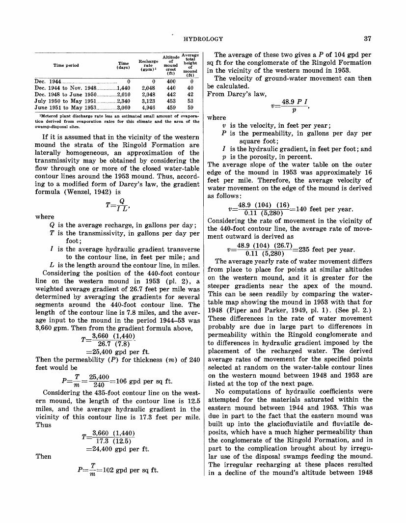
HYDROLOGY 37
Time period Time (days)
Altitude A£ feRecharge of h*£ht
rate mound he0fht<gpm)i crest mound
(£t) (ft)
Dec. 1944...............................Dec. 1944 to Nov. 1948.......Dec. 1948 to June 1950.......July 1950 to May 1951.......June 1951 to May 1953.......
....... 0
.......1,440
.......2,010
.......2,340
.......3,060
02,0482,0483,1234,946
400440442453459
040425359
1Metered plant discharge rate less an estimated small amount of evapora tion derived from evaporation rates for this climate and the area of the swamp-disposal sites.
If it is assumed that in the vicinity of the western mound the strata of the Ringold Formation are laterally homogeneous, an approximation of the transmissivity may be obtained by considering the flow through one or more of the closed water-table contour lines around the 1953 mound. Thus, accord ing to a modified form of Darcy's law, the gradient formula (Wenzel, 1942) is
T __ Q_ '-I L'
whereQ is the average recharge, in gallons per day ; T is the transmissivity, in gallons per day per
foot;/ is the average hydraulic gradient transverse
to the contour line, in feet per mile; and L is the length around the contour line, in miles.
Considering the position of the 440-foot contour line on the western mound in 1953 (pi. 2), a weighted average gradient of 26.7 feet per mile was determined by averaging the gradients for several segments around the 440-foot contour line. The length of the contour line is 7.8 miles, and the aver age input to the mound in the period 1944-53 was 3,660 gpm. Then from the gradient formula above,
3,660 (1,440) 26.7 (7.8) "
=25,400 gpd per ft.Then the permeability (P) for thickness (ra) of 240 feet would be
per sq ft-Considering the 435-foot contour line on the west
ern mound, the length of the contour line is 12.5 miles, and the average hydraulic gradient in the vicinity of this contour line is 17.3 feet per mile. Thus
3,660 (1,440)
Then
T~ 17.3 (12.5) =24,400 gpd per ft.
P=-^=102 gpd per sq ft.
The average of these two gives a P of 104 gpd per sq ft for the conglomerate of the Ringold Formation in the vicinity of the western mound in 1953.
The velocity of ground-water movement can then be calculated. From Darcy's law,
48.9 P Iv=-P
wherev is the velocity, in feet per year;P is the permeability, in gallons per day per
square foot;/ is the hydraulic gradient, in feet per foot; andp is the porosity, in percent.
The average slope of the water table on the outer edge of the mound in 1953 was approximately 16 feet per mile. Therefore, the average velocity of water movement on the edge of the mound is derived as follows:
48.9 (104) (16)v=- -=140 feet per year.0.11 (5,280)Considering the rate of movement in the vicinity of the 440-foot contour line, the average rate of move ment outward is derived as
48.9 (104) (26.7) ooc « , V= 0.11 (5,280) ~235 feet Per year-
The average yearly rate of water movement differs from place to place for points at similar altitudes on the western mound, and it is greater for the steeper gradients near the apex of the mound. This can be seen readily by comparing the water- table map showing the mound in 1953 with that for 1948 (Piper and Parker, 1949, pi. 1). (See pi. 2.) These differences in the rate of water movement probably are due in large part to differences in permeability within the Ringold conglomerate and to differences in hydraulic gradient imposed by the placement of the recharged water. The derived average rates of movement for the specified points selected at random on the water-table contour lines on the western mound between 1948 and 1953 are listed at the top of the next page.
No computations of hydraulic coefficients were attempted for the materials saturated within the eastern mound between 1944 and 1953. This was due in part to the fact that the eastern mound was built up into the glaciofluviatile and fluviatile de posits, which have a much higher permeability than the conglomerate of the Ringold Formation, and in part to the complication brought about by irregu lar use of the disposal swamps feeding the mound. The irregular recharging at these places resulted in a decline of the mound's altitude between 1948
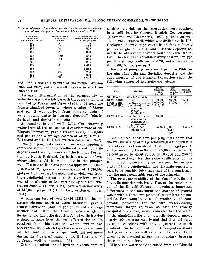
38 HANFORD RESERVATION, U.S. ATOMIC ENERGY COMMISSION, WASHINGTON
Rate of advance of specified points on the western recharge mound for the period November 1948 to May 1953
Altitude of water-table
contour line, in feet
400405410430
395400395400
405390400430
Direction from center of
mound
NNNN
NENEEE
ESESEW
Average rate of contour line movement,
in feet per year
0167722978
578835875
1,355
1,090200890
1,445
and 1953, a variable growth of the mound between 1953 and 1957, and an overall increase in size from 1958 to 1966.
An early determination of the permeability of water-bearing materials beneath the reservation was reported by Parker and Piper (1949, p. 6) near the former Hanford townsite, where a value of 35,000 gpd per ft was derived from pumping tests of wells tapping water in "terrace deposits" (glacio- fluviatile and fluviatile deposits).
A pumping test of well 13/26-5D2, obtaining water from 88 feet of saturated conglomerate of the Ringold Formation, gave a transmissivity of 50,000 gpd per ft and a storage coefficient of 2xlO~4 (J. R. Strand and D. H. Hart, written commun., 1952).
Two pumping tests were run on wells tapping a combined section of the glaciofluviatile and fluviatile deposits and the conglomerate of the Ringold Forma tion at North Richland. In both tests water-level observations could be made only in the pumped well. The test on Richland public-supply well 3000-F (10/28-14K2) gave a transmissivity of 1,080,000 gpd per ft; however, the main water yield was from the glaciofluviatile deposits at the river level, which was at an altitude of 344 feet during the test. The test on 3000-G (10/28-23P4) gave a transmissivity of 146,000 gpd per ft (D. H. Hart, written commun., 1951).
A pumping test of well 13/26-13R2 in the old stream channel north of Gable Mountain gave a transmissivity of 1,430,000 gpd per ft and a storage coefficient of 0.03 for the 31 feet of saturated glacio fluviatile and fluviatile deposits. A hydraulic barrier a short distance from the well affected the results obtained from this test; the water level in one observation well, which taps the same saturated zone 400 feet south of the pumped well, did not move during the 7 days of pumping (D. H. Hart and F. J. Frank, written commun., 1954).
Other determinations of hydraulic coefficients of
aquifer materials on the reservation were obtained in a 1956 test by General Electric Co. personnel (Raymond and Bierschenk, 1957, p. 729) on well 13/26-26B2. This well, which was drilled by the U.S. Geological Survey, taps water in 45 feet of highly permeable glaciofluviatile and fluviatile deposits be neath the old stream channel south of Gable Moun tain. This test gave a transmissivity of 3 million gpd per ft, a storage coefficient of 0.20, and a permeabil ity of 66,700 gpd per sq ft.
Results of pumping tests made prior to 1956 for the glaciofluviatile and fluviatile deposits and the conglomerate of the Ringold Formation show the following ranges of hydraulic coefficients:
Test Deposit
Trans missivity
(gpd per ft)
Perme ability Storage
(gpd per coefficient sq ft)
Old Hanford Glaciofluviatile ................ 35,000 ........13/26-13R2 ......do......................1,430,000 46,000 0.0313/26-26B2 ......do......................3,000,000 67,000 .210/28-14K2 Combined (pre- 1,080,000 ............ ........
dominantly glacio fluviatile)
10/28-23P4 Combined (pre dominantly Ringold con glomerate)
146,000
13/26-5D2 Ringold con glomerate
50,000 450 (aver
age
2X10⁻⁴
Summarized, these few pumping tests show that the transmissivity of the glaciofluviatile and fluviatile deposits ranges from about 1 to 3 million gpd per ft, and permeability from 35,000 to 67,000 gpd per sq ft, as contrasted to about 20,000 to 100,000 and 200 to 600, respectively, for the same coefficients of the Ringold conglomerate. By comparison, the permea bility of the glaciofluviatile and fluviatile deposits is seen to be roughly 100 times that of the conglomer ate, the most permeable part of the Ringold.
The great permeability of the glaciofluviatile and fluviatile deposits relative to that of the conglomer ate of the Ringold Formation produces important differences in the movement and storage of ground water within these two principal water-bearing ma terials. For example, at equal gradients and com parable porosities for the two water-bearing materials Darcy's equation, as used for velocity computations above, would indicate that the water in the glaciofluviatile and fluviatile deposits moves nearly 100 times as rapidly and that it would move at equal velocities with only 1 percent as much gradient. Further application of this equation shows that great changes will occur in the water table when it is elevated across the boundary between these unlike aquifers.
Where the water table is raised from the Ringold

GROUND DISPOSAL OF RADIOACTIVE WASTES 39
conglomerate to the glaciofluviatile and fluviatile deposits (section A-A' on pi. 1; Newcomb and Strand, 1953, p. 97 and pi. 3), the much lower gradient required for percolation of comparable quantities of water through the glaciofluviatile ma terials frees over 90 percent of the water for accele rated migration downgradient. Movement of the augmented ground water in the more permeable glaciofluviatile and fluviatile deposits downgradient off a ground-water mound at the new velocities toward surface outlets is retarded only by the neces sity to fill any unsaturated materials below its new gradients. The practical operation of this theoretical analysis is mentioned previously under sections "Changes in Ground-Water Regimen" and beyond under "Ground Disposal of Radioactive Wastes."
The horizontal permeability of the bedrock basalt differs greatly from one stratigraphic element to the next but, on the average, is much less than that of glaciofluviatile and fluviatile deposits. However, the average horizontal permeability of most any 500- or 1,000-foot section of the basalt is greater than the permeability of 450 gpd per sq ft commonly found for the Ringold conglomerate. Six pumping tests on wells drawing water from the basalt (Newcomb, 1959 (3 tests) ; Price, 1960; an unpublished test at Larson Air Force Base, 40 miles north of the Han- ford Reservation, D. H. Hart, oral commun., 1960; and at The Dalles, Foxworthy and Bryant, 1967) gave transmissivity values ranging from 500 to 1,000,000 gpd per ft. Permeability, approximated by dividing the derived values of transmissivity by the saturated thickness of the basalt, ranged fromp 2 to 50,000 gpd per sq ft. However, an attempt to st£|te an average permeability for the basalt can be mis leading because the rock consists of many layers of relatively impermeable lava separating some rela tively thin strata of moderate to great permeability. Estimates based on many drilling records and well- capacity tests indicate that the basalt has an overall water-carrying porosity of between 1 and 2 percent (Newcomb, 1969). This is the part of the basalt that effectively contributes water to wells of moderate and high yield. Storage coefficients of the basalt aquifers, derived from several pumping tests, are approximately equal to the compressibility of water, suggesting that the ground water occurs confined in nonelastic aquifers.
GROUND DISPOSAL OF RADIOACTIVE WASTES
The disposal of wastes at the Hanford Reservation involves many types of radioactive materials as well as many levels of radiation energy. Certain similar methods of disposal are common throughout the
plant, even though the byproduct wastes differ in various sections of the production and manufactur ing areas. The Atomic Energy Commission and the plant contractors maintain quantitative and quali tative data on the radioactive material passed to the ground, the streams, and the atmosphere. The fixa tion or movement of the radioactive material dis posed to, or stored in, the ground is observed by monitoring.
Common definitions of the three levels of radio activity in waste place the upper limit of activity of low-level waste at 1.0XlO'5 ftc per ml (microcuries per milliliter) and that of intermediate-level waste at 100 /AC per ml; high-level waste has more than 100 /-ic per ml and commonly has up to 1,500 /xc per ml, which is somewhat more than 5 curies per gallon. (A curie is defined as 3.7XlO10 disintegrations per second. This is a refinement of the older definition, which was the number of disintegrations per second emanating from 1 gram of radium which is in equi librium with its daughter element, radon.)
In many of the descriptions of the radioactive waste disposal methods, the large quantities of reac tor cooling water disposed to the Columbia River and the large quantities of wash water and cooling water disposed to swamps from the chemical-separa tion plants are termed nonradioactive water on the basis of monitoring data. However, the disposal of these lowest level wastes is described here because the waste water at times may acquire a higher level of radioactivity and because, at most times, its dis posal creates part of the hydrologic conditions where other wastes of much greater radioactivity are placed.
HISTORY OF DISPOSAL
Up to mid-1959 the total volume of liquid waste discharged to the ground since 1945 and the equiva lent number of curies of gross beta activity (exclud ing metal wastes stored in subsurface tanks and the spills therefrom), as listed by Belter (1963, p. 19 and 20), were:
Cribs (72).......Trenches (18) Swamps.............
Volume (billion gallons)
4.0.028
37.5
Activity (curies)
1,900,000647,000
2,500
These totals included 95 percent of the 2.6 million curies of radioactivity in the low- and intermediate- level liquid wastes disposed to the ground within the United States prior to January 1959 (U.S. Congress, 1959, p. 21).
EARLY PROCEDURES
During construction and early operation of the Hanford Works, from 1944 to 1947, the disposal or

40 HANFORD RESERVATION, U.S. ATOMIC ENERGY COMMISSION, WASHINGTON
storage of radioactive wastes underground (or to the river) included the following means in the areas cited: Reactor areas:
(1) Retention of large volumes of slightly acti vated reactor coolant for about 2 hours before release to the river.
(2) Trench infiltration of coolant containing dissolved and suspended metal and fission products as well as irradiated salts sent to trenches after the rupture of a uran ium container in the reactor.
(3) Burial of contaminated and irradiated solid material in established burial pits and vaults.
Chemical-separation-plant areas:(1) Tank storage of metal wastes and fission
products originally mostly in solution (first-cycle wastes).
(2) Injection to the ground through wells, tile fields, and cribs of dissolved and sus pended fission products and small amounts of metal wastes (second-cycle wastes).
(3) Lagoon infiltration of wash water and coolants having low-level radioactivity of all types.
(4) Burial of contaminated and irradiated ma terials.
Laboratory areas:(1) Burial of contaminated materials, sweep
ings, and refuse.(2) Lagoon infiltration of metallic, wash, and
laundry wastes.(3) Trench infiltration of wash, laundry, and
laboratory wastes. Service areas:
(1) Burial by covering with soil.(2) Liquid infiltration in cribs and swamps.
LATER DEVELOPMENTS
Changes in the disposal system have included the addition of monitoring wells and the improvement of radiation-detection instruments and techniques to indicate the extent of underground contamination. Also, new practices resulted in the abandonment of deep injection wells in favor of cribs for second-cycle and other liquid waste of high or intermediate radio activity, and the addition of evaporation and treat ment to reduce the volume of metallic wastes needing tank storage. Other changes have included the reduc tion (to about li/4 hours in some instances) of the holding time of reactor coolant before discharge to
the river, and the recovery and reuse of metallic wastes stored in tanks. A number of spills, leaks, migrations of ground water carrying radioactive isotopes, and unplanned wastages of radioactive liquids to the ground have provided the opportunity to test the monitoring and emergency disposal ar rangements.
A most significant development in subsurface dis posal involves the movement of ground water carry ing tritium and ruthenium-106 southeastward and eastward from the area of the eastern large recharge mound through the highly permeable glaciofluviatile and fluviatile materials for 14 miles to the zone of bank storage along the Columbia River (Brown and Haney, 1964). This movement in general followed the direction of highest permeability, as indicated by the relatively flat hydraulic gradients and the bulging of contour lines on the ground-water contour maps of 1953 (Newcomb and Strand, 1953) and of 1951, 1955, and 1957 (Bierschenk and McConiga, 1957). Movement of the tritium and ruthenium at the rate of about 2 miles per year (Brown and Haney, 1964) through the glaciofluviatile and fluviatile de posits over a 6- to 8-year period illustrates the accel eration that occurs in the ground-water flow once the water table has risen above the base of the highly permeable deposits, as described above from a theo retical standpoint under the section on "Rate of Ground-Water Movement."
An attempt was made to locate recharge mounds resulting from swamp and crib infiltration so as to contain the radioactivity in the ground water at places from which it would move most slowly. Still practically untouched is the whole field of water-table manipulation which can be of vital use in waste disposal and control. A first beginning at these practices, for better containment of the radioactive wastes underground in materials of low permeability, was proposed by Parker and Piper (1949, p. 95-96).
The location of the open artificial recharge areas (swamps), which build the bulk of the large water- table mounds, and the location of radioactive isotopes from the crib infiltrations, which supply most of the contamination to the ground water, are susceptible to greater control. For example, an installation of ten 500-gpm wells, drawing nonradioactive ground water from the western side of the two large re charge mounds, could have removed water equivalent to the recharge placed in the two large mounds dur ing the period 1944-61. A similar judicious removal of excess nonradioactive water might be used to control the location and movement of radioactive ground water.

GROUND DISPOSAL OF RADIOACTIVE WASTES 41
, Outlet of cooling V water to river
(D)
\ \/// ^\^_
^^^ ^-^^'^'Trench ^^ ^^ (G)
\Retention basin __
(leaks) Y\ /(D, with very small amounts -v \ ^X' (
oiA.B, andC) r \ Y \.
1 ___ -A\ \Vw
Y\\
1 \ \
\V
=-HT\Reactor 1 ,|
DCribs
-u-r- D (A,B,
Pit (EandF)
// // y '/Perimeter fence
-/ / / i Cooling water /
disposal trench 1
D, with some A, B, and C)
v Pipeline, leaks at junction boxes
/^ (D, with some/4, S, and C)
Plant coordinates ^
\ _ Trench \ Pipeline leaks ' ' (E)/(D, with some A,B,and C)
_ Trench (H) * J _ Cave radiation zone (CandF)
LJ Crib (A,B,C, and D)
", and D)
1 Burial ground
500 1000 FEET
TEXPLANATION
Symbol for type of radioactive waste put underground or in riverA, Uranium E, Various contamination items, largely B, Plutonium dry wastes, cloth, paper, tools,and C, Fission products machineryD, Short-lived radiation from salts F, Long-lived radiation on building materials
dissolved in water Q_ Trash from repair of retention basin
H, Long-lived radiation from irradiated salts
FIGURE 10. Typical Hanford nuclear reactor plant, showing points of disposal of several types of radioactive waste.
TYPES OF WASTES DISPOSED
REACTOR AREAS
Materials containing a variety of radionuclides are included in the wastes from reactor areas. Uranium, plutonium, fission products, short-lived radioactive salts dissolved in water, long-lived activity imposed on parts of structural materials, and miscellaneous
contaminated items are disposed in these areas (fig. 10).
Thousands of gallons per minute of filtered river water are pumped through each operating reactor for cooling purposes. The dissolved mineral matter, in part, becomes slightly irradiated, and the water is held about 2 hours in coolant-retention basins to

42 HANFORD RESERVATION, U.S. ATOMIC ENERGY COMMISSION, WASHINGTON
allow some decay of radioactivity before the coolant returns to the river. Besides the natural dissolved materials that are irradiated, this coolant can carry radionuclides from water-treatment chemicals and rust-inhibiting coatings.
Under unusual conditions, which result in an in crease in the radioactivity of the reactor coolant, the water as it comes from the reactor may be switched to special trenches. There it infiltrates, moves down to the water table, and percolates through glaciofluviatile and fluviatile deposits and the Ringold Formation in its return to the river.
Burial grounds for solid materials such as con taminated building materials, equipment, and acces sories are maintained in the reactor areas.
CHEMICAL-SEPARATION PLANTS
Uranium, plutonium, fission products, short-lived radioactive salts dissolved in water, and miscella neous contaminated items (largely dry wastes) form most of the wastes from separation plants (fig. 11). Stack gases and emissions have been of minor signifi cance and are commonly an atmospheric-disposal matter, but at times they coat the soil sufficiently to become a ground disposal. All types of radionuclides are present in this group of wastes.
The radioactive metallic wastes from which plu tonium has been removed contain mostly uranium and fission products. These high-level wastes are largely in concentrated solutions when placed in steel-lined concrete tanks about 25 feet underground; this placement is called storage, not ultimate dis posal.
Waste solutions and condensate from the subse quent steps in the plutonium-production process contain largely fission products, of which cesium-137 is reported to be the principal emitter. These high- and intermediate-level wastes are disposed to the subsurface through cribs built to assure the infiltra tion of large quantities of pipe-transported dissolved (and suspended) radioactive materials.
Low-level waste, mostly wash and cooling water, is piped to swamps, where most infiltrates the ground and small amounts evaporate or are transpired.
MEANS OF WASTE DISPOSAL AND MANAGEMENT
RETENTION BASINS
The cooling water from each reactor is normally returned to the Columbia River after retention for a short period in concrete or steel basins to allow natural decay of radioactivity. When an accidental rupture of a uranium container introduces a slug of contaminant and raises the level of radioactivity in the coolant discharging from a reactor, the coolant is temporarily switched to disposal trenches where
it infiltrates and percolates underground, presum ably with retention of the contaminants on the earth materials.
PITS AND TRENCHES
Most pits and trenches are temporary features dug 5 to 20 feet deep for immediate use for the catchment of waterborne wastes or the burial of dry materials that cannot be transported any great distance to other disposal sites. In addition, trenches are used to dispose of waterborne radioactive wastes in reac tor coolant, spills in chemical processing, waste from cleanup operations around the pile buildings, and leaks of retention basins and pipelines, as well as to dispose of waste solids and liquids incident to the repair of the retention basins.
CRIBS AND TILE FIELDS
Cribs are covered, porous walled and bottomed, dry wells lined with wood, metal, or concrete. They are constructed to provide a protected means of dis charging waterborne radioactive materials at a safe depth in the ground. If a large volume of water is anticipated or if sludge is likely to clog the crib, tile fields may be tied in with the cribs to aid in the disposal of the surplus liquid. The main use for cribs is the disposal of waterborne contaminants carrying long-lived radioactive elements (the "second-cycle" or fission-product-rich waste) from the chemical- processing plants.
In most crib disposal, some precipitation of the radioactive adsorbable cations is provided for within the crib. The amount of base-exchangeable radio active ions placed in each crib is planned so as to be only a small part of the previously estimated adsorp tion and base-exchange capacity of the mineral ma terial to be traversed by the solutions en route to the water table.
BURIAL GROUNDS AND VAULTS
In each of the operating-plant areas there are burial grounds that receive solid wastes, in large part packaged, from the laboratories and plants. These wastes are placed in trenches in the burial grounds and covered. Some individual buildings or groups of buildings have nearby burial vaults for packaged dry waste. Other burial grounds receive contaminated building materials, equipment, and cleaning material wastes of a lower level of radio activity.
TANK FARMS
Metal-processing wastes whose radioactivity is considered too highly concentrated or long lived to be released safely underground in quantity, and metal wastes that may be reprocessed at some future time, are stored underground in tanks. The tanks

GROUND DISPOSAL OF RADIOACTIVE WASTES 43
are made with a substantial concrete floor slab, 10- inch concrete walls, and a domed roof. The sides and top are poured around a steel liner that is three- fourths of an inch in thickness and extends across the floor slab. A tar coat is applied to the steel tank surface. The entire tank farm is covered with earth to at least a depth of 10 feet, with only the vents reaching to the land surface. The inflow pipes lead from one tank to another in series of three. Overflow ports in the tank sides are above the level of the inlet and outlet lines. Overflow and condensate are piped to cribs and infiltration lines.
INJECTION WELLS
Disposal to shallow injection wells was a former practice which was limited to small quantities of liquid wastes, although not necessarily to low-level wastes. If sludge was present in the solutions, set tling tanks were connected with the pipelines, and the supernatant liquids were then sent into the injec tion wells. Most of the wells still in use in 1947 were planned so that discharge of wastes would be at some height above the water table; some of the first dis posal wells at some reactor and chemical-separation areas led radioactive wastes directly to the ground- water body or close to the water table.
SWAMP AREAS
Normally, nonradioactive water and water con taining low-level wastes from sewers, powerplants, laundries, or holding basins are sent to swamps for disposal by infiltration and evaporation. Small amounts of higher level wastes have entered swamps on some occasions. Swamps that are no longer used are backfilled with an earth cover, and the surface is fixed against contemporary erosion. Swamps con tribute the major part of the water that reaches the ground-water body, and infiltration from them has produced much of the saturated volume in the large mounds on the water table, as previously described.
UNPLANNED DISPOSAL
Pipelines, diversion boxes, and storage-tank sys tems have at times leaked radioactive wastes directly underground or onto the land surface where little or no attention has been given to the wastes other than monitoring their radioactivity and covering them with earth. Small spills, or the accidental spread of contaminants on the land surface, are gen erally immobilized with an earth, asphalt, or concrete cover, if practicable, and are fenced and marked with signs as necessary.
LOCATION OF DISPOSED WASTES
The following outline summarizes briefly the place ment of the radioactive wastes:
1. Subsurfacea. Above the water table
(1) Tank storage (metallic wastes)(2) Capillary bond of water, with dissolved
wastes, onto "dry" mineral grains(3) Adsorption on mineral grains by ion
exchange or other physicochemical processes
(4) Burial (dry solids) b. Ground water (solution of fission products)
2. Surfacea. Swamps and sumps (waste water, spills,
dust flares, and precipitates)b. Columbia River (slightly irradiated solu
tions mostly reactor coolant)3. Atmosphere (gases and vapors)
The tank-stored metallic wastes and the crib-dis posed "second-cycle" wastes contain the most impor tant disposals the bulk of the radioactivity. These storages and disposals are placed far above the water table in the glaciofluviatile and fluviatile deposits beneath the high (600- to 800-ft) terraces in the northwestern part of the reservation. Downward movement from the cribs, as described above, carries some dissolved radioactive materials into the under lying Ringold Formation and, in a few places, into the top part of the bedrock basalt.
The liquid that infiltrates within the cribs of the chemical-separation plants is the major disposal of potential long-lived radioactivity; part of this reaches the ground water. These wastes form a small part of the large ground-water mounds which have been built up mainly by the water descending from the swamps, where nonradioactive water and low- level wastes are disposed.
Locally, less permeable layers cause some perching of the descending water. The liquid wastes from two cribs have been monitored where they accumulated above silt or clay layers. A 1-foot-thick "clay" bed in the glaciofluviatile and fluviatile deposits "perched" the infiltrant from one temporary crib at a depth of 30 feet below the surface in 1948. A clayey silt layer at a depth of 89-114 feet caused the infiltrant from a second crib to be perched and to spread laterally and spill over the edge of the perching layer. Elsewhere the infiltrants from many other cribs have largely descended freely to the water table.
In the process of infiltration and transfer to the water table, dissolved and suspended radioactive cations are partly taken up by the earth materials (Atomic Energy Comm., 1951), presumably by base exchange and adsorption. Some of the cations with

44 HANFORD RESERVATION, U.S. ATOMIC ENERGY COMMISSION, WASHINGTON
Ditch (Small amounts of/4,B,and D)
* \/Ditch (Small amounts of S and D)
o0 Pits(AB.andD)
'iU-Ditch (Small amounts of A, 6,andC)
oooo Tanks oooo (Aaandc)oooo (AB.and C) O~O O O
r/Cribs " (BandC)
Leaks in diversion boxes , 'i (BandC)"
Cribs . (AS.andC)', Reverse well
(A.B.andC)
Ol CribslM,8,C,andD)
Cribs (AB.andC)
Reverse well (A,B.C.and D)
EXPLANATION
Symbol for type of radioactive waste put underground or in sumps
A, UraniumB, PlutoniumC, Fission productsD, Short-lived radioactivity in salts dissolved in waterE, Contaminated items, largely dry wastes, cloth, paper, tools, and machini
FIGURE 11. Typical Hanford chemical-separation plant, showing
the longest half life apparently are taken up in such a short distance from the bottom of a crib that their location is monitored with great difficulty. Excess cations present in the calcium-rich deposits of these geological materials are reported to be instrumental in this take up of radioactive cations by base ex change. The rapidity with which the different radio active cations are lodged and fixed in the earth
materials is reported to be in the general order of plutonium-239, strontium-90, zirconium-95, yttrium- 91, cesium-137, and ruthenium-106. Some compara tive travel rates for ruthenium and cesium have been described by Belter (1963, p. 20). Much of the ruthenium-106 and most of the tritium (H3 ) are not fixed on the geologic materials and are free to mi grate with the water.

GROUND DISPOSAL OF RADIOACTIVE WASTES 45
rBurial ground
Cribs and tile fieldcs; , D
Reverse wel!
Cribs (B)
cribs
x Trenches I (BandC)
(B and
xx, x . *<*"
Crib and tile field(BandC)
Leak 000 (BandC)
O O O TanksOO O(/4,B,andC) OOOO
O^OOOo.n Tanks 0000 Tanks \ M.B.andC) o o o o
,A s < x'' e- a
Crib and tile field (BandC)
".Cribs (BandC)
Swamp(Small amounts of
A,B,C, and D)
n Spi " (SandC)C > Leak(SandC)
Leaks in diversion boxes (BandC
s Jkl )
/
,, Leak (SandC)
/ Burial \ \ ground I/ (E)
Leak somewhere in pipeline (BandC)
I T| Cribs | (BandC)
I o| Reverse well I (BandC)
I II D Q a
Trenches (A)
eaks (BandC)
Sumps (A)
Reverse well (A,B, C.andDr^x.
Cribs V Vaults
Railroad cut (D)
, andD) (£)
cf>Trenc\n (A)
Leak in pipeline (BandC)
Solid lines enclose buildings or other plant facilities; single-dash lines are pipelines
points of storage or disposal of several types of radioactive waste.
Where base-exchangeable radioactive ions have reached the water table and have been detected in the ground water, that crib usually has been taken out of service. The most distant of the emplaced ions is generally the nonradioactive nitrate, except where ruthenium and tritium are being placed underground in large quantities.
Of the subsurface disposals, the least hazard to
the hydrologic environment results from the burial of radioactive building materials and equipment and other solids above the water table, where the radio active material is protected from wind erosion and is far from surface streams. The solid state and the decay of their general low level of radioactivity make these disposals only a minor radiation hazard within a few years, except near the river, where these dis-

46 HANFORD RESERVATION, U.S. ATOMIC ENERGY COMMISSION, WASHINGTON
posals may be subject to flooding and erosion during abnormal changes in the river channel.
The potential hazard from large quantities of tank-stored metallic wastes and the adsorbed wastes of long half life cannot be entirely overlooked. The true structural life of the tanks and the permanence of the ground fixation of the base-exchanged and adsorbed crib-disposed wastes are not entirely known. If large quantities of the crib-disposed wastes, which were fixed by base exchange, became unlocked by unnatural chemical conditions, they could move with the ground water until readsorbed by natural cation exchange. The knowledge of ground-water movement and geochemistry is vital to the monitoring and control of these waste disposals.
The movement of ground water carrying ruthe nium and tritium from the eastern large mound can be controlled by management of waste disposal and, to some extent, by the manipulation of ground-water levels and hydraulic gradients.
SPECIAL GEOLOGIC SITUATIONS THAT AFFECTOPERATIONS OF AN INDUSTRIAL PLANT
TERRAIN, FOUNDATIONS, AND BUILDING MATERIAL
The general levelness of the terraces, the ease of excavation, and the ready drainage give the reserva tion advantages as an industrial site. The terrain advantages are formidable when combined with the adjacent large supplies of water of excellent quality, the area's lack of usefulness for some other purposes, and the accessibility to transportation. The glacio- fluviatile and fluviatile deposits and the gravelly parts of the conglomerate of the Ringold Formation provide stable foundation materials. The bearing strength of the silts and clays of the Ringold Forma tion is much less, but these materials reach the surface or approach close beneath possible building sites in very few places in the northern part of the reservation.
The gravel and sand of the glaciofluviatile and fluviatile deposits are unweathered and (except for the basaltic scabland gravel facies) consist mostly of rock and mineral particles that are nonreactive with common portland cements. Largely siliceous sand in the medium to fine sizes can be procured from the live dunes to build up the percentage of these particle sizes in concrete mixes. Common fill and miscellaneous-size basalt stone are abundant. Silty clay can be obtained at a few locations, mostly from the Ringold Formation.
STORAGE SPACE FOR FLUIDS AND GASES
The volume of space available for artificial storage of water in the unconsolidated deposits (mainly the
Ringold Formation) beneath the high terrace lands south of Gable Mountain and Gable Butte can be computed as near 3 million acre-feet. This volume is obtained by postulating levels at which the raised water table would not (1) intercept the land surface, (2) saturate the lowest part of the glaciofluviatile and fluviatile deposits, nor (3) cause an undue in crease in the discharge of ground water to the Colum bia River or to Cold Creek. At present only a small amount of the underground storage space is used for the recharged 130,000 acre-feet. of water in the ground-water mounds near the chemical-separation plants and for the small amounts of recharge near the reactors and the Richland well fields. Unsatu- rated ground space forms a valuable asset for nu clear industry on the reservation.
Space suitable for underground storage of com mercial gas or lighter-than-water fluids may exist in the basalt bedrock. The fine-grained sedimentary beds that occur between some of the basalt flows may in places form a confining layer. The occurrence of such a capping of impervious material below the water table is necessary to the efficient storage of gas in the basalt; this requirement was indicated by the quick depletion of the methane gas that occurred with a pressure of only 2 pounds per square inch in the wells of the old gas field on the east slope of Rattlesnake Mountain. (See well 11/26-29B1.) In this occurrence, the methane gas had accumulated above the water table and beneath the sedimentary layer that cropped out in the mountain slope to the west (pi. 1). An impervious capping in places may be provided by dense flow centers in the basalt, but fine-grained sedimentary beds can form a more uni form and less permeable containment. Where the basalt is gently arched and interstratified tuff beds form impervious layers below the water table, such as may be the situation in the anticline at and near sec. 18, T. 9 N., R. 28 E., southeast of Red Mountain, the main requirements for off-line underground stor age of commercial gas may be present in the porous tops of the basalt flows below the tuff beds.
DISPOSAL OF RADIOACTIVE WASTES
Because time is the only ultimate rectifier for the health hazards of long-lived radioactivity, the com mon requirements for waste disposal are protective shielding, isolation, and conditions of relative immo bility. Convenient and economical methods of dis posal for its wastes are inherent necessities for a nuclear plant. Protective shielding for small amounts of radioactive waste, even that having a long half life and a high level of radioactivity, can be provided by earth cover that will remain indefinitely. The
SPECIAL GEOLOGIC SITUATIONS 47
cover over permanent disposals of high-level wastes must be sufficient to prevent its disturbance. Isola tion may be provided by closure of the area to unnecessary entry and is more easily managed where ordinary uses of the area are negligible. Stability of the waste disposal the opportunity for it to stay in place is largely controlled by the geologic and hydrologic conditions.
DISPOSAL BENEATH THE HIGH TERRACES
The high terraces of the central and northwest- central parts of the reservation provide a setting that meets the above requirements for subsurface disposal of some radioactive wastes.
Solid wastes placed underground, with the surface protected from wind erosion, are relatively safely fixed against natural disturbances in the high-terrace areas. Except for finer grained materials of the Touchet Beds in Cold Creek valley, the mantle of glaciofluviatile and fluviatile deposits that underlies the high terraces readily accepts wastes in solution and assures the liquid's transfer downward to the Ringold Formation, in which the water table lies 100 to 300 feet below the surface and in which ground water moves slowly except where influenced locally by artificially steepened hydraulic gradients.
The results of analyses by the plant-operating companies and the Atomic Energy Commission show that during downward movement to the ground water the radioactive wastes pass through some ma terials having a high capacity for base exchange. In this downward movement of the waste solutions, much of the longest lived radioactive-cation content is adsorbed or fixed by base exchange on the trans- missive materials (Belter and Bernard, 1963, p. 179). Some of the radioactive cations, particularly cesium, are so slowly adsorbed, however, that some of this waste reaches the water table (Belter, 1963, p. 20).
Personnel of the operating contractors have con tended orally in many conferences that no foresee able natural phenomena or artificial effect can reverse the base exchange, or sorption, and free the adsorbed radioactive cations and permit them to migrate. Apparently, all agree that such columns of mineral-fixed radioactive cations need to be moni tored and permanently protected from human access.
The ruthenium (Ru10G ) and tritium (H3 ) are the principal radioactive ions whose distribution has been relatively unaffected by sorption. The 1-year half life of the ruthenium renders this isotope less persistent than the tritium, which has about a 12- year half life and is able to enter directly into the water molecules.
The spot introduction to the ground water of radioactive waste in solutions having a density simi lar to that of the ground water is followed by dis persion that accompanies movement of ground water in granular materials. This dispersion normally dilutes initial concentrations many times during long movements through deposits like the Ringold For mation.
The direction and rate that the radioactive wastes travel in the ground water of the Ringold Formation is influenced artificially by control of the slopes of the water table. The average accelerated rate of movement of the artificially recharged ground water through the conglomerate is a few hundreds of feet per year in the directions of the slopes of the re charge mounds. The contours of the mounds show that in some parts of the Ringold Formation, such as the southeast side of the top part of the western large mound (Brown and Haney, 1964, fig. 5), the ground water is traveling outward faster than else where, as indicated by the rate-of-movement compu tations given for 1953.
Thus, from the ground-water travel rates previ ously described, we may conclude that some of the residual radioactivity from disposals beneath the high terraces of the northwest-central part of the reservation, if kept entirely in the Ringold Forma tion, would reach the Columbia River only after at least many scores of years, and probably after a hundred years. Also, during these periods of time the radioactivity of any effluent waste would have been greatly lessened by decay, adsorption or base exchange, and dilution. If radioactive waste is dis posed to ground water that is rising into or traveling in the glaciofluviatile and fluviatile deposits, the waste can be flushed to the Columbia River in about one-hundredth of the average time of travel for a similar distance in the Ringold conglomerate.
DISPOSAL BENEATH THE LOW TERRACES
The low terraces along the Columbia River stand only 30 to 100 feet above the natural water table and lie over the riverside zone of bank storage in which ground water rises and recedes with the annual flood level of the river. Water carrying radio active waste to ground water beneath these low terraces might reach the river within a few tens of years. Though the radioactivity would be lessened by dilution, decay, and adsorption in amounts that depend on the type of waste and the manner and place of its disposal, the low terraces afford less favorable waste disposal sites than the high terraces. Radioactive wastes disposed to the ground in solid form are conceivably vulnerable to erosion by the
48 HANFORD RESERVATION, U.S. ATOMIC ENERGY COMMISSION, WASHINGTON
river as mentioned below under "Geologic Hazards of the Reservation."
THE POSSIBILITY OF DISPOSAL IN THE BASALT
Suitability of the basalt of the Columbia River Group as a disposal place has been intermittently considered by the Atomic Energy Commission and the prime contractors. The costs of waste-emplace ment and monitoring installations and the lack of knowledge on rates and directions of ground-water movement in the basalt have discouraged tests of the potential utility of the upper several thousand feet of the basalt for this purpose. The circulation of ground water probably is confined to relatively few and thin aquifers. The ground water in the top thousand feet or so of the basalt is a part of the basic water supply of the region and is developed by an ever increasing number of wells; consequently, radioactive wastes improperly placed in the upper part of the basalt could be subject to movement toward ground water now in use by the public. The possibility of using space in the basalt or in the bed rock formations below the basalt is a matter for further study.
WATER SUPPLY
Besides the water available in the adjacent rivers, large quantities can be obtained from wells in some parts of the reservation. Wells with yields of 1,000 gpm can be obtained by deep drilling in the basalt and also by proper well construction in the conglom erate of the Ringold Formation beneath part of the reservation. Wells of much larger yield can be con structed in the glaciofluviatile and fluviatile deposits in the few places where these gravelly materials extend below the water table.
At present the only appreciable withdrawal of ground water is by the city of Richland, which ob tains water from about 20 wells. These wells are clustered around ponds in which water from the Yakima and Columbia Rivers is used for artificial recharge to increase the thickness of saturation in the sand and gravel. The producing zone is mostly in the Ringold conglomerate until the recharged water raises the water table into the overlying glaciofluviatile deposits (Price and others, 1965). In winter, when water is not recharged and the water table is low, some of the wells have only one-third or one-fourth of the yield that they have during the recharge period of the summer. This difference in yield is especially evident for the wells in which the recharge water saturates part of the overlying glaciofluviatile and fluviatile deposits. Recharge water from the Columbia River has been substituted for part of the supply formerly taken from the
Yakima River in order to decrease the hardness resulting from the very hard water of the Yakima River during the late summer and fall (Price and others, 1965).
GEOLOGIC HAZARDS OF THE RESERVATION
Earthquakes of sufficient intensity to create dam age are unlikely in any one year, but their occurrence is probable within any one century. Records of the past 90 years include only six earthquakes that pro duced slight damage. These six are earthquakes felt most strongly at Walla Walla, December 16, 1872, and January 4, 1873; Umatilla, March 6, 1893; Corfu, November 1, 1918; and Umapine, July 15, 1936, and November 17, 1936. Corfu is at the north ern foot of the Saddle Mountains, 8 miles northeast of Wahluke; Umatilla is 24 miles south of Richland; and Walla Walla and Umapine are along the north side of the Horse Heaven anticline, 45 miles southeast of Richland. The inferred epicenter for the Corfu earthquake was at the foot of the Wahluke Slope 10 miles northeast of Gable Mountain. Other earth quakes felt in the region of the reservation had epicenters at more distant places. The geologic youthfulness of many lines of bedrock deformation suggest that an earthquake potential is present.
Landslides, or block slumpage, represent an ever present hazard along parts of the Columbia River, especially at The White Bluffs. This hazard is some what related to the others, because earthquakes are a common trigger mechanism for landslides and because flooding can be either a cause or a result of landslides. Major damage can result from flooding by landslide-blocked streams. The competence of the Ringold strata exposed in The White Bluffs in places may be decreasing because of progressive wetting from irrigation on the plateau to the east. The blocked-channel type of flood hazard from landslides is greatest for the low terraces, especially in some places near the Hanford and White Bluffs townsites. Near these places, some radioactive wastes have been disposed to the ground, and flooding could result in their release to the river.
Among various proposals for hydroelectric power and navigation developments is a 45-foot-high dam, called the Ben Franklin, in sec. 1, T. 11 N., R. 28 E., 12 miles north of Richland (U.S. Army Corps of Engineers, 1958, p. 228-233). The proposed 400-foot level of the reservoir would cause a rise of ground water in accommodation to reservoir level. Some of the damage and the hazards that are expected to be induced by raising the water table beneath the ter race lands on the east side of the Columbia River have been evaluated in studies by the Atomic Energy

REFERENCES CITED 49
Commission (U.S. Army Corps of Engineers, 1958, p. 228), but the increase in landslide hazards created by raising the level of saturation within large slide blocks along The White Bluffs (pi. 1) may surpass the evident flooding, increased operating costs, and other detriments that have been evaluated for such a dam.
Flash-flood types of water damage have occurred in the valleys of Cold Creek and Dry Creek, but such sudden runs of water are infrequent. This kind of flooding is destructive only at a few places within the valleys of those streams.
The flood record of the Columbia River indicates the highest river level was reached during the annual early summer peak in 1894; the second highest occurred early in June 1948. Most of the atomic- plant structures and installations along the river are sited to withstand levels comparable to the level of the 1894 flood, but they could be damaged by the release of additional water when a flood crest com parable to that of 1894 or 1948 was passing the plant.
REFERENCES CITEDAllison, I. S., 1933, New version of the Spokane flood: Geol.
Soc. America Bull., v. 44, no. 4, p. 675-722.Atomic Energy Commission, 1951, Handling of radioactive
wastes in the atomic energy program: U.S. Govt. Print ing Office, 28 p.
Belter, W. G., 1963, Waste management activities in the Atomic Energy Commission: Natl. Water Well Assoc., Ground Water Jour., v. 1, p. 17-24.
Belter, W. G., and Bernard, Harold, 1963, Status of radio active liquid waste management in the United States: Water Pollution Control Federation Jour., v. 35, no. 2, p. 168-185, 9 figs.
Bierschenk, W. H., and McConiga, M. W., 1957, Changes in the Hanford water table, 1944-1957: Gen. Elec. Co., Hanford Atomic Products Operation, HW-51277, 21 p., 6 figs.
Bingham, J. V., and Grolier, M. J., 1966, The Yakima Basalt and Ellensburg Formation of south-central Washington: U.S. Geol. Survey Bull. 1224-G, 15 p., 4 figs.
Brown, D. J., and Haney, W. A., 1964, The movement of contaminated ground water from the 200 areas to the Columbia River: Gen. Elec. Co., Hanford Atomic Prod ucts Operation, HW-80909, 16 p., 6 figs.
Brown, R. E., and Brown, D. J., 1961, The Ringold Forma tion and its relationships to other formations: Gen. Elec. Co., Hanford Atomic Products Operation Paper HW- SA-2319, 17 p., 3 figs.
Brown, R. E., and McGoniga, M. W., 1960, Some contributions to the stratigraphy and indicated deformation of the Ringold Formation: Northwest Sci., v. 34, no. 2, p. 43-54.
Brown, R. E., and Ruppert, H. G., 1948, Underground waste disposal at Hanford Works; an interim report covering the 200-west area: Hanford Works Docs. HW-9428 and HW-9671.
1950, The underground disposal of liquid wastes at the Hanford Works, Washington; an interim report cov
ering the period up to January 1, 1950: Hanford Works Doc. HW-17088.
Daugherty, R. D., 1956, Archeology of the Lind Coulee site, Washington: Am. Philos. Soc., v. 100, no. 3, p. 223-278.
Flint, R. F., 1937, Pliestocene drift border in eastern Wash ington: Geol. Soc. America Bull., v. 48, no. 2, p. 203-232.
_____1938, Origin of the Cheney-Palouse scabland tract, Washington: Geol. Soc. America Bull., v. 49, no. 3, p. 461-523.
Foxworthy, B. L., and Bryant, C. T., 1967, Artificial recharge through a well tapping basalt aquifers at The Dalles, Oregon: U.S. Geol. Survey Water-Supply Paper 1594-E, 55 p., 8 illus.
Fryxell, Roald, 1962, A radiocarbon limiting date for scabland flooding: Northwest Sci., v. 36, no. 4, p. 113-119.
Grolier, M. J., and Bingham, J. W., 1969, Geology and ground- water conditions in parts of Grant, Adams, and Franklin Counties, east-central Washington: U.S. Geol. Survey open-file report, 302 p.
Hart, D. H., 1958, Tests of artesian wells in the Cold Creek area, Washington: U.S. Geol. Survey open-file report, 21 p., 11 illus.
Jenkins, O. P., 1922, Underground water supply of the region about White Bluffs and Hanford, Washington: Washing ton Div. Mines and Geology Bull. 26, 41 p.
Jones, F. 0., 1945, Geological report on Potholes dam site and reservoir, Columbia Basin Project, Washington: U.S. Bur. Reclamation intradepartmental rept., 22 p., 24 illus.
_____1950, In Columbia River Basalts, recorded informal discussion, Northwest Sci., v. 24, no. 2, p. 55.
Lupher, R. L., 1944, Clastic dikes of the Columbia Basin region, Washington and Idaho: Geol. Soc. America Bull., v. 55, no. 12, p. 1431-1462, 6 pis., 2 figs.
Mackin, J. H., 1961, A stratigraphic section in the Yakima Basalt and the Ellensburg Formation in south-central Washington: Washington Div. Mines and Geology Rept. Inv. 19, 43 p., 13 illus.
Mason, G. W., 1953, Interbasalt sediments of south-central Washington: Washington State Univ. M.S. thesis, 16 p., 10 illus.
Merriam, J. D., and Buwalda, J. P., 1917, Age of strata referred to the Ellensburg Formation in The White Bluffs of the Columbia River: California Univ. Pub Bull. 15, p. 255-266, 2 figs.
Newcomb, R. C., 1958, Ringold Formation of Pleistocene age in type locality, The White Bluffs, Washington: Am. Jour. Sci., v. 256, p. 328-340.
_____1959, Some preliminary notes on ground water in the Columbia River Basalt: Northwest Sci., v. 33, no. 1, p. 1-18.
_____1961a, Storage of ground water behind subsurface dams in the Columbia River Basalt, Washington, Ore gon, and Idaho: U.S. Geol. Survey Prof. Paper 383-A, 15 p., 12 illus. [1962].
_____1961b, Age of the Palouse Formation in the Walla Walla and Umatilla River basins, Oregon and Washing ton: Northwest Sci., v. 35, no. 4, p. 122-127.
_____1969, Effect of tectonic structure on the occurrence of ground water in the basalt of the Columbia River Group of The Dalles area, Oregon and Washington: U.S. Geol. Survey Prof. Paper 383-C, p. C1-C33.
_____1970, Tectonic structure of the main part of the basalt of the Columbia River Group, Washington, Ore gon, and Idaho: U.S. Geol. Survey Misc. Geol. Inv. Map 1-587.

50 HANFORD RESERVATION, U.S. ATOMIC ENERGY COMMISSION, WASHINGTON
Newcomb, R. C., and Brown, S. G., 1961, Evaluation of bank storage along the Columbia River between Richland and China Bar, Washington: U.S. Geol. Survey Water-Sup ply Paper 1539-1, 13 p., 5 illus.
Newcomb, R. C., and Strand, J. R., 1953, Geology and ground water characteristics of the Hanford Reservation of the Atomic Energy Commission, Washington: U.S. Geol. Survey admin, rept., Hanford Doc. U.S. Geol. Survey WP-8, 265 p., 42 illus.
Parker, G. G., and Piper, A. M., 1949, Geologic and hydro- logic features of the Richland area, Washington, relevant to disposal of waste at the Hanford-directed operations of the Atomic Energy Commission: Interim rept. 1, U.S. Geol. Survey admin, rept. to Atomic Energy Comm., 101 p., 5 illus.
Powers, H. A., and Wilcox, R. E., 1964, Volcanic ash from Mount Mazama (Crater Lake) and from Glacier Park: Science, v. 144, no. 3624, p. 1334-1336.
Price, C. E., 1960, Artificial recharge of a well tapping basalt aquifers, Walla Walla area, Washington: Washington Div. Water Resources Water-Supply Bull. 7, 50 p., 4 figs.
Price, Don, Hart, D. H., and Foxworthy, B. L., 1965, Artificial recharge in Oregon and Washington, 1962: U.S. Geol. Survey Water-Supply Paper 1594-C, 65 p., 2 pis., 9 figs.
Raymond, J. R., and Bierschenk, W. H., 1957, Hydrologic investigations at Hanford: Am. Geophys. Union Trans., v. 38, no. 5, p. 724-729.
Russell, I. C., 1893, A geological reconnaissance in central Washington: U.S. Geol. Survey Bull. 108, 108 p., 20 illus.
Schmincke, Hans Ulrich, 1964, Petrology, paleocurrents and stratigraphy of the Ellensburg Formation and inter- bedded Yakima Basalt flows, south-central Washington:
Johns Hopkins Univ., Ph. D. thesis, 426 p., 119 figs. ___1967, Stratigraphy and petrography of four UpperYakima Basalt flows in south-central Washington: Geol. Soc. America Bull., v. 78, no. 11, p. 1385-1422, 21 figs.
Smith, G. 0., 1903, Description of the Ellensburg Quad rangle (Washington): U.S. Geol. Survey Geol. Atlas, Folio 86.
Strand, J. R., and Hough, M. J., 1952, Age of the Ringold Formation: Northwest Sci., v. 26, no. 4, p. 152-154.
Theis, C. V., 1935, Relation between lowering of the piezo- metric surface and the rate and duration of discharge of a well using ground-water storage: Am. Geophys. Union Trans., pt. 2, p. 519-524.
Twiss, S. N., 1933, Stratigraphy of the Saddle Mountains, Washington: Washington State Coll. M.S. thesis, 36 p., 6 illus.
U.S. Army Corps Engineers, 1958, Water-resources develop ment of the Columbia River basin: U.S. 81st Cong., 2d sess., Rev. House Doc. 531, v. 1, 396 p.
U.S. Congress, Joint Committee on Atomic Energy, 1959, Industrial radioactive waste disposal, Hearings: U.S. 86th Cong., 1st sess., v. 1, 986 p., 1 pi.
Walters, K. L., and Grolier, M. J., 1960, Geology and ground- water resources of the Columbia Basin Project area, Washington, Volume 1: Washington Div. Water Re sources Water-Supply Bull. 8, 542 p., 27 illus.
Warren, C. R., 1941, Course of Columbia River in southern central Washington: Am. Jour. Sci., v. 239, p. 209-232.
Wenzel, L. K., 1942, Methods for determining permeability of water-bearing materials with special reference to dis- charging-well methods: U.S. Geol. Survey Water-Supply Paper 887, 192 p., 23 illus.

TABLES 1-3

52 HANFORD RESERVATION, U.S. ATOMIC ENERGY COMMISSION, WASHINGTON
S o *o w
s>»
1^®^
e ^
si
C
w^
s®
e'e
1
H
CQ<|
EH
&(UM
SX"o
o
6 O0
S
01O
0?
1*
o
O
02
&
% so>K^
g
i"SM
51o
QJ
O
^..
03
E
1
TJ
3 Oa 1_c"S(U
<H
_aj "o
4!*
_C
£^g
|
<J
1^H
^H
OJ
§OJ-(J
H
'rt ^
S ^
02
ftHH
B
10)-»->
c
(U
oX
...
15 £o
201
a as4*
OJ*Q
^
,B
M
gM
<C
OI
5
^i S'"S
^
1"*
0)
*r^a
SB
OI
§%H
aO
OI
o
I03U
OI
-4J
*H°
1
OI
**>>"s
&3B
M
.2^^
1.s
51
li
1 < ]
s i1"
g(>,"a asin
^Ti
Sa
02"PMJH""3
«
.
4J
<4HO
c_o"S
V
1-
.*QJ
O
»M
g."§
i.
jQ ^
.1
.Sfc"
..[3 'C
s.«T3
ibo
..U'p
sg
TJp"
Too"a
E
o
^ .
ll
! |s ^S -a|
3 & i i1 ^ o
3 *^ "m
j"
t*o
2T3"ai*
<N«<^B_c
_O
..
§.G
»*
^s'g.^OIa
B
"«M
aM^"
I
-J
,*.
B^
§
1 $}
3TO
_0)
2
t'*"
103
i i
O'3 "1 sCJ 2. «
Q g j"s a
y v"* tt*>"?"e3 3
.. M g
3-201 o
*l
Is
i& "^«
1 U
1iOIi*OI
^
B
K£
1
«
ifotJ
1TJC3
§3
0
555
^jSgBa;§O
KJ
D
.2
I
!"B
?
O
"3
101
"efi
^S
(
OICo
K v'C 0
Ig^1
M_C
03O
dfc"3
jo
PUBJ M0[3q 133 J)
PUB[(aoBjjns
(S31J3UI)
. jo a (
PUB
PJOJUBJJ
ON sosn
<H
enetrated Touchet Beds to 70 Owned by Kiona Auto Court
PM
02PM
oIO
^
000
rW
Sw nt-
w* 00
Z *°
*
0 tr-
f_lt-
co
00TO
^
P
IO
CO
^
iIN
W
00
pi«
g9>
g
C
B ^".B^
; supplies city of West Richlz (formerly named Enterprise d 130 ft after 7 hr pumping
at 300 to 500 gpm.
d 16 ft after 8 hr pumping a
470 gpm.
; cement plug set at alt 291 1 dd 27 ft after 15% hr pump 2,550 gpm. Type well of Rid
pond recharge group.
J P P J
.CO2 O2 O2 O2BpH PM PM PH
oo t- 10 «* «*T io T 7 -<H OO rH OS OS
1 I i-l <M <M
<H rH OS OS
00 rH O OCO ^ OO O
rH OO ^ >O t-CO ^ rH
O rH 00IO rH OS OS
C^ ^ IO OSoo o ua 10CO ^ CO CO
"o "3c Ab 1 ^ bfl
*j ."a ,2 Ti^ C3 ^ > > ^B g c B : « B
02CQ 0 C CC O W
IN O5 tH IO33 tH MTO
^IN TO OO'i'lOO IO
w^ri
oOi t- C^I OOtr- tH IO CO
t- IO (M COt- ^ IN -^
IO
^ O OO N C^IIO OO t- CO t-
tH tH
C^I O
CO 1 1 IN 00CO ^ tH tH
IO Od OO Od WIO t- tr- CO tr
io tH
HKPQ PPP
o o o_IN O TO ^ o'ao en o 10 coTO TO -^ M M
*V H H H
« ico :TO |
& :
2 tH IN 10
§ p c e
SS | S 5
w«
piy
2o
H
a ; former Hodges Ranch well
0
fc
?
S
IO
COTOTO
O
TOt-T
-j."5««
N00
00TOTO
00
O
"*
^
P
O oqTO
rf
P
Ht-
Pi*
fco
H
p
1tH
00
cntH
' " " r *
-tJ"2?C Ms amm
00 <M
Otr- co tr-
10^ t-
« v
CO
00
8500
(4
P
O IN
*
1
L........NN104
*IN
H00
piJ
2o
H
IO00 0105 M ,
oi ** r-tj 4^ bd "M ^ £^<H
C S t~3 JS B ;3 C3 O! 13 ^ 1 ,C ^ P 2 O bO
M * * ^30 ^"g^l
PH J PM P U P Q J
S SS"*5 * M M ^
tHtHtHtHtH C^I CX1 tH Od O5 OO
ff f ? ? f f t 1? T TIN IN IN <M <M O O CO IO tH tH
O5O <M O51O O5 00 tr- Mi'0 t-tHlOO5O85 tH IO IO ^< CO tH
OOt- CO O t- 00 IO IO IOIO CO OTO IO IO tH ^ C^I Od OO OO ^ tH r-t
tHIO 10 tH'* 0 tr- 00 * 05CO tH TO TO TO CO C5 C^l O5 t-
IO IO CO G5 ^ IO TO O* CO Nt- C5 C5 OO OO tr- tr- CO O5 t-TOTOTOTOTO CO TO ^* TO TO
i|i >> i i
"S'S ^^ "3 "2 i : > B 13 f > B : ic3 tf en JJ jj rt : :bfl ^ Si'3 : i."3" *3 -"o f "31 .jiii'o T3 - i "3
C 03 rt C c C c3 nj C bfl co 03 nJ C nJ
020 OwO wO O 02 CQO O wO
t-OOlNt-lO OOCO 1^1 O >* COIN tH i-lTO tH TO OJ tH C^ITOC^I
ONIOC5C*I*O OoC^l TO O OO'* OO ^< CO CO O5 O5 IO CO |M t- O5 IN tH ^ tH OO
tH tH <M
CO O CO CO TO O
1 1 1 1 J. 1 1 1 1 1 1 1 1 1 1OOTOOO OOOo<M TO OO >* ^< IO O
»2£ ^^£ - S^ ^2
t rH -^ ^ O W CD LO t- 1A t-Ht- O <H OS O CO t- <M OOt- OS O
rH«HrHr-(<H<H N«H rH
OO OO OO OO OO OO OO t- 00 ^ t- OO O OOrH _ _ rH -^ rH
^i iO
t-N OS NrHlO rH rH OO -^ OS O rHt-O rH rHOt- O C- W t- rH N O
$4*4*4*-l^^*4bll J-l bfl bO^-l t~t
PQ P PPP P P P P P P P
CON N OO cO <H ^ CO rH ^ O CO
^ ^ IO t- c^5 CO ^ ^ OO OS <>I OS CO t- OS OS OO OO O t- t- IO OS t- CO ^CO CO CO CO CO ^ CO CO ^ CO CO CO CO
HVHHVH H H H H HH H
c-
« ^' fe O OC tH
I'l' T I'"!'!' oo Co ,,o oTOTO TO TOTOO O O r/) O "r O O OO O OOO O O ii: O ^ tH tH TOTO M TOTOTO TO TO t-> TO W tH t-
&H« m OQH MM m PM up K!HtH,-ltHtHtH tHIN TOTO «
H
M
pi?
^H
^
X*« ^ 01 *"' S O
O ^^ C X
pokane-Benton Natural Gas C Rattlesnake gas field test we! No. 1 (on former Snively Rs as test well, known as Horses
No. 1.
w O
TO IOO TOo cn
s- :-P P
0 0 CO IN
t-T ev
02 a
W fc10 tr-
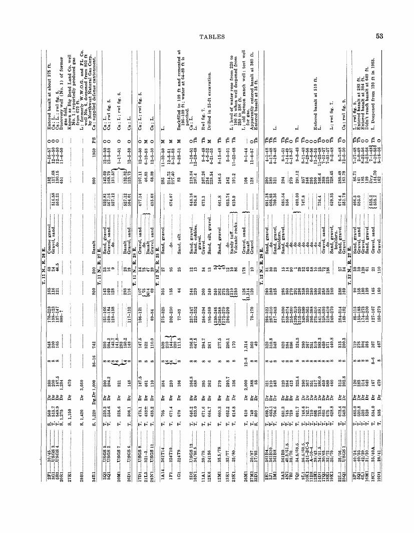
2F
1 .1
0/45
......
. ....
....
3G1.
......
.US
GS
3 .
5B
1
US
GS
4
20R
1 ..
.
..
27
E1
....
......
......
......
......
..
29B
1....
. ....
......
.. ...
......
......
.
34R
1. ..
......
......
......
......
......
2Q1.
......
.US
GS
5.
5Q1.
......
.US
GS
2...
......
..
£U
JM
.l .
... .
UO
lrO
<
.. .
26D
1-.
-.U
SG
S 6
......
.....
17D
1....
....U
SG
S 8
......
.....
29N
1....
....U
SG
S 1
1....
.....
1A
14 3
61T
14...
....
1F
1 ..
224T
10.
...
1G1.
......
.224
T9.
.....
......
...
3D2.
......
.US
GS
13
10N
1.-.
...34
/88.
5.. .
......
...
11A
1....
....3
9/79
......
.. ...
.....
12K
6....
.. ..241S
6
12M
1....
...35
.5/7
8....
......
...
13E
1-...
... 3
2/77
... ..
.... ..
....
23K
1....
... .2
5/8
0
26M
1. ..
......
......
......
......
......
27M
1.. .
.....2
0/87
......
......
...
33D
1...
.....
17/9
3....
......
.....
...
S,
560
...
T,
513.
7...
T
, 54
9.9
...
S, 1
,275
...
S,
1,15
0
... S,
1,4
20
.. S,
1,2
20
.. T
, 52
0.3
.. T
, 55
4.6
T,
525.
6
.. T
, 50
6.1
.. T
, 47
5.1
... T
, 43
3-1-
.. T
, 43
3.2
.. T
, 70
5
.. T
, 67
1.4
... T
, 67
0
.. T
, 64
6.2
.. T
, 63
3.0
.. T
, 67
1.6
.. T
, 66
4.7
.. T
, 66
0.3
... T
, 65
2.2
.. T
, 61
4.8
...
T,
610
... T
, 74
0 ...
S,
800
Dr
Dr
Dr
Dr
Dr
Dr
Dg.
Dr
Dr
Dr
Dr
Dr
Dr
Dr
Dr
Dr
Dr
Dr
Dr
Dr
Dr
Dr
Dr
Dr
Dr
Dr
Dr
Dr
380
200
167.
5 1,
234
670
3,66
0
1,00
0
200
204.
2
321
148
147.
5 46
1 11
0
534
230
106
306.
8 68
8
295
262
279
290.
7 33
6
2,00
038
8 55
8 8 8
36-1
6
8 8(* V u 8 8 8 8 8 \6 I4. 8 8 8 8 6 8 8 8
12-8 8 8
348
200
165
742
200
204.
2 14
3.7
141.8
29
3 15
0.2
148
147.
5 32
2 11
0.0
509
210
) 144 f
23
0 1
111.
5
306.
8 64
7.5
294.
7 26
1
277.
5
290.
1 17
0
1,31
436
0 40
170-
220
108-
123
137-
147
800-
?
151-
166
169-
184
128-
138
117-
132
106-
121
69-8
4
275-
325
202-
230
77-8
3
237-
247
222-
252
264-
294
195-
260
(230
-245
{
262-
268
(272
-279
20
4-29
0
70-1
70
165
116
121
800
143
169
128
293
116
107
( 75
14
14
69 305
135 64 244
220
260
249
240
262
275
259
(210
12
50
( 12
6 U
.314
12
0
T.
11 N
., R
.60
24
46
.5
200
T.
11 N
., R
.25
16
9 28
19T
. 11
N.,
R.
34 75
47
39T
. 12
N.,
R.
27
95
25 12
13 34
13 8 4) 12
10
86 178 10
26 E
.
......
do...
......
......
......
..
Bas
alt.
......
......
......
.27
E.
......
do...
......
......
......
..
Bas
alt.
. ....
......
......
...G
rave
l, sa
nd...
......
.28
E.
......do..... .
......
....
Gra
vel,
san
d... .
25 E
.
......
do...
.... .
......
......
...
San
d, c
obbl
es,
grav
el.
......do..... .
......
.....
San
dy t
uff.
.. ...
......
..V
olca
nic
rock
s....
..
Gra
vel,
sand
... ..
.....
516.
5855
2.21
522.
8156
7.16
527.
12
527.
1250
4.01
477.
14
435.
68
674.
07
648.
1663
4.8
673.
3
661.
8
653.
74}
615.
9
)_ ....
.......
182
8-16
-57
117.
68
12-5
-50
130.
15
12-5
-50
451
11-6
-50
800
1959
142.
69
12-5
-50
168.
79
12-5
-50
131.
531
>
1-
17-5
1
132.
32J
123.
73
12-5
-50
107.
11
12-5
-50
46.8
3 6-
10-5
3 68
.89
12-5
-50
285
11-3
0-50
214.
75
12-5
-51
217.
40
5-15
-53
83
9-28
-51
219.
34
1-16
-51
207.
4 12
-20-
48
267.
26
9-8-
48
234
4-5-
52
223.
54
4-21
-53
246.
5 8-
15-4
8
242
5-5-
51
191.
2 11
-22-
48
106
9-1-
44
128
11-4
-57
O
O
O PS O
O O
0 0 M
O M
M
M O Th
Th
M Th
Th
Th
O Th
Ente
red b
asal
t at
about
375
ft.
Ca
; L
. C
a ;
L.
; rw
l fi
g. 5
. D
isco
very
wel
l (N
o. 1
) of
form
er
gas
fiel
d.
Kno
wn
as B
ig B
end
Lan
d C
o. w
ell
No.
1 ;
report
edly
pro
duce
d ga
s fr
om
670
ft.
L
; fo
rmer
ly
W.W
.O.G
. an
d
PL
C
o.
wel
l N
o. 6
, de
epen
ed f
rom
803
ft
by N
ort
hw
est
Nat
ura
l G
as C
orp.
C
a ;
supp
lied
def
ense
can
ton
men
t.
Ca
; L
. C
a ;
rwl
fig.
5.
Ca
; L
; rw
l fi
g. 6
.
Ca;
L.
Ca
; L
; rw
l fi
g. 5
.
Ca;
L.
L.
Bac
kfil
led
to
109
ft a
nd c
emen
ted
at
106-
109
ft ;
wat
er a
t 64
-89
ft i
s pe
rche
d.
Ca;
L.
L.
Rw
l fi
g. 7
. D
rill
ed i
n 25
-ft
exca
vat
ion.
L ;
leve
l of
wat
er r
ose
fro
m 2
20 t
o 19
0 ft
whe
n w
ell
deep
ened
fro
m
250
to 3
36 f
t.
L ;
old
Ben
son
ranch
w
ell
; te
st
wel
l fo
r ga
s.
Appar
entl
y e
nte
red b
asal
t at
360
ft.
E
nte
red b
asal
t at
35
ft.
T.
12 N
., R
. 26
E.
2E
1
..361B
4
2J
1....
.....3
61B
10..
......
. ....
2M1.
......
.361
B8.
......
......
..
3A3.
......
.361
B9.
. ....
......
. ..4N
1....
... .4
0.3/
61.5
......
. ...
7B1.
......
.38/
70..
......
......
..7Q
1....
.... 3
4.5
/69.5
9L
1 ..
36.5
/60.
5
10K
1 .2
41-B
C-5
.
11B
8....
....A
-10-
4...
......
...12
H1.
......
.38/
43...
.....
.....
.. 14D
1 3
4/5
1.5
17Q
1....
. ...
30/6
5...
......
......
18
E1.
......
.32/
72. .
......
......
.. 19K
1 2
5/7
0
22L
1. ..
.....
25/5
6....
.. ...
......
25
Q1.
......
.US
GS
1...
......
..
3P1.
......
.40/
24...
......
......
5Q
1....
.... 4
0/35
......
......
...
6L1.
.....
..42/
39...
.. ...
.....
.. 1
6M
1
.31/3
0
18C
1
35/4
0A
19D
1....
....2
8/41
......
......
...
... T
, 68
9.7
.. T
, 66
5.1
... T
, 70
4.6
... T
, 68
1.3
.. T
, 74
5 ...
T,
720
.. T
, 69
1.7
.. T
, 74
6.6
.. T
, 74
2.7
... T
, 71
0..
T,
685
.. T
, 73
3.2
... T
, 66
5 ...
T
, 67
5 ...
T,
628.
8
...
T,
673.
4 ...
T
, 54
9.2
.. T
, 46
5.0
.. T
, 53
0.8
.. T
, 53
0 ..
T,
520
.. T
, 53
5
Dr
Dr
Dr
Dr
Dr
Dr
Dr
Dr
Dr
Dr
Dr
Dr
Dr
Dr
Dr
Dr
Dr
Dr
Dr
Dr
Dr
Dr
Dr
321
310
348
320
384
413
325.
439
0 36
7 35
1 51
7 38
6.0
450
580
460
315
202.
8
120
283
314
640
167
470
8 6 8 6 8 8 8 8 8 8 8 8 8 8 8 8 8 8 8 8 8 8-6 8
320
310.
8 34
8
320
384
386
324.
339
0 36
7 35
1 51
0 38
3.3
450
571
440.
8
315
200.
3
119
276
304
595
167
467
295-
321
287-
310
317-
343
278-
300
359-
374
255-
380
(295
-310
13
15-3
20
348-
389
330-
365
295-
398
275-
310
341-
381
258-
330
210-
410
240-
270
284-
314
169-
182
85-1
15
155-
185
174-
273
135-
200
127-
167
150-
270
290
280
325
295
360
270
291
296
358
320
290
300
360
258
226
240
288
169 90
15
5 18
0 13
914
5 16
0
31
30
23 15
14
90 1 29
32
45
58
10
25
72
186 27
34
T.
12 N
., R
.30
30
12
0 61 21
110
......do. ..
......
.S
and,
gra
vel,
bo
ulde
rs.
......do... .
......
.....
......do..... ...
......
do...
.... .
......
.
......do. .
......
.....
.........do....... ..
......
.....
... d
o..... .
......
.....
.. d
o.-
..--.
-..
..d
o ..
......do............ ...
do .
......
..S
and,
gra
vel,
bo
ulde
rs.
Gra
vel..
. ....
... ..
.....
....
27 E
.
Gra
vel.
.. .
......
....
691.
1866
5.93
709.
36
685.
5435
6
] 69
3.00
747.
8
734.
4
629.
35
674.
455
1.78
466.
553
5.0
( 53
5.2
1 53
5.7
290
4-1-
48
280
5-17
-48
321
4-19
-48
294
8-1-
51
......
....
1-14
-49
270
6-18
-57
291.
12
9-8-
4835
7 8-
11-4
8 34
6 8-
29-5
6 29
5 6-
6-56
30
0 11
-3-5
5 34
6.4
11-2
2-48
26
8 7-
11-5
7 22
5 7-
31-5
7 22
8.45
9-
2-48
285.
49
8-7-
48
161.
79
12-5
-50
86.7
1 7-
17-4
8 14
1 2-
9-49
18
5 8-
22-5
6 13
9 2-
23-5
6 D
ry
7-1-
481
144.
70
6-1
0-53
J 16
2 5-
16-5
6
Th
Th
Th
Th
Th
O Th
Th
O
O
O
Th
O
O
Th
Th
O Th
Th
O
O Th O
L.
L.
Ente
red b
asal
t at
510
ft.
L
.
L ;
rwl
fig.
7.
Ca
; rw
l fi
g. 9
.
L ;
rwl
fig.
9.
Ente
red b
asal
t at
283
ft.
E
nte
red b
asal
t at
304
ft.
D
idn't
reac
h bas
alt
at 6
40 f
t.L
. D
eepe
ned
from
130
ft
in 1
953.
W f
M
CO OX
CO

TAB
LE 1
. D
ata
on W
ells
of
the
Hanfo
rd R
ese
rvati
on C
onti
nued
Or
d co
O
co
Wel
l N
o. to .2
1 01 "2"
0
u 3°
Cas
ing
C8
0)>,
£ 1-s !H S
otS !
'S <H O
01 ft
"8
£ JS "a
Q
01 t, V 5
o
J5 | 'oS ^
"£ *
Q
>
K
s £
'" £ ju,a
01
^ -
+J
CS
0 $h
£8*
^Q
Wat
er-b
eari
ng z
one
or z
ones
(3-g
<H
O U
HI
tj a
O
"8 01
<H O
01
B
Wat
er l
evel
0 1 01
01
Dat
eU
seR
emar
ks
T.
12 N
., R
. 27
E. C
onti
nued
20P1
....
27J1
-.
33Q
1....
6A1.
..18
D1.
...
24N
1...
31H
1...
.....2
5/3
5. .
.....2
0/2
0 .
......
.. ....14/2
7
..... U
SG
S 1
0....
......
.
TT
QflQ
Q
T,
T,
T,
T,
T,
T,
T,
528.
7 50
3.5
515
407
497.
543
0
433.
2
Dr
Dr
Dr
Dg
Dr
Dr
Dr
165.
5 15
8 35
0 68
176
755
105
8 8 8 60 8 12 8
164.
5 15
6.5
346
164.
0
105
144-
164
130-
155
120-
135
57-7
2
141
130
130
117
(65
(93
23.5
28
20
T.
12 N
., R
.
16 12
12
......do .
......
....
...do
......
......
......
......
.
28 E
.
San
d, s
ilt,
gra
vel
-
San
d, g
rave
l....
......
.)S
and,
sil
t, g
rave
l...}
531.
22
505.
07
407.
5 50
0.03
434.
7
134.
5 12
0.57
13
1 65.3
4 12
8.34
(1
9 11
9 61.9
8
8-12
-48
7-28
-48
4-12
-56
3-16
-43
12-5
-50
1921
) 19
40}
12-5
-50
Th
Th
O D
O
D O
L ;
rwl
fig.
9.
Bas
alt
not
reac
hed.
Wel
l N
o. 5
3 of
Jen
kin
s (1
922)
. C
a ;
L ;
rwl
fig.
5.
L ;
old
Stu
bble
fiel
d w
ell
nea
r R
ingo
ld
Sch
ool.
Ca;
L.
T.
13 N
., R
. 25
E.
1N2.
..
5P
1
7M1.
..7Q
1....
11A
3...
11J3
....
12P1
....
14N
1...
16J1
...,
23A
2....
25
R1
26N
1...
27C
1....
30
G1-
.
33D
1...
36D
1....
1A1.
..
1G
1
2N1.
.. 3B
1..
5D2.
..
701.
...
13R
1...
13R
2...
14C
1-.
17Q
1...
18C
1...
19R
1...
20Q
1...
21B
1...
21Q
1....
.....1
07B
-2...
......
......
.... G
44
7..
.
.
.... R
RY
C/D
2W...
..
.....1
08B
3....
.... .
......
.....
..105
-0-1
......
.....
.....
.Rob
inso
n R
anch
.
.....6
2.5
/90 .
..... 6
0/8
0B
.. .
...
51/75 .
.....5
0/8
4.
. 5
5/8
8.5
....U
SE
D(L
-6).
...
....
.49
-79
...
..... S
1610 .
......
......
....
74/4
4.... ...
.....7
1/52
......
......
......
7
7/5
4
......
...
..... 1
00K
-10 .
......
..
7
0-6
8
.....
......
. ...
..Gab
le M
tn.
Rl
.....G
able
Mtn
. R
2
.....6
5/50
......
......
.....
.....6
1/65
......
......
.....
R
anch
13.
......
....
....
.55/7
0
.....2
00N
D3W
......
...
.....6
0/60
......
......
.....
.....2
00N
D5W
... ..
....
T,
T,
T,
T,
T,
T,
T,
T,
T,
T,
T,
T,
T,
T,
S, T,
T,
T,
T,
T,
T,
T,
T,
T,
T,
S,
T,
T,
T,
T,
T,
T,
420.
3
436
461
450
461.
8
460
476.
5 49
0.8
580
510
580.
6 63
8 73
0 60
7 83
1
800
687.
5
441
440
520
475
464.
6
526.
3 43
0.1
419.
7
465.
3 53
0 53
3 56
7.9
577.
6
508.
5
570.
5
Dr
Dr
Dg
Dg
Dr
Dr
Dr
Dg
Dr
Dr
Dr
Dr
Dr
Dr
Dr
Dr
Dr
Dg
Dr
Dr
Dr
Dr
Dr
Dr
Dr
Dr
Dr
{Dg
\Dr
Dr
Dr
Dr
Dr
790 52 69
93
128.
5
91
119
100
111
253
198
382
600
235
1,11
0
540
290 44 150
210
150
170.
5
149 72 68 585
225 60
) 21
6}
205
146
128
288
8 (I)
42 8 12 8 8 72 12 8 8 8 8 8 8 6 8 72
8 8 8 12 8 8 12 8 8 12 8 (2
0)
116} 8
{24
114
650 52 128 90 117
237.
9 18
1 37
7 58
5 23
4.4
266.
8
150
204
150
170
149 72 68 583
216
216
200.
5
126 10
) 28
8}
95-1
25
70-9
0 90
-117
115-
147
192-
222
17-6
7 12
0-16
0 70
-120
(1
26-1
31
{13
7-13
9 (1
54-1
64
126-
147
55-6
5
33-6
3
( 55
-85
) 11
00-1
25}
115-
160
182-
200
230-
285
(764
(7
85 62 70
93 116
190
205
295
200
700
392
265 58
12
9 80
126
137
154
127 54 33 100
125
181
(110
11
23 230
5 5 31 21
25+
122 8 30
55
25
41
0 26
25T
. 13
N.,
R.
9 31
40 5 2 10
22
11 30 25
25 19 4 3 55
Bas
alt.
......
..
...
..)
San
dsto
ne...
. ....
.... .
..J
......d
o .
......
......
......
. .
do
......
.. ...
....
......
do...
... ..
..... .
......
....
26 E
.
......
do...
......
......
... ..
....
.G
rave
l )
......
do...
......
......
......
. ..[
....
..d
o
......
.)
......
do...
.... .
......
......
....
.
Sand .
......
.....
......
.IS
and,
gra
vel..
......
...}
......
do...
... ..
.....
433.
0 46
1
461.
16
511.
9 58
2.6
607.
80
827
688.
6
441.
37
466.
1
432.
08
420.
21
540.
36
569.
1
511.
29
571.
34
41 39.3
756
.94
62
72.9
66.2
6 68
D
ry
Dry
112.
44
179.
96
206
297
190.
38
+19
2
365
267.
0
34.7
7
58.1
5 13
3 80 76.1
126 39
.15
32.9
0
70
126
148.
28
168.
1 D
ry
116.
66
179.
07
9-21
-53
5-15
-53
5-15
-53
12-1
7-52
1-
26-4
4
3-10
-49
7-10
-52
3-15
-51
10-1
-43
11-1
2-48
9-
2-48
10
-4-5
7 10
-21-
57
11-2
6-48
11
-28-
51
4-1-
43
7-10
-48
10-7
-44
5-15
-57
7-22
-54
5-24
-57
8-4-
52
7-6-
54
1-8-
53
3-29
-54
8-12
-55
6-16
-55
3-15
-43
7-10
-48
5-1-
44
12-1
3-52
8-16
-44
M O O
D Ind
Th
M
O Th
Th
Th
Th
Th
Th
Irr
Th
O O O
O
O PS
O o Th
Th
Th
O
Th
Th
Th
Ind
Ca
; L
.
Old
far
m w
ell.
Wel
l N
o. 5
3 of
Jen
kin
s (1
922)
. C
a; w
ell
at m
ilit
ary c
amp
. P
um
ped
at
540
gpm
wit
h d
d of
0.
60 f
t.
Rw
l fi
g. 4
. D
rill
ed i
n cr
ib e
xca
vat
ion
. M
ay b
e w
ell
No.
170
of
Jen
kin
s (1
922)
.
L.
L.
Ente
red b
asal
t at
376
ft.
E
nte
red b
asal
t at
585
ft.
Ca
; L
; fl
ow 1
,375
gpm
on
3-7-
43 ;
tem
p
of
wat
er
79 °
F ;
east
ern
mo
st
of 6
art
esia
n w
ells
in
upper
C
old
Cre
ek v
alle
y.
L ;
wel
l no
w 3
34 f
t de
ep w
ith
up
per
mo
st
2 ca
sing j
oin
ts
brok
en.
L.
Wel
l N
o. 7
4 of
Jen
kin
s (1
922)
. C
aved
in.
Did
not
reac
h b
asal
t.
Ca
; L
; te
sted
at
560
gpm
wit
h
50 f
t dd
.
Wat
er l
evel
did
not
mov
e w
hen
13R
2 pu
mpe
d.
Ca
; T
est
pum
ped
for
per
mea
bil
ity
det
erm
inat
ion
s ;
loca
ted
400
ft
nort
h o
f 13
R1.
Ente
red b
asal
t at
578
ft.
Ente
red b
asal
t at
220
ft.
R
wl.
fig.
4.
Wel
l N
o.
169
of J
enk
ins
(192
2).
L ;
rwl
fig.
7.
Cas
ing
pull
ed.
Rw
l ;
fig.
4.
Dd
1 ft
aft
er 2
6.5
hr
pum
pin
g a
t 1,
280
gpm
; te
mp o
f w
ater
62°
F.
25 *l O
»
O cc
M O
25 O M
25
M O
O O
25 O
25

25A
1...
26B
1...
26B
2...
28B
1...
31R
1...
33K
1...
34
J11
..
34J1
4..
34R
20.
35R
1...
36R
1...
3G1.
..
5B1.
...7G
1....
8B1.
..9K
1...
10B
1....
13N
1...
15L
2...
16G
1....
16R
1...
17J1
....
21L
1....
23R
2...
25L
3...
26F
1...
26L
4...
28P
1...
30H
1...
32K
1...
35G
1...
35N
1...
36G
2...
36G
7...
31F
2...
1D1.
..
21B
1...
28E
1...
31N
1..
....5
4.5/
42.5
......
.....
....5
5/50
......
......
......
..
..5
5/5
0-2
....
....
....
..
....2
00N
D1W
......
......
.45/
69.5
......
......
...
....4
7.5/
60.5
......
.....
....2
41B
Y2.
......
......
.
....2
41B
5....
......
......
. ...
-361
B11
......
......
...
....
'KR
^. ..
......
......
..
....C
C13
3....
......
......
....S
1683
. ....
......
.... .
.
....H
illm
an-
US
ED
.
....P
isto
l R
ang
e....
....H
D7W
......
......
...
....H
D2W
......
......
......
.HD
8W...
......
......
....H
D24
W...
......
....
.... 5
0/30
......
.... .
......
....4
6/34
......
......
......
..
..H
D2
2T
H..
....
....
....
..45/
20...
......
......
...
....H
D16
W...
.. ...
... ..
....
HD
20
TH
....
....
...
....4
10-2
......
......
.....
....P
SN
525.
......
......
.....P
SN
515.
......
......
T,
T,
T,
T,
T,
T,
T,
T,
T,
T,
T,
T,
T,
T,
T,
T,
T,
T,
T,
T,
T,
T,
T,
T,
T,
T,
T,
T,
T,
T,
T,
T,
T,
T,
T,
T,
T,
T,
T,
509.
7
441.
3 44
0
569.
8 71
8.2
650.
3
647.
962
0 63
3.8
616
576.
1
376.
5
394.
5 42
0 39
7
391
400
420
394.
1
405
405
434.
23
414.
2
383.
4
392.
0 38
2.0
408.
9
526.
7
530
473
429.
2 52
1.5
411.
9
410.
1
382.
1
659.
0
637
860
774
Dr
Dr
Dr
Dr
Dr
Dr
Dr
Dr
Dr
Dr
Dr
Dr
Dg
D
g
Dg
Dg
D
g
Dr
Dr
Dr
Dr
Dg
D?|
Dr
Dr
Dr
Dr
Dr
Dr
Dr
Dr
Dr
Dr
Dr
Dr
Dr
Dr
Dr
Dr
210
108 98 233
368
285
275
415
258
248
195 50 19
25
24.5
39
37.7
607
110 84
363 74
.5
68 41.7
100 57 140
380
970
107 83
337 92 102 45 938
522
648
699
8 20
2.2
8 10
1 12
85
12
132.
21
10
233
J 8
368
8 27
8
8 26
48
232
8 23
08
229
8 18
6.5
6 36
24
......
......
36
......
......
10
......
......
241
30 J
--
»
48
...
......
...
8 30
3
8 10
0
8 83
6
215
60
......
......
12
67
24
38
12
100
24
60
16
122
8 37
3.5
6 13
9 )
4.5
139-
702}
- 3.
5 702-8
41)
8 10
2 6
83
8 33
3 20
90
6 92
2 33
20 )
16
I12
1
g94
10 f
89
48
I6
'
24
0-1
75
120
0-
520
J 24
120
}
36
0-3
7
24
0-30
7 16
0-
699
(140-1
45)
{ 18
0-18
5 >
(195-2
00)
70-1
00
190-
230
336-
366
269-
277
252-
262
204-
220
217-
227
( 60
-160
j
185-
280
94-1
00
65-7
4
50-6
5
25-3
5
(22
-45
1
t 67
-90
J 30
-50
50-9
0
191-
221
55-8
0
76-8
8
18-3
3
( 49
2-50
3 )
j 55
0-56
0 >
( 59
3-60
0 )
429-
437
512-
516
670-
678
128 60
40
180
338
270
(264
(265
204
(150
(22
2
189 62 312
/34
j 44
)
55
I 79
53
(
44
(120 47
20 35
15 45 {177
191
300
374 75 160 47 19 18 {224
625
895
934
342
547
429
512
672
12 35
45 53
27 8 1 10 16
72
18
6
T.
13 N
., R
.
48 295 2 8 11
24
22
30
11 21 18 65
45 49
3 89
20 6 27 40
42 73T
. 13
N.,
R.
15T
. 14
N.,
R.
2 5 5 1
30 22 11 4 2
......
do...
......
......
......
...
......
do...
......
......
......
...
San
d..
....
....
....
....
....
...)
Gra
vel
, sa
nd...........
1
27 E
.
»
......
do...
......
......
......
... I
......d
o......
........
........
...r...
...do
......
......
......
......
7
San
d,
gra
vel
....
....
...
I
......
do...
......
......
......
...
San
d,
silt
......
......
.....
......
do...
......
......
......
...
San
d....
......
......
......
... }
San
d,
gra
vel
....
....
...
I S
and.
......
......
......
......
1
Bas
alt.
....
....
....
....
....
../
......
do...
......
......
......
...
.
Gra
vel
, sa
nd,
bo
uld
ers.
S
and
, gra
vel
... .
.....
..28
E.
San
d,
gra
vel
...........
25 E
.
Bas
alt.
......
......
......
....
I
"Rock
" /
......
do...
......
......
......
...
.
......
do...
......
......
......
...)
......
do...
......
......
......
...}-
.
......
do...
......
......
......
...)
511.
3
442.
6
569.
84
719.
2
649.
0
649.
92
635.
3
616.
85
577.
10
376.
48
395.
0
399.
5 39
1.0
400.
0
396.
3
434.
23
414.
20
384.
32
394.
97
382.
30
409.
90
528.
80
429.
26
411.
40
410.
35
386.
65
118.
38
47.6
7 40 13
0.0
319.
9 (2
57.6
4 (2
55.1
2
257
227
241.
722
6.7
(180
11
73.5
4
18.2
20
.0
17.8
9
24.2
7 30
.48
47.3
2
31 53
44 69.3
4
50.3
5
20.5
32.0
15
.23
45.8
4
160
150 80
82
.62
162 47
.73
48.1
2
17.8
3
195
235
370
12
-13
-52
12
-13
-52
9-2
8-5
6
10
-28
-43
7-1
0-4
8
7-2
0-4
81
1
2-1
6-5
2 J
7-2
0-4
9
9-2
1-5
3
1-2
7-5
311-4
-48
6-2
3-4
8 1
3
-12
-53
J
11
-18
-52
7-1
0-5
3
3-1
5-4
3
11
-15
-52
1
1-1
5-5
2
8-2
8-5
0
9-1
-44
11
-17
-52
4-1
-43
3-1
6-4
3
3-2
4-4
4
9-1
8-4
3
5-3
1-4
4
10
-25
-43
5-3
1-4
4
6-2
9-4
8
1923
8-2
4-5
5
4-2
-49
9-2
2-5
5
3-2
0-4
4
3-2
1-4
4
7-3
-43
5-1
-52
5-4
-53
3-1
7-5
3
Th
Th
T
h
Th
Th
T
h
Th
M
Th
M
Th
Th
O
O
D O
O N Th
D N O
O PS
PS
PS
Th
D O Th
O
P
S
O O D PS
PS
PS
L.
Bas
alt
at
98 f
t ;
scre
en se
t 3
8-8
5 f
t ;
test
pum
ped
an
d d
ism
antl
ed.
Dd
2 ft
aft
er
pum
pin
g a
t 56
5 gpm
; te
mp o
f w
ate
r 58-6
0°F
.
L.
Bas
alt
found a
t 24
7 ft
.
L ;
rwl
fig.
8.
Dri
lled
by
Ran
ney
Wat
er C
oll
ecto
r C
o. ;
slo
t-p
erfo
rate
d c
asin
g s
et ;
test
pum
ped
at
60 g
pm
. W
ell
No
. 70
of
Jen
kin
s (1
922).
W
ell
No
. 66
of
Jenkin
s (1
922).
F
orm
er f
arm
wel
l.W
ell
No
. 63
of
Jenkin
s (1
92
2).
L ;
dd 1
40 f
t aft
er
pum
pin
g a
t 75
gpm
; k
no
wn
as
Fost
er R
anch
w
ell
; o
lder
, sh
allo
wer
wel
l n
earb
y.
Bac
kfi
lled
wit
h g
rav
el t
o d
epth
of
100
ft.
Ca
; fo
rmer
arm
y-c
amp
wel
l.
L ;
casi
ng
pu
lled
and w
ell
des
tro
yed
.
Rw
l fi
g. 4
; w
ell
No
. 60
of
Jenkin
s (1
922).
D
ug 4
7 ft
, d
rill
ed t
o 6
8 ft
; dd
2 f
t aft
er
pum
pin
g 1
hr
at
500
gpm
. D
d 2.
0 ft
aft
er
9 h
r pum
pin
g a
t 1,
100
gpm
; ol
d H
anfo
rd h
igh
scho
ol w
ell.
Cas
ing
pull
ed.
Dd
abo
ut
10 ft
aft
er
6 h
r pum
pin
g
at
1,08
0 gpm
; te
mp
of
wat
er 5
9°F
. D
d 0.
3 ft
aft
er
27 h
r pum
pin
g a
t 1,
500
gp
m ;
tem
p o
f w
ate
r 68°F
.
L ;
rwl
fig.
8 ;
wat
er i
n d
iffe
rent
stra
ta
has
sl
ightl
y dif
fere
nt
stati
c
leve
ls.
Fo
rmer
Hay
nes
sto
ck w
ell.
En
tere
d b
asa
lt a
t 10
2 ft
.
Dd
0.7
ft a
fter
12 h
rs p
um
pin
g a
t 75
0 gpm
; te
mp
of
wat
er 5
8°F
.
Ca
; lo
g publi
shed
by
Wal
ters
an
d
Gro
lier
(1
960,
p.
394)
; d
d 7
f t
aft
er
9 hr
pum
pin
g 1
00 g
pm
; te
mp
of
wat
er 7
8 °F
.
Ca
; lo
g p
ubli
shed
by
Wal
ters
an
d
Gro
lier
(1
960,
p.
39
4).
Lo
g p
ub
lish
ed b
y W
alte
rs a
nd
G
roli
er
(196
0, p
. 395).
Ca
; lo
g
pu
bli
shed
by
W
alte
rs
and
G
roli
er
(196
0, p
. 395).
ta
r H
CO

56 HANFORD RESERVATION, U.S. ATOMIC ENERGY COMMISSION, WASHINGTON
3U3
Hj
33
i3i
S0a^H
3
S ?3 (
0^
^
-*
Oo^ i>
o ^5
335
H
3J 0 if^H
M «
§«
0)to
"3
«
S^^
0)"ca
Q
<JJff MOT9q ?l99.hf
V
oearing z
zones
' 0
J->ca^
M
aO
JO J9}3BJBI13
, ,
^SUMOITJ Tn -HJj
(!J99J )
do} O} md9Q
PUB[ Avopq }aaj)|BAJ9^UI p91BJOJJ9 <T
(aoBjjnspuB|; Avopq ^99J)
lUdaa
(S3lJDUt) J9}3UIBI(J
(^^J) ^I^Q-^CE
npMjo^m
(^aaj) gpn^njBPUB AijdBjSodojL
6
"3
"O^J 9OU1Q
SUOl^BJddO P-tOJUBJT
ON SDSII
to'IM
PSr%
3_
+j _c" -3
-P h>S >H
1 &
c 3 N01 -«O (1) Mi-1
W PH
EHEHOO fc
IMIM
C
1 « g g -» S° -S * 3 to g
^ §
IMIMO1-1
111 of Jenkins
s i i i.i i«JPH ^
O O OHfcOQ
CO CO N CO COCO C"- N N CO C"- CO TjlTjILOlO ^"LO LO LOLOLOLOTJI
C-IMIMCO LOCO * t-OSt-«OLO
LO LO CO i-l CO rl -A rtCOIN1 l
LO CO
tOOS TJI TflM OO 00 OO IO IO IM CQ
LO OO tO LO LOrHLOlM iH
: IM
: ^tJ
i^1"*
"Z \cd ' bt :
"c"^^
C3 \ W i
LO
iH T-l t-
Tjl IMiH
to tocoi-l tO
t-
LOCO
LOt-OO «cooo
LOO «*
5
0
t»
1
to to to o ctO <£
IM i-l 00
CO C CO tO 00^ ^ N N t"
TJa!
M
n w
oLO
OLO
/_^s0
OO
LO LOco to
oLO
tC2
M
iHn w
IM
CQto
<!I?"
c^to coc-co
.
6 6 -q-q
COCO
t-00
oIM
OOO
C"T <=
c-
IMOLOotoco
iH rt r-
00 00 00 tOC-^ i-
rH
OOOto
LOO LOT* O
t-LOOi-H t-c-e-oo TJI e>
LO o to i^- aTjl LO (MO 1C
i-l iH »-
otoLOCO1-1
hbbu MM >« Mt, t< h M QQQQ QQ Q QQQQQ
IM
OOiHOO IfOOO^l1 i-l C
IO O LO TfCO IO r-l ,-1 t£
> O iH>c-co
HHHH HH H HHHHH
c4t-Q
S *1
- c> co :
u: to O Q
Si Ua' i Q
- ' '
IMto
OOt-
!iH -^ -^t Tf ^* IO IO IO rH N CO tC r-li-li-IIM CJN OJ IMCOCOCOCO
w
»J
z3, "
^C ..£a ^ p, ,jM S ft =>fc,^- g 3 0Dto 2 M -fl*3 o rl .-scs«> g S
fe- i «** ?
^S 5g «^M -gj-s_3 ft S&jg^TS« . -» 2 l.g-3X o . 3 5 «^S o'SB-s^ §- gijsg^a & o^SgS M-S! -? fe^ aj <ii-I 2a^*s -o ^g-s^-s
JO ^fe ^
O O £ OO O
IM IM CO 00 IMCO CO
C- i-l OO t-CJ IM IM 1 r-l I i-l 1 1
1 LO | tO 1 IM IMCO rt i-l1-1 1-1
oo to ^i isO LO CO OO OO 00
coco
C- LOC\I ^
C- C5i-l IMTjl Tjl
ca
"> la ^ ^ ca O CQ
OOtO IMi-l i-l IM
O LO O CO ^ LO OO C~
COCO CO
CO
LO OIM t-
co
OO i-l
t-: co «oLO tO O
0
CO1-1
CO CO
to to OtOIMOOOOOOO t£
1-^.-*--
OO LT
LO to to ojos trt-OO O TJICO LT
CO CO C<3
iH
Q Q Q QQ C
CO OO O O O t-O rH tO i-li-l 1-
H H H HH t-
LC
- e> Stl fat ^ ^ P Mo o if
-OO OO T* OO O i-l rH CJ IMCO CO
101-1
cato
SlO
If-14J *i«H ..
to ft
Q
A
oCO
cs
«T 1
«
«LO
-*o
"3
2M
13
ca w
toCO
«*
to
2
oLO
to
COLO
Q
T 1
IMo
EH
^t>
QCQ
^I_J
CO
aa"c
"H^_N
K
zrt
H
>>01
1"o
>.BoB-i^> o tH '30^3 60 9)
0 C -^ 0 3"
2^ o
O HO S S
to coto co coLO ^LO ,0 LO
LO i-ICO LO OO
"7 to7 T "T00 OO IO IM
toIM
00 OLO -V LOi-l COCO CO CO
i-l 0
00 IM*O i 1 * *
- "2 "3Q> C >> ca c3C3 M t.
K ^- »
S O w
O t Tf O t rH iH CO l-( N
O IMLOLOCOCO * COIM t-
~^J>~~*OO i-l OLO
LOO-** O LO O O
o^i 1111IMC-CO LoiMoote-^v-i "*
tO i-l O LO
1-1 »H 1-1 »H
00 IMOO OO OO
O IM i-l O LOLO tOO O iHT-l i-l iH iH
Q QQ Q Qt- t-
1O CO CJ
1O CO1O rH OO OO i-l r-
H HH EH EH
rH «i CX rH
ci, tti S S
« c> o -« Qfc O SC4 CO CO CO CO CO COCO CO CO
Ht-
PS!
z10
^
*fe3 o fl *o3 a 'ft'T c
Bl l?si
Hjiifl
J O
yja< Q
O IMOO LO LO1O
i S?o 1 to
LO
i-! 1-1 o(M C^N
T?
* i i
ca i iCQ i :
tooLO rH
TJ1TJ1
s§
/ , ^CO C IO ^* ^ C> O LO "^ IO.- rt(N(NCO
00otoiM :
O (MrH 1-1 :
o -*T 1 1 1
Z! *°
Q Q
t
o t-CO OSt- to
EH EH
ooLO
i-i IM
M *CO CO

TABLES 57
TABLE 2. Logs of type wells on the Hanford Reservation[Stratigraphic designations by R. C. Newcomb]
Materials Thickness Depth (feet) (feet)
9/2&-5C1 [City of West Richland. Driller's log]
Alluvium:Sand and top soil.........................-......-. ...... 8
Glaciofluviatile and fluviatile deposits(mostly) :
Sand, gravel, and boulders, water-bearing 50Ringold Formation:
Clay, blue.......................................................... 17Sand gravel, and boulders, water-bearing 7 Sand and Clay, water-bearing...................... 8Sand, blue........ ............................................. 4Gravel and boulders, water-bearing.......... 9Clay, brown...................................................... 18Sand and gravel, water-bearing................ 4Clay.................................................................... 46Sand, loose...................................................... 2
Basalt of the Columbia River Group:Basalt, porous, black, water-bearing.......... 8Basalt, hard, dark........................................:. 3Basalt, porous, water-bearing...................... 4Basalt, hard, dark.......................................... 3Lava rock, "burned"...................................... 6Basalt, hard, gray.......................................... 3Basalt, porous, water-bearing.................... 5Basalt, hard, gray.......................................... 76Clay, gray-green............................................ 59Basalt, hard, gray.......................................... 150Clay, gray-green............................................ 35Basalt, medium-hard, gray.... . . ... 5Clay, gray-green............................................ 10Basalt, gray.................................................... 32
58
75829094
103121125171173
181184188191197200205281340490525530540572
9/2&-15J1 [City of Richland. Drilled and recorded by A. A. Durand & Son, 1943]
Alluvium:Sand, fine....................................................... 18 18
Glaciofluviatile and fluviatile deposits (?) :Silt and clay..................... .......................... 10 28Sand and gravel............................................ 4 32Gravel, coarse.................................................. 2 34Sand......... .................................................... 7 41Sand, coarse, and gravel.............................. 4 45Sand, fine, and coarse gravel...................... 16 61Gravel and boulders...................................... 9 70
Ringold (?) Formation:Clay . ........ . ...... _. ... . .... 2 72
10/2&-10G1[Drilling, sampling, and Stratigraphic designations of samples by U.S.
Geol. Survey. Leveling and altitude data by Gen. Elec. Co.]
Alluvium:Sand, silty; about 40 percent quartz and
60 percent basalt; angular to subangu- lar; poorly sorted mostly coarse to fine sand with some %- to xA-in. diam eter gravel and a few boulders; some artificial fill in places................................ 3 3
Materials Thickness Depth (feet) (feet)
Glaciofluviatile and fluviatile deposits:Gravel, sandy and bo.uldery; contains a
small amount of silt; basalt predomi nates in the gravel and coarse sand and makes up 80 percent of the finer sand; sand is angular to subangular, and gravel is subrounded to subrounded...... 12 15
Gravel, sandy and slightly silty; pebbles, averaging 1 to 3 in. in diameter, are subrounded to subangular, about 40 per cent basalt and 60 percent exotic types; material is about 40 percent gravel, -55 percent medium to very fine sand, and 15 percent silt.............................................. 6 21
Gravel, sandy; gravel forms 60 percent of sample, sand 25 percent, and silt 15 percent; ratio of basalt to exotic types in gravel is about 65 percent-35 per cent; sand is about 55 percent basalt and 45 percent exotics and quartz; gravel is subangular to subrounded and has 3-in. maximum diameter and 1-in. average diameter........................................ 4 25
Gravel, coarse to fine, and coarse sand; maximum diameter of gravel 4 in., average diameter 2 in.; pebbles form about 80 percent of bed; basalt com ponent of pebble gravel about 40 per cent at 30-ft depth, decreasing gradu ally to 20 percent at 50-ft depth; basalt in coarse to medium sand decreases gradually from 30 percent at 30-ft depth to 5 percent at 50-ft depth; al most no silt present. ................................ 25 50
Ringold Formation:Gravel; mostly exotic rock types; fine to
coarse from *4 to 6 in. in diameter, although mainly pebbles with occasional cobbles, in a medium clean micaceous, quartzose sand matrix; upper 10 ft of this gravel is highly calcareous and gives strong reaction to acid; sand content increases to 55 percent of sample in 57- to 60-ft zone, remainder being gravel.... 13 63
Gravel, exotic-type, subrounded to suban gular; has thin silt and clay zones in bottom foot of bed......... ........................ 4 67
Clay, light-tan; contains a few %-in.angular pebbles.......................................... 5 72
Clay, light-tan, finely micaceous, slightlysilty. ........................................................ 9 81
Clay, light-tan, slightly silty; has a few KG- to ^4-in. diameter rounded to sub- rounded indurated claystone nodules...... 3 84
Gravel, granule and pebble, in a silty clay matrix; approximate percentages: gran ule gravel, 75; pebble gravel, 15; silty clay, 10; rock particles are about half exotic and half basalt, all rounded to subrounded ...... ....................................... 3 87

58 HANFORD RESERVATION, U.S. ATOMIC ENERGY COMMISSION, WASHINGTON
TABLE 2. Logs of type wells on the Hanford Reservation Continued
Materials Thickness (feet)
Depth(feet)
Ringold Formation ContinuedSiltstone, light-tan, clayey, very finely
micaceous...................................................... 4 91Sand, quartzose and micaceous, medium
to fine, well-sorted, over 90 percent siliceous, and gravel mainly of dark exotic types mostly about Vz to 1% in. in diameter; gravel about 30 percent of sample in 91- to 96-ft zone increasing to 50 percent of sample in the 96- to 99-ft zone...................................................... 8 99
Sand, silty and clayey, and gravel; gravel, maximum diameter 1 in., forms approximately 20 percent of sample; rude %-in.-thick weathering rind on basalt pebbles.............................................. 3 102
Sand, quartzose and micaceous, and gravel, as in 91- to 96-ft zone; good weathering rind on basalt........................ 4 106
Gravel, sandy, as in 91- to 99-ft bed ex cept that gravel component has in creased to 80 percent of sample; gravel in lower 6 ft increases in size to maxi mum diameter of 4 in. and average di ameter of 2% in.; larger gravel is about 20 percent basalt having weath ering rinds.................................................... 10 116
Sand, quartzitic and micaceous, medium to fine, well-sorted; medium to heavy response to acid test.................................. 4 120
Siltstone, gravelly and slightly clayey; gravel of ^-in. diameter forms 40 per cent of bed in 120- to 123-ft zone, is absent in 123- to 126-ft zone and in creases to 50 percent of sample in 126- to 130-ft zone, where the maximum di ameter is 3 in.; gravel is mainly exotic types, and sand is siliceous...................... 10 130
Sand, silty; contains about 3 percent sub- rounded granule gravel.............................. 6 136
Gravel, sandy and bouldery; gravel forms about 80 percent of bed, is 50 percent granules, and is composed mainly of dark exotic rocks; cemented sand coat ings on pebbles and excellent %-in.-thick rinds on basalts.......................................... 5 141
Sand, fine to medium, micaceous; about 90 percent clear angular to subangular quartz, about 2 percent basalt, and estimated 1 percent calcareous grains; very reactive to acid test; a sand inter- bed in gravel of 136- to 165-ft unit........ 3 144
Gravel, pebble and boulder, in a clayey sand; subrounded gravel, mainly of exotic types, forms 50 percent of bed in 144- to 156-ft zone and increases to 80 percent in 156- to 165-ft zone............ 21 165
Gravel, boulder, cobble, and pebble; peb ble gravel is mainly Vz to 1 in. in diameter........................................................ 6 171
Materials Thickness Depth (feet) (feet)
Ringold Formation ContinuedSilt, clayey, gray-tan; contains about 5
percent angular granules both exotics and basalt; fewer rock particles in lower half of bed than in upper half.... 6 177
Clay, silty, gray-tan; has thin laminae of fine gray-white volcanic ash near bottom of bed.............................................. 13 190
Clay, blue-gray, has some greenish lami nae................................................................. 2 192
Sand, basaltic; sand is 80 percent coarse to fine black basalt, with 10 percent quartz and 10 percent calcareous ce ment; some basalt and cemented frag ments are % in. in diameter; pyrite occurs as rare vesicle filling in basalt pebbles; water-bearing.............................. 2 194
Basalt of the Columbia River Group:Basalt, black, dense to vesicular; con
tains about 30 percent khaki banded and botryoidal opaline vesicle fillings, together with some clear feldspar and rounded and frosted quartz vesicle fill ings; secondary minerals abundant in upper part of basalt; basalt is weath ered and clayey in upper part but fresh and hard below 200-ft depth.................... 18 212
10/28-17B1[Drilling:, sampling:, and stratigraphic designations by U.S. Geol. Survey]
Alluvium (wind-worked) :Sand, mixed, very fine to coarse................ 12 12
Glaciofluviatile and fluviatile deposits:Sand, mixed, fine to coarse, quartz, exotic,
and basaltic.................................................. 4 16Sand; same as just above, but with pods
of clay.................................................. 5 21Sand and gravel, gray, fine to coarse........ 64 85Sand and gravel.............. ......................... 8 93Sand and gravel; mixed grain sizes of a
quartzose tan-white sand with 35 per cent granule, pebble, and cobble gravel. Gravel consists equally of basalt and upriver exotic rock types; 93- to 128-ft zone is probably largely reworked Rin gold material.. ....................................... 35 128
Ringold Formation:Gravel and sand; granule and pebble ba
saltic and exotic gravel with 30 to 50 percent mixed quartzose sand; some basalt pebbles have iron-cemented sand coatings and weathering rinds. ...... 4 132
Sand and some gravel; medium and coarse brown-gray sand with 10 percent granule and pebble basaltic and exotic gravel............................................................ 16 148
Sand and gravel.............................................. 37 185Silt, clayey; greenish-brown and bluish-
gray laminated silt with some basalt pebbles and minor quantities of fine quartz sand; lowest 1 ft contains well- weathered basalt fragments... .. ......... 36 221

TABLES 59
TABLE 2. Logs of type wells on the Hanford Reservation Continued
Materials Thickness Depth (feet) (feet)
30 33
Basalt of the Columbia River Group:Basalt, vesicular, porphyritic, partly de
composed......... .............................................. 7 228
10/28-35H1[City of Richland. Drilling and sampling by Gen. Elec. Co. stratigraphic
designation of samples by U.S. Geol. Survey]
Rubble:Gravel and sand; well-rounded pebble and
cobble gravel containing medium and coarse basalt and quartz sand; may in part be artificial fill.................................. 3 3
Glaciofluviatile and fluviatile deposits:Gravel and sand; mixed (mainly coarse)
sand of quartz and basalt intermixed in pebble and cobble gravel that is 75 percent basalt..............................................
Ringold Formation:Gravel and sand; pebble and cobble gravel
that is 75 percent upriver exotic rock types and 25 percent basalt; sand pres ent to 30 percent in places and consists of medium subangular and subrounded quartz grains and siliceous exotic ma terials; some basaltic particles in top part of zone may have carried down from above; bed of clean sand 40-41 feet; sandy and clayey 41-45 ft..... .... 12
Silt, gray-green (blue when drilled)...... 34Gravel, granule and pebble; exotic rock
types (65 percent) and basalt (35 per cent) with a little fine and medium quartzose sand............................................ 5
Sand, fine and medium; light-brown quartzose subangular sand with a few included coarse-sand (rounded), granu lar, and small-pebble streaks; almost all material is quartz, but larger grains in clude some basalt; thin silt bed at 85-ft depth............................................................
4579
84
17 101
11/26-361[Drilling, sampling, and stratigraphic designations by U.S. Geol. Survey]
Glaciofluviatile and fluviatile deposits:Silt, tan, and 40 percent fine quartzose
sand............................................................... 9 9Sand, silt, and some clay; probably con
sists of Touchet Beds................................ 68 77Sand and silt; tan-gray fine to coarse
quartzose sand with some silt that di minishes downward; probably also Touchet Bed material................................ 4 81
Gravel and sand; granule, pebble, and cobble gravel with 30-50 percent me dium dark basaltic sand; fine sand is higher in quartz; gravel is 70 percent basalt and 30 percent exotic types.......... 15 96
Gravel, sand, and some tan silt; similar to zone just above, but the particles (even the sand) are chiefly exotic rock types and quartz, with basalt negligible 28 124
Materials Thickness (feet)
Depth (feet)
Glaciofluviatile and fluviatile deposits Con.Sand, tannish-gray; poorly sorted quartz
ose and exotic sand with 20 percent tan silt................................................................ 4 128
Sand, gravel, and some silt; sorted me dium to fine quartzose and exotic-type sand with 15-25 percent pebble gravel of exotic rock types; zone 96-136 ft may be largely reworked Ringold For mation. ...................... .............................. 8 136
Ringold Formation:Sand, brownish-white, subrounded, fine
and medium, quartzose; has 5 percent mica........................... .................................. 9 145
Gravel and sand; exotic-type gravel up to cobble size, with exotic-type sorted sand forming 40 percent of the material.. ... 12 157
Sand and some tan silt; very coarse to medium exotic-type brownish-gray sand with some pebbles...................................... 12 169
Sand, gravel, and silty clay; quartzose and exotic-type medium and coarse sand having 20-30 percent exotic-type pebble gravel and some silty clay........................ 4 173
Clay-silt and a little sand and gravel; bluish-gray clay-silt having sand and gravel interbed............................................ 8 181
Gravel and some sand and silt; granule and pebble basalt and exotic gravel having 10 percent quartzose fine sand and tan silt.-......--.......- ............... 3 184
Silt, clayey and chalky, tannish-white when dry and bluish-green-white when wet; includes 10 percent scattered ex otic-type and basalt granules and peb bles and quartzose fine sand.................... 16 200
11/26-5B1 [Drilling, sampling, and stratigraphic designations by U.S. Geol. Survey]
Alluvium:Sand, silty, medium; consists equally of
basalt and exotic types.. .. 13 13Silt, sandy and clayey; khaki silt with
fine and coarse quartz sand carrying ba salt, mica, and exotic rock types............ 8 21
Glaciofluviatile and fluviatile deposits:Sand, gravel, and some silt; about 50 per
cent medium subangular basaltic sand with an equal amount of largely ba saltic subangular caliche-coated pebble gravel that increases downward.............. 24 45
Gravel, sandy; similar to lower part justabove.....-........... ....................................... 8 53
Sand, silty; medium to coarse quartzose sand with fine and very coarse admix tures and some tan silt. ........................ 12 65
Ringold Formation:Silt, clayey; stratified tan clayey silt hav
ing 10 percent sand of largely quartzose and exotic types.......................................... 39 104
Sand, silty; medium to fine light-buff
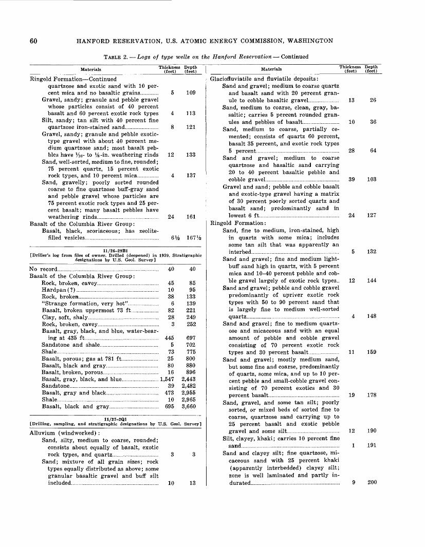
60 HANFORD RESERVATION, U.S. ATOMIC ENERGY COMMISSION, WASHINGTON
TABLE 2. Logs of type wells on the Hanford Reservation Continued
Materials Thickness Depth (feet) (feet)
Ringold Formation Continuedquartzose and exotic sand with 10 per cent mica and no basaltic grains............ 5 109
Gravel, sandy; granule and pebble gravel whose particles consist of 40 percent basalt and 60 percent exotic rock types 4 113
Silt, sandy; tan silt with 40 percent finequartzose iron-stained sand.. ................. 8 121
Gravel, sandy; granule and pebble exotic- type gravel with about 40 percent me dium quartzose sand; most basalt peb bles have Yw- to %-in. weathering rinds 12 133
Sand, well-sorted, medium to fine, rounded; 75 percent quartz, 15 percent exotic rock types, and 10 percent mica.............. 4 137
Sand, gravelly; poorly sorted rounded coarse to fine quartzose buff-gray sand and pebble gravel whose particles are 75 percent exotic rock types and 25 per cent basalt; many basalt pebbles have weathering rinds...................................... 24 161
Basalt of the Columbia River Group:Basalt, black, scoriaceous; has zeolite-
filled vesicles ................ ..................... 6% 167%
11/26-29B1[Driller's log from files of owner. Drilled (deepened) in 1939. Stratigraphic
designations by U.S. Geol. Survey]
No record..... ........................................................ 40 40Basalt of the Columbia River Group:
Rock, broken, cavey........................................ 45 85Hardpan (?)..................................................... 10 95Rock, broken............................................... . 38 133"Strange formation, very hot"... .............. 6 139Basalt, broken uppermost 73 ft.................. 82 221Clay, soft, shaly ........................ 28 249Rock, broken, cavey........................................ 3 252Basalt, gray, black, and blue, water-bear
ing at 435 ft................................................ 445 697Sandstone and shale.................................... 5 702Shale ............................................................ 73 775Basalt, porous; gas at 781 ft 25 800Basalt, black and gray. . 80 880Basalt, broken, porous 16 896Basalt, gray, black, and blue. 1,547 2,443Sandstone....----......-...--. 39 2,482Basalt, gray and black 473 2,955Shale----.-----...---..----. 10 2,965Basalt, black and gray 695 3,660
11/27-2Q1[Drilling, sampling, and stratigraphic designations by U.S. Geol. Survey]
Alluvium (windworked) :Sand, silty, medium to coarse, rounded;
consists about equally of basalt, exotic rock types, and quartz. 3 3
Sand; mixture of all grain sizes; rock types equally distributed as above; some granular basaltic gravel and buff silt included..---..-.--------.. 10 13
Materials Thickness (feet)
Depth(feet)
Glaciofluviatile and fluviatile deposits:Sand and gravel; medium to coarse quartz
and basalt sand with 20 percent gran ule to cobble basaltic gravel 13 26
Sand, medium to coarse, clean, gray, ba saltic; carries 5 percent rounded gran ules and pebbles of basalt........................ 10 36
Sand, medium to coarse, partially ce mented; consists of quartz 60 percent, basalt 35 percent, and exotic rock types 5 percent----. . . 28 64
Sand and gravel; medium to coarse quartzose and basaltic sand carrying 20 to 40 percent basaltic pebble and cobble gravel.--------- 39 103
Gravel and sand; pebble and cobble basalt and exotic-type gravel having a matrix of 30 percent poorly sorted quartz and basalt sand; predominantly sand in lowest 6 ft.-----.---- 24 127
Ringold Formation:Sand, fine to medium, iron-stained, high
in quartz with some mica; includes some tan silt that was apparently an interbed..-- ................... 5 132
Sand and gravel; fine and medium light- buff sand high in quartz, with 5 percent mica and 10-40 percent pebble and cob ble gravel largely of exotic rock types.. 12 144
Sand and gravel; pebble and cobble gravel predominantly of upriver exotic rock types with 50 to 90 percent sand that is largely fine to medium well-sorted quartz 4 148
Sand and gravel; fine to medium quartz ose and micaceous sand with an equal amount of pebble and cobble gravel consisting of 70 percent exotic rock types and 30 percent basalt.. ------- 11 159
Sand and gravel; mostly medium sand, but some fine and coarse, predominantly of quartz, some mica, and up to 10 per cent pebble and small-cobble gravel con sisting of 70 percent exotics and 30 percent basalt 19 178
Sand, gravel, and some tan silt; poorly sorted, or mixed beds of sorted fine to coarse, quartzose sand carrying up to 25 percent basalt and exotic pebble gravel and some silt.................. ............. 12 190
Silt, clayey, khaki; carries 10 percent fine sand. ..................................... 1 191
Sand and clayey silt; fine quartzose, mi caceous sand with 25 percent khaki (apparently interbedded) clayey silt; zone is well laminated and partly in durated...........-......-... . 9 200

TABLES 61
TABLE 2. Logs of type wells on the Hanford Reservation Continued
Materials Thickness Depth (feet) (feet)
11/27-20M1 [Drilling, sampling, and stratigraphic designations by U.S. Geol. Survey]
Alluvium (windworked) :Silt and sand; fine subrounded sand of
about 80 percent quartz and exotic rock types; silt makes up about half of ma terial............................................................. 4 4
Glaciofluviatile and fluviatile deposits :Sand; 90 percent coarse sand having
small amounts of granules and pebbles; finer grains largely quartz, and larger ones basalt.................................................... 89 93
Sand, silty ; similar to that just above, but largely medium to coarse; consists about equally of quartz and basalt; granule and pebble basaltic gravel in- terlayered......... ............................................. 31 124
Silt and sand, buff; sandy silt carrying a few basalt granules and pebbles in the upper part......... ........................................ 4 128
Sand and gravel, silty; fresh granular exotic and basaltic gravel in an un- sorted fine to coarse gray-white quartz- ose sand having 25 percent tan-gray silt 8 136
Sand, gravelly, medium, and some silt; gravel almost entirely, and coarse sand largely, basalt.---.---.........-.--............-...........- 8 144
Basalt of the Columbia River Group :Basalt, gray, hard.......................................... 25 169Sand, tuffaceous; composed principally of
volcanic glass shards, quartz, opal, feld spar, muscovite and biotite mica, basalt particles, and secondary gypsum............ 23 192
Tuff; weathered into silty and clayey ma terial but containing identifiable par ticles of basalt, quartz, glass, mica, and feldspar................................................... 69 261
Basalt, hard, black, very finely crystallineand glassy.-.................. ............. ...... 60 321
11/27-26D1 [Drilling, sampling, and stratigraphic designations by U.S. Geol. Survey]
Alluvium (windworked) :Sand, well-sorted, light-brown, quartzose,
medium to coarse ; carries some fine and very coarse sand intermixed...... .............. 19 19
Glaciofluviatile and fluviatile deposits:Sand and clayey silt........... . ....................... 5 24Sand and gravel; poorly sorted gray me
dium and coarse basalt and quartz sand carrying 20 percent granule and pebble gravel of basaltic type......................... . 3 27
Sand, mixed fine to coarse, gray, quartz and basalt; 10 percent tan silt inter- layered........................................................... 5 32
Sand and gravel ; poorly sorted angular to subrounded gray quartz, basalt, and exotic-type sand carrying 15 to 20 per cent granule and pebble basaltic gravel 8
Sand, poorly sorted, quartzose...................... 274067
Materials Thickness (feet)
Depth (feet)
Glaciofluviatile and fluviatile deposits Con.Sand and gravel; poorly sorted basaltic
sand having 25 percent basaltic granule to cobble gravel............................................ 9 76
Gravel and sand; basaltic pebble and cobble gravel having 25 percent basalt, quartz, and exotic sand---.-..... ................. 7 83
Sand; similar to 67- to 76-ft zone above.... 9 92Gravel and sand; pebble and cobble ba
saltic gravel having 30 percent poorly sorted quartz, basalt, and exotic sand.... 8 100
Sand and gravel; poorly sorted gray quartz and exotic sand having 25 per cent granule and pebble basalt gravel.... 7 107
Sand, medium to coarse, clean, white,gray............................................................... 5 112
Ringold Formation:Sand and gravel; medium to coarse clean
whitish-tan quartzose sand carrying 30 percent pebble and cobble gravel of predominantly exotic rock types............ 27 139
Sand, fine to medium, largely quartz but much exotic rock material in coarse sizes; has 10 percent mica........................ 4 143
Sand and gravel; medium white quartz and mixed types of sand having 30 percent exotic and basaltic gravel.......... 5 148
11/28-17D1 [Drilling, sampling, and stratigraphic designations by U.S. Geol. Survey]
Alluvium:Sand, buff-white, subrounded, coarse in
upper 3 ft (wind-worked) and medium to fine below; sand is equally basalt and siliceous materials, but the few gravel granules are largely basalt.......... 8 8
Glaciofluviatile and fluviatile deposits:Sand, gravelly, medium to very coarse,
high basalt composition in coarser, and high quartz in finer, grains; about 15 percent granule and pebble gravel that is 75 percent basalt.................................... 4 12
Sand, clean, medium and coarse, basaltic and siliceous, gray, subrounded... .......... 32 44
Sand; similar to just above, but higherin basalt (50 to 75 percent).................... 12 56
Sand and gravel; mixed sand of average medium size; larger grains are basaltic, and smaller are siliceous; about 30 per cent granule and pebble gravel is pre dominantly basalt without weathering rinds............................................................... 39 95
Ringold Formation:Gravel and sand; granule and pebble
exotic gravel having a matrix of me dium siliceous sand; some basalt pebbles have weathering rinds.... ................. 20 115
Sand, gravelly; medium and fine quartz ose, exotic, and micaceous (5 percent) sand having granule, pebble, and cobble

62 HANFORD RESERVATION, U.S. ATOMIC ENERGY COMMISSION, WASHINGTON
TABLE 2. Logs of type wells on the Hanford Reservation Continued
Materials Thickness Depth (feet) (feet)
Ringold Formation Continuedgravel that is predominantly of exoticrock types.................................................... 5 120
Sand, clean, medium to fine, siliceous;contains granular largely exotic gravel 7 127
Gravel, sandy; granule and pebble exotic- type gravel having an equal amount of medium clean tan-gray siliceous sand; tan silt makes up 10 percent of material 8 135
Sand, gravelly; mixed, averaging medium, quartzose sand carrying 20 percent granule, pebble, and cobble gravel in which basalt forms 60 percent; some basalt pebbles have weathering rinds.... 8 143
Gravel, sandy; granule, pebble, and cobble gravel of about equal basalt and exotic types; medium sand, carrying fine and coarse, is predominantly siliceous ma terial; some basalt pebbles have weath ering rinds.................................. ............... 4 147
11/28-29N1 [Drilling, sampling, and stratigraphic designations by U.S. Geol. Survey]
Alluvium (windworked) :Sand, very fine to medium, buff, basaltic
and exotic, and 25 percent silt................ 4 4Glaciofluviatile and fluviatile deposits:
Sand and some gravel; fine to coarse sand, but predominantly coarse, is equally basaltic and exotic rock types in coarser sizes and mainly siliceous in finer; the 15 percent granule and pebble gravel is predominantly basalt................ 40 44
Ringold Formation:Sand, fine to coarse but largely coarse
quartz; exotic rock types make up about 80-90 percent of deposit; 10 percent is silt.... ......................................................... 8 52
Sand and gravel; medium to coarse tan- white quartzose sand having 10 percent granule and pebble gravel that is 70 percent exotics and 30 percent basalt.... 8 60
Sand, gravelly; fine to coarse, mainly medium, siliceous subrounded sand car rying 35 percent granule and pebble gravel that is 75 percent exotic rock types ......................................................... 9 69
Sand, fine to coarse in various beds, exotic rock types and quartz; 10 percent gran ule and pebble gravel is 70 percent exotic rock types; some silt is present.... 39 108
Clay, silty, blue-green and plastic whenwet, grayish-green when dry.... ........... 2 110
12/25-1A14 [Drilling, sampling, and stratigraphic designation by U.S. Geol. Survey]
Alluvium:Silt and fine sand; has a little intermixed
medium and coarse sand and 10 percent granules and pebbles up to Vz in. in di-
Materials Thickness Depth (feet) (feet)
Alluvium Continuedameter; pebbles and granules mostly basalt, finer sand sizes largely quartz, and coarser ones equally basalt and quartz............................................................. 5 5
Glaciofluviatile and fluviatile deposits:Silt and gravel, dun; carries some varied
sizes of sand together with scattered boulders and cobbles; material is simi lar to 0- to 5-ft bed, but with more gravel (40 percent) ; sand of all sizes makes up 30 percent.................................. 12 17
Sand, gravelly and silty, dun; sand of mixed sizes, coarse to fine, is mainly subangular quartz in fine sizes and up to 60 percent basalt in medium to coarse sizes; basalt and exotics are about equally represented in the granule, peb ble, and occasional cobble gravels; ba salt is fresh; light-gray Touchet-type silt is intermixed and forms 10-25 per cent of samples..-.-.-..--................-.-...--... . 41 58
Sand, largely medium and coarse; con tains granule and small-pebble gravel and silt; sand is mostly subangular to subrounded siliceous (milky and clear quartz) ; coarse sand and basalt gran ule gravel form 25-50 percent; pebble gravel in 80- to 85-ft sample is 75 percent basalt and 25 percent exotics.... 52 110
Ringold Formation:Silt, clayey and gravelly; 50 percent me
dium and fine sand is almost entirely quartz 50 percent clear and 50 per cent milky or stained; about 5 percent granule gravel is largely quartz and exotics; sample is tan-buff; some mag netite in the very fine sand .... 8 118
Sand, silty, fine, cream-buff; contains 5-10 percent intermixed coarse sand and granule gravel (to % in. in diameter) ; has some calcareous stemlike tubes and nodular concretions... .................. ....... 25 143
Sand, medium to coarse, silty, and gran ule and pebble gravel; granule gravel and pebbles % to 1 in. in diameter form about 30 percent of deposit; as much as 75 percent of gravel is basalt with J<6-in-thick decomposition rinds; fine sand is mostly quartz, although basalt comprises much of the coarse sand; silt component forms 15-20 per cent....... .................................................. 32 175
Gravel and sand; a mixture of about 70 percent granule and pebble gravel with 30 percent medium quartz sand; gravel is 75 percent basalt.................................... 8 183
Sand, gravel, and silt; mixed sizes of sand, averaging medium, 20 percent

TABLES 63
TABLE 2. Logs of type wells on the Hanford Reservation Continued
Materials Thickness (feet)
Depth(feet)
Ringold Formation Continuedgranule and pebble gravel, and 20 per cent silt; sand is normal Ringold type, subangular to subrounded, clear and milky quartz and siliceous exotics; gravel is % well-rounded basaltic ma terial.............................................................. 8 191
Sand and gravel; medium to coarse sili ceous sand having 50 percent granule and pebble gravel; gravel is largely exotic rock types........................................ 5 196
Sand, gravel, and silt, gray; much like the 191- to 196-ft bed; a thorough jumble of grain sizes; silt and fine sand is almost entirely quartz; medium to coarse sand includes increasing amounts of exotic rock types and ba salt; gravel is about Vz basalt in gran ule sizes and % in pebble sizes................ 10 206
Sand, silt, and gravel, with boulders; fine sand and silt with some medium and coarse sand (10 percent ±) and 30 per cent granule and pebble gravel to 1 in. in diameter; fine sand is almost entirely quartz, subangular, largely clear; coarser grades of sand are quartz, exot ics, and a little basalt; gravel is 75 percent exotic and 25 percent basalt; silt is 10-15 percent.................................. 14 220
Sand, gravel, and silt; materials largely the same as overlying bed; rinds % in. thick on basalt pebbles; this remarkably uniform sand carrying gravel is appar ently the same as the Ringold conglom erate in The White Bluffs........................ 82 302
Sand and gravel, in part silty and clayey; sand is fine to medium, quartzose, and subrounded to subangular; gravel is mainly % to 2 in. in diameter, although in 315- to 320-ft zone sizes up to 4 in. in diameter are present; appproximately 3 percent basalt in gravel which forms 25 to 40 percent of bed; cemented coating of sand and mica on pebbles; some basalt pebbles have rinds........................ 33 335
Gravel, sandy and silty; 60 percent gravel and coarse sand, 40 percent silt and fine sand; gravel is mostly less than 1 in. in diameter; sand is quartzose and lightly calcareous........................................ 10 345
Sand, silt, and gravel; fine to l-in.-diame- ter pebbles; 70 percent sand and silt, 30 percent gravel; basalt less than 1 per cent of sand component; pebbles mostly exotic types.................................................. 26 371
Gravel, exotic, subrounded, up to 2 in. in diameter in a silty sand matrix; gravel forms about 75 percent of sample; very little basalt present................................... 4 375
Gravel and sand, silty; gravel averages about 1 in. in diameter; sand is medium
Materials Thickness (feet)
Depth (feet)
Ringold Formation Continuedto fine and quartzose; white swelling sand at 375- to 380-ft depth; gravel, sand, silt comprise 50, 40, 10 percent respectively.................................................. 25 400
Silt, sandy and gravelly; tan silt carrying gravel that is mostly Vz- to ^-in. di ameter subrounded pebbles about 20 percent basalt and 80 percent exotic rock types mainly light-colored quartzites; sand-gravel ratio is approxi mately 50-50; sand is about 80 percent quartz, 5 percent basalt, and 15 percent exotics; some basalt pebbles have weathering rinds........................................ 15 415
Gravel, medium to fine, in a matrix of silty sand; gravel forms about 70 per cent of sample, is rounded to sub- rounded, averages % in. in diameter, and is mainly of exotic rock types.......... 5 420
Sand, silty and gravelly, tan; gravel com ponent about 10 percent in upper 10 ft of bed, with gravel-free medium to fine sand and silt in lower 8 ft; drilled like a "rotten sandstone" at 430-438 ft........ 18 438
Gravel in a matrix of silty sand; pebbles, predominately exotic rock types but a few basalt, are mostly 1 to 1% in. in diameter and form approximately 50 percent of the bed; sand component is about 10 percent coarse sand, and re mainder is silt and fine sand.................. 22 460
Sand, coarse to fine, and silt; has about15 percent medium to fine gravel............ 5 465
Sand, fine to coarse, and silt; carri'es about 30 percent gravel; sand is quartz ose, but granule-size material contains about 30 percent angular basalt; some cobbles present........................-...-......- 27 492
Sand, coarse to fine, silty; carries fine to coarse gravel and occasional cobbles and boulders; coarse sand and fine gravel is about 50 percent basalt; carbonized wood fragments of a low lignite rank lie in 500- to 505-ft zone; gravel com prises about 20 percent, sand 60 percent, and silt 20 percent.... ........ .................. 13 505
Sand, coarse to fine, silty and clayey, and gravel (10 percent) ; sample is about 70 percent basalt in coarse sand fractions and 30 percent basalt in fine sand and silt fractions; drilled material is sulfur- ous and rank smelling; basalt pebbles and cobbles have weathering rinds and have cemented sand on their surfaces.... 4 509
Basalt of the Columbia River Group:Basalt, black, vesicular, porous; contains
clear to milky and greenish-brown opa line vesicle fillings . ............. .. 25 534
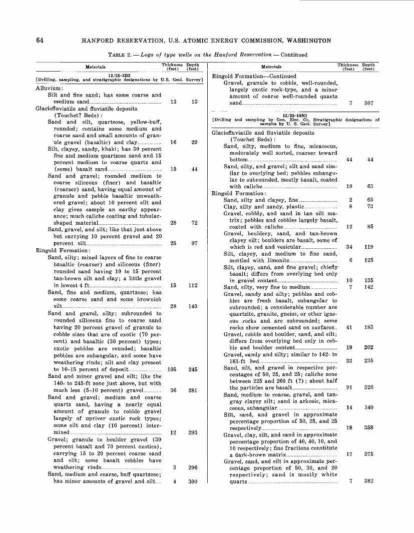
64 HANFORD RESERVATION, U.S. ATOMIC ENERGY COMMISSION, WASHINGTON
TABLE 2. Logs of type wells on the Hanford Reservation Continued
Materials Thickness Depth (feet) (feet)
12/25-3D2 [Drilling, sampling, and stratigraphic designations by U.S. Geol. Survey]
Alluvium:Silt and fine sand; has some coarse and
medium sand................................................ 13 13Glaciofluviatile and fluviatile deposits
(Touchet? Beds) :Sand and silt, quartzose, yellow-buff,
rounded; contains some medium and coarse sand and small amounts of gran ule gravel (basaltic) and clay. ............ 16 29
Silt, clayey, sandy, khaki; has 30 percent fine and medium quartzose sand and 15 percent medium to coarse quartz and (some) basalt sand.................................... 15 44
Sand and gravel; rounded medium to coarse siliceous (finer) and basaltic (coarser) sand, having equal amount of granule and pebble basaltic unweath- ered gravel; about 10 percent silt and clay gives sample an earthy appear ance; much caliche coating and tubular- shaped material.............---.....-....-.------------. 28 72
Sand, gravel, and silt; like that just above but carrying 10 percent gravel and 20 percent silt.................................................. 25 97
Ringold Formation:Sand, silty; mixed layers of fine to coarse
basaltic (coarser) and siliceous (finer) rounded sand having 10 to 15 percent tan-brown silt and clay; a little gravel in lowest 4 ft................................................ 15 112
Sand, fine and medium, quartzose; has some coarse sand and some brownish silt.................................................................. 28 140
Sand and gravel, silty; subrounded to rounded siliceous fine to coarse sand having 20 percent gravel of granule to cobble sizes that are of exotic (70 per cent) and basaltic (30 percent) types; exotic pebbles are rounded; basaltic pebbles are subangular, and some have weathering rinds; silt and clay present to 10-15 percent of deposit.................. 105 245
Sand and minor gravel and silt; like the 140- to 245-ft zone just above, but with much less (5-10 percent) gravel. .... 36 281
Sand and gravel; medium and coarse quartz sand, having a nearly equal amount of granule to cobble gravel largely of upriver exotic rock types; some silt and clay (10 percent) inter mixed ...................................................... 12 293
Gravel; granule to boulder gravel (30 percent basalt and 70 percent exotics), carrying 15 to 20 percent coarse sand and silt; some basalt cobbles have weathering rinds. . ...... 3 296
Sand, medium and coarse, buff quartzose; has minor amounts of gravel and silt.... 4 300
Materials Thickness Depth(feet) (feet)
Ringold Formation ContinuedGravel, granule to cobble, well-rounded,
largely exotic rock-type, and a minor amount of coarse well-rounded quartz sand................................... ......................... 7 307
12/25-10N1[Drilling and sampling by Gen. Elec. Co. Stratigraphic designations of
samples by U. S. Geol. Survey]
Glaciofluviatile and fluviatile deposits (Touchet Beds) :
Sand, silty, medium to fine, micaceous, moderately well sorted, coarser toward bottom.....................-....... ........................... 44 44
Sand, silty, and gravel; silt and sand sim ilar to overlying bed; pebbles subangu lar to subrounded, mostly basalt, coated with caliche - . 19 63
Ringold Formation:Sand, silty and clayey, fine......................... 2 65Clay, silty and sandy, plastic...................... 8 73Gravel, cobbly, and sand in tan silt ma
trix; pebbles and cobbles largely basalt, coated with caliche................................. 12 85
Gravel, bouldery, sand, and tan-brown clayey silt; boulders are basalt, some of which is red and vesicular........................ 34 119
Silt, clayey, and medium to fine sand,mottled with limonite................................ 6 125
Silt, clayey, sand, and fine gravel; chiefly basalt; differs from overlying bed only in gravel content.........- .......................... 10 135
142Sand, silty, very fine to medium.................. 1Gravel, sandy and silty; pebbles and cob
bles are fresh basalt, subangular to subrounded; a considerable number are quartzite, granite, gneiss, or other igne ous rocks and are subrounded; some rocks show cemented sand on surfaces.. 41 183
Gravel, cobble and boulder, sand, and silt; differs from overlying bed only in cob ble and boulder content. .. 19 202
Gravel, sandy and silty; similar to 142- to183-ft bed.---- 33 235
Sand, silt, and gravel in respective per centages of 50, 25, and 25; caliche zone between 225 and 260 ft (?) ; about half the particles are basalt. . . 91 326
Sand, medium to coarse, gravel, and tan- gray clayey silt; sand is arkosic, mica ceous, subangular....-.-.-.- ...... 14 340
Silt, sand, and gravel in approximate percentage proportion of 50, 25, and 25 respectively . . .. 18 358
Gravel, clay, silt, and sand in approximate percentage proportion of 40, 40, 10, and 10 respectively; fine fractions constitute a dark-brown matrix 17 375
Gravel, sand, and silt in approximate per centage proportion of 50, 30, and 20 respectively; sand is mostly white quartz-..-..--.--. 7 382

TABLES 65
TABLE 2. Logs of type wells on the Hanford Reservation Continued
Materials Thickness (feet)
Depth (feet)
Ringold Formation ContinuedSand, fine, white, quartz.............................. 2 384Gravel and sand in weak matrix of silt
and clay; pebbles are chiefly quartzite, granite, gneiss, and schist, with a few of basalt; includes numerous lenses and streaks of almost clean sand.................... 25 409
Sand, silt, clay, and gravel; sand forms 70 percent, silt and clay 20 percent, and gravel 10 percent........................................ 13 422
Clay, gritty, heavy, plastic, light-greenish- gray; grit is about 20 percent of sample and is composed of metamorphic and igneous rocks................................................ 11 433
Clay, blue-gray, dense, sticky, imperme able................................................................. 43 476
Sand, black, fine to coarse; 85 percent basalt, 15 percent quartz; a "quick sand" that "heaved" 50 feet into the well, carrying with it a few angular pieces of olive-black basalt up to 4 in. in length...................................................... 7 483
Clay, gritty; contains very fine sand; blue-gray, plastic, "greasy"; grit sim ilar to that in 422- to 433-ft bed...... 22 505
Volcanic ash and clay, light-brown, sandy; has shards of volcanic glass and small pebbles; clay is probably altered vol canic ash. ............................................... 21 526
Sand and silt, gray........................................ 11 537Gravel, fine to coarse, in a matrix of sand
and tan silt; many pebbles have a yel lowish-tan coating of cemented sandy silt; sand is fine to medium and mostly quartz, feldspars, and mica. . 14 551
Sand, silty and clayey; sand is similar to overlying bed; silt and clay are green ish gray to brownish gray; silt is about 40 percent, clay 10 percent, and sand 50 percent of sample........................................ 14 565
Gravel, fine to medium, in a sandy, silty matrix... . .. --. ...... 1 566
Sand, silty and clayey; similar to 551- to656-ft bed.... ...................... 18 584
Gravel, sand, and tan-brown silt; propor tions are approximately 50, 20, and 30 percent respectively.................................... 5 589
Sand and silt, tan, fine to medium, weaklycemented............................ ..................... 25 614
Sand and silt, olive-brown, and a smallamount of gravel........................................ 20 634
Sand and tan-brown silt in about equalproportions......... .................................. 2 636
Sand, gravel, and light-gray silt in ap proximate percentage proportion of 50, 20, and 30 respectively; gravel is fine to medium well-rounded particles; sand is fine to medium mostly light-colored minerals. . . 13 649
Basalt of the Columbia River Group:Basalt, scoriaceous to dense, light-gray to
Materials Thickness Depth (feet) (feet)
Basalt of the Columbia River Group Con.black, jointed; zeolites occur in some ofthe vesicles ............................................. 39 688
12/25-23K1[Drilling and sampling by Gen. Elec. Co. Stratigraphic designations of
samples by U.S. Geol. Survey]
Alluvium (dune sand) :Sand, silty, brown-tan, fine to medium...... 1 1
Glaciofluviatile and fluviatile deposits:Sand, silty, brown-tan; fine to coarse,
averages medium; light-colored miner als predominate.. 32 33
Ringold Formation:Gravel, medium to coarse, sand, and silt;
pebbles and cobbles principally quartzite and basalt; some samples contain only a trace of silt (as from 85 to 90 ft where aquagel was required to make a sludge) ; in others the silt fraction in creases to nearly 50 percent of the whole; 33- to 38-ft zone contains cali che-coated pebbles and caliche-cemented sand 72 105
Gravel and sand in matrix of clayey silt; differs from overlying bed in its clay fraction.......................................................... 4 109
Basalt of the Columbia River Group:Basalt, talus(?).............................................. 36 145Volcanic ash or tuff; carries angular ba
salt fragments -. . 3 148Basalt, black 6 154Volcanic ash or tuff; carries angular ba
salt fragments.-.. 4 158Basalt; has a few thin interbeds of ash
or tuff; ranges from dense, black, and fresh to scoriaceous, gray, and devitri- fied; fresh basalt is jointed into small blocks ................................. 52 210
Tuff, altered in part to bentonitic(?) clay, light-gray, tan-brown, and greenish- brown; in part is sandy and contains considerable amount of glass shards, also some basalt fragments.. ................ 108 318
Basalt, black and red, scoriaceous in part; lowest 4 ft is entirely scoriaceous and includes considerable ash.......................... 18 336
12/25-26M1[Benson Ranch well. Driller's log by George E. Scott, 1929. Stratigraphic
headings by U.S. Geol. Survey]
Undifferentiated:Clay..... . . -- 6 6Sand, dry, loose.. 24 30Sand, dirty. . ---- 17 47Sand, fine..- . -- 11 58Gravel, coarse.. .....................................-.... 10 68Gravel, cemented.-----....-....----.----- ----- 6 74Gravel, loose, coarse........-----.---------- ----. 6 80Gravel, fine, pea-size....-..-......--- ................ 5 85Gravel, dirty.................................................... 41 126

66 HANFORD RESERVATION, U.S. ATOMIC ENERGY COMMISSION, WASHINGTON
TABLE 2. Logs of type wells on the Hanford Reservation Continued
Materials Thickness Depth (feet) (feet)
Undifferentiated ContinuedGravel, dirty, water-bearing at 127 ft;
water level 100 ft.................................... 23 149Ringold (?) Formation:
Sand......................................................... 151 300Gravel.-..-.--.-.-.........-. . . 4 304Clay, blue..................... .... ................... 41 345
Basalt of the Columbia River Group:Basalt, black and gray.-... ....... ............... 113 458Clay, white, sandy....... 12 470Sand, white, sticky.................. 11 481Clay, blue, sandy............................................ 66 547Basalt, black and gray.............. 308 855Shale, blue.... ... .. -.. 31 886Sandstone.................................... .............. 7 893Shale, blue, sandy.......................................... 31 924Basalt, black, gray, and red........................ 277 1,201Clay, yellow. .......................................... 2 1,203Shale, blue, green, and brown; trace of
sand in uppermost 46 ft... 107 1,310Basalt, gray and black; water level 210 ft
below surface to end of drilling.............. 128 1,438Sandstone, fine-grained............ ................. 12 1,450Basalt, gray and black. 90 1,540Sandstone, fine-grained............. ................ 13 1,553Basalt, gray and black.... . 447 2,000
12/26-2M1[Drilling and sampling by Gen. Elec. Co. Stratigraphic designations of
samples by U.S. Geol. Survey]
Alluvium:Sand, silty, tan................................................ 7 7
Glaciofluviatile and fluviatile deposits:Gravel................................. .. 3 10Sand and gravel; sand grains largely
quartz and feldspar, but some mica;probably reworked Ringold materials.... 9 19
Sand, very fine to coarse, and tan silt;silt content is 10 to 25 percent andincreases with depth; coarser sandgrains are largely basalt and quartz,finer grains are quartz and feldsparwith some mica............................................ 36 55
Ringold Formation:Sand, silt, and clay; similar to overlying
bed but contains clay................................ 40 95Silt, sandy, tan; similar to 19- to 55-ft bed 15 110 Sand, silt, and clay; similar to 55- to 95-ft
bed...........-........-.............. 15 125Silt, sandy, or silty sand, tan; sand grains
predominantly very fine to mediumlight-colored materials.............................. 15 140
Sand, silt, and clay, tan; relatively lowpermeability................................................ 70 210
Sand, medium to coarse; about half basaltand half light-colored minerals.............. 7 217
Gravel, bouldery........ .............. ............. 5 222Sand, as in 210- to 217-ft bed...................... 8 230Sand, silt, and clay; similar to 140- to
210-ft bed............. 25 255Gravel, sand, silt, and clay, tan.................. 10 265
Materials Thickness (feet)
Depth(feet)
Ringold Formation ContinuedGravel, bouldery, and sand; contains di
verse rock types 15 280Gravel, granular, and sand; (silt in sam
ple possibly is from soil added to make drilling sludge)., 7 287
Sand, medium to coarse; about half isbasalt and half is light-colored minerals 7 294
Clay, slightly silty, tan to dark-yellow,plastic, impermeable...... ....... 6 300
Sand, very fine to medium; light-colored minerals predominate................................ 10 310
Sand, gravel, and boulders; basalt is com monest in coarser particles, but quartz, feldspars, and mica predominate in finer particles.............................................. 4 314
Sand, very fine to medium, gray.................. 3 317Sand, gravel, and boulders; similar to 310-
to 314-ft bed................. .. 20 337Sand, fine to coarse; coarser grains chiefly
basalt, finer grains mainly quartz, feld spars, and mica.......................................... 11 348
12/26-7Q1[Drilling and sampling by Gen. Elec. Co. Stratigraphic designations of
samples by U.S. Geol. Survey]
Alluvium (dune sand) :Sand, silty; basalt and quartz grains
abundant; mica and feldspars common; subangular to angular.............................. 5 5
Glaciofluviatile and fluviatile deposits:Sand, fine to medium, silty; predomi
nantly subrounded to angular basalt, quartz, and feldspar................................. 15 20
Sand, silty, and fine to medium gravel; pebbles and sand grains, subrounded to rounded and apparently derived from Ringold Formation; includes some ba salt particles which generally are angu lar to subangular . 13 33
Sand, fine, and clayey silt............................ 22 55Ringold Formation:
Silt, clay, and sand; sand grains are pre dominantly quartz, feldspar, and mica; basalt sand grains are medium to coarse, subangular, and less than 35 percent of the total; tan silt and clay comprise 35 to 60 percent of sample...... 120 175
Silt, sandy and clayey, tan, plastic; very fine to medium sand is less than 50 percent of sample.......................... ....... 43 218
Sand and gravel; fine to coarse sand thatis clean and permeable.............................. 13 231
Silt, clay, sand, and gravel in respective percentage proportions of about 40, 20, 30, and 10........ 19 250
Silt, sand, and gravel; differs from over lying bed by lack of clay........... 40 290
Silt, clay, sand, and gravel; similar to231- to 250-ft bed......... 15 305
Silt, sand, and gravel; similar to 250- to 290-ft bed................ . 10 315

TABLES 67
TABLE 2. Logs of type wells on the Hanford Reservation Continued
Materials Thickness Depth (feet) (feet)
Ringold Formation ContinuedGravel, fine to coarse, and fine to medium
sand, clean; fairly high permeability; mostly light-colored minerals.................... 5 320
Gravel and sand; similar to overlying bed, but with clayey silt matrix; permeabil ity relatively low................... .................. 5 325
12/26-14D1[Drilling and sampling by Gen. Elec. Co. Stratigraphic designations of
samples by U.S. Geol. Survey]
Alluvium (dune sand):Sand, silty, gray, very fine to very coarse,
sharp to subangular; predominantly basalt............................................................. 12 12
Glaciofluviatile and fluviatile deposits:Sand, silty, tan; chiefly angular to sub-
rounded basalt grains; silt is about 30 to 50 percent of sample............................ 13 25
Sand, silty, and fine to medium gravel; sand and silt as above; pebbles of va ried rock types............................................ 5 30
Sand, silty, gray; similar to overlying bed(reworked Eingold(?) Formation)........ 10 40
Eingold Formation:Sand, silty, tan-gray; sand and silt frac
tions about equal........................................ 15 55Silt, sandy, tan, semiconsolidated; sand is
very fine to coarse, averages medium.... 5 60Sand, silty, tan; silt ranges from about 30
to 50 percent of sample; in large part, probably lenses and an alternation of layers of almost clean silt with clean sand............................................................... 120 180
Sand, silty; composition similar to over lying materials, but grains more firmly consolidated; (first drive-core sample, from 189 to 191 ft, dusty dry below the penetration of drilling water)................ 37 217
Silt, gravelly and gritty, gray-tan; peb bles and granules chiefly quartzite, granite, granodiorite, and basalt............ 5 222
Sand, silty and gritty, calcareous; core sample dusty dry; differs from overly ing bed only in proportion of constitu ents... ................................._........................... 12 234
Gravel, fine to medium, very fine to very coarse sand and tan silt; silt is cal careous and makes 35 to 50 percent of sample........................................................... 52 286
Clay, silty, plastic, tan-brown, damp........ 3.5 289.5Silt, sandy, light-gray; contains granules
and fine gravel............................................ 8.5 298Gravel, fine to coarse, sandy and silty...... 2 300Gravel, bouldery, in matrix of tan silty
sand which is 45 percent of sample; pebbles and cobbles stream-worn, sub- rounded to rounded, chiefly light-colored 39 339
Gravel, sand, and tan silt; sand is very fine to medium a "quicksand"; pro-
Materials Thickness(feet)
Depth (feet)
Ringold Formation Continuedportions are approximately 60, 30, and10 percent respectively.............................. 2 341
Gravel and sand in a matrix of gray-tan silty clay; relatively impermeable ma trix...................................... ........................... 10 351
Gravel, coarse, clean, well-worn, highlypermeable..................................................... 4 355
Sand, fine to medium, gray, permeable...... 2 357Gravel and sand in a silty clay matrix,
relatively impermeable..------..-........-. ...... 13 370Gravel, clayey, fine to medium; pebbles
are mostly quartzite; clay is silty and gritty; grit is very fine to coarse, sharply angular to subangular; low permeability..................... ........................ 10 380
Sand, very fine to medium, clean, perme able............................................................... 2 382
Sand and gravel, lenticular-bedded, iron- stained; clay and silt form less than 10 percent of sample; sand is gray, mica ceous, largely quartz; medium permea bility.............................................................. 4 386
12/26-19K1[Drilling and sampling by Gen. Elec. Co. Stratigraphic designations of
samples by U.S. Geol. Survey]
Alluvium (dune sand) :Sard, gray, clean, medium to fine, sub-
angular to subrounded; dominantly quartz, feldspars, and basalt.................... 5 5
Glaciofluviatile and fluviatile deposits (Touchet? Beds) :
Sand, silty, tan; sand as in member above; silt constitutes 20 to 30 percent of sample.................. ............................... 75 80
Sand, silty and clayey; dominantly quartz, feldspars, mica, and basalt; very fine to medium, averages fine; clay sufficient to make sample slightly plastic................ 25 105
Sand, silty, tan-brown; composition asabove, but grain size averages medium.. 20 125
Ringold Formation:Sand, clayey, brown, very fine and fine.... 5 130Clay, sandy, brown........................................ 14 144Gravel, clayey, pebble and granule; has
caliche coatings......................... .............. 10 154Clay, sandy, brown, and minor quantity of
fine granular gravel--.-....-................. . 11 165Sand, clayey, brown; similar to material
from 125 to 130 ft...................................... 5 170Sand, clayey, brown, and small amount of
fine gravel showing caliche coatings...... 5 175Sand, clayey, brown; has caliche frag
ments............................................................. 12 187Gravel, medium to coarse, in a matrix of
brown clayey silt; pebbles subrounded and chiefly quartzite; probably boulders and cobbles from 200 to 215 ft................ 28 215
Gravel, sand, and silt; similar to bedabove, but lacks the clay . 11 226

68 HANFORD RESERVATION, U.S. ATOMIC ENERGY COMMISSION, WASHINGTON
TABLE 2. Logs of type wells on the Hanford Reservation Continued
Materials Thickness (feet)
Depth(feet)
Ringold Formation ContinuedSand, gray, medium, clean, moderately
well sorted; largely light-colored miner als; fairly permeable................................ 5 231
Gravel, sand, and silt; pebbles chiefly quartzite, rhyolite, granite, gneiss, and basalt; subangular to subrounded; a few limonite concretions from 260 to 265 ft............................................................ 54 285
Gravel and sand in a matrix of tan siltyclay; pebbles as in bed above.................. 5 290
Sand and medium to coarse gravel in a matrix of tan silt; pebbles and cobbles of diverse composition as above; sub- rounded; sand grains subangular, poorly sorted, mostly light-colored min erals............................................................... 5 295
Sand and gravel in a matrix of brown clayey silt; differs from overlying bed only in clay content. ................................ 20 315
Sand and gravel in a matrix of tan-brownsilt; similar to 290- to 295-ft bed............ 19 334
Sand, clayey, fine, mottled reddish-brown by limonite.................................................... 4 338
Sand, fine to medium, and fine to coarse gravel, almost free of silt; gravel and sand are subangular to rounded and most commonly quartzite and basalt...... 122 460
12/27-3P1[Drilling and sampling by Gen. Elec. Co. Stratigraphic designations of
samples by U.S. Geol. Survey]
Alluvium (dune sand) :Sand, silty........................................................ 1 1
Glaciofluviatile and fluviatile deposits:Cobbles, coarse to fine gravel, and sand;
predominantly basalt................................ 43 44Sand, silty and clayey, medium to fine...... 14 58Gravel, granular, and sand; mostly basalt 32 90
Ringold Formation:Gravel, fine to medium, and sand in a tan
silt matrix.................................................... 30 120
12/27-18C1[Drilling and sampling to 130 ft by Gen. Elec. Co.; deepened and changed
to 6-in. diameter by U.S. Geol. Survey, 1953. Stratigraphic designations by U.S. Geol. Survey]
Alluvium (dune sand) :Sand; fine to very coarse, averages
coarse; mostly basalt................................ 3 3Glaciofluviatile and fluviatile deposits:
Sand and tan silt; sand mostly basalt, fineto very coarse.............................................. 30 33
Sand with minor amount of silt; sandmostly basalt, fine to medium.................. 7 40
Gravel, sand, and tan silt; gravel andsand mostly basalt...................................... 2 42
Gravel, boulders, sand, and minor amountof tan silt; largely basalt; very highpermeability................................................. 25 67
Boulders, coarse gravel, sand, and minoramount of silt; differs from overlying
Materials Thickness (feet)
Depth (feet)
Glaciofluviatile and fluviatile deposits Con.bed in larger proportion of boulders and cobbles........................................................ 19 86
Sand, coarse; principally basalt; sample shows gravel, which probably is "carry- down" from overlying bed........................ 4 90
Boulders, finer gravel, sand, and silt; sim ilar to 67- to 86-ft bed.............................. 20 110
Boulders and finer gravel; mostly basalt.. 2 112 Sand, fine to coarse; principally basalt...... 5 117Sand and gravel, with boulders; mostly
basalt............................................................. 13 130Sand and gravel.............................................. 5 135Boulders........................................................... 3 138Gravel and sand; very clean and free of
silt in lower 10 ft, wood fragments in lower 1 ft...................................................... 28 166
Boulder, large.................................................. 1 167
12/27-27J1[Drilled and sampled by Gen. Elec. Co. Stratigraphic designations of
samples by U.S. Geol. Survey]
Alluvium:Sand, silty, and some fine gravel; coarse
particles chiefly basalt............-.-.--- --.-- 5 5Glaciofluviatile and fluviatile deposits:
Gravel, fine, and fine to very coarse sand; slightly silty in part but generally clean and fairly permeable; coarse particles chiefly basalt, angular to subrounded....
Ringold Formation:Sand, silty, tan-gray, subangular to sub-
rounded; very fine to coarse, averages medium; about 50 percent quartz, feld spars, and mica and 50 percent basalt-
Gravel, sand, and some silt and clay; pebbles are chiefly quartzite and basalt, subrounded to rounded; sand is very fine to coarse, averages medium, and is largely quartz, feldspar, mica, and ba salt; both sand and silt are tan.............. 45
Sand, silty, and some fine gravel; sand is chiefly quartz and feldspars and car ries a minor amount of basalt; size ranges from fine to coarse and aver ages medium; pebbles generally well rounded; mostly quartzite, granitoid and gneissoid rocks, and basalt........ 10
Gravel, medium to coarse, and fine to coarse sand, slightly silty; mostly quartzite and granitoid rocks, generally subrounded; may include cobbles or boulders from 145 to 154 ft..------------
50
25
55
80
125
23
135
158
12/28-18D1 [Drilling, sampling, and Stratigraphic designations by U.S. Geol. Survey]
Alluvium (dune sand) :Sand, fine and medium, clean; quartz and
exotic rock types with 10 percent mica; about 5 to 10 percent silt-size material present........... .......................................... 4 4

TABLES 69
TABLE 2. Logs of type wells on the Hanford Reservation Continued
Materials Thickness (feet)
Depth (feet)
Glaciofluviatile and fluviatile deposits:Sand and gravel; principally medium
dark basaltic sand with much pebble and cobble basalt gravel that makes up 30-50 percent of the zone.. 41 45
Sand, medium, dark-gray, basaltic; con tains some interbedded gray clayey silt and a few basalt pebbles 4 49
Sand and gravel; mixed sand of basalt materials with basaltic pebble and cobble gravel making up 25-40 percent of deposit.. ................ . 15 64
Sand, mixed,'dark; consists of 60-80 per cent basalt; the zone at 74 to 77 ft is a scabland-bar type of deposit similar to those in the Scooteney channels east ward across the river 13 77
Sand and clayey silt; fine to medium tan-gray quartz and basalt sand in which some brown clay silt beds are interlayered ..................................... 11 88
Sand and gravel; medium, but mixed, exotic and basaltic light-gray-tan sand that is about equally quartz and basalt with 30 percent granule, pebble, and cobble gravel in which exotic rock types predominate over basalt; the zone may be either fluviatile reworked Ringold materials or Ringold strata 28 116
Ringold Formation:Silt, sandy, light-tan 1 117Sand and gravel; mixed, but average me
dium, tan-gray mainly quartz sand accompanied by 25 percent granule to cobble gravel that is 80 percent exotic rock types and 20 percent basalt 16 133
Silt, clayey; gray siliceous silt carrying fine quartz sand and some clayey ma terial.---.-----..-..------ 4 137
Sand and gravel; medium quartz sand having 20 percent granule and pebble exotic-type gravel...................................... 11 148
Sand, medium, quartzose; contains anoccasional pebble layer.............................. 17 165
Silt, clayey, gray; carries 10 percent finesand near the top........................................ 11 176
12/28-24N1[Driller's log, by N. C. Jannsen Company, 1921. Stratigraphic designations
by U.S. Geol. Survey]
Alluvium:Sand................................................................... 18 18
Ringold Formation:Gravel, cemented 67 85Clay ...................................................... 20 105Clay and gravel 22 127Gravel----.--..----.---.- 28 155Boulders and finer gravel............................ 6 161Clay, black and blue...................................... 35 196Sand ....................................................... 9 205
Materials Thickness (feet)
Depth(feet)
Basalt of the Columbia River Group:Rock, black----.----.... 29 234Rock, black, and shale. .. 6 240Shale.------...-..-.------ 17 257Rock, black--------.-- 151 408Basalt.......----------.---. 63 471Clay and gravel...-.--- 16 487Shale--.-.--.......-..----- 9 496Rock.-..-------------- 39 535Basalt-----------.. 2 537Rock--.---.--......-.-.-----.- 2 539Shale, black and blue 25 564Basalt....-------..--- 103 667Basalt, porous............ 10 677Basalt, scoriaceous, water-bearing . 15 692Shale, blue------.------- . 19 711Sandstone, gray.--... 9 720Basalt, creviced, water-bearing.. 35 755
12/28-31H1 [Drilling, sampling, and stratigraphic designations by U.S. Geol. Survey]
Glaciofluviatile and fluviatile deposits:Sand, gravelly and silty; medium to
coarse basalt forms 60-90 percent of the coarse, and 25-50 percent of the fine, grains; granule and pebble gravel is largely basalt.... 32 32
Gravel and sand, gray, subrounded; about equally basalt and exotic pebbles and granules carrying fine to coarse basaltic sand and 10 percent siliceous silt.. ...... 4 36
Ringold (?) Formation:Sand, fine to medium, quartzose, tannish-
white, and layers of siliceous and ba saltic granule and pebble gravel 4 40
Gravel and sand; has 10 percent tan silt; rounded granule and pebble gravel of 60 percent exotic rock, types and 40 percent basalt accompanied by about 50 percent quartzose whitish-gray sub- rounded medium sand.. . 21 61
Sand; has gravel and silt layers; medium to coarse light-tan and gray quartz and basalt sand; includes layers of silt and pebble gravel that each forms about 20 percent of the zone.................................... 7 68
Ringold Formation:Sand; largely medium sand, but having
much fine and some coarse sand, is gray, quartzose, and subrounded; some layers of granule and pebble siliceous gravel as well as some gray silt . 12 80
Silt, clayey and sandy; buff silt and clay carrying some layers of siliceous sand and gravel....-.......--..... 17 97
Gravel and sand; subrounded granule, pebble, and cobble gravel that is equally basaltic and exotic; about 50 percent of material is medium quartz ose, arkosic, and basaltic sand................ 8 105
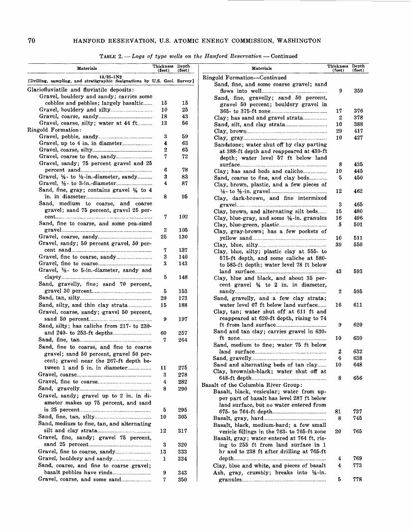
70 HANFORD RESERVATION, U.S. ATOMIC ENERGY COMMISSION, WASHINGTON
TABLE 2. Logs of type wells on the Hanford Reservation Continued
Materials Thickness Depth(feet) (feet)
13/25-1N2 [Drilling, sampling, and stratigraphic designations by U.S. Geol. Survey]
Glaciofluviatile and fluviatile deposits:Gravel, bouldery and sandy; carries some
cobbles and pebbles; largely basaltic...... 15 15Gravel, bouldery and silty............................ 10 25Gravel, coarse, sandy.................................... 18 43Gravel, coarse, silty; water at 44 ft.......... 13 56
Ringold Formation:Gravel, pebble, sandy.................................... 3 59Gravel, up to 4 in. in diameter.................... 4 63Gravel, coarse, silty ........ .......................... 2 65Gravel, coarse to fine, sandy........................ 7 72Gravel, sandy; 75 percent gravel and 25
percent sand................................................ 6 78Gravel, %- to %-in.-diameter, sandy.......... 3 83Gravel, y2 - to 3-in.-diameter........................ 4 87Sand, fine, gray; contains gravel % to 4
in. in diameter............................................ 8 95Sand, medium to coarse, and coarse
gravel; sand 75 percent, gravel 25 per cent................................................................. 7 102
Sand, fine to coarse, and some pea-sized gravel............................................................. 3 105
Gravel, coarse, sandy.................................... 25 130Gravel, sandy; 50 percent gravel, 50 per
cent sand...................................................... 7 137Gravel, fine to coarse, sandy........................ 3 140Gravel, fine to coarse.................................... 3 143Gravel, Vz- to 5-in.-diameter, sandy and
clayey............................................................. 5 148Sand, gravelly, fine; sand 70 percent,
gravel 30 percent........................................ 5 153Sand, tan, silty................................................ 20 173Sand, silty, and thin clay strata................ 15 188Gravel, coarse, sandy; -gravel 50 percent,
sand 50 percent.......................................... 9 197Sand, silty; has caliche from 217- to 230-
and 240- to 253-ft depths.......................... 60 257Sand, fine, tan................................................ 7 264Sand, fine to coarse, and fine to coarse
gravel; sand 50 percent, gravel 50 per cent; gravel near the 267-ft depth be tween 1 and 5 in. in diameter................ 11 275
Gravel, coarse.................................................. 3 278Gravel, fine to coarse.................................... 4 282Sand, gravelly................................................ 8 290Gravel, sandy; gravel up to 2 in. in di
ameter makes up 75 percent, and sand is 25 percent................................................ 5 295
Sand, fine, tan, silty...................................... 10 305Sand, medium to fine, tan, and alternating
silt and clay strata.................................... 12 317Gravel, fine, sandy; gravel 75 percent,
sand 25 percent.......................................... 3 320Gravel, fine to coarse, sandy........................ 13 333Gravel, bouldery and sandy.......................... 1 334Sand, coarse, and fine to coarse gravel;
basalt pebbles have rinds.......................... 9 343Gravel, coarse, and some sand..... ............ 7 350
Materials Thickness(feet)
Depth (feet)
Ringold Formation ContinuedSand, fine, and some coarse gravel; sand
flows into well...................... ................... 9Sand, fine, gravelly; sand 50 percent,
gravel 50 percent; bouldery gravel in 365- to 375-ft zone...................................... 17
Clay; has sand and gravel strata................ 2Sand, silt, and clay strata........ ............... 10Clay, brown....... ..... ........... ................ 29Clay, gray........................................................ 10Sandstone; water shut off by clay parting
at 388-ft depth and reappeared at 430-ft depth; water level 57 ft below land surface........................... _............................................................................. 8
Clay; has sand beds and caliche........ ..... 10Sand, coarse to fine, and clay beds............ 5Clay, brown, plastic, and a few pieces of
Vs- to %-in. gravel...................................... 12Clay, dark-brown, and fine intermixed
gravel............................................................Clay, brown, and alternating silt beds......Clay, blue-gray, and some %-in. granulesClay, blue-green, plastic................................Clay, gray-brown; has a few pockets of
yellow sand. . . .. . 10Clay, blue, silty.............................................. 39Clay, blue, silty; plastic clay at 555- to
575-ft depth, and some caliche at 580- to 585-ft depth; water level 78 ft below land surface................................................
Clay, blue and black, and about 35 per cent gravel % to 2 in. in diameter, sandy........................... .. ........... .........
Sand, gravelly, and a few clay strata; water level 67 ft below land surface......
Clay, tan; water shut off at 611 ft and reappeared at 620-ft depth, rising to 74 ft from land surface..................................
Sand and tan clay; carries gravel in 630- ft zone..........................................................
Sand, medium to fine; water 75 ft below land surface................................................
Sand, gravelly..................................................Sand and alternating beds of tan clay......Clay, brownish-black; water shut off at
648-ft depth.................................... .......Basalt of the Columbia River Group:
Basalt, black, vesicular; water from up per part of basalt has level 287 ft below land surface, but no water entered from 675- to 764-ft depth.......... ................... 81
Basalt, gray, hard . . . 8Basalt, black, medium-hard; a few small
vesicle fillings in the 763- to 765-ft zoneBasalt, gray; water entered at 764 ft, ris
ing to 255 ft from land surface in 1 hr and to 238 ft after drilling at 765-ft depth..............................................................
Clay, blue and white, and pieces of basaltAsh, gray, crumbly; breaks into %-in.
granules........................................................
359
376378388417427
435445450
462
465480496501
511550
43 593
16
20
595
611
620
630
632638648
656
737745
765
769773
778

TABLES 71
TABLE 2. Logs of type wells on the Hanford Reservation Continued
Materials Thickness Depth(feet) (feet)
Basalt of the Columbia River Group Con.Sand, medium to fine, white, quartzitic;
water rose to within 106 ft of land sur face when sand was penetrated and to 73 ft from land surface when drilled to 780-ft depth; at 785-ft depth water level was 38 ft from land surface..... .. 9 787
Sandstone, red; water temperature 130° F; bailing at 100 gpm lowered water level from 34 to 51 ft below land sur face and lowered water temperature from 130 to 90° F; in 30 minutes after bailing ceased, water level recovered 7 ft, and water temperature recovered to 98° F; at completion of well, after bail ing sand 5 days, water level was 41.4 ft from land surface with water tem perature 73° F at well bottom and 86° F at the top............................................ 3 790
13/25-16J1[Drilling and sampling: by Gen. Elec. Co. Stratigraphic designations from
samples by U.S. Geol. Survey]
Glaciofluviatile and fluviatile deposits:Gravel, bouldery, sandy, and slightly silty 22 22Sand, basaltic, medium to coarse, angular
to subangular.............................................. 3 25Sand, basaltic, fine, angular to subangular 13 38Gravel, sand, and silt; has an occasional
cobble or boulder; mostly basalt, sub- angular to subrounded. ..................... 24 62
Sand, medium, mostly basalt, subangular;slightly silty in part 8 70
Sand, silty, as above; carries fine to coarse gravel; silt is gray tan................ 54 124
Gravel and sand in clayey silt matrix; materials suggestive of Ringold Forma tion, but coarser particles are prepon derantly basalt; probably reworked Ringold Formation mixed with basaltic detritus ................................................. 11 135
Ringold Formation:Gravel in a matrix of silty and clayey
sand; pebbles about half basalt and half light-colored rocks; subrounded to rounded; some coated by cemented sand; sand is very fine to coarse, com monly quartz, feldspars, and mica; approximate proportions: gravel, 65 percent; sand, 20 percent; silt, 10 per cent; clay, 5 percent . 103 238
Basalt of the Columbia River Group:Basalt, gray to black, dense to vesicular,
jointed into small blocks, water-bearing 15 253
13/25-23A2[Drilling and sampling by Gen. Elec. Co. Stratigraphic designations of
samples by U.S. Geol. Survey]
Glaciofluviatile and fluviatile deposits:Gravel, bouldery, in silty sand matrix;
pebbles and cobbles subrounded to rounded, chiefly basalt; sand is fine to
Materials Thickness (feet)
Depth (feet)
Glaciofluviatile and fluviatile deposits Con.very coarse and predominantly basalt.... 29 29
Sand, silty, fine to medium; predominantlybasalt ........................................................ 7 36
Gravel and sand, silty; chiefly basalt;pebbles subrounded to subangular.- .-... 9 45
Sand, medium to fine, subangular, clean;chiefly basalt 5 50
Pebbles, subrounded; particles chiefly ba salt .............................................................. 5 55
Sand, medium, slightly silty; grains sub- rounded to subangular; basaltic.............. 7 62
Gravel, medium, and fine to coarse sand, slightly silty, basaltic; pebbles sub- rounded ........................._........................... 12 74
Ringold Formation:Sand, medium, subangular, clean; propor
tions of light and dark minerals equal.... 2 76Gravel in compact matrix of brown silty
medium sand ... 19 95Sand, medium, and medium to fine gravel;
sand is poorly sorted and subangular.... 5 100Sand, coarse, moderately sorted, clean;
chiefly quartz, feldspar, and basalt.. ... 10 110Gravel in a matrix of tan-brown silty
sand; much mica in the sand 15 125Gravel, medium to coarse, and sand in a
clayey silt matrix; pebbles and cobbles subrounded, of diverse rock types, and commonly coated with cemented sand. 40 165
Basalt of the Columbia River Group:Volcanic ash and tuff, clayey and gritty;
contains angular fragments of basalt and quartzite of fine-gravel size; appar ently water laid or reworked; color ranges from pale bluish to greenish gray, mottled with rusty streaks and spots....... . ... 12 177
Basalt, dense to scoriaceous, black to gray, water-bearing... .. . . 21 198
13/25-30G1[Driller's log by Frank B. Lawson, 1927. Stratigraphic designations by U.S.
Geol. Survey]
Surficial material, silt, etc.... 22 22Ringold (?) Formation:
Clay and boulders........... . . 316 338Clay, blue, green, and yellow .. . 240 578
Basalt of the Columbia River Group:Basalt, black, with soft seams. . 34 612 Clay, blue, hard, sandy.. 10 622 Clay, sticky, blue.... 48 670Shale, soft, and "soapstone float" . 10 680 Rock, water-bearing........ 25 705Basalt, black; increase in waterflow.......... 115 820Basalt, broken; increase in waterflow. 4 824 Clay, soft, with "broken rock" (no water) 26 850 "Lakebed with wood"; layers of green
clay.................................... . 10 860Basalt, black, broken; increase in water-
flow..................................... - 65 925

72 HANFORD RESERVATION, U.S. ATOMIC ENERGY COMMISSION, WASHINGTON
TABLE 2. Logs of type wells on the Hanford Reservation Continued
MaterialsThickness Depth
(feet) (feet)
Basalt of the Columbia River Group Con.Basalt, hard, black........................................ 25Basalt, black, "broken"; increase in water-
flow. 25 15
8 1
Porous rock; "heavy flow" of water............ 101Sand, fine . . . .. 10
Basalt, broken; increase in waterflow........Basalt, broken..... ................... ....................Sand, fine; "heavy flow" of water................
950
975990998999
1,1001,110
13/25-33D1[Driller's log (1943) with approximate stratigraphic designations by U.S.
Geol. Survey]
Soil ...................................................................... 5 5Glaciofluviatile and fluviatile deposits:
Sand and some gravel.................................... 3 8Sand and coarse gravel................................ 4 12Boulders, with sand and finer gravel.......... 8 20Gravel, cemented.............................................. 50 70Gravel, clay, and sand (dry) ................. 16 86
Ringold Formation:Sand, clay, and sandstone............................ 9 95Sandstone ...................................................... 30 125Sand, loose, caving.......................................... 20 145Sandstone (caving 194-200 ft)... .......... 105 250Sand, gravel, and some clay........................ 38 288Gravel, cemented (probably top of Ringold
conglomerate zone).... ............................. 54 342Gravel, pea-size, sand, and a little clay.... 7 349Sand and pea gravel, loose (dry)................ 16 365Sandstone.......................................................... 26 391Sand and pea gravel, water-bearing;
static water level 390 ft below land surface.... .................................................. 12 403
Sandstone.......................................................... 26 429Sand and gravel.............................................. 1 430Sandstone and pea gravel............................ 23 453Sand and gravel.............................................. 8 461Sandstone (washed cuttings are quartz,
feldspar, basalt, and mica; drills into greenish-brown sludge).............................. 10 471
Sandstone, hard.............................................. 9 480Sandstone and pea gravel.............................. 12 492Clay, sandy, brown.......................................... 20 512Sand and gravel............... ............................ 5 517Sand and pea gravel...................................... 23 540
13/25-36D1[Drilling and sampling by Gen. Elec. Co. Stratigraphic designation of
samples by U.S. Geol. Survey]
Glaciofluviatile and fluviatile deposits:Gravel, fine, with cobbles, boulders, sand,
and some tan silt; predominantly basalt Sand, silty, fine to coarse..............................Gravel, medium to coarse, clean..................Sand and tan silt; sand is fine to coarse,
mostly quartz, feldspars, and mica, andmakes about 60 percent of sample............
Gravel, fine to medium, in a matrix of tansilty sand; pebbles are of diverse rocktypes, well rounded to rounded; sand is
1962
192527
35
Materials Thickness (feet)
Depth(feet)
Glaciofluviatile and fluviatile deposits Con.of same material, very fine to coarse...... 9 44
Sand and silt, as in 27- to 35-ft bed.... ... 6 50Gravel, sandy and silty, as in 35- to 44-ft
bed...:....... ...................................--... 20 70Sand, tan, silty, micaceous, mostly light-
colored minerals, very fine to medium.... 40 110Sand and medium gravel, silty; sand as in
overlying bed; pebbles well rounded; 50 percent basalt, 50 percent diverse light- colored rocks................................................ 20 130
Sand, silty, as in 70- to 110-ft bed-.... 5 135Gravel, coarse sand, and trace of silt........ 20 155
Ringold Formation:Sand, fine to medium, and tan silt; has
1-ft layer of fine gravel at 159 ft............ 8 163Gravel, fine to coarse, granules, coarse
sand, clean, highly permeable; diverse rock types; pebbles well rounded............ 30 193
Gravel in a sandy, silty matrix; single boulder from 232-237 ft; gravel is di verse rock types, fine to coarse, sub- angular to well rounded, and about 50 percent of sample; sand and silt are about 25 percent each ........................... 97 290
13/26-5D2 [Drilling, sampling, and stratigraphic designations by U.S. Geol. Survey]
Alluvium:Silt, grayish-brown, sandy and gravelly.... 3 3
Glaciofluviatile deposits:Gravel, sandy and slightly silty; contains
boulders up to 3 ft in diameter, mostly basalt; gravel ranges from % to 10 in. in diameter.---.......-----...-.......---..--....-.---..-...- 12 15
Gravel and sand, mostly basalt, sub- rounded to rounded; gravel 60 percent, sand 40 percent.............. ........................... 14 29
Sand, tan, silty, mostly fine, micaceous; contains grains having a higher than usual percentage of limestone and gneiss, schist, and metasediments rather than a predominance of quartz grains. 9 38
Sand, silty, as above, and slightly grav elly; sand is 95 percent of deposit and gravel averaging 1 in. in diameter is 5 percent........................................................ 7 45
Ringold Formation:Gravel, sandy; x/4- to 5-in.-diameter
rounded to subrounded mostly meta- morphic pebbles in a coarse to fine angular micaceous sand matrix; a few basalt pebbles have thin weathering rinds......................- ................................. 35 80
Gravel, coarse to fine, and sand; weather ing rinds on basalt pebbles; sand is medium to fine, micaceous, largely sili ceous; gravel forms 50 percent of bed, and sand 50 percent; first water noted at 83 ft. .............................................. 4 84

TABLES 73
TABLE 2. Logs of type wells on the H an ford Reservation Continued
Materials Thickness(feet)
Depth(feet)
Ringold Formation ContinuedSand, gravelly, gray-tan, fine to coarse;
forms 75 percent of bed; gravel forms 25 percent, is rounded to subrounded, and is largely metamorphics and gra- nitics ranging in diameter from % to 3Vz in. and averaging 1% in.................... 5 89
Gravel, cobble and pebble, subrounded to rounded; forms 80 percent of bed; max imum diameter of 4 in. and all inter mediate grade sizes give an average diameter of about 1 in.; sand 20 per cent, coarse to medium, subangular to subrounded; basalt pebbles have weath ering rinds; water at this depth cut off by casing........................................................ 2 91
Sand, gravelly; sand is coarse to fine and forms 80 percent of bed; gravel, pebbly, has average diameter Vz in. and forms 20 percent of bed.-..-.-....-..-......--..-. 2 93
Sand, coarse to fine, mainly quartzitic, micaceous, and only rare pieces of gravel; sand forms over 95 percent of bed; depth to water 77.2 ft below land surface; sand caves easily and rises in pipe................................................................. 4.5 97.5
Sand, gravelly; 60 percent sand, 40 per cent gravel ................................................. .5 98
Gravel, sandy; 60 percent gravel, 40 per cent sand; diameter of gravel ranges from 5 down to !/z in.; 50 percent of gravel ranges from 2^ to 3% in. in diameter...... ............................................... 3.5 101.5
Sand, gravelly and slightly silty; 95 per cent sand, medium to fine, micaceous, largely siliceous; gravel forms 5 percent of bed and has a maximum diameter of 4 in. and a minimum of x/4 in.; gravel is composed of 75 percent upriver exot ics, mainly metamorphic rocks, and 25 percent basalt, much of which has thin weathering rinds; pebbles are sub- rounded to rounded; sand in this stratum runs freely into well---......... - .5 102
Sand, gravelly; 70 percent coarse to fine sand, micaceous, siliceous; gravel, main ly pebbles and occasional cobbles, aver ages 1 in. in diameter and forms 30 percent of bed.............................................. 2 104
Gravel, sandy; 70 percent medium to fine gravel, 30 percent coarse to fine sili ceous, micaceous sand................................ 2 106
Sand, gravelly; sand 95 percent, gravel 5 percent; sand rises in well........................ .5 106.5
Boulders, basaltic, and a few cobbles andpebbles .................................................... 1.5 108
Gravel, pebble and cobble, in a coarse to fine micaceous, quartzitic sand matrix;
Materials Thickness (feet)
Depth(feet)
8
Ringold Formation Continuedmaximum diameter of the occasional cobbles present is 4 in.; pebble gravel 2 in. in diameter forms 50 percent of gravel component; gravel forms 70 per cent of bed, sand 30 percent; 15 percent of gravel is basalt, 17 percent granitics and felsites, and 68 percent metamor phic rocks; a cemented gravel stratum having a sandy matrix with calcareous cement was penetrated; a bailer test utilizing an 8-in. dart bailer was made at 112-ft depth; 40 gpm were bailed during a 15-min test with a 16-ft draw down ; depth to water before bailing was 73.25 ft below land surface.... .................. 16.5 124.5
Gravel, granule, pebble, and cobble, rounded to subrounded; has a maximum diameter of 5 in. and average diameter of 2 in.; about 30 percent of gravel is % to 1 in. in diameter in a siliceous, micaceous angular coarse to fine sand matrix; weathering rinds, manganese stains, and cemented micaceous sand on basalt pebbles; gravel 90 percent, sand 10 percent-.... ................ ...........................
Sand, coarse to medium; has about 20 percent granule gravel and 5 percent pebble gravel averaging 1 in. in diame ter; sand is mainly siliceous and angu lar...................................................................
Gravel, cobble, pebble, and granule; forms 90 percent of bed; a 10-min bailer test at 139-ft depth produced 45 gpm with a 6-ft drawdown..... ......... .......................
Sand, tan, medium to coarse, siliceous, micaceous; forms 80 percent of bed; pebble gravel, average diameter 1 in. with maximum diameter 2 in., forms 20 percent of bed.. ..................... ........... .........
Gravel, pebble and granule; has a few cobbles in a medium to coarse sand; gravel 50 percent, sand 50 percent; maximum gravel diameter 3Vz in. with 60 percent of the gravel near the 2-in.- diameter size........... ..................................... 5 152
Gravel, cobble to pebble, well-rounded, average diameter 1 in., in a granule gravel to coarse sand matrix; gravel 70 percent, sand 30 percent....... ............ ......... 12 164
Claystone, silty, cream, indurated; con tains angular granules and small peb bles >J4 to Vz in. in diameter, with a few larger pebbles and cobbles, mainly ba salt, averaging 2 in. in diameter and having a maximum diameter of 7 in...... 5.5 169.5
Sandstone, cream streaked with yellow- brown iron stains, medium- to fine grained, indurated----.-..-. ................... 1 170.5*
132.5
133.5
6.5 140
147

74 HANFORD RESERVATION, U.S. ATOMIC ENERGY COMMISSION, WASHINGTON
TABLE 2. Logs of type wells on the Hanford Reservation Continued
Materials Thickness Depth (feet) (feet)
13/26-19R1[Drilling and sampling by Gen. Elec. Co. Stratigraphic designations of
samples by U.S. Geol. Survey]
Glaciofluviatile and fluviatile deposits:Silt, tan, and bouldery gravel; materials
are mainly basalt...... ............................... 5 5Gravel and sand, with boulders; has minor
amount of silt; cobbles and boulders are 90 percent basalt........................................ 20 25
Boulder, basalt................................................ 5 30Gravel and sand, with boulders.................... 15 45Gravel, sand, and clay, with boulders
(largely reworked Ringold? Formation) 5 50 Ringold Formation:
Gravel, sand, tan silt, and bluish-gray clay; pebbles and coarser sand about 50 percent basalt; the remainder, also the silt and clay, are chiefly light-colored minerals; considerable mica in the sand 30 80
Gravel and minor amount of silt and clay, with boulders; gravel is 50 percent basalt............................................................. 3 83
Gravel and clay.............................................. 2 85Sand and gravel in a matrix of indurated
gray-tan clay................................................ 36 121Clay, light-brown; contains some sand
and fine gravel............................................ 34 155Sand and granules in a light-brown clay
matrix............................................................ 10 165Clay, light-brown, plastic, impermeable.... 16 181Clay, gravelly, light-brown, plastic, imper
meable............................................................ 1 182Sand, clayey; contains fine gravel.............. 8 190Clay, light-brown; contains granular and
pebble gravel................................................ 6 196Clay, bouldery and sandy, light-brown........ 4 200
Basalt of the Columbia River Group:Basalt, black, dense, water-bearing............ 5 205
13/26-25A1[Drilling and sampling by Gen. Elec. Co. Stratigraphic designations of
samples by U.S. Geol. Survey]
Alluvium:Sand and tan silt; sand is fine to coarse,
is mostly basalt, and forms 75 percent of sample...................................................... 14
Gravel, granule, and sand; larger par ticles mainly basalt.................................... 3
Gravel, sand, and tan silt, with boulders; mostly basalt................................................ 36
14
17
5360Gravel, sand, and silt; chiefly basalt.......... 7
Ringold Formation:Gravel, boulders, silt, and clay; driller's
log lists "coarse sand, rocks, and boul ders"; gravel and sand are of diverse rock types, with basalt forming less than 35 percent............................................ 14 74
Gravel, sand, silt, and clay; differs from overlying bed mainly in lack of boulders in driller's log; sample marked "90 feet" appears to be from shoulder of bit (not mixed) and is about 50 percent silt and clay drilling sludge...................... 18 92
Materials Thickness (feet)
Depth (feet)
8 100
128
Ringold Formation ContinuedClay, silt, sand, and some gravel, dark-
grayish-brown ; silt and clay are 85 per cent of sample, sand 10 percent, gravel 5 percent; sand is predominantly light- colored minerals..........................................
Clay, silty and sandy; clay is 80 percent, silt 10 percent, sand 10 percent ............. 28
Sand, light-gray, and minor amount of tan silt; sand is very fine to medium; prin cipally quartz, feldspar, and mica (some flakes of mica are 1 mm across); differs from overlying bed mainly in lack of clay................................................................. 12
Clay, gritty, gray-tan; driller's log lists "clay and a little gravel".....................,.... 5
Clay, gray-tan.................................................. 30Clay, silty and sandy, light-tan; similar
to 100- to 128-ft bed.................................... 13Clay, gray-tan; probably an altered
water-laid volcanic ash..............................Basalt of the Columbia River Group:
Basalt, black, dense, jointed; probably more permeable than overlying sedi ments........................................................ ..
14
8
140
145175
188
202
210
13/26-33K1[Drilling and sampling by Gen. Elec. Co. Stratigraphic designations of
samples by U.S. Geol. Survey]
Alluvium:Sand, silty, tan................................................ 3 3
Glaciofluviatile and fluviatile deposits:Sand, and fine gravel, chiefly basalt; silt
present both as lenses and throughout the bed..... .............................................. 45 48
Sand, fine to coarse, subangular to sub- rounded, and granule gravel; both sand and gravel about 50 percent basalt, with remainder exotics.. . . .. . 17 65
Gravel, fine to coarse, and sand, basaltic; contains tan silt and clay; basalt forms about 70 percent of gravel and 50 per cent of sand ........................................... 17 82
Gravel and sand; differs from overlyingbed in lack of silt and clay .. . 33 115
Gravel, fine, in a silty sand matrix; gran ule and pebble gravel is mainly sub- rounded basalt; sand is about Vz basalt; some caliche present.................................... 40 155
Sand and fine gravel in a gray-brown clayey silt matrix. . .. 7 162
Sand, coarse to very fine, basaltic, fairly clean and permeable; possibly reworked Ringold materials. . 5 167
Gravel and sand, basaltic, in a dark-gray clayey silt matrix; possibly reworked Ringold materials........................................ 36 203
Ringold Formation:Sand, medium to very fine; contains little
clay; about 30 percent basalt present, with remainder quartzose material 3 206

TABLES 75
TABLE 2. Logs of type wells on the Hanford Reservation Continued
Materials Thickness Depth (feet) (feet)
Ringold Formation ContinuedGravel; much like 167- to 203-ft bed.......... 4 210Sand, coarse to fine, and a small amount
of granule gravel....... .............................. 8 218Gravel, medium to fine, sandy and silty.... 22 240Gravel, medium to fine, silty and sandy;
has caliche . coatings on some pebbles;sand is very fine to coarse........................ 37 277
Basalt of the Columbia River Group:Basalt, dark-gray, jointed............................ 8 285
13/26-36R1[Drilling and sampling by Gen. Elec. Co. Stratigraphic designations of
.samples by U.S. Geol. Survey]
Alluvium:Sand, silty, tan................................................ 2 2
Glaciofluviatile and fluviatile deposits:Gravel, sand, and silt, with boulders,
mostly basalt................................................ 13 15Boulders, finer gravel, and sand, mostly
basalt............................................................. 10 25Gravel and sand, almost clean, about 90
percent basalt.............................................. 9 34Sand, fine to very coarse, basaltic................ 1 35Gravel and sand; similar to 25- to 34-ft
bed.................................................................. 15 50Gravel, granular, and sand in a matrix of
tan silt and clay; at 75 ft materials characteristic of the Ringold Formation were penetrated; these are probably reworked .................................................... 35 85
Ringold Formation:Sand, silty, tan, fine to very coarse;
mostly light-colored minerals but part basalt............................................................. 5 90
Sand, granules, silt, and clay; sand is fine to very coarse, about 50 percent light- colored minerals, 50 percent basalt........ 25 115
Gravel, sand, and silt; differs from over lying bed chiefly in presence of gravel and absence of clay........ ......................... 10 125
Gravel, sand, and tan silt, with boulders.... 7 132Sand, fine to very coarse; contains minor
quantities of granules and tan silt.......... 8 140Gravel, boulders, and sand; coarser
grained than overlying bed........................ 5 145Gravel, granules, and sand; lacks boulders
of overlying bed.......................................... 10 155Gravel, fine to medium, and sand in a silt
and clay matrix............................................ 5 160Clay, dark-gray, silty; includes sand and
granules......................................................... 15 175Basalt of the Columbia River Group:
Basalt, reddish, rubbly, ashy........................ 15 190Basalt, black, dense, jointed.......................... 5 195
13/27-13N1[Drilling and sampling by Gen. Elec. Co. Stratigraphic designations of
samples by U.S. Geol. Survey]
Soil, silt, clay, and fine sand ............................. 4 4
Materials Thickness (feet)
Depth(feet)
Ringold Formation (possibly disturbed to 48-ft depth) :
Silt, sandy, clayey; about equally quartz silt (40 percent) and fine and very fine quartz sand (40 percent) with some clay and some medium pale-buff sand.... 22 26
Sand and silt; medium to very fine, aver age fine, quartz sand (60 percent) with quartz silt and some clay; pale-buff; silt and clay are more prominent in lowest few feet. ................................................ 22 48
Claystone, silty, tan grading downward into greenish-tan and blue; contains claystone nodules and concretions up to 1 in. in diameter; "chalky" layer at 63 ft is water bearing.................................... 42 90
Claystone; silty and sandy like that just above, but contains more fine sand (up to 15 percent increasing downward); has concretionary nodules up to */% in. in diameter; dark-buff.. ........................... 30 120
Sand, silt, and clay; medium to very fine sand that is 90 percent quartz; contains silt and clay (up to 40 percent at top) decreasing downward .. 25 145
Silt, sand, pebbles, and cobbles; gray-buff; has 10 percent sand and 15 percent gravel (up to 4-in. cobbles) interbedded in silt . .. 5 150
Sand, medium to fine, and silt, pale-buff, well-sorted, friable, quartzose and mica ceous; poorly consolidated sandstone...... 45 195
Silt, sandy, quartzose, gray-tan, and 25 percent fine quartz sand .. .. . 10 205
Siltstone and claystone; dark-brown quartzose compact silt and some clay with concretionary nodules of claystone 10 215
Sand, medium to very fine; gray-tan quartz sand having 25 percent quartzose silt; a few basaltic pebbles present in the 220- to 225-ft zone ......................... 18 233
Siltstone and claystone; brown quartzose siltstone and clay having a few white and brown claystone nodules; a few basalt and exotic rock pebbles are pres ent in 256- to 280-ft zone.... 72 305
Sand, coarse and medium, quartzose (80percent)..................... ...._....... ............. 5 310
Sand and gravel; medium and coarse gray sand having about 25 percent basaltic gravel... . ..................................... .... 5 315
Basalt of the Columbia River Group:Basalt, gray, unweathered ..................... 4 319Shale, black, tuffaceous...- ............... 5 324Basalt, dark-gray, slightly vesicular; a
large fragment or thin flow 6 330Tuff, dark-gray, "gravelly" 26 356Basalt, black, glassy, hard. 9 365Sandstone, tan, tuffaceous, quartzose. 5 370Basalt, medium-gray; has thin interbeds
of shaly tuff and sandstone. 80 450

76 HANFORD RESERVATION, U.S. ATOMIC ENERGY COMMISSION, WASHINGTON
TABLE 2. Logs of type wells on the Hanford Reservation Continued
Materials Thickness Depth (feet) (feet)
Basalt of the Columbia River Group Con.Tuff, sandstone, and breccia; mainly olive-
green sandy tuff containing large and small basalt fragments in places.--- .. 38 488
Basalt, gray, scoriaceous at top.. ............. 26 514Tuff, tan....................................-............ .. 6 520Basalt, gray, massive.................................... 87 607
13/27-16R1[Drilled and log recorded by unknown driller, 1943. Stratigraphic designa
tions by U.S. Geol. Survey]
Soil..............-.......-.... . . 2 2Glaciofluviatile and fluviatile deposits:
Sand, loose, and some gravel--------.-..........-.- 18 20Gravel, cemented ("hard pan").......--.--...... 24 44Sand and pea gravel, water-bearing. .... 30 74
Ringold Formation:Clay, sticky........ ....................................... 46 120Sand, coarse grading to fine, light-red,
water-bearing............................................... 11 131Sand, fine (some clay?)................................ 24 155Clay ............................................................. 25 180Sand, fine- ... . 12 192Gravel; "basaltic" rocks and fragments.... 3 195Clay ............................................................. 21 216Clay, soft, silt, and sand (gravel at bot
tom) ............................................................... 24 240Clay, sticky, bluish-gray; has streaks of
light-yellow fine sand ......................... 117 357Gravel, pea-size, and sand........... .............. 6 363
13/27-28P1[Drilling and sampling by Gen. Elec. Co. Stratigraphic designations of
samples by U.S. Geol. Survey]
Alluvium:Sand, silty, tan................................................ 2 2Gravel and sand; contains gray silt and
clay; gravel and sand about 70 percent basalt, remainder of diverse rock types 23 25
Ringold Formation:Clay, silty, tan; contains very fine sand.... 40 65Gravel, sand, silt, and clay; pebbles and
cobbles of quartzite, granite, gneiss, and schist; well-rounded to subrounded . 23 88
Boulders, gravel, sand, silt, and clay; dif fers from overlying bed in presence of boulders..... ............................................ 12 100
Sand, very fine to fine, in a matrix of gray silt and clay; sand grains mostly light- colored minerals.......................... ............. 12 112
Sand, silty; differs from overlying bed in lack of clay.................................................... 26 138
Sand, silty and clayey, as in 100- to 112-ft bed ............................................................. 27 165
Gravel, sand, and silt; some basalt peb bles show matrix of cemented sand and silt.................................................................. 9 174
Sand, gray-tan, very fine to medium. . 4 178Gravel, sand, and silt, as in 165- to 174-ft
bed.................................................................. 20 198
Materials Thickness (feet)
Depth (feet)
Ringold Formation ContinuedGravel and very coarse to fine sand; con
tains tan silt and clay........... . ... ........ 12 210Sand, silty, tan 10 220Silt, clayey, and very fine sand...... .......... 10 230Sand, silty, very fine to fine; grains angu
lar to rounded, of diverse mineral types, and weakly cemented by silt.................... 15 245
Gravel, sand, silt, and clay; pebbles and sand grains generally rounded to sub- rounded, comprised of light-colored minerals, and weakly cemented by clayey silt ................................. . 20 265
Sand, silty and clayey; similar to overly ing bed but lacks the gravel. ........... 8 273
Gravel, sand, silt, and clay, as in 245- to265-ft bed..... . . 7 280
Clay, silty, or clayey silt . 20 300 Sand, silty, highly micaceous, very fine to
medium....... ............................................... 10 310Silt, clayey, gritty, gray-tan; grit is angu
lar and largely basalt................. ......... 15 325Clay, gritty, gray-tan mottled with blue,
plastic...................... . 5 330Clay, gritty, blue, plastic; a few angular
basalt pebbles....---..----. ............................. 5 335Clay, dark-gray, nodular.............................. 32 367Sand, coarse to very coarse, basaltic,
highly permeable............... --.----- - . .. 7 374Basalt of the Columbia River Group:
Basalt, black, broken into small blocks;yields water freely .. 6 380
14/26-31R1 [Drilling, sampling, and Stratigraphic designations by U.S. Geol. Survey]
Alluvium:Silt, grayish-tan, finely micaceous, slightly
calcareous.--.-----.. ............................ . 10 10Silt, tan, finely micaceous; more tan than
bed above ................................ 5 15Ringold Formation:
Gravel, fine to medium; has subrounded metamorphic and granitic pebbles up to 2% in. in diameter in a sandy silt ma trix. ................................................ 21 36
Gravel, sandy; gravel forms about 60 per cent of sample, sand 40 percent; pebbles are about 80 percent metamorphic and granitic types and 20 percent basalt, some of which have thin weathering rinds; subrounded to subangular gravel, averaging 1% in. in diameter and hav ing a maximum diameter of 3 in., lies in a tan well-sorted medium to fine quartzose sand matrix.. . . ..... ...... 7 43
Gravel, granule to pebble, sandy and silty; granule and small-pebble gravel makes up about 50 percent of zone, with remainder a quartzose sand...... ............. 13 56
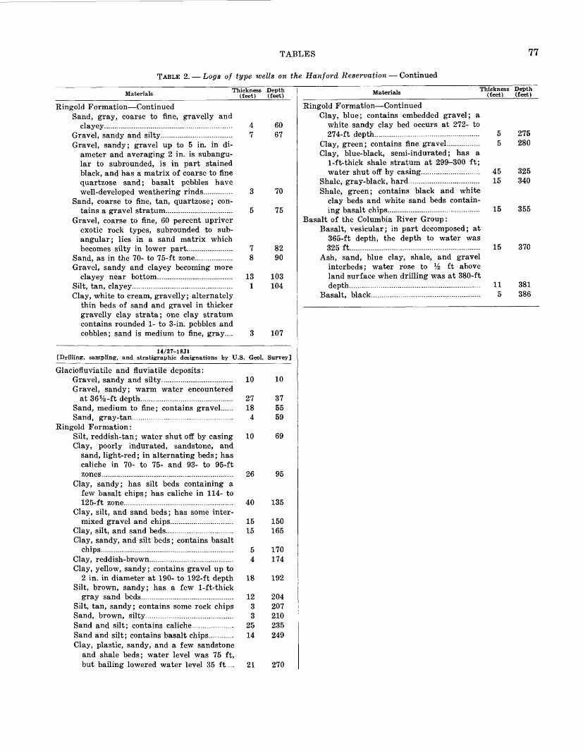
TABLES 77
TABLE 2. Logs of type wells on the Hanford Reservation Continued
Materials Thickness (feet)
Depth (feet)
60
67
Ringold Formation ContinuedSand, gray, coarse to fine, gravelly and
clayey......... .. - .. . . -... . 4Gravel, sandy and silty--..-........................... 7Gravel, sandy; gravel up to 5 in. in di
ameter and averaging 2 in. is subangu- lar to subrounded, is in part stained black, and has a matrix of coarse to fine quartzose sand; basalt pebbles have well-developed weathering rinds............. 3
Sand, coarse to fine, tan, quartzose; con tains a gravel stratum................................ 5
Gravel, coarse to fine, 60 percent upriver exotic rock types, subrounded to sub- angular; lies in a sand matrix which becomes silty in lower part--.--........----. 7
Sand, as in the 70- to 75-ft zone.................. 8Gravel, sandy and clayey becoming more
clayey near bottom.................................... 13Silt, tan, clayey................................................Clay, white to cream, gravelly; alternately
thin beds of sand and gravel in thicker gravelly clay strata; one clay stratum contains rounded 1- to 3-in. pebbles and cobbles; sand is medium to fine, gray....
70
75
8290
103104
107
14/27-18Jl [Drilling, sampling, and stratigraphic designations by U.S. Geol. Survey]
Glaciofluviatile and fluviatile deposits:Gravel, sandy and silty................... ............ 10 10Gravel, sandy; warm water encountered
at 36 x/2-ft depth...........-......... ................ 27 37Sand, medium to fine; contains gravel...... 18 55Sand, gray-tan................................................ 4 59
Ringold Formation:Silt, reddish-tan; water shut off by casing 10 69 Clay, poorly indurated, sandstone, and
sand, light-red; in alternating beds; has caliche in 70- to 75- and 93- to 95-ft zones............................................................... 26 95
Clay, sandy; has silt beds containing a few basalt chips; has caliche in 114- to 125-ft zone........................................... .. 40 135
Clay, silt, and sand beds; has some inter mixed gravel and chips.............................. 15 150
Clay, silt, and sand beds................................ 15 165Clay, sandy, and silt beds; contains basalt
chips..........-...... .-..... ................................. 5 170Clay, reddish-brown........................................ 4 174Clay, yellow, sandy; contains gravel up to
2 in. in diameter at 190- to 192-ft depth 18 192 Silt, brown, sandy; has a few 1-ft-thick
gray sand beds............................................ 12 204Silt, tan, sandy; contains some rock chips 3 207 Sand, brown, silty.......................................... 3 210Sand and silt; contains caliche.................... 25 235Sand and silt; contains basalt chips............ 14 249Clay, plastic, sandy, and a few sandstone
and shale beds; water level was 75 ft, but bailing lowered water level 35 ft.... 21 270
Materials Thickness (feet)
Depth (feet)
Ringold Formation ContinuedClay, blue; contains embedded gravel; a
white sandy clay bed occurs at 272- to 274-ft depth.... ....................................... 5 275
Clay, green; contains fine gravel......... - 5 280Clay, blue-black, semi-indurated; has a
1-ft-thick shale stratum at 299-300 ft; water shut off by casing....... ................. 45 325
Shale, gray-black, hard.................. ... 15 340Shale, green; contains black and white
clay beds and white sand beds contain ing basalt chips.............................. ... ... 15 355
Basalt of the Columbia River Group:Basalt, vesicular; in part decomposed; at
365-ft depth, the depth to water was 325 ft.... ................................................... 15 370
Ash, sand, blue clay, shale, and gravel interbeds; water rose to Vz ft above land surface when drilling was at 380-ft depth...-..........-. ................................... 11 381
Basalt, black.................... . 5 386

TABL
E 3.
Ana
lyse
s of
wat
ers
from
the
Han
ford
Res
erva
tion
[Che
mic
al c
onst
itue
nts
in m
illi
gram
s pe
r li
ter]
00
Wel
l D
ate
of
No.
co
llect
ion
10/2
6-ll
Dl..
......
.....M
ar.
24,
1959
......
......
10/2
8-17
B1
(US
GS
12)
*...
.... J
une
15,
1951
......
......
11
/26-
3G1
(US
GS
3 ).
......
...A
ug.
13,
1951
......
......
11
/26-
5B1
(USG
S 4
)....
. ....
.Aug
. 14
, 19
51...
......
...ll
/26-
34R
l.....
......
..Mar
. 24
, 19
59...
......
...11
/27-
2Q1
(USG
S 5 )
......
.. ...
June
14,
195
1....
......
..11
/27-
5Q1
(USG
S 2)
.....
......
.. ...
.do.
......
......
......
......
..11
/27-
20M
1 (U
SGS
7)*.
......
.. Ju
ne 1
5, 1
951.
......
.....
11/2
7-26
D1
(US
GS
6).
......
....M
ay 1
6, 1
951.
......
......
.11
/28-
17D
1 (U
SG
S 8
) ....
......
.May
15,
195
1....
......
....
11/2
8-29
N1
(USG
S11
).....
.....
Sep
t. 12
, 19
51...
......
...12
/25-
3D2
(USG
S 13
)....
.. ...
Feb.
5,
1953
......
......
....
12/2
5-29
NE
%5.
.....
Sep
t. 12
, 19
60...
......
...12
/26-
25Q
1 (U
SGS
1 )...
......
.. A
ug.
19,
1953
......
......
.12
/28-
18D
1 (U
SGS
10 ).
.... .
...Se
pt.
12,
1951
......
......
12/2
8-31
H1
(USG
S 9)
... ..
......
Feb.
6,
1953
......
......
....
June
10,
1953
......
......
.13
/25-
lN2.
......
......
..Sep
t. 21
, 195
3..1
30-7
813
/25-
7Ml..
......
......
.Sep
t. 2,
195
3....
......
13/2
5-30
G1
(McG
ee).
......
......
Dec
. 1,
195
1....
......
....
Sep
t. 2,
195
3....
......
..O
ct.
28,
1954
......
......
Oct
. 24
, 19
56...
......
...13
/26-
5D2.
......
......
..Oct
. 3,
195
2....
......
....
13/2
6-13
R2.
......
......
Apr
. 6,
19
54...
......
...13
/27-
16G
l.....
......
...O
ct.
25,
1956
......
......
14/2
5-lD
l.....
......
....A
ug.
7, 1
95 26
......
......
Oct
. 28
, 19
54...
......
...O
ct.
28,
1959
......
......
..14
/25-
21B
l.....
......
...Se
pt.
3, 1
953.
......
.....
Oct
. 28
, 19
54...
......
...Ja
n.
7, 1
958.
......
......
.M
ar.
24,
1959
......
......
14/2
5-31
Nl..
......
.....S
ept.
3, 1
953.
......
.....
14/2
7-24
Cl-
.-...
.....M
ar.
23,
1959
......
......
Oct
. 28
, 19
59...
......
...15
/27-
32E
l.....
......
..Oct
. 28
, 19
54...
......
...15
/27-
34L
2....
......
....J
an.
7, 1
958.
......
......
.M
ar.
24,
1959
......
......
Temperature (°F) Tempe
rature (8C)
......
......
..
54-2
560
16
ai
9787
30
84 2
970
24
64
1858
14
70 2
482
28
65
1870
24
72 2
2
65
18
86 3
062
17
71 2
2
Total
dissolved solid
s at
180°C
270
119
168
202
146
212
223
245
260
222
194
133
154
200
170
233
244
216
128
225
216
214
207
181
202
431
265
229
228
243
250
239
232
184
316
322
231
262
249
O
t» oj _o (« 51 18
24
41 38 22 25 46 31 31 24 4.3
36 20 10 30 19 39 25 62 64 67 62 34 39 36 75 61 59 70 69 50 67 43 64 63 54 57 73
1 £ 8
M >, nM C3 0.68 .0
5
2.7
5.2 .0
2
.10
.03
.06
.03
.04
.04
.01
.03
.01
.19
.02
.0 .05
.03
.02
.05
.04
.05
.02
.00
.01
.22
.16
.00
.05
.02
.07
.03
.02
.07
.00
.29
.07
.02
I g '3 3 38 9.2
23
30 22 37 39 36 39 36 29 22
22 34 28 42 47 19 26 17 18 17 17 31 23 77 12 24 28 28 28 30 30 25 7 7 21 13 14
Magnesium
(Mg)
21 3.8
11
10 9.8
8.3
9.0
9.9
11 10 7.6
6.1
10 9.6
8.8
10 9.5
11 6.7
9.4
10 9.4
9.3
9.7
10 20 4.5
9.3
11 11 11 9.6
9.8
11.8 .4 8.8
6.0
6.1
"e? a a 1 VI
13 25
12
12 7.1
17 17 17 29 16 20 14 7.2
16 17 13 14 22 3.5
30 30 30 30 9.3
23 34 47 20 19 22 21 21 20 11 80 SA 26 40 35
Potassium
(K)
4.8
4.8
4.6
4.6
2.1
8.0
6.1
10 9.1
6.9
7.2
3.9 1.7
6.8
7.7
4.8
5.2
11 1.8
Q
O
6.3
7.7
8.2
4.9
4.8
6.6
19 12 6.0
6.5
6.7
6.4
6.9
5.5
26 26 12 18 19
« 1 0.06 .07
.03
.04
.06
.01 .04
.06
.02
.12
.05
.05
.05
.06
Bicarbonate (HC
03>
176
»90
126
143
111
147
151
162
199
158
136 80
11
4
150
145
149
158
143
100
181
180
178
178
144
150
239
157
142
154
155
156
154
157
127
216
216
146
152
150
Sulfate
(SO<)
43
2.1
20
22 11 33 40 40 15 33 32 31
11 32 30 35 34 23 15 1.6
2.1
2.1 .4
16 18 113 25 27 21 26 25 23 24 24 28 28 25 26 27
Chloride
(Cl)
7.5
10 5.9
4.5
3.2
8.0
6.5
6.1
26 7.0
6.0
11 2.8
7.2
6.8
8.4
11 8 1.5
4.8
5.2
5.1
4.8
2.7
3 22 9.7
6.2
5.2
7.0
7.4
7.0
7.2
4.0
12 12 5.8
8.2
7.5
Fluoride
(F) 0.2 1.0 .4
.4 .2 .2 .3 .3 1.0 .4 .5 .3
.3 .1 .3 .3 .3 .4 .2 .6 .7 .6 .7 .2 .5 .3 .4 .5 .3 .4 .3 .3 1.0 .3 1.2
1 9 .6 .4 .5
Nitrate
(NOs)
4.5 .3
1.8
1.7
4.7
5.8
5.5 .1 1.0
4.3 .8 1.4
4.5 .8 .3
16 14 0 1.1 .1 .2 0 .2 2.1
4.5
6.0
1.1 .1 1.9
2.2
1.8
2.0
2.1
3.8 .1 .5 .1 2.5
2.7
Hardness as CaCOs (calculate
d)
2182 39
103
116 95 126
134
130
143
131
104 80
96 124
106
146
156 93 92 fll 86 81 81 117 98 274 48 98 114
115
115
114
115
108 20 1 Q 89 57 60
W n 7.7 9.2
8.0
8.2
7.5
7.9
7.9
7.9
7.4
7.5
8.0
8.3
7.8
8.2
7.8
7.8
7.6
7.6
7.5
7
ft
7.7
7.4
8.0
7 8 8.2
7.7
7.9
7.7
7.7
7.8
7.6
7 8
7 8 7.8
8.1
Q
A
7.9
7.8
7.6
Percent
sodium 55
19
18 21 21 20 29 20 28 26 21 24 16 41 14
Specific
conduc tance
(micromh
os at
25°
C)
397
206
258
270
216
321
343
343
418
338
281
182
221
318
284
351
374
296
277
289
291
286
266
292
647
330
291
310
319
313
318
324
262
451
457
298
330
327
Rad
ium
ac
tivi
ty
base
d on
rad
on
mea
sure
men
t (c
urie
/lit
er)
1
ixio
-121X
10-1
2
IXIO
^2
IXIO
^12
IXIO
^12
ixio
-^IX
IO^
2
IV 1
0 1
*
iv in
m
0.43
X10
-12
1X
10-"
o.ei
xio^
12
IX 1
0-"
7.68
X10
^2
Bet
a-ga
mm
a ac
tivi
ty i
n dr
y re
sidu
e (c
urie
/lit
er)
1
100X
10-1
2
100X
10-1
2
100X
10-1
2
100X
10^*
lOO
XlO
^12
100X
10-"
300X
10-*
*
100X
10-1
2
100X
10-"
100X
10-1
2
100X
10-1
2
lOO
XlO
^12
lOO
XlO
^2
1To
conv
ert
to m
icro
curi
es p
er m
illi
lite
r, m
ulti
ply
by 1
,000
. in
clu
des
38
mg/
1 no
ncar
bona
te h
ardn
ess.
sH
CO
s in
clud
es 1
6 m
g/1
CO
3.
'Sam
ple
from
bas
alt
aqui
fer.
BR
attle
snak
e S
prin
g.6S
ampl
e ta
ken
duri
ng d
rill
ing
and
befo
re p
umpi
ng a
nd d
evel
opin
g.
B > 2 *J
O » o CO H O
55 o I I o 55
O O
O o 55 cc B
i i
55
O
»-3
O
55