Genesee Valley Glacial and Postglacial Geology …1 Genesee Valley Glacial and Postglacial Geology...
24
1 Genesee Valley Glacial and Postglacial Geology from 50,000 Years Ago to the Present: A Selective Annotated Review Richard A. Young, Department of Geological Sciences, SUNY, Geneseo, NY 14454 Introduction The global chronology for The Pleistocene Epoch, or “ice age,” has been significantly revised during the last three decades (Alley and Clark, 1999) as a result of the extended and more accurate data provided by deep sea drilling projects, ice core studies from Greenland and Antarctica (Andersen et al. 2006; Svensson et al. 2008), oxygen isotope studies of marine sediments, and climatic proxy data from lake cores, peat bogs, and cave stalactites. These new data have improved our ability to match the Earth’s Milankovitch orbital cycles to the improved ice core and radiometric chronologies (ages based on radiocarbon, U-Th, U-Pb). However, the Milankovitch theory has recently been the subject of renewed controversy, and not all cyclical climatic phenomena are directly reconcilable with Milankovitch’s original ideas (Ridgwell et al., 1999; Ruddiman, 2006). Overall, it is evident that there must have been as many as 20 or more glacial cycles in the last 2.5 million years, not all of which necessarily resulted in the expansion of large ice sheets as far south as the United States-Canadian border. The International Union of Geological Sciences recently adopted a change for the Pliocene-Pleistocene boundary, extending the beginning of the Pleistocene Epoch back from 1.8 to 2.588 million years Before Present (BP). The average length of the most recent glacial- interglacial cycles (also known as “Stages”) is on the order of 100,000 years, with 10,000 to 15,000 years being the approximate length of the interglacial warm episodes between the longer cold cycles (also known as cold stadials and warm interstadials). Although a wide variety of geologic studies has improved the chronology of major terrestrial and oceanic climatic oscillations during the youngest “late” Wisconsin Stage of the Pleistocene Epoch, there are still unanswered questions concerning the causes of shorter climatic cycles such as Heinrich Events and Dansgaard-Oeschger Cycles, as well as unique climatic excursions, such as the Younger Dryas cold period around 12,000 years ago (Voelker, 2002). The middle and late Wisconsin glacial history of the Genesee Valley (Figure 1) has been extended back approximately 50,000 years by the dating of glacial and interglacial sediments, as well as wood samples recovered from water well drill holes, and by a complex stratigraphic record preserved in two adjacent gravel excavations on the west bank of the Genesee River near its confluence with Honeoye Creek (Young and Sirkin, 1994; Young and Burr, 2006). The glacial history has been extended back through a middle Wisconsin ice advance that occurred approximately 35,000 years ago to a warmer interstadial episode that peaked globally around 50,000 years ago. This middle Wisconsin ice advance buried interstadial spruce trees growing
Transcript of Genesee Valley Glacial and Postglacial Geology …1 Genesee Valley Glacial and Postglacial Geology...

1
Genesee Valley Glacial and Postglacial Geology from 50,000 Years Ago to the
Present: A Selective Annotated Review
Richard A. Young, Department of Geological Sciences, SUNY, Geneseo, NY 14454
Introduction
The global chronology for The Pleistocene Epoch, or “ice age,” has been significantly
revised during the last three decades (Alley and Clark, 1999) as a result of the extended and more
accurate data provided by deep sea drilling projects, ice core studies from Greenland and
Antarctica (Andersen et al. 2006; Svensson et al. 2008), oxygen isotope studies of marine
sediments, and climatic proxy data from lake cores, peat bogs, and cave stalactites. These new
data have improved our ability to match the Earth’s Milankovitch orbital cycles to the improved
ice core and radiometric chronologies (ages based on radiocarbon, U-Th, U-Pb). However, the
Milankovitch theory has recently been the subject of renewed controversy, and not all cyclical
climatic phenomena are directly reconcilable with Milankovitch’s original ideas (Ridgwell et al.,
1999; Ruddiman, 2006). Overall, it is evident that there must have been as many as 20 or more
glacial cycles in the last 2.5 million years, not all of which necessarily resulted in the expansion
of large ice sheets as far south as the United States-Canadian border.
The International Union of Geological Sciences recently adopted a change for the
Pliocene-Pleistocene boundary, extending the beginning of the Pleistocene Epoch back from 1.8
to 2.588 million years Before Present (BP). The average length of the most recent glacial-
interglacial cycles (also known as “Stages”) is on the order of 100,000 years, with 10,000 to
15,000 years being the approximate length of the interglacial warm episodes between the longer
cold cycles (also known as cold stadials and warm interstadials). Although a wide variety of
geologic studies has improved the chronology of major terrestrial and oceanic climatic
oscillations during the youngest “late” Wisconsin Stage of the Pleistocene Epoch, there are still
unanswered questions concerning the causes of shorter climatic cycles such as Heinrich Events
and Dansgaard-Oeschger Cycles, as well as unique climatic excursions, such as the Younger
Dryas cold period around 12,000 years ago (Voelker, 2002).
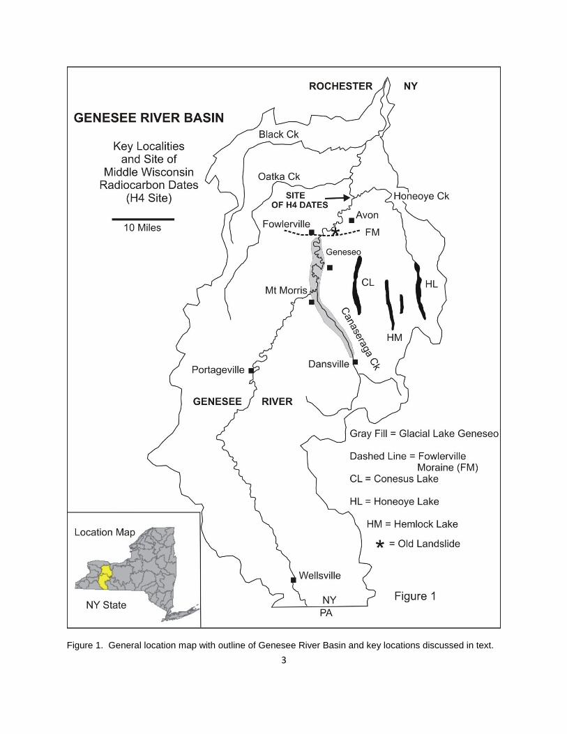
The middle and late Wisconsin glacial history of the Genesee Valley (Figure 1) has been
extended back approximately 50,000 years by the dating of glacial and interglacial sediments, as
well as wood samples recovered from water well drill holes, and by a complex stratigraphic
record preserved in two adjacent gravel excavations on the west bank of the Genesee River near
its confluence with Honeoye Creek (Young and Sirkin, 1994; Young and Burr, 2006). The
glacial history has been extended back through a middle Wisconsin ice advance that occurred
approximately 35,000 years ago to a warmer interstadial episode that peaked globally around
50,000 years ago. This middle Wisconsin ice advance buried interstadial spruce trees growing
2
on the ancestral Genesee floodplain that have finite radiocarbon ages as old as 48,800 14
C years
BP and extending slightly beyond the range of conventional radiocarbon dating (Young and
Burr, 2006).
The postglacial Genesee River floodplain history also has been extended back nearly
15,000 calendar years from analyses of wood samples buried by a prehistoric landslide near
Avon, NY (Young, 2003). Historic human impacts on the Genesee River floodplain at the
surface and from underground salt mining are significant and ongoing (Young, 2003). This brief
review cites critical peer-reviewed references that contain the details of the glacial history of the
Genesee Valley and of the adjacent Great Lakes and eastern North America, as well as some of
the most relevant concepts, chronology and climatic data that are essential to understand the
local glacial history within a broader global perspective.
Wisconsin Glacial History
Although the most recent Wisconsin Stage of the Pleistocene Epoch lasted approximately
100,000 years, most of the depositional glacial features (drumlins, moraines, kames, kettle lakes,
eskers, outwash channels, proglacial lake shorelines) that modify the older bedrock landscape of
New York State were only formed during the late Wisconsin glacial advance and recession,
between approximately 21,000 and 12,500 14
C years BP in upstate New York (see endnote on
radiocarbon dating conventions and calendar year conversion). The late Wisconsin glacial
episode essentially ended in New York State when the Laurentide ice sheet melted back from the
latitude of the glacial Lake Iroquois shoreline (Ridge Road) into the Lake Ontario Basin. Lake
Iroquois drained rapidly when the ice sheet finally melted back from the northern Adirondack
Mountains (Covey Hill spillway) and opened the St Lawrence Valley for glacial meltwater to
escape directly to the Atlantic Ocean, rather than following its earlier eastward routes through
the Hudson and Mohawk Valleys or westward into the glacial predecessors of Lake Erie.
Reviews of the Wisconsin glacial history of the eastern Great Lakes and eastern North America
can be found in Karrow and Occhiette (1989), Karrow et al. (2000), Muller and Calkin (1993),
Muller and Prest (1985), and Morner (1971), as well as in the numerous references therein.
During the final retreat of the Late Wisconsin ice sheet a series of 14 progressively larger and
lower proglacial lakes formed in the Genesee Valley (Fairchild, 1904, 1928), a sequence of
events that is reviewed and updated in Muller et al. (1988).
The last major glacial lake stage that submerged part of the lower Genesee Valley was
Lake Iroquois (~435 ft. ASL near Rochester), after which Lake Ontario dropped significantly
below its current elevation (246 ft ASL) to a level currently referred to as “early lake Ontario,” a
lake stage whose exact age and lowest elevation have been somewhat uncertain (Muller and
Prest, 1985). The surface water level of this early Lake Ontario stage at Irondequoit Bay was at
least 140 ft below current lake level, as documented by borings for the Town of Webster well
3
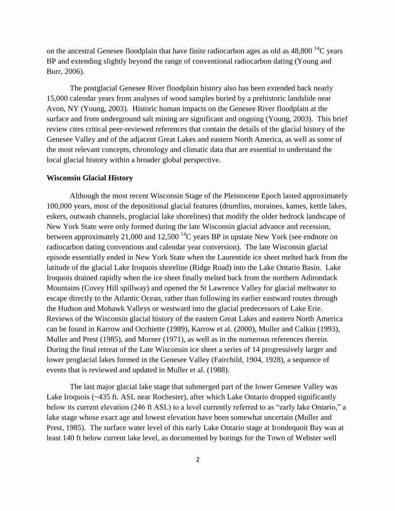
Figure 1. General location map with outline of Genesee River Basin and key locations discussed in text.
4
field, the Irondequoit Bay bridge, and the new bridge foundation borings located on the
Irondequoit Bay outlet sandbar (Young, 1983, 1988; Kappel and Young, 1989; Erdman et al.,
1991). Anderson and Lewis (2012, in press) have revised the water-level history for this low
water stage in the Lake Ontario basin. Their comprehensive analysis indicates that Lake Ontario
occupied a closed basin, disconnected from an outlet to the Atlantic Ocean for approximately
4,000 years beginning 12,300 calendar years BP during a relatively dry climatic interval.
Immediately prior to this time the lower lake level was confluent with the Champlain Sea, but
the fresh water influx to the lake prevented it from becoming a marine environment. During the
low, closed-basin stage, Lake Ontario’s shoreline would have been as much as 50 to 60 meters
(164 to 197 feet) below modern-day sea level.
Ongoing glacial rebound of the rising Ontario outlet threshold in the St Lawrence Valley
has gradually caused the southwestern Lake Ontario lake level to rise, creating the drowned
shoreline features (embayments) that characterize the lakeshore from Sodus Bay westward to
Buffalo (Muller and Prest, 1985; Young, 1983, 1998). In contrast, the northeastern shoreline of
the lake has been elevated (emerged), thus shaping modern features such as the Thousand
Islands. Contrary to some of the ideas of Fairchild and other early workers, marine waters
(Champlain Sea) never dominated the St Lawrence Valley further southwestward than the
approximate longitude of Brockville, Ontario, immediately after the ice retreated, and before
postglacial rebound of the land became significant. Differential postglacial rebound continues to
tilt Lake Ontario toward the southwest at a rate that changes the relative shoreline elevations by
almost one foot per century between the eastern and western ends of the lake.
The existing landforms in the Genesee Valley downstream from the postglacial
Letchworth Park gorge were formed by a combination of ice advance (erosion), ice recession
(deposition, including a widespread mantle of varved lake sediments and shoreline deposits), and
subsequent modifications related to the effects of the modern Genesee River (fluvial erosion,
floodplain deposition, landslides, historic deforestation, agricultural impacts, mining) (Young,
2003). The glacial landforms and glacial geology of the region and across the entire state may be
examined on the 5 large sheets of the Surficial Geology Map of New York published in 1986 as
New York State Museum Map and Chart Series #40 (Scale, 1:250,000).
Correlation of Glacial Terrestrial and Glacial Marine Records
The incomplete terrestrial chronology of continental glaciations has been gradually
improved and reorganized using the more complete and combined climatic records from ice cap
studies and from hundreds of deep sea sediment cores. The ability to correlate the Pleistocene
stratigraphic record from the deep sea cores directly with poorly preserved terrestrial landforms
(such as glacial moraines) is a more difficult and challenging task, given the sparse occurrence of
organic remains that are preserved in the generally coarser and more oxidized continental
sediments. The Genesee Valley near the Monroe-Livingston County border contains a unique
5
and diverse continental record of organic remains that is contemporaneous with one of the best
studied marine glacial events in the North Atlantic Ocean, Heinrich Event H4.
Seven thin sand layers, named Heinrich Events, and designated as H0 through H6, have
been defined in North Atlantic Ocean sediment cores and are presumed to record seven distinct
periods of extreme Laurentide glacier advances, or surges, accompanied by massive episodes of
iceberg calving (Bond and Lotti, 1995). These massive iceberg discharges are tentatively
attributed to an unstable thickening of the Laurentide ice sheet, which eventually results in basal-
ice shear failure accompanied by a sudden outward surge of the ice margin. The result is a
massive, but relatively short-lived, discharge of icebergs into the North Atlantic (Bond et al.,
1992, 1993; Cortijo et al., 1997; Elliot et al., 1998). The southward drift and slow melting of
these iceberg armadas disperses sandy glacial sediment that forms thin but pervasive sand layers
encountered in the otherwise fine-grained sediments that characterize most deep sea sediment
cores. These Heinrich iceberg discharge events have been dated as occurring at the following
approximate times (14
C years BP): H0 at 12,000; H1 at 17,000; H2 at 24,000; H3 at 31,000; H4
at 35,000; H5 at 45,000; and H6 at 60,000. A number of the younger Heinrich Events
correspond to the approximate ages of the major dated glacial moraine sequences in the
terrestrial glacial record of North America (Clark and Bartlein, 1995; Mooers and Lehr, 1997).
In other words, the unusually prolific marine iceberg calving events correspond with terrestrial
ice sheet advances that created some of the major glacial terminal and recessional end moraines.
However, accurate radiocarbon dating of organic material is not feasible for events much older
than 49,000 14
C years BP, and few glacial deposits older than 35,000 in eastern North America
contain well-preserved and datable organic remains. Wood found in glacial tills generally has an
uncertain age relationship to the encompassing sediments, due to the fact that glacial advances
and associated till deposition can override and incorporate organic remains that are significantly
older than the age of the till-forming ice advance (Young and Burr, 2006; Young, 2003).
Heinrich Event H4 (35,000 14
C years BP) is marked by a relatively thick detrital sand
layer (2 to 4 inch range) in deep sea cores. There is evidence in the ocean cores that it was a
dual-pulsed glacial advance (sand layer with 2 distinctively coarser intervals). It is estimated by
marine geologists to be as short as 250 years in duration, but may have impacted global climate
for as long as 1000 years (Kirby and Andrews, 1999; Cortijo et al., 1997). The calendar age for
circa 35,000 14
C years BP dates most likely falls somewhere between 37,000 and 39,000 actual
calendar years BP.
Middle Wisconsin Site, Northern Livingston County
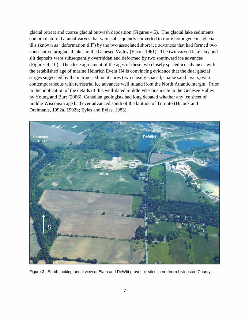
A complexly stratified glacial deposit in shallow gravel pit excavations adjacent to the
west edge of the Genesee River floodplain in northern Livingston County, opposite the Genesee
confluence with Honeoye Creek (Figures 1-3), was studied for over 10 years by the author
(Young and Sirkin, 1994; Young and Burr, 2006). The site produced 68 radiocarbon dates with

6
ages ranging between 30,000 and 49,000 14
C years BP on large wood fragments, mammoth
bones, and miscellaneous organic materials (spruce cones, twigs, tiny pelecypod shells, small
plant roots) all of which predate the most recent (late Wisconsin) ice advance in western New
York. The late Wisconsin ice advance that created the terminal moraines in northern
Pennsylvania and on Long Island occurred approximately 22,000 to 20,000 14
C years ago.
Middle Wisconsin time in NY State is poorly defined but probably corresponds roughly to events
spanning the time interval from ~30,000 to ~60,000 14
C years BP.
Figure 2. Location map for Elam-DeWitt middle Wisconsin glacial site (pink) in northern Livingston County. Arrows indicate flow of younger, late Wisconsin meltwater in well-preserved ice-marginal channels shown as light blue. Modern flood plains of Genesee River and Honeoye Creek colored yellow.
The unique middle Wisconsin glacial section in the lower Genesee Valley consists of an
interstadial ancestral Genesee River floodplain deposit dominated by spruce trees between
49,000 and 36,000 14
C years old and overlain by two separate gray glacial lake deposits, all of
which underlie the red-colored glacial till of the better-known late Wisconsin ice advance
(Figures 4-9). The two middle Wisconsin lake deposits are very close in age (circa 35,000 14
C
years BP), but are separated by a conspicuous gravel deposit that signifies a short interval of
7
glacial retreat and coarse glacial outwash deposition (Figures 4,5). The glacial lake sediments
contain distorted annual varves that were subsequently converted to more homogeneous glacial
tills (known as “deformation till”) by the two associated short ice advances that had formed two
consecutive proglacial lakes in the Genesee Valley (Elson, 1961). The two varved lake clay and
silt deposits were subsequently overridden and deformed by two southward ice advances
(Figures 4, 10). The close agreement of the ages of these two closely spaced ice advances with
the established age of marine Heinrich Event H4 is convincing evidence that the dual glacial
surges suggested by the marine sediment cores (two closely-spaced, coarse sand layers) were
contemporaneous with terrestrial ice advances well inland from the North Atlantic margin. Prior
to the publication of the details of this well-dated middle Wisconsin site in the Genesee Valley
by Young and Burr (2006), Canadian geologists had long debated whether any ice sheet of
middle Wisconsin age had ever advanced south of the latitude of Toronto (Hicock and
Dreimanis, 1992a, 1992b; Eyles and Eyles, 1983).
Figure 3. South-looking aerial view of Elam and DeWitt gravel pit sites in northern Livingston County.

8
Other proglacial deposits in the Cayuga Valley and from a site closer to Buffalo
previously provided a few isolated 14
C ages for events close to the same middle Wisconsin
interval, but the glacial events associated with those sites are not as clearly defined or as well
documented as in the Genesee Valley study (Muller and Calkin, 1993). In summary, well
documented evidence now exists for a middle Wisconsin ice advance that extended at least 20
miles (32 km) south of the Lake Ontario shoreline and that clearly preceded the classical late
Wisconsin event that created most of the modern surficial glacial landforms. Additional
evidence from other buried organic remains and dated wood from engineering and water well
borings (Young and Burr, 2006) suggests that the record of middle Wisconsin glaciation is
probably much more widespread, but is buried beneath glacial drift in the scoured bedrock
valleys of the northern Finger Lakes region.
Figure 4. Diagrammatic section of middle Wisconsin glacial sequence showing the record of two glacial advances (gray varve deformation tills) surrounded by yellow outwash gravels above green ancestral Genesee River floodplain. Ages are in
14C years BP.
9
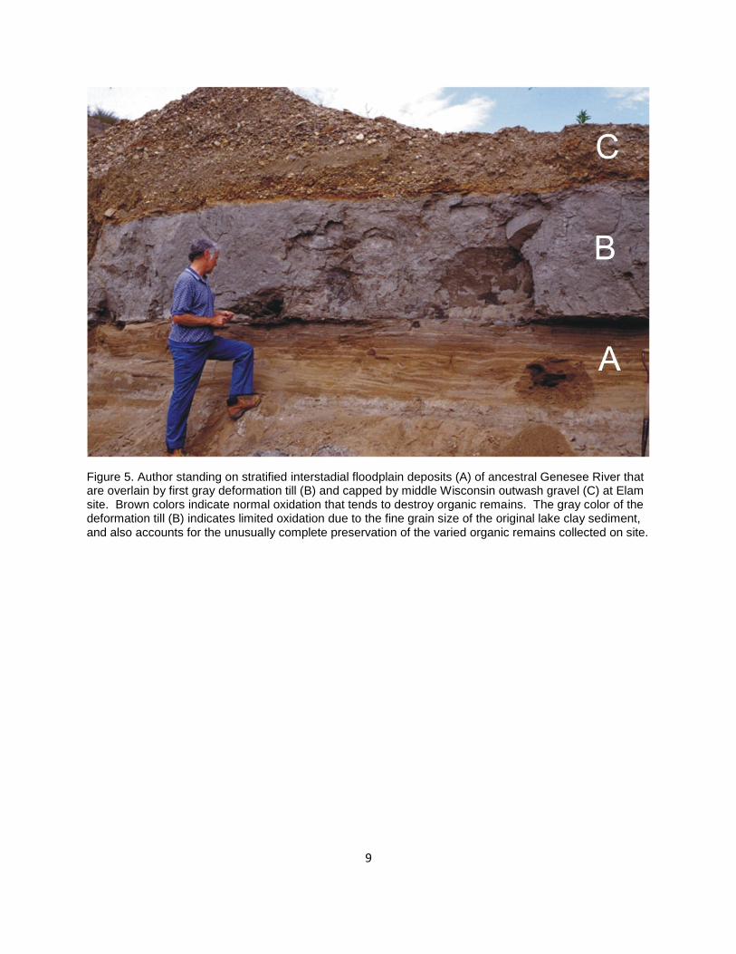
Figure 5. Author standing on stratified interstadial floodplain deposits (A) of ancestral Genesee River that are overlain by first gray deformation till (B) and capped by middle Wisconsin outwash gravel (C) at Elam site. Brown colors indicate normal oxidation that tends to destroy organic remains. The gray color of the deformation till (B) indicates limited oxidation due to the fine grain size of the original lake clay sediment, and also accounts for the unusually complete preservation of the varied organic remains collected on site.
10
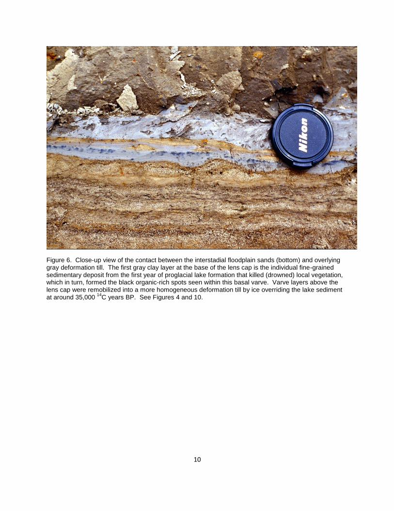
Figure 6. Close-up view of the contact between the interstadial floodplain sands (bottom) and overlying gray deformation till. The first gray clay layer at the base of the lens cap is the individual fine-grained sedimentary deposit from the first year of proglacial lake formation that killed (drowned) local vegetation, which in turn, formed the black organic-rich spots seen within this basal varve. Varve layers above the lens cap were remobilized into a more homogeneous deformation till by ice overriding the lake sediment at around 35,000
14C years BP. See Figures 4 and 10.

11
Figure 7. The contact between the interstadial floodplain sandy river gravel (bottom) and the overlying varved lakebeds at the base of lower deformation till. Note how the varves conform to the irregularities on the original floodplain surface and are draped over individual pebbles (center). This indicates that the lake-forming event involved slow sedimentation in a low energy environment as the advancing glacier dammed the ancestral Genesee River. The pebble near the center of the image is approximately two inches in diameter.

12
Figure 8. Contact between interstadial floodplain sands (bottom) and the basal varve of the initial proglacial lake sequence. This image clearly shows the nature of the organic-rich basal varve (gray and brown layer with black spots near top of view). Vertical black root (center) is from a small reed-like plant that grew in the floodplain sediment before the 35,000 year old ice advance, similar to annual plant growth seen on modern Genesee River point bars (Diagrammatic location of roots is shown on Figure 4). The organic remains of both the basal lake varve and the root were radiocarbon dated to obtain the relative age of the initial glacial lake (ice advance) compared to the age of the preexisting floodplain. The youngest organic remains found in the floodplain sediment were approximately 1000 years older than the 35,000-year-old basal lake sediment, which is in remarkable agreement, considering the random nature of the geologic preservation and the equally random collection and dating methods.
13
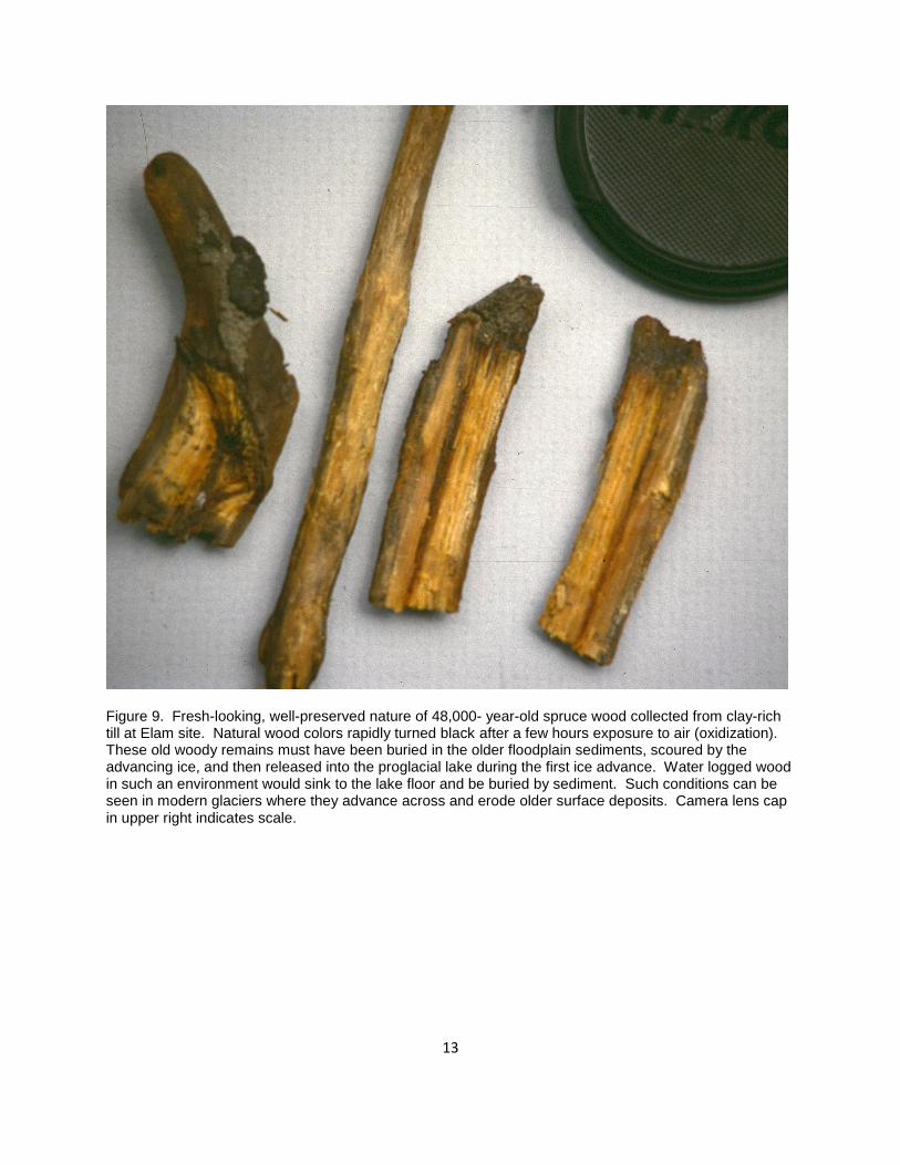
Figure 9. Fresh-looking, well-preserved nature of 48,000- year-old spruce wood collected from clay-rich till at Elam site. Natural wood colors rapidly turned black after a few hours exposure to air (oxidization). These old woody remains must have been buried in the older floodplain sediments, scoured by the advancing ice, and then released into the proglacial lake during the first ice advance. Water logged wood in such an environment would sink to the lake floor and be buried by sediment. Such conditions can be seen in modern glaciers where they advance across and erode older surface deposits. Camera lens cap in upper right indicates scale.
14
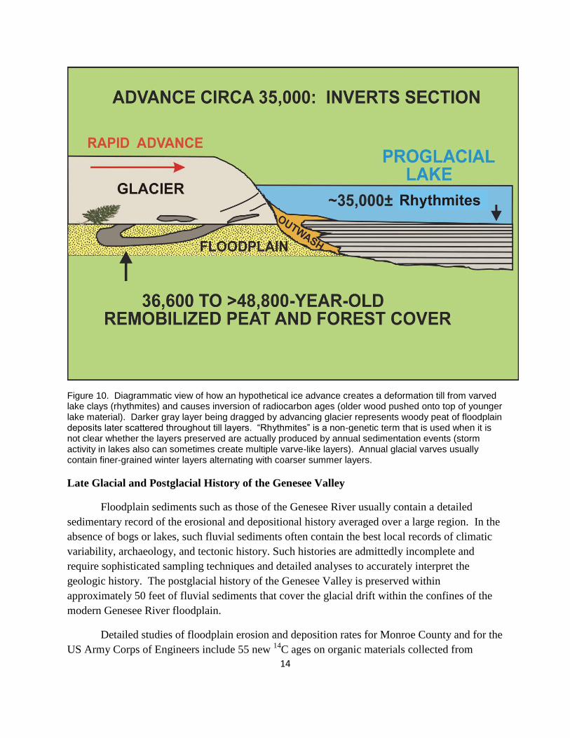
Figure 10. Diagrammatic view of how an hypothetical ice advance creates a deformation till from varved lake clays (rhythmites) and causes inversion of radiocarbon ages (older wood pushed onto top of younger lake material). Darker gray layer being dragged by advancing glacier represents woody peat of floodplain deposits later scattered throughout till layers. “Rhythmites” is a non-genetic term that is used when it is not clear whether the layers preserved are actually produced by annual sedimentation events (storm activity in lakes also can sometimes create multiple varve-like layers). Annual glacial varves usually contain finer-grained winter layers alternating with coarser summer layers.
Late Glacial and Postglacial History of the Genesee Valley
Floodplain sediments such as those of the Genesee River usually contain a detailed
sedimentary record of the erosional and depositional history averaged over a large region. In the
absence of bogs or lakes, such fluvial sediments often contain the best local records of climatic
variability, archaeology, and tectonic history. Such histories are admittedly incomplete and
require sophisticated sampling techniques and detailed analyses to accurately interpret the
geologic history. The postglacial history of the Genesee Valley is preserved within
approximately 50 feet of fluvial sediments that cover the glacial drift within the confines of the
modern Genesee River floodplain.
Detailed studies of floodplain erosion and deposition rates for Monroe County and for the
US Army Corps of Engineers include 55 new 14
C ages on organic materials collected from

15
within the floodplain sediments (Young 1997, 2003). The oldest dates in these floodplain studies
come from a prehistoric landslide on the east bank of the Genesee River near Avon, NY, that
occurred nearly 15,000 calendar years before the present (Figure 1) (Young, 2003). This
landslide buried small trees that are preserved within 2 feet of the current channel bed elevation
of the Genesee River (Figure 11a, 11b). The adjacent river channel is eroded into glacial varves
at this site. This demonstrates that the Genesee River had carved its channel through glacial drift
essentially to its present depth at the time of the landslide and only a short time after the late
Wisconsin ice sheet is known to have receded from the northern border of Livingston County.
This landslide site is on the northern edge of the large Fowlerville moraine complex that fills
much of the valley between Geneseo and Fowlerville (Figure 1). The river floodplain is quite
narrow (1000 ft.) through this long morainal reach due to the greater erosional resistance of the
glacial till exposed by the 1973 Oxbow Lane landslide (Young, 1973; Muller et al., 1988). This
broad, nearly featureless moraine created glacial Lake Geneseo (Figure 1), the last glacial lake
stage in the central part of the Genesee Valley (Muller et al., 1988). Lake Geneseo extended
from the edge of the Fowlerville moraine southward nearly to Dansville, and was probably no
deeper than 120 feet (Muller et al. 1988).
The age and depth of postglacial erosion at the prehistoric Avon landslide indicates that
glacial Lake Geneseo could not have been a long-lived feature. Glacial Lake Geneseo would
have drained as soon as the Genesee channel had eroded deeply enough to cause the landslide.
Thus the river must have eroded entirely through the Fowlerville moraine to its present level by
15,000 years ago, within a few hundred years of the age of the estimated ice sheet recession from
this latitude. Furthermore, the modern elevation of the river channel at the foot of the prehistoric
landslide indicates that erosion (lowering) of the channel bed over the past 15,000 years since the
landslide occurred has been minimal (~2 feet). This suggests that lateral reworking (not
downcutting) of fluvial sediment within the upper 50 feet of the floodplain has been the
dominant activity of the river since that time, as argued by Young (2003). This is probably due
to two major factors: (1) the Genesee River channel crosses two bedrock thresholds at Geneseo
and near York Landing, which restrict vertical incision of the channel, and (2) the impact of
glacial rebound (southward tilting of the entire basin) has acted to reduce the channel gradient
between the York Landing bedrock threshold and the bedrock elevation of the resistant Lockport
Dolomite, which forms the crest of the Upper Falls in the City of Rochester.
Results of the 2002-2003 Floodplain Study
The floodplain study contracted by the US Army Corps of Engineers for the Genesee River
downstream from Letchworth Park gorge concluded the following (from Executive Summary;
Young, 2003):
Of the three major geologic reaches identified in this 57-mile study, the 15-mile channel
reach on the agricultural floodplain located on the former glacial lake bed immediately below

16
the Mt Morris Dam has experienced the most rapid changes in recent time. Changes along
the remaining 42 miles of channel to the north are relatively insignificant by comparison.
Channel changes within the Mt Morris-Honeoye Creek reach (42 miles) since 1942 include
meander migration rates of up to 28 feet per year, with an average of 4.75 feet per year for 45
locations. The downstream banks of north-trending, non-vegetated meander loops show the
fastest erosion rates.
Estimated floodplain overbank sedimentation rates on the natural, forested (?) floodplain
were relatively constant prior to European settlement at rates between 4 and 6 inches per
century. Post-European settlement sedimentation rates appear to have more than doubled,
but radiocarbon data are too scarce to provide adequate measurements for the last 300 years.
Lateral migration of the river channel in areas where the Genesee flows through glacial till
and where the banks are naturally vegetated shows little change since 1942. However,
significant prehistoric channel changes near major tributary junctions north of Fowlerville
are obvious from abandoned channel patterns still visible on aerial photography. These
include the reaches immediately upstream and downstream from Dugan Creek (see Figure 2),
Oatka Creek and Black Creek (see Figure 1). Tributary junction areas on the floodplain are
likely to be areas of sudden or discrete channel changes (avulsions) triggered by exceptional
flood events combined with debris dams.
Both the measured rate of vertical channel sedimentation and the inferred rate of lateral
channel migration, implied by the ages of the majority of point bars sampled, suggest that
both the overbank floodplain sediments and point bar deposits to the depth of the modern
channel base have been extensively reworked and deposited by natural processes within the
past 2500 years with an estimated error of ±20%.
The channel shows an inverted, abnormal gradual widening upstream between Geneseo and
Mt Morris, below the Mt Morris Dam. This atypical upstream widening may be related to
flood-control discharge practices and/or land-use practices. Local channel widening also
occurs erratically near major and minor tributary junctions. This localized widening may be
a response to decreasing channel depth where tributary bedloads are added to the main stem
Genesee channel bedload.
The 15-mile Geneseo-Mt Morris reach of the river channel lengthened by 1.36 miles (9.8 %)
in the interval from 1942 to 2002, upstream from a bedrock threshold near Geneseo. This
length change resulted in an addition of 2.72 miles (both sides of channel) of erosion-prone
banks, which contribute to increased sedimentation along downstream reaches.
At least one conspicuous charcoal horizon (forest fire?) sampled between 5- and 6-foot
depths in the overbank sediments appears to correlate with a documented anomaly in global
climate that is preserved in drought records circa 536 AD on most continents. Location of
additional evidence of such potentially widespread events can provide a means of
17
subdividing the floodplain stratigraphy into more geologically significant intervals over
larger areas, or to link similar chronologies among several basins.
Where the river banks are heavily vegetated, the dense root-growth exposed along the
channel sides attests to the erosion protection provided by natural tree growth along channel
banks.
The dating of annual leaf mats within point bar sediments provides a more reliable measure
of sediment age than ages derived from random wood fragments, which may have a complex
history of reworking from older buried logs. In contrast, charcoal residues from overbank
sediments do appear to provide reliable measures of sediment age (presumed floodplain fire
events).
Erosion by the Genesee River channel to near its present grade appears to have occurred in a
short time interval following the last glacial retreat. This assertion is based on the discovery
of a 14,000-to 15,000-year-old landslide exposed at the base of the modern channel near
Avon, NY. It is also assumed that the river had vertically incised its channel through the
Fowlerville moraine complex (immediately upstream) by this time. In any event, the
location of the landslide next to the modern channel indicates that the river must have been at
or very close to its present grade between Avon and Rochester by 14,000 years ago.
Mean annual discharge at the Mt Morris gage shows an increase of as much as 25% for the
period of record (1909 to present). If this is simply a normal fluctuation in the natural
system, it fortuitously coincides with the period of post-dam channel adjustment. Most of
the increased discharge postdates the regional drought of the mid 1960s.
Insufficient information exists at present to adequately address the potential contribution of
the 1994 Akzo-Nobel mine collapse and resulting floodplain subsidence to localized flooding
and recent channel adjustments between Mt Morris and Geneseo. Future studies should
address this issue.

18
Figure 11a. Prehistoric landslide deposit on Genesee River bank near Avon, NY.
Figure 11b. Close-up view of trees buried by landslide in 11a. Red arrows are 6 inches apart.
19
Summary and Conclusions
The geologic record of the glacial history of the Genesee Valley and west-central NY is
imperfectly understood and is more complex than indicated in much of the published geologic
literature. The known 14
C ages of major glacial features in central New York State is still very
limited in most areas, and the presumed ages of many events, such as ice advances marked by
dated moraine positions, have previously been extrapolated entirely across NY State from the
eastern Erie Basin near Buffalo all the way east to the Hudson Valley region (Calkin, 1970;
Cadwell et al. 1988; Muller and Cadwell, 1986). It is now clear there was a middle Wisconsin
ice advance into central and western NY circa 35,000 14
C years BP that extended well south of
the Lake Ontario shoreline, but the event has been poorly documented elsewhere. The presence
of these much older glacial lake deposits (varved clays) in the Genesee Valley also may have
complicated previous studies of the glacial history that were based on the paleomagnetism of the
varved glacial clays (Brennan, 1988). Discrimination between middle and late Wisconsin glacial
lake sediments within or near the floodplain would have been problematic prior to discovery and
dating of the Elam-DeWitt site. The middle Wisconsin proglacial lake sediments could have
extended well south of the middle Wisconsin ice margin, and exposures of varved sediments in
riverbanks or small tributaries might have widely differing ages (middle and late Wisconsin) due
to their random preservation and selective exposure by river and tributary erosion.
The preservation of the middle Wisconsin glacial sediments at depths no greater than 30
feet below the late Wisconsin surface in the Genesee Valley near Honeoye Creek also indicates
that the well known late Wisconsin ice advance southward into Pennsylvania, and as far as Long
Island, did not necessarily scour all the Finger Lakes valleys completely down to bedrock as
implied in Mullins and Eyles (1996). The shape and depth of the buried bedrock valley under
the Genesee River floodplain is similar to that of the largest Finger Lakes, and the longitudinal
valley profile is similarly influenced by the resistance of the southward-dipping resistant
Onondaga limestone. The buried valleys of the Finger Lakes region are likely to be hiding a rich
source of geologic information concerning middle Wisconsin, and possibly older glacial events.
The failure of the late Wisconsin ice sheet to significantly scour the middle Wisconsin glacial
drift from the buried Genesee Valley at the latitude of Honeoye Creek raises fundamental
uncertainties regarding our understanding (or assumptions) concerning the severity of glacial
erosion by individual ice advances, especially in the classic Finger Lakes region.
The postglacial history contained in the floodplain sediments of the Genesee Valley
provides a wealth of information concerning postglacial erosion and sedimentation rates, as well
as about the apparent historic impact of agriculture and dams on the behavior of large river
systems (US Army Corps of Engineers, 1969; Mansue et al., 1991; Mansue and Bauersfeld,
1991; Young, 2003). However, the impact of the Akzo-Nobel salt mine collapse on the Genesee
River’s hydraulic readjustment has yet to be quantitatively evaluated over the long term (Nieto
and Young, 1998). Much data concerning this avoidable mine disaster is contained in both

20
published and unpublished reports, including the ongoing impact of upward vertical brine
migration into the basal floodplain aquifer near the collapse area east of Cuylerville, NY (Yager
et al. 2001, Nieto and Young, 1998). In addition, details of the subsurface geology of the valley
are as yet to be quantitatively evaluated from several detailed deep borings between Sonyea and
Fowlerville completed during the summer of 1999 (Research in progress, Young, 2011).
End Note: Radiocarbon Dating Issues
The problem of converting measured radiocarbon years to actual calendar years, using methods
such as tree ring calibration and continuous ice core records, is relatively accurate back to 30,000
radiocarbon years, but at that point calendar years may be as much as 5,000 years older than
measured 14
C ages. When reading the geologic literature it is important to distinguish between
radiocarbon years, commonly expressed as “14
C years BP,” (BP = Before Present) and “calendar
years” (actual years before the present, and usually expressed as “kyr BP”). The “present” is
always measured from 1950 AD, the common conventional reference point used for comparing
radiocarbon measurements (Joris and Weninger, 1998; Voelker et al., 1998). Calibration
programs to explain and readily convert radiocarbon ages to actual calendar years are maintained
online by radiocarbon research laboratories. One such program is CALIB, provided by the
Quaternary Isotope Lab, University of Washington, and currently maintained by Paula and Ron
Reimer. Maintenance of CALIB is supported by the University of Washington, Queens
University of Belfast, and the National Science Foundation. CALIB can be located by a simple
web search or accessed directly at: http://calib.qub.ac.uk/calib. The conversion of radiocarbon
years to calendar years is not a simple linear relationship, and individual radiocarbon ages
sometimes have two or more different calendar year conversions. Many interesting examples
and discussions of the relationships between calendar years and radiocarbon measurements for
different portions of the 50,000-year timescale can be found online. Regardless of these inherent
problems, 14
C dating is the best means of comparing the relative ages of glacial events that
happened during the past 50,000 years.
References
Alley, R.B., Clark, P.U., 1999. The deglaciation of the Northern Hemisphere: A global
perspective. Ann. Rev. Earth Planet. Sci. 27, p.149-182.
Anderson, T.W. and Lewis, C.F.M., (2012), A new water-level history for Lake Ontario basin:
Evidence for a climate-driven early Holocene lowstand. Journal of Paleolimnology, v. 47, no. 3,
p. 513-530.
Andersen, K.K., Svensson, A., Johnsen, S.J., Rasmussen, S.O., Bigler, B., Rothlisberger, R.,
Ruth, U., Siggaard-Andersen, M.L., Steffensen, J.P., Dahl-Jensen, D., Vinther, B.M., and
Clausen, H.B., 2006, The Greenland Ice core Chronology 2005, 15-42 ka. Part 1: Constructing
the Time Scale. Quaternary Science Reviews, v. 25, nos. 23-24, p. 3246-3257.
21
Bond, G. and Lotti, R., 1995. Iceberg discharges into the North Atlantic on millennial time
scales during the last glaciation. Science, 267, p.1005-1010.
Bond, G., Heinrich, H., Broecker, W., Labeyrie, L., McManus, J., Andrews, J., Huon, S.
Jantschik, R., Clasen, S., Simet, C., Tedesco, K., Klas, M., Bonanl, G., and Ivy, S., 1992.
Evidence for massive discharges of icebergs into the North Atlantic Ocean during the last glacial
period. Nature, 360,p. 245-249.
Bond, G., Broecker, W., Johnson, S., McManus, J., Labeyrie, L., Jouzel, J., and Bonani, G.,
1993. Correlation’s between climatic records from North Atlantic sediments and Greenland ice.
Nature 365, p.143-147.
Brennan, W.J., 1988, Geophysical investigations of glacial drift. 51st Annual Meeting of Friends
of the Pleistocene, Guidebook, Late Wisconsin Deglaciation of the Genesee Valley, SUNY
Geneseo, p. 15-27.
Cadwell, D.H., Connally, G.G., Fleisher, P.J., and Muller, E.H., 1988. Surficial Geologic Map of
New York, Niagara Sheet (revision), New York State Geological Survey, Map and Chart Series
#40, Albany, NY, Scale 1:250,000.
Calkin, P.E., 1970. Strand lines and chronology of the glacial Great Lakes in northwestern New
York. Ohio J. Sci., 70(2), p.78-96.
Clark, P.U. and Bartlein, P.J., 1995, Correlation of late Pleistocene glaciation in the western
United States with North Atlantic Heinrich events. Geology, 23(6), p.483-486.
Cortijo, E., Labeyrie, L., Vidal, L., Vautravers, M., Chapman, M., Duplessy, J-C., Elliot, M.,
Arnold, M., Turon, J-L., and Auffret, G., 1997. Changes in sea surface hydrology associated with
Heinrich event 4 in the North Atlantic Ocean between 40 and 60 N. Earth Planet. Sci. Lett.
146, p.29-45.
Elliot, M., Labeyrie, L., Bond, G., Cortijo, E., Turon, J.-L., Tisnerat, N., Duplessy, J.-C., 1998.
Millennial-scale iceberg discharges in the Irminger Basin during the last glacial period:
Relationship with Heinrich events and environmental settings. Paleoceanography, v. 13 (5),
p.433-446.
Elson, J.A., 1961. The geology of tills, in Penner, E. and Butler, J., eds, Proceedings, 14th
Canadian Soils Mechanics Conference: Ottawa, Canada, National Research Council of Canada,
Associate Committee on Soil and Snow Mechanics, Technical Memorandum 69, p 5-17.
Erdman, Anthony, and Associates, Inc., 1991, Draft Design Report and Environmental
Impact/Section 4(f) Statement, Vol. 6 Appendix M: Preliminary Geotechnical Engineering
Report for Proposed Irondequoit Bay Outlet Bridge, Irondequoit and Webster NY. Prepared for
NYSDOT and Monroe County Department of Engineering, p. 1-7, Tables, Soils Analyses, Well
logs.
Eyles, C.H., and Eyles, N., 1983. Sedimentation in a large lake: A reinterpretation of the late
Pleistocene stratigraphy at Scarborough Bluffs, Ontario, Canada. Geology, 11, p.146-152.

22
Fairchild, H.L., 1904, Glacial waters in central New York. N.Y. State Museum Bulletin 127, pp.
1-66, Plates p.34-42.
Fairchild, H.L, 1928, Geologic story of the Genesee Valley and western NY. pp. 1-215,
published by the author, distributed by Scrantom’s Inc.
Hicock, S.R., and Dreimanis, A., 1992a, Sunnybrook drift in the Toronto area, Canada;
Reinvestigation and reinterpretation. Geol. Soc. Amer., Special Paper 270, p. 39-161.
Hicock, S.R., and Dreimanis, A., 1992b. Deformation till in the Great Lakes region:
implications for rapid flow along the south-central margin of the Laurentide Ice Sheet. Can. J.
Earth Sci. 29, p.1565-1579.
Joris, O. and Weninger, B., 1998. Extension of the 14
C calibration curve to ca. 40,000 cal BC by
synchronizing Greenland 18
O/16
O ice core records and north Atlantic foraminifera profiles. A
comparison with U/Th coral data. Radiocarbon, 40(1), p.495-504.
Kappel, W.M., and Young, R.A., 1989, Glacial History and Geohydrology of the Irondequoit
Creek Valley, Monroe County, NY. US Geological Survey Water-Resources Investigations
Report 88-4145, p. 1-34, 3 maps.
Karrow, P.F. and Occhiette, S., 1989. Quaternary geology of the St. Lawrence lowlands of
Canada. In R.J. Fulton (ed.) Quaternary Geology of Canada and Greenland, Geological Survey
of Canada, Geology of Canada, no. 1, p.321-389.
Karrow, P.F., Dreimanis, A., and Barnett, P.J., 2000. A proposed diachronic revision of Late
Quaternary time-stratigraphic classification in the eastern and northern Great Lakes area. J.
Quat. Res. 54, p.1-12.
Kirby, M.E., and Andrews, J.T., 1999. Mid-Wisconsin Laurentide ice sheet growth and decay:
Implications for Heinrich events 3 and 4. Paleoceanography 14, no. 2, p.211-223.
Mansue, L. J, Young, R.A., and Soren, J., 1991, Hydrologic influences on sediment-transport
patterns in the Genesee River Basin, New York, In: Genesee River Watershed Study, Volume
IV, Special Studies, U.S. Geological Survey, U.S. Environmental Protection Agency Publication
EPA-905/9-91-005D, GL-07D-91, p. II-1 to II-33.
Mansue, L.J., and Bauersfeld, W.R., 1991, Streamflow and sediment transport in the Genesee
River Basin, New York. In: Genesee River Watershed Study, Volume IV, Special Studies, U.S.
Geological Survey, U.S. Environmental Protection Agency Publication EPA-905/9-91-005D,
GL-07D-91, p. I-1 to I-54.
Mooers, H.D., and Lehr, J.D., 1997. Terrestrial record of Laurentide Ice Sheet reorganization
during Heinrich events. Geology, 25(11), p.987-990.
Morner, N.-A., 1971. The Plum Point Interstadial: Age, Climate, and Subdivision. Can. J. Earth
Sci. 8, p.1423-1431.
Muller, E. H. and Calkin, P.E., 1993, Timing of Pleistocene glacial events in New York
23
State. Can. J. Earth Sci., v. 30, p.1829-1845.
Muller, E.H. and Cadwell, D.H.,1986. Surficial Geologic Map of New York, Finger Lakes
Sheet, N.Y. State Geological Survey, Map and Chart Series #40, Albany, NY, Scale 1:250,000.
Muller, E.H., and Prest, V.K., 1985. Glacial lakes in the Ontario basin. In: Karrow, P.F., and
Calkin, P.E. (Eds.), Quaternary Evolution of the Great Lakes. Geol. Soc. Can. Special Paper 30.
Johanns Graphics, Waterloo, Canada, p. 213-230.
Muller, E., Braun, D., Young, R.A., and Wilson, M., 1988, Morphogenesis of the Genesee
Valley, Northeastern Geology 10(2), p.112-133.
Mullins, H.T., and Eyles, N. (Eds.), 1996. Subsurface geologic investigations of New York
Finger Lakes: Implications for Late Quaternary deglaciation and environmental change. Geol.
Soc. Am. Special Paper 311, Boulder, CO, p. 1-89.
Nieto, A.S., and Young, R.A., 1998, Retsof Salt Mine collapse and Aquifer Dewatering, Genesee
Valley, Livingston County, NY. In: Land Subsidence, Case Studies and Current Research,
Proceedings of the Joseph F. Poland Symposium on Land Subsidence, Ed. J.W. Borchers, USGS,
Special Publication 8 of the Association of Engineering Geologists, Star Publishing Co.,
Belmont, CA, p.309-325.
Ridgwell, A.J., Watson, A.J., and Raymo, M.E., 1999, Is the spectral signature of the 100,000
kyr glacial cycle consistent with a Millankovitch origin? Paleoceanography, v. 14, no. 4, p.437-
440.
Ruddiman, W.F., 2006, Orbital changes and climate. Quaternary Science Reviews, v. 25, nos.
23-24, p. 3092-3111.
Svensson, A., Andersen, K.K., Bigler, M., Clausen, H.B., Dahl-Jensen, D., Davies, S.M.,
Johnsen, S.J., Muscheler, R., Parrenin, F., Rasmussen, S.O., Rothlisberger, R., Seierstad, I.,
Steffensen, J.P., and Vinther, B.M., 2008, A 60,000 year Greenland stratigraphic ice core
chronology. Climate of the Past, v. 4, p.47-57.
US Army Corps of Engineers, 1969, Genesee River Basin, Study of Water and Related Land
Resources. Buffalo District, US Army Corps of Engineers, Vols. I-VIII.
Voelker, A.H.L., 2002. Global distribution of centennial-scale records for Marine Isotope Stage
(MIS) 3: a database. Quat. Sci. Rev. 21(10), p.1213-1228.
Voelker, A.H.L., Sarnthein, M., Grootes, P.M., Erlenkeuser, H., Laj, C., Mazaud, A., Nadeau,
M.-J., and Schleicher, M., 1998. Correlation of marine 14C ages from the Nordic Seas with the
GISP2 isotope record: implications for 14C calibration beyond 25 ka BP. Radiocarbon, 40(1),
p.517-534.
Yager, R.M., Miller, T.S., and Kappel, W.M., 2001, Simulated effects of 1994 salt-mine collapse
on ground-water flow and land subsidence in a glacial aquifer system, Livingston County, NY.
US Geological Survey Professional Paper 1611, p.1-85.
24
Young, R.A., 1973, Late glacial and postglacial geology of the Genesee Valley in Livingston
County, NY: A preliminary report. New York State Geological Association Guidebook for
Fieldtrips, NYSGA 45th
Annual Meeting, SUNY Brockport/Monroe Community College, p. E-1
to E-21.
Young, R.A., 1983, The geologic evolution of the Genesee Valley region and early Lake
Ontario: A review of recent progress. Proceedings of the Rochester Academy of Science,
Centennial Colloquium Issue: Geology of the Genesee Region of New York Since H.L.
Fairchild, v.15, no. 2, p. 85-98.
Young, R.A., 1988, Pleistocene Geology of Irondequoit Bay. 51st Annual Meeting of Friends of
the Pleistocene, Guidebook, Late Wisconsin Deglaciation of the Genesee Valley, SUNY
Geneseo, p.73-87.
Young, R.A., 1997, Postglacial to modern channel erosion and overbank deposition rates, Mt
Morris to Geneseo reach, Genesee River, NY. Monroe County Department of Health, Monroe
County, N.Y., pp. 1-17, Appendices.
Young, R.A., 1998, Postglacial Tilting of Lake Ontario. Rochester Committee for Scientific
Information, Bull. 322, Rochester, NY, p. 1-8.
Young, R.A., 2003, Recent and long-term sedimentation and erosion along the Genesee River
floodplain in Livingston and Monroe Counties, NY: U.S. Army Corps of Engineers, U.S. Army
Engineering District, Buffalo (Final report for SUNY Research Foundation Award No. 25106),
Buffalo, NY, 140 pages, CD Rom images.
Young, R.A. and Burr, G.S., 2006, Middle Wisconsin glaciations in the Genesee Valley, NY: A
stratigraphic record contemporaneous with Heinrich Event, H4. Geomorphology, v. 75, p. 226-
247.
Young, R.A. and Sirkin, Les, 1994. Subsurface Geology of the lower Genesee River Valley
Region: A progress report on the evidence for Middle Wisconsin sediments and implications for
ice sheet erosion models: In: Brett, C.E., and Scatterday, J.W., (Eds. ) Field Trip Guidebook, N
Y State Geological Association, 66th Annual Meeting, University of Rochester, Rochester, NY,
pp. 89-126.