GENERAL PERMIT BWM-GP-11 MAINTENANCE, TESTING, …
25
3930-PM-WM0511 Rev. 12/2006 COMMONWEALTH OF PENNSYLVANIA DEPARTMENT OF ENVIRONMENTAL PROTECTION BUREAU OF WATERSHED MANAGEMENT GENERAL PERMIT BWM-GP-11 MAINTENANCE, TESTING, REPAIR, REHABILITATION, OR REPLACEMENT OF WATER OBSTRUCTIONS AND ENCROACHMENTS 1. GENERAL DESCRIPTION AND FEES – In accordance with the following registration requirements and the standard general permit conditions, the Department of Environmental Protection hereby authorizes by General Permit the maintenance, testing, repair, rehabilitation or replacement of existing currently serviceable, water obstructions or encroachments, including bridges and culverts owned by railroad companies. Minor deviations in the structure’s configuration or filled area including those due to changes in materials, construction techniques, current construction codes or safety standards which are necessary to repair, modify or replace the water obstruction or encroachment are permitted, provided the environmental impacts resulting from such repair, modification or replacement are minimal, those minimal impacts fall within the terms and conditions of this General Permit, and there is no adverse impact on public health and safety. There is no registration fee required for a project authorized under this General Permit. 2. DAMS – This General Permit may not be used for the maintenance, repair, modification, removal, or replacement of dams. 3. DENIAL OF AUTHORIZATION – The Department shall have the discretion, on a case-by-case basis, to deny, revoke or suspend the authorization to use this general permit for any project which the Department determines to have a significant adverse impact and would not adequately protect public health, safety or the environment or otherwise could not be adequately regulated by the provisions of this general permit. 4. AUTHORITY AND CONTINUING AUTHORIZATION – Authorization of this General Permit is under Section 7 of the Dam Safety and Encroachments Act (32 P.S. §§693.1-693.27) and the rules and regulations promulgated thereunder at 25 Pa. Code §§105.441-105.449 (relating to General Permits). This General Permit becomes effective August 10, 2004 and will remain in effect unless specifically modified, suspended, or revoked by the Department. 5. NOTIFICATION OF PROPOSED USE OF GENERAL PERMIT – Prior to the activity, the owner(s) shall submit the “Registration Form” along with the required attachments to the appropriate DEP Regional Office’s Permitting and Technical Services Section (see exhibit B). The Department may require additional information necessary to determine that the proposed maintenance complies with the terms and conditions of this General Permit. A copy of the “Registration Form” shall also be sent to the municipality and county in which the work will be performed. The owner may not begin work until he has received the acknowledged “Registration Form” from the Department. 6. DEFINITIONS – The terms as used in this General Permit shall have the following meanings: ALONG – Touching or contiguous; to be in contact with; to abut upon. APPURTENANT WORKS – Structures or materials incident to water obstructions or encroachments which are built or maintained in connection with the water obstruction or encroachment and essential to their proper maintenance, function, operation and stability. BODY OF WATER – Any natural or artificial lake, pond, reservoir, swamp, marsh or wetland. DEPARTMENT – The Department of Environmental Protection. EARTH DISTURBANCE – Any construction or other human activity which disturbs the surface of the land including, but not limited to clearing and grubbing, grading, excavations, embankments, land development, subdivision development, mineral extraction and the moving, depositing or storing of soil, rock or earth. This includes any excavation or fill within a stream channel. - 1 -
Transcript of GENERAL PERMIT BWM-GP-11 MAINTENANCE, TESTING, …

3930-PM-WM0511 Rev. 12/2006
COMMONWEALTH OF PENNSYLVANIA DEPARTMENT OF ENVIRONMENTAL PROTECTION
BUREAU OF WATERSHED MANAGEMENT
GENERAL PERMIT BWM-GP-11
MAINTENANCE, TESTING, REPAIR, REHABILITATION, OR REPLACEMENT OF WATER OBSTRUCTIONS AND ENCROACHMENTS
1. GENERAL DESCRIPTION AND FEES – In accordance with the following registration requirements and the standard general permit conditions, the Department of Environmental Protection hereby authorizes by General Permit the maintenance, testing, repair, rehabilitation or replacement of existing currently serviceable, water obstructions or encroachments, including bridges and culverts owned by railroad companies. Minor deviations in the structure’s configuration or filled area including those due to changes in materials, construction techniques, current construction codes or safety standards which are necessary to repair, modify or replace the water obstruction or encroachment are permitted, provided the environmental impacts resulting from such repair, modification or replacement are minimal, those minimal impacts fall within the terms and conditions of this General Permit, and there is no adverse impact on public health and safety. There is no registration fee required for a project authorized under this General Permit.
2. DAMS – This General Permit may not be used for the maintenance, repair, modification, removal, or replacement of dams.
3. DENIAL OF AUTHORIZATION – The Department shall have the discretion, on a case-by-case basis, to deny, revoke or suspend the authorization to use this general permit for any project which the Department determines to have a significant adverse impact and would not adequately protect public health, safety or the environment or otherwise could not be adequately regulated by the provisions of this general permit.
4. AUTHORITY AND CONTINUING AUTHORIZATION – Authorization of this General Permit is under Section 7 of the Dam Safety and Encroachments Act (32 P.S. §§693.1-693.27) and the rules and regulations promulgated thereunder at 25 Pa. Code §§105.441-105.449 (relating to General Permits). This General Permit becomes effective August 10, 2004 and will remain in effect unless specifically modified, suspended, or revoked by the Department.
5. NOTIFICATION OF PROPOSED USE OF GENERAL PERMIT – Prior to the activity, the owner(s) shall submit the “Registration Form” along with the required attachments to the appropriate DEP Regional Office’s Permitting and Technical Services Section (see exhibit B). The Department may require additional information necessary to determine that the proposed maintenance complies with the terms and conditions of this General Permit. A copy of the “Registration Form” shall also be sent to the municipality and county in which the work will be performed. The owner may not begin work until he has received the acknowledged “Registration Form” from the Department.
6. DEFINITIONS – The terms as used in this General Permit shall have the following meanings:
ALONG – Touching or contiguous; to be in contact with; to abut upon.
APPURTENANT WORKS – Structures or materials incident to water obstructions or encroachments which are built or maintained in connection with the water obstruction or encroachment and essential to their proper maintenance, function, operation and stability.
BODY OF WATER – Any natural or artificial lake, pond, reservoir, swamp, marsh or wetland.
DEPARTMENT – The Department of Environmental Protection.
EARTH DISTURBANCE – Any construction or other human activity which disturbs the surface of the land including, but not limited to clearing and grubbing, grading, excavations, embankments, land development, subdivision development, mineral extraction and the moving, depositing or storing of soil, rock or earth. This includes any excavation or fill within a stream channel.
- 1 -
3930-PM-WM0511 Rev. 12/2006
EROSION AND SEDIMENT CONTROL PLAN – A plan which is designed to minimize accelerated erosion and sediment developed in accordance with the requirements of 25 Pa. Code Chapter 102.
ENCROACHMENT – A structure or activity which changes, expands or diminishes the course, current or cross section of a watercourse, floodway or body of water.
FLOODWAY – The channel of the watercourse and portions of the adjoining floodplains which are reasonably required to carry and discharge the 100-year frequency flood. Unless otherwise specified, the boundary of the floodway is as indicated on maps and flood insurance studies provided by the Federal Emergency Management Agency (FEMA). In an area where no FEMA maps or studies have defined the boundary of the 100-year frequency floodway, it is assumed, absent evidence to the contrary, that the floodway extends from the stream to 50 feet from the top of the bank of the stream.
OWNER – A person who owns, controls, operates, maintains, or manages a reservoir, water obstruction or encroachment.
REGULATED WATER OF THIS COMMONWEALTH – Watercourses, streams or bodies of water and their floodways wholly or partly within or forming part of the boundary of this Commonwealth.
STOCKED TROUT STREAMS – Regulated waters of this Commonwealth classified by the Pennsylvania Fish and Boat Commission as waters approved for trout stocking. Steam classification shall be verified by contacting the Pennsylvania Fish and Boat Commission's Division of Fisheries Management (see Exhibit A).
STREAM – A watercourse.
STREAM ENCLOSURE – A bridge, culvert or other structure in excess of 100 feet in length upstream to downstream which encloses a regulated water of this Commonwealth.
SUBMERGED LANDS OF THIS COMMONWEALTH – Waters and permanently or periodically inundated lands owned by the Commonwealth, including lands in the beds of navigable lakes and rivers and beds of streams declared public highways which are owned and held in trust by the Commonwealth.
TESTING – A procedure (internal or external to the structure) used as a means of analysis or diagnosis.
WATERCOURSE – A channel or conveyance of surface water having defined bed and banks, whether natural or artificial, with perennial or intermittent flow.
WATER OBSTRUCTION – A dike, bridge, culvert, wall, wingwall, fill, pier, wharf, embankment, abutment or other structure located in, along or across or projecting into a watercourse, floodway or body of water. In the case of ponds, lakes and reservoirs, a water obstruction is considered to be in or along the body of water if, at normal pool elevation, the water obstruction is either in the water or adjacent to and abutting the water's edge.
WATERWAY OPENING – The cross-sectional area of a structure that is available to convey stream flow. This area is expressed in terms of span multiplied by underclearance.
WETLANDS – Areas that are inundated or saturated by surface water or groundwater at a frequency and duration sufficient to support, and that under normal circumstances do support, a prevalence of vegetation typically adapted for life in saturated soil conditions, including swamps, marshes, bogs and similar areas.
WILD TROUT STREAMS – A stream classified as supporting naturally reproducing trout populations by the Fish and Boat Commission. For a list of wild trout streams, the Fish and Boat Commission can be contacted at: Fish and Boat Commission, Bureau of Fisheries, Division of Fisheries Management, 450 Robinson Lane, Bellefonte, Pennsylvania 16823-9620.
7. SPECIAL CONDITIONS
A. Activities conducted under GP-11 authorization must protect and maintain water quality of waters of the Commonwealth in accordance with 25 Pa. Code Chapter 93. Projects located in High Quality/Exceptional Value (HQ/EV) waters must utilize cost effective and reasonable best management practices for non point source control.
- 2 -

3930-PM-WM0511 Rev. 12/2006
B. No new stream relocation, stream enclosure or stream channel is authorized by this General Permit.
C. No stream realignments are permitted except for those incidental activities immediately adjacent to the upstream and downstream waterway opening of bridges and culverts that are necessary to support the structure.
D. All projects must be designed and constructed to protect or enhance existing aquatic habitat.
E. Wetlands must be identified in accordance with the 1987 U.S. Army Corps of Engineers Manual for Identifying and Delineating Wetlands and properly flagged or otherwise identified on the site to ensure they are protected. Impacts to wetland and other waters of the Commonwealth must be avoided or minimized to the maximum extent practicable at the project site. Wetland areas which cannot be avoided and which will be temporarily impacted during the maintenance activity must be identified on the plan and be stabilized and restored to original contours and grade at the conclusion of the activity. Wetland areas which cannot be avoided and which will be permanently impacted are limited to a cumulative total of 0.05 acres per project site.
F. Utilization of General Permit BDWM-GP-8, Temporary Road Crossing - Temporary road crossings of streams and causeways that are necessary to access the project must be constructed in accordance with BDWM-GP-8. The applicant shall indicate utilization of BDWM-GP-8 on the General Permit Registration form, and provide location and dimensions of the temporary crossing on the plan drawing or sketch plan that is required for General Permit 11 Registration.
G. Paving the metal bottom pipes, arches and culverts with concrete, grouting or the use of concrete for scour protection shall be done in dry conditions.
H. Bridge or culvert maintenance, replacement projects, or upgrades to existing facilities to meet current standards are subject to the following:
• Bridge and culvert replacement for purposes of converting the existing structure to a new or differing use, e.g., converting a logging or forest road or a private access road to a residential, retail, or commercial subdivision access, is not authorized by this general permit.
• No significant reduction in existing waterway openings is permitted.
• There will be no significant changes to grades of approach roadways or to overtopping characteristics.
• Increases in culvert length are limited to a maximum of 12 feet perpendicular to the roadway on each end of the existing culvert. Appurtenant works beyond the maximum 12 feet increase on each end of the culvert, such as, but not limited to, wingwalls, headwalls, bank stabilization, and scour protection are also authorized under this general permit. The appurtenant works must be minimized and limited to the extent necessary to ensure the protection of the structure, public health and safety, and the environment.
• Increases in bridge width are limited to a maximum of 12 feet on each side of the bridge as measured from the upstream side of the bridge deck to the downstream side of the bridge deck. Appurtenant works beyond the maximum 12 feet increase on each side of the bridge deck, such as, but not limited to, wingwalls, headwalls, bank stabilization and scour protection are also authorized under this general permit. The appurtenant works must be minimized and limited to the extent necessary to ensure the protection of the structure, public health and safety and the environment.
• The removal of debris and accumulated sediment to ensure adequate hydraulic capacity for bridges or culverts is limited to 50 feet upstream and downstream of the bridge or culvert and shall be conducted in accordance with the Department’s Standards for Channel Cleaning at Bridges and Culverts.
• Bridges and culverts with paved bottoms shall provide for fish passage by constructing a low flow channel.
- 3 -

3930-PM-WM0511 Rev. 12/2006
• Bridge and culvert replacement projects may not increase water surface elevations for the 100-year flood event.
• Backfill material may not be stored in the floodway and/or wetlands.
Hydraulic capacity.
• Bridge and culvert maintenance or replacement projects shall be designed and constructed in accordance with the following criteria:
- The structure shall pass flood flows without loss of stability. - The structure may not create or constitute a hazard to life or property, or both. - The structure may not materially alter the natural regimen of the stream. - The structure may not increase velocity or direct flow in a manner which results in
accelerated erosion of streambeds and banks.
Multiple pipes and spans.
• Multi-culvert groups and multiple span bridges which may tend to collect debris, contribute to the formation of ice jams, and cause excessive increases in head losses shall be avoided to the maximum extent practicable. Spans of less than 15 feet shall be by single-opening structure, except where conditions make it impractical to design the crossing with a single span.
Bridge piers.
• Bridge piers shall be kept to a minimum in number and cross-sectional area and shall be designed to offer the least obstruction to the passage of water and ice, consistent with safety and current engineering practice.
• Bridge piers in channels subject to unstable or super critical flow shall require special investigation and shall be so designed as to minimize backwater and avoid standing waves downstream of the pier.
Bridge abutments.
• Bridge abutments shall be aligned with the flow of the stream for the design flood. The Department may require the construction of wingwalls on either side of the bridge to assist in directing flood flows through the bridge opening.
Culverts.
• Culverts shall be aligned with the stream flow.
• Culverts shall be of sufficient width to minimize narrowing of the stream channel.
• The ends of culverts shall be protected by wingwalls, or with other structures sufficient to assist in directing flood flows to and through the culvert opening.
• Culverts with a drainage area of 640 acres or less shall be installed with the invert a minimum of 6 inches below natural streambed and in such a manner that the average gradient of the invert shall not deviate from that of the natural streambed.
• Culverts with a drainage area of greater than 640 acres shall be installed with the invert a minimum of 12 inches below natural streambed and in such a manner that the average gradient of the invert shall not deviate from that of the natural streambed.
• The flow velocities of water discharging from culverts must not cause erosion of the downstream channel.
- 4 -

3930-PM-WM0511 Rev. 12/2006
Professional Engineer Certification
Plans, specifications and reports for bridges and culverts across a stream which are to be used by the general public such as an access to an industrial, commercial or residential development, etc., shall be prepared by a registered professional engineer and shall be affixed with their seal and certification which shall read as follows:
“I (name) do hereby certify pursuant to the penalties of 18 Pa. C.S.A. Sec. 4904 to the best of my knowledge, information and belief, that the information contained in the accompanying plans, specifications, and reports has been prepared in accordance with accepted engineering practice, is true and correct, and is in conformance with Chapter 105 of the rules and regulations of the Department of Environmental Protection.”
I. Pipelines and utilities:
• Trenches excavated for the maintenance and replacement of utility lines shall be the minimum width necessary.
• Trenches excavated for the maintenance and replacement of utility lines shall be backfilled with suitable material, stabilized and restored to pre-existing elevation and condition.
• Construction material such as pipes, rock and bedding materials may not be stored in the floodway and/or wetlands.
• Excavated material to be used as backfill may be temporarily stored adjacent to the trench, but for no more than 72 hours.
• Trench plugs must be installed within the trench on both sides of the stream channel. In wetlands, trench plugs, must be used to prevent the trench from draining the wetland.
J. A copy of this General Permit along with the Erosion and Sediment Control Plan must be provided to all contracting and construction entities involved with the project and must be available on-site during all phases of the project.
8. EROSION AND SEDIMENT CONTROLS – Activities conducted under this General Permit which involve an earth disturbance must be done in compliance with Chapter 102 of the Department's Rules and Regulations (relating to Erosion Control). The Erosion and Sediment Control Plan shall be submitted with the General Permit registration, for review by the DEP Regional Office. The Erosion and Sediment Control Plan must be available at the site at all times, and all BMP's on the plan must be implemented and maintained prior to, during and after construction.
9. SPECIES OF SPECIAL CONCERN
A. No regulated activity is authorized under this General Permit which is likely to directly or indirectly adversely affect a State or Federal species of special concern or a species proposed for such designation, or which is likely to destroy or adversely modify the critical habitat of such a species, as identified under the Federal Endangered Species Act of 1973; Title 30, Chapter 75 of the PA Fish and Boat Code; Title 17, Chapter 25, Conservation of Wild Plants; and Title 31 Chapter 133 Game Wildlife Code.
B. Permit registrations shall include a Pennsylvania Natural Diversity Inventory (PNDI) search receipt. Activities conducted under this General Permit beyond one year of the date acknowledged will require the submission of an updated PNDI search to the DEP Regional Office. Information on PNDI searches is available through the PA Department of Conservation and Natural Resources, Bureau of Forestry, Ecological Services Section, P.O. Box 8552, Harrisburg, PA 17105-8852, telephone 717-787-3444.
Complete the Pennsylvania Natural Diversity Inventory (PNDI) Form and submit it to the person conducting the online PNDI Project Planning and Environmental Review Tool search. This person performing the search could be someone from DEP, the County Conservation Districts, or a consultant. Alternatively, if you plan to conduct the PNDI online search yourself-a search form is not needed prior to the PNDI online search.
- 5 -

3930-PM-WM0511 Rev. 12/2006
After conducting the PNDI online search, if your PNDI Project Environmental Review Receipt has "Potential Impacts," DEP and the jurisdictional agencies require that you submit additional information to the agencies noted on the Receipt for further review. Please send a copy of the PNDI Receipt, a completed PNDI Form, and a USGS 7.5 minute quadrangle map with project boundaries delineated on the map to the agencies referenced on your PNDI Receipt.
C. Applicants must comply with special bog turtle screening requirements. See Section H of the Registration Form.
10. BEACH NOURISHMENT – Sand used for beach nourishment shall be free from zebra mussels.
11. EQUIPMENT – Use of motorized vehicles or equipment in a watercourse, stream or body of water is limited to the minimum necessary to complete the project. Motorized vehicles or equipment working in wetlands must be placed on mats or other measures must be taken to minimize disturbance.
12. PROPER MAINTENANCE – Facilities and activities authorized under this General Permit must be operated and maintained to protect public health, safety and the environment.
13. AQUATIC LIFE MOVEMENTS – No regulated activity may substantially disrupt the movement of those species of aquatic life indigenous to the watercourse, stream or body of water, including those species which normally migrate through the area.
14. WILD AND STOCKED TROUT WATERS – Activities authorized by this General Permit in regulated waters of this Commonwealth are prohibited in the following streams for the specified time period unless written approval is obtained from the PA Fish and Boat Commission’s Division of Environmental Services at 459 Robinson Lane, Bellefonte, PA 16823-9616 or the local DEP Regional Office. Stocked and wild trout stream locations are compiled and available through the Commission’s Division of Fishery Management.
Stocked trout streams March 1 through June 15 Wild trout streams October 1 through December 31 Lake Erie tributaries September 1 through April 30
15. WATERFOWL BREEDING AREAS – Breeding areas for migratory waterfowl must be avoided to the maximum extent practicable.
16. HISTORICAL RESOURCES
A. No regulated activity is authorized which will adversely impact:
• Historical, cultural or archaeological sites as identified in the latest published version of the Pennsylvania Inventory of Historic Places or the National Register of Historic Places.
• Local historical sites officially approved or recognized by a municipality.
B. Any archaeological artifacts discovered during the performance of work authorized under this General Permit must be adequately protected and their discovery promptly reported to the Bureau for Historic Preservation, Pennsylvania Historic and Museum Commission, Commonwealth Keystone Building, 400 North Street, 2nd Floor, Harrisburg, PA 17120-0093.
17. FILL – Fill material must be uncontaminated, nonwater-soluble, nondecomposible inert solid material and must be free of asphalt, trash, construction debris, tires, toxic pollutants and never been subject to a spill or release of a contaminated substance. Temporary fills for construction purposes (e.g. road embankments, equipment staging, cofferdams and causeways). shall consist of only clean nonwater-soluble rock material (without fine particles or small-grained materials) to prevent the introduction of sediment to water resources.
18. REMOVAL OF TEMPORARY FILLS – Temporary fills must be removed in their entirety, and the affected areas stabilized and returned to their pre-existing elevations.
19. NAVIGATION – No authorized activity shall permanently hinder commercial or recreational navigation.
- 6 -
3930-PM-WM0511 Rev. 12/2006 20. EFFECTIVE TIME PERIOD – This General Permit will remain in effect indefinitely unless specifically modified,
suspended or revised by the Department.
21. SUBMERGED LANDS OF THIS COMMONWEALTH – This General Permit shall not be effective to authorize any project over, across or occupying submerged lands of this Commonwealth until the owner has obtained a license from the Department authorizing the occupation of such submerged lands issued under Section 15 of the Dam Safety and Encroachments Act (32 P.S. §693.15), Section 514 of the Administrative Code of 1929 (71 P.S. §194), or other applicable laws. Upon receipt of notification from the owner, the Department will review the project, determine if its location is over, across or occupies submerged lands of the Commonwealth. If applicable, the Department will prepare a Submerged Lands License Agreement and forward same to the owner for execution prior to acknowledgement of registration to use the General Permit. No annual charge is required for facilities constructed, owned or operated by a Political Subdivision of the Commonwealth.
22. USE OF EXPLOSIVES – Prior to the use of explosives in a watercourse or body of water, the permittee shall secure a written permit from the Pennsylvania Fish and Boat Commission, under the Fish and Boat Code, Act 1980-175 Title 30 Pennsylvania Consolidated Statutes, Section 2906. Requests should be directed to the Pennsylvania Fish and Boat Commission, Division of Environmental Services (see Exhibit A).
23. SUSPENSION, MODIFICATION OR REVOCATION – The Department may suspend, modify or revoke this General Permit at any time upon notice in the Pennsylvania Bulletin.
24. PROJECT INTERFERENCE – This General Permit does not authorize any interference with any existing or proposed local, State, Federal or Federally licensed project, and permittee shall not be entitled to compensation for damage or injury to the work authorized herein which may be caused by or a result of existing or future operations undertaken by the United States or the Commonwealth of Pennsylvania or its Political Subdivisions in the public interest.
25. INSPECTION – As a condition of use of this General Permit, and of the owner’s authority to conduct the activities authorized by this General Permit, the owner hereby authorizes and consents to allow authorized employees or agents of the Department, including the County Conservation District, without advance notice or a search warrant, at any reasonable time and upon presentation of appropriate credentials, and without delay, to have access to and to inspect all areas where the project is being constructed, operated or maintained. The authorization and consent shall include consent to conduct tests or sampling, to take photographs, to perform measurements, survey and other tests, to inspect the methods of construction, operation or maintenance, to examine and copy books, papers and records pertinent to any matter under investigation, and to take any other action necessary to assure that the project is constructed, operated or maintained in accordance with the terms and criteria of the General Permit. This General Permit condition is referenced in accordance with Section 16 of the Dam Safety and Encroachments Act, 32 P.S. §693.16, and in no way limits any other powers granted under the Dam Safety and Encroachments Act.
26. FISH AND BOAT COMMISSION NOTIFICATION – The owner(s) shall notify the Pennsylvania Fish and Boat Commission's Regional Field Office Manager (see "Exhibit A") responsible for the County where the activities are proposed ten (10) days prior to start of construction. Written notification is suggested. The project site shall at all times be available for inspection by authorized officers and employees of the Pennsylvania Fish and Boat Commission.
27. ACTIVITIES NOT IN ACCORDANCE WITH THE TERMS OR CONDITIONS – If the Department determines, upon inspection, that the construction, operation or maintenance of a project has violated the terms or criteria of this General Permit or of the Chapter 105 Rules and Regulations, the Department may take such actions, legal or administrative, that it may deem to be appropriate.
28. STRUCTURE REMOVAL – The owner shall remove all or any portion of the water obstruction upon written notification to the owner by the Department in the event the water obstruction is causing an adverse impact on public health, safety, or the environment, or in any other manner violates the conditions of this General Permit or Chapter 105 Rules and Regulations. The removal of railroad bridges and culverts is not subject to this condition. The removal of railroad bridges and culverts is regulated exclusively by the Federal Surface Transportation Board under the Interstate Commerce Commission Termination Act of 1995, 49 U.S.C. Sections 10501(b), 10903.
- 7 -

3930-PM-WM0511 Rev. 12/2006
- 8 -
29. PROPERTY RIGHTS – This General Permit does not convey any property rights, either in real estate or material, or in any exclusive privileges; nor does it authorize any injury to property or invasion of rights or any infringement of Federal, State or local laws or regulations.
30. WATER QUALITY CERTIFICATION – The issuance of this General Permit also constitutes approval of Water Quality Certification under Section 401 of the Federal Clean Water Act (33 U.S.C.A. §1341).
31. OTHER PERMITS – Nothing in this General Permit relieves the owner(s) of the obligation of complying with all Interstate Compacts, Federal, State and local laws, and regulations.
32. SIGNATURE – The General Permit Registration Form shall be signed by the person responsible for installation, operation and maintenance of the authorized activity.
DEP USE ONLY
Acknowledged Date GP PASPGP-3 Authorization included:
YES NO Transfer Date
3930-PM-WM0511A Rev. 5/2007
- 1 -
COMMONWEALTH OF PENNSYLVANIA DEPARTMENT OF ENVIRONMENTAL PROTECTION
BUREAU OF WATERSHED MANAGEMENT WATER OBSTRUCTION AND ENCROACHMENT
BWM-GP-11 GENERAL PERMIT REGISTRATION Maintenance, Testing, Repair, Rehabilitation, or
Replacement of Water Obstructions and Encroachments
SECTION A. APPLICANT INFORMATION
Check One: New Permit Transfer of Existing Permit – complete Sections A, C & H and transfer form - 3930-PM-WM0016
Existing Permit(s) Number for Project(s) with a Submerged Lands License Agreement or an annual fee (if applicable):
Applicant Name
Contact Person Last Name First Name MI Telephone
( )
Mailing Address City State Zip + 4
Email Address
SECTION B. CONSULTANT (if applicable)
Consultant - Last Name First Name MI
Consulting Firm
Mailing Address City State Zip + 4
Telephone FAX Email
( ) ( )
3930-PM-WM0511A Rev. 5/2007
- 2 -
SECTION C. INSTRUCTIONS
If you have any questions concerning whether your project qualifies for GP-11 please contact your regional office (Exhibit B).
1. Prepare a project location map using the appropriate portion of the USGS 7½ Minute Quadrangle Map or other suitable mapping with the project site(s) identified. Number each activity making sure it corresponds with the activity number found in the Project Inventory Chart (Section D1).
2. Project Description: Describe the project in enough detail to allow Department to determine that the proposed work complies with both the terms and environmental and engineering conditions of the General Permit. (A project can be one structure or a series of structures that are related to one another located in one county.)
(attach additional sheets if necessary)
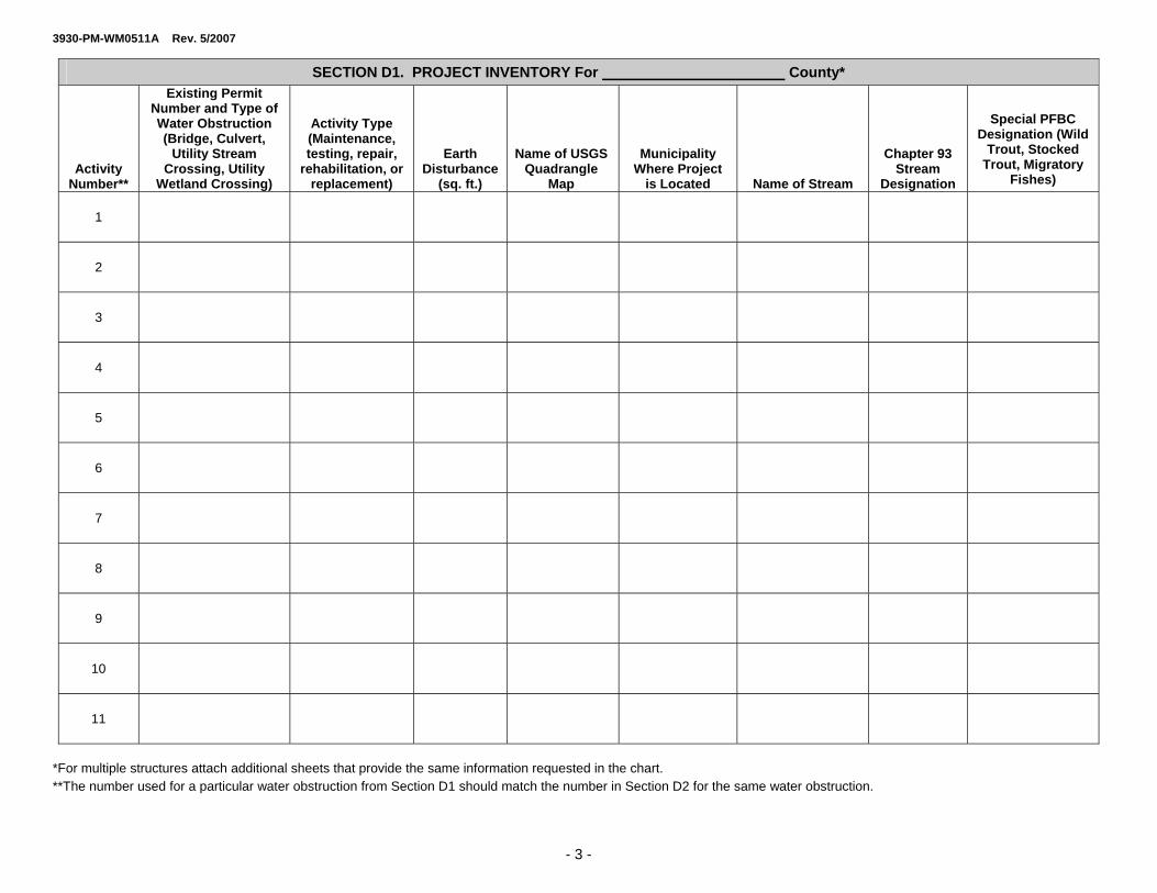
3. Using the Project Inventory Chart (Section D1), list each water obstruction and/or encroachment that requires maintenance. Please fill out the row for each activity in its entirety. Please make sure the activity number corresponds with the area identified on the site location map.
4. If you are proposing a bridge or culvert replacement or the proposed work will change the waterway opening, please complete and provide the chart in Section D2. If the project consists of similar work (replacement or change in waterway opening) on more than one structure, submit the data requested in Section D2 for each structure included in this registration.
5. For bridges and culverts across a watercourse which are to be used by the general public such as an access to an industrial, commercial, or residential development, etc., plans, specifications and hydrologic and hydraulic reports shall be prepared and submitted by a registered professional engineer and shall be affixed with their seal and certification.
6. For bridge or culvert replacements, activities that reduce the size of the waterway opening, or work on a structure that poses a threat to human life or a substantial potential risk to property, plans, specifications and hydrologic and hydraulic reports shall be prepared and submitted by a registered professional engineer and shall be affixed with their seal and certification.
7. Submit 2 complete copies of the permit registration form and plans including all Erosion and Sediment Controls to the appropriate Regional Office.
3930-PM-WM0511A Rev. 5/2007
- 3 -
SECTION D1. PROJECT INVENTORY For County*
Activity Number**
Existing Permit Number and Type of Water Obstruction (Bridge, Culvert,
Utility Stream Crossing, Utility
Wetland Crossing)
Activity Type (Maintenance, testing, repair,
rehabilitation, or replacement)
Earth Disturbance
(sq. ft.)
Name of USGSQuadrangle
Map
Municipality Where Project
is Located Name of Stream
Chapter 93 Stream
Designation
Special PFBC Designation (Wild
Trout, Stocked Trout, Migratory
Fishes)
1
2
3
4
5
6
7
8
9
10
11
*For multiple structures attach additional sheets that provide the same information requested in the chart. **The number used for a particular water obstruction from Section D1 should match the number in Section D2 for the same water obstruction.

3930-PM-WM0511A Rev. 5/2007
SECTION D2. BRIDGE AND/OR CULVERT REPLACEMENT PROJECTS OR PROJECTS THAT CHANGE THE WATERWAY OPENING*
Bridge/Culvert Existing Bridge/Culvert Proposed
Activity Number**
Waterway Opening (sq. ft.) (cross section/area)
Span (ft.)
Underclearance (ft.)
Length (ft.) (upstream to downstream)
Material Type
(RCP, CMP, etc.)
Waterway Opening (sq. ft.) (cross section/area)
Span (ft.)
Underclearance (ft.)
Length (ft.) (upstream to downstream)
Material Type
(RCP, CMP, etc.)
1
2
3
4
5
6
7
8
9
10
11
*For multiple structures attach additional sheets that provide the same information requested in the chart. **The number used for a particular water obstruction from Section D1 should match the number in Section D2 for the same water obstruction.
- 4 -
3930-PM-WM0511A Rev. 5/2007
- 5 -
SECTION E. COMPLIANCE REVIEW
Yes No Is the applicant (owner and/or operator) currently in violation of any permits issued by the Department?
If yes, please provide:
1. Permit Number:
2.
Nature of the violation (if any):
3.
Status of violation (i.e., schedule for compliance, etc.):
SECTION F. OTHER PERMITS
Yes No Are any other Chapter 105 permits required for this project, excluding GP-8?
SECTION G. CERTIFICATION
I certify that the information provided in this permit registration is true and correct to the best of my knowledge and information.
Signature of Permittee Date (Person Responsible for Installation, Operation and Maintenance of Authorized Activity)
Type or Print Name
AN ACKNOWLEDGED COPY OF THIS GENERAL PERMIT AND THE EROSION AND SEDIMENT CONTROL PLAN REVIEWED BY THE DEP REGIONAL OFFICE MUST BE AVAILABLE AT THE PROJECT SITE DURING CONSTRUCTION.

3930-PM-WM0511A Rev. 5/2007
SECTION H. REGISTRATION CHECKLIST
In order to register use of this General Permit, confirm the following: N/A
I/we have notified the Municipality and County. I/we hereby notify the Department that BDWM-GP-8, Temporary Road Crossing will also be utilized during the
maintenance activity.
Please Submit: Completed Permit Registration Form. LOCATION MAP. An 8 ½” by 11” photocopy of a portion of the U.S.G.S. 7 ½ Minute Quadrangle Map or
suitable mapping with the project site(s) identified. Wetland Information Data Sheets, Field Notes, or Photos of the wetland area. Engineering plan or sketch drawing that provides the necessary information. Project cross-section drawing. Completed copy of a PNDI Search Form with Search Receipt. For bridge or culvert replacements, activities that reduce the size of the waterway opening, or work on a
structure that poses a threat to human life or a substantial potential risk to property, plans, specifications and hydrologic and hydraulics report shall be prepared and submitted by a registered professional engineer and shall be affixed with their seal and certification.
Erosion and Sediment Control Plan for earth disturbance activities Any existing Submerged Lands License Agreements
Please submit where required: Photographs – For projects involving a waterway opening, photos upstream and downstream of the existing
structure are required. Bog Turtle Habitat Screening Form (where required). This screening is required for General Permits 5, 6, 7, 8,
9, and 11 which may impact wetlands in the following counties: Adams, Berks, Bucks, Chester, Cumberland, Delaware, Franklin, Lancaster, Lebanon, Lehigh, Monroe, Montgomery, Northampton, Schuylkill (Swatara Watershed), and York.
- 6 -

3930-PM-WM0511A Rev. 5/2007
SECTION I1. DRAWINGS/PLANS
1) Engineering drawings prepared and sealed by a Professional Engineer are required for the following types of projects:
a) bridge and culvert replacements b) activities that reduce the size of the waterway opening c) bridges or culverts across a watercourse which are to be used by the general public d) work on a structure that poses a threat to human life or a substantial potential risk to property
2) Prepared plans or sketch plans maybe submitted for activities not listed in 1 a) through d). *Please make sure the information below is provided on all engineering plans, drawings, and other prepared plans or sketch plan required for registration.
SECTION I2. DRAWINGS/PLANS CHECKLIST
YES N/A YES N/A
Stream Name Permanent Stream Impacts with Dimensions
Total Length Total sq. ft.
Chapter 93 Stream Designation
Temporary Stream Impacts Location of Property Lines Relative to the Project
Wetland Acreage Onsite
Existing Utilities
Permanent Wetland Impacts sq. ft. Proposed Utilities
Temporary Wetland sq. ft.
Stream Limits and Flow Direction Existing Buildings, Roadways, Other Structures
Floodway Limits (if known) Proposed Buildings, Roadways, Other Structures
Limits of Earth Disturbance Associated with this Activity
Other Waters (i.e. pond, lakes)
Please indicate North
Please indicate photo locations
Use the next sheet for sketch if applicable
- 7 -

3930-PM-WM0511A Rev. 5/2007
SKETCH PLAN (if applicable)
Applicant Name |______________| Scale 1" = ft.
- 8 -

3930-PM-WM0511A Rev. 5/2007
- 9 -
Applicant Name
PROJECT CROSS SECTIONS
Provide a cross section of the project if not included on the Engineering Drawings, showing the dimensions of the waterway opening, area of fill materials used, and other pertinent information necessary to accurately depict the scope of your project, and allow the Department to determine that the project complies with the terms and conditions of this General Permit.

3930-PM-WM0500A Rev. 12/2006 EXHIBIT A
OFFICES OF THE PENNSYLVANIA FISH AND BOAT COMMISSION
Headquarters Address County Responsibility
NORTHWEST REGION Regional Manager Butler, Clarion, Crawford, Erie, 11528 Highway 98 Forest, Lawrence, Mercer, Venango Meadville, PA 16335-7320 and Warren 814-337-0444
SOUTHWEST REGION Regional Manager Allegheny, Armstrong, Beaver, 236 Lake Road Cambria, Fayette, Greene, Indiana, Somerset, PA 15501-1644 Somerset, Washington and 814-445-8974 Westmoreland
NORTHCENTRAL REGION Regional Manager Cameron, Centre, Clearfield, P.O. Box 5306 Clinton, Elk, Jefferson, Lycoming, Pleasant Gap, PA 16823 McKean, Montour, Northumberland, 814-359-5250 Potter, Snyder, Tioga and Union
SOUTHCENTRAL REGION Regional Manager Adams, Bedford, Blair, Cumberland, 1704 Pine Road Dauphin, Franklin, Fulton, Newville, PA 17241 Huntingdon, Juniata, Lebanon, 717-486-7087 Mifflin, Northumberland (Mahatango
Creek in Jordan and Lower Mahanoy Townships only), Perry and York
SOUTHEAST REGION
Regional Manager Berks, Bucks, Chester, Delaware, P.O. Box 9 Lancaster, Lehigh, Montgomery, Elm, PA 17521 Northampton, Philadelphia and 717-626-0228 Schuylkill
NORTHEAST REGION Regional Manager Bradford, Carbon, Columbia, P.O. Box 88 Lackawanna, Luzerne, Monroe, Sweet Valley, PA 18656 Pike, Sullivan, Susquehanna, 570-477-5717 Wayne and Wyoming
DIVISION OF ENVIRONMENTAL SERVICES 450 Robinson Lane, Bellefonte, PA 16823-9620
814-359-5147
DIVISION OF FISHERIES MANAGEMENT 450 Robinson Lane, Bellefonte PA 16823-9620
814-359-5110

3930-PM-WM0500B Rev. 10/2005 EXHIBIT B
REGIONAL OFFICES OF THE DEPARTMENT OF ENVIRONMENTAL PROTECTION AND
U.S. ARMY CORPS OF ENGINEERS DISTRICT OFFICES Permitting and Technical Services Section County Responsibility Southcentral Regional Office Adams, Bedford, Berks, Blair, Cumberland, 909 Elmerton Avenue, Second Floor Dauphin, Franklin, Fulton, Huntingdon, Harrisburg, PA 17110 Juniata, Lancaster, Lebanon, Mifflin, Perry (717) 705-4707 and York Southeast Regional Office Bucks, Chester, Delaware, Montgomery and 2 East Main Street Philadelphia Norristown, PA 19401 (484) 250-5970 Southwest Regional Office Allegheny, Armstrong, Beaver, Cambria, 400 Waterfront Drive Fayette, Greene, Indiana, Somerset, Pittsburgh, PA 15222-4745 Washington and Westmoreland (412) 442-4000 Northwest Regional Office Butler, Clarion, Crawford, Elk, Erie, Forest, 230 Chestnut Street Jefferson, Lawrence, McKean, Mercer, Meadville, PA 16335 Venango and Warren (814) 332-6984 Northeast Regional Office Carbon, Lackawanna, Lehigh, Luzerne, 2 Public Square Monroe, Northampton, Pike, Schuylkill, Wilkes-Barre, PA 18711-0790 Susquehanna, Wayne and Wyoming (570) 826-2511 Northcentral Regional Office Bradford, Cameron, Centre, Clearfield, 208 W. Third Street, Suite 101 Clinton, Columbia, Lycoming, Montour, Williamsport, PA 17701 Northumberland, Potter, Snyder, Sullivan, (570) 327-3574 Tioga and Union Note: Registration for the use of General Permits (except General Permit 11 Registrations which must be sent to the Permitting and Technical Services Section) must be sent to the County Conservation District in those counties where the District has a delegation agreement with the Department of Environmental Protection.
U.S. ARMY CORPS OF ENGINEERS DISTRICT OFFICES
Delaware River Basin
Ohio River Basin Portions of Lake Erie and
Genesee River Basins Located in PA Susquehanna River Basin
Philadelphia District Corps of Engineers Wanamaker Building 100 Penn Square East Philadelphia, PA 19107 Phone: 215-656-6725 Phone: 215-656-6729 (to report violations) Fax: 215-656-6724
Pittsburgh District Corps of Engineers Regulatory Branch 1000 Liberty Avenue Pittsburgh, PA 15222 Phone: 412-395-7152 Fax: 412-644-4211
Baltimore District Corps of Engineers P.O. Box 1715 Baltimore, MD 21203-1715 Phone: 814-235-0570 Fax: 814-235-0576

P e n n s y l v a n i a N a t u r a l D i v e r s i t y I n v e n t o r y P r o j e c t P l a n n i n g & E n v i r o n m e n t a l R e v i e w F o r m
This form provides site information necessary to perform an Environmental Review for special concern species and resources listed under the Endangered Species Act of 1973, the Wild Resource Conservation Act, the Pennsylvania Fish and Boat code or the Pennsylvania Game and Wildlife Code.
A p p l i c a n t I n f o r m a t i o n Name: Address: Phone Number: Fax Number:
C o n t a c t P e r s o n I n f o r m a t i o n - if different from applicant Name: Address: Phone Number: Fax Number: P r o j e c t I n f o r m a t i o n Project Name: Project Location: Municipality: County:
Attach a copy of a U.S.G.S. 7 ½ Minute Quadrangle Map with Project Boundaries clearly marked. U.S.G.S. Quad Name:
P r o j e c t D e s c r i p t i o n
Proposed Project Activity (including ALL earth disturbance areas and current conditions)
Total Acres of Property: Acreage to be Impacted: 1. Will the entire project occur in or on an existing building, parking lot, driveway, road, maintained road shoulder,
street, runway, paved area, railroad bed, or maintained lawn? Yes No
2. Are there any waterways or waterbodies (intermittent or perennial rivers, streams, creeks, tributaries, lakes or ponds) in or near the project area, or on the land parcel? If so, how many feet away is the project? Yes Feet No
3. Are wetlands located in or within 300 feet of the project area? Yes No If No, is this the result of a wetland delineation?
If you have a "PNDI Project Environmental Review Receipt" with potential impacts, please send a receipt copy, this completed form, and a USGS Quad Map to the agency/agencies noted on the receipt. If you are unable to generate a PNDI Receipt because you do not have
Internet access, complete this form, attach a USGS Quad Map, and send them to your local DEP or County Conservation District. For review of a "Large Project," please send form and map to all the agencies listed below. See page 2 for more information.
Dept. of Conservation and Natural Resources Bureau of Forestry, Ecological Services Section
400 Market St., PO Box 8552 Harrisburg, PA 17105
fax: 717-772-0271
PA Fish and Boat Commission Natural Diversity Section
450 Robinson Lane Bellefonte, PA 16823
fax 814-359-5175
PA Game Commission Bureau of Land Management
2001 Elmerton Avenue Harrisburg, PA 17110-9797
fax: 717-787-6957
US Fish and Wildlife Service Endangered Species Biologist 315 South Allen St., Suite 322
State College, PA 16801 no faxes please
8100-FM-FR0161 8/2005 PNDI Form Page 1 of 2

8100-FM-FR0161 8/2005 PNDI Form Page 2 of 2
H o w t o U s e t h e P N D I P r o j e c t P l a n n i n g & E n v i r o n m e n t a l R e v i e w F o r m
H o w d o I a c c e s s t h e P N D I E n v i r o n m e n t a l R e v i e w T o o l ? Visit www.naturalheritage.state.pa.us. Click on “PNDI Project Planning and Environmental Review” on the bottom left corner of the homepage to access the tool. Follow this link to access the ER Tool and for step-by-step instructions on using the ER Tool, FAQ’s and access to an electronic version of the PNDI Form. W h e n d o I u s e t h i s f o r m ?
1. Before conducting the PNDI online search The Applicant can complete the PNDI Form and submit it to the person conducting the online PNDI Project Planning and Environmental Review Tool search. This person performing the search could be someone from DEP, the County Conservation Districts, or a consultant. Alternatively, if the Applicant plans to conduct the PNDI online search his or herself—a search form is not needed prior to the PNDI online search.
2. After conducting the PNDI online search If your PNDI Project Environmental Review Receipt has “Potential Impacts,” DEP and the jurisdictional agencies require that you submit additional information to the agencies noted on the Receipt for further review. Please send a copy of the PNDI Receipt, a completed PNDI Form, and a USGS 7.5 minute quadrangle map with project boundaries delineated on the map to the agencies referenced on your PNDI Receipt.
3. If your Project is a “Large Project”— too large/long to search on the online system Projects are considered “Large Projects” when the ENTIRE project is:
Linear/Large Projects that exceed map limits: approximately 2-2.84 miles depending on browser size
Projects that will not fit on 1:24,000 scale map. Project Maximums: 1024 x 768 browsers: 2625 acres; 15,000 feet long x 7600 feet wide; approximately 2.84 miles 800 x 600 browsers: 1050 acres; 11,000 feet long x 4000 feet wide; approximately 2 miles
Township-wide, Countywide or Statewide Projects. Examples: Act 537 Sewage Plans, Wind Farms, Roadway Improvements exceeding map limits above.
For “Large Project” review, please forward a completed PNDI Form and a USGS 7.5 minute quadrangle with project boundaries and quad name marked on the map to DCNR, PFBC, PGC, and USFWS (contact information on page 1 of form). Due to system limitations and agency requirements, projects should not be submitted piecemeal. The entire project area including roads and infrastructure should be submitted as a single unit.
P N D I F o r m D e f i n i t i o n s
Applicant: Person that owns the property or is proposing the project or activity Contact Person: Person to receive response if different than applicant (e.g. Consultant) Project Name: Descriptive title of project (e.g. Twin Pines Subdivision, Miller Bridge Replacement) Project Location: Description of actual location (e.g. Intersection of Smith and Clay Rd., Latitude & Longitude) Proposed Activity: Include ALL earth disturbance activities for project (e.g. for a timber sale—include stream
crossings, cutting areas and new roadway accesses). Also include Current Conditions (e.g. housing, farmland, current land cover), and how Construction/Maintenance Activity is to be accomplished
Total Acres of Property: Entire site acreage (e.g. timber sale property—including road access (200 acres)
Acreage to be Impacted: Disturbance acreage (e.g. timber sale—if the property is 200 acres, but only 100 acres will be disturbed, for example: cutting on 90 acres, a road impacting 10 acres); include all temporary and permanent activities
3930-PM-WM0550 Rev. 4/2006
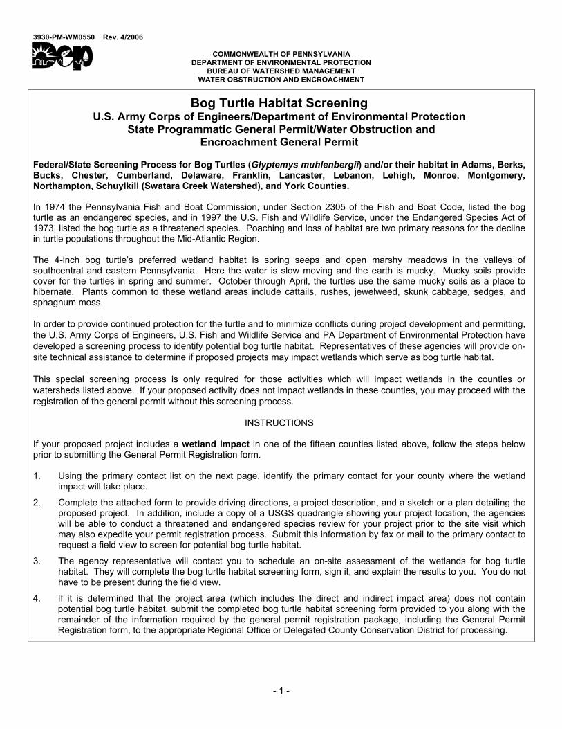
COMMONWEALTH OF PENNSYLVANIA DEPARTMENT OF ENVIRONMENTAL PROTECTION
BUREAU OF WATERSHED MANAGEMENT WATER OBSTRUCTION AND ENCROACHMENT
Bog Turtle Habitat Screening U.S. Army Corps of Engineers/Department of Environmental Protection
State Programmatic General Permit/Water Obstruction and Encroachment General Permit
Federal/State Screening Process for Bog Turtles (Glyptemys muhlenbergii) and/or their habitat in Adams, Berks, Bucks, Chester, Cumberland, Delaware, Franklin, Lancaster, Lebanon, Lehigh, Monroe, Montgomery, Northampton, Schuylkill (Swatara Creek Watershed), and York Counties. In 1974 the Pennsylvania Fish and Boat Commission, under Section 2305 of the Fish and Boat Code, listed the bog turtle as an endangered species, and in 1997 the U.S. Fish and Wildlife Service, under the Endangered Species Act of 1973, listed the bog turtle as a threatened species. Poaching and loss of habitat are two primary reasons for the decline in turtle populations throughout the Mid-Atlantic Region. The 4-inch bog turtle’s preferred wetland habitat is spring seeps and open marshy meadows in the valleys of southcentral and eastern Pennsylvania. Here the water is slow moving and the earth is mucky. Mucky soils provide cover for the turtles in spring and summer. October through April, the turtles use the same mucky soils as a place to hibernate. Plants common to these wetland areas include cattails, rushes, jewelweed, skunk cabbage, sedges, and sphagnum moss. In order to provide continued protection for the turtle and to minimize conflicts during project development and permitting, the U.S. Army Corps of Engineers, U.S. Fish and Wildlife Service and PA Department of Environmental Protection have developed a screening process to identify potential bog turtle habitat. Representatives of these agencies will provide on-site technical assistance to determine if proposed projects may impact wetlands which serve as bog turtle habitat. This special screening process is only required for those activities which will impact wetlands in the counties or watersheds listed above. If your proposed activity does not impact wetlands in these counties, you may proceed with the registration of the general permit without this screening process.
INSTRUCTIONS If your proposed project includes a wetland impact in one of the fifteen counties listed above, follow the steps below prior to submitting the General Permit Registration form. 1. Using the primary contact list on the next page, identify the primary contact for your county where the wetland
impact will take place.
2. Complete the attached form to provide driving directions, a project description, and a sketch or a plan detailing the proposed project. In addition, include a copy of a USGS quadrangle showing your project location, the agencies will be able to conduct a threatened and endangered species review for your project prior to the site visit which may also expedite your permit registration process. Submit this information by fax or mail to the primary contact to request a field view to screen for potential bog turtle habitat.
3. The agency representative will contact you to schedule an on-site assessment of the wetlands for bog turtle habitat. They will complete the bog turtle habitat screening form, sign it, and explain the results to you. You do not have to be present during the field view.
4. If it is determined that the project area (which includes the direct and indirect impact area) does not contain potential bog turtle habitat, submit the completed bog turtle habitat screening form provided to you along with the remainder of the information required by the general permit registration package, including the General Permit Registration form, to the appropriate Regional Office or Delegated County Conservation District for processing.
- 1 -

3930-PM-WM0550 Rev. 4/2006
5. If it is determined that the project area (which includes the direct and indirect impact area) is potential bog turtle habitat, the agency representative will discuss your options with you. These may include moving the project to an alternate location, contacting a professional bog turtle surveyor, or consulting with the U.S. Fish and Wildlife Service. Neither a state general permit nor a federal State Programmatic General Permit can be registered without the U.S. Fish and Wildlife Service clearing the potential bog turtle conflict.
6. If you cannot avoid the impacts to bog turtle habitat, an Individual Chapter 105 and Section 404 Permit Application will be required for processing, public notice, and review. An application does not guarantee permit approval.
7. If you have any questions specific to this process, please contact the appropriate agency representative for your county.
PRIMARY CONTACT LIST BY COUNTY Adams, Cumberland Counties
Debby Nizer U. S. Army Corps of Engineers Baltimore Dist., Regulatory Branch, PA Section P. O. Box 1715 Baltimore, MD 21203-1715 Phone: 410-962-6085 Fax: 410-962-6024
Berks (Baltimore District), York Counties Mike Danko U. S. Army Corps of Engineers Carlisle Regulatory Field Office 401 East Louther Street, Suite 205 Carlisle, PA 17013 Phone: 717-249-8730 Fax: 717-240-0523
Berks (Philadelphia District), Bucks, Chester (Philadelphia District), Delaware, Montgomery Counties Chief, Applications Section U. S. Army Corps of Engineers Philadelphia Dist., Regulatory Branch Wanamaker Building 100 Pen Square East Philadelphia, PA 19107-3390 Phone: 215-656-6728 Fax: 215-656-6724
Chester (Baltimore District), Lancaster, Lebanon Counties Pat Strong U. S. Army Corps of Engineers Baltimore Dist., Regulatory Branch, PA Section P. O. Box 1715 Baltimore, MD 21203-1715 Phone: 410-962-1847 Fax: 410-962-6024
Franklin, Lehigh, Northampton, Schuylkill (Swatara Creek Watershed) Counties U.S. Fish and Wildlife Service 315 South Allen St., Suite 322 State College, PA 16801 Phone: 814-234-4090 Fax: 814-234-0748
Monroe County Victor Motts Monroe County Conservation District 8050 Running Valley Road Stroudsburg, PA 18360-8841 Phone: 570-629-3060 Fax: 570-629-3063
If you have more general questions or need information on permitting, please contact the appropriate DEP Regional Office listed below.
DEP Northeast Regional Office 2 Public Square Wilkes-Barre, PA 18711-0790 570-826-2511 Lehigh, Monroe, and Northampton, and Schuylkill (Swatara Creek Watershed) Counties
DEP Southcentral Regional Office 909 Elmerton Avenue Harrisburg, PA 17110 717-705-4707 Adams, Berks, Cumberland, Franklin, Lancaster, Lebanon, and York Counties
DEP Southeast Regional Office 2 East Main Street Norristown, PA 19401 484-250-5940 Bucks, Chester, Delaware, and Montgomery Counties
- 2 -

3930-PM-WM0550 Rev. 4/2006
SPECIAL BOG TURTLE HABITAT SCREENING
U. S. ARMY CORPS OF ENGINEERS/DEPARTMENT OF ENVIRONMENTAL PROTECTION STATE PROGRAMMATIC GENERAL PERMIT/WATER OBSTRUCTION AND
ENCROACHMENT GENERAL PERMIT APPLICANT INFORMATION Applicant Name
Mailing Address Telephone ( )
City State ZIP+4
Email Address
PROJECT DESCRIPTION Project Name
County Municipality
Latitude Longitude
Which general permit(s) are you planning to register? GP-5 GP-6 GP-7 GP-8 GP-9 GP-11
Detailed Written Directions to Project
Briefly Describe Your Project
SIGNATURE
I hereby grant permission for representatives of the U. S. Army Corps of Engineers or other authorized screening representative to inspect the project site as necessary in order to perform the requested habitat determination.
Signature Date
On the reverse side of this page, prepare a sketch showing your project, the wetlands, and all proposed impacts.
- 3 -

3930-PM-WM0550 Rev. 4/2006
- 4 -
Applicant Name
BOG TURTLE HABITAT - SKETCH PLAN To ensure the sketch plan is complete, include the following on the site plan in the immediate vicinity of the project. (√ all that apply) YES N/A YES N/A
Stream Name Stream Impacts with Dimensions Total Length Total sq. ft.
Chapter 93 Stream Designation
Location of Property Lines Relative to the Project Wetland Impacts Total sq. ft.
Existing Utilities
Wetland Acreage Onsite Proposed Utilities Stream Limits and Flow Direction Existing Buildings, Roadways, Other Structures Floodway Limits (if known) Proposed Buildings, Roadways, Other Structures Limits of Earth Disturbance
Associated with this Activity Other Waters (i.e. pond, lakes)
|______________| Scale 1" = ft.